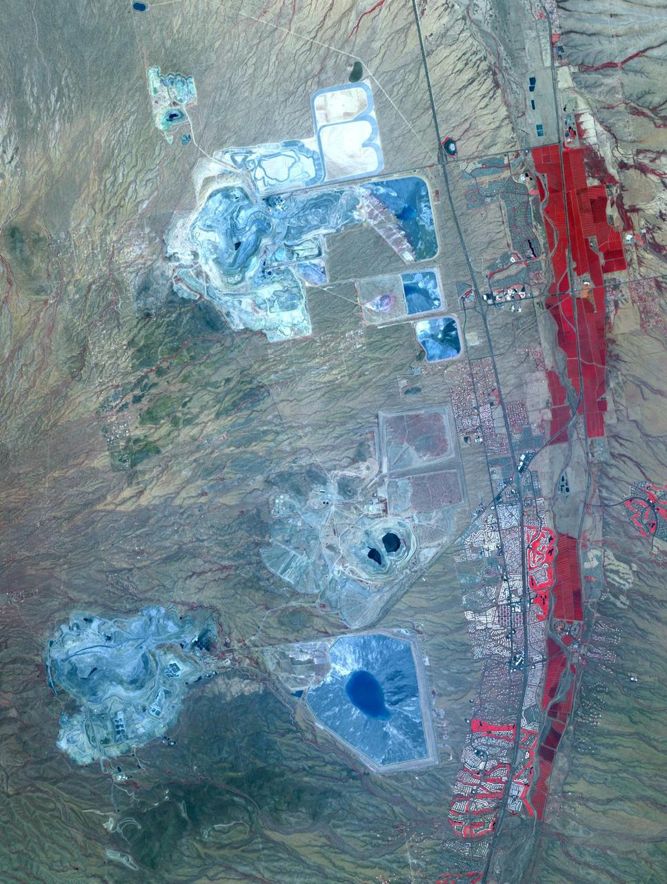
Arizona produces 60% of the total copper mined in the US; in 2007, 750,000 tons of copper came out of the state. One of the major mining districts is located about 30 km south of Tucson. Starting around 1950, open-pit mining replaced underground operations, and the ASARCO-Mission complex, Twin Buttes, and Sierrita mines became large open pit operations. Accompanying copper mineralization, silver, molybdenum, zinc, lead and gold are extracted. In addition to the pits themselves, enormous leach ponds and tailings piles surround the pits. The image was acquired May 31, 2012, covers an area of 22 by 28 km, and is located at 31.9 degrees north, 111 degrees west. With its 14 spectral bands from the visible to the thermal infrared wavelength region and its high spatial resolution of 15 to 90 meters (about 50 to 300 feet), ASTER images Earth to map and monitor the changing surface of our planet. ASTER is one of five Earth-observing instruments launched Dec. 18, 1999, on Terra. The instrument was built by Japan's Ministry of Economy, Trade and Industry. A joint U.S./Japan science team is responsible for validation and calibration of the instrument and data products. The broad spectral coverage and high spectral resolution of ASTER provides scientists in numerous disciplines with critical information for surface mapping and monitoring of dynamic conditions and temporal change. Example applications are: monitoring glacial advances and retreats; monitoring potentially active volcanoes; identifying crop stress; determining cloud morphology and physical properties; wetlands evaluation; thermal pollution monitoring; coral reef degradation; surface temperature mapping of soils and geology; and measuring surface heat balance. The U.S. science team is located at NASA's Jet Propulsion Laboratory, Pasadena, Calif. The Terra mission is part of NASA's Science Mission Directorate, Washington, D.C. More information about ASTER is available at <a href="http://asterweb.jpl.nasa.gov/" rel="nofollow">asterweb.jpl.nasa.gov/</a> Credit: NASA/GSFC/METI/ERSDAC/JAROS, and U.S./Japan ASTER Science Team <b><a href="http://www.nasa.gov/audience/formedia/features/MP_Photo_Guidelines.html" rel="nofollow">NASA image use policy.</a></b> <b><a href="http://www.nasa.gov/centers/goddard/home/index.html" rel="nofollow">NASA Goddard Space Flight Center</a></b> enables NASA’s mission through four scientific endeavors: Earth Science, Heliophysics, Solar System Exploration, and Astrophysics. Goddard plays a leading role in NASA’s accomplishments by contributing compelling scientific knowledge to advance the Agency’s mission. <b>Follow us on <a href="http://twitter.com/NASAGoddardPix" rel="nofollow">Twitter</a></b> <b>Like us on <a href="http://www.facebook.com/pages/Greenbelt-MD/NASA-Goddard/395013845897?ref=tsd" rel="nofollow">Facebook</a></b> <b>Find us on <a href="http://instagram.com/nasagoddard?vm=grid" rel="nofollow">Instagram</a></b>

This image acquired by NASA Terra spacecraft shows Arizona, Calif., which produces 60% of the total copper mined in the United States.
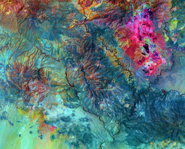
This image from NASA Terra satellite shows the Morenci open-pit copper mine in southeast Arizona, North America leading producer of copper.
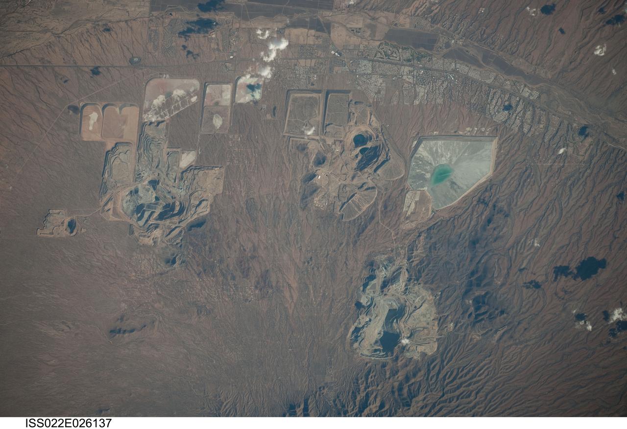
ISS022-E-026137 (14 Jan. 2010) --- Open Pit Mines in southern Arizona are featured in this image photographed by an Expedition 22 crew member on the International Space Station. The State of Arizona is the United States? largest producer of the metal copper, primarily mined from ore bodies known as porphyry copper deposits. Copper is a good conductor of electricity and heat, and is a vital element of virtually all of our electronic devices and components. A porphyry copper deposit is a geological structure formed by crystal-rich magma moving upwards through pre-existing rock layers. As the magma cools and crystallizes, it forms an igneous rock with large crystals embedded in a fine-grained matrix, known as porphyry. Hot fluids circulate through the magma and surrounding rocks via fractures, depositing copper-bearing and other minerals in characteristic spatial patterns that signal the nature of the ore body to a geologist. The most common approach to extracting metal-bearing ore from a porphyry copper deposit is by open-pit mining. For more details, please refer to http://earth.jsc.nasa.gov/EarthObservatory/OpenPitMinesSouthernArizona.htm.
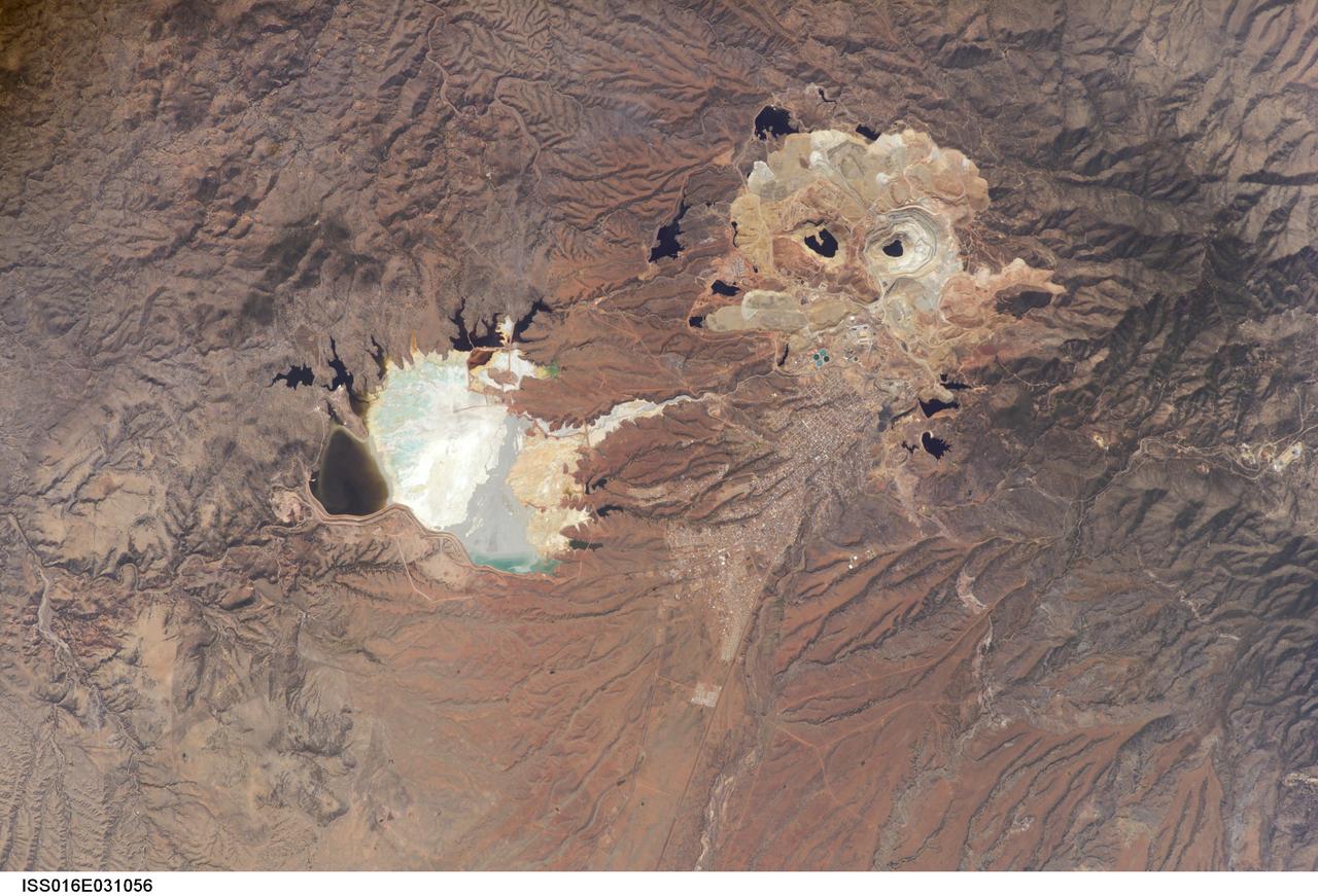
ISS016-E-031056 (3 March 2008) --- Cananea Copper Mine, Sonora, Mexico is featured in this image photographed by an Expedition 16 crewmember on the International Space Station. One of the largest open-pit copper mines in the world, the Cananea mine produced over 164,000 tons of copper in 2006. The mine is located approximately 40 kilometers south of the border between the USA (Arizona) and Mexico (Sonora). Copper and gold ores at Cananea are found in a porphyry copper deposit, a geological structure formed by crystal-rich magma moving upwards through pre-existing rock layers. A porphyry - an igneous rock with large crystals in a fine-grained matrix -- is formed as the magma cools and crystallizes. While crystallization is occurring, hot fluids can circulate through the magma and surrounding rocks via fractures. This hydrothermal alteration of the rocks typically forms copper-bearing and other minerals. Much of the Cananea mine's ore is concentrated in breccia pipes -- mineralized rod or chimney-shaped bodies that contain broken rock fragments. The active, two-kilometers-in-diameter Colorada Pit (top right) is recognizable in this image by the concentric steps or benches cut around its perimeter. These benches allow for access into the pit for extraction of ore and waste materials. Water (black) is visible filling the bottom of the pit, and several other basins in the surrounding area. The city of Cananea -- marked by its street grid -- is located to the northeast of the mine workings. A leachate reservoir is located to the east of the mine (lower left) for removal and evaporation of water pumped from the mine workings -- the bluish-white coloration of deposits near the reservoir suggests the high mineral content of the leachate. A worker strike halted mine operations in 2007.
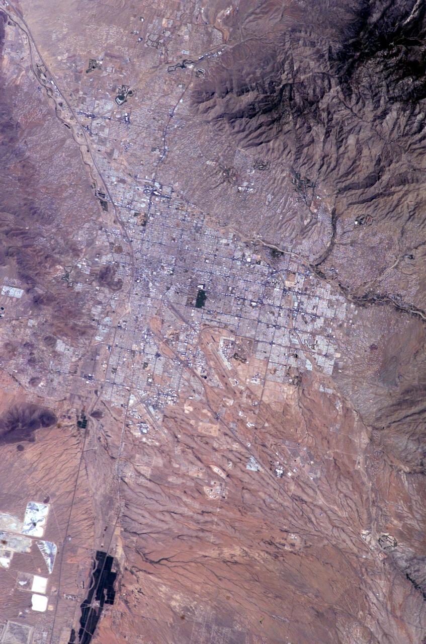
ISS009-E-10382 (7 June 2004) --- Tucson, Arizona is featured in this image photographed by an Expedition 9 crewmember on the International Space Station (ISS). Tucson lies between the forested Catalina Mountains and the Tucson Mountains (dark reddish brown at left). The typical western North American cityscape is a pattern of regular north-south aligned rectangles outlined by major streets set one mile apart. Tucson’s Randolph golf course is the large rectangular dark zone in the image center. The striking contrast between the golf course and its surroundings is due to dense grass cover maintained by frequent watering. The rectangular grid pattern disappears in the small streets of the original city center, situated along the Santa Cruz River (enters the view lower left and exits in the top left corner). Newer and less densely built-up neighborhoods in the foothills of the Catalina Mountains are designed to incorporate natural landscape features, and retain major washes with natural vegetation. This portion of the cityscape seen from space is consequently quite different from the main city grid. The foothills afford views of the city to the south and the mountains to the north and are major areas of development. Large white dots within the urban grid are the reflective rooftops of shopping malls. Tucson enjoys an important position along several major crossroads. Interstate highway I-10, which connects southern California to Florida, appears as a straight line running parallel with the Santa Cruz River northwest from Tucson in the direction of Phoenix. The I-10 traverses a well-marked alluvial fan that extends from the Santa Rita Mountains to the southeast (fine drainage pattern lower center) and exits the view lower right. Highway I-19 is the straight line (lower left) leading south from the city center, between the Santa Cruz River and rectangular spoil heaps of nearby copper mines. The I-19 connects Tucson with Nogales on the Mexican border.