
Australian Space Agency Head Enrico Palermo, left, and NASA Deputy Administrator Pam Melroy, sign a joint statement of intent for cooperation in Earth science during the 37th Space Symposium, Monday, April 4, 2022, in Colorado Springs, Colorado. Photo Credit: (NASA/Bill Ingalls)

Australian Space Agency Head Enrico Palermo, left, and NASA Deputy Administrator Pam Melroy, shake hands after signing a joint statement of intent for cooperation in Earth science during the 37th Space Symposium, Monday, April 4, 2022, in Colorado Springs, Colorado. Photo Credit: (NASA/Bill Ingalls)
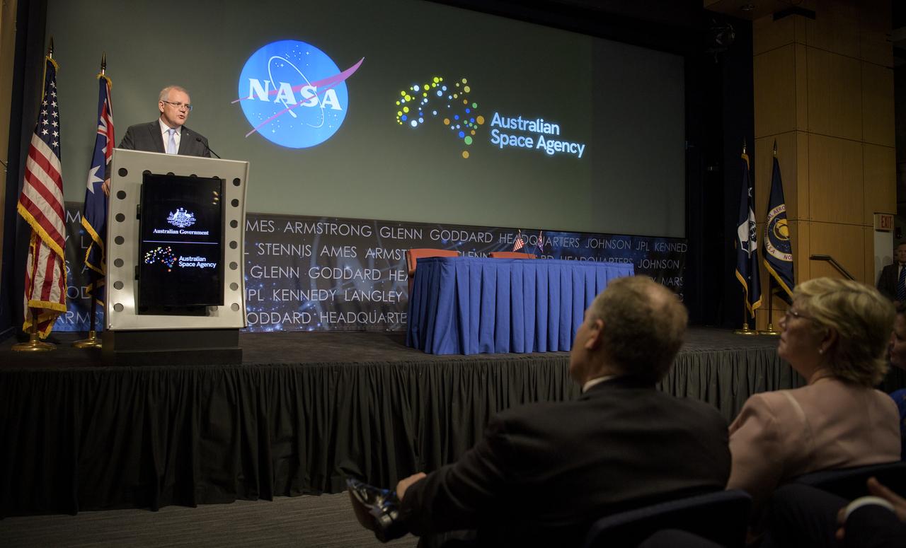
Australian Prime Minister Scott Morrison delivers remarks prior the signing of a letter of intent between NASA and the Australian Space Agency, Saturday, Sept. 21, 2019 at NASA Headquarters in Washington. NASA and the Australian Space Agency will build on over 60 years of collaboration in space exploration between the two countries and commit to expanding cooperation. Photo Credit: (NASA/Joel Kowsky)
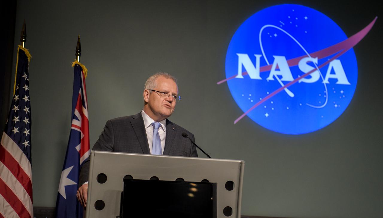
Australian Prime Minister Scott Morrison delivers remarks prior the signing of a letter of intent between NASA and the Australian Space Agency, Saturday, Sept. 21, 2019 at NASA Headquarters in Washington. NASA and the Australian Space Agency will build on over 60 years of collaboration in space exploration between the two countries and commit to expanding cooperation. Photo Credit: (NASA/Joel Kowsky)
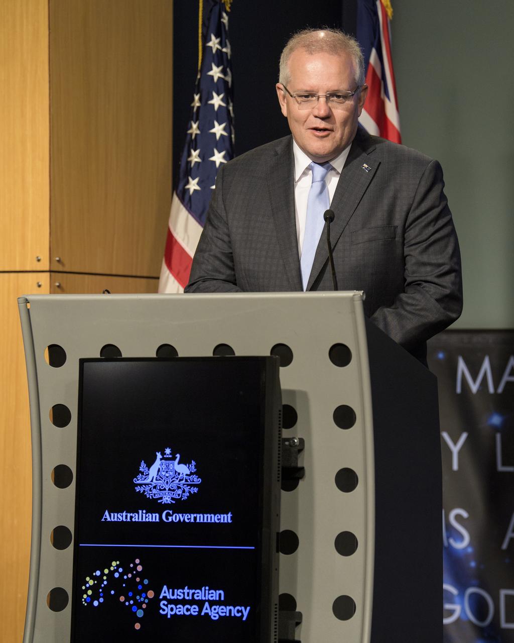
Australian Prime Minister Scott Morrison delivers remarks prior the signing of a letter of intent between NASA and the Australian Space Agency, Saturday, Sept. 21, 2019 at NASA Headquarters in Washington. NASA and the Australian Space Agency will build on over 60 years of collaboration in space exploration between the two countries and commit to expanding cooperation. Photo Credit: (NASA/Joel Kowsky)
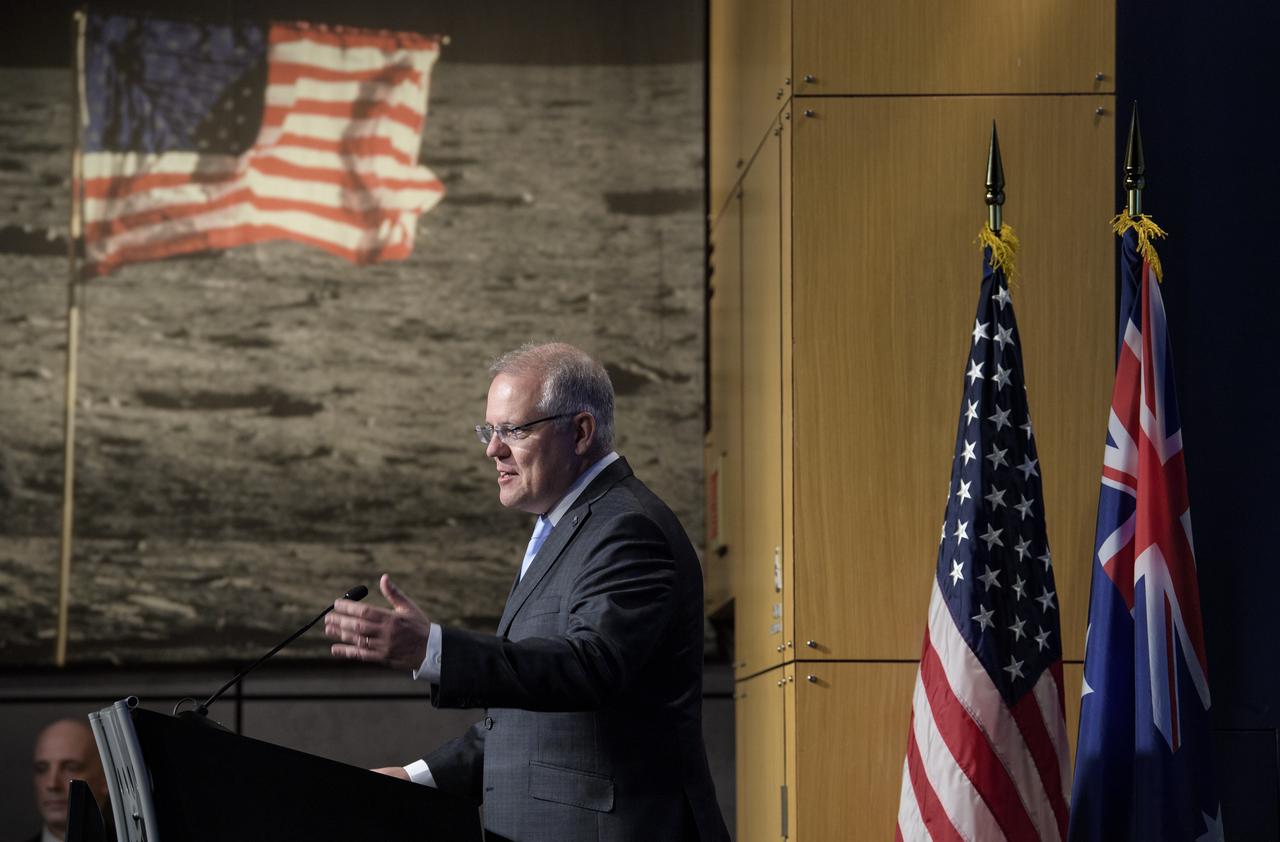
Australian Prime Minister Scott Morrison delivers remarks prior the signing of a letter of intent between NASA and the Australian Space Agency, Saturday, Sept. 21, 2019 at NASA Headquarters in Washington. NASA and the Australian Space Agency will build on over 60 years of collaboration in space exploration between the two countries and commit to expanding cooperation. Photo Credit: (NASA/Joel Kowsky)

U.S. Secretary of Commerce Wilbur Ross delivers remarks prior the signing of a letter of intent between NASA and the Australian Space Agency, Saturday, Sept. 21, 2019 at NASA Headquarters in Washington. NASA and the Australian Space Agency will build on over 60 years of collaboration in space exploration between the two countries and commit to expanding cooperation. Photo Credit: (NASA/Joel Kowsky)

NASA Deputy Associate Administrator for Communications Bob Jacobs holds up the Logie Award presented to the crew of Apollo 11 in 1969 as he gives opening remarks prior the signing of a letter of intent between NASA and the Australian Space Agency, Saturday, Sept. 21, 2019 at NASA Headquarters in Washington. NASA and the Australian Space Agency will build on over 60 years of collaboration in space exploration between the two countries and commit to expanding cooperation. Photo Credit: (NASA/Joel Kowsky)
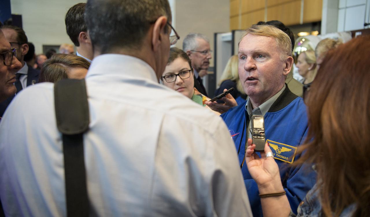
Former NASA astronaut Andy Thomas speaks with members of the media following the signing of a letter of intent between NASA and the Australian Space Agency, Saturday, Sept. 21, 2019 at NASA Headquarters in Washington. NASA and the Australian Space Agency will build on over 60 years of collaboration in space exploration between the two countries and commit to expanding cooperation. Photo Credit: (NASA/Joel Kowsky)

U.S. Secretary of Commerce Wilbur Ross delivers remarks prior the signing of a letter of intent between NASA and the Australian Space Agency, Saturday, Sept. 21, 2019 at NASA Headquarters in Washington. NASA and the Australian Space Agency will build on over 60 years of collaboration in space exploration between the two countries and commit to expanding cooperation. Photo Credit: (NASA/Joel Kowsky)

NASA Deputy Associate Administrator for Communications Bob Jacobs gives opening remarks prior the signing of a letter of intent between NASA and the Australian Space Agency, Saturday, Sept. 21, 2019 at NASA Headquarters in Washington. NASA and the Australian Space Agency will build on over 60 years of collaboration in space exploration between the two countries and commit to expanding cooperation. Photo Credit: (NASA/Joel Kowsky)
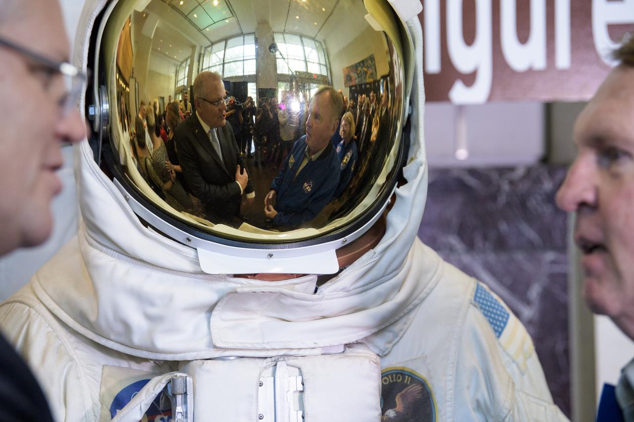
Australian Prime Minister Scott Morrison, left, and former NASA astronaut Andy Thomas, right, are reflected in the visor of a spacesuit replica as they talk following the signing of a letter of intent between NASA and the Australian Space Agency, Saturday, Sept. 21, 2019 at NASA Headquarters in Washington. NASA and the Australian Space Agency will build on over 60 years of collaboration in space exploration between the two countries and commit to expanding cooperation. Photo Credit: (NASA/Joel Kowsky)
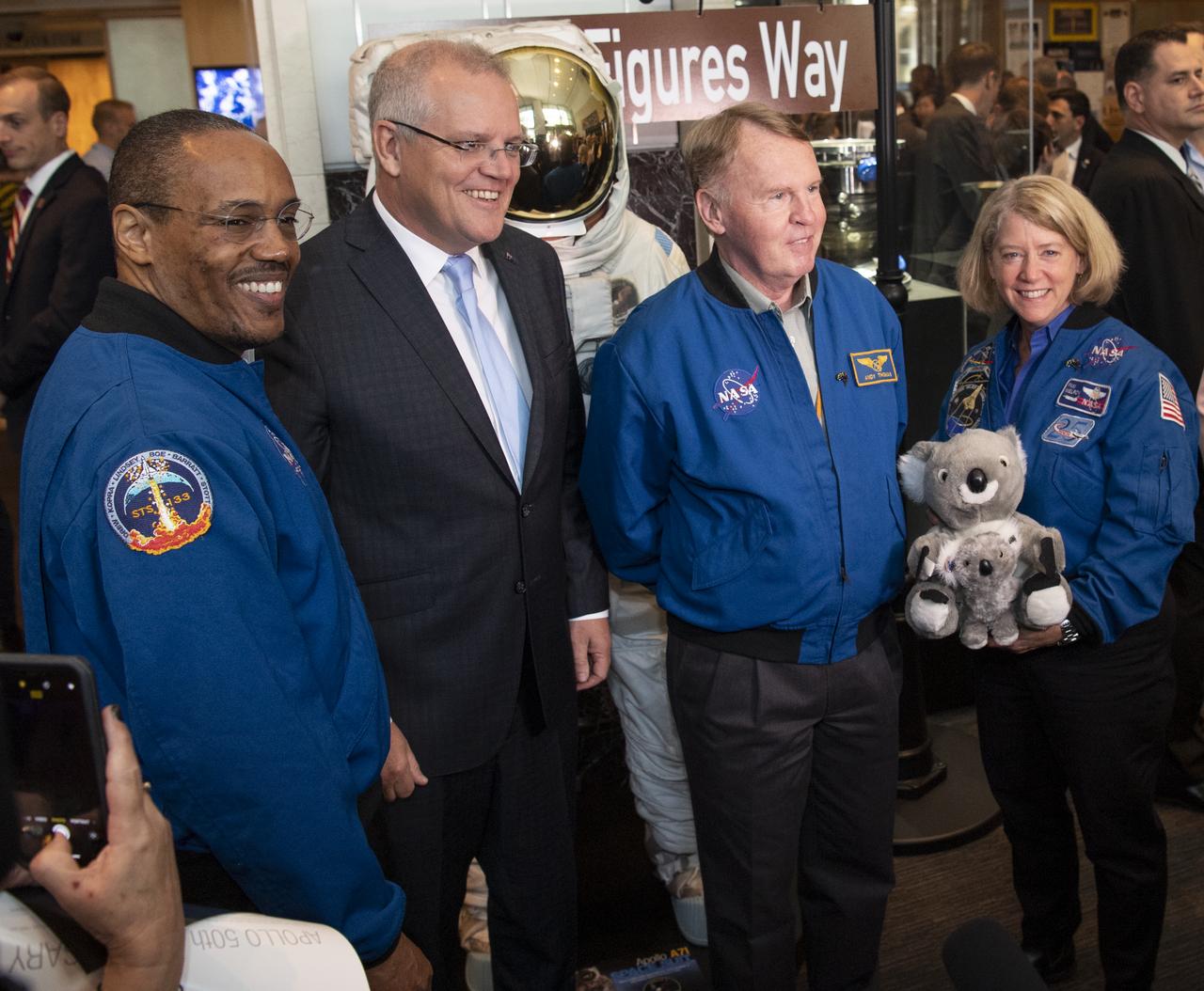
Australian Prime Minister Scott Morrison, second from left, poses for a picture with NASA astronaut Alvin Drew, left, and former NASA astronauts Andy Thomas, second from right, and Pam Melroy, right, following the signing of a letter of intent between NASA and the Australian Space Agency, Saturday, Sept. 21, 2019 at NASA Headquarters in Washington. NASA and the Australian Space Agency will build on over 60 years of collaboration in space exploration between the two countries and commit to expanding cooperation. Photo Credit: (NASA/Joel Kowsky)
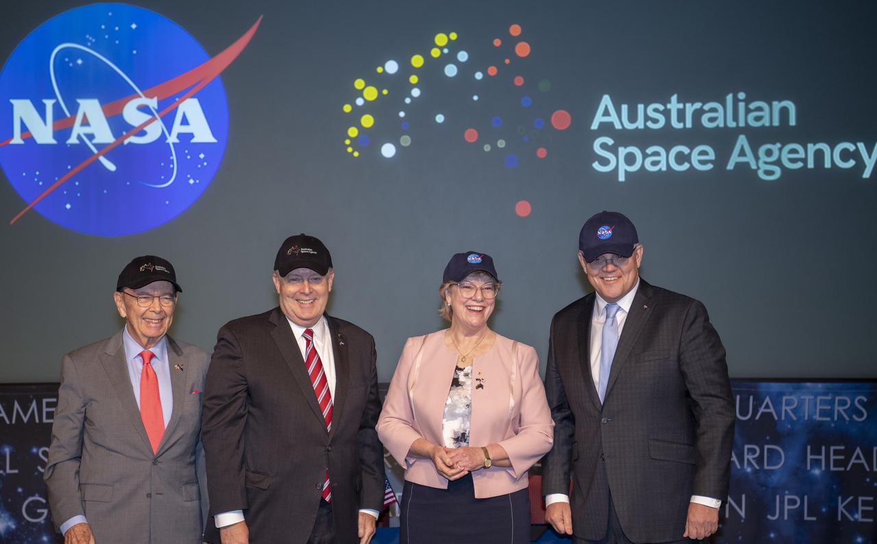
U.S. Secretary of Commerce Wilbur Ross, left, NASA Deputy Administrator Jim Morhard, second from left, Dr. Megan Clark, Head of the Australian Space Agency, second from right, and Australian Prime Minister Scott Morrison, right, pose for a picture after exchanging space agency hats following the signing of a letter of intent between NASA and the Australian Space Agency, Saturday, Sept. 21, 2019 at NASA Headquarters in Washington. NASA and the Australian Space Agency will build on over 60 years of collaboration in space exploration between the two countries and commit to expanding cooperation. Photo Credit: (NASA/Joel Kowsky)
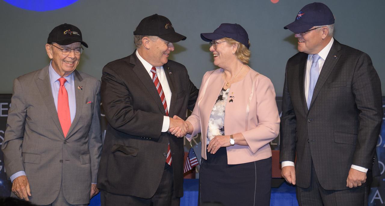
U.S. Secretary of Commerce Wilbur Ross, left, NASA Deputy Administrator Jim Morhard, second from left, Dr. Megan Clark, Head of the Australian Space Agency, second from right, and Australian Prime Minister Scott Morrison, right, pose for a picture after exchanging space agency hats following the signing of a letter of intent between NASA and the Australian Space Agency, Saturday, Sept. 21, 2019 at NASA Headquarters in Washington. NASA and the Australian Space Agency will build on over 60 years of collaboration in space exploration between the two countries and commit to expanding cooperation. Photo Credit: (NASA/Joel Kowsky)
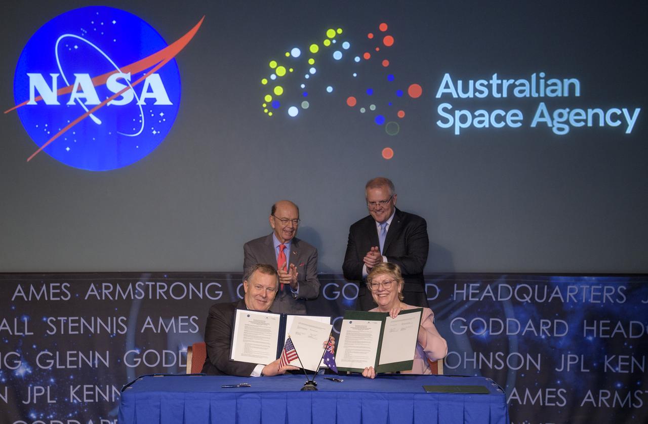
U.S. Secretary of Commerce Wilbur Ross, top left, and Australian Prime Minister Scott Morrison, top right, witness the signing of a letter of intent between NASA and the Australian Space Agency by NASA Deputy Administrator Jim Morhard, left, and Dr. Megan Clark, Head of the Australian Space Agency, right, Saturday, Sept. 21, 2019 at NASA Headquarters in Washington. NASA and the Australian Space Agency will build on over 60 years of collaboration in space exploration between the two countries and commit to expanding cooperation. Photo Credit: (NASA/Joel Kowsky)
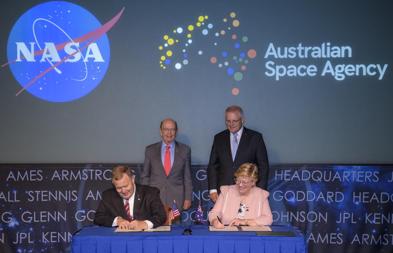
U.S. Secretary of Commerce Wilbur Ross, top left, and Australian Prime Minister Scott Morrison, top right, witness the signing of a letter of intent between NASA and the Australian Space Agency by NASA Deputy Administrator Jim Morhard, left, and Dr. Megan Clark, Head of the Australian Space Agency, right, Saturday, Sept. 21, 2019 at NASA Headquarters in Washington. NASA and the Australian Space Agency will build on over 60 years of collaboration in space exploration between the two countries and commit to expanding cooperation. Photo Credit: (NASA/Joel Kowsky)

NASA Deputy Administrator Jim Morhard, second from left, shakes hands with Dr. Megan Clark, Head of the Australian Space Agency, second from right, as they pose for a photo with U.S. Secretary of Commerce Wilbur Ross, left, and Australian Prime Minister Scott Morrison, right, following the signing of a letter of intent between NASA and the Australian Space Agency, Saturday, Sept. 21, 2019 at NASA Headquarters in Washington. NASA and the Australian Space Agency will build on over 60 years of collaboration in space exploration between the two countries and commit to expanding cooperation. Photo Credit: (NASA/Joel Kowsky)

NASA Deputy Administrator Jim Morhard delivers remarks prior the signing of a letter of intent between NASA and the Australian Space Agency, Saturday, Sept. 21, 2019 at NASA Headquarters in Washington. NASA and the Australian Space Agency will build on over 60 years of collaboration in space exploration between the two countries and commit to expanding cooperation. Photo Credit: (NASA/Joel Kowsky)

NASA Deputy Administrator Jim Morhard delivers remarks prior the signing of a letter of intent between NASA and the Australian Space Agency, Saturday, Sept. 21, 2019 at NASA Headquarters in Washington. NASA and the Australian Space Agency will build on over 60 years of collaboration in space exploration between the two countries and commit to expanding cooperation. Photo Credit: (NASA/Joel Kowsky)
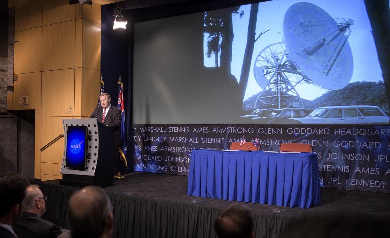
An image of the former Honeysuckle Creek Tracking Station near Canberra, Australia is seen on screen as NASA Deputy Administrator Jim Morhard delivers remarks prior the signing of a letter of intent between NASA and the Australian Space Agency, Saturday, Sept. 21, 2019 at NASA Headquarters in Washington. NASA and the Australian Space Agency will build on over 60 years of collaboration in space exploration between the two countries and commit to expanding cooperation. Photo Credit: (NASA/Joel Kowsky)
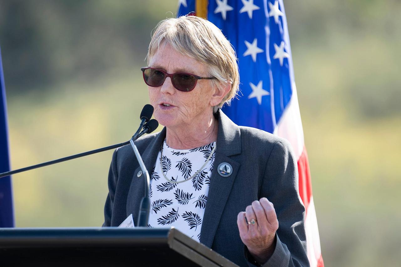
Suzanne Dodd, the director for the Interplanetary Network Directorate at NASA's Jet Propulsion Laboratory in Southern California, addresses an audience at the Deep Space Network's Canberra complex on March 19, 2025. That day marked 60 years since the Australian facility joined the network. JPL's Interplanetary Network Directorate oversees the Deep Space Network's three complexes in Canberra, Madrid, and Goldstone, near Barstow, California. JPL manages the Deep Space Network for the agency's Space Communications and Navigation program at NASA Headquarters in Washington. https://photojournal.jpl.nasa.gov/catalog/PIA26585

NASA Associate Administrator for STEM Engagement, Mike Kincaid, introduces the heads of agencies that will be participating in an interactive session with students, from left to right, Dr. Johann-Dietrich Worner, director general of the European Space Agency (ESA); NASA Administrator Jim Bridenstine; Sylvain Laporte, president of the Canadian Space Agency (CSA); Dr. Hiroshi Yamakawa, president of the Japan Aerospace Exploration Agency (JAXA); Anthony Murfett, deputy head fo the Australian Space Agency (ASA); Jeong Joo Park, Vice President fo the Korean Aerospace Research Institute (KARI); and H.E. Dr. Ahmad bin Abdulla Humaid Belhoul Al Falasi, Minister of State for Higher Education and Advanced Skills and Chairman of the UAE Space Agency (UAESA), during the 70th International Astronautical Congress, Monday, Oct. 21, 2019 at the Walter E. Washington Convention Center in Washington. Photo credit: (NASA/Aubrey Gemignani)
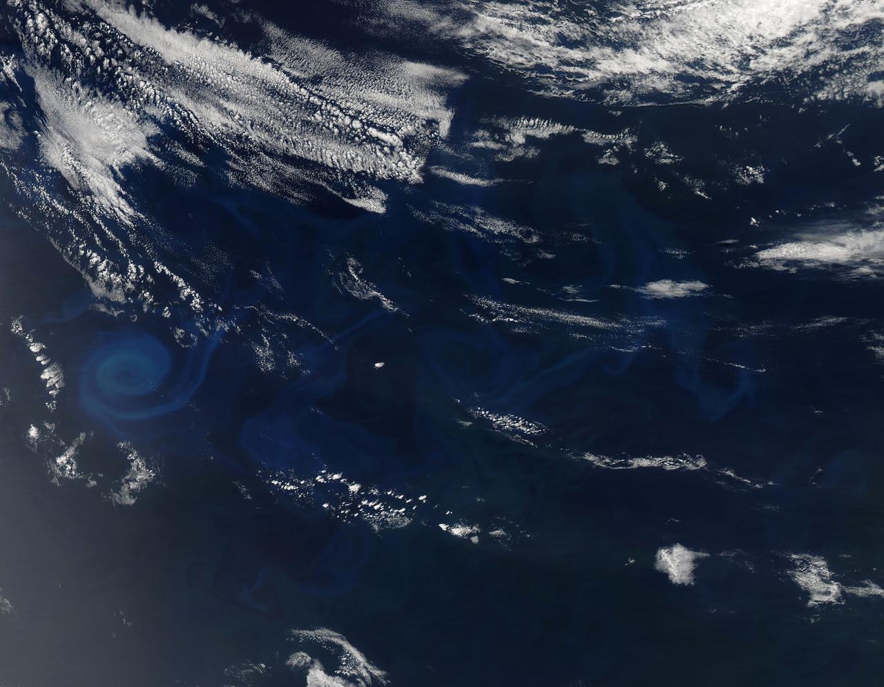
Phytoplankton bloom in the Great Australian Bight captured by the MODIS instrument on the Aqua satellite on December 30, 2013 at 6:05 UTC. The Great Australian Bight is a large bight, or open bay, off the central and western portions of the southern coastline of mainland Australia. Credit: NASA/GSFC/Jeff Schmaltz/MODIS Land Rapid Response Team <b><a href="http://www.nasa.gov/audience/formedia/features/MP_Photo_Guidelines.html" rel="nofollow">NASA image use policy.</a></b> <b><a href="http://www.nasa.gov/centers/goddard/home/index.html" rel="nofollow">NASA Goddard Space Flight Center</a></b> enables NASA’s mission through four scientific endeavors: Earth Science, Heliophysics, Solar System Exploration, and Astrophysics. Goddard plays a leading role in NASA’s accomplishments by contributing compelling scientific knowledge to advance the Agency’s mission. <b>Follow us on <a href="http://twitter.com/NASA_GoddardPix" rel="nofollow">Twitter</a></b> <b>Like us on <a href="http://www.facebook.com/pages/Greenbelt-MD/NASA-Goddard/395013845897?ref=tsd" rel="nofollow">Facebook</a></b> <b>Find us on <a href="http://instagram.com/nasagoddard?vm=grid" rel="nofollow">Instagram</a></b>
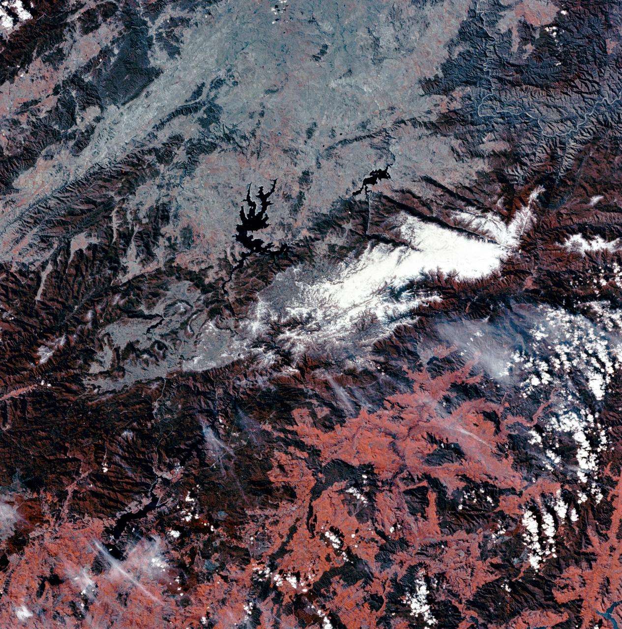
SL3-27-180 (July-September 1973) --- A vertical view of the Snowy Mountains area of Australian Alps in the States of Victoria and New South Wales, Australia, as photographed from Earth orbit by one of the six lenses of the Itek-furnished S190-A Multispectral Photographic Facility Experiment aboard the Skylab space station. This picture was taken with type 2443 infrared color film. The lake near the center of the picture is the Eucumbene Reservoir. This area is located immediately south-southwest of the capital city of Canberra. Federal agencies participating with NASA on the EREP project are the Departments of Agriculture, Commerce, Interior, the Environmental Protection Agency and the Corps of Engineers. All EREP photography is available to the public through the Department of Interior?s Earth Resources Observations Systems Data Center, Sioux Falls, South Dakota, 57198. Photo credit: NASA

NASA Administrator Jim Bridenstine, fourth from right, and Deputy Administrator Jim Morhard, fifth from right, speak with the Honorable Karen Andrews Minister of Parliament and Minister, Industry, Science and Technology, Austrailia, second from left, during the 70th International Astronautical Congress, Monday, Oct. 21, 2019 in Washington. Photo Credit: (NASA/Aubrey Gemignani)
NASA image acquired January 30, 2011 at 23:20 UTC. Satellite: Terra <b> Click here to see the most recent image captured Feb. 1: <a href="http://www.flickr.com/photos/gsfc/5407540724/">www.flickr.com/photos/gsfc/5407540724/</a></b> Tropical Storm Anthony made landfall in Queensland, Australia this past weekend, and now the residents are watching a larger, more powerful cyclone headed their way. NASA's Terra satellite captured a visible image of the large Tropical Cyclone Yasi late yesterday as it makes its way west through the Coral Sea toward Queensland. The Moderate Resolution Imaging Spectroradiometer (MODIS) instrument that flies aboard NASA's Terra satellite captured an image of Cyclone Yasi on Jan. 30 at 23:20 UTC (6:20 p.m. EST/09:20 a.m., Monday, January 31 in Australia/Brisbane local time). Although the image did not reveal a visible eye, the storm appears to be well-formed and also appears to be strengthening. Warnings and watches are already in effect throughout the Coral Sea. The Solomon Islands currently have a Tropical Cyclone warning for the provinces of Temotu, Rennell & Bellona, Makira and Guadalcanal. The Australian Bureau of Meteorology has already posted a Tropical Cyclone Watch from Cooktown to Yeppoon and inland to between Georgetown and Moranbah in Queensland, Australia. The Australian Bureau of Meteorology expects damaging winds to develop in coastal and island communities between Cooktown and Yeppoon Wednesday morning, and inland areas on Wednesday afternoon. Updates from the Australian Bureau of Meteorology can be monitored at the Bureau's website at <a href="http://www.bom.gov.au" rel="nofollow">www.bom.gov.au</a>. On January 31 at 1500 UTC (10 a.m. EST/ 1:00 a.m. Tuesday February 1, 2011 in Australia/Brisbane local time), Tropical Cyclone Yasi had maximum sustained winds near 90 knots (103 mph/166 kmh). Yasi is a Category Two Cyclone on the Saffir-Simpson Scale. It was centered about 875 miles E of Cairns, Australia, near 13.4 South latitude and 160.4 East longitude. It was moving west near 19 knots (22 mph/35 kmh). Cyclone-force winds extend out to 30 miles (48 km) from the center. Animated infrared satellite imagery, such as that from the Atmospheric Infrared Sounder (AIRS) that flies on NASA's Aqua satellite, showed deep convective (thunderstorm) bands wrapping tighter into the low level circulation center. Wrapping bands of thunderstorms indicate strengthening. Yasi is forecast to move west then southwestward into an area of low vertical wind shear (strong wind shear can weaken a storm). Forecasters at the Joint Typhoon Warning Center (JTWC) expect Yasi to continue strengthening over the next 36 hours. JTWC forecasts a landfall just south of Cairns as a large 100-plus knot (115 mph/185 kmh)n system by Wednesday. Residents along the Queensland coast should now be making preparations now for the storm's arrival. Rob Gutro NASA's Goddard Space Flight Center Credit: NASA/GSFC/Jeff Schmaltz/MODIS Land Rapid Response Team Click here to see more images from <b><a href="http://rapidfire.sci.gsfc.nasa.gov/gallery/?latest" rel="nofollow">MODIS</a></b> <b><a href="http://www.nasa.gov/centers/goddard/home/index.html" rel="nofollow">NASA Goddard Space Flight Center</a></b> enables NASA’s mission through four scientific endeavors: Earth Science, Heliophysics, Solar System Exploration, and Astrophysics. Goddard plays a leading role in NASA’s accomplishments by contributing compelling scientific knowledge to advance the Agency’s mission. <b>Follow us on <a href="http://twitter.com/NASA_GoddardPix" rel="nofollow">Twitter</a></b> <b>Join us on <a href="http://www.facebook.com/pages/Greenbelt-MD/NASA-Goddard/395013845897?ref=tsd" rel="nofollow">Facebook</a></b>

In late July 2013, a low pressure system off Australia’s southeast coast and moist onshore winds combined to create unsettled weather across central Australia – and a striking image of a broad cloud band across the stark winter landscape. The Moderate Resolution Imaging Spectroradiometer (MODIS) aboard NASA’s Terra satellite captured this true-color image on July 22 at 01:05 UTC (10:35 a.m. Australian Central Standard Time). To the west of the low pressure trough the skies are clear and dry. To the east, the broad band of bright white clouds obscures the landscape. The system brought wind, precipitation and cooler temperatures to the region. The same day as MODIS captured this image, the Naval Research Lab (NRL) published an edition of the Global Storm Tracker (GST), which gave a world-wide view of the low-pressure systems across the world. This tracker shows the entire cloud band across Australia, as well as the location of the low pressure system. A good view of the Storm Tracker is provided by Red Orbit at: <a href="http://www.redorbit.com/media/uploads/2013/07/072213-weather-003-storm-tracker.jpg" rel="nofollow">www.redorbit.com/media/uploads/2013/07/072213-weather-003...</a> Credit: NASA/GSFC/Jeff Schmaltz/MODIS Land Rapid Response Team <b><a href="http://www.nasa.gov/audience/formedia/features/MP_Photo_Guidelines.html" rel="nofollow">NASA image use policy.</a></b> <b><a href="http://www.nasa.gov/centers/goddard/home/index.html" rel="nofollow">NASA Goddard Space Flight Center</a></b> enables NASA’s mission through four scientific endeavors: Earth Science, Heliophysics, Solar System Exploration, and Astrophysics. Goddard plays a leading role in NASA’s accomplishments by contributing compelling scientific knowledge to advance the Agency’s mission. <b>Follow us on <a href="http://twitter.com/NASA_GoddardPix" rel="nofollow">Twitter</a></b> <b>Like us on <a href="http://www.facebook.com/pages/Greenbelt-MD/NASA-Goddard/395013845897?ref=tsd" rel="nofollow">Facebook</a></b> <b>Find us on <a href="http://instagram.com/nasagoddard?vm=grid" rel="nofollow">Instagram</a></b>
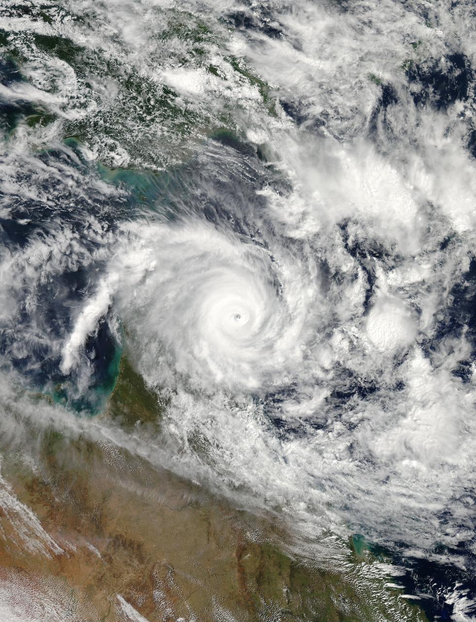
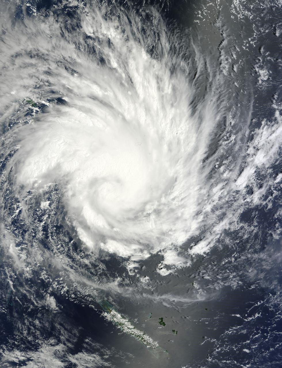
NASA's Aqua satellite passed over Tropical Cyclone Ita as it began making landfall on the Eastern Cape York Peninsula of Queensland, Australia, today, April 11, 2014. Ita officially made landfall at Cape Flattery about 9:00 p.m. local AEST time as a Category 4 storm according to reports from the Australian Broadcasting Corporation (ABC). The Moderate Resolution Imaging Spectroradiometer that flies aboard Aqua captured an image of the Category 4 storm on April 11 at 12:00 a.m. EDT (4 a.m. UTC). Satellite imagery indicates the eye is 9.2 miles wide (8 nautical miles, or 14.8 km). Warnings and watches remain in effect as the center of Ita is expected to remain at hurricane strength as it moves in a southerly direction, staying just west of Cairns over the next day. A tropical cyclone warning is in effect between Coen and Innisfail, including Cooktown, Port Douglas, Cairns, extending inland to Kalinga, Palmerville, Mareeba and Chillagoe. A tropical cyclone watch is in effect between Innisfail to Cardwell, extending inland. ABC reported that the strongest maximum sustained winds around the center of circulation were near 142.9 mph (124.2 knots, or 230 kph) and many trees have been downed and homes damaged. According to ABC, preliminary reports suggest that power may be out for a month in some areas. On April 11 at 5 a.m. EDT (9 a.m. UTC), Tropical Cyclone Ita had maximum sustained winds near 143.8 mph (125 knots, or 231.5 kph). It was centered near 14.8 degrees south latitude and 145.3 degrees east longitude, about 168 miles (146 nautical miles, or 288 km) north of Cairns, Australia, and has tracked south-southwestward at 10.3 mph (9 knots, or 16.6 kph). Ita is moving around a subtropical ridge (elongated area) of high pressure and the Joint Typhoon Warning Center expects Ita to start curving to the southeast around that ridge in the next day before heading back out into the Coral Sea. Credit: NASA/GSFC/Jeff Schmaltz/MODIS Land Rapid Response Team Rob Gutro, NASA's Goddard Space Flight Center, Greenbelt, Md. <b><a href="http://www.nasa.gov/audience/formedia/features/MP_Photo_Guidelines.html" rel="nofollow">NASA image use policy.</a></b> <b><a href="http://www.nasa.gov/centers/goddard/home/index.html" rel="nofollow">NASA Goddard Space Flight Center</a></b> enables NASA’s mission through four scientific endeavors: Earth Science, Heliophysics, Solar System Exploration, and Astrophysics. Goddard plays a leading role in NASA’s accomplishments by contributing compelling scientific knowledge to advance the Agency’s mission. <b>Follow us on <a href="http://twitter.com/NASAGoddardPix" rel="nofollow">Twitter</a></b> <b>Like us on <a href="http://www.facebook.com/pages/Greenbelt-MD/NASA-Goddard/395013845897?ref=tsd" rel="nofollow">Facebook</a></b> <b>Find us on <a href="http://instagram.com/nasagoddard?vm=grid" rel="nofollow">Instagram</a></b>
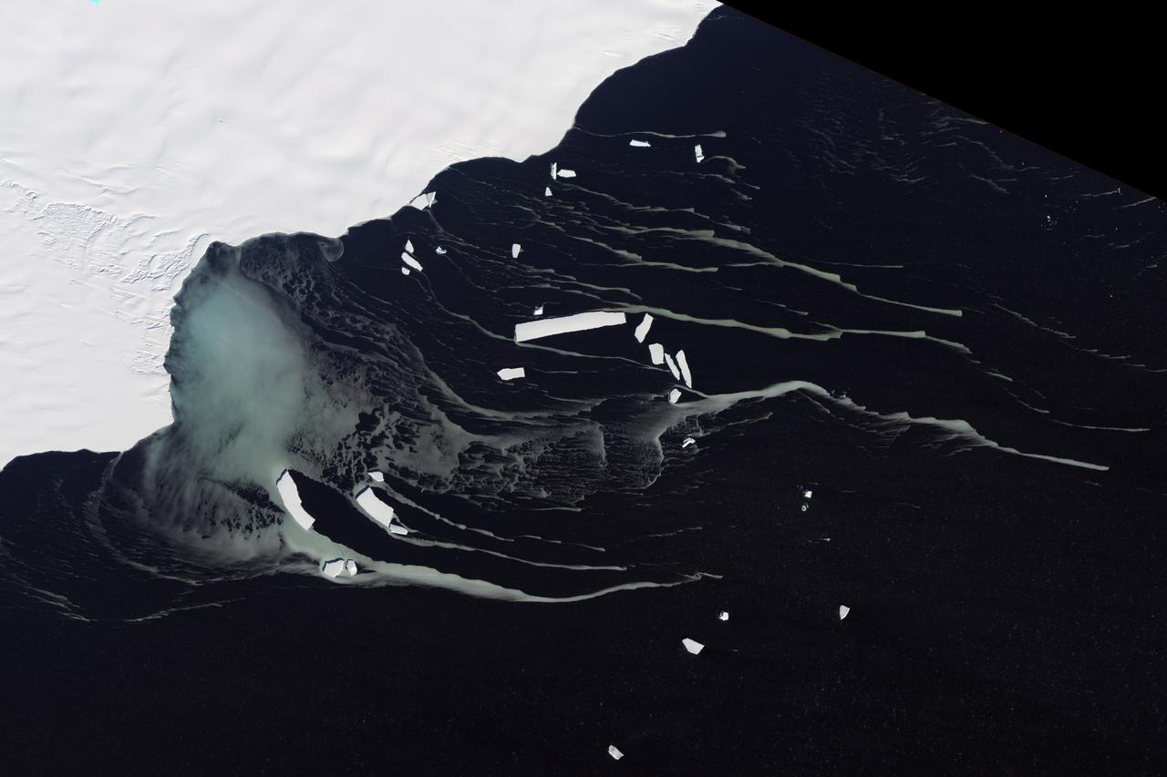
Off the northeastern edge of Antarctica’s Amery Ice Shelf lies Mackenzie Bay, which was painted with a ghostly blue-green mass in early February 2012. Similarly colored tendrils also streamed northward across the ocean, their flow sometimes interrupted by icebergs. Multiple factors might account for the ghostly shapes, including low-lying clouds or katabatic winds—downslope winds blowing toward the coast, which can freeze the water at the ocean surface. But an intriguing and perhaps more likely explanation involves processes occurring below the ice shelf. An ice shelf is a thick slab of ice often fed by glaciers attached to the coastline. The shelf floats on the ocean surface, with seawater circulating underneath. Like most ice shelves, the Amery is very thick in the upstream area near the shore. It thins significantly as it stretches northward away from the continent. Water at depth is subject to much greater pressure than water at the surface, and one effect of this intense pressure is that it effectively lowers the freezing point. So water circulating at depth beneath the Amery Ice Shelf may be slightly below the temperature at which it would normally begin to freeze. As some that water wells up along the underbelly of the shelf, the pressure is reduced and the water begins to freeze even though the temperature may not change. As it freezes, this deep-ocean water forms needle-like crystals known as frazil. The crystals are only 3 to 4 millimeters (0.12 to 0.16 inches) wide, but a sufficient concentration of frazil can change the appearance of the water. A frazil-rich plume probably accounts for the blue-green waters off the Amery Ice Shelf in the image above. Modeling of ocean circulation beneath the shelf indicates just such a plume emerging in that location. Frazil-rich water explains the plume, and wind transport of the surface water explains the long streams extending northward. As the sub-iceshelf water mixes with surface water around the Antarctic coastline, the frazil is gradually melted and the streams disappear. The Advanced Land Imager (ALI) on NASA’s Earth Observing-1 (EO-1) satellite captured this natural-color image of Mackenzie Bay and the ice shelf on February 12, 2012. NASA Earth Observatory image created by Jesse Allen and Robert Simmon, using EO-1 ALI data provided courtesy of the NASA EO-1 team. Caption by Michon Scott with information from Helen A. Fricker, Scripps Institution of Oceanography; Robert Massom, Australian Antarctic Division; Ben Galton-Fenzi, University of Tasmania, Australia; and Florence Fetterer, Walt Meier, and Ted Scambos, National Snow and Ice Data Center. Credit: <b><a href="http://www.earthobservatory.nasa.gov/" rel="nofollow"> NASA Earth Observatory</a></b> <b><a href="http://www.nasa.gov/audience/formedia/features/MP_Photo_Guidelines.html" rel="nofollow">NASA image use policy.</a></b> <b><a href="http://www.nasa.gov/centers/goddard/home/index.html" rel="nofollow">NASA Goddard Space Flight Center</a></b> enables NASA’s mission through four scientific endeavors: Earth Science, Heliophysics, Solar System Exploration, and Astrophysics. Goddard plays a leading role in NASA’s accomplishments by contributing compelling scientific knowledge to advance the Agency’s mission. <b>Follow us on <a href="http://twitter.com/NASA_GoddardPix" rel="nofollow">Twitter</a></b> <b>Like us on <a href="http://www.facebook.com/pages/Greenbelt-MD/NASA-Goddard/395013845897?ref=tsd" rel="nofollow">Facebook</a></b> <b>Find us on <a href="http://instagrid.me/nasagoddard/?vm=grid" rel="nofollow">Instagram</a></b> Instrument: EO-1 - ALI