
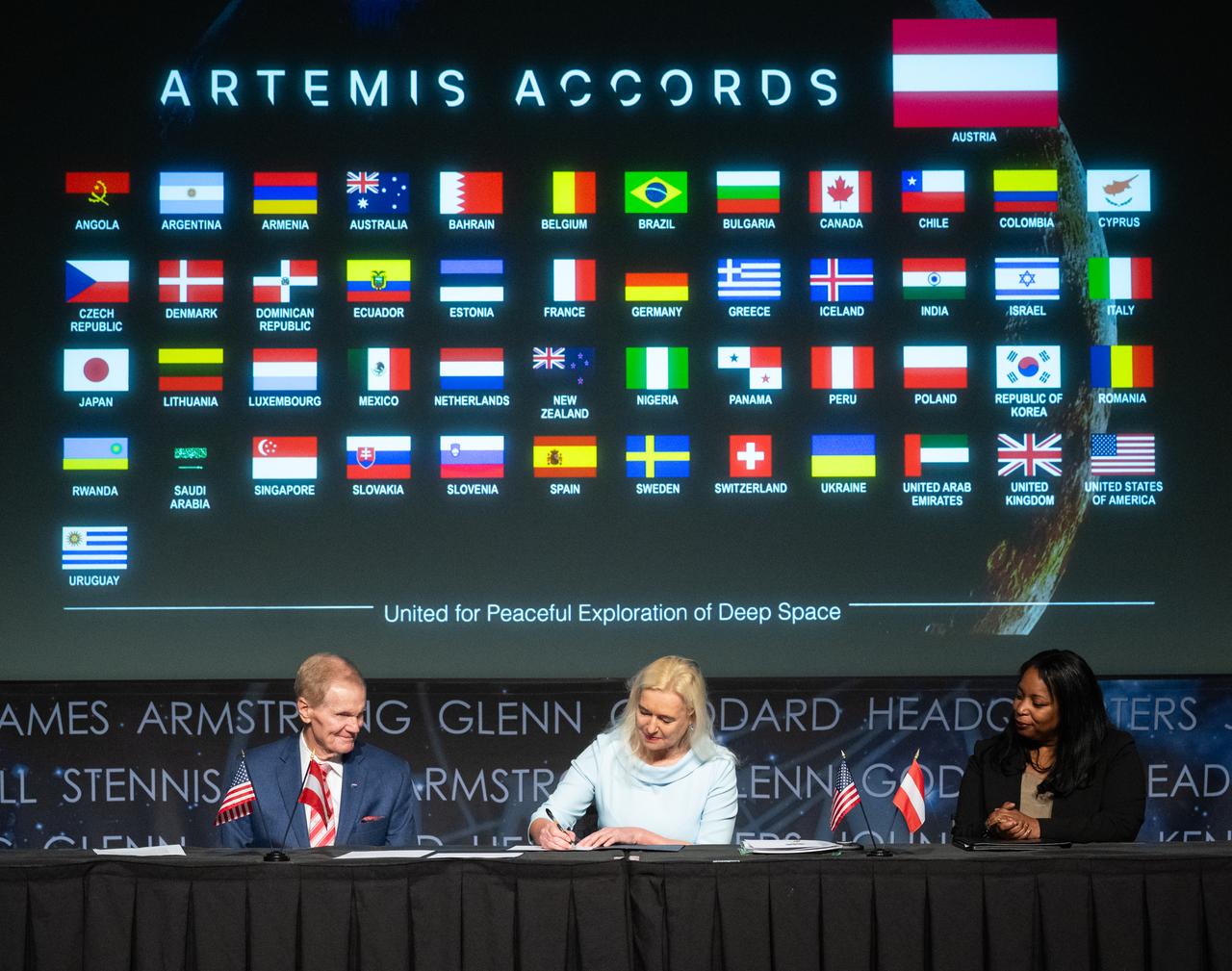
The flags of the United States and the Republic of Austria are seen before an Artemis Accords signing ceremony, Wednesday, Dec. 11, 2024, at the Mary W. Jackson NASA Headquarters building in Washington. The Republic of Austria is the 50th country to sign the Artemis Accords, which establish a practical set of principles to guide space exploration cooperation among nations participating in NASA’s Artemis program. Photo Credit: (NASA/Joel Kowsky)
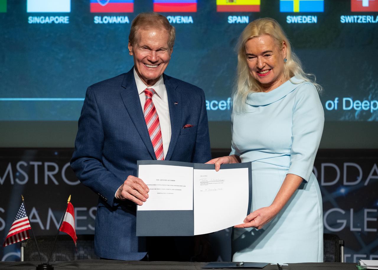
NASA Administrator Bill Nelson, left, and Ambassador of the Republic of Austria to the United States of America Petra Schneebauer, pose for a picture after the Republic of Austria signed the Artemis Accords, Wednesday, Dec. 11, 2024, at the Mary W. Jackson NASA Headquarters building in Washington. The Republic of Austria is the 50th country to sign the Artemis Accords, which establish a practical set of principles to guide space exploration cooperation among nations participating in NASA’s Artemis program. Photo Credit: (NASA/Joel Kowsky)

NASA Administrator Bill Nelson, left, and Ambassador of the Republic of Austria to the United States of America Petra Schneebauer, shake hands after the Republic of Austria signed the Artemis Accords, Wednesday, Dec. 11, 2024, at the Mary W. Jackson NASA Headquarters building in Washington. The Republic of Austria is the 50th country to sign the Artemis Accords, which establish a practical set of principles to guide space exploration cooperation among nations participating in NASA’s Artemis program. Photo Credit: (NASA/Joel Kowsky)
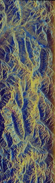
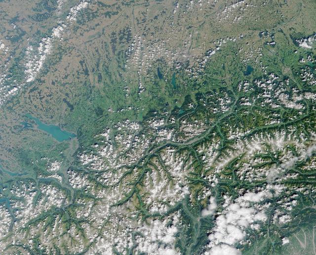
This image is a false-color composite of Oetzal, Austria located in the Central Alps centered at 46.8 degrees north latitude, 10.70 degrees east longitude, at the border between Switzerland top, Italy left and Austria right and bottom.

NASA Administrator Bill Nelson speaks to members of the media after Austria signed the Artemis Accords, Wednesday, Dec. 11, 2024, at the Mary W. Jackson NASA Headquarters building in Washington. The Republic of Austria is the 50th country to sign the Artemis Accords, which establish a practical set of principles to guide space exploration cooperation among nations participating in NASA’s Artemis program. Photo Credit: (NASA/Joel Kowsky)

Ambassador of the Republic of Austria to the United States of America Petra Schneebauer delivers remarks during an Artemis Accords signing ceremony, Wednesday, Dec. 11, 2024, at the Mary W. Jackson NASA Headquarters building in Washington. The Republic of Austria is the 50th country to sign the Artemis Accords, which establish a practical set of principles to guide space exploration cooperation among nations participating in NASA’s Artemis program. Photo Credit: (NASA/Joel Kowsky)

NASA Administrator Bill Nelson speaks to members of the media after Austria signed the Artemis Accords, Wednesday, Dec. 11, 2024, at the Mary W. Jackson NASA Headquarters building in Washington. The Republic of Austria is the 50th country to sign the Artemis Accords, which establish a practical set of principles to guide space exploration cooperation among nations participating in NASA’s Artemis program. Photo Credit: (NASA/Joel Kowsky)

Ambassador of the Republic of Austria to the United States of America Petra Schneebauer, speaks with a member of the media after signing the Artemis Accords, Wednesday, Dec. 11, 2024, at the Mary W. Jackson NASA Headquarters building in Washington. The Republic of Austria is the 50th country to sign the Artemis Accords, which establish a practical set of principles to guide space exploration cooperation among nations participating in NASA’s Artemis program. Photo Credit: (NASA/Joel Kowsky)

Ambassador of the Republic of Austria to the United States of America Petra Schneebauer delivers remarks during an Artemis Accords signing ceremony, Wednesday, Dec. 11, 2024, at the Mary W. Jackson NASA Headquarters building in Washington. The Republic of Austria is the 50th country to sign the Artemis Accords, which establish a practical set of principles to guide space exploration cooperation among nations participating in NASA’s Artemis program. Photo Credit: (NASA/Joel Kowsky)

Ambassador of the Republic of Austria to the United States of America Petra Schneebauer, signs the Artemis Accords, Wednesday, Dec. 11, 2024, at the Mary W. Jackson NASA Headquarters building in Washington. The Republic of Austria is the 50th country to sign the Artemis Accords, which establish a practical set of principles to guide space exploration cooperation among nations participating in NASA’s Artemis program. Photo Credit: (NASA/Joel Kowsky)
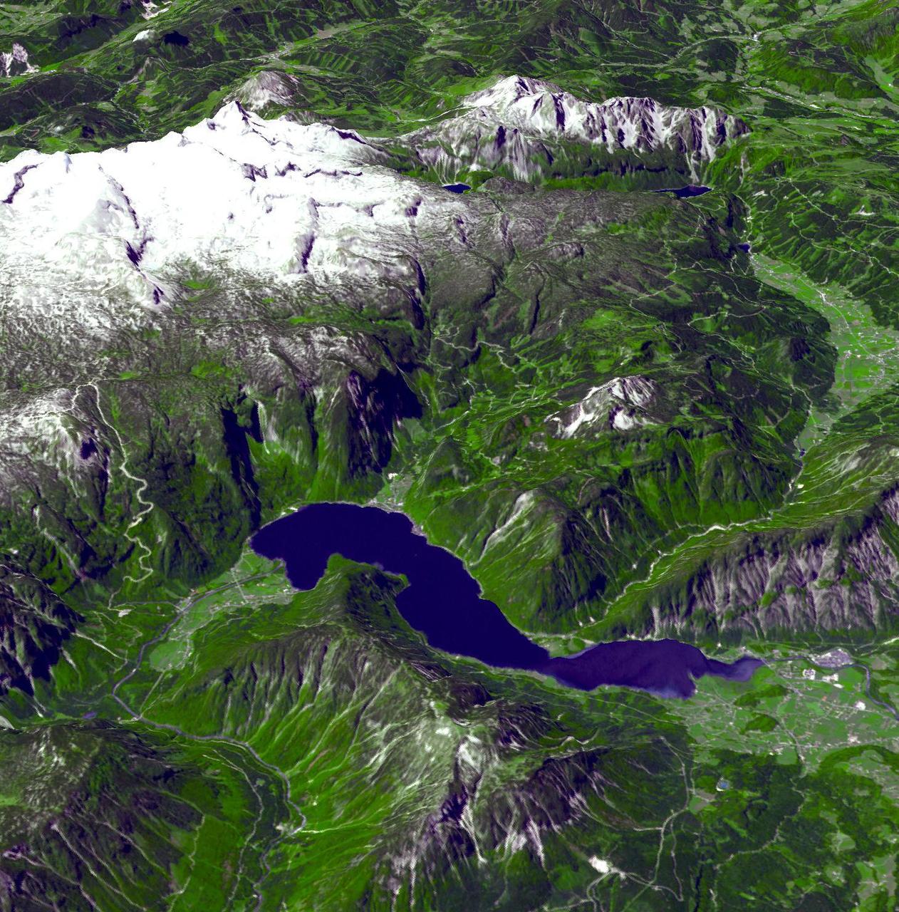
This perspective view from the Advanced Spaceborne Thermal Emission and Reflection Radiometer instrument aboard NASA Terra spacecraft shows the magnificent natural landscape of Salzkammergut, Austria.

NASA Administrator Bill Nelson looks on as Ambassador of the Republic of Austria to the United States of America Petra Schneebauer, signs the Artemis Accords, Wednesday, Dec. 11, 2024, at the Mary W. Jackson NASA Headquarters building in Washington. The Republic of Austria is the 50th country to sign the Artemis Accords, which establish a practical set of principles to guide space exploration cooperation among nations participating in NASA’s Artemis program. Photo Credit: (NASA/Joel Kowsky)
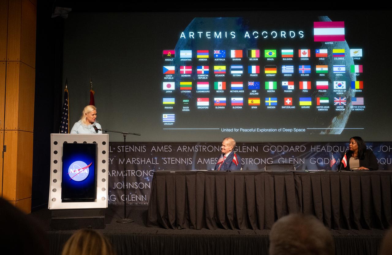
Ambassador of the Republic of Austria to the United States of America Petra Schneebauer delivers remarks as NASA Administrator Bill Nelson and U.S. Department of State Acting Assistant Secretary in the Bureau of Oceans and International Environmental and Scientific Affairs Jennifer R. Littlejohn look on during an Artemis Accords signing ceremony, Wednesday, Dec. 11, 2024, at the Mary W. Jackson NASA Headquarters building in Washington. The Republic of Austria is the 50th country to sign the Artemis Accords, which establish a practical set of principles to guide space exploration cooperation among nations participating in NASA’s Artemis program. Photo Credit: (NASA/Joel Kowsky)

U.S. Department of State Acting Assistant Secretary in the Bureau of Oceans and International Environmental and Scientific Affairs Jennifer R. Littlejohn delivers remarks as NASA Administrator Bill Nelson and Ambassador of the Republic of Austria to the United States of America Petra Schneebauer look on during an Artemis Accords signing ceremony, Wednesday, Dec. 11, 2024, at the Mary W. Jackson NASA Headquarters building in Washington. The Republic of Austria is the 50th country to sign the Artemis Accords, which establish a practical set of principles to guide space exploration cooperation among nations participating in NASA’s Artemis program. Photo Credit: (NASA/Joel Kowsky)
NASA Administrator Bill Nelson, left, and U.S. Department of State Acting Assistant Secretary in the Bureau of Oceans and International Environmental and Scientific Affairs Jennifer R. Littlejohn, right, look on as Ambassador of the Republic of Austria to the United States of America Petra Schneebauer, signs the Artemis Accords, Wednesday, Dec. 11, 2024, at the Mary W. Jackson NASA Headquarters building in Washington. The Republic of Austria is the 50th country to sign the Artemis Accords, which establish a practical set of principles to guide space exploration cooperation among nations participating in NASA’s Artemis program. Photo Credit: (NASA/Joel Kowsky)

U.S. Department of State Acting Assistant Secretary in the Bureau of Oceans and International Environmental and Scientific Affairs Jennifer R. Littlejohn delivers remarks as NASA Administrator Bill Nelson and Ambassador of the Republic of Austria to the United States of America Petra Schneebauer look on during an Artemis Accords signing ceremony, Wednesday, Dec. 11, 2024, at the Mary W. Jackson NASA Headquarters building in Washington. The Republic of Austria is the 50th country to sign the Artemis Accords, which establish a practical set of principles to guide space exploration cooperation among nations participating in NASA’s Artemis program. Photo Credit: (NASA/Joel Kowsky)

U.S. Department of State Acting Assistant Secretary in the Bureau of Oceans and International Environmental and Scientific Affairs Jennifer R. Littlejohn delivers remarks as NASA Administrator Bill Nelson and Ambassador of the Republic of Austria to the United States of America Petra Schneebauer look on during an Artemis Accords signing ceremony, Wednesday, Dec. 11, 2024, at the Mary W. Jackson NASA Headquarters building in Washington. The Republic of Austria is the 50th country to sign the Artemis Accords, which establish a practical set of principles to guide space exploration cooperation among nations participating in NASA’s Artemis program. Photo Credit: (NASA/Joel Kowsky)

Ambassador of the Republic of Austria to the United States of America Petra Schneebauer delivers remarks as NASA Administrator Bill Nelson and U.S. Department of State Acting Assistant Secretary in the Bureau of Oceans and International Environmental and Scientific Affairs Jennifer R. Littlejohn look on during an Artemis Accords signing ceremony, Wednesday, Dec. 11, 2024, at the Mary W. Jackson NASA Headquarters building in Washington. The Republic of Austria is the 50th country to sign the Artemis Accords, which establish a practical set of principles to guide space exploration cooperation among nations participating in NASA’s Artemis program. Photo Credit: (NASA/Joel Kowsky)

NASA Administrator Bill Nelson, left, and U.S. Department of State Acting Assistant Secretary in the Bureau of Oceans and International Environmental and Scientific Affairs Jennifer R. Littlejohn, right, look on as Ambassador of the Republic of Austria to the United States of America Petra Schneebauer, signs the Artemis Accords, Wednesday, Dec. 11, 2024, at the Mary W. Jackson NASA Headquarters building in Washington. The Republic of Austria is the 50th country to sign the Artemis Accords, which establish a practical set of principles to guide space exploration cooperation among nations participating in NASA’s Artemis program. Photo Credit: (NASA/Joel Kowsky)

Meira Bernstein, NASA Press Secretary, introduces NASA Administrator Bill Nelson during an Artemis Accords signing ceremony, Wednesday, Dec. 11, 2024, at the Mary W. Jackson NASA Headquarters building in Washington. The Republic of Austria is the 50th country to sign the Artemis Accords, which establish a practical set of principles to guide space exploration cooperation among nations participating in NASA’s Artemis program. Photo Credit: (NASA/Joel Kowsky)

NASA Administrator Bill Nelson delivers remarks during an Artemis Accords signing ceremony, Wednesday, Dec. 11, 2024, at the Mary W. Jackson NASA Headquarters building in Washington. The Republic of Austria is the 50th country to sign the Artemis Accords, which establish a practical set of principles to guide space exploration cooperation among nations participating in NASA’s Artemis program. Photo Credit: (NASA/Joel Kowsky)

NASA Administrator Bill Nelson delivers remarks during an Artemis Accords signing ceremony, Wednesday, Dec. 11, 2024, at the Mary W. Jackson NASA Headquarters building in Washington. The Republic of Austria is the 50th country to sign the Artemis Accords, which establish a practical set of principles to guide space exploration cooperation among nations participating in NASA’s Artemis program. Photo Credit: (NASA/Joel Kowsky)

NASA Administrator Bill Nelson delivers remarks during an Artemis Accords signing ceremony, Wednesday, Dec. 11, 2024, at the Mary W. Jackson NASA Headquarters building in Washington. The Republic of Austria is the 50th country to sign the Artemis Accords, which establish a practical set of principles to guide space exploration cooperation among nations participating in NASA’s Artemis program. Photo Credit: (NASA/Joel Kowsky)

NASA Administrator Bill Nelson delivers remarks during an Artemis Accords signing ceremony, Wednesday, Dec. 11, 2024, at the Mary W. Jackson NASA Headquarters building in Washington. The Republic of Austria is the 50th country to sign the Artemis Accords, which establish a practical set of principles to guide space exploration cooperation among nations participating in NASA’s Artemis program. Photo Credit: (NASA/Joel Kowsky)
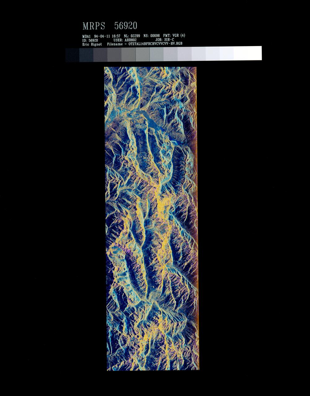
STS059-S-072 (13 April 1994) --- This image is a false-color composite of Oetztal, Austria located in the Central Alps, centered at 46.8 degrees north latitude, and 10.70 degrees east longitude, at the border between Switzerland (top), Italy (left) and Austria (right and bottom). The area shown is 50 kilometers (30 miles) south of Innsbruck, Austria. This image was acquired by the Spaceborne Imaging Radar-C and X-Band Synthetic Aperture Radar (SIR-C/X-SAR) aboard the Space Shuttle Endeavour on its 14th orbit. Oetztal is a SIR-C/X-SAR hydrology supersite. Approximately one quarter of this image is covered by glaciers, the largest of which, Gepatschferner, is visible as a triangular yellow patch in the center of the scene. The summits of the main peaks reach elevations between 3,500 and 3,768 meters (11,500 and 12,362 feet) above sea level. The tongues of the glaciers are descending from elevated plateaus down into narrow valleys which were formed during the last ice age. This color image was produced in C-Band using multi-polarization information (Red=CHV, Green=CVV, Blue=CVV/CHV). The blue areas are lakes (Gepatsch Dam at center right; Lake Muta at top right) and glacier ice. The yellow areas are slopes facing the radar and areas of dry snow. Purple corresponds to slopes facing away from the radar. Yellow in the valley bottom corresponds to tree covered areas. There is 30 to 50 centimeters (12 to 20 inches) of dry, fresh snow on the glaciers, and about 10 centimeters (4 inches) in the valley at the city of Vent, Austria (center). At these data were taken, the weather was cold, with snow and thick fog. The entire area would appear white to an optical sensor because it is all covered under a winter snowpack. Researchers are interested in Oetztal because knowing how glaciers shrink and grow over time is an important indication of climatic change. SIR-C/X-SAR is part of NASA's Mission to Planet Earth (MTPE). SIR-C/X-SAR radars illuminate Earth with microwaves allowing detailed observations at any time, regardless of weather or sunlight conditions. SIR-C/X-SAR uses three microwave wavelengths: L-Band (24 cm), C-Band (6 cm), and X-Band (3 cm). The multi-frequency data will be used by the international scientific community to better understand the global environment and how it is changing. The SIR-C/X-SAR data, complemented by aircraft and ground studies, will give scientists clearer insights into those environmental changes which are caused by nature and those changes which are induced by human activity. SIR-C was developed by NASA's Jet Propulsion Laboratory (JPL). X-SAR was developed by the Dornire and Alenia Spazio Companies for the German Space Agency, Deutsche Agentur fuer Raumfahrtangelegenheiten (DARA), and the Italian Space Agency, Agenzia Spaziale Italiana (ASI). JPL Photo ID: P-43890
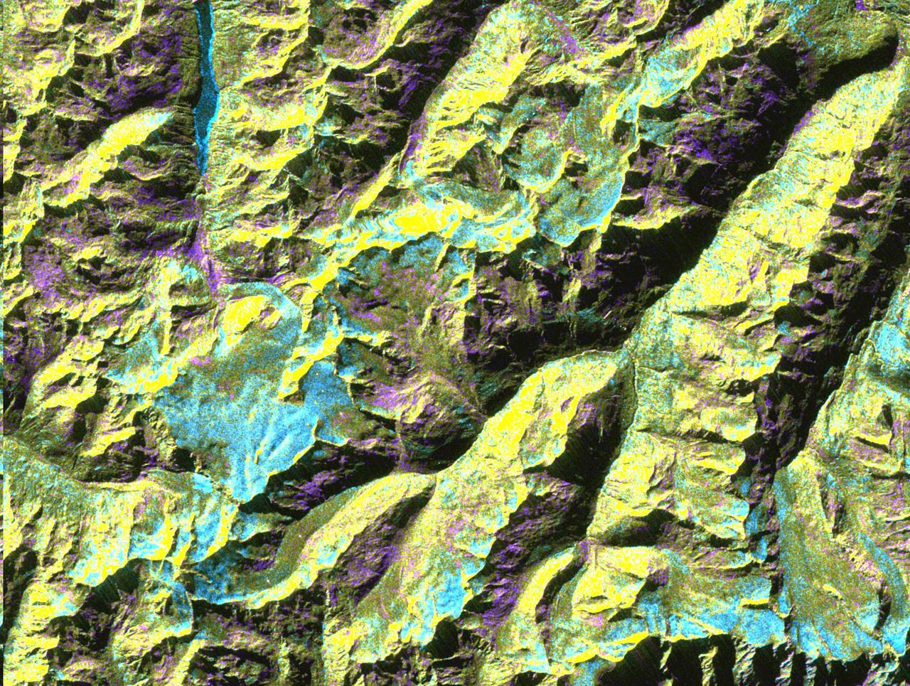
This is a digital elevation model that was geometrically coded directly onto an X-band seasonal change image of the Oetztal supersite in Austria. The image is centered at 46.82 degrees north latitude and 10.79 degrees east longitude. This image is located in the Central Alps at the border between Switzerland, Italy and Austria, 50 kilometers (31 miles) southwest of Innsbruck. It was acquired by the Spaceborne Imaging Radar-C/X-band Synthetic Aperture aboard the space shuttle Endeavour on April 14, 1994 and on October 5, 1994. It was produced by combining data from these two different data sets. Data obtained in April is green; data obtained in October appears in red and blue, and was used as an enhancement based on the ratio of the two data sets. Areas with a decrease in backscatter from April to October appear in light blue (cyan), such as the large Gepatschferner glacier seen at the left of the image center, and most of the other glaciers in this view. A light blue hue is also visible at the east border of the dark blue Lake Reschensee at the upper left side. This shows a significant rise in the water level. Magenta represents areas with an increase of backscatter from April 10 to October 5. Yellow indicates areas with high radar signal response during both passes, such as the mountain slopes facing the radar. Low radar backscatter signals refer to smooth surface (lakes) or radar grazing areas to radar shadow areas, seen in the southeast slopes. The area is approximately 29 kilometers by 21 kilometers (18 miles by 13.5 miles). The summit of the main peaks reaches elevations of 3,500 to 3,768 meters (xx feet to xx feet) above sea level. The test site's core area is the glacier region of Venter Valley, which is one of the most intensively studied areas for glacier research in the world. Research in Venter Valley (below center) includes studies of glacier dynamics, glacier-climate regions, snowpack conditions and glacier hydrology. About 25 percent of the core test site is covered by glaciers. Corner reflectors are set up for calibration. Five corner reflectors can be seen on the Gepatschferner and two can be seen on the Vernagtferner. http://photojournal.jpl.nasa.gov/catalog/PIA01760
This image acquired by NASA Terra spacecraft is of the Principality of Liechtenstein, a landlocked alpine country between Austria and Switzerland.
Lake Constance, bordered by Switzerland, Germany, and Austria. This image from NASA Terra satellite is MISR Mystery Image Quiz #2.

iss074e0149548 (Jan. 18, 2026) --- Vienna, Austria, and Bratislava, Slovakia, light up the Central European nightscape, each divided by the Danube River. Surrounding the two capital cities are wine‑country towns and historic market villages that dot the landscape. The International Space Station was orbiting 262 miles above Earth at approximately 9:09 p.m. local time when this photograph was taken. Credit: NASA/Chris Williams

iss064e005231 (Nov. 21, 2020) --- Vienna, Austria, is pictured during a night pass from the International Space Station as it orbited 263 miles above.

iss070e080294 (Jan. 23, 2024) --- Clouds stop on the peaks of the snow-capped Alps that separate Italy's Po Valley from Austria in this photograph from the International Space Station as it orbited 261 miles above.

iss072e143829 (Nov. 2, 2024) -- The first rays of an orbital sunrise display pink and blue hues in Earth's atmosphere as the International Space Station orbited 257 miles above Austria.

The InSight Team at Lockheed Martin Space in May 2017 The InSight team is comprised of scientists and engineers from multiple disciplines and is a unique collaboration between countries and organizations around the world. The science team includes co-investigators from the U.S., France, Germany, Austria, Belgium, Canada, Japan, Switzerland and the United Kingdom. https://photojournal.jpl.nasa.gov/catalog/PIA22235

iss072e034791 (Oct. 11, 2024) --- NASA astronaut and Expedition 72 Flight Engineer Nick Hague is pictured inside the cupola with space botany hardware that supports the Rhodium Plant LIFE investigation. The experiment studies the affects of radiation and microgravity on plant growth to promote self-sustainable long-term human missions and increase crop production on Earth. The International Space Station was orbiting 259 miles above the Alps in Austria at the time of this photograph.

The InSight Team at NASA's Jet Propulsion Laboratory, JPL, in June 2015. The InSight team is comprised of scientists and engineers from multiple disciplines and is a unique collaboration between countries and organizations around the world. The science team includes co-investigators from the U.S., France, Germany, Austria, Belgium, Canada, Japan, Switzerland and the United Kingdom. https://photojournal.jpl.nasa.gov/catalog/PIA22234

STS085-501-069 (7 - 19 August 1997) --- This 70mm frame was photographed from the Space Shuttle Discovery during the mission. Bare, brown rock and snow-capped Alpine summits in Austria contrast with dark, heavily-wooded upper slopes, the patchy silviculture of lower slopes, and completely farmed plains of Bavaria to the north. The large river is the Inn; Innsbruck is visible within the flat-bottomed, formerly glaciated valley. The new and old airports of Munich are prominent on the flat land to the north. Oberpfaffenhofen, the home of the German Space Agency (DARA), can be picked out west of Munich, south of an autobahn.

STS098-716-034 (18 February 2001) --- This east-to-west orbital view of the Inn River Valley of southern Austria was photographed by one the crew members of Atlantis during Space Shuttle Mission STS-98 on February 18, 2001, as the spacecraft orbited Earth at an altitude of 173 nautical miles (320 kilometers). Despite the heavy ground fog in the lower valleys, this 70mm handheld camera's photo provides a strikingly detailed view of the Italian, Swiss and Austrian Alps of central Europe. For example, the famous Brenner Pass, an historic gateway connecting Italy to the rest of Europe, can be seen in the left central foreground. The Austrian city of Innsbruck on the Inn River, scene of the 1964 and 1976 Winter Olympics, and normally visible in great detail, is completely masked by heavy ground fog. Center coordinates of the pictured area are located at 47.5 degrees north latitude and 12.5 degrees east longitude.

A truck arrives at NASA's Jet Propulsion Laboratory in Southern California on June 3, 2024, to deliver the Medium Articulating Transportation System (MATS), which will be used during the construction and transportation of components for NASA's Near-Earth Object Surveyor mission. Originating at the aerospace company Beyond Gravity in Vienna, Austria, the MATS traveled via ship through the Panama Canal to Port Hueneme, California, before arriving by road at JPL. Construction has begun on NEO Surveyor's instrument enclosure in the High Bay 1 clean room at JPL's Spacecraft Assembly Facility. When the enclosure is complete later this year, it will be moved inside the MATS to NASA's Johnson Space Center in Houston for environmental testing. The MATS is a transportable clean room with its own filtration and climate control systems that keep the spacecraft and components clean, stable, and safe while being moved between facilities. NEO Surveyor's instrument enclosure contains the spacecraft's telescope, mirrors, and infrared sensors that will be used to detect, track, and characterize the most hazardous near-Earth objects. BAE Systems, Space Dynamics Laboratory, and Teledyne are among the aerospace and engineering companies contracted to build the spacecraft and its instrumentation. The Laboratory for Atmospheric and Space Physics at the University of Colorado, Boulder will support operations, and IPAC at Caltech in Pasadena, California, is responsible for processing survey data and producing the mission's data products. JPL manages the project; Caltech manages JPL for NASA. Launching no earlier than 2027, NEO Surveyor supports the objectives of NASA's Planetary Defense Coordination Office (PDCO) at NASA Headquarters in Washington. The NASA Authorization Act of 2005 directed NASA to discover and characterize at least 90% of the near-Earth objects more than 140 meters (460 feet) across that come within 30 million miles (48 million kilometers) of our planet's orbit. Objects of this size can cause significant regional damage, or worse, should they impact the Earth. https://photojournal.jpl.nasa.gov/catalog/PIA26381
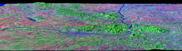
After draining the northern flank of the Alps Mountains in Germany and Austria, the Danube River flows east as it enters this west-looking scene (upper right) and forms the border between Slovakia and Hungary. The river then leaves the border as it enters Hungary and transects the Transdanubian Mountains, which trend southwest to northeast. Upon exiting the mountains, the river turns southward, flowing past Budapest (purplish blue area) and along the western margin of the Great Hungarian Plain. South and west of the Danube, the Transdanubian Mountains have at most only about 400 meters (about 1300 feet) of relief but they exhibit varied landforms, which include volcanic, tectonic, fluvial (river), and eolian (wind) features. A thick deposit of loess (dust deposits likely blown from ancient glacial outwash) covers much of this area, and winds from the northwest, funneled between the Alps and the Carpathian Mountains, are apparently responsible for a radial pattern of erosional streaks across the entire region. This image was generated from a Landsat satellite image draped over an elevation model produced by the Shuttle Radar Topography Mission (SRTM). The view uses a 3-times vertical exaggeration to enhance topographic expression. The false colors of the scene result from displaying Landsat bands 1, 4, and 7 in blue, green, and red, respectively. Band 1 is visible blue light, but bands 4 and 7 are reflected infrared light. This band combination maximizes color contrasts between the major land cover types, namely vegetation (green), bare ground (red), and water (blue). Shading of the elevation model was used to further highlight the topographic features. http://photojournal.jpl.nasa.gov/catalog/PIA04952
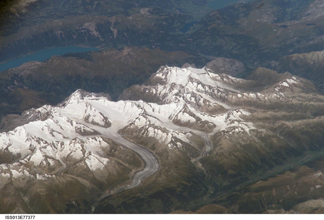
ISS013-E-77377 (5 Sept. 2006) --- Bernese Alps, Switzerland is featured in this image photographed by an Expedition 13 crewmember onboard the International Space Station. The formidable mountain system of the Alps stretches across much of central Europe, with seven countries claiming portions of the mountains within their borders (Germany, France, Switzerland, Italy, Liechtenstein, Austria, and Slovenia). The glacial landscape of the Bernese Alps, located in southwestern Switzerland, is well illustrated by this view. The image was taken by a crewmember looking north-northwest while the station was located over the Mediterranean Sea between Corsica and Italy -- this oblique viewing angle imparts a sense of perspective to the image. This type of viewing angle complements more nadir (downward)--viewing imagery of the region. Three of the higher peaks of the central Alps are visible--Jungfrau (4,158 meters), Moench (4,089 meters), and Eiger (3,970 meters). To the east and south of the Jungfrau is the Aletsch Glacier, clearly marked by dark medial moraines extending along the glacier's length parallel to the valley axis. The moraines are formed from rock and soil debris collected along the sides of three mountain glaciers located near the Jungfrau and Moench peaks -- as these flowing ice masses merge to form the Aletsch Glacier, the debris accumulates in the middle of the glacier and is carried along the flow direction. According to geologists, Lake Brienz to the northwest was formed by the actions of both glacial ice and the flowing waters of the Aare and Lutschine rivers, and has a maximum depth of 261 meters. The lake has a particularly fragile ecosystem, as demonstrated by the almost total collapse of the whitefish population in 1999. Possible causes for the collapse, according to the scientists, include increased water turbidity associated with upstream hydropower plant operations, and reduction of phosphorus (a key nutrient for lake algae, a basic element of the local food web) due to water quality concerns.