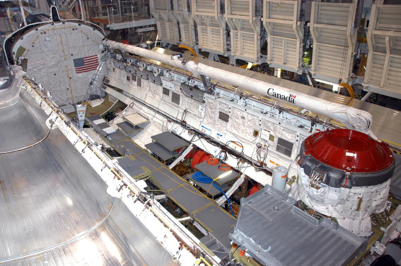
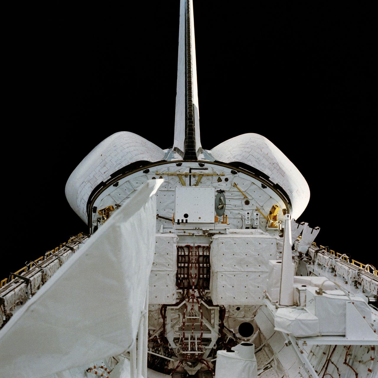
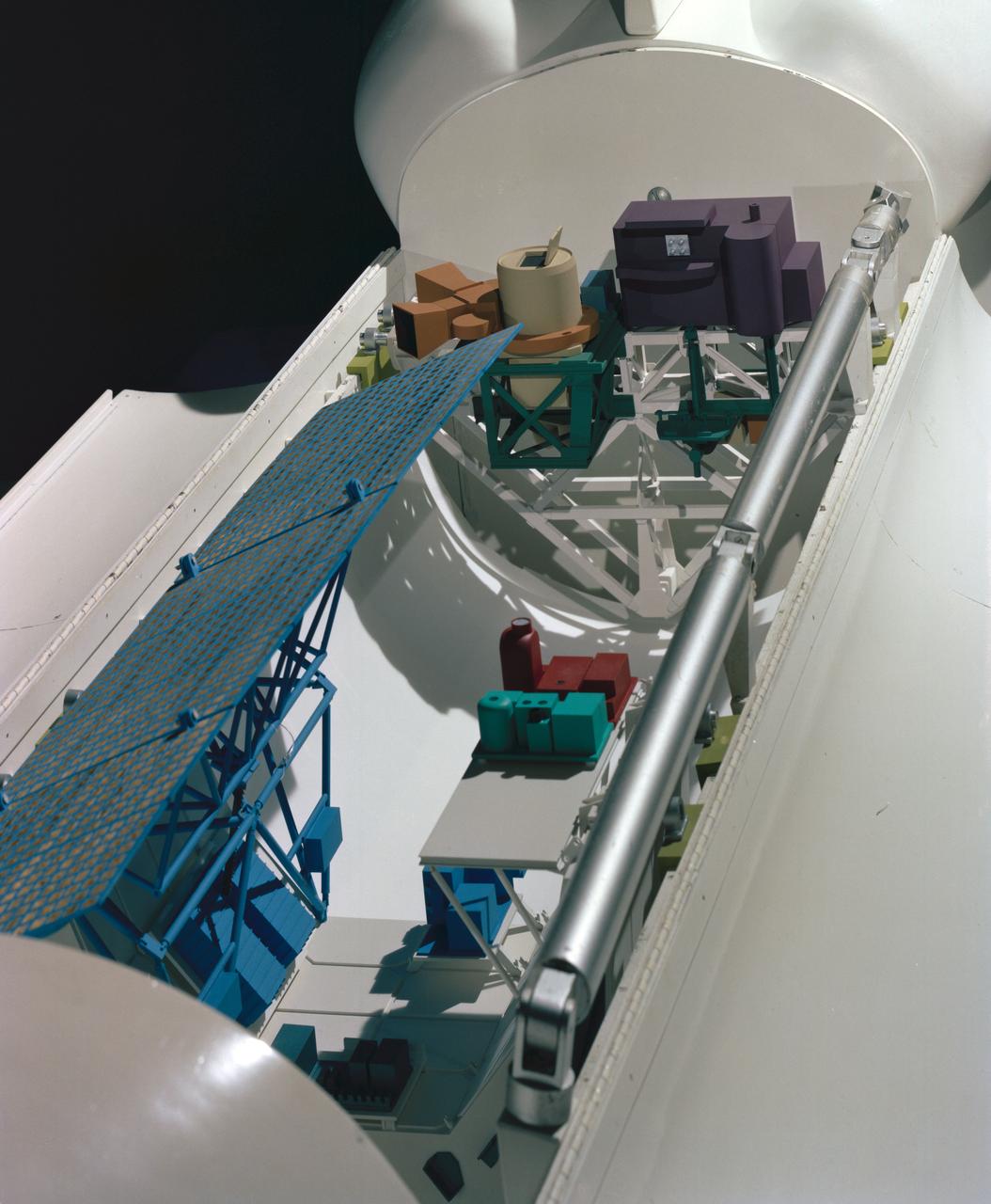
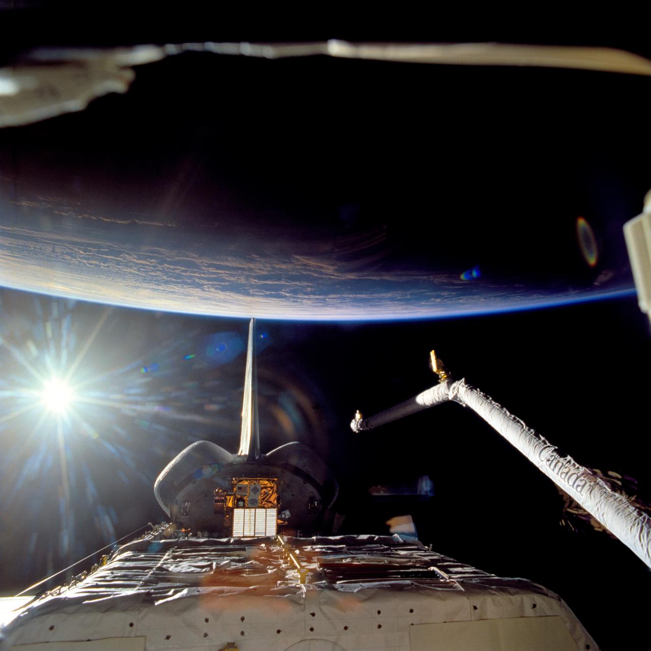
Endeavour's payload bay is open for payload configuration work in Orbiter Processing Facility bay 2. The orbiter is the vehicle designated for mission STS-118, scheduled to launch in late June. The mission will continue space station construction by delivering a third starboard truss segment, S5, as well as carrying the External Stowage Platform 3. The crew comprises six astronauts: Commander Scott Kelly, Pilot Charles Hobaugh and Mission Specialists Dr. Dafydd (Dave) Williams, Barbara Morgan, Richard Mastracchio and Tracy Caldwell. Williams represents the Canadian Space Agency.
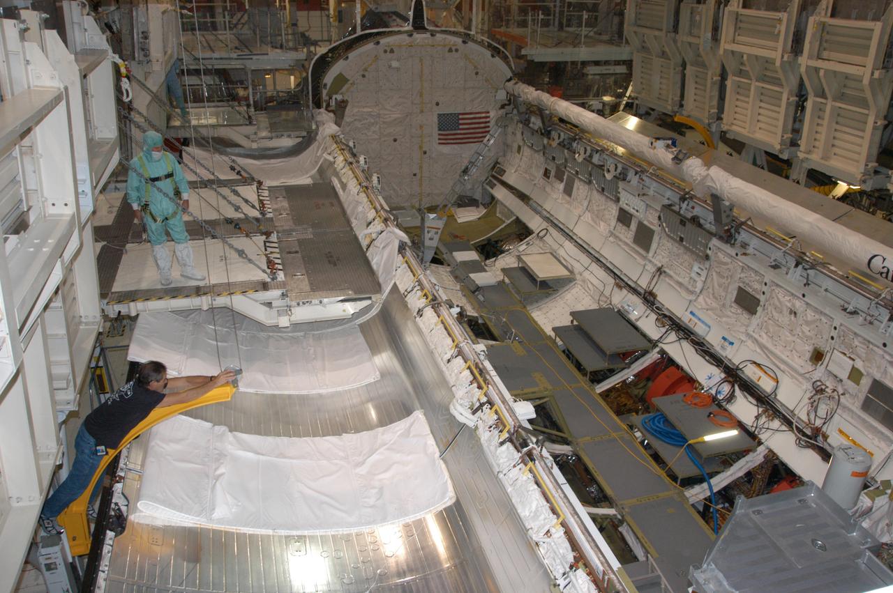
Endeavour's payload bay is open for payload configuration work in Orbiter Processing Facility bay 2. The orbiter is the vehicle designated for mission STS-118, scheduled to launch in late June. The mission will continue space station construction by delivering a third starboard truss segment, S5, as well as carrying the External Stowage Platform 3. The crew comprises six astronauts: Commander Scott Kelly, Pilot Charles Hobaugh and Mission Specialists Dr. Dafydd (Dave) Williams, Barbara Morgan, Richard Mastracchio and Tracy Caldwell. Williams represents the Canadian Space Agency.
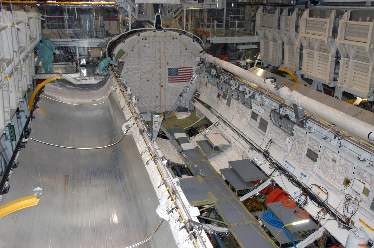
Endeavour's payload bay is open for payload configuration work in Orbiter Processing Facility bay 2. The orbiter is the vehicle designated for mission STS-118, scheduled to launch in late June. The mission will continue space station construction by delivering a third starboard truss segment, S5, as well as carrying the External Stowage Platform 3. The crew comprises six astronauts: Commander Scott Kelly, Pilot Charles Hobaugh and Mission Specialists Dr. Dafydd (Dave) Williams, Barbara Morgan, Richard Mastracchio and Tracy Caldwell. Williams represents the Canadian Space Agency.
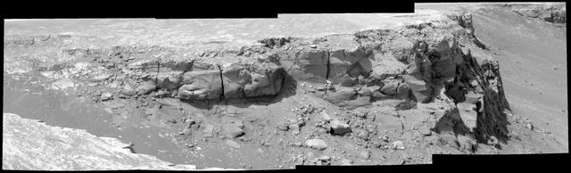
Duck Bay, Victoria Crater
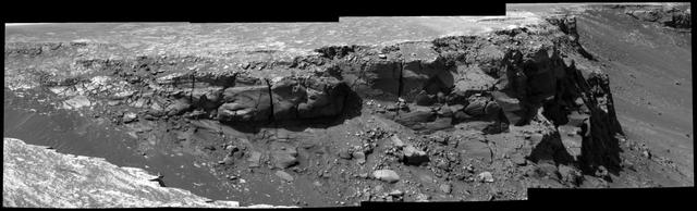
Band at Duck Bay
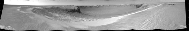
View of Bottomless Bay on Rim of Victoria
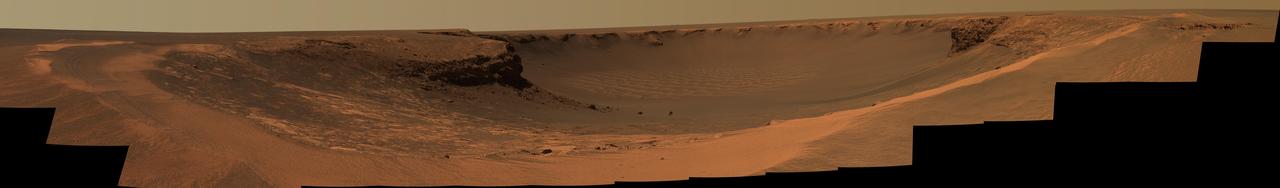
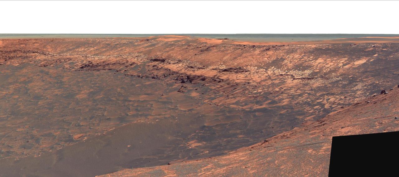
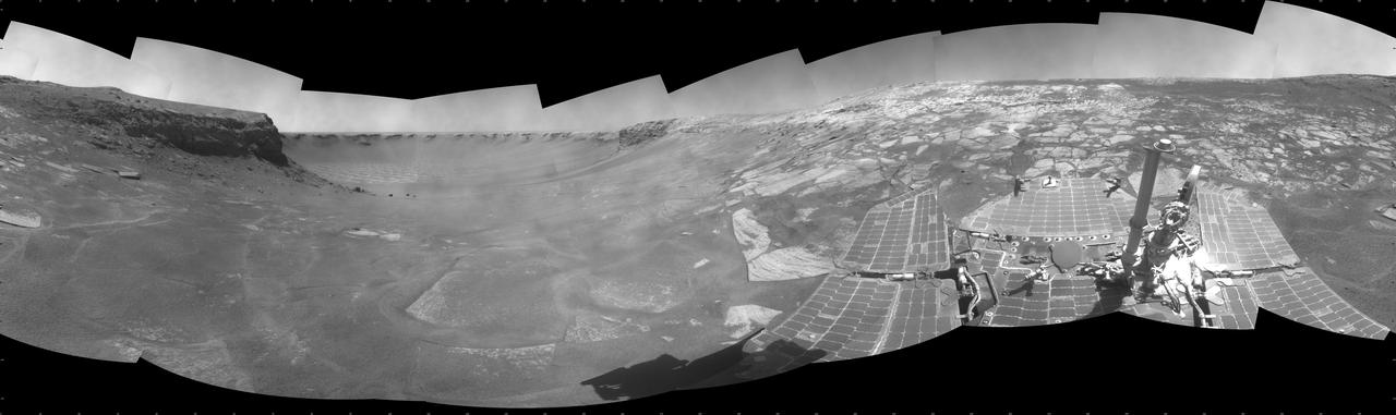
Victoria Crater from Duck Bay
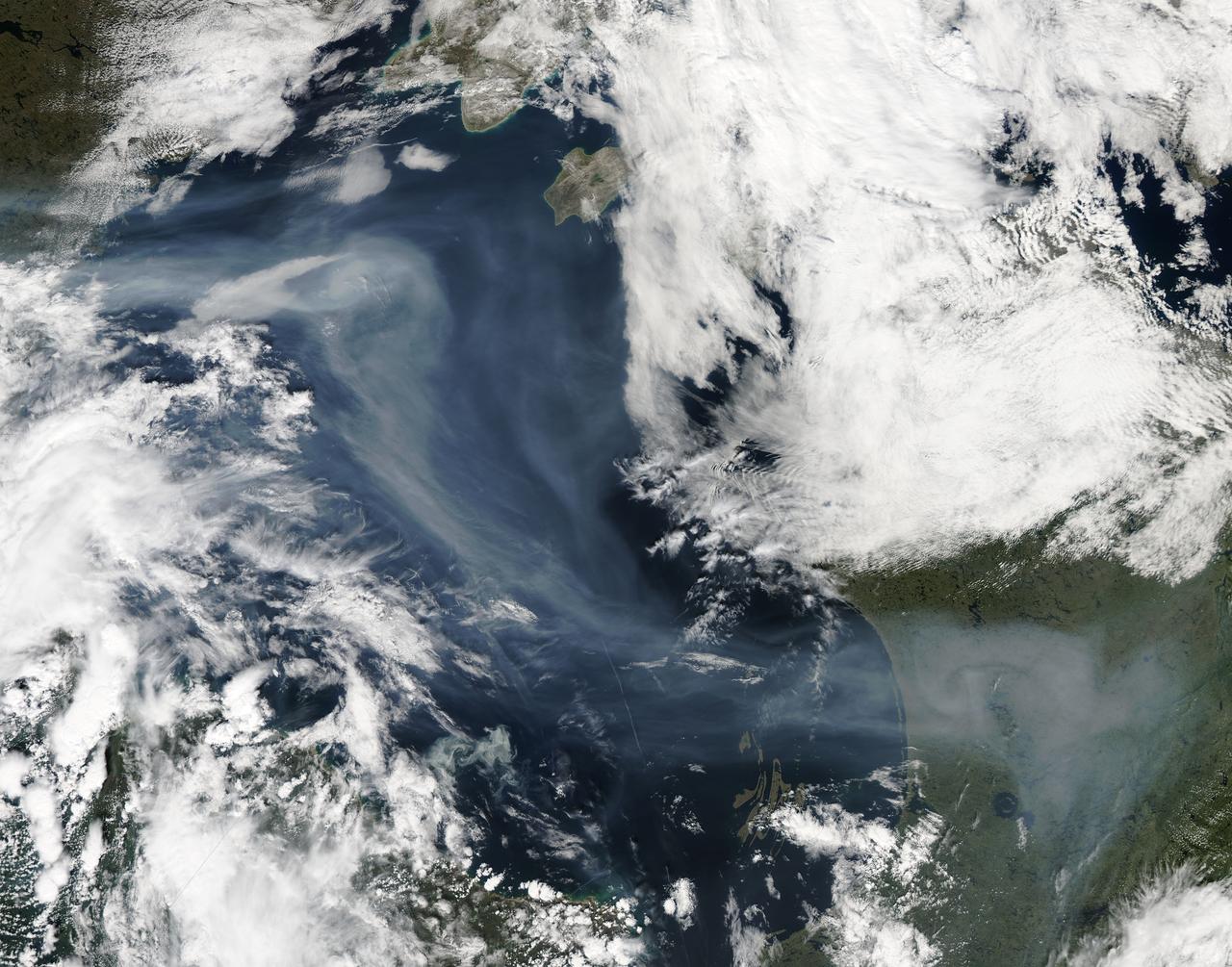
A vigorous summer fire season continued through July, 2013 as many large wildfires continued to burn in the forests of northern Canada. The high fire activity not only laid waste to thousands of hectares of boreal forest, but sent thick smoke billowing high into the atmosphere, where it was carried far across the Atlantic Ocean. On July 30, the Moderate Resolution Imaging Spectroradiometer (MODIS) aboard NASA’s Aqua satellite captured this true-color image of a river of smoke spreading south across the Hudson Bay. The blue background is formed by the waters of Hudson Bay. In the southeast the green, forest-covered land of Quebec province peeks from under a large cloud bank. Another large bank of white cloud covers the water in the southwest, and a smaller cloud bank covers the territory of Nunavut in the northwest. A bit of Baffin Island can be seen near the top center of the image. Looking closely at the image, it appears that the gray smoke mixes with whiter cloud in the south, suggesting they may be at the same level in the atmosphere. In the northeast corner of the image, a ribbon of smoke appears to blow over a bank of popcorn clouds as well as over a few lower-lying clouds, causing some of the clouds to appear gray beneath the smoky veil. Where cloud meets smoke in the northeast, however, the line of the cloud bank remains sharp, while the smoke appears to continue traveling under the edge. Although these interpretations are somewhat subjective in this true-color image, the false-color image of the same scene (not shown here) lends strength to the interpretation. Data from other NASA instruments, designed to measure cloud height and characteristics, agree that clouds vary in height, and that smoke mingles with cloud in the south. Credit: NASA/GSFC/Jeff Schmaltz/MODIS Land Rapid Response Team <b><a href="http://www.nasa.gov/audience/formedia/features/MP_Photo_Guidelines.html" rel="nofollow">NASA image use policy.</a></b> <b><a href="http://www.nasa.gov/centers/goddard/home/index.html" rel="nofollow">NASA Goddard Space Flight Center</a></b> enables NASA’s mission through four scientific endeavors: Earth Science, Heliophysics, Solar System Exploration, and Astrophysics. Goddard plays a leading role in NASA’s accomplishments by contributing compelling scientific knowledge to advance the Agency’s mission. <b>Follow us on <a href="http://twitter.com/NASA_GoddardPix" rel="nofollow">Twitter</a></b> <b>Like us on <a href="http://www.facebook.com/pages/Greenbelt-MD/NASA-Goddard/395013845897?ref=tsd" rel="nofollow">Facebook</a></b> <b>Find us on <a href="http://instagram.com/nasagoddard?vm=grid" rel="nofollow">Instagram</a></b>
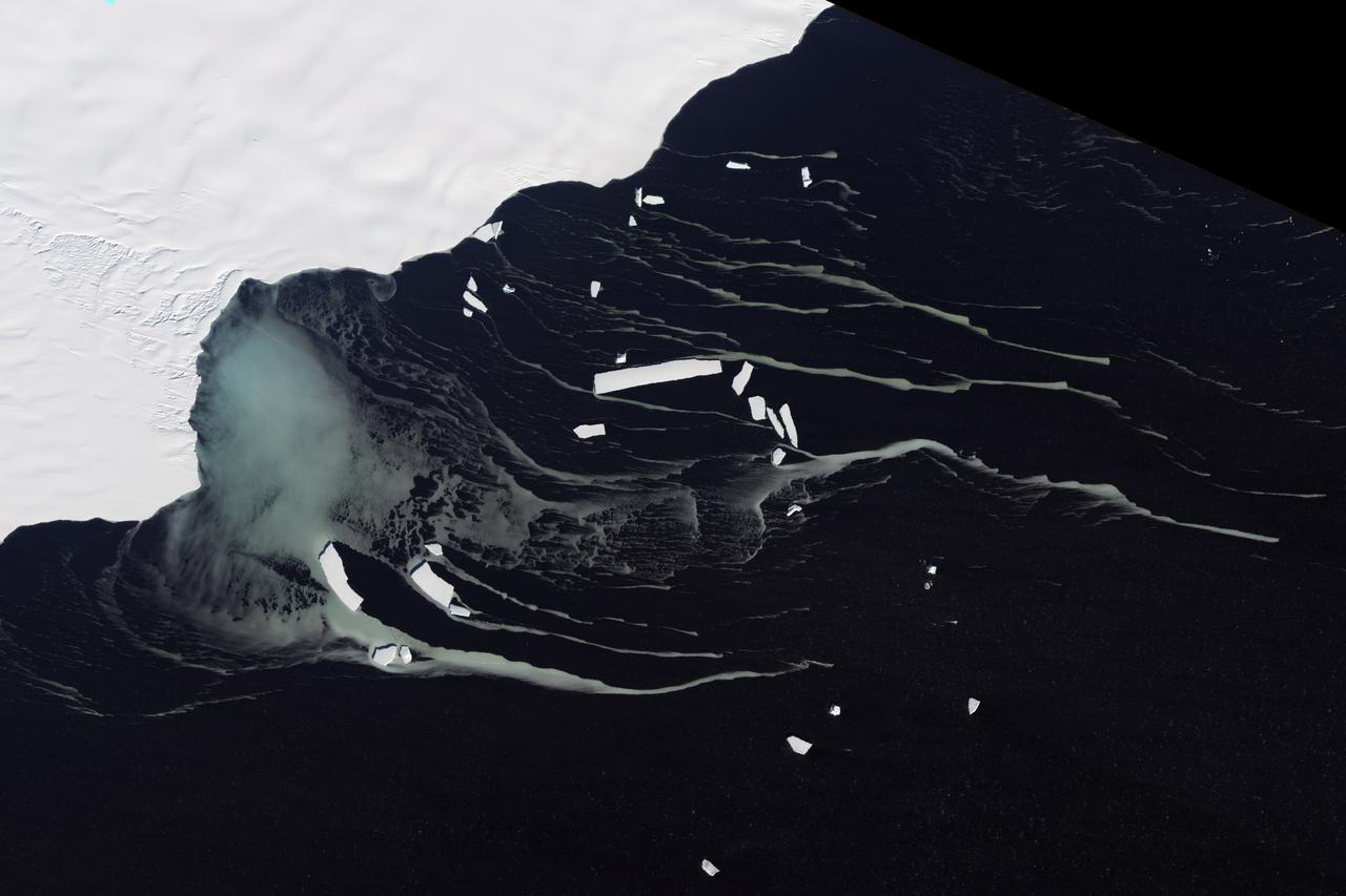
Off the northeastern edge of Antarctica’s Amery Ice Shelf lies Mackenzie Bay, which was painted with a ghostly blue-green mass in early February 2012. Similarly colored tendrils also streamed northward across the ocean, their flow sometimes interrupted by icebergs. Multiple factors might account for the ghostly shapes, including low-lying clouds or katabatic winds—downslope winds blowing toward the coast, which can freeze the water at the ocean surface. But an intriguing and perhaps more likely explanation involves processes occurring below the ice shelf. An ice shelf is a thick slab of ice often fed by glaciers attached to the coastline. The shelf floats on the ocean surface, with seawater circulating underneath. Like most ice shelves, the Amery is very thick in the upstream area near the shore. It thins significantly as it stretches northward away from the continent. Water at depth is subject to much greater pressure than water at the surface, and one effect of this intense pressure is that it effectively lowers the freezing point. So water circulating at depth beneath the Amery Ice Shelf may be slightly below the temperature at which it would normally begin to freeze. As some that water wells up along the underbelly of the shelf, the pressure is reduced and the water begins to freeze even though the temperature may not change. As it freezes, this deep-ocean water forms needle-like crystals known as frazil. The crystals are only 3 to 4 millimeters (0.12 to 0.16 inches) wide, but a sufficient concentration of frazil can change the appearance of the water. A frazil-rich plume probably accounts for the blue-green waters off the Amery Ice Shelf in the image above. Modeling of ocean circulation beneath the shelf indicates just such a plume emerging in that location. Frazil-rich water explains the plume, and wind transport of the surface water explains the long streams extending northward. As the sub-iceshelf water mixes with surface water around the Antarctic coastline, the frazil is gradually melted and the streams disappear. The Advanced Land Imager (ALI) on NASA’s Earth Observing-1 (EO-1) satellite captured this natural-color image of Mackenzie Bay and the ice shelf on February 12, 2012. NASA Earth Observatory image created by Jesse Allen and Robert Simmon, using EO-1 ALI data provided courtesy of the NASA EO-1 team. Caption by Michon Scott with information from Helen A. Fricker, Scripps Institution of Oceanography; Robert Massom, Australian Antarctic Division; Ben Galton-Fenzi, University of Tasmania, Australia; and Florence Fetterer, Walt Meier, and Ted Scambos, National Snow and Ice Data Center. Credit: <b><a href="http://www.earthobservatory.nasa.gov/" rel="nofollow"> NASA Earth Observatory</a></b> <b><a href="http://www.nasa.gov/audience/formedia/features/MP_Photo_Guidelines.html" rel="nofollow">NASA image use policy.</a></b> <b><a href="http://www.nasa.gov/centers/goddard/home/index.html" rel="nofollow">NASA Goddard Space Flight Center</a></b> enables NASA’s mission through four scientific endeavors: Earth Science, Heliophysics, Solar System Exploration, and Astrophysics. Goddard plays a leading role in NASA’s accomplishments by contributing compelling scientific knowledge to advance the Agency’s mission. <b>Follow us on <a href="http://twitter.com/NASA_GoddardPix" rel="nofollow">Twitter</a></b> <b>Like us on <a href="http://www.facebook.com/pages/Greenbelt-MD/NASA-Goddard/395013845897?ref=tsd" rel="nofollow">Facebook</a></b> <b>Find us on <a href="http://instagrid.me/nasagoddard/?vm=grid" rel="nofollow">Instagram</a></b> Instrument: EO-1 - ALI
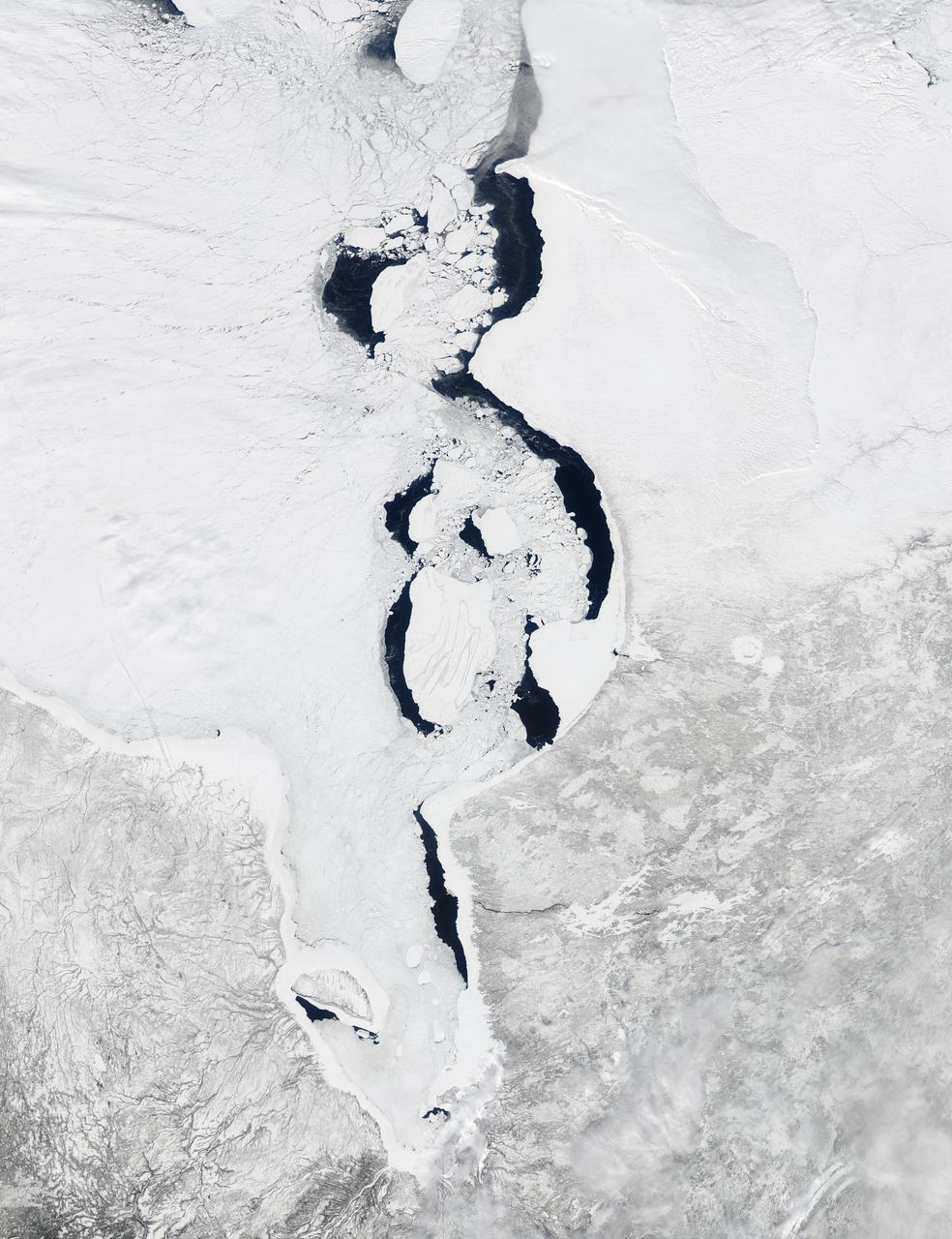
Each winter sea ice forms over the salty waters of frigid northeastern Canada's Hudson Bay. As sunlight lengthens and weather warms, ice begins to break up and melt, with retreat typically starting in May and melt-out completed sometime in July. Since the 1970s, the timing of sea ice breakup in Hudson Bay has changed, with melting beginning earlier in the spring. The Moderate Resolution Imaging Spectroradiometer (MODIS) aboard NASA’s Aqua satellite captured this a true-color image of Hudson Bay on March 26, 2013. Although snow still covers the surrounding land, ice has already begun to retreat from much of the eastern shore of the Bay visible in the image. A ring of bright white ice remains solidly frozen around the Belcher Islands in the southeast section of the Bay, but this ring is surrounded by blue waters and large chunks of ice. In the southwest, a similar situation is seen at Akimiski Island. The shelf of bright white ice gives way to open water in the south, as well as fractured, blue-tinted ice. The blue tint generally indicates water logging as ice begins to soften. The Aqua satellite captured a similar image of early ice melt on Hudson Bay on April 6, 2012. That image can be viewed at: <a href="http://modis.gsfc.nasa.gov/gallery/individual.php?db_date=2012-04-19" rel="nofollow">modis.gsfc.nasa.gov/gallery/individual.php?db_date=2012-0...</a> <b><a href="http://www.nasa.gov/audience/formedia/features/MP_Photo_Guidelines.html" rel="nofollow">NASA image use policy.</a></b> <b><a href="http://www.nasa.gov/centers/goddard/home/index.html" rel="nofollow">NASA Goddard Space Flight Center</a></b> enables NASA’s mission through four scientific endeavors: Earth Science, Heliophysics, Solar System Exploration, and Astrophysics. Goddard plays a leading role in NASA’s accomplishments by contributing compelling scientific knowledge to advance the Agency’s mission. <b>Follow us on <a href="http://twitter.com/NASA_GoddardPix" rel="nofollow">Twitter</a></b> <b>Like us on <a href="http://www.facebook.com/pages/Greenbelt-MD/NASA-Goddard/395013845897?ref=tsd" rel="nofollow">Facebook</a></b> <b>Find us on <a href="http://instagram.com/nasagoddard?vm=grid" rel="nofollow">Instagram</a></b>
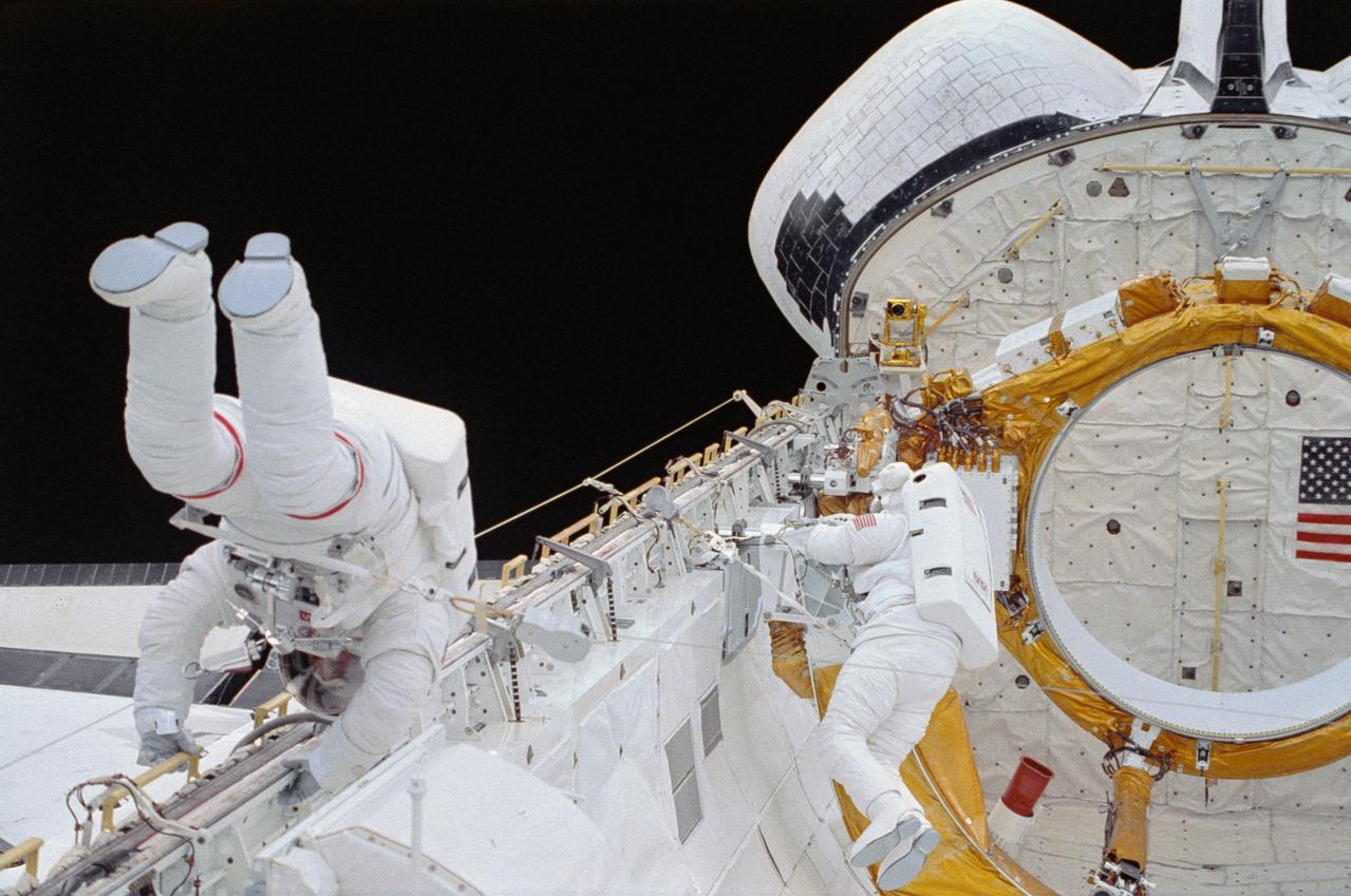
STS054-33-030 (17 Jan. 1993) --- Astronaut Gregory J. Harbaugh (left) translates along the starboard longeron in space shuttle Endeavour's cargo bay while astronaut Mario Runco Jr. prepares to work on a restraint device near the aft cargo bay firewall. The two mission specialists spent four-plus hours on the extravehicular activity (EVA) on Jan. 17, 1993. Others onboard NASA's newest shuttle for the six-day mission were astronauts John H. Casper, mission commander; Donald R. McMonagle, pilot; and Susan J. Helms, mission specialist. The photograph was taken with a 35mm camera. Photo credit: NASA
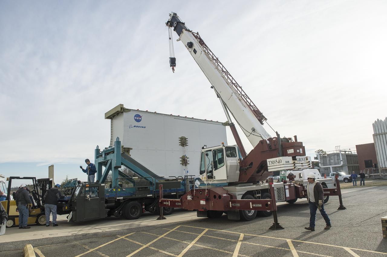
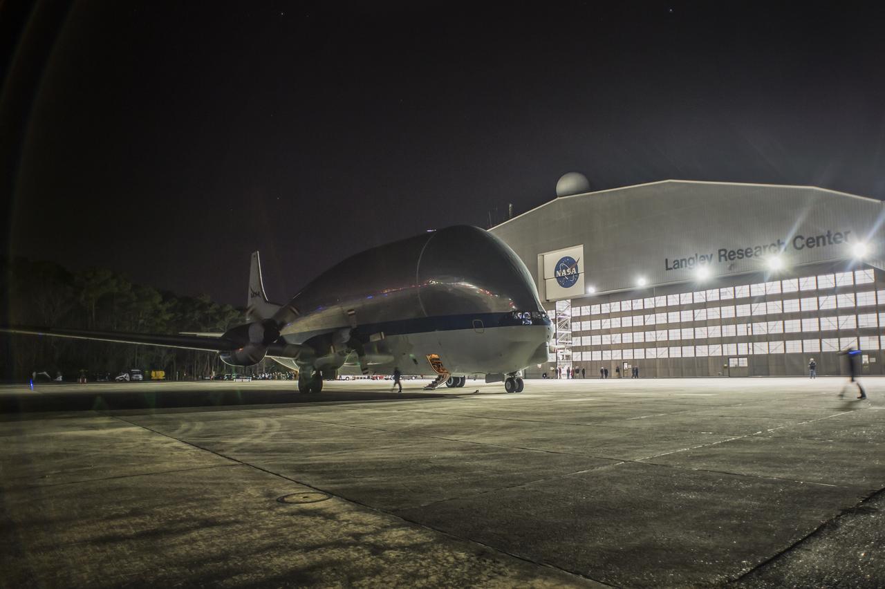
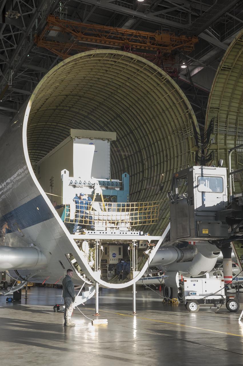
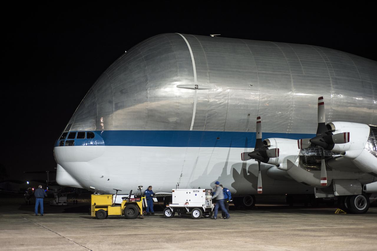
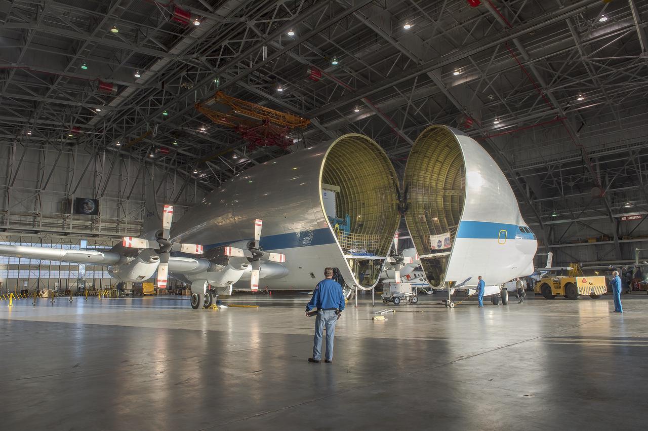
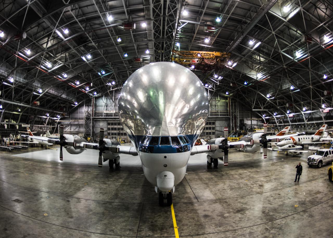
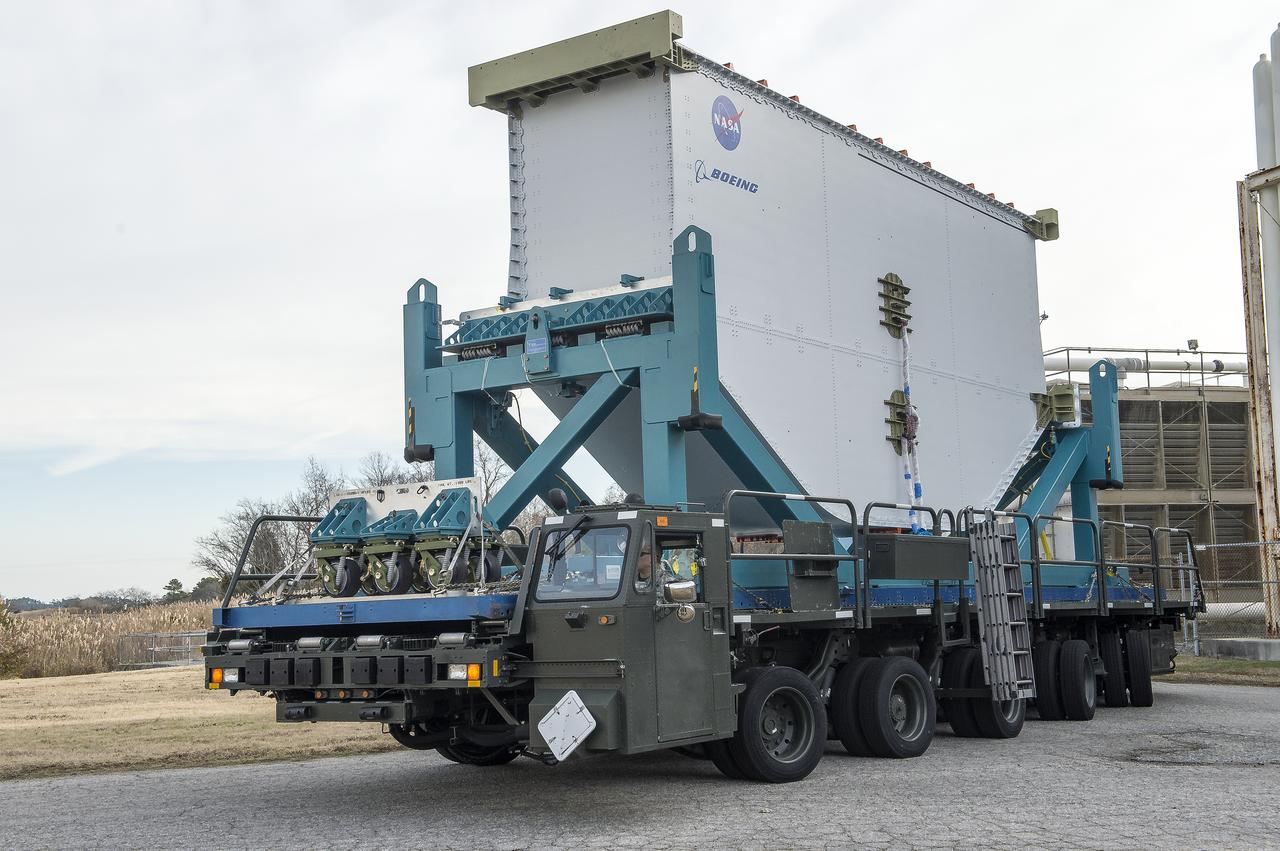
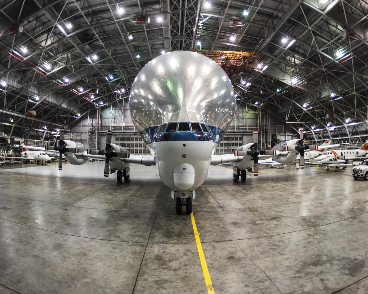
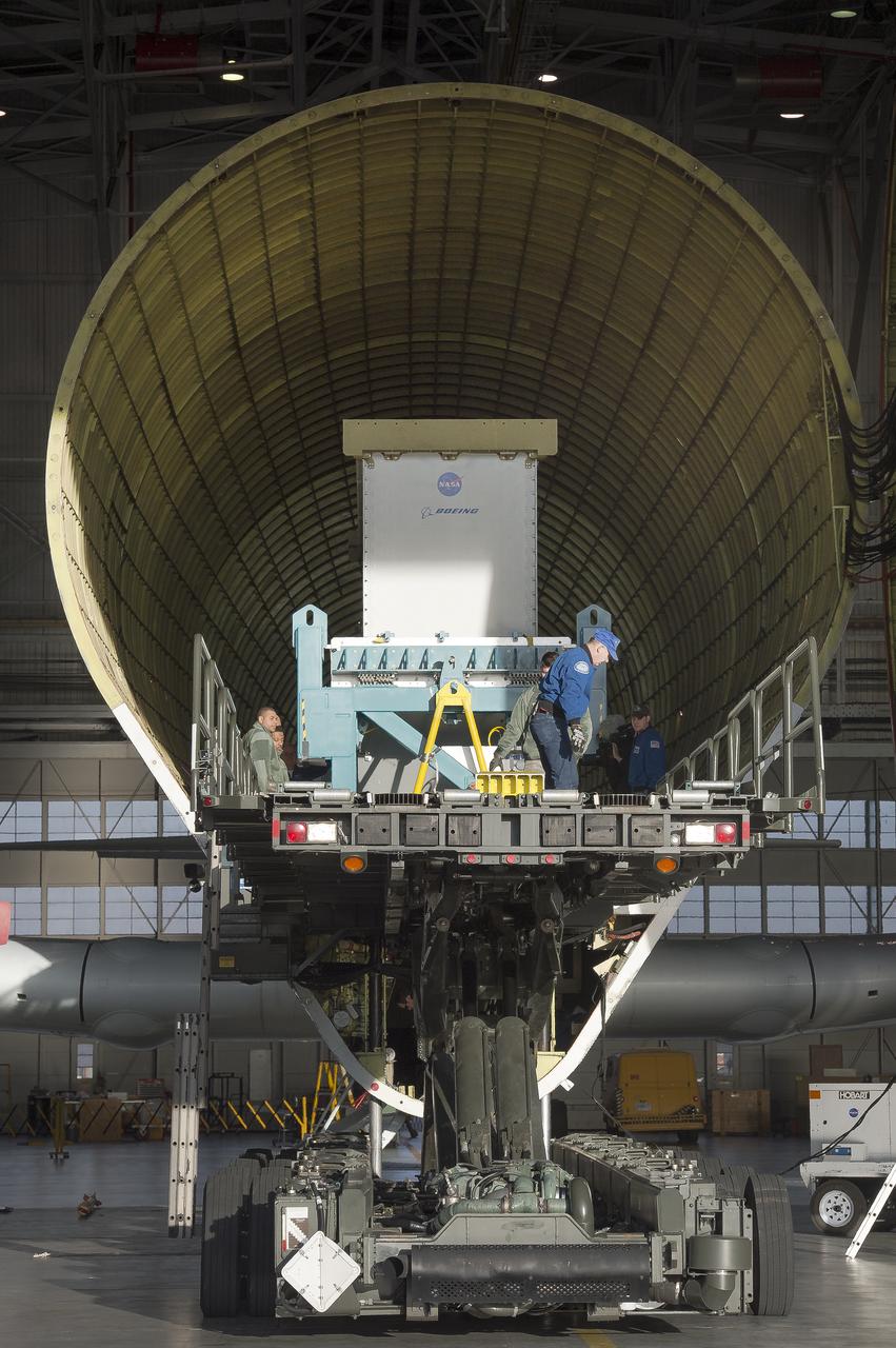
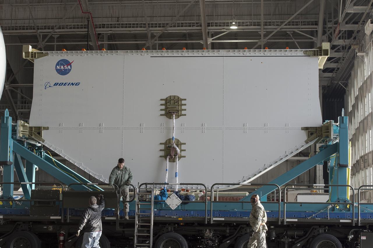
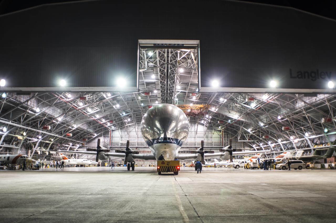
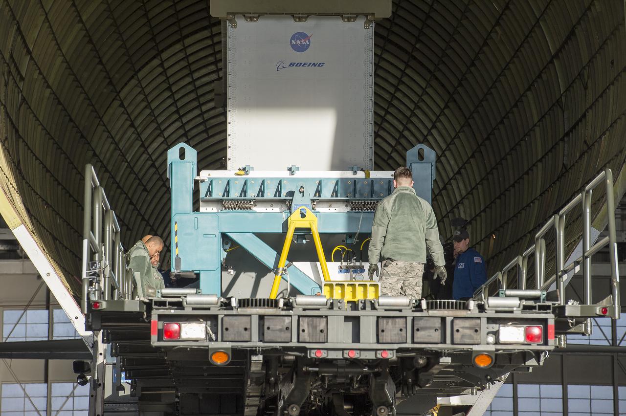
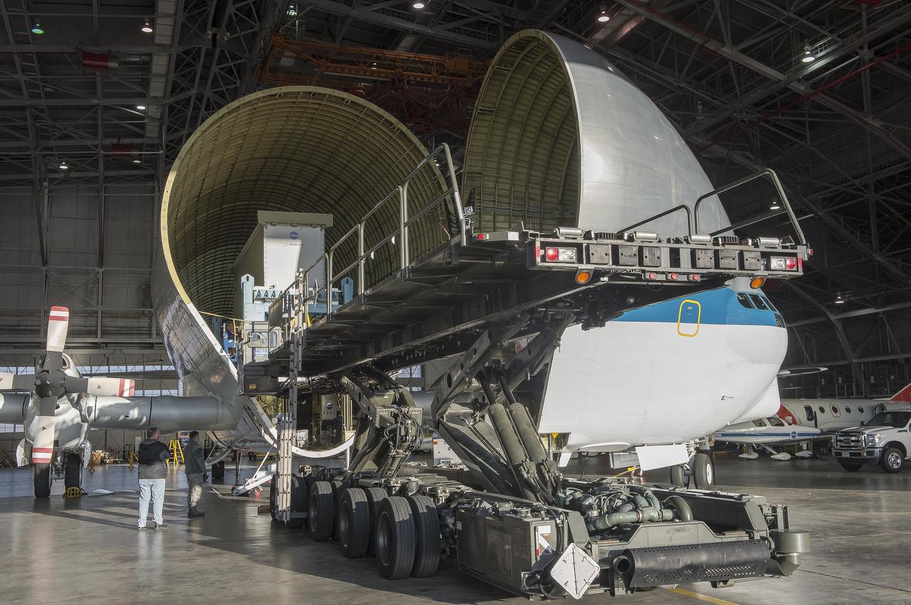
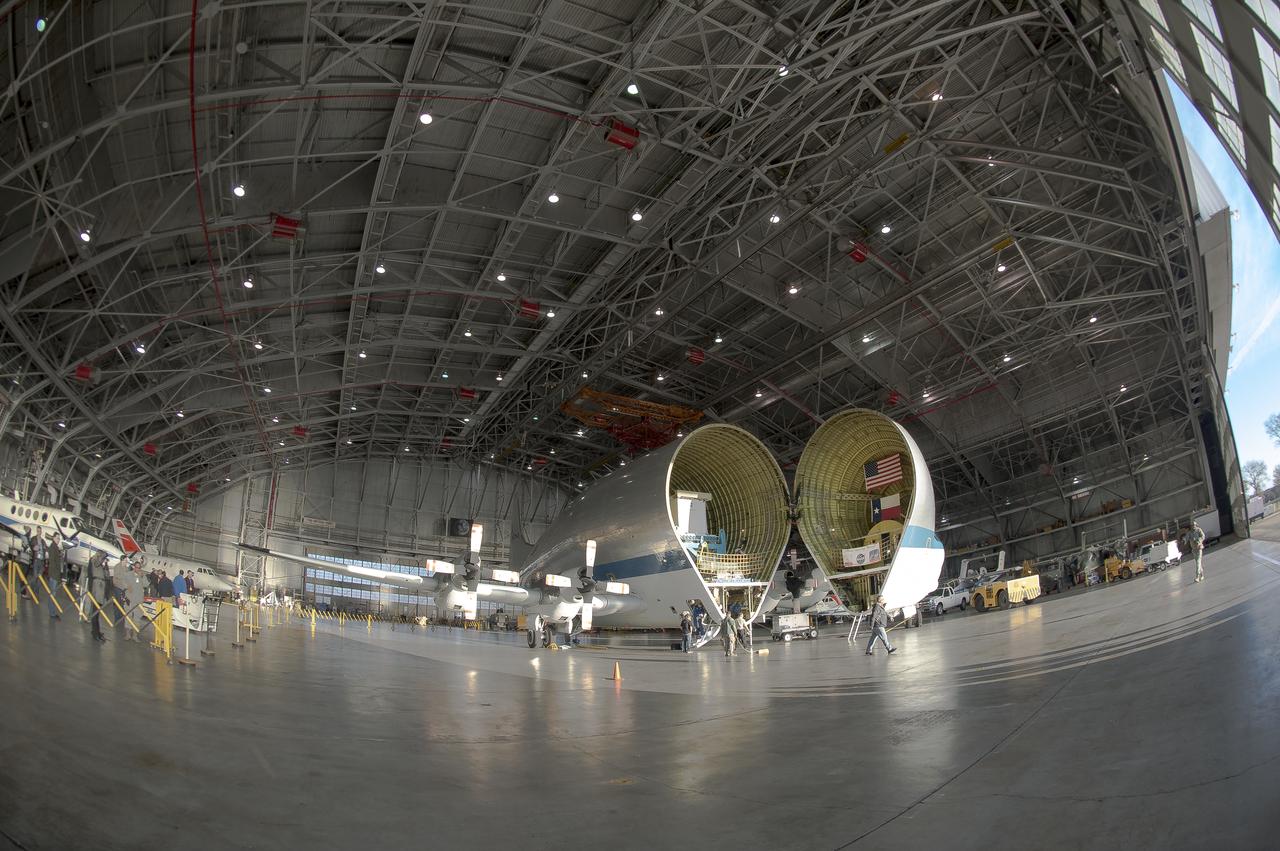
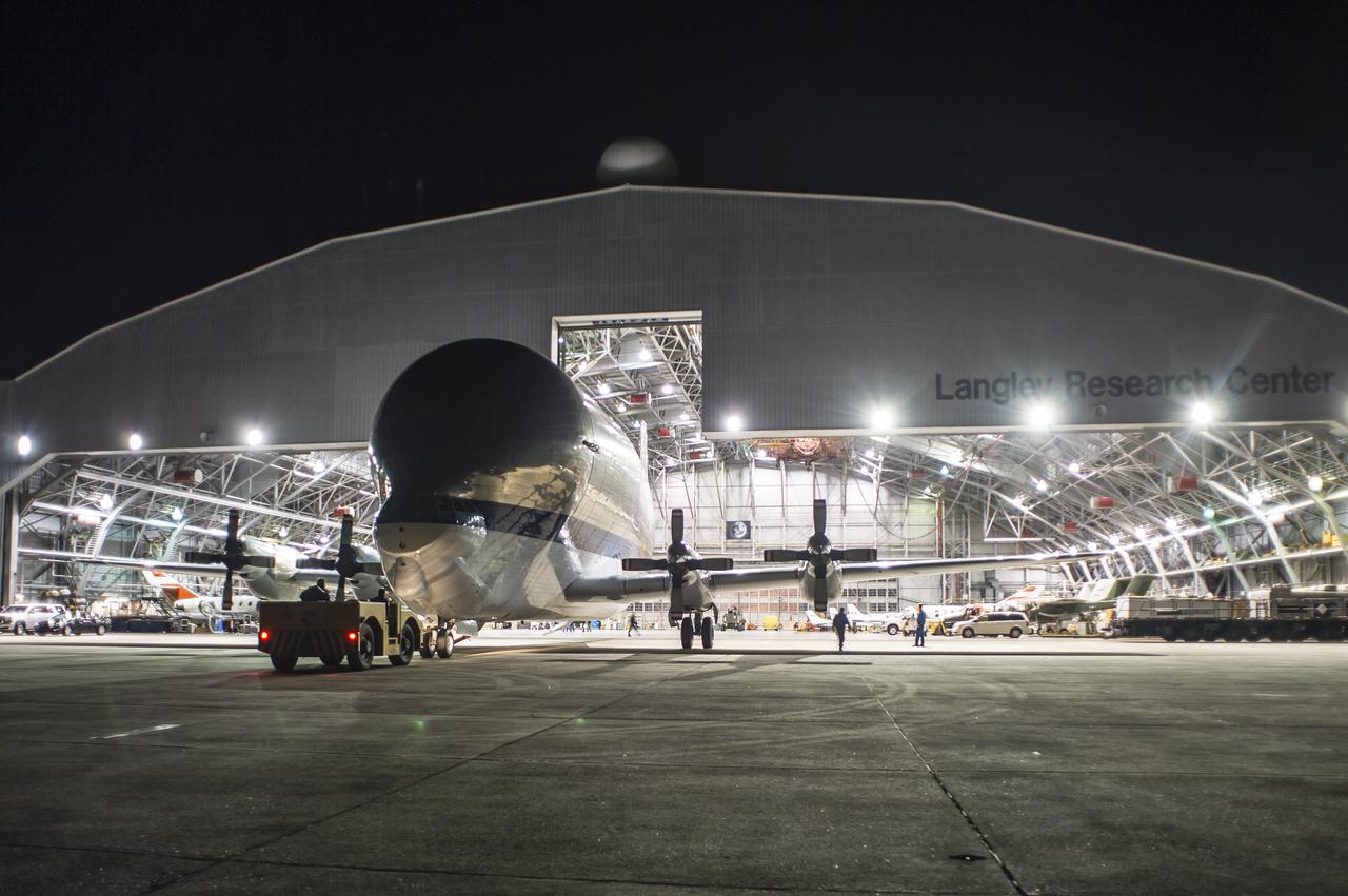
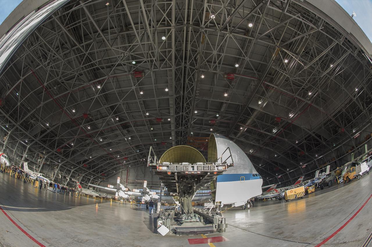
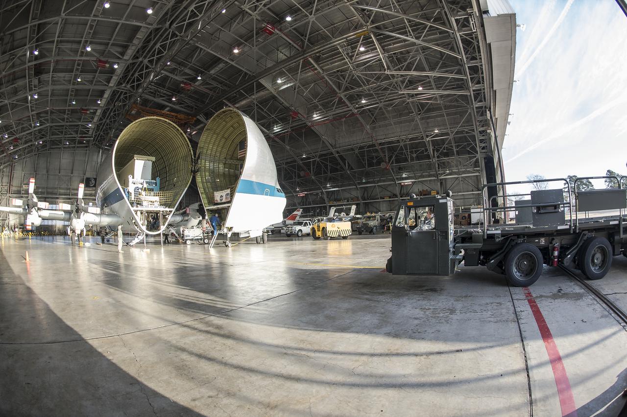
Super Guppy arrival and (MBB) Multi-Bay Box Delivery ; Super Guppy arrival and MBB Delivery: super Guppy arrival at NASA Langley hangar, and unloading of (MBB) multi-bay box, transport of MBB to COLTS and move into building 1256.
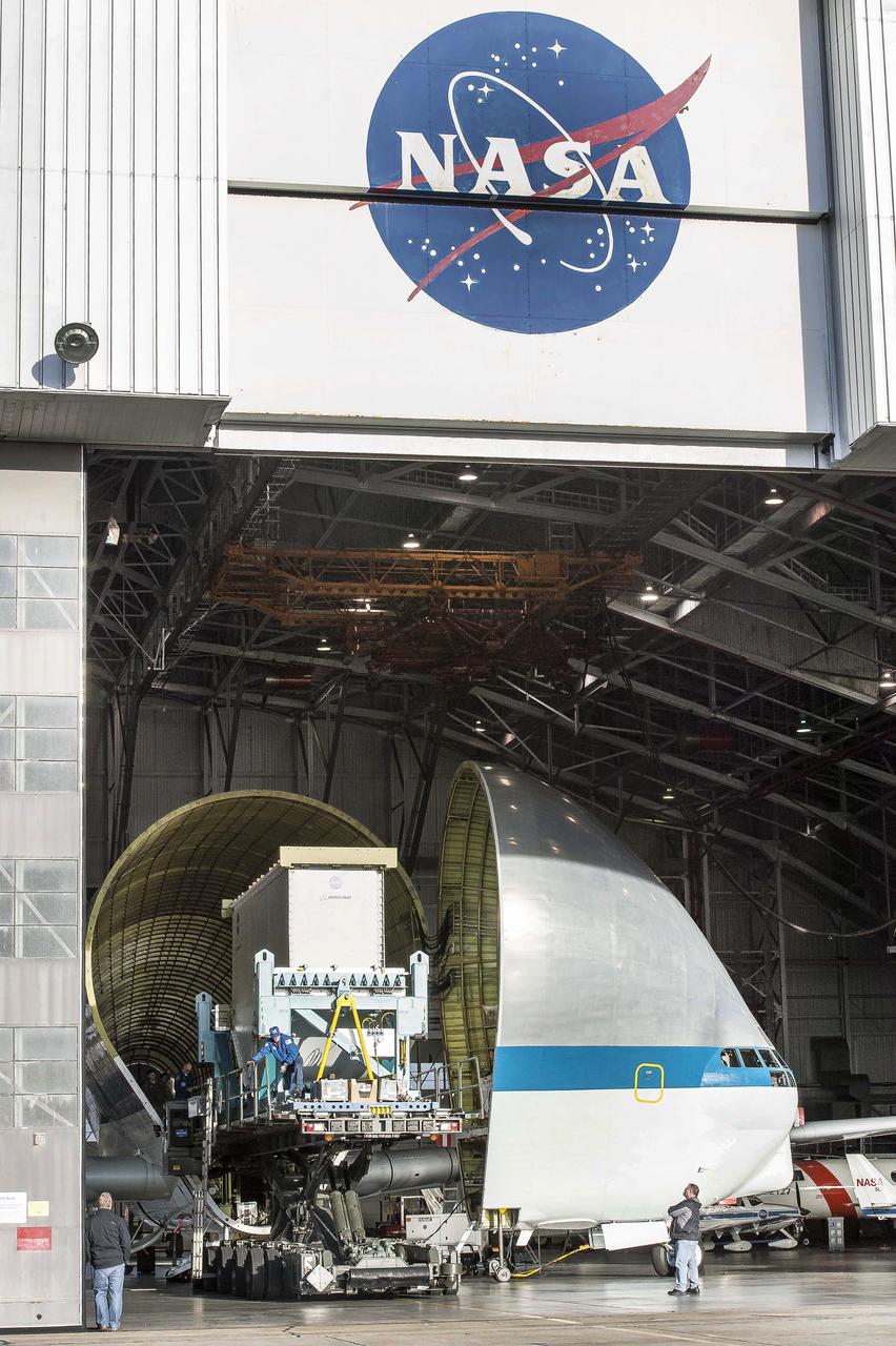
Super Guppy arrival and (MBB) Multi-Bay Box Delivery ; Super Guppy arrival and MBB Delivery: super Guppy arrival at NASA Langley hangar, and unloading of (MBB) multi-bay box, transport of MBB to COLTS and move into building 1256.
Super Guppy arrival and (MBB) Multi-Bay Box Delivery ; Super Guppy arrival and MBB Delivery: super Guppy arrival at NASA Langley hangar, and unloading of (MBB) multi-bay box, transport of MBB to COLTS and move into building 1256.
Super Guppy arrival and (MBB) Multi-Bay Box Delivery ; Super Guppy arrival and MBB Delivery: super Guppy arrival at NASA Langley hangar, and unloading of (MBB) multi-bay box, transport of MBB to COLTS and move into building 1256.
Super Guppy arrival and (MBB) Multi-Bay Box Delivery ; Super Guppy arrival and MBB Delivery: super Guppy arrival at NASA Langley hangar, and unloading of (MBB) multi-bay box, transport of MBB to COLTS and move into building 1256.
Super Guppy arrival and (MBB) Multi-Bay Box Delivery ; Super Guppy arrival and MBB Delivery: super Guppy arrival at NASA Langley hangar, and unloading of (MBB) multi-bay box, transport of MBB to COLTS and move into building 1256.
Super Guppy arrival and (MBB) Multi-Bay Box Delivery ; Super Guppy arrival and MBB Delivery: super Guppy arrival at NASA Langley hangar, and unloading of (MBB) multi-bay box, transport of MBB to COLTS and move into building 1256.
Super Guppy arrival and (MBB) Multi-Bay Box Delivery ; Super Guppy arrival and MBB Delivery: super Guppy arrival at NASA Langley hangar, and unloading of (MBB) multi-bay box, transport of MBB to COLTS and move into building 1256.
Super Guppy arrival and (MBB) Multi-Bay Box Delivery ; Super Guppy arrival and MBB Delivery: super Guppy arrival at NASA Langley hangar, and unloading of (MBB) multi-bay box, transport of MBB to COLTS and move into building 1256.
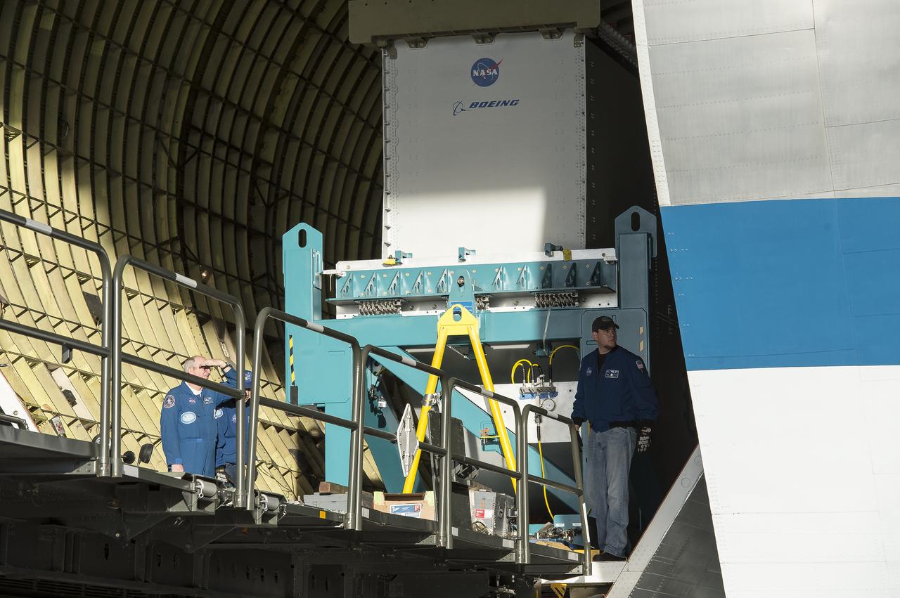
Super Guppy arrival and (MBB) Multi-Bay Box Delivery ; Super Guppy arrival and MBB Delivery: super Guppy arrival at NASA Langley hangar, and unloading of (MBB) multi-bay box, transport of MBB to COLTS and move into building 1256.

Super Guppy arrival and (MBB) Multi-Bay Box Delivery ; Super Guppy arrival and MBB Delivery: super Guppy arrival at NASA Langley hangar, and unloading of (MBB) multi-bay box, transport of MBB to COLTS and move into building 1256.
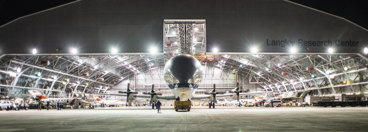
Super Guppy arrival and (MBB) Multi-Bay Box Delivery ; Super Guppy arrival and MBB Delivery: super Guppy arrival at NASA Langley hangar, and unloading of (MBB) multi-bay box, transport of MBB to COLTS and move into building 1256.
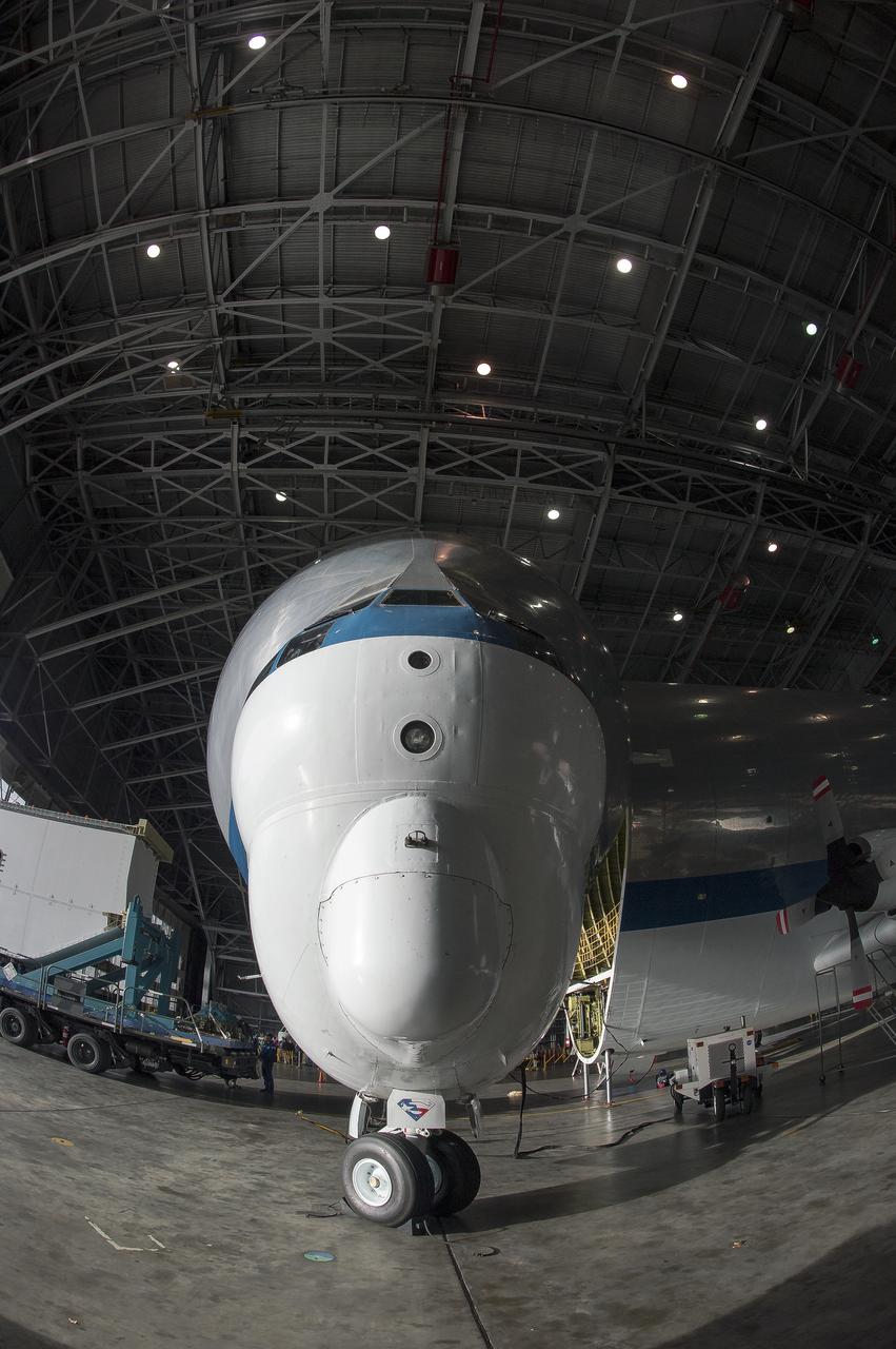
Super Guppy arrival and (MBB) Multi-Bay Box Delivery ; Super Guppy arrival and MBB Delivery: super Guppy arrival at NASA Langley hangar, and unloading of (MBB) multi-bay box, transport of MBB to COLTS and move into building 1256.
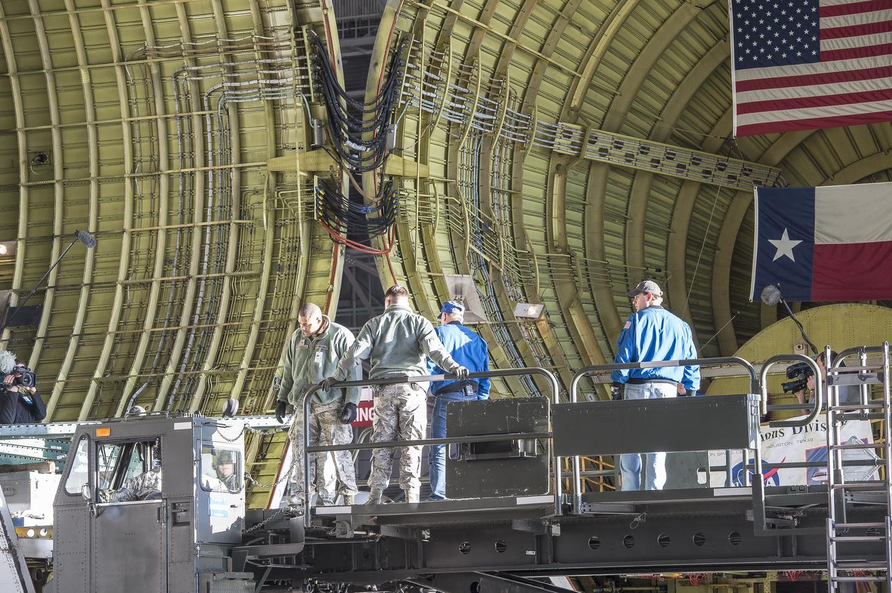
Super Guppy arrival and (MBB) Multi-Bay Box Delivery ; Super Guppy arrival and MBB Delivery: super Guppy arrival at NASA Langley hangar, and unloading of (MBB) multi-bay box, transport of MBB to COLTS and move into building 1256.
Super Guppy arrival and (MBB) Multi-Bay Box Delivery ; Super Guppy arrival and MBB Delivery: super Guppy arrival at NASA Langley hangar, and unloading of (MBB) multi-bay box, transport of MBB to COLTS and move into building 1256.
Super Guppy arrival and (MBB) Multi-Bay Box Delivery ; Super Guppy arrival and MBB Delivery: super Guppy arrival at NASA Langley hangar, and unloading of (MBB) multi-bay box, transport of MBB to COLTS and move into building 1256.
Super Guppy arrival and (MBB) Multi-Bay Box Delivery ; Super Guppy arrival and MBB Delivery: super Guppy arrival at NASA Langley hangar, and unloading of (MBB) multi-bay box, transport of MBB to COLTS and move into building 1256.
Super Guppy arrival and (MBB) Multi-Bay Box Delivery ; Super Guppy arrival and MBB Delivery: super Guppy arrival at NASA Langley hangar, and unloading of (MBB) multi-bay box, transport of MBB to COLTS and move into building 1256.
Super Guppy arrival and (MBB) Multi-Bay Box Delivery ; Super Guppy arrival and MBB Delivery: super Guppy arrival at NASA Langley hangar, and unloading of (MBB) multi-bay box, transport of MBB to COLTS and move into building 1256.
Super Guppy arrival and (MBB) Multi-Bay Box Delivery ; Super Guppy arrival and MBB Delivery: super Guppy arrival at NASA Langley hangar, and unloading of (MBB) multi-bay box, transport of MBB to COLTS and move into building 1256.
Super Guppy arrival and (MBB) Multi-Bay Box Delivery ; Super Guppy arrival and MBB Delivery: super Guppy arrival at NASA Langley hangar, and unloading of (MBB) multi-bay box, transport of MBB to COLTS and move into building 1256.
Super Guppy arrival and (MBB) Multi-Bay Box Delivery ; Super Guppy arrival and MBB Delivery: super Guppy arrival at NASA Langley hangar, and unloading of (MBB) multi-bay box, transport of MBB to COLTS and move into building 1256.
Super Guppy arrival and (MBB) Multi-Bay Box Delivery ; Super Guppy arrival and MBB Delivery: super Guppy arrival at NASA Langley hangar, and unloading of (MBB) multi-bay box, transport of MBB to COLTS and move into building 1256.
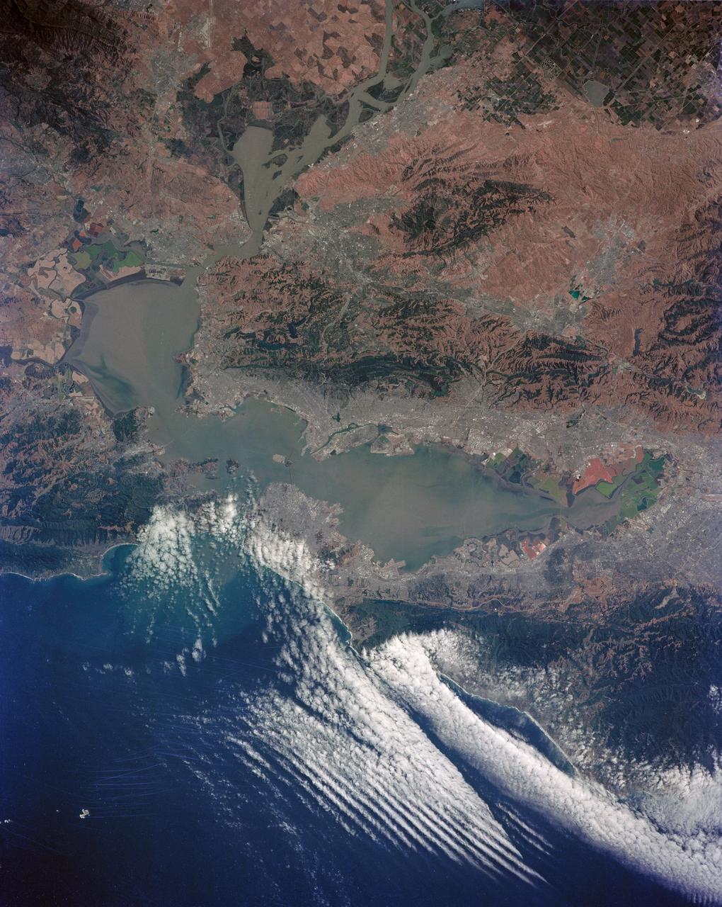
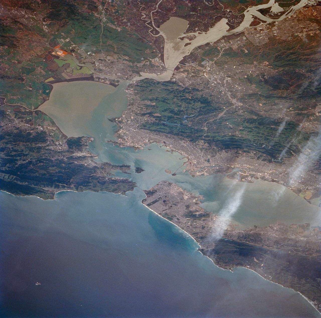
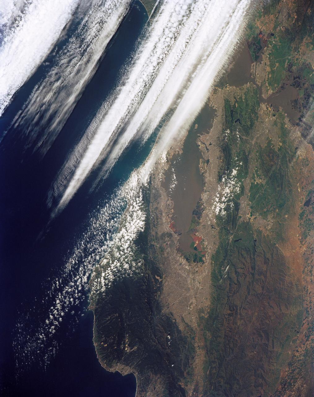
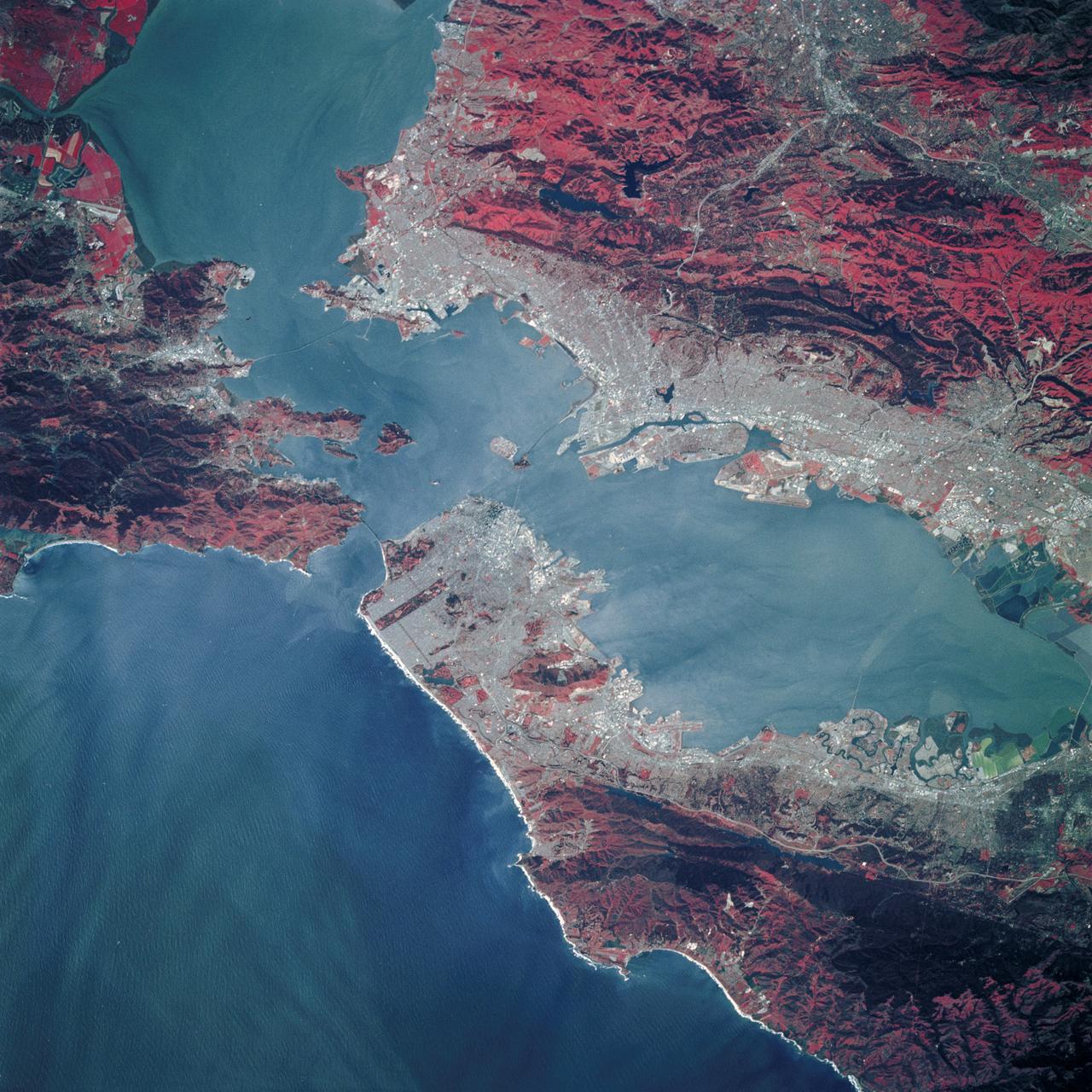
STS040-152-100 (5-14 June 1991) --- Although clouds obscure part of the city of San Francisco and the mouth of San Francisco Bay, development and physiographic features in the immediate vicinity of the bay are well displayed. The photograph clearly shows the eastern part of the city, including the Embarcadero, the Bay Bridge, which was damaged in the 1989 earthquake, and Candlestick Park, San Mateo, and Dumbarton Bridges, cross the southern portion of the bay. Vari-colored salt ponds also rim the southern Bay near Moffett Field. Highway 280 runs along the San Andreas fault south of the city. On the eastern margin of the bay are Berkeley the Sacramento River and the Haywood and Calaveras faults.
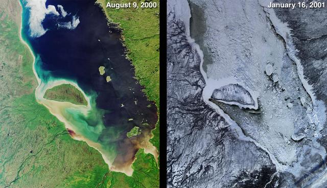
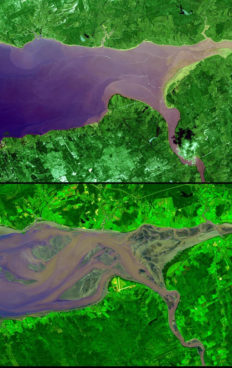
James Bay lies at the southern end of Hudson Bay. Visible in these images captured by NASA Terra satellite on Aug 9, 2000 and Jan. 15, 2001, are some of the many rivers that flow into the bay.
Victoria Crater from Duck Bay Polar Projection
View of Bottomless Bay on Rim of Victoria Altered Contrast
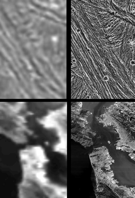
Galileo Resolutions: Ganymede and the San Francisco Bay Area
Victoria Crater from Duck Bay Vertical Projection
STS035-81-040 (2-10 Dec 1990) --- Numerous algae reefs are seen in Shark Bay, Western Australia, Australia (26.0S, 113.5E) especially in the southern portions of the bay. The south end is more saline because tidal flow in and out of the bay is restricted by sediment deposited at the north and central end of the bay opposite the mouth of the Wooramel River. This extremely arid region produces little sediment runoff so that the waters are very clear, saline and rich in algae.
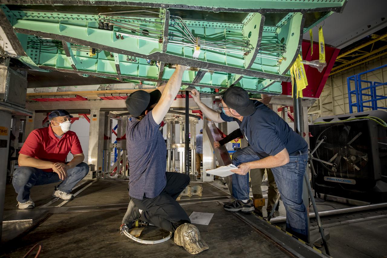
Technicians preform some installation work in the mid-bay on the X-59 Quiet SuperSonic Technology or QueSST aircraft. The aircraft, under construction at Lockheed Martin Skunk Works in Palmdale, California, will fly to demonstrate the ability to fly supersonic while reducing the loud sonic boom to a quiet sonic thump. Lockheed Martin Photography By Garry Tice 1011 Lockheed Way, Palmdale, Ca. 93599 Event: SEG 450 Mid Bay - Encoders Date: 4/28/2021
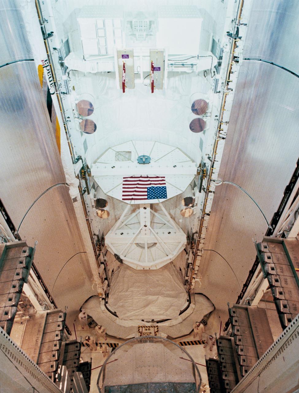
View of the Payload Flight Test Article (PFTA) installed into Challenger's cargo bay in the Payload Changeout Room at Pad 39A at the Kennedy Space Center (KSC). The American flag is visible on one side of the PFTA in the cargo bay. The Kennedy Space Center alternative photo number is KSC-108-83PC-566.
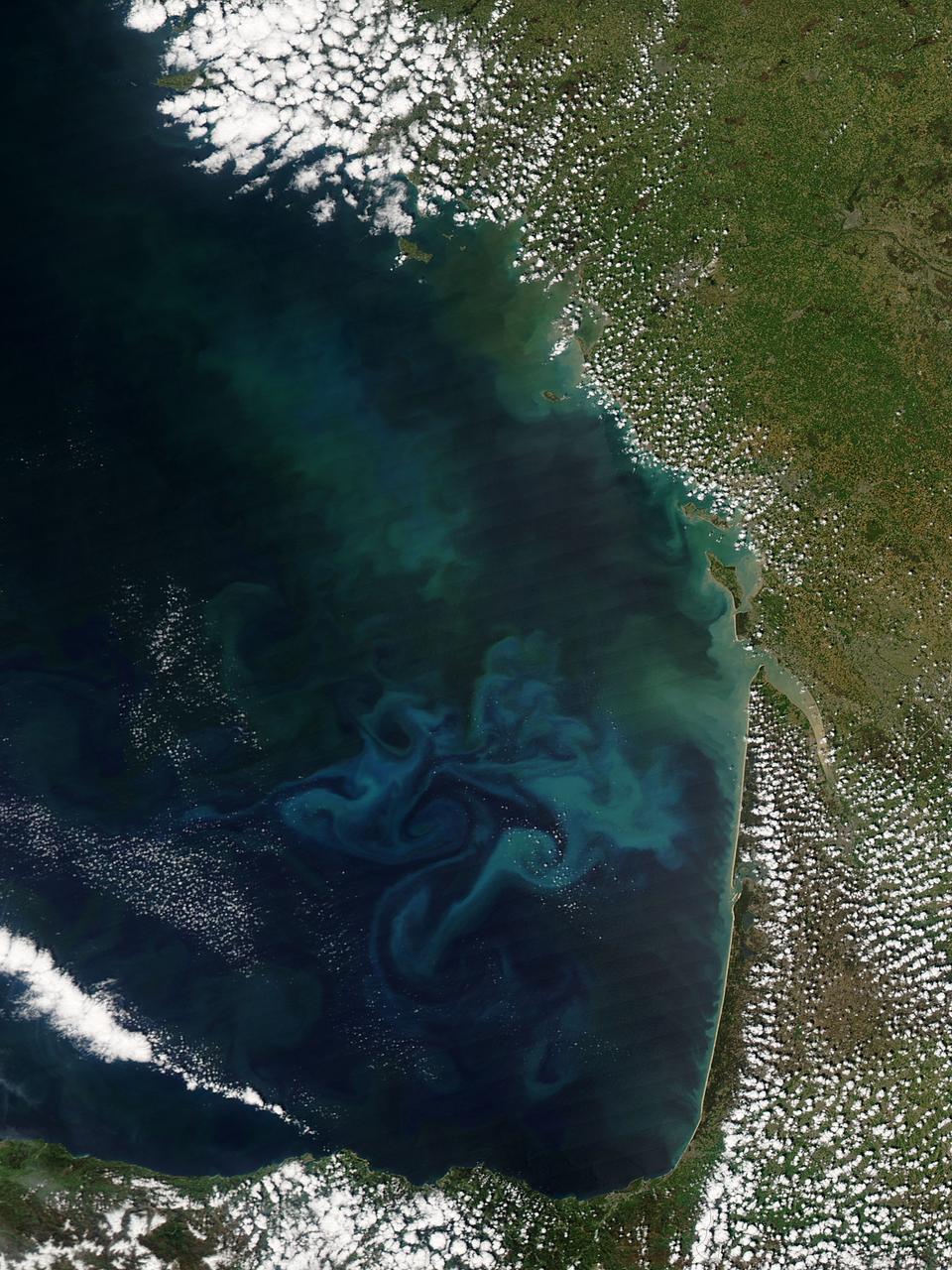
Springtime in the Bay of Biscay, off the coast of France, as in most places, is a season of abundant growth. On April 20, 2013, the Moderate Resolution Imaging Spectroradiometer (MODIS) aboard NASA’s Aqua satellite captured this true-color image of the dynamic growth of a springtime phytoplankton bloom. The swirling colors indicate the presence of vast numbers of phytoplankton – tiny plant-like microorganisms that live in both fresh and salt water. Although these organisms live year-round in the Bay of Biscay, it is only when conditions are right that explosive blooms occur. In spring, the lengthening sunlight, the increased nutrient load swept into the Bay from ocean currents and from snowmelt carried by freshwater rivers, combined with warming waters create the perfect conditions to spur phytoplankton in to tremendous growth. The result is a swirling, multi-hued discoloration that can be easily seen from space. Each year, typically from March through April, such blooms occur in the Bay of Biscay. By May, however, conditions are not as favorable and the blooms fade, then disappear. Credit: NASA/GSFC/Jeff Schmaltz/MODIS Land Rapid Response Team <b><a href="http://www.nasa.gov/audience/formedia/features/MP_Photo_Guidelines.html" rel="nofollow">NASA image use policy.</a></b> <b><a href="http://www.nasa.gov/centers/goddard/home/index.html" rel="nofollow">NASA Goddard Space Flight Center</a></b> enables NASA’s mission through four scientific endeavors: Earth Science, Heliophysics, Solar System Exploration, and Astrophysics. Goddard plays a leading role in NASA’s accomplishments by contributing compelling scientific knowledge to advance the Agency’s mission. <b>Follow us on <a href="http://twitter.com/NASA_GoddardPix" rel="nofollow">Twitter</a></b> <b>Like us on <a href="http://www.facebook.com/pages/Greenbelt-MD/NASA-Goddard/395013845897?ref=tsd" rel="nofollow">Facebook</a></b> <b>Find us on <a href="http://instagram.com/nasagoddard?vm=grid" rel="nofollow">Instagram</a></b>
The highest tides on Earth occur in the Minas Basin, the eastern extremity of the Bay of Fundy, Nova Scotia, Canada. This image was acquired by NASA Terra spacecraft.
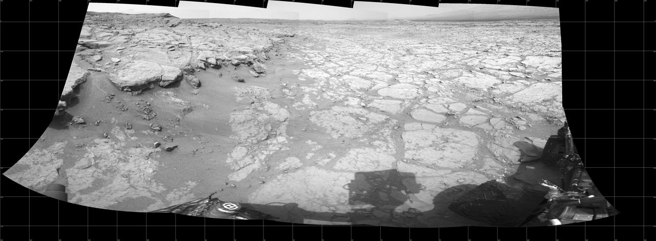
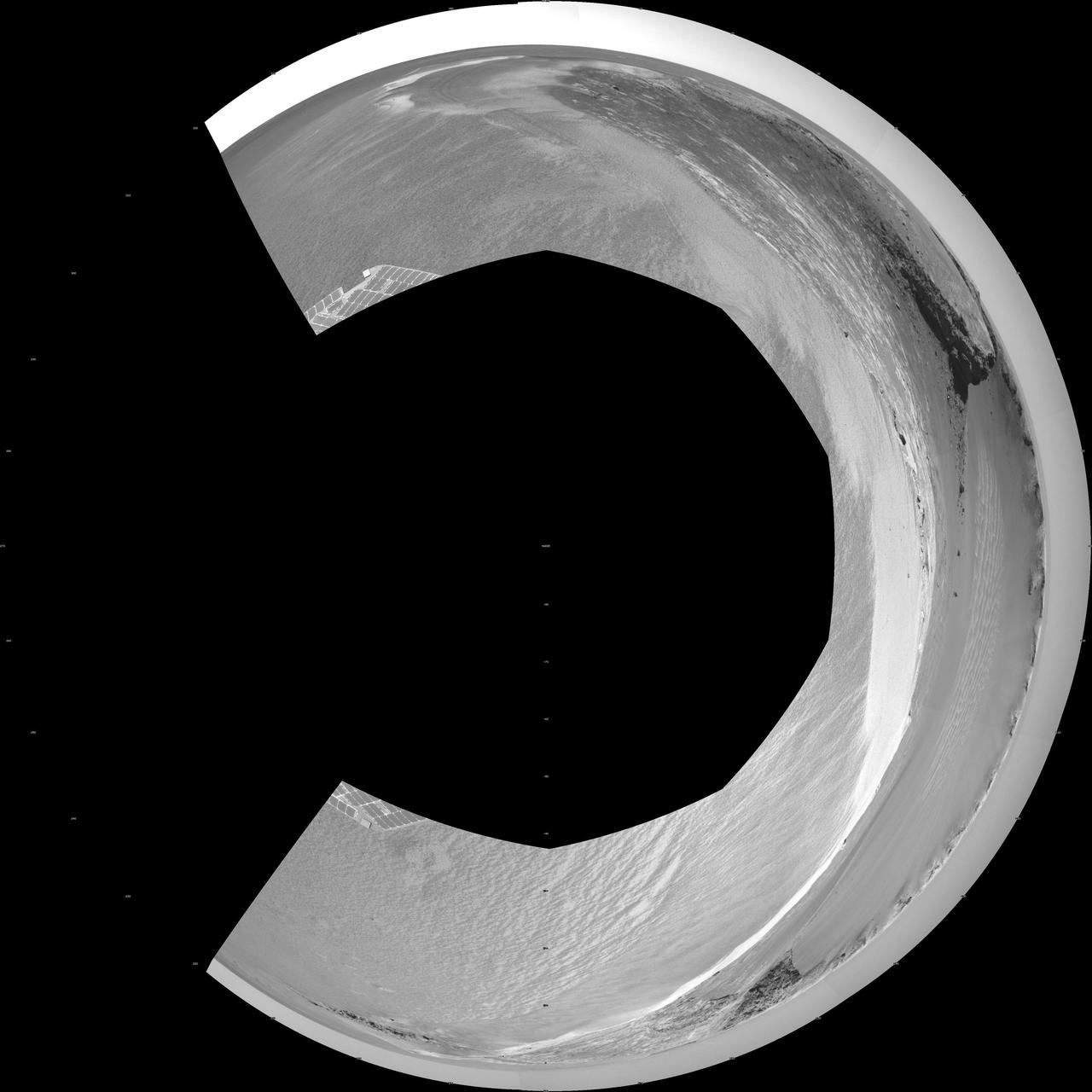
In a shallow depression called Yellowknife Bay, the NASA Mars rover Curiosity drove to an edge of the feature to record this view of the ledge at the margin and a view across the bay during the 130th Martian day, or sol, Dec. 17, 2012.

For five years, Jeremy Harbeck has worked as a support scientist for NASA’s Operation IceBridge, an airborne mission to study polar ice. The data processing that he does typically takes place in an office at NASA’s Goddard Space Flight Center in Maryland. However, to speed the process of delivering data to the Arctic sea ice forecasting community, Harbeck traveled to Greenland for the first time in spring 2015. He had just arrived at Greenland’s Thule Air Base on March 20 when a mechanical issue grounded the aircraft. No science flight could happen for a few days. As teams in the United States and Greenland scrambled to locate and deliver a replacement part, researchers on the ground waited. Some of them hiked to what was locally known as “the iceberg.” The unnamed berg pictured above has been frozen in place by sea ice in North Star Bay. Harbeck shot the photograph—a composite of four 49-second images—on March 21 at about 2:30 a.m. local time. The sun never fully sets at this time of year in the Arctic, so sunlight appears on the left side of the image. Lights from Thule are visible on the right side. Look for the Milky Way (top left) and a few very faint meteors visible in the early morning sky. Harbeck left the dock at Thule with sea ice scientist (and current IceBridge project scientist) Nathan Kurtz and a local recreation officer at about 10 p.m. From there, the group hiked 2.4 kilometers (1.5 miles) across the still-thick sea ice in weather that Harbeck called a “pleasant” minus 18 degrees Celsius (0 degrees Fahrenheit). They paused frequently on the way, and they even circled the berg to check for polar bears. “You don’t have a sense of scale of this berg until you get up to it,” Harbeck said. “It’s about the size of my apartment building, and that’s only the part protruding from the water.” Assuming the berg is ungrounded (which is uncertain), about one-tenth of its mass is above water. Photograph by Jeremy Harbeck, support scientist for NASA's Operation IceBridge mission. Caption by Kathryn Hansen. Credit: <b><a href="http://www.earthobservatory.nasa.gov/" rel="nofollow"> NASA Earth Observatory</a></b> <b><a href="http://www.nasa.gov/audience/formedia/features/MP_Photo_Guidelines.html" rel="nofollow">NASA image use policy.</a></b> <b><a href="http://www.nasa.gov/centers/goddard/home/index.html" rel="nofollow">NASA Goddard Space Flight Center</a></b> enables NASA’s mission through four scientific endeavors: Earth Science, Heliophysics, Solar System Exploration, and Astrophysics. Goddard plays a leading role in NASA’s accomplishments by contributing compelling scientific knowledge to advance the Agency’s mission. <b>Follow us on <a href="http://twitter.com/NASAGoddardPix" rel="nofollow">Twitter</a></b> <b>Like us on <a href="http://www.facebook.com/pages/Greenbelt-MD/NASA-Goddard/395013845897?ref=tsd" rel="nofollow">Facebook</a></b> <b>Find us on <a href="http://instagrid.me/nasagoddard/?vm=grid" rel="nofollow">Instagram</a></b>
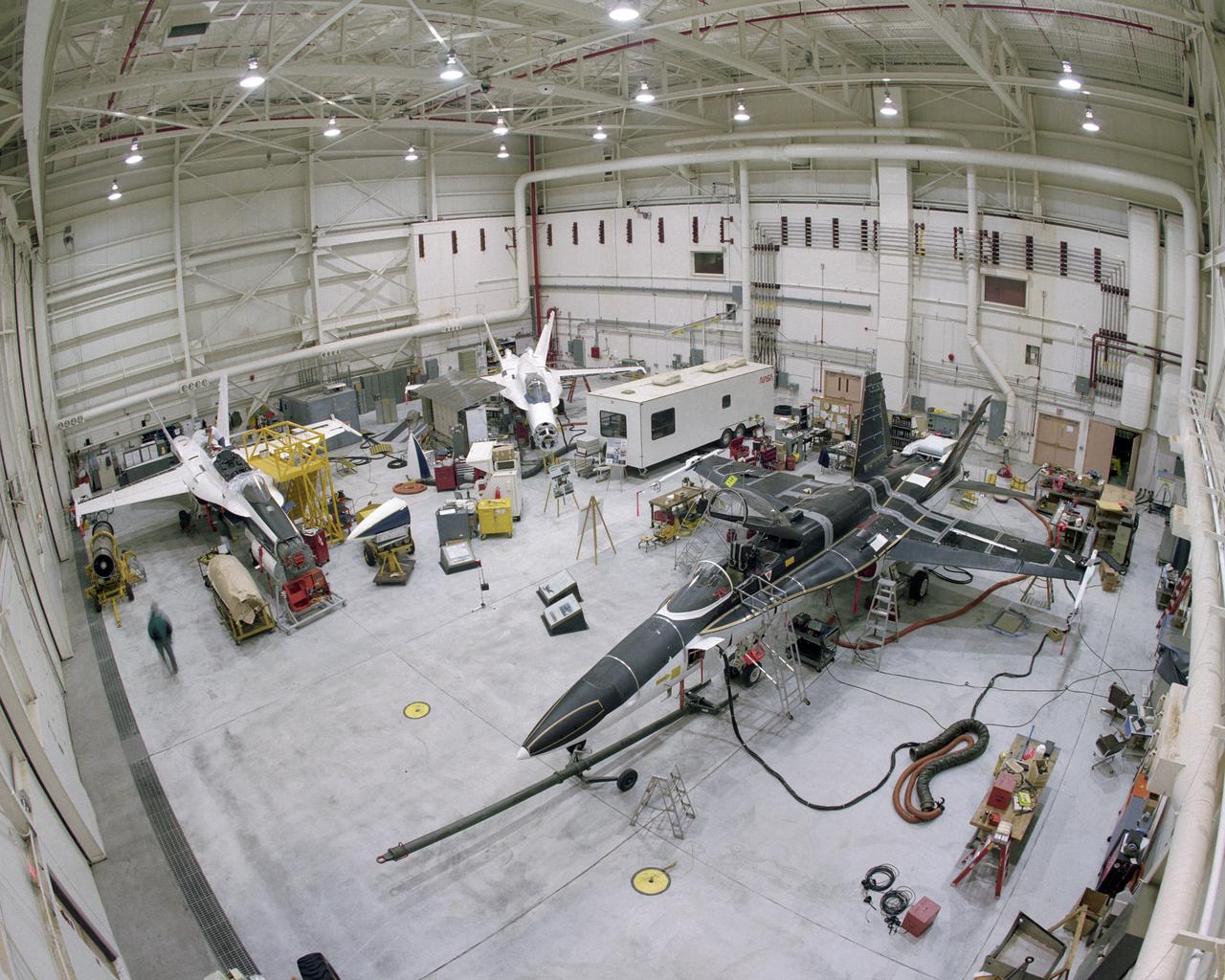
RAIF Hangar Bays 1 and 2. Three of NASA's F-18 aircraft can be seen in this photo. The SRA, or Systems Research Aircraft, is at the far left. In the middle is the F-18 Iron Bird, used for full-scale, hardware-in-the-loop simulations. On the right is the F-18 High Alpha Research Vehicle, or HARV.
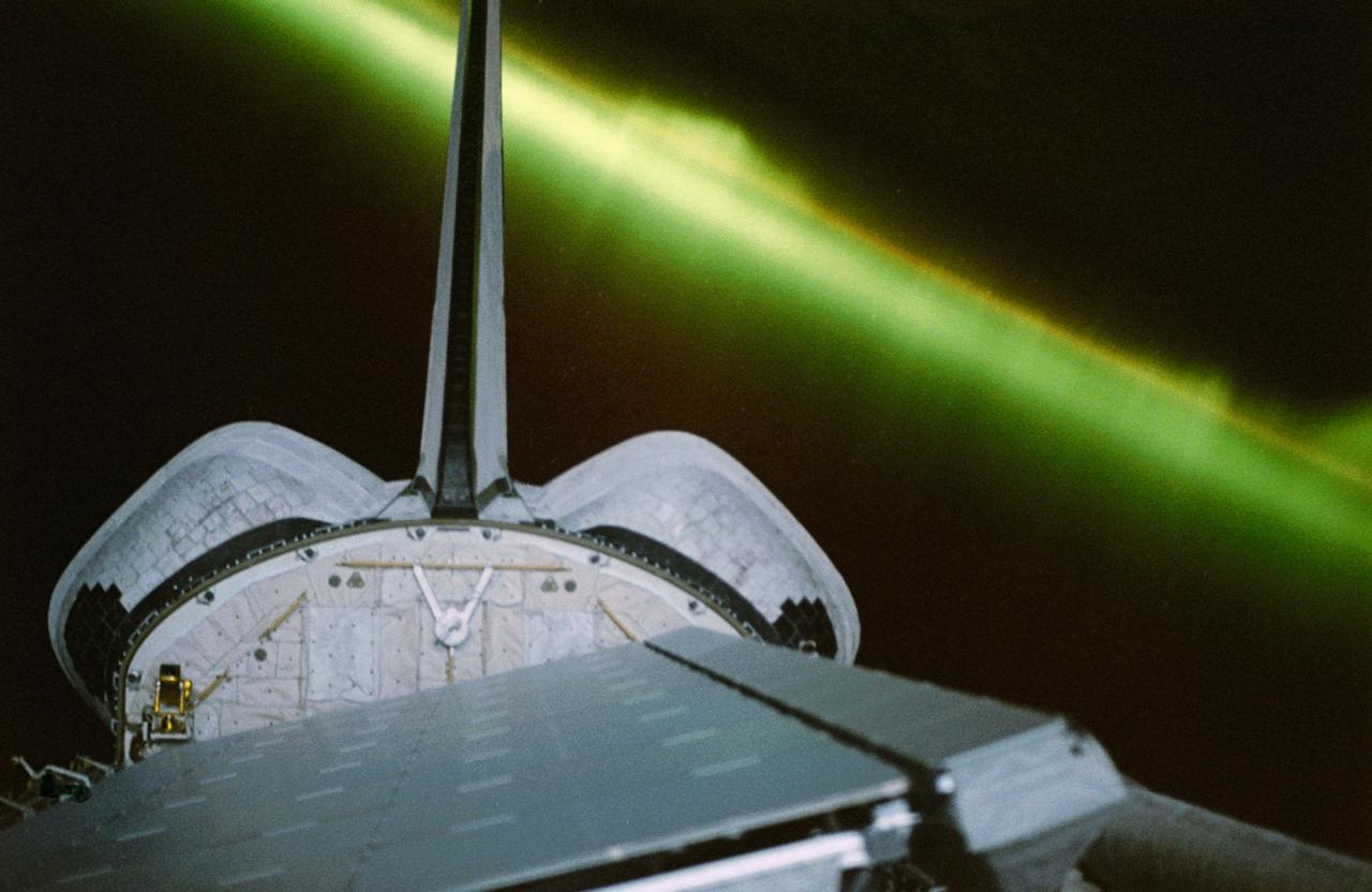
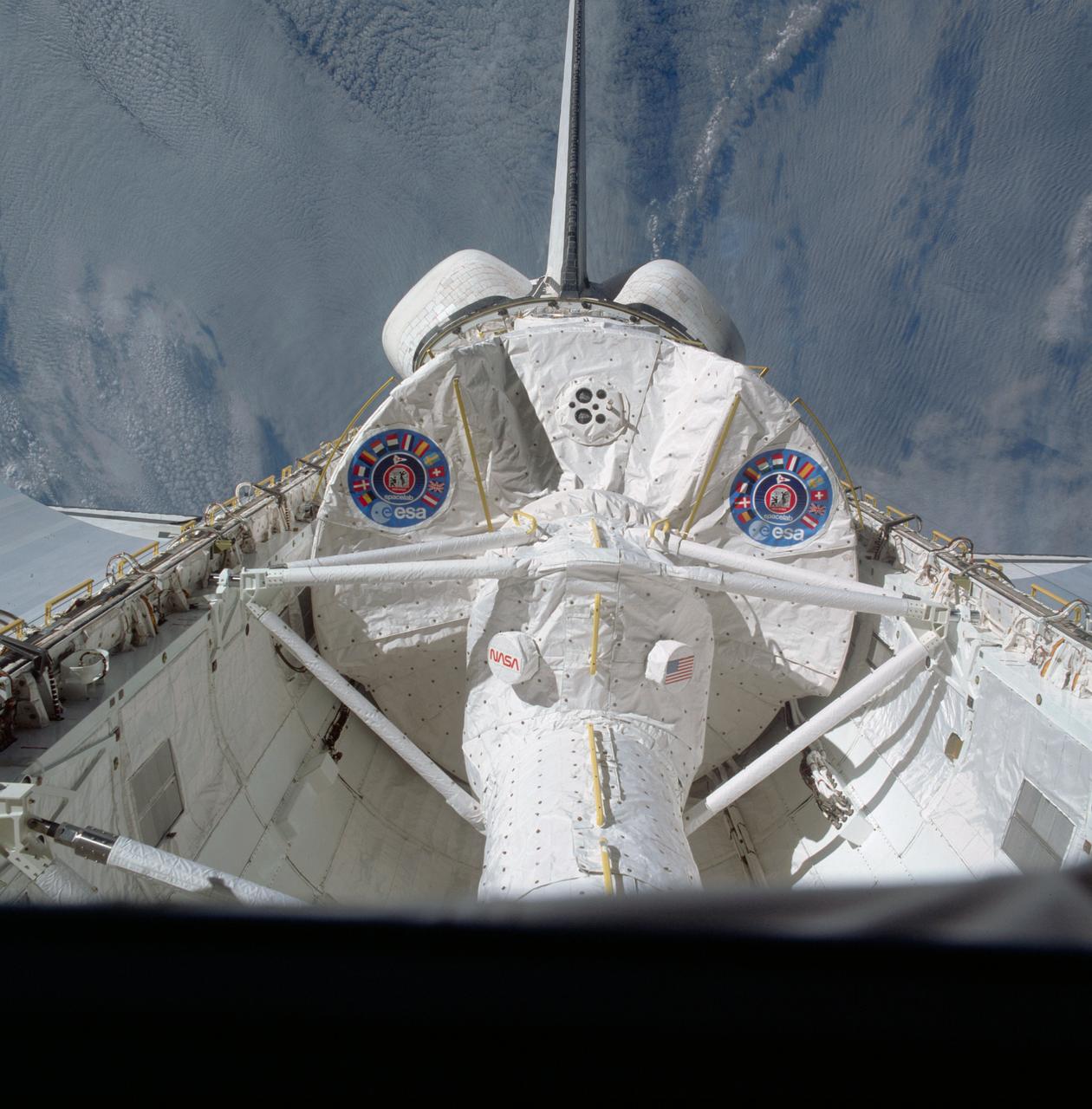
STS059-50-011 (9-20 April 94) --- A greenish appearing aurora forms the backdrop for this 35mm scene of the Earth orbiting Space Shuttle Endeavour's aft cargo bay. Featured in the bay are the antennae for the SIR-C/X-SAR imaging radar instruments, illuminated by moonlight. The crew sighted the southern lights (aurora australis) several times during each of the eleven days of the mission.
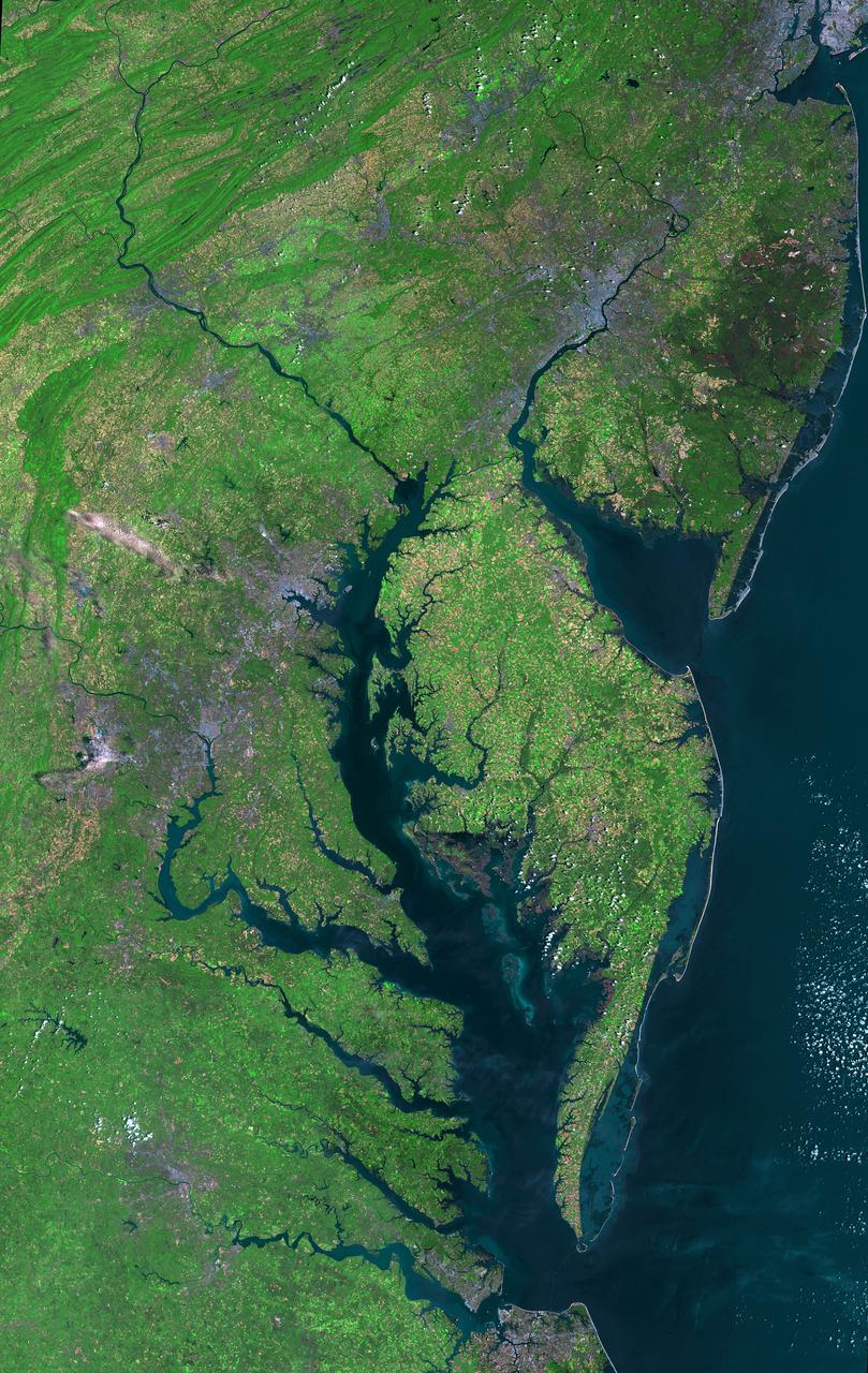
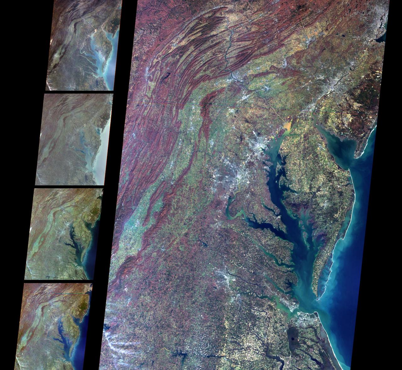
Aug 30, 2011 USGS has released a new mosaic of the Chesapeake Bay. Using six Landsat 5 images collected in July 2009 and 2011 a beautiful, seamless mosaic of the Chesapeake Bay region was created by the USGS Landsat team. The Washington D.C.-Baltimore-Philadelphia-New York City corridor can be clearly seen (look for silvery purple) as can the Chesapeake and Delaware Bays and the coastal Atlantic barrier islands from Fishermans Island, Virginia to Sandy Hook, New Jersey. To download the full high res go to: <a href="http://landsat.gsfc.nasa.gov/news/news-archive/news_0387.html" rel="nofollow">landsat.gsfc.nasa.gov/news/news-archive/news_0387.html</a> Credit: NASA/USGS/Landsat 5 <b><a href="http://www.nasa.gov/centers/goddard/home/index.html" rel="nofollow">NASA Goddard Space Flight Center</a></b> enables NASA’s mission through four scientific endeavors: Earth Science, Heliophysics, Solar System Exploration, and Astrophysics. Goddard plays a leading role in NASA’s accomplishments by contributing compelling scientific knowledge to advance the Agency’s mission. <b>Follow us on <a href="http://twitter.com/NASA_GoddardPix" rel="nofollow">Twitter</a></b> <b>Like us on <a href="http://www.facebook.com/pages/Greenbelt-MD/NASA-Goddard/395013845897?ref=tsd" rel="nofollow">Facebook</a></b> <b>Find us on <a href="http://instagrid.me/nasagoddard/?vm=grid" rel="nofollow">Instagram</a></b>
These multi-angle images of Delaware Bay, Chesapeake Bay, and the Appalachian Mountains, acquired 24 March 2000 from NASA Terra spacecraft, come from the downward-looking nadir camera on the MISR instrument onboard NASA Terra satellite.
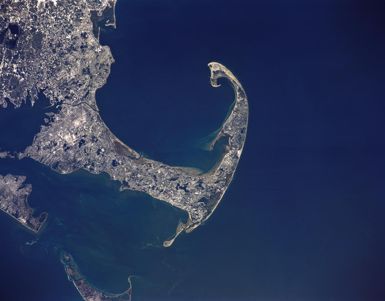
STS036-151-225 (2 March 1990) --- Surrounded by waters of the Atlantic Ocean, Cape Cod Bay and Nantucket Sound, the jutting Cape Cod feature caught the attention of the astronaut crewmembers aboard the Earth-orbiting Space Shuttle Atlantis, 126 nautical miles above Earth. Parts of Martha's Vineyard and Nantucket are in bottom left corner. Plymouth Bay is in upper left corner. Center point coordinates are 42 degrees north latitude and 70 degrees west longitude. A large format Linhof camera (4" x 5" film) was used to expose the frame.
STS002-12-833 (13 Nov. 1981) --- Clouds over Earth and black sky form the background for this unique photograph from the space shuttle Columbia in Earth orbit. The photograph was shot through the aft flight deck windows viewing the cargo bay. Part of the scientific payload of the Office of Space and Terrestrial Applications (OSTA-1) is visible in the open cargo bay. The astronauts inside Columbia's cabin were remotely operating the Canadian-built remote manipulator system (RMS). Note television cameras on its elbow and wrist pieces. Photo credit: NASA
STS058-81-049 (18 Oct-1 Nov 1993) --- This view encompasses most of the large estuarine system of the Chesapeake Bay. The farmland and marshes of eastern shores of the Chesapeake (eastern Maryland and Virginia) are the foreground. The largest tributary flowing into the Bay is the Potomac River; Washington, D.C. is visible where the river bends to the northwest. The urban-suburban corridor between Washington, D.C. and Baltimore to the north (toward the right on this view) shows well as the gray zone which extends from left (D.C. on the Potomac) to right (Baltimore on the Patapsco River embayment on the Chesapeake, near the upper right).
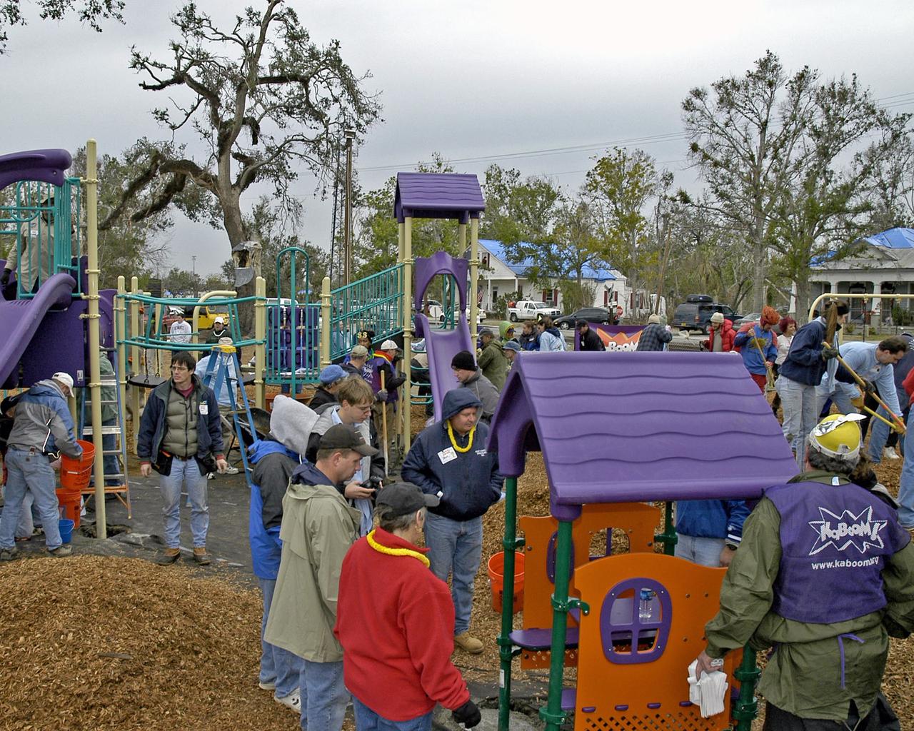
More than 650 volunteers - many of them employees at NASA's Stennis Space Center - weathered rain and cold to transform Bay St. Louis' old City Park into a playground Dec. 17. Volunteers assembled and erected a slide, swing set, jungle gym, sand box and planter benches in an eight-hour time frame. The playground was the first new structure built in the town devastated by Hurricane Katrina and the first on the Gulf Coast after the storm. The project was financed and led by nonprofit organization KaBOOM!, whose vision is to create a great place to play within walking distance of every child in America.
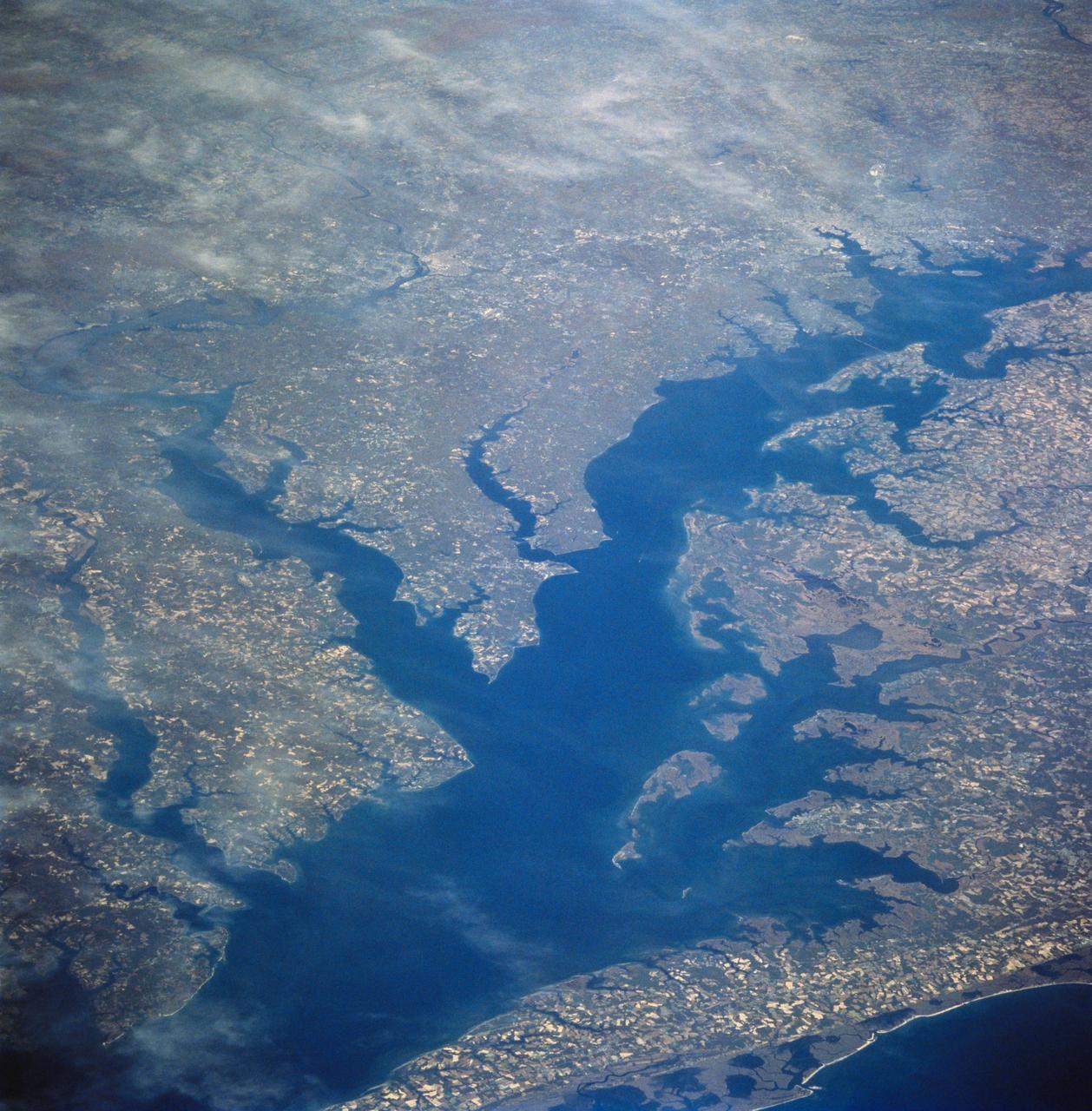
These multi-angle images of Hudson Bay and James Bay, Canada, taken 24 February 2000 from NASA Terra spacecraft, come from the downward-looking nadir camera on the MISR instrument onboard NASA Terra satellite.
STS054-31-031 (17 Jan 1993) --- Astronaut Gregory J. Harbaugh, mission specialist, waves to fellow crew members on Endeavour's aft flight deck from the payload bay during the four-plus hours extravehicular activity (EVA). Harbaugh was joined on the EVA by astronaut Mario Runco Jr., mission specialist.
Phytoplankton growth in the Bay of Biscay intensified in early May, 2013, painting the deep blue waters with huge swirls of jewel-tone colors that were brilliantly visible from space. The Moderate Resolution Imaging Spectroradiometer (MODIS) aboard NASA’s Terra satellite captured this true-color image on May 4, 2013. Each year, typically from March through April, such blooms occur in the Bay of Biscay. By May, however, conditions are not as favorable and the blooms tend to fade, then disappear. This bloom is expanding in early May this year, but will likely begin to diminish soon. Credit: NASA/GSFC/Jeff Schmaltz/MODIS Land Rapid Response Team <b><a href="http://www.nasa.gov/audience/formedia/features/MP_Photo_Guidelines.html" rel="nofollow">NASA image use policy.</a></b> <b><a href="http://www.nasa.gov/centers/goddard/home/index.html" rel="nofollow">NASA Goddard Space Flight Center</a></b> enables NASA’s mission through four scientific endeavors: Earth Science, Heliophysics, Solar System Exploration, and Astrophysics. Goddard plays a leading role in NASA’s accomplishments by contributing compelling scientific knowledge to advance the Agency’s mission. <b>Follow us on <a href="http://twitter.com/NASA_GoddardPix" rel="nofollow">Twitter</a></b> <b>Like us on <a href="http://www.facebook.com/pages/Greenbelt-MD/NASA-Goddard/395013845897?ref=tsd" rel="nofollow">Facebook</a></b> <b>Find us on <a href="http://instagram.com/nasagoddard?vm=grid" rel="nofollow">Instagram</a></b>
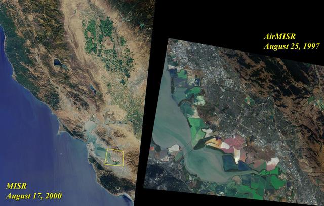
This image acquired on August 17, 2000 during Terra orbit 3545 shows Northern California and San Francisco Bay.
Hamelin Pool Marine Nature Reserve is located in the Shark Bay World Heritage Site in Western Australia. It is one of the very few places in the world where living stromatolites can be found. These are the first living examples of structures built by cyanobacteria. These bacteria are direct descendants of the oldest form of photosynthetic life on earth, dating back 3,500 million years (Wikipedia). The image was acquired December 30, 2010, covers an area of 34 x 46 km, and is located at 26.4 degrees south latitude, 114.1 degrees east longitude. With its 14 spectral bands from the visible to the thermal infrared wavelength region and its high spatial resolution of 15 to 90 meters (about 50 to 300 feet), ASTER images Earth to map and monitor the changing surface of our planet. ASTER is one of five Earth-observing instruments launched Dec. 18, 1999, on Terra. The instrument was built by Japan's Ministry of Economy, Trade and Industry. A joint U.S./Japan science team is responsible for validation and calibration of the instrument and data products. The broad spectral coverage and high spectral resolution of ASTER provides scientists in numerous disciplines with critical information for surface mapping and monitoring of dynamic conditions and temporal change. Example applications are: monitoring glacial advances and retreats; monitoring potentially active volcanoes; identifying crop stress; determining cloud morphology and physical properties; wetlands evaluation; thermal pollution monitoring; coral reef degradation; surface temperature mapping of soils and geology; and measuring surface heat balance. The U.S. science team is located at NASA's Jet Propulsion Laboratory, Pasadena, Calif. The Terra mission is part of NASA's Science Mission Directorate, Washington, D.C. More information about ASTER is available at <a href="http://asterweb.jpl.nasa.gov/" rel="nofollow">asterweb.jpl.nasa.gov/</a>. Credit: NASA/GSFC/METI/ERSDAC/JAROS, and U.S./Japan ASTER Science Team Image Addition Date: 2013-03-15 <b><a href="http://www.nasa.gov/audience/formedia/features/MP_Photo_Guidelines.html" rel="nofollow">NASA image use policy.</a></b> <b><a href="http://www.nasa.gov/centers/goddard/home/index.html" rel="nofollow">NASA Goddard Space Flight Center</a></b> enables NASA’s mission through four scientific endeavors: Earth Science, Heliophysics, Solar System Exploration, and Astrophysics. Goddard plays a leading role in NASA’s accomplishments by contributing compelling scientific knowledge to advance the Agency’s mission. <b>Follow us on <a href="http://twitter.com/NASA_GoddardPix" rel="nofollow">Twitter</a></b> <b>Like us on <a href="http://www.facebook.com/pages/Greenbelt-MD/NASA-Goddard/395013845897?ref=tsd" rel="nofollow">Facebook</a></b> <b>Find us on <a href="http://instagram.com/nasagoddard?vm=grid" rel="nofollow">Instagram</a></b>

Acquired by NASA Terra spacecraft, this image shows Hamelin Pool Marine Nature Reserve, located in the Shark Bay World Heritage Site in Western Australia.
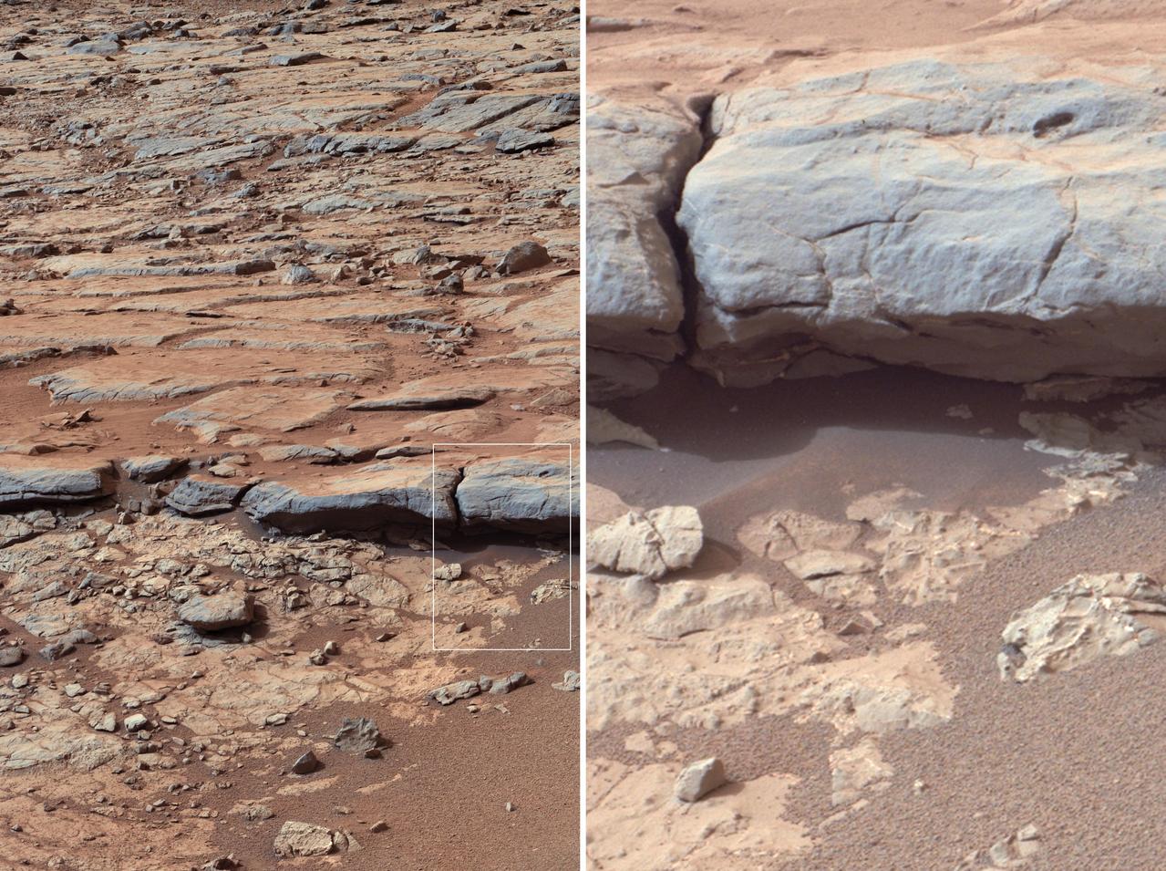
The right Mast Camera Mastcam of NASA Curiosity Mars rover provided this view of the lower stratigraphy at Yellowknife Bay inside Gale Crater on Mars.
STS059-213-009 (9-20 April 1994) --- San Francisco Bay. Orient with the sea up. The delta of the combined Sacramento and San Joaquin Rivers occupies the foreground, San Francisco Bay the middle distance, and the Pacific Ocean the rest. Variations in water color caused both by sediment load and by wind streaking strike the eye. Man-made features dominate this scene. The Lafayette/Concord complex is left of the bay head, Vallejo is to the right, the Berkeley/Oakland complex rims the shoreline of the main bay, and San Francisco fills the peninsula beyond. Salt-evaporation ponds contain differently-colored algae depending on salinity. The low altitude (less than 120 nautical miles) and unusually-clear air combine to provide unusually-strong green colors in this Spring scene. Hasselblad camera.
STS002-13-208 (12-14 Nov. 1981) --- This clear view of the aft section of the Earth-orbiting space shuttle Columbia's cargo bay and some of its cargo was photographed through the flight deck's aft windows. Visible in the center of the photo are the twin orbital maneuvering system (OMS) pods. The vertical stabilizer or tail splits the top part of the image in half. The Induced Environment Contamination Monitor (IECM) Location experiment is located in the back center of the cargo bay, near the top. There is a grapple fixture attached to the side of the IECM. Various components of the Office of Space Terrestrial Applications (OSTA-1) payload are seen near the aft section of the cargo bay, such as the Feature Identification and Location Experiment (FILE) (the long cone shaped object on the right back), the Shuttle Multispectral Infrared Radiometer (SMIRR) (on pallet base) and the SIR-A recorder in the right foreground. In the left foreground the Shuttle Imaging Radar-A (SIR-A) antenna can be seen. Photo credit: NASA
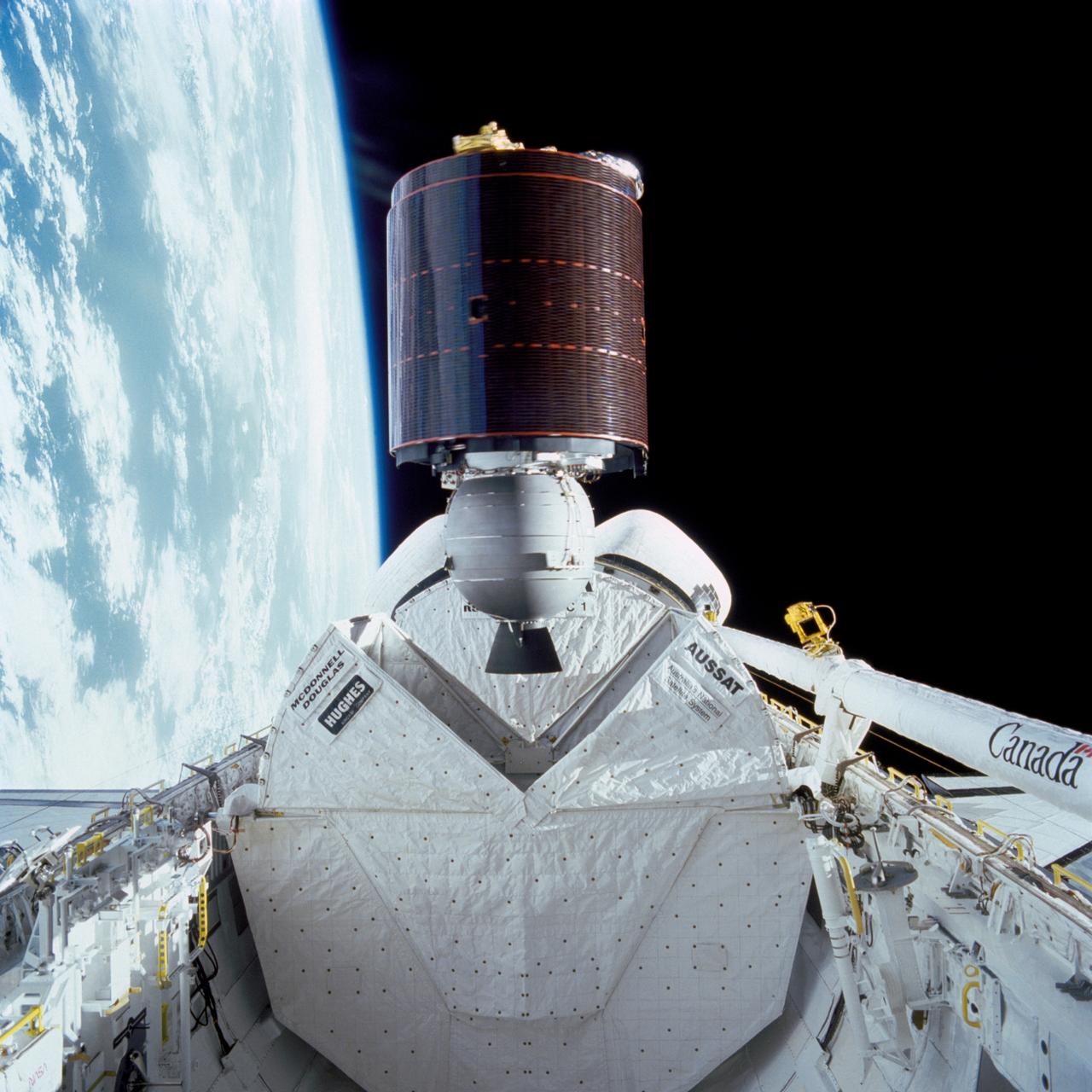
51I-32-023 (27 Aug. 1985) --- Australia's AUSSAT communications satellite is deployed from the payload bay of the space shuttle Discovery on flight day one. A portion of the cloudy surface of Earth can be seen to the left of the frame. Photo credit: NASA
STS039-151-181A (28 April-6 May 1991) --- Large format (five-inch) frame of the San Francisco/Oakland Bay Area of northern California. Stratus clouds at 35,000 feet and cumulus clouds at about 15,000 feet are seen over the Pacific Coast, obscuring the Golden Gate Bridge.
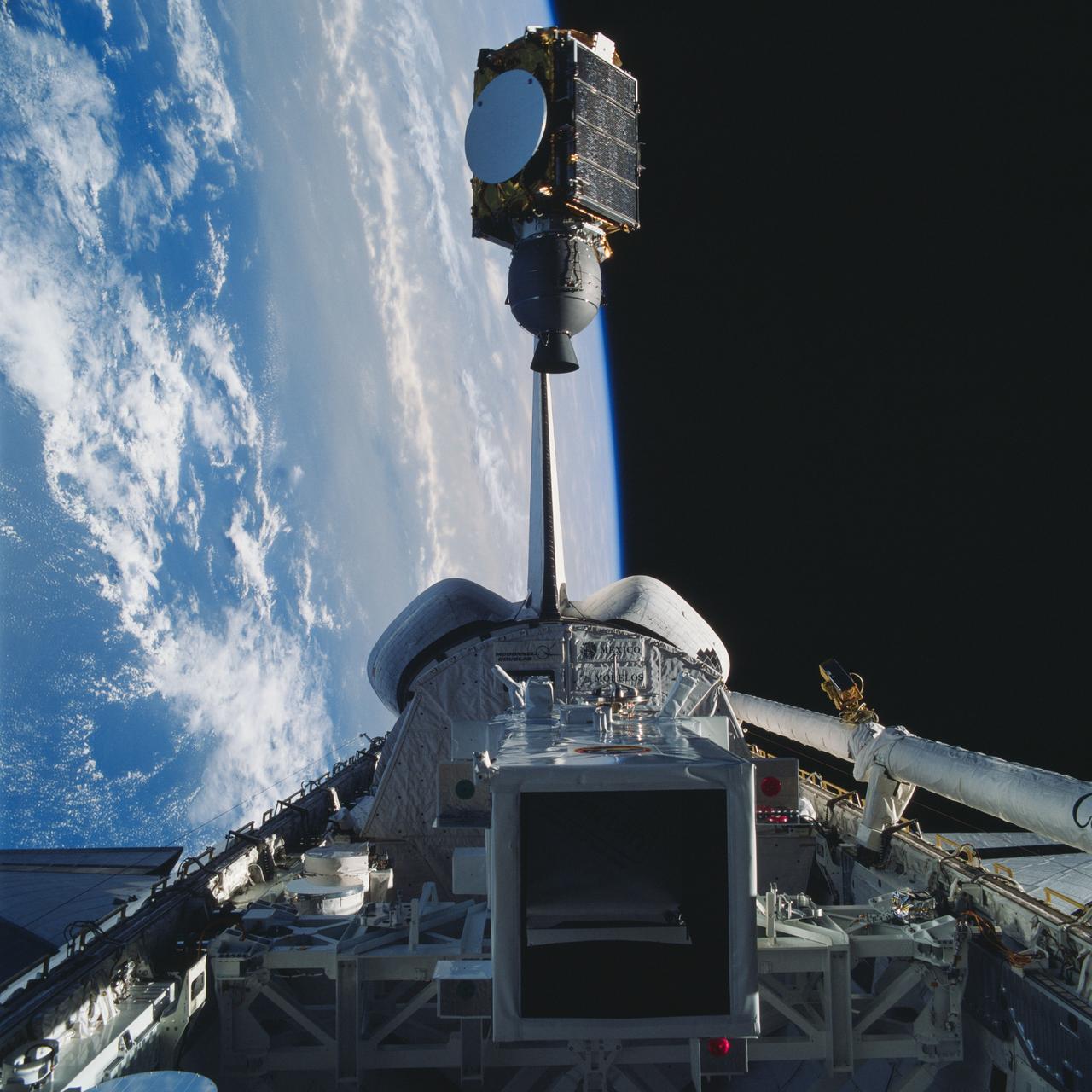
Arabsat communications satellite deploying from Discovery's payload bay. Cloudy Earth's surface can be seen to the left of the frame.
Model showing OSTA-3 and other payloads in the open shuttle orbiter cargo bay.
SL2-03-118 (June 1973) --- An infrared photograph of the San Francisco Bay, California area, taken from the Skylab 1/2 space station in Earth orbit. THE PICTURE SHOULD BE HELD WITH THE CLOUDS AND PACIFIC OCEAN ON THE LEFT. This photograph was taken by one of the six lenses of the Itek-furnished S190-A Multispectral Photographic Facility Experiment in the Multiple Docking Adapter of the space station. Type 2443 film was used. Note the thickly populated and highly developed area around the bay. Among the cities visible in this photograph are San Francisco, Oakland, Berkeley and San Jose. This view extends eastward to show a portion of the San Joaquin Valley. The S190-A experiment is part of the Skylab Earth Resources Experiment Package (EREP). Photo credit: NASA
Spartan I satellte sits in the Discovery's payload bay prior to being deployed. Above it can be seen the remote manipulator system (RMS) arm and end effector. The Earth's horizon can also be seen above the orbiter.
Telstar 3-D communications satellite deploying from Discovery's payload bay. Cloudy Earth's surface can be seen to the left of the frame.
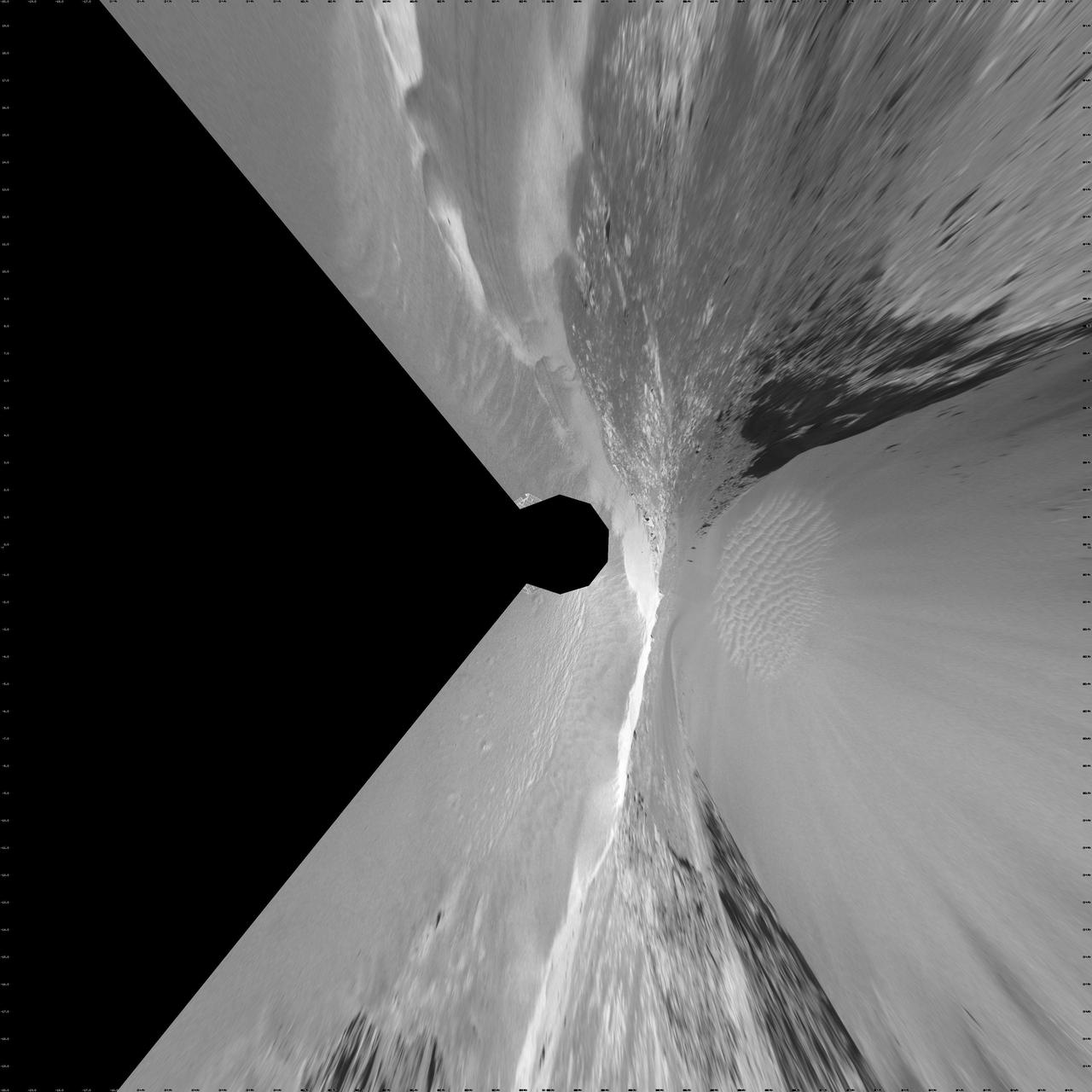
Opportunity View During Exploration in Duck Bay, Sols 1506-1510 Stereo
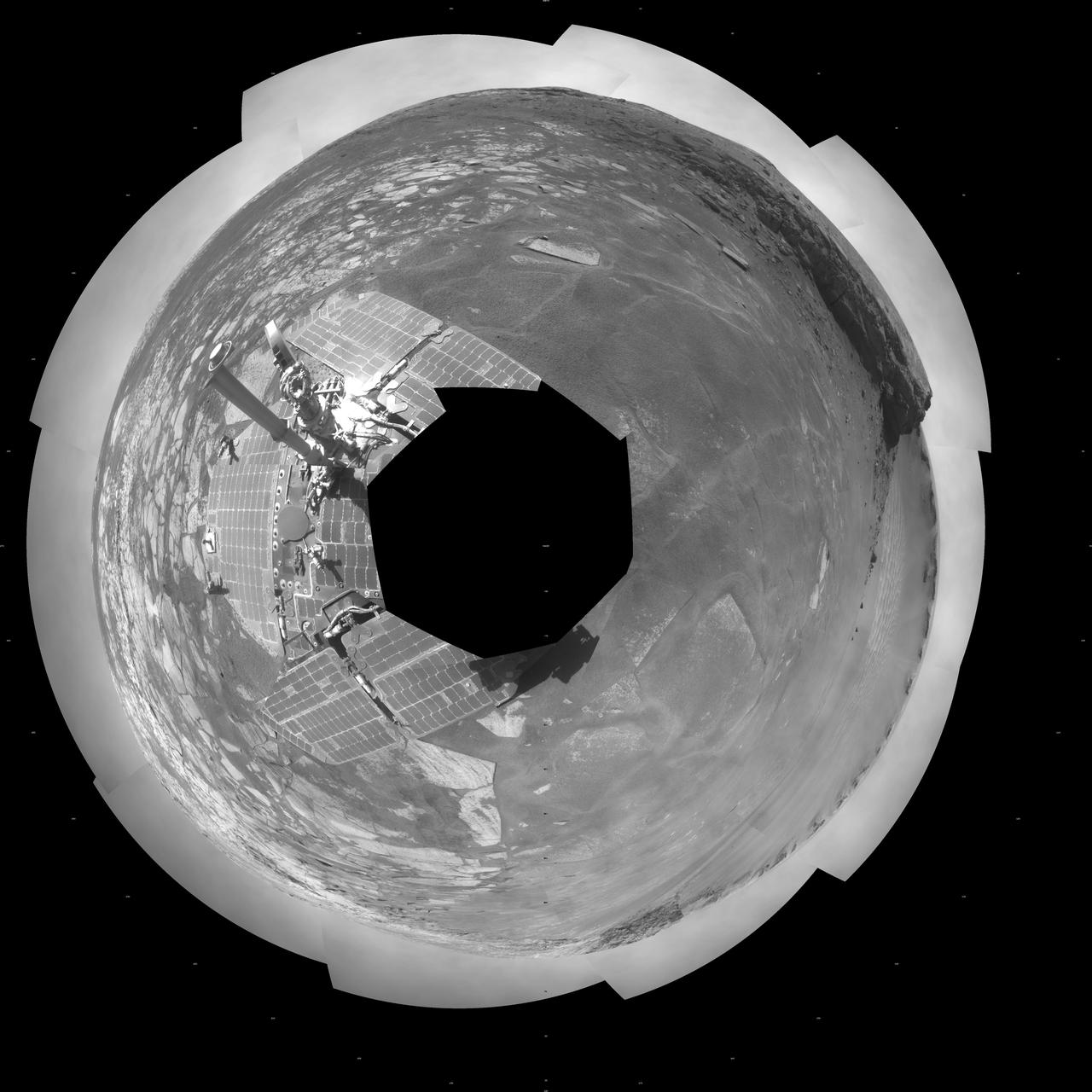
Opportunity View During Exploration in Duck Bay, Sols 1506-1510 Vertical
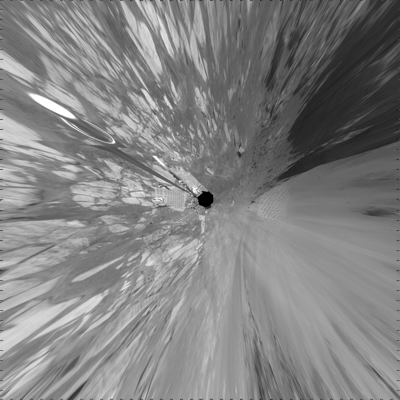
Opportunity View During Exploration in Duck Bay, Sols 1506-1510 Polar
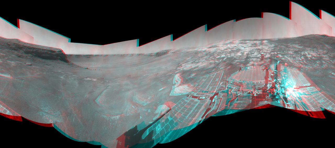
Opportunity View During Exploration in Duck Bay, Sols 1506-1510
STS039-89-053 (28 April-6 May 1991) --- A 70mm, infrared frame of the city of San Francisco, taken on a clear day. The gray areas represent urban regions, and the red areas are vegetated. Within the city of San Francisco, parks like Golden Gate park and the Presidio at the base of the Golden Gate Bridge easily stand out from the well-developed parts of the city. Major thoroughfares and bridges (Golden Gate and Bay Bridges) are seen as are other landmarks such as Candlestick Park and Alcatraz. The trace of the San Andreas faults show as a straight valley running northerly along the San Francisco peninsula. Good detail is visible in the turbid waters of San Francisco Bay.
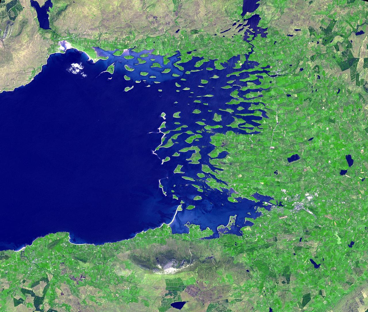
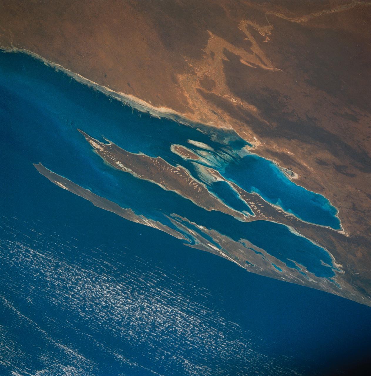
Clew Bay is in County Mayo, Republic of Ireland. It contains Ireland's best example of sunken glacial drumlins. Clew Bay is associated with Grace O'Malley, the Pirate Queen during Elizabethan times; and Dorinish, a private island purchased by John Lennon. The drumlins are low hills formed from glacial sediment deposited at the end of the last Ice Age. The image was acquired May 31, 2016, covers an area of 22.5 by 26.2 km, and is located at 53.9 degrees north, 9.6 degrees west. http://photojournal.jpl.nasa.gov/catalog/PIA18670

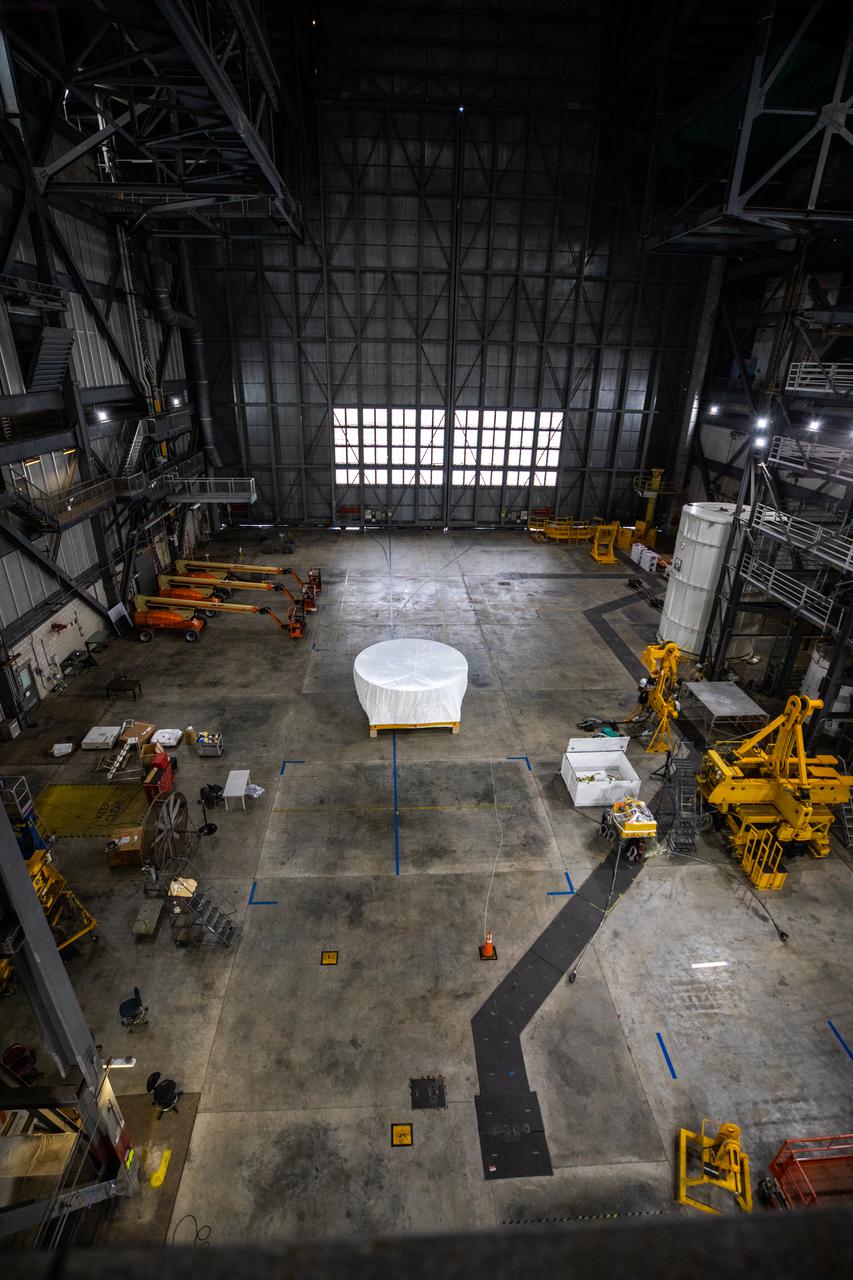
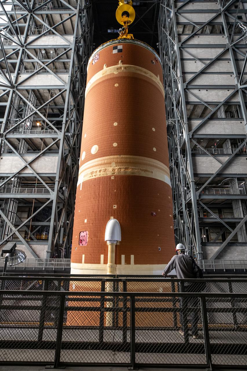
Teams with NASA’s Exploration Ground Systems lower the agency’s 212-foot-tall SLS (Space Launch System) core stage into High Bay 2 at the Vehicle Assembly Building at NASA’s Kennedy Space Center in Florida on Wednesday, Dec. 11, 2024. The one-of-a kind lifting beam is designed to lift the core stage from the transfer aisle to High Bay 2 where it will remain while teams stack the two solid rocket boosters on top of mobile launcher 1 for the SLS core stage. Boeing and their sub-contractor Futuramic refurbished High Bay 2 to increase efficiencies while processing core stages for Artemis II and beyond.

Teams with NASA’s Exploration Ground Systems lower the agency’s 212-foot-tall SLS (Space Launch System) core stage into High Bay 2 at the Vehicle Assembly Building at NASA’s Kennedy Space Center in Florida on Wednesday, Dec. 11, 2024. The one-of-a kind lifting beam is designed to lift the core stage from the transfer aisle to High Bay 2 where it will remain while teams stack the two solid rocket boosters on top of mobile launcher 1 for the SLS core stage. Boeing and their sub-contractor Futuramic refurbished High Bay 2 to increase efficiencies while processing core stages for Artemis II and beyond.

Teams with NASA’s Exploration Ground Systems lower the agency’s 212-foot-tall SLS (Space Launch System) core stage into High Bay 2 at the Vehicle Assembly Building at NASA’s Kennedy Space Center in Florida on Wednesday, Dec. 11, 2024. The one-of-a kind lifting beam is designed to lift the core stage from the transfer aisle to High Bay 2 where it will remain while teams stack the two solid rocket boosters on top of mobile launcher 1 for the SLS core stage. Boeing and their sub-contractor Futuramic refurbished High Bay 2 to increase efficiencies while processing core stages for Artemis II and beyond.

Teams with NASA’s Exploration Ground Systems lower the agency’s 212-foot-tall SLS (Space Launch System) core stage into High Bay 2 at the Vehicle Assembly Building at NASA’s Kennedy Space Center in Florida on Wednesday, Dec. 11, 2024. The one-of-a kind lifting beam is designed to lift the core stage from the transfer aisle to High Bay 2 where it will remain while teams stack the two solid rocket boosters on top of mobile launcher 1 for the SLS core stage. Boeing and their sub-contractor Futuramic refurbished High Bay 2 to increase efficiencies while processing core stages for Artemis II and beyond.

Teams with NASA’s Exploration Ground Systems lower the agency’s 212-foot-tall SLS (Space Launch System) core stage into High Bay 2 at the Vehicle Assembly Building at NASA’s Kennedy Space Center in Florida on Wednesday, Dec. 11, 2024. The one-of-a kind lifting beam is designed to lift the core stage from the transfer aisle to High Bay 2 where it will remain while teams stack the two solid rocket boosters on top of mobile launcher 1 for the SLS core stage. Boeing and their sub-contractor Futuramic refurbished High Bay 2 to increase efficiencies while processing core stages for Artemis II and beyond.

Teams with NASA’s Exploration Ground Systems lower the agency’s 212-foot-tall SLS (Space Launch System) core stage into High Bay 2 at the Vehicle Assembly Building at NASA’s Kennedy Space Center in Florida on Wednesday, Dec. 11, 2024. The one-of-a kind lifting beam is designed to lift the core stage from the transfer aisle to High Bay 2 where it will remain while teams stack the two solid rocket boosters on top of mobile launcher 1 for the SLS core stage. Boeing and their sub-contractor Futuramic refurbished High Bay 2 to increase efficiencies while processing core stages for Artemis II and beyond.

Teams with NASA’s Exploration Ground Systems lower the agency’s 212-foot-tall SLS (Space Launch System) core stage into High Bay 2 at the Vehicle Assembly Building at NASA’s Kennedy Space Center in Florida on Wednesday, Dec. 11, 2024. The one-of-a kind lifting beam is designed to lift the core stage from the transfer aisle to High Bay 2 where it will remain while teams stack the two solid rocket boosters on top of mobile launcher 1 for the SLS core stage. Boeing and their sub-contractor Futuramic refurbished High Bay 2 to increase efficiencies while processing core stages for Artemis II and beyond.

51I-32-059 (27 August 1985) --- The American Satellite Company (ASC) communications satellite rises from the cargo bay at 6:54 a.m. August 27, 1985.
This panorama taken by NASA Mars Exploration Rover Opportunity includes an outcrop informally called Cambridge Bay. Opportunity examined this outcrop in August 2010.
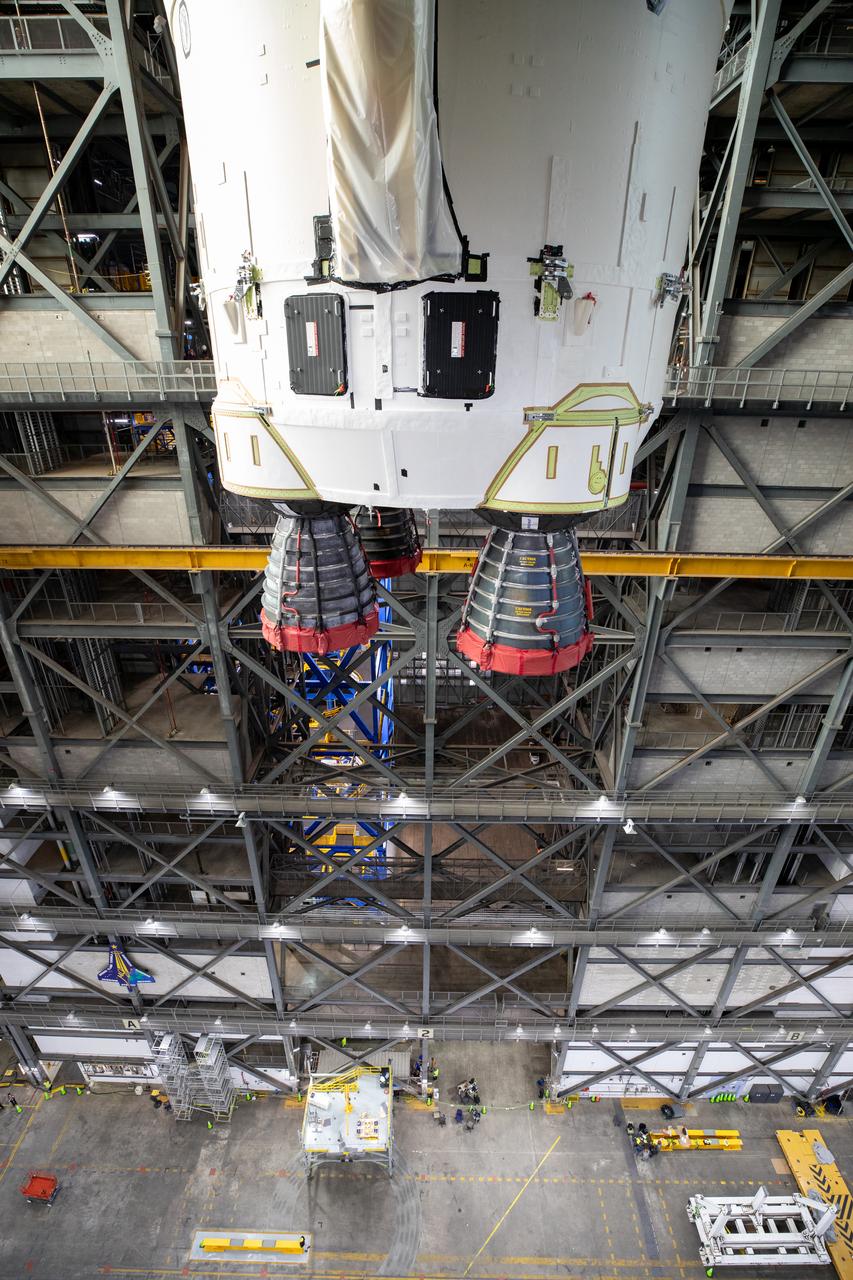
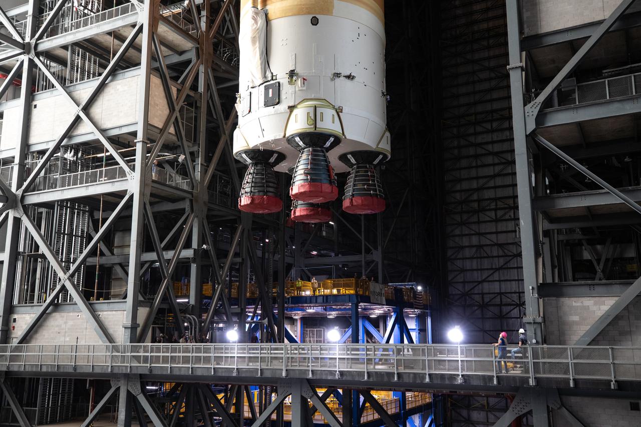
Under a protective cover, the Orion Stage Adapter (OSA) arrives in High Bay 4 of the Vehicle Assembly Building on Oct. 4, 2021, at NASA's Kennedy Space Center in Florida. Teams will lift the ring-shaped OSA, filled with shoebox-sized CubeSats, and connect it to the Interim Cryogenic Propulsion Stage (ICPS). The Orion spacecraft will be secured on top of the Space Launch System (SLS) rocket to complete the stack ahead of the Artemis I launch. This mission will be the first integrated flight test of the SLS and Orion spacecraft. In later missions, NASA will land the first woman and the first person of color on the surface of the Moon, paving the way for a long-term lunar presence and serving as a steppingstone on the way to Mars.
Under a protective cover, the Orion Stage Adapter (OSA) arrives in High Bay 4 of the Vehicle Assembly Building on Oct. 4, 2021, at NASA's Kennedy Space Center in Florida. Teams will lift the ring-shaped OSA, filled with shoebox-sized CubeSats, and connect it to the Interim Cryogenic Propulsion Stage (ICPS). The Orion spacecraft will be secured on top of the Space Launch System (SLS) rocket to complete the stack ahead of the Artemis I launch. This mission will be the first integrated flight test of the SLS and Orion spacecraft. In later missions, NASA will land the first woman and the first person of color on the surface of the Moon, paving the way for a long-term lunar presence and serving as a steppingstone on the way to Mars.

STS060-93-043 (9 Feb 1994) --- BREMSAT, a 140 pound (63 kilogram) satellite, quickly leaves the cargo bay of the Space Shuttle Discovery. The 480 mm (19 inch) deployable satellite was built by the University of Bremen's Center of Applied Space Technology and Microgravity (ZARM) under sponsorship of the German Space Agency (DARA). A modified ejection system in one of the payload bay's getaway special (GAS) type canisters aided the STS-60 crew members in deploying the satellite toward the end of their eight-day mission in Earth orbit.
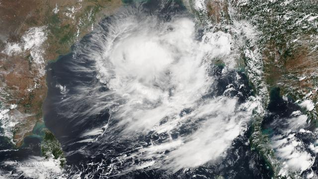
The Joint Typhoon Warning Center states that formation of a significant tropical cyclone is possible in the Bay of Bengal within the next 12 - 24 hours as of 0730Z on May 21, 2014. Along with deep convective banding associated with a consolidating low-level circulation center, warm sea surface temperatures are conducive for further development. This image was taken by the Suomi NPP satellite's VIIRS instrument in two passes, the east pass around 0615Z and the west pass around 0755Z on May 21, 2014. Credit: NASA/NOAA/NPP/VIIRS The Joint Typhoon Warning Center states that formation of a significant tropical cyclone is possible in the Bay of Bengal within the next 12 - 24 hours as of 0730Z on May 21, 2014. Along with deep convective banding associated with a consolidating low-level circulation center, warm sea surface temperatures are conducive for further development. This image was taken by the Suomi NPP satellite's VIIRS instrument in two passes, the east pass around 0615Z and the west pass around 0755Z on May 21, 2014.

Teams with NASA’s Exploration Ground Systems transport the agency’s 212-foot-tall SLS (Space Launch System) core stage into High Bay 2 at the Vehicle Assembly Building at NASA’s Kennedy Space Center in Florida on Wednesday, Dec. 11, 2024. The one-of-a kind lifting beam is designed to lift the core stage from the transfer aisle to High Bay 2 where it will remain while teams stack the two solid rocket boosters on top of mobile launcher 1 for the SLS core stage.
Teams with NASA’s Exploration Ground Systems transport the agency’s 212-foot-tall SLS (Space Launch System) core stage into High Bay 2 at the Vehicle Assembly Building at NASA’s Kennedy Space Center in Florida on Wednesday, Dec. 11, 2024. The one-of-a kind lifting beam is designed to lift the core stage from the transfer aisle to High Bay 2 where it will remain while teams stack the two solid rocket boosters on top of mobile launcher 1 for the SLS core stage.
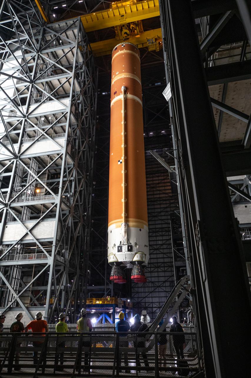
Teams with NASA’s Exploration Ground Systems transport the agency’s 212-foot-tall SLS (Space Launch System) core stage into High Bay 2 at the Vehicle Assembly Building at NASA’s Kennedy Space Center in Florida on Wednesday, Dec. 11, 2024. The one-of-a kind lifting beam is designed to lift the core stage from the transfer aisle to High Bay 2 where it will remain while teams stack the two solid rocket boosters on top of mobile launcher 1 for the SLS core stage.
Teams with NASA’s Exploration Ground Systems transport the agency’s 212-foot-tall SLS (Space Launch System) core stage into High Bay 2 at the Vehicle Assembly Building at NASA’s Kennedy Space Center in Florida on Wednesday, Dec. 11, 2024. The one-of-a kind lifting beam is designed to lift the core stage from the transfer aisle to High Bay 2 where it will remain while teams stack the two solid rocket boosters on top of mobile launcher 1 for the SLS core stage.
Teams with NASA’s Exploration Ground Systems transport the agency’s 212-foot-tall SLS (Space Launch System) core stage into High Bay 2 at the Vehicle Assembly Building at NASA’s Kennedy Space Center in Florida on Wednesday, Dec. 11, 2024. The one-of-a kind lifting beam is designed to lift the core stage from the transfer aisle to High Bay 2 where it will remain while teams stack the two solid rocket boosters on top of mobile launcher 1 for the SLS core stage.
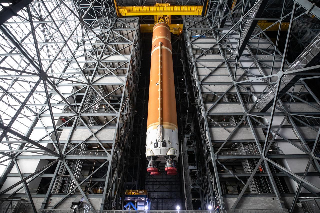
Teams with NASA’s Exploration Ground Systems transport the agency’s 212-foot-tall SLS (Space Launch System) core stage into High Bay 2 at the Vehicle Assembly Building at NASA’s Kennedy Space Center in Florida on Wednesday, Dec. 11, 2024. The one-of-a kind lifting beam is designed to lift the core stage from the transfer aisle to High Bay 2 where it will remain while teams stack the two solid rocket boosters on top of mobile launcher 1 for the SLS core stage.
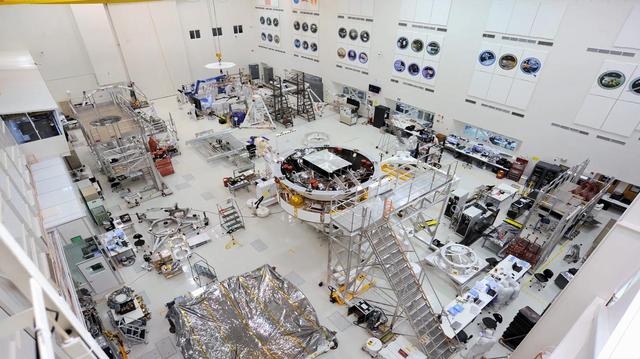
This image shows major components of NASA's Mars 2020 mission in the High Bay 1 clean room in JPL's Spacecraft Assembly Facility. Movie available at https://photojournal.jpl.nasa.gov/catalog/PIA23164
STS063-716-025 (9 Feb. 1995) --- In tail-to Earth mode, the Space Shuttle Discovery is backdropped against dark space, Sunburst and massive clouds over the ocean. The Spartan 204 is visible in the cargo bay. This is one of 16 still photographs released by the NASA Johnson Space Center (JSC) Public Affairs Office (PAO) on February 14, 1995. Onboard Discovery were astronauts James D. Wetherbee, mission commander; Eileen M. Collins, pilot; Bernard A. Harris, Jr., payload commander; mission specialists C. Michael Foale, Janice E. Voss, and cosmonaut Vladimir G. Titov.
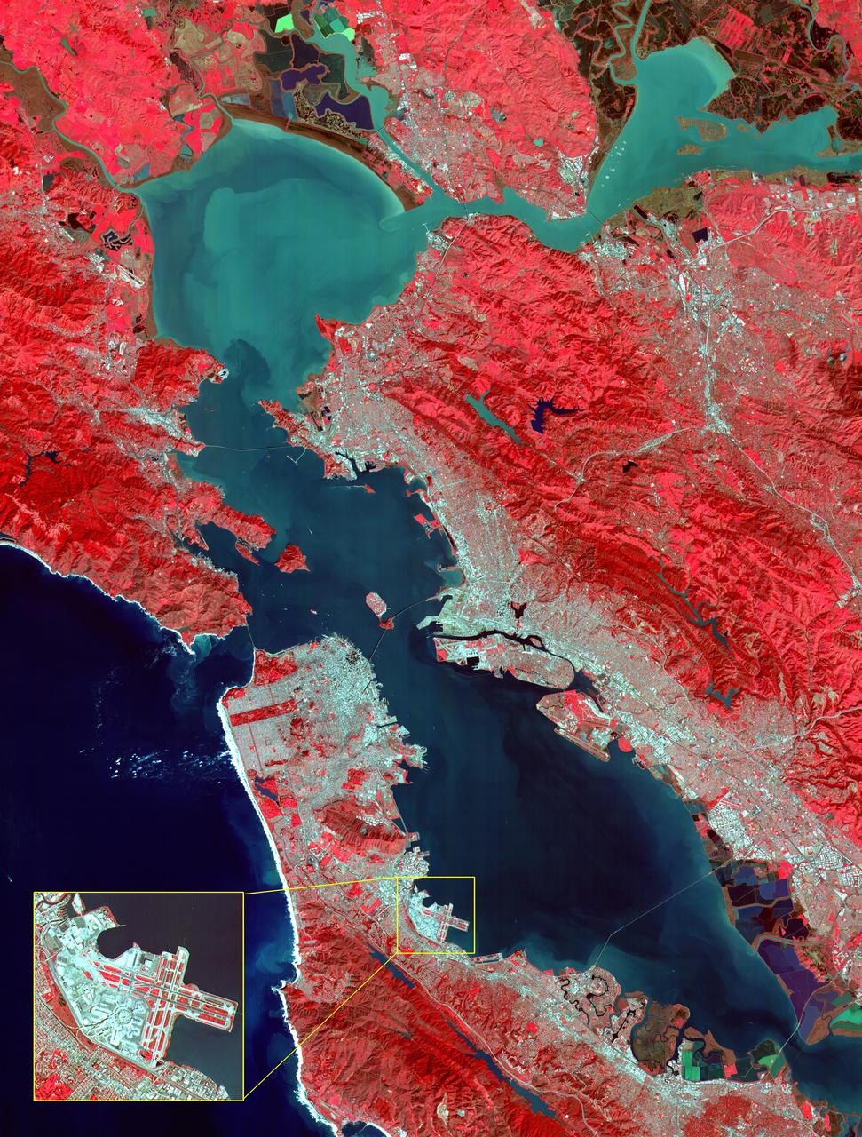
This image of the San Francisco Bay region was acquired on March 3, 2000 by the Advanced Spaceborne Thermal Emission and Reflection Radiometer (ASTER) on NASA's Terra satellite. With its 14 spectral bands from the visible to the thermal infrared wavelength region, and its high spatial resolution of 15 to 90 meters about 50 to 300 feet ), ASTER will image Earth for the next 6 years to map and monitor the changing surface of our planet. Image: This image covers an area 60 kilometers (37 miles) wide and 75 kilometers (47 miles) long in three bands of the reflected visible and infrared wavelength region. The combination of bands portrays vegetation in red, and urban areas in gray. Sediment in the Suisun Bay, San Pablo Bay, San Francisco Bay, and the Pacific Ocean shows up as lighter shades of blue. Along the west coast of the San Francisco Peninsula, strong surf can be seen as a white fringe along the shoreline. A powerful rip tide is visible extending westward from Daly City into the Pacific Ocean. In the lower right corner, the wetlands of the South San Francisco Bay National Wildlife Refuge appear as large dark blue and brown polygons. The high spatial resolution of ASTER allows fine detail to be observed in the scene. The main bridges of the area (San Mateo, San Francisco-Oakland Bay, Golden Gate, Richmond-San Rafael, Benicia-Martinez, and Carquinez) are easily picked out, connecting the different communities in the Bay area. Shadows of the towers along the Bay Bridge can be seen over the adjacent bay water. With enlargement the entire road network can be easily mapped; individual buildings are visible, including the shadows of the high-rises in downtown San Francisco. Inset: This enlargement of the San Francisco Airport highlights the high spatial resolution of ASTER. With further enlargement and careful examination, airplanes can be seen at the terminals. http://photojournal.jpl.nasa.gov/catalog/PIA02606
STS009-32-1112 (28 Nov-8 Dec 1983) --- A handheld Hasselblad camera was aimed through the aft windows on the flight deck of Columbia for this initially released scene of the active Spacelab module in the cargo bay. The docking tunnel, leading from the shirt-sleeve environment of the orbiter to the equally comfortable environment of Spacelab, is in the foreground.