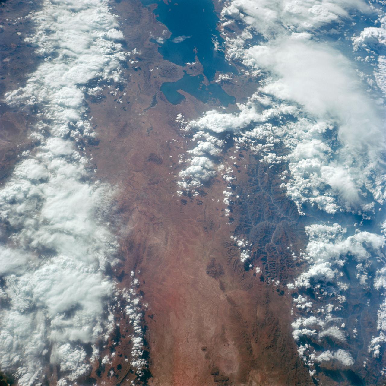
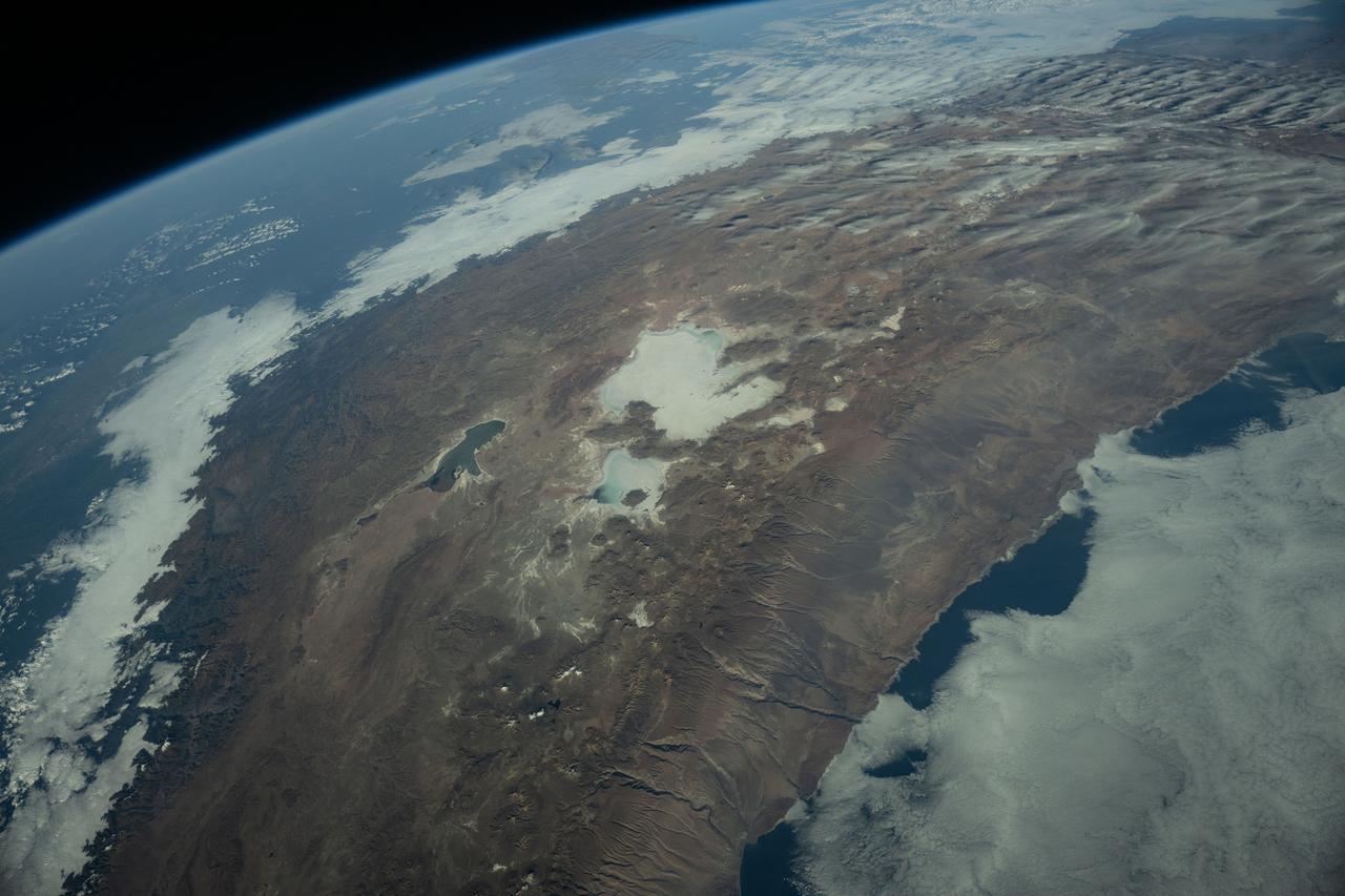
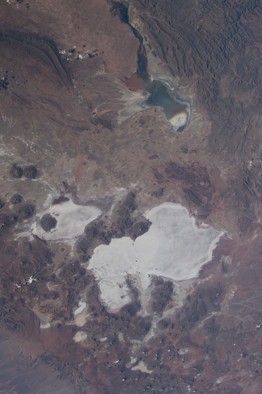
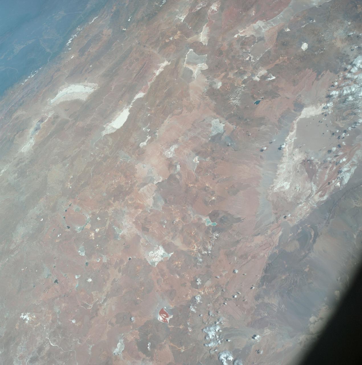
S66-54834 (14 Sept. 1966) --- Peru, Bolivia, Chile, Lake Titicaca and La Paz, as seen from the Gemini-11 spacecraft during its 34th revolution of Earth. Photo credit: NASA
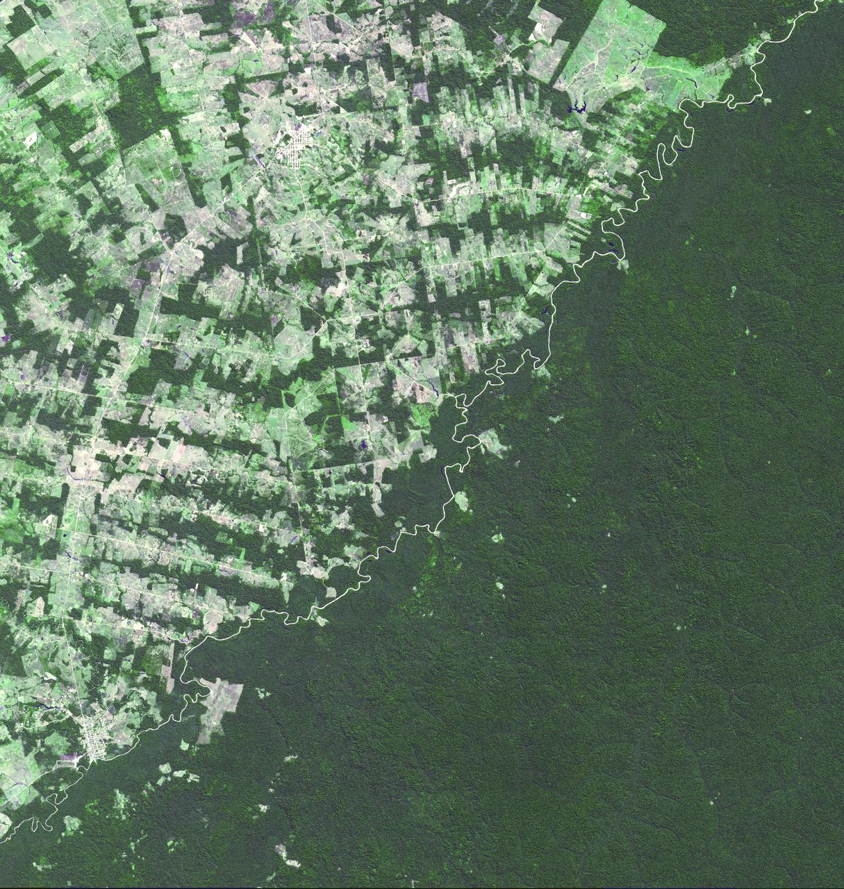
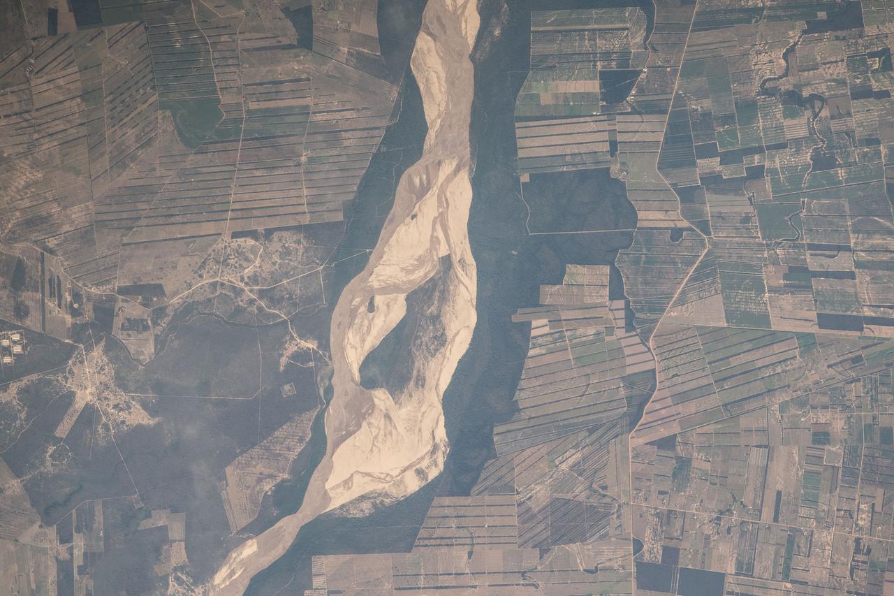
This image of the river-delineated border between western Brazil Acre province, and northwestern Bolivia Pando Department, demarcates a remarkable difference in land use and development practices as seen by NASA Terra spacecraft.
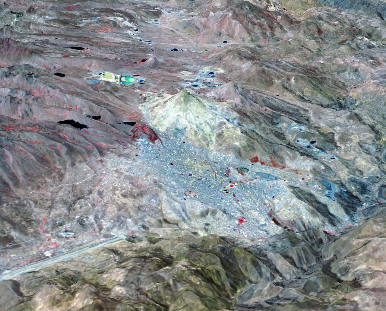
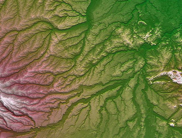
Potosi is the capital city of the Department of Potosi in Bolivia, and one of the highest cities in the world at 4090 m. For centuries it was the location of the Spanish colonial silver mint, the major supplier of silver for the Spanish Empire until the 18th century. Potosi lies at the foot of the Cerro Rico ("rich mountain"), rumored to be made of silver. Today, Potosi continues to be an important mining center, and is famous for its well-preserved colonial architecture. The perspective view covers an area of about 20 by 30 km, was acquired October 12, 2021, and is located at 19.6 degrees south, 65.7 degrees west. https://photojournal.jpl.nasa.gov/catalog/PIA25705
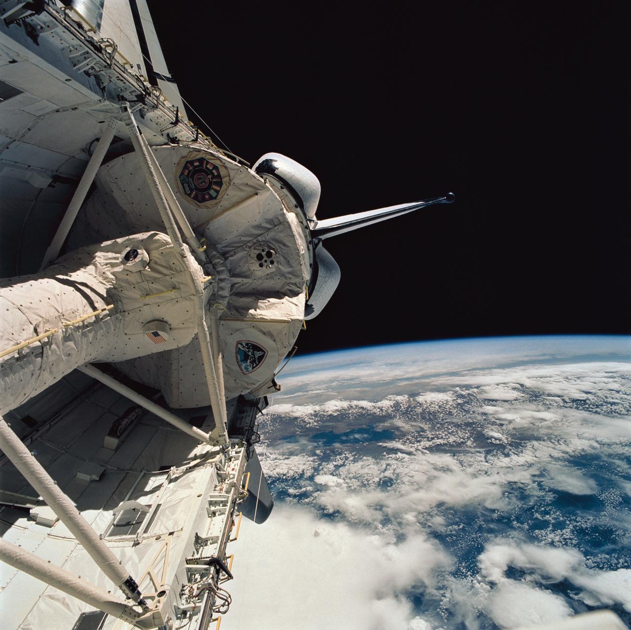
STS058-76-041 (18 Oct-1 Nov 1993) --- Backdropped against the Peru-Bolivia border and part of the Amazon basin, the Spacelab Life Sciences (SLS-2) laboratory module was captured with a 70mm camera, by one of the seven crew members inside the Space Shuttle Columbia's cabin. Part of the tunnel-like passageway is visible in the foreground. Six NASA astronauts and a veterinarian from the private sector spent two weeks devoted to medical research in Earth-orbit. Lake Titicaca, the largest high-altitude lake in the world lies in the Altiplano of Bolivia and Peru. Space Shuttle photography has been used to document fluctuations of several meters of the level of Lake Titicaca during the past decade, as well as to document the eutrophication of the north end of the lake, which is primarily due to increased population in the Peruvian shoreline areas. This view shows the effect of abnormally heavy precipitation of the region for the third successive year. Meteorologists feel this precipitation increase, which may portend another increase of the lake level, is due to the third successive El Nino - Southern Oscillation phenomenon in the 1993 - 94 southern hemisphere summertime. This global phenomenon is now resulting in major weather disturbances in Indonesia, California, Texas and elsewhere.
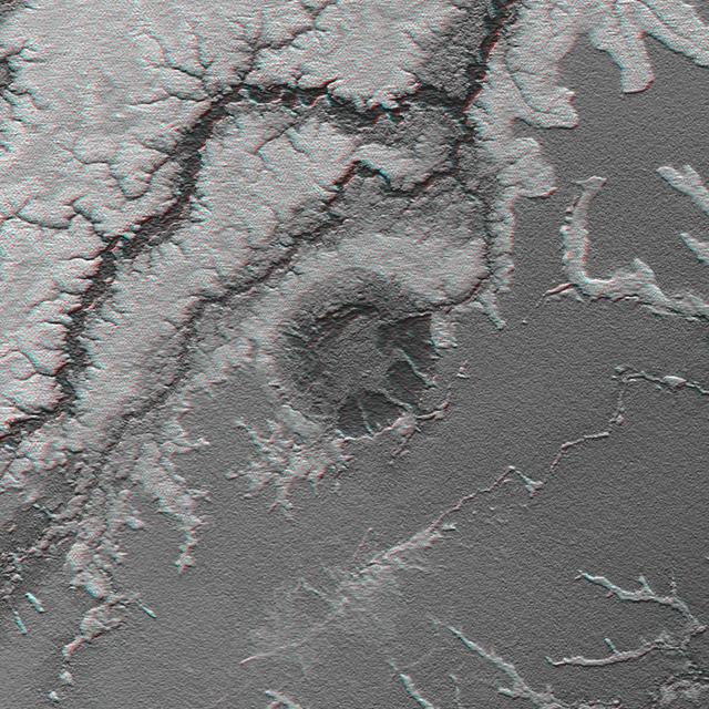
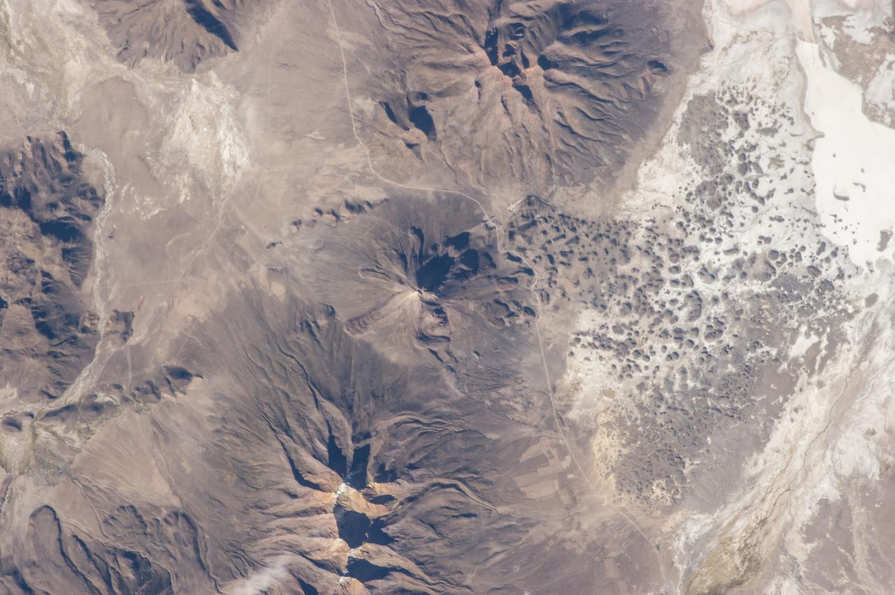
This anaglyph, from NASA Shuttle Radar Topography Mission, is of the Iturralde Structure, Bolivia, a possible impact crater. 3D glasses are necessary to view this image.
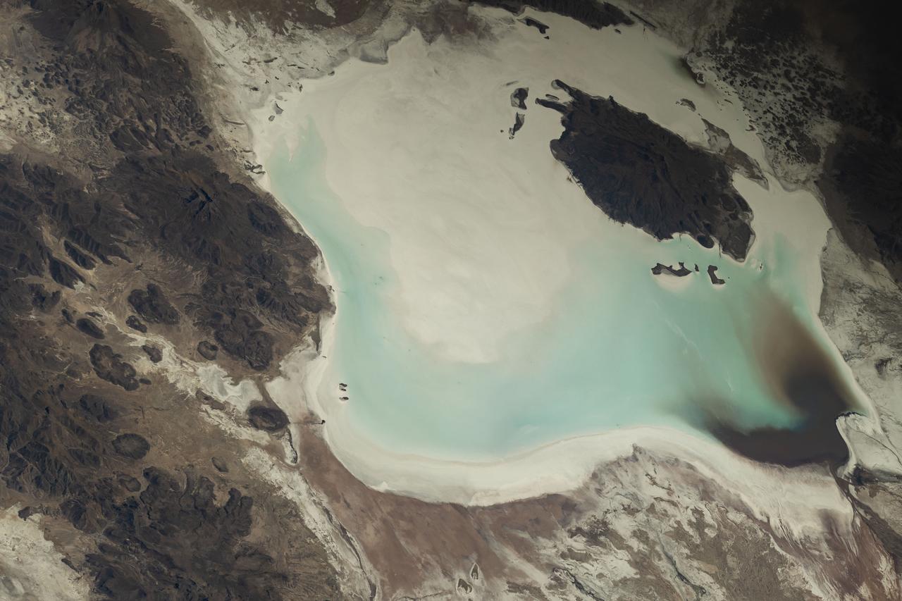
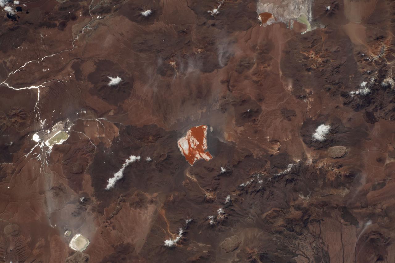
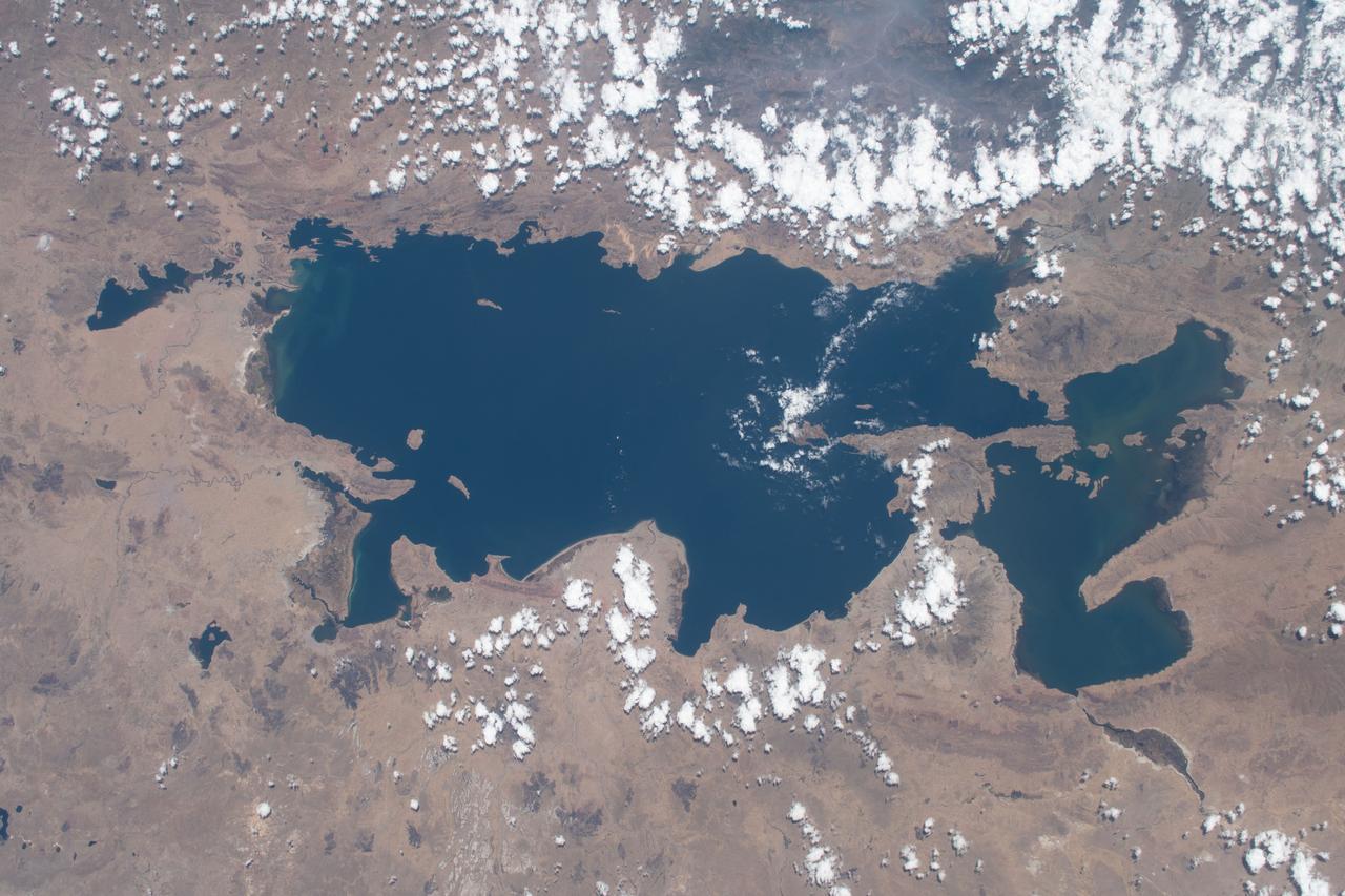
iss073e0248064 (June 24, 2025) --- Lake Poopó, a large saline lake at an altitude of about 12,100 feet in Bolivia's Andean Plateau, is pictured from the International Space Station as it orbited 264 miles above South America.
iss073e0248066 (June 24, 2025) --- Lake Poopó, a large saline lake at an altitude of about 12,100 feet in Bolivia's Andean Plateau, is pictured from the International Space Station as it orbited 264 miles above South America.
In the high plains of the Andes in Bolivia, Lake Poopo has virtually vanished, as shown in this image from NASA Terra spacecraft. Once covering over 3,000 square kilometers, the lake essentially dried up in 2015. What led to Lake Poopo's demise? Water diversions upstream, weather extremes and recurrent droughts are thought to blame. The images cover an area of 48.9 by 55.1 km, were acquired February 14, 2001 and November 6, 2016, and are located near 18.7 degrees south, 67.1 degrees west. https://photojournal.jpl.nasa.gov/catalog/PIA21546
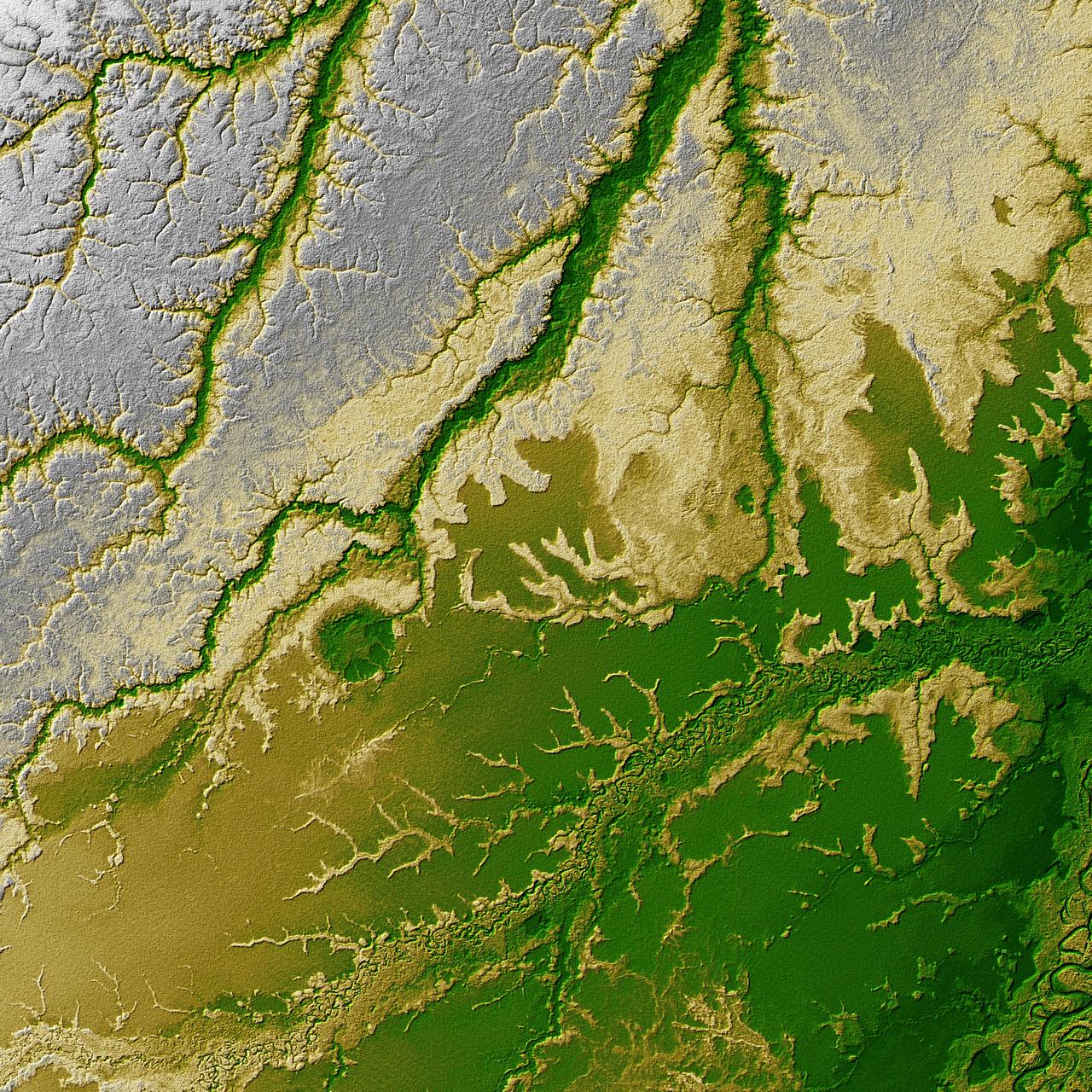
Pando Province, Bolivia, and adjacent parts of Brazil and Peru are seen in this visualization of NASA Shuttle Radar Topography Mission SRTM elevation data covering part of the Amazon Basin.
iss073e0384067 (July 12, 2025) --- The Andes Mountains run through Chile and Bolivia on the South American continent. The eastern slope of the Andes in Bolivia captures moisture from the Amazon basin creating more rainfall on that side of the nation and contributes to an arid climate on South America's Pacific coast. The International Space Station was orbiting 260 miles above Chile when this photograph was taken.
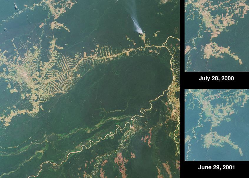
NASA scientists will venture into an isolated part of the Bolivian Amazon to try and uncover the origin of a 5 mile (8 kilometer) diameter crater there known as the Iturralde Crater. Traveling to this inhospitable forest setting, the Iturralde Crater Expedition 2002 will seek to determine if the unusual circular crater was created by a meteor or comet. Organized by Dr. Peter Wasilewski of NASA's Goddard Space Flight Center, Greenbelt, Md., the Iturralde Crater Expedition 2002 will be led by Dr. Tim Killeen of Conservation International, which is based in Bolivia. Killeen will be assisted by Dr. Compton Tucker of Goddard. The team intends to collect and analyze rocks and soil, look for glass particles that develop from meteor impacts and study magnetic properties in the area to determine if the Iturralde site was indeed created by a meteor. This image was acquired on June 29, 2001 by the Advanced Spaceborne Thermal Emission and Reflection Radiometer (ASTER) on NASA's Terra satellite. With its 14 spectral bands from the visible to the thermal infrared wavelength region, and its high spatial resolution of 15 to 90 meters (about 50 to 300 feet), ASTER will image Earth for the next 6 years to map and monitor the changing surface of our planet. http://photojournal.jpl.nasa.gov/catalog/PIA03859
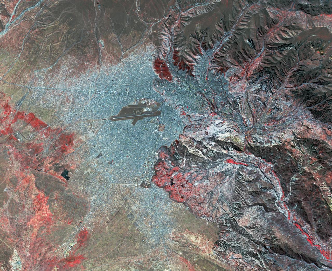
La Paz, Bolivia is the highest capital in the world, located on the Andes' Altiplano plateau at more than 3500 meters above sea level. It is situated in a bowl-like depression, surrounded by high mountains. La Paz was founded in 1548 by Spanish conquistadors at the site of the Inca settlement of Laja. Like many South American cities, La Paz and its suburbs have seen remarkable growth in the last 30 years. From 1986 to 2017 the population grew from about 400,000 to over 2.3 million. The ASTER image was acquired July 11, 2017. The images cover an area of 27 by 33 kilometers, and are located at 16.5 degrees south, 68.1 degrees west. https://photojournal.jpl.nasa.gov/catalog/PIA21220
iss073e0248069 (June 24, 2025) --- Lake Coipasa, a basin created by tectonic activity with a high salt concentration surrounded by the Coipasa Salt Flats, in Bolivia near the border with Chile is pictured from the International Space Station as it orbited 264 miles above South America. The volcano Wila Pukarini (upper right) is located inside the lake.
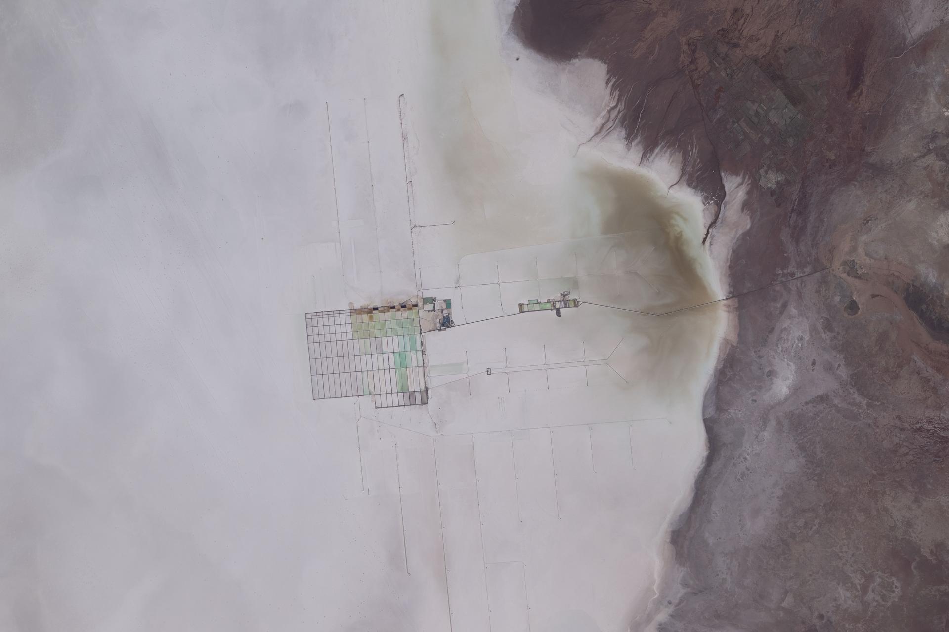
iss074e0319935 (Feb. 21, 2026) --- The Salar de Uyuni in Bolivia is the world's largest salt flat and one of the flattest surfaces on Earth. At the center of the photograph is a mining operation extracting extensive lithium deposits across the salt flat. Credit: NASA/Jessica Meir
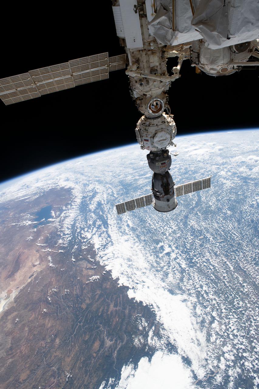
iss069e006058 (April 28, 2023) --- Four main components on the Roscosmos segment of the International Space Station are pictured as the orbital outpost soared 260 miles above the Andes mountain range in Bolivia. From top to bottom, are the Nauka multipurpose laboratory module, the European robotic arm attached to Nauka, the Prichal docking module, and the Soyuz MS-23 crew ship.
Rio Brancois the capital of the Brazilian state of Acre and is situated near the border with northeastern Bolivia. This image from NASA Terra satellite was acquired on July 28, 2000.
This anaglyph, from NASA Shuttle Radar Topography Mission, is of the Iturralde Structure, Bolivia, a possible impact crater. 3D glasses are necessary to view this image.
NASA Terra spacecraft shows that extremely heavy seasonal rains have fallen on northern Bolivia since October 2013. The worst affected province is Beni in the northeastern part of the country.

In the high plateau of southwestern Bolivia, two large salt deserts, or playas, are located between the eastern and western Andes. NASA Terra spacecraft depicted the playas on January 16, 2002 and January 3, 2003.
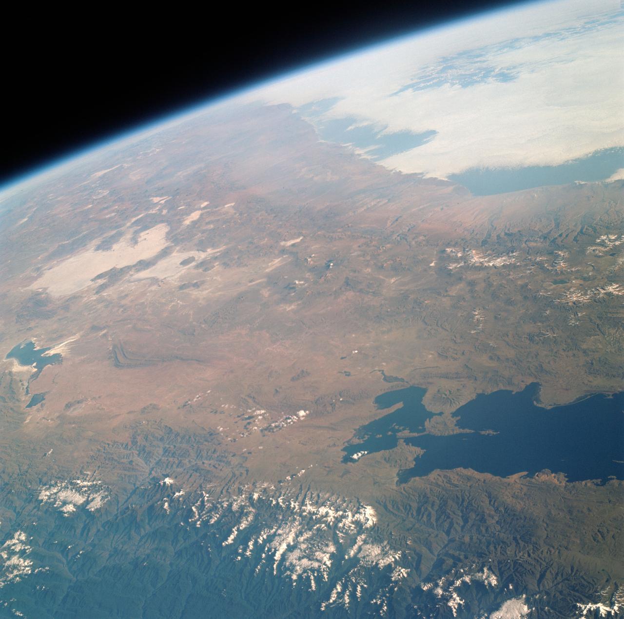
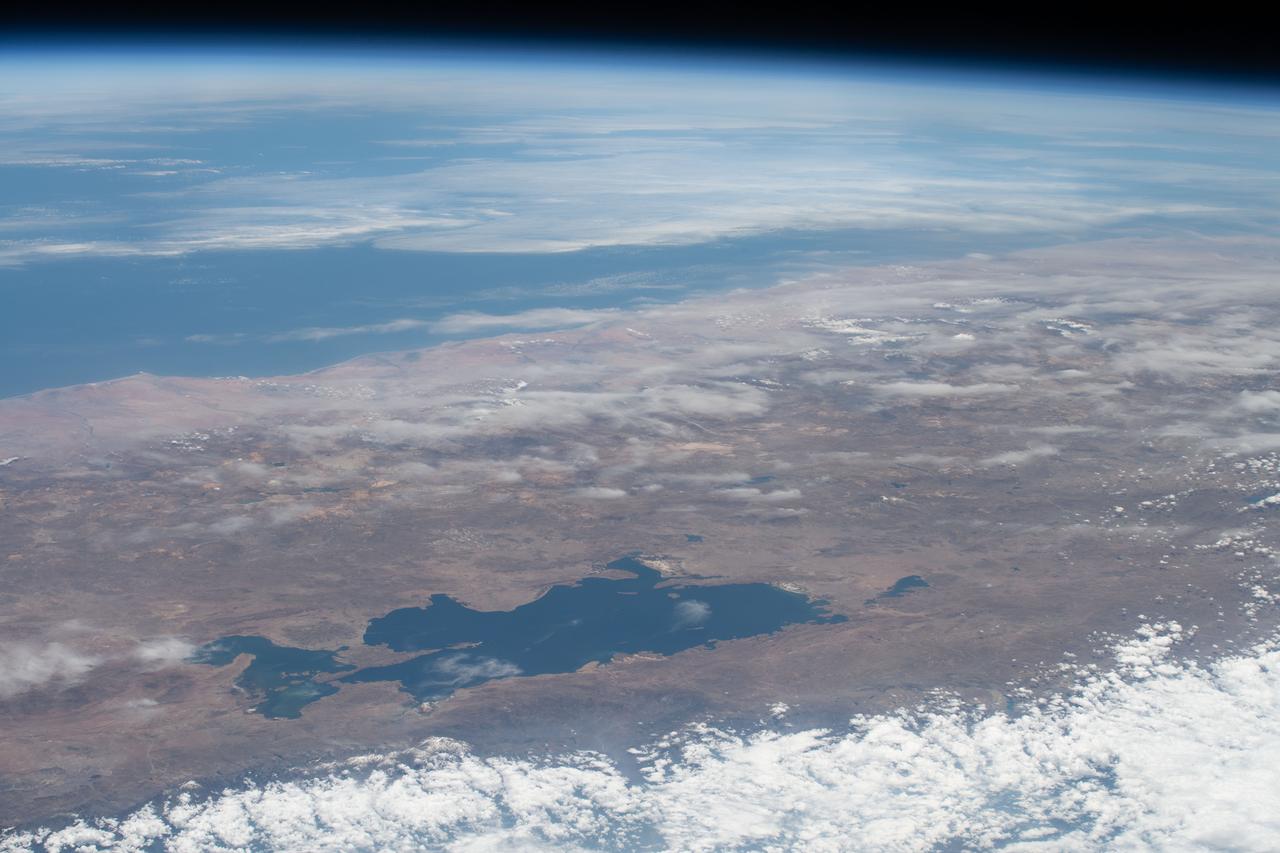
S66-38313 (5 June 1966) --- Areas of Peru (upper right), Chile (top center) and Bolivia as seen from the Gemini-9 spacecraft during its 35th revolution of Earth. The large body of water at lower right is Lake Titicaca. The smaller lake at left edge is Lake Poopo. Salar de Uyuni is the large light-colored area at upper left. At the bottom of the picture is the snow-capped Cordillera Real range of the Andes Mountains. The Pacific coastline of Peru and Chile is at upper right. The range running parallel with the coastline is the Cordillera Occidental. The image was taken with a modified 70mm Hasselblad camera, using Eastman Kodak, Ektachrome MS (S.O. 217) color film. Photo credit: NASA
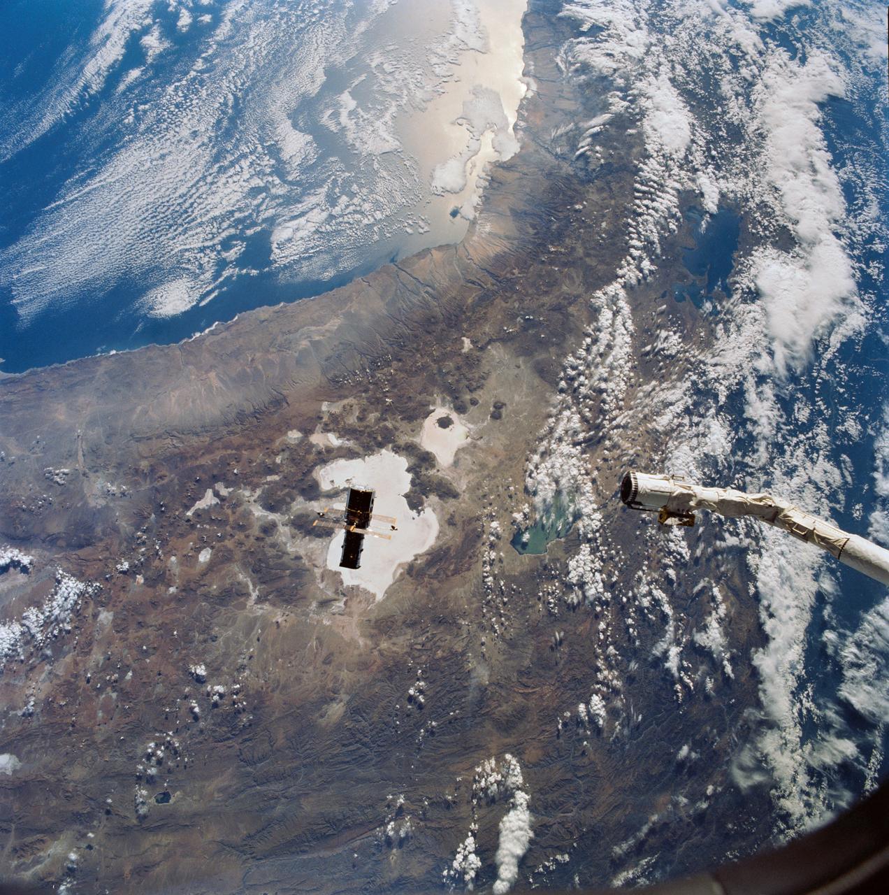
Hubble Space Telescope (HST), with its solar array (SA) wings and high gain antennae (HGA) fully extended,is released from Discovery's, Orbiter Vehicle (OV) 103's, remote manipulator system (RMS) end effector and is set free into Earth orbit by the STS-31 crew. HST drifts away from the end effector over the Andes Mountains.Parts of Bolivia, Peru, Chile, and Argentina are visible. The view covers a huge area of the western half of South America stretching from 14 degrees south latitude to 23 degrees, about 1,000 kilometers.
iss066e110899 (Jan. 7, 2022) --- (From left) Laguna Capina and Laguna Colorada are pictured in the Andes Mountain range in the southern portion of Bolivia.
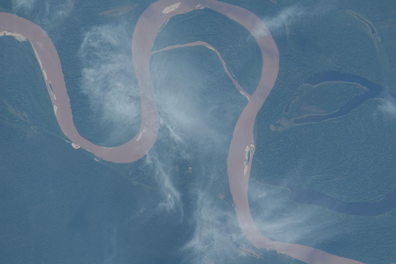
iss069e033689 (July 19, 2023) -- Curves of the Amazon River are pictured from the International Space Station as it orbited 260 miles above Bolivia.

iss064e010989 (Dec. 8, 2020) --- This photograph from the International Space Station looks over the Andes Mountains in Chile and across to Bolivia and Paraguay on the South American continent.
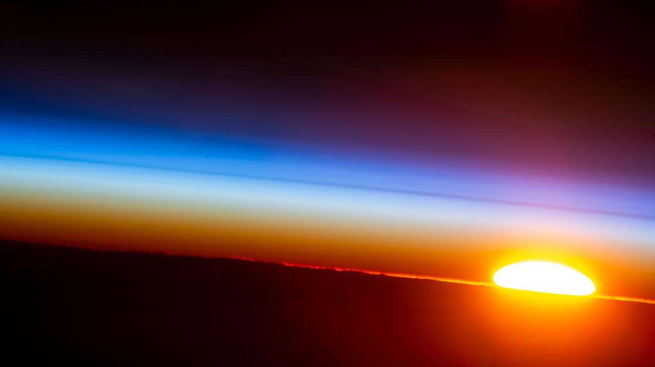
iss066e091822 (Dec. 17, 2021) --- An orbital sunrise is pictured from the International Space Station as it orbited 262 miles above Bolivia on the South American continent.
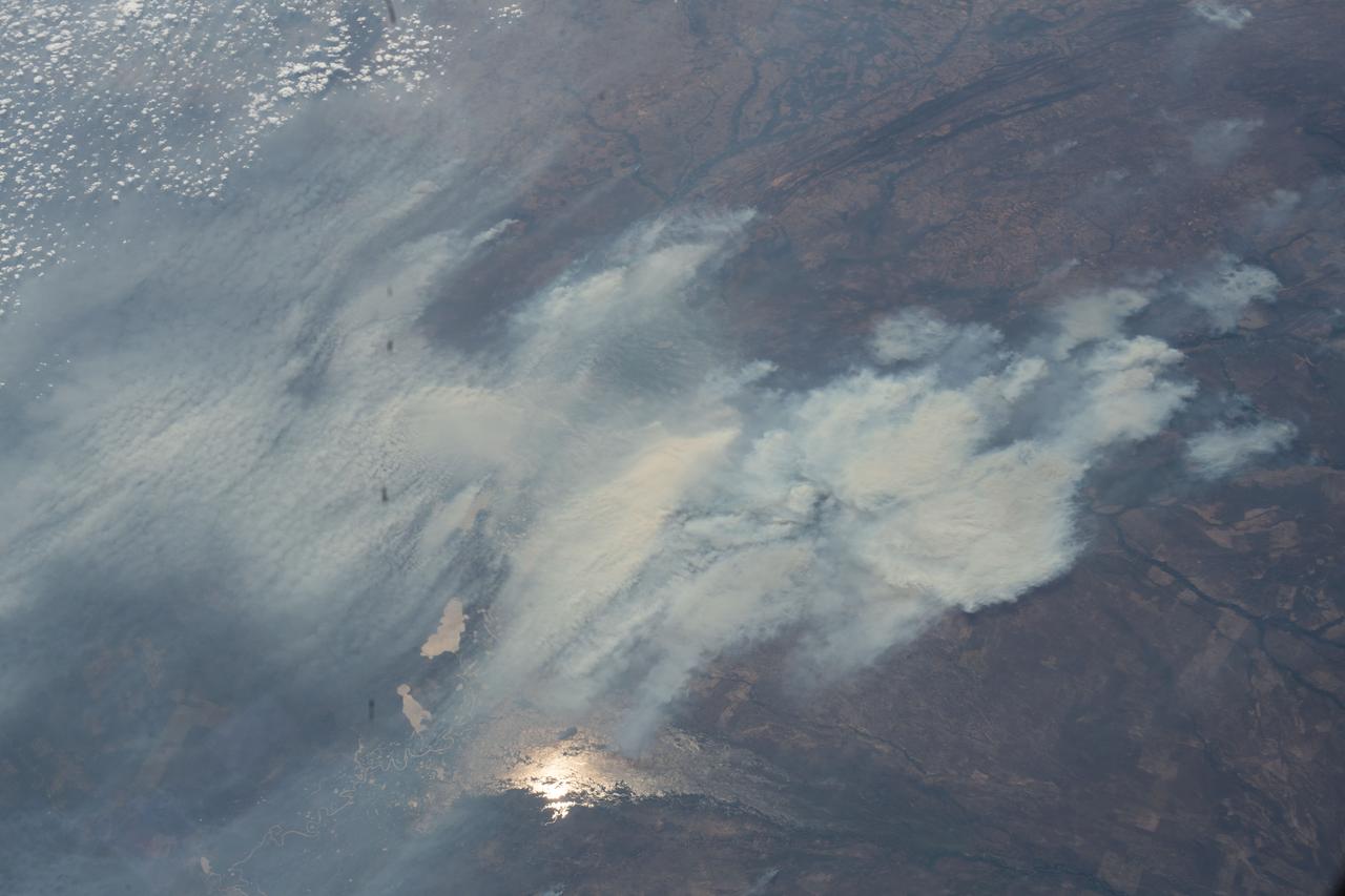
iss063e080404 (Aug. 29, 2020) --- Wildfires are pictured in the Amazon rainforest as the International Space Station orbited above the border between Bolivia and Brazil.
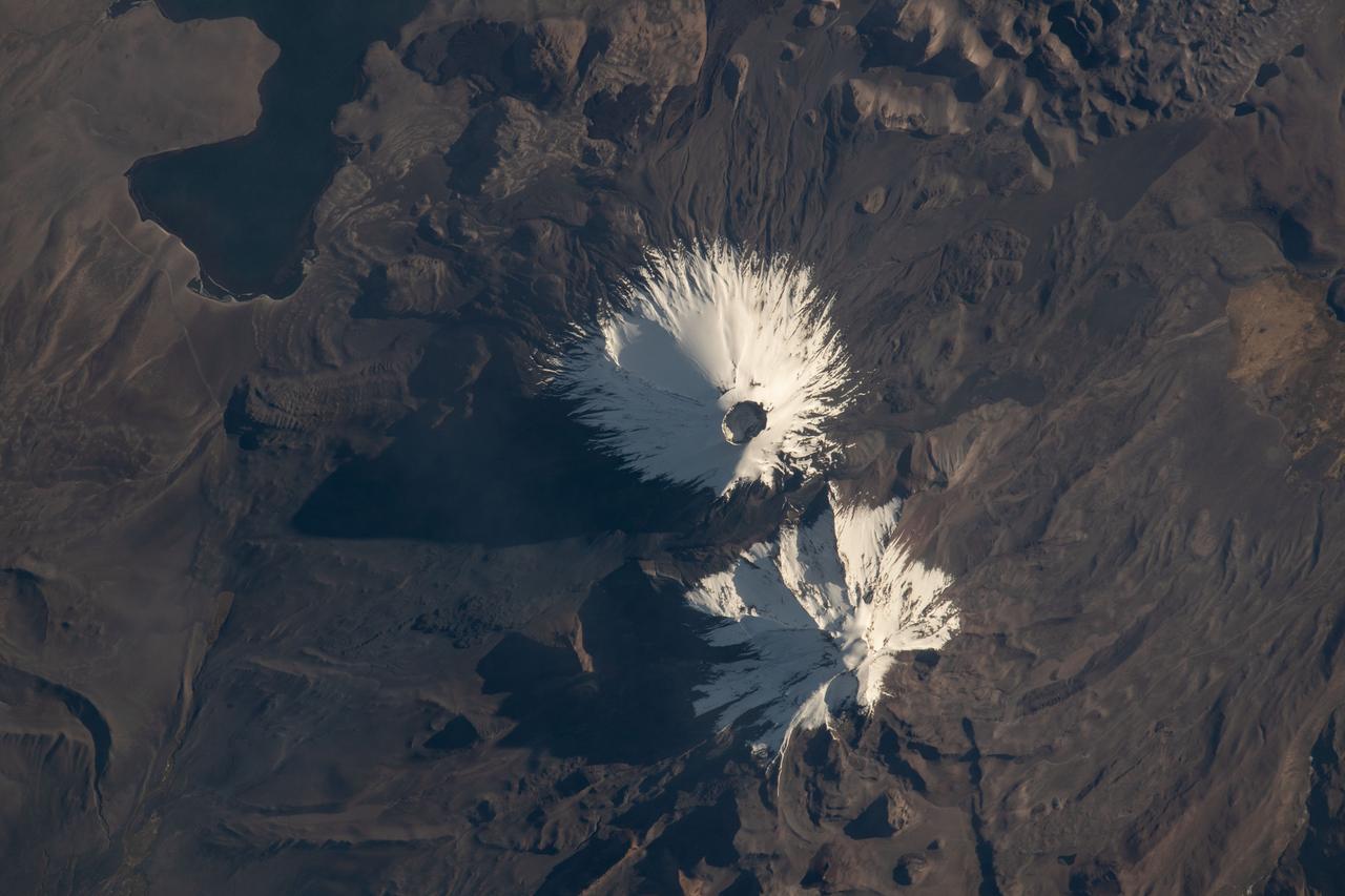
iss067e147189 (June 21, 2022) --- The Parinacota and Pomerape stratovolcanoes (top to bottom) are pictured from the International Space Station as it orbited 263 miles above the South American nation of Chile. Parinacota is a dormant volcano on the Chile-Bolivia border and its peak is about 20,800 feet. Pomerape, last active over 100,000 years ago, is also on the Chile- Bolivia border with an elevation of about 20,600 feet. At top left, is Chungará Lake in northern Chile which rests about 14,800 feet above sea level.
Earth Observation taken during a day pass by the Expedition 40 crew aboard the International Space Station (ISS). Folder lists items in this group as: Chile Atacama Bolivia Andes and active volcano.
Earth Observation taken during a day pass by the Expedition 40 crew aboard the International Space Station (ISS). Folder lists items in this group as: Chile Atacama Bolivia Andes and active volcano.
Earth Observation taken during a day pass by the Expedition 40 crew aboard the International Space Station (ISS). Folder lists items in this group as: Chile Atacama Bolivia Andes and active volcano.
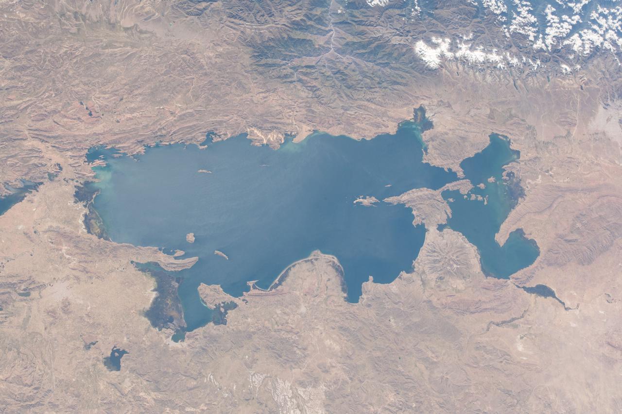
iss055e071030 (May 14, 2018) --- Lake Titicaca is bisected by the South American countries of Peru and Bolivia with the Andes Mountain range skirting up against its northwestern edge.
iss068e025502 (Nov. 30, 2022) --- Lake Titicaca in the Andes Mountains is pictured from the International Space Station as it orbited 264 miles above western Bolivia on the South American continent.
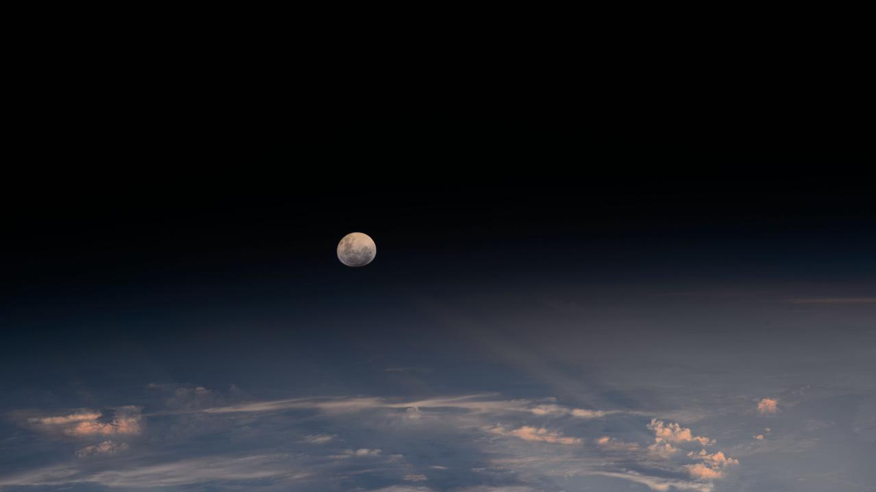
iss072e978997 (April 13, 2025) --- The Moon's light is refracted by the Earth's atmosphere giving it a spheroid shape in this photograph from the International Space Station as it orbited into a sunset 264 miles above the border between Bolivia and Brazil in South America.
Earth Observation taken during a day pass by the Expedition 40 crew aboard the International Space Station (ISS). Folder lists items in this group as: Chile Atacama Bolivia Andes and active volcano.
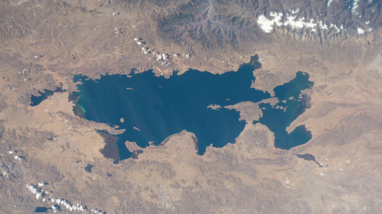
iss067e169915 (July 1, 2022) --- Lake Titicaca, a freshwater lake in the Andes on the border between Bolivia and Peru, is pictured from the International Space Station as it orbited 262 miles above the western portion of the South American continent.
Earth Observation taken during a day pass by the Expedition 40 crew aboard the International Space Station (ISS). Folder lists items as: Andes 2, Atacama, Bolivia, Chile, Volcanos.
Earth Observation taken during a day pass by the Expedition 40 crew aboard the International Space Station (ISS). Folder lists items as: Andes 2, Atacama, Bolivia, Chile, Volcanos.
Earth Observation taken during a day pass by the Expedition 40 crew aboard the International Space Station (ISS). Folder lists items in this group as: Chile Atacama Bolivia Andes and active volcano.
Earth Observation taken during a day pass by the Expedition 40 crew aboard the International Space Station (ISS). Folder lists items in this group as: Chile Atacama Bolivia Andes and active volcano.
iss070e015250 (Oct. 29, 2023) --- Lake Titicaca, a freshwater lake nestled in between Peru and Bolivia in the Andes Mountains, is pictured from the International Space Station as it orbited 261 miles above the South American continent.
NASA's Ecosystem Spaceborne Thermal Radiometer Experiment on Space Station (ECOSTRESS) captured new imagery of fires in the Amazon regions of Brazil and Bolivia on Aug. 23, 2019. The red areas are where surface temperatures exceeded the maximum measureable temperature of the instrument's sensor (approximately 220 degrees Fahrenheit or 104 degrees Celsius), highlighting the burning areas along the fire fronts. The dark wispy areas indicate thick smoke — thick enough that it obscures much of the fire from view. The measurements cover areas of about 77 by 77 yards (70 by 70 meters) each, or about the size of a football field. https://photojournal.jpl.nasa.gov/catalog/PIA23357

ISS012-E-06456 (3 Nov. 2005) --- Salar de Uyuni, the largest Salar (salt flat) in the world, located within the Altiplano of Bolivia, South America is featured in this image photographed by an Expedition 12 crewmember on the International Space Station. The Altiplano is a high plateau formed during uplift of the Andes Mountains. The plateau harbors fresh and saltwater lakes, together with Salars, that are surrounded by mountains with no drainage outlets--all at elevations greater than 3,659 meters (12,000 feet) above mean sea level. The Salar de Uyuni covers approximately 8,000 square kilometers (3,100 square miles), and it is a major transport route across the Bolivian Altiplano due to its flatness. This image features the northern end of the Salar and the dormant volcano Mount Tunupa (image center). This mountain is high enough to support a summit glacier, and enough rain falls on the windward slopes to provide water for small communities along the base. The dark volcanic rocks comprising Mt. Tunupa are in sharp contrast with the white, mineral-crusted surface of the Salar. The major minerals are halite--common table salt--and gypsum--a common component of drywall. Relict shorelines visible in the surface salt deposits (lower right of the image) attest to the occasional presence of small amounts of water in the Salar. Sediments in the Salar basin record fluctuations in water levels that occurred as the lake that once occupied the Salar evaporated. These sediments provide a valuable paleoclimate record for the region. The dynamic geological history of the Altiplano is recorded in isolated "islands" within the salt flat (image left); these islands are typically built from fossil coral reefs covered by Andean volcanic rocks.
In this image of the Andes along the Chile-Bolivia border, the visible and infrared data have been computer enhanced to exaggerate the color differences of the different materials. The scene is dominated by the Pampa Luxsar lava complex, occupying the upper right two-thirds of the scene. Lava flows are distributed around remnants of large dissected cones, the largest of which is Cerro Luxsar. On the middle left edge of the image are the Olca and Parumastrato volcanoes, which appear in blue due to a lack of vegetation (colored red in this composite). This image covers an area 60 kilometers (37 miles) wide and 60 kilometers (37 miles) long in three bands of the reflected visible and infrared wavelength region. It was acquired on April 7, 2000. The image is located at 21 degrees south latitude, 68.3 degrees west longitude. http://photojournal.jpl.nasa.gov/catalog/PIA02654
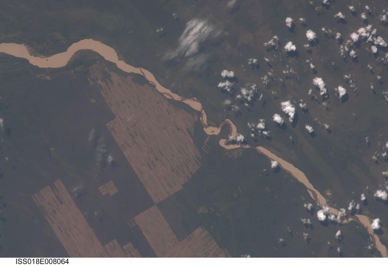
ISS018-E-008064 (9 Nov. 2008) --- Progressive forest clearing in Bolivia is featured in this image photographed by an Expedition 18 crewmember on the International Space Station. The eastern half of Bolivia is covered with tropical rainforest. In the 1990s, Bolivia initiated a large-scale effort to increase the rate of logging and create tracts of land for commercial agriculture (primarily soy and sugar cane, but also coca) on the Amazon Basin side of the Andean highlands. Today, the commercial fields are well-established and easily mapped from space as large, rectangular clearings in the forest. The agricultural developments are still growing today. The clearings start off as small rectangles arranged perpendicular to an access road; early clearings take on a herring-bone pattern when viewed from above. The uncleared (dark forest) areas are gradually logged and cultivated, filling in the pattern to make a larger cleared area. Astronauts aboard the space station routinely observe intensive land use and document their observations through imagery so that changes can be identified.
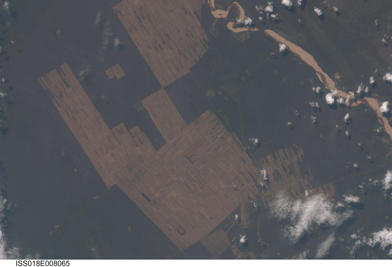
ISS018-E-008065 (9 Nov. 2008) --- Progressive forest clearing in Bolivia is featured in this image photographed by an Expedition 18 crewmember on the International Space Station. The eastern half of Bolivia is covered with tropical rainforest. In the 1990s, Bolivia initiated a large-scale effort to increase the rate of logging and create tracts of land for commercial agriculture (primarily soy and sugar cane, but also coca) on the Amazon Basin side of the Andean highlands. Today, the commercial fields are well-established and easily mapped from space as large, rectangular clearings in the forest. The agricultural developments are still growing today. The clearings start off as small rectangles arranged perpendicular to an access road; early clearings take on a herring-bone pattern when viewed from above. The uncleared (dark forest) areas are gradually logged and cultivated, filling in the pattern to make a larger cleared area. Astronauts aboard the space station routinely observe intensive land use and document their observations through imagery so that changes can be identified.
iss070e098385 (Feb. 23, 2023) --- Poopó Lake in Bolivia. a mostly dried up saline lake due to a variety of reasons including mining and agricultural activities, is pictured from the International Space Station as it orbited 261 miles above the South American continent.
iss056e094532 (July 10, 2018) --- This portion of Bolivia's Rio Grande is about 27 miles east of downtown Santa Cruz de la Sierra, the country's largest city. The river in the Amazon Basin and the sub-tropical climate support navigation, fishing and agriculture.

iss063e053023 (July 22, 2020) --- Lake Titicaca, pictured from the International Space Station as it orbited off the Pacific coast of South America, is located between the nations of Peru and Bolivia in the Andes Mountains and is one of the highest navigable lakes in the world.
ISS043E184521 (05/10/2015) --- NASA astronaut Terry Virts Expedition 43 Commander on the International Space Station tweeted this Earth observation image of South America with the following comment: "Salar de Uyuni in the #Bolivia desert #SouthAmerica. The world's largest salt flat".
iss056e094533 (July 10, 2018) --- This portion of Bolivia's Rio Grande is about 27 miles east of downtown Santa Cruz de la Sierra, the country's largest city. The river in the Amazon Basin and the sub-tropical climate support navigation, fishing and agriculture.

iss069e091770 (Sept. 23, 2023) --- Two Soyuz crew ships are pictured docked to the International Space Station as it orbited 262 miles above La Paz, Bolivia, on the South American continent. In the foreground, is the Soyuz MS-24 spacecraft docked to the Rassvet module. In the background is the Soyuz MS-23 spacecraft docked to the Prichal docking module.
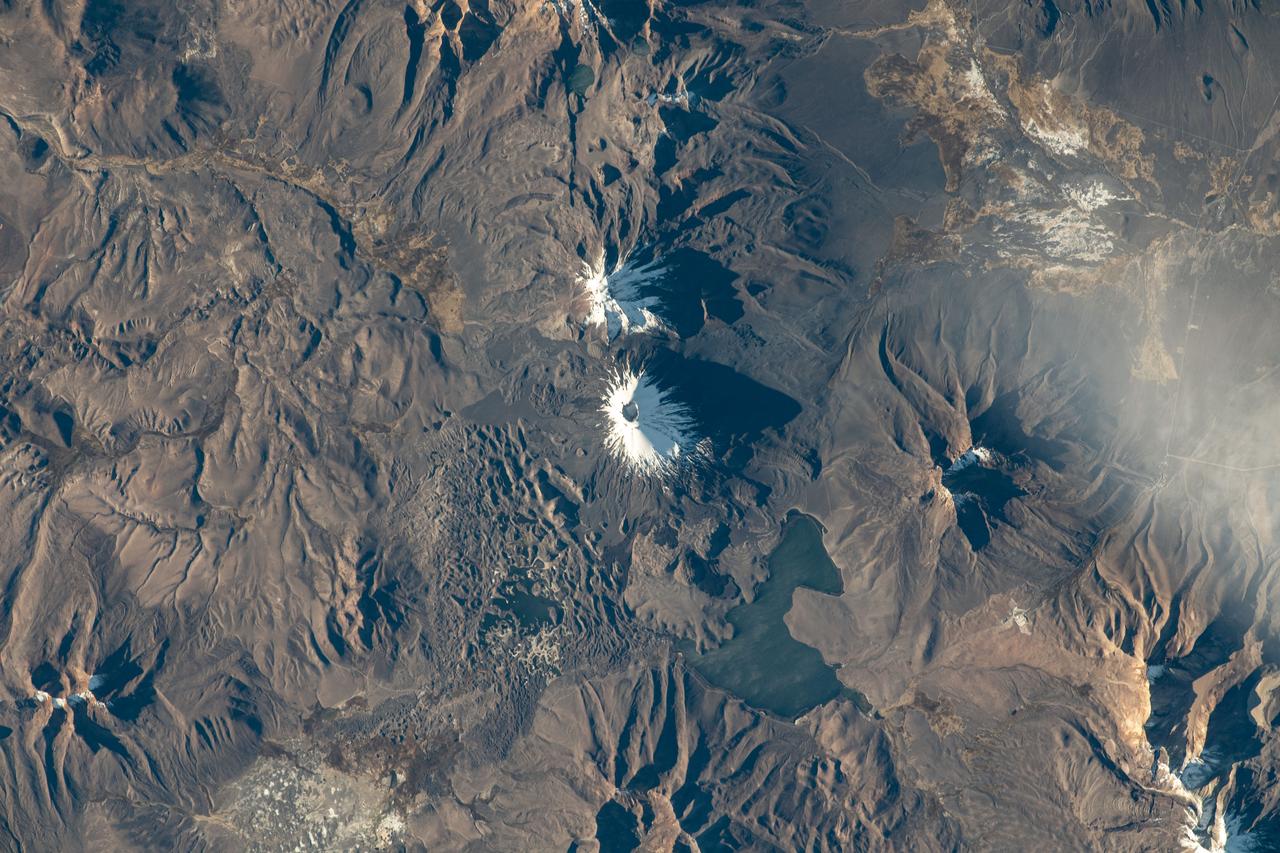
iss069e023100 (June 19, 2023) --- The Pomerape (center top) and Payachata (center bottom) volcanoes and Chungará Lake, on the border between the nations of Chile and Bolivia, are pictured from the International Space Station as it orbited 263 miles above South America.
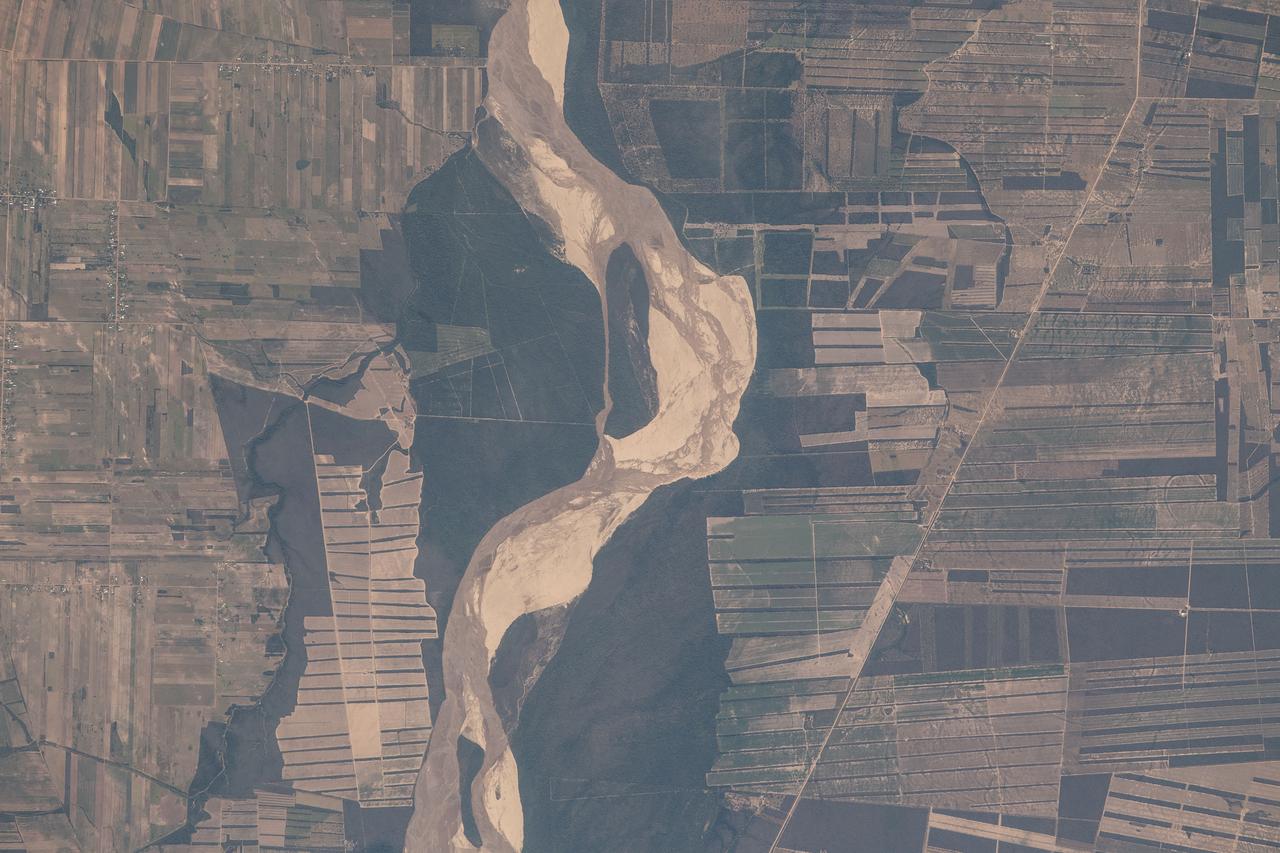
iss056e094531 (July 10, 2018) --- This portion of Bolivia's Rio Grande in the Amazon Basin is about 27 miles east of downtown Santa Cruz de la Sierra, the country's largest city. The river and the region's sub-tropical climate support navigation, fishing and agriculture.
AS07-04-1593 (21 Oct. 1968) --- This Earth observation photograph shows Argentina, Chile, Bolivia, Salar de Atacama, the Andes Mountains, and Gran Chaco. The coordinates for the center of this photograph are 23.00 degrees south and 67.30 degrees west, taken at an altitude of 175 miles during the 154th revolution around Earth. The crew consisted of astronauts Walter M. Schirra, Donn F. Eisele and Walter Cunningham.

STS109-E-5887 (9 March 2002) --- This view of a good portion of the country of Chile was recorded with a digital still camera by one of the STS-109 astronauts aboard the Space Shuttle Columbia. Chile's Pacific Coast is featured and the country's borders with three other nations--Bolivia, Peru and Argentina--almost or just barely made it into the frame in three different directions. Punta Angamos and Punta Tetas are readily visible on the anvil shaped peninsular feature, near the city of Antofagasta.
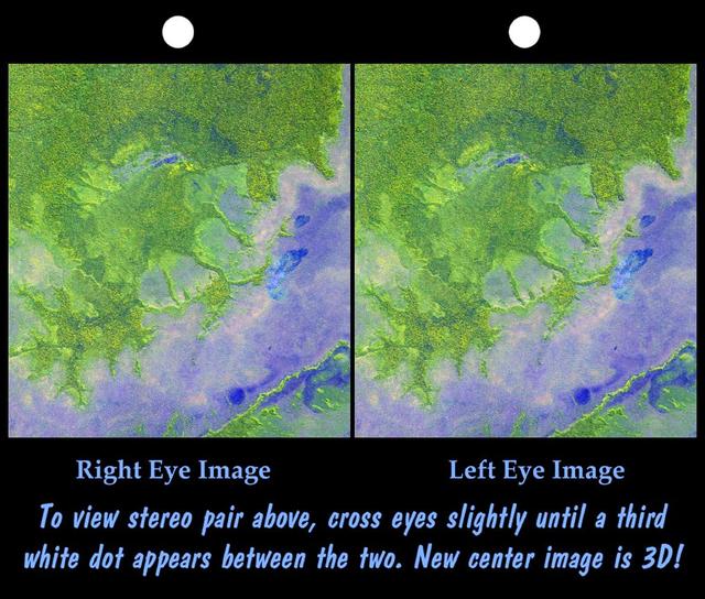
An 8-kilometer 5-mile wide crater of possible impact origin is shown in this stereoscopic view of an isolated part of the Bolivian Amazon.
An 8-kilometer 5-mile wide crater of possible impact origin is shown in this view of an isolated part of the Bolivian Amazon from NASA Shuttle Radar Topography Mission.
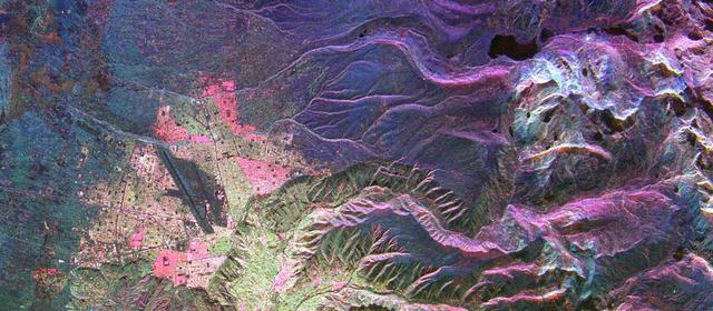
This is an image of the Bolivian capital city of La Paz that was created using three radar frequencies.
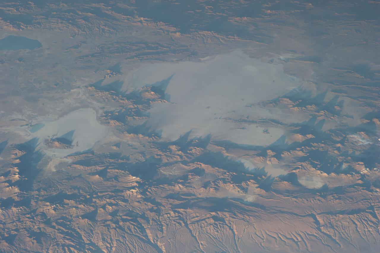
ISS033-E-006202 (20 Sept. 2012) --- Salar de Coipasa, Bolivia is featured in this image photographed by an Expedition 33 crew member on the International Space Station. The Salar de Coipasa, located in the Altiplano region of western Bolivia, covers an area of approximately 2,500 square kilometers. The word ?salar? describes arid closed basins in which evaporation of mineral-rich waters leads to the formation of thick, flat-laying salt deposits. Salar de Coipasa is located to the southwest of the saline Lake Poopo and northwest of the largest salt flat in the world, Salar de Uyuni. At Coipasa, a crust composed of halite?common table salt?provides the brilliant white coloration characteristic of the Altiplano salars (right). While the environment of Salar de Coipasa is arid, it does receive constant water from the Lauca River flowing from the north; this feeds Lake (Lago) Coipasa that fills the northern end of the basin with shallow water (center). However, the water flow can drop off sharply during periods of drought. The waters of Lake Coipasa, and the white salt crust of the salar, also serve to highlight dark river sediments flowing into the basin along the northeastern shore. Dark volcanic rocks contrast sharply with the surrounding salt crust at right. While the western Andes Mountains contain many active volcanoes, the nearby Tata Sabaya volcano has not been historically active.
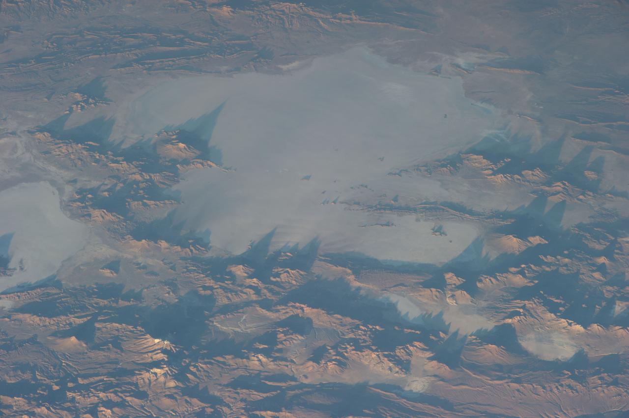
S65-63780 (12 Dec. 1965) --- Wave of clouds along the east flanks of the Andes Mountains cast off an orange glow by the low angle of the sun in the west. The dark area to the left is at Earth's terminator. Astronauts James A. Lovell Jr., pilot, and Frank Borman, command pilot, of the National Aeronautics and Space Administration's (NASA) Gemini-Titan 7 (GT-7) mission took the picture while looking south from northern Bolivia across the Andes Mountains. The intermontane salt basins are visible in the background. This photograph was taken with a modified 70mm Hasselblad camera, with Eastman Kodak, Ektachrome MS (SO 217) color film. Photo credit: NASA

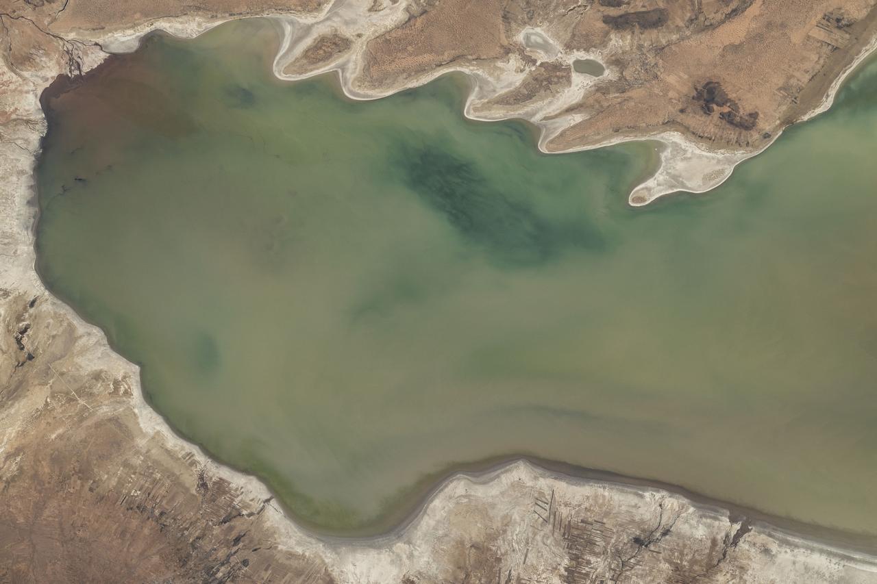
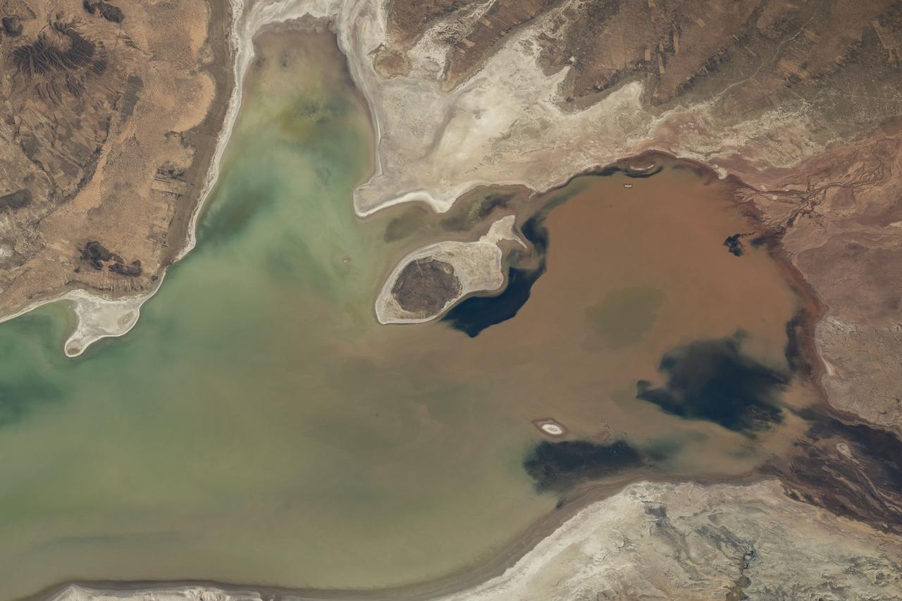
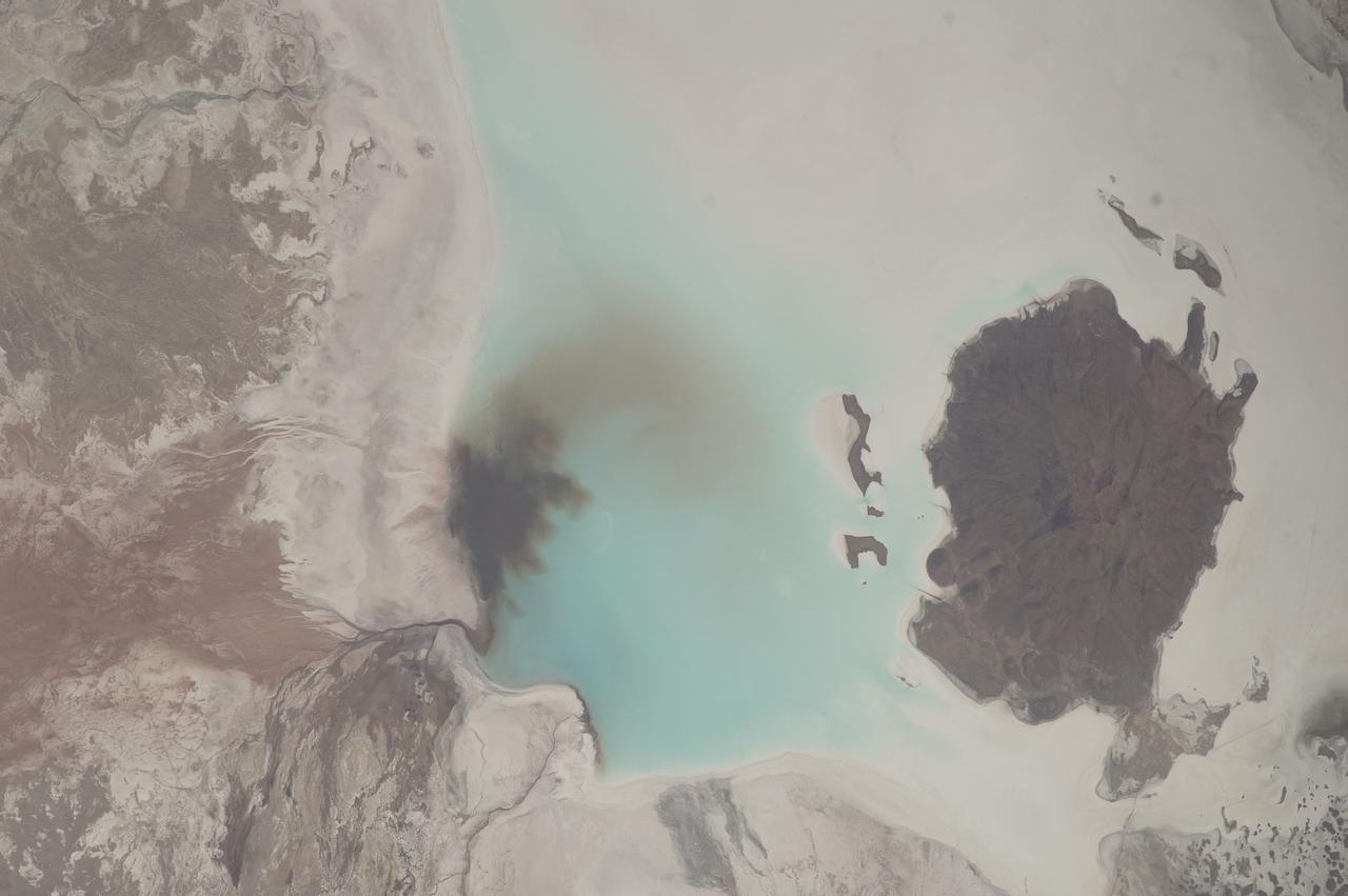
ISS012-E-06469 (3 Nov. 2005) --- A portion of Lake Poopo is featured in this image photographed by an Expedition 12 crewmember on the International Space Station. Lake Poopo sits high in the Bolivian Andes, catching runoff from its larger neighbor to the north - Lake Titicaca (not shown) - by way of the Desaguadero River (muddy area at the north end of the lake). Because Lake Poopo is very high in elevation (roughly 3400 meters or 11,000 feet above sea level), very shallow (generally less than 3 meters or 9 feet), and the regional climate is very dry, small changes in precipitation in the surrounding basin have large impacts on the water levels and areal extent of Lake Poopo. When the lake fills during wet periods, Poopo drains from the south end into Salar de Coipasa (not shown). Water levels in Poopo are important because it is one of South America’s largest saline lakes, and a prime stop for migratory birds, including flamingoes. NASA managers have tasked the station crew to track such changes, which are related to regional weather patterns. Lake Poopo’s sensitivity to precipitation in the high Andes (possibly reflecting larger climate cycles) provides an excellent visual indicator of these trends.
ISS012-E-06468 (3 Nov. 2005) --- A portion of Lake Poopo is featured in this image photographed by an Expedition 12 crewmember on the International Space Station. Lake Poopo sits high in the Bolivian Andes, catching runoff from its larger neighbor to the north - Lake Titicaca (not shown) - by way of the Desaguadero River (muddy area at the north end of the lake). Because Lake Poopo is very high in elevation (roughly 3400 meters or 11,000 feet above sea level), very shallow (generally less than 3 meters or 9 feet), and the regional climate is very dry, small changes in precipitation in the surrounding basin have large impacts on the water levels and areal extent of Lake Poopo. When the lake fills during wet periods, Poopo drains from the south end into Salar de Coipasa (not shown). Water levels in Poopo are important because it is one of South America’s largest saline lakes, and a prime stop for migratory birds, including flamingoes. NASA managers have tasked the station crew to track such changes, which are related to regional weather patterns. Lake Poopo’s sensitivity to precipitation in the high Andes (possibly reflecting larger climate cycles) provides an excellent visual indicator of these trends.
AS07-07-1826 (17 Oct. 1968) --- This view of South America was photographed from the Apollo 7 spacecraft during its 81st revolution of Earth from an altitude of 120 nautical miles. The port city of Antofagasta, Chile, is located in the half-moon shaped bay in the lower left portion of the picture. Beyond the coast is the Andean peak of Llullaillaco Volcano which rises 22,000 feet above sea level. At left center is the Chuquicamata copper mines located near Coloma. At the center of the photo, behind the large salt lake and atop a 19,000 foot high volcano, the countries of Bolivia, Argentina, and Chile meet at a common point. Below the clouds in the upper portion of the photo are the Great Plains known as the Gran Chaco.
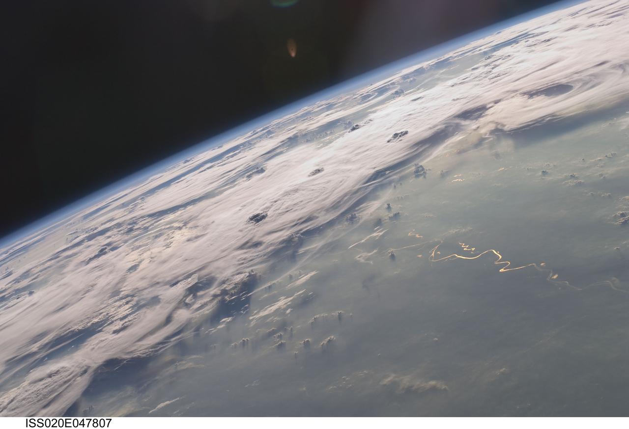
ISS020-E-047807 (6 Oct. 2009) --- Thunderstorms on the Brazilian horizon are featured in this image photographed by an Expedition 20 crew member on the International Space Station. A picturesque line of thunderstorms and numerous circular cloud patterns filled the view as the station crew members looked out at the limb and atmosphere (blue line on the horizon) of Earth. This region displayed in the photograph (top) includes an unstable, active atmosphere forming a large area of cumulonimbus clouds in various stages of development. The crew was looking west southwestward from the Amazon Basin, along the Rio Madeira, toward Bolivia when the image was taken. The distinctive circular patterns of the clouds in this view are likely caused by the aging of thunderstorms. Such ring structures often form during the final stages of a storm?s development as their centers collapse. Sunglint is visible on the waters of the Rio Madeira and Lago Acara in the Amazon Basin. Widespread haze over the basin gives the reflected light an orange hue. The Rio Madeira flows northward and joins the Amazon River on its path to the Atlantic Ocean. Scientists believe that a large smoke plume near the bottom center of the image may explain one source of the haze.

STS089-709-049 (22-31 Jan. 1998) --- This oblique photograph of Argentina and Chile was among several of South America photographed with a 70mm handheld camera from the Earth-orbiting space shuttle Endeavour. This part of Patagonia in Argentina and the lake district of Chile and Argentina are in southern South America between latitudes 40 degrees and 43 degrees. It is a beautiful alpine region noted for skiing and for the recent immigration of rich Americans and Europeans. On the west side of the Andes are a series of snow-capped volcanoes that are formed due to melting of sediments and portions of the Pacific Plate, which are being subducted beneath South America. East of the mountains the plains are barren and windswept, noted as having "the curse of sterility" by Charles Darwin. In the mountain regions some alpine valleys are filled by lovely lakes, such as Nahuel Huapi (in sunglint). The university town and ski resort of Bariloche, Argentina is the light area on the southeastern shore. In 1901 Robert Leroy Parker and Harry Longabaugh (aka Butch Cassidy and Sundance Kid) bought a ranch near the town of Cholila (lower left in the photo) with the proceeds of a robbery of the First National Bank of Winnemucca, Nevada. They lived there as successful ranchers until 1907, when they were reportedly forced to sell out and flee to Bolivia where their career ended at the hands of the Bolivian army. Photo credit: NASA
ISS035-E-18006 (8 April 2013) --- One of the Expedition 35 crew members aboard the Earth-orbiting International Space Station photographed this image of Tata Sabaya Volcano, located in the Altiplano region of Bolivia. The volcano rises to a summit elevation of 5430 meters above sea level. While its current form is that of a “youthful” stratovolcano, the regional geological evidence indicates an older, eventful history, according to scientists. The scientists say that prior to approximately 12,000 years ago (during the late Pleistocene Epoch), a large debris avalanche was formed by collapse of the ancestral Tata Sabaya volcano. Debris from the avalanche swept into the nearby Salar de Coipasa –at that time filled with a lake larger than today – significantly changing its northwestern coastline. Timing of the event is obtained from tufa deposits formed on debris islands during a high stand of the Coipasa lake – illustrating the geological principle of cross-cutting relationships, in that the debris avalanche had to have occurred before the tufa deposits were formed in the lake. The Tata Sabaya stratovolcano is located at image center. Several young lava flows are visible on the northwestern and western flanks of the volcano. Peaks visible to the northeast and southwest appear to be volcanoes as well, but unlike Tata Sabaya there is no record of recent activity from either of them (according to the Smithsonian National Museum of Natural History’s Global Volcanism Program). As the Altiplano became more arid and the Coipasa Lake shrank, much of the hummocky terrain of the debris avalanche became exposed over an area of more than 300 square kilometers. The hummocky terrain is clearly visible at image right. White salt deposits of the salar surround many of the individual hummocks, making them “islands” once again.
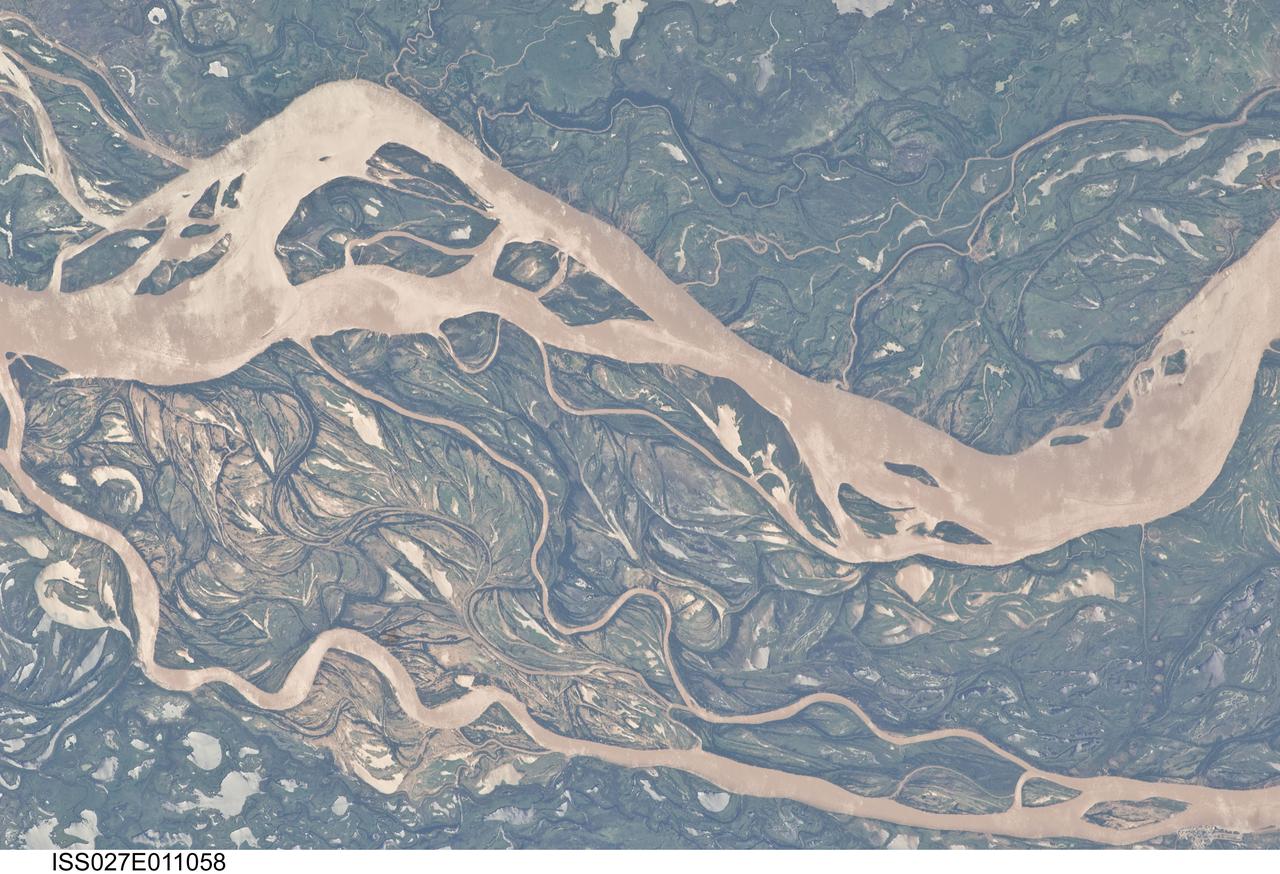
ISS027-E-011058 (9 April 2011) --- The Parana River floodplain in northern Argentina is featured in this image photographed by an Expedition 27 crew member on the International Space Station. This image shows a 29-kilometer stretch of the Parana River, South America?s second largest river, downstream of the small city of Goya (barely distinguishable as grayer surfaces in the extreme top left corner of the image). The Parana River ranges up to three kilometers wide along the reach illustrated in the image. Its strong brown color indicates that it is carrying a heavy load of muddy sediment. Smaller active side channels also carry this muddy water. Numerous lakes are typical on active floodplains, and appear here as irregular bodies of water. Some appear brown, indicating that they have been refilled during recent higher flood levels of the active channels. The main channel Parana River (top) is deep enough to allow smaller ocean-going ships to pass north of the illustrated region to the capital city of Asuncion in landlocked Paraguay, fully 1,200 kilometers inland (well out of the image). The Parana River is thus an important transportation route for landlocked cities such as Asuncion and inland cities of eastern landlocked Bolivia and inland Brazil. The Parana floodplain occupies the entire image; it is so wide?18 kilometers?that its banks are not visible. Numerous curved, or meandering past channels are the most prominent characteristic of the floodplain. These indicate prior positions of rivers. As river beds move laterally by natural processes, they leave remnants of their channels, which appear as lakes, and finally fill with mud. This is an excellent image for illustrating these meander forms. From a geological standpoint it is interesting that almost all the past channels are similar in curvature to the smaller active side rivers; almost no forms show, in any obvious way, prior positions of the main, very wide Parana channel. The reverse might be expected since the main channel is so dominant in the modern landscape.
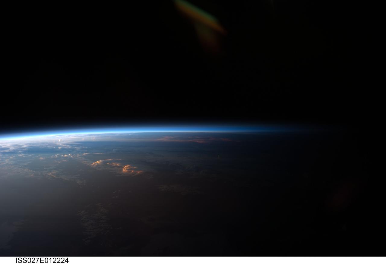
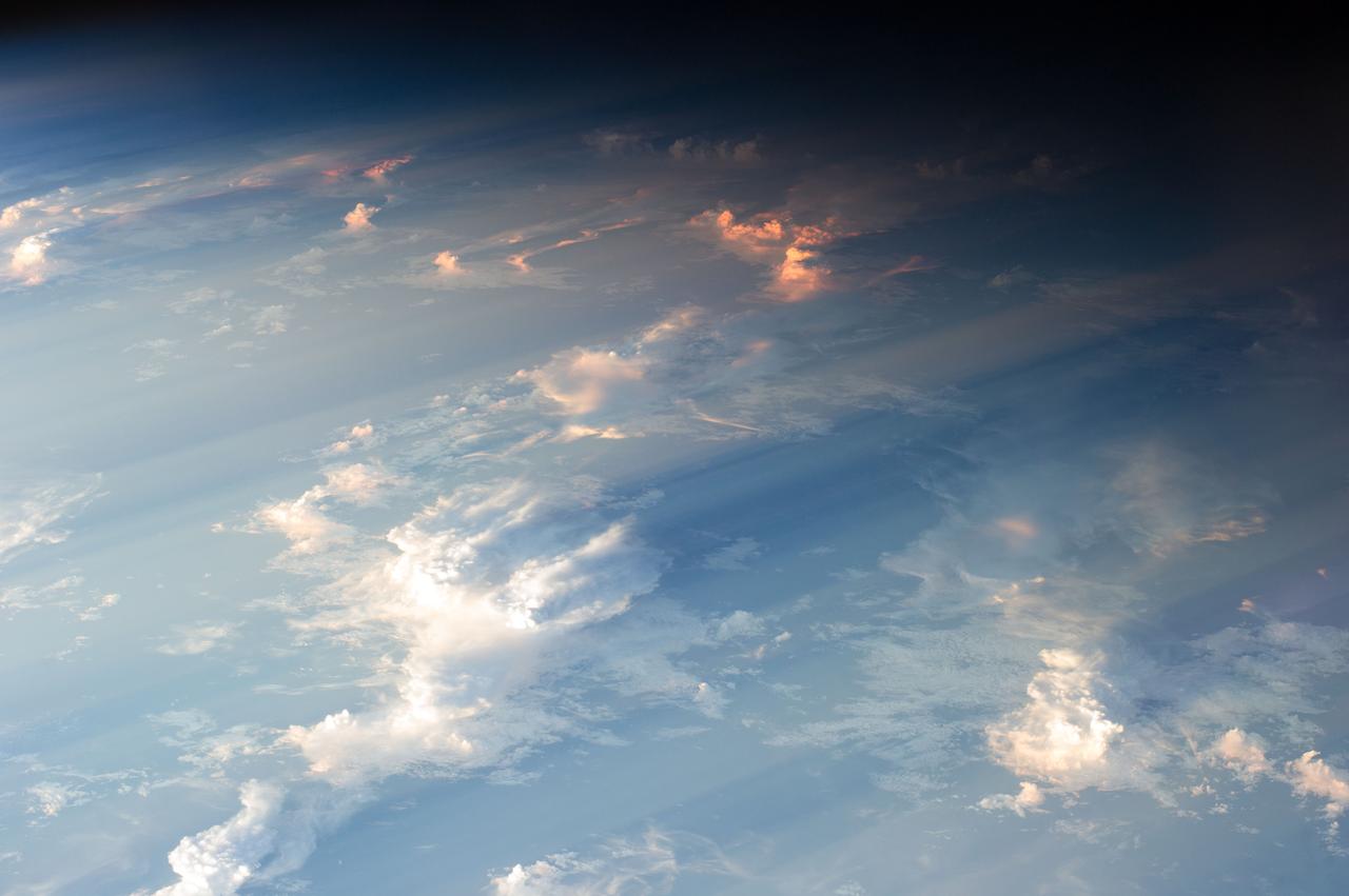
ISS027-E-012224 (12 April 2011) --- Sunset over western South America is featured in this image photographed by an Expedition 27 crew member on the International Space Station. Crew members onboard the space station see, on average, sixteen sunrises and sunsets during a 24-hour orbital period. Each changeover between day and night on the ground is marked by the terminator, or line separating the sunlit side of Earth from the side in darkness. While the terminator is conceptualized as a hard boundary?and is frequently presented as such in graphics and visualizations?in reality the boundary between light and dark is diffuse due to scattering of light by Earth?s atmosphere. This zone of diffuse lighting is experienced as dusk or twilight on the ground ? while the sun is no longer visible, some illumination is still present due to light scattering over the local horizon. The terminator is visible in this photograph trending across the image from lower left to upper right. This panoramic view across central South America, looking towards the northeast, was acquired at approximately 7:37 p.m. local time. Layers of Earth?s atmosphere, colored bright white to deep blue, are visible extending across the horizon (or limb). The highest cloud tops have a reddish glow from the direct light of the setting sun while lower clouds are in twilight. The Salar de Coipasa, a large salt lake in Bolivia, is dimly visible on the night side of the terminator. The salar provides a geographic reference point that allows the location and viewing orientation of the image to be determined.
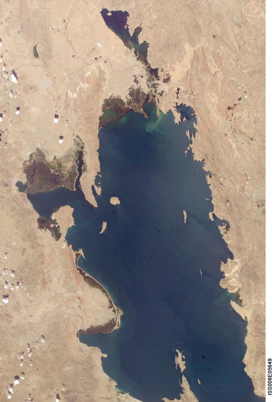
ISS008-E-05649 (8 November 2003) --- Lake Titicaca was featured in this image taken by one of the Expedition 8 crewmembers onboard the International Space Station (ISS). Lake Titicaca, at an elevation of 12,507 feet in the Andean Altiplano, is the highest large lake in the world. More than 120 miles long and 50 miles wide, it was the center of Incan civilization, and today straddles the boundary between Peru and Bolivia. Scientists have studied indicators of the water level changes over time to tease out information about precipitation shifts in the high Andes and the South American tropics. Following are some observations by NASA scientists who are studying this imagery: Because the lake occupies the low point of the Altiplano, much of the water of the high plateau eventually trickles into the lake. And because it is surrounded by mountains, very little of Lake Titicaca’s water drains out -- the Rio Desguadero is the only major outflow river. So, like a bathtub with no drain, this large and deep lake (with depths of several hundred feet) has become the collecting basin for thousands of years of sediment. These sediments and their fossils contain clues about past climate conditions. The restricted outflow of the lake creates conditions where even shorter, interannual climate cycles (like El Niño /Southern Oscillation) impact Lake Titicaca’s water levels. Recent lake level variations have been several meters, with low levels occurring during regional droughts of El Niños. Right now, the region is relatively wet. In this image, the dark greens of the wetlands along the shallower margins of the lake contrast strongly with the surrounding desert. But the even large cities like Puno, Peru (100,000 people) are difficult to discern from the surrounding countryside.
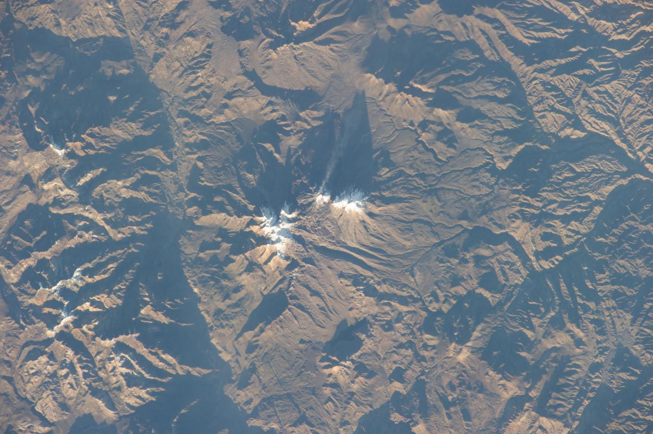
ISS029-E-020003 (7 Oct. 2011) --- Parinacota Volcano in the Chile-Bolivia border region, South America is featured in this image photographed by an Expedition 29 crew member on the International Space Station. Volcan Parinacota (?flamingo lake? in the regional Aymara language) is a potentially active stratovolcano located on the Altiplano, a high plateau situated within the Andes Mountains of west-central South America. While no direct observations of eruptive activity are recorded, surface exposure age-dating of lava flows suggests that activity occurred as recently as 290 AD approximately 300 years, according to scientists. Local Aymara stories also suggest that the volcano has erupted during the past 1,000 years. This detailed photograph highlights the symmetrical cone of Parinacota, with its well-developed summit crater (elevation 6,348 meters above sea level) at center. Dark brown to dark gray surfaces to the east and west of the summit include lava flows, pyroclastic deposits, and ash. A companion volcano, Pomerape, is located across a low saddle to the north ? scientists believe this volcano last erupted during the Pleistocene Epoch (extending from approximately 3 million to 12,000 years ago). The summits of both volcanoes are covered by white permanent snowpack and small glaciers. Together, the two volcanoes form the Nevados de Payachata volcanic area. Eruptive activity at Parinacota has directly influenced development of the local landscape beyond the emplacement of volcanic deposits ? approximately 8,000 years ago the western flank of the volcano collapsed, creating a debris avalanche that traveled 22 kilometers to the west. This debris avalanche blocked drainages, leading to the formation of Lake Chungara to the south (upper right). The uneven, hummocky surface of the debris avalanche deposit provides ample catchments for water, as evidenced by the numerous small ponds and Cotacotani Lake to the west.
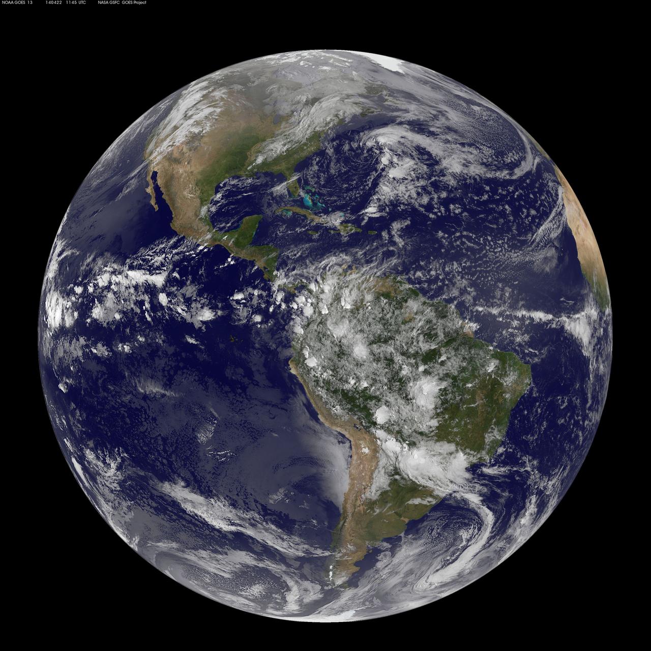
Today, April 22, 2014 is Earth Day, and what better way to celebrate than taking a look at our home planet from space. NOAA's GOES-East satellite captured this stunning view of the Americas on Earth Day, April 22, 2014 at 11:45 UTC/7:45 a.m. EDT. The data from GOES-East was made into an image by the NASA/NOAA GOES Project at NASA's Goddard Space Flight Center in Greenbelt, Md. In North America, clouds associated with a cold front stretch from Montreal, Canada, south through the Tennessee Valley, and southwest to southern Texas bringing rain east of the front today. A low pressure area in the Pacific Northwest is expected to bring rainfall in Oregon, Washington, Idaho, stretching into the upper Midwest, according to NOAA's National Weather Service. That low is also expected to bring precipitation north into the provinces of British Columbia and Alberta, Canada. Another Pacific low is moving over southern Nevada and the National Weather Service expects rain from that system to fall in central California, Nevada, and northern Utah. Near the equator, GOES imagery shows a line of pop up thunderstorms. Those thunderstorms are associated with the Intertropical Convergence Zone (ITCZ). The ITCZ encircles the Earth near the equator. In South America, convective (rapidly rising air that condenses and forms clouds) thunderstorms pepper Colombia, Venezuela, Ecuador, Peru, Bolivia, Paraguay and northwestern and southeastern Brazil. GOES satellites provide the kind of continuous monitoring necessary for intensive data analysis. Geostationary describes an orbit in which a satellite is always in the same position with respect to the rotating Earth. This allows GOES to hover continuously over one position on Earth's surface, appearing stationary. As a result, GOES provide a constant vigil for the atmospheric "triggers" for severe weather conditions such as tornadoes, flash floods, hail storms and hurricanes. For more information about GOES satellites, visit: <a href="http://www.goes.noaa.gov/" rel="nofollow">www.goes.noaa.gov/</a> or <a href="http://goes.gsfc.nasa.gov/" rel="nofollow">goes.gsfc.nasa.gov/</a> Rob Gutro NASA's Goddard Space Flight Center <b><a href="http://www.nasa.gov/audience/formedia/features/MP_Photo_Guidelines.html" rel="nofollow">NASA image use policy.</a></b> <b><a href="http://www.nasa.gov/centers/goddard/home/index.html" rel="nofollow">NASA Goddard Space Flight Center</a></b> enables NASA’s mission through four scientific endeavors: Earth Science, Heliophysics, Solar System Exploration, and Astrophysics. Goddard plays a leading role in NASA’s accomplishments by contributing compelling scientific knowledge to advance the Agency’s mission. <b>Follow us on <a href="http://twitter.com/NASAGoddardPix" rel="nofollow">Twitter</a></b> <b>Like us on <a href="http://www.facebook.com/pages/Greenbelt-MD/NASA-Goddard/395013845897?ref=tsd" rel="nofollow">Facebook</a></b> <b>Find us on <a href="http://instagram.com/nasagoddard?vm=grid" rel="nofollow">Instagram</a></b>