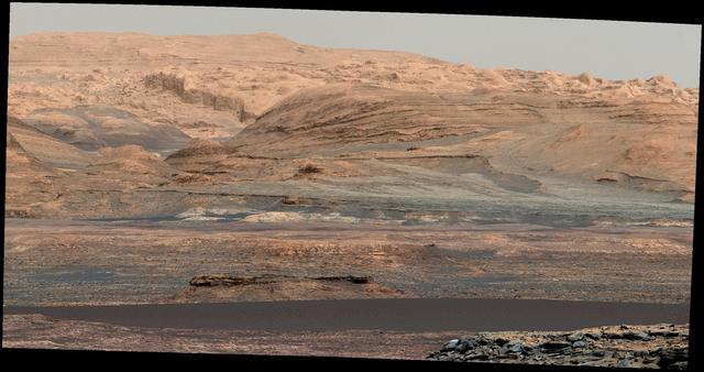
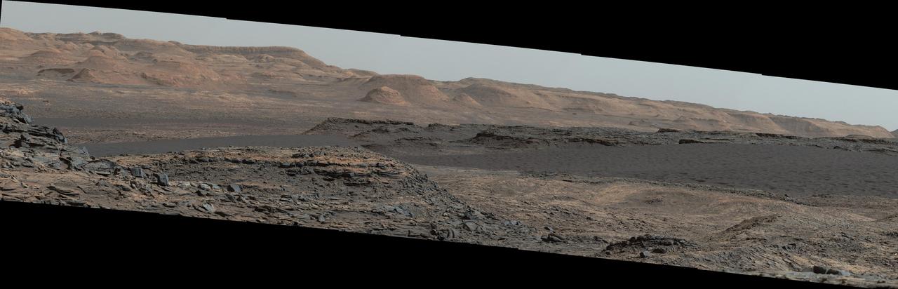
The dark band in the lower portion of this Martian scene is part of the "Bagnold Dunes" dune field lining the northwestern edge of Mount Sharp, inside Gale Crater. The view combines multiple images taken with the Mast Camera (Mastcam) on NASA's Curiosity Mars rover on Sept. 25, 2015, during the 1,115th Martian day, or sol, of Curiosity's work on Mars. The images are from Mastcam's right-eye camera, which has a telephoto lens. The view is toward south-southeast. Curiosity will visit examples of the Bagnold Dunes on the rover's route to higher layers of Mount Sharp. The informal name for the dune field is a tribute to British military engineer Ralph Bagnold (1896-1990), a pioneer in the study of how winds move sand particles of dunes on Earth. The dune field is evident as a dark band in orbital images of the area inside Gale Crater where Curiosity has been active since landing in 2012, such as a traverse map at PIA20162. Dunes are larger than wind-blown ripples of sand or dust that Curiosity and other rovers have visited previously. The scene is presented with a color adjustment that approximates white balancing, to resemble how the rocks and sand would appear under daytime lighting conditions on Earth. http://photojournal.jpl.nasa.gov/catalog/PIA19929

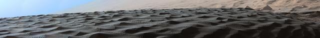
This view from the Mast Camera (Mastcam) on NASA's Curiosity Mars rover shows two scales of ripples, plus other textures, in an area where the mission examined a linear-shaped dune in the Bagnold dune field on lower Mount Sharp. The scene is an excerpt from a 360-degree panorama acquired on March 24 and March 25, 2017, (PST) during the 1,647th Martian day, or sol, of Curiosity's work on Mars, at a location called "Ogunquit Beach." Crests of the longer ripples visible in the dark sand of the dune are several feet (a few meters) apart. This medium-scale feature in active sand dunes on Mars was one of Curiosity's findings at the crescent-shaped dunes that the rover examined in late 2015 and early 2016. Ripples that scale are not seen on Earth's sand dunes. Overlaid on those ripples are much smaller ripples, with crests about ten times closer together. Textures of the local bedrock in the foreground -- part of the Murray formation that originated as lakebed sediments -- and of gravel-covered ground (at right) are also visible. The image has been white-balanced so that the colors of the colors of the rock and sand materials resemble how they would appear under daytime lighting conditions on Earth. https://photojournal.jpl.nasa.gov/catalog/PIA11242
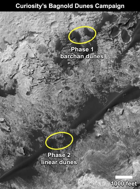
This map shows the two locations of a research campaign by NASA's Curiosity Mars rover mission to investigate active sand dunes inside Gale Crater on Mars. The Bagnold Dunes form a dark band on the northwestern flank of Mount Sharp, inside the crater. In late 2015 and early 2016, Curiosity examined crescent-shaped dunes, called barchans, which are convex on the downwind (leeward) side. This was the first close-up study of active sand dunes anywhere other than Earth. In February 2017, the rover reached a location where the dunes are linear in shape, and the mission began Phase 2 of its dunes campaign. http://photojournal.jpl.nasa.gov/catalog/PIA21269
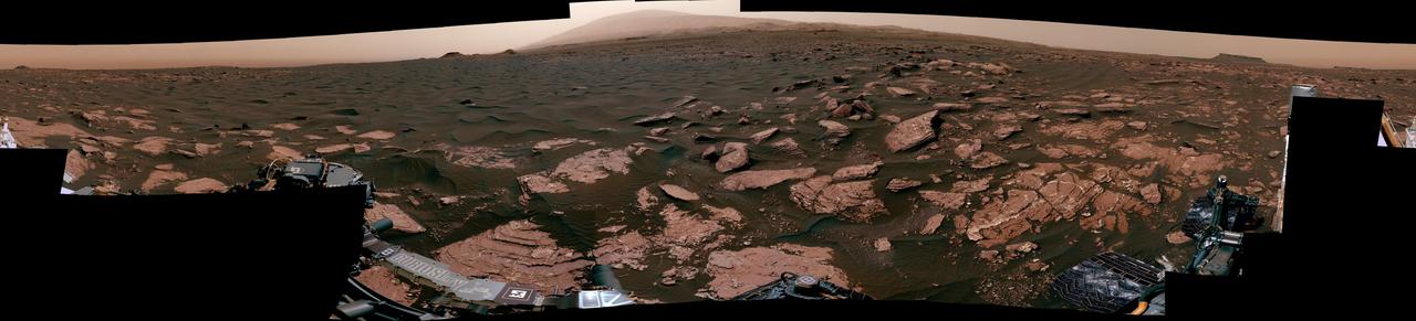
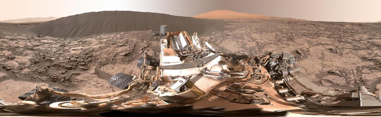
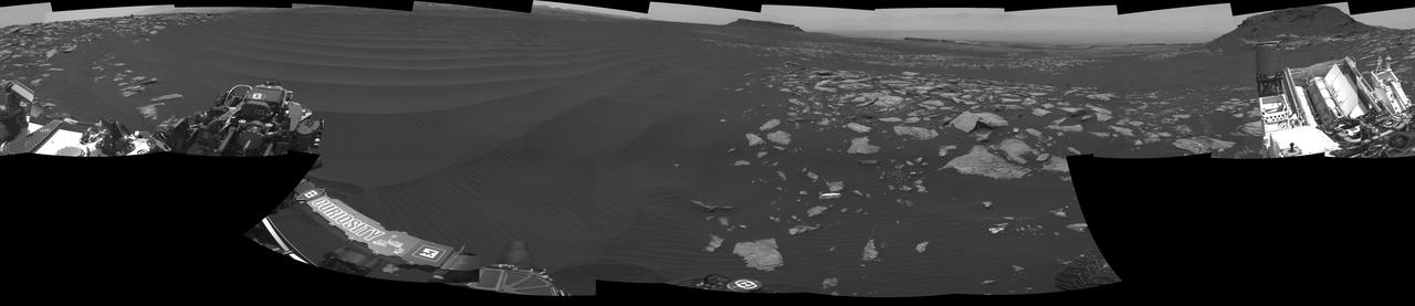
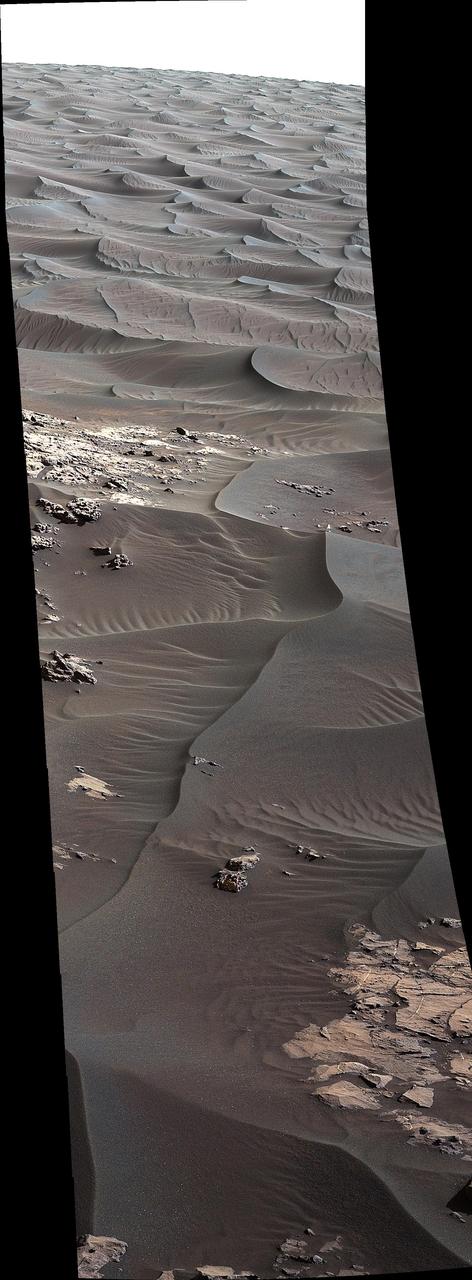
This 360-degree mosaic from the Mast Camera (Mastcam) on NASA's Curiosity Mars rover looks out over a portion of the Bagnold Dunes, which stretch for several miles. From early February to early April 2017, the rover examined four sites near linear dunes for comparison with what it found in late 2015 and early 2016 during its investigation of crescent-shaped dunes. The dark, rippled surface of a linear dune is visible at the center of the view and receding into the distance to the left. The bedrock of the Murray formation, made from sediments deposited in lakes billions of years ago, is in the foreground, along with some components of the rover. The location, called "Ogunquit Beach," is on the northwestern flank of lower Mount Sharp. Northwest is at both ends of this full-circle panorama; southeast is at the center, where a higher portion of Mount Sharp dominates the horizon. Among the questions this Martian dune campaign is addressing is how winds shape the dunes into different patterns. Others include whether Martian winds sort grains of sand in ways that affect the distribution of mineral compositions, which also would have implications for studies of Martian sandstones. The 115 individual images that were combined into this mosaic were acquired by the Mastcam's left-eye camera on March 24 and March 25, 2017, (PST) during the 1,647th Martian day, or sol, of Curiosity's work on Mars. This mosaic is white-balanced so that the colors of the colors of the rock and sand materials resemble how they would appear under daytime lighting conditions on Earth. The rover's position on Sol 1647 is shown at https://mars.nasa.gov/multimedia/images/2017/curiositys-traverse-map-through-sol-1646 as the location reached by a drive on Sol 1646. https://photojournal.jpl.nasa.gov/catalog/PIA11241
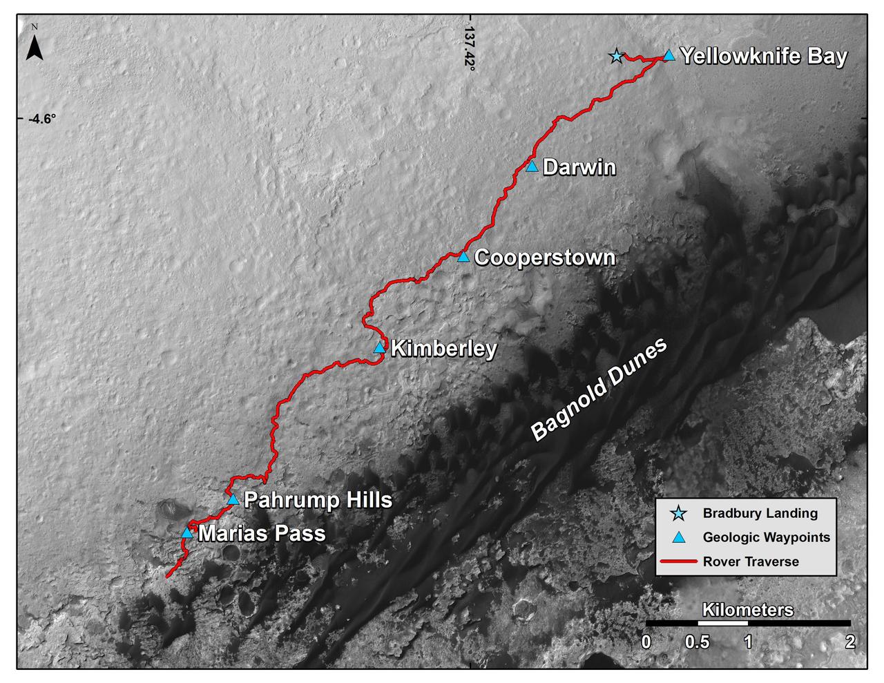
This map shows the route driven by NASA's Curiosity Mars rover from the location where it landed in August 2012 to its location in mid-November 2015, approaching examples of dunes in the "Bagnold Dunes" dune field. The traverse line covers drives completed through the 1,165rd Martian day, or sol, of Curiosity's work on Mars (Nov. 15, 2015). The base image for this map is from the High Resolution Imaging Science Experiment (HiRISE) camera on NASA's Mars Reconnaissance Orbiter. North is up. The dark ground south of the rover's route is the Bagnold Dunes of dark, wind-blown material at the foot of Mount Sharp. The scale bar at lower right represents two kilometers (1.2 miles). http://photojournal.jpl.nasa.gov/catalog/PIA20162
This view of the downwind face of "Namib Dune" on Mars covers 360 degrees, including a portion of Mount Sharp on the horizon. The site is part of the dark-sand "Bagnold Dunes" field along the northwestern flank of Mount Sharp. Images taken from orbit indicate that dunes in the Bagnold field move as much as about 3 feet (1 meter) per Earth year. The component images of this scene were taken on Dec. 18, 2015, by the Mast Camera (Mastcam) on NASA's Curiosity Mars rover during the 1,197th Martian day, or sol, of the rover's work on Mars. http://photojournal.jpl.nasa.gov/catalog/PIA20284
This view from NASA's Curiosity Mars Rover shows the downwind side of "Namib Dune," which stands about 13 feet (4 meters) high. The site is part of Bagnold Dunes, a band of dark sand dunes along the northwestern flank of Mars' Mount Sharp. The component images stitched together into this scene were taken with Curiosity's Navigation Camera (Navcam) on Dec. 17, 2015, during the 1,196th Martian day, or sol, of the rover's work on Mars. In late 2015 and early 2016, Curiosity is conducting the first up-close studies ever made of active sand dunes anywhere but on Earth. Under the influence of Martian wind, the Bagnold Dunes are migrating up to about one yard or meter per Earth year. The view spans from westward on the left to east-southeastward on the right. It is presented as a cylindrical perspective projection. http://photojournal.jpl.nasa.gov/catalog/PIA20281
This stereo view from NASA's Curiosity Mars Rover shows the downwind side of "Namib Dune," which stands about 13 feet (4 meters) high. The image appears three-dimensional when viewed through red-blue glasses with the red lens on the left. The site is part of Bagnold Dunes, a band of dark sand dunes along the northwestern flank of Mars' Mount Sharp. The component images stitched together into this scene were taken with Curiosity's Navigation Camera (Navcam) on Dec. 17, 2015, during the 1,196th Martian day, or sol, of the rover's work on Mars. In late 2015 and early 2016, Curiosity is conducting the first up-close studies ever made of active sand dunes anywhere but on Earth. Under the influence of Martian wind, the Bagnold Dunes are migrating up to about one yard or meter per Earth year. http://photojournal.jpl.nasa.gov/catalog/PIA20282
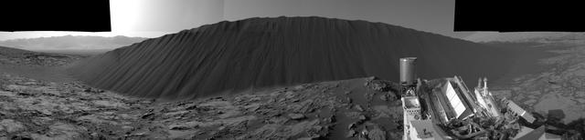
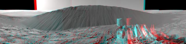
The left side of this 360-degree panorama from NASA's Curiosity Mars rover shows the long rows of ripples on a linear shaped dune in the Bagnold Dune Field on the northwestern flank of Mount Sharp. The view is a mosaic of images taken with Curiosity's Navigation Camera (Navcam) on Feb. 5, 2017, during the 1,601st Martian day, or sol, of the rover's work on Mars. The view is centered toward west-southwest, with east-southeast on either end. A capped mound called "Ireson Hill" is on the right. http://photojournal.jpl.nasa.gov/catalog/PIA21268
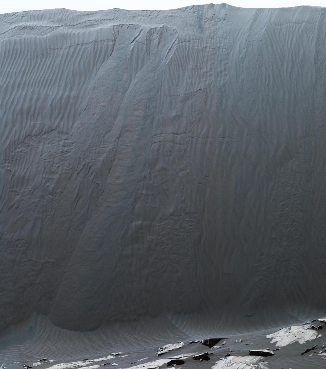
This view combines multiple images from the telephoto-lens camera of the Mast Camera (Mastcam) on NASA's Curiosity Mars rover to reveal fine details of the downwind face of "Namib Dune." The site is part of the dark-sand "Bagnold Dunes" field along the northwestern flank of Mount Sharp. Images taken from orbit have shown that dunes in the Bagnold field move as much as about 3 feet (1 meter) per Earth year. Sand on this face of Namib Dune has cascaded down a slope of about 26 to 28 degrees. The top of the face is about 13 to 17 feet (4 to 5 meters) above the rocky ground at its base. http://photojournal.jpl.nasa.gov/catalog/PIA20283
Two sizes of wind-sculpted ripples are evident in this view of the top surface of a Martian sand dune. Sand dunes and the smaller type of ripples also exist on Earth. The larger ripples -- roughly 10 feet (3 meters) apart -- are a type not seen on Earth nor previously recognized as a distinct type on Mars. The Mast Camera (Mastcam) on NASA's Curiosity Mars rover took the multiple component images of this scene on Dec. 13, 2015, during the 1,192nd Martian day, or sol, of the rover's work on Mars. That month, Curiosity was conducting the first close-up investigation ever made of active sand dunes anywhere other than Earth. The larger ripples have distinctive sinuous crest lines, compared to the smaller ripples. The location is part of "Namib Dune" in the Bagnold Dune Field, which forms a dark band along the northwestern flank of Mount Sharp. The component images were taken in early morning at this site, with the camera looking in the direction of the sun. This mosaic combining the images has been processed to brighten it and make the ripples more visible. The sand is very dark, both from the morning shadows and from the intrinsic darkness of the minerals that dominate its composition. http://photojournal.jpl.nasa.gov/catalog/PIA20755
This image from NASA Mars Reconnaissance Orbiter spacecraft shows the Curiosity rover currently located on the Naukluft Plateau just north of the Bagnold Dune field. Its position was captured by HiRISE on 25 March 2016 (MSL Sol 1291. Views from the surface at this location are available here and here.) The rover is within sandstone outcrops informally named the "Stimson Formation." There are no obvious rover tracks in the HiRISE views indicating that this bedrock contains little dust that otherwise could be disturbed by the rover wheels as has been seen earlier in Curiosity's traverse. http://photojournal.jpl.nasa.gov/catalog/PIA20738
The rippled surface of the first Martian sand dune ever studied up close fills this view of "High Dune" from the Mast Camera (Mastcam) on NASA's Curiosity rover. This site is part of the "Bagnold Dunes" field along the northwestern flank of Mount Sharp. The dunes are active, migrating up to about one yard or meter per year. The component images of this mosaic view were taken on Nov. 27, 2015, during the 1,176th Martian day, or sol, of Curiosity's work on Mars. The scene is presented with a color adjustment that approximates white balancing, to resemble how the sand would appear under daytime lighting conditions on Earth. The annotated version includes superimposed scale bars of 30 centimeters (1 foot) in the foreground and 100 centimeters (3.3 feet) in the middle distance. Malin Space Science Systems, San Diego, built and operates Curiosity's Mastcam. NASA's Jet Propulsion Laboratory, a division of the California Institute of Technology, Pasadena, built the rover and manages the project for NASA's Science Mission Directorate, Washington. http://photojournal.jpl.nasa.gov/catalog/PIA20168
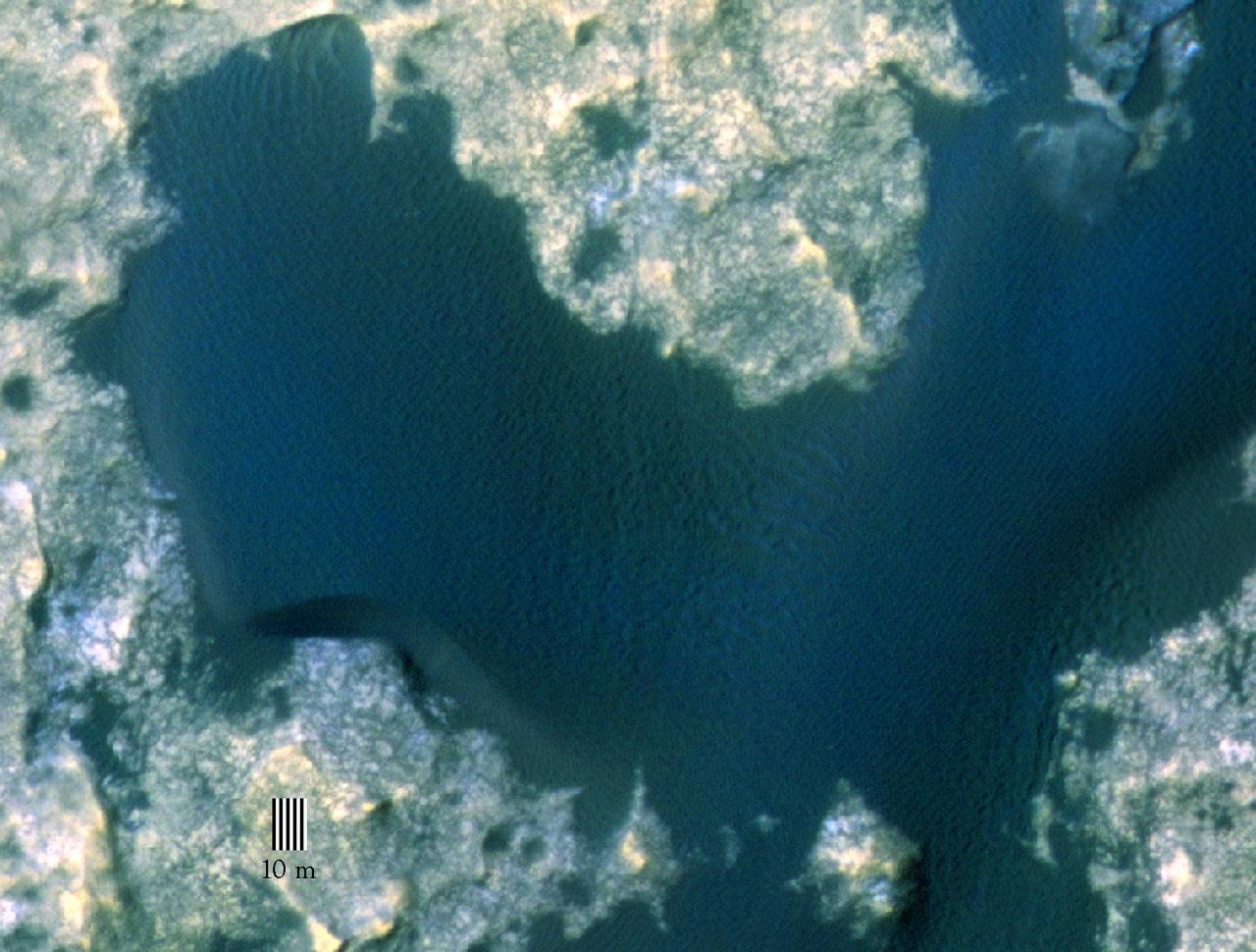
This view taken from orbit around Mars shows the sand dune that will be the first to be visited by NASA's Curiosity Mars Rover along its route to higher layers of Mount Sharp. The view covers an area about 1,250 feet (about 380 meters) across, showing a site called "Dune 1" in the "Bagnold Dunes" dune field. It was taken by the High Resolution Imaging Science Experiment (HiRISE) camera on NASA's Mars Reconnaissance Orbiter. The image is in false color, combining information recorded by HiRISE in red, blue-green and infrared frequencies of light. http://photojournal.jpl.nasa.gov/catalog/PIA19930
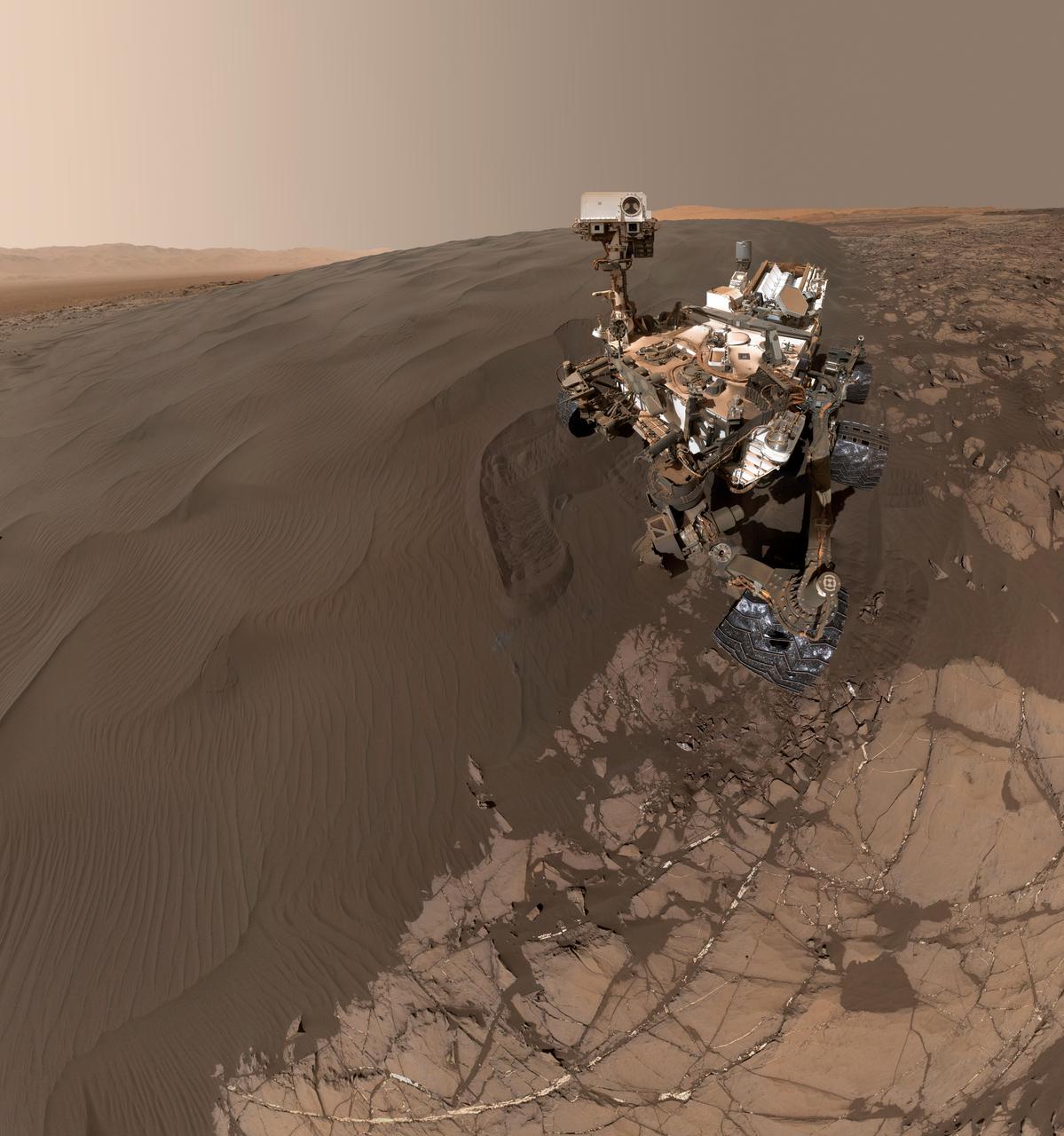
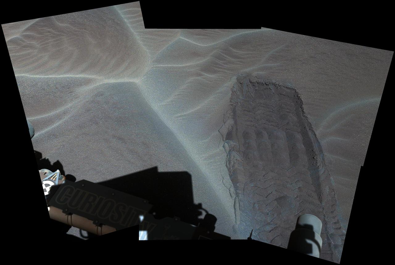
This self-portrait of NASA's Curiosity Mars rover shows the vehicle at "Namib Dune," where the rover's activities included scuffing into the dune with a wheel and scooping samples of sand for laboratory analysis. The scene combines 57 images taken on Jan. 19, 2016, during the 1,228th Martian day, or sol, of Curiosity's work on Mars. The camera used for this is the Mars Hand Lens Imager (MAHLI) at the end of the rover's robotic arm. Namib Dune is part of the dark-sand "Bagnold Dune Field" along the northwestern flank of Mount Sharp. Images taken from orbit have shown that dunes in the Bagnold field move as much as about 3 feet (1 meter) per Earth year. The location of Namib Dune is show on a map of Curiosity's route at http://mars.nasa.gov/msl/multimedia/images/?ImageID=7640. The relationship of Bagnold Dune Field to the lower portion of Mount Sharp is shown in a map at PIA16064. The view does not include the rover's arm. Wrist motions and turret rotations on the arm allowed MAHLI to acquire the mosaic's component images. The arm was positioned out of the shot in the images, or portions of images, that were used in this mosaic. This process was used previously in acquiring and assembling Curiosity self-portraits taken at sample-collection sites, including "Rocknest" (PIA16468), "Windjana" (PIA18390) and "Buckskin" (PIA19807). For scale, the rover's wheels are 20 inches (50 centimeters) in diameter and about 16 inches (40 centimeters) wide. Other Curiosity self-portraits are available at http://photojournal.jpl.nasa.gov/catalog/PIA20316
This view of the undisturbed surface of a Martian sand dune called "High Dune" visited by NASA's Curiosity rover shows coarse grains remaining on the surface after wind removal of smaller particles. The image covers an area 1.4 inches by 1.1 inches (3.6 by 2.7 centimeters). It was taken by the Mars Hand Lens Imager (MAHLI) camera on the rover's arm on Dec. 5, 2015, during the 1,184th Martian day, or sol, of Curiosity's work on Mars. The imaged location is near the base of the dune. High Dune, in the Bagnold Dunes field skirting the northwestern flank of Mount Sharp, is the first sand dune studied in place anywhere except Earth. What distinguishes actual dunes from windblown ripples of sand or dust, like those found at several sites visited previously by Mars rovers, is that dunes form a downwind face steep enough for sand to slide down. http://photojournal.jpl.nasa.gov/catalog/PIA20171
This animation flips back and forth between views taken in 2010 and 2014 of a Martian sand dune at the edge of Mount Sharp, documenting dune activity. The images are from the High Resolution Imaging Science Experiment (HiRISE) camera on NASA's Mars Reconnaissance Orbiter. They cover an area about 740 feet (about 225 meters) wide, showing a site called "Dune 2" in the "Bagnold Dunes" dune field. NASA's Curiosity Mars rover will observe this dune up close on the rover's route up Mount Sharp. North is toward the top. The edge of the dune at the crescent-shaped slip face on the south edge advances slightly during the four-year period between the dates of the images. Figure A is an annotated version with an arrow indicating the location of this change. The lighting angle is different in the two images, resulting in numerous changes in shadows. http://photojournal.jpl.nasa.gov/catalog/PIA20161
This view from the Mast Camera (Mastcam) on NASA's Curiosity Mars rover shows a dark sand dune in the middle distance. The rover's examination of dunes on the way toward higher layers of Mount Sharp will be the first in-place study of an active sand dune anywhere other than Earth. The scene combines several images taken on Sept. 25, 2015, during the 1,115th Martian day, or sol, of Curiosity's work on Mars. The images are from Mastcam's right-eye camera, which has a telephoto lens. The view is toward south-southwest. The dunes on Curiosity's route are part of a band of dunes called "Bagnold Dunes," along the northwestern edge of Mount Sharp. The informal naming recognizes British military engineer Ralph Bagnold (1896-1990), a pioneer in the study of how winds move sand particles of dunes on Earth. The dune field is evident as a dark band in orbital images of the area inside Gale Crater were Curiosity has been active since landing in 2012, such as a traverse map at PIA20162. Dunes are larger than wind-blown ripples of sand or dust that Curiosity and other rovers have visited previously. One dune that Curiosity will investigate in coming days is as tall as a two-story building and as broad as a football field. Ripples on the surface of these Martian dunes are larger than ripples on the surfaces of sand dunes on Earth. The scene is presented with a color adjustment that approximates white balancing, to resemble how the rocks and sand would appear under daytime lighting conditions on Earth. http://photojournal.jpl.nasa.gov/catalog/PIA19928
The rippled surface of the first Martian sand dune ever studied up close fills this view of "High Dune" from the Mast Camera (Mastcam) on NASA's Curiosity rover. This site is part of the "Bagnold Dunes" field along the northwestern flank of Mount Sharp. The dunes are active, migrating up to about one yard or meter per year. The component images of this mosaic view were taken on Nov. 27, 2015, during the 1,176th Martian day, or sol, of Curiosity's work on Mars. The scene is presented with a color adjustment that approximates white balancing, to resemble how the sand would appear under daytime lighting conditions on Earth. The annotated version includes superimposed scale bars of 30 centimeters (1 foot) in the foreground and 100 centimeters (3.3 feet) in the middle distance. Malin Space Science Systems, San Diego, built and operates Curiosity's Mastcam. NASA's Jet Propulsion Laboratory, a division of the California Institute of Technology, Pasadena, built the rover and manages the project for NASA's Science Mission Directorate, Washington. http://photojournal.jpl.nasa.gov/catalog/PIA20169
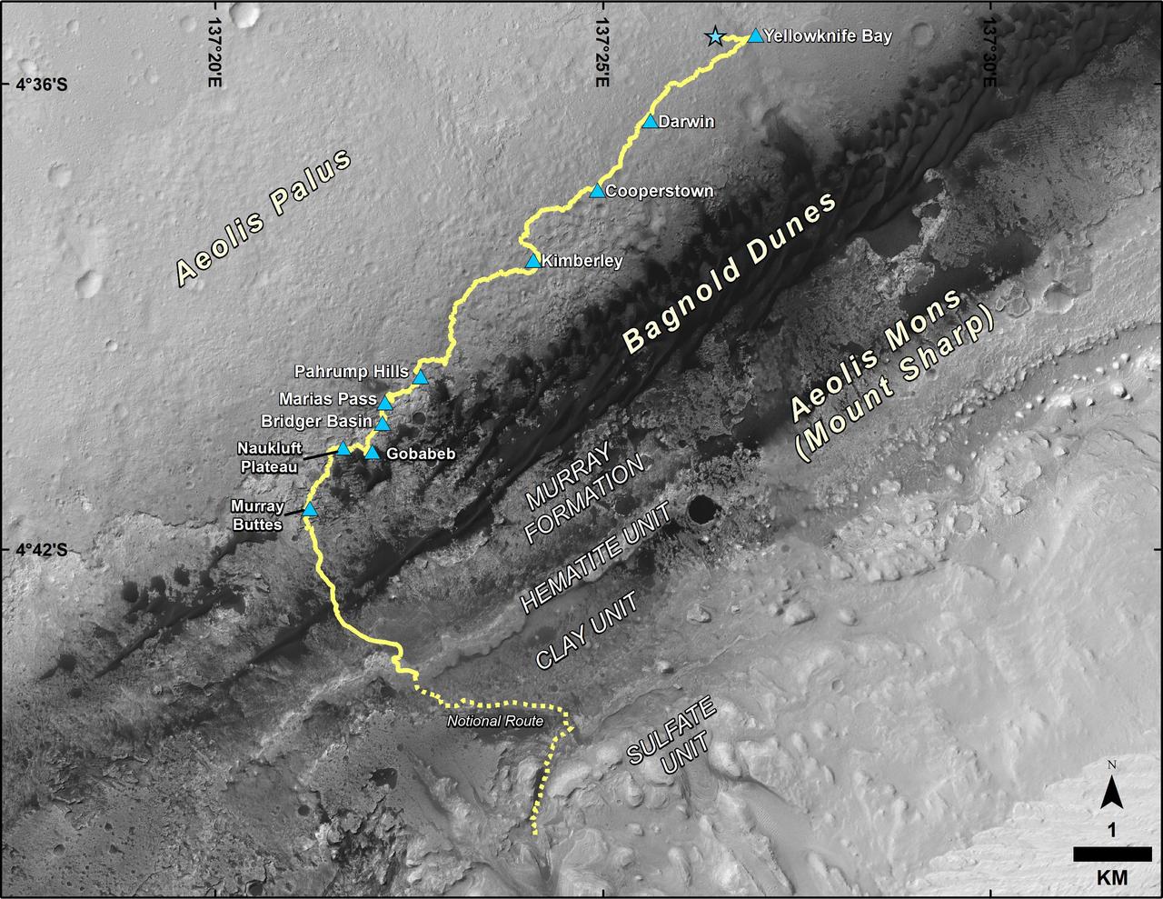
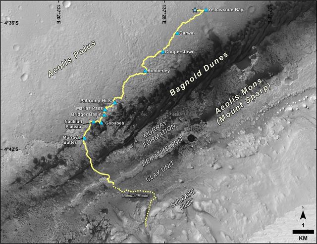
This map shows the route driven by NASA's Curiosity Mars rover from the location where it landed in August 2012 to its location in September 2016 at "Murray Buttes," and the path planned for reaching destinations at "Hematite Unit" and "Clay Unit" on lower Mount Sharp. Blue triangles mark waypoints investigated by Curiosity during the rover's two-year prime mission and first two-year extended mission. The Hematite Unit and Clay Unit are key destinations for the second two-year extension, through September 2018. The base image for the map is from the High Resolution Imaging Science Experiment (HiRISE) camera on NASA's Mars Reconnaissance Orbiter. North is up. Bagnold Dunes form a band of dark, wind-blown material at the foot of Mount Sharp. http://photojournal.jpl.nasa.gov/catalog/PIA20846
This map shows the route driven by NASA's Curiosity Mars rover from the location where it landed in August 2012 to its location in December 2016, which is in the upper half of a geological unit called the Murray formation, on lower Mount Sharp. Blue triangles mark waypoints investigated by Curiosity during the rover's two-year prime mission and first two-year extended mission. The "Hematite Unit" and "Clay Unit" are key destinations for the second two-year extension, through September 2018. An approximate possible route is indicated for studying those layers of the mountain. The base image for the map is from the High Resolution Imaging Science Experiment (HiRISE) camera on NASA's Mars Reconnaissance Orbiter. North is up. Bagnold Dunes form a band of dark, wind-blown material at the foot of Mount Sharp. The scale bar at lower right represents one kilometer (0.62 mile). http://photojournal.jpl.nasa.gov/catalog/PIA21144
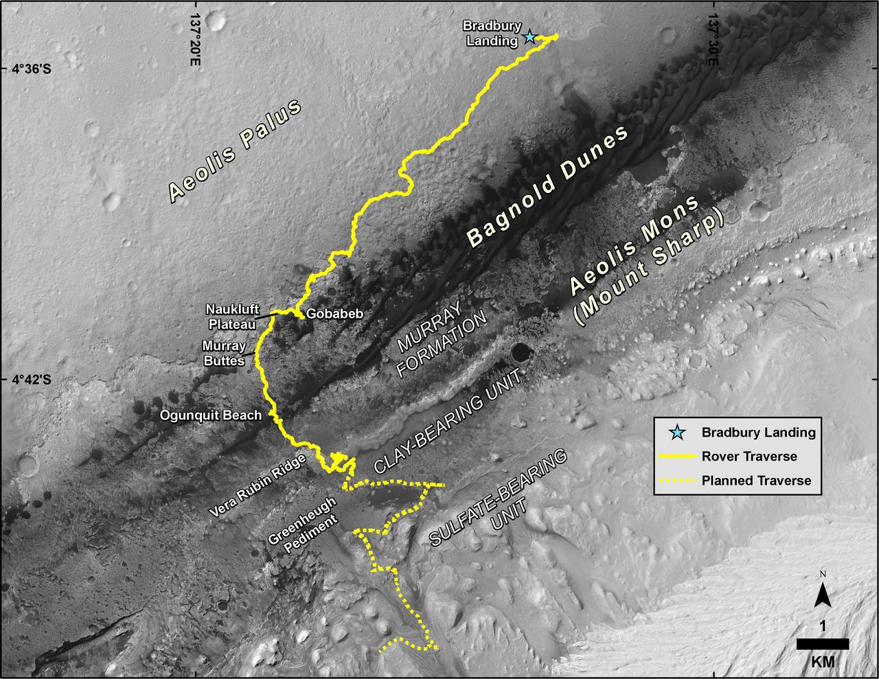
This map shows the route driven by NASA's Curiosity Mars rover, from the location where it landed in August 2012 to its location in August 2019, and its planned path to additional geological layers of lower "Mount Sharp." The blue star near top center marks "Bradbury Landing," the site where Curiosity arrived on Mars on Aug. 5, 2012, PDT (Aug. 6, EDT and Universal Time). Curiosity landed on Aeolis Palus, the plains surrounding Aeolis Mons (Mount Sharp) in Gale Crater. The base image for the map is from the High Resolution Imaging Science Experiment (HiRISE) camera on the Mars Reconnaissance Orbiter. North is up. "Bagnold Dunes" form a band of dark, wind-blown material at the foot of Mount Sharp. The scale bar at lower right represents one kilometer (0.62 mile). https://photojournal.jpl.nasa.gov/catalog/PIA23412
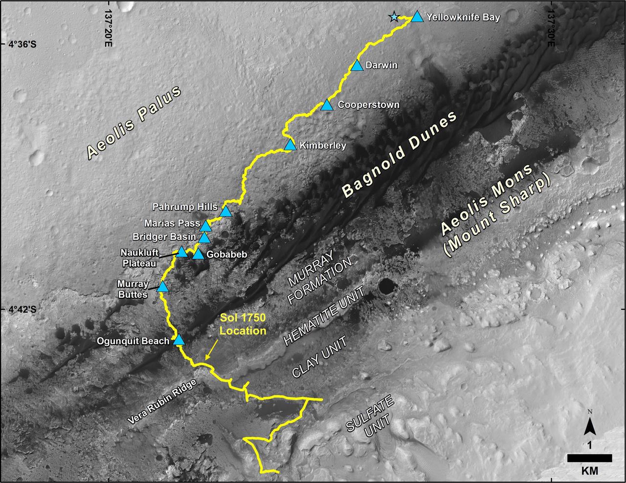
This map shows the route driven by NASA's Curiosity Mars rover, from the location where it landed in August 2012 to its location in July 2017, and its planned path to additional geological layers of lower Mount Sharp. The blue star near top center marks "Bradbury Landing," the site where Curiosity arrived on Mars on Aug. 5, 2012, PDT (Aug. 6, EDT and Universal Time). Blue triangles mark waypoints investigated by Curiosity on the floor of Gale Crater and, starting with "Pahrump Hills," on Mount Sharp. The Sol 1750 label identifies the rover's location on July 9, 2017, the 1,750th Martian day, or sol, since the landing. In July 2017, the mission is examining "Vera Rubin Ridge" from the downhill side of the ridge. Spectrometry observations from NASA's Mars Reconnaissance Orbiter have detected hematite, an iron-oxide mineral, in the ridge. Curiosity's planned route continues to the top of the ridge and then to geological units where clay minerals and sulfate minerals have been detected from orbit. The base image for the map is from the High Resolution Imaging Science Experiment (HiRISE) camera on the Mars Reconnaissance Orbiter. North is up. "Bagnold Dunes" form a band of dark, wind-blown material at the foot of Mount Sharp. https://photojournal.jpl.nasa.gov/catalog/PIA21720