
Students from the Our Lady of Perpetual Help School in Bakersfield, CA, pass by one of NASA Dryden's F-18 chase aircraft during a tour.
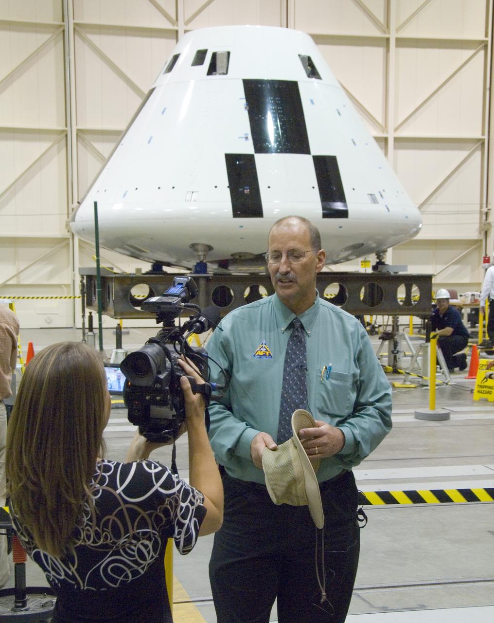
Reporter Julie Flannery of KERO-TV, Bakersfield, interviews NASA Dryden's Orion Abort Flight Test project manager Gary Martin in front of the Orion PA-1 crew module.
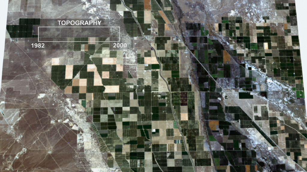
This frame from an animation depicts ground subsidence resulting from the extraction of oil. The oil fields are located near the community of Lost Hills, California, approximately 100 km northwest of Bakersfield.

The Erskine wildfire, northeast of Bakersfield, California, is the state's largest to date in 2016. After starting on June 23, the fire has consumed 47,000 acres (19,020 hectares), destroyed more than 250 single residences, and is responsible for two fatalities. As of June 30, the fire was 70 percent contained; full containment was estimated by July 5. This image, obtained June 30 by the Advanced Spaceborne Thermal Emission and Reflection Radiometer (ASTER) instrument on NASA's Terra spacecraft, displays vegetation in red. The image covers an area of 19 by 21 miles (31 by 33 kilometers), and is located at 35.6 degrees north, 118.5 degrees west. http://photojournal.jpl.nasa.gov/catalog/PIA20741
STS003-010-593 (30 March 1982) --- A general view of the greater Los Angeles region of California (34,0N, 118.5W) showing the coastline, Vandenberg AFB, the south end of the Central Valley and the dry lake beds at Edwards AFB. A close look can pinpoint water on the lake beds at Edwards Air Force Base used previously for two shuttle landings. Among other features that can be seen are Oxnard, Santa Barbara, Bakersfield, Vandenberg Air Force Base, and The Ranch. Photo credit: NASA
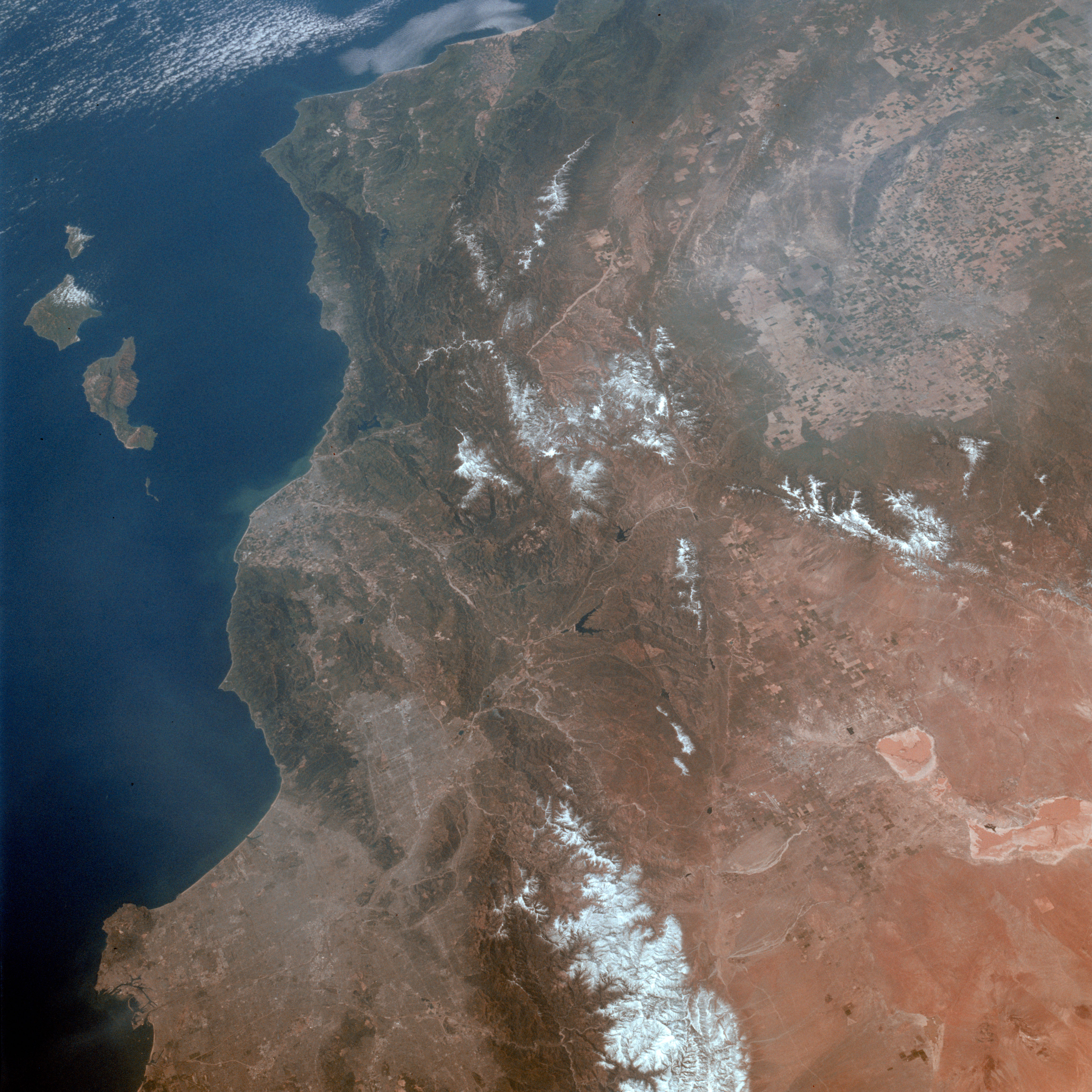
This view of southern California as seen from the Apollo 7 spacecraft during its 18th revolution of the earth. Photographed from an altitude of 124 nautical miles. The coast of California can be seen from Point Mugu southward to Oceanside. Santa Catalina can be seen below the off shore clouds. Details of the Los Angeles area are obscured by pollution which extends from Banning westard for 100 miles to beyond Malibu. In the upper portion of the photograph can be seen (left to right) the San Joaquin Valley beyond Bakersfield, the Techachapi Mountains, the Sierra Nevada, Owens Valley, Death Valley and the Mojave Desert.
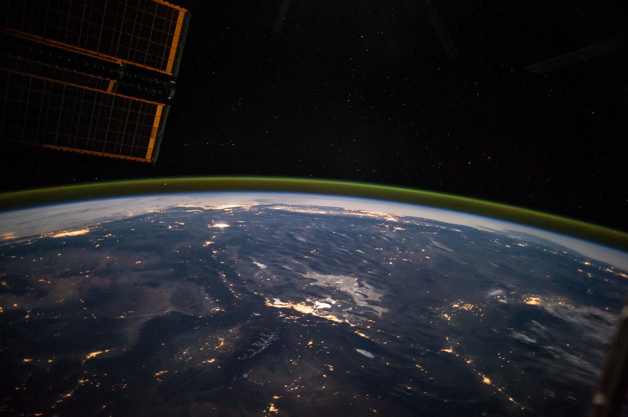
ISS041-E-067595 (6 Oct. 2014) --- This moonlit panorama was shot recently with a wide-angle lens by an Expedition 41 crew member aboard the International Space Station, as they looked southwest from a point over Nebraska. The wide-angle lens shows a huge swath of country that stretches from Portland, Oregon (right) to Phoenix, Arizona (left). The largest string of lights is the Ogden-Salt Lake City-Provo area (lower center) in Utah. The Los Angeles and San Francisco metropolitan regions, and the cities of the central valley of California (Bakersfield to Redding) stretch across the horizon. The green airglow layer always appears in night images. Moonlight shows the red tinge of the space station?s solar arrays top left. Moonlight emphasizes the broader-scale geological zones. Nevada?s short, dark, parallel mountain ranges of the basin and range geological province (center) contrast with the expanses of flat terrain of the Colorado Plateau (left) in Colorado, Arizona, Utah and New Mexico. The near-full moon even reveals the vast dry lake bed known as the Bonneville Salt Flats. The black line of the Sierra Nevada marks the edge of California?s well-lit central valley (directly below the San Francisco Bay area).
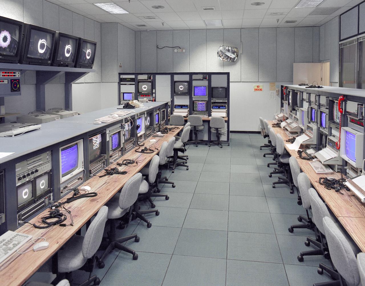
Mission control Blue Room, seen here, in building 4800 at NASA's Dryden Flight Research Center, is part of the Western Aeronautical Test Range (WATR). All aspects of a research mission are monitored from one of two of these control rooms at Dryden. The WATR consists of a highly automated complex of computer controlled tracking, telemetry, and communications systems and control room complexes that are capable of supporting any type of mission ranging from system and component testing, to sub-scale and full-scale flight tests of new aircraft and reentry systems. Designated areas are assigned for spin/dive tests, corridors are provided for low, medium, and high-altitude supersonic flight, and special STOL/VSTOL facilities are available at Ames Moffett and Crows Landing. Special use airspace, available at Edwards, covers approximately twelve thousand square miles of mostly desert area. The southern boundary lies to the south of Rogers Dry Lake, the western boundary lies midway between Mojave and Bakersfield, the northern boundary passes just south of Bishop, and the eastern boundary follows about 25 miles west of the Nevada border except in the northern areas where it crosses into Nevada.

STS098-714A-020 (7-20 February 2001) ---One of the STS-98 astronauts aboard the Earth-orbiting Space Shuttle Atlantis used a 70mm handheld camera to record this image of Southern California. Snow blanketing the higher elevations in the Los Padres National Forest (center of the image) and that covering the Angeles National Forest (right middle) help to accentuate and separate three major landform regions in southern California. The northern Los Angeles Basin that includes the San Fernando Valley and the Santa Monica Mountains is visible in the lower right quadrant of the image. The western end of the Mojave Desert (upper right) shows the two distinctive mountain boundaries along the southwest and northwest edge of the desert. The San Andreas Fault and the Garlock Fault converge (snow covered in this scene) at the western end of the desert. The intensively irrigated and cultivated southern end of the San Joaquin Valley that includes Bakersfield is visible (upper left) north of the snow-covered, northeast-southwest trending Tehachapi Mountains. The island off of the California coast (bottom left) is Santa Cruz Island.
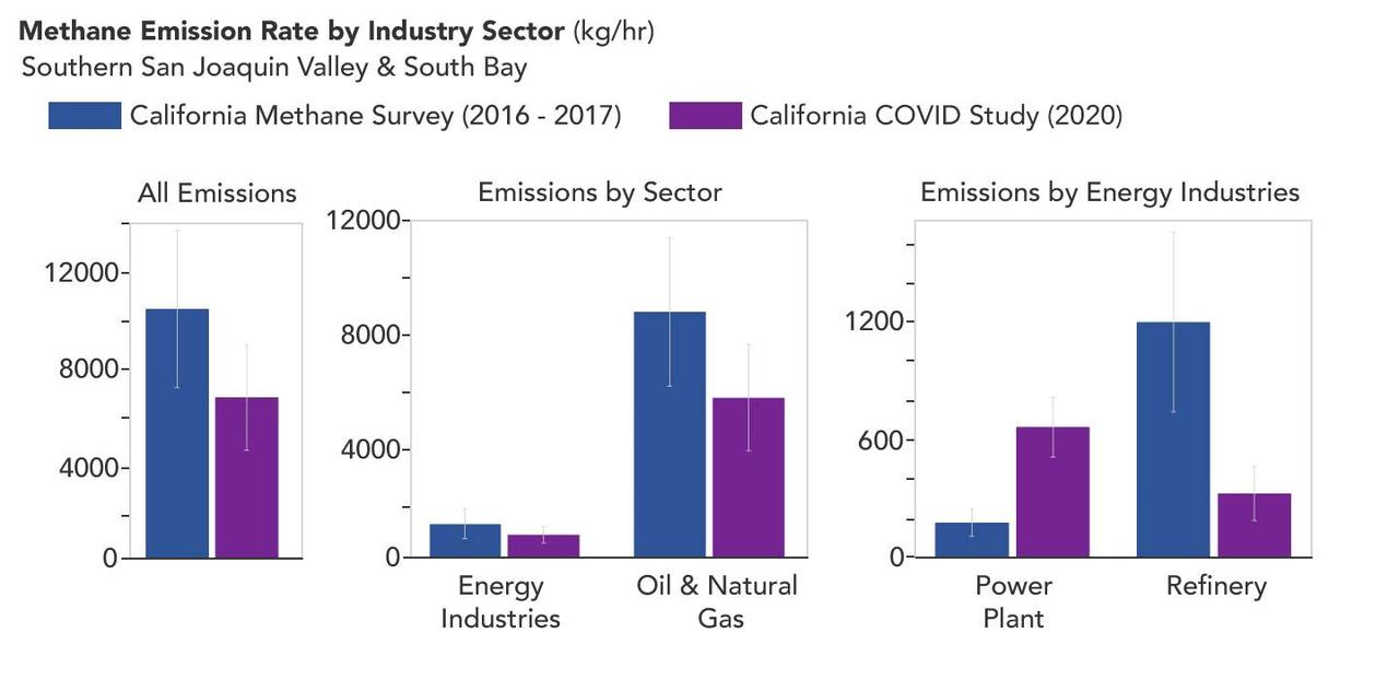
A March 2023 study by researchers at NASA's Jet Propulsion Laboratory in Southern California compared emissions from a belt of oil refineries across the South Bay area of Los Angeles during the first summer of the COVID-19 pandemic to those observed three years earlier. Using data from a NASA airborne instrument, researchers saw that most of the facilities they identified as methane sources in 2016-17 were no longer emitting the greenhouse gas in 2020, leading to a 73% reduction in measured emissions. The study uses measurements made by an imaging spectrometer called AVIRIS-NG (Airborne Visible/Infrared Imaging Spectrometer-Next Generation). Attached to the bottom of an aircraft, the instrument can detect greenhouse gas emissions from individual facilities or even pieces of equipment by looking at how the gases absorb sunlight. In 2016 and 2017, AVIRIS-NG was flown over 22,000 square miles (57,000 square kilometers) of the state as part of the California Methane Survey. From July to September 2020, researchers retraced some of those flight paths over refineries and power plants in Los Angeles County and over oil fields in central California's San Joaquin Valley. The flights were funded by NASA's Earth Science Division, the California Air Resources Board, and the California Energy Commission. The 2020 surveys over Los Angeles identified only 11 plumes from five refinery sources, with a total emissions rate of about 712 pounds (323 kilograms) methane per hour. The 2016 and 2017 flights had found 48 plumes from 33 sources, with a total emissions rate of roughly 2,639 pounds (1,197 kilograms) methane per hour. The drop correlates with an 18% decrease in monthly production in Southern California refineries between the two flight campaigns, the scientists noted, citing data from the California Energy Commission. The study also found that emissions from oil fields in and around the city of Bakersfield in central California fell 34.2%, correlating with a 24.2% drop in oil production. Reduced production during the pandemic due to lower demand for fuel and lower gas prices could have led to the drop in methane emissions, as oil fields and refineries emitted less methane as part of operations. However, researchers said, improved equipment maintenance and mitigation efforts at those facilities between 2016 and 2020 can't be ruled out as a factor. https://photojournal.jpl.nasa.gov/catalog/PIA25864