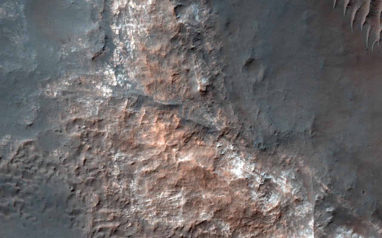
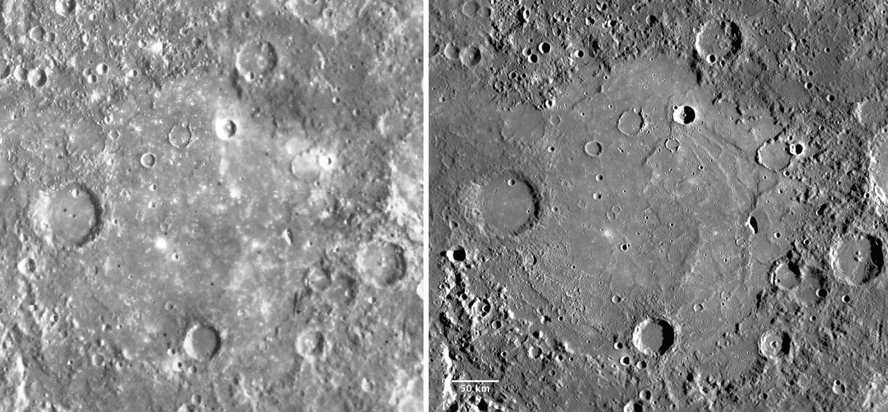
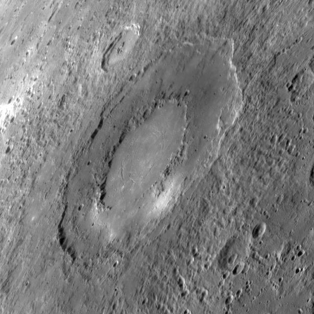
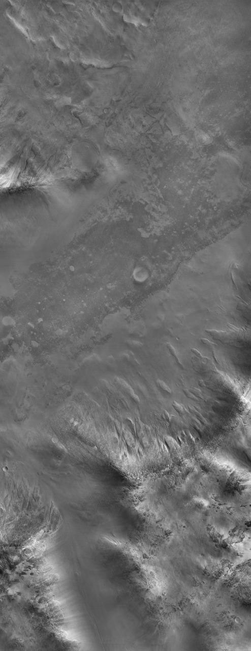
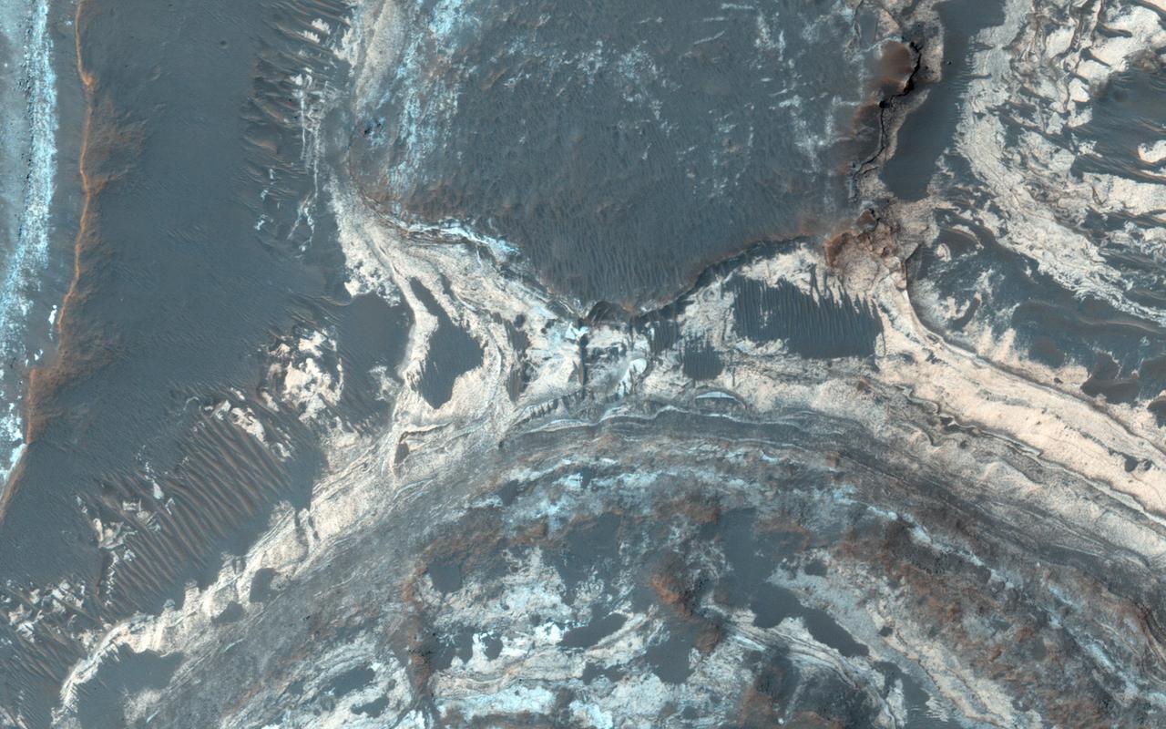
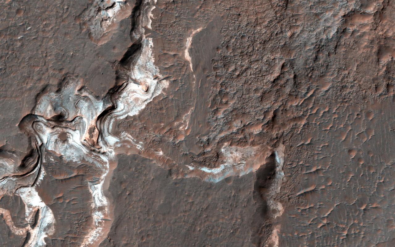
This image from NASA's Mars Reconnaissance Orbiter shows Gorgonum Basin, one of several large basins within the Terra Sirenum region of Mars. Each basin has light-toned mounds, many of which contain clays. Scientists think that Terra Sirenum once had a large lake during an epoch called the Late Noachian/Early Hesperian, and each basin filled with sediments. The water within the lake may have altered these sediments to form the clays we now observe from orbit. Ma'adim Vallis, which drains into Gusev Crater where the Spirit rover landed, drained the water from this ancient lake. Why the basin floors exhibit mounds similar to chaos regions on Mars is unknown, but could be the result of collapse and subsequent erosion within the basins. https://photojournal.jpl.nasa.gov/catalog/PIA21767
Orientale Basin
Goethe Basin
Hellas Basin
Defacing a Basin
Callisto Basin
Basins Everywhere
The Great Basin
Big Basin
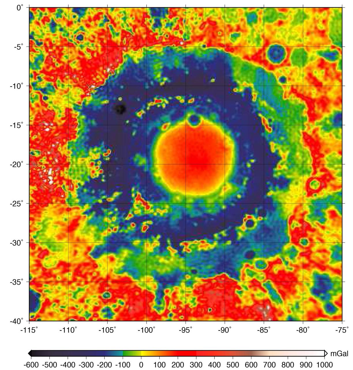
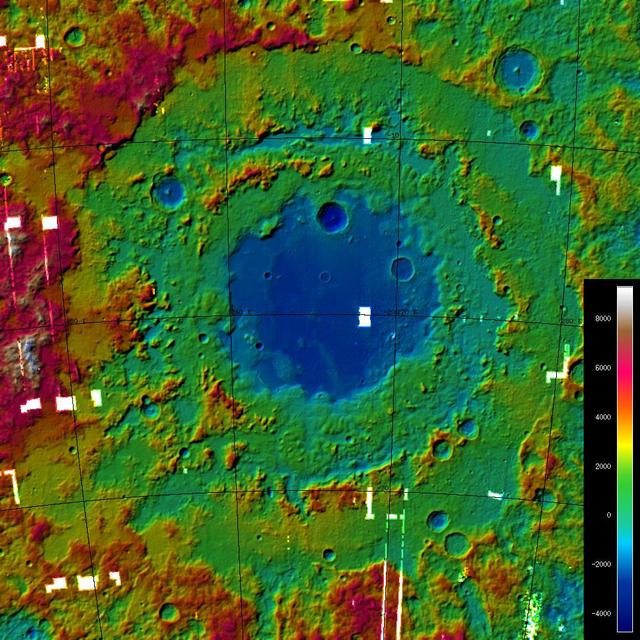
This color-coded map shows the strength of surface gravity around Orientale basin on Earth's moon, derived from data obtained by NASA's GRAIL mission. The GRAIL mission produced a very high-resolution map of gravity over the surface of the entire moon. This plot is zoomed in on the part of that map that features Orientale basin, where the two GRAIL spacecraft flew extremely low near the end of their mission. Their close proximity to the basin made the probes' measurements particularly sensitive to the gravitational acceleration there (due to the inverse squared law). The color scale plots the gravitational acceleration in units of "gals," where 1 gal is one centimeter per second squared, or about 1/1000th of the gravitational acceleration at Earth's surface. (The unit was devised in honor of the astronomer Galileo). Labels on the x and y axes represent latitude and longitude. http://photojournal.jpl.nasa.gov/catalog/PIA21050
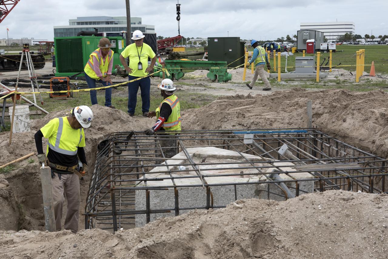
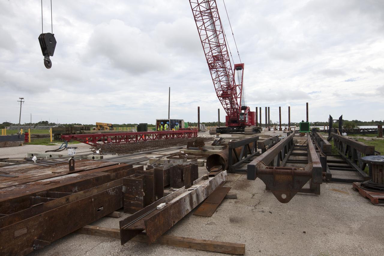
Modifications are underway at the Launch Complex 39 turn basin wharf at NASA's Kennedy Space Center in Florida to prepare for the arrival of the agency's massive Space Launch System (SLS) core booster aboard the barge Pegasus. Construction workers with Southeast Cherokee Construction Inc. work to shore up the turn basin area. A crane will be used to lift up precast concrete poles and position them to be driven to a depth of about 70 feet into the bedrock below the water around the turn basin. The upgrades are necessary to accommodate the 300,000-pound core booster aboard the modified Pegasus barge. The Ground Systems Development and Operations Program is overseeing the upgrades to the turn basin wharf.
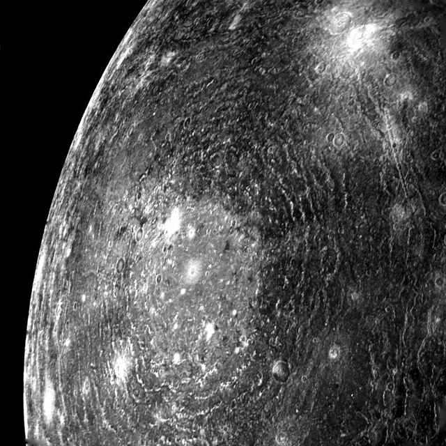
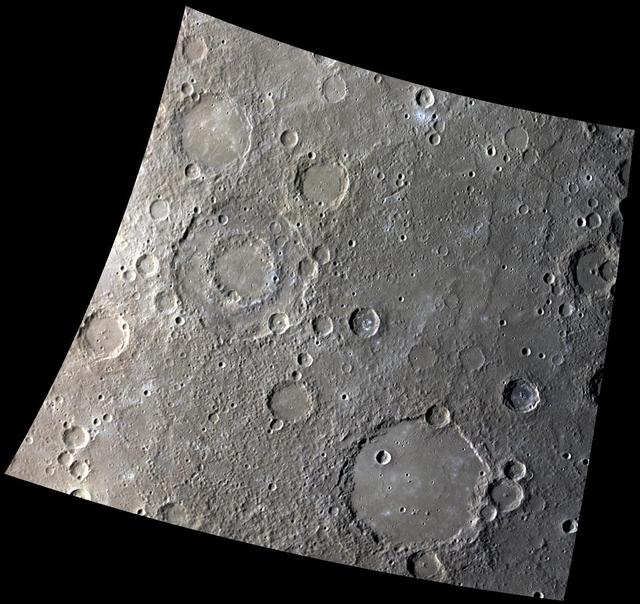
Mercury Caloris Basin, One of the Largest Impact Basins in the Solar System
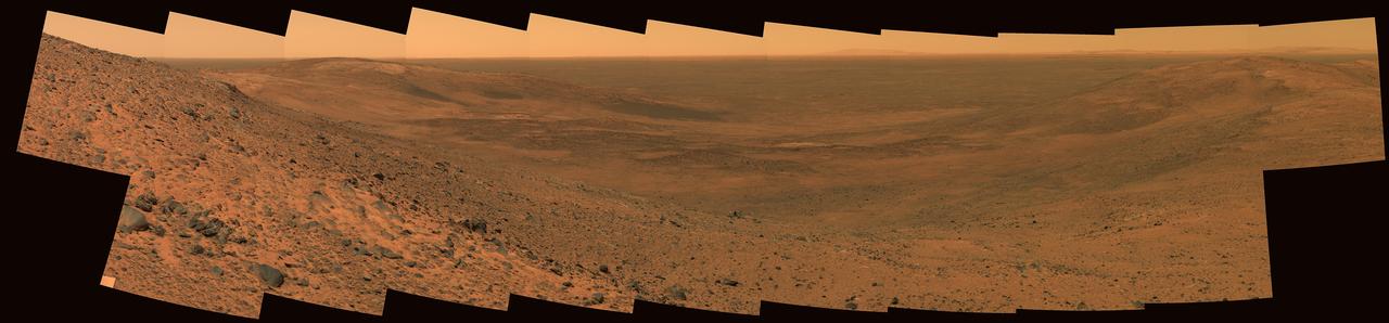
East Basin Panorama
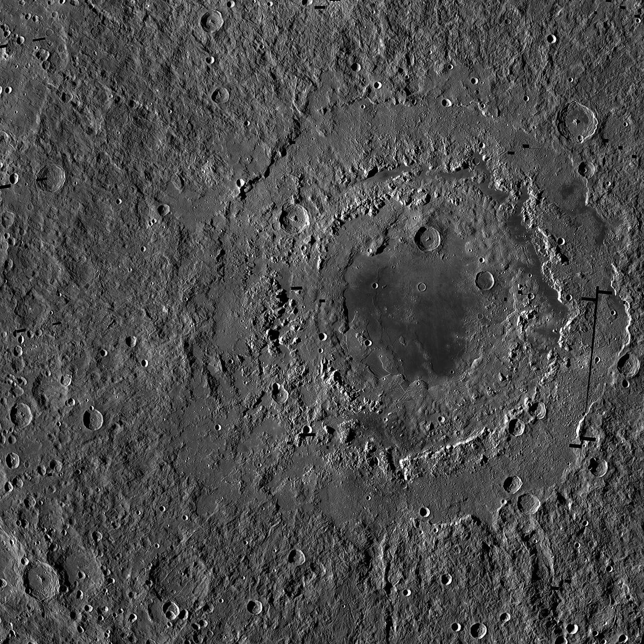
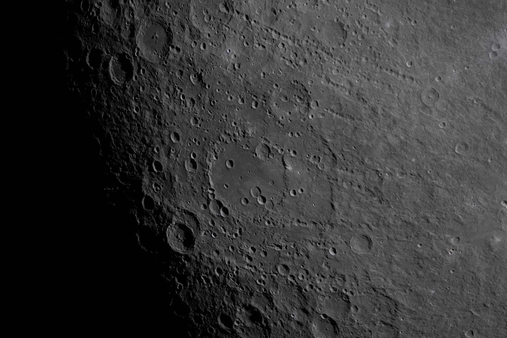
The Moon Largest Impact Basin
Sinuous Ridges in Argyre Basin
Hellas Basin Dunes
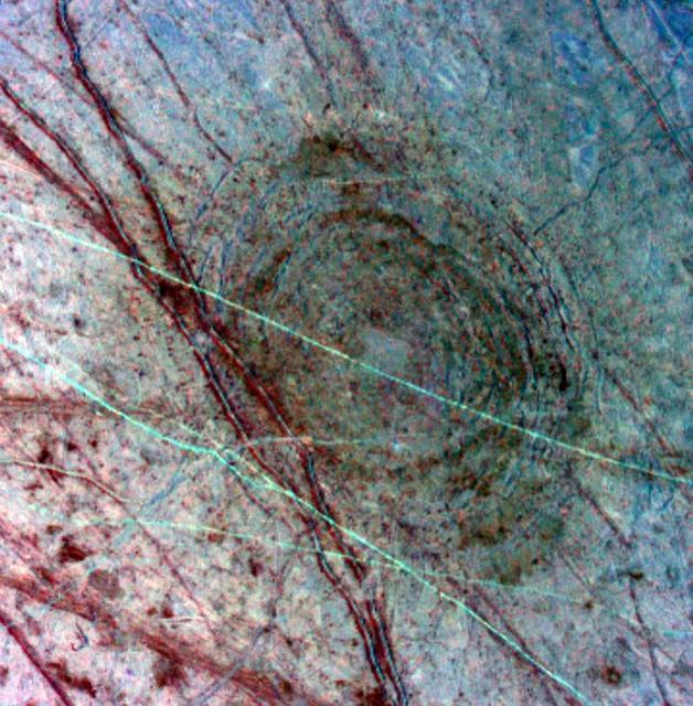
Ancient Impact Basin on Europa
A Tale of Two Basins
Ring Around the Basin
Argyre Basin Dunes
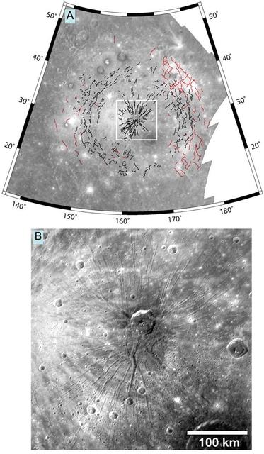
Faults in the Caloris Basin
Stunning Landforms in Raditladi Basin
Graben in Goethe Basin

Rembrandt Basin -- in Color!
The Tolstoj Impact Basin
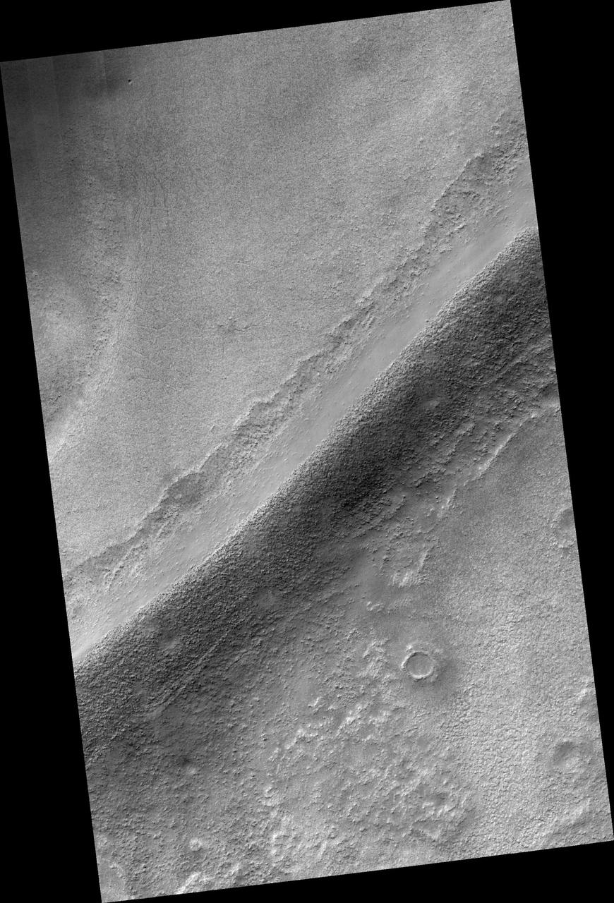
A Newly Imaged Basin
The Great Caloris Basin on Mercury
Out of the Basin. These images from NASA MESSENGER MASCS top and MDIS bottom are of Rembrandt, Mercury second largest impact basin.
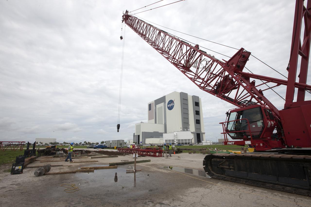
Modifications are underway at the Launch Complex 39 turn basin wharf at NASA's Kennedy Space Center in Florida to prepare for the arrival of the agency's massive Space Launch System (SLS) core stage aboard the barge Pegasus. A crane will be used to lift up precast concrete poles and position them to be driven to a depth of about 70 feet into the bedrock below the water around the turn basin. The upgrades are necessary to accommodate the increased weight of the core stage along with ground support and transportation equipment aboard the modified barge Pegasus. The Ground Systems Development and Operations Program is overseeing the upgrades to the turn basin wharf.
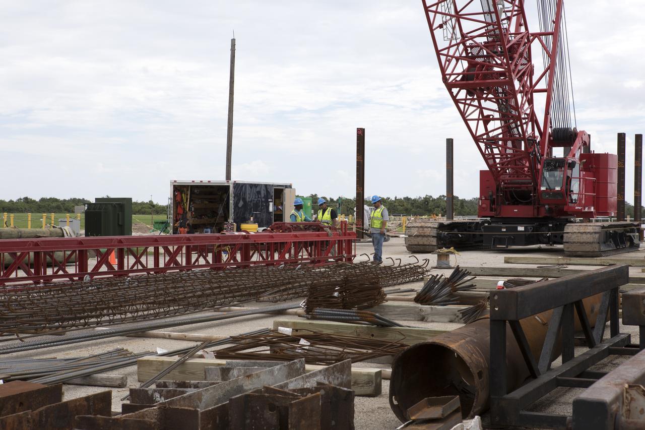
Modifications are underway at the Launch Complex 39 turn basin wharf at NASA's Kennedy Space Center in Florida to prepare for the arrival of the agency's massive Space Launch System (SLS) core stage aboard the barge Pegasus. Equipment is staged and a crane will be used to lift up precast concrete poles and position them to be driven to a depth of about 70 feet into the bedrock below the water around the turn basin. The upgrades are necessary to accommodate the increased weight of the core stage along with ground support and transportation equipment aboard the modified barge Pegasus. The Ground Systems Development and Operations Program is overseeing the upgrades to the turn basin wharf.
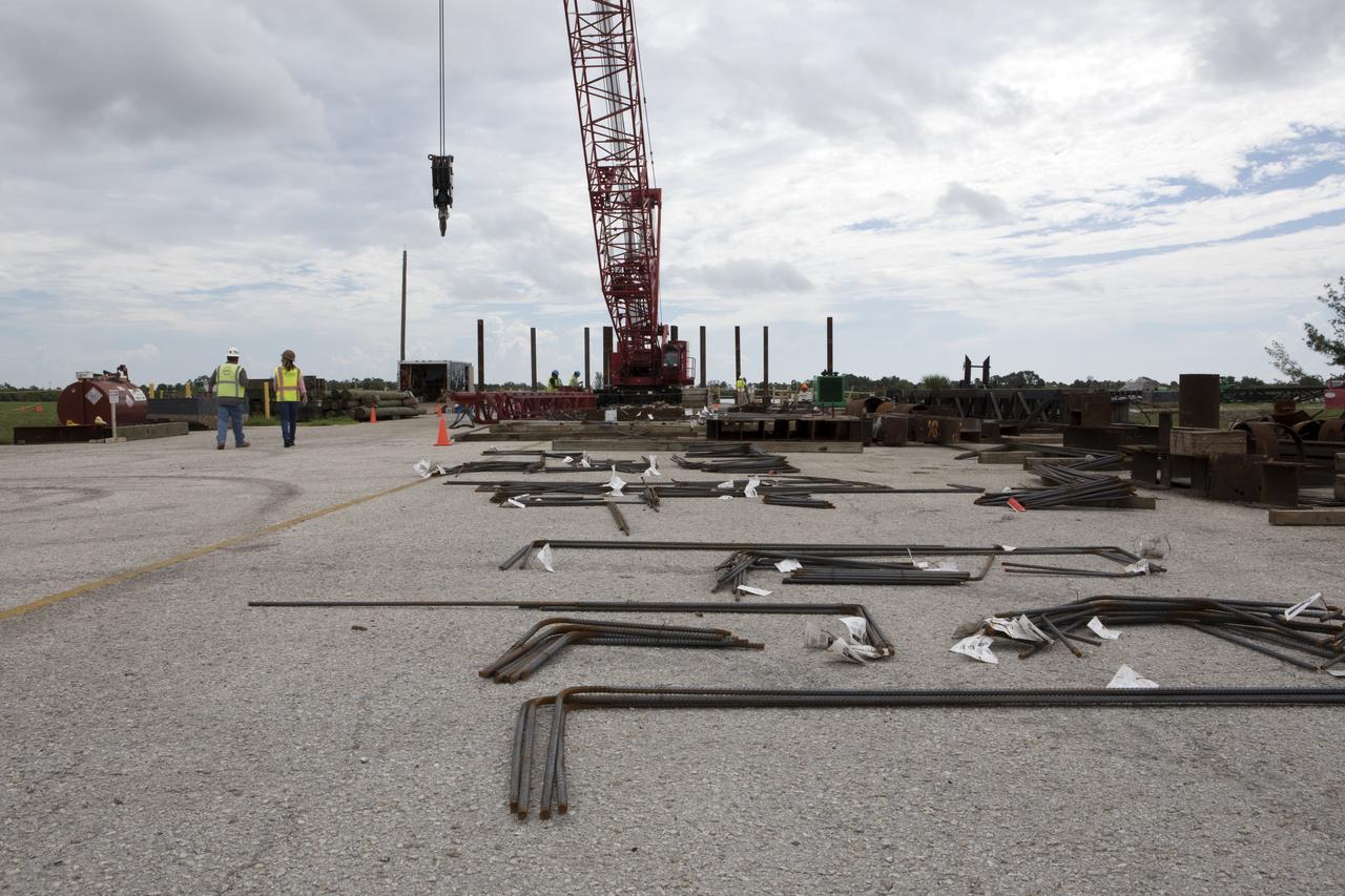
Modifications are underway at the Launch Complex 39 turn basin wharf at NASA's Kennedy Space Center in Florida to prepare for the arrival of the agency's massive Space Launch System (SLS) core stage aboard the barge Pegasus. A crane will be used to lift up precast concrete poles and position them to be driven to a depth of about 70 feet into the bedrock below the water around the turn basin. The upgrades are necessary to accommodate the 300,000-pound core booster aboard the modified Pegasus barge. The Ground Systems Development and Operations Program is overseeing the upgrades to the turn basin wharf.
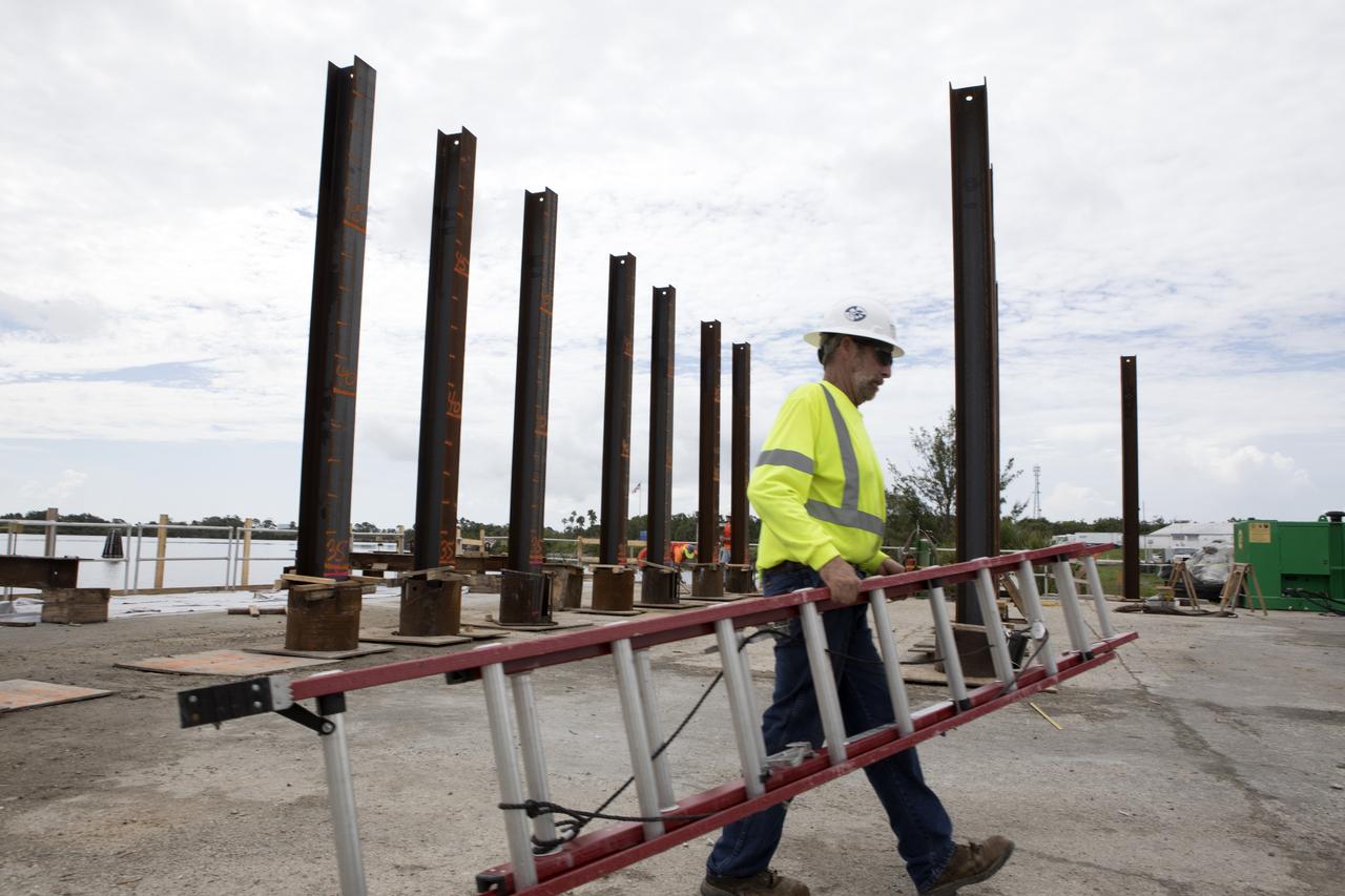
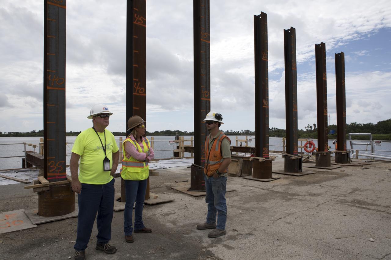
Modifications are underway at the Launch Complex 39 turn basin wharf at NASA's Kennedy Space Center in Florida to prepare for the arrival of the agency's massive Space Launch System (SLS) core stage aboard the barge Pegasus. Precast concrete poles are being driven to a depth of about 70 feet into the bedrock below the water around the turn basin. The upgrades are necessary to accommodate the increased weight of the core stage along with ground support and transportation equipment aboard the modified barge Pegasus. The Ground Systems Development and Operations Program is overseeing the upgrades to the turn basin wharf.
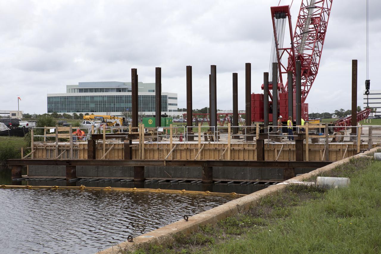
Modifications are underway at the Launch Complex 39 turn basin wharf at NASA's Kennedy Space Center in Florida to prepare for the arrival of the agency's massive Space Launch System (SLS) core stage aboard the barge Pegasus. Precast concrete poles are being driven to a depth of about 70 feet into the bedrock below the water around the turn basin. The upgrades are necessary to accommodate the increased weight of the core stage along with ground support and transportation equipment aboard the modified barge Pegasus. The Ground Systems Development and Operations Program is overseeing the upgrades to the turn basin wharf.
Modifications are underway at the Launch Complex 39 turn basin wharf at NASA's Kennedy Space Center in Florida to prepare for the arrival of the agency's massive Space Launch System (SLS) core stage aboard the barge Pegasus. Equipment is staged and a crane will be used to lift up precast concrete poles and position them to be driven to a depth of about 70 feet into the bedrock below the water around the turn basin. The upgrades are necessary to accommodate the increased weight of the core stage along with ground support and transportation equipment aboard the modified barge Pegasus. The Ground Systems Development and Operations Program is overseeing the upgrades to the turn basin wharf.
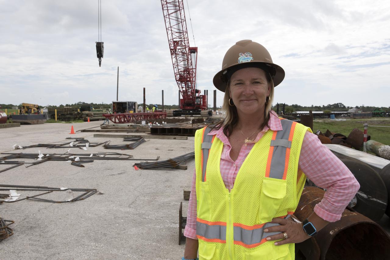
Modifications are underway at the Launch Complex 39 turn basin wharf at NASA's Kennedy Space Center in Florida to prepare for the arrival of the agency's massive Space Launch System (SLS) core stage aboard the barge Pegasus. In the foreground is Tammy Kelly, site manager, with Southeast Cherokee Construction Inc. A crane will be used to lift up precast concrete poles and position them to be driven to a depth of about 70 feet into the bedrock below the water around the turn basin. The upgrades are necessary to accommodate the increased weight of the core stage along with ground support and transportation equipment aboard the modified barge Pegasus. The Ground Systems Development and Operations Program is overseeing the upgrades to the turn basin wharf.
Exploring the Evolution of the Caloris Basin http://photojournal.jpl.nasa.gov/catalog/PIA10606

Modifications are underway at the Launch Complex 39 turn basin wharf at NASA's Kennedy Space Center in Florida to prepare for the arrival of the agency's massive Space Launch System (SLS) core stage aboard the barge Pegasus. Tammy Kelly, in the center, site manager, with Southeast Cherokee Construction Inc. talks with construction workers. A crane will be used to lift up precast concrete poles and position them to be driven to a depth of about 70 feet into the bedrock below the water around the turn basin. The upgrades are necessary to accommodate the increased weight of the core stage along with ground support and transportation equipment aboard the modified barge Pegasus. The Ground Systems Development and Operations Program is overseeing the upgrades to the turn basin wharf.
Modifications are underway at the Launch Complex 39 turn basin wharf at NASA's Kennedy Space Center in Florida to prepare for the arrival of the agency's massive Space Launch System (SLS) core stage aboard the barge Pegasus. Tammy Kelly, in the center, site manager, with Southeast Cherokee Construction Inc. talks with construction workers. A crane will be used to lift up precast concrete poles and position them to be driven to a depth of about 70 feet into the bedrock below the water around the turn basin. The upgrades are necessary to accommodate the increased weight of the core stage along with ground support and transportation equipment aboard the modified barge Pegasus. The Ground Systems Development and Operations Program is overseeing the upgrades to the turn basin wharf.
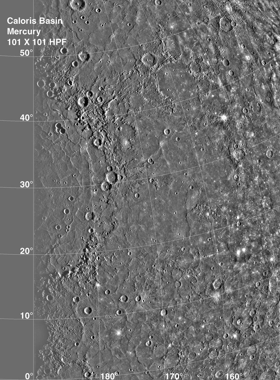
Caloris Basin on Mercury, is one of the largest basins in the solar system, its diameter exceeds 1300 kilometers and is in many ways similar to the great Imbrium basin on the Moon. This image is from NASA Mariner 10 spacecraft which launched in 1974.
art002e012090 (April 6, 2026) - In this view of the Moon, the Artemis II crew captured an intricate snapshot of the rings of the Orientale basin, one of the Moon’s youngest and best-preserved large impact craters on his first shift during the lunar flyby observation period. Credit: NASA
Proposed MSL Site in Margaritifer Basin
Regional Topographic Model of the Hellas Basin
Sample of the Argyre Impact Basin Rim
Textured Terrain in Callisto Asgard Basin
Gullies in a Crater Wall in Newton Basin:
Gullies and Dunes in a Crater in Newton Basin
Delta in Crater South of Parana Basin
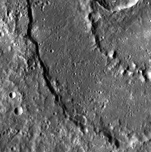
Dario Basin: Complex Cross-cuts
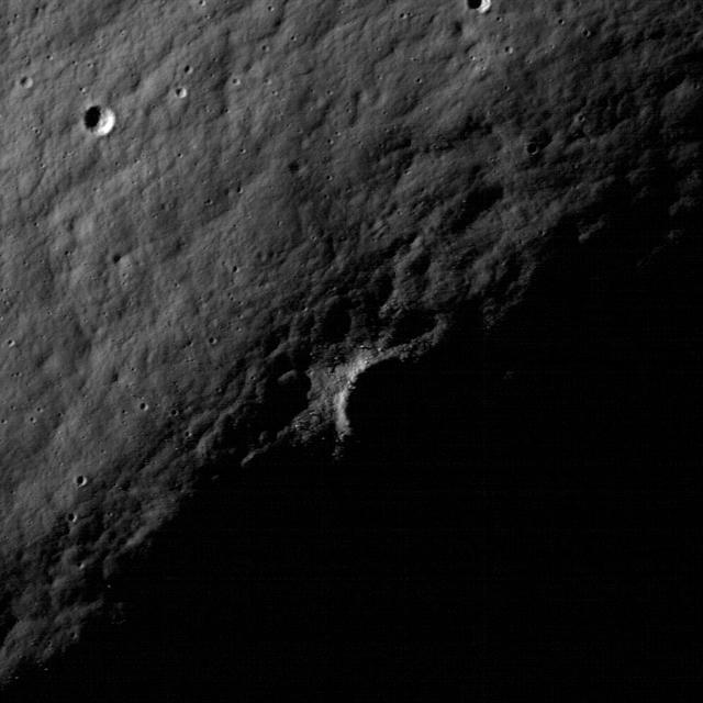
Hunting for Ancient Lunar Impact Basins
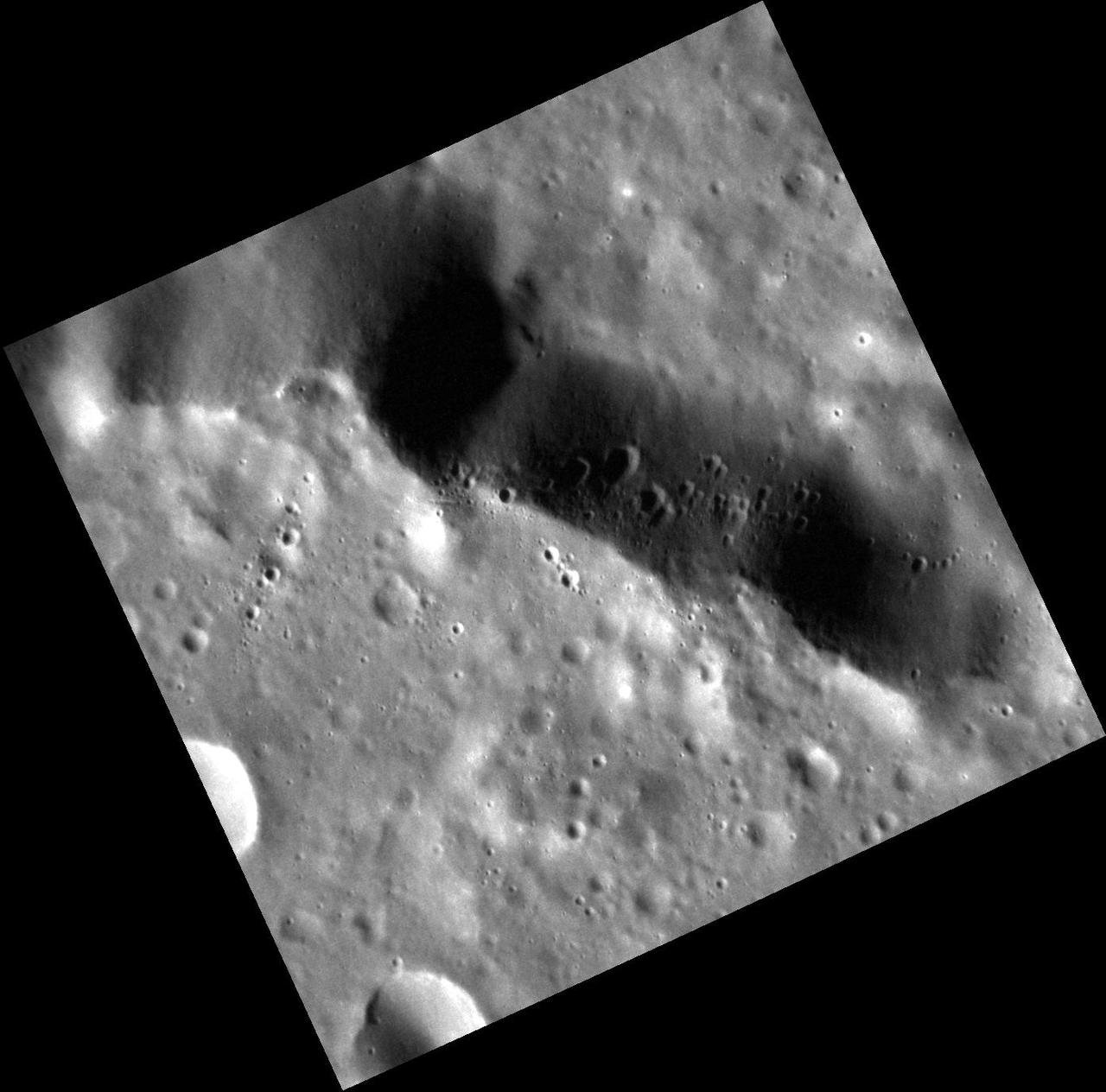
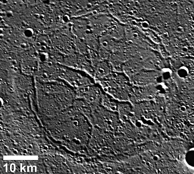
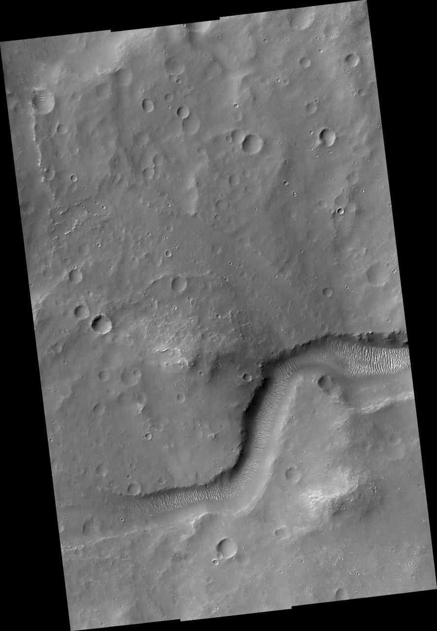
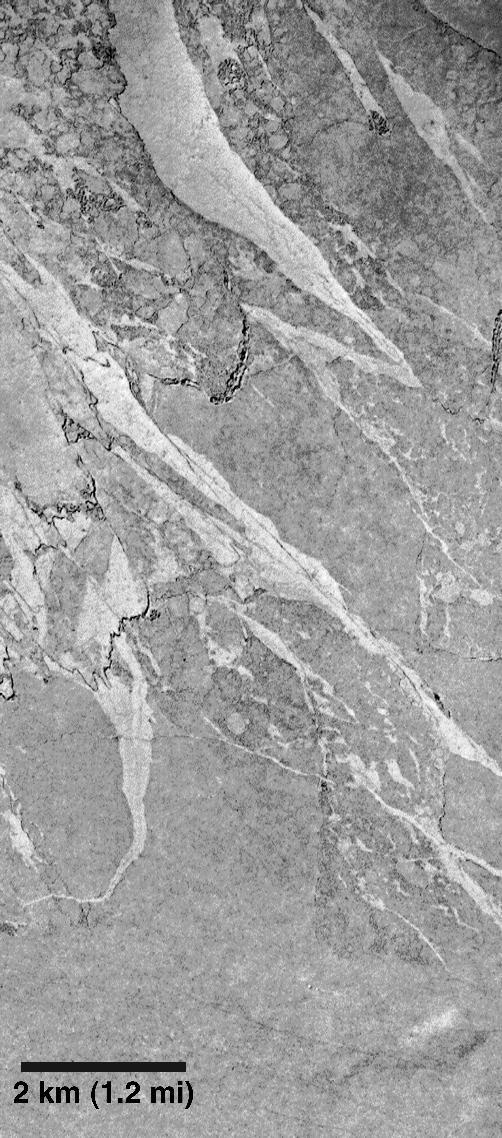
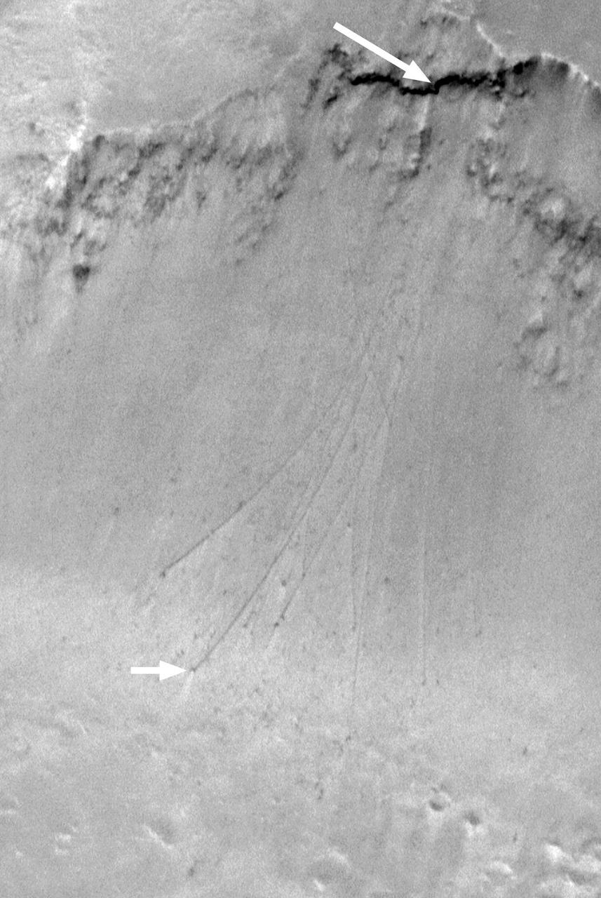
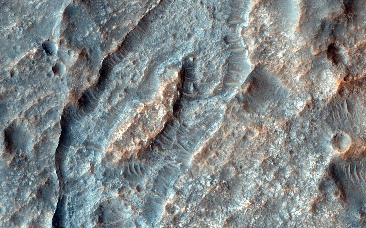
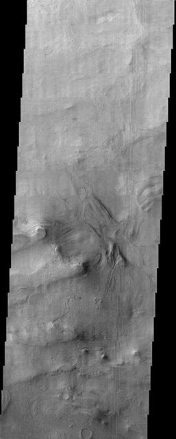
This image shows a transition from depressed to inverted channels in the Gorgonum Basin. In the darker terrain, there are two channels that display depressed topography. As these two channels cross into the underlying brighter terrain, the channels now stand above the surrounding area, indicating they are inverted in topography. This change from depressed to inverted topography is the result of what is called "differential erosion." The channel may contain hardened sediments or have cements that make it more resistant to erosion relative to the darker terrain that once flowed through it. As a result, erosion has removed the less resistant upper darker terrain, leaving behind the more resistant channel standing above the underlying bright terrain. http://photojournal.jpl.nasa.gov/catalog/PIA21103
art002e012093 (April 6, 2026) - Hertzsprung Basin comes into view with its distinctive two concentric rings of mountains, revealing the scale of this ancient impact structure. Near the lower left, Vavilov crater—identified by its central peak—stands out, a feature often described by the Artemis II crew during their lunar flyby. Credit: NASA
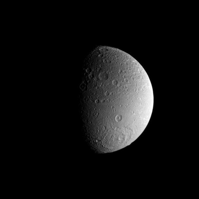
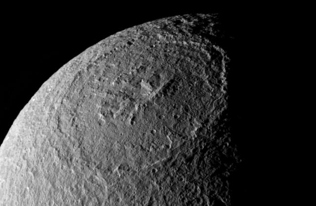
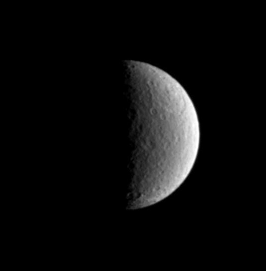
A large impact basin dominates the high southern latitudes of Saturn moon Dione.
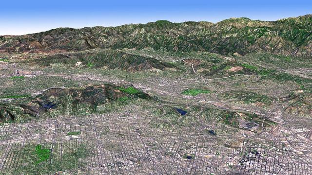
The Los Angeles Basin is bordered on the north by the San Gabriel Mountains. Other smaller basins are separated by smaller mountain ranges, like the Verdugo Hills, and the Santa Monica Mountains in this image from NASA Terra spacecraft.
This computer photomosaic is of the Caloris Basin, the largest basin on Mercury. NASA Mariner 10 spacecraft imaged the region during its initial flyby of the planet after its launch in 1974.
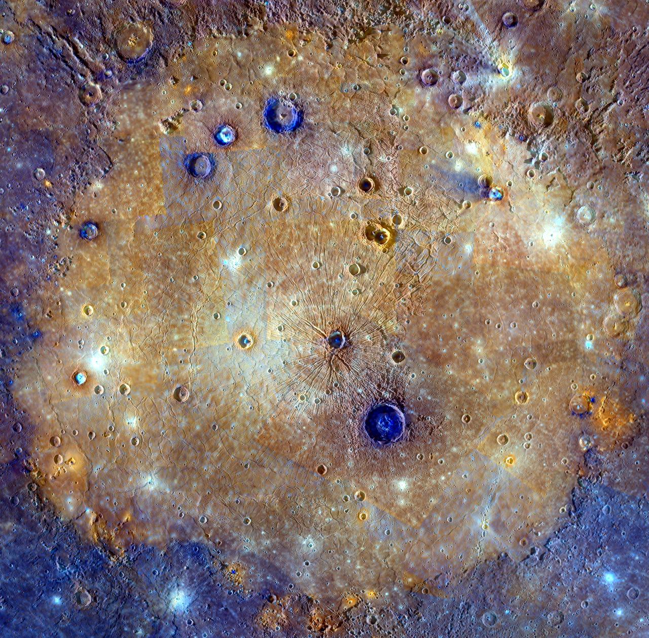
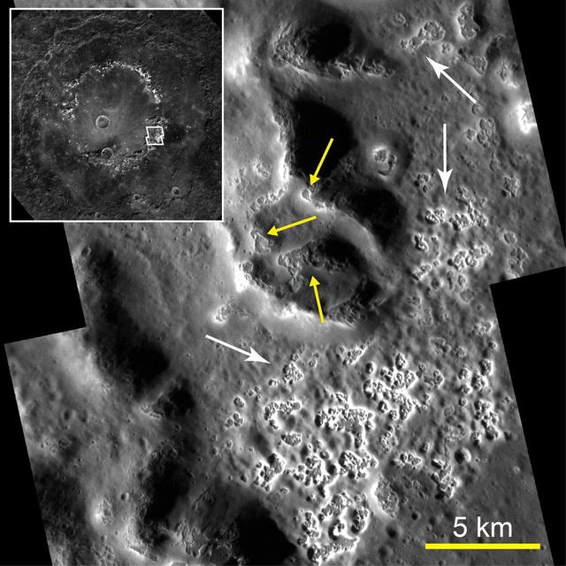
This mosaic of Caloris basin is an enhanced-color composite overlain on a monochrome mosaic featured in a previous post. The color mosaic is made up of WAC images obtained when both the spacecraft and the Sun were overhead, conditions best for discerning variations in albedo, or brightness. The monochrome mosaic is made up of WAC and NAC images obtained at off-vertical Sun angles (i.e., high incidence angles) and with visible shadows so as to reveal clearly the topographic form of geologic features. The combination of the two datasets allows the correlation of geologic features with their color properties. In portions of the scene, color differences from image to image are apparent. Ongoing calibration efforts by the MESSENGER team strive to minimize these differences. Caloris basin has been flooded by lavas that appear orange in this mosaic. Post-flooding craters have excavated material from beneath the surface. The larger of these craters have exposed low-reflectance material (blue in this mosaic) from beneath the surface lavas, likely giving a glimpse of the original basin floor material. Analysis of these craters yields an estimate of the thickness of the volcanic layer: 2.5–3.5 km (1.6–2.2 mi.). The MESSENGER spacecraft is the first ever to orbit the planet Mercury, and the spacecraft's seven scientific instruments and radio science investigation are unraveling the history and evolution of the Solar System's innermost planet. In the mission's more than three years of orbital operations, MESSENGER has acquired over 250,000 images and extensive other data sets. MESSENGER is capable of continuing orbital operations until early 2015. Credit: NASA/Johns Hopkins University Applied Physics Laboratory/Carnegie Institution of Washington <b><a href="http://www.nasa.gov/audience/formedia/features/MP_Photo_Guidelines.html" rel="nofollow">NASA image use policy.</a></b> <b><a href="http://www.nasa.gov/centers/goddard/home/index.html" rel="nofollow">NASA Goddard Space Flight Center</a></b> enables NASA’s mission through four scientific endeavors: Earth Science, Heliophysics, Solar System Exploration, and Astrophysics. Goddard plays a leading role in NASA’s accomplishments by contributing compelling scientific knowledge to advance the Agency’s mission. <b>Follow us on <a href="http://twitter.com/NASAGoddardPix" rel="nofollow">Twitter</a></b> <b>Like us on <a href="http://www.facebook.com/pages/Greenbelt-MD/NASA-Goddard/395013845897?ref=tsd" rel="nofollow">Facebook</a></b> <b>Find us on <a href="http://instagrid.me/nasagoddard/?vm=grid" rel="nofollow">Instagram</a></b>
Windblown Dunes on the Floor of Herschel Impact Basin
Joint Observation of the Isidis Basin with the Rosetta Mission
Dust-Devil Tracks in Southern Schiaparelli Basin
Ancient Lakes on Mars? Results for Elysium Basin
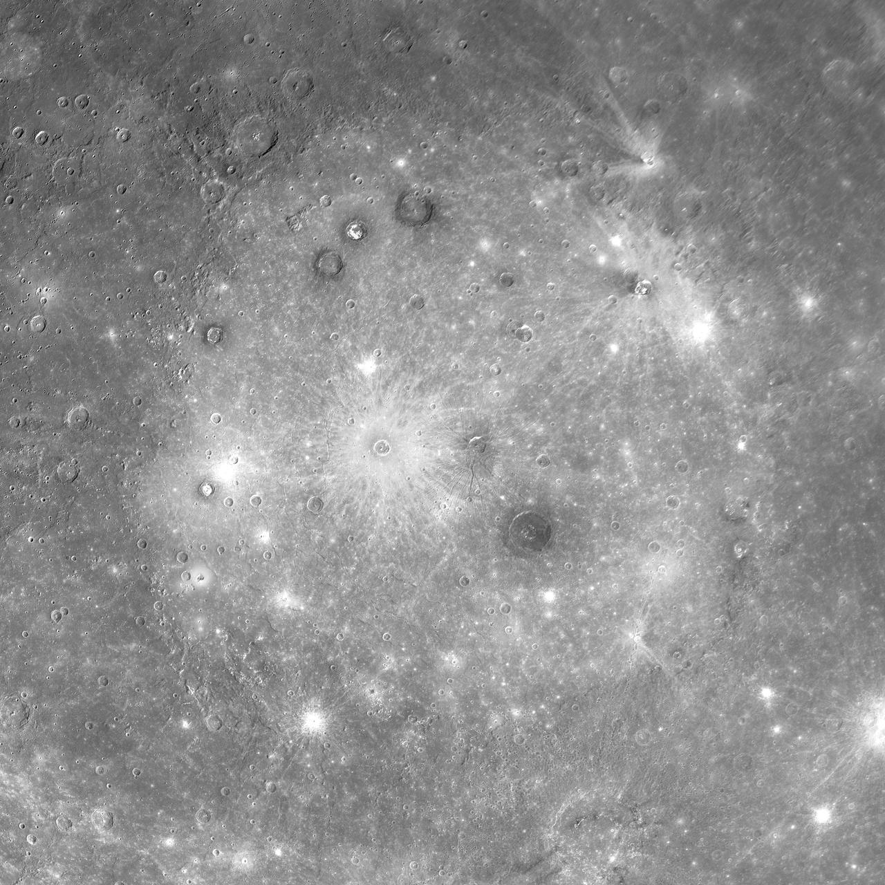
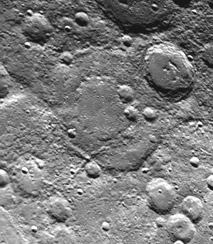
MESSENGER Discovers an Unusual Large Basin on Mercury
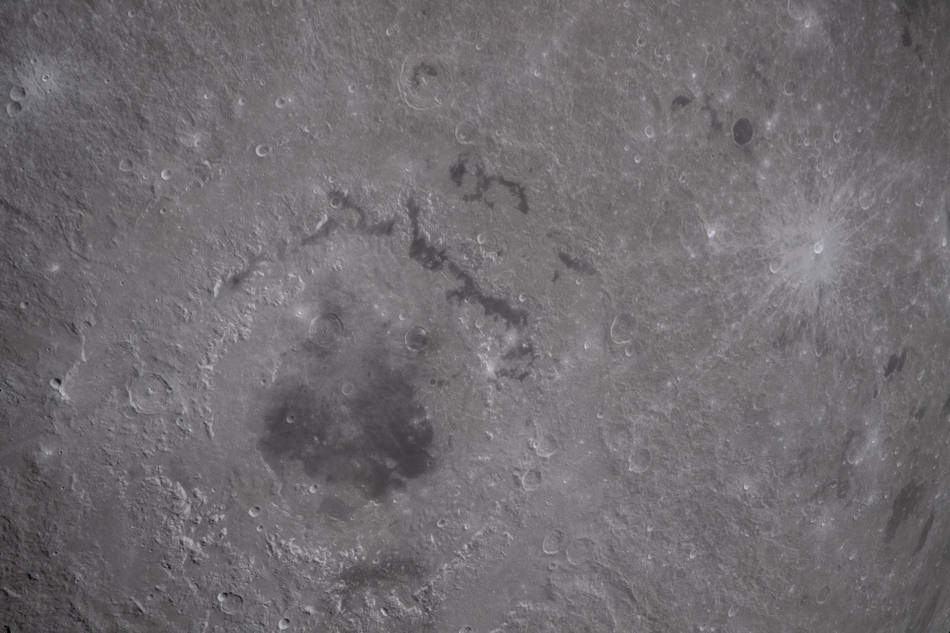
Young Cunningham Crater in Old Caloris Basin
Looking in Detail at a Spectacular Double-Ring Basin
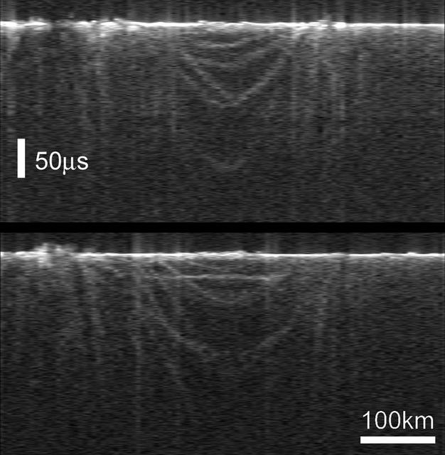
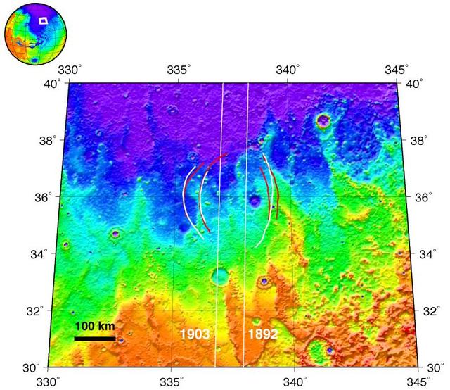
Radargrams of Buried Basin from Two Adjacent Orbits
Boulder Tracks on Schiaparelli Basin South Wall
Eroded Crater Adjacent to Huygens Impact Basin
art002e020686 (April 6, 2026) – A portion of the Moon’s farside is seen along the terminator—the boundary between lunar day and night—where low-angle sunlight casts long shadows across the surface. A section of Orientale Basin is visible along the upper right portion of the lunar disk, its structure subtly revealed under grazing illumination. This lighting enhances contrast across the cratered terrain, highlighting variations in surface features and providing insight into the Moon’s geologic history. Credit: NASA
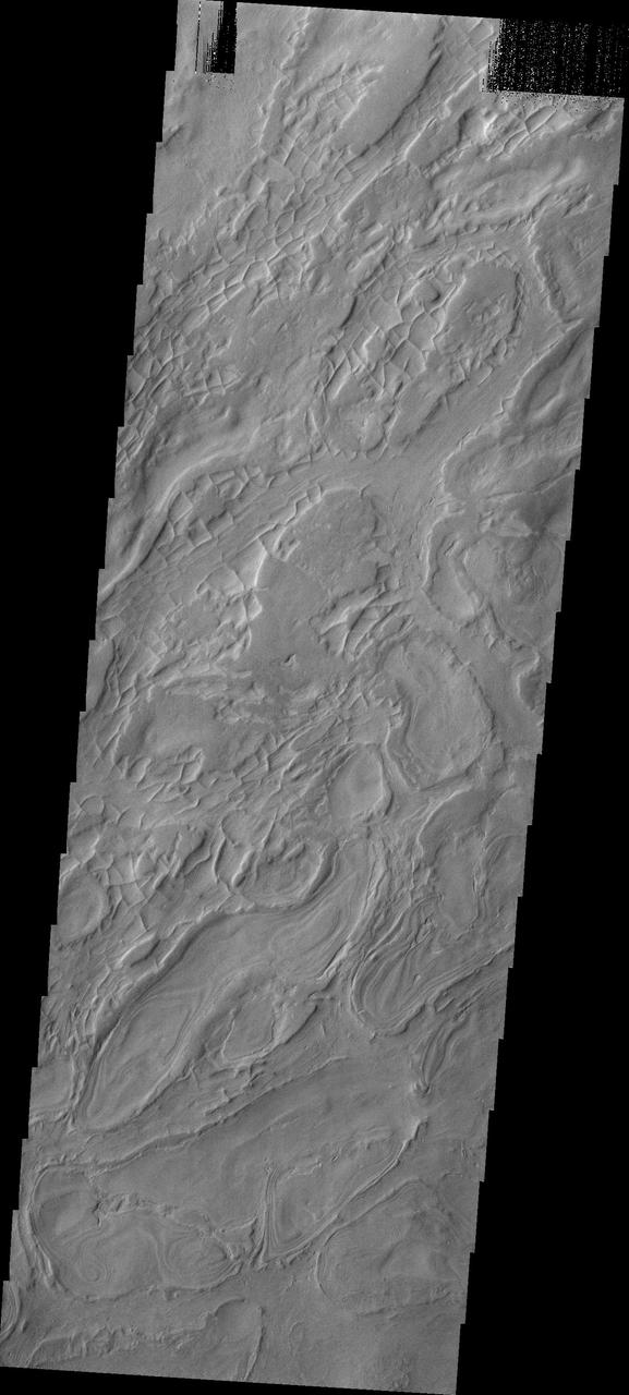
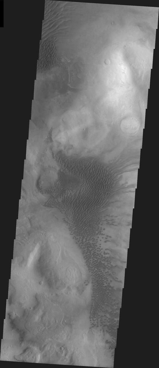
This closeup from NASA Mars Reconnaissance Orbiter covers a region in the Eridania Basin that shows interesting inverted ridges.
The gullies seen in this image taken by NASA 2001 Mars Odyssey spacecraft are located on the western rim region of the Argyre Basin.
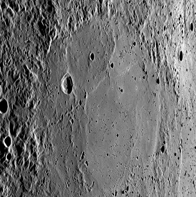
Raditladi basin, imaged during MESSENGER first Mercury flyby and named in April 2008, is intriguing for several reasons.
A depiction of NASA MESSENGER spacecraft is shown viewing the Rachmaninoff basin.
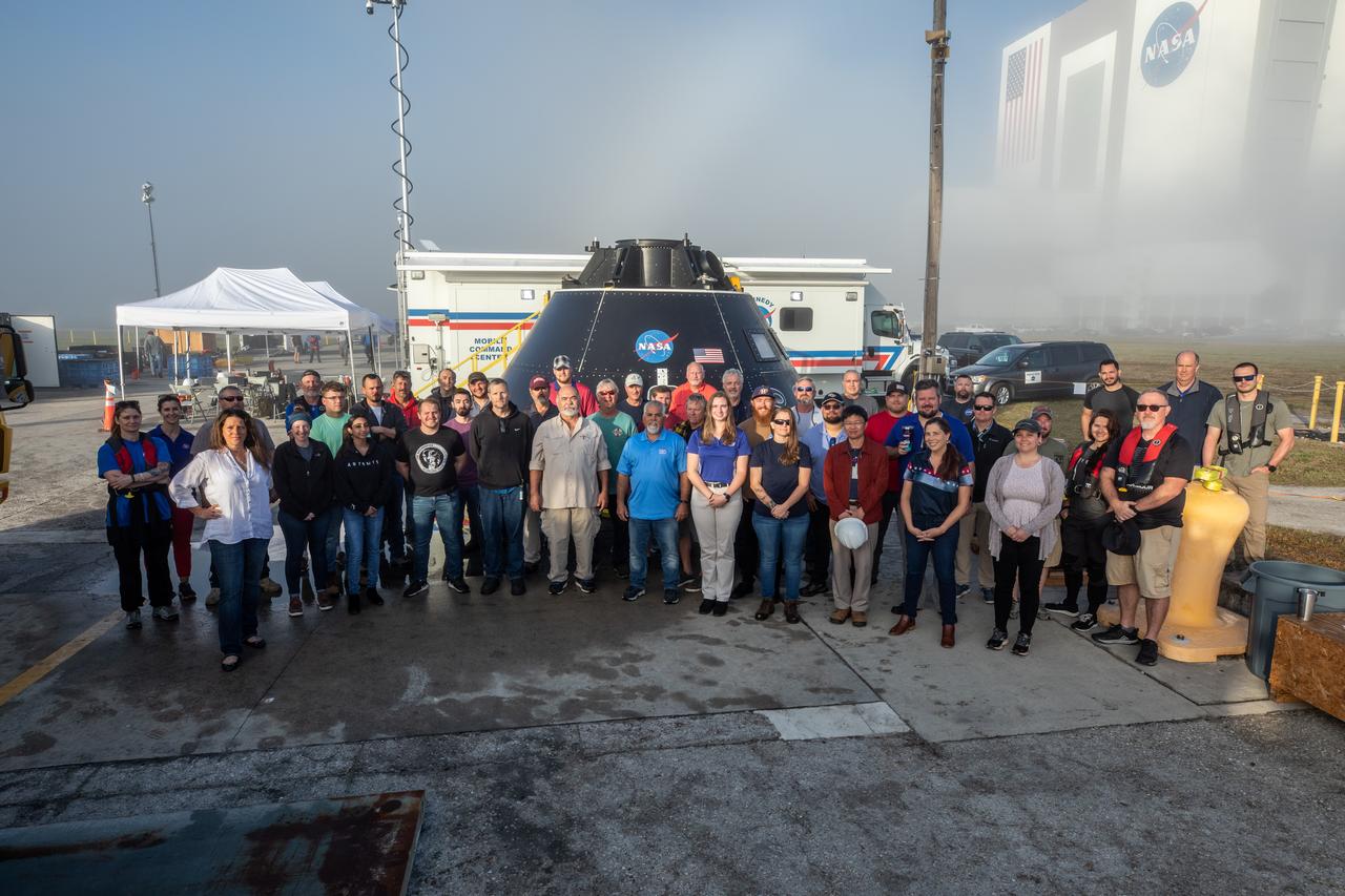
Members of the Exploration Ground Systems (EGS) landing and recovery team gather for a group photograph in front of the Crew Module Test Article (CMTA) at the turn basin in the Launch Complex 39 area at NASA’s Kennedy Space Center in Florida on Feb. 1, 2023. The CMTA is being used to practice recovery after splashdown of the Orion spacecraft to prepare for the Artemis II crewed mission. EGS leads recovery efforts.
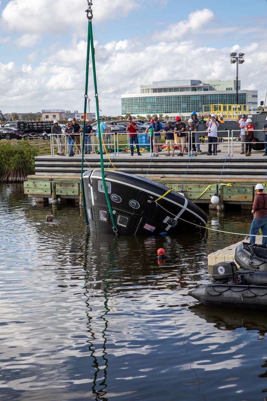
A crane is used to turn the Crew Module Test Article (CMTA) upside down in the water at the turn basin in the Launch Complex 39 area at NASA’s Kennedy Space Center in Florida on Jan. 31, 2023. The CMTA is being certified for use to practice recovery after splashdown of the Orion spacecraft to prepare for the Artemis II crewed mission. Exploration Ground Systems leads recovery efforts.
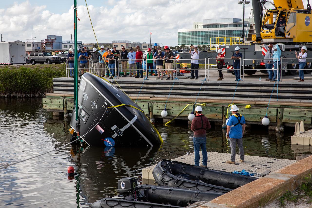
A crane is used to rotate the Crew Module Test Article (CMTA) in the water at the turn basin in the Launch Complex 39 area at NASA’s Kennedy Space Center in Florida on Jan. 31, 2023. The CMTA is being certified for use to practice recovery after splashdown of the Orion spacecraft to prepare for the Artemis II crewed mission. Exploration Ground Systems leads recovery efforts.
To put the size of Mercury Rembrandt basin into a familiar context, a NAC mosaic of the basin is overlaid on an AVHRR image of the east coast of the United States
This image is a Digital Terrain Model of the large Orientale Basin, located on the western hemisphere of the Moon.
This NASA Mars Odyssey image was taken during winter in the southern hemisphere, meaning that the usually cloudy Hellas Basin is relatively free from clouds.

Details about the newly discovered Rembrandt impact basin were published recently in Science magazine, and the images shown here are from that article.
This observation from NASA Mars Reconnaissance Orbiter shows light-toned layered deposits at the contact between the Ladon Valles channel and Ladon Basin.
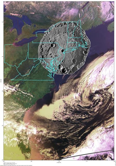
art002e010208 (April 6, 2026) - As the Artemis II crew flew over the terminator, the astronauts described this boundary between day and night as "anything but a straight line." Crater rims along the terminator stand out as "islands" in the night. Giant chains of craters emanating from the 3.7-billion-year-old Orientale basin can be seen scouring the surface, stretching almost to the terminator. This tells a geologic story: these crater chains produced by the Orientale impact event mar the surface of the relatively flat Hertzsprung Basin (center of this image), which means that Hertzsprung Basin must be even older than Orientale!
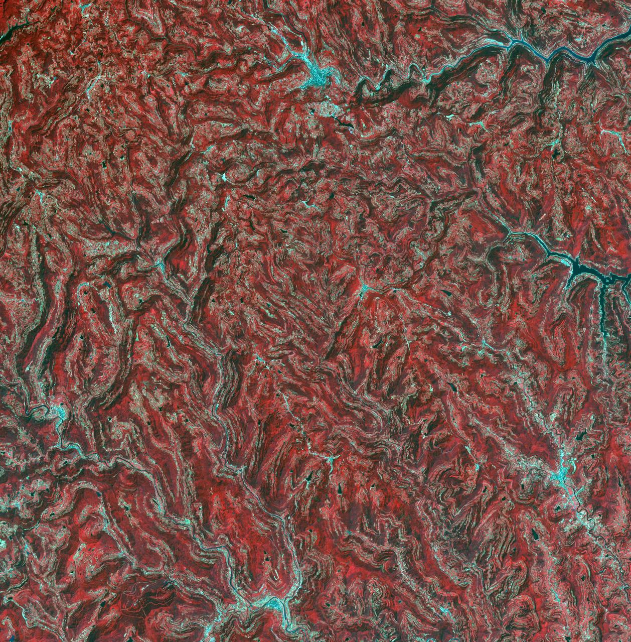
In the northeast Sichuan province of China lies the Sichuan Basin, surrounded by mountains on all sides and drained by the Yangtzee River. The basin is considered the breadbasket of China. On the northeast edge, flat-lying Jurassic to Cretaceous sandstones have been eroded to form an intricately carved landscape of upland fields and lowland streams and valleys. The image was acquired September 11, 2016, covers an area of 36 by 37 kilometers, and is located at 31.9 degrees north, 105.4 degrees east. https://photojournal.jpl.nasa.gov/catalog/PIA23532
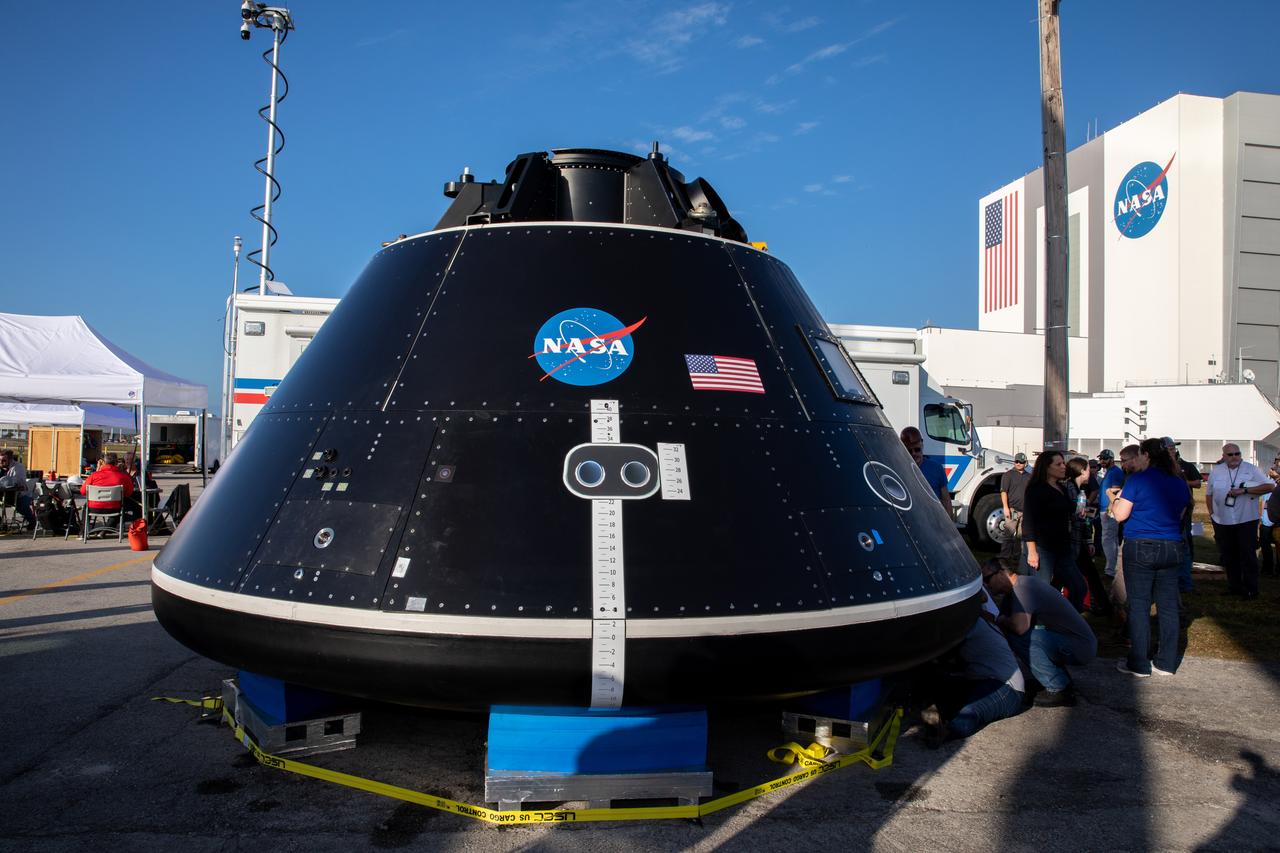
The Crew Module Test Article (CMTA) is in view at the turn basin in the Launch Complex 39 area at NASA’s Kennedy Space Center in Florida on Jan. 30, 2023. The CMTA is being used to practice recovery after splashdown of the Orion spacecraft to prepare for the Artemis II crewed mission. Exploration Ground Systems leads recovery efforts.

View of Argyre Basin from Test of Mars Color Image
Mercury Izquierdo: An Impact Basin Newly Named for the Mexican Painter
Topographic Map of Chryse Planitia with Location of Possible Buried Basin
Peak-Ring Basin Close-Up from the Second Mercury Flyby

Liliana Villarreal, Artemis landing and recovery director with Exploration Ground Systems (EGS), stands in front of the Crew Module Test Article (CMTA) at the turn basin in the Launch Complex 39 area at NASA’s Kennedy Space Center in Florida on Feb. 1, 2023. The CMTA is being used to practice recovery after splashdown of the Orion spacecraft to prepare for the Artemis II crewed mission. EGS leads recovery efforts.

Liliana Villarreal, Artemis landing and recovery director with Exploration Ground Systems (EGS), stands in front of the Crew Module Test Article (CMTA) at the turn basin in the Launch Complex 39 area at NASA’s Kennedy Space Center in Florida on Feb. 1, 2023. The CMTA is being used to practice recovery after splashdown of the Orion spacecraft to prepare for the Artemis II crewed mission. EGS leads recovery efforts.

Liliana Villarreal, Artemis landing and recovery director with Exploration Ground Systems (EGS), stands in front of the Crew Module Test Article (CMTA) at the turn basin in the Launch Complex 39 area at NASA’s Kennedy Space Center in Florida on Feb. 1, 2023. The CMTA is being used to practice recovery after splashdown of the Orion spacecraft to prepare for the Artemis II crewed mission. EGS leads recovery efforts.
Excellent exposures of light-toned layered deposits occur along the northern edge of Hellas Basin as seen by NASA Mars Reconnaissance Orbiter.
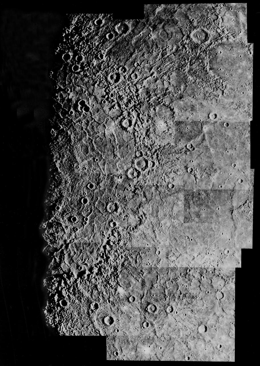
This image, from NASA Mariner 10 spacecraft which launched in 1974, shows an old basin hummocky rim is partly degraded and cratered by later events.
This image, from NASA Mariner 10 spacecraft which launched in 1974, includes part of the floor of the Caloris basin showing the ridges and fractures.
This image shows some bright layered deposits exposed within a linear trough along the floor of the Ladon Basin as seen by NASA Mars Reconnaissance Orbiter.
Eridania Basin, located at the head of Maadim Vallis, has mounting geomorphic and spectral evidence that it may have been the site of an ancient inland sea. This image is from NASA Mars Reconnaissance Orbiter.
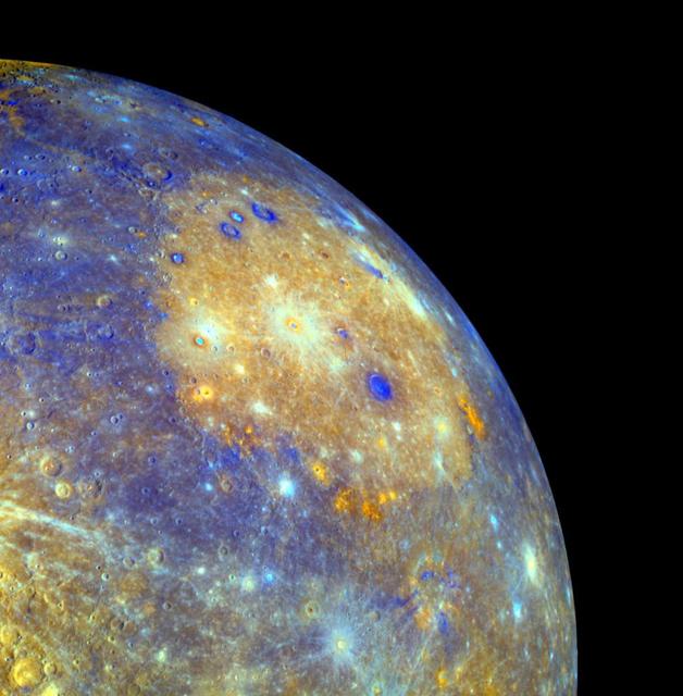
This false-color image of Mercury captured by NASA MESSENGER spacecraft shows the great Caloris impact basin, visible here as a large, circular, orange feature in the center of the picture.
Eridania is the name of topographically enclosed basin located in the Southern highlands of Mars that has been suggested to be the site of a large ancient lake or inland sea. This image is from NASA Mars Reconnaissance Orbiter.
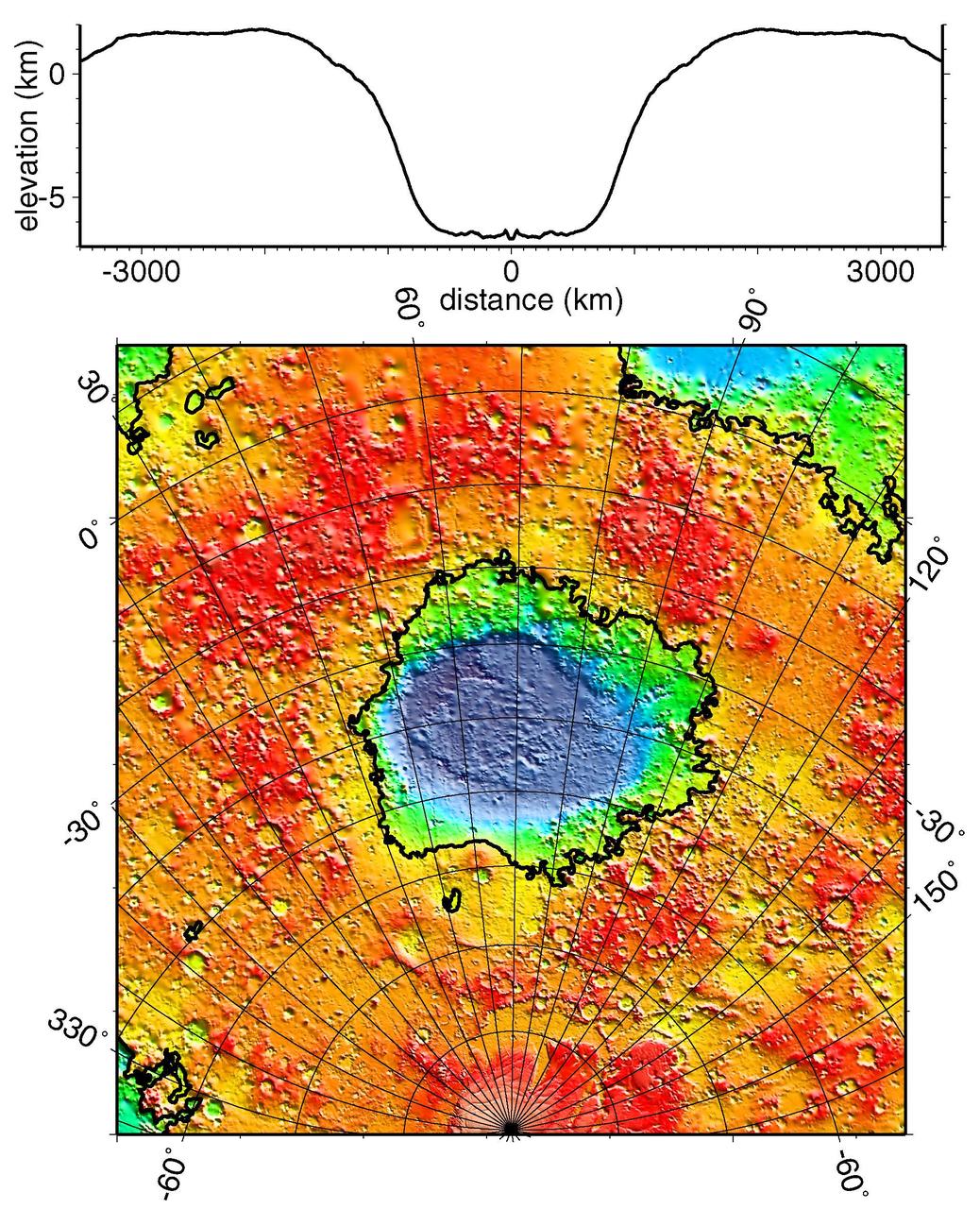
With a diameter of roughly 2,000 km 1,243 miles and a depth of over 7 km more than 4 miles, the Hellas Basin, shown in this image from NASA Mars Odyssey spacecraft, is the largest impact feature on Mars.

An enigmatic large basin appears in the south polar region of Saturn moon Titan at the center of this Titan Radar Mapper image from NASA Cassini spacecraft acquired on June 22, 2009.
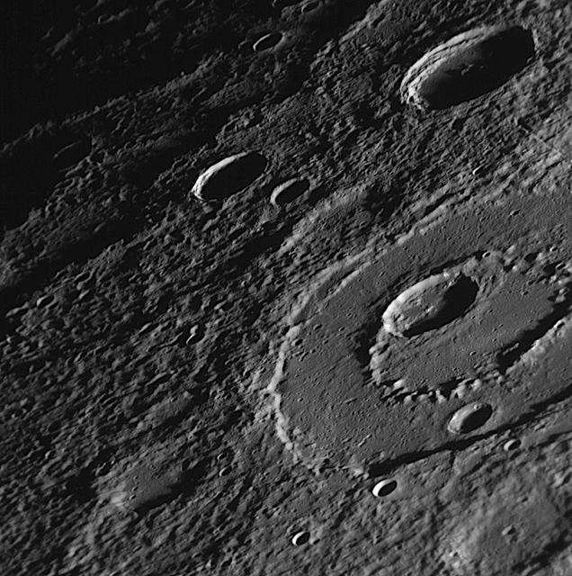
Taken about 40 minutes before NASA Mariner 10 made its close approach to Mercury on Sept. 21,1974, this picture shows a large double-ringed basin center of picture located in the planet south polar region
This image, from NASA Mariner 10 spacecraft which launched in 1974, is of the northeastern quadrant of the Caloris basin and shows the smooth hills and domes between the inner and outer scarps and the well-developed radial system east of the outer scarp

Liliana Villarreal, Artemis landing and recovery director with Exploration Ground Systems (EGS), stands in front of the Crew Module Test Article (CMTA) at the turn basin in the Launch Complex 39 area at NASA’s Kennedy Space Center in Florida on Feb. 1, 2023. The CMTA is being used to practice recovery after splashdown of the Orion spacecraft to prepare for the Artemis II crewed mission. EGS leads recovery efforts.