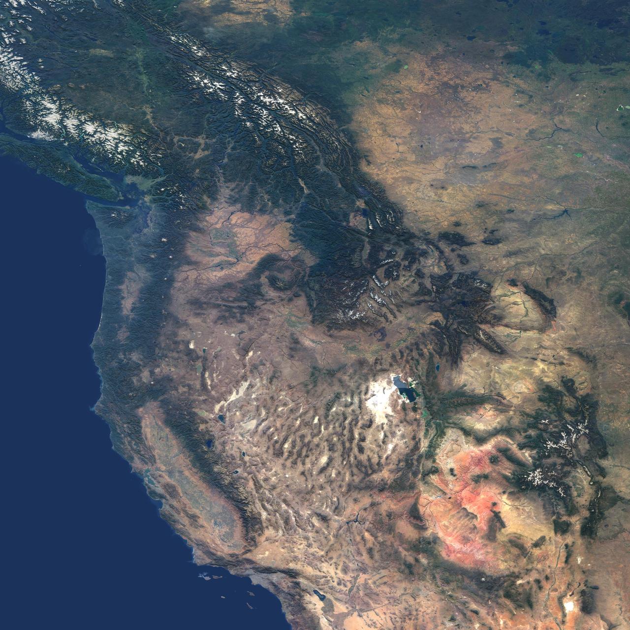
This natural-color image from NASA Terra spacecraft captures the beauty of the western United States and Canada.
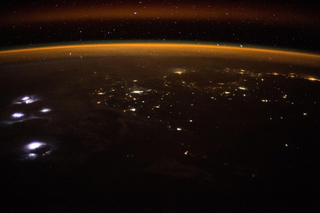
ISS047e007765 (03/14/2016) --- Using special cameras and Chronophotography aboard the International Space Station, crew members of Expedition 47 during Earth observations capture awesome beauty . This nighttime image shows an approaching lightning storm on the left. The gold and red aurora act as a frame to this display of natures wonders.

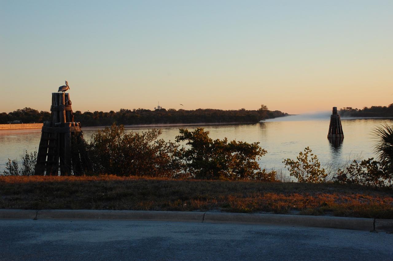
CAPE CANAVERAL, Fla. – A pelican is silhouetted against the rosy dawn sky as morning fog floats over the turn basin at NASA's Kennedy Space Center in Florida. Kennedy is surrounded by water: the Banana River, Banana Creek, Indian River Lagoon and the Atlantic Ocean, all of which provide scenes of beauty and nature that contrast with the high technology and power of the center. Photo credit: NASA/Ben Smegelsky
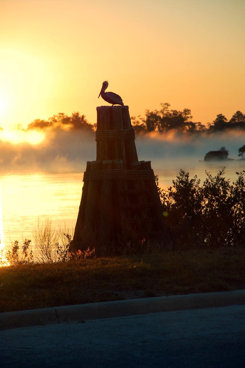
CAPE CANAVERAL, Fla. – Rising higher in the morning sky, the sun puts a glow on the fog rising from the turn basin at NASA's Kennedy Space Center in Florida. A pelican has a front row seat for the spectacle. Kennedy is surrounded by water: the Banana River, Banana Creek, Indian River Lagoon and the Atlantic Ocean, all of which provide scenes of beauty and nature that contrast with the high technology and power of the center. Photo credit: NASA/Ben Smegelsky

CAPE CANAVERAL, Fla. – The fog clears from the turn basin as the morning sky turns blue over NASA's Kennedy Space Center in Florida. A pelican has a front row seat for the spectacle. Kennedy is surrounded by water: the Banana River, Banana Creek, Indian River Lagoon and the Atlantic Ocean, all of which provide scenes of beauty and nature that contrast with the high technology and power of the center. Photo credit: NASA/Ben Smegelsky
CAPE CANAVERAL, Fla. – The sun rising over the Launch Complex 39 Area turn basin at NASA's Kennedy Space Center in Florida casts a brilliant flame in the water. At right is the U.S. flag on the grounds of the NASA News Center. Kennedy is surrounded by water: the Banana River, Banana Creek, Indian River Lagoon and the Atlantic Ocean, all of which provide scenes of beauty and nature that contrast with the high technology and power of the center. Photo credit: NASA/Ben Smegelsky
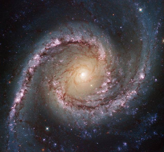
This new Hubble image shows NGC 1566, a beautiful galaxy located approximately 40 million light-years away in the constellation of Dorado (The Dolphinfish). NGC 1566 is an intermediate spiral galaxy, meaning that while it does not have a well-defined bar-shaped region of stars at its center — like barred spirals — it is not quite an unbarred spiral either. The small but extremely bright nucleus of NGC 1566 is clearly visible in this image, a telltale sign of its membership of the Seyfert class of galaxies. The centers of such galaxies are very active and luminous, emitting strong bursts of radiation and potentially harboring supermassive black holes that are many millions of times the mass of the sun. NGC 1566 is not just any Seyfert galaxy; it is the second brightest Seyfert galaxy known. It is also the brightest and most dominant member of the Dorado Group, a loose concentration of galaxies that together comprise one of the richest galaxy groups of the southern hemisphere. This image highlights the beauty and awe-inspiring nature of this unique galaxy group, with NGC 1566 glittering and glowing, its bright nucleus framed by swirling and symmetrical lavender arms. This image was taken by Hubble’s Wide Field Camera 3 (WFC3) in the near-infrared part of the spectrum. European Space Agency Credit: ESA/Hubble & NASA, Acknowledgement: Flickr user Det58 <b><a href="http://www.nasa.gov/audience/formedia/features/MP_Photo_Guidelines.html" rel="nofollow">NASA image use policy.</a></b> <b><a href="http://www.nasa.gov/centers/goddard/home/index.html" rel="nofollow">NASA Goddard Space Flight Center</a></b> enables NASA’s mission through four scientific endeavors: Earth Science, Heliophysics, Solar System Exploration, and Astrophysics. Goddard plays a leading role in NASA’s accomplishments by contributing compelling scientific knowledge to advance the Agency’s mission. <b>Follow us on <a href="http://twitter.com/NASAGoddardPix" rel="nofollow">Twitter</a></b> <b>Like us on <a href="http://www.facebook.com/pages/Greenbelt-MD/NASA-Goddard/395013845897?ref=tsd" rel="nofollow">Facebook</a></b> <b>Find us on <a href="http://instagram.com/nasagoddard?vm=grid" rel="nofollow">Instagram</a></b>

NGC 4639 is a beautiful example of a type of galaxy known as a barred spiral. It lies over 70 million light-years away in the constellation of Virgo and is one of about 1500 galaxies that make up the Virgo Cluster. In this image, taken by the NASA/ESA Hubble Space Telescope, one can clearly see the bar running through the bright, round core of the galaxy. Bars are found in around two thirds of spiral galaxies, and are thought to be a natural phase in their evolution. The galaxy’s spiral arms are sprinkled with bright regions of active star formation. Each of these tiny jewels is actually several hundred light-years across and contains hundreds or thousands of newly formed stars. But NGC 4639 also conceals a dark secret in its core — a massive black hole that is consuming the surrounding gas. This is known as an active galactic nucleus (AGN), and is revealed by characteristic features in the spectrum of light from the galaxy and by X-rays produced close to the black hole as the hot gas plunges towards it. Most galaxies are thought to contain a black hole at the centre. NGC 4639 is in fact a very weak example of an AGN, demonstrating that AGNs exist over a large range of activity, from galaxies like NGC 4639 to distant quasars, where the parent galaxy is almost completely dominated by the emissions from the AGN.
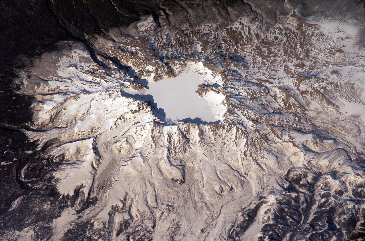
ISS006-E-43366 (4 April 2003) --- This view featuring Baitoushan Volcano, China and North Korea, was photographed by an Expedition 6 crewmember on the International Space Station (ISS). One of the largest known Holocene eruptions occurred at Baitoushan Volcano (also known as Changbaishan in China and P’aektu-san in Korea) about 1000 A.D., with erupted material deposited as far away as northern Japan – a distance of approximately 1200 kilometers. The eruption also created the 4.5 kilometer diameter, 850 meters deep summit caldera of the volcano that is now filled with the waters of Lake Tianchi (or Sky Lake). This oblique photograph was taken during the winter season, and snow highlights frozen Lake Tianchi along with lava flow lobes along the southern face of the volcano. Baitoushan last erupted in 1702 and is considered a dormant volcano. Gas emissions were reported from the summit and nearby hot springs in 1994, but no evidence of renewed activity of the volcano was observed. The Chinese-Korean border runs directly through the center of the summit caldera, and the mountain is considered sacred by the dominantly Korean population living near the volcano. Lake Tianchi is a popular resort destination, both for its natural beauty and alleged sightings of unidentified creatures living in its depths (similar to legendary Loch Ness Monster in Scotland).
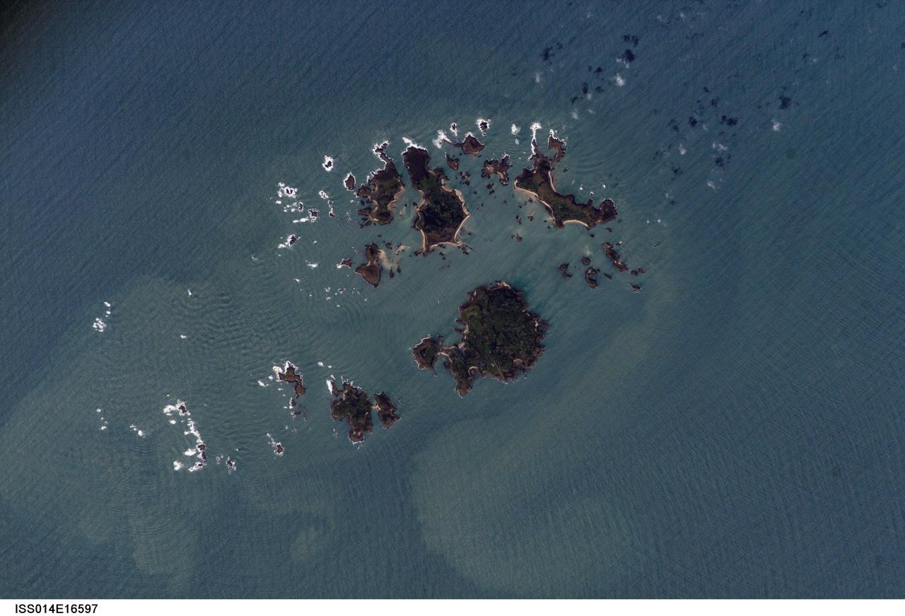
ISS014-E-16597 (10 March 2007) --- Isles of Scilly, United Kingdom is featured in this image photographed by an Expedition 14 crewmember on the International Space Station. The Isles of Scilly, an archipelago of approximately 150 islands, is located some 44 kilometers southwest of the westernmost point of England (Land's End). According to scientists, the islands are an erosional remnant of an ancient granite intrusion, and are notable because they have been inhabited for over 4000 years. Historical and geological evidence cited by NASA scientists on the Isles indicates that many of the islands were larger and/or connected in the recent past--this could be due to local subsidence, rising sea levels, or a combination of both factors. Even today, it is possible to walk between certain islands during low tides. The Isles have been designated a United Kingdom Area of Outstanding Natural Beauty due to their unique landscape, ecology, and historical significance. The potential effect of rising sea level on the Isles is a primary concern for both long-term ecosystem health and human habitability. This image illustrates the geographic configuration of the archipelago, and its effect on ocean wave patterns. Long linear swells oriented northeast-southwest and moving to the southeast (from upper left to lower right) are diffracted (bent) as they approach the coastlines and small shoals of the Isles. The wave diffraction forms complex interacting surface patterns--this is most clearly visible southwest of St. Mary's island (left). The dominant ocean wave pattern resumes to the southeast of St. Mary's, but with an additional northwest-southeast oriented pattern superimposed, possibly due to winds originating in the English channel to the east (not shown). Suspended, tan-colored sediments visible within and around the archipelago are locally derived from continuing wave erosion of the granite forming the islands and remobilization of beach sands. Bright white areas in the photograph are waves breaking on shoals.
The ruins of Machu Picchu, rediscovered in 1911 by Hiram Bingham, are one of the most beautiful and enigmatic ancient sites in the world. While the Inca people utilized the Andean mountain top (2800 m elevation), erecting massive stone structures from the early 1400's, legends and myths indicate that Machu Picchu (meaning "Old Peak" in the Quechua language) was revered as a sacred place from a far earlier time. The Inca turned the site into a small (12 square kilometers) but extraordinary city. Invisible from the Urubamba River valley below and completely self-contained, surrounded by agricultural terraces sufficient to feed the population, and watered by natural springs, Machu Picchu seems to have been utilized by the Inca as a secret ceremonial city. The Spaniards never found Machu Picchu, even though they suspected its existence. The mountain top sanctuary fell into disuse and was abandoned some forty years after the Spanish took Cuzco in 1533. Supply lines linking the many Inca social centers were disrupted and the great empire came to an end. This image was acquired on June 25, 2001 by the Advanced Spaceborne Thermal Emission and Reflection Radiometer (ASTER) on NASA's Terra satellite. With its 14 spectral bands from the visible to the thermal infrared wavelength region, and its high spatial resolution of 15 to 90 meters (about 50 to 300 feet), ASTER will image Earth for the next 6 years to map and monitor the changing surface of our planet. http://photojournal.jpl.nasa.gov/catalog/PIA03853
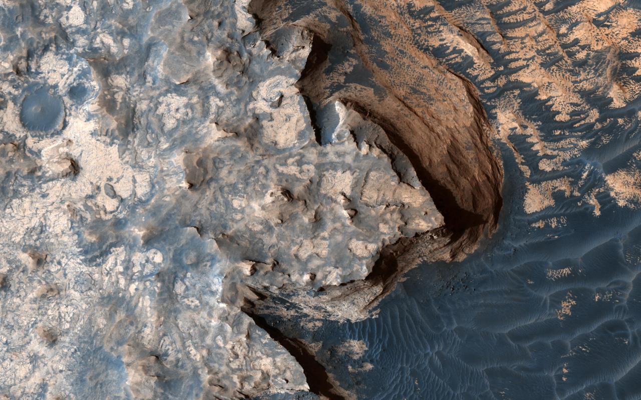
This image from NASA's Mars Reconnaissance Orbiter is reminiscent of the rugged and open terrain of a stark shore-line, perhaps of an island nation, such as the British Isles. A close-up in enhanced color produces a striking effect, giving the impression of a cloud-covered cliff edge with foamy waves crashing against it. The reality is that the surface of Mars is much dryer than our imaginations might want to suggest. This is only a tiny part of a much larger structure; an inverted crater -- a crater that has been infilled by material that is more resistant to erosion than the rocks around it -- surrounded by bluish basaltic dunes. The edge of these elevated light-toned deposits are degraded, irregular and cliff-forming. Dunes visible below the cliff, give the impression of an ocean surface, complete with foam capped waves crashing against the "shore line," demonstrating the abstract similarity between the nature of a turbulent ocean and a Martian dune field. Meridiani Planum has an overall smooth terrain, which starkly contrasts with the more common boulder- and crater-laden landscapes observed over much of the rest of Mars. This makes it relatively younger in character than many other areas of the planet. Meridiani is one of the Mars Exploration Rover landing sites, and, is known for its layers and sediments. The orbital detection of hematite was one of the main reasons for sending Opportunity to this area. Salt-bearing rocks -- also called sulphates -- were observed in the very first image from Opportunity, so perhaps it's apt that this HiRISE image reminds us of the turmoil and rugged beauty of a cliff-face, a coastline, being worn down by a relentless sea. https://photojournal.jpl.nasa.gov/catalog/PIA21760
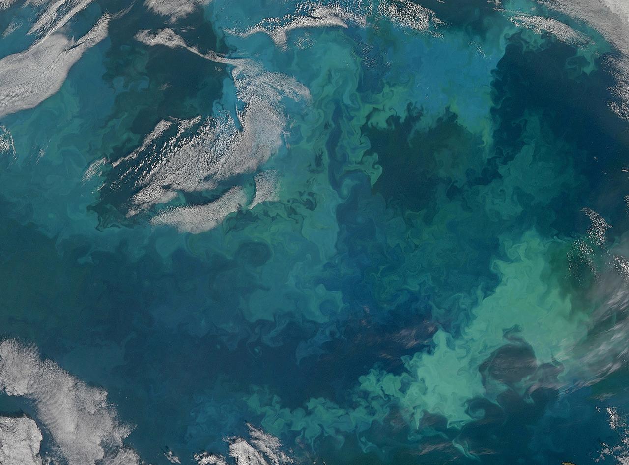
NASA image acquired August 31, 2010 To see the full view of this image go to: <a href="http://www.flickr.com/photos/gsfc/4970549945">www.flickr.com/photos/gsfc/4970549945</a> In this natural-color image from August 31, 2010, the ocean’s canvas swirls with turquoise, teal, navy, and green, the abstract art of the natural world. The colors were painted by a massive phytoplankton bloom made up of millions of tiny, light-reflecting organisms growing in the sunlit surface waters of the Barents Sea. Such blooms peak every August in the Barents Sea. The variations in color are caused by different species and concentrations of phytoplankton. The bright blue colors are probably from coccolithophores, a type of phytoplankton that is coated in a chalky shell that reflects light, turning the ocean a milky turquoise. Coccolithophores dominate the Barents Sea in August. Shades of green are likely from diatoms, another type of phytoplankton. Diatoms usually dominate the Barents Sea earlier in the year, giving way to coccolithophores in the late summer. However, field measurements of previous August blooms have also turned up high concentrations of diatoms. The Barents Sea is a shallow sea sandwiched between the coastline of northern Russia and Scandinavia and the islands of Svalbard, Franz Josef Land, and Novaya Zemlya. Within the shallow basin, currents carrying warm, salty water from the Atlantic collide with currents carrying cold, fresher water from the Arctic. During the winter, strong winds drive the currents and mix the waters. When winter’s sea ice retreats and light returns in the spring, diatoms thrive, typically peaking in a large bloom in late May. The shift between diatoms and coccolithophores occurs as the Barents Sea changes during the summer months. Throughout summer, perpetual light falls on the waters, gradually warming the surface. Eventually, the ocean stratifies into layers, with warm water sitting on top of cooler water. The diatoms deplete most of the nutrients in the surface waters and stop growing. Coccolithophores, on the other hand, do well in warm, nutrient-depleted water with a lot of light. In the Barents Sea, these conditions are strongest in August. The shifting conditions and corresponding change in species lead to strikingly beautiful multicolored blooms such as this one. The Moderate Resolution Imaging Spectroradiometer (MODIS) on NASA’s Aqua satellite acquired this image. NASA image courtesy Norman Kuring, NASA Ocean Color Group. Caption by Holli Riebeek. Instrument: Aqua - MODIS Click here to see more images from <b><a href="#//earthobservatory.nasa.gov/" rel="nofollow"> NASA Goddard’s Earth Observatory</a></b> <b><a href="http://www.nasa.gov/centers/goddard/home/index.html" rel="nofollow">NASA Goddard Space Flight Center</a></b> is home to the nation's largest organization of combined scientists, engineers and technologists that build spacecraft, instruments and new technology to study the Earth, the sun, our solar system, and the universe. <b>Follow us on <a href="http://twitter.com/NASA_GoddardPix" rel="nofollow">Twitter</a></b> <b>Join us on <a href="http://www.facebook.com/pages/Greenbelt-MD/NASA-Goddard/395013845897?ref=tsd" rel="nofollow">Facebook</a></b>
NASA image acquired August 31, 2010 To see a detail of this image go to: <a href="http://www.flickr.com/photos/gsfc/4971318856/">www.flickr.com/photos/gsfc/4971318856/</a> In this natural-color image from August 31, 2010, the ocean’s canvas swirls with turquoise, teal, navy, and green, the abstract art of the natural world. The colors were painted by a massive phytoplankton bloom made up of millions of tiny, light-reflecting organisms growing in the sunlit surface waters of the Barents Sea. Such blooms peak every August in the Barents Sea. The variations in color are caused by different species and concentrations of phytoplankton. The bright blue colors are probably from coccolithophores, a type of phytoplankton that is coated in a chalky shell that reflects light, turning the ocean a milky turquoise. Coccolithophores dominate the Barents Sea in August. Shades of green are likely from diatoms, another type of phytoplankton. Diatoms usually dominate the Barents Sea earlier in the year, giving way to coccolithophores in the late summer. However, field measurements of previous August blooms have also turned up high concentrations of diatoms. The Barents Sea is a shallow sea sandwiched between the coastline of northern Russia and Scandinavia and the islands of Svalbard, Franz Josef Land, and Novaya Zemlya. Within the shallow basin, currents carrying warm, salty water from the Atlantic collide with currents carrying cold, fresher water from the Arctic. During the winter, strong winds drive the currents and mix the waters. When winter’s sea ice retreats and light returns in the spring, diatoms thrive, typically peaking in a large bloom in late May. The shift between diatoms and coccolithophores occurs as the Barents Sea changes during the summer months. Throughout summer, perpetual light falls on the waters, gradually warming the surface. Eventually, the ocean stratifies into layers, with warm water sitting on top of cooler water. The diatoms deplete most of the nutrients in the surface waters and stop growing. Coccolithophores, on the other hand, do well in warm, nutrient-depleted water with a lot of light. In the Barents Sea, these conditions are strongest in August. The shifting conditions and corresponding change in species lead to strikingly beautiful multicolored blooms such as this one. The Moderate Resolution Imaging Spectroradiometer (MODIS) on NASA’s Aqua satellite acquired this image. NASA image courtesy Norman Kuring, NASA Ocean Color Group. Caption by Holli Riebeek. Instrument: Aqua - MODIS Click here to see more images from <b><a href="#//earthobservatory.nasa.gov/" rel="nofollow"> NASA Goddard’s Earth Observatory</a></b> <b><a href="http://www.nasa.gov/centers/goddard/home/index.html" rel="nofollow">NASA Goddard Space Flight Center</a></b> is home to the nation's largest organization of combined scientists, engineers and technologists that build spacecraft, instruments and new technology to study the Earth, the sun, our solar system, and the universe. <b>Follow us on <a href="http://twitter.com/NASA_GoddardPix" rel="nofollow">Twitter</a></b> <b>Join us on <a href="http://www.facebook.com/pages/Greenbelt-MD/NASA-Goddard/395013845897?ref=tsd" rel="nofollow">Facebook</a></b>

NGC 4639 is a beautiful example of a type of galaxy known as a barred spiral. It lies over 70 million light-years away in the constellation of Virgo and is one of about 1,500 galaxies that make up the Virgo Cluster. In this image, taken by the NASA/ESA Hubble Space Telescope, one can clearly see the bar running through the bright, round core of the galaxy. Bars are found in around two-thirds of spiral galaxies, and are thought to be a natural phase in their evolution. The galaxy’s spiral arms are sprinkled with bright regions of active star formation. Each of these tiny jewels is actually several hundred light-years across and contains hundreds or thousands of newly formed stars. But NGC 4639 also conceals a dark secret in its core — a massive black hole that is consuming the surrounding gas. This is known as an active galactic nucleus (AGN), and is revealed by characteristic features in the spectrum of light from the galaxy and by X-rays produced close to the black hole as the hot gas plunges towards it. Most galaxies are thought to contain a black hole at the center. NGC 4639 is in fact a very weak example of an AGN, demonstrating that AGNs exist over a large range of activity, from galaxies like NGC 4639 to distant quasars, where the parent galaxy is almost completely dominated by the emissions from the AGN. Image credit: ESA/Hubble & NASA <b><a href="http://www.nasa.gov/audience/formedia/features/MP_Photo_Guidelines.html" rel="nofollow">NASA image use policy.</a></b> <b><a href="http://www.nasa.gov/centers/goddard/home/index.html" rel="nofollow">NASA Goddard Space Flight Center</a></b> enables NASA’s mission through four scientific endeavors: Earth Science, Heliophysics, Solar System Exploration, and Astrophysics. Goddard plays a leading role in NASA’s accomplishments by contributing compelling scientific knowledge to advance the Agency’s mission. <b>Follow us on <a href="http://twitter.com/NASAGoddardPix" rel="nofollow">Twitter</a></b> <b>Like us on <a href="http://www.facebook.com/pages/Greenbelt-MD/NASA-Goddard/395013845897?ref=tsd" rel="nofollow">Facebook</a></b> <b>Find us on <a href="http://instagrid.me/nasagoddard/?vm=grid" rel="nofollow">Instagram</a></b>

This new Hubble image is centered on NGC 5793, a spiral galaxy over 150 million light-years away in the constellation of Libra. This galaxy has two particularly striking features: a beautiful dust lane and an intensely bright center — much brighter than that of our own galaxy, or indeed those of most spiral galaxies we observe. NGC 5793 is a Seyfert galaxy. These galaxies have incredibly luminous centers that are thought to be caused by hungry supermassive black holes — black holes that can be billions of times the size of the sun — that pull in and devour gas and dust from their surroundings. This galaxy is of great interest to astronomers for many reasons. For one, it appears to house objects known as masers. Whereas lasers emit visible light, masers emit microwave radiation. The term "masers" comes from the acronym Microwave Amplification by Stimulated Emission of Radiation. Maser emission is caused by particles that absorb energy from their surroundings and then re-emit this in the microwave part of the spectrum. Naturally occurring masers, like those observed in NGC 5793, can tell us a lot about their environment; we see these kinds of masers in areas where stars are forming. In NGC 5793 there are also intense mega-masers, which are thousands of times more luminous than the sun. Credit: NASA, ESA, and E. Perlman (Florida Institute of Technology) <b><a href="http://www.nasa.gov/audience/formedia/features/MP_Photo_Guidelines.html" rel="nofollow">NASA image use policy.</a></b> <b><a href="http://www.nasa.gov/centers/goddard/home/index.html" rel="nofollow">NASA Goddard Space Flight Center</a></b> enables NASA’s mission through four scientific endeavors: Earth Science, Heliophysics, Solar System Exploration, and Astrophysics. Goddard plays a leading role in NASA’s accomplishments by contributing compelling scientific knowledge to advance the Agency’s mission. <b>Follow us on <a href="http://twitter.com/NASAGoddardPix" rel="nofollow">Twitter</a></b> <b>Like us on <a href="http://www.facebook.com/pages/Greenbelt-MD/NASA-Goddard/395013845897?ref=tsd" rel="nofollow">Facebook</a></b> <b>Find us on <a href="http://instagram.com/nasagoddard?vm=grid" rel="nofollow">Instagram</a></b>

Aerial view cityscape from airplane at summer
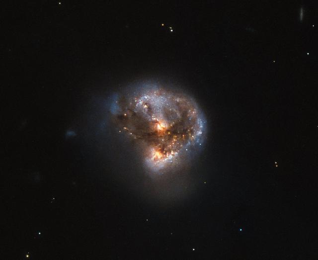
This galaxy has a far more exciting and futuristic classification than most — it hosts a megamaser. Megamasers are intensely bright, around 100 million times brighter than the masers found in galaxies like the Milky Way. The entire galaxy essentially acts as an astronomical laser that beams out microwave emission rather than visible light (hence the ‘m’ replacing the ‘l’). A megamaser is a process that involves some components within the galaxy (like gas) that is in the right physical condition to cause the amplification of light (in this case, microwaves). But there are other parts of the galaxy (like stars for example) that aren’t part of the maser process. This megamaser galaxy is named IRAS 16399-0937 and is located over 370 million light-years from Earth. This NASA/ESA Hubble Space Telescope image belies the galaxy’s energetic nature, instead painting it as a beautiful and serene cosmic rosebud. The image comprises observations captured across various wavelengths by two of Hubble’s instruments: the Advanced Camera for Surveys (ACS), and the Near Infrared Camera and Multi-Object Spectrometer (NICMOS). NICMOS’s superb sensitivity, resolution, and field of view gave astronomers the unique opportunity to observe the structure of IRAS 16399-0937 in detail. They found it hosts a double nucleus — the galaxy’s core is thought to be formed of two separate cores in the process of merging. The two components, named IRAS 16399N and IRAS 16399S for the northern and southern parts respectively, sit over 11,000 light-years apart. However, they are both buried deep within the same swirl of cosmic gas and dust and are interacting, giving the galaxy its peculiar structure. The nuclei are very different. IRAS 16399S appears to be a starburst region, where new stars are forming at an incredible rate. IRAS 16399N, however, is something known as a LINER nucleus (Low Ionization Nuclear Emission Region), which is a region whose emission mostly stems from weakly-ionized or neutral atoms of particular gases. The northern nucleus also hosts a black hole with some 100 million times the mass of the sun! Image credit: ESA/Hubble & NASA, Acknowledgement: Judy Schmidt (geckzilla) <b><a href="http://www.nasa.gov/audience/formedia/features/MP_Photo_Guidelines.html" rel="nofollow">NASA image use policy.</a></b> <b><a href="http://www.nasa.gov/centers/goddard/home/index.html" rel="nofollow">NASA Goddard Space Flight Center</a></b> enables NASA’s mission through four scientific endeavors: Earth Science, Heliophysics, Solar System Exploration, and Astrophysics. Goddard plays a leading role in NASA’s accomplishments by contributing compelling scientific knowledge to advance the Agency’s mission. <b>Follow us on <a href="http://twitter.com/NASAGoddardPix" rel="nofollow">Twitter</a></b> <b>Like us on <a href="http://www.facebook.com/pages/Greenbelt-MD/NASA-Goddard/395013845897?ref=tsd" rel="nofollow">Facebook</a></b> <b>Find us on <a href="http://instagrid.me/nasagoddard/?vm=grid" rel="nofollow">Instagram</a></b>
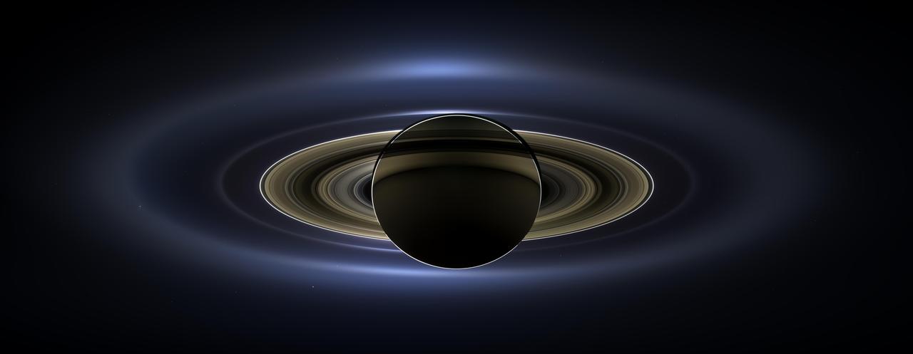
On July 19, 2013, in an event celebrated the world over, NASA's Cassini spacecraft slipped into Saturn's shadow and turned to image the planet, seven of its moons, its inner rings -- and, in the background, our home planet, Earth. With the sun's powerful and potentially damaging rays eclipsed by Saturn itself, Cassini's onboard cameras were able to take advantage of this unique viewing geometry. They acquired a panoramic mosaic of the Saturn system that allows scientists to see details in the rings and throughout the system as they are backlit by the sun. This mosaic is special as it marks the third time our home planet was imaged from the outer solar system; the second time it was imaged by Cassini from Saturn's orbit; and the first time ever that inhabitants of Earth were made aware in advance that their photo would be taken from such a great distance. With both Cassini's wide-angle and narrow-angle cameras aimed at Saturn, Cassini was able to capture 323 images in just over four hours. This final mosaic uses 141 of those wide-angle images. Images taken using the red, green and blue spectral filters of the wide-angle camera were combined and mosaicked together to create this natural-color view. A brightened version with contrast and color enhanced (Figure 1), a version with just the planets annotated (Figure 2), and an annotated version (Figure 3) are shown above. This image spans about 404,880 miles (651,591 kilometers) across. The outermost ring shown here is Saturn's E ring, the core of which is situated about 149,000 miles (240,000 kilometers) from Saturn. The geysers erupting from the south polar terrain of the moon Enceladus supply the fine icy particles that comprise the E ring; diffraction by sunlight gives the ring its blue color. Enceladus (313 miles, or 504 kilometers, across) and the extended plume formed by its jets are visible, embedded in the E ring on the left side of the mosaic. At the 12 o'clock position and a bit inward from the E ring lies the barely discernible ring created by the tiny, Cassini-discovered moon, Pallene (3 miles, or 4 kilometers, across). (For more on structures like Pallene's ring, see PIA08328). The next narrow and easily seen ring inward is the G ring. Interior to the G ring, near the 11 o'clock position, one can barely see the more diffuse ring created by the co-orbital moons, Janus (111 miles, or 179 kilometers, across) and Epimetheus (70 miles, or 113 kilometers, across). Farther inward, we see the very bright F ring closely encircling the main rings of Saturn. Following the outermost E ring counter-clockwise from Enceladus, the moon Tethys (662 miles, or 1,066 kilometers, across) appears as a large yellow orb just outside of the E ring. Tethys is positioned on the illuminated side of Saturn; its icy surface is shining brightly from yellow sunlight reflected by Saturn. Continuing to about the 2 o'clock position is a dark pixel just outside of the G ring; this dark pixel is Saturn's Death Star moon, Mimas (246 miles, or 396 kilometers, across). Mimas appears, upon close inspection, as a very thin crescent because Cassini is looking mostly at its non-illuminated face. The moons Prometheus, Pandora, Janus and Epimetheus are also visible in the mosaic near Saturn's bright narrow F ring. Prometheus (53 miles, or 86 kilometers, across) is visible as a faint black dot just inside the F ring and at the 9 o'clock position. On the opposite side of the rings, just outside the F ring, Pandora (50 miles, or 81 kilometers, across) can be seen as a bright white dot. Pandora and Prometheus are shepherd moons and gravitational interactions between the ring and the moons keep the F ring narrowly confined. At the 11 o'clock position in between the F ring and the G ring, Janus (111 miles, or 179 kilometers, across) appears as a faint black dot. Janus and Prometheus are dark for the same reason Mimas is mostly dark: we are looking at their non-illuminated sides in this mosaic. Midway between the F ring and the G ring, at about the 8 o'clock position, is a single bright pixel, Epimetheus. Looking more closely at Enceladus, Mimas and Tethys, especially in the brightened version of the mosaic, one can see these moons casting shadows through the E ring like a telephone pole might cast a shadow through a fog. In the non-brightened version of the mosaic, one can see bright clumps of ring material orbiting within the Encke gap near the outer edge of the main rings and immediately to the lower left of the globe of Saturn. Also, in the dark B ring within the main rings, at the 9 o'clock position, one can see the faint outlines of two spoke features, first sighted by NASA's Voyager spacecraft in the early 1980s and extensively studied by Cassini. Finally, in the lower right of the mosaic, in between the bright blue E ring and the faint but defined G ring, is the pale blue dot of our planet, Earth. Look closely and you can see the moon protruding from the Earth's lower right. (For a higher resolution view of the Earth and moon taken during this campaign, see PIA14949.) Earth's twin, Venus, appears as a bright white dot in the upper left quadrant of the mosaic, also between the G and E rings. Mars also appears as a faint red dot embedded in the outer edge of the E ring, above and to the left of Venus. For ease of visibility, Earth, Venus, Mars, Enceladus, Epimetheus and Pandora were all brightened by a factor of eight and a half relative to Saturn. Tethys was brightened by a factor of four. In total, 809 background stars are visible and were brightened by a factor ranging from six, for the brightest stars, to 16, for the faintest. The faint outer rings (from the G ring to the E ring) were also brightened relative to the already bright main rings by factors ranging from two to eight, with the lower-phase-angle (and therefore fainter) regions of these rings brightened the most. The brightened version of the mosaic was further brightened and contrast-enhanced all over to accommodate print applications and a wide range of computer-screen viewing conditions. Some ring features -- such as full rings traced out by tiny moons -- do not appear in this version of the mosaic because they require extreme computer enhancement, which would adversely affect the rest of the mosaic. This version was processed for balance and beauty. This view looks toward the unlit side of the rings from about 17 degrees below the ring plane. Cassini was approximately 746,000 miles (1.2 million kilometers) from Saturn when the images in this mosaic were taken. Image scale on Saturn is about 45 miles (72 kilometers) per pixel. This mosaic was made from pictures taken over a span of more than four hours while the planets, moons and stars were all moving relative to Cassini. Thus, due to spacecraft motion, these objects in the locations shown here were not in these specific places over the entire duration of the imaging campaign. Note also that Venus appears far from Earth, as does Mars, because they were on the opposite side of the sun from Earth. http://photojournal.jpl.nasa.gov/catalog/PIA17172