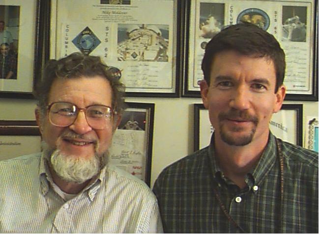
Dr. Dr. Robert F. Berg (right), principal investigator and Dr. Micheal R. Moldover (left), co-investigator, for the Critical Viscosity of Xenon (CVX/CVX-2) experiment. They are with the National Institutes of Standards and Technology, Gaithersburg, MD. The Critical Viscosity of Xenon Experiment (CVX-2) on the STS-107 Research 1 mission in 2002 will measure the viscous behavior of xenon, a heavy inert gas used in flash lamps and ion rocket engines, at its critical point. Although it does not easily combine with other chemicals, its viscosity at the critical point can be used as a model for a range of chemicals.
51B-06-010 (29 April-6 May 1985) --- Lodewijk van den Berg, 51-B payload specialist, observes the growth of mercuric iodide crystal in the vapor crystal growth system (VCGS) on the Spacelab 3 science module aboard the Space Shuttle Challenger.
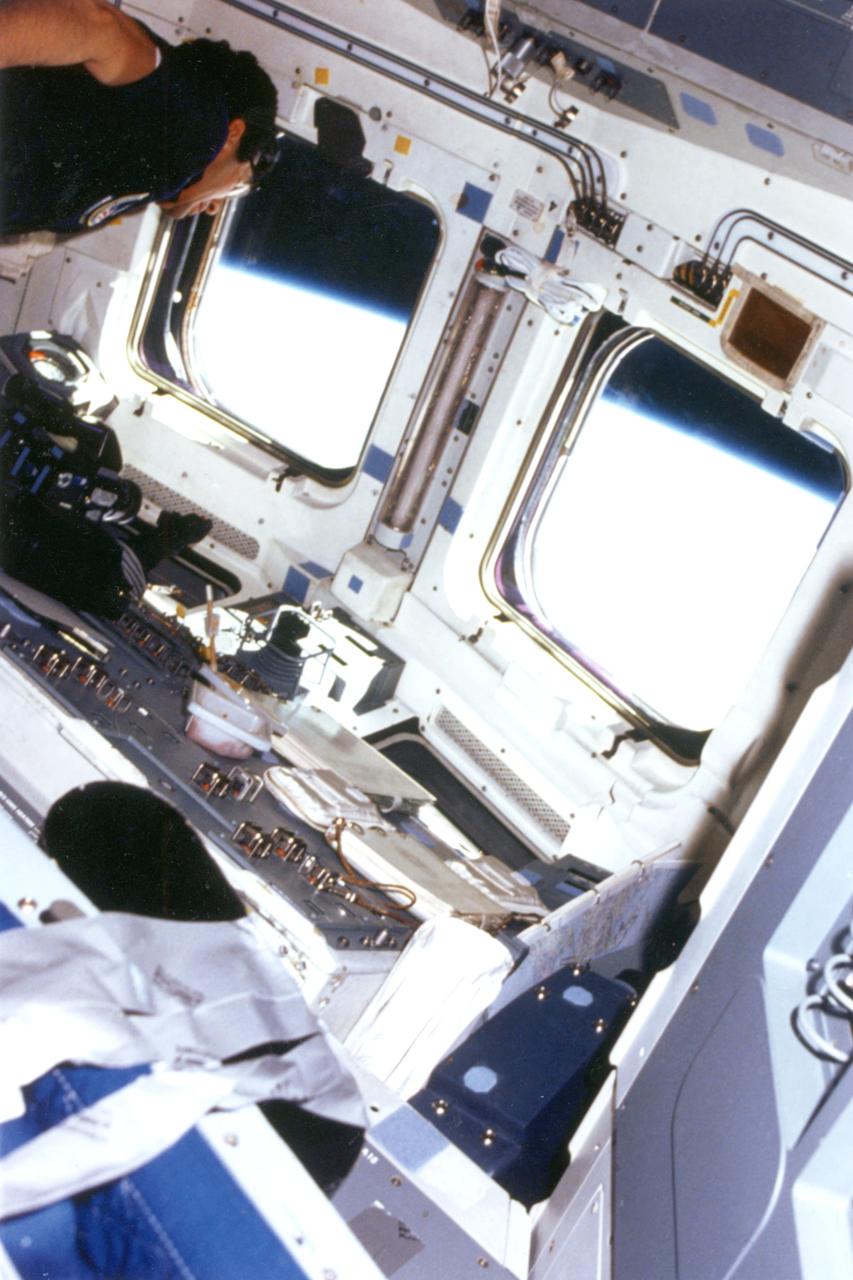
In this low-angle photo Payload specialist Lodewijk van den Berg, one of two payload specialists, looks out aft flight deck window aboard the shuttle orbiter Challenger.
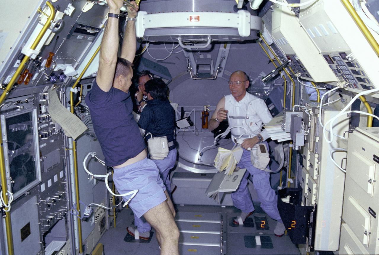
Activities inside the laboratory module during the Spacelab-3 mission are shown in this photograph. Left to right are astronauts Robert Overmyer, Commander of the mission; Don Lind, Mission Specialist; Lodewijk van den Berg, Payload Specialist; and William Thornton, Mission Specialist. The primary purpose of the Spacelab-3 mission was to conduct materials science experiments in a stable low-gravity environment. In addition, the crew did research in life sciences, fluid mechanics, atmospheric science, and astronomy. Spacelab-3 was equipped with several new minilabs, special facilities that would be used repeatedly on future flights. Two elaborate crystal growth furnaces, a life support and housing facility for small animals, and two types of apparatus for the study of fluids were evaluated on their inaugural flight. Spacelab-3 (STS-51B) was launched aboard the Space Shuttle Challenger on April 29, 1985. The Marshall Space Flight Center had managing responsibilities of the mission.
STS-51B, Spacelab-3, Payload Specialist Lodewijk van den Berg on flight deck with earth view out window.
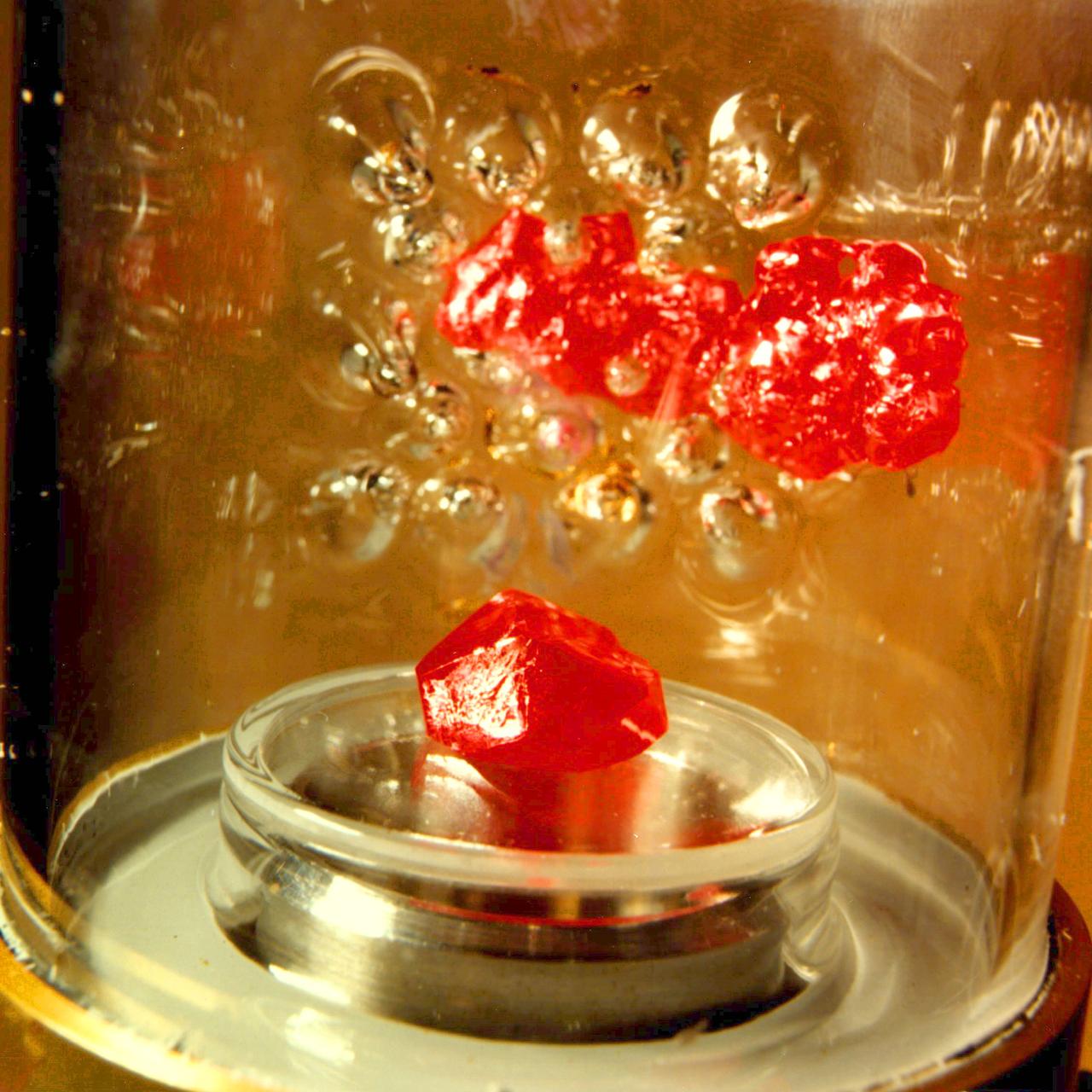
Vapor Crystal Growth System (VCGS), Flown on IML-1, Spacelab 3, Principal Investigator: Lodewijk van den Berg
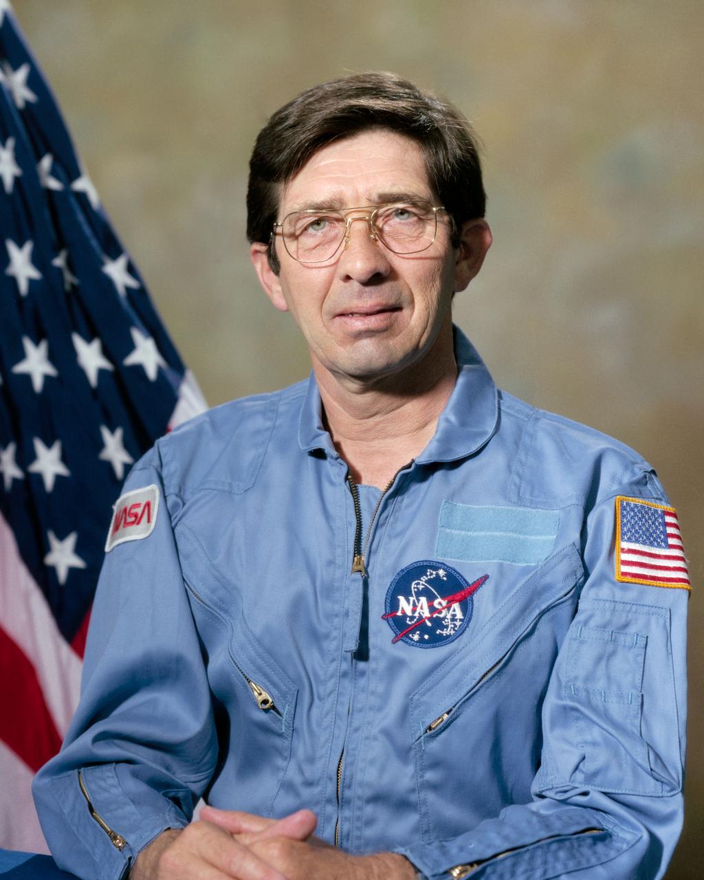
S84-36140 (16 June 1984) --- Lodewijk van den Berg, EG&G Corporation Spacelab 3 Payload Specialist.
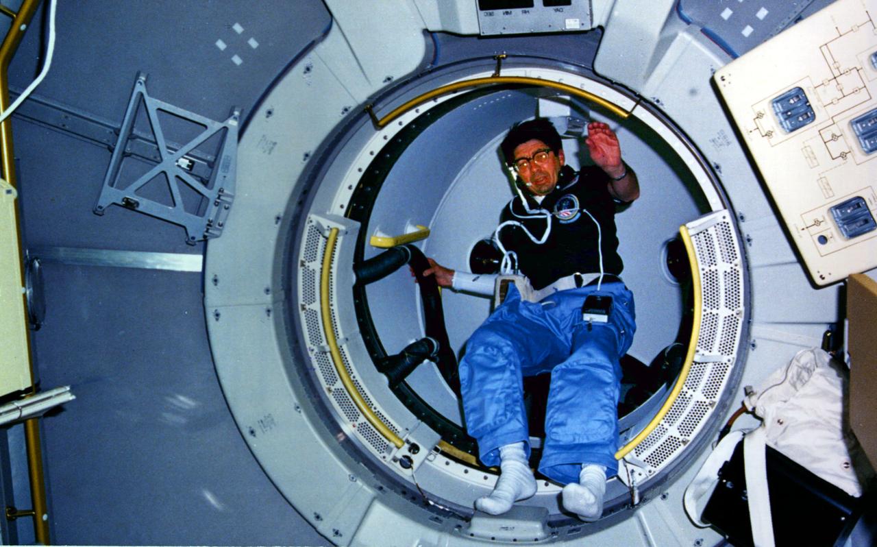
STS-51B, Spacelab 3, Lodewijk van den Berg coming through the turnel.
Ampoule view of the Vapor Crystal Growth System (VCGS) Furnace. Used on IML-1 International Microgravity Laboratory Spacelab 3. Prinicipal Investigator and Payload Specialist was Lodewijk van den Berg.
Overall view of the Vapor Crystal Growth System (VCGS) Furnace. Used on IML-1 International Microgravity Laboratory Spacelab 3. Principal Investigator and Payload Specialist was Lodewijk van den Berg.
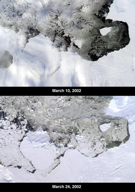
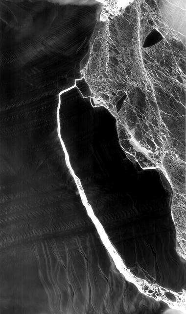
The Thwaites Ice Tongue is a large sheet of glacial ice extending from the West Antarctic mainland into the southern Amundsen Sea. A large crack in the Thwaites Tongue was discovered in imagery from Terra's Moderate Resolution Imaging SpectroRadiometer (MODIS). Subsequent widening of the crack led to the calving of a large iceberg. The development of this berg, designated B-22 by the National Ice Center, can be observed in these images from the Multi-angle Imaging SpectroRadiometer, also aboard Terra. The two views were acquired by MISR's nadir (vertical-viewing) camera on March 10 and 24, 2002. The B-22 iceberg, located below and to the left of image center, measures approximately 82 kilometers long x 62 kilometers wide. Comparison of the two images shows the berg to have drifted away from the ice shelf edge. The breakup of ice near the shelf edge, in the area surrounding B-22, is also visible in the later image. These natural-color images were acquired during Terra orbits 11843 and 12047, respectively. At the right-hand edge is Pine Island Bay, where the calving of another large iceberg (B-21) occurred in November 2001. B-21 subsequently split into two smaller bergs, both of which are visible to the right of B-22. http://photojournal.jpl.nasa.gov/catalog/PIA03700
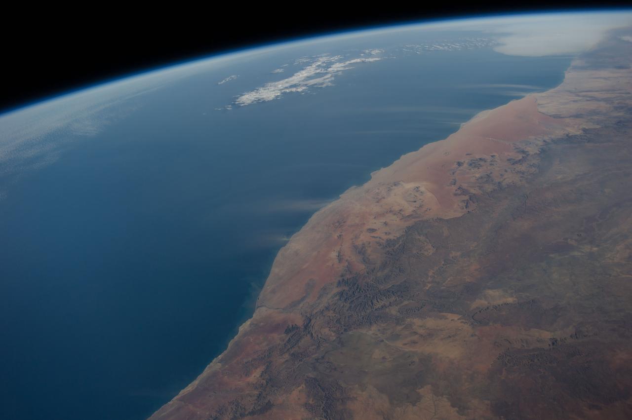
ISS040-E-016513 (21 June 2014) --- Dust plumes and the Namib Desert coast are featured in this image photographed by an Expedition 40 crew member on the International Space Station. Strong, hot winds known as “berg” (mountain) winds are lofting plumes of dust directly out into the Atlantic Ocean in this panoramic image. The southern African equivalent of Santa Ana winds in California, berg winds blow on a few occasions in fall and winter, off all coasts of southern Africa. Other images from the space station have captured these dust plumes. Namibia’s great Sand Sea appears here as a reddish zone along part of the coast (center). The Sand Sea is more than 350 kilometers long, giving a sense of the length of the visible dust plumes. A light-toned sediment plume enters the sea at the mouth of the Orange River (lower left), southern Africa’s largest river.
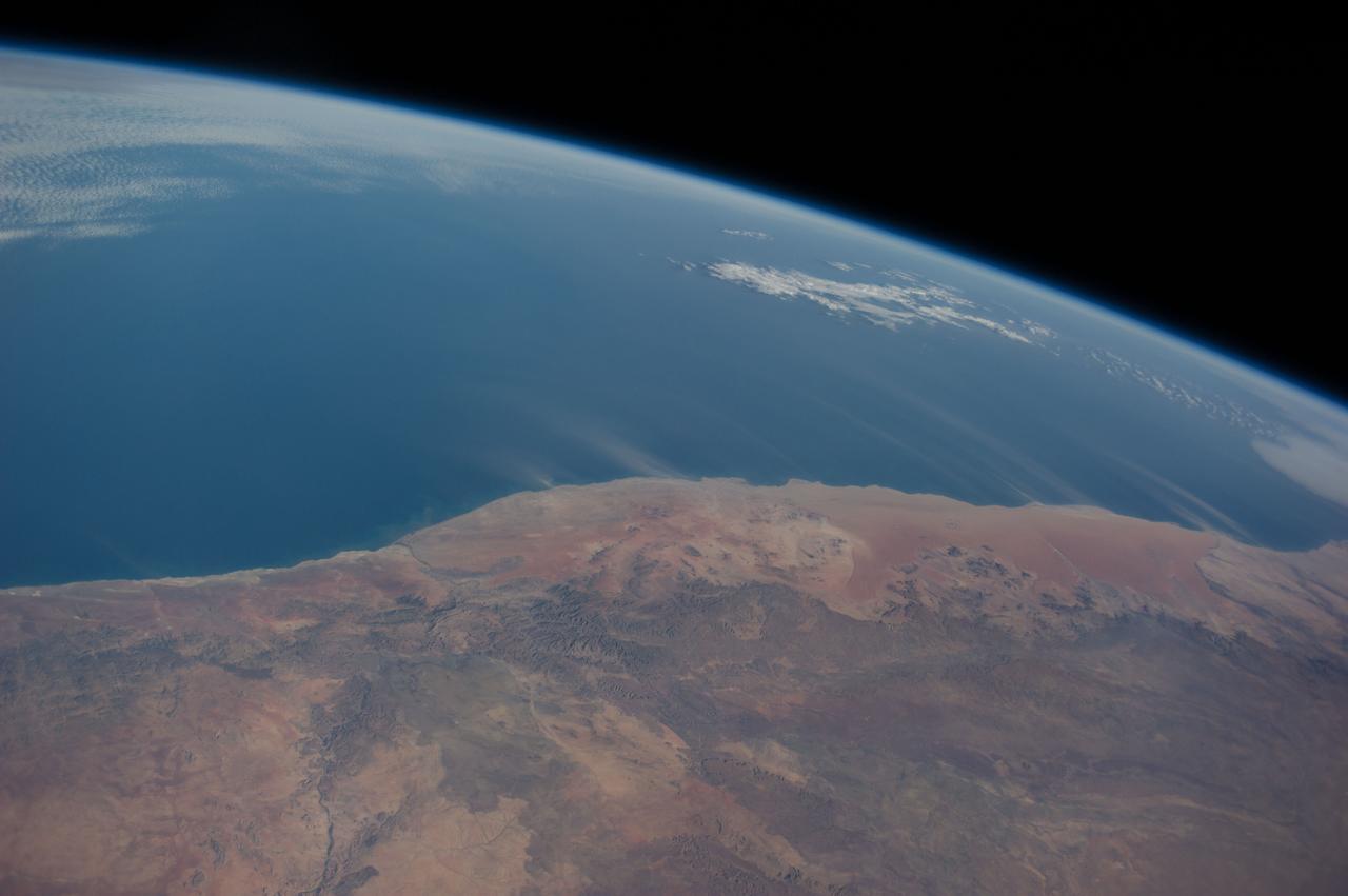
ISS040-E-016514 (21 June 2014) --- Dust plumes and the Namib Desert coast are featured in this image photographed by an Expedition 40 crew member on the International Space Station. Strong, hot winds known as “berg” (mountain) winds are lofting plumes of dust directly out into the Atlantic Ocean in this panoramic image. The southern African equivalent of Santa Ana winds in California, berg winds blow on a few occasions in fall and winter, off all coasts of southern Africa. Other images from the space station have captured these dust plumes. Namibia’s great Sand Sea appears here as a reddish zone along part of the coast (center). The Sand Sea is more than 350 kilometers long, giving a sense of the length of the visible dust plumes. A light-toned sediment plume enters the sea at the mouth of the Orange River (lower left), southern Africa’s largest river.
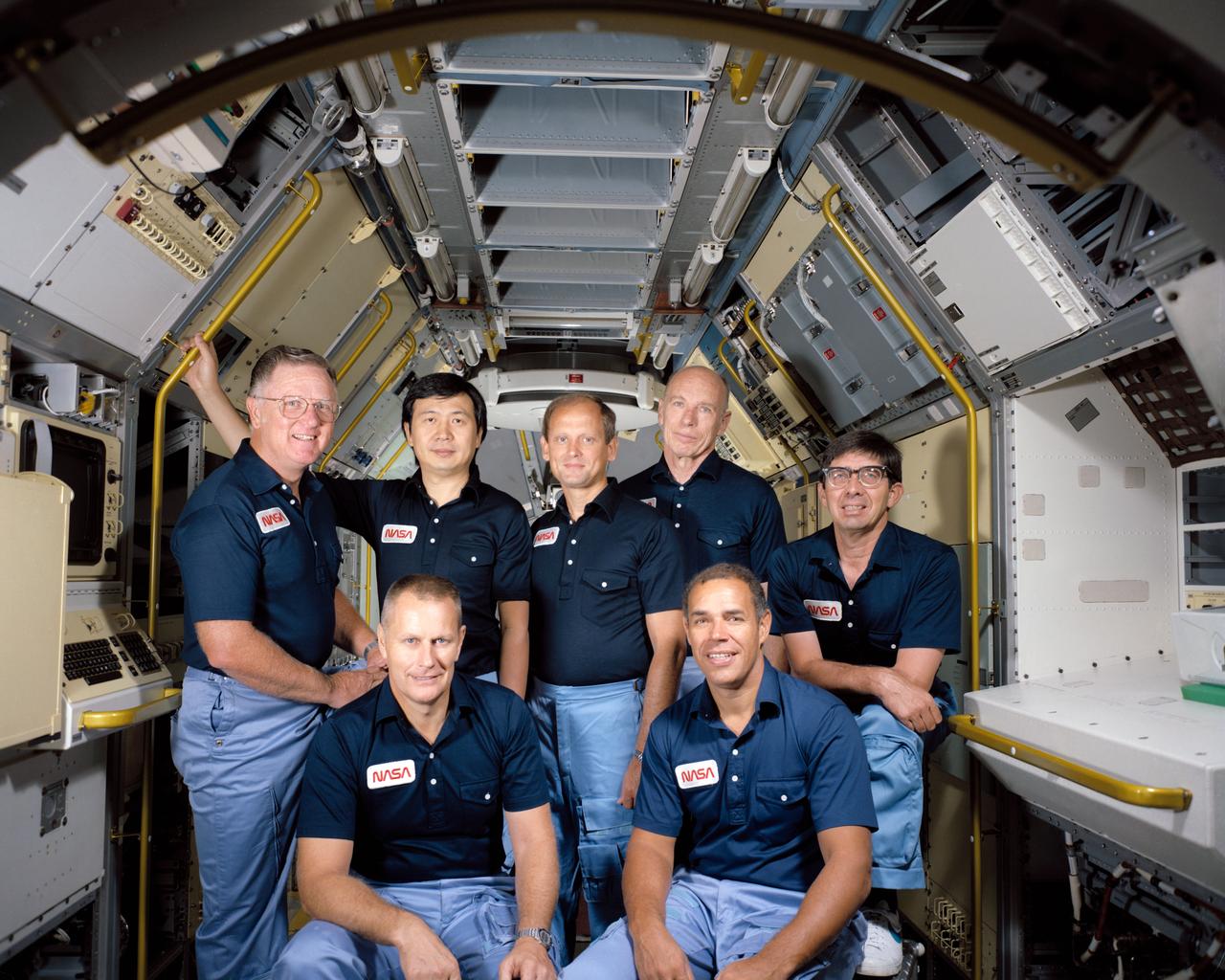
S84-43852 (November 1984) --- These seven men have been training for NASA’s Spacelab 3/STS-51B mission scheduled for launch in late April 1985. On the front row are astronauts Robert F. Overmyer (left), commander; and Frederick D. Gregory, pilot. On the back row, left to right, are Don L. Lind, mission specialist; Taylor G. Wang, payload specialist; Norman E. Thagard and William E. Thornton, both mission specialists; and Lodewijk van den Berg, payload specialist.

Whipped cream and the filling for pumpkin pie are two familiar materials that exhibit the shear-thinning effect seen in a range of industrial applications. It is thick enough to stand on its own atop a piece of pie, yet flows readily when pushed through a tube. This demonstrates the shear-thinning effect that was studied with the Critical Viscosity of Xenon Experiment (CVX-2) on the STS-107 Research 1 mission in 2002. CVX observed the behavior of xenon, a heavy inert gas used in flash lamps and ion rocket engines, at its critical point. The principal investigator was Dr. Robert Berg of the National Institutes of Standards and Technology in Gaithersburg, MD.
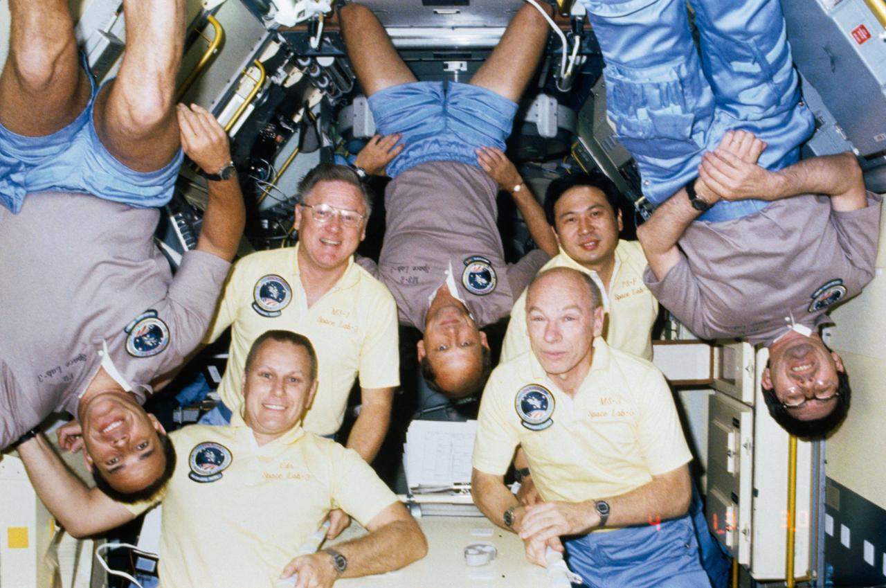
51B-101-025 (29 April-6 May 1985) --- A new twist to the traditional on-orbit group portrait was added by the 51-B/Spacelab 3 crewmembers. Note the Gold T-shirts of ?Gold? team members Robert F. Overmyer (bottom left), Don L. Lind (behind Overmyer), William E. Thornton (bottom right) and Taylor G. Wang (behind Thornton). Posting ?upside down? are ?silver? team members (L-R) Frederick D. Gregory, Norman E. Thagard and Lodewijk van den Berg. The seven are in the Long Science Module for Spacelab 3 in the cargo bay of the earth-orbiting Space Shuttle Challenger.
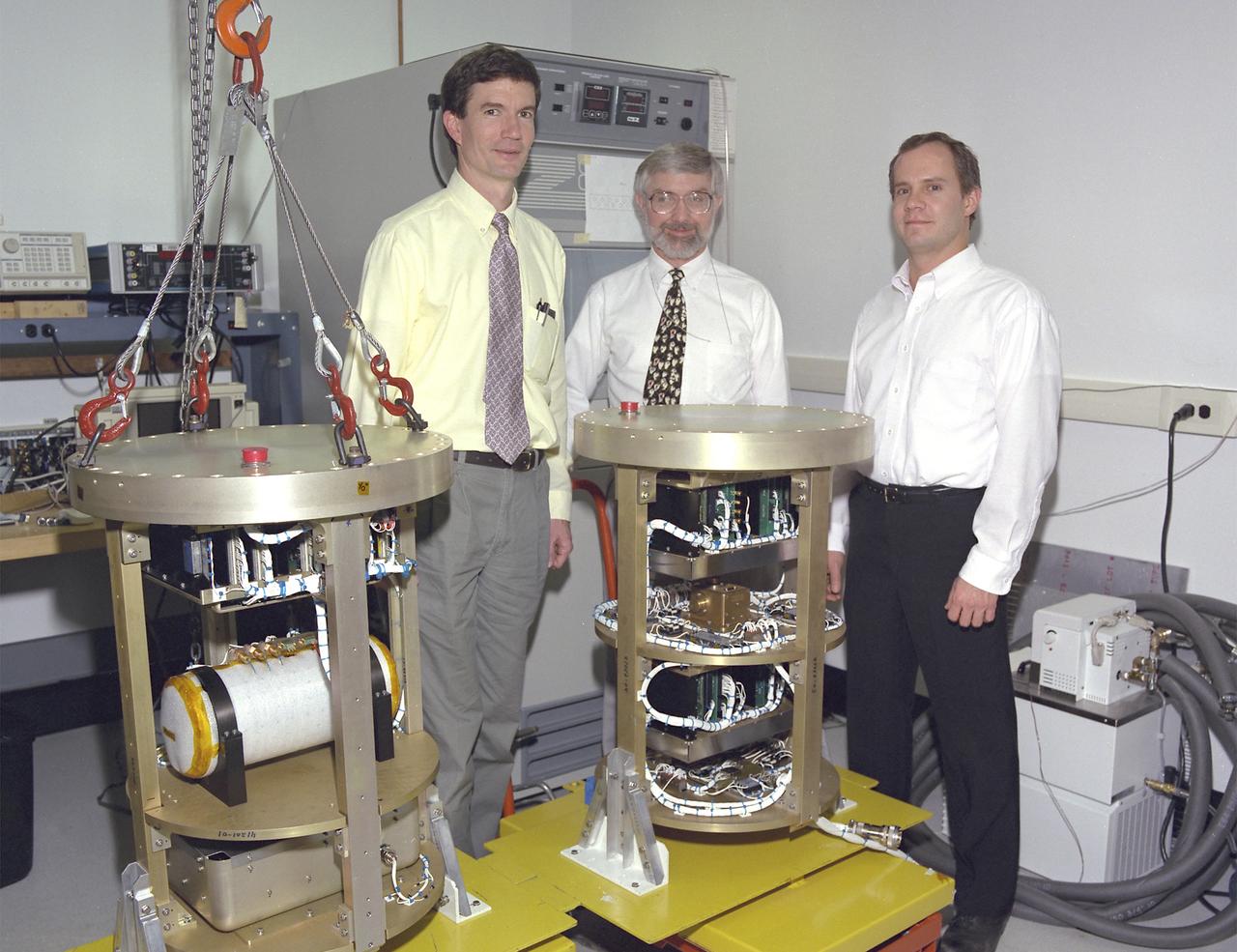
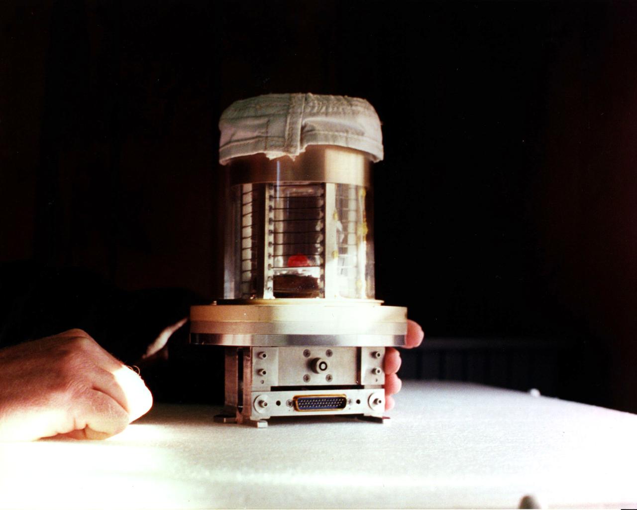
The Critical Viscosity of Xenon Experiment (CVX-2) on the STS-107 Research 1 mission in 2002 will measure the viscous behavior of xenon, a heavy inert gas used in flash lamps and ion rocket engines, at its critical point. The thermostat for CVX sits inside the white cylinder on a support structure (at left) that is placed inside a pressure canister. A similar canister (right) holds the electronics and control systems. The CVX-2 arrangement is identical. The principal investigator is Dr. Robert F. Berg (left) of the National Institutes of Standards and Technology, Gaithersburg, MD.
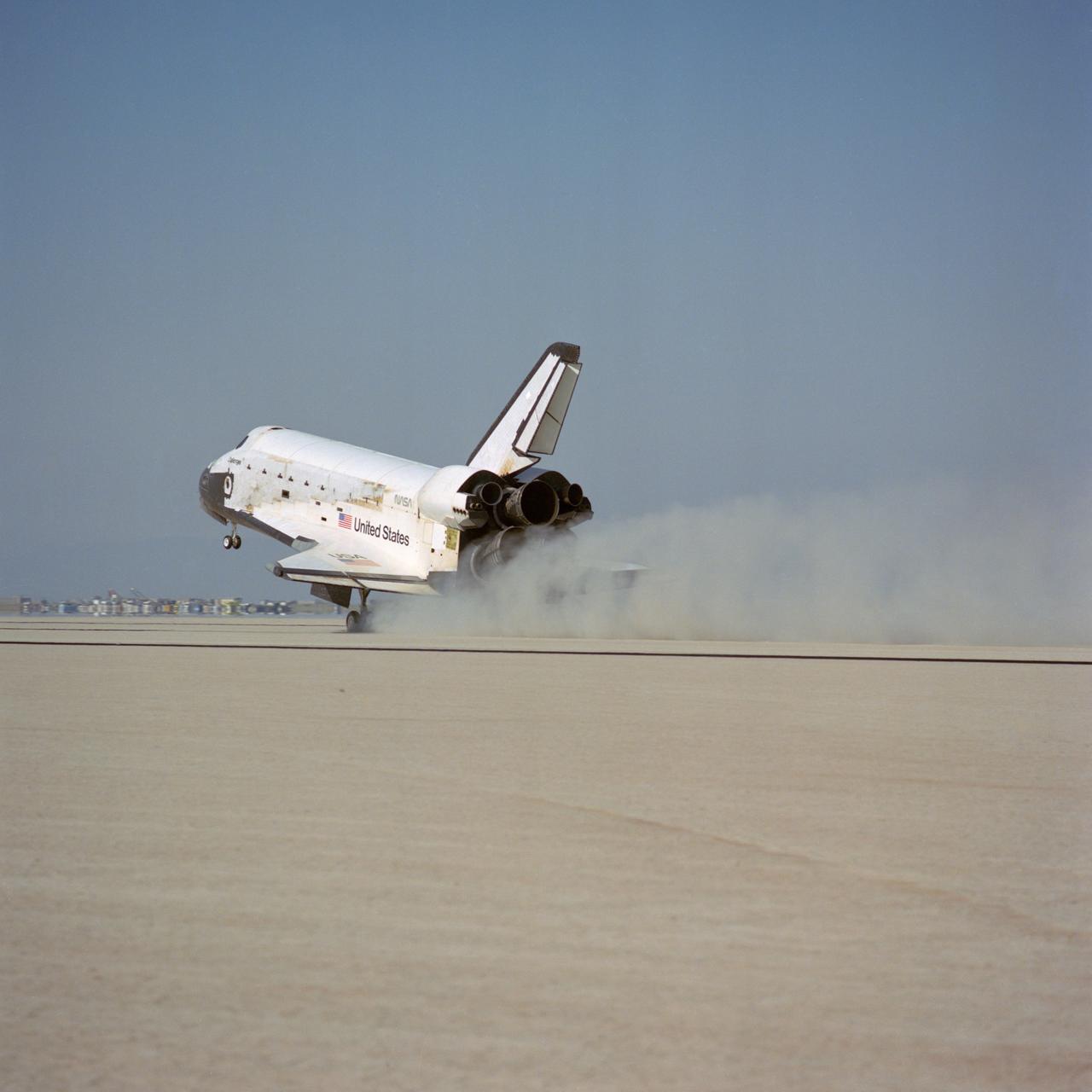
51B-S-071 (6 May 1985) --- The Space Shuttle Challenger lands on Runway 17 at Edwards Air Force Base to complete a week in space for its seven-member crew and a variety of payload. The vehicle stopped at 9:12:05 a.m. (PDT), May 6, 1985. Onboard were astronauts Robert F. Overmyer, Frederick D. Gregory, Don L. Lind, Norman E. Thagard and William E. Thornton of National Aeronautics and Space Administration (NASA); and payload specialists Lodewijk van den Berg and Taylor G. Wang.

A small hole in the clouds revealed newly formed sea ice in the Bellingshausen Sea next to an ice berg on Nov. 5, 2014 flight. Image Credit: NASA/Digital Mapping System NASA’s Operation IceBridge collected some rare images on a flight out of Punta Arenas, Chile on Nov. 5, 2014, on a science flight over western Antarctica dubbed Ferrigno-Alison-Abbott 01. The crew snapped a few shots of a calving front of the Antarctic ice sheet. This particular flight plan was designed to collect data on changes in ice elevation along the coast near the Ferrigno and Alison ice streams, on the Abbot Ice Shelf, and grounded ice along the Eights Coast.
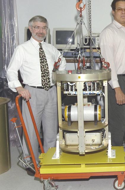
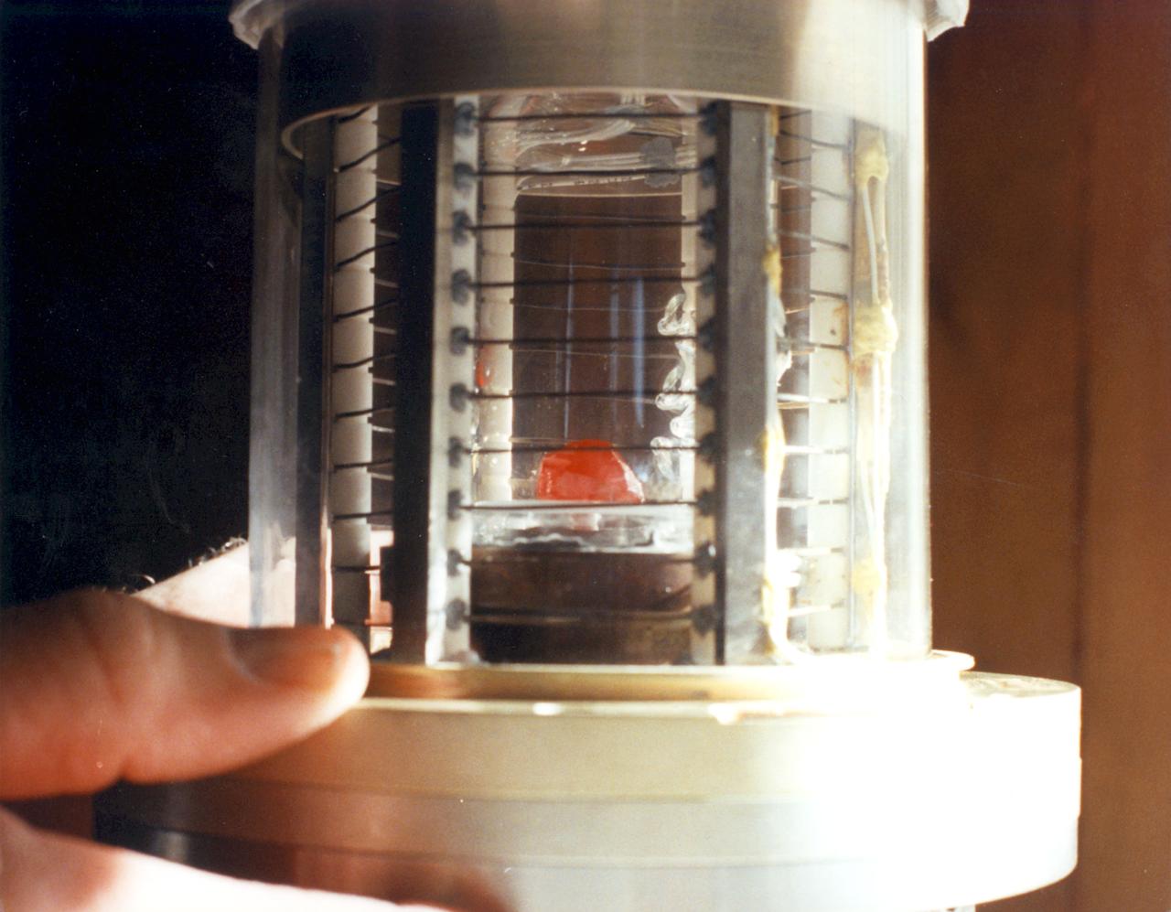
The Critical Viscosity of Xenon Experiment (CVX-2) on the STS-107 Research 1 mission in 2001 will measure the viscous behavior of xenon, a heavy inert gas used in flash lamps and ion rocket engines, at its critical point. The thermostat for CVX sits inside the white cylinder on a support structure that is placed inside a pressure canister. A similar canister holds the electronics and control systems. The CVX-2 arrangement is identical. The principal investigator is Dr. Robert F. Berg (not shown) of the National Institutes of Standards and Technology, Gaithersburg, MD. This is a detail view of MSFC 0100143.
JSC2001-E-11704 (9 April 2001) --- Astronaut James F. Reilly, STS-104 mission specialist, participates in an Extravehicular Mobility Unit (EMU) fit check in one of the chambers in the Crew Systems Laboratory at the Johnson Space Center (JSC). Standing near the doorway are Peggy Berg and Dave Simon, Crew Personnel Representatives (CPR), from the Mission Operations Directorate (MOD) at the Johnson Space Center. The STS-104 mission to the International Space Station (ISS) represents the Space Shuttle Atlantis' first flight using a new engine and is targeted for a liftoff no earlier than June 14, 2001.
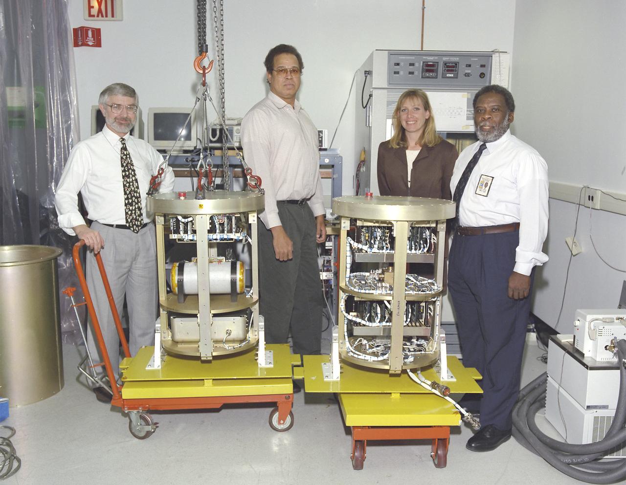
The Critical Viscosity of Xenon Experiment (CVX-2) on the STS-107 Research 1 mission in 2002 will measure the viscous behavior of xenon, a heavy inert gas used in flash lamps and ion rocket engines, at its critical point. The thermostat for CVX sits inside the white cylinder on a support structure (at left) that is placed inside a pressure canister. A similar canister (right) holds the electronics and control systems. The CVX-2 arrangement is identical. The principal investigator is Dr. Robert F. Berg (not shown) of the National Institutes of Standards and Technology, Gaithersburg, MD.
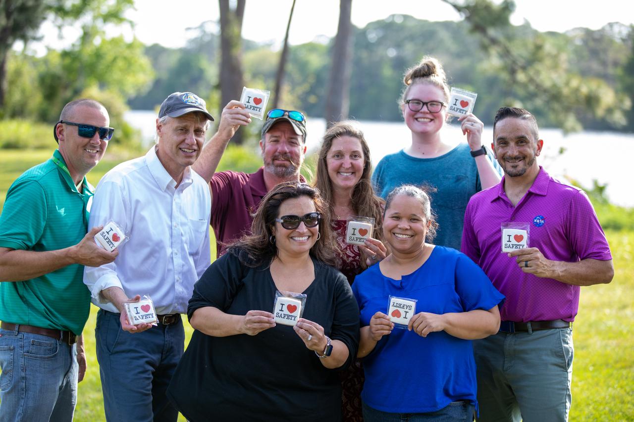
NASA Kennedy Space Center employees are photographed during a Safety and Health Days celebration at the Florida spaceport’s KARS Park II on March 5, 2020. Front row from left are Michele Richtmeyer and Heidi Harden, and back row from left are Phil Falk, Chris Berg, Marcus Chancery, Amber Philman-Blair, Larrin Moody and Dustin Cammack. Taking place March 2 through March 6, Safety and Health Days provides Kennedy employees with a variety of presentations to attend – all of which focus on how to maintain a safe and healthy workforce. The celebration on March 5 took place at the spaceport’s KARS Park II and was open for all employees to attend.
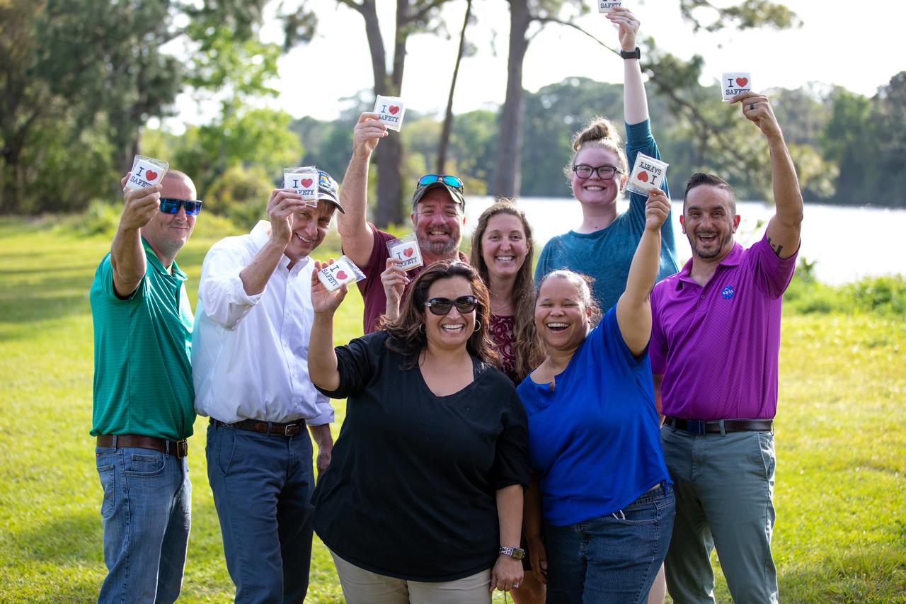
NASA Kennedy Space Center employees are photographed during a Safety and Health Days celebration at the Florida spaceport’s KARS Park II on March 5, 2020. Front row from left are Michele Richtmeyer and Heidi Harden, and back row from left are Phil Falk, Chris Berg, Marcus Chancery, Amber Philman-Blair, Larrin Moody and Dustin Cammack. Taking place March 2 through March 6, Safety and Health Days provides Kennedy employees with a variety of presentations to attend – all of which focus on how to maintain a safe and healthy workforce. The celebration on March 5 took place at the spaceport’s KARS Park II and was open for all employees to attend.

For five years, Jeremy Harbeck has worked as a support scientist for NASA’s Operation IceBridge, an airborne mission to study polar ice. The data processing that he does typically takes place in an office at NASA’s Goddard Space Flight Center in Maryland. However, to speed the process of delivering data to the Arctic sea ice forecasting community, Harbeck traveled to Greenland for the first time in spring 2015. He had just arrived at Greenland’s Thule Air Base on March 20 when a mechanical issue grounded the aircraft. No science flight could happen for a few days. As teams in the United States and Greenland scrambled to locate and deliver a replacement part, researchers on the ground waited. Some of them hiked to what was locally known as “the iceberg.” The unnamed berg pictured above has been frozen in place by sea ice in North Star Bay. Harbeck shot the photograph—a composite of four 49-second images—on March 21 at about 2:30 a.m. local time. The sun never fully sets at this time of year in the Arctic, so sunlight appears on the left side of the image. Lights from Thule are visible on the right side. Look for the Milky Way (top left) and a few very faint meteors visible in the early morning sky. Harbeck left the dock at Thule with sea ice scientist (and current IceBridge project scientist) Nathan Kurtz and a local recreation officer at about 10 p.m. From there, the group hiked 2.4 kilometers (1.5 miles) across the still-thick sea ice in weather that Harbeck called a “pleasant” minus 18 degrees Celsius (0 degrees Fahrenheit). They paused frequently on the way, and they even circled the berg to check for polar bears. “You don’t have a sense of scale of this berg until you get up to it,” Harbeck said. “It’s about the size of my apartment building, and that’s only the part protruding from the water.” Assuming the berg is ungrounded (which is uncertain), about one-tenth of its mass is above water. Photograph by Jeremy Harbeck, support scientist for NASA's Operation IceBridge mission. Caption by Kathryn Hansen. Credit: <b><a href="http://www.earthobservatory.nasa.gov/" rel="nofollow"> NASA Earth Observatory</a></b> <b><a href="http://www.nasa.gov/audience/formedia/features/MP_Photo_Guidelines.html" rel="nofollow">NASA image use policy.</a></b> <b><a href="http://www.nasa.gov/centers/goddard/home/index.html" rel="nofollow">NASA Goddard Space Flight Center</a></b> enables NASA’s mission through four scientific endeavors: Earth Science, Heliophysics, Solar System Exploration, and Astrophysics. Goddard plays a leading role in NASA’s accomplishments by contributing compelling scientific knowledge to advance the Agency’s mission. <b>Follow us on <a href="http://twitter.com/NASAGoddardPix" rel="nofollow">Twitter</a></b> <b>Like us on <a href="http://www.facebook.com/pages/Greenbelt-MD/NASA-Goddard/395013845897?ref=tsd" rel="nofollow">Facebook</a></b> <b>Find us on <a href="http://instagrid.me/nasagoddard/?vm=grid" rel="nofollow">Instagram</a></b>
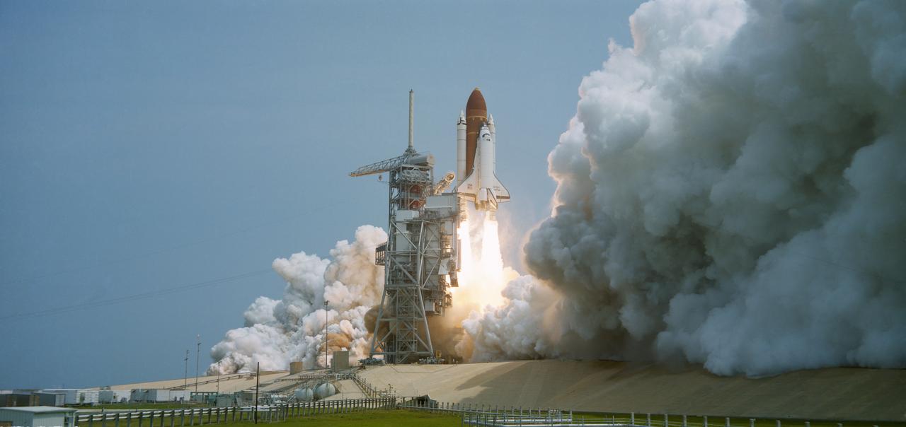
51B-S-052 (20 April 1985) --- The STS 51-B Spacelab 3 mission begins with the liftoff of the Challenger from Pad 39A at 12:02 p.m. (EDT). The Spacelab-3 configuration consists of a long module and a Mission Experiment Support Structure (MPESS). The object of the mission is to conduct applications, science and technology-oriented experimentation requiring the low-gravity of Earth orbit and extended duration stable vehicle attitude. Mission emphasis will be on materials processing. The seven-member crew consists of astronauts Robert F Overmyer, commander; Frederick D. Gregory, pilot; Don L. Lind, Norman E. Thagard and William E. Thornton; all mission specialists and payload specialists Taylor G. Wang and Lodewijk van den Berg. The mission is planned for 7 days with a landing at Dryden Flight Research Facility, Edwards California scheduled for May 6.
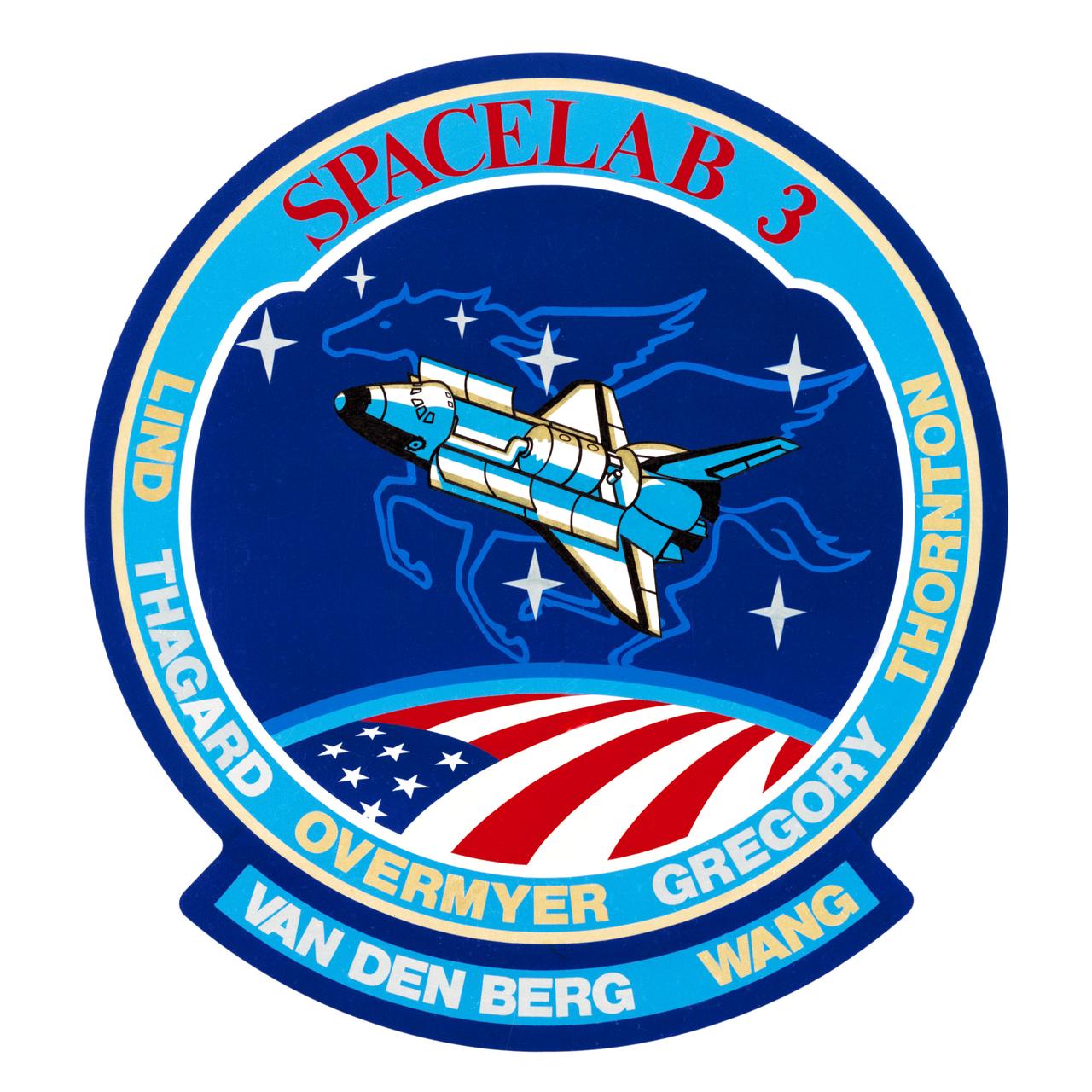
S84-44372 (December 1984) --- The space shuttle Discovery and its science module payload are featured in the insignia for the STS-51B/Spacelab 3 mission. The seven stars of the constellation Pegasus surround the orbiting spaceship above the flag draped Earth. Surnames of the seven crew members encircle the scene. Crew members are astronauts Robert F. Overmyer, Frederick D. Gregory, Don L. Lind, Norman E. Thagard and William E. Thornton; and payload specialists Lodewijk van den Berg and Taylor G. Wang. The artwork was done by Carol Ann Lind. The NASA insignia design for space shuttle flights is reserved for use by the astronauts and for other official use as the NASA Administrator may authorize. Public availability has been approved only in the forms of illustrations by the various news media. When and if there is any change in this policy, which is not anticipated, the change will be publicly announced. Photo credit: NASA
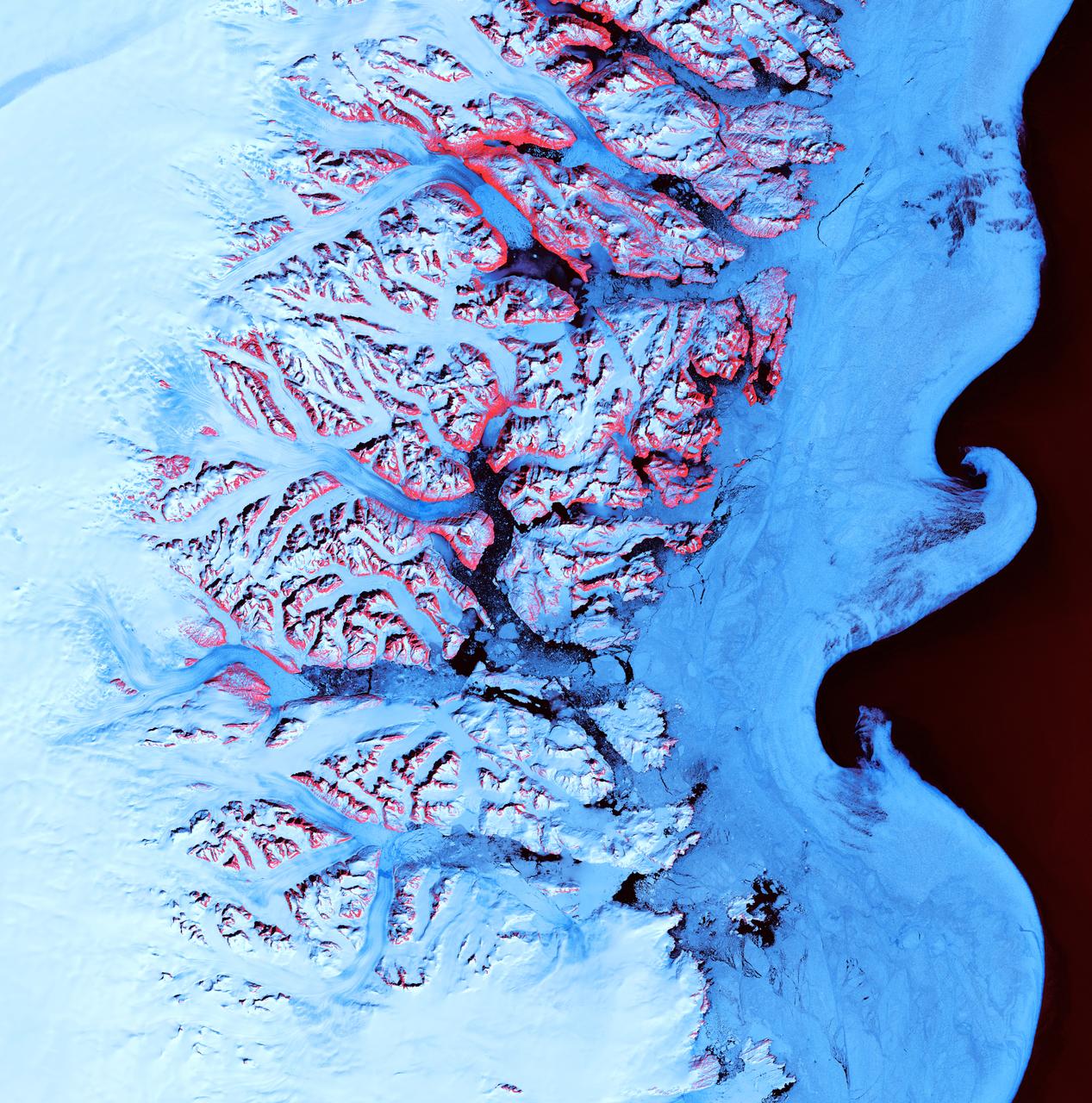
The College Fjord with its glaciers was imaged by ASTER on June 24, 2000. This image covers an area 20 kilometers (13 miles) wide and 24 kilometers (15 miles) long in three bands of the reflected visible and infrared wavelength region. College Fjord is located in Prince Williams Sound, east of Seward, Alaska. Vegetation is in red, and snow and ice are white and blue. Ice bergs calved off of the glaciers can be seen as white dots in the water. At the head of the fjord, Harvard Glacier (left) is one of the few advancing glaciers in the area; dark streaks on the glacier are medial moraines: rock and dirt that indicate the incorporated margins of merging glaciers. Yale Glacier to the right is retreating, exposing (now vegetated) bedrock where once there was ice. On the west edge of the fjord, several small glaciers enter the water. This fjord is a favorite stop for cruise ships plying Alaska's inland passage. This image is located at 61.2 degrees north latitude and 147.7 degrees west longitude. http://photojournal.jpl.nasa.gov/catalog/PIA02664
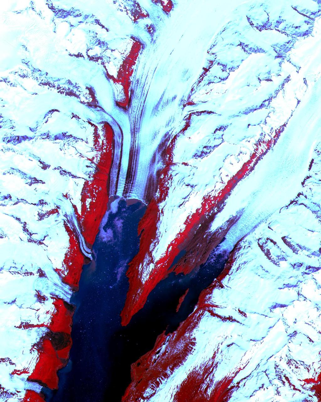
Ice Waves - May 21st, 2001 Description: Along the southeastern coast of Greenland, an intricate network of fjords funnels glacial ice to the Atlantic Ocean. During the summer melting season, newly calved icebergs join slabs of sea ice and older, weathered bergs in an offshore slurry that the southward-flowing East Greenland Current sometimes swirls into stunning shapes. Exposed rock of mountain peaks, tinted red in this image, hints at a hidden landscape. Credit: USGS/NASA/Landsat 7 To learn more about the Landsat satellite go to: <a href="http://landsat.gsfc.nasa.gov/" rel="nofollow">landsat.gsfc.nasa.gov/</a> <b><a href="http://www.nasa.gov/centers/goddard/home/index.html" rel="nofollow">NASA Goddard Space Flight Center</a></b> enables NASA’s mission through four scientific endeavors: Earth Science, Heliophysics, Solar System Exploration, and Astrophysics. Goddard plays a leading role in NASA’s accomplishments by contributing compelling scientific knowledge to advance the Agency’s mission. <b>Follow us on <a href="http://twitter.com/NASA_GoddardPix" rel="nofollow">Twitter</a></b> <b>Join us on <a href="http://www.facebook.com/pages/Greenbelt-MD/NASA-Goddard/395013845897?ref=tsd" rel="nofollow">Facebook</a></b>
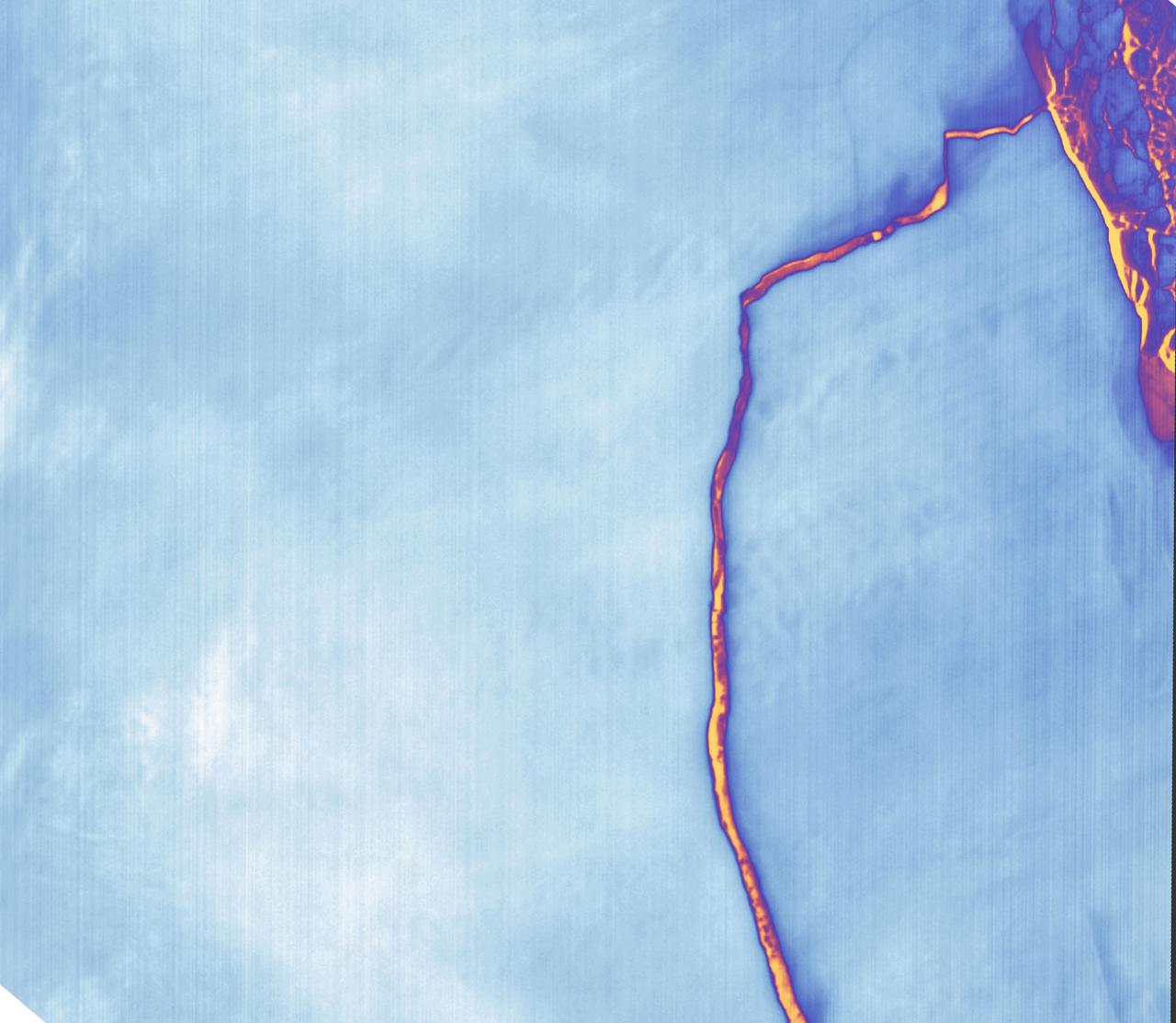
Sometime between July 10 and July 12, an iceberg about the size of Delaware split off from Antarctica’s Larsen C ice shelf. Now that nearly 5,800 square kilometers (2,200 square miles) of ice has broken away, the Larsen C shelf area has shrunk by approximately 10 percent. This false-color image was captured by Landsat’s Thermal Infrared Sensor (TIRS). It shows the relative warmth or coolness of the landscape. Orange indicates where the surface is the warmest, most notably the mélange between the new berg and the ice shelf. Light blues and whites are the coldest areas, including the ice shelf and the iceberg. On July 13, the U.S. National Ice Center issued a press release confirming the new iceberg and officially naming it A-68. Credit: NASA Earth Observatory images by Joshua Stevens, using Landsat data from the U.S. Geological Survey <b><a href="http://www.nasa.gov/audience/formedia/features/MP_Photo_Guidelines.html" rel="nofollow">NASA image use policy.</a></b> <b><a href="http://www.nasa.gov/centers/goddard/home/index.html" rel="nofollow">NASA Goddard Space Flight Center</a></b> enables NASA’s mission through four scientific endeavors: Earth Science, Heliophysics, Solar System Exploration, and Astrophysics. Goddard plays a leading role in NASA’s accomplishments by contributing compelling scientific knowledge to advance the Agency’s mission. <b>Follow us on <a href="http://twitter.com/NASAGoddardPix" rel="nofollow">Twitter</a></b> <b>Like us on <a href="http://www.facebook.com/pages/Greenbelt-MD/NASA-Goddard/395013845897?ref=tsd" rel="nofollow">Facebook</a></b> <b>Find us on <a href="http://instagrid.me/nasagoddard/?vm=grid" rel="nofollow">Instagram</a></b>
As Antarctica remains shrouded in darkness during the Southern Hemisphere winter, the Thermal Infrared Sensor (TIRS) on Landsat 8 captured a new snap of the 2,240-square-mile iceberg that split off from the Antarctic Peninsula’s Larsen C ice shelf on July 10-12. The satellite imagery is a composite of Landsat 8 as it past on July 14 and July 21 and shows that the main berg, A-68, has already lost several smaller pieces. The A-68 iceberg is being carried by currents northward out of its embayment on the Larsen C ice shelf. The latest imagery also details a group of three small, not yet released icebergs at the north end of the embayment. Credits: NASA Goddard/UMBC JCET, Christopher A. Shuman <b><a href="http://www.nasa.gov/audience/formedia/features/MP_Photo_Guidelines.html" rel="nofollow">NASA image use policy.</a></b> <b><a href="http://www.nasa.gov/centers/goddard/home/index.html" rel="nofollow">NASA Goddard Space Flight Center</a></b> enables NASA’s mission through four scientific endeavors: Earth Science, Heliophysics, Solar System Exploration, and Astrophysics. Goddard plays a leading role in NASA’s accomplishments by contributing compelling scientific knowledge to advance the Agency’s mission. <b>Follow us on <a href="http://twitter.com/NASAGoddardPix" rel="nofollow">Twitter</a></b> <b>Like us on <a href="http://www.facebook.com/pages/Greenbelt-MD/NASA-Goddard/395013845897?ref=tsd" rel="nofollow">Facebook</a></b> <b>Find us on <a href="http://instagrid.me/nasagoddard/?vm=grid" rel="nofollow">Instagram</a></b>

Antarctica—the continent at the southernmost reach of the planet—is fringed by cold, often frozen waters of the Southern Ocean. The extent of sea ice around the continent typically reaches a peak in September and a minimum in February. The photograph above shows Antarctic sea ice on November 5, 2014, during the annual cycle of melt. The image was acquired by the Digital Mapping System (DMS), a digital camera installed in the belly of research aircraft to capture images of terrain below. In this case, the system flew on the DC-8 during a flight as part of NASA’s Operation IceBridge. Most of the view shows first-year sea ice in the Bellingshausen Sea, as it appeared from an altitude of 328 meters (1,076 feet). The block of ice on the right side of the image is older, thicker, and was once attached to the Antarctic Ice Sheet. By the time this image was acquired, however, the ice had broken away to form an iceberg. Given its close proximity to the ice sheet, this could have been a relatively new berg. Read more: <a href="http://earthobservatory.nasa.gov/IOTD/view.php?id=86721" rel="nofollow">earthobservatory.nasa.gov/IOTD/view.php?id=86721</a> Credit: NASA/Goddard/IceBridge DMS L0 Raw Imagery courtesy of the Digital Mapping System (DMS) team and the NASA DAAC at the National Snow and Ice Data Center Credit: <b><a href="http://www.earthobservatory.nasa.gov/" rel="nofollow"> NASA Earth Observatory</a></b> <b><a href="http://www.nasa.gov/audience/formedia/features/MP_Photo_Guidelines.html" rel="nofollow">NASA image use policy.</a></b> <b><a href="http://www.nasa.gov/centers/goddard/home/index.html" rel="nofollow">NASA Goddard Space Flight Center</a></b> enables NASA’s mission through four scientific endeavors: Earth Science, Heliophysics, Solar System Exploration, and Astrophysics. Goddard plays a leading role in NASA’s accomplishments by contributing compelling scientific knowledge to advance the Agency’s mission. <b>Follow us on <a href="http://twitter.com/NASAGoddardPix" rel="nofollow">Twitter</a></b> <b>Like us on <a href="http://www.facebook.com/pages/Greenbelt-MD/NASA-Goddard/395013845897?ref=tsd" rel="nofollow">Facebook</a></b> <b>Find us on <a href="http://instagrid.me/nasagoddard/?vm=grid" rel="nofollow">Instagram</a></b>