
NASA Phoenix Mars Lander parachuted for nearly three minutes as it descended through the Martian atmosphere on May 25, 2008. Extensive preparations for that crucial period included this drop test near Boise, Idaho, in October 2006.

iss054e037647 (Feb. 8, 2018) --- NASA astronauts (from left) Joe Acaba, Mark Vande Hei and Scott Tingle talk to high school students and teachers who linked up to the International Space Station during a STEM (Science, Technology, Engineering and Mathematics) event from the Boise State University in Boise, Idaho.
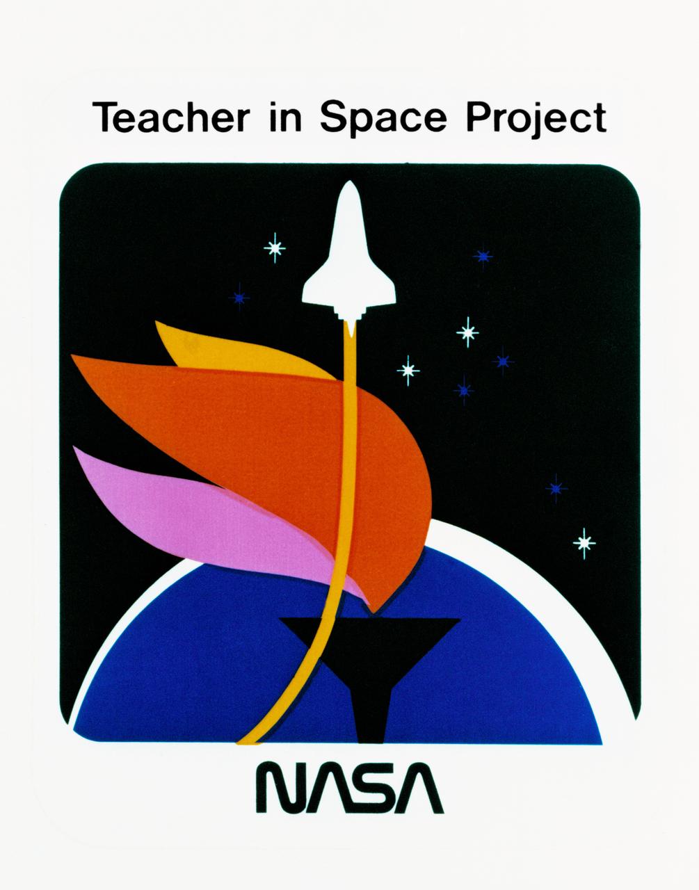
S85-38312 (September 1985) --- Logo designed for use by the 10 finalists in NASA’s Teacher in Space Project, who were at JSC for training and orientation the week of July 8–12, 1985. They are David M. Marquart, Boise High, Boise, Idaho; Michael W. Metcalf, Hazen Union School, Hardwick, Vermont; Judith Marie Garcia, Thomas Jefferson School for Science and Technology, Alexandria, Virginia; Peggy J. Lathlaen, Westwood Elementary, Friendswood, Texas; Niki Mason Wenger, Vandevender Junior High, Parkersburg, West Virginia; Barbara R. Morgan, McCall-Donnelly Elementary, McCall, Idaho; Kathleen Anne Beres, Kenwood High, Baltimore, Maryland; Richard A. Methia, New Bedford High, New Bedford, Mass.; Sharon Christa McAuliffe, Concord High, Concord, New Hampshire; and Robert S. Foerster, Cumberland Elementary School, West Lafayette, Indiana. Photo credit: NASA

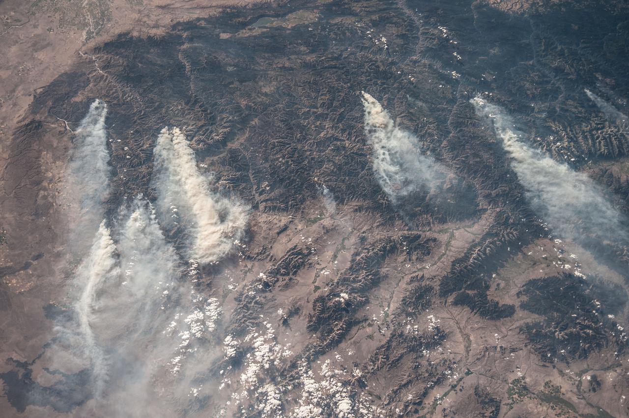
ISS032-E-024687 (3 Sept. 2012) --- Idaho fires are featured in this image photographed by an Expedition 32 crew member on the International Space Station. Taken with a short lens (45 mm), this west-looking photograph has a field of view covering much of the forested region of central Idaho. The dark areas are all wooded mountains—the Salmon River Mountains (left), Bitterroot Mountains (lower right) and Clearwater Mountains (right). All three areas experienced wildfires in September 2012—this image illustrates the situation early in the month. Smaller fire ‘complexes” appear as tendrils of smoke near the sources (e.g. Halstead complex at left), and as major white smoke plumes from the Mustang fire complex in the densest forests (darkest green, center) of the Clearwater Mountains. This was the largest plume noted in the region with thick smoke blowing eastward over the Beaverhead Mountains at bottom. The linear shape of the smoke plumes gives a sense of the generally eastward smoke transport on this day in early September. The smoke distribution shows another kind of transport: at night, when winds are weak, cooling of the atmosphere near the ground causes drainage of cooled (denser) air down into the major valleys. Here the smoke can be seen flowing west down into the narrow Salmon and Lochsa River valleys (at a local time of 12:18:50 p.m.) – in the opposite direction to the higher winds and the thick smoke masses. The bright yellow-tan areas at top left and top right contrasting with the mountains are grasslands of the Snake River in southern Idaho around Boise, and the Palouse region in western Idaho–SE Washington state. This latter area is known to ecologists as the Palouse Grasslands Ecoregion. Light green areas visible in the center of many of the valleys are agricultural crops including barley, alfalfa, and wheat. The image also shows several firsts of which Idaho can boast. The Snake River between Boise and the Palouse region has cut Hells Canyon (top), the deepest gorge in the U.S. at almost 2,436 meters (8,000 feet). The largest single wilderness area in the contiguous U.S., the Frank Church-River of No Return Wilderness occupies the wooded zones of the Salmon River Mountains and the Clearwater Mountains, i.e. most of the area shown in the middle of the image. Idaho’s highest peak is Borah Peak (lower left) at 3,860 meters above sea level (12,662 feet ASL). The Continental Divide cuts through the bottom of the image—rivers on the eastern slopes of the Beaverhead Mountains drain to the Atlantic Ocean, whereas rivers in the rest of the area drain to the Pacific Ocean.
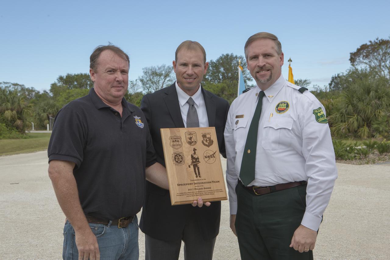
From left, Jon Wallace, deputy fire coordinator, U.S. Fish and Wildlife Service Southeast Region, Atlanta, Georgia; Chris Wilcox, U.S. Fish and Wildlife chief, Fire Management, National Interagency Fire Center, Boise, Idaho; and John Fish, chief, Florida Forest Service, pose for a portrait following a ceremony Nov. 1 on the Merritt Island National Wildlife Refuge in Florida. During the joint ceremony, the Spaceport Integration Team and its partners were presented with the prestigious 2017 Pulaski Award and a new memorial marker was dedicated. The multi-agency team includes representatives from NASA's Kennedy Space Center, Cape Canaveral Air Force Station's 45th Space Wing, the Merritt Island National Wildlife Refuge, as well as the Florida Forest Service and Brevard County Fire Rescue. The memorial marker honors two fallen firefighters, Scott Maness and Beau Sauselein, who died fighting a wildfire on space center property in 1981. Held outdoors, the ceremony was attended by 140 guests.
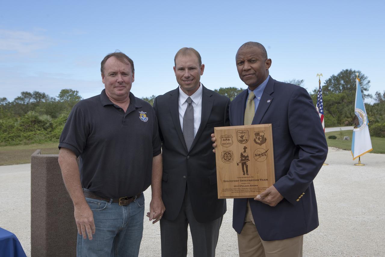
From left, Jon Wallace, deputy fire coordinator, U.S. Fish and Wildlife Service Southeast Region, Atlanta, Georgia; Chris Wilcox, U.S. Fish and Wildlife chief, Fire Management, National Interagency Fire Center, Boise, Idaho; and Kelvin Manning, associate director, NASA's Kennedy Space Center, pose for a portrait following a ceremony Nov. 1 on the Merritt Island National Wildlife Refuge in Florida. During the joint ceremony, the Spaceport Integration Team and its partners were presented with the prestigious 2017 Pulaski Award and a new memorial marker was dedicated. The multi-agency team includes representatives from NASA's Kennedy Space Center, Cape Canaveral Air Force Station's 45th Space Wing, the Merritt Island National Wildlife Refuge, as well as the Florida Forest Service and Brevard County Fire Rescue. The memorial marker honors two fallen firefighters, Scott Maness and Beau Sauselein, who died fighting a wildfire on space center property in 1981. Held outdoors, the ceremony was attended by 140 guests.
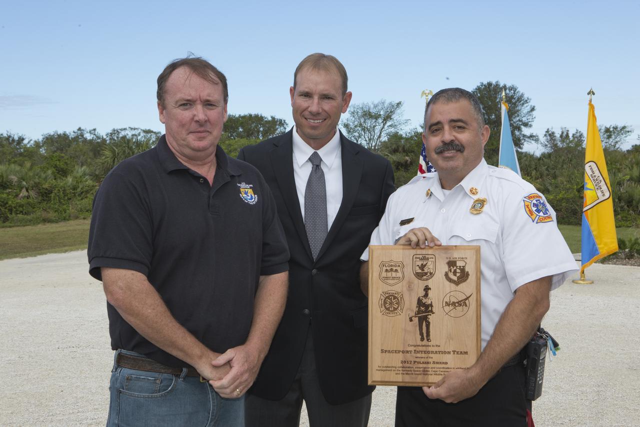
From left, Jon Wallace, deputy fire coordinator, U.S. Fish and Wildlife Service Southeast Region, Atlanta, Georgia; Chris Wilcox, U.S. Fish and Wildlife chief, Fire Management, National Interagency Fire Center, Boise, Idaho; and Mark Schollmeyer, chief, Brevard County Fire Rescue, pose for a portrait following a ceremony Nov. 1 on the Merritt Island National Wildlife Refuge in Florida. During the joint ceremony, the Spaceport Integration Team and its partners were presented with the prestigious 2017 Pulaski Award and a new memorial marker was dedicated. The multi-agency team includes representatives from NASA's Kennedy Space Center, Cape Canaveral Air Force Station's 45th Space Wing, the Merritt Island National Wildlife Refuge, as well as the Florida Forest Service and Brevard County Fire Rescue. The memorial marker honors two fallen firefighters, Scott Maness and Beau Sauselein, who died fighting a wildfire on space center property in 1981. Held outdoors, the ceremony was attended by 140 guests.
ISS036-E-032853 (18 Aug. 2013) --- Central Idaho wildfires are featured in this image photographed by an Expedition 36 crew member on the International Space Station. Taken with a short lens (50 mm), this west-looking image covers much of forested central Idaho?the dark areas are all wooded mountains. The image highlights part of the largest single wilderness area in the contiguous United States (the Frank Church-River of No Return Wilderness). Within this mountainous region, several fires can be seen producing extensive smoke plumes. Some fires had been named by Aug. 20, 2013, two days after the image was taken. The densest smoke on that day appears to be generated by a combination of the Little Queens and Leggit fires (left, within the Salmon River Mountains). The named fires were mostly set by lightning, and on Aug. 20 totaled 53,000 acres of burned forest south of the Salmon River, and many more if the unnamed fires are included. The Gold Pan fire north of the Salmon River had burned 27,000 acres. For a sense of scale in this oblique view, the Gold Pan fire lies about 125 miles north of the Little Queens fire. This image shows the common pattern of westerly winds transporting smoke in an easterly direction, as seen during the wildfire season of one year ago. Ten days before this image was taken, fires in central Idaho near Boise were aggravated by southerly winds. Some of the fires began to burn in July but were quelled and remain under observation for new flare-ups. Smoke from fires in the south partly obscures the black lava flows of the Craters of the Moon National Monument (lower left). The Beaverhead Mountains mark the eastern boundary of Idaho with Montana.
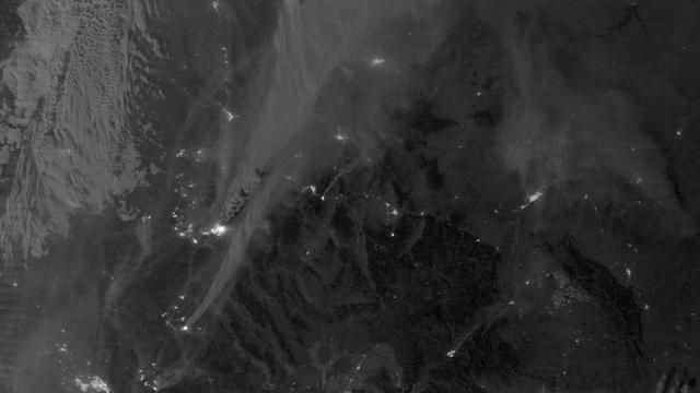
On August 29, 2012, the Visible Infrared Imaging Radiometer Suite (VIIRS) on the Suomi NPP satellite captured this nighttime view of wildfires burning in Idaho and Montana. The image was captured by the VIIRS “day-night band,” which detects light in a range of wavelengths from green to near-infrared and uses filtering techniques to observe signals such as gas flares, auroras, wildfires, city lights, and reflected moonlight. When the image was acquired, the moon was in its waxing gibbous phase, meaning it was more than half-lit, but less than full. Numerous hot spots from the Mustang Complex Fire are visible in northern Idaho. A plume of thick, billowing smoke streams west from the brightest fires near the Idaho-Montana border. The Halstead and Trinity Ridge fires are visible to the south. In addition to the fires, city lights from Boise and other smaller cities appear throughout the image. A bank of clouds is located west of the Mustang Complex, over southeastern Washington and northeastern Oregon. The Operational Line System (OLS)—an earlier generation of night-viewing sensors on the U.S. Defense Meteorological Satellite Program (DMSP) satellites—was also capable of detecting fires at night. But the VIIRS “day-night band” is far better than OLS at resolving them. Each pixel of an VIIRS image shows roughly 740 meters (0.46 miles), compared to the 3-kilometer footprint (1.86 miles) on the OLS system. NASA Earth Observatory image by Jesse Allen and Robert Simmon, using VIIRS Day-Night Band data from the Suomi National Polar-orbiting Partnership. Suomi NPP is the result of a partnership between NASA, the National Oceanic and Atmospheric Administration, and the Department of Defense. Caption by Adam Voiland. Instrument: Suomi NPP - VIIRS Credit: <b><a href="http://www.earthobservatory.nasa.gov/" rel="nofollow"> NASA Earth Observatory</a></b> <b>Click here to view all of the <a href="http://earthobservatory.nasa.gov/Features/NightLights/" rel="nofollow"> Earth at Night 2012 images </a></b> <b>Click here to <a href="http://earthobservatory.nasa.gov/NaturalHazards/view.php?id=79754" rel="nofollow"> read more </a> about this image </b> <b><a href="http://www.nasa.gov/audience/formedia/features/MP_Photo_Guidelines.html" rel="nofollow">NASA image use policy.</a></b> <b><a href="http://www.nasa.gov/centers/goddard/home/index.html" rel="nofollow">NASA Goddard Space Flight Center</a></b> enables NASA’s mission through four scientific endeavors: Earth Science, Heliophysics, Solar System Exploration, and Astrophysics. Goddard plays a leading role in NASA’s accomplishments by contributing compelling scientific knowledge to advance the Agency’s mission. <b>Follow us on <a href="http://twitter.com/NASA_GoddardPix" rel="nofollow">Twitter</a></b> <b>Like us on <a href="http://www.facebook.com/pages/Greenbelt-MD/NASA-Goddard/395013845897?ref=tsd" rel="nofollow">Facebook</a></b> <b>Find us on <a href="http://instagram.com/nasagoddard?vm=grid" rel="nofollow">Instagram</a></b>
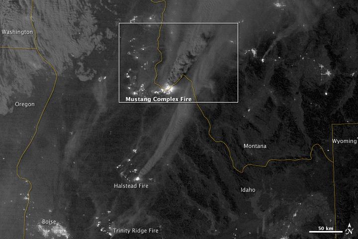
On August 29, 2012, the Visible Infrared Imaging Radiometer Suite (VIIRS) on the Suomi NPP satellite captured this nighttime view of wildfires burning in Idaho and Montana. The image was captured by the VIIRS “day-night band,” which detects light in a range of wavelengths from green to near-infrared and uses filtering techniques to observe signals such as gas flares, auroras, wildfires, city lights, and reflected moonlight. When the image was acquired, the moon was in its waxing gibbous phase, meaning it was more than half-lit, but less than full. Numerous hot spots from the Mustang Complex Fire are visible in northern Idaho. A plume of thick, billowing smoke streams west from the brightest fires near the Idaho-Montana border. The Halstead and Trinity Ridge fires are visible to the south. In addition to the fires, city lights from Boise and other smaller cities appear throughout the image. A bank of clouds is located west of the Mustang Complex, over southeastern Washington and northeastern Oregon. The Operational Line System (OLS)—an earlier generation of night-viewing sensors on the U.S. Defense Meteorological Satellite Program (DMSP) satellites—was also capable of detecting fires at night. But the VIIRS “day-night band” is far better than OLS at resolving them. Each pixel of an VIIRS image shows roughly 740 meters (0.46 miles), compared to the 3-kilometer footprint (1.86 miles) on the OLS system. NASA Earth Observatory image by Jesse Allen and Robert Simmon, using VIIRS Day-Night Band data from the Suomi National Polar-orbiting Partnership. Suomi NPP is the result of a partnership between NASA, the National Oceanic and Atmospheric Administration, and the Department of Defense. Caption by Adam Voiland. Instrument: Suomi NPP - VIIRS Credit: <b><a href="http://www.earthobservatory.nasa.gov/" rel="nofollow"> NASA Earth Observatory</a></b> <b>Click here to view all of the <a href="http://earthobservatory.nasa.gov/Features/NightLights/" rel="nofollow"> Earth at Night 2012 images </a></b> <b>Click here to <a href="http://earthobservatory.nasa.gov/NaturalHazards/view.php?id=79754" rel="nofollow"> read more </a> about this image </b> <b><a href="http://www.nasa.gov/audience/formedia/features/MP_Photo_Guidelines.html" rel="nofollow">NASA image use policy.</a></b> <b><a href="http://www.nasa.gov/centers/goddard/home/index.html" rel="nofollow">NASA Goddard Space Flight Center</a></b> enables NASA’s mission through four scientific endeavors: Earth Science, Heliophysics, Solar System Exploration, and Astrophysics. Goddard plays a leading role in NASA’s accomplishments by contributing compelling scientific knowledge to advance the Agency’s mission. <b>Follow us on <a href="http://twitter.com/NASA_GoddardPix" rel="nofollow">Twitter</a></b> <b>Like us on <a href="http://www.facebook.com/pages/Greenbelt-MD/NASA-Goddard/395013845897?ref=tsd" rel="nofollow">Facebook</a></b> <b>Find us on <a href="http://instagram.com/nasagoddard?vm=grid" rel="nofollow">Instagram</a></b>
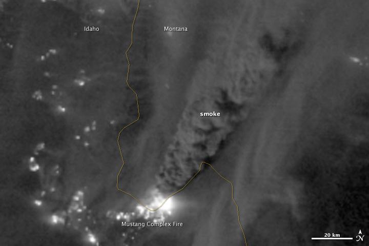
On August 29, 2012, the Visible Infrared Imaging Radiometer Suite (VIIRS) on the Suomi NPP satellite captured this nighttime view of wildfires burning in Idaho and Montana. The image was captured by the VIIRS “day-night band,” which detects light in a range of wavelengths from green to near-infrared and uses filtering techniques to observe signals such as gas flares, auroras, wildfires, city lights, and reflected moonlight. When the image was acquired, the moon was in its waxing gibbous phase, meaning it was more than half-lit, but less than full. Numerous hot spots from the Mustang Complex Fire are visible in northern Idaho. A plume of thick, billowing smoke streams west from the brightest fires near the Idaho-Montana border. The Halstead and Trinity Ridge fires are visible to the south. In addition to the fires, city lights from Boise and other smaller cities appear throughout the image. A bank of clouds is located west of the Mustang Complex, over southeastern Washington and northeastern Oregon. The Operational Line System (OLS)—an earlier generation of night-viewing sensors on the U.S. Defense Meteorological Satellite Program (DMSP) satellites—was also capable of detecting fires at night. But the VIIRS “day-night band” is far better than OLS at resolving them. Each pixel of an VIIRS image shows roughly 740 meters (0.46 miles), compared to the 3-kilometer footprint (1.86 miles) on the OLS system. NASA Earth Observatory image by Jesse Allen and Robert Simmon, using VIIRS Day-Night Band data from the Suomi National Polar-orbiting Partnership. Suomi NPP is the result of a partnership between NASA, the National Oceanic and Atmospheric Administration, and the Department of Defense. Caption by Adam Voiland. Instrument: Suomi NPP - VIIRS Credit: <b><a href="http://www.earthobservatory.nasa.gov/" rel="nofollow"> NASA Earth Observatory</a></b> <b>Click here to view all of the <a href="http://earthobservatory.nasa.gov/Features/NightLights/" rel="nofollow"> Earth at Night 2012 images </a></b> <b>Click here to <a href="http://earthobservatory.nasa.gov/NaturalHazards/view.php?id=79754" rel="nofollow"> read more </a> about this image </b> <b><a href="http://www.nasa.gov/audience/formedia/features/MP_Photo_Guidelines.html" rel="nofollow">NASA image use policy.</a></b> <b><a href="http://www.nasa.gov/centers/goddard/home/index.html" rel="nofollow">NASA Goddard Space Flight Center</a></b> enables NASA’s mission through four scientific endeavors: Earth Science, Heliophysics, Solar System Exploration, and Astrophysics. Goddard plays a leading role in NASA’s accomplishments by contributing compelling scientific knowledge to advance the Agency’s mission. <b>Follow us on <a href="http://twitter.com/NASA_GoddardPix" rel="nofollow">Twitter</a></b> <b>Like us on <a href="http://www.facebook.com/pages/Greenbelt-MD/NASA-Goddard/395013845897?ref=tsd" rel="nofollow">Facebook</a></b> <b>Find us on <a href="http://instagram.com/nasagoddard?vm=grid" rel="nofollow">Instagram</a></b>
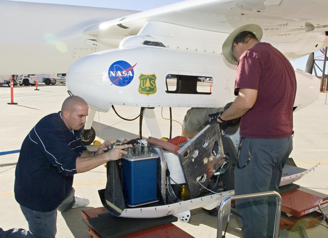
NASA Dryden's Ikhana ground crewmen Gus Carreno and James Smith load the thermal-infrared imaging scanner pallet into the Ikhana's underwing payload pod.
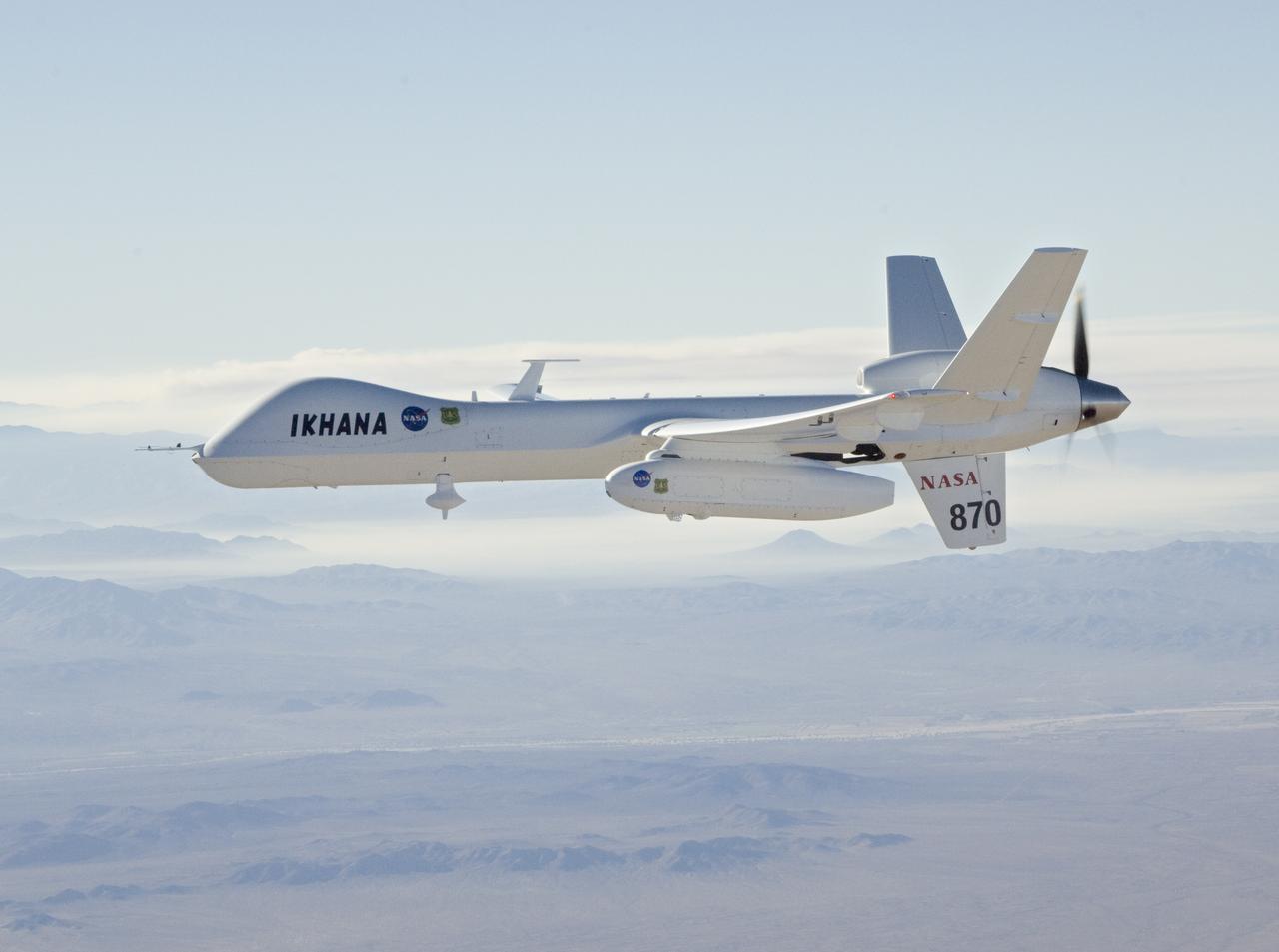
With smoke from the Lake Arrowhead area fires streaming in the background, NASA's Ikhana unmanned aircraft heads out on a Southern California wildfires imaging mission.
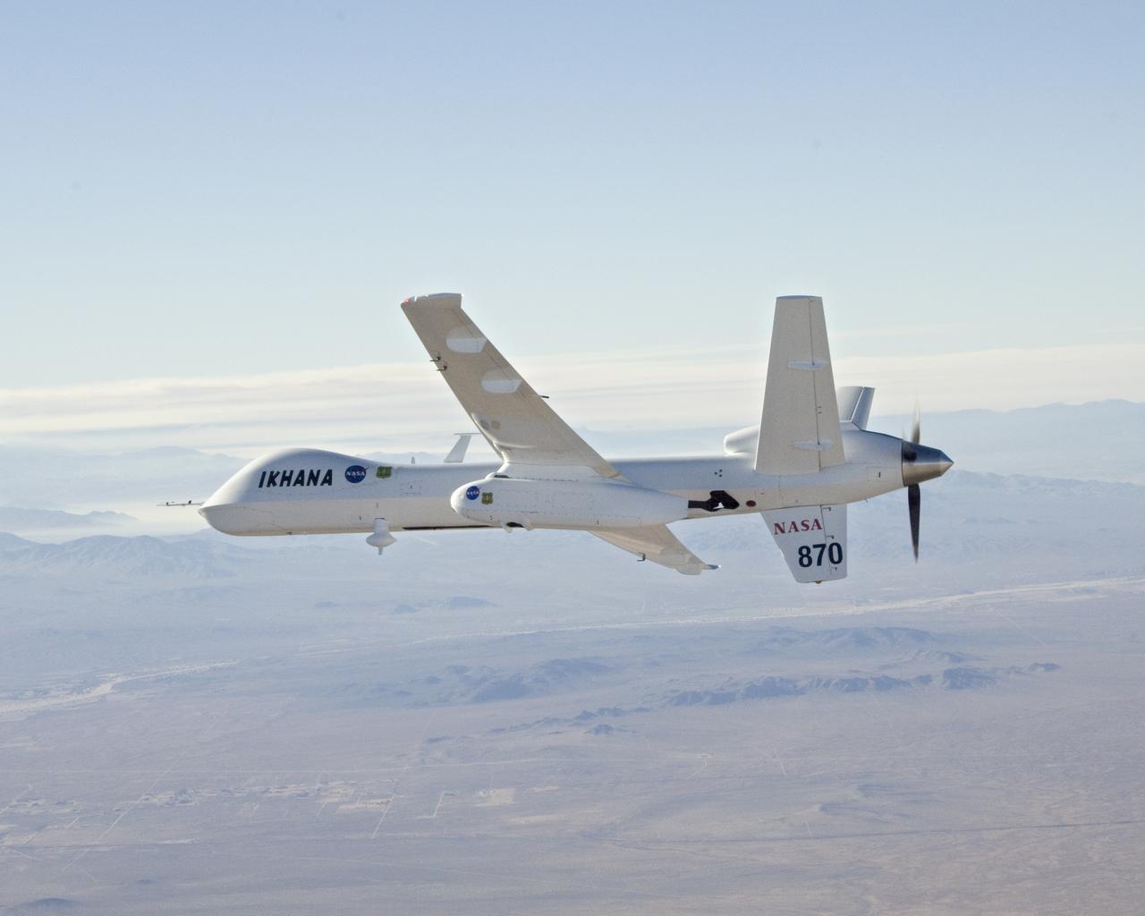
With smoke from the Lake Arrowhead area fires streaming in the background, NASA's Ikhana unmanned aircraft heads out on a Southern California wildfires imaging mission.
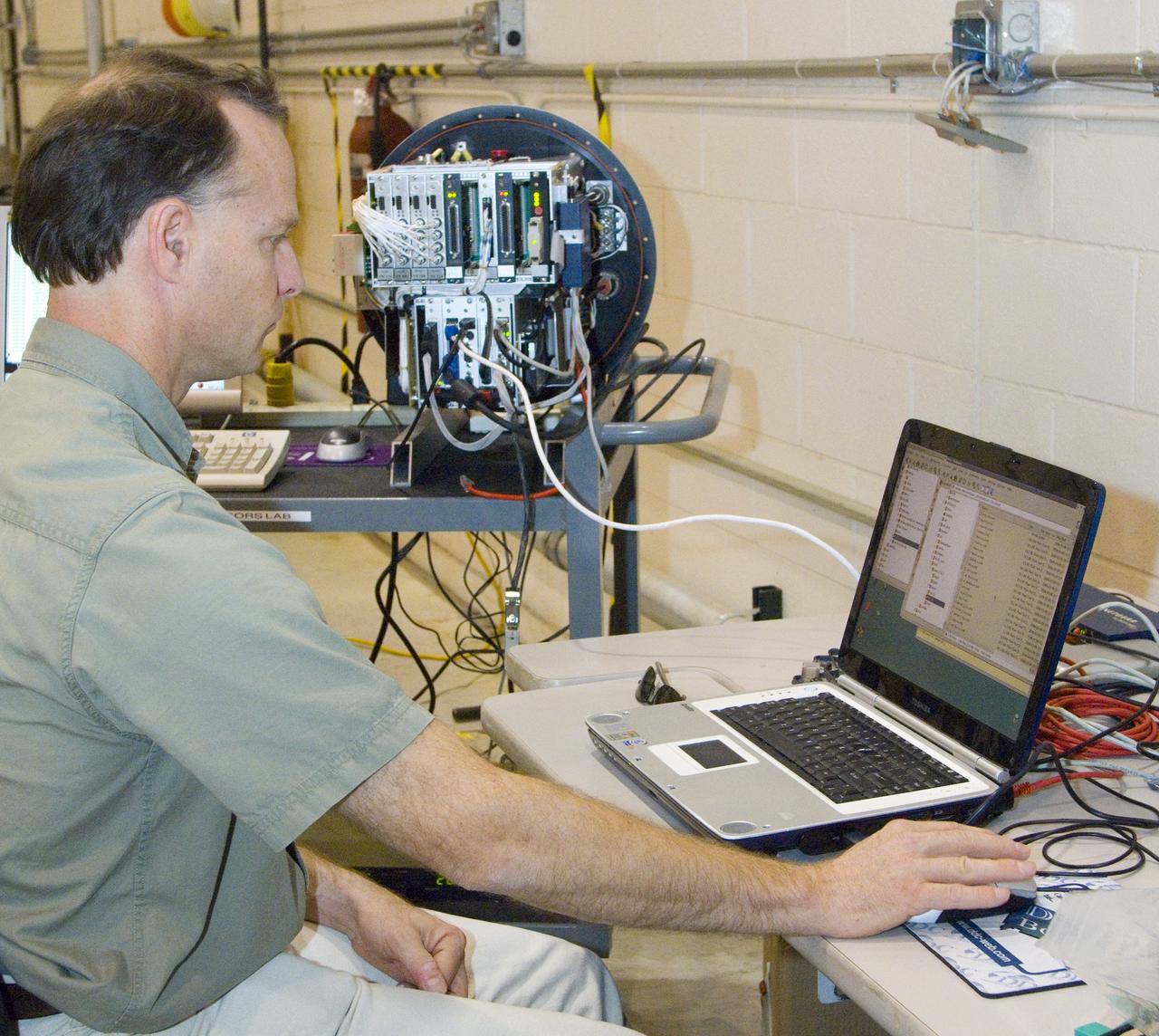
NASA Ames engineer Ted Hildum checks out the thermal-infrared scanner computer before it is loaded on NASA's Ikhana unmanned aircraft.