
NASA Deputy Administrator Shana Dale delivers a keynote address during the NASA Future Forum event at the Museum of Science in Boston, MA, Thursday, September 18, 2008. Photo Credit: (NASA/Bill Ingalls)
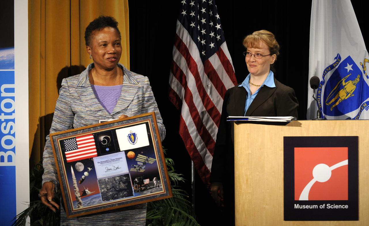
Mayor of Cambridge, Massachusetts, E. Denise Simmons, left, holds a plaque presented to her by NASA Deputy Administrator Ms. Shana Dale during the NASA Future Forum event at the Museum of Science in Boston, MA, Thursday, September 18, 2008. Photo Credit: (NASA/Bill Ingalls)
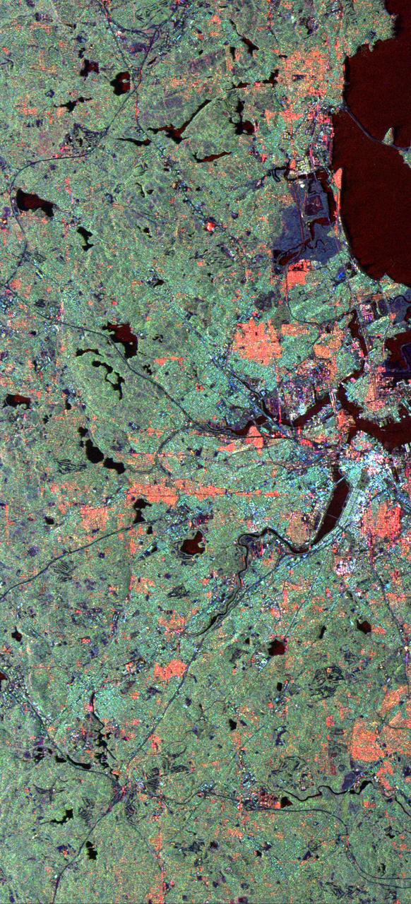
This radar image of the area surrounding Boston, Mass., shows how a spaceborne radar system distinguishes between densely populated urban areas and nearby areas that are relatively unsettled.
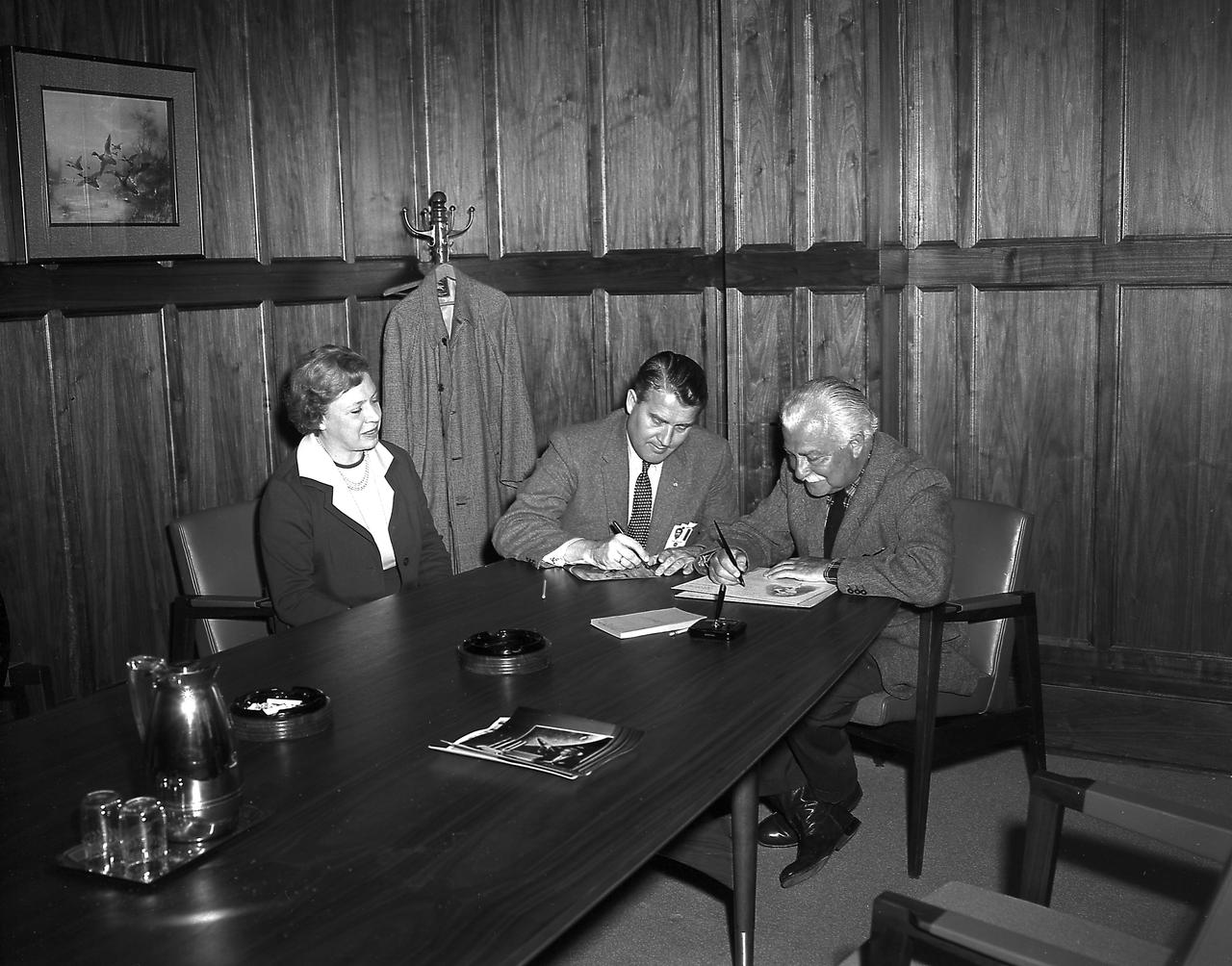
Mr. Mrs. Arthur Fiedler of the Boston Pops Orchestra and Dr. von Braun in his office during the Fiedlers' visit to the Marshall Space Flight Center (MSFC) on March, 23, 1962.
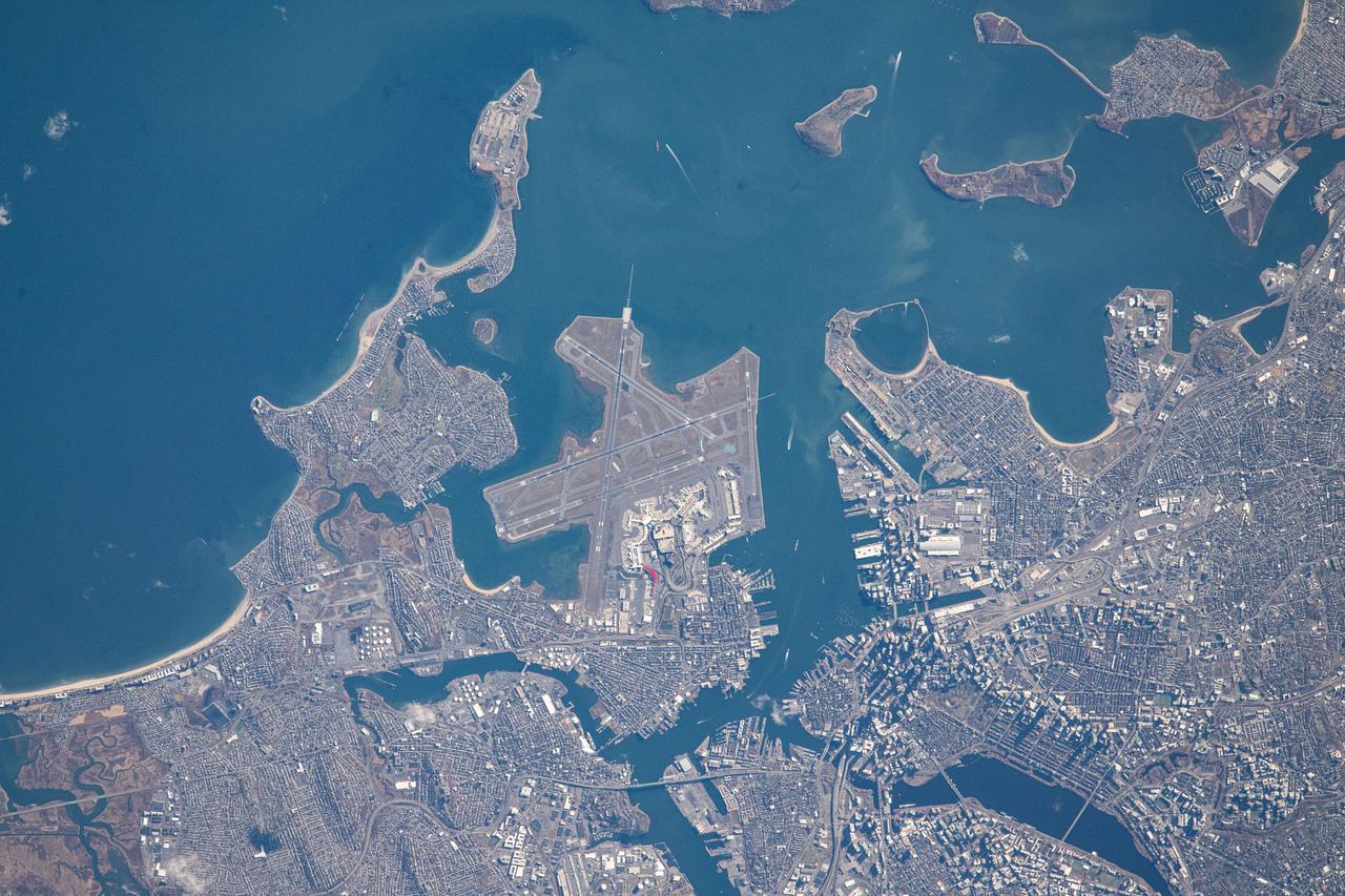
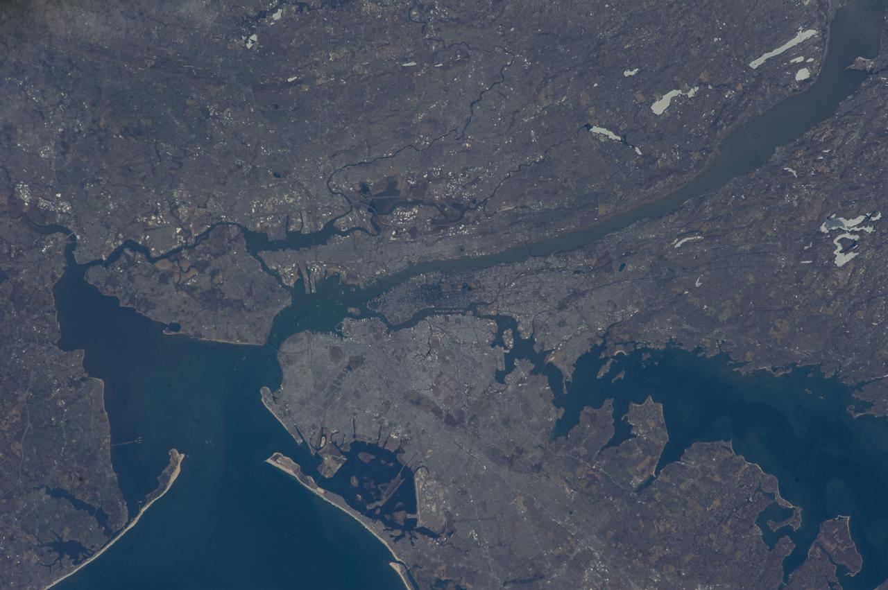
iss072e311839 (Dec. 3, 2024) --- Boston Logan International Airport on Massachusetts Bay is pictured from the International Space Station as it orbited 263 miles above.

iss073e0982172 (Oct. 25, 2025) --- Boston, Massachusetts—home to America's first public park, public school, and subway system—is pictured at approximately 2:24 a.m. local time from the International Space Station as it orbited 263 miles above the northeastern United States. Located on Boston Harbor, Boston Logan International Airport (center) opened in 1923 and handled 43.5 million passengers and 568 million pounds of cargo in 2024.
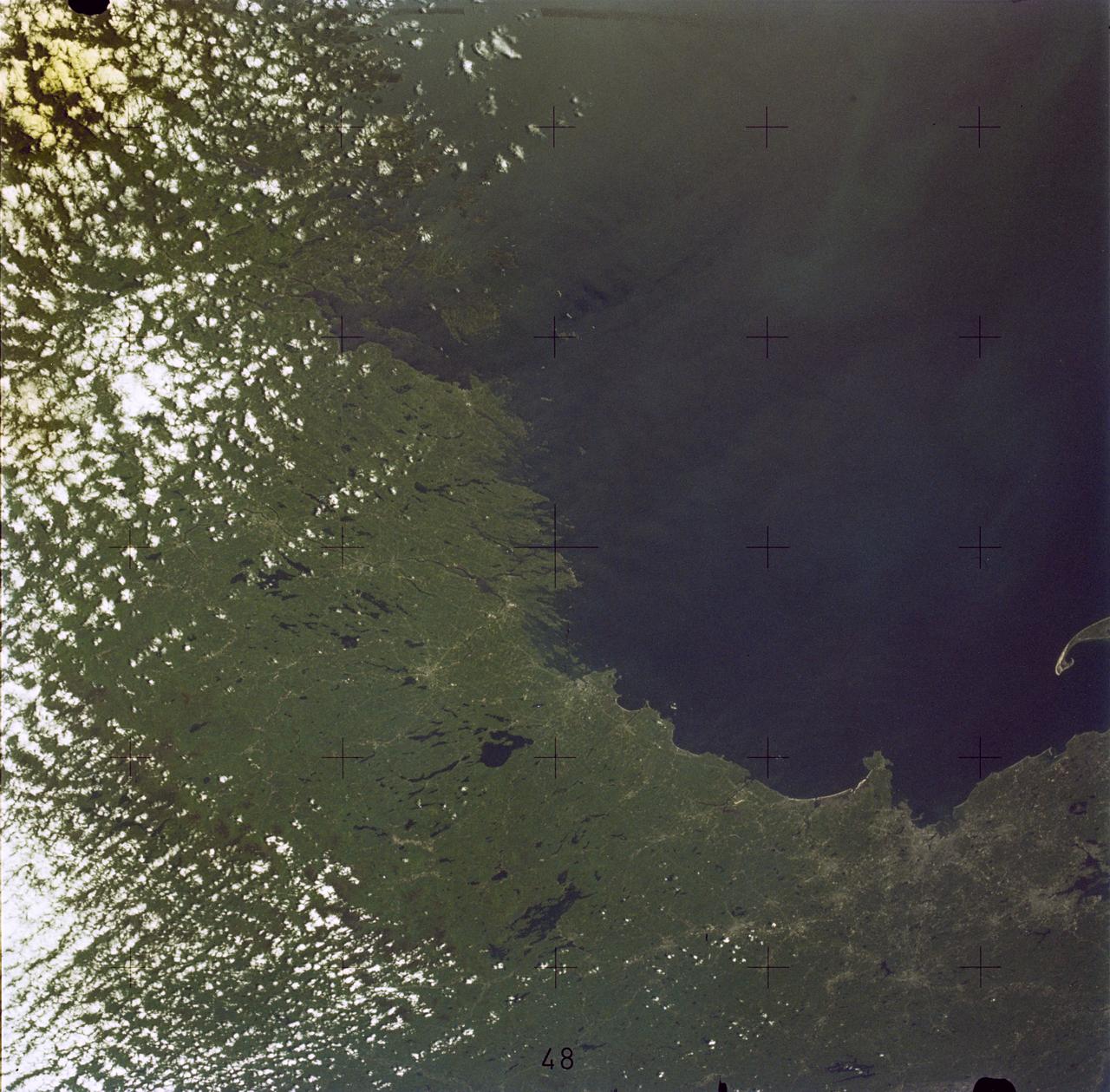
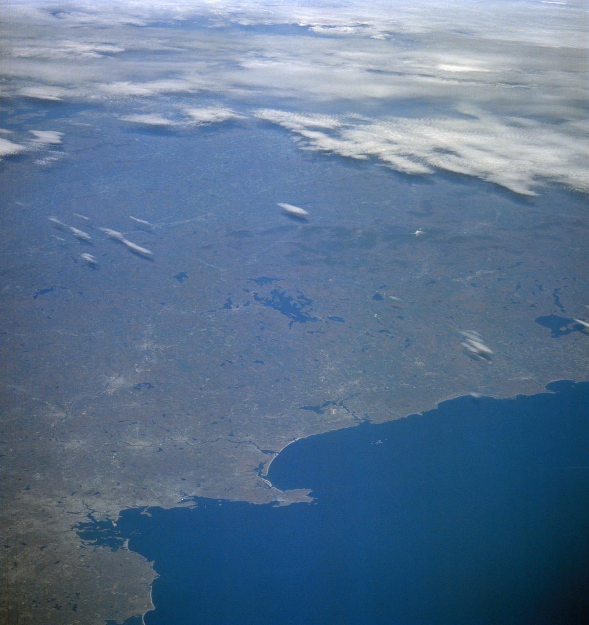
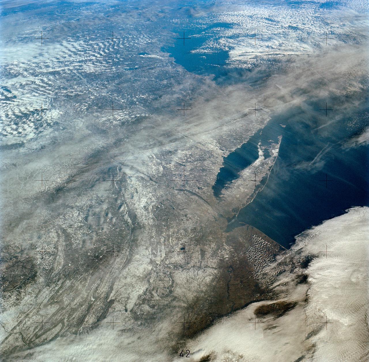
SL2-05-381 (22 June 1973) --- Boston, MA and the New England Coastline (43.5N, 84.0W) can be seen in this view. The typical rugged rocky coast of Maine is the result of heavy glacial action producing the rocky cliffs, jagged spurs of land and islands that characterize Main's Atlantic Coast. During the last Ice Age, extensive sediments were laid down producing a landscape of rolling hills with rocky outcrops. Photo credit: NASA
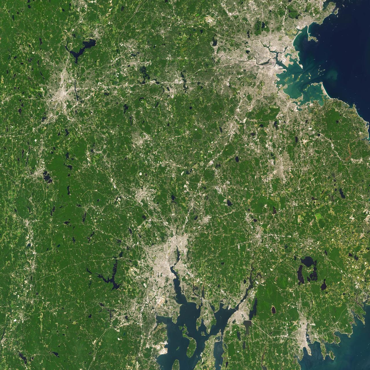
Landsat 7 image of Boston/Providence area acquired August 25, 2014. Landsat 7 is a U.S. satellite used to acquire remotely sensed images of the Earth's land surface and surrounding coastal regions. It is maintained by the Landsat 7 Project Science Office at the NASA Goddard Space Flight Center in Greenbelt, MD...Landsat satellites have been acquiring images of the Earth’s land surface since 1972. Currently there are more than 2 million Landsat images in the National Satellite Land Remote Sensing Data Archive. For more information visit: <a href="http://landsat.usgs.gov/" rel="nofollow">landsat.usgs.gov/</a>..To learn more about the Landsat satellite go to:.<a href="http://landsat.gsfc.nasa.gov/" rel="nofollow">landsat.gsfc.nasa.gov/</a> Credit: NASA/GSFC/Landsat 7 <b><a href="http://www.nasa.gov/audience/formedia/features/MP_Photo_Guidelines.html" rel="nofollow">NASA image use policy.</a></b> <b><a href="http://www.nasa.gov/centers/goddard/home/index.html" rel="nofollow">NASA Goddard Space Flight Center</a></b> enables NASA’s mission through four scientific endeavors: Earth Science, Heliophysics, Solar System Exploration, and Astrophysics. Goddard plays a leading role in NASA’s accomplishments by contributing compelling scientific knowledge to advance the Agency’s mission. <b>Follow us on <a href="http://twitter.com/NASAGoddardPix" rel="nofollow">Twitter</a></b> <b>Like us on <a href="http://www.facebook.com/pages/Greenbelt-MD/NASA-Goddard/395013845897?ref=tsd" rel="nofollow">Facebook</a></b> <b>Find us on <a href="http://instagrid.me/nasagoddard/?vm=grid" rel="nofollow">Instagram</a></b>
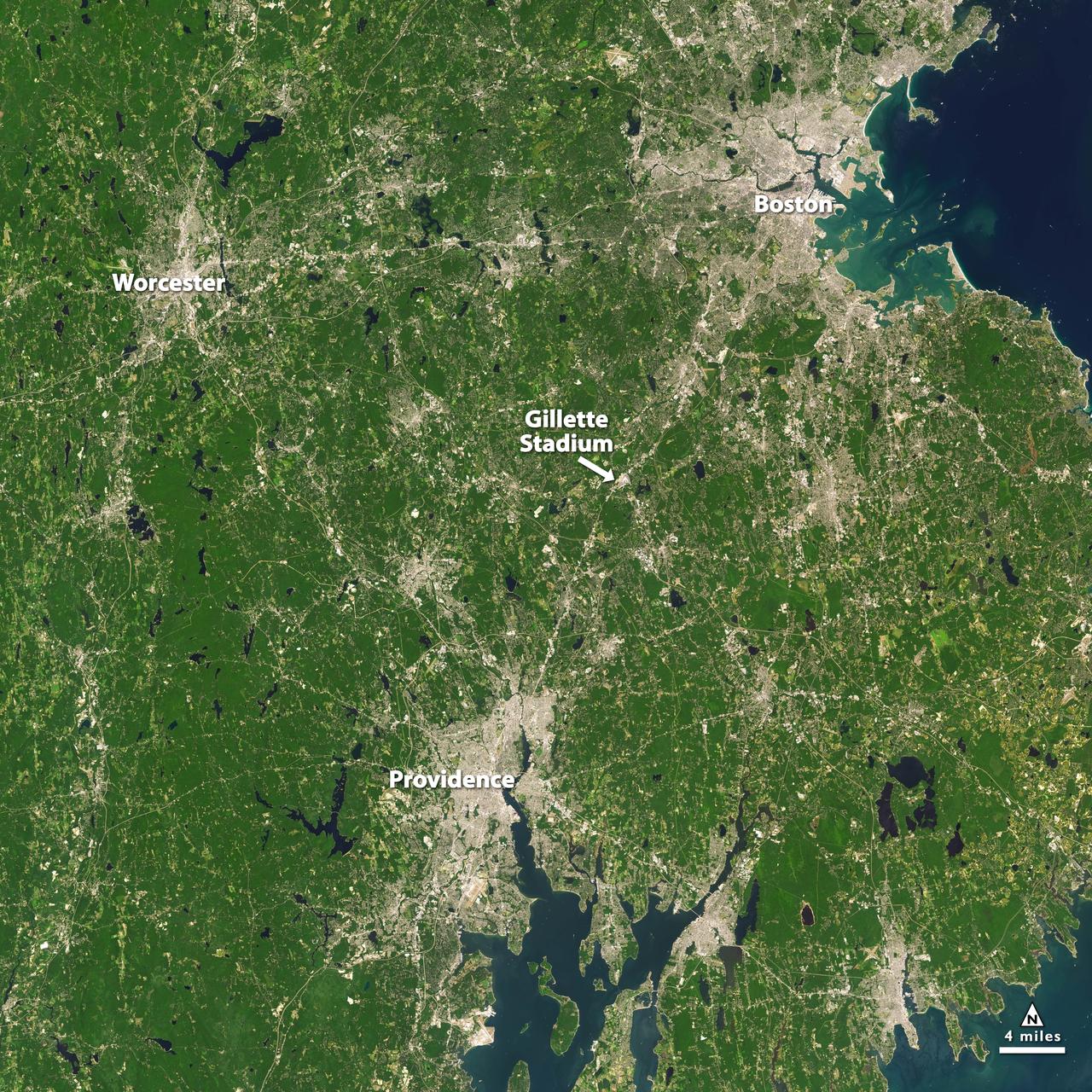
Landsat 7 image of Boston/Providence area acquired August 25, 2014. Landsat 7 is a U.S. satellite used to acquire remotely sensed images of the Earth's land surface and surrounding coastal regions. It is maintained by the Landsat 7 Project Science Office at the NASA Goddard Space Flight Center in Greenbelt, MD. Landsat satellites have been acquiring images of the Earth’s land surface since 1972. Currently there are more than 2 million Landsat images in the National Satellite Land Remote Sensing Data Archive. For more information visit: <a href="http://landsat.usgs.gov/" rel="nofollow">landsat.usgs.gov/</a>..To learn more about the Landsat satellite go to:.<a href="http://landsat.gsfc.nasa.gov/" rel="nofollow">landsat.gsfc.nasa.gov/</a> Credit: NASA/GSFC/Landsat 7 <b><a href="http://www.nasa.gov/audience/formedia/features/MP_Photo_Guidelines.html" rel="nofollow">NASA image use policy.</a></b> <b><a href="http://www.nasa.gov/centers/goddard/home/index.html" rel="nofollow">NASA Goddard Space Flight Center</a></b> enables NASA’s mission through four scientific endeavors: Earth Science, Heliophysics, Solar System Exploration, and Astrophysics. Goddard plays a leading role in NASA’s accomplishments by contributing compelling scientific knowledge to advance the Agency’s mission. <b>Follow us on <a href="http://twitter.com/NASAGoddardPix" rel="nofollow">Twitter</a></b> <b>Like us on <a href="http://www.facebook.com/pages/Greenbelt-MD/NASA-Goddard/395013845897?ref=tsd" rel="nofollow">Facebook</a></b> <b>Find us on <a href="http://instagrid.me/nasagoddard/?vm=grid" rel="nofollow">Instagram</a></b>
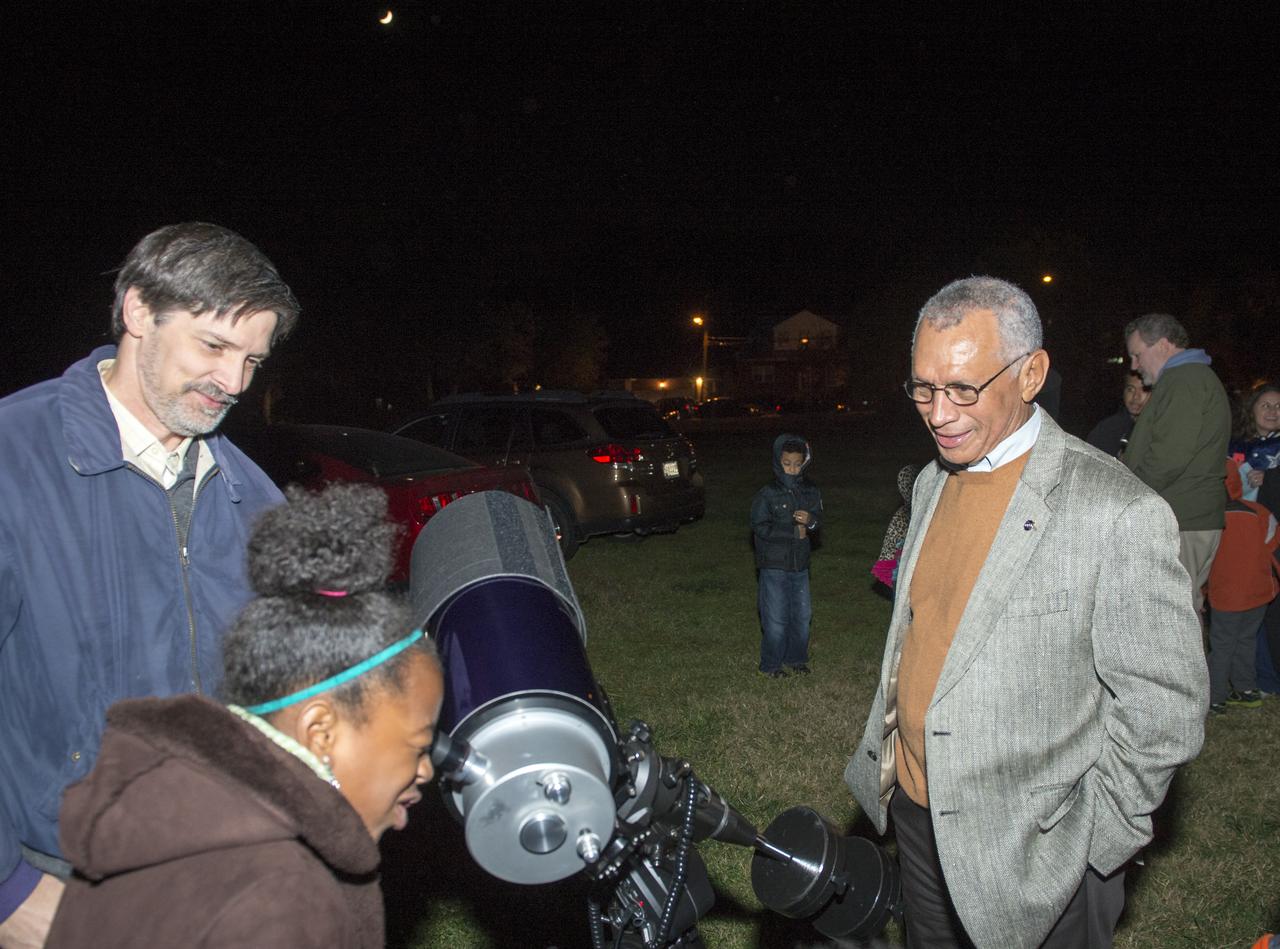
NASA Administrator Charles F. Bolden looks on as Kalani Brown, 9, of Arlington, Va., looks at the moon through a telescope during a stargazing event at Hoffman-Boston Elementary School in Arlington, Va. on Thursday, Nov. 7, 2013. Photo Credit: (NASA/Jay Westcott)

iss074e0300243 (Feb. 2, 2026) --- The wintry landscape of the southern New England region of the United States is seen from the International Space Station as it orbited 262 miles above North America. Temperatures in Boston, Massachusetts, ranged from a low of about 23 degrees Fahrenheit to a high of around 35 degrees when this photograph was taken.
STS058-105-016 (18 Oct-1 Nov 1993) --- This photograph includes much of the heart of New England, stretching from Boston and Boston Harbor (lower left) across New Hampshire and Vermont to Lake Champlain (upper left), and up to southern Maine (Portland is just off the photo at right center). The colors in this photograph are less vivid than those in STS-58-81-038, because the color changes on the deciduous trees in central and northern New England were past their peak when this photograph was taken. North of Boston flows the Merrimack River (which forms part of the state boundary between Massachusetts and New Hampshire). It is delineated by the small industrial towns (Concord, Manchester, Nashua, Lowell) which grew up on its banks. The White Mountains of New Hampshire are seen near the center, and Mt. Washington (6,288 feet) is capped with snow.
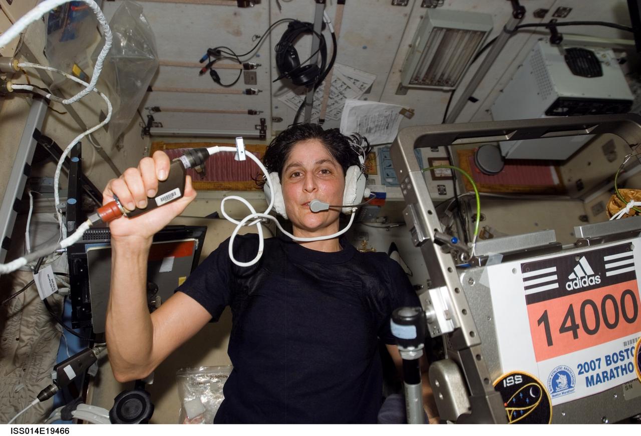
ISS014-E-19466 (16 April 2007) --- Astronaut Sunita L. Williams, Expedition 14 flight engineer, circled Earth almost three times as she participated in the Boston Marathon from space. She is seen here with her feet off the station treadmill on which she ultimately ran about six miles per hour while flying more than five miles each second. The treadmill is called TVIS, for Treadmill Vibration Isolation System, by the crewmembers and their ground support team. Williams' official completion time was four hours, 23 minutes and 10 seconds as she completed the race at 2:24 p.m. (EDT).
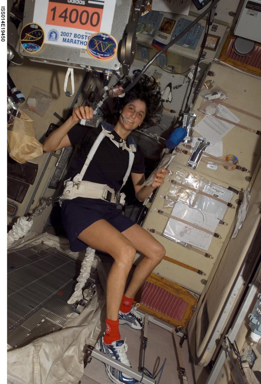
ISS014-E-19450 (16 April 2007) --- Astronaut Sunita L. Williams, Expedition 14 flight engineer, circled Earth almost three times as she participated in the Boston Marathon from space. She is seen here with her feet off the station treadmill on which she ultimately ran about six miles per hour while flying more than five miles each second. The treadmill is called TVIS, for Treadmill Vibration Isolation System, by the crewmembers and their ground support team. Williams' official completion time was four hours, 23 minutes and 10 seconds as she completed the race at 2:24 p.m. (EDT).
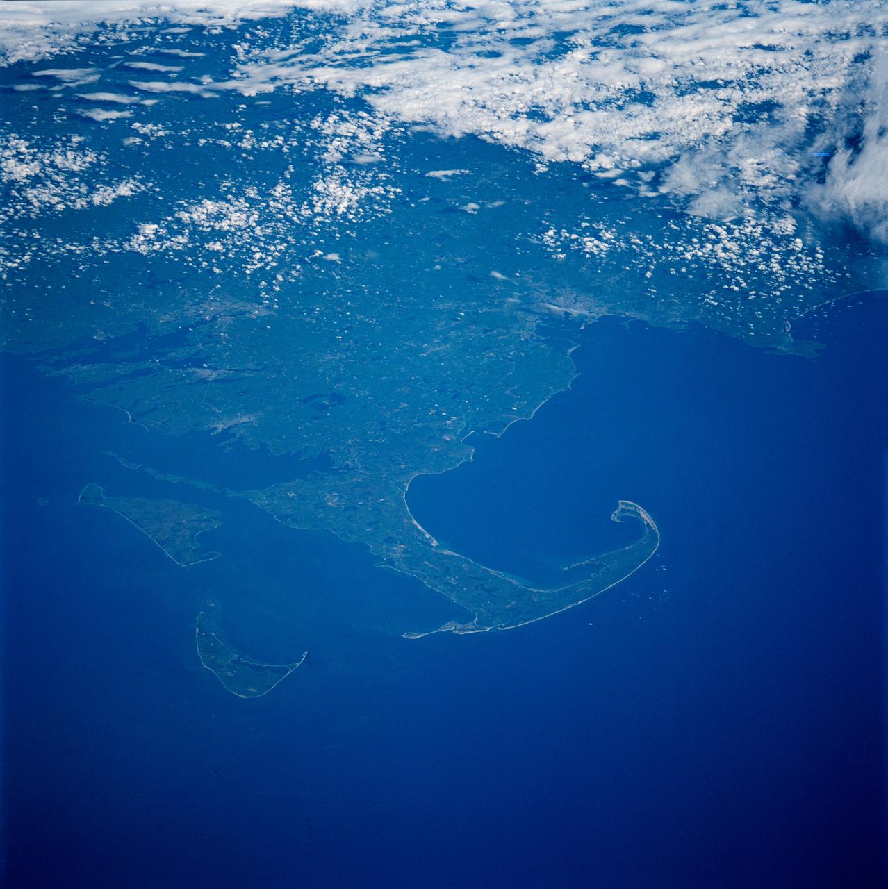
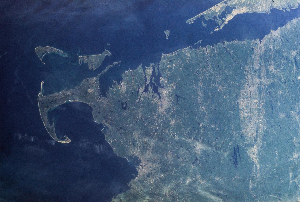
The distinctive curve of Cape Cod, Massachusetts and the greater Boston urban area are very clear of the northeastern coast of the United States in this image from NASA EarthKAM.

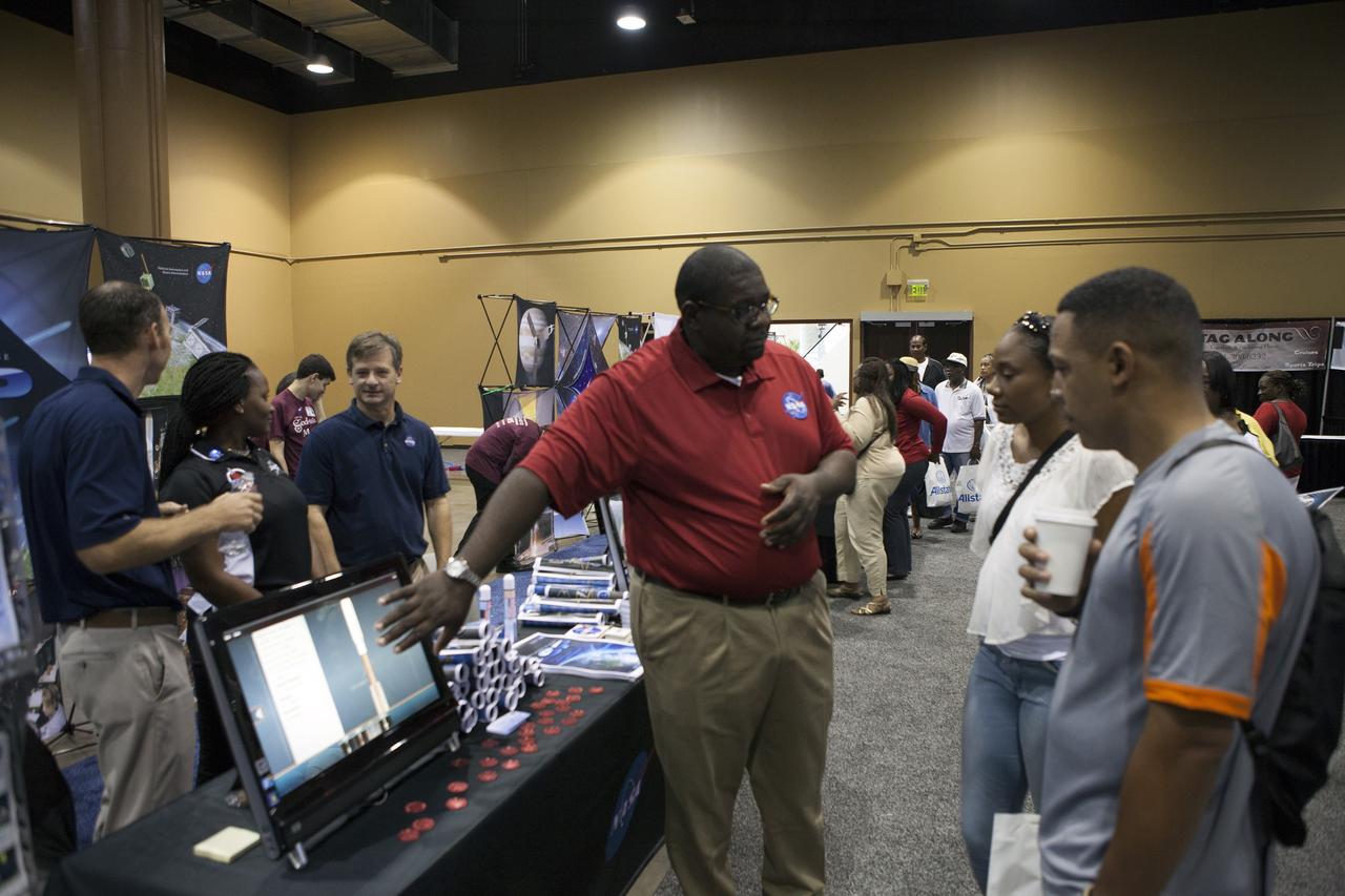
Students in the My Brother’s Keeper program hear from experts from across NASA’s Kennedy Space Center during a panel discussion in the Space Station Processing Facility Conference Center. Seated from left to right are Sheldon Lauderdale of the Commercial Crew Program (CCP); Yves Lamothe of the Ground Systems Development and Operations Program; Jennifer Levitt of CCP; Trent Smith and DeAntae Cooper (far right) of the Exploration Research and Technology Programs; and Malcolm Boston of the Launch Services Program. The spaceport is one of six NASA centers that participated in My Brother’s Keeper National Lab Week. The event is a nationwide effort to bring youth from underrepresented communities into federal labs and centers for hands-on activities, tours and inspirational speakers.
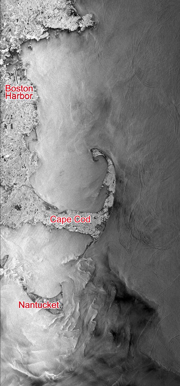
This Seasat synthetic aperture radar image from Aug. 27, 1978, shows the Massachusetts coast from Nantucket Island in the south past Cape Cod and Boston to Cape Ann in the north.
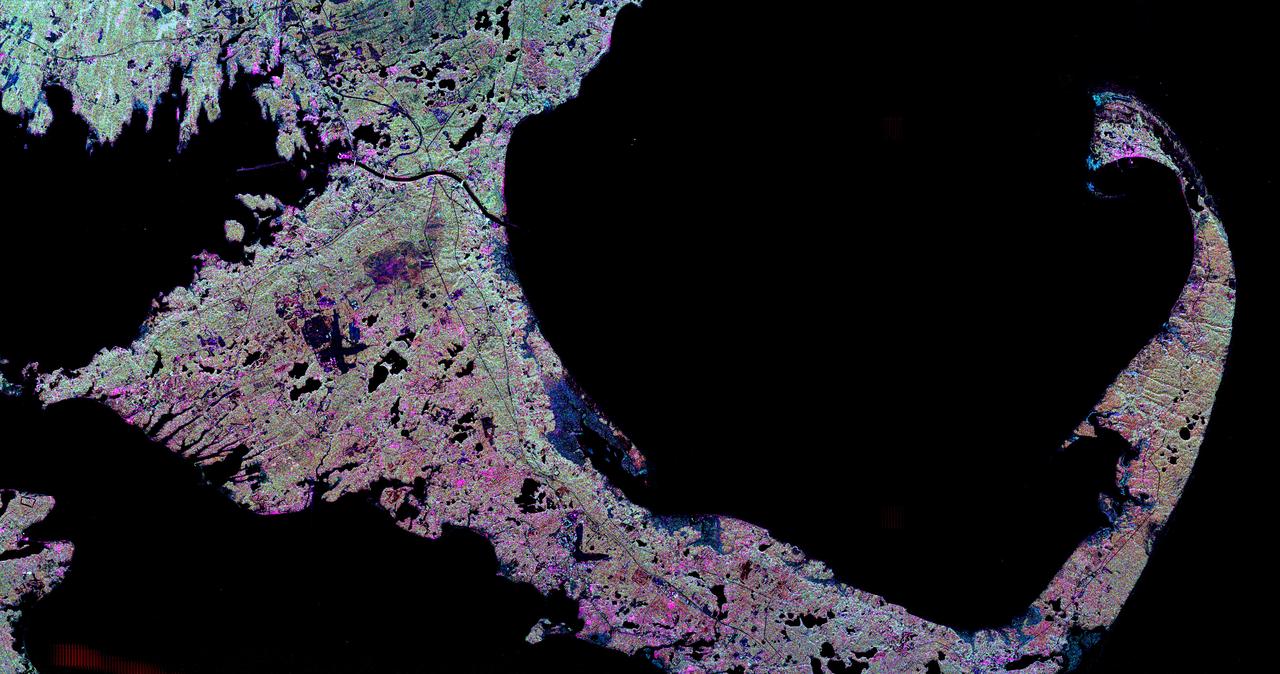
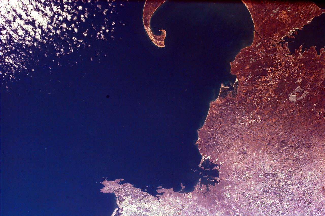
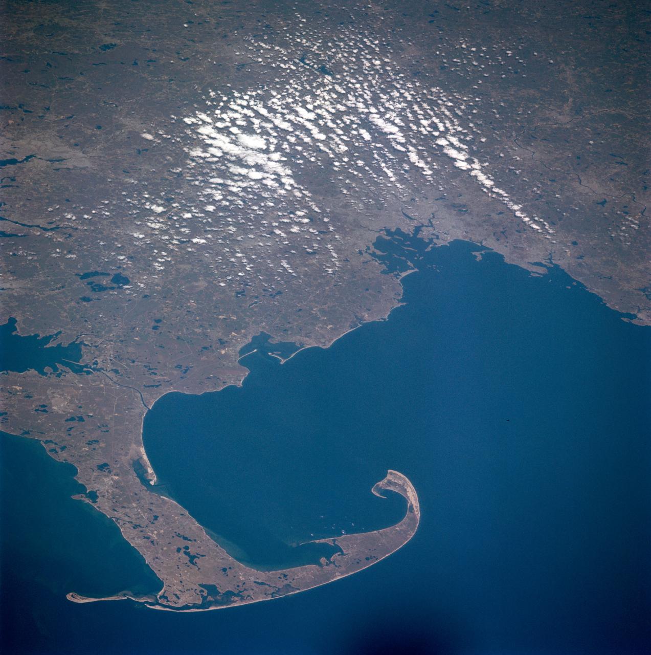
This spaceborne radar image shows the famous hook of Cape Cod, Massachusetts. The Cape, which juts out into the Atlantic Ocean about 100 kilometers 62 miles southeast of Boston.
Earth observation taken by the Expedition 39 crew aboard the ISS. Image downlinked in folder: Boston, New York, etc., and released by astronaut on Twitter.
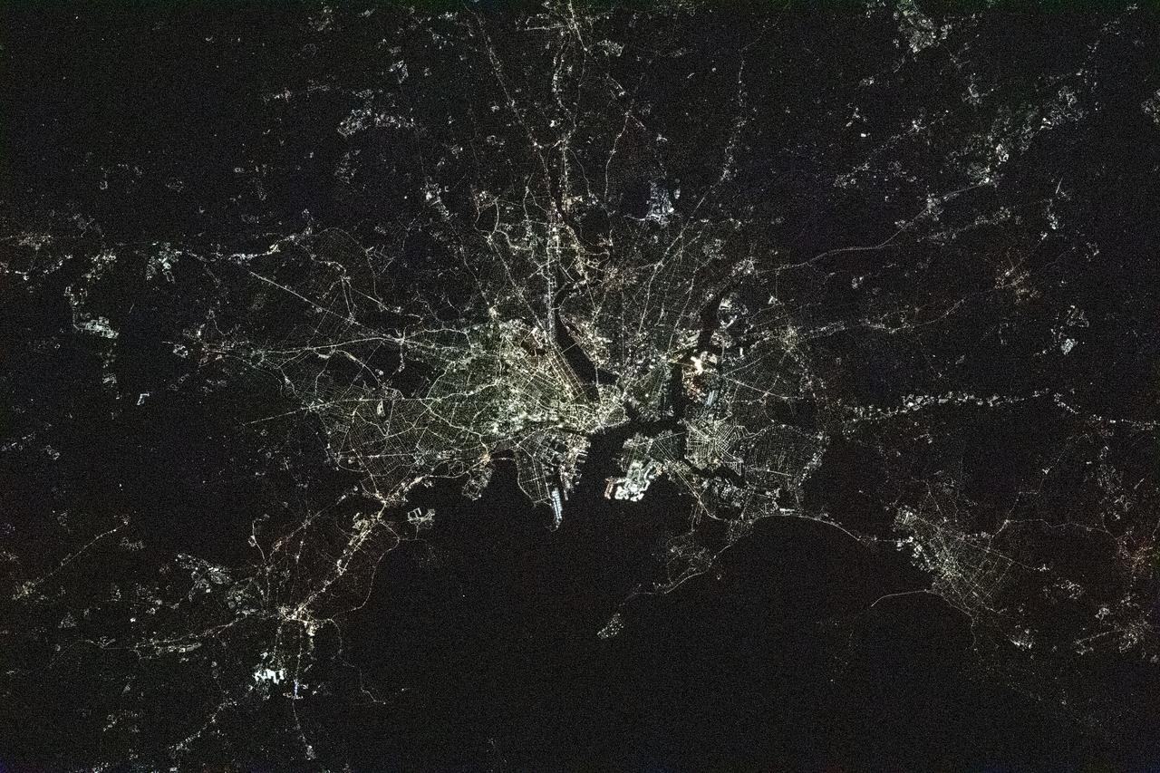
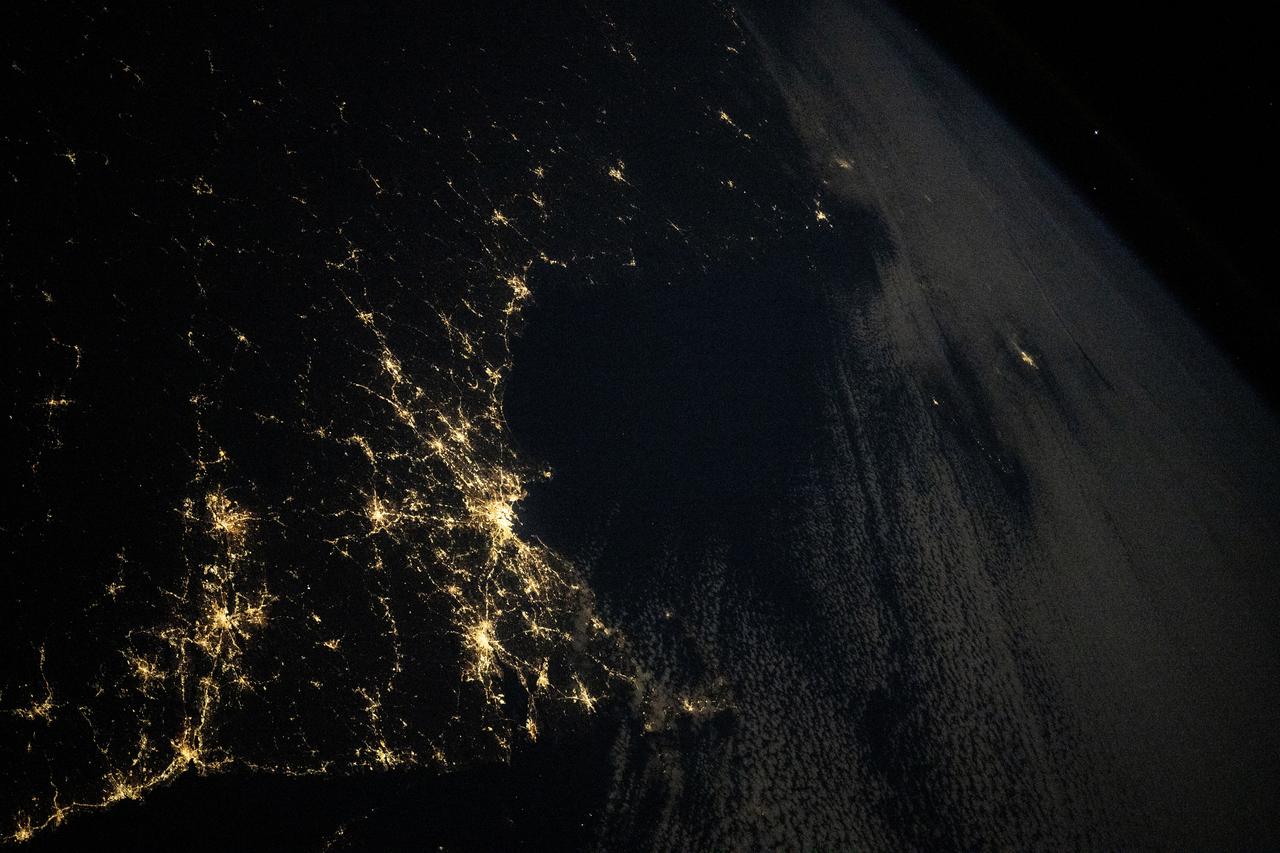
iss064e016786 (Dec. 30, 2020) --- This night time photograph of Boston, Massachusetts, was taken from the International Space Station as it orbited 263 miles above Connecticut.

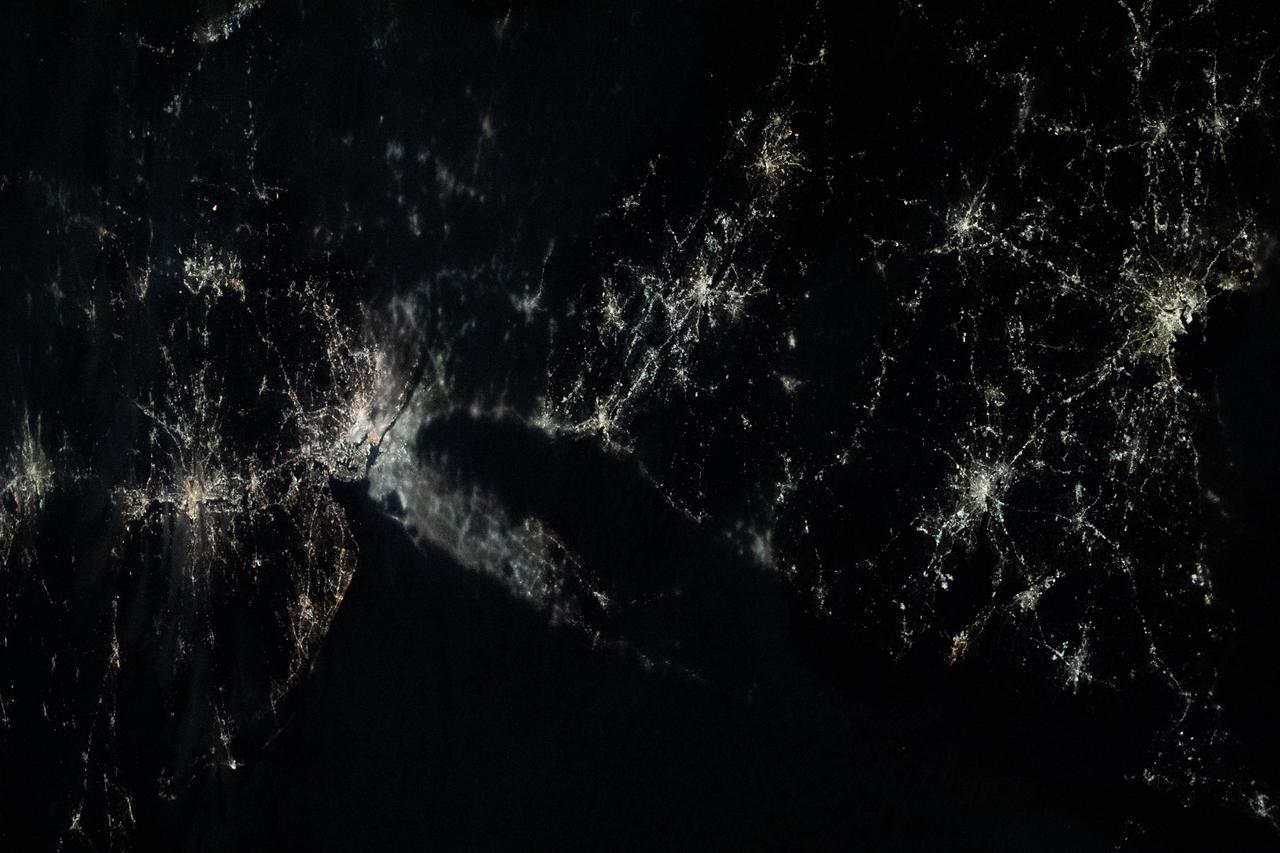
iss070e098022 (Feb. 22, 2024) --- Boston, Massachussetts, is pictured at night from the International Space Station as it orbited 262 miles above the Canadian province of Nova Scotia.
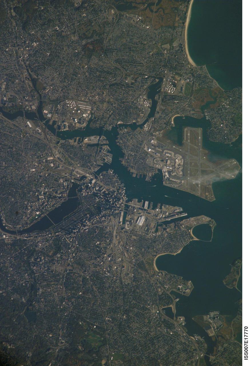
ISS007-E-17770 (20 October 2003) --- Boston, Massachusetts was featured in this image taken by one of the Expedition 7 crewmembers onboard the International Space Station (ISS). The image provides a good view of the center of the city, including famous colonial and independence locations extending from Boston Common to the North End. Wispy clouds hover over the south end of Logan Airport. Ship traffic in the Charles and Mystic Rivers is marked by wakes of the ships. And highly reflective construction locations, including the new I-93 and the bridge over the Charles River, and highway exchanges at Logan Airport mark the new elements of Boston's Big Dig, which is the local transportation project that is now believed to be the largest civil engineering endeavor in U.S. history.
NASA Administrator Charles F. Bolden gestures while making remarks at a stargazing event at Hoffman-Boston Elementary School in Arlington, Va. on Thursday, Nov. 7, 2013. Photo Credit: (NASA/Jay Westcott)
STS073-E-5099 (30 Oct. 1995) --- The entire coast of Massachusetts can be seen, from Martha's Vineyard and Buzzard's Bay in the foreground past the Boston metropolitan region. The frame was exposed with the Electronic Still Camera (ESC).

ISS035-E-017112 (6 April 2013) --- One of the crew members aboard the International Space Station recorded this almost vertical nocturnal view of the Boston metropolitan area on April 6, 2013.
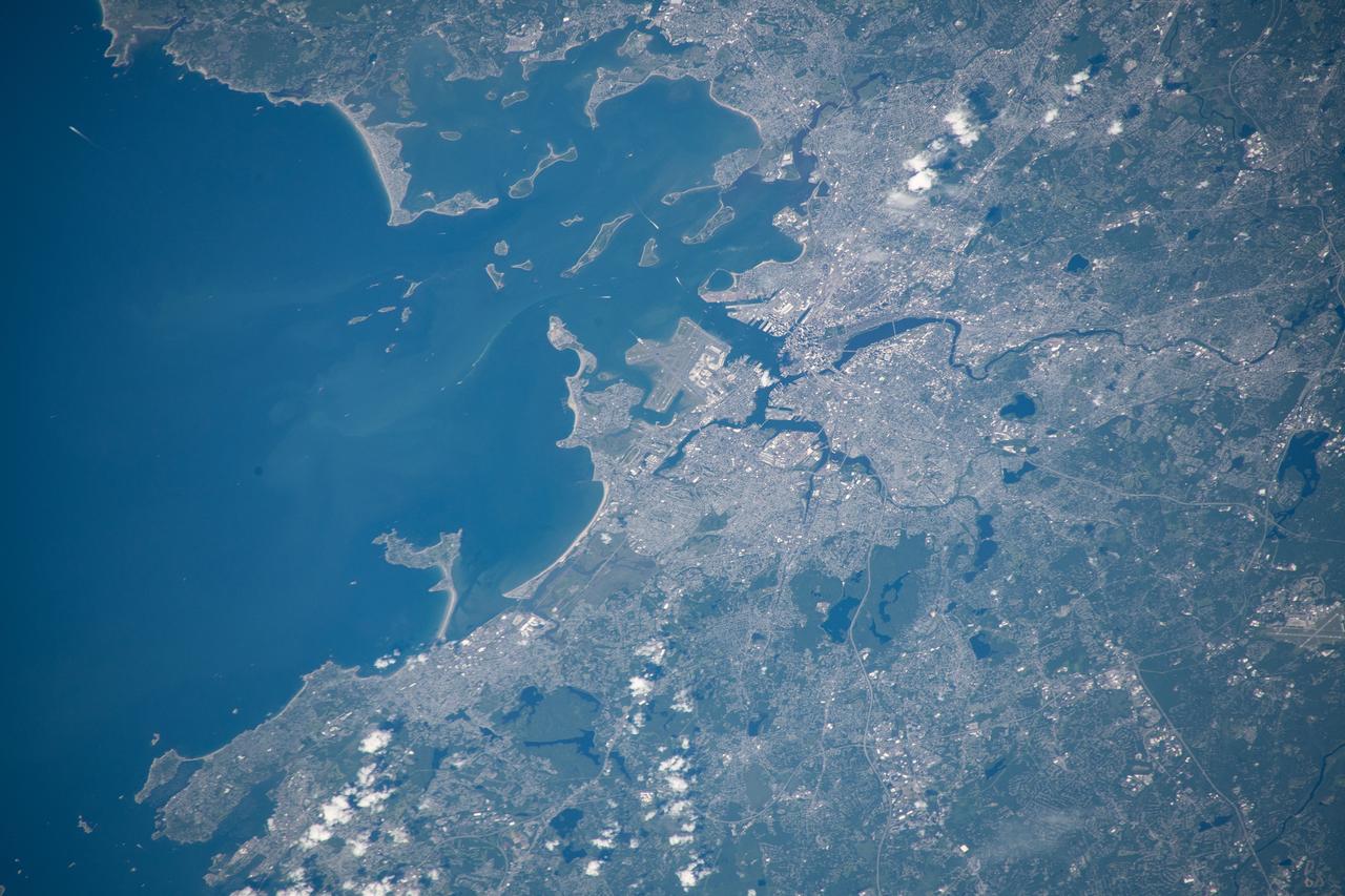
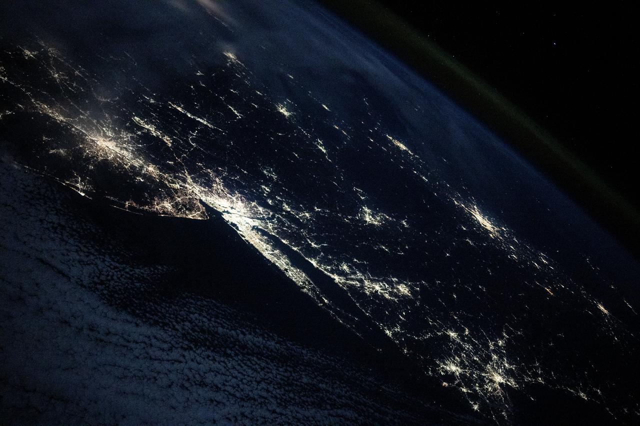
iss059e111579 (June 17, 2019) --- Boston, Massachusetts, Logan International Airport and Massachusetts Bay figure prominently in this photograph taken 255 miles above the Atlantic Ocean from the International Space Station.

NASA Administrator Charles F. Bolden gestures while making remarks before a stargazing event at Hoffman-Boston Elementary School in Arlington, Va. on Thursday, Nov. 7, 2013. Photo Credit: (NASA/Jay Westcott)
STS001-11-173 (12-14 April 1981) --- Space shuttle Columbia's view of Cape Cod, Boston, Plymouth, Glouster, Providence, Lowell, Taunton, and Worcester. Photo credit: NASA
iss072e186812 (Nov. 14, 2024) --- The city lights along the New England coast of the United States including New Haven, Connecticut; Providence, Rhode Island; and Boston, Massachusetts, are pictured from the United States as it orbited 254 miles above the Atlantic Ocean.
iss061e026260 (Nov. 1, 2019) --- NASA astronaut Jessica Meir, attached to foot restraints inside the Kibo laboratory module from JAXA (Japan Aerospace Exploration Agency), participates in interviews with journalists from Bangor, Maine and Boston, Massachusetts.
NASA Administrator Charles F. Bolden greets Lucas Yaroschuk, 3, of Arlington, Va., during a stargazing event at Hoffman-Boston Elementary School in Arlington, Va. on Thursday, Nov. 7, 2013. Photo Credit: (NASA/Jay Westcott)
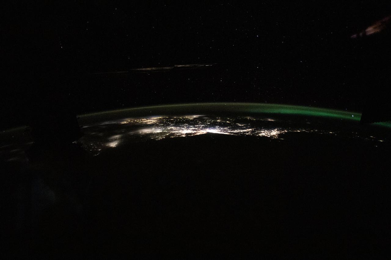
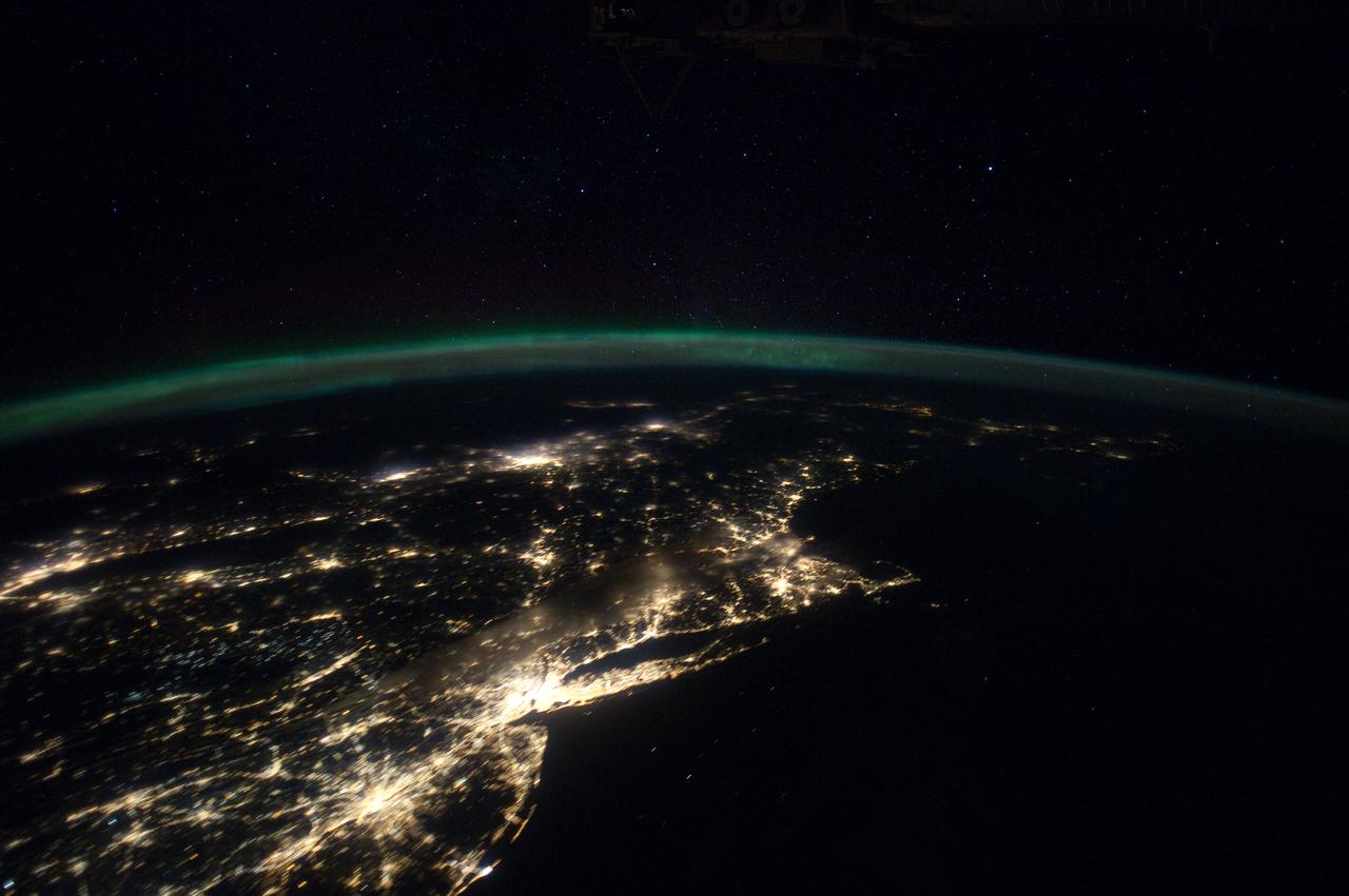
iss070e025086 (Nov. 15, 2023) --- The photograph from the International Space Station looks back toward the northeast Atlantic coast of the United States revealing the city lights (from left) of Norfolk, Virginia, to Boston, Massachusetts. At far right, an aurora in northern Canada crowns the Earth's horizon.
iss072e186819 (Nov. 14, 2024) --- The city lights of the United States' eastern seaboard from Philadelphia, Pennsylvania; to New York City; to Boston, Massachusetts; as well as Montreal, Quebec, in Canada (right center), are pictured from the International Space Station as it orbited 254 miles above the Atlantic Ocean.
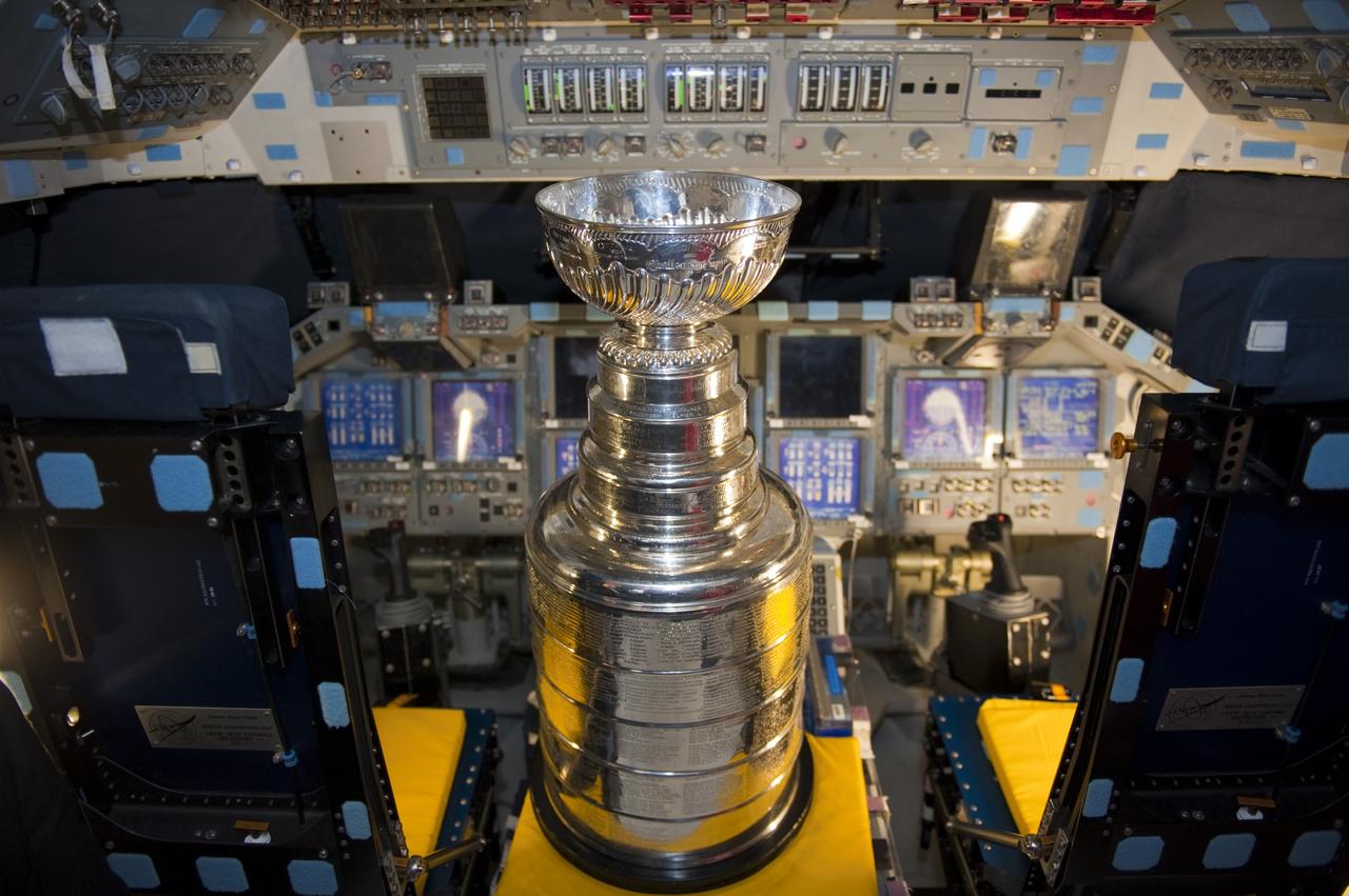
CAPE CANAVERAL, Fla. -- In Orbiter Processing Facility-2 at NASA's Kennedy Space Center in Florida, Lord Stanley’s Cup sits in the flight deck of space shuttle Atlantis. The Stanley Cup was awarded to the Boston Bruins after winning the 2011 National Hockey League (NHL) Championship. Jeremy Jacobs, chairman and chief executive officer of Delaware North Companies and owner of the Boston Bruins, brought the cup for Kennedy and Delaware North employees to view and take photographs of. The Stanley Cup is 34 1/4 inches tall, weighs 34 1/2 pounds and is more than 100 years old. Atlantis is being prepared for public display in 2013 at the Kennedy Space Center Visitor Complex. For more information, visit http://www.nasa.gov/shuttle. Photo credit: NASA/Kim Shiflett
STS084-703-003 (15-24 May 1997) --- Cape Cod extends 105 kilometers (65 miles) into the Atlantic Ocean. To the south of Cape Cod are the islands of Martha's Vineyard (west) and Nantucket (east). The city of Boston can be seen surrounding the bay above the "hook" on Cape Cod. To the south are the cities of New Bedford on Buzzards Bay, and Providence, Rhode Island. The Cape Cod Canal is an artificial waterway that connects Buzzards Bay and Cape Cod Bay. The waterway is 28 kilometers (17.5 miles) and does not contains locks. The canal was built to shorten the distance over water between New York City and Boston. In 1620 the Pilgrims landed at Provincetown, on the upper tip of Cape Cod, before they proceeded to Plymouth.
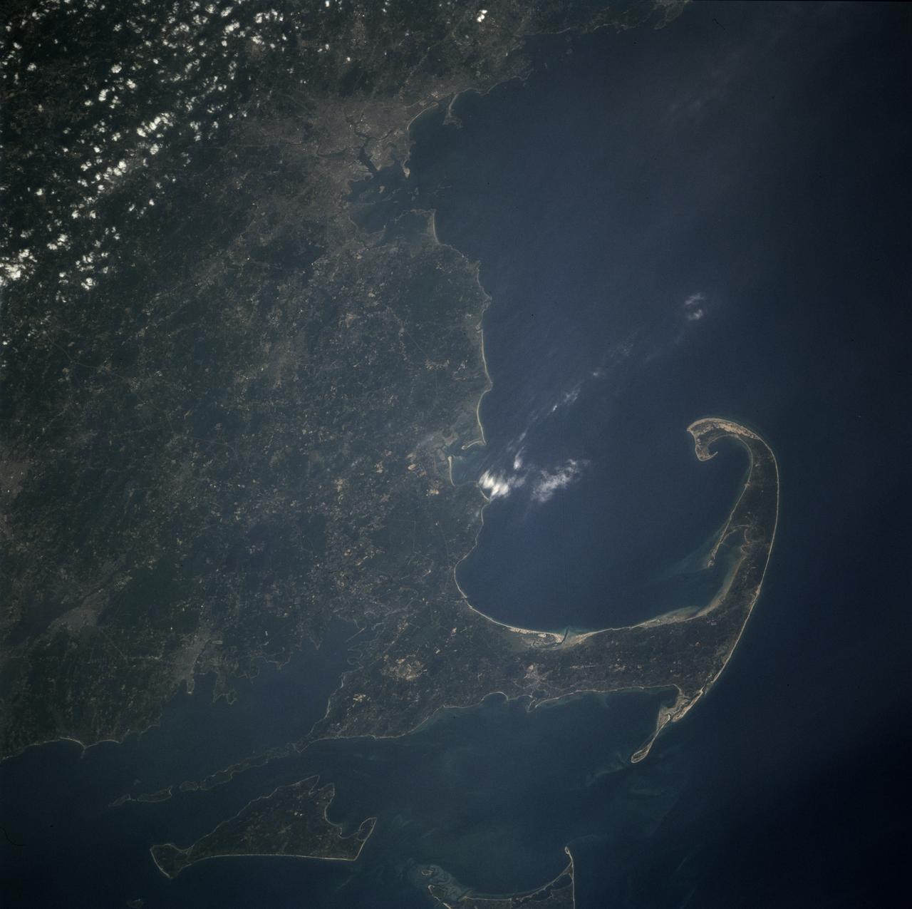
STS071-708-040 (27 June-7 July 1995) --- This view shows Cape Cod in some detail in the center right of the view. Provincetown lies on the inside of the hook of Cape Cod. Other larger cities are unusually easy to see on this frame. The Boston metropolitan area is the large gray area at the top (north), with a smaller gray patch immediately south indicating Brockton, Massachusetts. Other smaller patches in southern Massachusetts (bottom left) indicate Fall River (far left) and New Bedford in the coast on the north side of Buzzard's Bay. The outskirts of Providence, Rhode Island appear half way up the left edge of the frame. The islands at the bottom of the frame are Martha's Vineyard (bottom left) and Nantucket Island (partial view). Shoals (near-surface sand bars) appear as light-blue swirls on the shallow sea bottom between Cape Cod and these islands. The distance from Boston to Nantucket is almost 100 miles.

SL2-103-967 (22 June 1973) --- This view of lower New England, (41.5N, 72.0W) shows a rare cloud-free area stretching from northern Long Island across the states of Connecticut, Rhode Island and Massachusetts. The total area covered by this photo is more than 25,000 square miles and includes all of Rhode Island, most of Massachusetts and Connecticut, part of New York and the coastal waters of the Atlantic Ocean. Cape Cod, Boston and the offshore islands are distinctive features. Photo credit: NASA

J. Keith Motley, Chancellor, University of Massachusetts Boston, and Chair, APLU (Association of Public and Land-grant Universities) Commission on Access, Diversity and Excellence, speaks at the Symposium on Supporting Underrepresented Minority Males in Science, Technology, Engineering and Mathematics (STEM), Tuesday, February 28, 2012 at NASA Headquarters in Washington. Photo Credit: (NASA/Carla Cioffi)
NASA’s Kennedy Space Center Director Janet Petro (right) and Deputy Director Kelvin Manning (left) present a KSC Certificate of Appreciation to Malcom Boston at the center's 2022 KSC Honor Awards Ceremony inside the IMAX Theater at the Florida spaceport’s nearby Visitor Complex on June 13, 2023. Kennedy Space Center employees, award recipients, families, and friends attended the ceremony, which honored both civil servants and contractors for their contributions to NASA and Kennedy.
ISS030-E-055791 (29 Jan. 2012) --- This Jan. 29 panorama of much of the East Coast, photographed by one of the Expedition 30 crew members aboard the International Space Station, provides a look generally northeastward: Philadelphia-New York City-Boston corridor (bottom-center); western Lake Ontario shoreline with Toronto (left edge); Montreal (near center). An optical illusion in the photo makes the atmospheric limb and light activity from Aurora Borealis appear “intertwined.”

David Webb, a research physicist from the Institute for Scientific Research at Boston College speaks during a press briefing, Thursday, Aug. 18, 2011, at NASA Headquarters in Washington. The briefing was held to discuss new details about the structure of solar storms and the impact they have on Earth. The new information comes from NASA's Solar Terrestrial Relations Observatory, or STEREO, spacecraft and other NASA probes. Photo Credit: (NASA/GSFC/Rebecca Roth)

Deputy Director Colleen Hartman from NASA Goddard Space Flight Center looks on as Kamal Amiral, 5, of Arlington, Va., looks at the moon through a telescope during a stargazing event at Hoffman-Boston Elementary School in Arlington, Va. on Thursday, Nov. 7, 2013. NASA Administrator Charles F. Bolden is also pictured. Photo Credit: (NASA/Jay Westcott)
iss070e098484 (Feb., 23, 2024) --- This nightime view shows major northeastern U.S. urban centers including a cloudy New York City; Philadelphia, Pennsylvania; Providence, Rhode Island; Boston Massachussetts; and more. Expedition 70 Flight Engineer Loral O'Hara of NASA photographed the area as the International Space Station orbited 262 miles above the Gulf of Maine.
The Advanced Data Acquisition and Telemetry System team includes front row from left Mario Soto, Sam Habbal, Tiffany Titas, RIchard Hang, Randy Torres, Thang Quach, Otto Schnarr, Matthew Waldersen, Karen Estes, Andy Olvera, Stanley Wertenberger and Rick Cordes. In the second row from left are John Atherly, Doug Boston, Tom Horn, Brady Rennie, Chris Birkinbine, Jim McNally, Martin Munday and Tony Lorek.
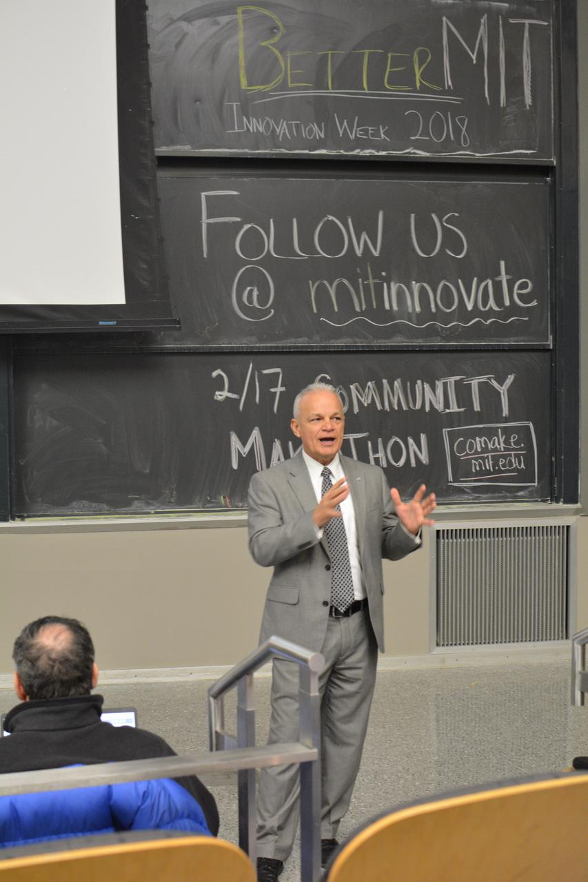
NASA Chief Technologist Douglas Terrier joined students, faculty and experts in Boston as part of MIT's "Better MIT Innovation Week 2018," a week-long program promoting leadership, entrepreneurship and action for a better future. During the February event, Terrier spoke about a culture of innovation at America's Space Program. (Photo: Damian Barabonkov/MIT Technique)

STS073-725-031 (24 October 1995) --- The contrasting colors of fall in New England are captured on this northward-looking photo of Martha's Vineyard, Nantucket Island, and the famous hook-shaped Cape Cod. Light-colored patches of urbanization are scattered throughout the scene, the most evident being the greater Boston area along the shores of Massachusetts Bay. The cape is composed of rock debris that, according to NASA scientists studying Columbia's photo collection, was deposited along the end of glacier some 20,000 years ago.

J. Keith Motley, Chancellor, University of Massachusetts Boston, and Chair, APLU (Association of Public and Land-grant Universities) Commission on Access, Diversity and Excellence, speaks at the Symposium on Supporting Underrepresented Minority Males in Science, Technology, Engineering and Mathematics (STEM), Tuesday, February 28, 2012 at NASA Headquarters in Washington. Photo Credit: (NASA/Carla Cioffi)
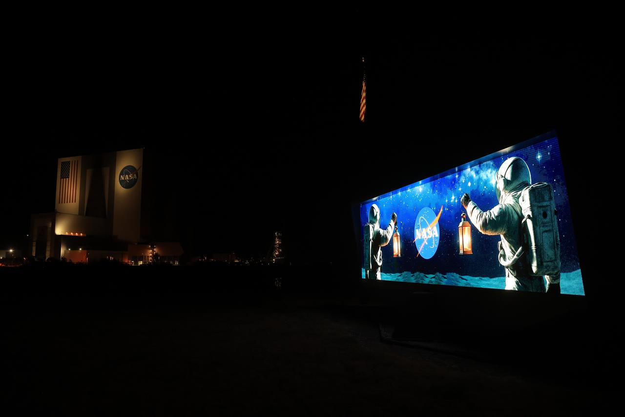
The historic countdown clock by the NASA News Center at the agency’s Kennedy Space Center in Florida on Friday, April 18, 2025, displays a graphic commemorating the 250th anniversary of Paul Revere’s midnight ride. The display is part of an initiative for all federal agencies to place two lights in a window as a symbol of the two lanterns placed in the steeple of Boston’s Old North Church used to signal to Revere and William Dawes to begin the famous midnight ride warning fellow minutemen in the Province of Massachusetts Bay that British soldiers were coming by sea.
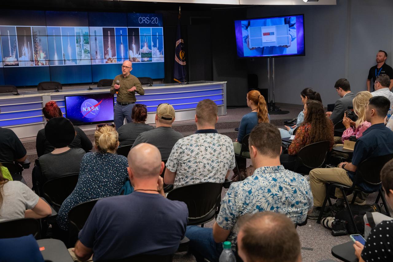
Aaron Beeler, professor of chemistry at Boston University and principal investigator of the Flow Chemistry Platform for Synthetic Reactions on ISS study, addresses NASA Social participants during a What’s on Board science briefing at the agency’s Kennedy Space Center in Florida on March 5, 2020. The briefing provided a closer look at some of the payloads launching on SpaceX’s 20th Commercial Resupply Services (CRS-20) mission to the International Space Station. The company’s Falcon 9 rocket is scheduled to lift off from Cape Canaveral Air Force Station’s Space Launch Complex 40 at 11:50 p.m. EST on March 6, 2020.

In recognition of Black History Month, the Black Employee Strategy Team hosted a panel discussion featuring some of the future leaders of NASA’s Kennedy Space Center on Feb. 13, 2019. Participants from left, are Tamiko Fletcher, Kennedy’s chief security information officer in IT Security; Anthony Harris, chief, Facility Systems Branch in Safety and Mission Assurance; Charmel Anderson-Jones, senior cross program quality engineer in the Safety and Mission Assurance Directorate, Exploration Ground Systems Division; and Malcolm Boston, contracting officer representative in the Launch Services Program. They shared personal testimony about their journey toward NASA employment, leadership styles and keys to their success.

KENNEDY SPACE CENTER, FLA. - Sen. John F. Kerry, D-Mass., greets Kennedy Space Center employees during a tour of the Orbiter Processing Facility (OPF). The orbiter Discovery is being prepared for flight in the OPF on the next Space Shuttle mission. The tour follows a public meeting Kerry held at the Dr. Kurt H. Debus Conference Facility at the Kennedy Space Center Visitor Complex. He said he chose to speak at KSC because it symbolizes America’s commitment to science, innovation and technology. He and Sen. John Edwards, D-N.C., are on a speaking tour prior to their appearance at the Democratic National Convention in Boston.

In recognition of Black History Month, the Black Employee Strategy Team hosted a panel discussion featuring some of the future leaders of NASA’s Kennedy Space Center on Feb. 13, 2019. Participants from left, are Tamiko Fletcher, Kennedy’s chief security information officer in IT Security; Anthony Harris, chief, Facility Systems Branch in Safety and Mission Assurance; Charmel Anderson-Jones, senior cross program quality engineer in the Safety and Mission Assurance Directorate, Exploration Ground Systems Division; and Malcolm Boston, contracting officer representative in the Launch Services Program. They shared personal testimony about their journey toward NASA employment, leadership styles and keys to their success.
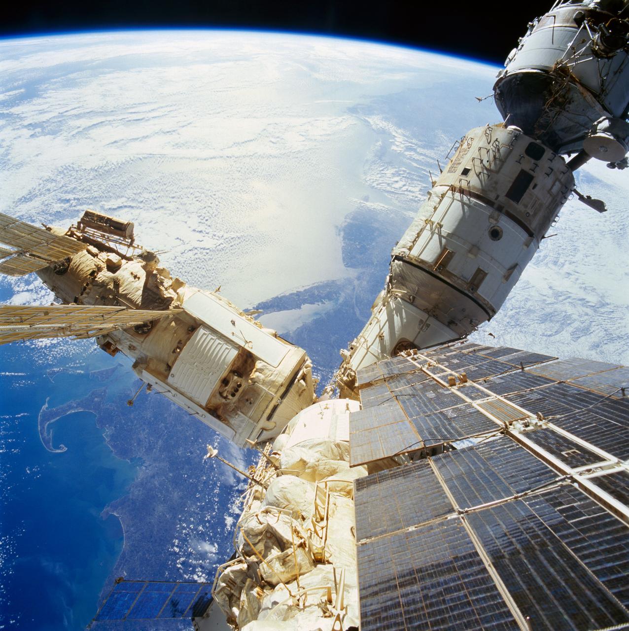
STS074-718-056 (12-20 Nov 1995) --- As photographed from the overhead Windows on the aft flight deck of the docked Space Shuttle Atlantis, a number of components of the cluster comprising the Russia?s Mir Space Station are backdropped over the northeastern United States. The crew enjoyed a southward looking view of the United States east coast from New Hampshire to South Carolina. Cape Cod and Boston, Massachusetts are seen on the north or the side away from Earth?s limb. New York City and Long Island are in the center of the photo. The mouths of both the Delaware and Chesapeake Bays are visible southward.

Aaron Beeler, professor of chemistry at Boston University and principal investigator of the Flow Chemistry Platform for Synthetic Reactions on ISS study, addresses NASA Social participants during a What’s on Board science briefing at the agency’s Kennedy Space Center in Florida on March 5, 2020. The briefing provided a closer look at some of the payloads launching on SpaceX’s 20th Commercial Resupply Services (CRS-20) mission to the International Space Station. The company’s Falcon 9 rocket is scheduled to lift off from Cape Canaveral Air Force Station’s Space Launch Complex 40 at 11:50 p.m. EST on March 6, 2020.

KENNEDY SPACE CENTER, FLA. - Sen. John F. Kerry (center), D-Mass., discusses Space Shuttle processing with NASA Vehicle Manager Stephanie Stilson during a tour of the Orbiter Processing Facility (OPF). They are standing under the orbiter Discovery, which is being prepared for flight on the next Space Shuttle mission. The tour follows a public meeting Kerry held at the Dr. Kurt H. Debus Conference Facility at the Kennedy Space Center Visitor Complex. He said he chose to speak at KSC because it symbolizes America’s commitment to science, innovation and technology. He and Sen. John Edwards, D-N.C., are on a speaking tour prior to their appearance at the Democratic National Convention in Boston.
ISS030-E-078095 (6 Feb. 2012) --- One of the Expedition 30 crew members aboard the International Space Station took this nighttime photograph of much of the eastern (Atlantic) coast of the United States. Large metropolitan areas and other easily recognizable sites from the Virginia/Maryland/Washington, D.C. area spanning almost to Rhode Island are visible in the scene. Boston is just out of frame at right. Long Island and the Greater Metropolitan area of New York City are visible in the lower right quadrant. Large cities in Pennsylvania (Philadelphia and Pittsburgh) are near center. Parts of two Russian vehicles parked at the orbital outpost are seen in left foreground.

KENNEDY SPACE CENTER, FLA. - Sen. Bill Nelson (second from left), D-Fla., former astronaut and Sen. John H. Glenn, D-Ohio, and Sen. John F. Kerry, D-Mass., receive a briefing from NASA Vehicle Manager Stephanie Stilson during a tour of the Orbiter Processing Facility (OPF). They are standing under the orbiter Discovery, which is being prepared for flight on the next Space Shuttle mission. The tour follows a public meeting Kerry held at the Dr. Kurt H. Debus Conference Facility at the Kennedy Space Center Visitor Complex. He said he chose to speak at KSC because it symbolizes America’s commitment to science, innovation and technology. He and Sen. John Edwards, D-N.C., are on a speaking tour prior to their appearance at the Democratic National Convention in Boston.
KENNEDY SPACE CENTER, FLA. - Sen. John F. Kerry, D-Mass., visits the flight deck of Space Shuttle Discovery during a tour of the Orbiter Processing Facility (OPF). The “bunny suit” he is wearing is clean room attire required for anyone coming in close proximity to Discovery, currently being prepared for flight on the next Space Shuttle mission. The tour of the OPF follows a public meeting Kerry held at the Dr. Kurt H. Debus Conference Facility at the Kennedy Space Center Visitor Complex. He said he chose to speak at KSC because it symbolizes America’s commitment to science, innovation and technology. He and Sen. John Edwards, D-N.C., are on a speaking tour prior to their appearance at the Democratic National Convention in Boston.
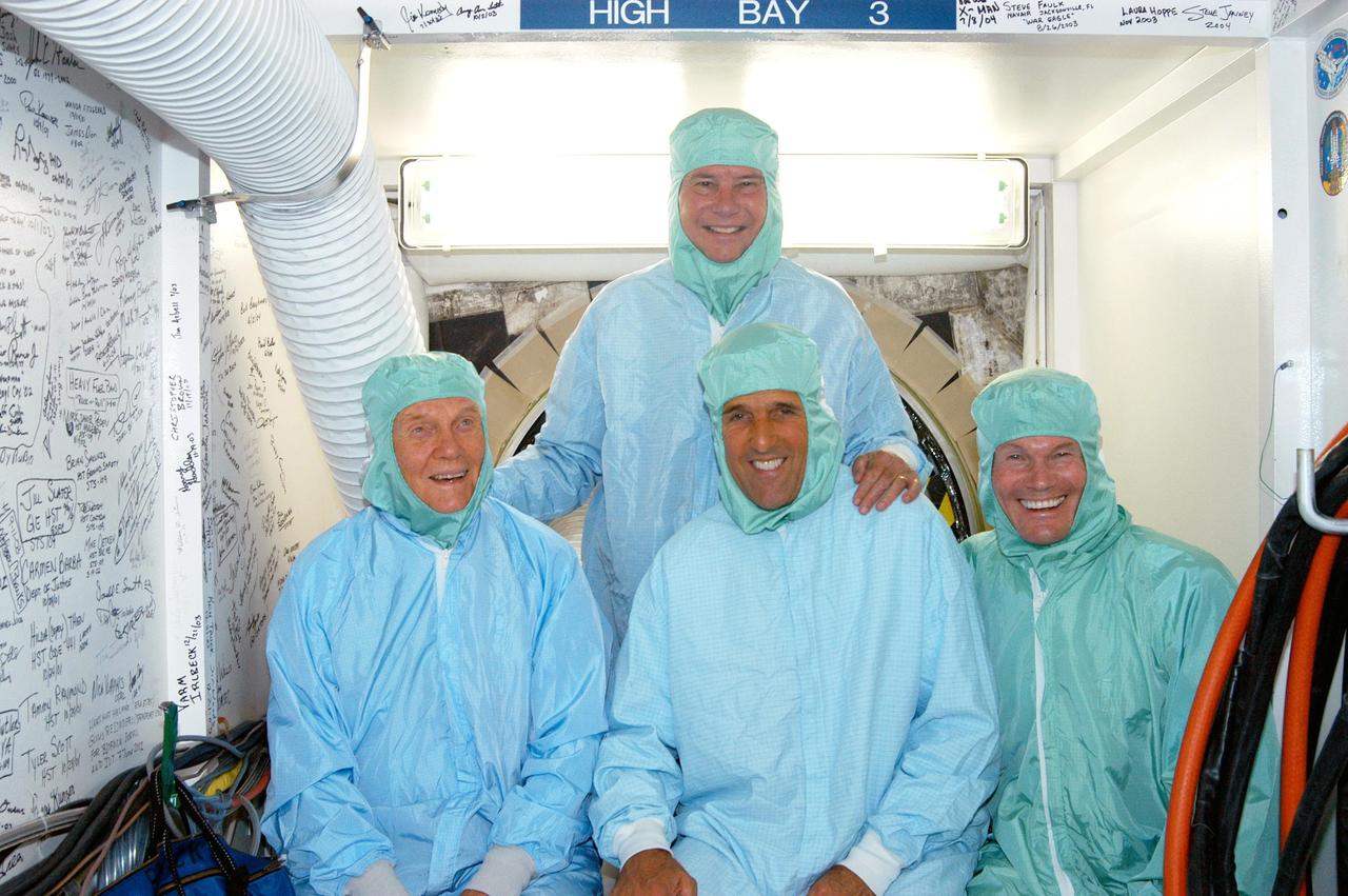
KENNEDY SPACE CENTER, FLA. - Sen. Bob Graham (back), D-Fla., former astronaut and Sen. John H. Glenn (front left), D-Ohio, Sen. John F. Kerry, D-Mass., and Sen. Bill Nelson, D-Fla., don clean room attire during a tour of the Orbiter Processing Facility (OPF). The “bunny suits” are required dress for anyone coming in close proximity to the orbiter Discovery, currently being prepared for flight on the next Space Shuttle mission. The tour of the OPF follows a public meeting Kerry held at the Dr. Kurt H. Debus Conference Facility at the Kennedy Space Center Visitor Complex. He said he chose to speak at KSC because it symbolizes America’s commitment to science, innovation and technology. He and Sen. John Edwards, D-N.C., are on a speaking tour prior to their appearance at the Democratic National Convention in Boston.
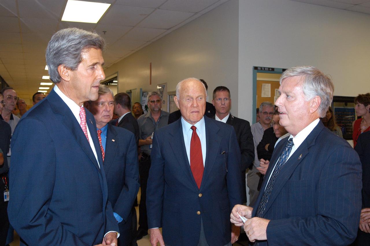
KENNEDY SPACE CENTER, FLA. - From left, Sen. John F. Kerry, D-Mass., Sen. Bob Graham, D-Fla., and former astronaut and Sen. John H. Glenn, D-Ohio, receive a briefing from Kennedy Space Center Director James W. Kennedy before a tour of the Orbiter Processing Facility (OPF). In the OPF, the orbiter Discovery is being prepared for flight on the next Space Shuttle mission. The tour follows a public meeting Kerry held at the Dr. Kurt H. Debus Conference Facility at the Kennedy Space Center Visitor Complex. He said he chose to speak at KSC because it symbolizes America’s commitment to science, innovation and technology. He and Sen. John Edwards, D-N.C., are on a speaking tour prior to their appearance at the Democratic National Convention in Boston.
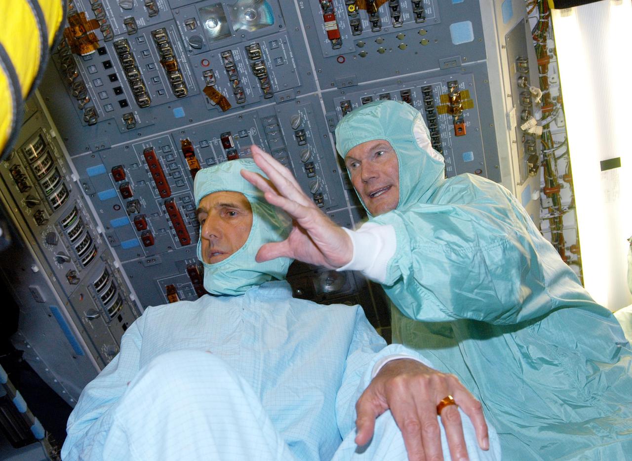
KENNEDY SPACE CENTER, FLA. - Sen. Bill Nelson (right), D-Fla., explains the layout of the glass cockpit to Sen. John F. Kerry, D-Mass., on the flight deck of orbiter Discovery during a tour of the Orbiter Processing Facility (OPF). The “bunny suits” they are wearing are clean room attire required for anyone coming in close proximity to Discovery, currently being prepared for flight on the next Space Shuttle mission. The tour of the OPF follows a public meeting Kerry held at the Dr. Kurt H. Debus Conference Facility at the Kennedy Space Center Visitor Complex. He said he chose to speak at KSC because it symbolizes America’s commitment to science, innovation and technology. He and Sen. John Edwards, D-N.C., are on a speaking tour prior to their appearance at the Democratic National Convention in Boston.
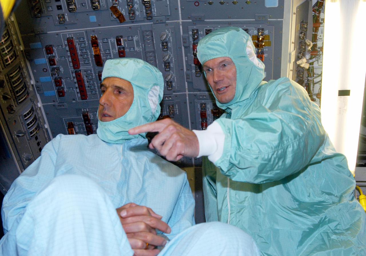
KENNEDY SPACE CENTER, FLA. - Sen. John F. Kerry (left), D-Mass., and Sen. Bill Nelson, D-Fla., dressed in clean room attire, visit the flight deck of Space Shuttle Discovery during a tour of the Orbiter Processing Facility (OPF). The “bunny suits” are required dress for anyone coming in close proximity to Discovery, currently being prepared for flight on the next Space Shuttle mission. The tour of the OPF follows a public meeting Kerry held at the Dr. Kurt H. Debus Conference Facility at the Kennedy Space Center Visitor Complex. He said he chose to speak at KSC because it symbolizes America’s commitment to science, innovation and technology. He and Sen. John Edwards, D-N.C., are on a speaking tour prior to their appearance at the Democratic National Convention in Boston.
KISSIMMEE, Fla. – Guests at the Tom Joyner Family Reunion listen as Malcom Boston of the Fleet System Integration Branch of the Launch Services Program LSP explains a computer demonstration on rockets. Behind the table, from the left, are Brian Norton, Emily Fields and Randy Mizelle, all from the Program Planning Office in LSP. The Tom Joyner Family Reunion is designed to present uplifting programs, entertainment and information about growing, diverse communities. An annual event of the nationally-syndicated Tom Joyner Morning Show, the many exhibits included NASA's participation focusing on encouraging young people to consider studies and careers in STEM -- science, technology, engineering and math. NASA's Education Division promoted the benefits of math and scientific learning along with career opportunities offered by the space agency. The activities took place at the Gaylord Palms Resort in Kissimmee, Florida, during the Labor Day weekend. Photo credit: NASA/Daniel Casper
The Dryden Aeronautical Test Range staff at NASA’s Armstrong Flight Research Center in California monitor all aircraft flights from the center as well as supporting the International Space Station and Russian Soyuz missions. Sitting from left to right are Bailey Cook, Lucio Ortiz, Matt Kearns, Sonja Belcher, John Batchelor, Jeff Koenig, Will Peters, Russ Franz, Zack Springer and Mike Webb. Standing left to right are Joy Bland, Doug Boston, April Norcross, Randy Torres, Robert Racicot, Jesus Vazquez, Jim Abercromby, Steve Simison, Tracy Ackeret, Chris Birkinbine, Darryl Burkes, Joe Innis, Bruce Lipe, Pat Ray, Kevin Knutson, Greg Strombo, Bart Rusnak, Tim Burt, Al Guajardo, Feras, Abu-Issa and Hector Rodriquez.
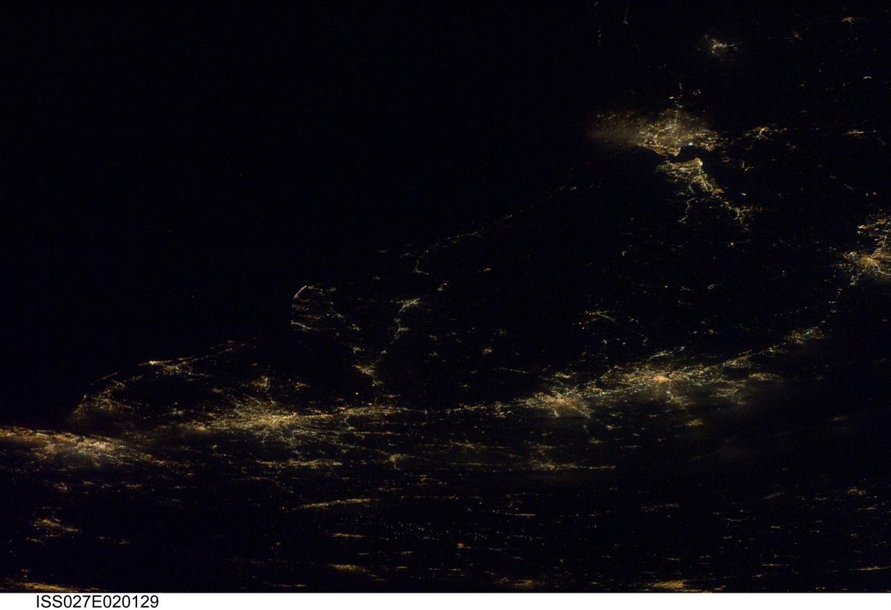
ISS027-E-020129 (6 April 2011) --- A night time view of the Atlantic Seaboard Conurbation, United States of America, is featured in this image photographed by an Expedition 27 crew member on the International Space Station. As regional metropolitan areas expand in both physical area and population, they typically aggregate to form economically, politically, and to some extent socially linked entities known as conurbations – the term “megalopolis” has also been used. One of the largest conurbations in the world is located along the eastern coastline of the United States, and has been termed the Atlantic Seaboard Conurbation (ASC). The ASC extends over 1,000 kilometers and includes the major economic, governmental, and cultural centers of Boston, Mass.; New York, N.Y.; Philadelphia, Pa.; Baltimore, Md.; and Washington, D.C. This photograph includes every metropolitan area in the ASC except for Boston, Mass. (located off the image to the northeast of New York, N.Y.). The image was taken during “local night”, which highlights the position and extent of each metropolitan area along the eastern seaboard by their urban lighting patterns. The establishment and growth of the conurbation was facilitated by transportation networks (railroads, highways, and air travel routes) for transfer of goods, materials, and population between the metropolitan areas. Two other large metropolitan areas are visible in the image – Norfolk, Va. and Richmond, Va. at upper right – but these are not considered to be part of the ASC. In contrast to the city lights that mark metropolitan areas and smaller communities along the sea coast and interior, the Atlantic Ocean appears as a featureless dark region occupying the upper left quarter of the image.
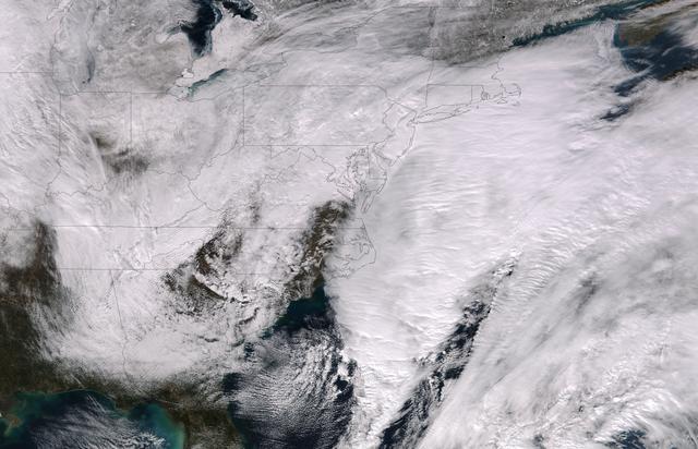
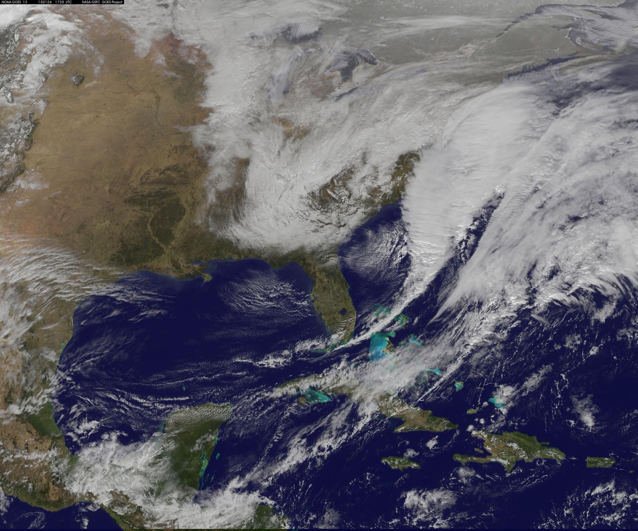
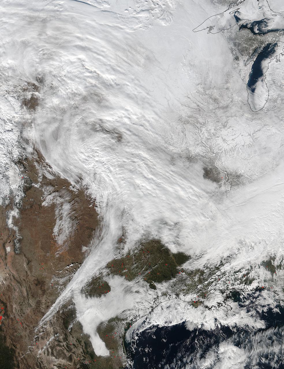
This image was taken by the Suomi NPP satellite's VIIRS instrument at 1825Z on January 26, 2015. A low pressure system currently forming off the mid-Atlantic coast will rapidly strengthen into a major nor'easter today and affect parts of the Northeast U.S. through early Wednesday. This system will be responsible for heavy to intense snowfall and strong winds, with blizzard conditions expected from eastern New Jersey to eastern Massachusetts where Blizzard Warnings are in effect. Accumulations will likely exceed one foot from eastern New Jersey through eastern Maine by late Tuesday. The heaviest snow accumulations, perhaps exceeding two feet, are forecast across portions of Connecticut, Rhode Island and Massachusetts, including the Boston area. Currently, New York City is forecast to receive 18-24 inches of snow, and Boston is forecast to receive 24-36 inches of snow. Wind gusts of 45 to 60 mph will be common from eastern New Jersey to eastern Massachusetts, leading to widespread blizzard conditions. Wind gusts up to 70 mph are possible in far eastern Massachusetts, including Cape Cod and Nantucket. Credit: NASA/NOAA/NPP/VIIRS Via: NASA/NOAA via <b><a href="www.nnvl.noaa.gov/" rel="nofollow"> NOAA Environmental Visualization Laboratory</a></b> <b><a href="http://www.nasa.gov/audience/formedia/features/MP_Photo_Guidelines.html" rel="nofollow">NASA image use policy.</a></b> <b><a href="http://www.nasa.gov/centers/goddard/home/index.html" rel="nofollow">NASA Goddard Space Flight Center</a></b> enables NASA’s mission through four scientific endeavors: Earth Science, Heliophysics, Solar System Exploration, and Astrophysics. Goddard plays a leading role in NASA’s accomplishments by contributing compelling scientific knowledge to advance the Agency’s mission. <b>Follow us on <a href="http://twitter.com/NASAGoddardPix" rel="nofollow">Twitter</a></b> <b>Like us on <a href="http://www.facebook.com/pages/Greenbelt-MD/NASA-Goddard/395013845897?ref=tsd" rel="nofollow">Facebook</a></b> <b>Find us on <a href="http://instagram.com/nasagoddard?vm=grid" rel="nofollow">Instagram</a></b>
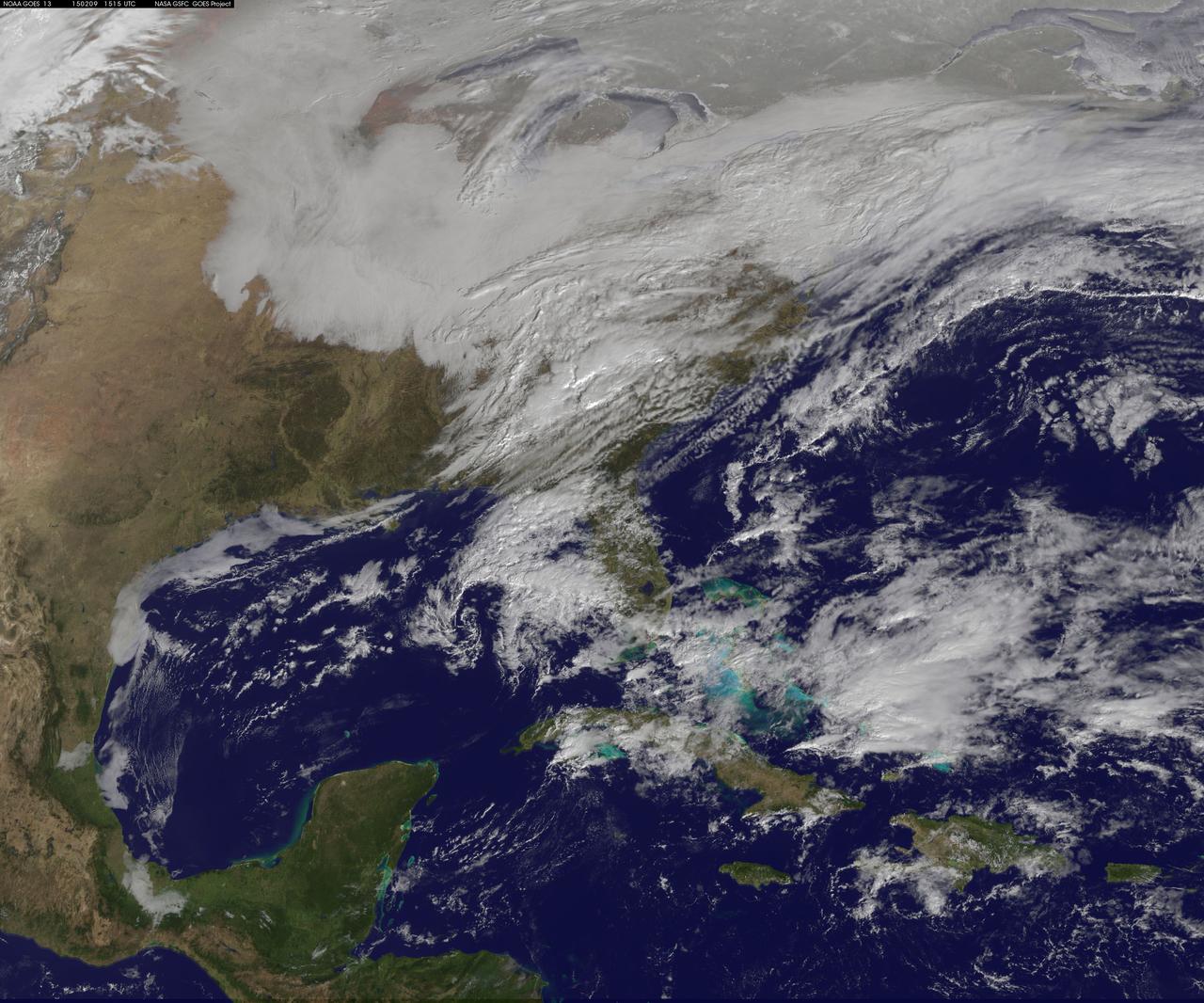
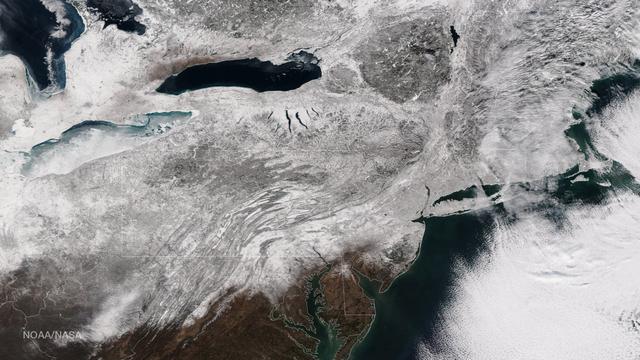
Another large snowstorm affecting New England was dropping more snow on the region and breaking records on February 9, as NOAA's GOES-East satellite captured an image of the clouds associated with the storm system. On Feb. 9, NOAA's National Weather Service in Boston, Massachusetts noted that "The 30-day snowfall total at Boston ending 7 a.m. this morning is 61.6 inches. This exceeds the previous maximum 30 day snowfall total on record at Boston, which was 58.8 inches ending Feb 7 1978." The GOES-East image was created by NASA/NOAA's GOES Project at NASA's Goddard Space Flight Center in Greenbelt, Maryland. It showed a blanket of clouds over the U.S. northeast that stretched down to the Mid-Atlantic where there was no snow on the ground in Washington, D.C. NOAA's National Weather Service Weather Prediction Center provided a look at the extent of the storm system and noted "Heavy snow will impact portions of New York State and New England as the new week begins. Freezing rain will spread from western Pennsylvania to Long Island, with rain for the mid-Atlantic states." The low pressure area bringing the snow to the northeast was located in central Pennsylvania. A cold front extended southward from the low across the Tennessee Valley while a stationary boundary extended eastward from the low across the central mid-Atlantic. To create the image, NASA/NOAA's GOES Project takes the cloud data from NOAA's GOES-East satellite and overlays it on a true-color image of land and ocean created by data from the Moderate Resolution Imaging Spectroradiometer, or MODIS, instrument that flies aboard NASA's Aqua and Terra satellites. Together, those data created the entire picture of the storm. NOAA's GOES satellites provide the kind of continuous monitoring necessary for intensive data analysis. Geostationary describes an orbit in which a satellite is always in the same position with respect to the rotating Earth. This allows GOES to hover continuously over one position on Earth's surface, appearing stationary. As a result, GOES provide a constant vigil for the atmospheric triggers for severe weather conditions such as tornadoes, flash floods, hail storms and hurricanes. For updated information about the storm system, visit NOAA's NWS website: <a href="http://www.weather.gov" rel="nofollow">www.weather.gov</a> For more information about GOES satellites, visit: <a href="http://www.goes.noaa.gov/" rel="nofollow">www.goes.noaa.gov/</a> or goes.gsfc.nasa.gov/ Rob Gutro NASA's Goddard Space Flight Center <b><a href="http://goes.gsfc.nasa.gov/" rel="nofollow">Credit: NOAA/NASA GOES Project</a></b> <b><a href="http://www.nasa.gov/audience/formedia/features/MP_Photo_Guidelines.html" rel="nofollow">NASA image use policy.</a></b> <b><a href="http://www.nasa.gov/centers/goddard/home/index.html" rel="nofollow">NASA Goddard Space Flight Center</a></b> enables NASA’s mission through four scientific endeavors: Earth Science, Heliophysics, Solar System Exploration, and Astrophysics. Goddard plays a leading role in NASA’s accomplishments by contributing compelling scientific knowledge to advance the Agency’s mission. <b>Follow us on <a href="http://twitter.com/NASAGoddardPix" rel="nofollow">Twitter</a></b> <b>Like us on <a href="http://www.facebook.com/pages/Greenbelt-MD/NASA-Goddard/395013845897?ref=tsd" rel="nofollow">Facebook</a></b> <b>Find us on <a href="http://instagram.com/nasagoddard?vm=grid" rel="nofollow">Instagram</a></b>
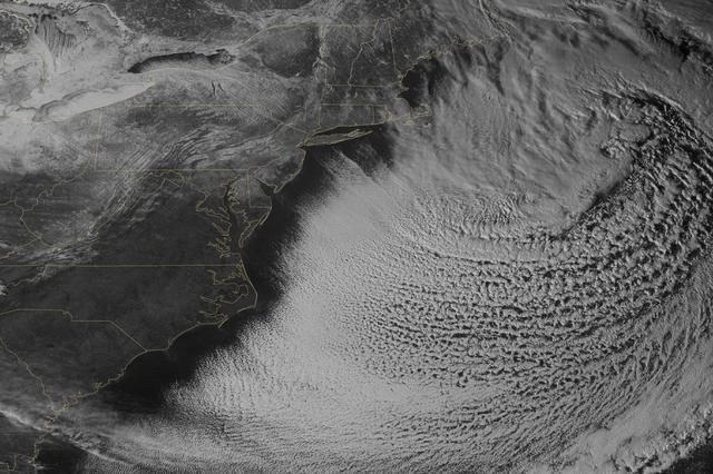
Yet another potent winter storm battered the northeastern United States on February 14-15, 2015. The nor'easter brought 12 to 20 inches (30 to 50 centimeters) of snow across much of eastern New England, along with tropical storm force winds over 60 miles (100 kilometers) per hour. The latest snowfall pushed Boston to its highest monthly total on record—58 inches and counting—and its third highest yearly snow total. This image was acquired by the GOES-East weather satellite at 3:45 p.m. Eastern Standard Time (20:45 Universal Time) on February 15, 2015, as the storm was mostly out to sea. Note the comma-like shape of the nor'easter, which spawned blizzard conditions at coastal locations. The official meteorological definition of a blizzard is three consecutive hours of falling or blowing snow with winds gusting above 35 miles (56 kilometers) per hour and visibility below one-fourth of a mile (0.4 kilometers). As of February 17, the snow depth near Boston was greater than in all but two reported locations in Alaska. It was significantly higher than the notoriously snowy states of Michigan, Wisconsin, and Minnesota. Only Buffalo, New York, had a higher snow pack. On February 16-17, more snow and ice fell across the eastern United States from northern Mississippi all the way to Maine. Read more: <a href="http://1.usa.gov/19wR4LI" rel="nofollow">1.usa.gov/19wR4LI</a> Via: <b><a href="http://www.earthobservatory.nasa.gov/" rel="nofollow"> NASA Earth Observatory</a></b> GOES image courtesy of the NASA/NOAA GOES Project Science team. Terra MODIS image by Jeff Schmaltz, LANCE/EOSDIS Rapid Response at NASA Goddard Space Flight Center. Caption by Mike Carlowicz. <b><a href="http://www.nasa.gov/audience/formedia/features/MP_Photo_Guidelines.html" rel="nofollow">NASA image use policy.</a></b> <b><a href="http://www.nasa.gov/centers/goddard/home/index.html" rel="nofollow">NASA Goddard Space Flight Center</a></b> enables NASA’s mission through four scientific endeavors: Earth Science, Heliophysics, Solar System Exploration, and Astrophysics. Goddard plays a leading role in NASA’s accomplishments by contributing compelling scientific knowledge to advance the Agency’s mission. <b>Follow us on <a href="http://twitter.com/NASAGoddardPix" rel="nofollow">Twitter</a></b> <b>Like us on <a href="http://www.facebook.com/pages/Greenbelt-MD/NASA-Goddard/395013845897?ref=tsd" rel="nofollow">Facebook</a></b> <b>Find us on <a href="http://instagram.com/nasagoddard?vm=grid" rel="nofollow">Instagram</a></b>
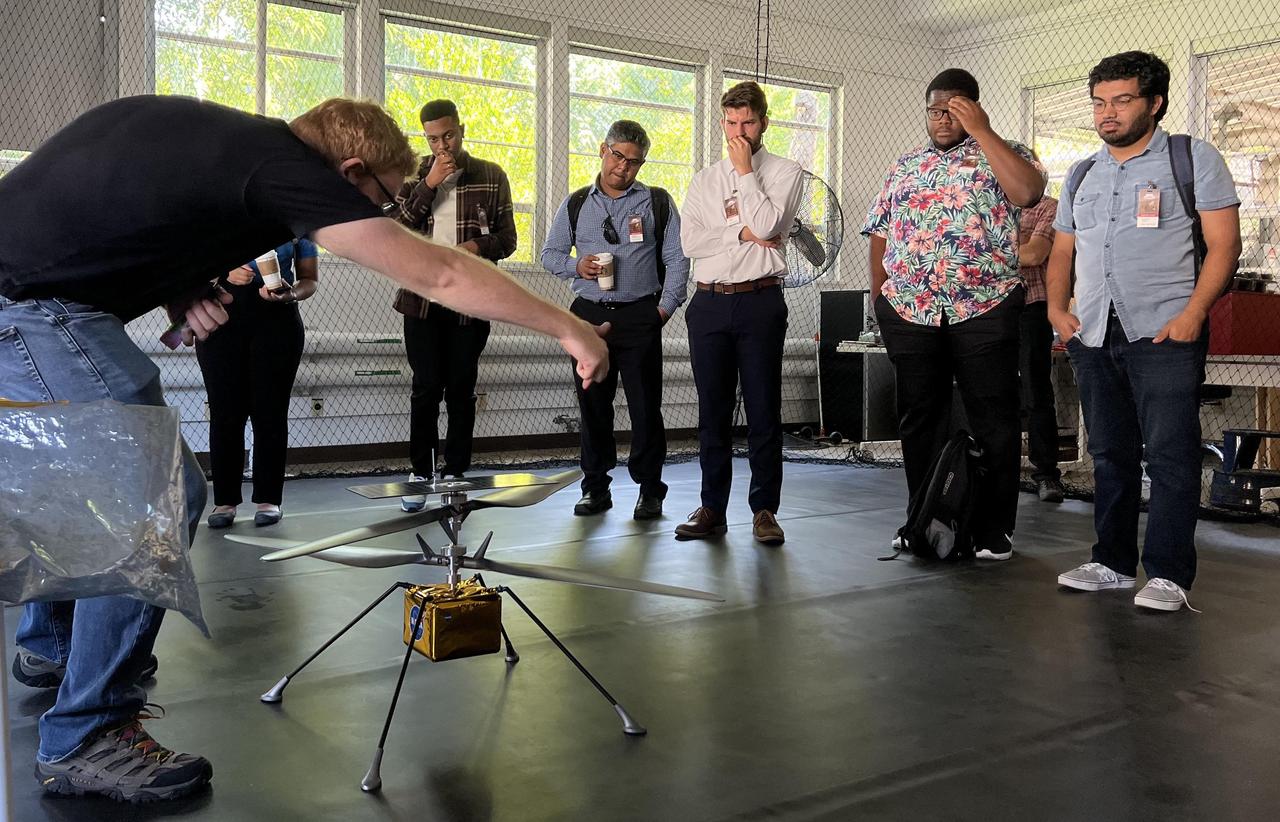
Participants in NASA's Minority Serving Institutions Space Accelerator program surround a full-scale model of NASA's Mars Ingenuity Helicopter as engineer Michael Starch discusses the mission. The group was visiting NASA's Jet Propulsion Laboratory on Aug. 18, 2022. These participants were members of three teams named as awardees in the first-of-its-kind accelerator program, a competition to advance the NASA's goals and meet its needs in the areas of machine learning, artificial intelligence, and development of autonomous systems while also engaging underrepresented academic institutions and reducing barriers for them to submit ideas to the agency. The program provides funding, business training through a 10-week accelerator course, and mentorship to help the teams develop ideas for systems that can operate without human oversight for future science missions in space and on Earth. The teams were made up of professors and students from Fayetteville State University in North Carolina, University of Massachusetts Boston, and California State University, Northridge. At the conclusion of the accelerator, participants arrived in Southern California for a variety of events, including two days at JPL. The program is a partnership between NASA's Science Mission Directorate, its Earth Science Technology Office, the Minority University Research Education Project within the agency's Office of STEM Engagement, JPL, and Starburst, a global aerospace accelerator company based in Los Angeles. https://photojournal.jpl.nasa.gov/catalog/PIA25315
![STS091-718-037 (2-12 June 1998)--- This photo taken from the aft flight deck of the Earth-orbiting Space Shuttle Discovery features Cape Cod, an easily recognizable hook-shaped peninsula in southeastern Massachusetts. Sandy and of glacial origin, it extends 65 miles (105 km) into the Atlantic Ocean, has a varying breadth of 1 to 20 miles (1.6-32 km), and is bounded by Cape Cod Bay (north and west), Buzzards Bay (west), and Vineyard and Nantucket sounds (south). The northern hook of the cape (embracing a recreation area of dunes, marshes, lakes, and pinewoods) was designated the Cape Cod National Seashore (area 68 square miles [176 square km]) in 1961. The Cape Cod Canal cuts across the base of the peninsula shortening the shipping distance between New York City and Boston by more than 75 miles (120 km) and forms part of the Atlantic Intracoastal Waterway. Cape Cod was named by Bartholomew Gosnold, an English explorer who visited its shores in 1602 and took aboard a "great store of codfish." In 1620 the Pilgrims landed at the site of Provincetown, on the hooked tip of Cape Cod, before proceeding to Plymouth.](https://images-assets.nasa.gov/image/sts091-718-037/sts091-718-037~medium.jpg)
STS091-718-037 (2-12 June 1998)--- This photo taken from the aft flight deck of the Earth-orbiting Space Shuttle Discovery features Cape Cod, an easily recognizable hook-shaped peninsula in southeastern Massachusetts. Sandy and of glacial origin, it extends 65 miles (105 km) into the Atlantic Ocean, has a varying breadth of 1 to 20 miles (1.6-32 km), and is bounded by Cape Cod Bay (north and west), Buzzards Bay (west), and Vineyard and Nantucket sounds (south). The northern hook of the cape (embracing a recreation area of dunes, marshes, lakes, and pinewoods) was designated the Cape Cod National Seashore (area 68 square miles [176 square km]) in 1961. The Cape Cod Canal cuts across the base of the peninsula shortening the shipping distance between New York City and Boston by more than 75 miles (120 km) and forms part of the Atlantic Intracoastal Waterway. Cape Cod was named by Bartholomew Gosnold, an English explorer who visited its shores in 1602 and took aboard a "great store of codfish." In 1620 the Pilgrims landed at the site of Provincetown, on the hooked tip of Cape Cod, before proceeding to Plymouth.
STS098-716-057 (7-20 February 2001) --- Baltimore, Maryland can be identified in this northwest-looking view, photographed with a 70mm handheld camera from the Space Shuttle Atlantis, which shows the western shore of Chesapeake Bay. Numerous drowned river valleys provide excellent natural harbors along the periphery of the bay. Baltimore’s harbor has been developed along one of these drowned valleys, the Patapsco River. With a population of over 2.5 million people, the greater Baltimore urban area is part of the northeastern U.S. Megalopolis that extends from the Boston (MA) area to Richmond (VA). Specific features that can be seen in the image include a short segment of Interstate Highway 95 that connects southwest Baltimore with northeast Washington, D.C.; the intersecting runways of Baltimore-Washington International Airport south of downtown Baltimore; Francis Scott Key Bridge that skirts around the southeast side of Baltimore; the Chesapeake Bay Bridge that spans the bay and connects the Baltimore area with the eastern shore of Maryland; and the central business district of Baltimore where the two arms of the inner harbor terminate. The darker-looking vegetation cover is mixed hardwood forests (notice that many wooded areas are located along streambeds and floodplains of small river valleys), while lighter-looking land parcels in the rural countryside is used for crops or pasturelands.
SL4-138-3894 (5 Jan. 1974) --- An oblique view of a portion of the northeastern part of the United States, as photographed from the Skylab space station in Earth orbit by one of the Skylab 4 crewmen. The camera used was a hand-held 70mm Hasselblad, and with SO-368 medium-speed Ektachrome film. This is an excellent example of the regional view which is available from space. The entire area of New Jersey, eastern Pennsylvania, southeastern New York, and southern New England can be examined in one view. Long Island, New York City and the lower Hudson River Valley are readily seen in their regional framework. The Boston area, although blurred by clouds, is also included. The spackling of the snow enhances the contrast, especially of terrain and cultural features. Different levels of clouds can be studies, especially the crossing layers of cirrus in the center of the photograph, with the lower cirrus trending north-south and the upper (probably associated with a jet stream) trending east-west. Photo credit: NASA
As the storm moves offshore and the skies clear over the Northeast United States, the extent of snowfall from the blizzard is shown in this image from the Suomi NPP satellite imagery, taken on January 28, 2015 at 1:50 EST. Portions of Suffolk County, New York and parts of eastern and southern New England, including areas in and around Portland, Maine, Boston, Massachusetts, and Providence, Rhode Island, received more than 20 inches of snowfall. Up to 36 inches of snow were reported in Auburn, Hudson and Lunenburg, Massachusetts. Credit: NASA/NOAA/NPP/VIIRS Via: <b><a href="www.nnvl.noaa.gov/" rel="nofollow"> NOAA Environmental Visualization Laboratory</a></b> <b><a href="http://www.nasa.gov/audience/formedia/features/MP_Photo_Guidelines.html" rel="nofollow">NASA image use policy.</a></b> <b><a href="http://www.nasa.gov/centers/goddard/home/index.html" rel="nofollow">NASA Goddard Space Flight Center</a></b> enables NASA’s mission through four scientific endeavors: Earth Science, Heliophysics, Solar System Exploration, and Astrophysics. Goddard plays a leading role in NASA’s accomplishments by contributing compelling scientific knowledge to advance the Agency’s mission. <b>Follow us on <a href="http://twitter.com/NASAGoddardPix" rel="nofollow">Twitter</a></b> <b>Like us on <a href="http://www.facebook.com/pages/Greenbelt-MD/NASA-Goddard/395013845897?ref=tsd" rel="nofollow">Facebook</a></b> <b>Find us on <a href="http://instagram.com/nasagoddard?vm=grid" rel="nofollow">Instagram</a></b>
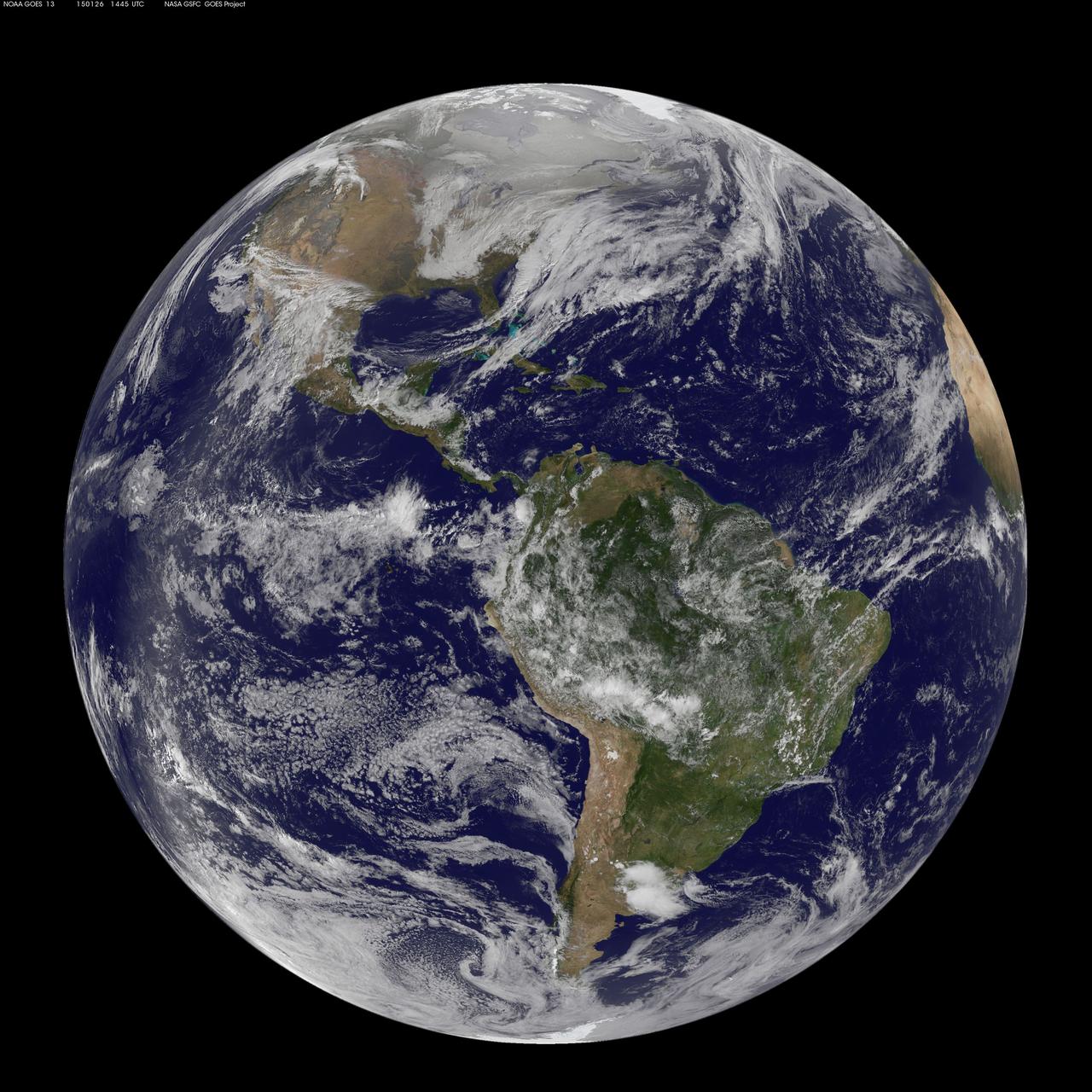
National Weather Service forecasters have been tracking a low pressure area that moved from the Midwest into the Atlantic Ocean today, and is expected to become a strong nor'easter that will bring blizzard conditions to the northeastern U.S. The path of the system was captured in a NASA movie of NOAA's GOES-East satellite imagery. (This GOES 13 image was captured on January 26, 2015 at 1445 UTC.) On Monday, January 26, 2015, the National Weather Service noted: A storm system off the East Coast will continue to strengthen as it develops into a major nor'easter on Monday. As the storm moves up the coast, it is expected to bring snowfall of 1-3 feet or more to many parts of the Northeast through Tuesday evening, including New York City and Boston. Strong, gusty winds will combine with the snow to create blizzard conditions along and near the coast. Winter storm warnings are in effect for the panhandles of West Virginia and Maryland, much of interior New England down to the northern Mid-Atlantic as well as for Nantucket Island, Massachusetts. Winter weather advisories are in effect for portions of the Ohio Valley, Mid-Atlantic and the southern Appalachians as well as a narrow area across interior New England. To create the video and imagery, NASA/NOAA's GOES Project located at NASA's Goddard Space Flight Center in Greenbelt, Maryland overlays the cloud data from NOAA's GOES-East satellite on a true-color image of land and ocean created by data from the Moderate Resolution Imaging Spectroradiometer, or MODIS, instrument that flies aboard NASA's Aqua and Terra satellites. Together, these data create the entire animation of the storm and show its movement. GOES satellites provide the kind of continuous monitoring necessary for intensive data analysis. Geostationary describes an orbit in which a satellite is always in the same position with respect to the rotating Earth. This allows GOES to hover continuously over one position on Earth's surface, appearing stationary. As a result, GOES provide a constant vigil for the atmospheric "triggers" for severe weather conditions such as tornadoes, flash floods, hail storms and hurricanes. For updated information about the storm system, visit NOAA's NWS website: <a href="http://www.weather.gov" rel="nofollow">www.weather.gov</a> For more information about GOES satellites, visit: <a href="http://www.goes.noaa.gov/" rel="nofollow">www.goes.noaa.gov/</a> or goes.gsfc.nasa.gov/ Rob Gutro NASA's Goddard Space Flight Center

The U.S. National Weather Service called it a “a crippling and historic winter blizzard.” In late January 2015, transportation systems from Trenton to Portland were shut down, and more than 35 million people hunkered down for extreme snowfall and biting winds. For those in New England, it turned out to be a monstrous storm. For the Mid-Atlantic region, not so much. Vast swaths of Massachusetts, Connecticut, Rhode Island, New Hampshire, Maine, and Long Island (NY) were blanketed with 15 to 25 inches (40 to 60 centimeters) of snow as of midday on January 27, 2015, and snow was expected to continue into January 28. Sustained winds reached gale force, with hurricane-force gusts along the coastlines. Storm surges sent ice and water into the streets of Scituate and Nantucket, Massachusetts. Many New England towns, including the city of Boston, were expected to approach all-time snowfall records. The Visible Infrared Imaging Radiometer Suite on the Suomi NPP satellite acquired these nighttime images at 1:45 am US eastern standard time (06:45 Universal Time) on January 27, 2015. The top image, lit by moonlight and city lights, shows a nor'easter off the coast of the East Coast of the United States. City lights are blurred somewhat by the cloud cover. The second image shows the same scene in longwave infrared radiation, with brighter shades representing the colder temperatures of snow-producing clouds. NASA Earth Observatory image by Jesse Allen, using VIIRS data from the Suomi National Polar-orbiting Partnership. Read more: <a href="http://earthobservatory.nasa.gov/IOTD/view.php?id=85166&eocn=home&eoci=iotd_title" rel="nofollow">earthobservatory.nasa.gov/IOTD/view.php?id=85166&eocn...</a> Via: <b><a href="http://www.earthobservatory.nasa.gov/" rel="nofollow"> NASA Earth Observatory</a></b> <b><a href="http://www.nasa.gov/audience/formedia/features/MP_Photo_Guidelines.html" rel="nofollow">NASA image use policy.</a></b> <b><a href="http://www.nasa.gov/centers/goddard/home/index.html" rel="nofollow">NASA Goddard Space Flight Center</a></b> enables NASA’s mission through four scientific endeavors: Earth Science, Heliophysics, Solar System Exploration, and Astrophysics. Goddard plays a leading role in NASA’s accomplishments by contributing compelling scientific knowledge to advance the Agency’s mission. <b>Follow us on <a href="http://twitter.com/NASAGoddardPix" rel="nofollow">Twitter</a></b> <b>Like us on <a href="http://www.facebook.com/pages/Greenbelt-MD/NASA-Goddard/395013845897?ref=tsd" rel="nofollow">Facebook</a></b> <b>Find us on <a href="http://instagram.com/nasagoddard?vm=grid" rel="nofollow">Instagram</a></b>
National Weather Service forecasters have been tracking a low pressure area that moved from the Midwest into the Atlantic Ocean today, and is expected to become a strong nor'easter that will bring blizzard conditions to the northeastern U.S. The path of the system was captured in a NASA movie of NOAA's GOES-East satellite imagery. On Monday, January 26, 2015, the National Weather Service noted: A storm system off the East Coast will continue to strengthen as it develops into a major nor'easter on Monday. As the storm moves up the coast, it is expected to bring snowfall of 1-3 feet or more to many parts of the Northeast through Tuesday evening, including New York City and Boston. Strong, gusty winds will combine with the snow to create blizzard conditions along and near the coast. Winter storm warnings are in effect for the panhandles of West Virginia and Maryland, much of interior New England down to the northern Mid-Atlantic as well as for Nantucket Island, Massachusetts. Winter weather advisories are in effect for portions of the Ohio Valley, Mid-Atlantic and the southern Appalachians as well as a narrow area across interior New England. To create the video and imagery, NASA/NOAA's GOES Project located at NASA's Goddard Space Flight Center in Greenbelt, Maryland overlays the cloud data from NOAA's GOES-East satellite on a true-color image of land and ocean created by data from the Moderate Resolution Imaging Spectroradiometer, or MODIS, instrument that flies aboard NASA's Aqua and Terra satellites. Together, these data create the entire animation of the storm and show its movement. GOES satellites provide the kind of continuous monitoring necessary for intensive data analysis. Geostationary describes an orbit in which a satellite is always in the same position with respect to the rotating Earth. This allows GOES to hover continuously over one position on Earth's surface, appearing stationary. As a result, GOES provide a constant vigil for the atmospheric "triggers" for severe weather conditions such as tornadoes, flash floods, hail storms and hurricanes. For updated information about the storm system, visit NOAA's NWS website: <a href="http://www.weather.gov" rel="nofollow">www.weather.gov</a> For more information about GOES satellites, visit: <a href="http://www.goes.noaa.gov/" rel="nofollow">www.goes.noaa.gov/</a> or goes.gsfc.nasa.gov/ Rob Gutro NASA's Goddard Space Flight Center

The U.S. National Weather Service called it a “a crippling and historic winter blizzard.” In late January 2015, transportation systems from Trenton to Portland were shut down, and more than 35 million people hunkered down for extreme snowfall and biting winds. For those in New England, it turned out to be a monstrous storm. For the Mid-Atlantic region, not so much. Vast swaths of Massachusetts, Connecticut, Rhode Island, New Hampshire, Maine, and Long Island (NY) were blanketed with 15 to 25 inches (40 to 60 centimeters) of snow as of midday on January 27, 2015, and snow was expected to continue into January 28. Sustained winds reached gale force, with hurricane-force gusts along the coastlines. Storm surges sent ice and water into the streets of Scituate and Nantucket, Massachusetts. Many New England towns, including the city of Boston, were expected to approach all-time snowfall records. The Visible Infrared Imaging Radiometer Suite on the Suomi NPP satellite acquired these nighttime images at 1:45 am US eastern standard time (06:45 Universal Time) on January 27, 2015. The top image, lit by moonlight and city lights, shows a nor'easter off the coast of the East Coast of the United States. City lights are blurred somewhat by the cloud cover. The second image shows the same scene in longwave infrared radiation, with brighter shades representing the colder temperatures of snow-producing clouds. NASA Earth Observatory image by Jesse Allen, using VIIRS data from the Suomi National Polar-orbiting Partnership. Read more: <a href="http://earthobservatory.nasa.gov/IOTD/view.php?id=85166&eocn=home&eoci=iotd_title" rel="nofollow">earthobservatory.nasa.gov/IOTD/view.php?id=85166&eocn...</a> Via: <b><a href="http://www.earthobservatory.nasa.gov/" rel="nofollow"> NASA Earth Observatory</a></b> <b><a href="http://www.nasa.gov/audience/formedia/features/MP_Photo_Guidelines.html" rel="nofollow">NASA image use policy.</a></b> <b><a href="http://www.nasa.gov/centers/goddard/home/index.html" rel="nofollow">NASA Goddard Space Flight Center</a></b> enables NASA’s mission through four scientific endeavors: Earth Science, Heliophysics, Solar System Exploration, and Astrophysics. Goddard plays a leading role in NASA’s accomplishments by contributing compelling scientific knowledge to advance the Agency’s mission. <b>Follow us on <a href="http://twitter.com/NASAGoddardPix" rel="nofollow">Twitter</a></b> <b>Like us on <a href="http://www.facebook.com/pages/Greenbelt-MD/NASA-Goddard/395013845897?ref=tsd" rel="nofollow">Facebook</a></b> <b>Find us on <a href="http://instagram.com/nasagoddard?vm=grid" rel="nofollow">Instagram</a></b>
On Jan. 20 at 2:30 p.m. EST the VIIRS instrument aboard NASA-NOAA's Suomi NPP captured this image of the winter storm moving through the central U.S. Credits: NASA Goddard Rapid Response The low pressure area from the Eastern Pacific Ocean moved into the western U.S. and tracked across the four corners region into Texas where NASA-NOAA's Suomi NPP satellite observed the clouds associated with the storm. The Visible Infrared Imaging Radiometer Suite (VIIRS) instrument aboard Suomi NPP satellite captured the visible image on January 20, 2016 at 19:30 UTC (2:30 p.m. EST) when the storm was over the central U.S. In the image, snow cover is visible in the Rockies and southern Great Lakes states. VIIRS collects visible and infrared imagery and global observations of land, atmosphere, cryosphere and oceans. That low pressure system located over the south central United States on Jan. 21 is expected to track east across the Tennessee Valley and will give way to a deepening coastal low pressure area. The National Weather Service said "This latter feature takes over and becomes a dominant force in setting up heavy snow bands over the Mid-Atlantic and very gusty winds." The storm system is expected to bring an increased risk of severe weather from far southeastern Texas across southern Louisiana/Mississippi, and into the far western Florida Panhandle on Thursday, Jan. 21. That threat for severe weather will move east as the low pressure area continues heading in that direction. The National Weather Service Weather Prediction Center in College Park, Maryland said "A potentially crippling winter storm is anticipated for portions of the mid-Atlantic Friday into early Saturday. Snowfall may approach two feet for some locations, including the Baltimore and Washington, D.C. metro areas. Farther north, there is uncertainty in snowfall for the New York City-to-Boston corridor. Farther south, significant icing is likely for portions of Kentucky and North Carolina." <b><a href="http://www.nasa.gov/audience/formedia/features/MP_Photo_Guidelines.html" rel="nofollow">NASA image use policy.</a></b> <b><a href="http://www.nasa.gov/centers/goddard/home/index.html" rel="nofollow">NASA Goddard Space Flight Center</a></b> enables NASA’s mission through four scientific endeavors: Earth Science, Heliophysics, Solar System Exploration, and Astrophysics. Goddard plays a leading role in NASA’s accomplishments by contributing compelling scientific knowledge to advance the Agency’s mission. <b>Follow us on <a href="http://twitter.com/NASAGoddardPix" rel="nofollow">Twitter</a></b> <b>Like us on <a href="http://www.facebook.com/pages/Greenbelt-MD/NASA-Goddard/395013845897?ref=tsd" rel="nofollow">Facebook</a></b> <b>Find us on <a href="http://instagram.com/nasagoddard?vm=grid" rel="nofollow">Instagram</a></b>
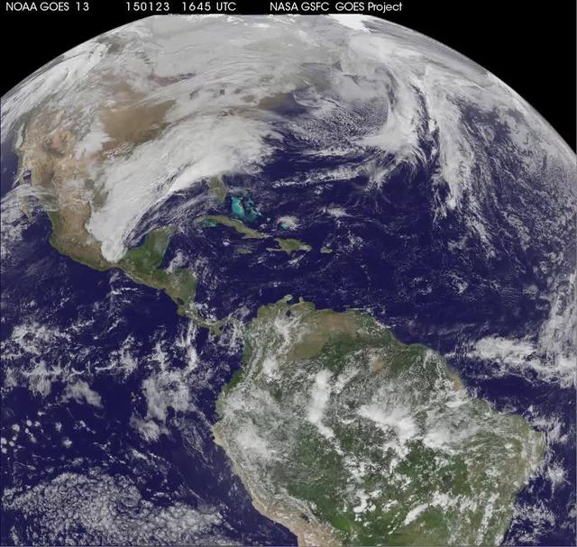
National Weather Service forecasters have been tracking a low pressure area that moved from the Midwest into the Atlantic Ocean today, and is expected to become a strong nor'easter that will bring blizzard conditions to the northeastern U.S. The path of the system was captured in a NASA movie of NOAA's GOES-East satellite imagery. An animation of visible and infrared imagery from NOAA's Geostationary Operational Environmental or GOES satellite captured over the period of January 24 through 26 showed the progression of the developing nor'easter. The satellite animation began on Jan. 24 when clouds associated with a cold front preceding the low, pushed off the U.S. East coast. The front was followed by a low pressure area that moved from the Midwest to the southeast. That low moved over the Carolinas and exited into the Atlantic Ocean on Jan. 26. NOAA's National Weather Service forecast calls for the low to intensify along the Eastern Seaboard and bring blizzard conditions to the northeastern U.S. on Monday night, January 26 and Tuesday, January 27. On Monday, January 26, 2015, the National Weather Service noted: A storm system off the East Coast will continue to strengthen as it develops into a major nor'easter on Monday. As the storm moves up the coast, it is expected to bring snowfall of 1-3 feet or more to many parts of the Northeast through Tuesday evening, including New York City and Boston. Strong, gusty winds will combine with the snow to create blizzard conditions along and near the coast. Winter storm warnings are in effect for the panhandles of West Virginia and Maryland, much of interior New England down to the northern Mid-Atlantic as well as for Nantucket Island, Massachusetts. Winter weather advisories are in effect for portions of the Ohio Valley, Mid-Atlantic and the southern Appalachians as well as a narrow area across interior New England. To create the video and imagery, NASA/NOAA's GOES Project located at NASA's Goddard Space Flight Center in Greenbelt, Maryland overlays the cloud data from NOAA's GOES-East satellite on a true-color image of land and ocean created by data from the Moderate Resolution Imaging Spectroradiometer, or MODIS, instrument that flies aboard NASA's Aqua and Terra satellites. Together, these data create the entire animation of the storm and show its movement. GOES satellites provide the kind of continuous monitoring necessary for intensive data analysis. Geostationary describes an orbit in which a satellite is always in the same position with respect to the rotating Earth. This allows GOES to hover continuously over one position on Earth's surface, appearing stationary. As a result, GOES provide a constant vigil for the atmospheric "triggers" for severe weather conditions such as tornadoes, flash floods, hail storms and hurricanes. For updated information about the storm system, visit NOAA's NWS website: <a href="http://www.weather.gov" rel="nofollow">www.weather.gov</a> For more information about GOES satellites, visit: <a href="http://www.goes.noaa.gov/" rel="nofollow">www.goes.noaa.gov/</a> or goes.gsfc.nasa.gov/ Rob Gutro NASA's Goddard Space Flight Center