Boulders, Boulders, Boulders
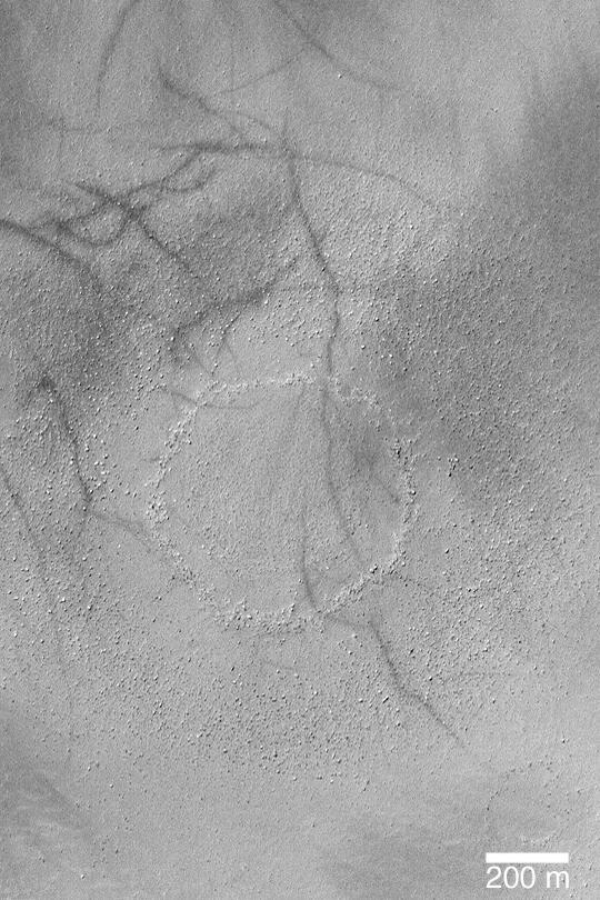
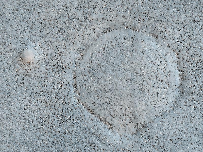
Boulder Ring
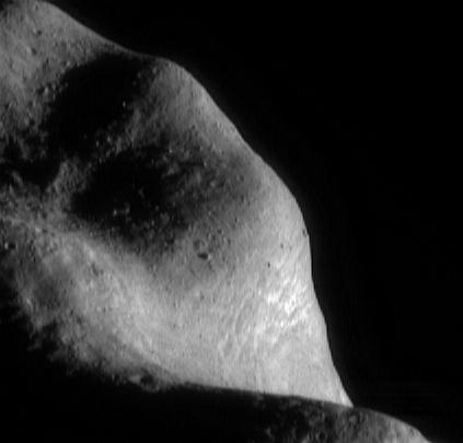
Boulders on Phobos
Boulder Rings
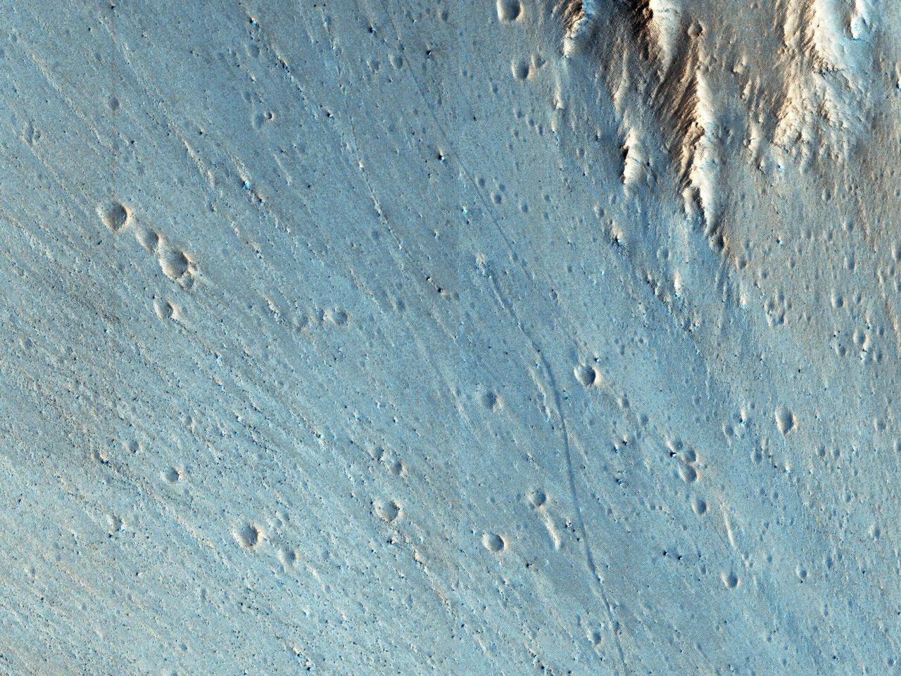
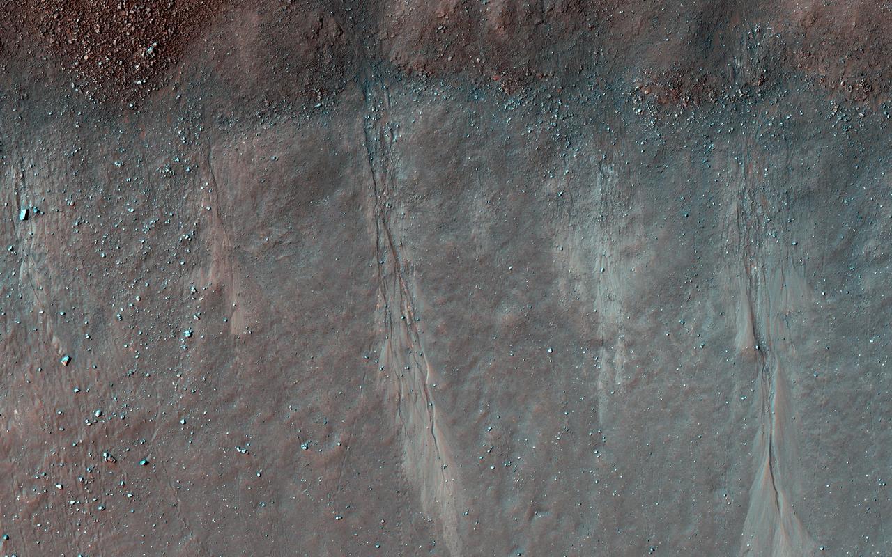
Boulder Tracks
Buckland Boulders
Packed with Boulders
Boulder Track

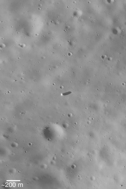
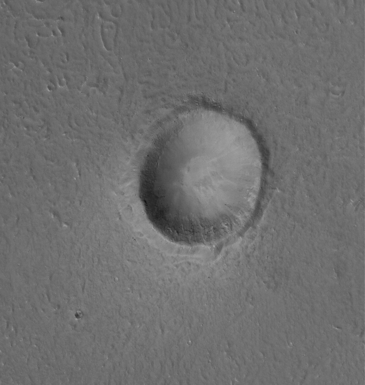
Big Boulder
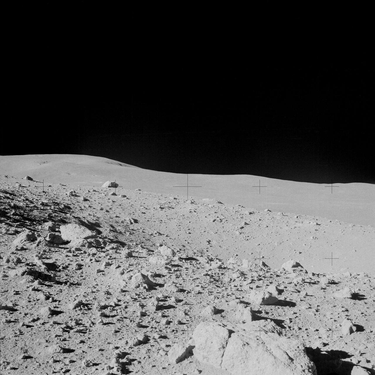
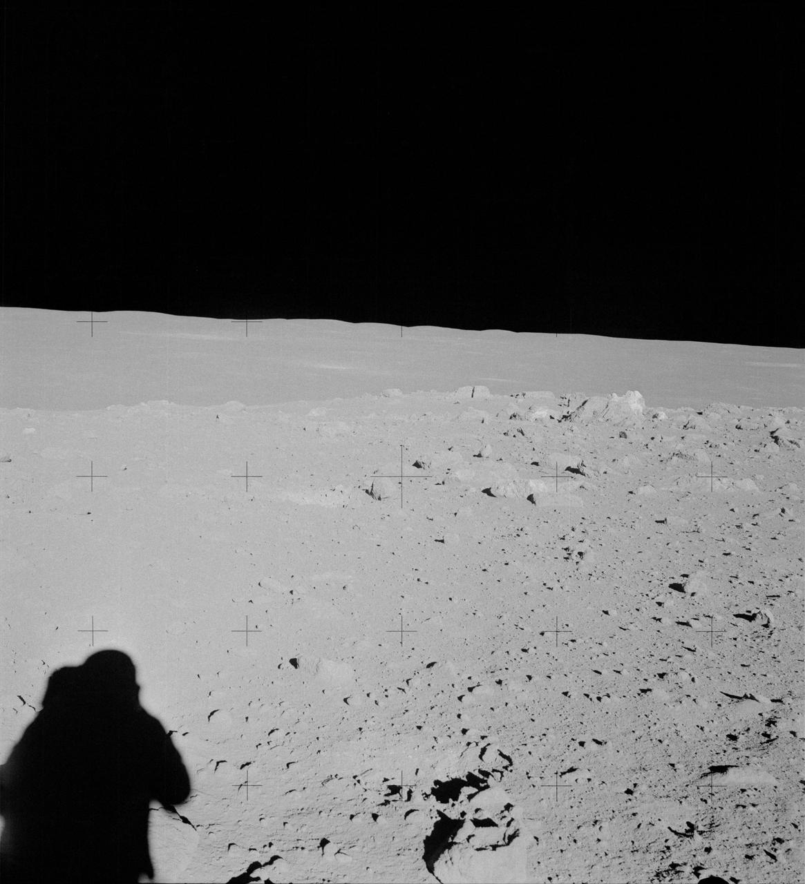
Hillside Boulders
Tracking Boulders
Bouncing Boulders
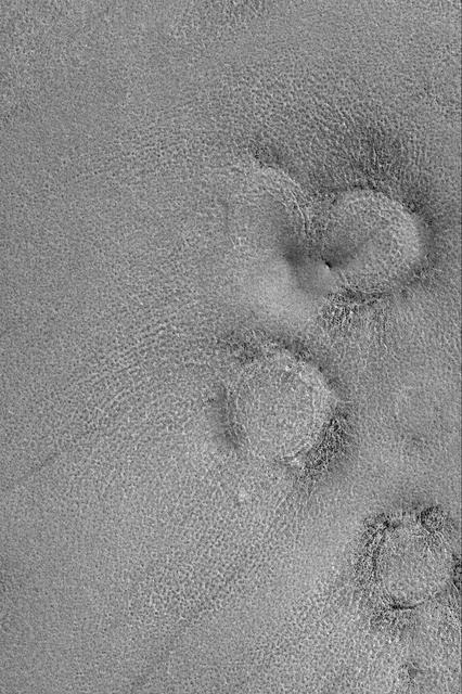
Ejecta Boulders
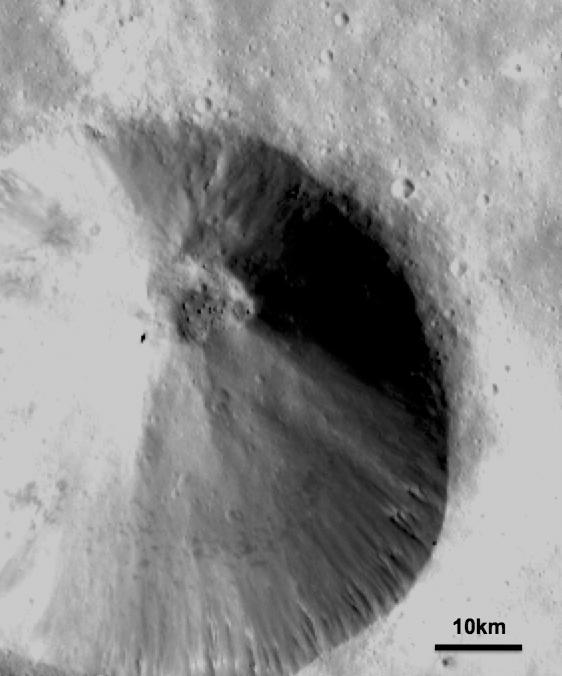
Boulder in Recht Crater
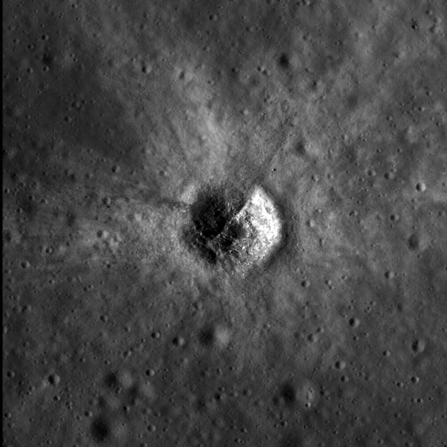
Boulder Trails in Menelaus Crater
Exposed Boulders in the Aitken Mare
Spirit Beholds Bumpy Boulder
Large Boulders in a Trough
Layers, Boulders, and Dust
Boulder-Strewn Surface
Layers with Boulders in Aeolis Region
Boulder Clusters on a Ridge Crest
This image from NASA Dawn spacecraft shows a fresh scarp rimmed crater with many boulders on asteroid Vesta crater floor. These boulders have diameters of 100-200m, which is roughly the size of many asteroids.
NASA Lunar Reconnaissance Orbiter sees bright crater rays and boulders.
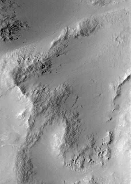
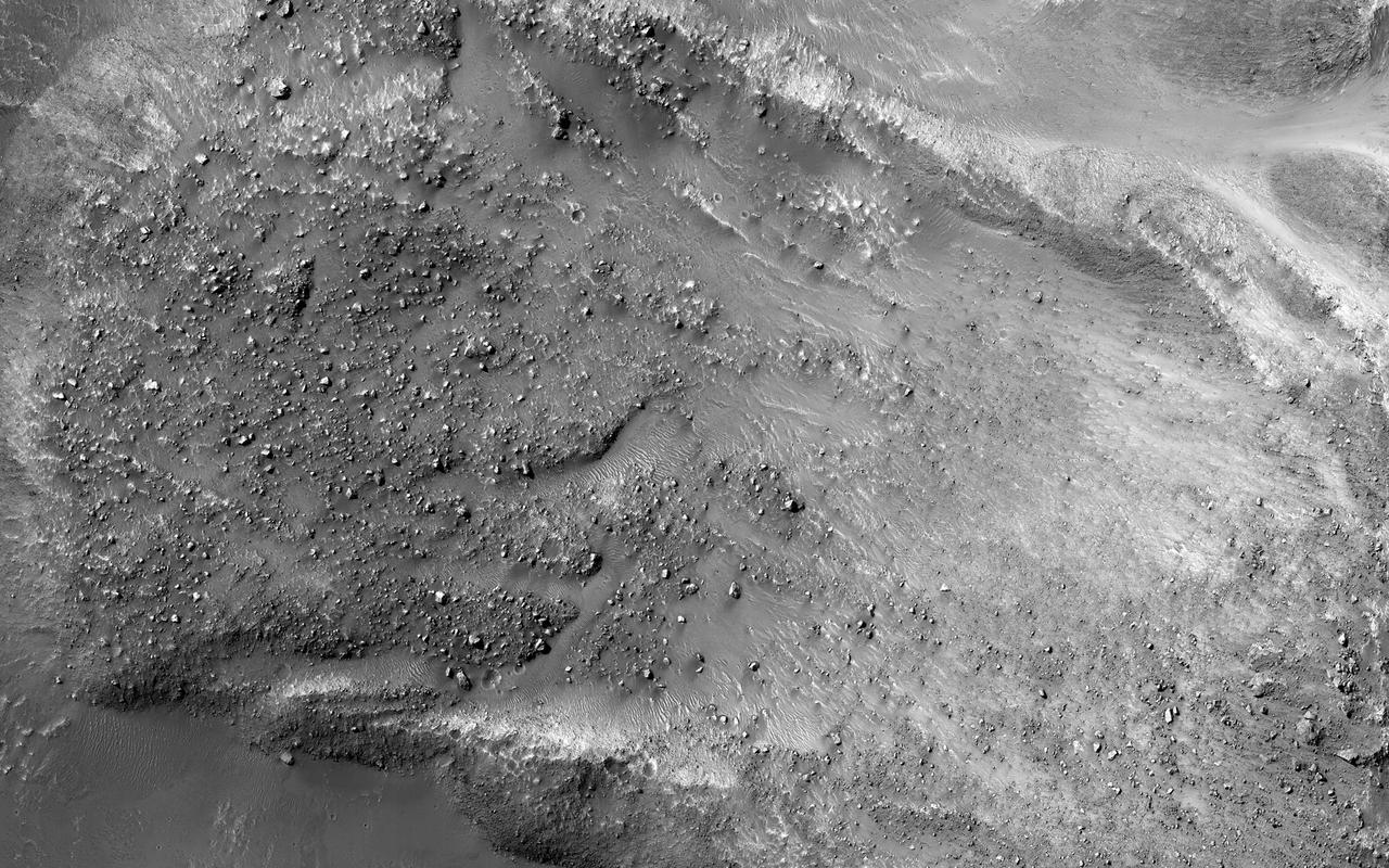
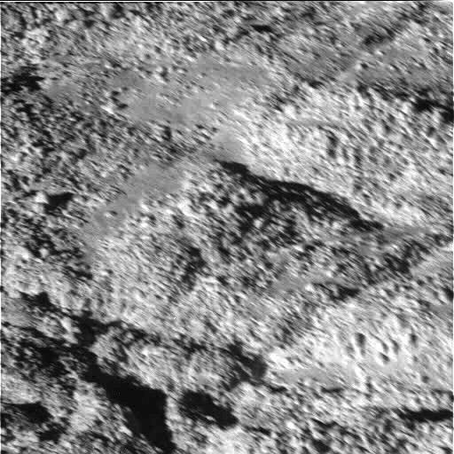
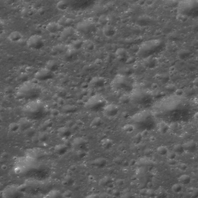
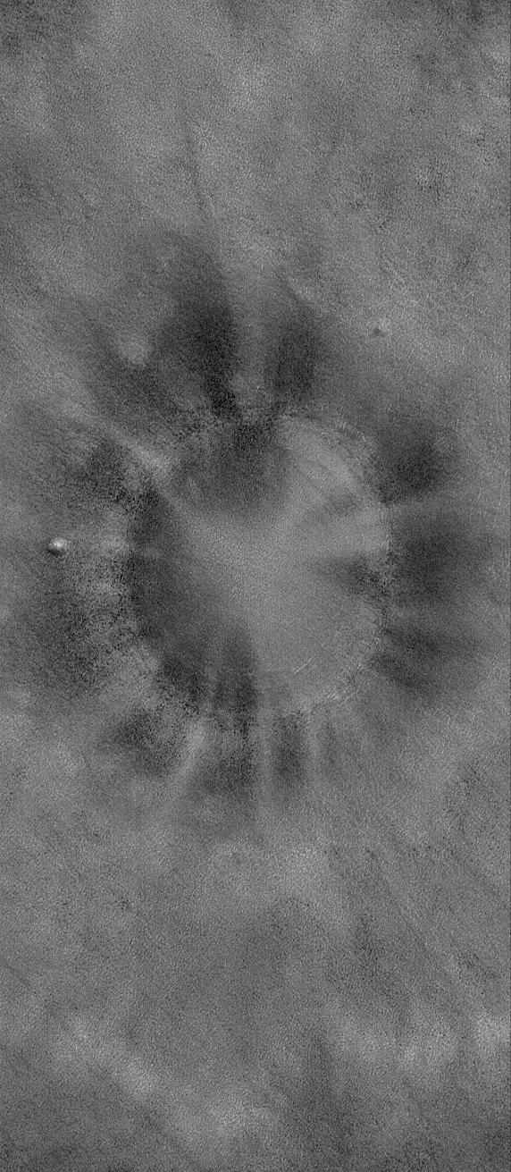
This image of a crater floor at high southern latitude reveals many boulders ranging from 1 to 10 meters in diameter. The boulders are not distributed randomly or uniformly but are often arranged in linear or circular patterns. Some of these patterns resemble the polygons often seen at high latitudes on Mars, which form from seasonal expansion and contraction of ground ice. Over many years, these processes might move boulders, concentrating then around the margins of polygons. If so, then the earlier polygons are no longer apparent at this location, but the boulder patterns persist. https://photojournal.jpl.nasa.gov/catalog/PIA25793
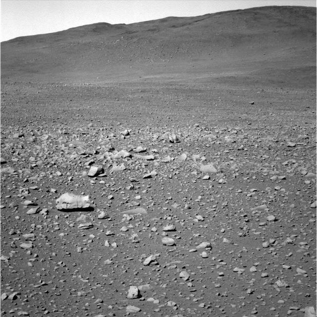
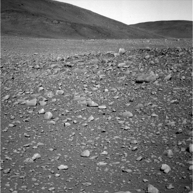
A Typical Martian Scene: Boulders and Slopes in a Crater in Aeolis
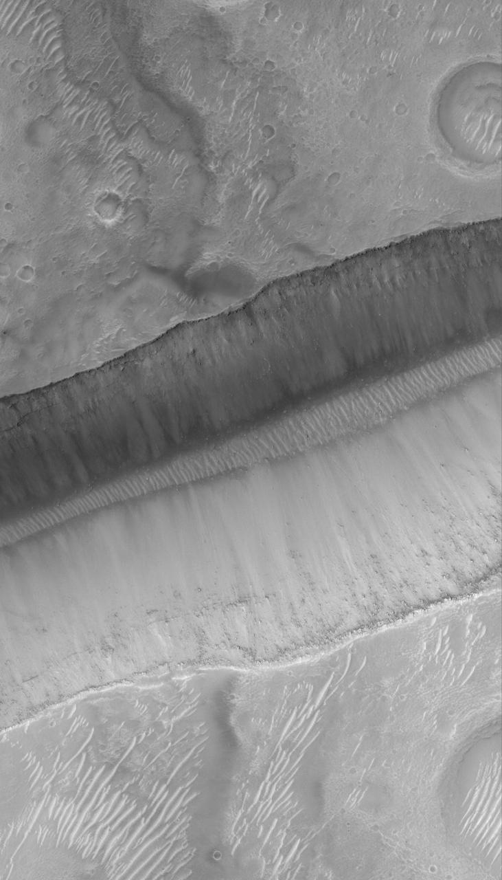
Layers and Boulders in Crater Wall, Nepenthes Mensae Region
Rolling Stones Make New Boulder Tracks
Boulder-Strewn Surface -- Wide Angle Camera View
Boulder Tracks on Schiaparelli Basin South Wall
The Mars Global Surveyor (MGS) Mars Orbiter Camera (MOC) was designed specifically to provide images of Mars that have a resolution comparable to the aerial photographs commonly used by Earth scientists to study geological processes and map landforms on our home planet. When MGS reaches its Mapping Orbit in March 1999, MOC will be able to obtain pictures with spatial resolutions of 1.5 meters (5 feet) per pixel--this good enough to easily see objects the size of an automobile. Boulders are one of the keys to determining which processes have eroded, transported, and deposited material on Mars (e.g.,landslides, mud flows, flood debris). During the first year in orbit,MGS MOC obtained pictures with resolutions between 2 and 30 meters (7to 98 feet) per pixel. It was found that boulders are difficult to identify on Mars in images with resolutions worse than about 2-3 meters per pixel. Although not known when the MOC was designed,"thresholds" like this are found on Earth, too. The MOC's 1.5 m/pixel resolution was a compromise between (1) the anticipation of such resolution-dependent sensitivity based on our experience with Earth and (2)the cost in terms of mass if we had built a larger telescope to get a higher resolution. Some rather larger boulders (i.e., larger than about 10 meters--or yards--in size) have already been seen on Mars by the orbiting camera. This is a feat similar to that which can be obtained by "spy" satellites on Earth. The MOC image 53104 subframe shown above features a low, rounded hill in southeastern Utopia Planitia. Each of the small, lumpy features on the top of this hill is a boulder. In this picture, boulders are not seen on the surrounding plain. These boulders are interpreted to be the remnants of a layer of harder rock that once covered the top of the hill, but was subsequently eroded and broken up by weathering and wind processes. MOC image 53104 was taken on September 2, 1998. The subframe shows an area 2.2 km by 3.3 km (1.4 miles by 2.7 miles). The image has a resolution of about 3.25 meters (10.7 feet) per pixel. The subframe is centered at 41.0°N latitude and 207.3°W longitude. North is approximately up, illumination is from the left. http://photojournal.jpl.nasa.gov/catalog/PIA01500
Boulder Big Joe And Surface Changes On Mars http://photojournal.jpl.nasa.gov/catalog/PIA00397
This image acquired by NASA Terra spacecraft is of Kalgoorlie-Boulder, a city in the Goldfields-Esperance region of Western Australia.
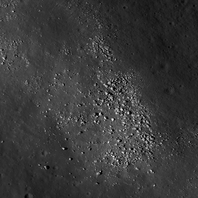
Boulders perched on the summit of the central peak of Tsiolkovskiy crater are seen in this image from NASA Lunar Reconnaissance Orbiter.
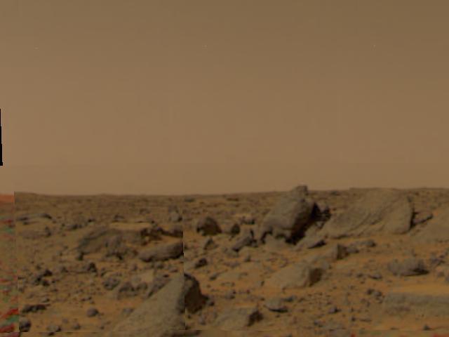
Large boulders are visible in this enlargement of pictures taken by the Imager for Mars Pathfinder (IMP) lander camera on July 4, 1997. The landing site is in the dry flood channel named Ares Valles. The boulders probably represent deposits from one of the catastrophic floods that carved the ancient channel. Between the rocks is brownish windblown soil. The gray-tan sky results from dust particles in the atmosphere. http://photojournal.jpl.nasa.gov/catalog/PIA00609
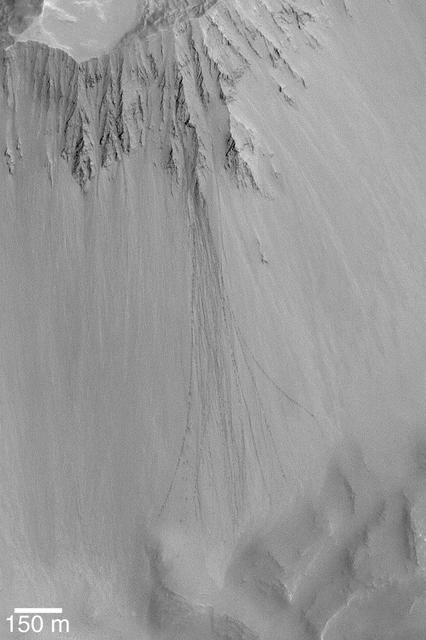
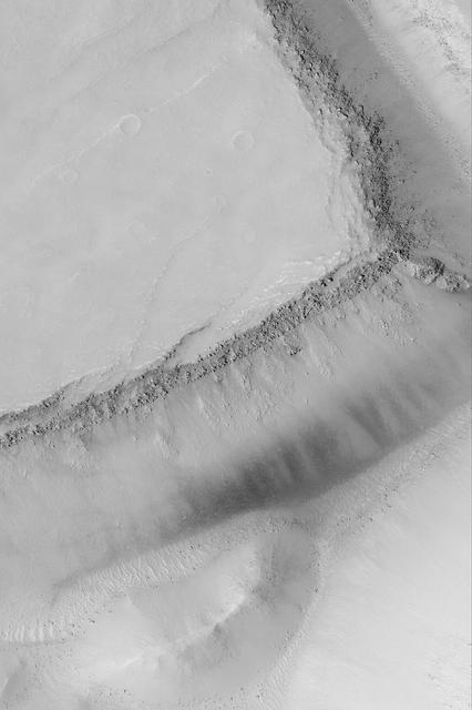
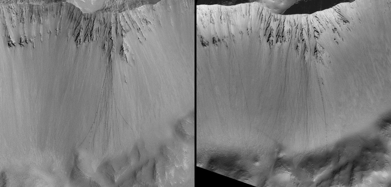
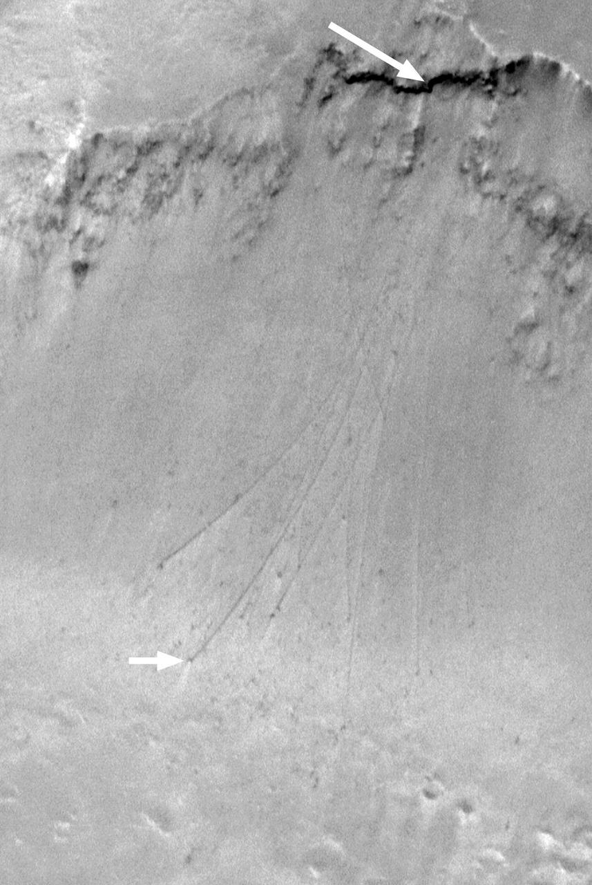
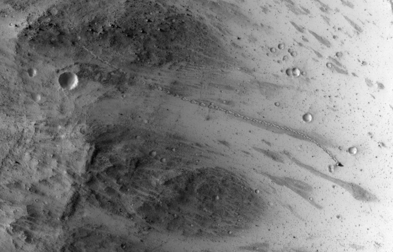
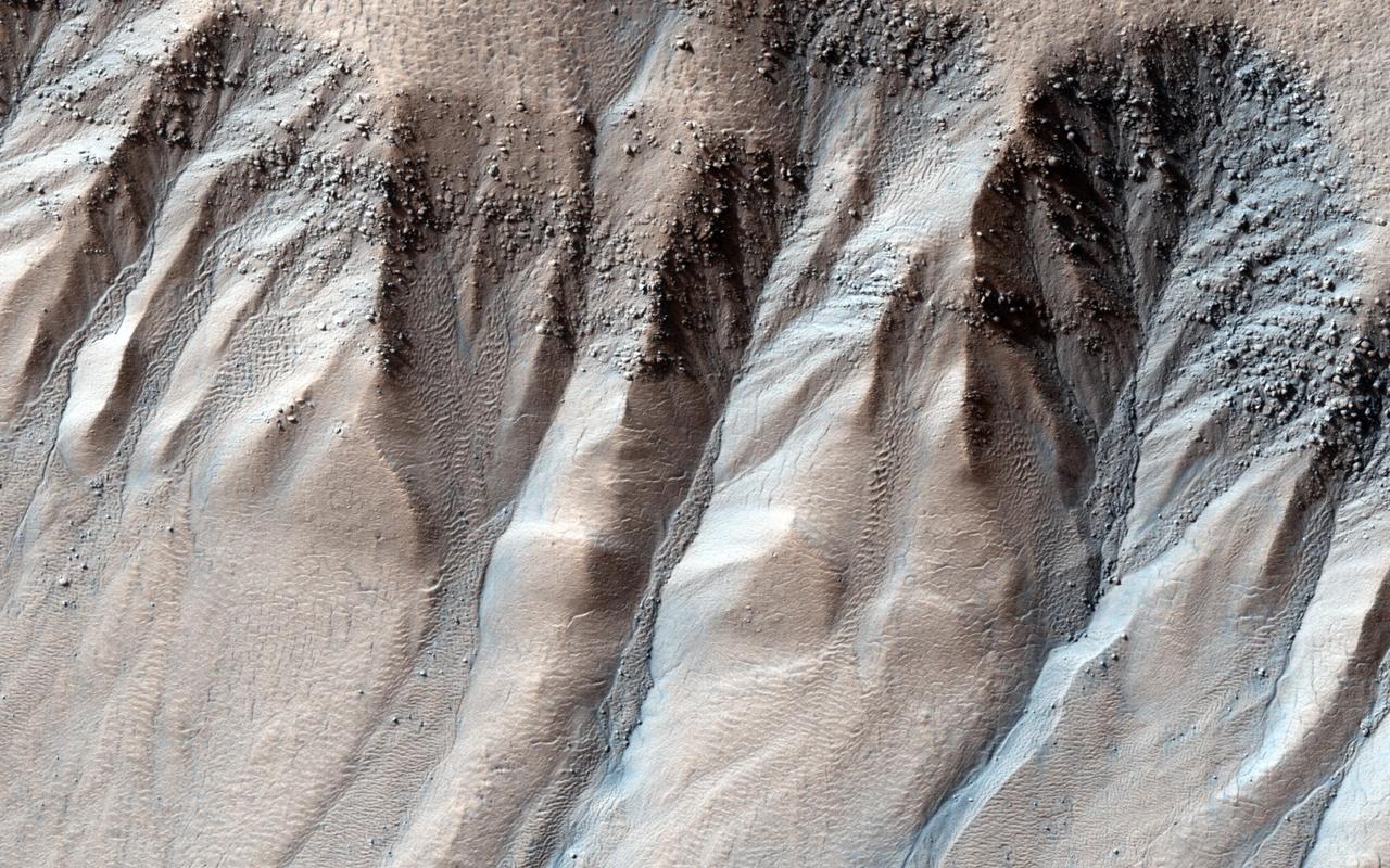
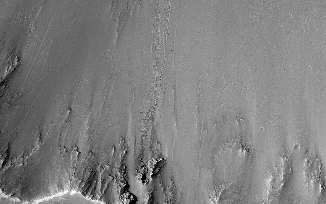
This picture of the rim of Eos Chasma in Valles Marineris shows active erosion of the Martian surface. Layered bedrock is exposed in a steep cliff on a spur of the canyon rim. Dark layers in this cliff are made up of large boulders up to 4 meters in diameter. The boulders are lined up along specific horizons, presumably individual lava flows, and are perched to descend down into the canyon upon the slightest disturbance. How long will the boulders remain poised to fall, and what will push them over the edge? Just as on Earth, the main factors that contribute to dry mass wasting erosion on Mars are frost heaving and thermal expansion and contraction due to changes in temperature. The temperature changes on Mars are extreme compared to Earth, because of the lack of humidity in the Martian atmosphere and the eccentricity of the Martian orbit. Each daily temperature cycle and each seasonal change from summer to winter produces a cycle of expansion and contraction that pushes the boulders gradually closer to the brink. Inevitably, the boulders fall from their precarious positions and plunge into the canyons below. Most simply slide down slope and collect just below the source layers. A few are launched along downward trajectories, travelling long distances before they settle on the slopes below. These trundling boulders left behind conspicuous tracks, up to a kilometer long. The tracks resemble dashed lines or perforations, indicating that the boulders bounced as they trundled down the slopes. The visibility of the boulder tracks suggests that this process may have taken place recently. The active Martian winds quickly erased the tracks of the rover Opportunity, for example. However, the gouges produced by trundling boulders probably go much deeper than the shallow compression of soil by the wheels of a relatively lightweight rover. The boulder tracks might persist for a much longer time span than the rover tracks for this reason. Nevertheless, the tracks of the boulders suggest that erosion of the rim of Eos Chasma is a process that continues today. http://photojournal.jpl.nasa.gov/catalog/PIA21203
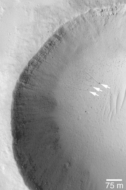
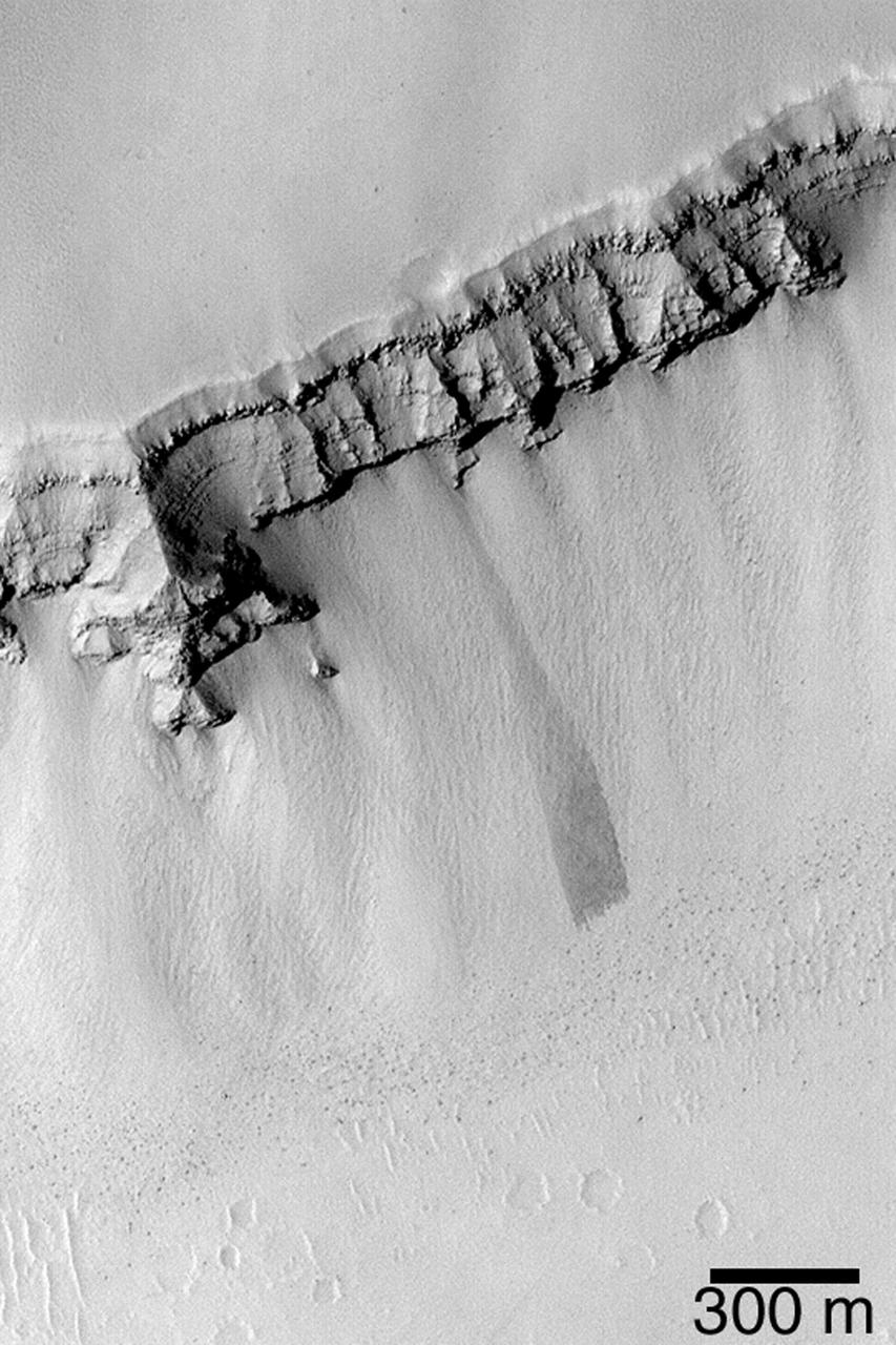
15 July 2004 The arrows in this Mars Global Surveyor (MGS) Mars Orbiter Camera (MOC) picture point to three boulders that left trails behind them as they rolled down the lower parts of a meteor crater's wall. In two cases, the tracks can be resolved into a series of small depressions, indicating the variable shape of the boulder as it unevenly proceeded down the slope. These features are located near 18.4°N, 120.1°W. The 75 meter scale bar is about 246 feet long. Sunlight illuminates the scene from the lower left. http://photojournal.jpl.nasa.gov/catalog/PIA06450
The track left by an oblong boulder as it tumbled down a slope on Mars runs from upper left to right center of this image taken by NASA Mars Reconnaissance Orbiter.
This image of a small boulder on Ceres was obtained by NASA's Dawn spacecraft on June 10, 2018 from an altitude of about 24 miles (38 kilometers). https://photojournal.jpl.nasa.gov/catalog/PIA22530
1.5 Meter Per Pixel View of Boulders in Ganges Chasma
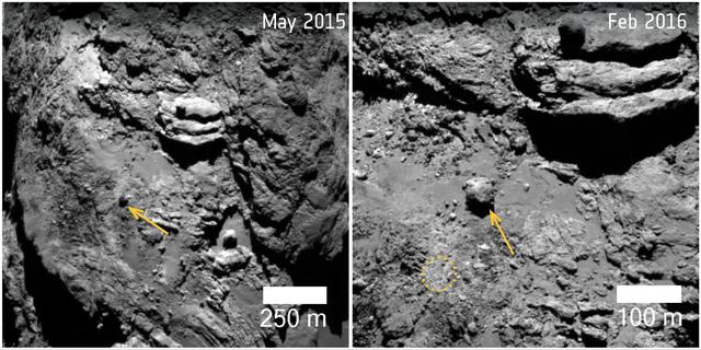
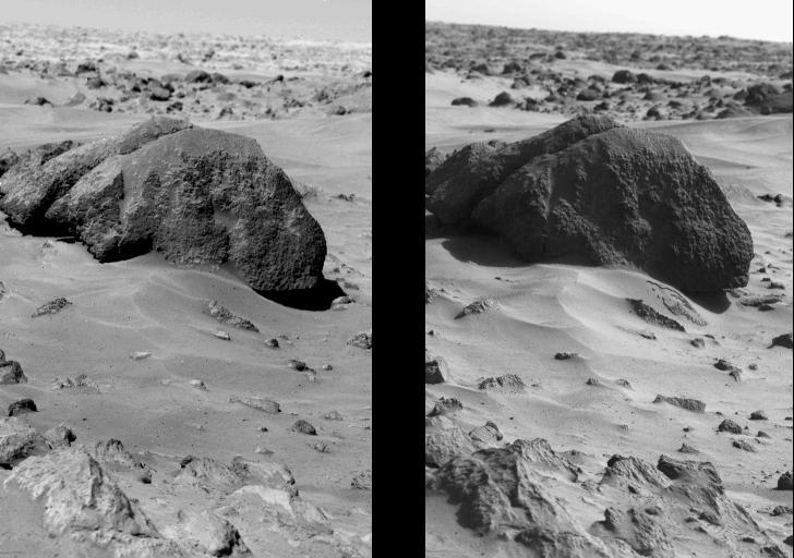
A 100 foot-wide (30 meter), 28-million-pound (12.8-million-kilogram) boulder, was found to have moved 460 feet (140 meters) on comet 67P/Churyumov-Gerasimenko in the lead up to perihelion in August 2015, when the comet's activity was at its highest. In both images, an arrow points to the boulder; in the right-hand image, the dotted circle outlines the original location of the boulder for reference. The movement could have been triggered in one of two ways: either the material on which it was sitting eroded away, allowing it to roll downslope, or a sufficiently forceful outburst could have directly lifted it to the new location. Indeed, several outburst events were detected close to the original position of the boulder during perihelion. The images were taken by Rosetta's OSIRIS camera on May 2, 2015 (left) and Feb. 7, 2016 (right), with resolutions of 7.5 feet (2.3 meters) per pixel and 2.6 feet (0.8 meters) per pixel, respectively. http://photojournal.jpl.nasa.gov/catalog/PIA21565
Columbia Boulders and Outcrop
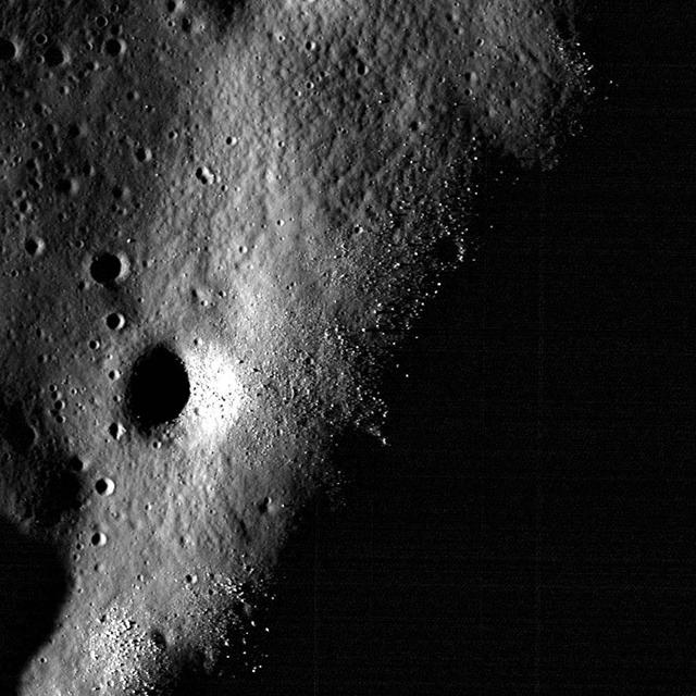
High-albedo marks on the lunar surface left by a boulder bouncing down the northeast wall of farside highlands crater Moore F in this image captured by NASA Lunar Reconnaissance Orbiter.
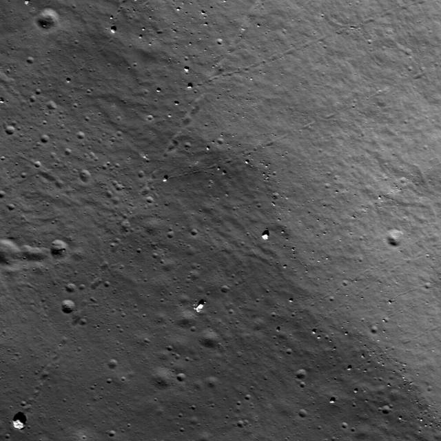
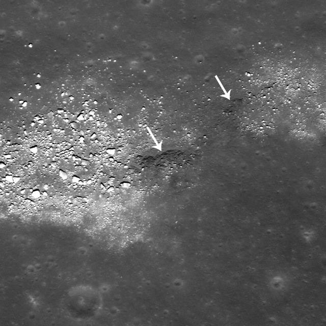
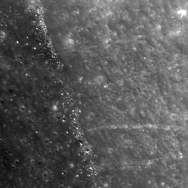
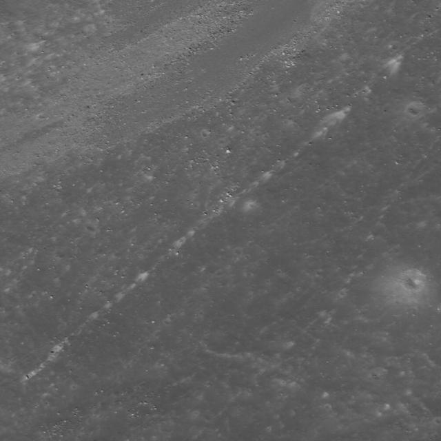
NASA Lunar Reconnaissance Orbiter spies many boulder trails are found on the lunar crater walls and basin massifs. Some of the trails are smooth and nearly straight while others are curvy or gouge into the surface.
Gullies are often found on steep slopes. In the winter, this area is covered with a layer of carbon dioxide ice (dry ice). In the spring, when the ice warms up and transitions to gas, it dislodges material on the slope, forming a gully. In general, this process works best on fine material, leaving behind large boulders. These boulders can be seen collected in the gully alcoves. Occasionally, boulders slide or roll downhill, like those sprinkled downslope in this image. This set of gullies is found at -71 degrees latitude in the Southern hemisphere. http://photojournal.jpl.nasa.gov/catalog/PIA19295
The striking feature in this image from NASA Mars Reconnaissance Orbiter is a boulder-covered landslide along a canyon wall. Landslides occur when steep slopes fail, sending a mass of soil and rock to flow downhill, leaving behind a scarp at the top of the slope. The mass of material comes to rest when it reaches shallower slopes, forming a lobe of material that ends in a well-defined edge called a toe. http://photojournal.jpl.nasa.gov/catalog/PIA20290
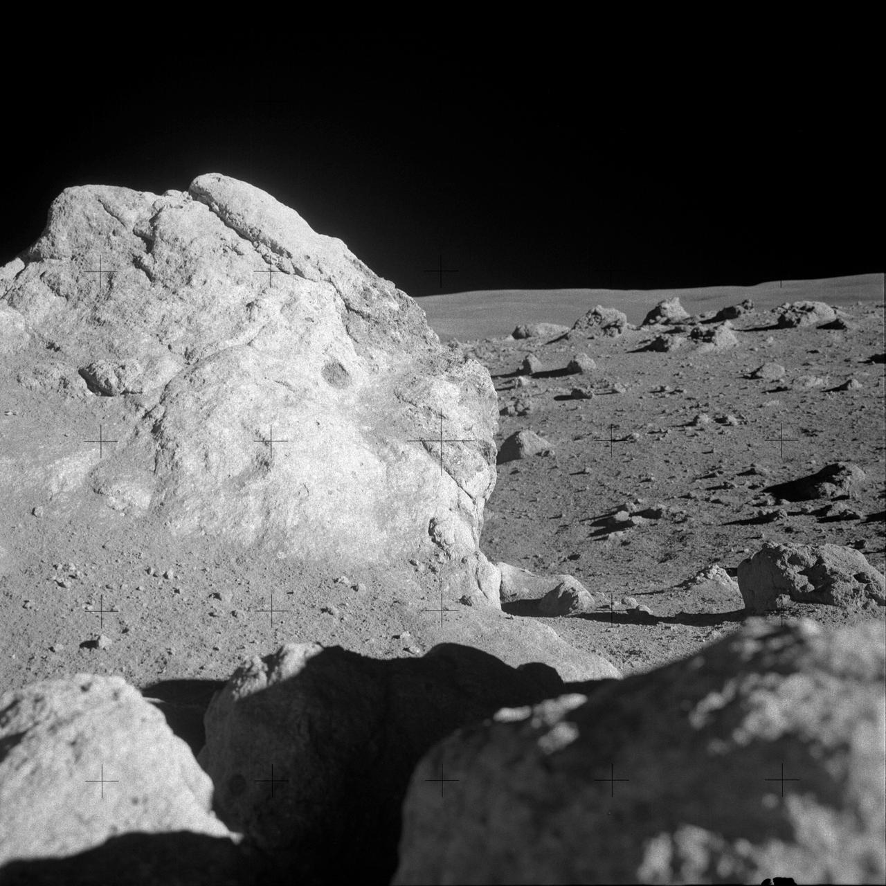
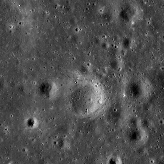
AS14-68-9451 (6 Feb. 1971) --- A close-up view of a large boulder in a field of boulders near the rim of Cone Crater, which was photographed by the Apollo 14 moon-explorers during the mission's second extravehicular activity (EVA). Astronauts Alan B. Shepard Jr., commander, and Edgar D. Mitchell, lunar module pilot, descended in the Apollo 14 Lunar Module (LM) to explore the lunar surface while astronaut Stuart A. Roosa, command module pilot, remained with the Command and Service Modules (CSM) in lunar orbit.
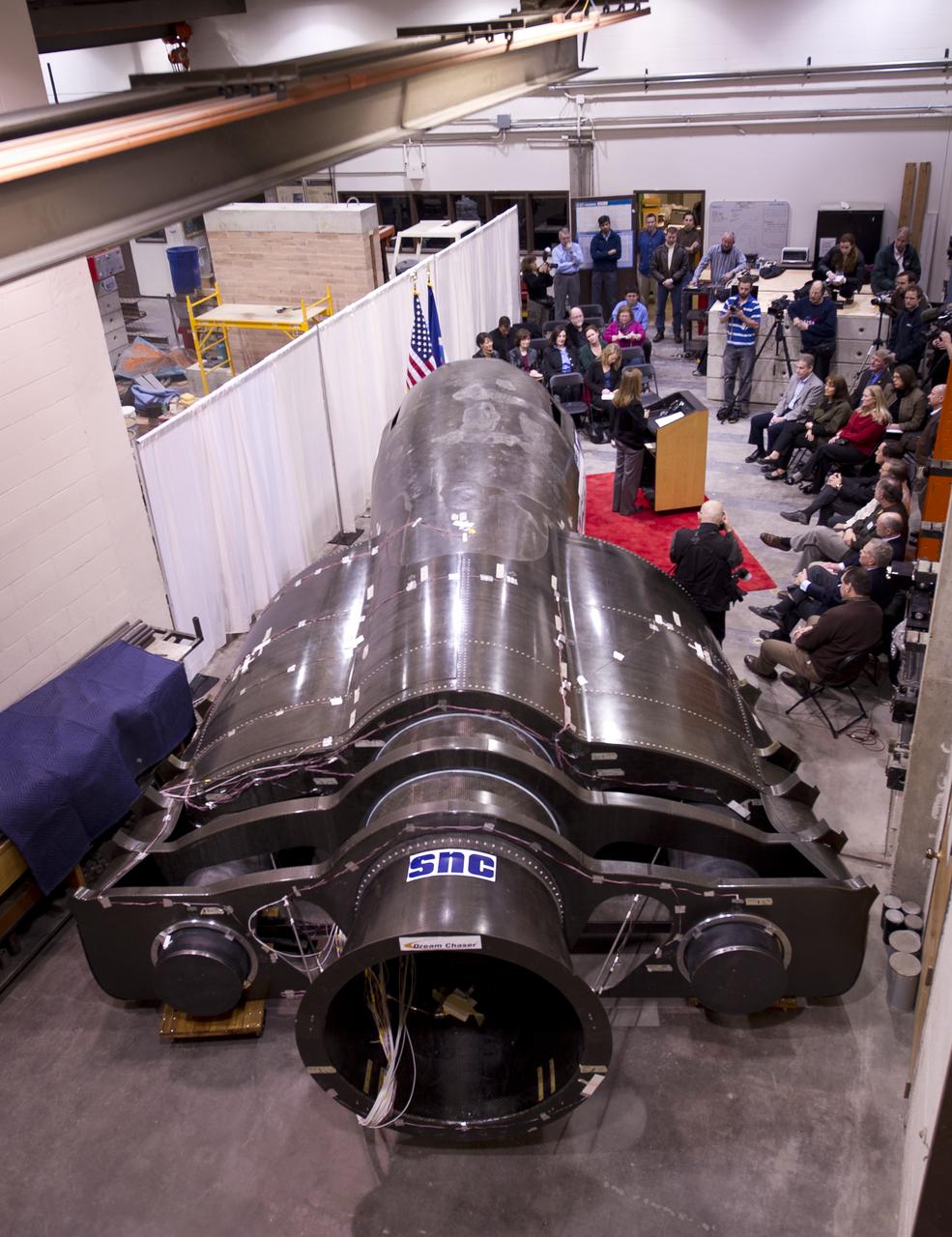
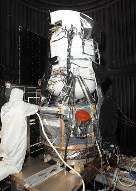
BOULDER, Colo. – A Sierra Nevada Corp. team member examines the company's structural test article for the Dream Chaser spacecraft in the University of Colorado at Boulder’s Facility for Advanced Spatial Technology. The university is one of Sierra Nevada’s partners on the design and development of the Dream Chaser orbital crew vehicle. Dream Chaser is one of five systems NASA invested in during Commercial Crew Development Round 1 CCDev1 activities in order to aid in the innovation and development of American-led commercial capabilities for crew transportation and rescue services to and from the International Space Station and other low Earth orbit destinations. In 2011, NASA's Commercial Crew Program CCP entered into another funded Space Act Agreement with Sierra Nevada for the second round of commercial crew development CCDev2) so the company could further develop its Dream Chaser spacecraft for NASA transportation services. For information about CCP, visit www.nasa.gov/commercialcrew. Photo credit: Sierra Nevada Corp.
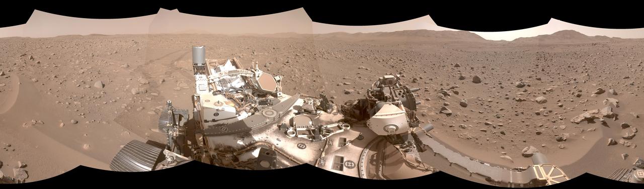
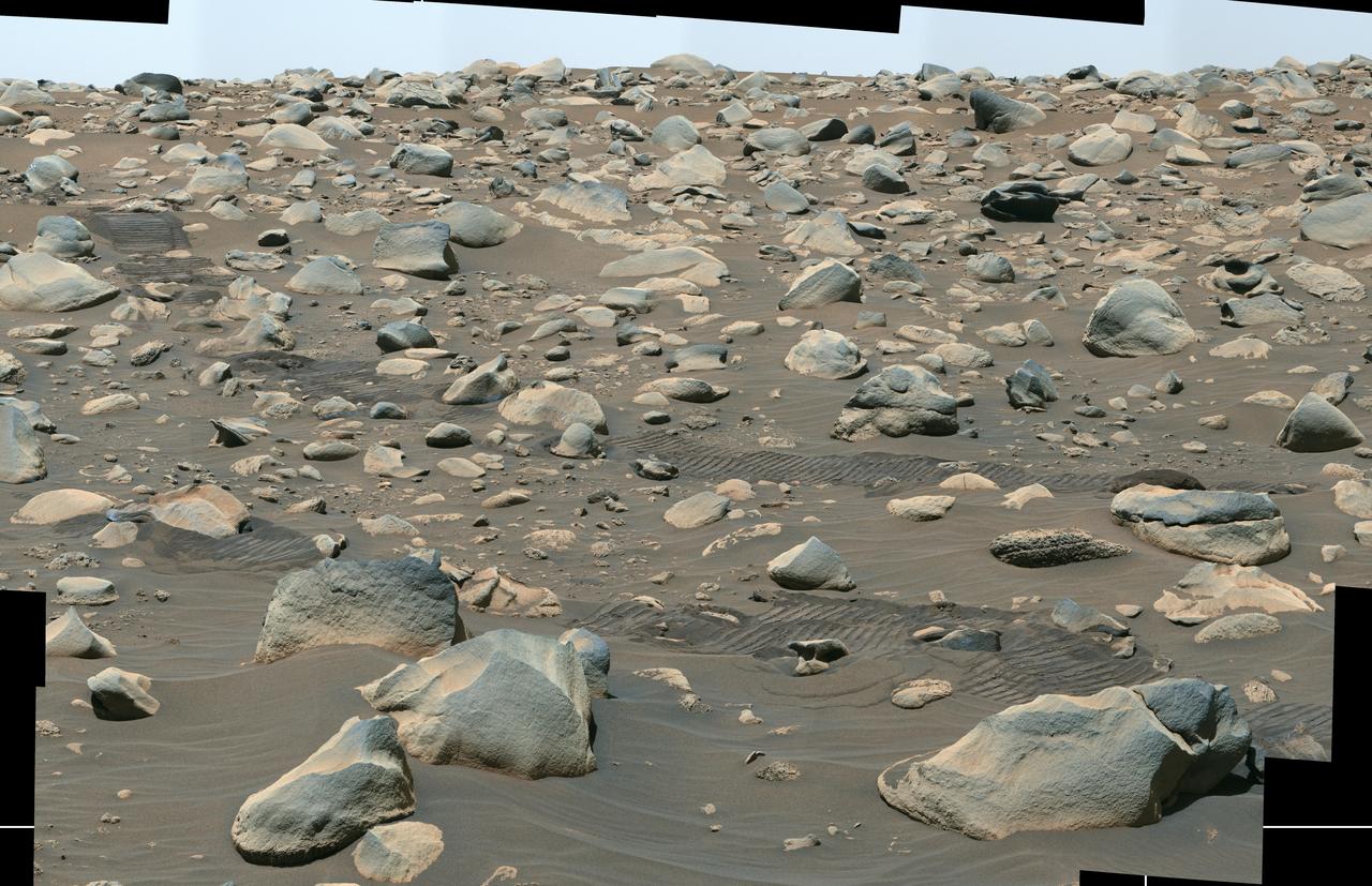
This mosaic shows part of the path NASA's Perseverance Mars rover took through a portion of a boulder field dubbed "Snowdrift Peak." It was generated using images taken by one of the rover's navigation cameras on July 28, 2023, the 866th day, or sol, of the mission. With the help of its self-driving autonomous navigation system, AutoNav, Perseverance traversed the boulder field much more quickly than previous rovers could have. A key objective for Perseverance's mission on Mars is astrobiology, including the search for signs of ancient microbial life. The rover will characterize the planet's geology and past climate, pave the way for human exploration of the Red Planet, and be the first mission to collect and cache Martian rock and regolith (broken rock and dust). Subsequent NASA missions, in cooperation with ESA (European Space Agency), would send spacecraft to Mars to collect these sealed samples from the surface and return them to Earth for in-depth analysis. The Mars 2020 Perseverance mission is part of NASA's Moon to Mars exploration approach, which includes Artemis missions to the Moon that will help prepare for human exploration of the Red Planet. https://photojournal.jpl.nasa.gov/catalog/PIA26072

Acting NASA Administrator Robert Lightfoot, center, is seen during a visit to the environmental test facilities at Ball Aerospace, Thursday, April 6, 2017 in Boulder, Colo. Photo Credit: (NASA/Joel Kowsky)

NASA Deputy Administrator Lori Garver talks during a press conference with Sierra Nevada's Dream Chaser spacecraft in the background on Saturday, Feb. 5, 2011, at the University of Colorado at Boulder. Sierra Nevada's Dream Chaser spacecraft is under development with support from NASA's Commercial Crew Development Program to provide crew transportation to and from low Earth orbit. NASA is helping private companies develop innovative technologies to ensure that the U.S. remains competitive in future space endeavors. Photo Credit: (NASA/Bill Ingalls)
Sierra Nevada's Dream Chaser spacecraft is seen as NASA Deputy Administrator Lori Garver talks during a press conference on Saturday, Feb. 5, 2011, at the University of Colorado at Boulder. Sierra Nevada's Dream Chaser spacecraft is under development with support from NASA's Commercial Crew Development Program to provide crew transportation to and from low Earth orbit. NASA is helping private companies develop innovative technologies to ensure that the U.S. remains competitive in future space endeavors. Photo Credit: (NASA/Bill Ingalls)

Sierra Nevada Space Systems chairman Mark Sirangello talks during a press conference with Sierra Nevada's Dream Chaser spacecraft in the background on Saturday, Feb. 5, 2011, at the University of Colorado at Boulder. Sierra Nevada's Dream Chaser spacecraft is under development with support from NASA's Commercial Crew Development Program to provide crew transportation to and from low Earth orbit. NASA is helping private companies develop innovative technologies to ensure that the U.S. remains competitive in future space endeavors. Photo Credit: (NASA/Bill Ingalls)
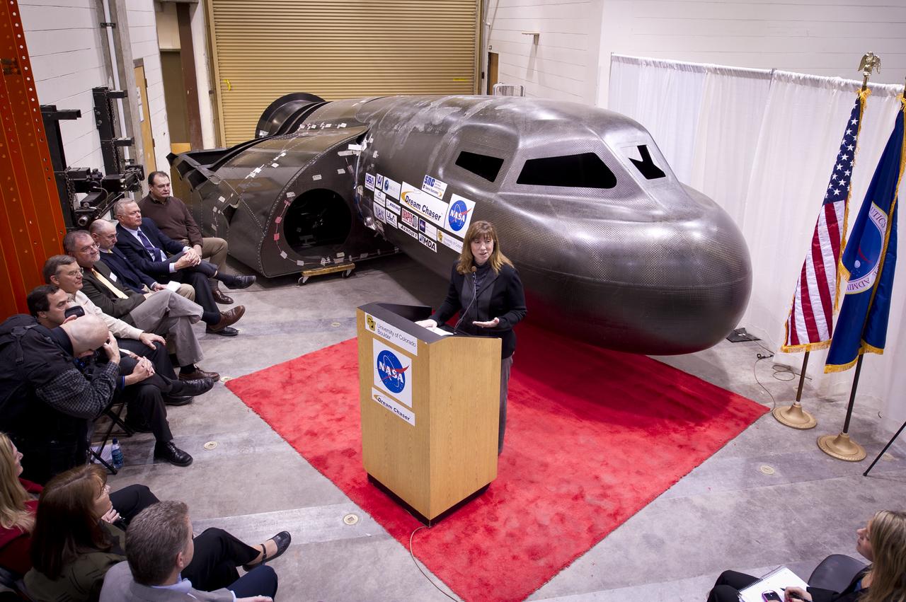
NASA Deputy Administrator Lori Garver talks during a press conference with Sierra Nevada's Dream Chaser spacecraft in the background on Saturday, Feb. 5, 2011, at the University of Colorado at Boulder. Sierra Nevada's Dream Chaser spacecraft is under development with support from NASA's Commercial Crew Development Program to provide crew transportation to and from low Earth orbit. NASA is helping private companies develop innovative technologies to ensure that the U.S. remains competitive in future space endeavors. Photo Credit: (NASA/Bill Ingalls)
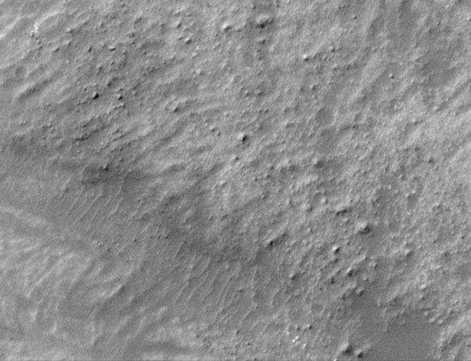
The formation of gullies on Martian slopes is still under debate. Potential mechanisms include the melting of surface water ice, groundwater outbursts, or dry mass wasting processes (landslides). This image shows several shallow gully channels with associated debris aprons emanating from a buried layer on the interior of a crater wall. Also visible are many boulders of varying sizes along the wall, with several exhibiting clear tracks from their journey downslope. These tracks can be used to better understand the mass wasting environment on the hill slope and whether there is any connection between the boulders and the gullies. https://photojournal.jpl.nasa.gov/catalog/PIA25554
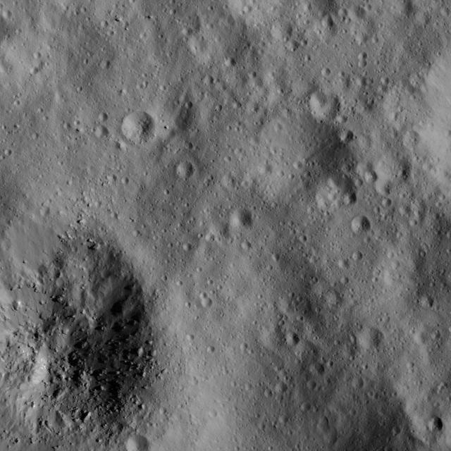
This image of a boulder field near Ceres' Occator Crater's eastern rim was obtained by NASA's Dawn spacecraft on June 9, 2018 from an altitude of about 30 miles (48 kilometers). https://photojournal.jpl.nasa.gov/catalog/PIA22525
This image taken by NASA Mars Reconnaissance Orbiter in the Cydnus Rupes region, shows that the northern plains of Mars are rock and boulder strewn landscapes otherwise devoid of major features except a few impact craters.
On this part of Mars there is an extensive surface brightness (albedo) boundary. One hypothesis is that this boundary marks a shoreline, from a time long ago when liquid water could have been stable on the surface of Mars. With the resolution of HiRISE we can see that the reason one side of the boundary is darker than the other is due to the many boulders strewn across the darker side. https://photojournal.jpl.nasa.gov/catalog/PIA25183
On Mercury, craters larger than approximately 10-12 km display a complex morphology, with slump terraces and central peaks, as compared to smaller bowl-shaped craters. At this complex crater, nearly 20 km in diameter, boulders created by the impact event can be seen outside the southwest rim and within the crater interior. The largest boulder observed here is around 180 m (590 feet) across! For comparison with humans for scale, check out the lunar House Rock at the Apollo 16 site, which is (only) 24 meters across. Date acquired: January 24, 2015 Image Mission Elapsed Time (MET): 64441328 Image ID: 7855678 Instrument: Narrow Angle Camera (NAC) of the Mercury Dual Imaging System (MDIS) Center Latitude: -2.66° Center Longitude: 83.54° E Resolution: 26 meters/pixel Scale: This crater is approximately 19.5 km (12.1 miles) in diameter Incidence Angle: 82.8° Emission Angle: 43.0° Phase Angle: 39.8° http://photojournal.jpl.nasa.gov/catalog/PIA19202

Director of Advanced Programs, Sierra Nevada Corporation, Jim Voss talks during a press conference with Sierra Nevada's Dream Chaser spacecraft in the background on Saturday, Feb. 5, 2011, at the University of Colorado at Boulder. Sierra Nevada's Dream Chaser spacecraft is under development with support from NASA's Commercial Crew Development Program to provide crew transportation to and from low Earth orbit. NASA is helping private companies develop innovative technologies to ensure that the U.S. remains competitive in future space endeavors. Photo Credit: (NASA/Bill Ingalls)
This image from NASA's Mars Reconnaissance Orbiter (MRO) was originally meant to track the movement of sand dunes near the North Pole of Mars, but what's on the ground in between the dunes is just as interesting! The ground has parallel dark and light stripes from upper left to lower right in this area. In the dark stripes, we see piles of boulders at regular intervals. What organized these boulders into neatly-spaced piles? In the Arctic back on Earth, rocks can be organized by a process called "frost heave." With frost heave, repeatedly freezing and thawing of the ground can bring rocks to the surface and organize them into piles, stripes, or even circles. On Earth, one of these temperature cycles takes a year, but on Mars it might be connected to changes in the planet's orbit around the Sun that take much longer. https://photojournal.jpl.nasa.gov/catalog/PIA22334
This composite image captured by NASA's Perseverance Mars rover shows boulders that decorate the top of the Jezero Crater fan deposit. Rover tracks across the middle of the image give a sense of scale. These boulders were transported by water that was either deeper or flowed faster than the ancient waterway that deposited the smaller pebbles that also populate the area. Because these boulders are sitting on top of the pebbles, scientists believe they arrived later, possibly much later. Perseverance's Mastcam-Z camera system took the series of images that make up this composite on July 6, 2023, the 845th day, or sol, of the rover's mission to Mars. Arizona State University leads the operations of the Mastcam-Z instrument, working in collaboration with Malin Space Science Systems in San Diego, on the design, fabrication, testing, and operation of the cameras, and in collaboration with the Niels Bohr Institute of the University of Copenhagen on the design, fabrication, and testing of the calibration targets. A key objective for Perseverance's mission on Mars is astrobiology, including the search for signs of ancient microbial life. The rover will characterize the planet's geology and past climate, pave the way for human exploration of the Red Planet, and be the first mission to collect and cache Martian rock and regolith (broken rock and dust). Subsequent NASA missions, in cooperation with ESA (European Space Agency), would send spacecraft to Mars to collect these sealed samples from the surface and return them to Earth for in-depth analysis. The Mars 2020 Perseverance mission is part of NASA's Moon to Mars exploration approach, which includes Artemis missions to the Moon that will help prepare for human exploration of the Red Planet. https://photojournal.jpl.nasa.gov/catalog/PIA25963
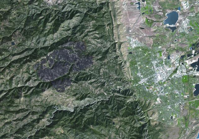
The Advanced Spaceborne Thermal Emission and Reflection Radiometer ASTER instrument aboard NASA Terra spacecraft captured this image of the Fourmile Canyon fire west of Boulder Colo., on Sept. 17, 2010; it was 100 percent contained.

Acting NASA Deputy Administrator Lesa Roe, right, speaks with Rob Strain, president of Ball Aerospace, Thursday, April 6, 2017 during a visit to Ball Aerospace in Boulder, Colo. Photo Credit: (NASA/Joel Kowsky)
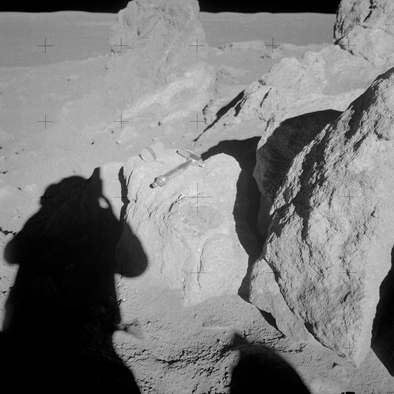
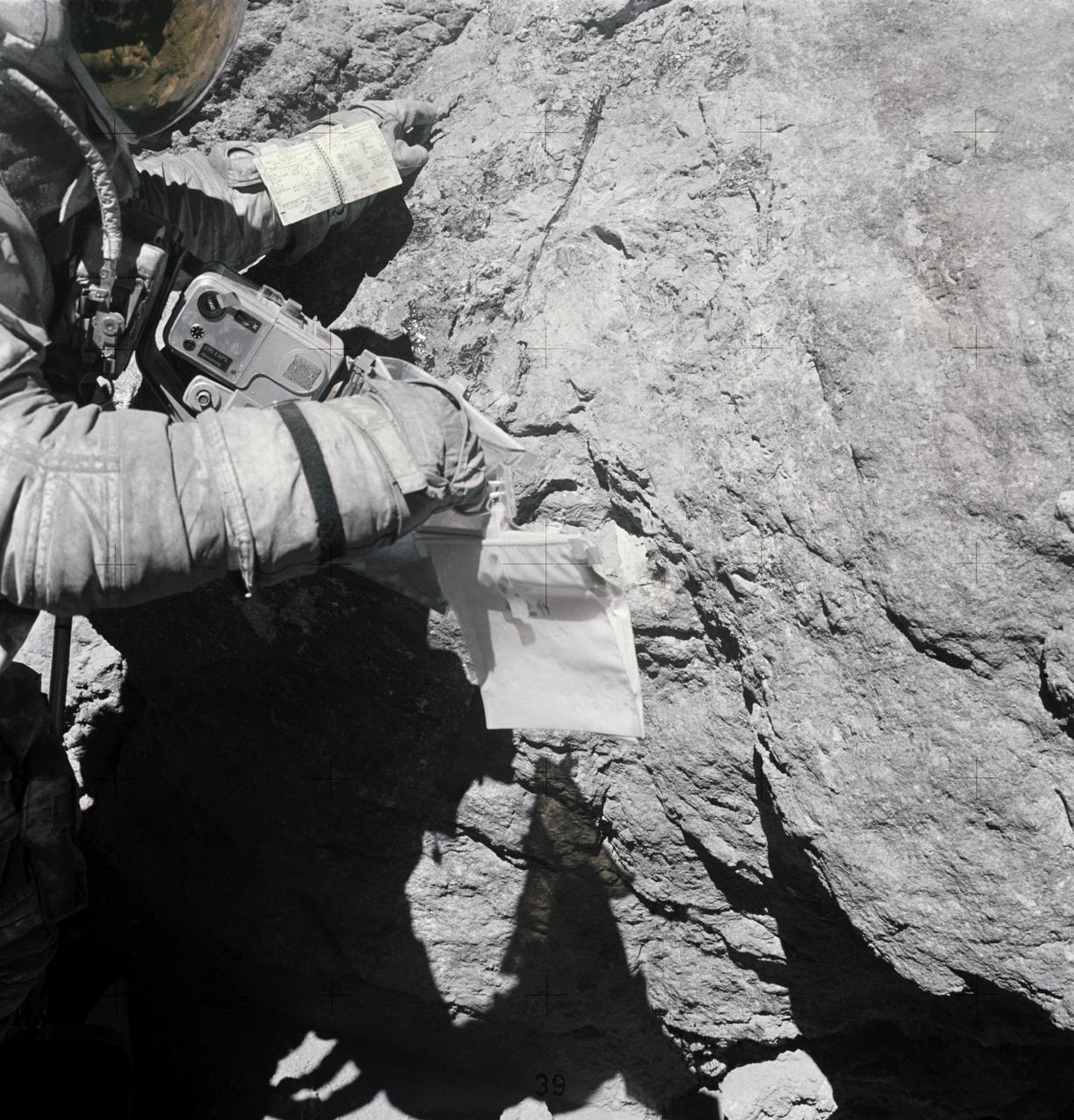
AS14-68-9453 (6 Feb. 1971) --- Astronaut Edgar D. Mitchell, lunar module pilot, whose shadow is in the foreground, photographs a group of large boulders near the rim of Cone Crater. An interesting feature is the white and brown rock in the boulder. Mitchell removed a sample where the hammer is lying. While astronauts Alan B. Shepard Jr., commander, and Mitchell descended in the Lunar Module (LM) "Antares" to explore the Fra Mauro region of the moon, astronaut Stuart A. Roosa, command module pilot, remained with the Command and Service Modules (CSM) "Kitty Hawk" in lunar orbit.

AS14-68-9448 (6 Feb. 1971) --- A close-up view of a large multi-colored boulder in the boulder field located on the rim of Cone Crater, as photographed by the moon-exploring crew members of the Apollo 14 lunar landing mission. This view is looking west by southwest. The Lunar Module (LM) can be seen in the background. While astronauts Alan B. Shepard Jr., commander, and Edgar D. Mitchell, lunar module pilot, were exploring the moon, after descending in the LM, astronaut Stuart A. Roosa, command module pilot, remained with the Command and Service Modules (CSM) in lunar orbit.
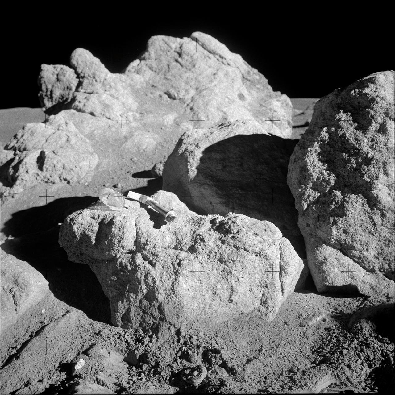
AS14-68-9452 (5-6 Feb. 1971) --- A hammer and a small collection bag lie atop a lunar boulder to give some indication of size in this view of several boulders clustered together. This is one of the white rocks from which samples were taken by the two moon-exploring crew men of the Apollo 14 lunar landing mission. While astronauts Alan B. Shepard Jr., commander, and Edgar D. Mitchell, lunar module pilot, were exploring the moon, astronaut Stuart A. Roosa, command module pilot, remained with the Command and Service Modules (CSM) in lunar orbit.
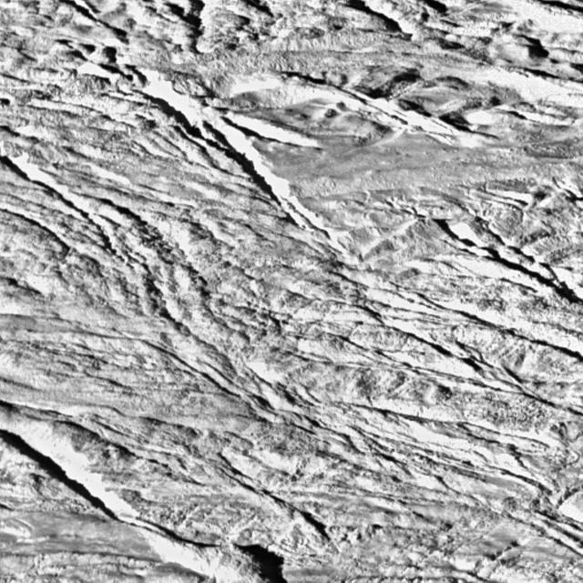
The tortured southern polar terrain of Enceladus appears strewn with great boulders of ice in this fantastic view, one of the highest resolution images obtained so far by Cassini of any world. Some smearing of the image due to spacecraft motion is apparent in this scene, which was acquired as Enceladus raced past Cassini's field of view near the time of closest approach. At the time, the imaging cameras were pointed close to the moon's limb (edge), rather than directly below the spacecraft. This allowed for less motion blur than would have been apparent had the cameras pointed straight down. Thus, the terrain imaged here was actually at a distance of 319 kilometers (198 miles) from Cassini. At this fine scale, the surface is dominated by ice blocks between 10 and 100 meters (33 and 330 feet) across. The origin of these icy boulders is enigmatic. Scientists are interested in studying the sizes and numbers of the blocks in this bizarre scene, and in understanding whether terrain covered with boulders is common on Enceladus. A wide-angle camera view centered on this location on Enceladus is available (see PIA06251), as well as a comparison view showing the position of this image within the wide-angle image (see PIA06250). The image was taken during Cassini's very close flyby of Enceladus on July 14, 2005, from a distance of approximately 208 kilometers (129 miles) above Enceladus. Resolution in the image is about 4 meters (13 feet) per pixel. The image has been contrast enhanced to improve the visibility of surface. http://photojournal.jpl.nasa.gov/catalog/PIA06252

Acting NASA Administrator Robert Lightfoot, left, views a clean room with Tim Schoenweis, senior project engineer for the Ozone Mapping Profiler Suite (OMPS) at Ball Aerospace, right, Thursday, April 6, 2017 at Ball Aerospace in Boulder, Colo. Photo Credit: (NASA/Joel Kowsky)

Acting NASA Deputy Administrator Lesa Roe, center, views a clean room with Tim Schoenweis, senior project engineer for the Ozone Mapping Profiler Suite (OMPS) at Ball Aerospace, left, Thursday, April 6, 2017 at Ball Aerospace in Boulder, Colo. Photo Credit: (NASA/Joel Kowsky)
This NASA Lunar Reconnaissance Orbiter shows boulders on a wrinkle ridge in Mare Crisium.
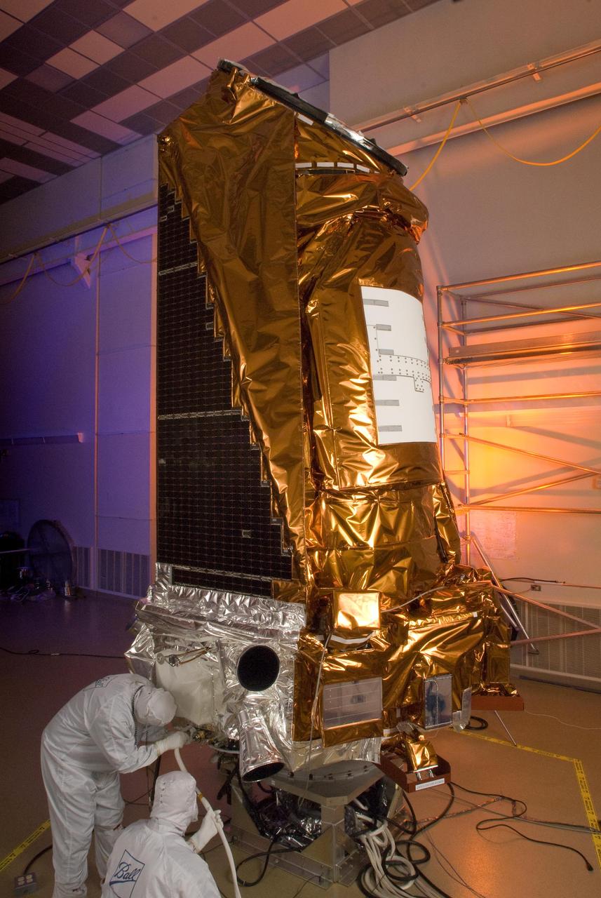
NASA Kepler spacecraft at Ball Aerospace & Technologies Corp. in Boulder, Colo.
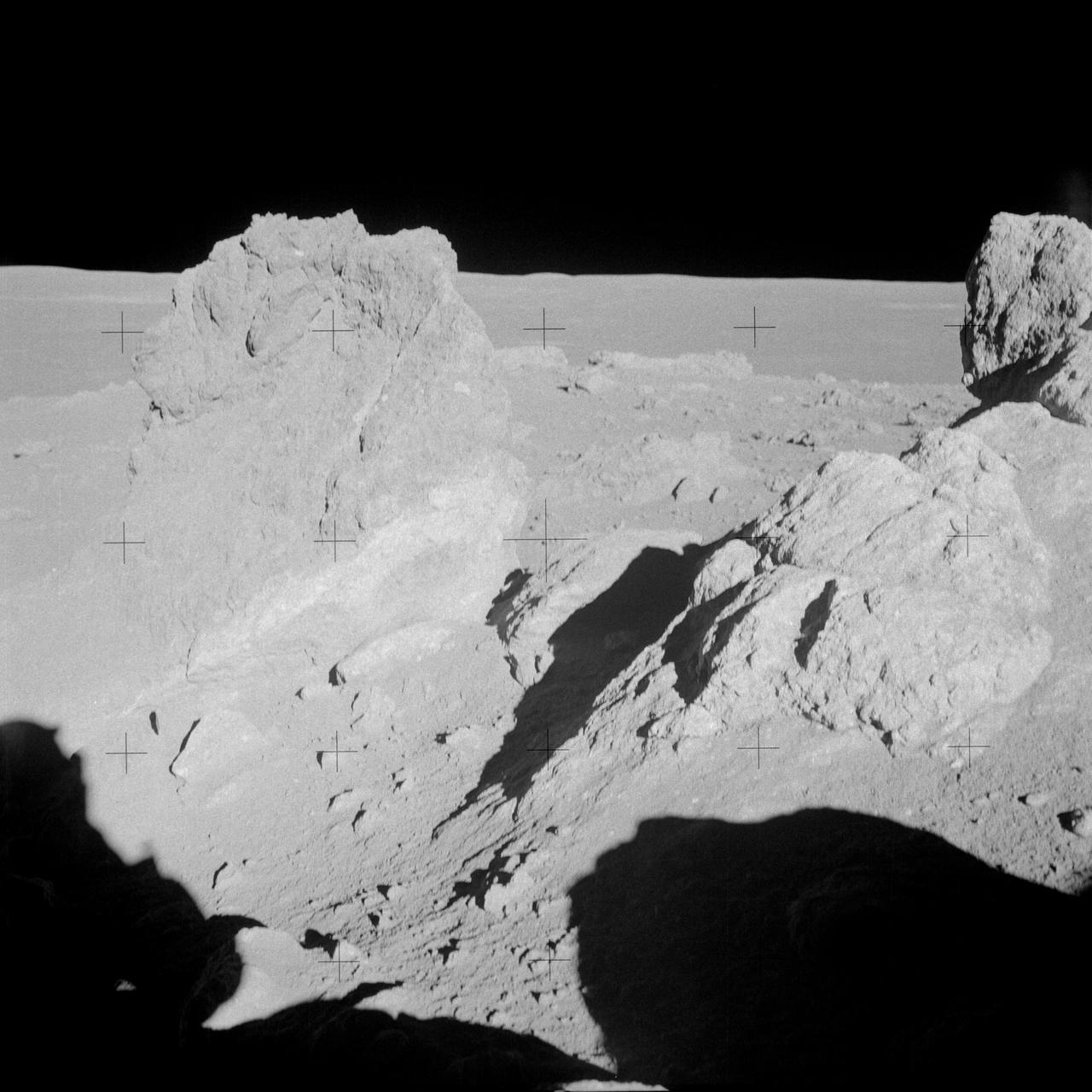
AS14-68-9449 (6 Feb. 1971) --- A close-up view of a group of large boulders near the rim of Cone Crater photographed by the Apollo 14 astronauts during their second extravehicular activity (EVA). While astronauts Alan B. Shepard Jr., commander, and Edgar D. Mitchell, lunar module pilot, descended in the LM to explore the moon, astronaut Stuart A. Roosa, command module pilot, remained with the Command and Service Modules (CSM) in lunar orbit.
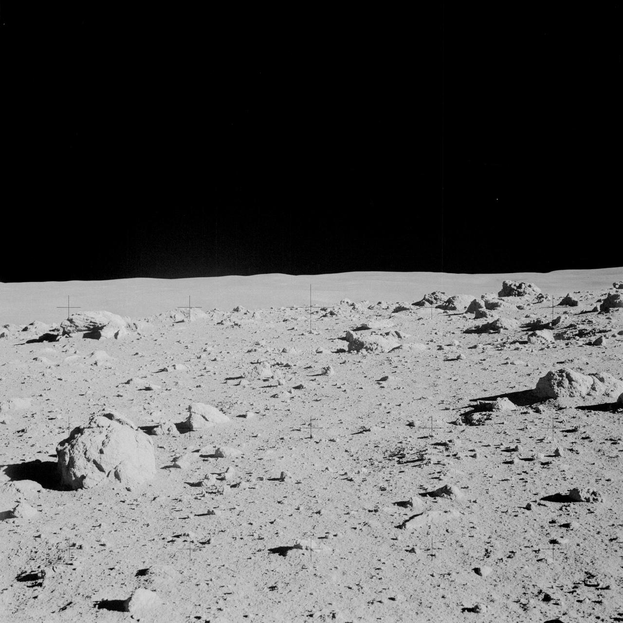
AS14-64-9103 (6 Feb. 1971) --- Astronaut Alan B. Shepard Jr., commander, photographed this overall view of a field of boulders on the flank of Cone Crater during the second extravehicular activity (EVA) on the lunar surface. Astronaut Edgar D. Mitchell, lunar module pilot, joined Shepard in exploring the moon, while astronaut Stuart A. Roosa, command module pilot, remained with the Command and Service Modules (CSM) in lunar orbit.
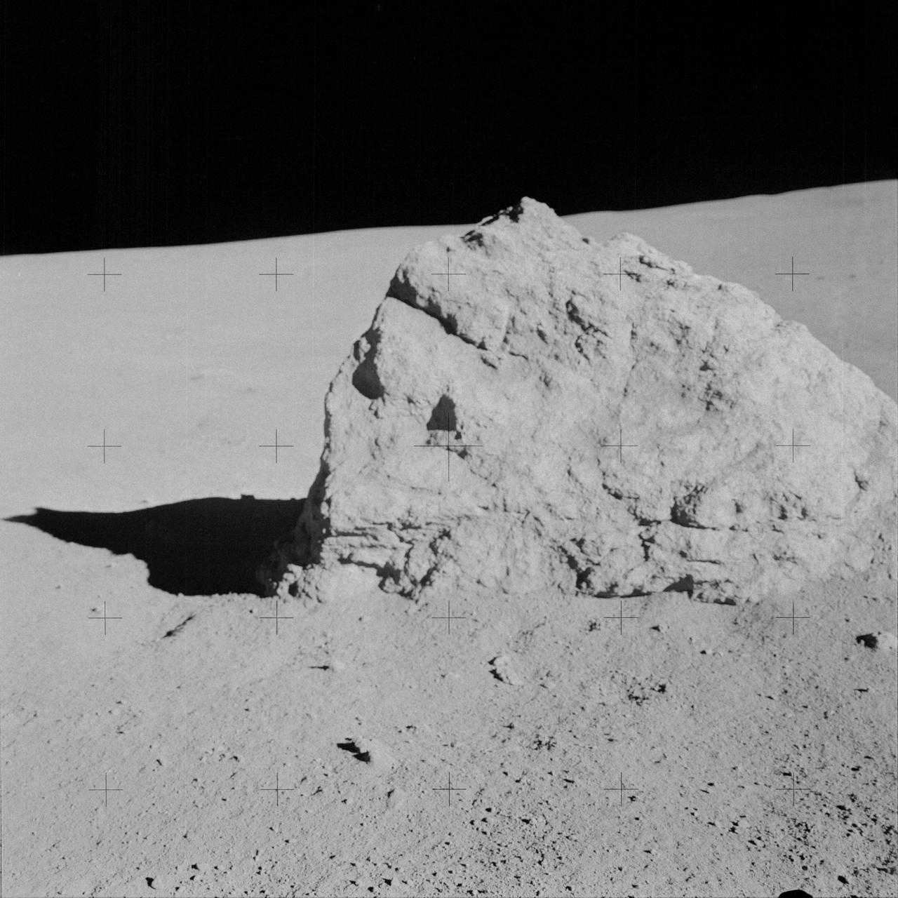
AS14-64-9135 (6 Feb. 1971) --- Astronaut Alan B. Shepard Jr., commander, took this close-up view of a large boulder, approximately five feet long, during the second extravehicular activity (EVA), on Feb. 6, 1971. Astronauts Shepard and Edgar D. Mitchell, lunar module pilot, descended in the Lunar Module (LM) to explore the moon, while astronaut Stuart A. Roosa, command module pilot, remained with the Command and Service Modules (CSM) in lunar orbit.
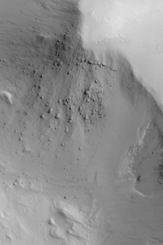
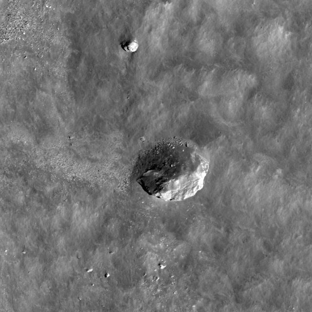
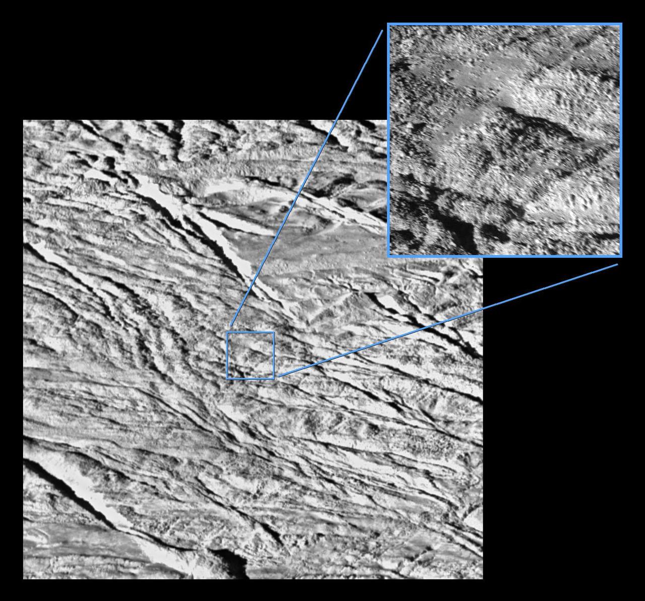
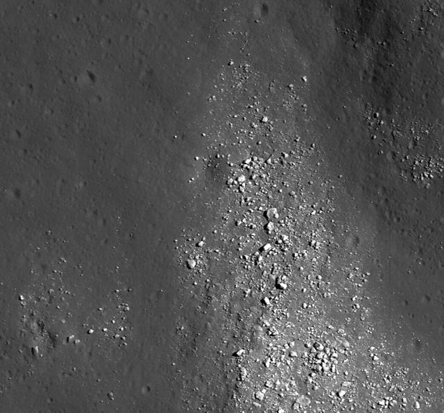
One small section of this image shows boulders that have rolled down the slope of a crater wall. The boulders vary in size, with the largest one approximately 6 meters across. Unlike the boulder in a previous image, this one is not standing on end. We can tell by using the sun angle and shadow length to figure out the height and then comparing that to its other measurements. We can determine the origin of the boulders by tracing their up-slope tracks. They appear to come from one small part of the crater wall that is less stable than surrounding materials. It is likely that there have been numerous rockfall events from this area, as suggested by the many boulders down-slope of this area, some with clear tracks and others with indistinct or no tracks visible. http://photojournal.jpl.nasa.gov/catalog/PIA20744
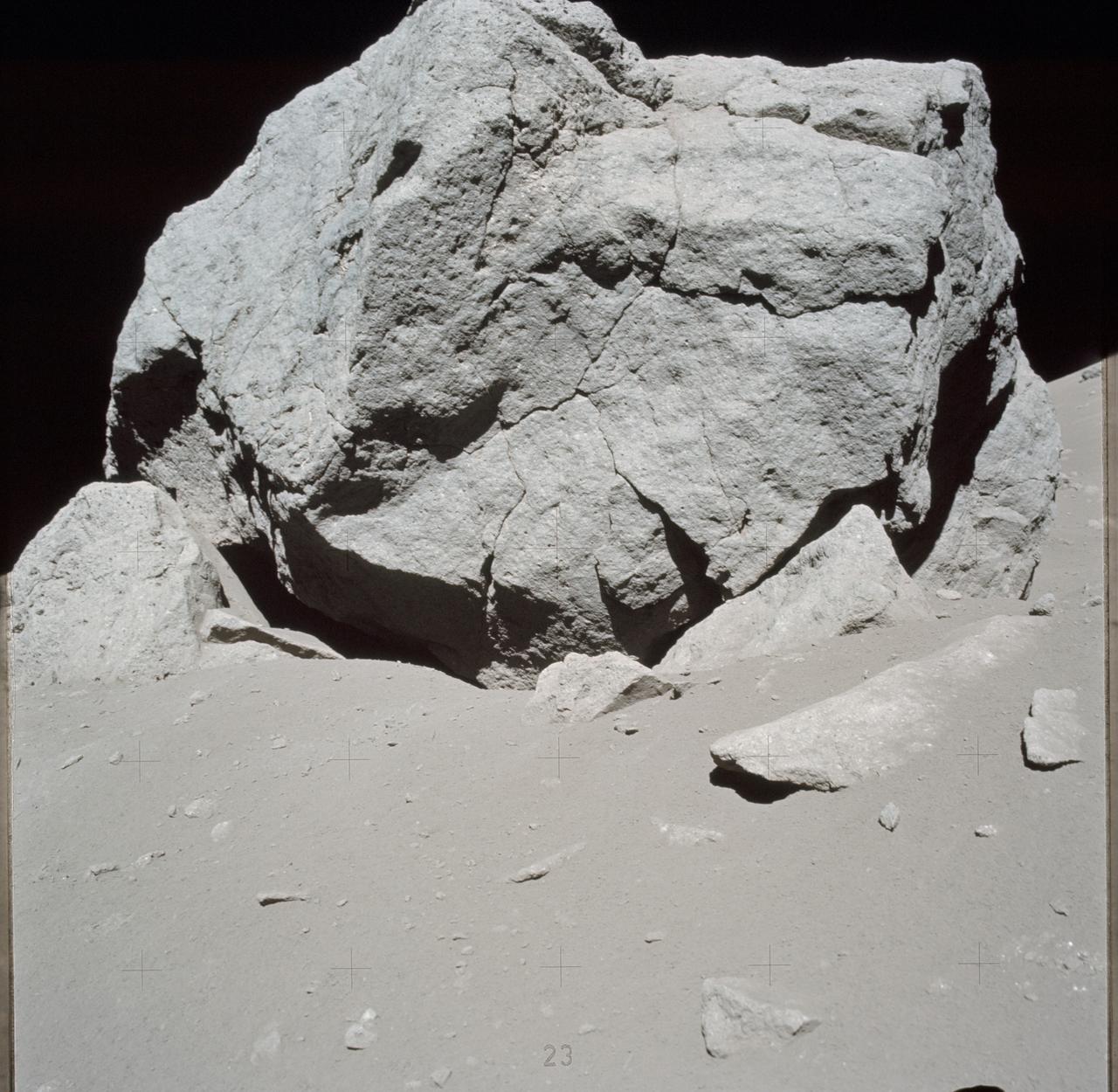
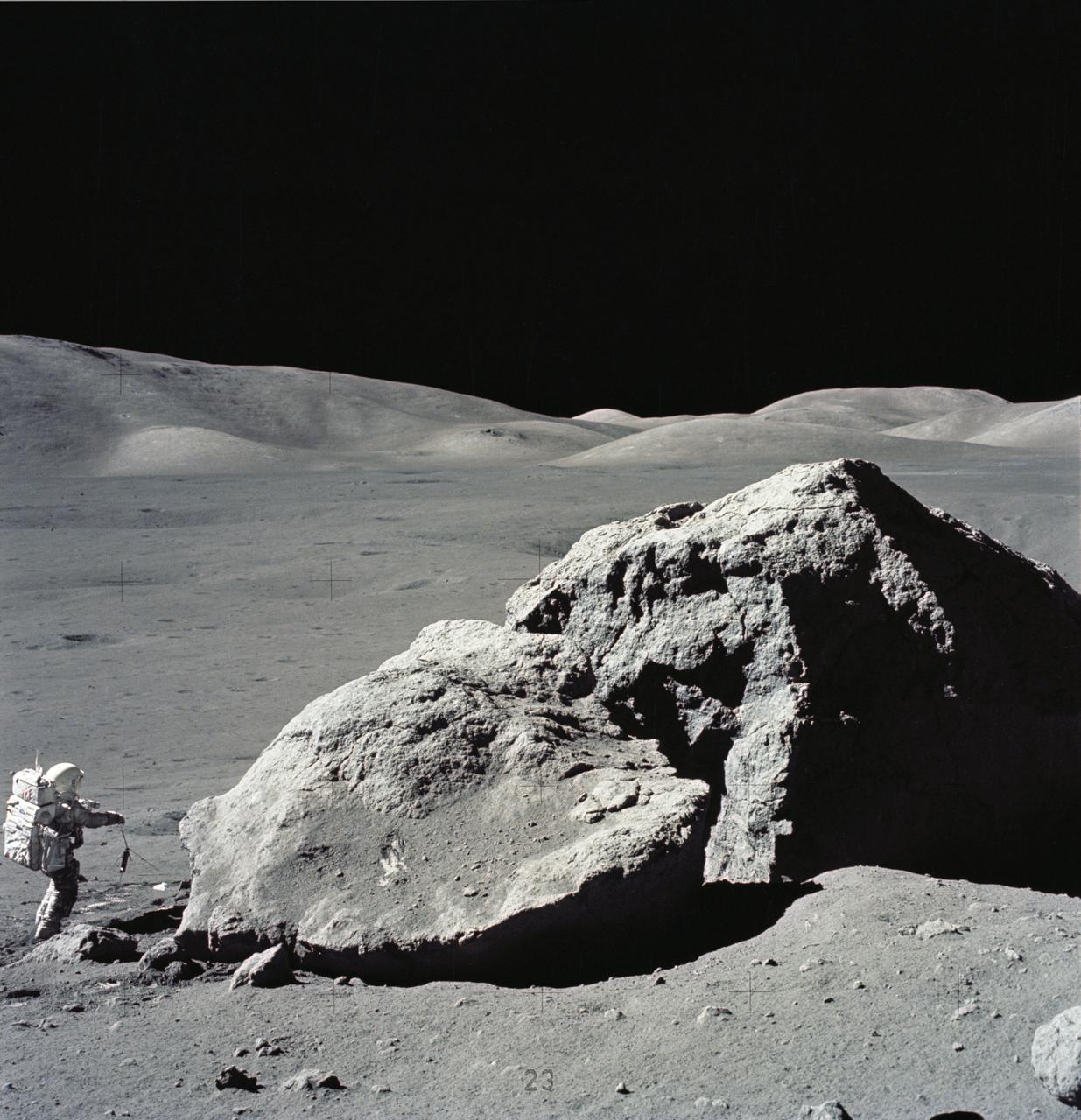
AS17-140-21438 (7-19 Dec. 1972) --- This 70mm frame features a close-up view of a large multi-cracked boulder discovered by astronauts Eugene A. Cernan, commander, and Harrison H. (Jack) Schmitt, lunar module pilot, during their visit to extravehicular activity (EVA) Station 6. This boulder, referred to as number two, provided several samples for the crew members' record-setting volume of rock collections. While astronauts Cernan and Schmitt descended in the Lunar Module (LM) "Challenger" to explore the Taurus-Littrow region of the moon, astronaut Ronald E. Evans, command module pilot, remained with the Command and Service Modules (CSM) "America" in lunar orbit. Cernan and Schmitt were the last crew members to explore the moon in the Apollo Program.
AS14-64-9118 (6 Feb. 1971) --- Astronaut Alan B. Shepard Jr., commander, photographed this overall view of a field of boulders on the flank of Cone Crater, during the second extravehicular activity (EVA), on Feb. 6, 1971. The view is looking south across the lunar valley through which the Apollo 14 moon-explorers flew their Lunar Module (LM) during the final approach to the landing. Astronaut Edgar D. Mitchell, lunar module pilot, joined Shepard in exploring the moon, while astronaut Stuart A. Roosa, command module pilot, remained with the Command and Service Modules (CSM) in lunar orbit.
This image from NASA's Mars Reconnaissance Orbiter (MRO) shows a field of boulders. More information is available at https://photojournal.jpl.nasa.gov/catalog/PIA22433

Acting NASA Deputy Administrator Lesa Roe, second from left, and acting NASA Administrator Robert Lightfoot, second from left, are seen with Mike Gazarik, vice president of Engineering at Ball Aerospace, left and Shawn Conley, test operations manager at Ball Aerospace, left, in front of the large semi-anechoic chamber, Thursday, April 6, 2017 during a visit to Ball Aerospace in Boulder, Colo. Photo Credit: (NASA/Joel Kowsky)

Michael Dean, senior project engineer for the Joint Polar Satellite System (JPSS) program at Ball Aerospace, right, speaks with acting NASA Deputy Administrator Lesa Roe, second from left, and acting NASA Administrator Robert Lightfoot, center, about the 20ft. by 24 ft. vertical thermal vacuum chamber, Thursday, April 6, 2017 during a visit to Ball Aerospace in Boulder, Colo. Photo Credit: (NASA/Joel Kowsky)
AS14-64-9099 (6 Feb. 1971) --- An Apollo 14 crew member (note shadow) photographs this field of boulders located on the flank of Cone Crater during the second extravehicular activity (EVA). This view is looking just north of west. While astronauts Alan B. Shepard Jr., commander, and Edgar D. Mitchell, lunar module pilot, were exploring the moon, astronaut Stuart A. Roosa, command module pilot, was maneuvering the Apollo 14 Command and Service Modules (CSM) in lunar orbit.
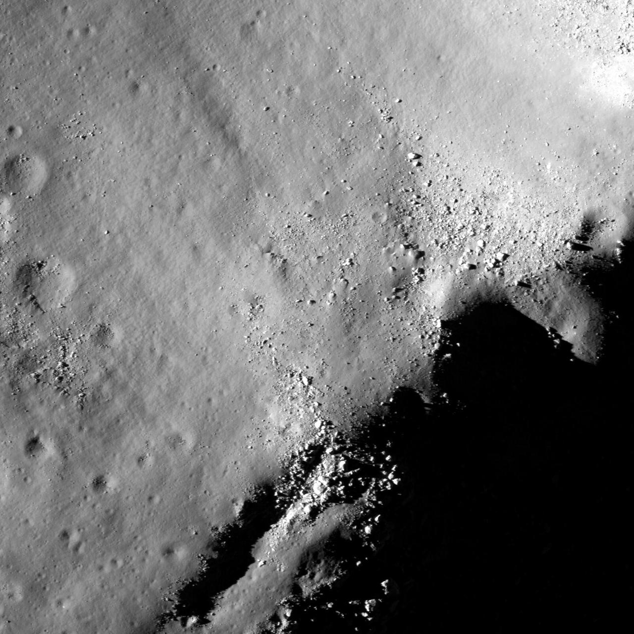
This image from NASA Lunar Reconnaissance Orbiter shows a view of boulders, on the floor of Rutherfurd crater, about to disappear into the shadows of dusk.
NASA Wide-field Infrared Survey Explorer in the clean room at Ball Aerospace & Technologies Corp., in Boulder, Colo.
This image from NASA Lunar Reconnaissance Orbiter shows a view of boulders, on the floor of Rutherfurd crater, about to disappear into the shadows of dusk.
Boulders perched on the summit of the central peak of Tsiolkovskiy crater are seen in this image from NASA Lunar Reconnaissance Orbiter.
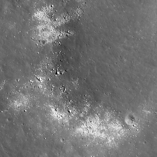
NASA Lunar Reconnaissance Orbiter view of boulders on an outlying rampart of the complex central peak of Tsiolkovskiy crater.
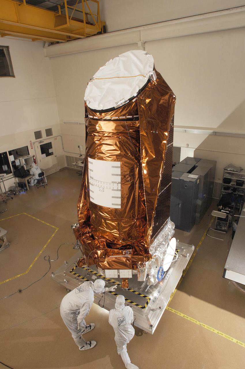
NASA Kepler spacecraft in a clean room at Ball Aerospace & Technologies Corp. in Boulder, Colo.
This MOC image shows a bowl-shaped crater on the martian northern plains with a mysterious radiant pattern of zones with and without boulders and rocks
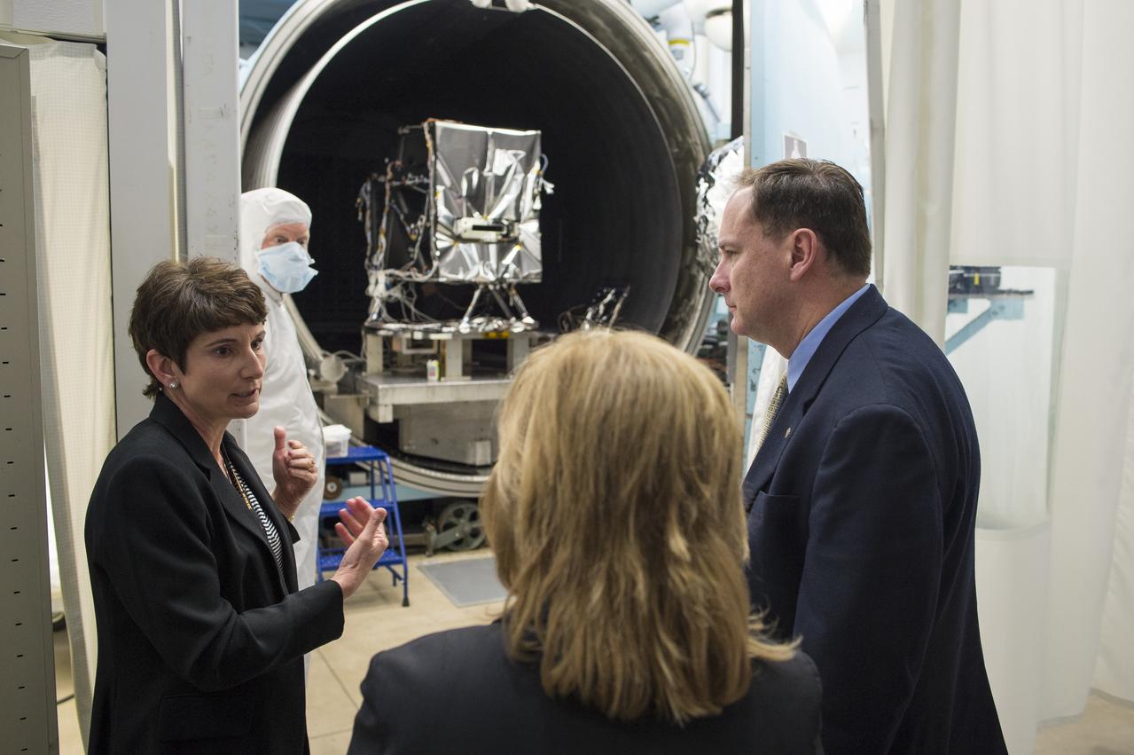
Leanne Presley, Operational Land Imager-2 (OLI-2) program manager at Ball Aerospace, left, speaks with acting NASA Deputy Administrator Lesa Roe, center, and acting NASA Administrator Robert Lightfoot in front of a thermal vacuum chamber used to test satellite optics, Thursday, April 6, 2017 during a visit to Ball Aerospace in Boulder, Colo. The Operation Land Imager-2 (OLI-2) is being build for Landsat 9, a collaboration between NASA and the U.S. Geological Survey that will continue the Landsat Program's 40-year data record of monitoring the Earth's landscapes from space. Photo Credit: (NASA/Joel Kowsky)
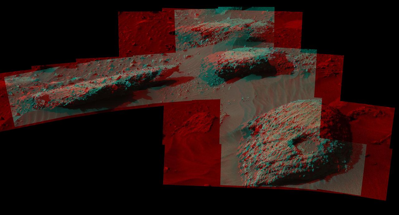
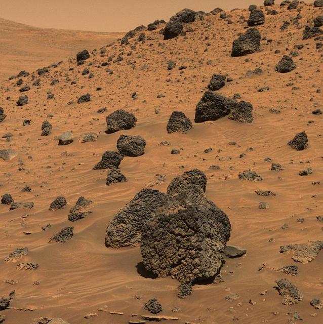
This stereo scene from the Mast Camera (Mastcam) on NASA's Curiosity Mars Rover shows boulders composed, in part, of pebble-size (0.2 to 2.6 inches, or 0.5 to 6.5 centimeters across) and larger rock fragments. The size and shape of the fragments provide clues to the origins of these boulders. This image is an anaglyph that appears three dimensional when viewed through red-blue glasses with the red lens on the left. The separate right-eye and left-eye views combined into the stereo version are Figure 1 and Figure 2. Mastcam's right-eye camera has a telephoto lens, with focal length of 100 millimeters. The left-eye camera provides a wider view, with a 34-millimeter lens. These images were taken on July 22, 2016, during the 1,408th Martian day, or sol, of Curiosity's work on Mars. For scale, the relatively flat rock at left is about 5 feet (1.5 meters) across. The rock in the foreground at right is informally named "Balombo." The group of boulders is at a site called "Bimbe." The Curiosity team chose to drive the rover to Bimbe to further understand patches of boulders first identified from orbit and seen occasionally on the rover's traverse. The boulders at Bimbe consist of multiple rock types. Some include pieces, or "clasts," of smaller, older rock cemented together, called breccias or conglomerates. The shapes of the inclusion clasts -- whether they are rounded or sharp-edged -- may indicate how far the clasts were transported, and by what processes. Breccias have more angular clasts, while conglomerates have more rounded clasts. As is clear by looking at these boulders, they contain both angular and rounded clasts, leading to some uncertainty about how they formed. Conglomerate rocks such as "Hottah" were inspected near Curiosity's landing site and interpreted as part of an ancient streambed. Breccias are generally formed by consolidation of fragments under pressure. On Mars such pressure might come from crater-forming impact, or by deep burial and exhumation. http://photojournal.jpl.nasa.gov/catalog/PIA20836
AS17-140-21496 (13 Dec. 1972) --- Scientist-astronaut Harrison H. Schmitt is photographed standing next to a huge, split boulder during the third Apollo 17 extravehicular activity (EVA) at the Taurus-Littrow landing site on the moon. Schmitt is the Apollo 17 lunar module pilot. This picture was taken by astronaut Eugene A. Cernan, commander. While Cernan and Schmitt descended in the Lunar Module (LM) "Challenger" to explore the moon, astronaut Ronald E. Evans, command module pilot, remained with the Apollo 17 Command and Service Modules (CSM) in lunar orbit.
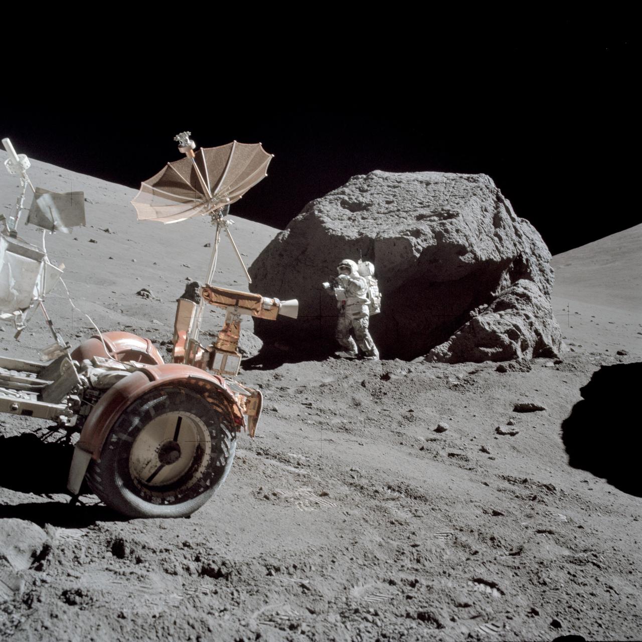
AS17-146-22294 (13 Dec. 1972) --- Scientist-astronaut Harrison H. Schmitt is photographed working beside a huge boulder at Station 6 (base of North Massif) during the third Apollo 17 extravehicular activity (EVA) at the Taurus-Littrow landing site. The front portion of the Lunar Roving Vehicle (LRV) is visible on the left. This picture was taken by astronaut Eugene A. Cernan, Apollo 17 commander. Schmitt is the lunar module pilot. While astronauts Cernan and Schmitt descended in the Lunar Module (LM) "Challenger" to explore the moon, astronaut Ronald E. Evans, command module pilot, remained with the Apollo 17 Command and Service Modules (CSM) in lunar orbit.
AS16-106-17413 (23 April 1972) --- Astronaut John W. Young, commander of the Apollo 16 lunar landing mission, looks over a large boulder at Station No.13 during the third Apollo 16 extravehicular activity (EVA) at the Descartes landing site. This was the site of the permanently shadowed soil sample which was taken from a hole extending under overhanging rock. Astronaut Charles M. Duke Jr., lunar module pilot, took this photograph. Concerning Young's reaching under the big rock, Duke remarked: "You do that in west Texas and you get a rattlesnake!"
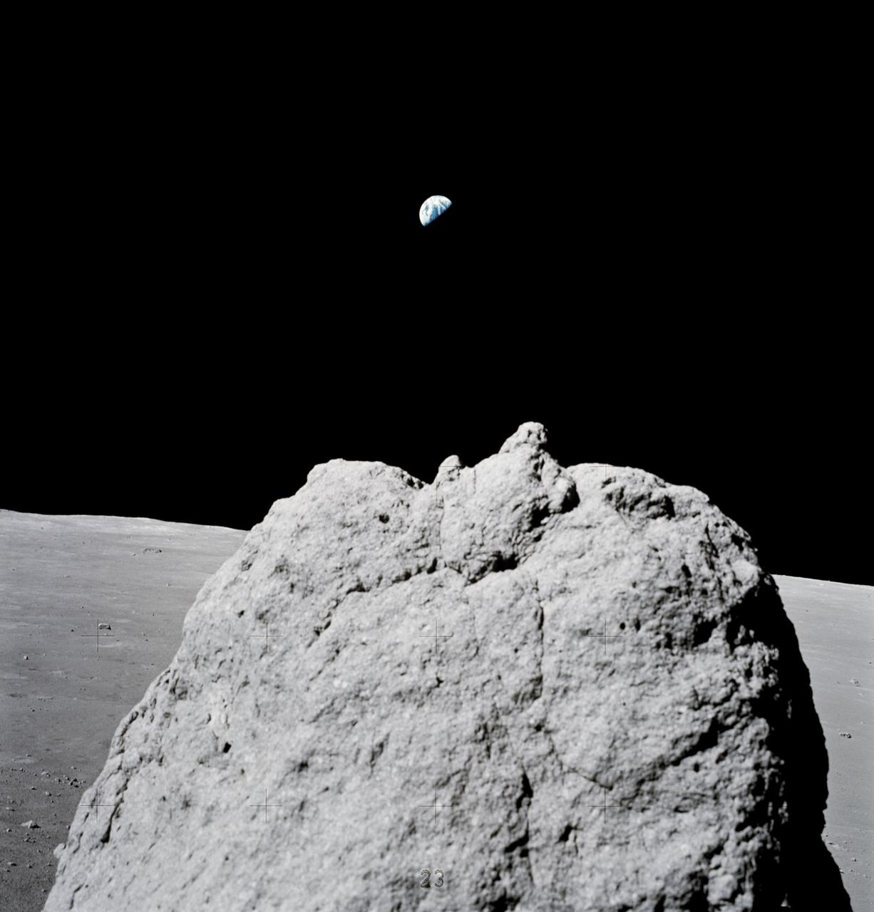
AS17-137-20910 (7-19 Dec. 1972) --- Earth (far distant background) is seen above a large lunar boulder (foreground) on the moon. The photo was taken with a handheld Hasselblad camera by the last two moon walkers in the Apollo Program. While astronauts Eugene A. Cernan, commander; and Harrison H. Schmitt, lunar module pilot, descended in the Lunar Module (LM) "Challenger" to explore the Taurus-Littrow region of the moon, astronaut Ronald E. Evans, command module pilot, remained with the Command and Service Modules (CSM) "America" in lunar orbit.
AS16-116-18649 (23 April 1972) --- Astronaut Charles M. Duke Jr., lunar module pilot of the Apollo 16 lunar landing mission, examines closely the surface of a large boulder at North Ray Crater during the third Apollo 16 extravehicular activity (EVA) at the Descartes landing site. This picture was taken by astronaut John W. Young, commander. Note the chest-mounted 70mm Hasselblad camera. While astronauts Young and Duke descended in the Apollo 16 Lunar Module (LM) "Orion" to explore the Descartes highlands landing site on the moon, astronaut Thomas K. Mattingly II, command module pilot, remained with the Command and Service Modules (CSM) "Casper" in lunar orbit.
jsc2024e043914 (7/10/2024) --- In-Space Expansion of Hematopoietic Stem Cells for Clinical Application (InSPA-StemCellEX-H1) continues tests of a technology to produce human hematopoietic stem cells (HSCs) in space. In this image, HSCs were incubated with a fluorescent probe that identifies living cells. Dead cells would fluoresce green. The cells have been loaded into a device called a hemocytometer that provides a grid to make it easy to obtain an accurate count of cells. Astronauts will use a similar technique in space to help determine the rate of HSC expansion over time. Expanding HSC production has the potential to improve patient outcomes and reduce overall mortality for thousands of people diagnosed and living with blood cancer every year. Image courtesy of University of Colorado Boulder.

Boulders perched atop a wrinkle ridge in Mare Imbrium west of the Montes Teneriffe can be seen in this image taken by NASA Lunar Reconnaissance Orbiter.

NASA Lunar Reconnaissance Orbiter shows boulders and impact melt line the floor of the 85-km crater Tycho, a potential site for future human exploration.
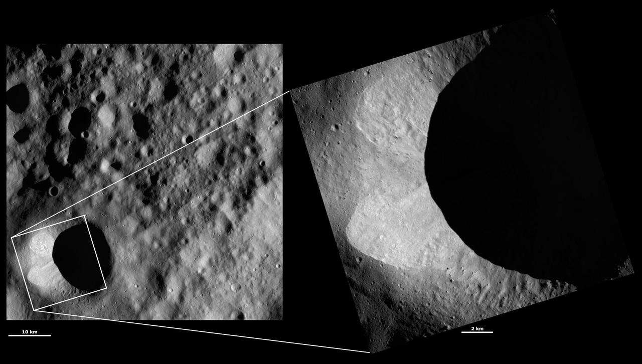
These images from NASA Dawn spacecraft are located in asteroid Vesta Floronia quadrangle, in Vesta northern hemisphere; small boulders visible inside of Scantia crater.