
NASA Administrator Bill Nelson and His Excellency Dato Paduka Serbini Ali, Ambassador of Brunei to the United States, speak during a courtesy visit, Wednesday, Jan. 8, 2025 at the Mary W. Jackson NASA Headquarters building in Washington. Photo Credit: (NASA/Joel Kowsky)

NASA Administrator Bill Nelson and His Excellency Dato Paduka Serbini Ali, Ambassador of Brunei to the United States, speak during a courtesy visit, Wednesday, Jan. 8, 2025 at the Mary W. Jackson NASA Headquarters building in Washington. Photo Credit: (NASA/Joel Kowsky)

His Excellency Dato Paduka Serbini Ali, Ambassador of Brunei to the United States, right, and NASA Administrator Bill Nelson speak during a courtesy visit, Wednesday, Jan. 8, 2025 at the Mary W. Jackson NASA Headquarters building in Washington. Photo Credit: (NASA/Joel Kowsky)

NASA Administrator Bill Nelson and His Excellency Dato Paduka Serbini Ali, Ambassador of Brunei to the United States, speak during a courtesy visit, Wednesday, Jan. 8, 2025 at the Mary W. Jackson NASA Headquarters building in Washington. Photo Credit: (NASA/Joel Kowsky)

NASA Administrator Bill Nelson, right, His Excellency Dato Paduka Serbini Ali, Ambassador of Brunei to the United States, left, speak alongside Izzati Baharuddin, Deputy Chief of Mission, Embassy of Brunei to the United States, second from left, and Najaah Ra’emi Maleek, Second Secretary, Embassy of Brunei to the United States, third from left, Gilbert Kirkham, science division director in NASA’s Office of International and Interagency Relations, second from right, and Lenai Johnson, international program specialist in NASA’s Office of International and Interagency Relations, second from right, during a courtesy visit during a courtesy visit, Wednesday, Jan. 8, 2025 at the Mary W. Jackson NASA Headquarters building in Washington. Photo Credit: (NASA/Joel Kowsky)
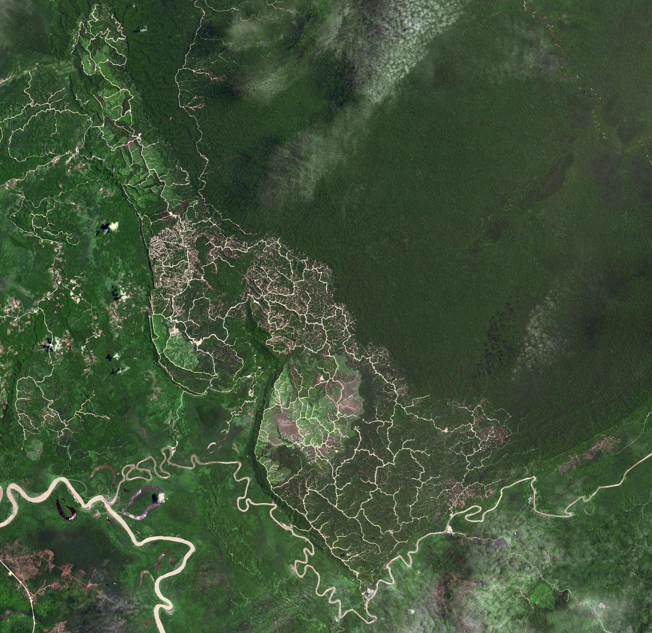
The southwestern border of Brunei with Sarawak, Malaysia is strikingly apparent due to differences in land use practice. On the Malaysian side, a spider web of small roads indicates intensive land use: in this case clearing of the forest for palm oil plantations. On the Brunei side, the virgin forest is preserved, with few if any roads cutting through the forest. The image was acquired September 10, 2012, covers an area of 38 by 38 km, and is located at 4.2 degrees north, 114.4 degrees east. https://photojournal.jpl.nasa.gov/catalog/PIA22034
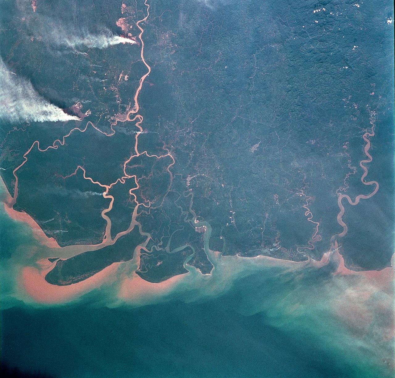
STS093-708-062 (23-27 July 1999) --- The STS-93 astronauts took this picture of the Island of Borneo, which is divided among Indonesia, Malaysia and Brunei. The Rajang River meets the South China Sea in the northwestern portion of the Malaysian state of Sarawak. Smoke from both large and small fires is blowing north by the prevailing summer winds. Notice the contrast of dark colored rainforest with the lighter clearings where the largest fires are burning. According to NASA scientists studying the STS-93 photo collection, the sediment plumes along the coast are mostly shoreline erosional materials caught up in longshore currents. The Saribas River can be seen at the bottom.