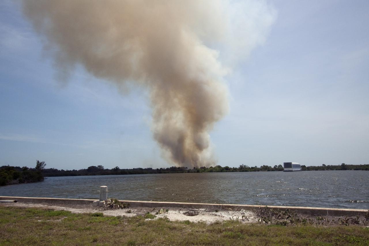
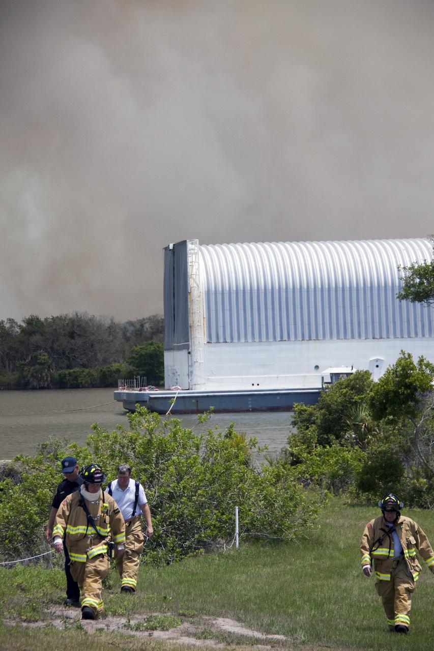
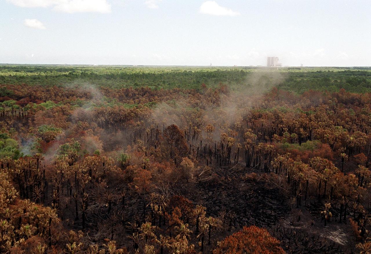
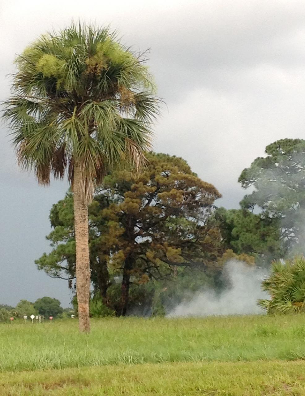
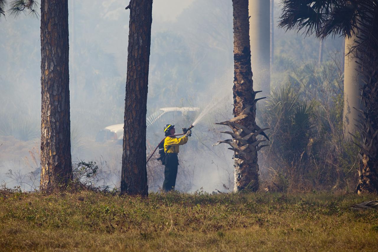
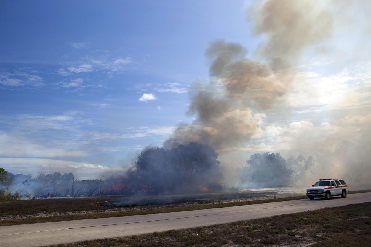
CAPE CANAVERAL, Fla. -- At NASA's Kennedy Space Center in Florida, smoke rises from a smoldering brush fire southeast of the Turn Basin. The fire was spotted near Kennedy’s Press Site approximately three miles away from Launch Pad 39A. The fires are being contained by firefighters from Kennedy Space Center and the U.S. Fish and Wildlife Service. No personnel are in danger and currently there is no to impact any operations related to space shuttle Endeavour’s launch countdown. Photo credit: NASA/Jack Pfaller
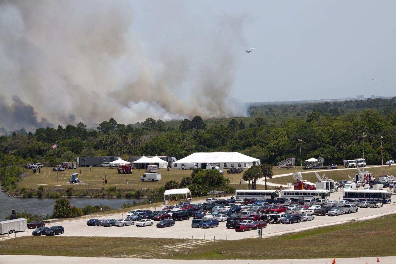
CAPE CANAVERAL, Fla. -- At NASA's Kennedy Space Center in Florida, smoke rises from a smoldering brush fire southeast of the Turn Basin. The fire was spotted near Kennedy’s Press Site approximately three miles away from Launch Pad 39A. The fires are being contained by firefighters from Kennedy Space Center and the U.S. Fish and Wildlife Service. No personnel are in danger and currently there is no to impact any operations related to space shuttle Endeavour’s launch countdown. Photo credit: NASA/Jack Pfaller
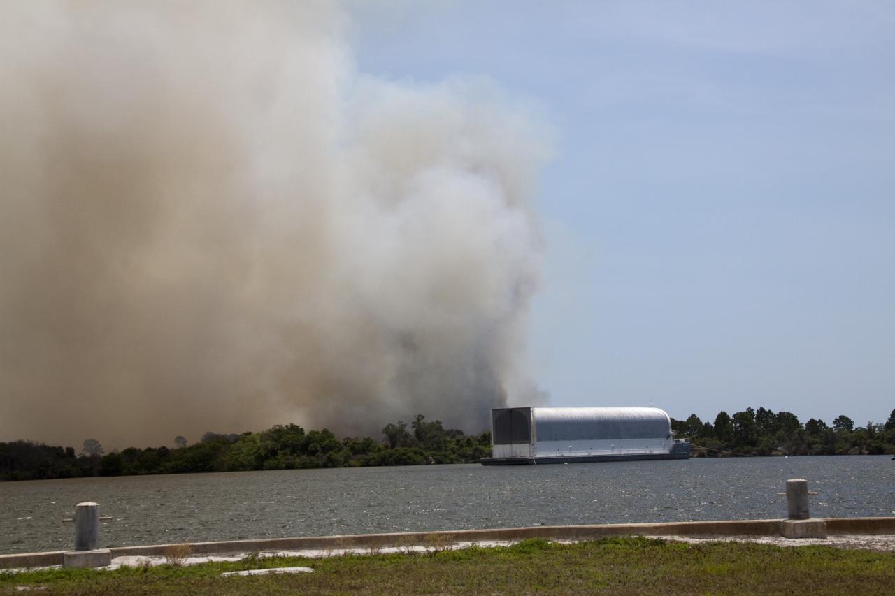
CAPE CANAVERAL, Fla. -- At NASA's Kennedy Space Center in Florida, smoke rises from a smoldering brush fire southeast of the Turn Basin. The fire was spotted near Kennedy’s Press Site approximately three miles away from Launch Pad 39A. The fires are being contained by firefighters from Kennedy Space Center and the U.S. Fish and Wildlife Service. No personnel are in danger and currently there is no to impact any operations related to space shuttle Endeavour’s launch countdown. Photo credit: NASA/Jack Pfaller
CAPE CANAVERAL, Fla. -- At NASA's Kennedy Space Center in Florida, smoke rises from a smoldering brush fire southeast of the Turn Basin. The fire was spotted near Kennedy’s Press Site approximately three miles away from Launch Pad 39A. The fires are being contained by firefighters from Kennedy Space Center and the U.S. Fish and Wildlife Service. No personnel are in danger and currently there is no to impact any operations related to space shuttle Endeavour’s launch countdown. Photo credit: NASA/Troy Cryder
CAPE CANAVERAL, Fla. -- At NASA's Kennedy Space Center in Florida, smoke rises from a smoldering brush fire southeast of the Turn Basin. The fire was spotted near Kennedy’s Press Site approximately three miles away from Launch Pad 39A. The fires are being contained by firefighters from Kennedy Space Center and the U.S. Fish and Wildlife Service. No personnel are in danger and currently there is no to impact any operations related to space shuttle Endeavour’s launch countdown. Photo credit: NASA/Jack Pfaller
CAPE CANAVERAL, Fla. -- At NASA's Kennedy Space Center in Florida, smoke rises from a smoldering brush fire southeast of the Turn Basin. The fire was spotted near Kennedy’s Press Site approximately three miles away from Launch Pad 39A. The fires are being contained by firefighters from Kennedy Space Center and the U.S. Fish and Wildlife Service. No personnel are in danger and currently there is no to impact any operations related to space shuttle Endeavour’s launch countdown. Photo credit: NASA/Jack Pfaller
CAPE CANAVERAL, Fla. -- At NASA's Kennedy Space Center in Florida, smoke rises from a smoldering brush fire southeast of the Turn Basin. The fire was spotted near Kennedy’s Press Site approximately three miles away from Launch Pad 39A. The fires are being contained by firefighters from Kennedy Space Center and the U.S. Fish and Wildlife Service. No personnel are in danger and currently there is no to impact any operations related to space shuttle Endeavour’s launch countdown. Photo credit: NASA/Kim Shiflett
CAPE CANAVERAL, Fla. -- At NASA's Kennedy Space Center in Florida, smoke rises from a smoldering brush fire southeast of the Turn Basin. The fire was spotted near Kennedy’s Press Site approximately three miles away from Launch Pad 39A. The fires are being contained by firefighters from Kennedy Space Center and the U.S. Fish and Wildlife Service. No personnel are in danger and currently there is no to impact any operations related to space shuttle Endeavour’s launch countdown. Photo credit: NASA/Kim Shiflett
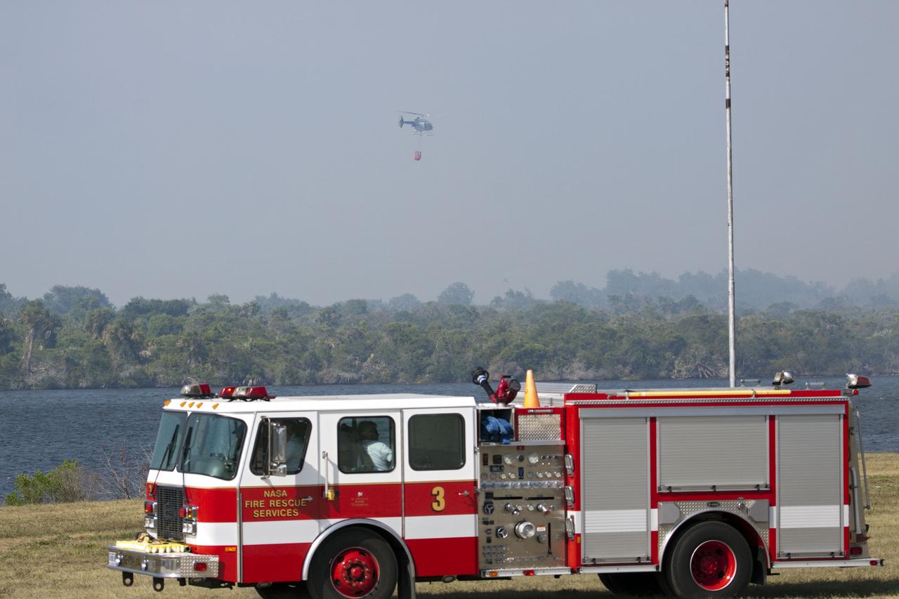
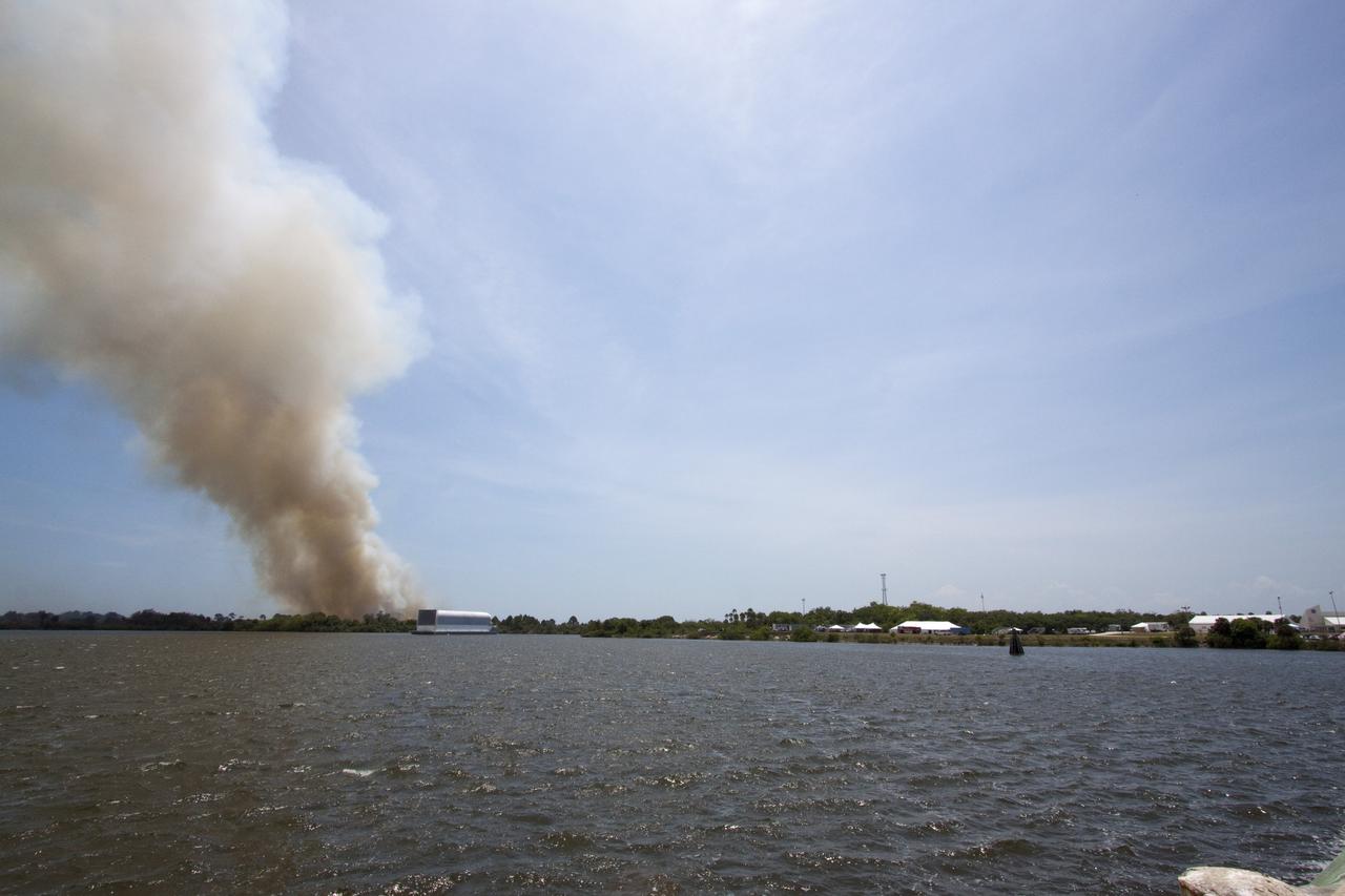
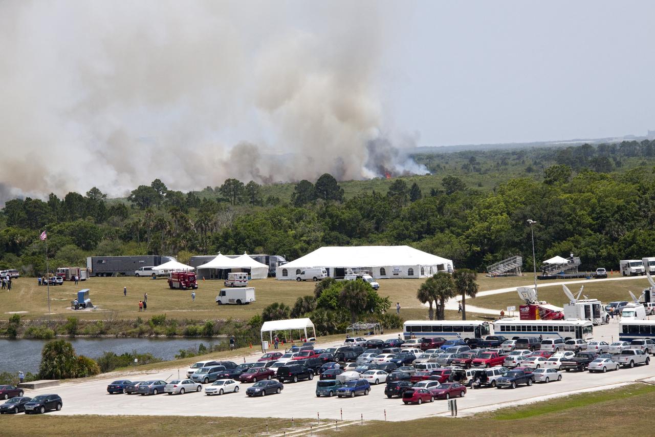
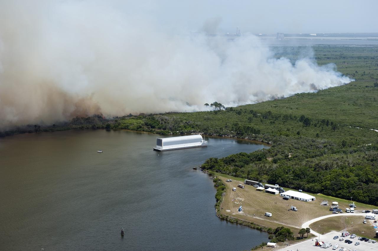
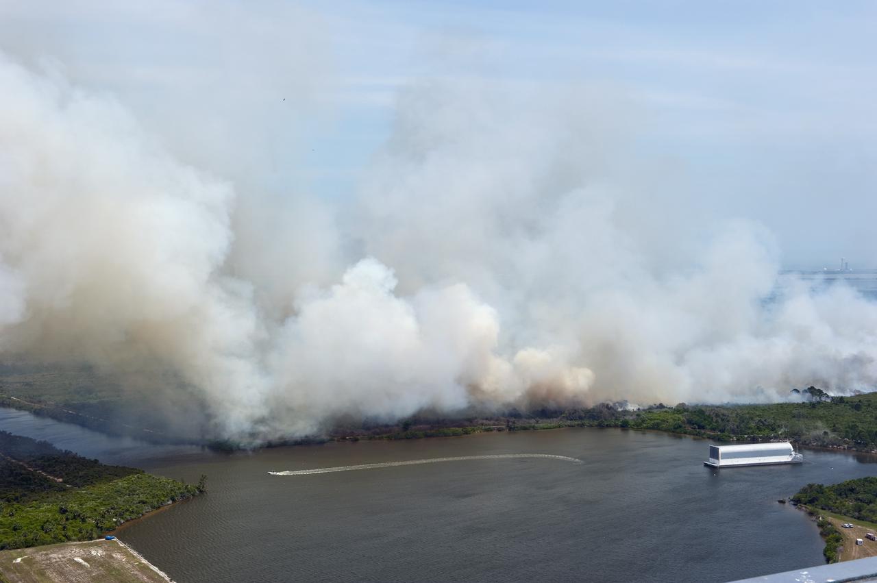
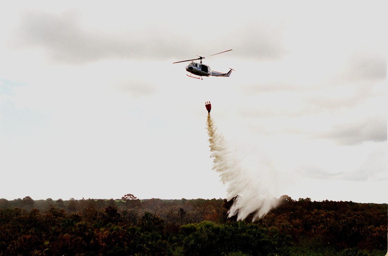
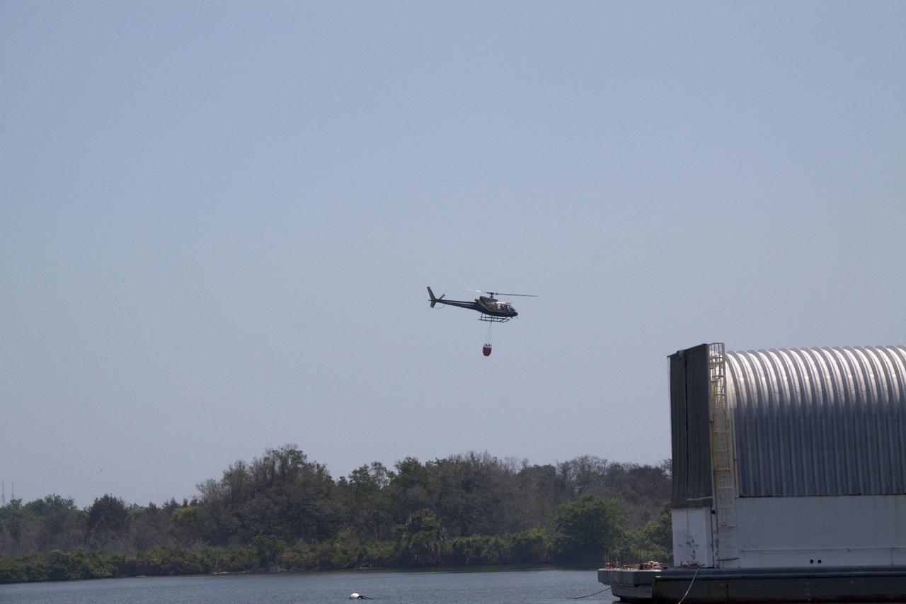
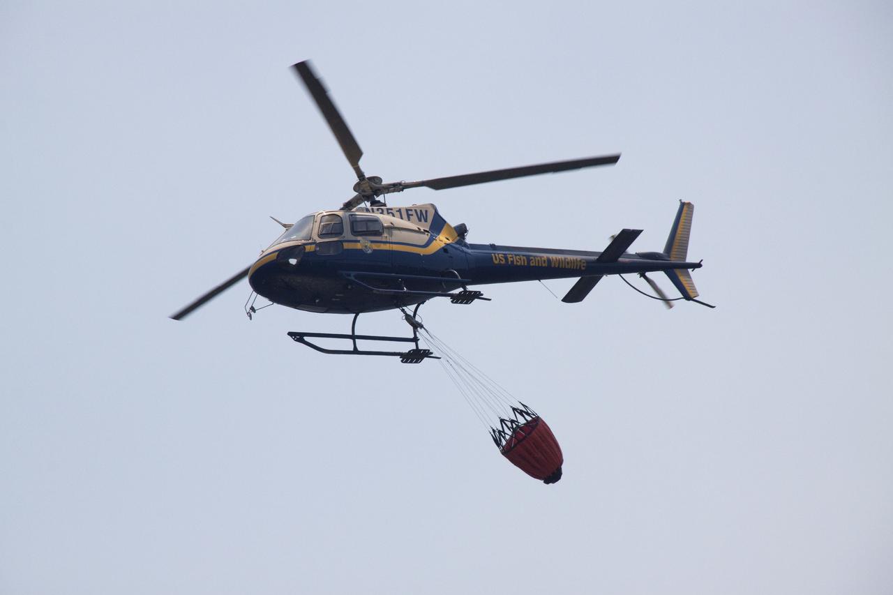
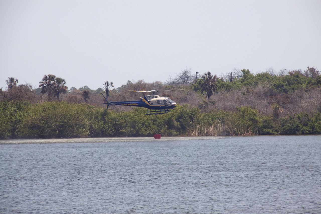
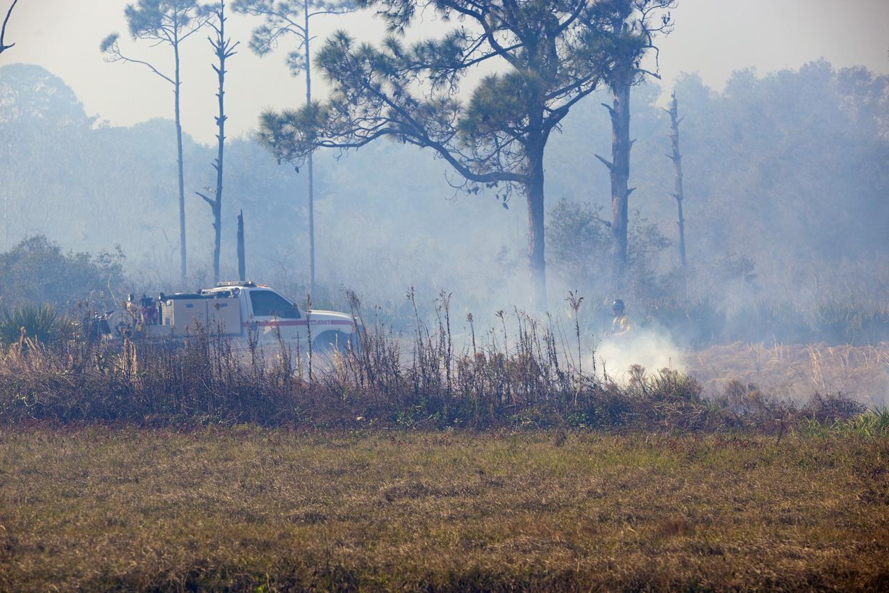
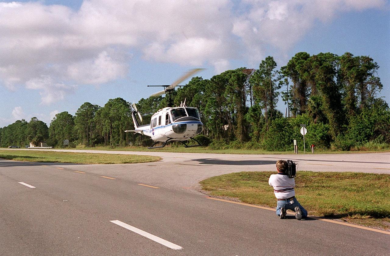
CAPE CANAVERAL, Fla. -- At NASA's Kennedy Space Center in Florida, a helicopter collects water from the Turn Basin to douse a nearby brush fire. The fire was spotted in a rural area southeast of Kennedy’s Press Site approximately three miles away from Launch Pad 39A, where space shuttle Endeavour awaits liftoff on the STS-134 mission to the International Space Station. The fire is being contained by crews from Kennedy and the U.S. Fish and Wildlife Service and smoke is not expected to impact launch. Photo credit: NASA/Jack Pfaller
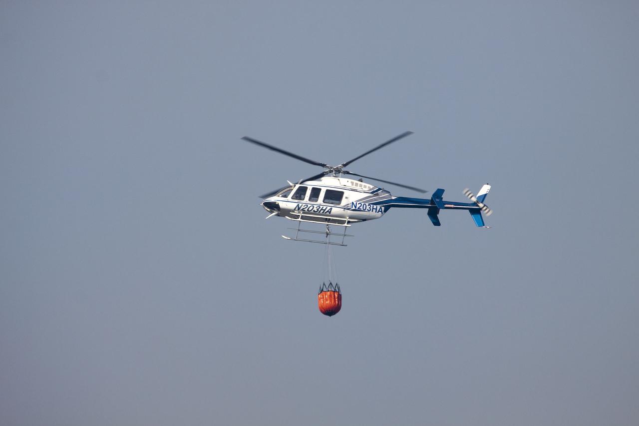
CAPE CANAVERAL, Fla. -- At NASA's Kennedy Space Center in Florida, a helicopter collects water from the Turn Basin to douse a nearby brush fire. The fire was spotted in a rural area southeast of Kennedy’s Press Site approximately three miles away from Launch Pad 39A, where space shuttle Endeavour awaits liftoff on the STS-134 mission to the International Space Station. The fire is being contained by crews from Kennedy and the U.S. Fish and Wildlife Service and smoke is not expected to impact launch. Photo credit: NASA/Jack Pfaller
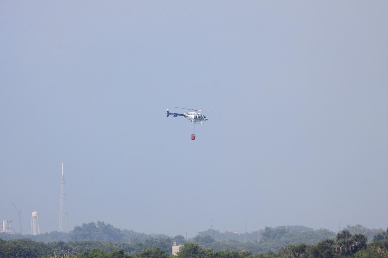
CAPE CANAVERAL, Fla. -- At NASA's Kennedy Space Center in Florida, a helicopter collects water from the Turn Basin to douse a nearby brush fire. The fire was spotted in a rural area southeast of Kennedy’s Press Site approximately three miles away from Launch Pad 39A, where space shuttle Endeavour awaits liftoff on the STS-134 mission to the International Space Station. The fire is being contained by crews from Kennedy and the U.S. Fish and Wildlife Service and smoke is not expected to impact launch. Photo credit: NASA/Jack Pfaller
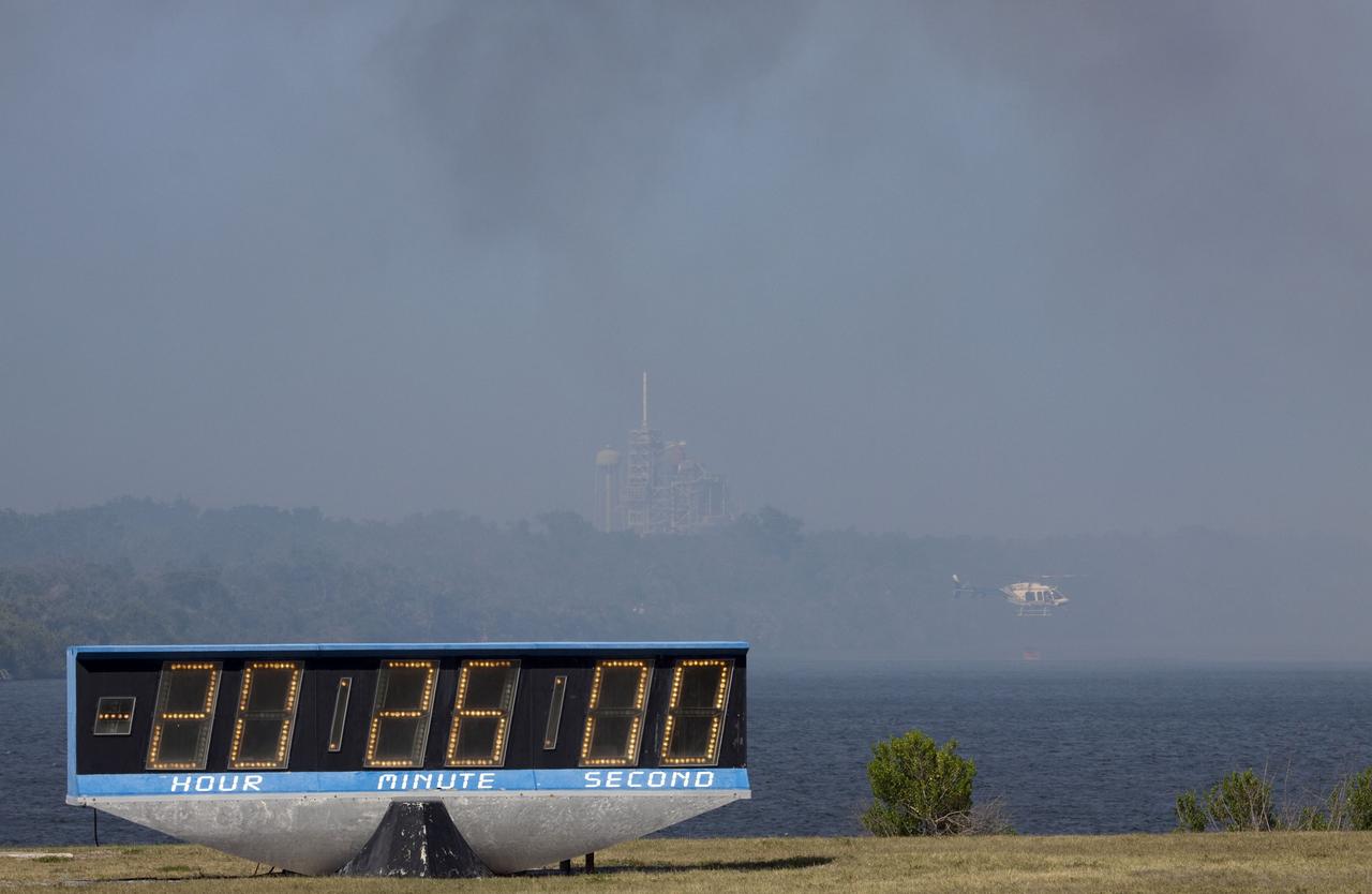
CAPE CANAVERAL, Fla. -- At NASA's Kennedy Space Center in Florida, a helicopter collects water from the Turn Basin to douse a nearby brush fire. The fire was spotted in a rural area southeast of Kennedy’s Press Site approximately three miles away from Launch Pad 39A, where space shuttle Endeavour awaits liftoff on the STS-134 mission to the International Space Station. The fire is being contained by crews from Kennedy and the U.S. Fish and Wildlife Service and smoke is not expected to impact launch. Photo credit: NASA/Jack Pfaller
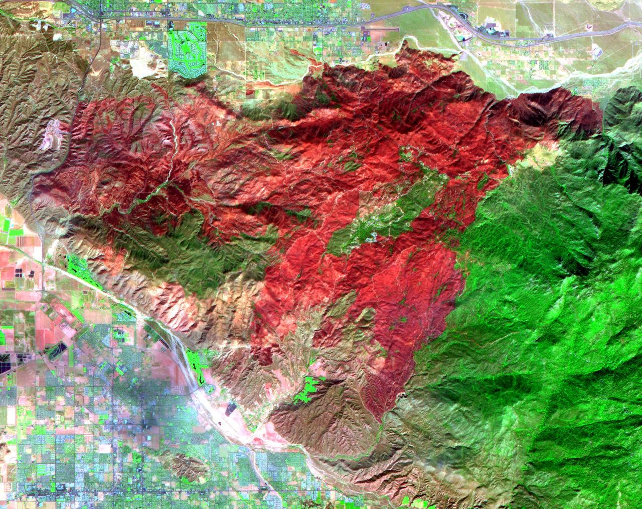
The Esperanza fire started on October 26 in the dry brush near Palm Springs, CA. By the time it was contained 6 days later, the fire had consumed 40,200 acres, and destroyed 34 homes and 20 outbuildings. Racing through grass, brush, and timber, the blaze had forced hundreds to evacuate, and it killed five firefighters who were working to protect homes. Fire officials are reporting the cause of the blaze as arson. In this ASTER image composite of visible and infrared bands, burned areas are shown in shades of red, vegetation is green, brown vegetation is brown and asphalt and concrete are blue-gray. http://photojournal.jpl.nasa.gov/catalog/PIA01900
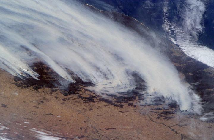
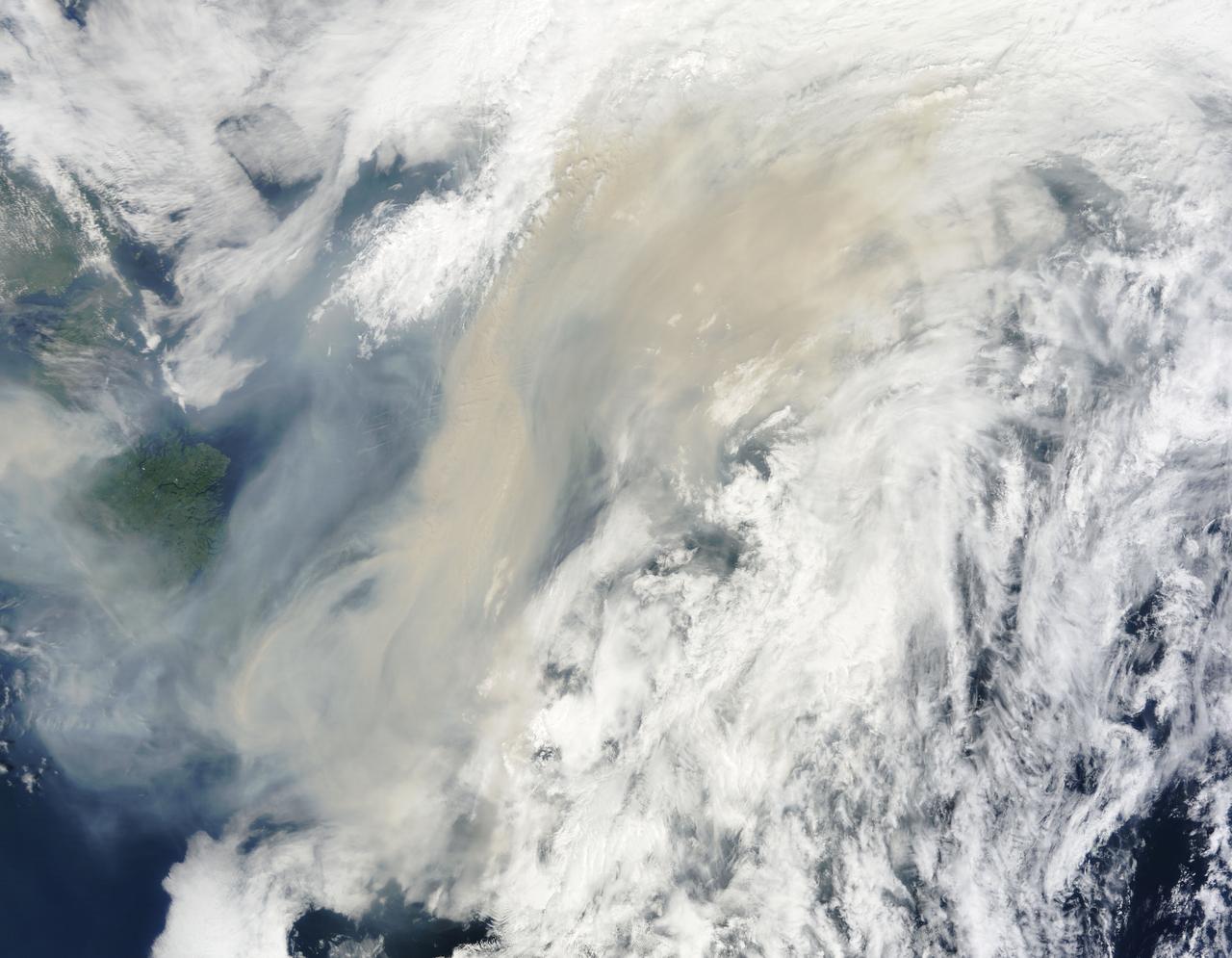
This dramatic image of the Australian brushers was taken from orbit by one of the crew members aboard the International Space Station (ISS). Following the worst regional drought in 50 years, this summer's fire season has resulted in numerous large fires over much of the Great Dividing Range as well as the enormous smoke pall over New South Wales, Victoria, and the adjacent South Pacific Ocean.
Brush fires consumed nearly 750,000 acres across Southern California between October 21 and November 18, 2003. Burn scars and vegetation changes wrought by the fires are illustrated in these false-color images from NASA Terra spacecraft.
A plume from a large brush fire that burned about 15,000 acres in 2000 is visible at the western edge of the Big Cypress Swamp in southern Florida. NASA Terra satellite captured acquired this image on April 9, 2000. 3D glasses are necessary.
A helicopter dumps water on smoldering brush on Kennedy Space Center. Hazardous fire conditions exist throughout Central Florida. The site is between Kennedy Parkway North and the Indian River

KENNEDY SPACE CENTER, FLA. -- Smoke rising from the smoldering brush on Kennedy Space Center illustrates the hazardous fire conditions that exist throughout Central Florida. The site is between Kennedy Parkway North and the Indian River

A helicopter dumps water on smoldering brush on Kennedy Space Center. Hazardous fire conditions exist throughout Central Florida. The site is between Kennedy Parkway North and the Indian River
KENNEDY SPACE CENTER, FLA. -- Smoke rising from the smoldering brush on Kennedy Space Center illustrates the hazardous fire conditions that exist throughout Central Florida. The site is between Kennedy Parkway North and the Indian River
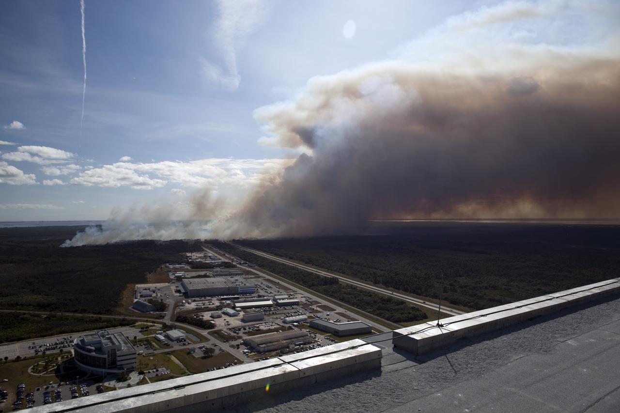
CAPE CANAVERAL, Fla. -- A controlled burn consumes the brush in the vicinity of the Industrial Area at NASA's Kennedy Space Center in Florida. The burn, managed by the U.S. Fish and Wildlife Service, targeted 2,174 acres near Kennedy's administrative complex. Shifting winds caused the fire to flare up in places to dramatic effect. Limited visibility caused by the smoke required NASA Security to close some roadways. The burn, which began during the 8 o'clock hour this morning, is expected to be extinguished this evening. Controlled burns are commonplace on the center to reduce the likelihood of an unplanned brush fire during Central Florida's dry season. Photo Credit: NASA/Dimitri Gerondidakis
On Aug. 16, 2016, at around 10:30 a.m., a brush fire ignited in the Cajon Pass east of Los Angeles, just to the west of Interstate 15. Within a matter of hours, extreme temperatures, high winds and low humidity allowed the fire to spread rapidly, burning through brush left tinder-dry by years of drought. Firefighters quickly responded, ordering the evacuation of about 83,000 people in and around the Cajon Pass, Wrightwood, Lytle Creek, Oak Hills and surrounding areas. An as-yet uncounted number of homes and structures have burned, and Interstate 15 remains closed to downed power lines and barrier damage. By Aug. 17, the fire had expanded to more than 30,000 acres and remains zero percent contained as some 1,300 firefighters continue to battle to save homes and evacuate residents. The Multi-angle Imaging SpectroRadiometer (MISR) instrument aboard NASA's Terra satellite passed over the region on Aug. 17 around 11:50 a.m. PDT and captured this natural-color image from MISR's 70-degree forward-viewing camera, which covers an areas about 257 miles (414 kilometers) wide. The oblique view angle makes the smoke more apparent than it would be in a more conventional vertical view. The Los Angeles metropolitan area is the large gray area on the coast in the center of the image. Three plumes from the Blue Cut Fire are clearly visible in the mountains to the north. This oblique view also shows an enormous cloud of smoke spreading northeastward over a significant portion of eastern California and Nevada. This smoke probably originated from the fire as it consumed almost 20,000 acres on the evening of the 16th and traveled north overnight. Also visible from this oblique view is considerable haziness filling California's Central Valley, to the northwest of the Blue Cut Fire. This haziness is most likely due to smoke from several other fires burning in California, including the Soberanes Fire near Monterey, the Clayton Fire that has destroyed 175 structures north of San Francisco, the Chimney Fire and the Cedar Fire, which is visible in the image in the southern Sierra Nevada. The total number of acres burned in California this year has tripled in just the past week. The 3D stereo anaglyph is made by combining data from MISR's 60-degree and 70-degree forward-viewing cameras. You will need red-blue glasses to view the 3D effect (ensure the red lens is over your left eye). In order to enable stereo viewing, the image has been rotated so north is to the left. These data were acquired during Terra orbit 88648. http://photojournal.jpl.nasa.gov/catalog/PIA20888
CAPE CANAVERAL, Fla. -- At NASA's Kennedy Space Center in Florida, a helicopter collects water from the Turn Basin to douse a nearby brush fire. The fire was spotted in a rural area southeast of Kennedy’s Press Site approximately three miles away from Launch Pad 39A, where space shuttle Endeavour awaits liftoff on the STS-134 mission to the International Space Station. The fire is being contained by crews from Kennedy and the U.S. Fish and Wildlife Service and smoke is not expected to impact launch. Photo credit: NASA_Jack Pfaller
CAPE CANAVERAL, Fla. -- At NASA's Kennedy Space Center in Florida, a helicopter collects water from the Turn Basin to douse a nearby brush fire. The fire was spotted in a rural area southeast of Kennedy’s Press Site approximately three miles away from Launch Pad 39A, where space shuttle Endeavour awaits liftoff on the STS-134 mission to the International Space Station. The fire is being contained by crews from Kennedy and the U.S. Fish and Wildlife Service and smoke is not expected to impact launch. Photo credit: NASA_Jack Pfaller
CAPE CANAVERAL, Fla. -- At NASA's Kennedy Space Center in Florida, a helicopter collects water from the Turn Basin to douse a nearby brush fire. The fire was spotted in a rural area southeast of Kennedy’s Press Site approximately three miles away from Launch Pad 39A, where space shuttle Endeavour awaits liftoff on the STS-134 mission to the International Space Station. The fire is being contained by crews from Kennedy and the U.S. Fish and Wildlife Service and smoke is not expected to impact launch. Photo credit: NASA_Jack Pfaller

Smoke rising from the smoldering brush on Kennedy Space Center illustrates the hazardous fire conditions that exist throughout Central Florida. The 525-foot tall Vehicle Assembly Building is in the background. The site is between Kennedy Parkway North and the Indian River
Smoke rising from the smoldering brush on Kennedy Space Center illustrates the hazardous fire conditions that exist throughout Central Florida. The 525-foot tall Vehicle Assembly Building is in the background. The site is between Kennedy Parkway North and the Indian River

CAPE CANAVERAL, Fla. – Fire Rescue personnel douse a brush fire near Headquarters Building in the Industrial Area of NASA’s Kennedy Space Center in Florida. The fire was ignited by a lightning strike. The space center is nestled on the Merritt Island National Wildlife Refuge, which is managed by the U.S. Fish and Wildlife Service. Chenega Security & Support Solutions is responsible for Kennedy's Fire Rescue Department. For information on the refuge, visit http://www.fws.gov/merrittisland/Index.html. For more on Kennedy Space Center, visit http://www.nasa.gov/kennedy. Photo credit: NASA/Ben Smegelsky
CAPE CANAVERAL, Fla. – A lightning strike sparks a brush fire near Headquarters Building in the Industrial Area of NASA’s Kennedy Space Center in Florida. The space center is nestled on the Merritt Island National Wildlife Refuge, which is managed by the U.S. Fish and Wildlife Service. Chenega Security & Support Solutions is responsible for Kennedy's Fire Rescue Department. For information on the refuge, visit http://www.fws.gov/merrittisland/Index.html. For more on Kennedy Space Center, visit http://www.nasa.gov/kennedy. Photo credit: NASA/Ben Smegelsky
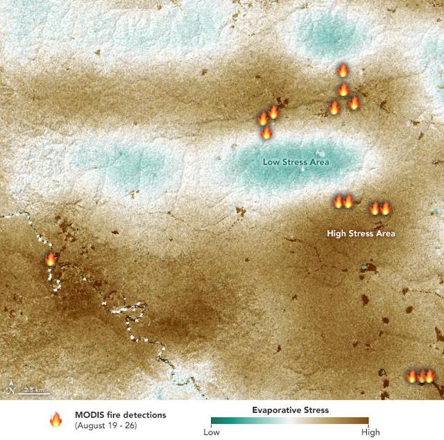
NASA's ECOsystem Spaceborne Thermal Radiometer Experiment on Space Station (ECOSTRESS) sensor measured the water-stress levels of plants when it passed over the Peruvian Amazon rainforest on Aug. 7, 2019, before the fires there began. The map shows areas of plants in distress (brown) and areas of less stress (blue). Water-stressed plants released measurably less water vapor into the air at the time of the summer fires. The fire icons represent fires imaged by NASA's Terra satellite between Aug. 19 and 26. The burn pattern reveals that the fires were concentrated in areas of highly water-stressed plants, pointing to how water-stressed plants can impact the spread of fires. The data may one day help NASA's Earth-observing missions predict the path of future forest or brush fires. https://photojournal.jpl.nasa.gov/catalog/PIA23432

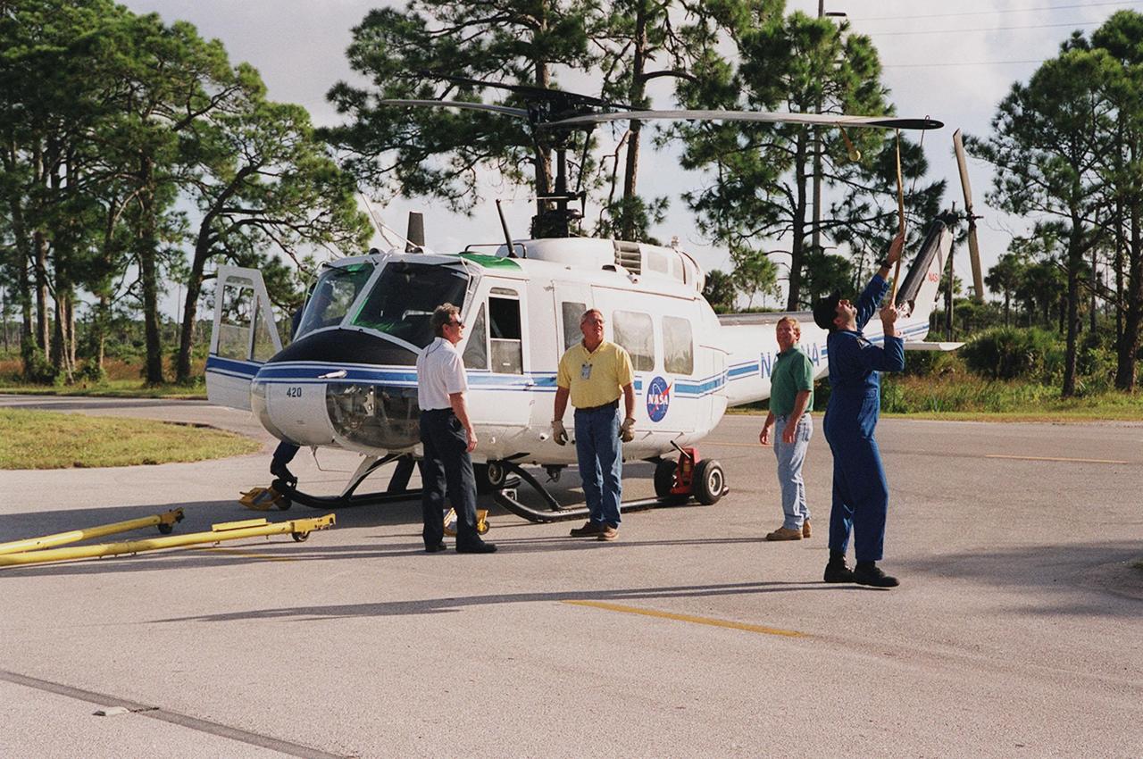
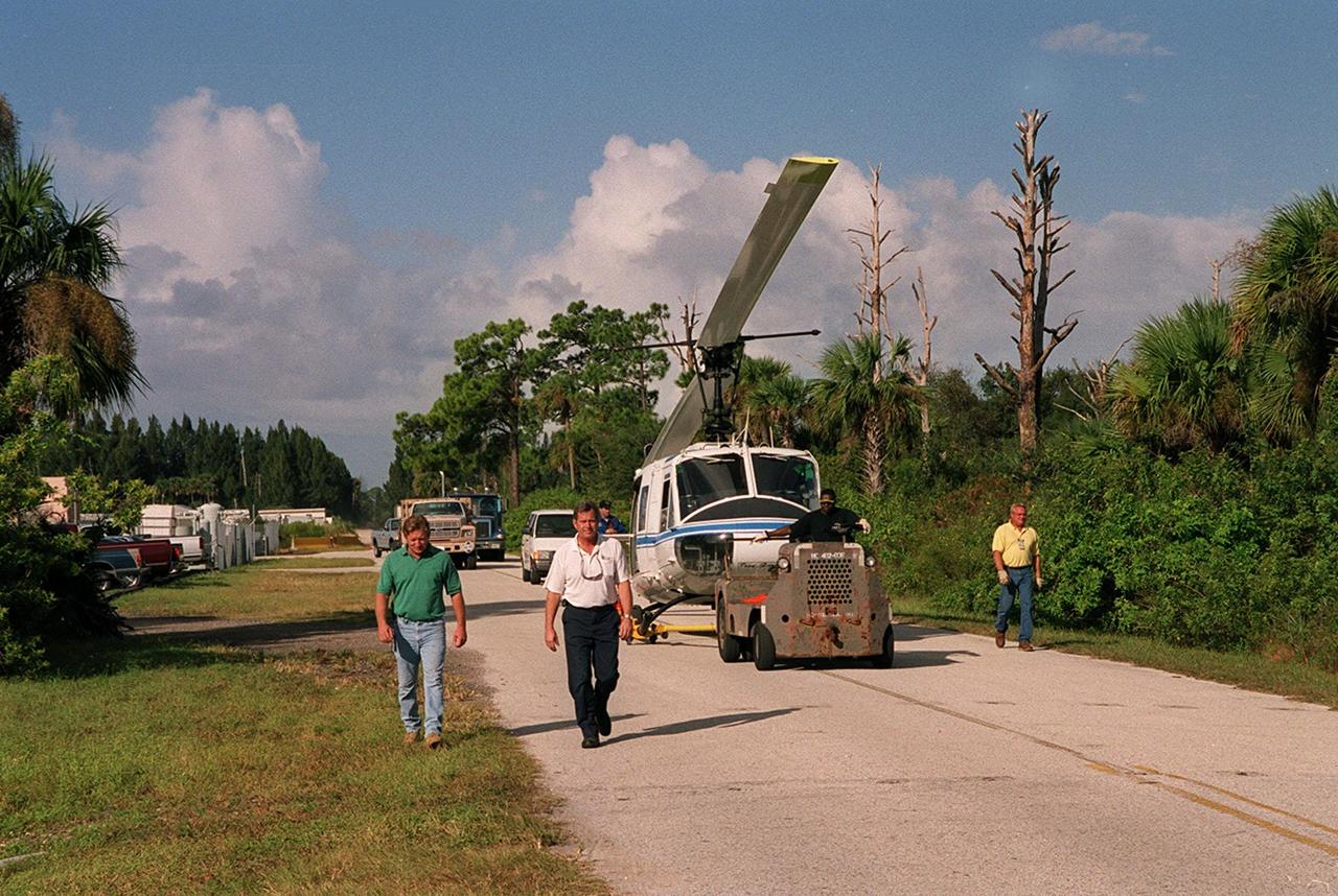
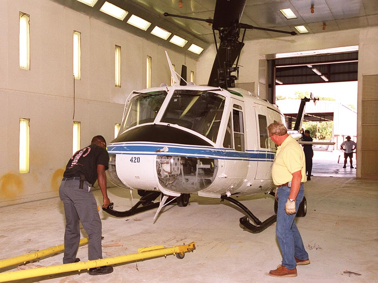
KENNEDY SPACE CENTER, FLA. -- A newly repainted NASA helicopter is transported to S.R. 3 for return to Patrick AFB. Workers painted the blades of four NASA UH-1H helicopters, changing the black to a pattern of white and yellow stripes. The pattern provides better visibility in smoke and fire conditions. When the rotors are turning, the stripes create a yellow and white circle that is more easily seen by a second helicopter from above. The helicopters, primarily used for security and medical evacuation for NASA, will be used to deliver water via buckets during brush fires. The change was made to comply with U.S. Fish and Wildlife and Department of Forestry regulations for helicopter-assisted fire control
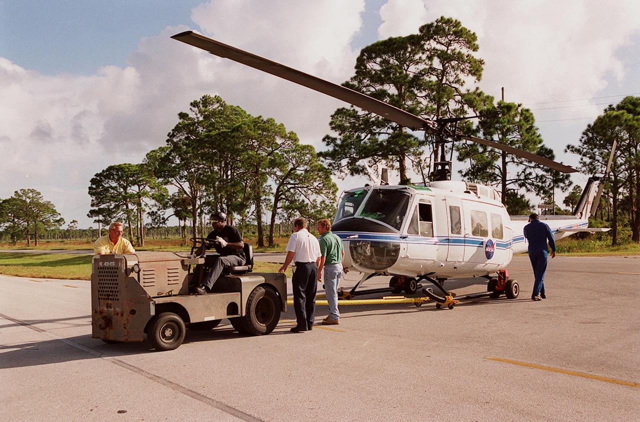
KENNEDY SPACE CENTER, FLA. -- A NASA helicopter is secured for transfer to Ransom Road at KSC. It is one of four UH-1H helicopters that will have its blades painted, changing the black to a pattern of white and yellow stripes. The pattern provides better visibility in smoke and fire conditions. When the rotors are turning, the stripes create a yellow and white circle that is more easily seen by a second helicopter from above. The helicopters, primarily used for security and medical evacuation for NASA, will be used to deliver water via buckets during brush fires. The change was made to comply with U.S. Fish and Wildlife and Department of Forestry regulations for helicopter-assisted fire control

KENNEDY SPACE CENTER, FLA. -- Workers put the finishing touches on new paint for the blades of a NASA UH-1H helicopter. They have changed the black to a pattern of white and yellow stripes. The pattern provides better visibility in smoke and fire conditions. When the rotors are turning, the stripes create a yellow and white circle that is more easily seen from above by a second helicopter. The helicopters, primarily used for security and medical evacuation for NASA, will be used to deliver water via buckets during brush fires. The change was made to comply with U.S. Fish and Wildlife and Department of Forestry regulations for helicopter-assisted fire control
KENNEDY SPACE CENTER, FLA. -- The pilot of the NASA helicopter secures the rotary blade before the helicopter’s transfer to Ransom Road at KSC. It is one of four UH-1H helicopters that will have its blades painted, changing the black to a pattern of white and yellow stripes. The pattern provides better visibility in smoke and fire conditions. When the rotors are turning, the stripes create a yellow and white circle that is more easily seen by a second helicopter from above. The helicopters, primarily used for security and medical evacuation for NASA, will be used to deliver water via buckets during brush fires. The change was made to comply with U.S. Fish and Wildlife and Department of Forestry regulations for helicopter-assisted fire control
KENNEDY SPACE CENTER, FLA. -- A newly repainted NASA helicopter is transported to S.R. 3 for return to Patrick AFB. Workers painted the blades of four NASA UH-1H helicopters, changing the black to a pattern of white and yellow stripes. The pattern provides better visibility in smoke and fire conditions. When the rotors are turning, the stripes create a yellow and white circle that is more easily seen by a second helicopter from above. The helicopters, primarily used for security and medical evacuation for NASA, will be used to deliver water via buckets during brush fires. The change was made to comply with U.S. Fish and Wildlife and Department of Forestry regulations for helicopter-assisted fire control

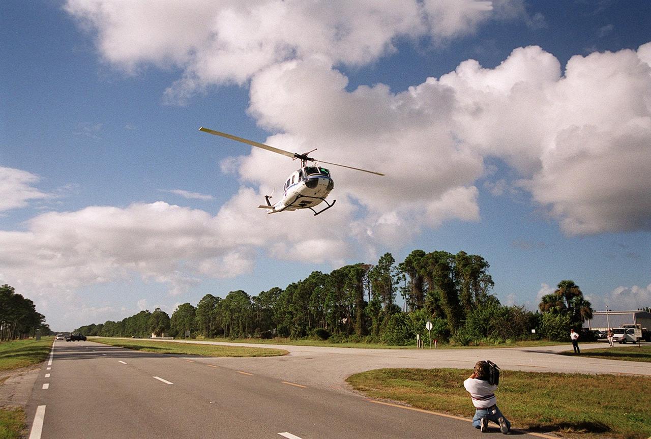
KENNEDY SPACE CENTER, FLA. -- A NASA helicopter from Patrick Air Force Base is about to land on S.R. 3. It is one of four UH-1H helicopters that will have its blades painted, changing the black to a pattern of white and yellow stripes. The pattern provides better visibility in smoke and fire conditions. When the rotors are turning, the stripes create a yellow and white circle that is more easily seen by a second helicopter from above. The helicopters, primarily used for security and medical evacuation for NASA, will be used to deliver water via buckets during brush fires. The change was made to comply with U.S. Fish and Wildlife and Department of Forestry regulations for helicopter-assisted fire control

KENNEDY SPACE CENTER, FLA. -- A NASA helicopter lands on S.R. 3 for transfer to Patrick Air Force Base. It is one of four UH-1H helicopters that will have its blades painted, changing the black to a pattern of white and yellow stripes. The pattern provides better visibility in smoke and fire conditions. When the rotors are turning, the stripes create a yellow and white circle that is more easily seen by a second helicopter from above. The helicopters, primarily used for security and medical evacuation for NASA, will be used to deliver water via buckets during brush fires. The change was made to comply with U.S. Fish and Wildlife and Department of Forestry regulations for helicopter-assisted fire control

KENNEDY SPACE CENTER, FLA. -- Workers get ready to move a NASA UH-1H helicopter outside. They have been painting the blades of four NASA UH-1H helicopters, changing the black to a pattern of white and yellow stripes. The pattern provides better visibility in smoke and fire conditions. When the rotors are turning, the stripes create a yellow and white circle that is more easily seen by a second helicopter from above. The helicopters, primarily used for security and medical evacuation for NASA, will be used to deliver water via buckets during brush fires. The change was made to comply with U.S. Fish and Wildlife and Department of Forestry regulations for helicopter-assisted fire contro
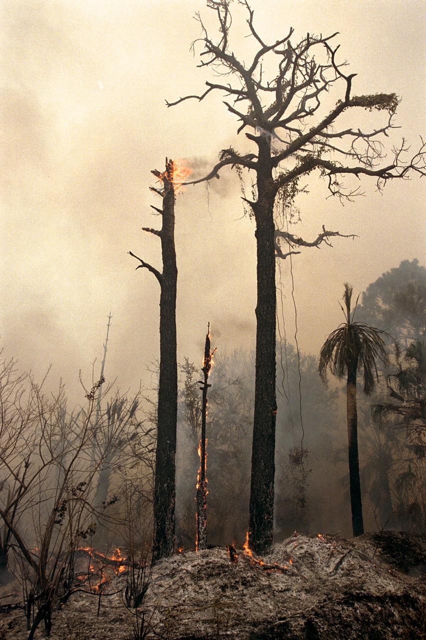
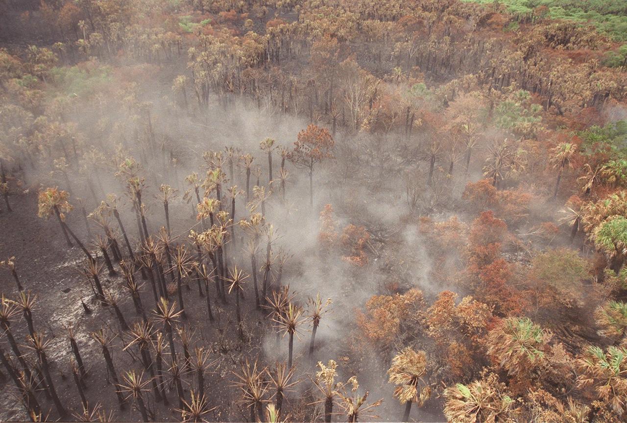
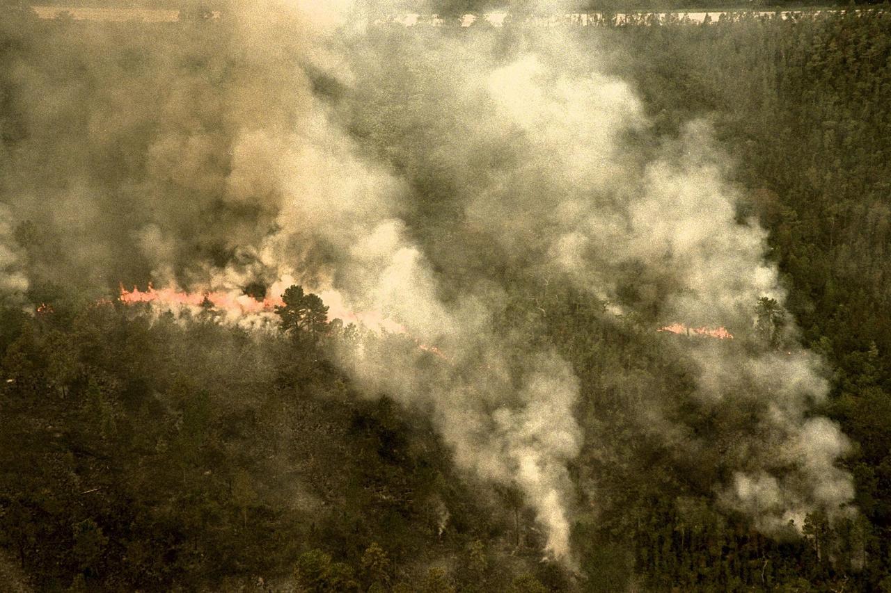
KENNEDY SPACE CENTER, FLA. -- Charred trees and brush in a wooded section of Kennedy Space Center still burn Monday, June 22, after lightning touched off three different fires Sunday evening in and around Kennedy Space Center at Tel IV, Ransom Road and Pine Island Road. This area is part of the Merritt Island National Wildlife Refuge operated by the U.S. Fish and Wildlife Service. The fires were a short distance from operational facilities at the space center and forced the closing of Florida State Route 3. The fires are being contained by firefighters from Kennedy Space Center and the U.S. Fish and Wildlife Service

KENNEDY SPACE CENTER, FLA. -- Workers paint the blades of a NASA UH-1H helicopter, changing the black to a pattern of white and yellow stripes. The pattern provides better visibility in smoke and fire conditions. When the rotors are turning, the stripes create a yellow and white circle that is more easily seen by a second helicopter from above. The helicopters, primarily used for security and medical evacuation for NASA, will be used to deliver water via buckets during brush fires. The change was made to comply with U.S. Fish and Wildlife and Department of Forestry regulations for helicopter-assisted fire control

KENNEDY SPACE CENTER, FLA. -- A NASA helicopter is secured for transfer to Ransom Road at KSC. It is one of four UH-1H helicopters that will have its blades painted, changing the black to a pattern of white and yellow stripes. The pattern provides better visibility in smoke and fire conditions. When the rotors are turning, the stripes create a yellow and white circle that is more easily seen by a second helicopter from above. The helicopters, primarily used for security and medical evacuation for NASA, will be used to deliver water via buckets during brush fires. The change was made to comply with U.S. Fish and Wildlife and Department of Forestry regulations for helicopter-assisted fire control
KENNEDY SPACE CENTER, FLA. -- Workers paint the blades of a NASA UH-1H helicopter, changing the black to a pattern of white and yellow stripes. The pattern provides better visibility in smoke and fire conditions. When the rotors are turning, the stripes create a yellow and white circle that is more easily seen by a second helicopter from above. The helicopters, primarily used for security and medical evacuation for NASA, will be used to deliver water via buckets during brush fires. The change was made to comply with U.S. Fish and Wildlife and Department of Forestry regulations for helicopter-assisted fire control
KENNEDY SPACE CENTER, FLA. -- Workers get ready to move a NASA UH-1H helicopter outside. They have been painting the blades of four NASA UH-1H helicopters, changing the black to a pattern of white and yellow stripes. The pattern provides better visibility in smoke and fire conditions. When the rotors are turning, the stripes create a yellow and white circle that is more easily seen by a second helicopter from above. The helicopters, primarily used for security and medical evacuation for NASA, will be used to deliver water via buckets during brush fires. The change was made to comply with U.S. Fish and Wildlife and Department of Forestry regulations for helicopter-assisted fire contro
KENNEDY SPACE CENTER, FLA. -- At S.R. 3 a NASA helicopter returns to Patrick Air Force Base. The helicopter is one of four UH-1H helicopters that have had its blades painted, changing the previous black color to a pattern of white and yellow stripes. The pattern provides better visibility in smoke and fire conditions. When the rotors are turning, the stripes create a yellow and white circle that is more easily seen by a second helicopter from above. The helicopters, primarily used for security and medical evacuation for NASA, will be used to deliver water via buckets during brush fires. The change was made to comply with U.S. Fish and Wildlife and Department of Forestry regulations for helicopter-assisted fire control
KENNEDY SPACE CENTER, FLA. -- A NASA helicopter from Patrick Air Force Base is about to land on S.R. 3. It is one of four UH-1H helicopters that will have its blades painted, changing the black to a pattern of white and yellow stripes. The pattern provides better visibility in smoke and fire conditions. When the rotors are turning, the stripes create a yellow and white circle that is more easily seen by a second helicopter from above. The helicopters, primarily used for security and medical evacuation for NASA, will be used to deliver water via buckets during brush fires. The change was made to comply with U.S. Fish and Wildlife and Department of Forestry regulations for helicopter-assisted fire control
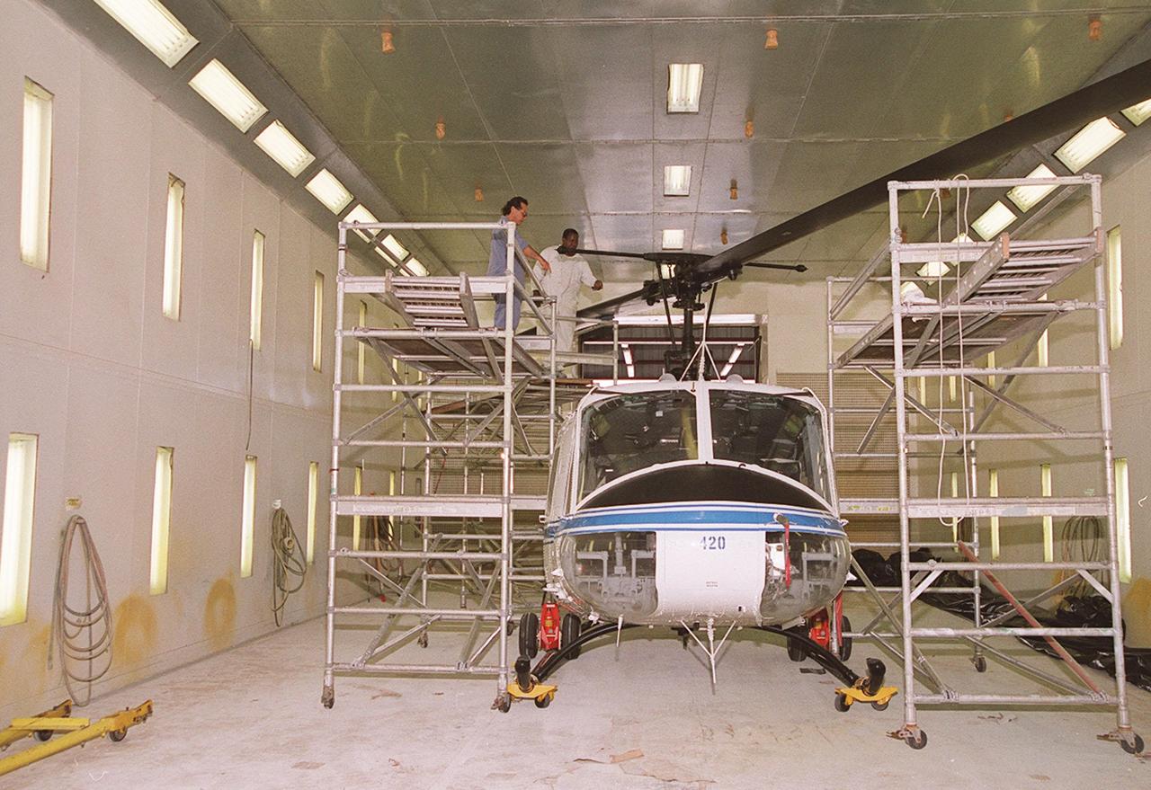
KENNEDY SPACE CENTER, FLA. -- Workers put the finishing touches on new paint for the blades of a NASA UH-1H helicopter. They have changed the black to a pattern of white and yellow stripes. The pattern provides better visibility in smoke and fire conditions. When the rotors are turning, the stripes create a yellow and white circle that is more easily seen from above by a second helicopter. The helicopters, primarily used for security and medical evacuation for NASA, will be used to deliver water via buckets during brush fires. The change was made to comply with U.S. Fish and Wildlife and Department of Forestry regulations for helicopter-assisted fire control
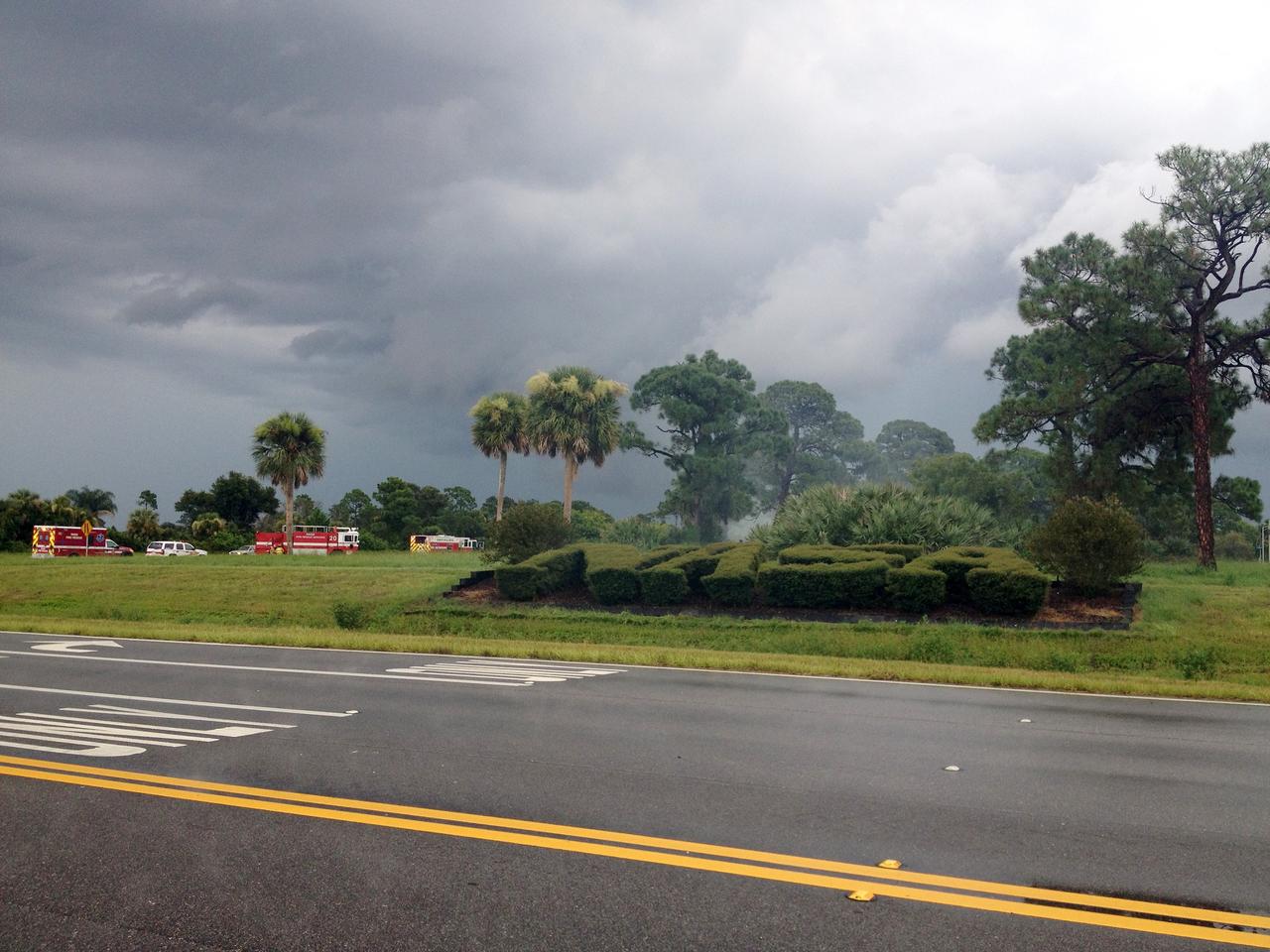
CAPE CANAVERAL, Fla. – Emergency responders are called to the scene of a brush fire near Headquarters Building in the Industrial Area of NASA’s Kennedy Space Center in Florida. The fire was ignited by a lightning strike. The space center is nestled on the Merritt Island National Wildlife Refuge, which is managed by the U.S. Fish and Wildlife Service. Chenega Security & Support Solutions is responsible for Kennedy's Fire Rescue Department. For information on the refuge, visit http://www.fws.gov/merrittisland/Index.html. For more on Kennedy Space Center, visit http://www.nasa.gov/kennedy. Photo credit: NASA/Ben Smegelsky

KENNEDY SPACE CENTER, FLA. -- At S.R. 3 a NASA helicopter returns to Patrick Air Force Base. The helicopter is one of four UH-1H helicopters that have had its blades painted, changing the previous black color to a pattern of white and yellow stripes. The pattern provides better visibility in smoke and fire conditions. When the rotors are turning, the stripes create a yellow and white circle that is more easily seen by a second helicopter from above. The helicopters, primarily used for security and medical evacuation for NASA, will be used to deliver water via buckets during brush fires. The change was made to comply with U.S. Fish and Wildlife and Department of Forestry regulations for helicopter-assisted fire control
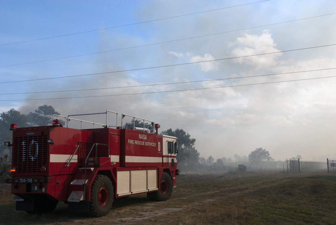
CAPE CANAVERAL, Fla. -- NASA Fire Rescue Services are on the scene to support a controlled burn in the vicinity of the Industrial Area at NASA's Kennedy Space Center in Florida. The burn, managed by the U.S. Fish and Wildlife Service, targeted 2,174 acres near Kennedy's administrative complex. Shifting winds caused the fire to flare up in places to dramatic effect. Limited visibility caused by the smoke required NASA Security to close some roadways. The burn, which began during the 8 o'clock hour this morning, is expected to be extinguished this evening. Controlled burns are commonplace on the center to reduce the likelihood of an unplanned brush fire during Central Florida's dry season. Photo Credit: NASA/Jim Grossmann
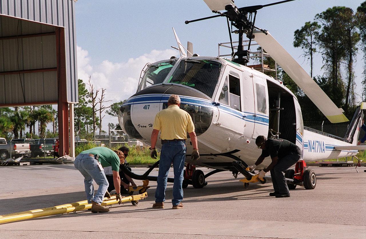
KENNEDY SPACE CENTER, FLA. -- A NASA UH-1H helicopter is prepared for transfer back to Patrick Air Force Base after being painted. The blades of four NASA UH-1H helicopters were repainted, changing the black to a pattern of white and yellow stripes. The pattern provides better visibility in smoke and fire conditions. When the rotors are turning, the stripes create a yellow and white circle that is more easily seen by a second helicopter from above. The helicopters, primarily used for security and medical evacuation for NASA, will be used to deliver water via buckets during brush fires. The change was made to comply with U.S. Fish and Wildlife and Department of Forestry regulations for helicopter-assisted fire control

KENNEDY SPACE CENTER, FLA. -- The pilot of the NASA helicopter secures the rotary blade before the helicopter’s transfer to Ransom Road at KSC. It is one of four UH-1H helicopters that will have its blades painted, changing the black to a pattern of white and yellow stripes. The pattern provides better visibility in smoke and fire conditions. When the rotors are turning, the stripes create a yellow and white circle that is more easily seen by a second helicopter from above. The helicopters, primarily used for security and medical evacuation for NASA, will be used to deliver water via buckets during brush fires. The change was made to comply with U.S. Fish and Wildlife and Department of Forestry regulations for helicopter-assisted fire control

KENNEDY SPACE CENTER, FLA. -- A NASA UH-1H helicopter is prepared for transfer back to Patrick Air Force Base after being painted. The blades of four NASA UH-1H helicopters were repainted, changing the black to a pattern of white and yellow stripes. The pattern provides better visibility in smoke and fire conditions. When the rotors are turning, the stripes create a yellow and white circle that is more easily seen by a second helicopter from above. The helicopters, primarily used for security and medical evacuation for NASA, will be used to deliver water via buckets during brush fires. The change was made to comply with U.S. Fish and Wildlife and Department of Forestry regulations for helicopter-assisted fire control

KENNEDY SPACE CENTER, FLA. -- Workers paint the blades of a NASA UH-1H helicopter, changing the black to a pattern of white and yellow stripes. The pattern provides better visibility in smoke and fire conditions. When the rotors are turning, the stripes create a yellow and white circle that is more easily seen by a second helicopter from above. The helicopters, primarily used for security and medical evacuation for NASA, will be used to deliver water via buckets during brush fires. The change was made to comply with U.S. Fish and Wildlife and Department of Forestry regulations for helicopter-assisted fire control
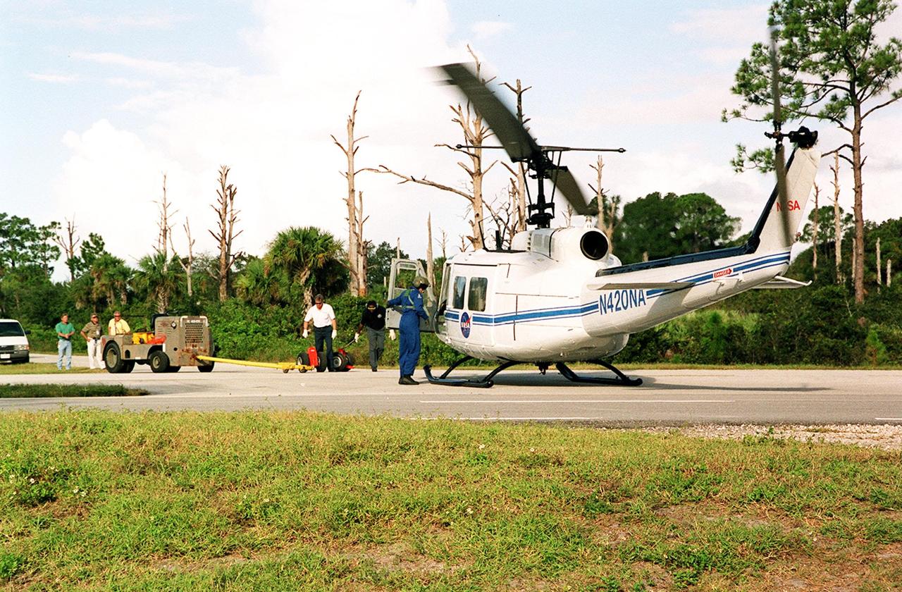
KENNEDY SPACE CENTER, FLA. -- A NASA helicopter lands on S.R. 3 for transfer to Patrick Air Force Base. It is one of four UH-1H helicopters that will have its blades painted, changing the black to a pattern of white and yellow stripes. The pattern provides better visibility in smoke and fire conditions. When the rotors are turning, the stripes create a yellow and white circle that is more easily seen by a second helicopter from above. The helicopters, primarily used for security and medical evacuation for NASA, will be used to deliver water via buckets during brush fires. The change was made to comply with U.S. Fish and Wildlife and Department of Forestry regulations for helicopter-assisted fire control
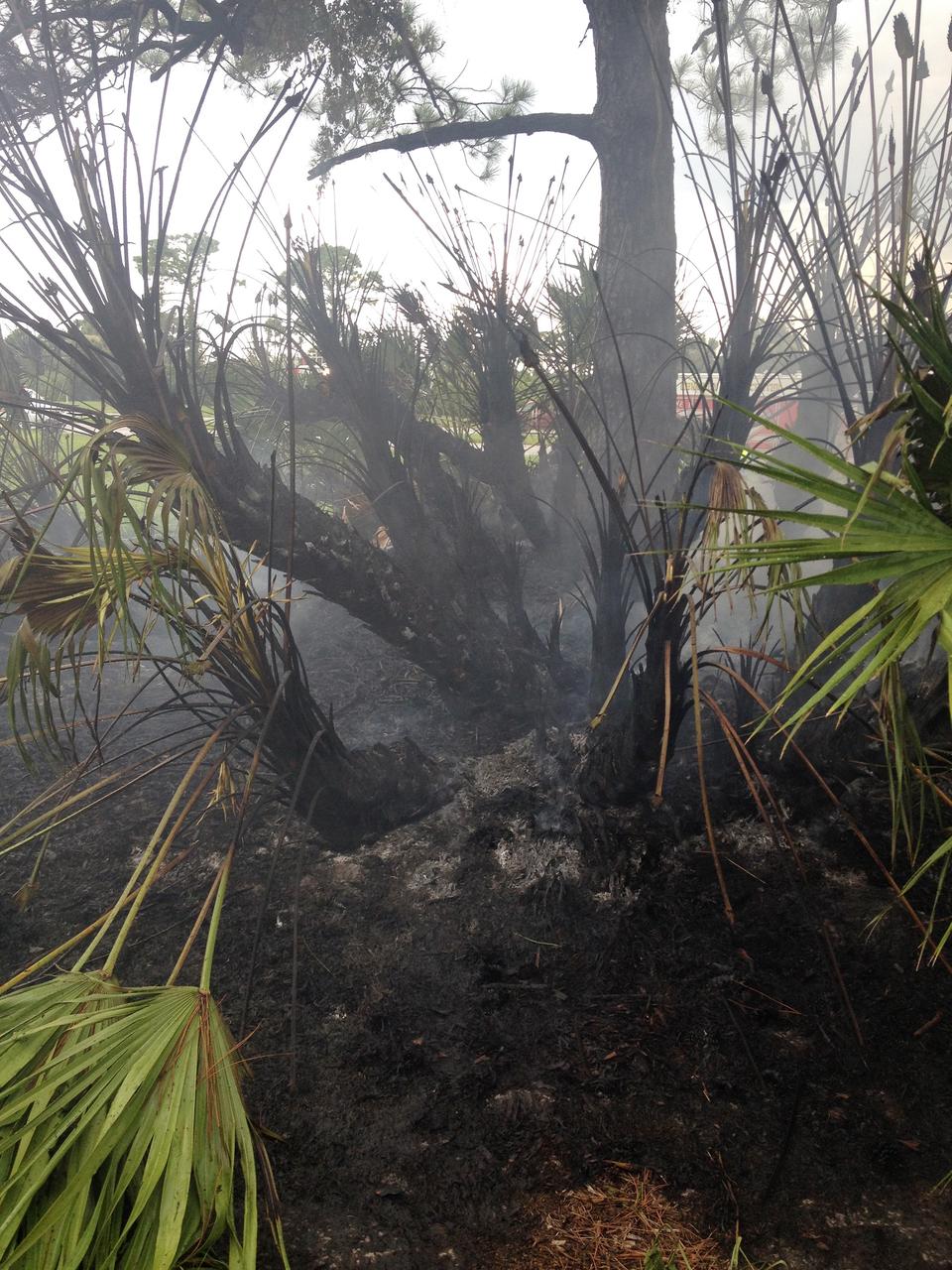
CAPE CANAVERAL, Fla. – A charred palmetto palm remains after a brush fire is extinguished near Headquarters Building in the Industrial Area of NASA’s Kennedy Space Center in Florida. The fire was ignited by a lightning strike. The space center is nestled on the Merritt Island National Wildlife Refuge, which is managed by the U.S. Fish and Wildlife Service. Chenega Security & Support Solutions is responsible for Kennedy's Fire Rescue Department. For information on the refuge, visit http://www.fws.gov/merrittisland/Index.html. For more on Kennedy Space Center, visit http://www.nasa.gov/kennedy. Photo credit: NASA/Ben Smegelsky
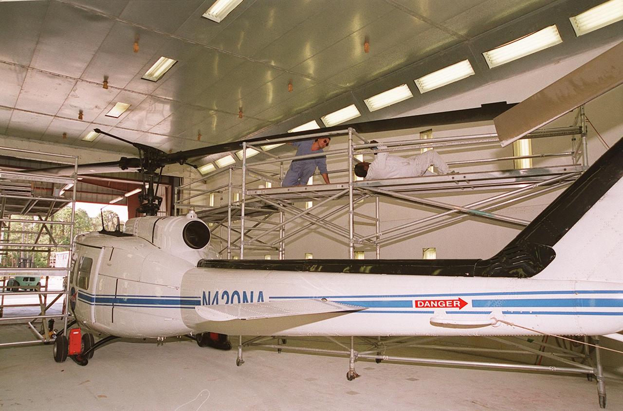
KENNEDY SPACE CENTER, FLA. -- Workers paint the blades of a NASA UH-1H helicopter, changing the black to a pattern of white and yellow stripes. The pattern provides better visibility in smoke and fire conditions. When the rotors are turning, the stripes create a yellow and white circle that is more easily seen by a second helicopter from above. The helicopters, primarily used for security and medical evacuation for NASA, will be used to deliver water via buckets during brush fires. The change was made to comply with U.S. Fish and Wildlife and Department of Forestry regulations for helicopter-assisted fire control
CAPE CANAVERAL, Fla. -- A firefighter manages the progress of a controlled burn in the vicinity of the Industrial Area at NASA's Kennedy Space Center in Florida. The burn, managed by the U.S. Fish and Wildlife Service, targeted 2,174 acres near Kennedy's administrative complex. Shifting winds caused the fire to flare up in places to dramatic effect. Limited visibility caused by the smoke required NASA Security to close some roadways. The burn, which began during the 8 o'clock hour this morning, is expected to be extinguished this evening. Controlled burns are commonplace on the center to reduce the likelihood of an unplanned brush fire during Central Florida's dry season. Photo Credit: NASA/Dimitri Gerondidakis
CAPE CANAVERAL, Fla. -- A firefighter mans his post at the edge of a controlled burn in the vicinity of the Industrial Area at NASA's Kennedy Space Center in Florida. The burn, managed by the U.S. Fish and Wildlife Service, targeted 2,174 acres near Kennedy's administrative complex. Shifting winds caused the fire to flare up in places to dramatic effect. Limited visibility caused by the smoke required NASA Security to close some roadways. The burn, which began during the 8 o'clock hour this morning, is expected to be extinguished this evening. Controlled burns are commonplace on the center to reduce the likelihood of an unplanned brush fire during Central Florida's dry season. Photo Credit: NASA/Dimitri Gerondidakis
CAPE CANAVERAL, Fla. -- A controlled burn in the vicinity of the Industrial Area at NASA's Kennedy Space Center in Florida sends billow of smoke over nearby roadways. The burn, managed by the U.S. Fish and Wildlife Service, targeted 2,174 acres near Kennedy's administrative complex. Shifting winds caused the fire to flare up in places to dramatic effect. Limited visibility caused by the smoke required NASA Security to close some roadways. The burn, which began during the 8 o'clock hour this morning, is expected to be extinguished this evening. Controlled burns are commonplace on the center to reduce the likelihood of an unplanned brush fire during Central Florida's dry season. Photo Credit: NASA/Dimitri Gerondidakis
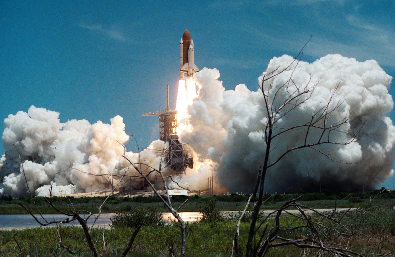
Columbia, Orbiter Vehicle (OV) 102, begins its roll maneuver after clearing the fixed service structure (FSS) tower as it rises above Kennedy Space Center (KSC) Launch Complex (LC) Pad 39A. In the foreground of this horizontal scene is Florida brush and a waterway. Beyond the brush, the shuttle's exhaust cloud envelops the immediate launch pad area. Launch occurred at 12:43 pm Eastern Daylight Time (EDT). The glow of the space shuttle main engine (SSME) and solid rocket booster (SRB) firings is reflected in the nearby waterway. Once in Earth orbit, STS-65's six NASA astronauts and a Japanese Payload Specialist aboard OV-102 will begin two weeks of experimentation in support of the second International Microgravity Laboratory (IML-2).
The 416 Fire started June 1, 2018, about 13 miles (18 kilometers) north of Durango, Colorado. Four weeks later, the fire was mostly contained, after consuming 35,000 acres of timber and brush. The cause of the fire is presently unknown. This image, acquired June 26, 2018 by the Advanced Spaceborne Thermal Emission and Reflection (ASTER) radiometer instrument aboard NASA's Terra satellite, shows vegetation in red, clouds in white, cities and bare rocky areas in gray, and the burned area in dark gray. A few small hot spots, detected on ASTER's thermal channels, are overlain in yellow. Smoke can be seen drifting eastward from these hotspots. The data cover an area of 15.2 by 12.9 miles (25.3 by 21.5 kilometers) located at 7.5 degrees north, 107.9 degrees east. https://photojournal.jpl.nasa.gov/catalog/PIA22554

KENNEDY SPACE CENTER, FLA. -- At S.R. 3 a pilot prepares a NASA helicopter for a return flight to Patrick Air Force Base. The helicopter is one of four UH-1H helicopters that have had its blades painted, changing the previous black color to a pattern of white and yellow stripes. The pattern provides better visibility in smoke and fire conditions. When the rotors are turning, the stripes create a yellow and white circle that is more easily seen by a second helicopter from above. The helicopters, primarily used for security and medical evacuation for NASA, will be used to deliver water via buckets during brush fires. The change was made to comply with U.S. Fish and Wildlife and Department of Forestry regulations for helicopter-assisted fire control
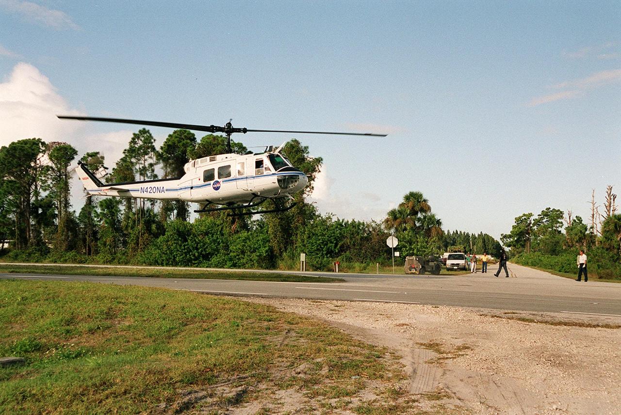
KENNEDY SPACE CENTER, FLA. -- At S.R. 3 a NASA helicopter lifts off to return to Patrick Air Force Base. The helicopter is one of four UH-1H helicopters that have had its blades painted, changing the previous black color to a pattern of white and yellow stripes. The pattern provides better visibility in smoke and fire conditions. When the rotors are turning, the stripes create a yellow and white circle that is more easily seen by a second helicopter from above. The helicopters, primarily used for security and medical evacuation for NASA, will be used to deliver water via buckets during brush fires. The change was made to comply with U.S. Fish and Wildlife and Department of Forestry regulations for helicopter-assisted fire control
ISS012-E-13692 (2 Jan. 2006) --- A Forest Fire in Ouachita National Wildlife Refuge, Louisiana is featured in this image photographed by an Expedition 12 crew member on the International Space Station. Dry conditions and high winds have led to numerous recent fire outbreaks throughout much of the southwestern and south-central USA. This image captures the smoke plume from a fire in the Upper Ouachita National Wildlife Refuge in northeastern Louisiana. Drought conditions have persisted for much of the past year, leading to an increased fuel load comprised of dried grasses, shrubs, and trees. The combination of high amounts of dry fuel and frequent high winds has stoked small point fires into widespread brush fires. The fires generating this minimum 25-kilometer smoke plume started at approximately 13:00 hours local time. This image was acquired approximately 3.5 hours later as the station passed over the Texas/Louisiana border to the southwest. The extent of the plume reflects the strong westerly winds that drove the fire eastwards and damaged an estimated 200-300 acres of the wildlife refuge. The striking illumination of the plume is caused by a very low sun angle (angle between the horizon and the Sun directly below the space station), but this also results in generally low illumination of other scene features such as agricultural fields.
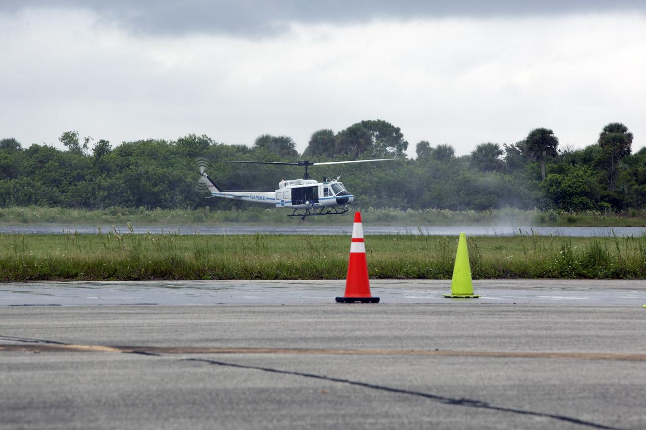
CAPE CANAVERAL, Fla. -- At NASA's Kennedy Space Center in Florida, the crew of the NASA helicopter carefully lowers a Bambi Bucket into a canal near the Shuttle Landing Facility. Minutes later, the water was dropped on the target cones in the foreground, using techniques that would be employed to fight a brush fire at the Kennedy Space Center. Firefighters respond to wildfires with teams on the ground and in the air. The most up-to-date tools include helicopters that use Bambi Buckets large quantities of water. NASA Flight Operations teams are training to perfect the skills needed to ensure they are ready to use tools, such as the Bambi Bucket, in the event of an out-of-control blaze at the spaceport. Photo credit: NASA/Frankie Martin
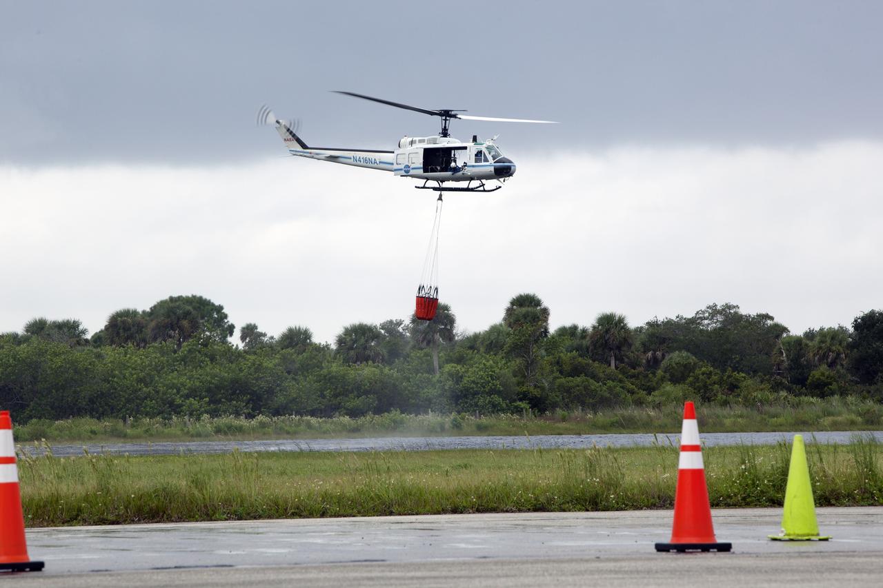
CAPE CANAVERAL, Fla. -- At NASA's Kennedy Space Center in Florida, the crew of the NASA helicopter carefully lifts a Bambi Bucket from a canal near the Shuttle Landing Facility. Minutes later, the water was dropped on the target cones in the foreground, using techniques that would be employed to fight a brush fire at the Kennedy Space Center. Firefighters respond to wildfires with teams on the ground and in the air. The most up-to-date tools include helicopters that use Bambi Buckets large quantities of water. NASA Flight Operations teams are training to perfect the skills needed to ensure they are ready to use tools, such as the Bambi Bucket, in the event of an out-of-control blaze at the spaceport. Photo credit: NASA/Frankie Martin
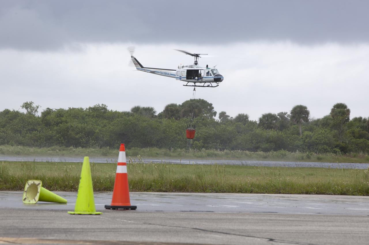
CAPE CANAVERAL, Fla. -- At NASA's Kennedy Space Center in Florida, the crew of the NASA helicopter carefully lifts a Bambi Bucket from a canal near the Shuttle Landing Facility. Minutes later, the water was dropped on the target cones in the foreground, using techniques that would be employed to fight a brush fire at the Kennedy Space Center. Firefighters respond to wildfires with teams on the ground and in the air. The most up-to-date tools include helicopters that use Bambi Buckets large quantities of water. NASA Flight Operations teams are training to perfect the skills needed to ensure they are ready to use tools, such as the Bambi Bucket, in the event of an out-of-control blaze at the spaceport. Photo credit: NASA/Frankie Martin
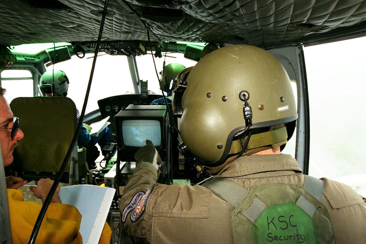
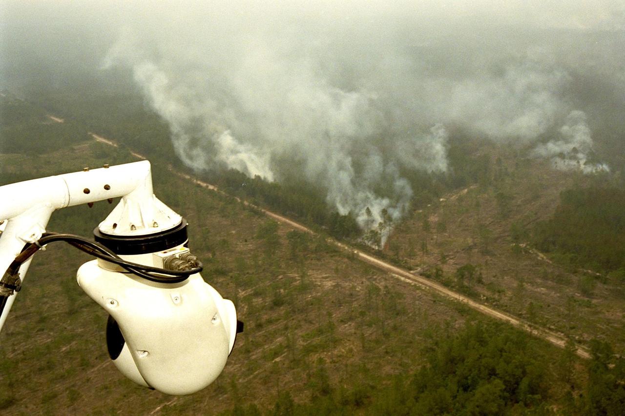
KENNEDY SPACE CENTER, FLA. -- Sgt. Mark Hines, of Kennedy Space Center (KSC) Security, points out a view of a fire on the Forward Looking Infrared Radar (FLIR) video screen to Greg Dunn, of Florida's Division of Forestry, as KSC pilots fly NASA's Huey UH-1 helicopter over fires burning in Volusia County, Florida. The FLIR includes a beach-ball sized infrared camera that is mounted on the helicopter's right siderail and a real-time TV monitor and recorder installed inside. The helicopter has also been outfitted with a portable global positioning satellite (GPS) system to support the Division of Forestry as they fight the brush fires which have been plaguing the state as a result of extremely dry conditions and lightning storms. While the FLIR collects temperature data and images, the GPS system provides the exact coordinates of the fires being observed and transmits the data to the firefighters on the ground. KSC's security team routinely uses the FLIR equipment prior to Shuttle launch and landing activities to ensure that the area surrounding the launch pad and runway are clear of unauthorized personnel. KSC's Base Operations Contractor, EG&G Florida, operates the NASA-owned helicopter.
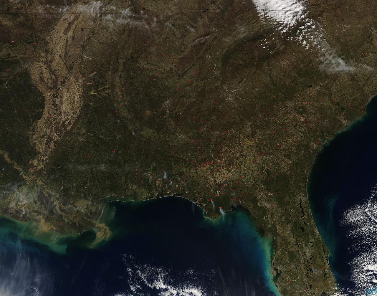
Fires both wild and prescribed dot the landscape of the southeastern portion of the United States. Wildfires are those that occur naturally with lightning strikes or are set by careless humans. Prescribed fires are those deliberately set by land management authorities to take out underlying brush and dead grass so that in the event of a wildfire there is not sufficient fuel for that fire to spread too far. The Southern Area Coordination Center for fire management has this information on its report for February 21, 2017. • Fires that have broken out recently (known as Initial Attack Activity): 198 fires for 2,292 acres • Ongoing Uncontained Large Fires: 3 fires for 5,947 acres • Other Fires reported through alternate channels: 56 fires for 1,400 acres • Prescribed Fire Activity: State and/or Federal Lands – 1,974 prescribed fires for 38,533 acres in AL, FL & GA The bulk of the fires seen in the image taken by the Aqua satellite using the onboard MODIS (Moderate Resolution Imaging Spectroradiometer) instrument on February 16, 2017 appear to be prescribed fires. Actively burning areas, detected by MODIS’s thermal bands, are outlined in red and when combined with smoke are indicative of fire. NASA image courtesy Jeff Schmaltz LANCE/EOSDIS MODIS Rapid Response Team, GSFC. Caption by Lynn Jenner with information from the Southern Area Coordination Center. <b><a href="http://www.nasa.gov/audience/formedia/features/MP_Photo_Guidelines.html" rel="nofollow">NASA image use policy.</a></b> <b><a href="http://www.nasa.gov/centers/goddard/home/index.html" rel="nofollow">NASA Goddard Space Flight Center</a></b> enables NASA’s mission through four scientific endeavors: Earth Science, Heliophysics, Solar System Exploration, and Astrophysics. Goddard plays a leading role in NASA’s accomplishments by contributing compelling scientific knowledge to advance the Agency’s mission. <b>Follow us on <a href="http://twitter.com/NASAGoddardPix" rel="nofollow">Twitter</a></b> <b>Like us on <a href="http://www.facebook.com/pages/Greenbelt-MD/NASA-Goddard/395013845897?ref=tsd" rel="nofollow">Facebook</a></b> <b>Find us on <a href="http://instagrid.me/nasagoddard/?vm=grid" rel="nofollow">Instagram</a></b>
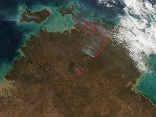
The Aqua satellite collected this natural-color image of fires in Australia with the Moderate Resolution Imaging Spectroradiometer (MODIS) instrument on June 30, 2017. The image looks at multiple fires and smoke from those fires burning in northern Australia and the island of Bathurst on June 30, 2017. The Northern Territory fire incident map does show some incidents of grass and shrub fires, in the past 24 hours, but it also shows areas of what are called "strategic fires" which are those set by fire experts to rid an area of overgrowth, brush, dead grass and shrubs to prevent fires from spreading in the event of a lightning strike. NASA image courtesy Jeff Schmaltz, MODIS Rapid Response Team <b><a href="http://www.nasa.gov/audience/formedia/features/MP_Photo_Guidelines.html" rel="nofollow">NASA image use policy.</a></b> <b><a href="http://www.nasa.gov/centers/goddard/home/index.html" rel="nofollow">NASA Goddard Space Flight Center</a></b> enables NASA’s mission through four scientific endeavors: Earth Science, Heliophysics, Solar System Exploration, and Astrophysics. Goddard plays a leading role in NASA’s accomplishments by contributing compelling scientific knowledge to advance the Agency’s mission. <b>Follow us on <a href="http://twitter.com/NASAGoddardPix" rel="nofollow">Twitter</a></b> <b>Like us on <a href="http://www.facebook.com/pages/Greenbelt-MD/NASA-Goddard/395013845897?ref=tsd" rel="nofollow">Facebook</a></b> <b>Find us on <a href="http://instagrid.me/nasagoddard/?vm=grid" rel="nofollow">Instagram</a></b>
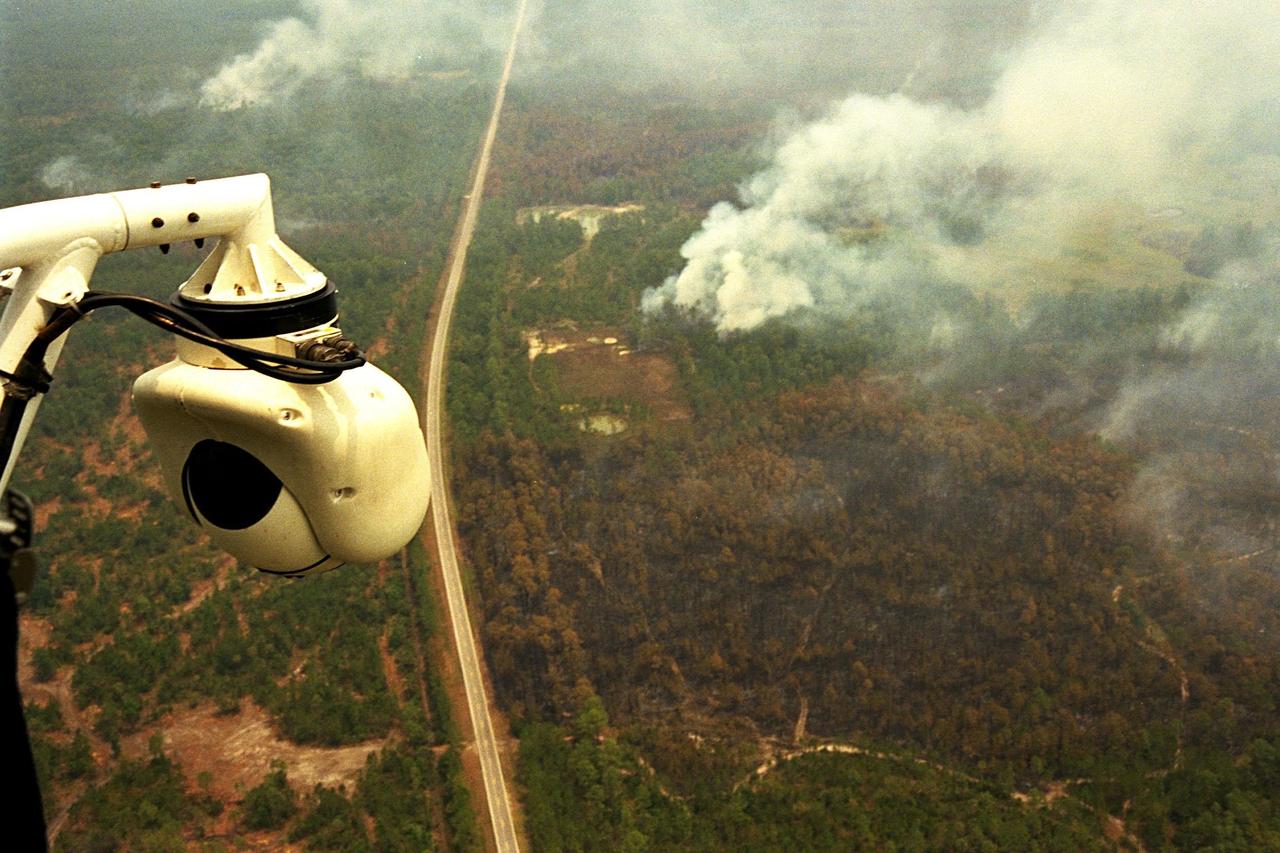
KENNEDY SPACE CENTER, FLA. -- A beach ball-sized infrared camera, part of the Forward Looking Infrared Radar (FLIR), has been mounted on the right siderail of NASA's Huey UH-1 helicopter and is being used to search for fires in Volusia County, Florida. The helicopter has also been outfitted with a portable global positioning satellite (GPS) system to support Florida's Division of Forestry as they fight the brush fires which have been plaguing the state as a result of extremely dry conditions and lightning storms. The FLIR also includes a real-time television monitor and recorder installed inside the helicopter. While the FLIR collects temperature data and images, the GPS system provides the exact coordinates of the fires being observed and transmits the data to the firefighters on the ground. The Kennedy Space Center (KSC) security team routinely uses the FLIR equipment prior to Shuttle launch and landing activities to ensure that the area surrounding the launch pad and runway are clear of unauthorized personnel. KSC's Base Operations Contractor, EG&G Florida, operates the NASA-owned helicopter
KENNEDY SPACE CENTER, FLA. -- A forest fire burning in Volusia County, Florida, is clearly visible from NASA's Huey UH-1 helicopter. The helicopter has been outfitted with a Forward Looking Infrared Radar (FLIR) and a portable global positioning satellite (GPS) system to support Florida's Division of Forestry as they fight the brush fires which have been plaguing the state as a result of extremely dry conditions and lightning storms. The FLIR includes a beach ball-sized infrared camera that is mounted on the helicopter's right siderail and a real-time television monitor and recorder installed inside. While the FLIR collects temperature data and images, the GPS system provides the exact coordinates of the fires being observed and transmits the data to the firefighters on the ground. The Kennedy Space Center (KSC) security team routinely uses the FLIR equipment prior to Shuttle launch and landing activities to ensure that the area surrounding the launch pad and runway are clear of unauthorized personnel. KSC's Base Operations Contractor, EG&G Florida, operates the NASA-owned helicopter
KENNEDY SPACE CENTER, FLA. -- A beach ball-sized infrared camera, part of the Forward Looking Infrared Radar (FLIR), has been mounted on the right siderail of NASA's Huey UH-1 helicopter and is being used to scan a large area of Volusia County, Florida, where a fire burns. The helicopter has also been outfitted with a portable global positioning satellite (GPS) system to support Florida's Division of Forestry as they fight the brush fires which have been plaguing the state as a result of extremely dry conditions and lightning storms. The FLIR also includes a real-time television monitor and recorder installed inside the helicopter. While the FLIR collects temperature data and images, the GPS system provides the exact coordinates of the fires being observed and transmits the data to the firefighters on the ground. The Kennedy Space Center (KSC) security team routinely uses the FLIR equipment prior to Shuttle launch and landing activities to ensure that the area surrounding the launch pad and runway are clear of unauthorized personnel. KSC's Base Operations Contractor, EG&G Florida, operates the NASA-owned helicopter
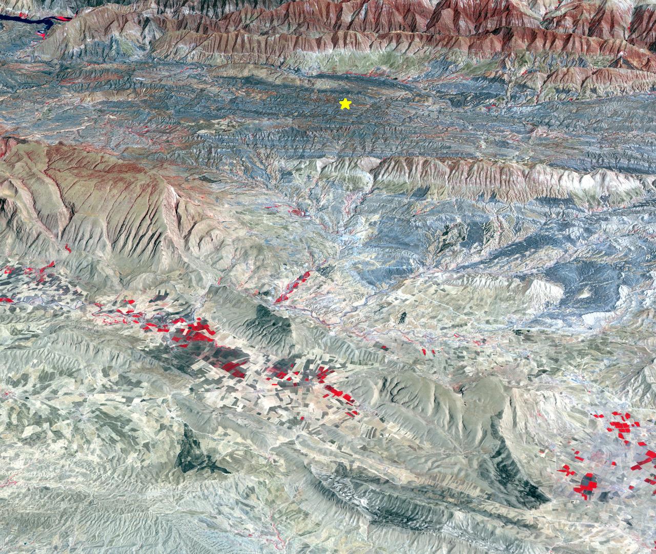
On Sunday, Nov. 12, 2017, a magnitude 7.3 earthquake struck along the Iran-Iraq border near Halabjah, Iraq. The earthquake was felt as far away as Kuwait, Qatar, Turkey, Lebanon and Israel. Extensive damage and numerous casualties were reported in the area near the epicenter (yellow star on image). The earthquake occurred along the boundary between the Arabian and Eurasian tectonic plates. This is an earthquake-prone area, and has experienced many deadly earthquakes in the past. In this perspective-view image, bright red areas are crops in fields, pale red on mountain ridges are shrubs and trees, dark gray areas are traces of earlier brush fires, and gray and tan colors are different rock types. The image was acquired Sept. 8, 2017, and the star marks the earthquake epicenter at 34.9 degrees north, 45.9 degrees east. https://photojournal.jpl.nasa.gov/catalog/PIA22112
The Meadow Fire in Yosemite National Park is a remote, hold-over lightning caused fire which began on September 4 and is located five miles east of Yosemite Valley, CA. The fuel burning is timber and brush. There is active fire behavior with long range spotting. The National Park Service reports that a fire, that may be a spot fire, from the Meadow lightning-caused fire, was discovered at approximately 12:30 PM, Sunday September 7. The fire is approximately 2,582 acres. It is burning within the Little Yosemite Valley on both sides of the Merced River. All trails in the area are closed. Approximately 100 hikers and backpackers were evacuated from the fire area in Little Yosemite Valley. Half-Dome, a popular tourist destination, has been closed. The fire is burning in Yosemite Wilderness. Eighty-five hikers and climbers were also evacuated from the summit of Half Dome by helicopters from the California Highway Patrol, US Department of Agriculture Forest Service, Sequoia Kings Canyon National Park, and CAL Fire. This natural-color satellite image was collected by the Moderate Resolution Imaging Spectroradiometer (MODIS) aboard the Aqua satellite on Sept. 07, 2014. Actively burning areas, detected by MODIS’s thermal bands, are outlined in red. NASA image courtesy Jeff Schmaltz, MODIS Rapid Response Team. Caption: NASA/Goddard, Lynn Jenner with information from the National Park Service and the National Interagency Coordination Center. <b><a href="http://www.nasa.gov/audience/formedia/features/MP_Photo_Guidelines.html" rel="nofollow">NASA image use policy.</a></b> <b><a href="http://www.nasa.gov/centers/goddard/home/index.html" rel="nofollow">NASA Goddard Space Flight Center</a></b> enables NASA’s mission through four scientific endeavors: Earth Science, Heliophysics, Solar System Exploration, and Astrophysics. Goddard plays a leading role in NASA’s accomplishments by contributing compelling scientific knowledge to advance the Agency’s mission. <b>Follow us on <a href="http://twitter.com/NASAGoddardPix" rel="nofollow">Twitter</a></b> <b>Like us on <a href="http://www.facebook.com/pages/Greenbelt-MD/NASA-Goddard/395013845897?ref=tsd" rel="nofollow">Facebook</a></b> <b>Find us on <a href="http://instagram.com/nasagoddard?vm=grid" rel="nofollow">Instagram</a></b>
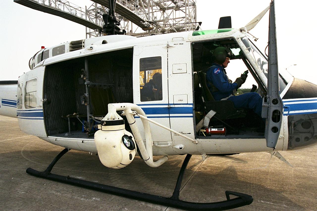
KENNEDY SPACE CENTER, FLA. -- A beach ball-sized infrared camera, part of the Forward Looking Infrared Radar (FLIR), has been mounted on the right siderail of NASA's Huey UH-1 helicopter. A KSC pilot prepares to fly the helicopter, which has also been outfitted with a portable global positioning satellite (GPS) system, to support Florida's Division of Forestry as they fight the brush fires which have been plaguing the state as a result of extremely dry conditions and lightning storms. The FLIR also includes a real-time television monitor and recorder installed inside the helicopter. While the FLIR collects temperature data and images, the GPS system provides the exact coordinates of the fires being observed and transmits the data to the firefighters on the ground. The Kennedy Space Center (KSC) security team routinely uses the FLIR equipment prior to Shuttle launch and landing activities to ensure that the area surrounding the launch pad and runway are clear of unauthorized personnel. KSC's Base Operations Contractor, EG&G Florida, operates the NASA-owned helicopter
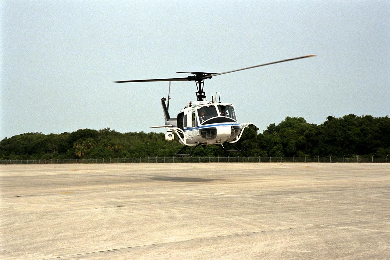
KENNEDY SPACE CENTER, FLA. -- NASA's Huey UH-1 helicopter lands at the Shuttle Landing Facility to pick up Kennedy Space Center (KSC) Security personnel who operate the Forward Looking Infrared Radar (FLIR) installed on board. The helicopter has also been outfitted with a portable global positioning satellite (GPS) system to support Florida's Division of Forestry as they fight the brush fires which have been plaguing the state as a result of extremely dry conditions and lightning storms. The FLIR includes a beach ball-sized infrared camera that is mounted on the helicopter's right siderail and a real-time television monitor and recorder installed inside. While the FLIR collects temperature data and images, the GPS system provides the exact coordinates of the fires being observed and transmits the data to the firefighters on the ground. KSC's security team routinely uses the FLIR equipment prior to Shuttle launch and landing activities to ensure that the area surrounding the launch pad and runway are clear of unauthorized personnel. KSC's Base Operations Contractor, EG&G Florida, operates the NASA-owned helicopter
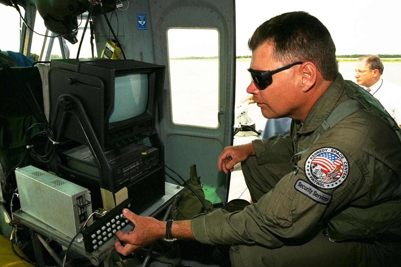
KENNEDY SPACE CENTER, FLA. -- Sgt. Mark Hines, of Kennedy Space Center (KSC) Security, checks out equipment used to operate the Forward Looking Infrared Radar (FLIR) installed on NASA's Huey UH-1 helicopter. The helicopter has also been outfitted with a portable global positioning satellite (GPS) system to support Florida's Division of Forestry as they fight the brush fires which have been plaguing the state as a result of extremely dry conditions and lightning storms. The FLIR includes a beach ball-sized infrared camera that is mounted on the helicopter's right siderail and a real-time television monitor and recorder installed inside. While the FLIR collects temperature data and images, the GPS system provides the exact coordinates of the fires being observed and transmits the data to the firefighters on the ground. KSC's security team routinely uses the FLIR equipment prior to Shuttle launch and landing activities to ensure that the area surrounding the launch pad and runway are clear of unauthorized personnel. KSC's Base Operations Contractor, EG&G Florida, operates the NASA-owned helicopter
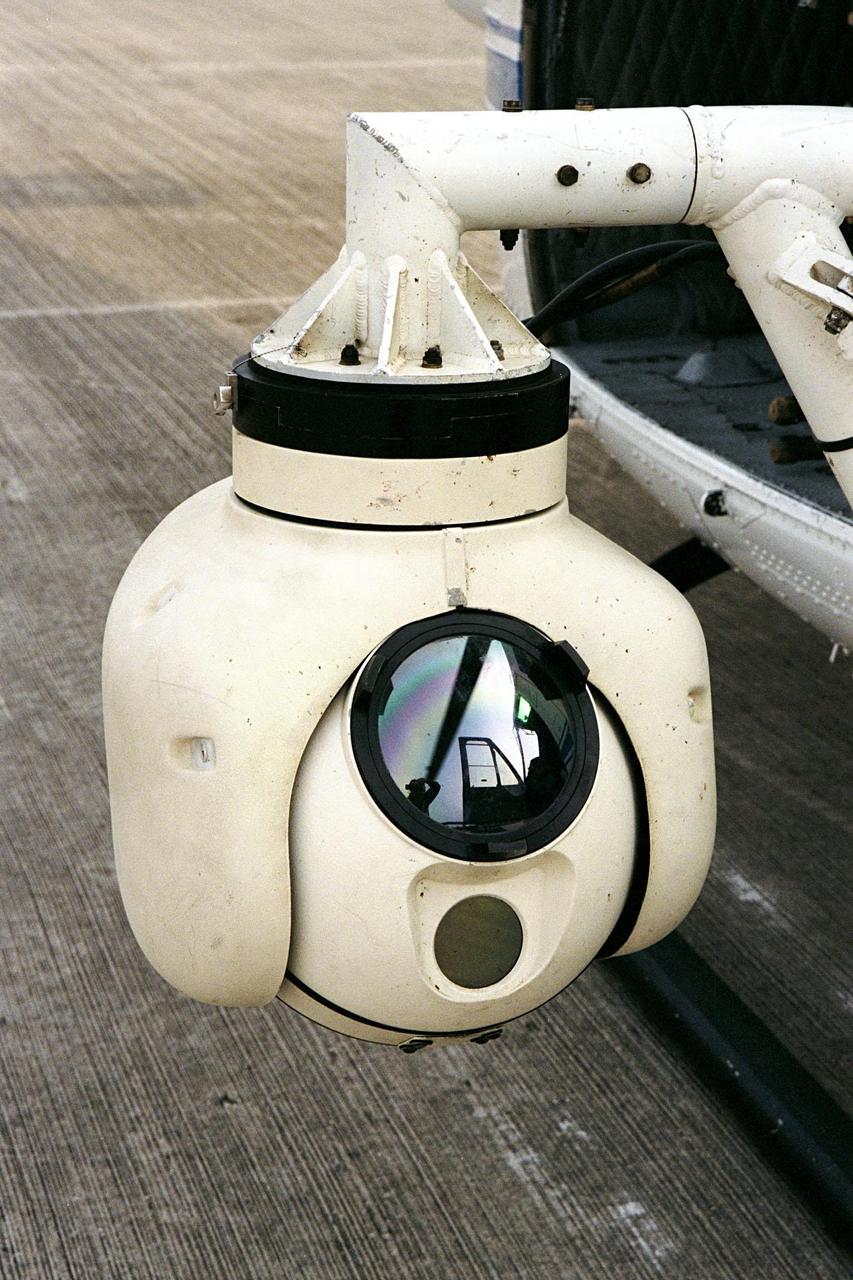
KENNEDY SPACE CENTER, FLA. -- A beach ball-sized infrared camera, part of the Forward Looking Infrared Radar (FLIR), has been mounted on the right siderail of NASA's Huey UH-1 helicopter. The helicopter has also been outfitted with a portable global positioning satellite (GPS) system to support Florida's Division of Forestry as they fight the brush fires which have been plaguing the state as a result of extremely dry conditions and lightning storms. The FLIR also includes a real-time television monitor and recorder installed inside the helicopter. While the FLIR collects temperature data and images, the GPS system provides the exact coordinates of the fires being observed and transmits the data to the firefighters on the ground. The Kennedy Space Center (KSC) security team routinely uses the FLIR equipment prior to Shuttle launch and landing activities to ensure that the area surrounding the launch pad and runway are clear of unauthorized personnel. KSC's Base Operations Contractor, EG&G Florida, operates the NASA-owned helicopter
The Rim Fire burning in the Stanislaus National Forest in California has crossed into the Yosemite National Park. The fire has burned more than 105,000 acres, approximately 162 square miles, of brush, oak and pine trees in steep and marginally accessible terrain. This image was taken by the Suomi NPP satellite's Day-Night Band around 0950Z on August 23, 2013. Credit NASA/NOAA <b><a href="http://www.nasa.gov/audience/formedia/features/MP_Photo_Guidelines.html" rel="nofollow">NASA image use policy.</a></b> <b><a href="http://www.nasa.gov/centers/goddard/home/index.html" rel="nofollow">NASA Goddard Space Flight Center</a></b> enables NASA’s mission through four scientific endeavors: Earth Science, Heliophysics, Solar System Exploration, and Astrophysics. Goddard plays a leading role in NASA’s accomplishments by contributing compelling scientific knowledge to advance the Agency’s mission. <b>Follow us on <a href="http://twitter.com/NASA_GoddardPix" rel="nofollow">Twitter</a></b> <b>Like us on <a href="http://www.facebook.com/pages/Greenbelt-MD/NASA-Goddard/395013845897?ref=tsd" rel="nofollow">Facebook</a></b> <b>Find us on <a href="http://instagram.com/nasagoddard?vm=grid" rel="nofollow">Instagram</a></b>
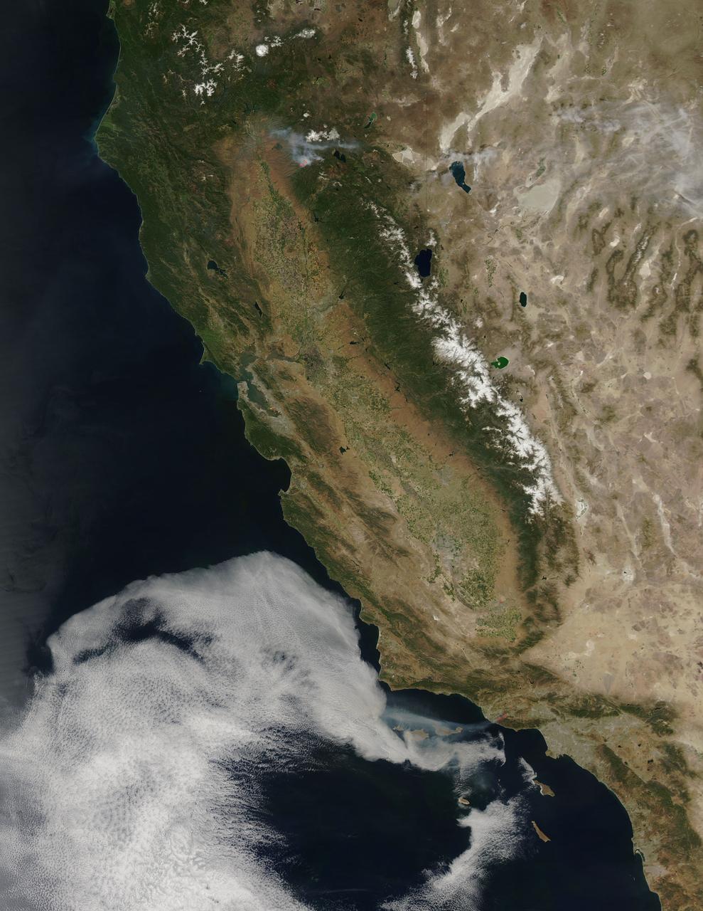
According to the NBCnews.com, Southern California firefighters were battling a growing, brush-fueled wildfire early Friday that had reached the beach in Ventura County and was pushing toward the upscale city of Malibu, officials said. Dubbed the Springs Fire, this "monster" of a wildfire has been made worse by howling Santa Ana winds and unusually dry vegetation. As of 2 am local time in California on Friday the 3rd, it was within "seven or eight miles" of Malibu, Ventura County Fire Department spokesman Bill Nash said. Weather conditions are not cooperating in the containment of this fire. The Weather Channel has predicted dry winds from offshore that will bring gusts of 40 to 50 miles per hour to the Southern California region on Friday the 3rd which could easily spread the fire. A complication to the winds is the extremely dry plant life left from a season in which only about five inches of rain fell in the area. The Springs Fire grew to 10,000 acres and was ten percent contained as of early Friday morning, according to the California Department of Forestry and Fire Prevention. Evacuations took place Thursday, and as of Friday morning 15 homes had been damaged. More than 2,000 homes and 100 commercial properties were under threat from the fire and those numbers could grow with weather conditions today (May 3). Currently the fire is burning in a rural area outside of Malibu, but it doesn't have to go very far to get to some expensive homes and more populated areas. It's current direction has it burning down the mountainside toward Malibu. Firefighters expect to receive help from tankers and helicopters in the air Friday morning, according to a release from the Ventura County Fire Department. The cause of the fire remained under investigation Friday. There had been no lightning or other natural fire-starting phenomenon in the area when the blaze began, Nash said. This natural-color satellite image was collected by the Moderate Resolution Imaging Spectroradiometer (MODIS) aboard the Aqua satellite on May 02, 2013. Actively burning areas, detected by MODIS’s thermal bands, are outlined in red. NASA image courtesy Jeff Schmaltz LANCE/EOSDIS MODIS Rapid Response Team, GSFC. Caption by Lynn Jenner with information from NBCnews.com <b><a href="http://www.nasa.gov/audience/formedia/features/MP_Photo_Guidelines.html" rel="nofollow">NASA image use policy.</a></b> <b><a href="http://www.nasa.gov/centers/goddard/home/index.html" rel="nofollow">NASA Goddard Space Flight Center</a></b> enables NASA’s mission through four scientific endeavors: Earth Science, Heliophysics, Solar System Exploration, and Astrophysics. Goddard plays a leading role in NASA’s accomplishments by contributing compelling scientific knowledge to advance the Agency’s mission. <b>Follow us on <a href="http://twitter.com/NASA_GoddardPix" rel="nofollow">Twitter</a></b> <b>Like us on <a href="http://www.facebook.com/pages/Greenbelt-MD/NASA-Goddard/395013845897?ref=tsd" rel="nofollow">Facebook</a></b> <b>Find us on <a href="http://instagram.com/nasagoddard?vm=grid" rel="nofollow">Instagram</a></b>
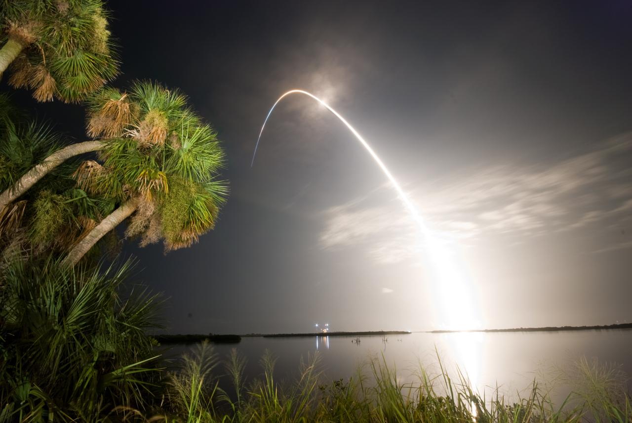
CAPE CANAVERAL, Fla. – Viewed from the Banana River Viewing Site at NASA's Kennedy Space Center in Florida, space shuttle Discovery arcs through a cloud-brushed sky lighted by the trail of fire after launch on the STS-128 mission. Liftoff from Launch Pad 39A was on time at 11:59 p.m. EDT. The first launch attempt on Aug. 24 was postponed due to unfavorable weather conditions. The second attempt on Aug. 25 also was postponed due to an issue with a valve in space shuttle Discovery's main propulsion system. The STS-128 mission is the 30th International Space Station assembly flight and the 128th space shuttle flight. The 13-day mission will deliver more than 7 tons of supplies, science racks and equipment, as well as additional environmental hardware to sustain six crew members on the International Space Station. The equipment includes a freezer to store research samples, a new sleeping compartment and the COLBERT treadmill. Photo credit: NASA/Ben Cooper
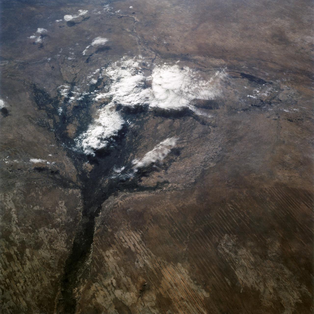
STS066-122-091 (3-14 Nov. 1994) --- This November 1994 view looking south-southeast shows clouds over the Okavango Delta area of northern Botswana. The Okavango is one of the wilder, less spoiled regions of Africa. The area still supports great herds of wild animals such as elephant, zebra and the cape buffalo. Despite conservation efforts from the stable government of Botswana, delta habitats are pressured. The Okavango River (lower left of view) brings water from the high, wet plateaus of Angola into the Kalahari Desert, and enormous inland basin. As a result of a series of small faults (upper center of the view) related to the African Rift System, the river is dammed up in the form of swampy inland delta. Here, water is consumed by evaporation, infiltration, and the swamp forests. Late summer floods take six months to slowly penetrate the 160 kilometer (95 miles) to the other end of the Delta. The visual patterns of the area are strongly linear: straight sand dunes occur in many places and can be seen across the bottom portion of the photograph. Numerous brush-fire scars produce a complex, straight-edged pattern over much of the lower portion of this view. Lake Ngami (upper right of view) was once permanently full as late as the middle 1800's. Changes in the climate of the area over the last 100 years has changed the size and shape of the inland delta.
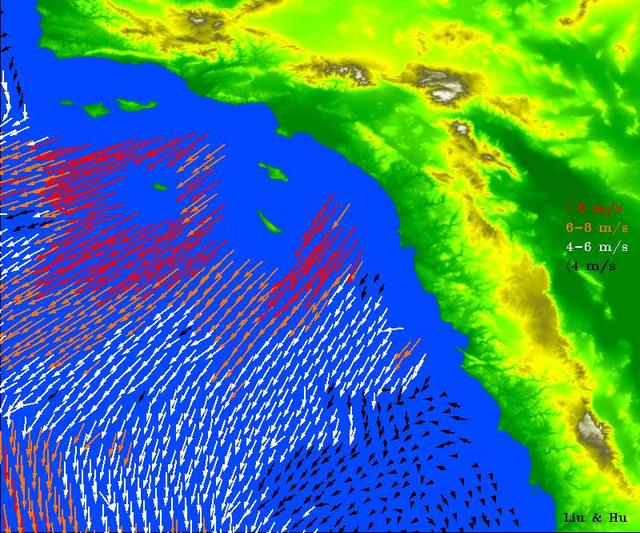
High-resolution ocean surface wind data from NASA's Quick Scatterometer (QuikScat) illustrate the strength of Santa Ana winds that pounded Southern California this week, causing damage and spreading brush fires. The colored arrows represent various ranges of wind speed, which were still well in excess of 30 knots (34 miles per hour), even after reaching the ocean and weakening. Santa Ana winds are offshore and down-slope winds unique to Southern California that are usually channeled through mountain gaps. These Santa Ana winds extend more than 500 kilometers (310 miles) offshore before changing direction to flow along the shore. The wind speeds and directions are retrieved from range-compressed backscatter data measured by QuikScat that has much higher spatial resolution than QuikScat's standard data products. Useful applications of high-resolution science-quality wind products derived from range-compressed backscatter have been demonstrated in two scientific papers: one on Hurricane Floyd and the other on Catalina Eddies. This is the first demonstration on near-real-time retrieval applications. http://photojournal.jpl.nasa.gov/catalog/PIA03892
Generally the old saying “where there is smoke, there is fire” rings true, but when thick, hot smoke rises high aloft into the atmosphere it may travel hundreds, sometimes thousands of kilometers away from the source. This was the case on July 6, 2013 when the Moderate Resolution Imaging Spectroradiometer (MODIS) instrument flying on NASA’s Terra satellite captured this true-color image of a thick river of smoke curling across the Atlantic Ocean. In the west of the image, the green land of Canada can be seen, most of which is covered by a thin gray haze. A thick veil of smoke obscures much of southern Canada, and this tan-gray veil blows to the east, then to the northeast. The color of the smoke appears both tan and gray, and is stretched into brush-stroke like curves across the ocean, which disappears from view under the smoke. The smoke filled plume is so high that it even hides the bright white clouds from view as it travels over them. Fires have been burning across Canada since early June, especially in Manitoba and Quebec. Rain in Quebec on July 5 helped diminish the fires in that location, although a severe fire was ignited when a freight train carrying oil derailed in the small, picturesque town of Lac-Megantic. This accident, which occurred on July 6, the same day this image was captured, killed at least 35 people and poured thick smoke into the skies. Credit: NASA/GSFC/Jeff Schmaltz/MODIS Land Rapid Response Team <b><a href="http://www.nasa.gov/audience/formedia/features/MP_Photo_Guidelines.html" rel="nofollow">NASA image use policy.</a></b> <b><a href="http://www.nasa.gov/centers/goddard/home/index.html" rel="nofollow">NASA Goddard Space Flight Center</a></b> enables NASA’s mission through four scientific endeavors: Earth Science, Heliophysics, Solar System Exploration, and Astrophysics. Goddard plays a leading role in NASA’s accomplishments by contributing compelling scientific knowledge to advance the Agency’s mission. <b>Follow us on <a href="http://twitter.com/NASA_GoddardPix" rel="nofollow">Twitter</a></b> <b>Like us on <a href="http://www.facebook.com/pages/Greenbelt-MD/NASA-Goddard/395013845897?ref=tsd" rel="nofollow">Facebook</a></b> <b>Find us on <a href="http://instagram.com/nasagoddard?vm=grid" rel="nofollow">Instagram</a></b>
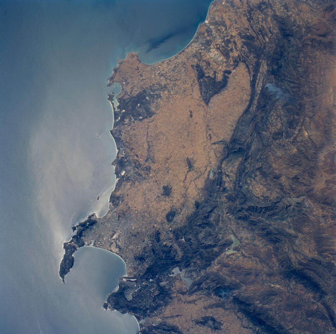
STS089-706-068 (22-31 Jan. 1998) --- This nadir view of the southern Cape District of South Africa was photographed with a 70mm handheld camera from the Earth-orbiting space shuttle Endeavour. Prominent landmarks are the Cape of Good Hope, False Bay and Cape Town. Cape Town is the gray area at the base of the peninsula that forms the Cape of Good Hope. East and north of Cape Town the dark mountain ranges are the Cape Fold Belt. Northerly structures of the region formed approximately 580 million years ago when east Antarctica, Africa and parts of South America combined. According to NASA scientists those continents separated and then recombined about 230 million years ago; in the later event, the northerly structures were again active and the west-trending folds of the Great and Little Karroo ranges formed. The westerly structures of the Karroo formed somewhat later; the northerly structures were re-folded at that time. The great continental mass, Gondwana, remained together until around 175 million years ago, when it rifted apart leaving the coastline essentially as it is seen today. Photos such as this are useful to geologists working in these areas as they provide, quite literally, the big picture in complex regions. Other items of interest are the internal waves noted offshore, several trains can be seen east, north and south of Cape Town. In the mountains to the north (upper left corner) a large brush fire is seen from the smoke plume. The giant gold and diamond mines are located northeast and east of this photo. The gold province is primarily located around Johannesburg (450 miles northeast) and the diamond mines are approximately 300 miles northeast around Kimberley. Photo credit: NASA

Canada has already had its share of wildfires this season, and the smoke from these wildfires is slowly drifting south over the United States' Midwest. The drifting smoke can be seen in this Terra satellite image over Lake Michigan, as well as parts of Minnesota, Wisconsin, Indiana and Ohio. The smoke released by any type of fire (forest, brush, crop, structure, tires, waste or wood burning) is a mixture of particles and chemicals produced by incomplete burning of carbon-containing materials. All smoke contains carbon monoxide, carbon dioxide and particulate matter (PM or soot). Smoke can contain many different chemicals, including aldehydes, acid gases, sulfur dioxide, nitrogen oxides, polycyclic aromatic hydrocarbons (PAHs), benzene, toluene, styrene, metals and dioxins. The type and amount of particles and chemicals in smoke varies depending on what is burning, how much oxygen is available, and the burn temperature. Exposure to any type of smoke should be avoided if possible, but especially by those with respiratory issues, the elderly, and children. This natural-color satellite image was collected by the Moderate Resolution Imaging Spectroradiometer (MODIS) aboard the Terra satellite on June 09, 2015. Credit: NASA image courtesy Jeff Schmaltz, MODIS Rapid Response Team <b><a href="http://www.nasa.gov/audience/formedia/features/MP_Photo_Guidelines.html" rel="nofollow">NASA image use policy.</a></b> <b><a href="http://www.nasa.gov/centers/goddard/home/index.html" rel="nofollow">NASA Goddard Space Flight Center</a></b> enables NASA’s mission through four scientific endeavors: Earth Science, Heliophysics, Solar System Exploration, and Astrophysics. Goddard plays a leading role in NASA’s accomplishments by contributing compelling scientific knowledge to advance the Agency’s mission. <b>Follow us on <a href="http://twitter.com/NASAGoddardPix" rel="nofollow">Twitter</a></b> <b>Like us on <a href="http://www.facebook.com/pages/Greenbelt-MD/NASA-Goddard/395013845897?ref=tsd" rel="nofollow">Facebook</a></b> <b>Find us on <a href="http://instagrid.me/nasagoddard/?vm=grid" rel="nofollow">Instagram</a></b>