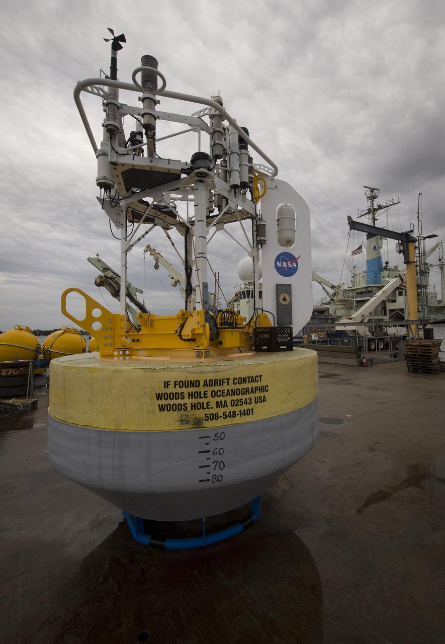
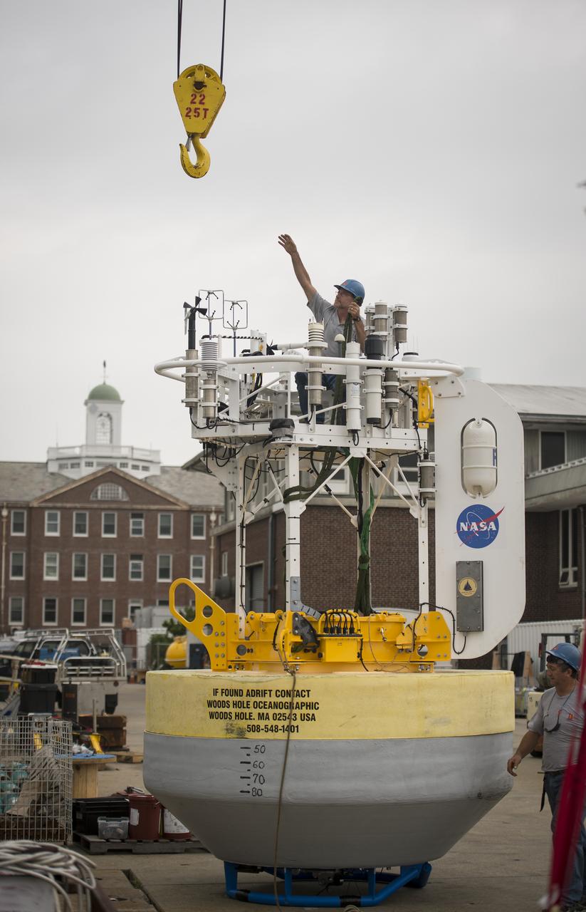
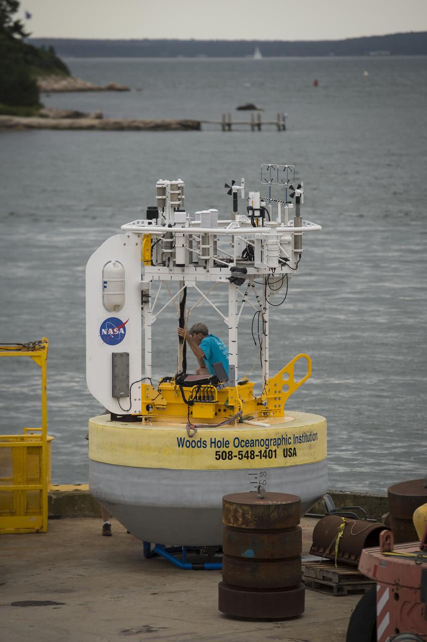
A sensor-laden buoy is seen prior to being loaded onboard the Woods Hole Oceanographic Institution's vessel Knorr on Tuesday, Sept. 4, 2012, in Woods Hole, Mass. The buoy will be deployed in the Atlantic Ocean as part of the Salinity Processes in the Upper Ocean Regional Study (SPURS) which is set to sail on Sept. 6. The NASA-sponsored expedition will sail to the North Atlantic's saltiest spot to get a detailed, 3-D picture of how salt content fluctuates in the ocean's upper layers and how these variations are related to shifts in rainfall patterns around the planet. Photo Credit: (NASA/Bill Ingalls)
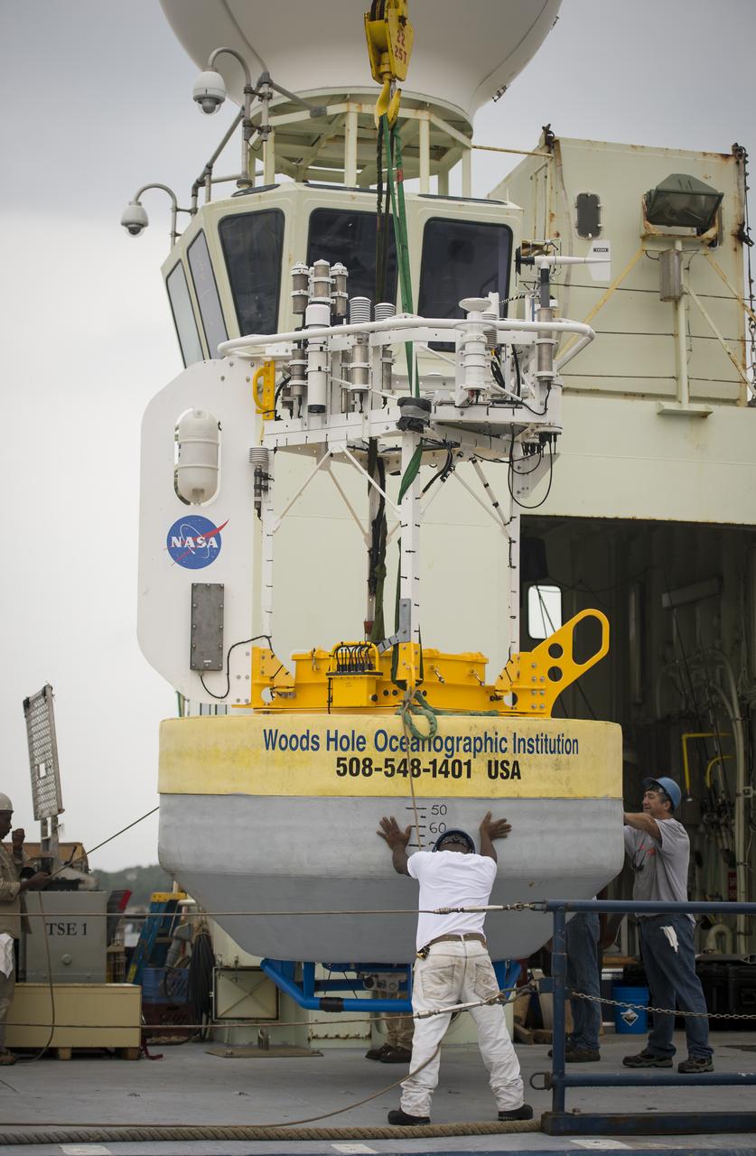
A sensor-laden buoy is lifted onboard the Woods Hole Oceanographic Institution's research vessel Knorr on wednesday, Sept. 5, 2012, in Woods Hole, Mass. The buoy will be deployed in the Atlantic Ocean as part of the Salinity Processes in the Upper Ocean Regional Study (SPURS) which is set to sail on Sept. 6. The NASA-sponsored expedition will sail to the North Atlantic's saltiest spot to get a detailed, 3-D picture of how salt content fluctuates in the ocean's upper layers and how these variations are related to shifts in rainfall patterns around the planet. Photo Credit: (NASA/Bill Ingalls)
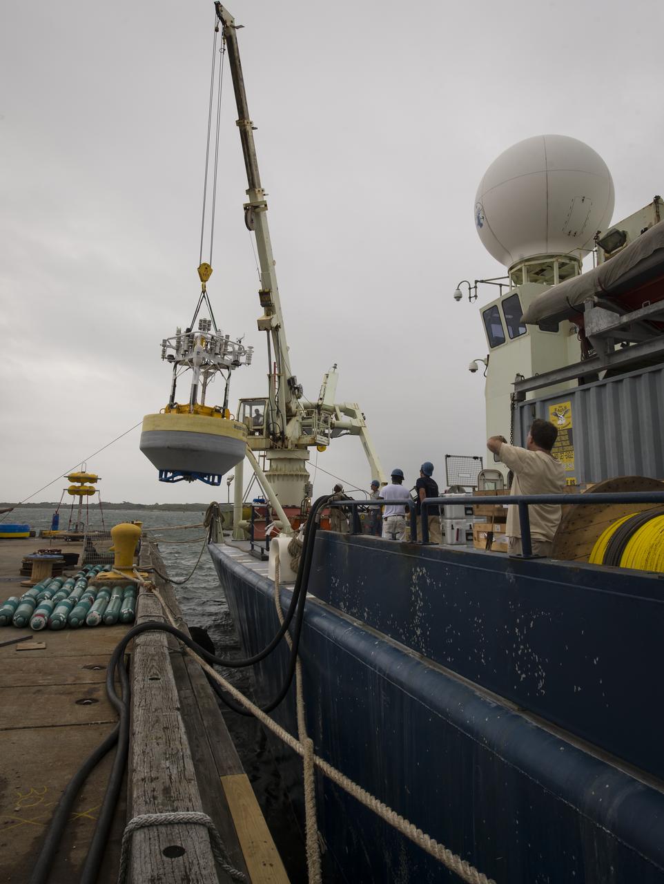
A sensor-laden buoy is lifted onboard the Woods Hole Oceanographic Institution's research vessel Knorr on wednesday, Sept. 5, 2012, in Woods Hole, Mass. The buoy will be deployed in the Atlantic Ocean as part of the Salinity Processes in the Upper Ocean Regional Study (SPURS) which is set to sail on Sept. 6. The NASA-sponsored expedition will sail to the North Atlantic's saltiest spot to get a detailed, 3-D picture of how salt content fluctuates in the ocean's upper layers and how these variations are related to shifts in rainfall patterns around the planet. Photo Credit: (NASA/Bill Ingalls)
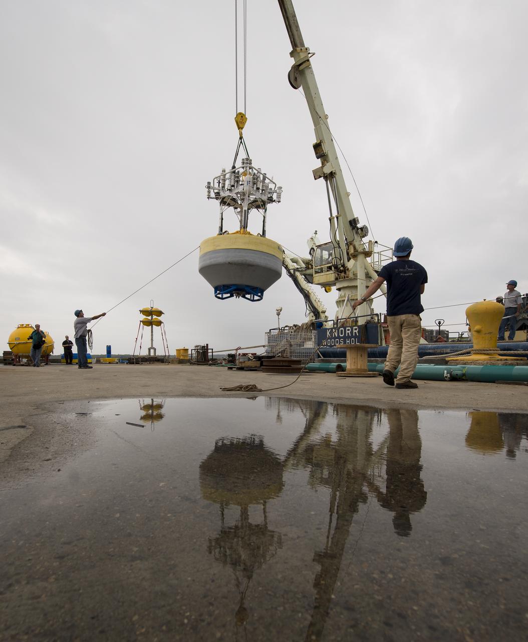
A sensor-laden buoy is lifted onboard the Woods Hole Oceanographic Institution's research vessel Knorr on wednesday, Sept. 5, 2012, in Woods Hole, Mass. The buoy will be deployed in the Atlantic Ocean as part of the Salinity Processes in the Upper Ocean Regional Study (SPURS) which is set to sail on Sept. 6. The NASA-sponsored expedition will sail to the North Atlantic's saltiest spot to get a detailed, 3-D picture of how salt content fluctuates in the ocean's upper layers and how these variations are related to shifts in rainfall patterns around the planet. Photo Credit: (NASA/Bill Ingalls)
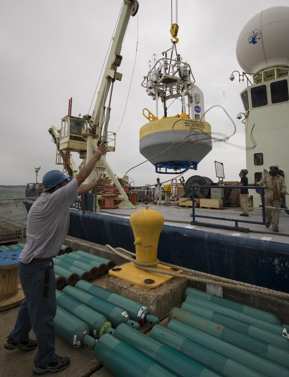
A sensor-laden buoy is lifted onboard the Woods Hole Oceanographic Institution's research vessel Knorr on wednesday, Sept. 5, 2012, in Woods Hole, Mass. The buoy will be deployed in the Atlantic Ocean as part of the Salinity Processes in the Upper Ocean Regional Study (SPURS) which is set to sail on Sept. 6. The NASA-sponsored expedition will sail to the North Atlantic's saltiest spot to get a detailed, 3-D picture of how salt content fluctuates in the ocean's upper layers and how these variations are related to shifts in rainfall patterns around the planet. Photo Credit: (NASA/Bill Ingalls)
An worker prepares to attached a crane hook onto a sensor-laden buoy so that it may be loaded onboard the Woods Hole Oceanographic Institution's research vessel Knorr on wednesday, Sept. 5, 2012, in Woods Hole, Mass. The buoy will be deployed in the Atlantic Ocean as part of the Salinity Processes in the Upper Ocean Regional Study (SPURS) which is set to sail on Sept. 6. The NASA-sponsored expedition will sail to the North Atlantic's saltiest spot to get a detailed, 3-D picture of how salt content fluctuates in the ocean's upper layers and how these variations are related to shifts in rainfall patterns around the planet. Photo Credit: (NASA/Bill Ingalls)
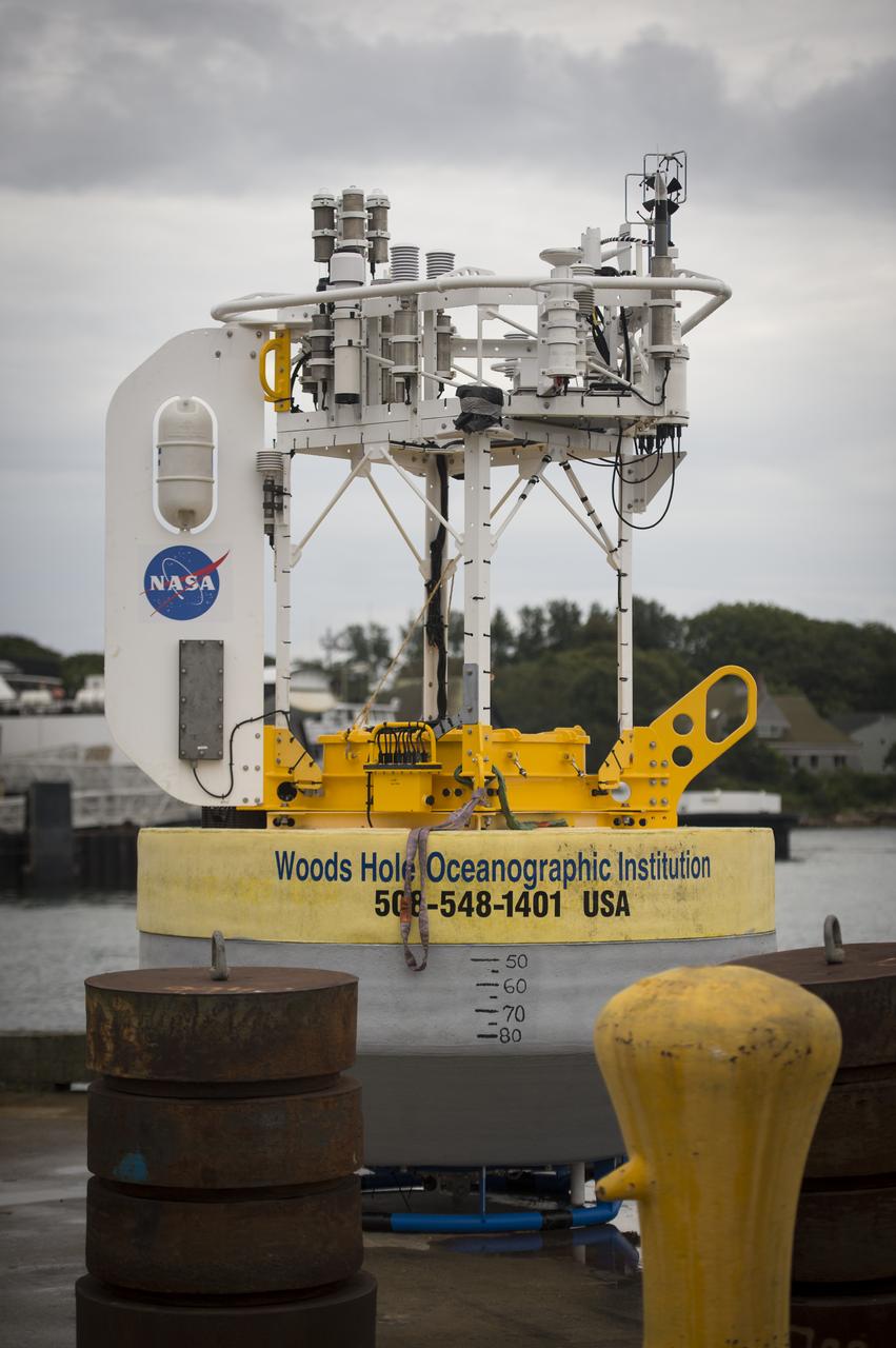
A sensor-laden buoy is seen prior to being loaded onboard the Woods Hole Oceanographic Institution's vessel Knorr on Tuesday, Sept. 4, 2012, in Woods Hole, Mass. The buoy will be deployed in the Atlantic Ocean as part of the Salinity Processes in the Upper Ocean Regional Study (SPURS) which is set to sail on Sept. 6. The NASA-sponsored expedition will sail to the North Atlantic's saltiest spot to get a detailed, 3-D picture of how salt content fluctuates in the ocean's upper layers and how these variations are related to shifts in rainfall patterns around the planet. Photo Credit: (NASA/Bill Ingalls)
Woods Hole Oceanographic Institution Senior Engineer Steve Faluotico works on the SPURS buoy prior to it being loaded onto the Institute's research vessel Knorr, Tuesday, Sept. 4, 2012, in Woods Hole, Mass. The SPURS buoy will be deployed in the Atlantic Ocean as part of the Salinity Processes in the Upper Ocean Regional Study (SPURS) which is set to sail on Sept. 6. The NASA-sponsored expedition will sail to the North Atlantic's saltiest spot to get a detailed, 3-D picture of how salt content fluctuates in the ocean's upper layers and how these variations are related to shifts in rainfall patterns around the planet. Photo Credit: (NASA/Bill Ingalls)
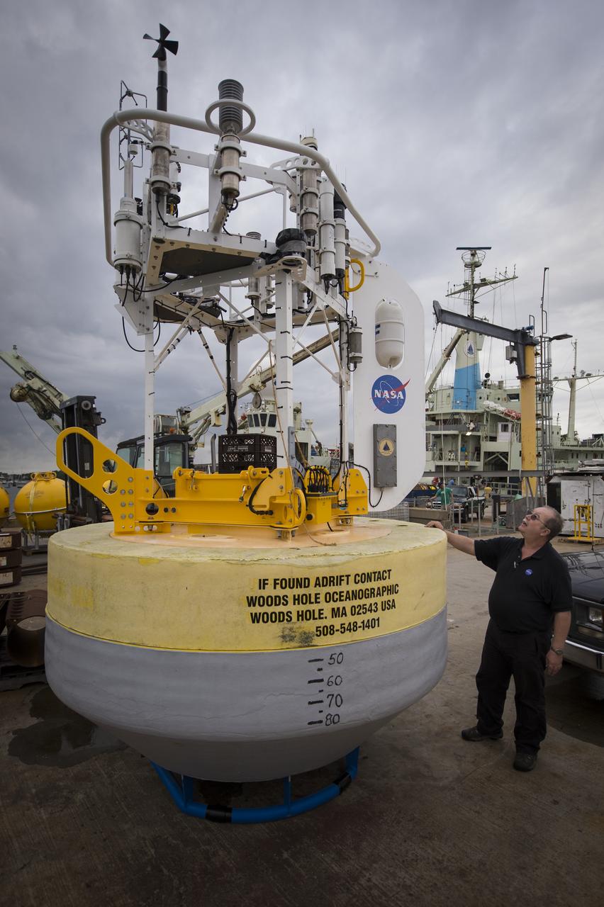
NASA Physical Oceanography Program Scientist Eric Lindstrom inspects a sensor-laden buoy prior to it being loaded onboard the Woods Hole Oceanographic Institution's vessel Knorr on Tuesday, Sept. 4, 2012, in Woods Hole, Mass. The buoy will be deployed in the Atlantic Ocean as part of the Salinity Processes in the Upper Ocean Regional Study (SPURS) which is set to sail on Sept. 6. The NASA-sponsored expedition will sail to the North Atlantic's saltiest spot to get a detailed, 3-D picture of how salt content fluctuates in the ocean's upper layers and how these variations are related to shifts in rainfall patterns around the planet. Photo Credit: (NASA/Bill Ingalls)
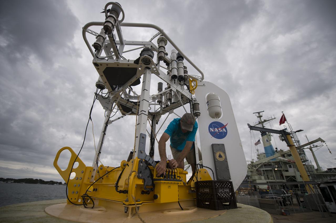
Woods Hole Oceanographic Institution Senior Engineer Steve Faluotico works on the SPURS buoy prior to it being loaded onto the Institute's research vessel Knorr, Tuesday, Sept. 4, 2012, in Woods Hole, Mass. The SPURS buoy will be deployed in the Atlantic Ocean as part of the Salinity Processes in the Upper Ocean Regional Study (SPURS) which is set to sail on Sept. 6. The NASA-sponsored expedition will sail to the North Atlantic's saltiest spot to get a detailed, 3-D picture of how salt content fluctuates in the ocean's upper layers and how these variations are related to shifts in rainfall patterns around the planet. Photo Credit: (NASA/Bill Ingalls)

Take Our Children to Work Day participants learn about buoys on June 27 during an activity conducted by Brandon Elsensohn, Amentum software engineer, for the National Data Buoy Center at NASA’s Stennis Space Center.
Support buoys are seen onboard USS John P. Murtha ahead of the return of the Artemis II crewmembers to Earth, Thursday, April 9, 2026, in the Pacific Ocean off the coast of California. NASA’s Artemis II mission is taking NASA astronauts Reid Wiseman, commander; Victor Glover, pilot; Christina Koch, mission specialist; and CSA (Canadian Space Agency) astronaut Jeremy Hansen, mission specialist on a 10-day journey around the Moon and back aboard their Orion spacecraft. Wiseman, Glover, Koch, and Hansen are scheduled to splash down off the coast of San Diego at approximately 5:07 p.m. PDT (8:07 p.m. EDT) on Friday, April 10. Photo Credit: (NASA/Bill Ingalls)
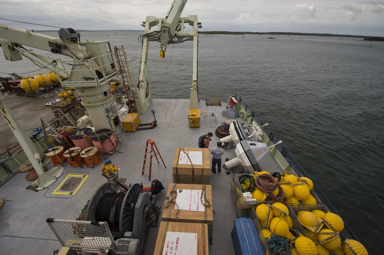
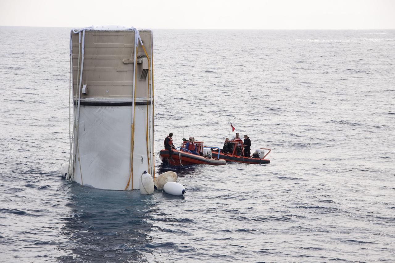
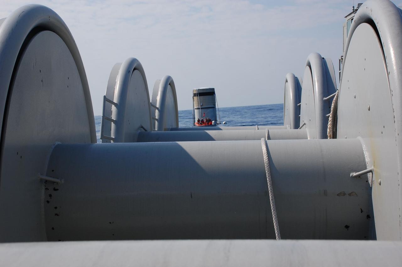
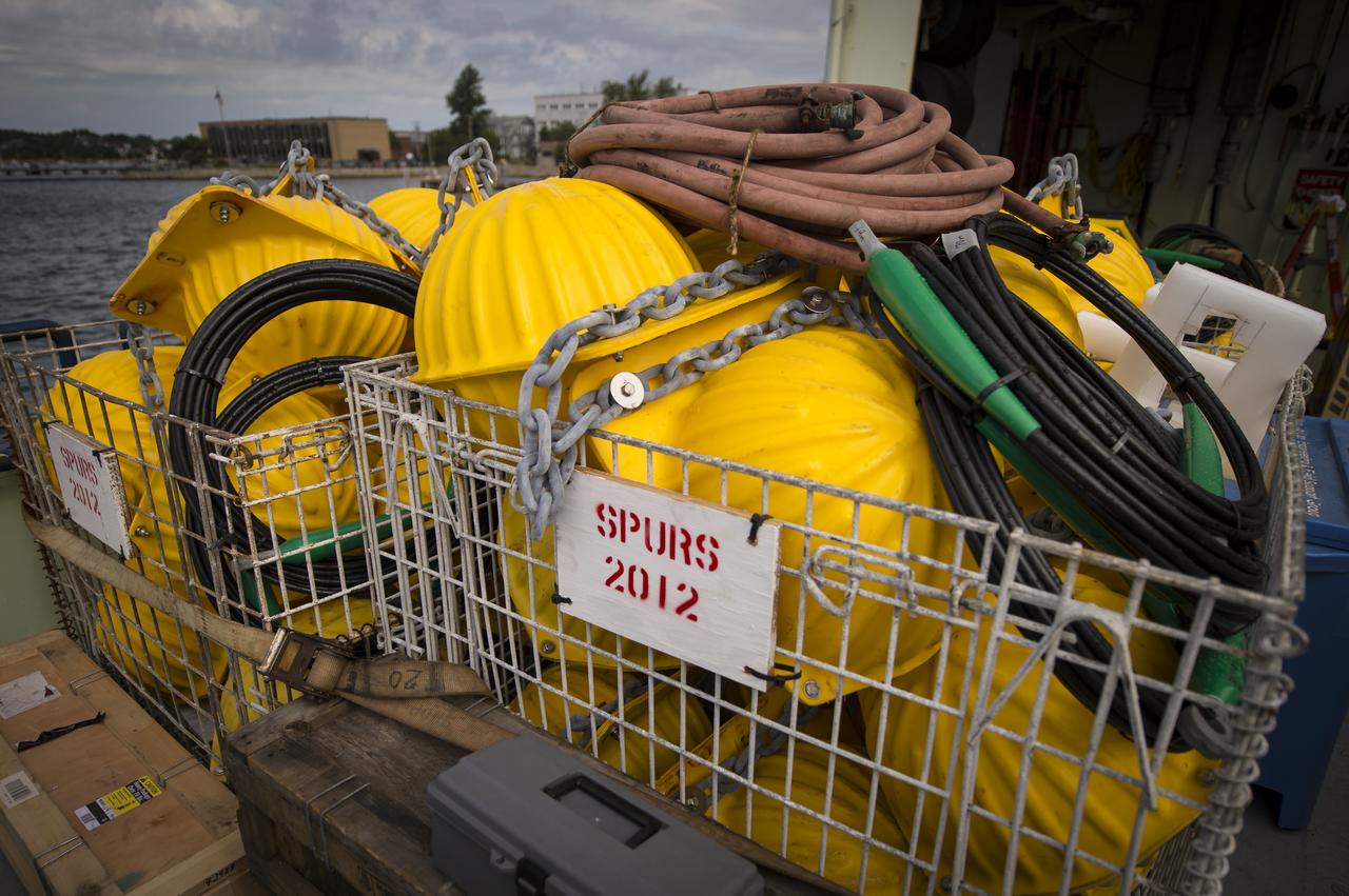
Scientific instruments, buoys, and shipping crates are seen on the stern of the Woods Hole Oceanographic Institution's research vessel Knorr on Tuesday, Sept. 4, 2012, in Woods Hole, Mass. Knorr is scheduled to depart on Sept. 6 to take part in the Salinity Processes in the Upper Ocean Regional Study (SPURS). The NASA-sponsored expedition will sail to the North Atlantic's saltiest spot to get a detailed, 3-D picture of how salt content fluctuates in the ocean's upper layers and how these variations are related to shifts in rainfall patterns around the planet. Photo Credit: (NASA/Bill Ingalls)
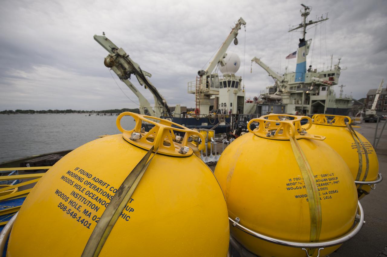
Buoys used to support scientific instruments at sea are seen in the foreground prior to being loaded onboard the Woods Hole Oceanographic Institution's research vessel Knorr, seen in the background, on Tuesday, Sept. 4, 2012, in Woods Hole, Mass. Knorr is scheduled to depart on Sept. 6 to take part in the Salinity Processes in the Upper Ocean Regional Study (SPURS). The NASA-sponsored expedition will sail to the North Atlantic's saltiest spot to get a detailed, 3-D picture of how salt content fluctuates in the ocean's upper layers and how these variations are related to shifts in rainfall patterns around the planet. Photo Credit: (NASA/Bill Ingalls)
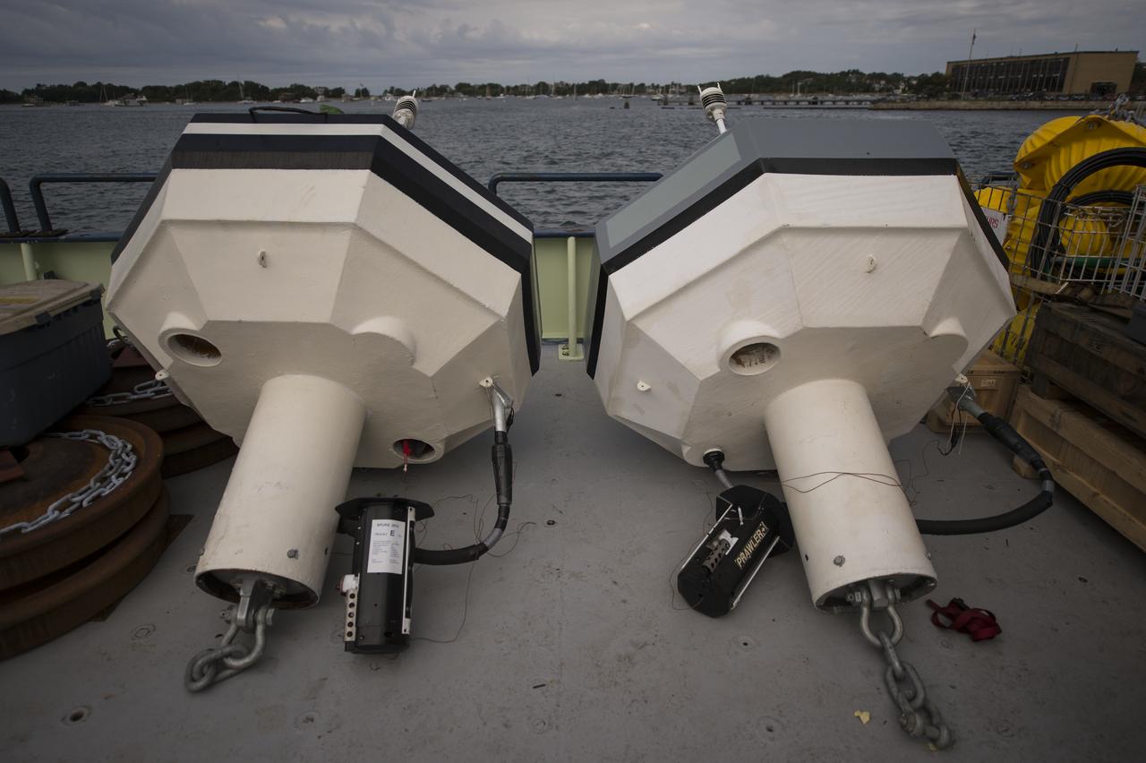
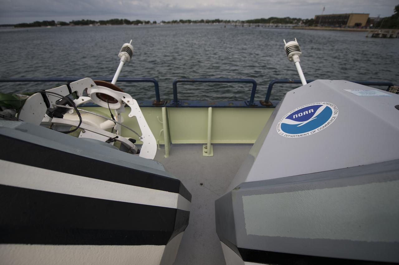
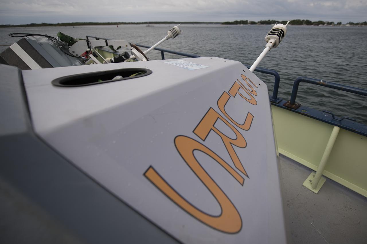
Two NOAA Pacific Marine Environmental Laboratory (PMEL) buoys are seen on the stern of the Woods Hole Oceanographic Institution's research vessel Knorr on Tuesday, Sept. 4, 2012, in Woods Hole, Mass. Knorr is scheduled to depart on Sept. 6 to take part in the Salinity Processes in the Upper Ocean Regional Study (SPURS). The NASA-sponsored expedition will sail to the North Atlantic's saltiest spot to get a detailed, 3-D picture of how salt content fluctuates in the ocean's upper layers and how these variations are related to shifts in rainfall patterns around the planet. Photo Credit: (NASA/Bill Ingalls)
Two NOAA Pacific Marine Environmental Laboratory (PMEL) buoys are seen on the stern of the Woods Hole Oceanographic Institution's research vessel Knorr on Tuesday, Sept. 4, 2012, in Woods Hole, Mass. Knorr is scheduled to depart on Sept. 6 to take part in the Salinity Processes in the Upper Ocean Regional Study (SPURS). The NASA-sponsored expedition will sail to the North Atlantic's saltiest spot to get a detailed, 3-D picture of how salt content fluctuates in the ocean's upper layers and how these variations are related to shifts in rainfall patterns around the planet. Photo Credit: (NASA/Bill Ingalls)
Two NOAA Pacific Marine Environmental Laboratory (PMEL) buoys are seen on the stern of the Woods Hole Oceanographic Institution's research vessel Knorr on Tuesday, Sept. 4, 2012, in Woods Hole, Mass. Knorr is scheduled to depart on Sept. 6 to take part in the Salinity Processes in the Upper Ocean Regional Study (SPURS). The NASA-sponsored expedition will sail to the North Atlantic's saltiest spot to get a detailed, 3-D picture of how salt content fluctuates in the ocean's upper layers and how these variations are related to shifts in rainfall patterns around the planet. Photo Credit: (NASA/Bill Ingalls)
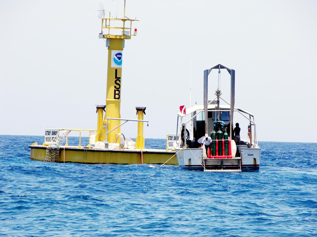
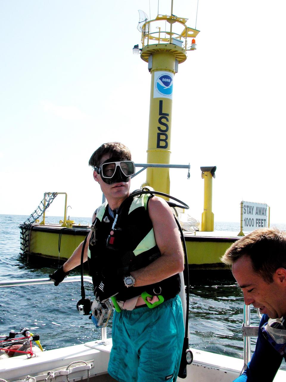
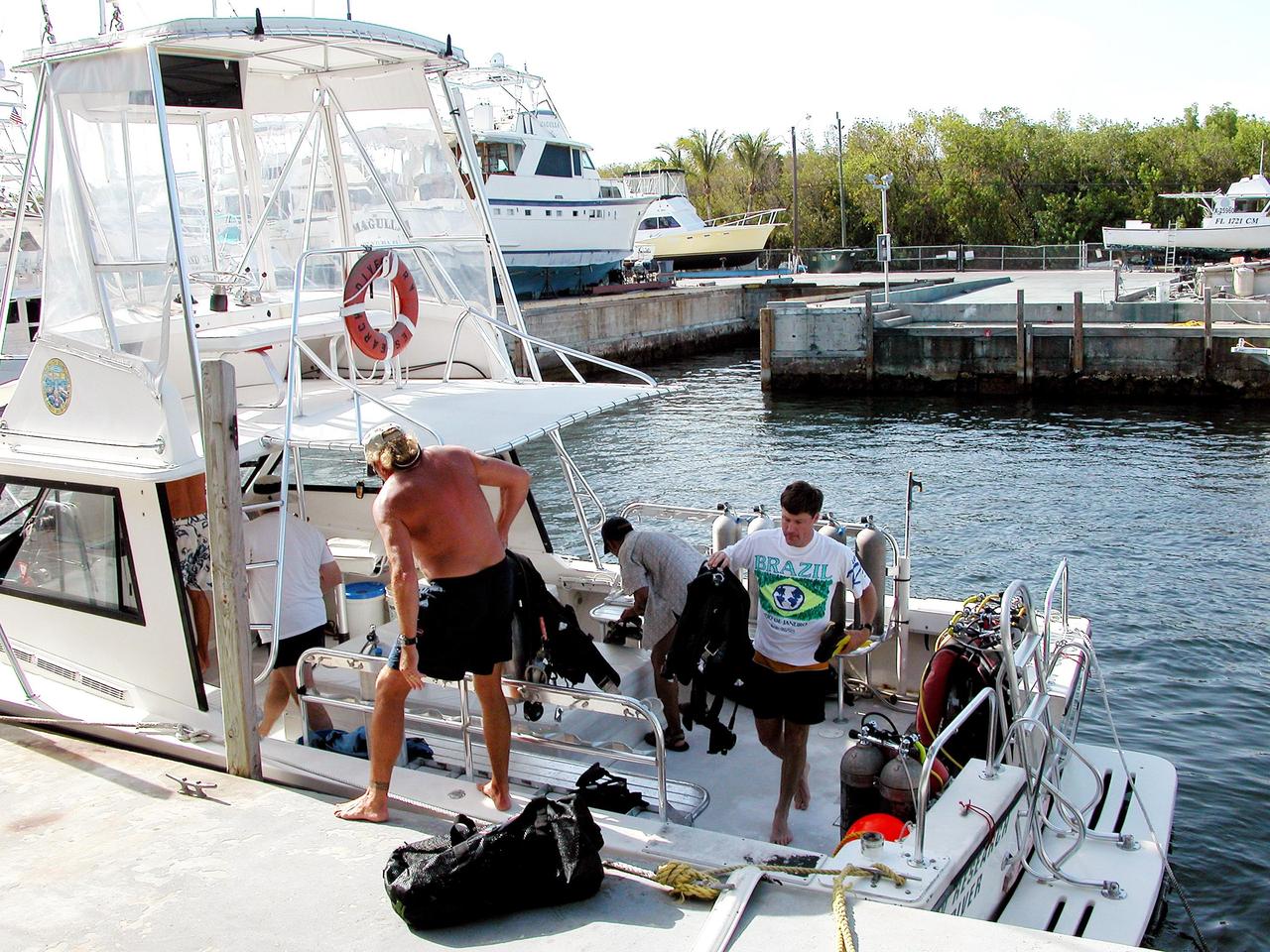
KENNEDY SPACE CENTER, FLA. - A dive boat is moored to the Life Support Buoy, anchored above the NOAA undersea station Aquarius, offshore from Key Largo. Underwater is the NASA Extreme Environment Mission Operations 6 (NEEMO-6) mission team: (left to right) Tara Ruttley, a biomedical engineer, and astronauts Nick Patrick, John Herrington and Doug Wheelock. The NEEMO-6 mission involves exposing an astronaut/scientist crew to a real mission experience in an extreme environment - Aquarius - to prepare for future space flight. Spacewalk-like diving excursions and field-tests on a variety of biomedical equipment are designed to help astronauts living aboard the International Space Station. To prepare for their 10-day stay, the team had dive training twice a day at the Life Support Buoy.
KENNEDY SPACE CENTER, FLA. - Onboard the dive boat at the Life Support Buoy offshore from Key Largo is Marc Reagan, mission lead for the NASA Extreme Environment Mission Operations 6 (NEEMO-6) mission. At right is Lt. Scott Sparks, a Navy medical officer. Reagan is also the underwater still photographer. The NEEMO-6 team comprises John Herrington, commander, Tara Ruttley, a biomedical engineer, and astronauts Nick Patrick and Doug Wheelock. The NEEMO-6 mission involves exposing an astronaut/scientist crew to a real mission experience in an extreme environment - the NOAA undersea station Aquarius - to prepare for future space flight. Spacewalk-like diving excursions and field-tests on a variety of biomedical equipment are designed to help astronauts living aboard the International Space Station. To prepare for their 10-day stay, the team had dive training twice a day at the Life Support Buoy, anchored above Aquarius.
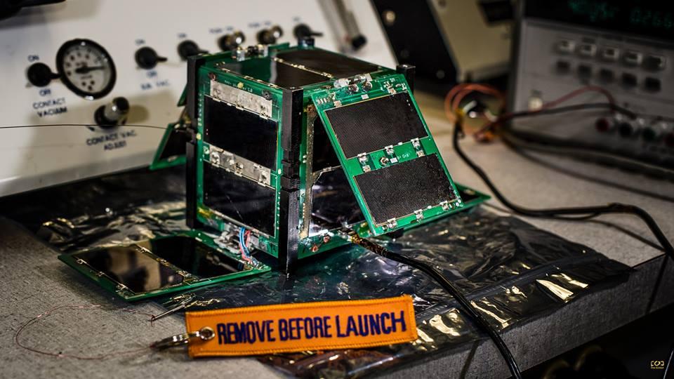
CAPE-2: Cajun Advanced Picosatellite Experiment – ELaNa IV CAPE-2 was developed by students from the University of Louisiana Lafayette to engage, inspire and educate K-12 students to encourage them to pursue STEM careers. The secondary focus is the technology demonstration of deployed solar panels to support the following payloads: text to speech, voice repeater, tweeting, email, file transfer and data collection from buoys. Launched by NASA’s CubeSat Launch Initiative on the ELaNa IV mission as an auxiliary payload aboard the U.S. Air Force-led Operationally Responsive Space (ORS-3) Mission on November 19, 2013.
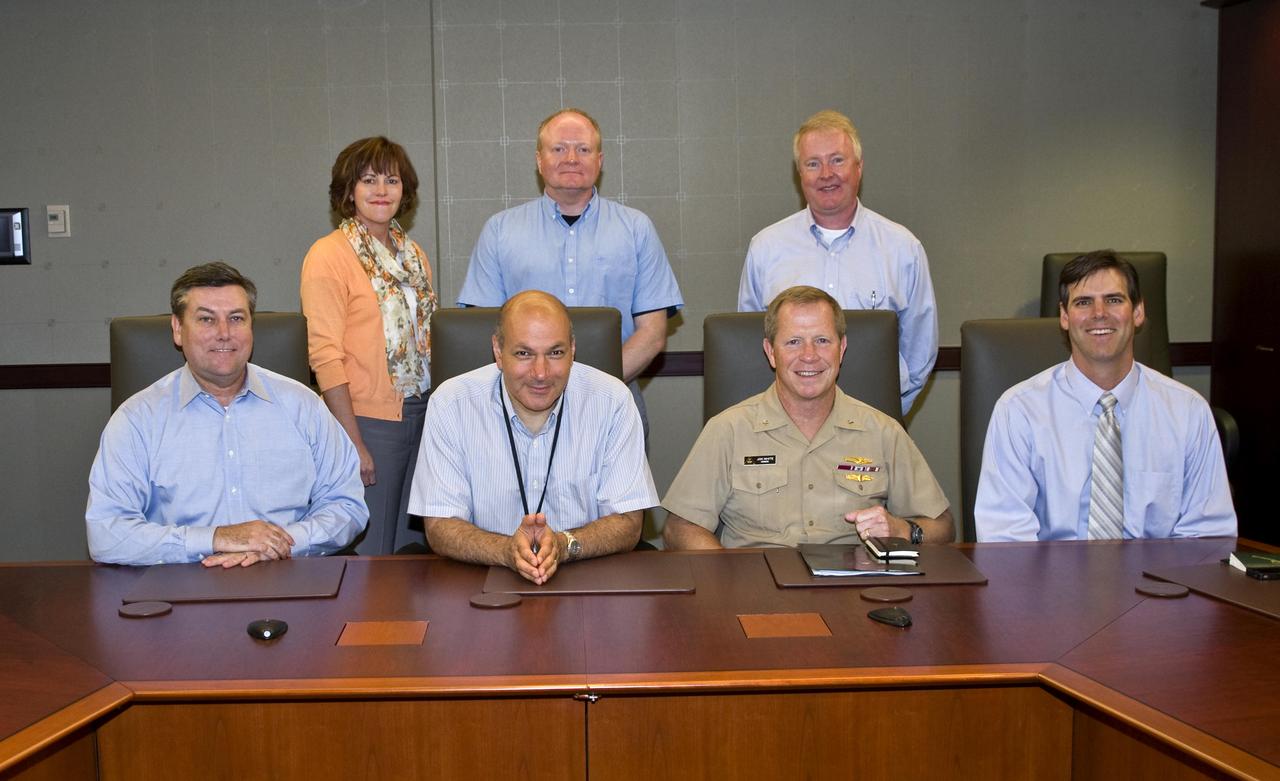
NASA Chief Scientist Dr. Waleed Abdalati visited Stennis Space Center on July 19, to learn about the extensive science capabilities onsite. Shown at right are: (seated, l to r), Stennis Center Director Patrick Scheuermann; Dr. Abdalati; U.S. Navy Rear Adm. Jonathan White; NOAA National Data Buoy Center Program Manager Shannon McArthur; (standing, l to r) Stennis Project Directorate Assistant Director Anne Peek; Stennis Applied Science & Technology Project Office Chief Duane Armstrong; and Stennis Project Directorate Director Keith Brock.
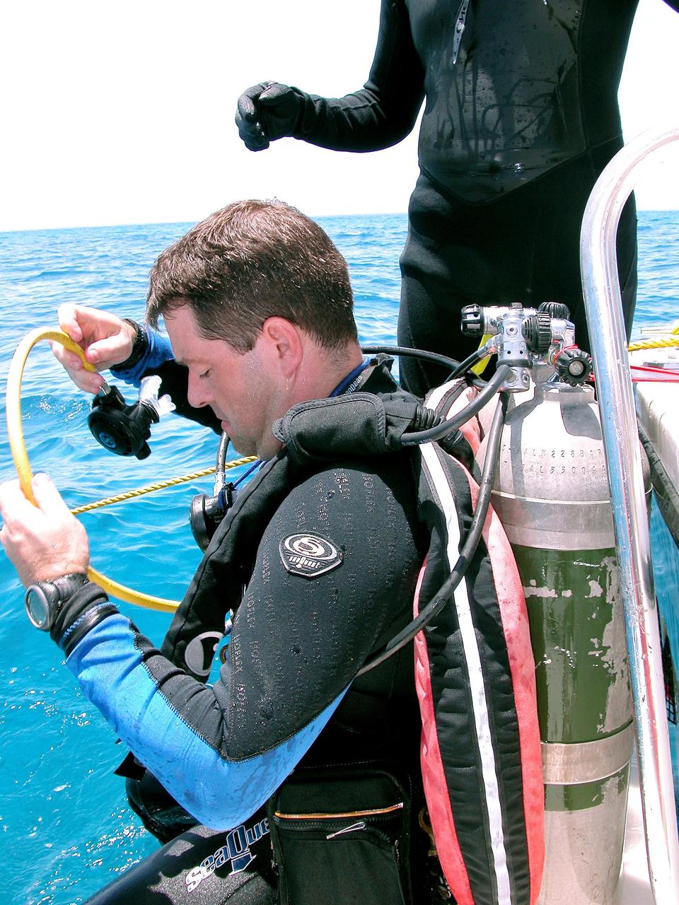
KENNEDY SPACE CENTER, FLA. - Getting ready to enter the water on a practice dive in the ocean offshore from Key Largo is Nick Patrick. He is a member of the NASA Extreme Environment Mission Operations 6 (NEEMO-6) mission team. The others are astronauts John Herrington, mission commander, and Doug Wheelock, plus Tara Ruttley, a biomedical engineer. The NEEMO-6 mission involves exposing an astronaut/scientist crew to a real mission experience in an extreme environment - the NOAA undersea station Aquarius - to prepare for future space flight. Spacewalk-like diving excursions and field-tests on a variety of biomedical equipment are designed to help astronauts living aboard the International Space Station. To prepare for their 10-day stay, the team had dive training twice a day at the Life Support Buoy, anchored above Aquarius.
CAPE CANAVERAL, Fla. -- Crew members in a skiff from Liberty Star, one of NASA's solid rocket booster retrieval ships, attach flotation devices, or buoys, to the parachute lines from the right spent booster from space shuttle Discovery's final launch. The shuttle's two solid rocket booster casings and associated flight hardware are recovered in the Atlantic Ocean after every launch by Freedom Star and Liberty Star. The boosters impact the Atlantic about seven minutes after liftoff and the retrieval ships are stationed about 10 miles from the impact area at the time of splashdown. After the spent segments are processed, they will be transported to Utah, where they will be refurbished and stored, if needed. Photo credit: NASA/Frank Michaux
CAPE CANAVERAL, Fla. -- This image taken through a winding and storage device on Freedom Star, one of NASA's solid rocket booster retrieval ships, shows crew members in a skiff attaching flotation devices, or buoys to the parachute lines from the left spent booster after space shuttle Discovery's STS-133 launch. The shuttle’s two solid rocket booster casings and associated flight hardware are recovered in the Atlantic Ocean after every launch by Liberty Star and Freedom Star. The boosters impact the Atlantic about seven minutes after liftoff and the retrieval ships are stationed about 10 miles from the impact area at the time of splashdown. After the spent segments are processed, they will be transported to Utah, where they will be refurbished and stored, if needed. Photo credit: NASA/Ben Smegelsky
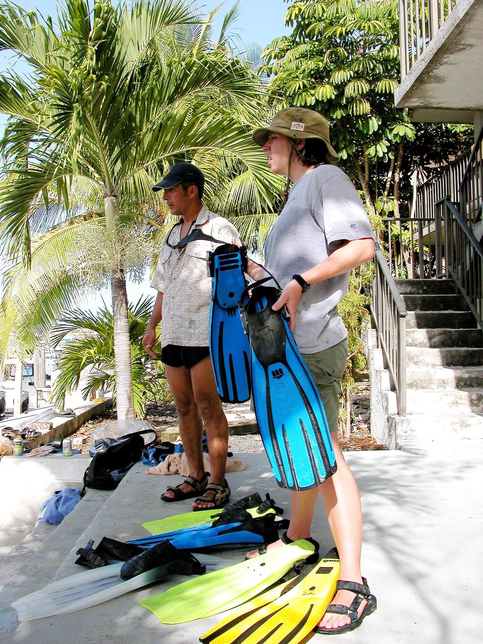
KENNEDY SPACE CENTER, FLA. - After their return from a practice dive at the NOAA Aquarius underwater station offshore at Key Largo, John Herrington and Tara Ruttley look over their dive gear. Herrington is mission commander and Ruttley, a biomedical engineer, is a member of the crew on the NASA Extreme Environment Mission Operations 6 (NEEMO-6) mission. The NEEMO-6 mission involves exposing an astronaut/scientist crew to a real mission experience in an extreme environment - the NOAA undersea station Aquarius offshore from Key Largo - to prepare for future space flight. Spacewalk-like diving excursions and field-tests on a variety of biomedical equipment are designed to help astronauts living aboard the International Space Station. Other team members are astronauts Doug Wheelock and Nick Patrick. To prepare for their 10-day stay, the team had dive training twice a day at the Life Support Buoy, anchored above Aquarius.

CAPE CANAVERAL, Fla. -- Crew members in a skiff from Freedom Star, one of NASA's solid rocket booster retrieval ships, attach flotation devices, or buoys, to the parachute lines from the left spent booster from space shuttle Discovery's STS-133 launch. The shuttle’s two solid rocket booster casings and associated flight hardware are recovered in the Atlantic Ocean after every launch by Liberty Star and Freedom Star. The boosters impact the Atlantic about seven minutes after liftoff and the retrieval ships are stationed about 10 miles from the impact area at the time of splashdown. After the spent segments are processed, they will be transported to Utah, where they will be refurbished and stored, if needed. Photo credit: NASA/Ben Smegelsky
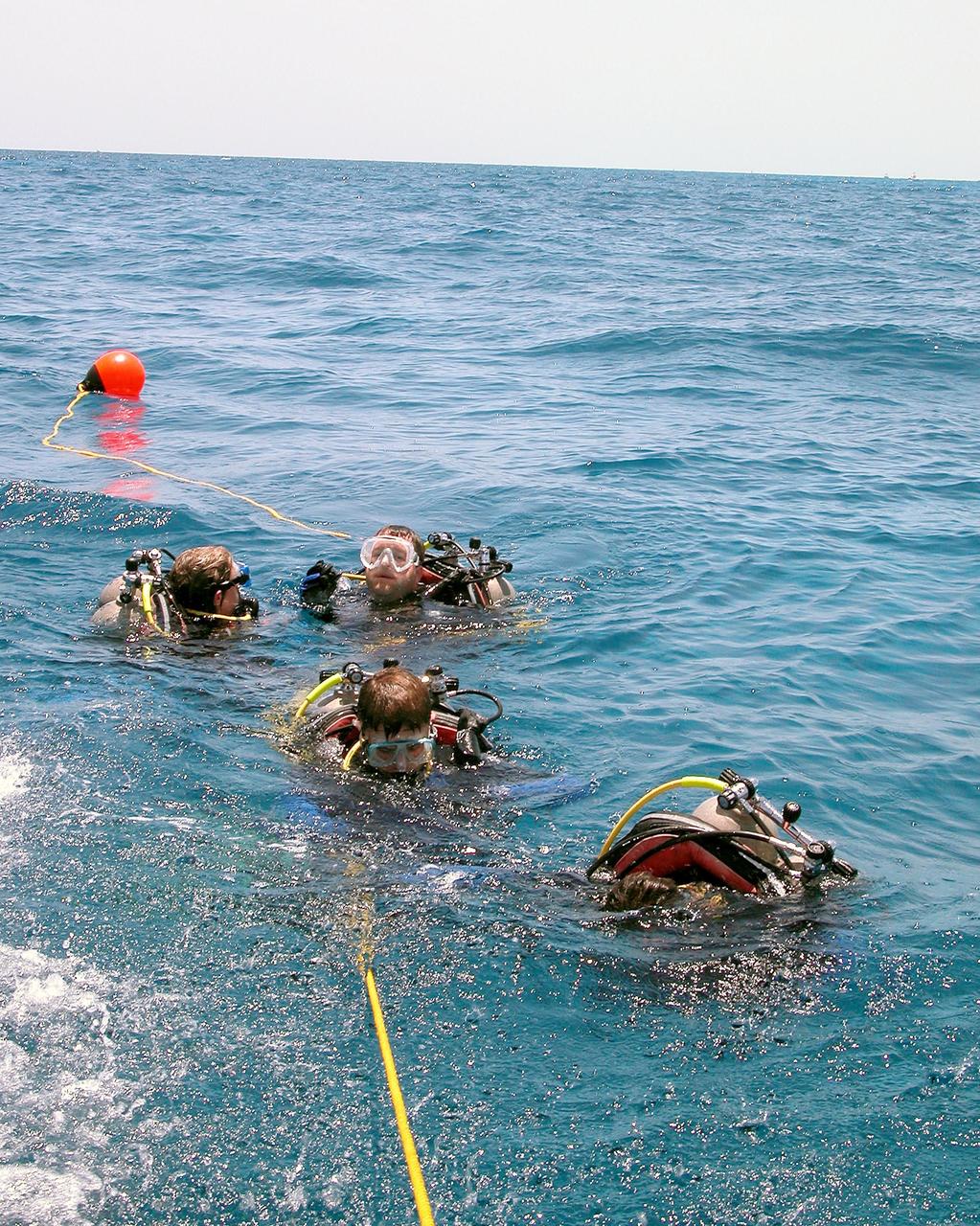
KENNEDY SPACE CENTER, FLA. - In the water for a practice dive in the ocean offshore from Key Largo are the NASA Extreme Environment Mission Operations 6 (NEEMO-6) mission team: (left to right) Tara Ruttley, a biomedical engineer, and astronauts Nick Patrick, John Herrington and Doug Wheelock. The NEEMO-6 mission involves exposing an astronaut/scientist crew to a real mission experience in an extreme environment - the NOAA undersea station Aquarius - to prepare for future space flight. Spacewalk-like diving excursions and field-tests on a variety of biomedical equipment are designed to help astronauts living aboard the International Space Station. To prepare for their 10-day stay, the team had dive training twice a day at the Life Support Buoy, anchored above Aquarius.
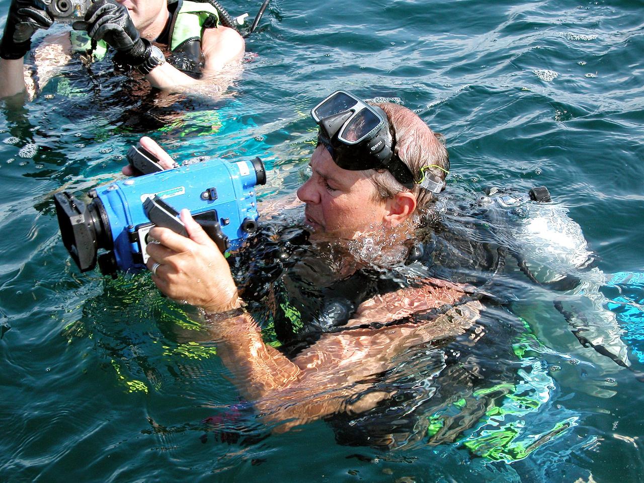
KENNEDY SPACE CENTER, FLA. - In the water offshore from Key Largo, site of the NASA Extreme Environment Mission Operations 6 (NEEMO-6), are (left to right) Bill Todd, project lead, and Marc Reagan, mission lead. Todd and Lucas are also the underwater videographer and still photographer, respectively, for the mission. The NEEMO-6 team comprises John Herrington, commander, Tara Ruttley, a biomedical engineer, and astronauts Nick Patrick and Doug Wheelock. The NEEMO-6 mission involves exposing an astronaut/scientist crew to a real mission experience in an extreme environment - the NOAA undersea station Aquarius - to prepare for future space flight. Spacewalk-like diving excursions and field-tests on a variety of biomedical equipment are designed to help astronauts living aboard the International Space Station. To prepare for their 10-day stay, the team had dive training twice a day at the Life Support Buoy, anchored above Aquarius.
CAPE CANAVERAL, Fla. -- This image taken from the bow of Freedom Star, one of NASA's solid rocket booster retrieval ships, shows crew members in a skiff attaching flotation devices, or buoys, to the parachute lines from the left spent booster from space shuttle Discovery's STS-133 launch. The shuttle’s two solid rocket booster casings and associated flight hardware are recovered in the Atlantic Ocean after every launch by Liberty Star and Freedom Star. The boosters impact the Atlantic about seven minutes after liftoff and the retrieval ships are stationed about 10 miles from the impact area at the time of splashdown. After the spent segments are processed, they will be transported to Utah, where they will be refurbished and stored, if needed. Photo credit: NASA/Ben Smegelsky
KENNEDY SPACE CENTER, FLA. - In the water for a practice dive in the ocean offshore from Key Largo is astronaut John Herrington. He is commander of the NASA Extreme Environment Mission Operations 6 (NEEMO-6) mission team. The others are Nick Patrick, Doug Wheelock, and Tara Ruttley, a biomedical engineer. The NEEMO-6 mission involves exposing an astronaut/scientist crew to a real mission experience in an extreme environment - the NOAA undersea station Aquarius - to prepare for future space flight. Spacewalk-like diving excursions and field-tests on a variety of biomedical equipment are designed to help astronauts living aboard the International Space Station. To prepare for their 10-day stay, the team had dive training twice a day at the Life Support Buoy, anchored above Aquarius.
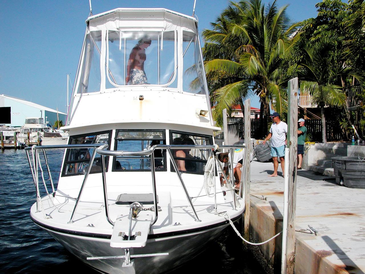
KENNEDY SPACE CENTER, FLA. - The boat with NEEMO-6 personnel ties up at the dock in Key Largo after a training session offshore at NASA’s undersea research station, named Aquarius. At right is Bill Todd, project lead. The NASA Extreme Environment Mission Operations 6 (NEEMO-6) mission involves spacewalk-like diving excursions and field-testing a variety of biomedical equipment designed to help astronauts living aboard the International Space Station. The NEEMO-6 team comprises astronaut John Herrington, mission commander, astronauts Doug Wheelock and Nick Patrick, and biomedical engineer Tara Ruttley. To prepare for their 10-day stay, the team had dive training twice a day at the Life Support Buoy, anchored above Aquarius.
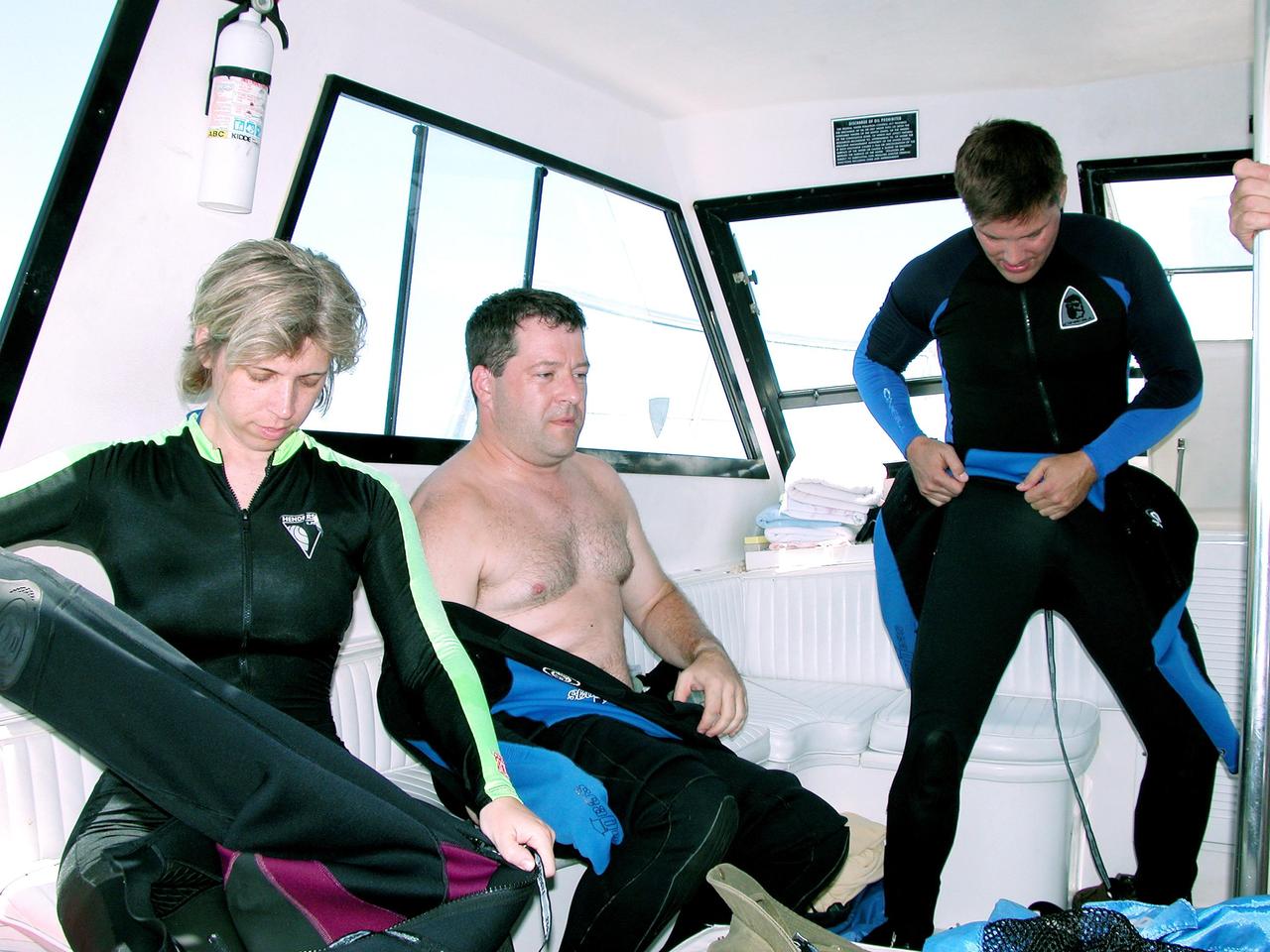
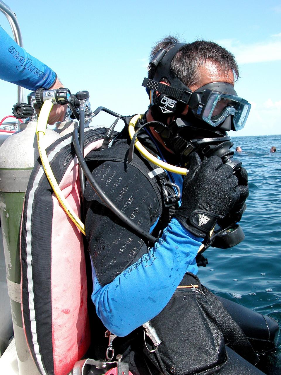
KENNEDY SPACE CENTER, FLA. - Onboard the dive boat, members of the NASA Extreme Environment Mission Operations 6 (NEEMO-6) mission don dive suits. From left are Tara Ruttley, a biomedical engineer, and astronauts Nick Patrick and Doug Wheelock. John Herrington is mission commander. The NEEMO-6 mission involves exposing an astronaut/scientist crew to a real mission experience in an extreme environment - the NOAA undersea station Aquarius offshore from Key Largo - to prepare for future space flight. Spacewalk-like diving excursions and field-tests on a variety of biomedical equipment are designed to help astronauts living aboard the International Space Station. To prepare for their 10-day stay, the team had dive training twice a day at the Life Support Buoy, anchored above Aquarius.
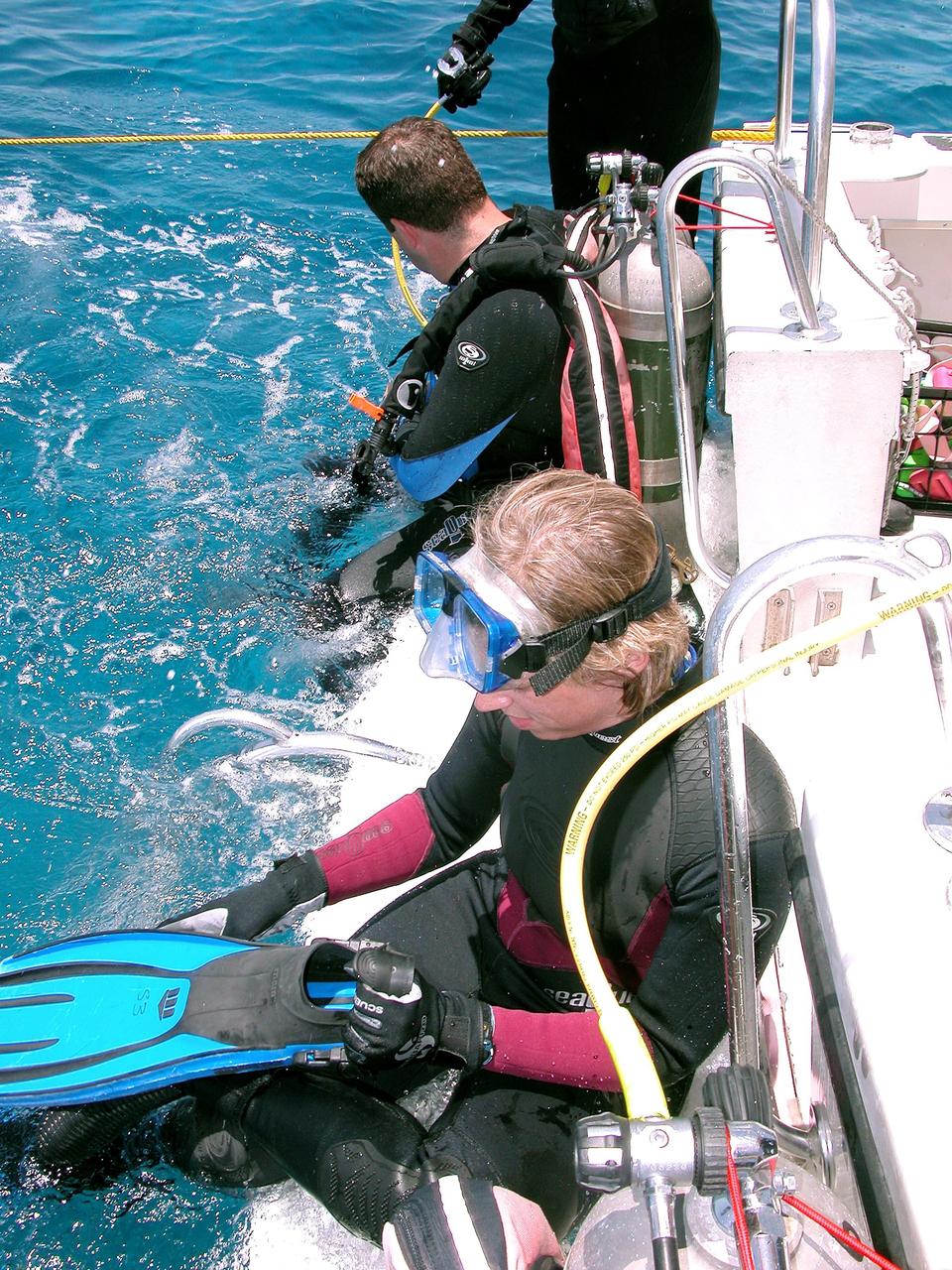
KENNEDY SPACE CENTER, FLA. - Getting ready to enter the water on a practice dive in the ocean offshore from Key Largo are Tara Ruttley (below) and Nick Patrick (above). The two are members of the NASA Extreme Environment Mission Operations 6 (NEEMO-6) mission team. Ruttley is a biomedical engineer. The others are astronauts John Herrington, mission commander, and Doug Wheelock. The NEEMO-6 mission involves exposing an astronaut/scientist crew to a real mission experience in an extreme environment - the NOAA undersea station Aquarius - to prepare for future space flight. Spacewalk-like diving excursions and field-tests on a variety of biomedical equipment are designed to help astronauts living aboard the International Space Station. To prepare for their 10-day stay, the team had dive training twice a day at the Life Support Buoy, anchored above Aquarius.
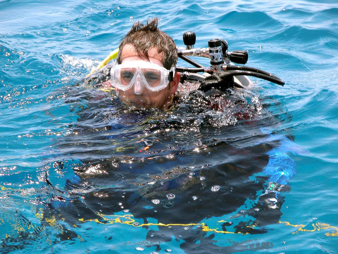
KENNEDY SPACE CENTER, FLA. - In the water for a practice dive in the ocean offshore from Key Largo is astronaut John Herrington. He is commander of the NASA Extreme Environment Mission Operations 6 (NEEMO-6) mission team. The others are Nick Patrick, Doug Wheelock, and Tara Ruttley, a biomedical engineer. The NEEMO-6 mission involves exposing an astronaut/scientist crew to a real mission experience in an extreme environment - the NOAA undersea station Aquarius - to prepare for future space flight. Spacewalk-like diving excursions and field-tests on a variety of biomedical equipment are designed to help astronauts living aboard the International Space Station. To prepare for their 10-day stay, the team had dive training twice a day at the Life Support Buoy, anchored above Aquarius.
KENNEDY SPACE CENTER, FLA. - Disembarking from the boat in Key Largo are Otto Rutten and Marc Reagan, participating in the NASA Extreme Environment Mission Operations 6 (NEEMO-6) mission at the NOAA Aquarius underwater station offshore. Rutten is director for the National Underwater Research Center; Reagan is mission lead. The NEEMO-6 mission involves exposing an astronaut/scientist crew to a real mission experience in an extreme environment to prepare for future space flight. Spacewalk-like diving excursions and field-tests on a variety of biomedical equipment are designed to help astronauts living aboard the International Space Station. The NEEMO-6 team comprises astronaut John Herrington, mission commander, astronauts Doug Wheelock and Nick Patrick, and biomedical engineer Tara Ruttley. To prepare for their 10-day stay, the team had dive training twice a day at the Life Support Buoy, anchored above Aquarius.
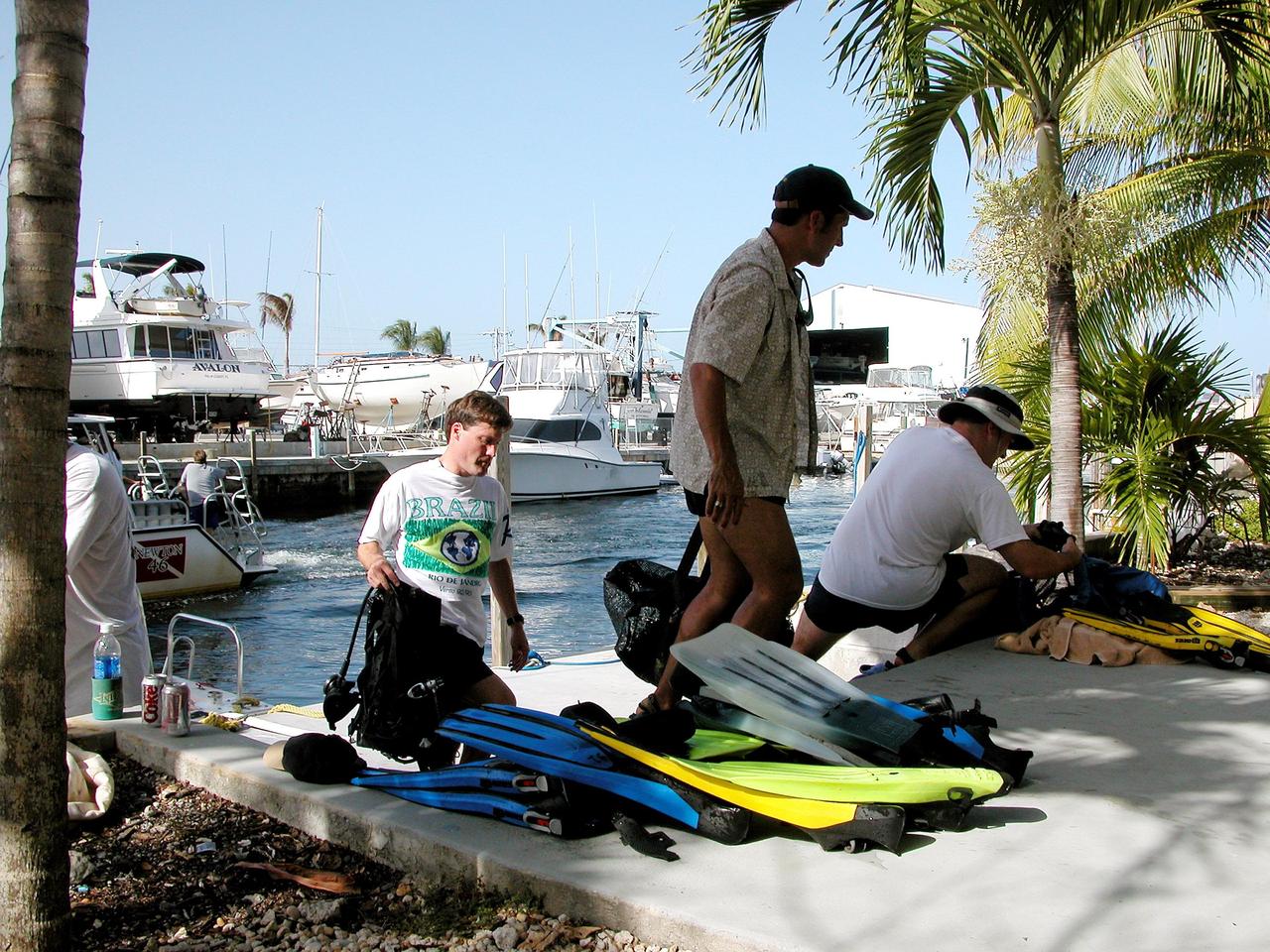
KENNEDY SPACE CENTER, FLA. - After their return from a practice dive at the NOAA Aquarius underwater station offshore at Key Largo, Marc Reagan, John Herrington and Nick Patrick unload dive gear. Herrington is mission commander and Patrick is a member of the crew on the NASA Extreme Environment Mission Operations 6 (NEEMO-6) mission. Reagan is mission lead as well as underwater still photographer. The NEEMO-6 mission involves exposing an astronaut/scientist crew to a real mission experience in an extreme environment - the NOAA undersea station Aquarius offshore from Key Largo - to prepare for future space flight. Spacewalk-like diving excursions and field-tests on a variety of biomedical equipment are designed to help astronauts living aboard the International Space Station. Other team members are Doug Wheelock and biomedical engineer Tara Ruttley. To prepare for their 10-day stay, the team had dive training twice a day at the Life Support Buoy, anchored above Aquarius.
KENNEDY SPACE CENTER, FLA. - Ready for another dive to the NOAA undersea station Aquarius, offshore from Key Largo, the site of the NASA Extreme Environment Mission Operations 6 (NEEMO-6), are (left to right) Monike Schultz, CB Office lead; Bill Todd, project lead; Marc Reagan, mission lead; and Michele Lucas, OPS planner. Todd and Lucas are also the underwater videographer and still photographer, respectively, for the mission. The NEEMO-6 team comprises John Herrington, commander, Tara Ruttley, a biomedical engineer, and astronauts Nick Patrick and Doug Wheelock. The NEEMO-6 mission involves exposing an astronaut/scientist crew to a real mission experience in an extreme environment - Aquarius - to prepare for future space flight. Spacewalk-like diving excursions and field-tests on a variety of biomedical equipment are designed to help astronauts living aboard the International Space Station. To prepare for their 10-day stay, the team had dive training twice a day at the Life Support Buoy, anchored above Aquarius.
Scientific instruments are seen on the stern of the Woods Hole Oceanographic Institution's research vessel Knorr on Tuesday, Sept. 4, 2012, in Woods Hole, Mass. Knorr is scheduled to depart on Sept. 6 to take part in the Salinity Processes in the Upper Ocean Regional Study (SPURS). The NASA-sponsored expedition will sail to the North Atlantic's saltiest spot to get a detailed, 3-D picture of how salt content fluctuates in the ocean's upper layers and how these variations are related to shifts in rainfall patterns around the planet. Photo Credit: (NASA/Bill Ingalls)
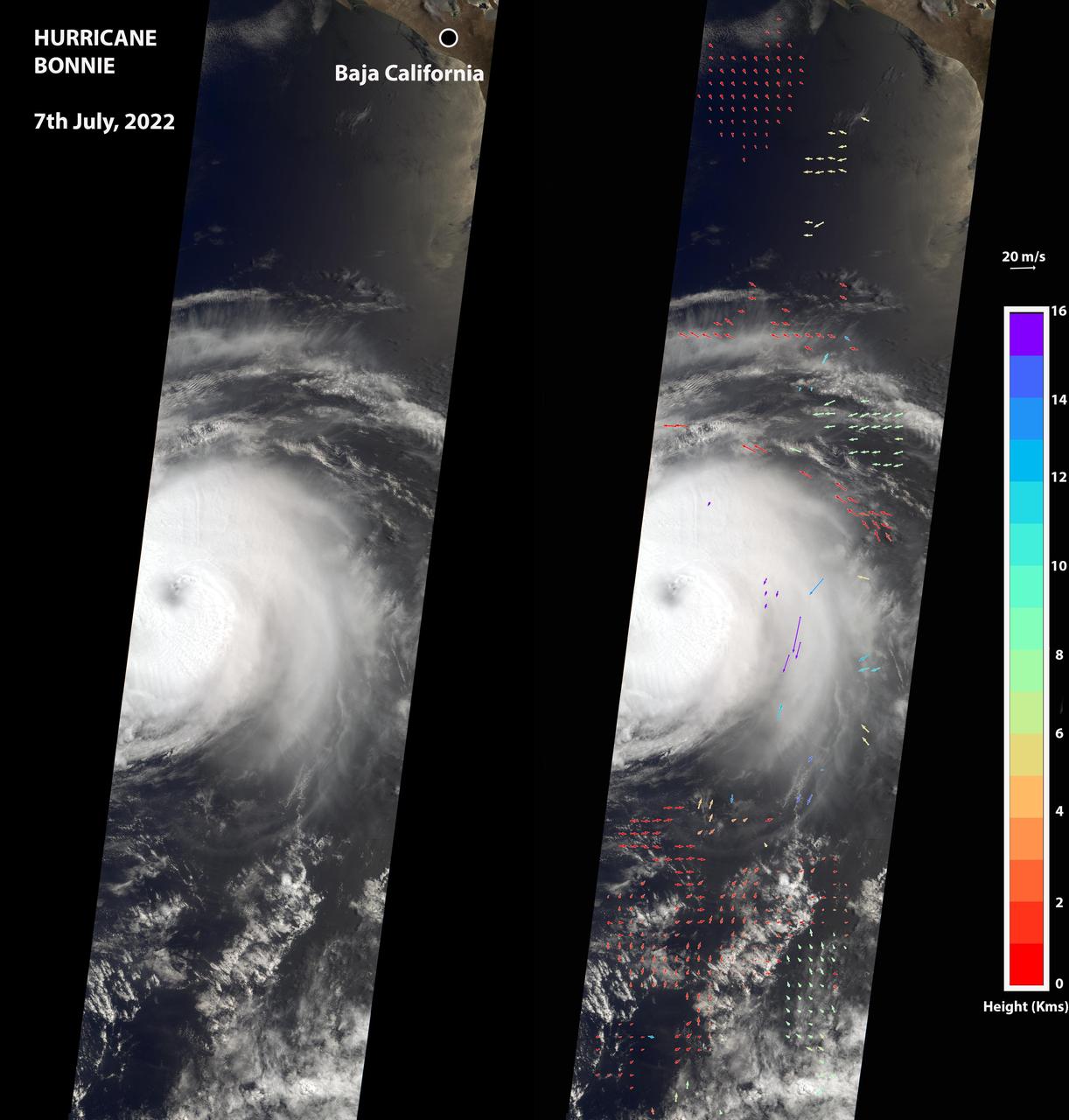
The Multi-angle Imaging SpectroRadiometer (MISR) instrument aboard NASA's Terra satellite captured this image of the eye of Hurricane Bonnie, located about 500 miles (800 kilometers) southwest of the southern tip of Baja California, Mexico, at about 11 a.m. local time on July 7, 2022. Initially classified as a tropical storm on July 2, Bonnie intensified to a Category 3 hurricane on July 5. It was later downgraded, and as of July 8, was considered a tropical storm. MISR carries nine cameras pointed at Earth at different angles and each camera viewed Bonnie over a period of seven minutes. The motion of the hurricane between those views provides information on wind speed and direction at the height of the clouds. The panel on the left shows the image from MISR's downward-pointing camera. The colored arrows in the panel on the right, superimposed on the same image as the left panel, show wind speed and direction. The length of the arrows is proportional to wind speed, and their color shows the altitude of the cloud tops in kilometers. MISR observed winds blowing counterclockwise at about 34 mph (55 kph) at altitudes of 6,500 to 33,000 feet (2 to 10 kilometers), consistent with maximal wind gusts reported by the National Hurricane Center based on data from local weather stations and buoys. At altitudes of about 36,000 to 52,000 feet (11 to 16 kilometers), MISR observed winds blowing clockwise at up to 123 mph (198 kph). The eye, spiral rainbands, and reversal of wind direction between low and high altitudes are typical features of a hurricane. https://photojournal.jpl.nasa.gov/catalog/PIA24906
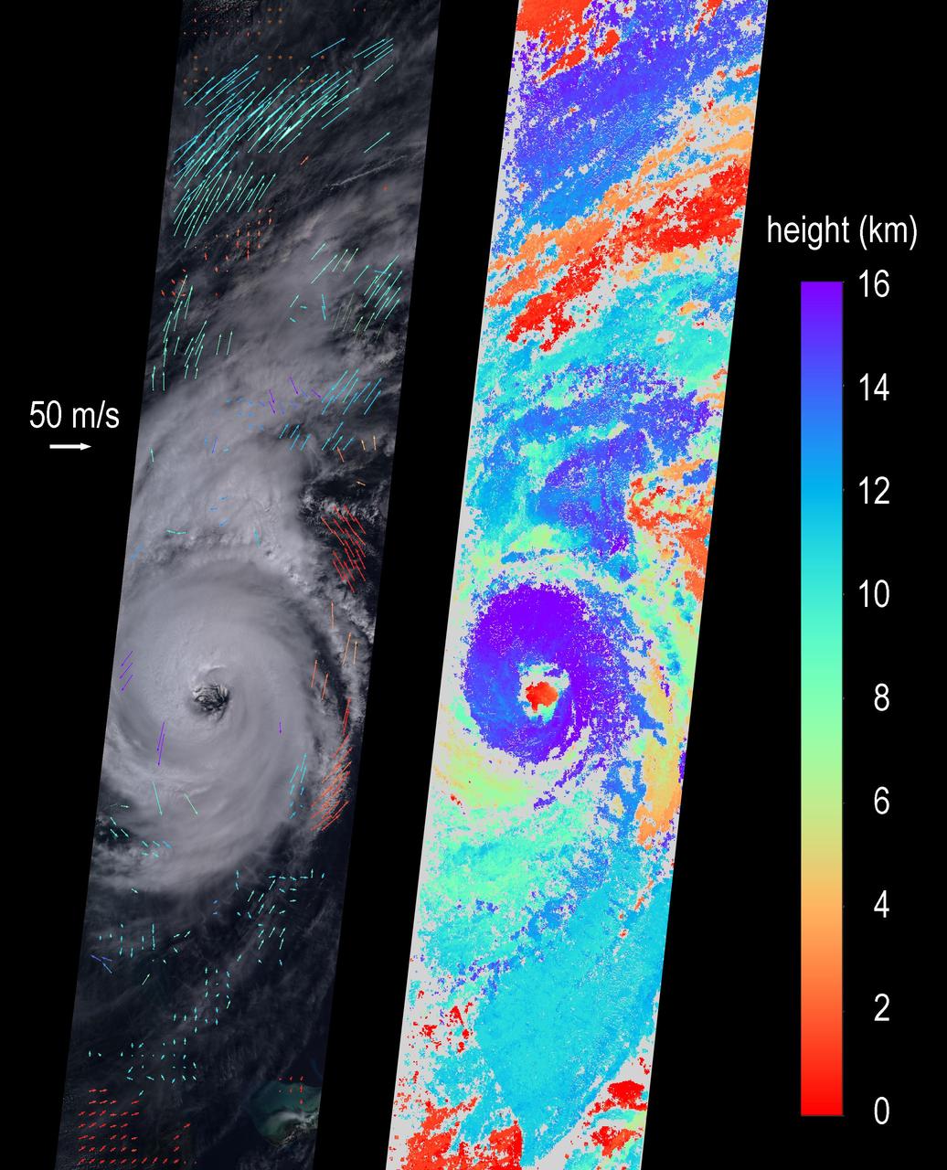
On Sept. 5, 2019 at about noon EDT, the Multi-angle Imaging SpectroRadiometer (MISR) instrument aboard NASA's Terra satellite passed over the eye of Hurricane Dorian as the storm tracked northeast along the Atlantic coast, about 50 miles from Charleston, South Carolina. During this time, Dorian was weakening from Category 3 to Category 2 following a second period of intensification. MISR carries nine cameras fixed at different angles, each of which viewed Dorian over a period of about seven minutes. The multi-camera views are used to calculate the heights of the cloud tops, and the motion of the clouds between the views provides information on wind speed and direction. The left side of the image shows the view from the downward-pointing (nadir) camera, with wind velocity vectors superimposed over it. The derived cloud-top heights are shown at the right, along with the color scale. The length of the wind arrows is proportional to wind speed and their colors show the altitude of the cloud tops in kilometers. MISR observed cyclonic (counterclockwise) wind speeds up to 35 meters per second (78 miles per hour) at altitudes of 3-4 kilometers (1.9 to 2.5 miles), consistent with maximal wind gusts reported by the National Hurricane Center based on data from local weather stations and buoys. At higher altitudes of 11-12 kms (6.8-7.5 miles), MISR observed anti-cyclonic (clockwise) wind speeds up to 55 meters per second (123 mph). The eye, spiral rainbands, and reversal of wind direction between low and high altitudes are typical features of a hurricane's anatomy. https://photojournal.jpl.nasa.gov/catalog/PIA23423
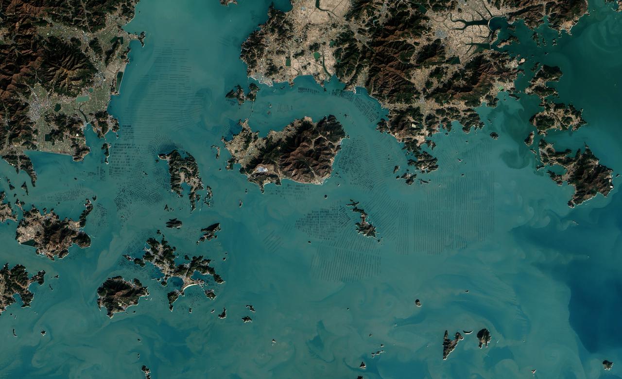
The dark squares that make up the checkerboard pattern in this image are fields of a sort—fields of seaweed. Along the south coast of South Korea, seaweed is often grown on ropes, which are held near the surface with buoys. This technique ensures that the seaweed stays close enough to the surface to get enough light during high tide but doesn’t scrape against the bottom during low tide. The Operational Land Imager (OLI) on Landsat 8 acquired this image of seaweed cultivation in the shallow waters around Sisan Island on January 31, 2014. Home to a thriving aquaculture industry, the south coast of South Korea produces about 90 percent of the country’s seaweed crop. The waters around Sisan are not the only place where aquaculture is common. View the large image to see how ubiquitous seaweed aquaculture is along the coast in Jeollanam-do, the southernmost province on the Korean peninsula. Two main types of seaweed are cultivated in South Korea: Undaria (known as miyeok in Korean, wakame in Japanese) and Pyropia (gim in Korean, nori in Japanese). Both types are used generously in traditional Korean, Japanese, and Chinese food. Since 1970, farmed seaweed production has increased by approximately 8 percent per year. Today, about 90 percent of all the seaweed that humans consume globally is farmed. That may be good for the environment. In comparison to other types of food production, seaweed farming has a light environmental footprint because it does not require fresh water or fertilizer. NASA Earth Observatory image by Jesse Allen, using Landsat data from the U.S. Geological Survey. Caption by Adam Voiland. Credit: <b><a href="http://www.earthobservatory.nasa.gov/" rel="nofollow"> NASA Earth Observatory</a></b> <b><a href="http://www.nasa.gov/audience/formedia/features/MP_Photo_Guidelines.html" rel="nofollow">NASA image use policy.</a></b> <b><a href="http://www.nasa.gov/centers/goddard/home/index.html" rel="nofollow">NASA Goddard Space Flight Center</a></b> enables NASA’s mission through four scientific endeavors: Earth Science, Heliophysics, Solar System Exploration, and Astrophysics. Goddard plays a leading role in NASA’s accomplishments by contributing compelling scientific knowledge to advance the Agency’s mission. <b>Follow us on <a href="http://twitter.com/NASAGoddardPix" rel="nofollow">Twitter</a></b> <b>Like us on <a href="http://www.facebook.com/pages/Greenbelt-MD/NASA-Goddard/395013845897?ref=tsd" rel="nofollow">Facebook</a></b> <b>Find us on <a href="http://instagrid.me/nasagoddard/?vm=grid" rel="nofollow">Instagram</a></b>
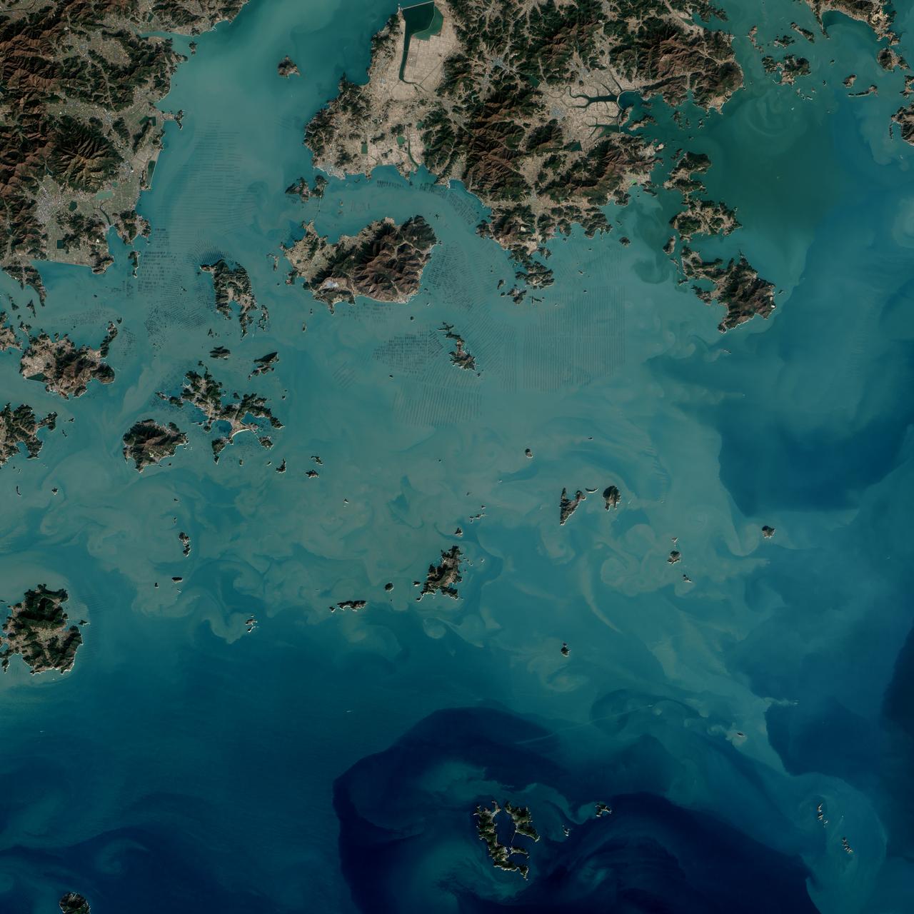
The dark squares that make up the checkerboard pattern in this image are fields of a sort—fields of seaweed. Along the south coast of South Korea, seaweed is often grown on ropes, which are held near the surface with buoys. This technique ensures that the seaweed stays close enough to the surface to get enough light during high tide but doesn’t scrape against the bottom during low tide. The Operational Land Imager (OLI) on Landsat 8 acquired this image of seaweed cultivation in the shallow waters around Sisan Island on January 31, 2014. Home to a thriving aquaculture industry, the south coast of South Korea produces about 90 percent of the country’s seaweed crop. The waters around Sisan are not the only place where aquaculture is common. View the large image to see how ubiquitous seaweed aquaculture is along the coast in Jeollanam-do, the southernmost province on the Korean peninsula. Two main types of seaweed are cultivated in South Korea: Undaria (known as miyeok in Korean, wakame in Japanese) and Pyropia (gim in Korean, nori in Japanese). Both types are used generously in traditional Korean, Japanese, and Chinese food. Since 1970, farmed seaweed production has increased by approximately 8 percent per year. Today, about 90 percent of all the seaweed that humans consume globally is farmed. That may be good for the environment. In comparison to other types of food production, seaweed farming has a light environmental footprint because it does not require fresh water or fertilizer. NASA Earth Observatory image by Jesse Allen, using Landsat data from the U.S. Geological Survey. Caption by Adam Voiland. Credit: <b><a href="http://www.earthobservatory.nasa.gov/" rel="nofollow"> NASA Earth Observatory</a></b> <b><a href="http://www.nasa.gov/audience/formedia/features/MP_Photo_Guidelines.html" rel="nofollow">NASA image use policy.</a></b> <b><a href="http://www.nasa.gov/centers/goddard/home/index.html" rel="nofollow">NASA Goddard Space Flight Center</a></b> enables NASA’s mission through four scientific endeavors: Earth Science, Heliophysics, Solar System Exploration, and Astrophysics. Goddard plays a leading role in NASA’s accomplishments by contributing compelling scientific knowledge to advance the Agency’s mission. <b>Follow us on <a href="http://twitter.com/NASAGoddardPix" rel="nofollow">Twitter</a></b> <b>Like us on <a href="http://www.facebook.com/pages/Greenbelt-MD/NASA-Goddard/395013845897?ref=tsd" rel="nofollow">Facebook</a></b> <b>Find us on <a href="http://instagrid.me/nasagoddard/?vm=grid" rel="nofollow">Instagram</a></b>