
Dr. Wernher von Braun served as Marshall Space Flight Center's first director from July 1, 1960 until January 27, 1970, when he was appointed NASA Deputy Associate Administrator for Planning. Following World War II, Dr. von Braun and his German colleagues arrived in the United States under Project Paper Clip to continue their rocket development work. In 1950, von Braun and his rocket team were transferred from Ft. Bliss, Texas to Huntsville, Alabama to work for the Army's rocket program at Redstone Arsenal and later, NASA's Marshall Space Flight Center. Under von Braun's leadership, Marshall developed the Saturn V launch vehicle which took Apollo astronauts to the moon. Dr. von Braun died in Alexandria, Va., on June 16, 1977, seven years after his NASA appointment. This photo was taken at the site where he was laid to rest.
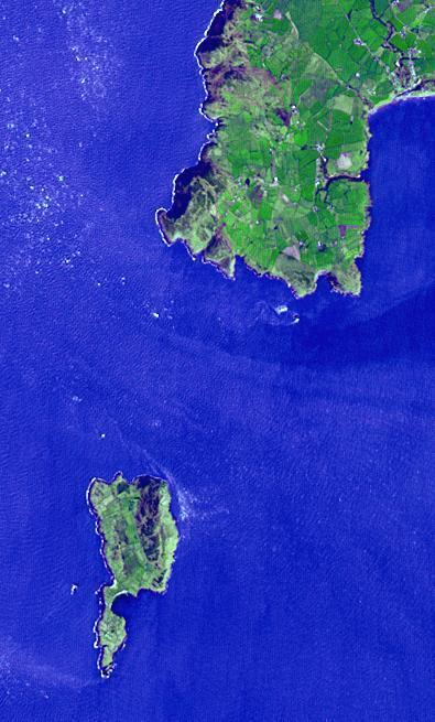
Lying 3 km off the Llyn peninsula of Wales, the Bardsey Island is known as the Island of 20,000 saints. While today's permanent population numbers only four, the island was once an important religious site, with a 6th century monastery. It is the legendary burial site of King Arthur. Another legend holds that anyone who died on the island would not go to hell. The image was acquired April 4, 2006, covers an area of 6 by 10 km, and is located at 52.7 degrees north, 4.8 degrees west. http://photojournal.jpl.nasa.gov/catalog/PIA21182
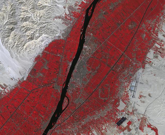
Luxor is a city in Upper Egypt, along the Nile. It is the site of the ancient Egyptian city of Waset, known to the Greeks as Thebes. Luxor is one of the world's greatest open-air museums, with the ruins of the temple complexes of Karnak and Luxor. Immediately across the Nile is the Valley of the Kings, burial place of dozens of Egypt's pharaohs, including King Tutankhamun. The image was acquired October 18, 2017, covers an area of 15.9 by 19.3 kilometers, and is located at 25.7 degrees north, 32.6 degrees east. https://photojournal.jpl.nasa.gov/catalog/PIA23060
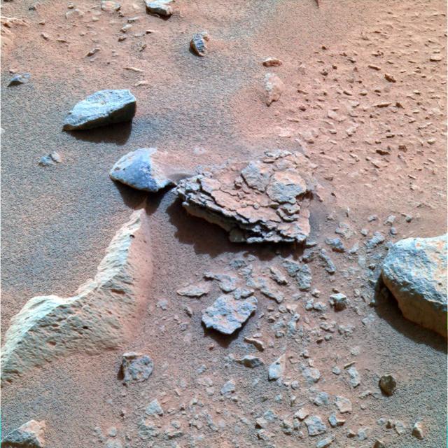
This color image taken by the Mars Exploration Rover Spirit's panoramic camera on Sol 40 is centered on an unusually flaky rock called Mimi. Mimi is only one of many features in the area known as "Stone Council," but looks very different from any rock that scientists have seen at the Gusev crater site so far. Mimi's flaky appearance leads scientists to a number of hypotheses. Mimi could have been subjected to pressure either through burial or impact, or may have once been a dune that was cemented into flaky layers, a process that sometimes involves the action of water. http://photojournal.jpl.nasa.gov/catalog/PIA05283
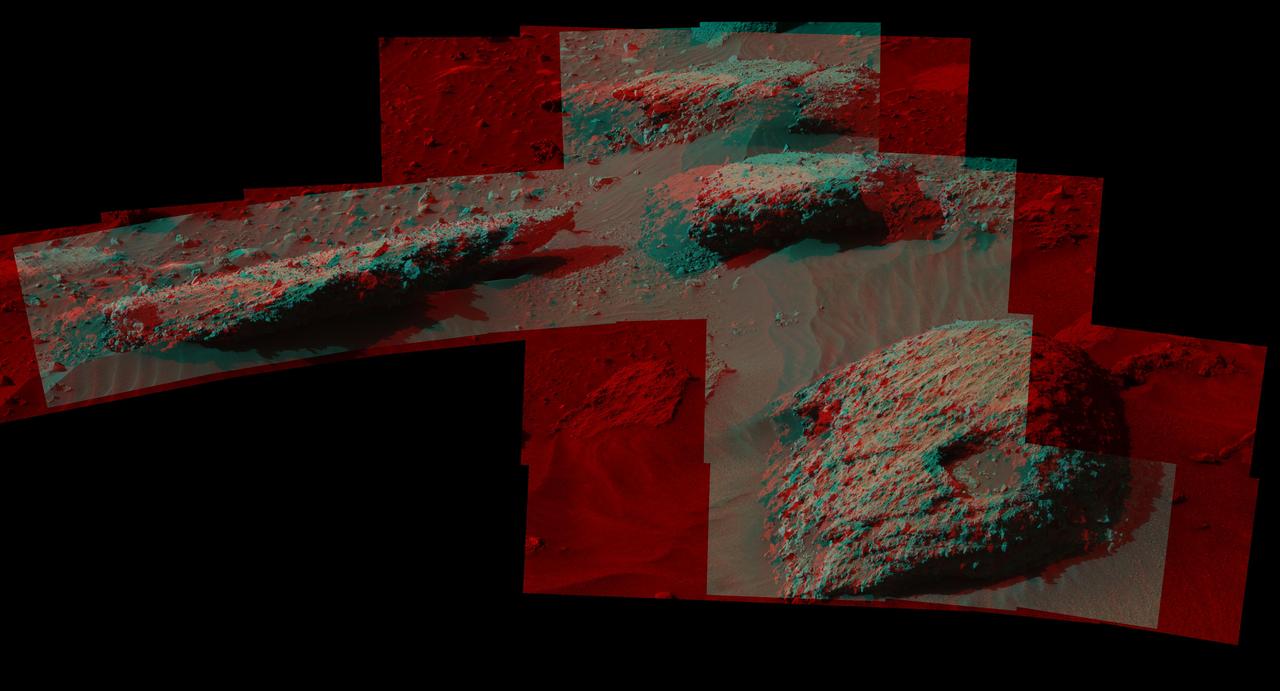
This stereo scene from the Mast Camera (Mastcam) on NASA's Curiosity Mars Rover shows boulders composed, in part, of pebble-size (0.2 to 2.6 inches, or 0.5 to 6.5 centimeters across) and larger rock fragments. The size and shape of the fragments provide clues to the origins of these boulders. This image is an anaglyph that appears three dimensional when viewed through red-blue glasses with the red lens on the left. The separate right-eye and left-eye views combined into the stereo version are Figure 1 and Figure 2. Mastcam's right-eye camera has a telephoto lens, with focal length of 100 millimeters. The left-eye camera provides a wider view, with a 34-millimeter lens. These images were taken on July 22, 2016, during the 1,408th Martian day, or sol, of Curiosity's work on Mars. For scale, the relatively flat rock at left is about 5 feet (1.5 meters) across. The rock in the foreground at right is informally named "Balombo." The group of boulders is at a site called "Bimbe." The Curiosity team chose to drive the rover to Bimbe to further understand patches of boulders first identified from orbit and seen occasionally on the rover's traverse. The boulders at Bimbe consist of multiple rock types. Some include pieces, or "clasts," of smaller, older rock cemented together, called breccias or conglomerates. The shapes of the inclusion clasts -- whether they are rounded or sharp-edged -- may indicate how far the clasts were transported, and by what processes. Breccias have more angular clasts, while conglomerates have more rounded clasts. As is clear by looking at these boulders, they contain both angular and rounded clasts, leading to some uncertainty about how they formed. Conglomerate rocks such as "Hottah" were inspected near Curiosity's landing site and interpreted as part of an ancient streambed. Breccias are generally formed by consolidation of fragments under pressure. On Mars such pressure might come from crater-forming impact, or by deep burial and exhumation. http://photojournal.jpl.nasa.gov/catalog/PIA20836
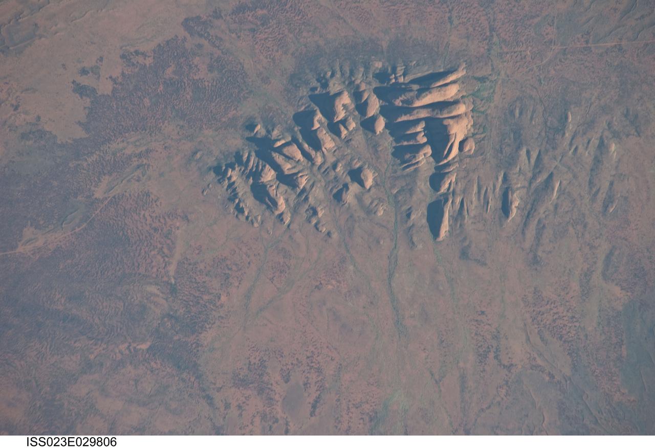
ISS023-E-029806 (30 April 2010) --- Kata Tjuta, Australia is featured in this image photographed by an Expedition 23 crew member on the International Space Station. Located in the Northern Territory of Australia, Uluru – Kata Tjuta National Park hosts some of the world’s most spectacular examples of inselbergs, or isolated mountains. The most famous of these inselbergs is Uluru (also known as Ayers Rock). An equally massive inselberg located approximately 30 kilometers to the northwest is known as Kata Tjuta– like Uluru, this is a sacred site to the native Anangu or Aboriginal people. Explorers named the highest peak Mount Olga, with the entire grouping of rocks informally known as “the Olgas”. Mount Olga has a peak elevation of 1,069 meters above sea level, making it 206 meters higher than Uluru. Kata Tjuta is comprised of gently dipping Mount Currie Conglomerate, a sedimentary rock that includes abundant rounded fragments of other rock types (here, primarily granite with less abundant basalt and rhyolite) in a coarse sandy matrix. Geologists interpret the Mount Currie Conglomerate as a remnant of a large fan of material rapidly eroded from mountains uplifted approximately 550 million years ago. Subsequent burial under younger sediments consolidated the eroded materials to form the conglomerate exposed at the surface today. In this photograph, afternoon sunlight highlights the rounded summits of Kata Tjuta against the surrounding sandy plains. Sand dunes are visible at upper right; while in other areas (image top and image left) sediments washed from the rocks have been anchored by a variety of grasses and bushes adapted to the arid climate. Green vegetation in the ephemeral stream channels that drain Kata Tjuta (bottom center) provides colorful contrast with the red rocks and surrounding soils. Large gaps in the rocks (highlighted by shadows) are thought to be fractures that have been enlarged due to erosion.