Burning Inside
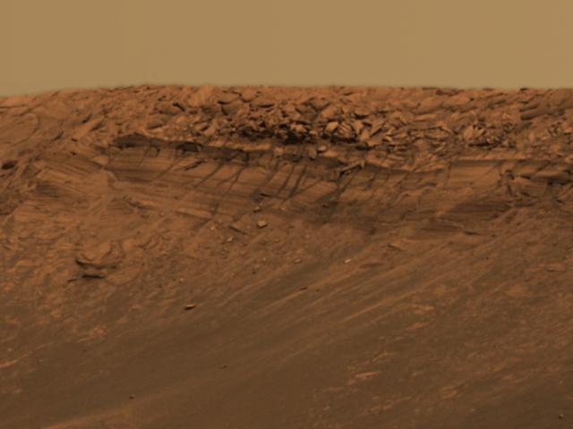
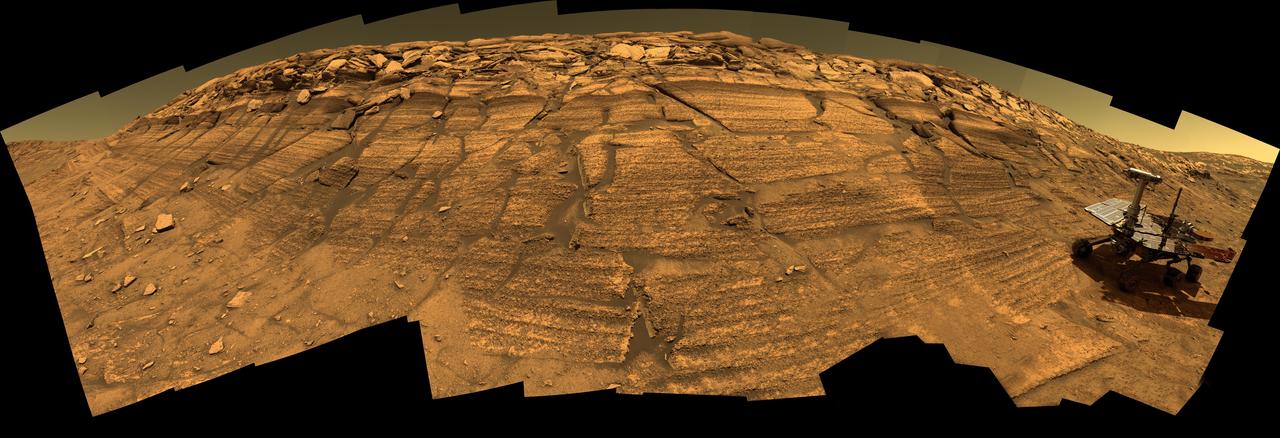
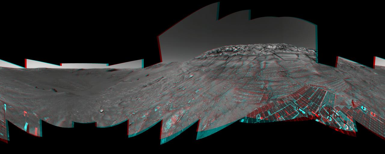
Burns Cliff Beckons
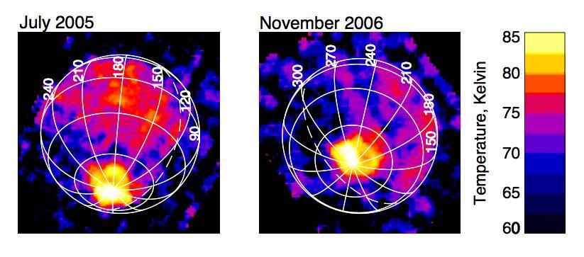
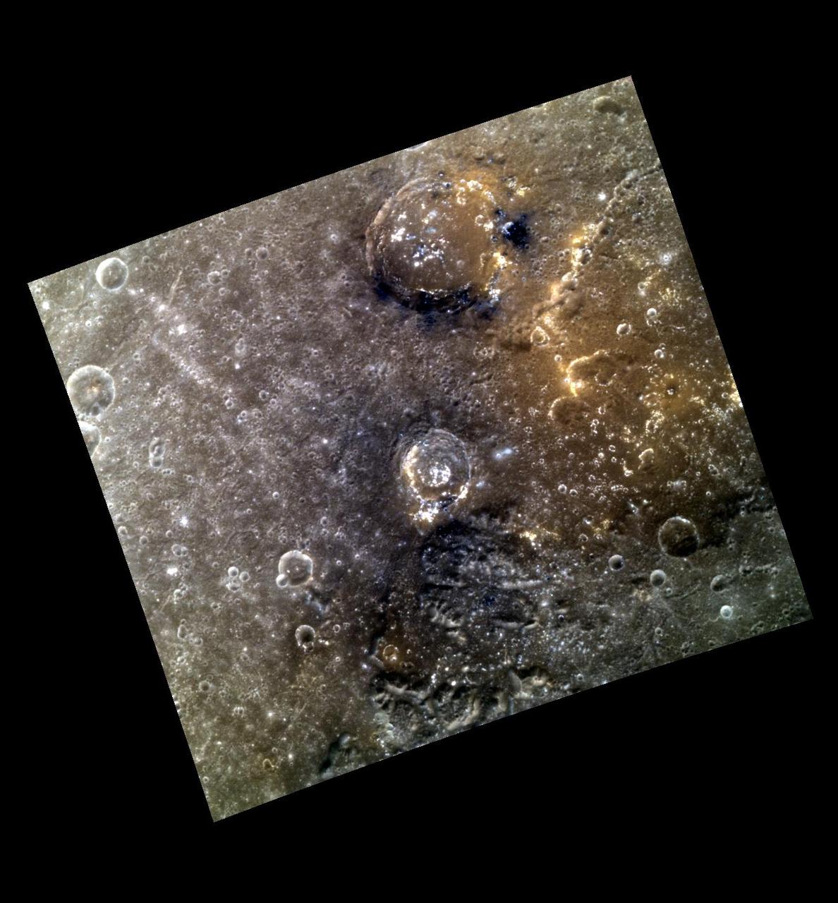
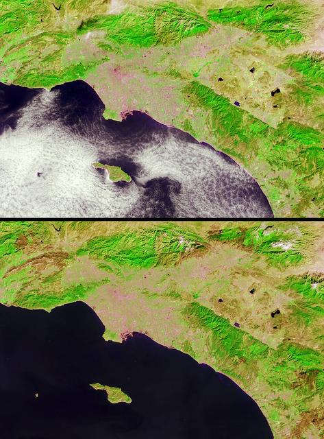
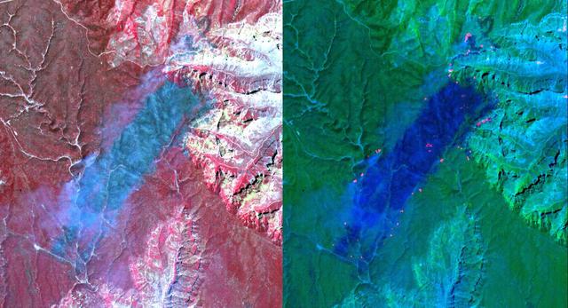
Enceladus Keeps the Home Fires Burning
Synthetic image of the Opportunity Mars Exploration Rover inside on Burns Cliff produced using Virtual Presence in Space technology.

jsc2026e019618 (April 2, 2026) – The Artemis II flight control team pictured at the White Flight Control Room in the Mission Control Center at NASA’s Johnson Space Center monitors mission operations during the translunar injection (TLI) burn, which sent the crew in Orion out of Earth orbit and on a trajectory toward the Moon. After the mission management team polled “Go” for the operation, NASA’s Orion spacecraft fired its main engine for five minutes and 50 seconds beginning at 7:49 p.m. ET, to successfully complete the TLI burn.
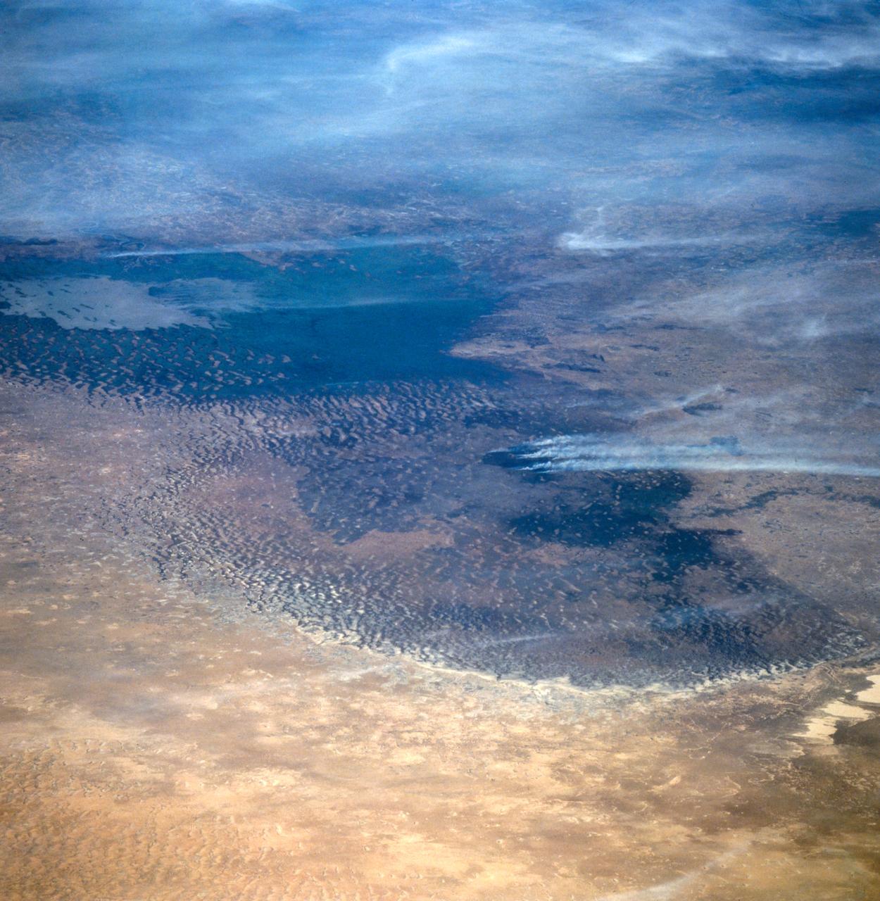
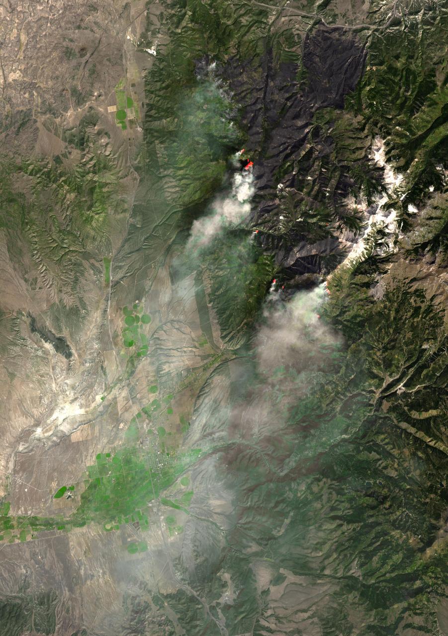
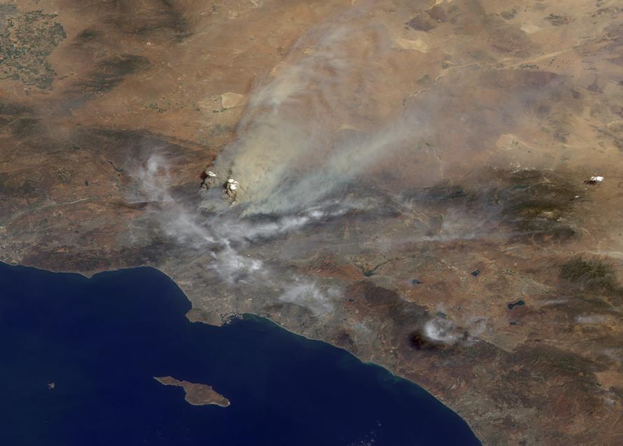
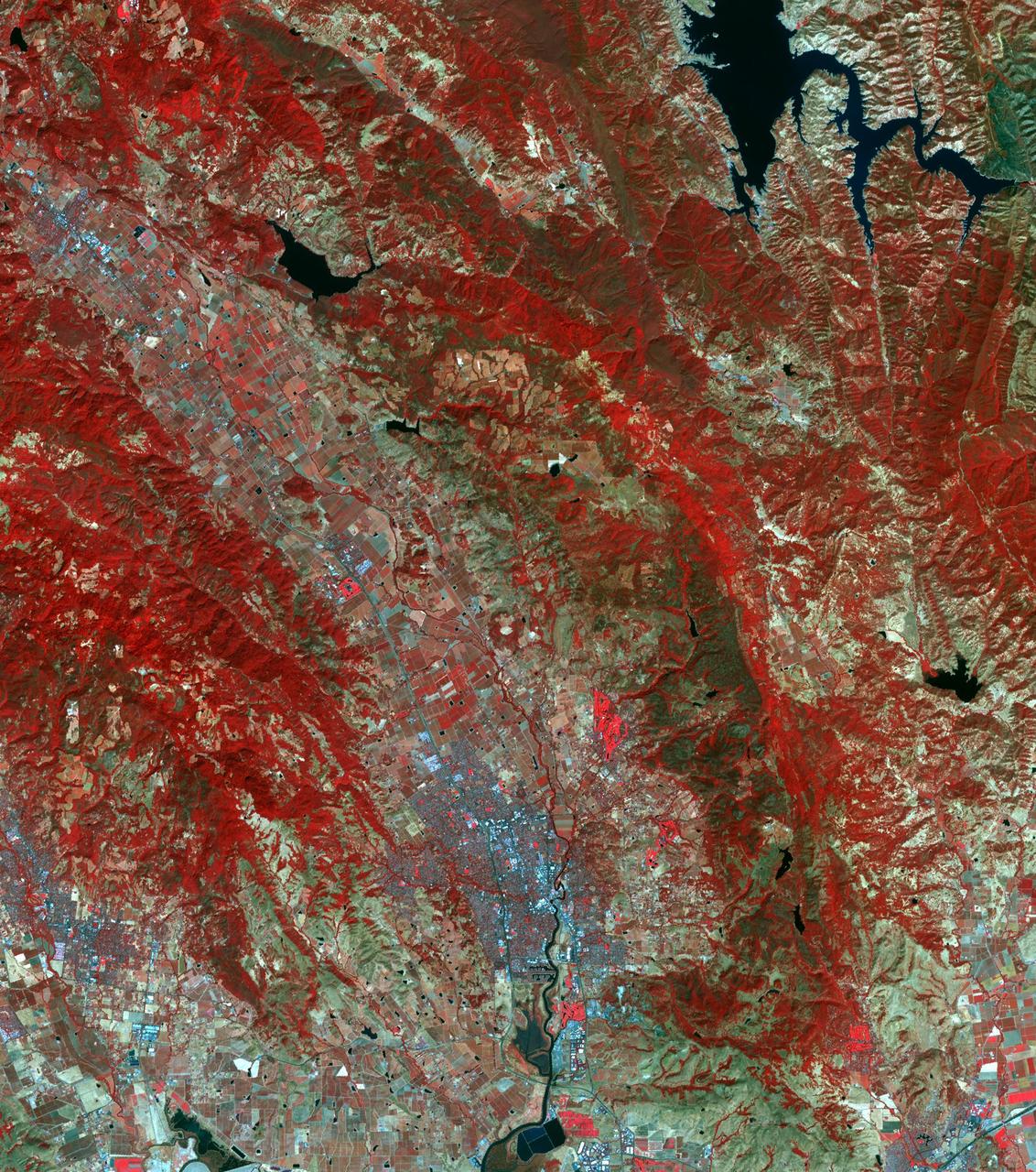
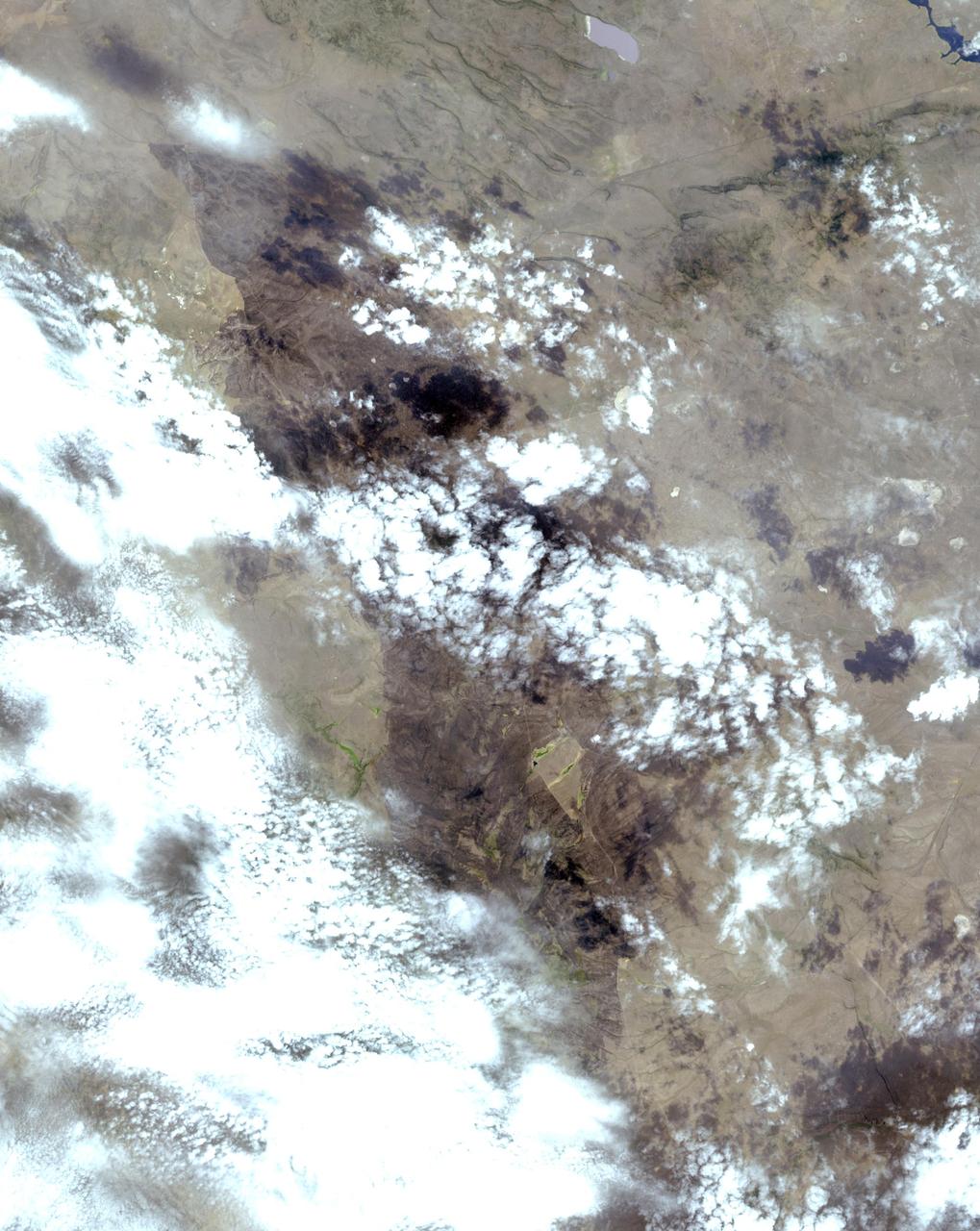
NASA image acquired September 12, 2011 To view more images from this event go to: <a href="http://earthobservatory.nasa.gov/NaturalHazards/event.php?id=52029" rel="nofollow">earthobservatory.nasa.gov/NaturalHazards/event.php?id=52029</a> The Bastrop County Complex Fire in southern Texas started on September 4, 2011. By September 13, 2011, the fire was 70 percent contained, but had scorched 34,068 acres (13,787 hectares). The Advanced Land Imager (ALI) on NASA’s Earth Observing-1 (EO-1) satellite captured this image of the affected region on September 12, 2011. This false-color image shows a wide-area view of the fire. Vegetation is bright green, and sparsely vegetated or bare land is green-yellow. The burn scar appears in shades of red and orange. The burn scar is far from uniform; burned areas are separated by unburned expanses. As of September 13, a re-entry plan had been established for residents of the region, the Incident Information System reported. Residents were warned, however, that they might see vegetation still smoldering or burning. Ongoing drought set the stage for severe fires in Texas in the slate summer of 2011. In early September, Tropical Storm Lee, which drenched other parts of the United States, brought strong winds to Texas, worsening the fires. NASA Earth Observatory image created by Jesse Allen and Robert Simmon, using EO-1 ALI data provided courtesy of the NASA EO-1 team. Caption by Michon Scott. Instrument: EO-1 - ALI Credit: <b><a href="http://www.earthobservatory.nasa.gov/" rel="nofollow"> NASA Earth Observatory</a></b> <b><a href="http://www.nasa.gov/audience/formedia/features/MP_Photo_Guidelines.html" rel="nofollow">NASA image use policy.</a></b> <b><a href="http://www.nasa.gov/centers/goddard/home/index.html" rel="nofollow">NASA Goddard Space Flight Center</a></b> enables NASA’s mission through four scientific endeavors: Earth Science, Heliophysics, Solar System Exploration, and Astrophysics. Goddard plays a leading role in NASA’s accomplishments by contributing compelling scientific knowledge to advance the Agency’s mission. <b>Follow us on <a href="http://twitter.com/NASA_GoddardPix" rel="nofollow">Twitter</a></b> <b>Like us on <a href="http://www.facebook.com/pages/Greenbelt-MD/NASA-Goddard/395013845897?ref=tsd" rel="nofollow">Facebook</a></b> <b>Find us on <a href="http://instagrid.me/nasagoddard/?vm=grid" rel="nofollow">Instagram</a></b>
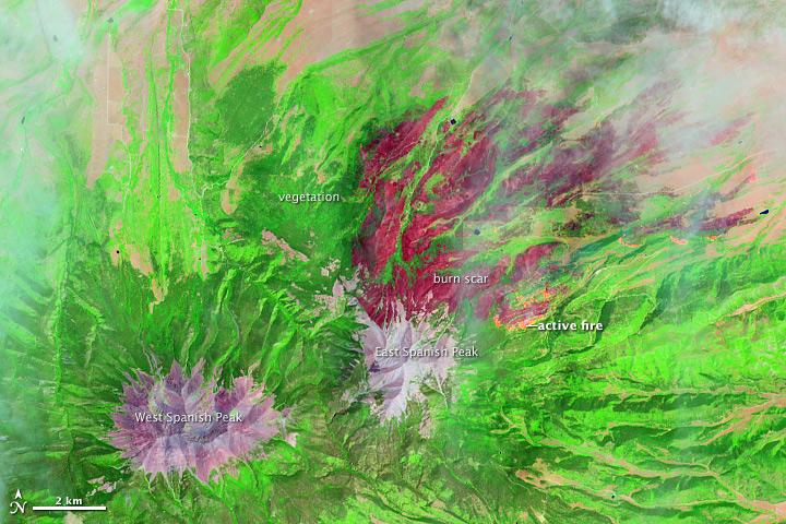
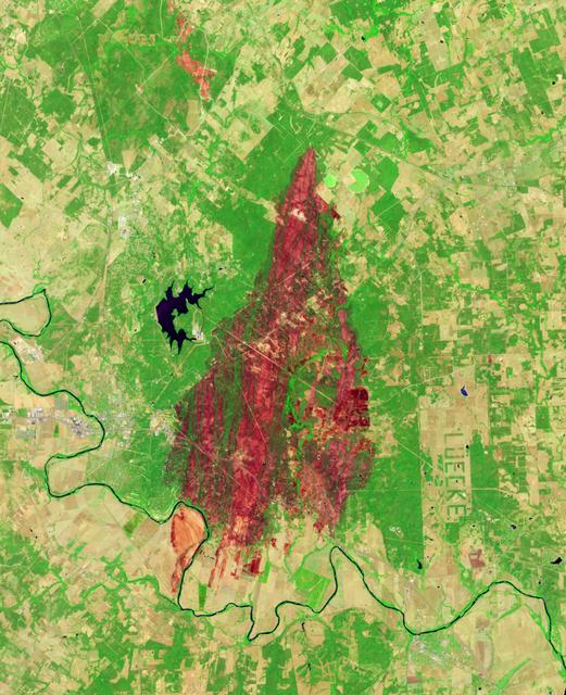
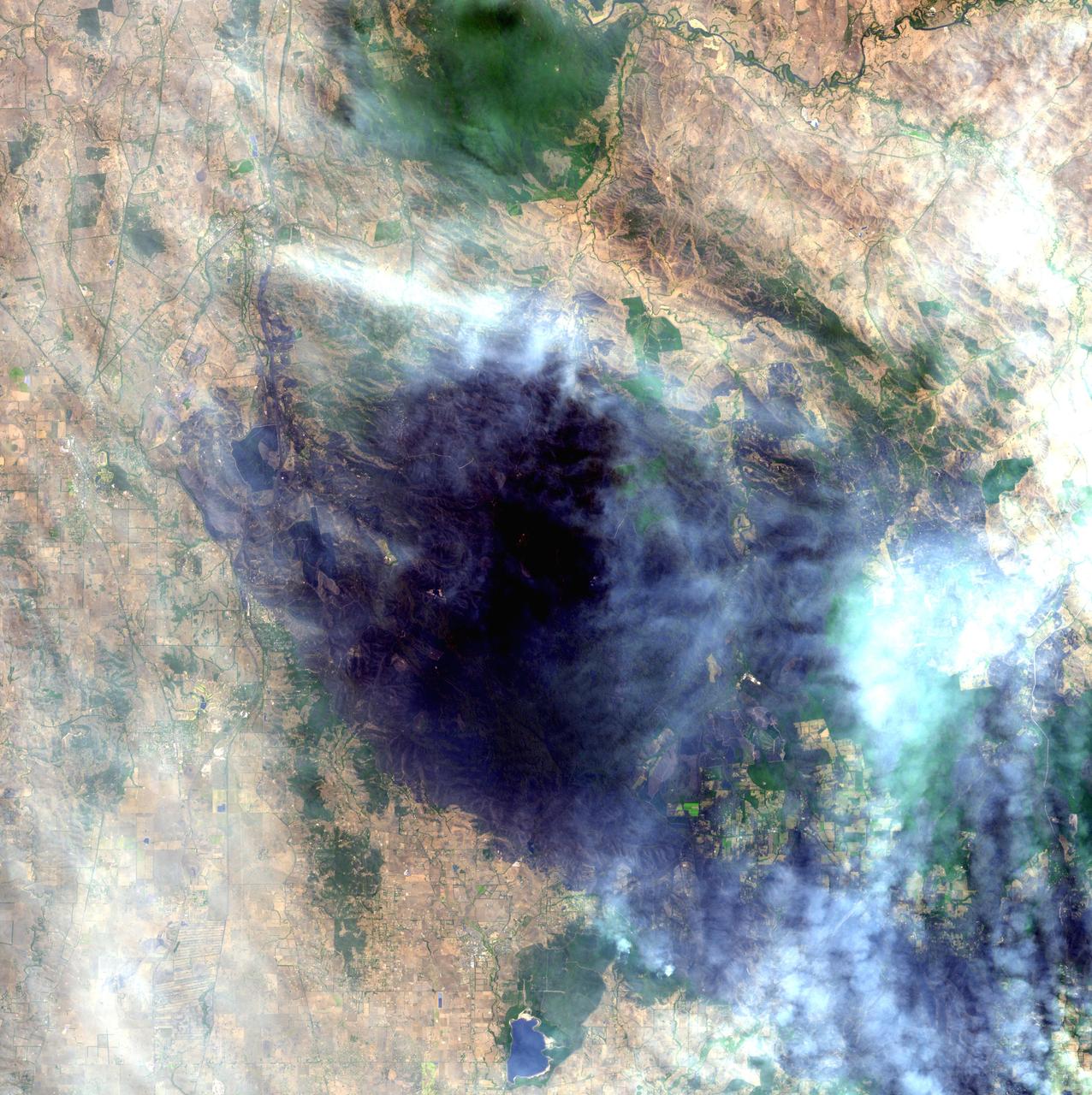
On June 22, 2013, the Operational Land Imager (OLI) on Landsat 8 captured this false-color image of the East Peak fire burning in southern Colorado near Trinidad. Burned areas appear dark red, while actively burning areas look orange. Dark green areas are forests; light green areas are grasslands. Lightning ignited the blaze on June 19, 2013. By June 25, it had burned nearly 13,500 acres (5,500 hectares). NASA Earth Observatory image by Jesse Allen and Robert Simmon, using Landsat data from the U.S. Geological Survey. Caption by Adam Voiland. Instrument: Landsat 8 - OLI More images from this event: <a href="http://1.usa.gov/14DesQC" rel="nofollow">1.usa.gov/14DesQC</a> Credit: <b><a href="http://www.earthobservatory.nasa.gov/" rel="nofollow"> NASA Earth Observatory</a></b> <b><a href="http://www.nasa.gov/audience/formedia/features/MP_Photo_Guidelines.html" rel="nofollow">NASA image use policy.</a></b> <b><a href="http://www.nasa.gov/centers/goddard/home/index.html" rel="nofollow">NASA Goddard Space Flight Center</a></b> enables NASA’s mission through four scientific endeavors: Earth Science, Heliophysics, Solar System Exploration, and Astrophysics. Goddard plays a leading role in NASA’s accomplishments by contributing compelling scientific knowledge to advance the Agency’s mission. <b>Follow us on <a href="http://twitter.com/NASA_GoddardPix" rel="nofollow">Twitter</a></b> <b>Like us on <a href="http://www.facebook.com/pages/Greenbelt-MD/NASA-Goddard/395013845897?ref=tsd" rel="nofollow">Facebook</a></b> <b>Find us on <a href="http://instagram.com/nasagoddard?vm=grid" rel="nofollow">Instagram</a></b>
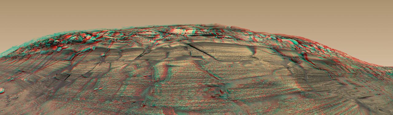
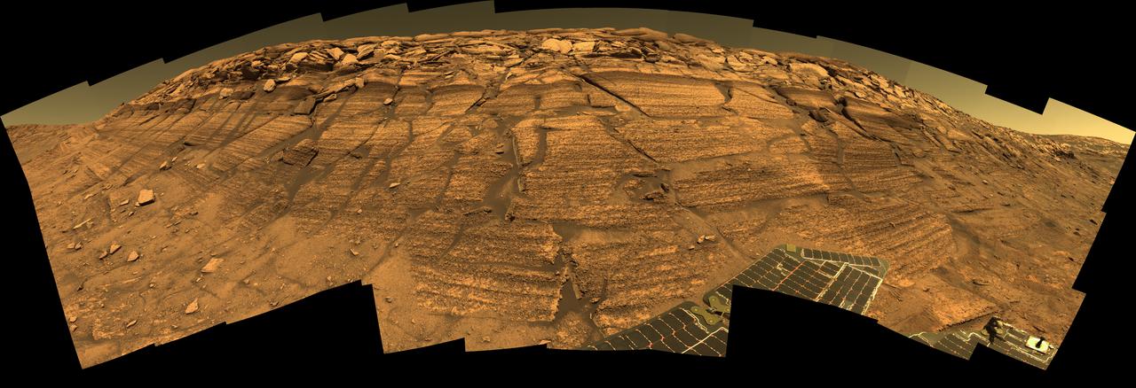
NASA Mars Exploration Rover Opportunity captured a sweeping stereo image of Burns Cliff after driving right to the base of this southeastern portion of the inner wall of Endurance Crater in November 2004. 3D glasses are necessary to view this image.
On June 22, 2013, the Operational Land Imager (OLI) on Landsat 8 captured this false-color image of the East Peak fire burning in southern Colorado near Trinidad. Burned areas appear dark red, while actively burning areas look orange. Dark green areas are forests; light green areas are grasslands. Lightning ignited the blaze on June 19, 2013. By June 25, it had burned nearly 13,500 acres (5,500 hectares). NASA Earth Observatory image by Jesse Allen and Robert Simmon, using Landsat data from the U.S. Geological Survey. Caption by Adam Voiland. Instrument: Landsat 8 - OLI More images from this event: <a href="http://1.usa.gov/14DesQC" rel="nofollow">1.usa.gov/14DesQC</a> Credit: <b><a href="http://www.earthobservatory.nasa.gov/" rel="nofollow"> NASA Earth Observatory</a></b> <b><a href="http://www.nasa.gov/audience/formedia/features/MP_Photo_Guidelines.html" rel="nofollow">NASA image use policy.</a></b> <b><a href="http://www.nasa.gov/centers/goddard/home/index.html" rel="nofollow">NASA Goddard Space Flight Center</a></b> enables NASA’s mission through four scientific endeavors: Earth Science, Heliophysics, Solar System Exploration, and Astrophysics. Goddard plays a leading role in NASA’s accomplishments by contributing compelling scientific knowledge to advance the Agency’s mission. <b>Follow us on <a href="http://twitter.com/NASA_GoddardPix" rel="nofollow">Twitter</a></b> <b>Like us on <a href="http://www.facebook.com/pages/Greenbelt-MD/NASA-Goddard/395013845897?ref=tsd" rel="nofollow">Facebook</a></b> <b>Find us on <a href="http://instagram.com/nasagoddard?vm=grid" rel="nofollow">Instagram</a></b>
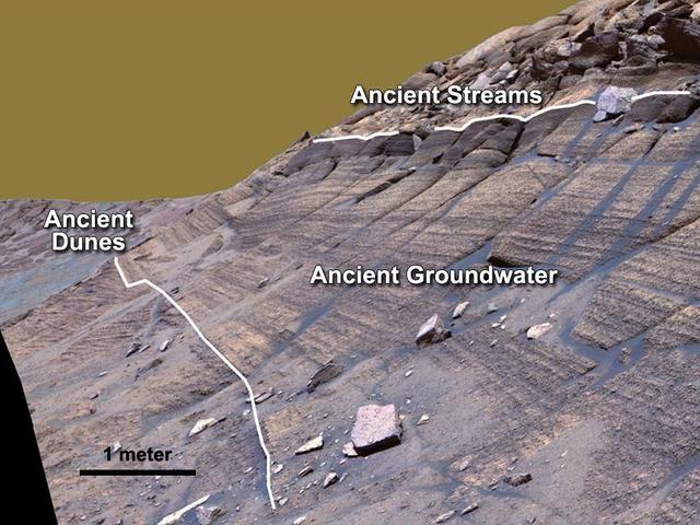
NASA Mars Exploration Rover Opportunity studied layers in the Burns Cliff slope of Endurance Crater in 2004. The layers show different types of deposition of sulfate-rich sediments. Opportunity panoramic camera recorded this image.
Disant view of 53P Progress burn up over the Earth's surface as seen by the Expedition 40 crew.
IDL TIFF file
Fires near Big Sur, Calif., continued to burn unchecked when the Advanced Spaceborne Thermal Emission and Reflection Radiometer ASTER instrument on NASA Terra satellite captured this image on Sunday, June 29, 2008.
Brush fires consumed nearly 750,000 acres across Southern California between October 21 and November 18, 2003. Burn scars and vegetation changes wrought by the fires are illustrated in these false-color images from NASA Terra spacecraft.
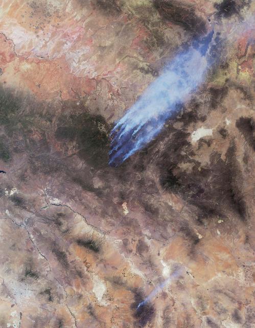
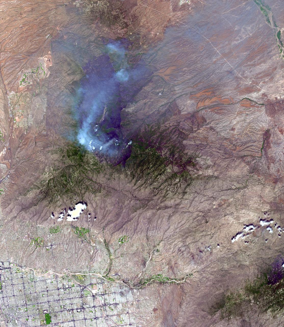
This image from NASA Terra spacecraft shows the Wallow and Horseshoe 2 Fires burning in Arizona. The data were acquired mid-morning on June 7, 2011. Nearly 10 distinct bluish-colored smoke plumes can be seen blowing toward the upper right northeast.
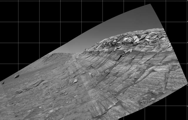
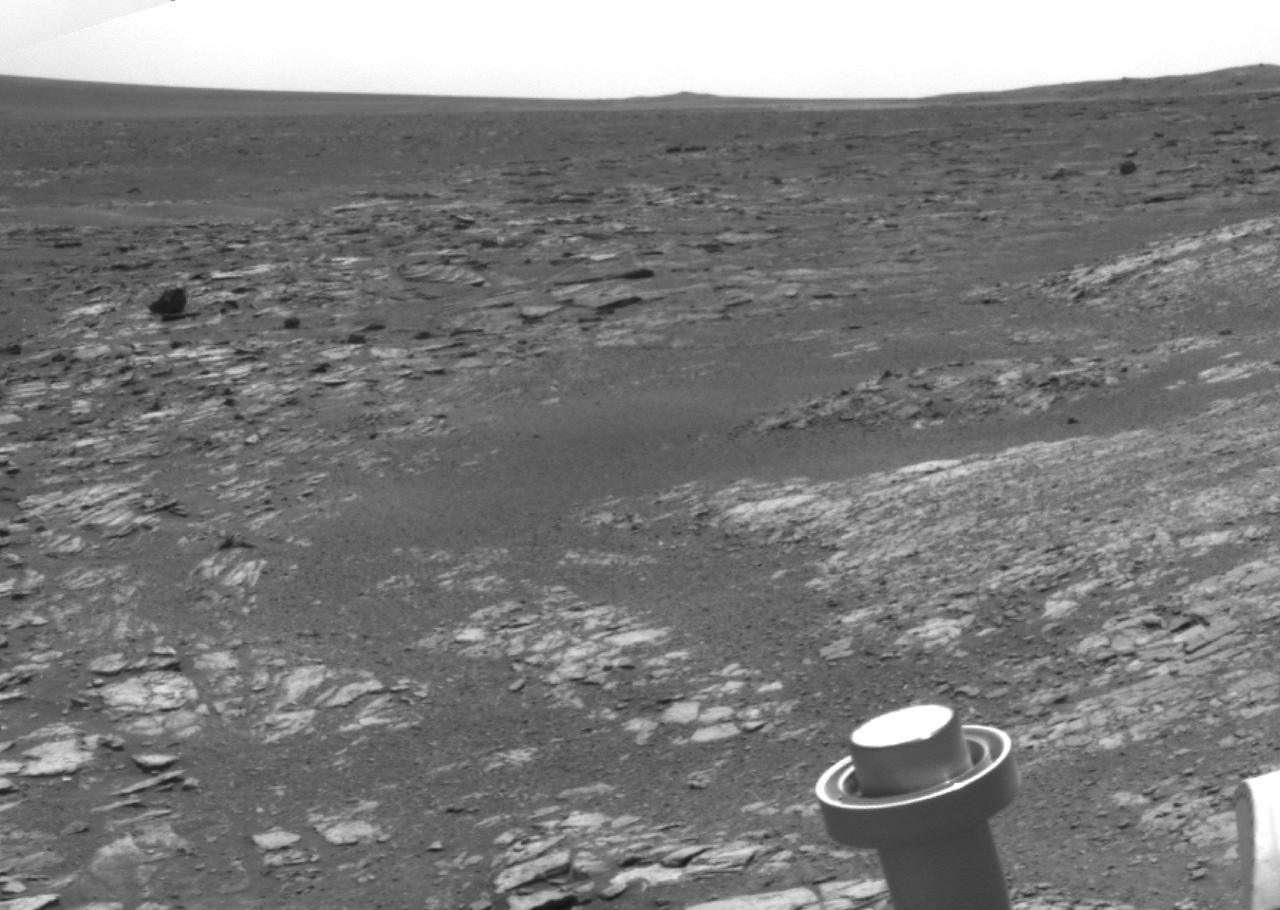
NASA's Mars Exploration Rover Opportunity captured this view from the base of "Burns Cliff" during the rover's 280th martian day (Nov. 6, 2004). This cliff in the inner wall of "Endurance Crater" displays multiple layers of bedrock for the rover to examine with its panoramic camera and miniature thermal emission spectrometer. The rover team has decided that the farthest Opportunity can safely advance along the base of the cliff is close to the squarish white rock near the center of this image. After examining the site for a few days from that position, the the rover will turn around and head out of the crater. The view is a mosaic of frames taken by Opportunity's navigation camera. The rover was on ground with a slope of about 30 degrees when the pictures were taken, and the view is presented here in a way that corrects for that tilt of the camera. http://photojournal.jpl.nasa.gov/catalog/PIA07039
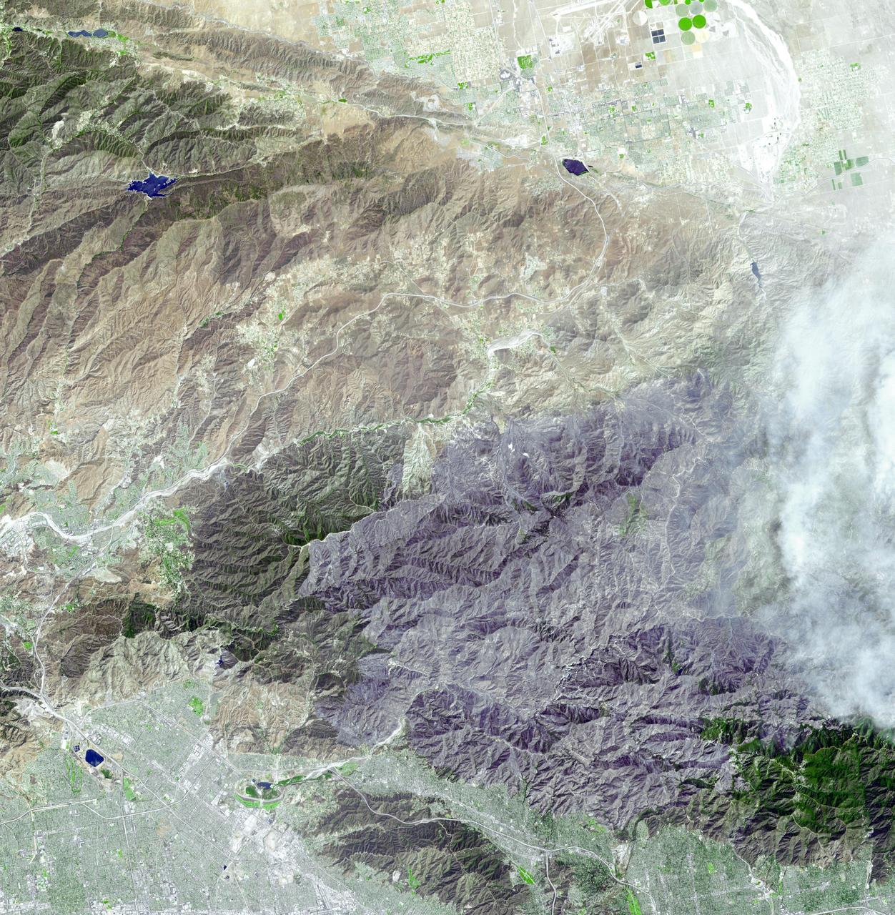
JPL Advanced Spaceborne Thermal Emission and Reflection Radiometer aboard NASA Terra satellite captured this simulated natural color image of the Station fire, burning in the San Gabriel Mountains.
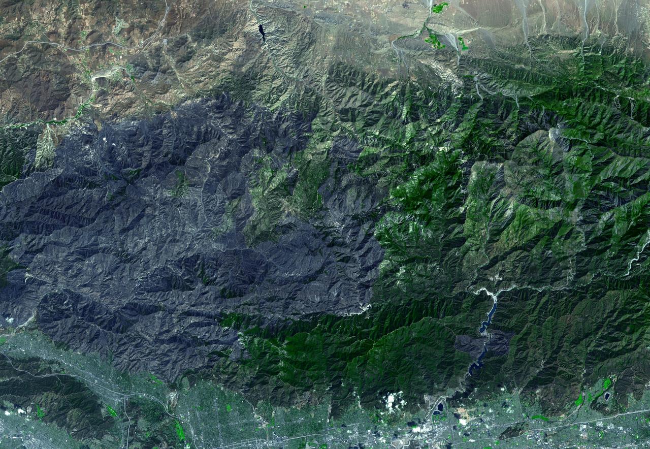
JPL Advanced Spaceborne Thermal Emission and Reflection Radiometer aboard NASA Terra satellite captured this simulated natural color image of the Station fire burning in the San Gabriel Mountains.

art002e000191 (April 3, 2026) - A view of Earth taken by NASA astronaut and Artemis II commander Reid Wiseman from one of the Orion spacecraft's four main windows after completing the translunar injection burn on April 2, 2026.
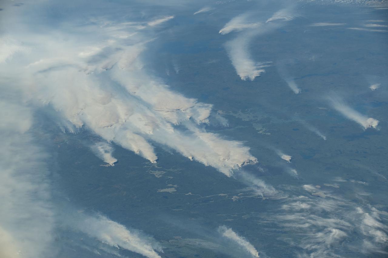
iss073e0420617 (Aug. 3, 2025) --- Wildfires burn throughout Canada's central provinces sending smoke drifting into the United States' Great Lakes and Northeast regions impacting air quality. The International Space Station was orbiting 262 miles above Canada at the time of this photograph.
STS093-347-031 (22-27 July 1999) --- Black space forms the backdrop for this scene of the Orbital Maneuvering System (OMS) engine pods during a thruster burn photographed by one of the astronauts on the aft flight deck of the Space Shuttle Columbia.
iss073e0420604 (Aug. 3, 2025) --- Wildfires burn throughout Canada's central provinces sending smoke drifitng into the United States' Great Lakes and Northeast regions impacting air quality. The International Space Station was orbiting 262 miles above Canada at the time of this photograph.
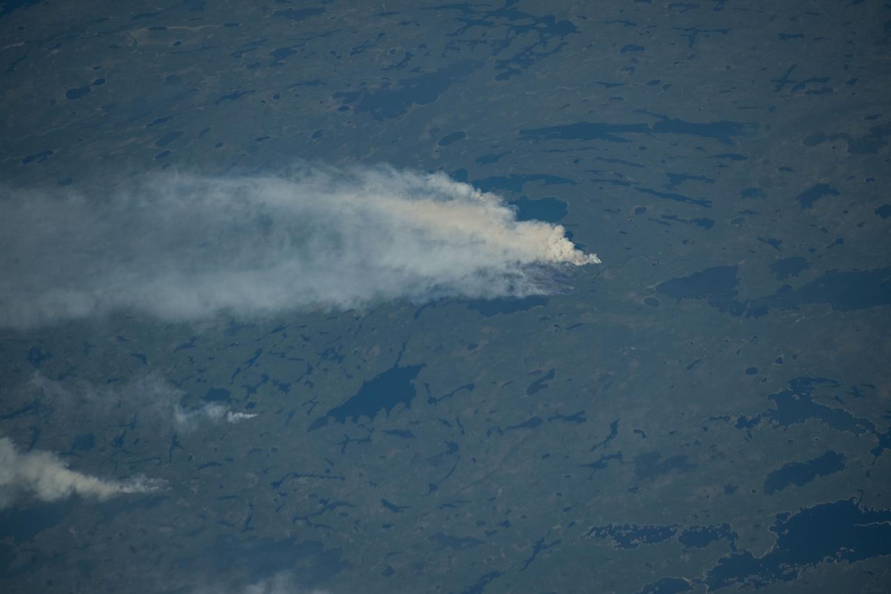
iss073e0420614 (Aug. 3, 2025) --- Wildfires burn throughout Canada's central provinces sending smoke drifitng into the United States' Great Lakes and Northeast regions impacting air quality. The International Space Station was orbiting 262 miles above Canada at the time of this photograph.

NASA Terra spacecraft acquired this image of the Wallow fire in Arizona on June 21, 2011; vegetation appears in red, bare ground in shades of tan, burned areas in black and very-dark red; and smoke from the active fire front appears gray.
STS062-106-042 (4-18 March 1994) --- This view of southern Australia about 100 miles northwest of Melbourne shows areas of protected reserves of natural forests in the midst of agricultural crop lands. The green patch seen here has been recently burned as indicated by the irregular large scar. The impact of winds on the scar is clearly visible. This nature preserve is reported to be the home to a large number of animals including the koala bears. Similar views were shot by the STS-60 crewmembers last month. These photographs will assist earth scientists in mapping the impact of forest fires and in moniotring the recovery of burned areas.
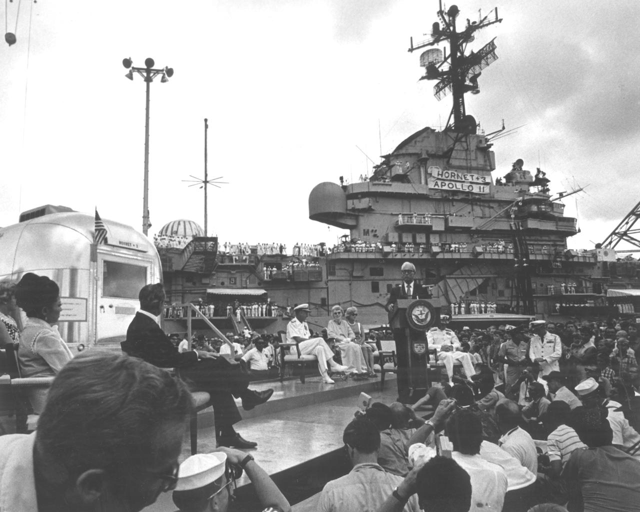
The Apollo 11 mission, the first manned lunar mission, launched from the Kennedy Space Center, Florida via the Marshall Space Flight Center (MSFC) developed Saturn V launch vehicle on July 16, 1969 and safely returned to Earth on July 24, 1969. Aboard the space craft were astronauts Neil A. Armstrong, commander; Michael Collins, Command Module (CM) pilot; and Edwin E. Aldrin Jr., Lunar Module (LM) pilot. The CM, piloted by Michael Collins remained in a parking orbit around the Moon while the LM, named “Eagle’’, carrying astronauts Neil Armstrong and Edwin Aldrin, landed on the Moon. During 2½ hours of surface exploration, the crew collected 47 pounds of lunar surface material for analysis back on Earth. The recovery operation took place in the Pacific Ocean where Navy para-rescue men recovered the capsule housing the 3-man Apollo 11 crew. The crew was airlifted to safety aboard the U.S.S. Hornet recovery ship, where they were quartered in a Mobile Quarantine Facility (MQF) for 21 days. The recovery vessel docked in Pearl Harbor Hawaii, where the occupied MQF was transferred for transport to the to NASA Manned Spacecraft Center (MSC) Lunar Receiving Laboratory in Houston, Texas. In this photo the quarantined astronauts are addressed by Hawaiian Governor John Burns upon their arrival at Pearl Harbor.
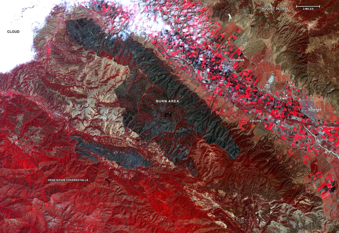
On Aug. 26, 2020, Advanced Spaceborne Thermal Emission and Reflection Radiometer (ASTER) instrument aboard NASA's Terra satellite passed over the River and Carmel fires in Monterey County, California, got a bird's eye view of the vast fire burn area. This false-color map shows the burn area as dark blue and gray, in the center of the image. Vegetation is in red, including agricultural crops along the Salinas River (bright red rectangles) surrounding the towns of Soledad and Gonzales; bare areas with no vegetation and rock are shown in tan and brown. The city of Salinas is in the upper left of the image, obscured by thick clouds. ASTER obtains high-resolution (15-90 square meters, or 161-969 square feet, per pixel) images of the Earth in 14 wavelengths of the electromagnetic spectrum, ranging from visible to thermal infrared light. Data from ASTER — which is managed by Japan Space Systems and NASA's Jet Propulsion Laboratory in Southern California — are used by scientists to create detailed maps of land surface temperature, how much infrared energy the land emits, how much light the land reflects and its elevation. On this occasion, ASTER was able to support NASA's Disaster Program response to the state's wildfires, providing data products that can be used by resources on the ground to fight the fires and for scientists to better understand their long-term effects. The area covered here is 21.4 by 31 miles (34.4 by 49.9 kilometers). https://photojournal.jpl.nasa.gov/catalog/PIA23800
This image, acquired by NASA Terra spacecraft, is of the Carstens, Calif. wildfire which continues to burn in the foothills west of Yosemite National Park. Vegetation is displayed in green and burned and bare areas are dark to light gray.
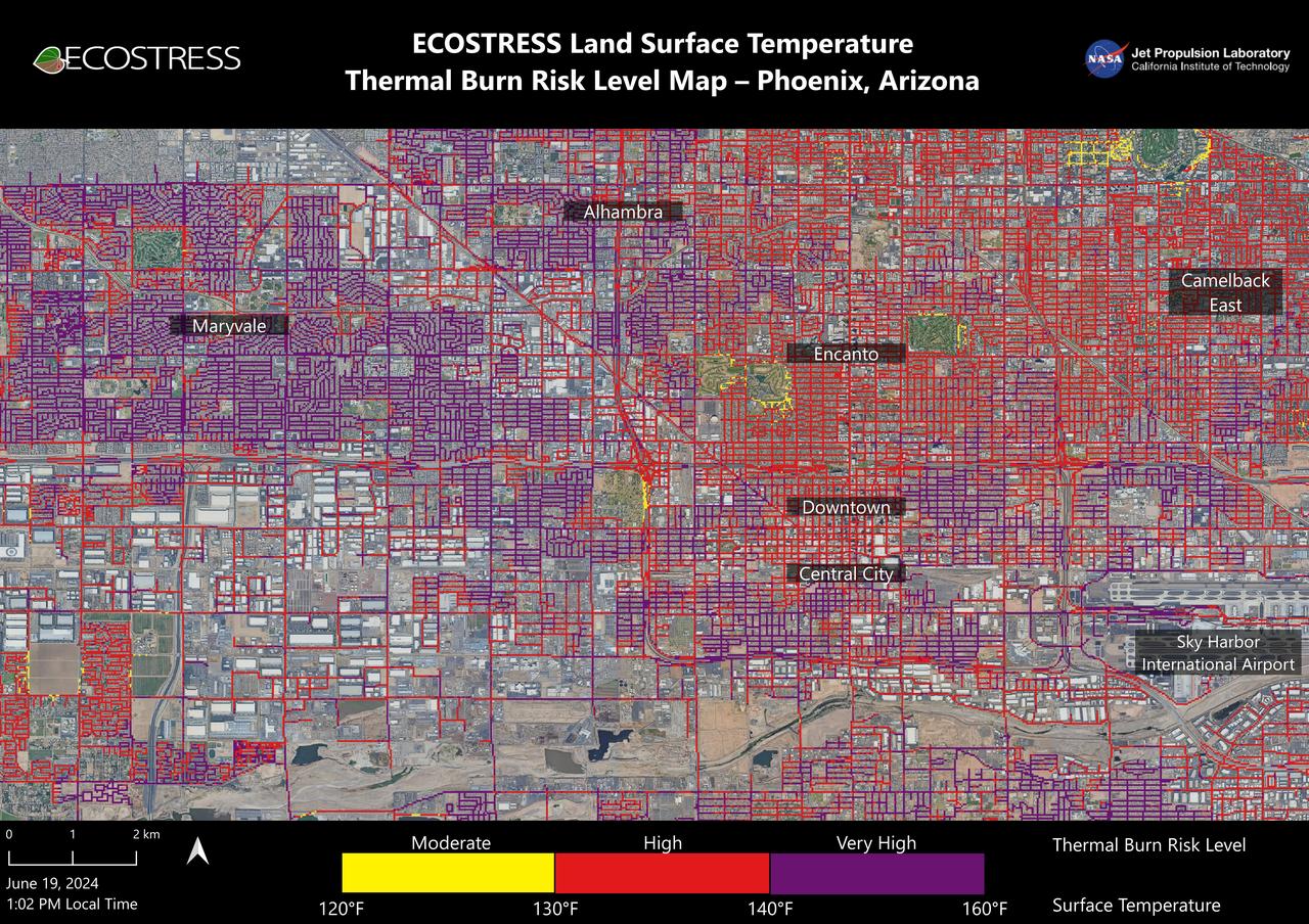
Data from NASA's ECOSTRESS (Ecosystem Spaceborne Thermal Radiometer Experiment on Space Station) instrument was used to map scorching pavement in Phoenix where contact with skin can cause serious burns. Based on measurements captured at 1:02 p.m. local time on June 19, 2024, the image shows land surface temperatures across a grid of roads and adjacent sidewalks, revealing how urban spaces can turn hazardous during hot weather. The Arizona city's miles of asphalt and concrete surfaces (colored here in yellow, red, and purple, based on temperature) trap heat, as the image indicates. The surfaces registered at least 120 degrees Fahrenheit (49 degrees Celsius) to the touch – hot enough to cause contact burns in minutes to seconds. At the lower right of the image is Phoenix Sky Harbor International Airport, where ECOSTRESS recorded some of the hottest land surface temperatures within the city – around 140 F (60 C). The air temperature on June 19 at the airport reached 106 F (43 C). Air temperature, which is measured out of direct sunlight, can differ significantly from the temperature at the land surface. Streets are often the hottest surfaces of the built environment due to dark asphalt paving that absorbs more sunlight than lighter-colored surfaces; asphalt absorbs up to 95% of solar radiation. These types of surfaces can easily be 40 to 60 degrees F (22 to 33 degrees C) hotter than the air temperature on a very hot day. Launched to the International Space Station in 2018, ECOSTRESS measures temperatures at the highest spatial resolution of any space-based instrument, producing images with a typical pixel size of about 225 feet (70 meters) by 125 feet (38 meters). The image of Phoenix was produced at higher spatial resolution using a machine learning algorithm that incorporates data from additional satellites: NASA/USGS Landsat and Sentinel-2. The combined measurements were used to "sharpen" the surface temperatures to a resolution of 100 feet (30 meters) by 100 feet (30 meters). https://photojournal.jpl.nasa.gov/catalog/PIA25529

jsc2026e020048 (April 2, 2026) – Flight Dynamics Officer Natasha Peake in Mission Control during Artemis II’s translunar injection burn on April 2, 2026, which not only sent the crew in Orion out of Earth orbit and on a trajectory toward the Moon, but also set them on the course that will ultimately bring them home for a splashdown in the Pacific Ocean.
NASA's Advanced Spaceborne Thermal Emission and Reflection Radiometer (ASTER) instrument imaged areas burned by the Bighorn Fire north of Tucson, Arizona, on June 29. In the image, vegetation is shown in red and burned areas are shown in dark gray. It covers an area of 20 by 30 miles (33 by 48 kilometers). https://photojournal.jpl.nasa.gov/catalog/PIA23691

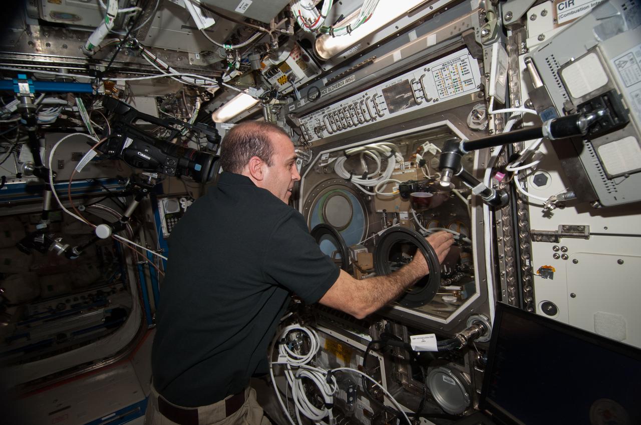
iss072e451296 (Jan. 8, 2025) --- NASA astronaut and Expedition 72 Flight Engineer Don Pettit works in the Destiny laboratory module's Combustion Integrated Rack swapping samples of materials to observe how they burn in weightlessness. The investigation taking place inside the International Space Station's CIR enables the safe observation of flames and how they spread in microgravity potentially improving fire safety on crew missions.
iss072e456120 (Jan. 13, 2025) --- NASA astronaut and Expedition 72 Flight Engineer Nick Hague works in the Destiny laboratory module's Combustion Integrated Rack swapping samples of materials to observe how they burn in weightlessness. The investigation taking place inside the International Space Station's CIR enables the safe observation of flames and how they spread in microgravity potentially improving fire safety on crew missions.
This oblique view of Lake Chad was taken by the STS-66 crew in November 1994. This lake lies mainly in the Republic of Chad and partly in Nigeria, Cameroon and Niger. The size of Lake Chad varies seasonally and is actually divided into north and south basins; neither of which is generally more than 25 feet (7.6 meters) deep. In this photograph, all the water appears to be located in the southern basin with the northern and eastern edges of both basins covered with sand dunes which have invaded the area where the water once stood. The prevailing wind direction can be seen from the agriculture burning in both basins to be from the east.
The tri-county Riley Road wildfire burning in Texas north of Houston was 85 percent contained when NASA Terra spacecraft acquired this image on Sept. 12, 2011. Burned areas are dark gray and black; vegetation red; and bare ground and roads light gray.
On February 17, 2009, NASA Terra satellite imaged bushfires burning in Victoria Australia.
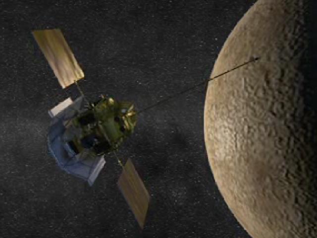
NASA MESSENGER prepares to perform the Mercury orbit insertion burn in this animated artist concept.
These ASTER images cover an area of 11 x 14 km on the north rim of the Grand Canyon, Arizona, and were acquired May 12, 2000. The left image displays bands 3,2,1 in RGB, displaying vegetation as red. The large dark area is burned forest, and small smoke plumes can be seen at the edges where active fires are burning. The right display substitutes SWIR band 8 for band 3. The bright red spots are the active fires, visible because the SWIR wavelength region has the capability to penetrate through the smoke. This image is located at 35.9 degrees north latitude and 113.4 degrees west longitude. http://photojournal.jpl.nasa.gov/catalog/PIA11092

Twitter user Ann Marie Cunningham who goes by the twitter name @talkingscience.org, right, uses her laptop, while Laura Burns, who goes by the twitter name @moonrangerlaura, listens to a guest speaker during a two-day NASA Tweetup event held at NASA's Kennedy Space Center in Cape Canaveral, Fla, Sunday, Nov. 15, 2009. NASA Twitter followers in attendance will have the opportunity to take a tour of NASA's Kennedy Space Center, view the space shuttle launch and speak with shuttle technicians, engineers, astronauts and managers. Photo Credit: (NASA/Carla Cioffi) 

Twitter user Laura Burns, left, who goes by the twitter name @moonrangerlaura, listens to a guest speaker, while Ann Marie Cunningham who goes by the twitter name @talkingscience.org, uses her laptop during a two-day NASA Tweetup event held at NASA's Kennedy Space Center in Cape Canaveral, Fla, Sunday, Nov. 15, 2009. NASA Twitter followers in attendance will have the opportunity to take a tour of NASA's Kennedy Space Center, view the space shuttle launch and speak with shuttle technicians, engineers, astronauts and managers. Photo Credit: (NASA/Carla Cioffi) 
jsc2023e046631 (7/25/2023) --- Plexiglass is shown burning in Spacecraft Fire Experiment-IV (Saffire-IV). The flame appears orange because of the soot that is produced as it burns. As the plexiglass burns, the solid is melted, vaporized, and then the vapor burns. The bright flame balls in the flame is vapor burning as it is expelled from the surface. Saffire-VI burns plexiglass at higher oxygen concentrations. The Saffire experiments aim to inform the development of fire safety equipment and strategies for future spacecraft.
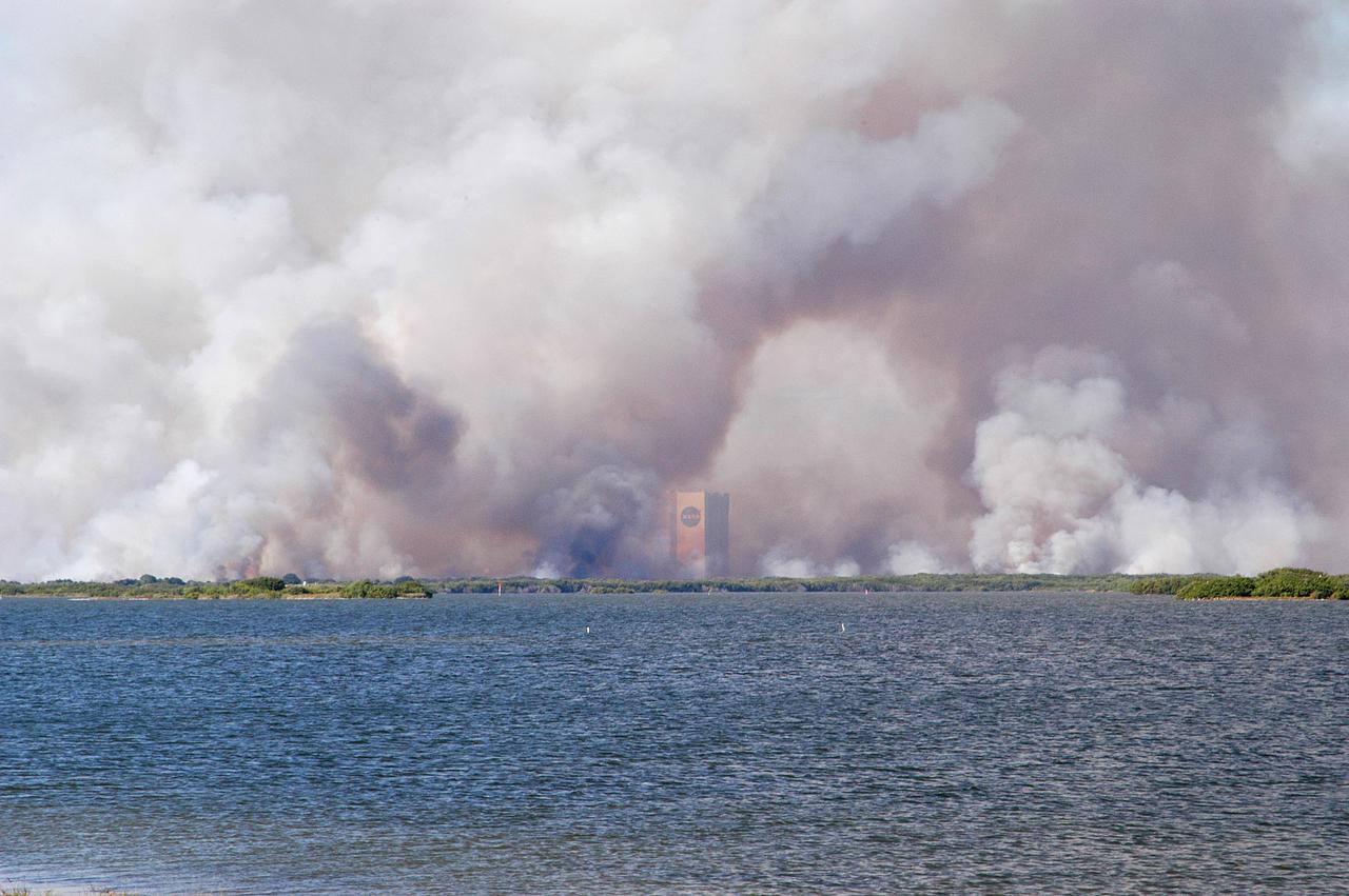
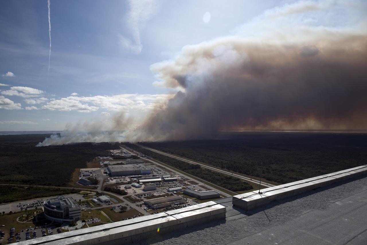
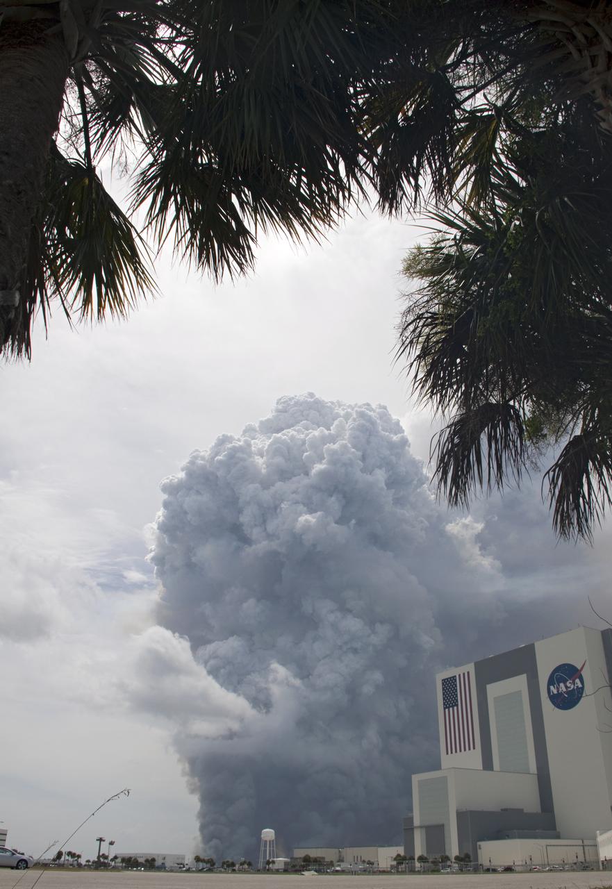
KENNEDY SPACE CENTER, FLA. - Smoke from a successful controlled burn near KSC’s Launch Complex 39 surrounds the Vehicle Assembly Building and spreads across the horizon. The water in the foreground is the Banana River.
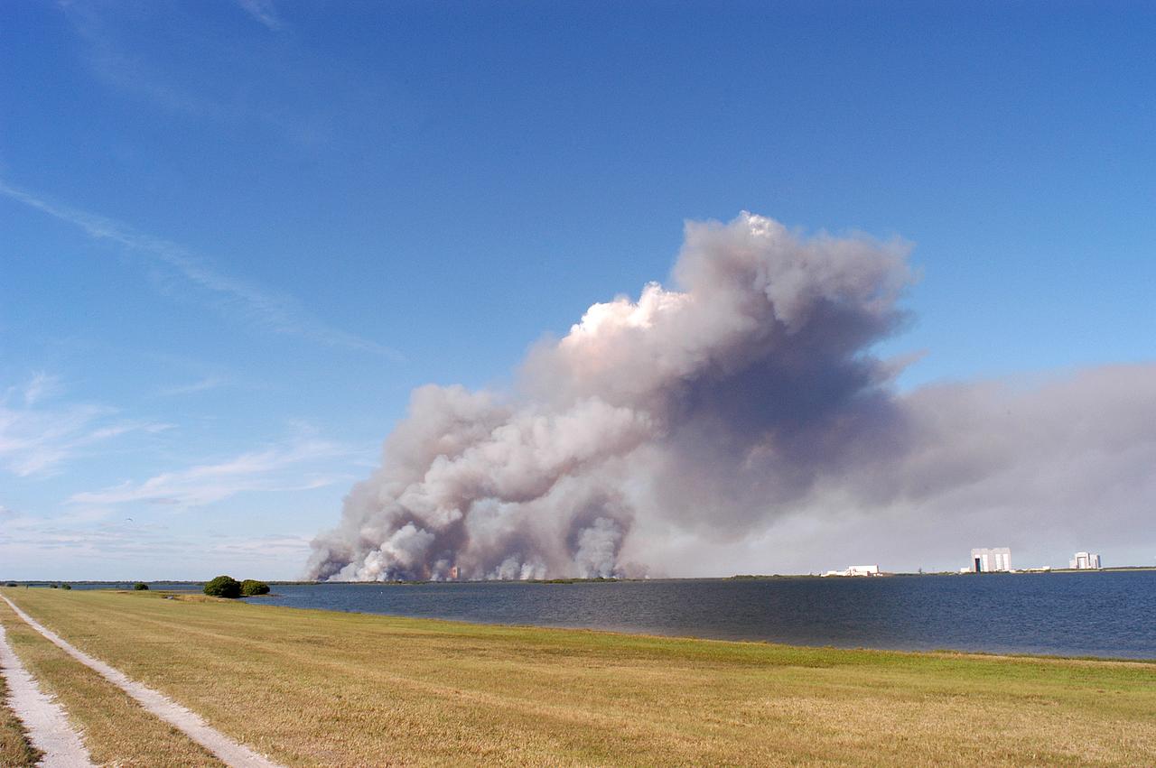
KENNEDY SPACE CENTER, FLA. - A successful controlled burn near KSC’s Launch Complex 39 area creates clouds of smoke in a clear blue sky. The water seen is the Banana River.
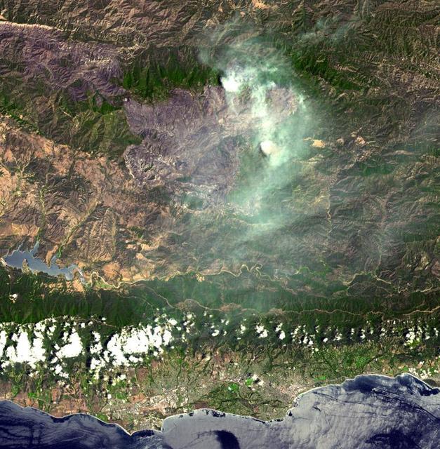
On August 7, 2007, the Zaca fire continued to burn in the Los Padres National Forest near Santa Barbara, California. This image is from NASA Terra spacecraft.
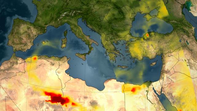
A series of fires across Greece in August of 2007 burned 469,000 acres, visualized here by the Atmospheric Infrared Sounder AIRS on NASA Aqua satellite.
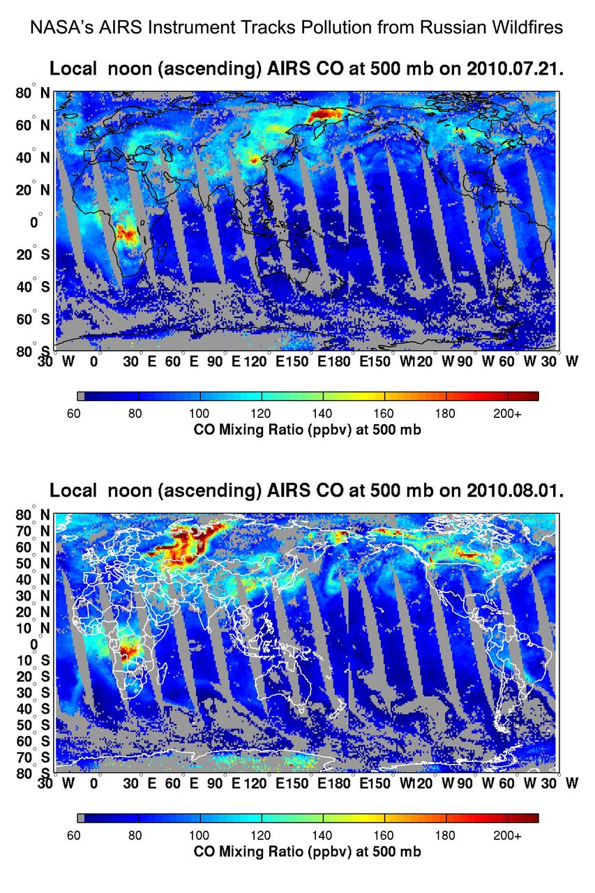
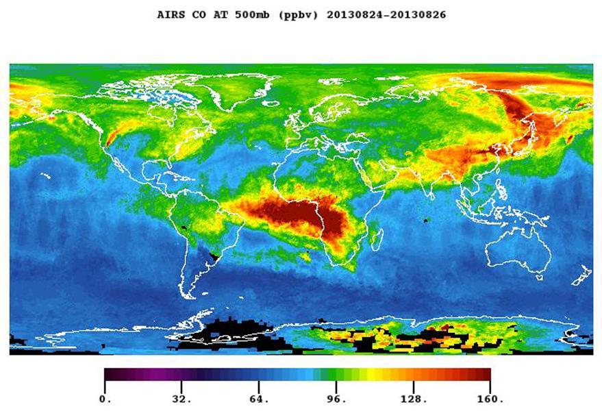
NASA Aqua spacecraft tracked the concentration and transport of carbon monoxide from Russian fires in 2010, during which time some 558 fires were burning.
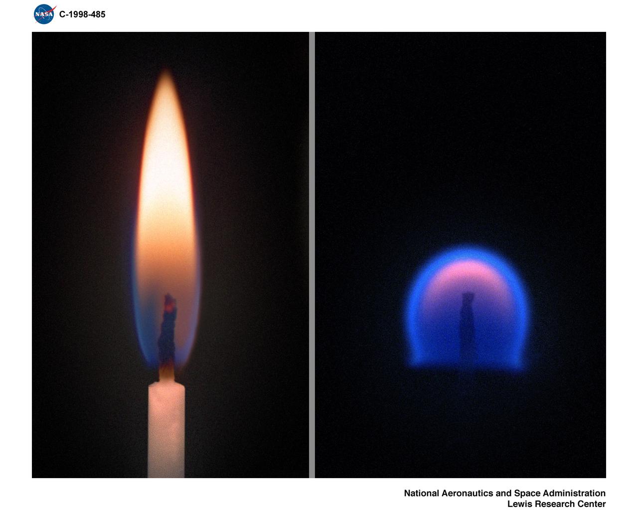
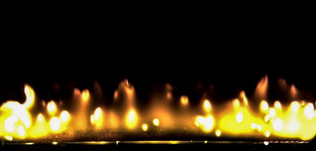
Comparison of a Candle Flame burning in normal gravity or 1-G (left) and a flame burning in Microgravity.
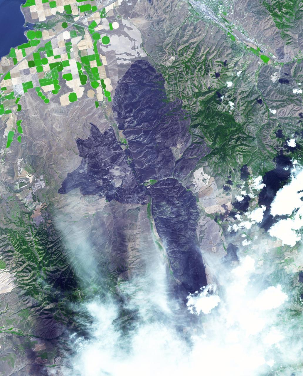
Thousands of acres damaged by the ongoing Kincade Fire in Northern California's Sonoma County are visible in this new image from the Advanced Spaceborne Thermal Emission and Reflection Radiometer (ASTER) instrument aboard NASA's Terra satellite. The image was taken at 11:01 a.m. PST (2:01 p.m. EST) on Nov. 3, 2019. The burned area appears dark gray in ASTER's visible channels. Hotspots, where the fire is still smoldering, appear as yellow dots in ASTER's heat-sensing, thermal infrared channels. After starting on Oct. 23, forcing residents to evacuate, the fire had burned 77,758 acres and destroyed 372 structures by Nov. 3, according to the California Department of Forestry and Fire Protection. It is now over 80% contained. The town of Healdsburg is in the center of the image, which covers an area of about 24 by 25 miles (39 by 40 kilometers). https://photojournal.jpl.nasa.gov/catalog/PIA23426
While the Thomas fire in Ventura County, CA is the largest and most destructive, several other smaller fires burned in the Los Angeles area. The Creek fire destroyed 123 buildings and consumed over 15,000 acres. The smaller Rye fire burned 6,000 acres and destroyed 9 structures. The image was acquired December 17, 2017, covers an area of 9.7 by 13.5 kilometers, and is located at 34.4 degrees north, 118.5 degrees west. https://photojournal.jpl.nasa.gov/catalog/PIA22149
A wildfire burned 46,000 acres southwest of Pocatello, Idaho, threatening homes and filling the area with smoke. The human-caused fire was 85 percent contained by Aug. 10, 2017. The extent of the burned area is evident in this image as the dark gray area. The image was acquired Aug. 13, 2017, covers an area of 22 by 28 miles (36 by 45 kilometers), and is located at 42.7 degrees north, 112.6 degrees west. https://photojournal.jpl.nasa.gov/catalog/PIA21875
This artist’s concept portrays SpaceX’s Starship Human Landing System (HLS) with two Raptor engines lit, performing a braking burn prior to its Moon landing. The burn will occur after Starship HLS departs low lunar orbit to reduce the lander’s velocity prior to final descent to the lunar surface. NASA is working with SpaceX to develop Starship HLS to carry astronauts from lunar orbit to the Moon’s surface and back for Artemis III and Artemis IV as part of the agency’s Artemis campaign.
On June 26, NASA's Terra satellite acquired this image of the Aspen fire burning out of control north of Tucson, AZ. As of that date, the fire had consumed more than 27,000 acres and destroyed more than 300 homes, mostly in the resort community of Summerhaven, according to news reports. These data are being used by NASA's Wildfire Response Team and the US Forest Service to assess the intensity of the burn for future remediation efforts. This image was acquired on June 26, 2003 by the Advanced Spaceborne Thermal Emission and Reflection Radiometer (ASTER) on Terra. With its 14 spectral bands from the visible to the thermal infrared wavelength region, and its high spatial resolution of 15 to 90 meters (about 50 to 300 feet), ASTER images Earth to map and monitor the changing surface of our planet. http://photojournal.jpl.nasa.gov/catalog/PIA04602
These images from NASA Terra satellite are of the Central Valley and the Sierra Nevada Mountains showing several smoke plumes from wildfires burning throughout Northern California on August 13, 2001.

Large plumes of smoke rising from devastating wildfires burning near Los Angeles and San Diego on Sunday, October 26, 2003, are highlighted in this set of images from NASA Terra spacecraft.
Smoke from multiple wildfires burning in Southern California in October, 2007, can be seen in this false-color image from the Atmospheric Infrared Sounder AIRS on NASA Aqua satellite.
The plume of carbon monoxide pollution from the Rim Fire burning in and near Yosemite National Park, Calif., shows a three-day running average of daily measurements from NASA Aqua spacecraft.
NASA Terra spacecraft captured this image of the Twitchell Canyon fire, a lightning-caused blaze burning in Utah, which has consumed more than 40,000 acres since it began on July 20, 2010.
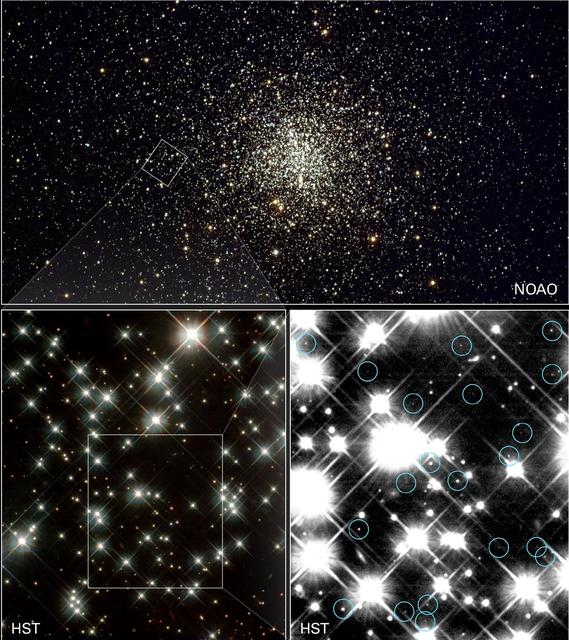
Peering deep inside a cluster of several hundred thousand stars, NASA Hubble Space Telescope has uncovered the oldest burned-out stars in our Milky Way Galaxy, giving astronomers a fresh reading on the age of the universe.

NASA Terra spacecraft captured this image of the wildfire near Palmdale, Calif. on August 1, 2010 called the Crown fire. The burned areas appear in shades of gray in this simulated natural color image.
These images and data products from NASA Terra spacecraft documented extensive smoke from fires burning throughout Nigeria and north central Africa on January 31, 2003.
The worst forest fires in nearly two decades are burning out of control on Borneo, creating the thick blanket of smoke in this Oct. 14, 2015 image from NASA Terra spacecraft.
The Multi-angle Imaging SpectroRadiometer MISR instrument on NASA Terra satellite captured this Aug. 30 image of smoke plumes from the Station and other wildfires burning throughout Southern California.
This image, acquired by NASA Terra spacecraft on May 1, 2011, shows more than 314,000 acres burned in west Texas. The 2011 fire season in Texas is of historic proportions.
NASA Mars Exploration Rover Opportunity reached the base of Burns Cliff, a portion of the inner wall of Endurance Crater in this anaglyph from the rover 285th martian day Nov. 11, 2004. 3D glasses are necessary to view this image.

The Livermore and Spring Ranch fires near the Davis Mountain Resort, Texas, burned 13,000 and 11,000 acres respectively. When NASA Terra spacecraft acquired this image on May 12, 2012, both fires had been contained.
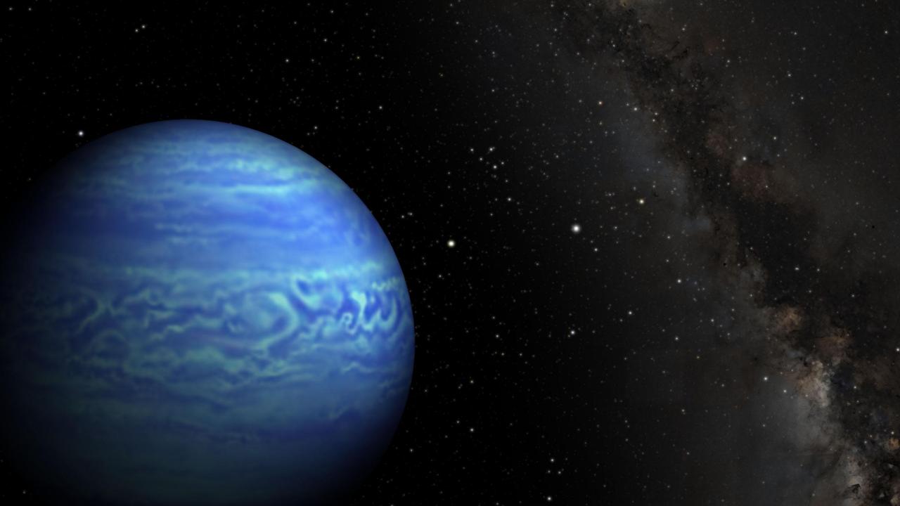
This artist conception shows the object named WISE J085510.83-071442.5, the coldest known brown dwarf. Brown dwarfs are dim star-like bodies that lack the mass to burn nuclear fuel as stars do.
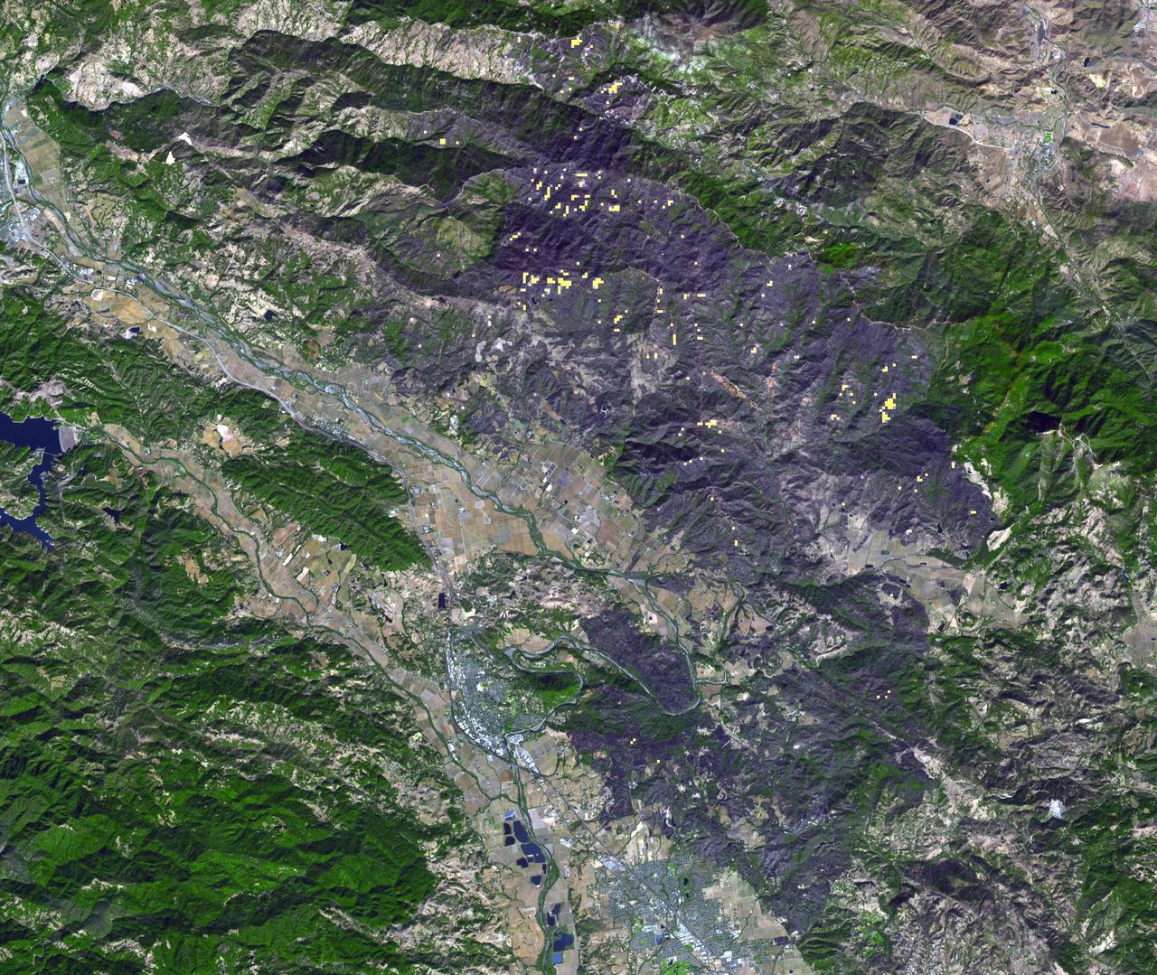
The October fires in Northern California were some of the most destructive in the state's history. The burned area on the right side of the image is the ATLAS fire, that burned east of Napa; the fire consumed 51,000 acres and destroyed almost 500 structures. The burned area on the left is part of the Nuns fire that burned between Sonoma and Napa; it consumed 110,000 acres, and destroyed almost 7,000 structures. The images were acquired September 7, 2016 and October 28, 2017, cover an area of 34.5 by 39 kilometers, and are located near 38.3 degrees north, 122.3 degrees east. https://photojournal.jpl.nasa.gov/catalog/PIA22019
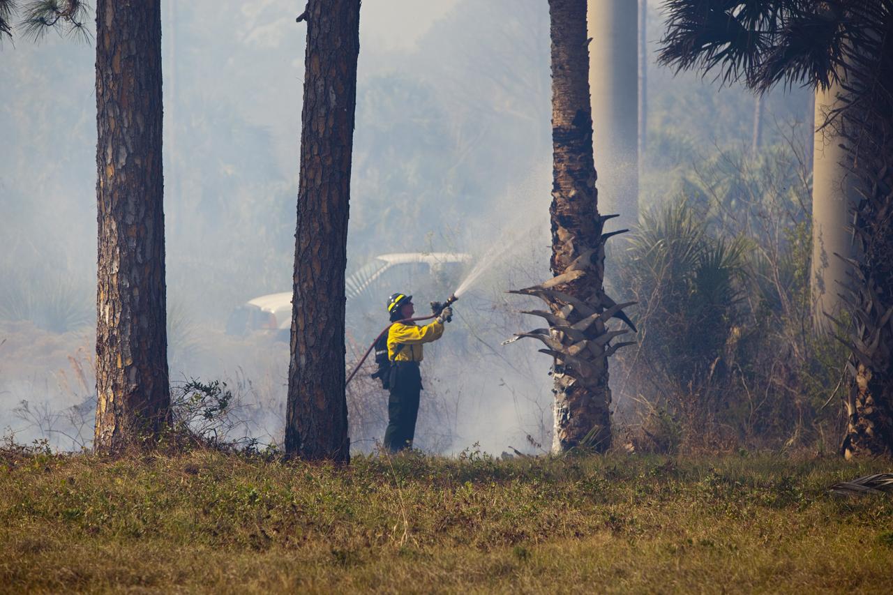
CAPE CANAVERAL, Fla. -- A firefighter manages the progress of a controlled burn in the vicinity of the Industrial Area at NASA's Kennedy Space Center in Florida. The burn, managed by the U.S. Fish and Wildlife Service, targeted 2,174 acres near Kennedy's administrative complex. Shifting winds caused the fire to flare up in places to dramatic effect. Limited visibility caused by the smoke required NASA Security to close some roadways. The burn, which began during the 8 o'clock hour this morning, is expected to be extinguished this evening. Controlled burns are commonplace on the center to reduce the likelihood of an unplanned brush fire during Central Florida's dry season. Photo Credit: NASA/Dimitri Gerondidakis
CAPE CANAVERAL, Fla. -- A controlled burn consumes the brush in the vicinity of the Industrial Area at NASA's Kennedy Space Center in Florida. The burn, managed by the U.S. Fish and Wildlife Service, targeted 2,174 acres near Kennedy's administrative complex. Shifting winds caused the fire to flare up in places to dramatic effect. Limited visibility caused by the smoke required NASA Security to close some roadways. The burn, which began during the 8 o'clock hour this morning, is expected to be extinguished this evening. Controlled burns are commonplace on the center to reduce the likelihood of an unplanned brush fire during Central Florida's dry season. Photo Credit: NASA/Dimitri Gerondidakis
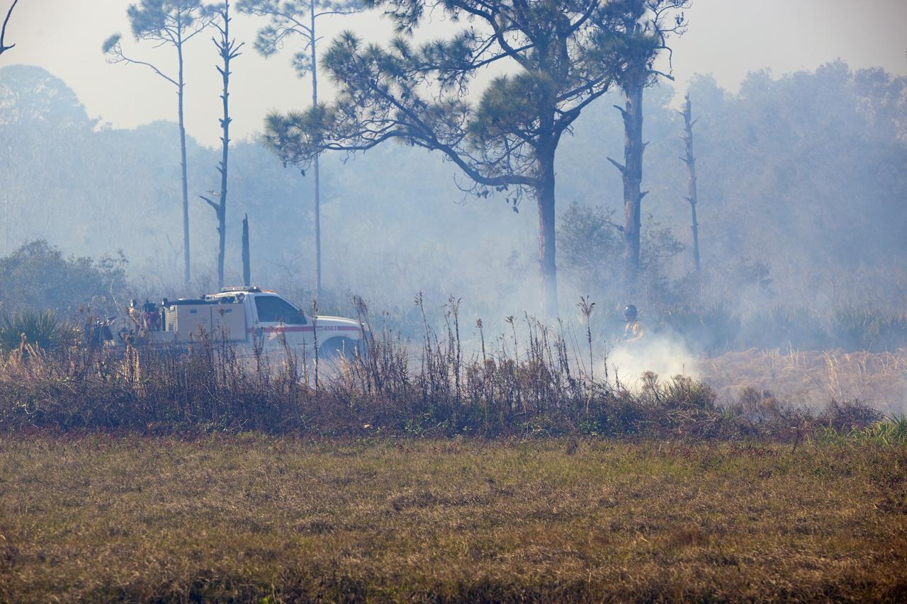
CAPE CANAVERAL, Fla. -- A firefighter mans his post at the edge of a controlled burn in the vicinity of the Industrial Area at NASA's Kennedy Space Center in Florida. The burn, managed by the U.S. Fish and Wildlife Service, targeted 2,174 acres near Kennedy's administrative complex. Shifting winds caused the fire to flare up in places to dramatic effect. Limited visibility caused by the smoke required NASA Security to close some roadways. The burn, which began during the 8 o'clock hour this morning, is expected to be extinguished this evening. Controlled burns are commonplace on the center to reduce the likelihood of an unplanned brush fire during Central Florida's dry season. Photo Credit: NASA/Dimitri Gerondidakis
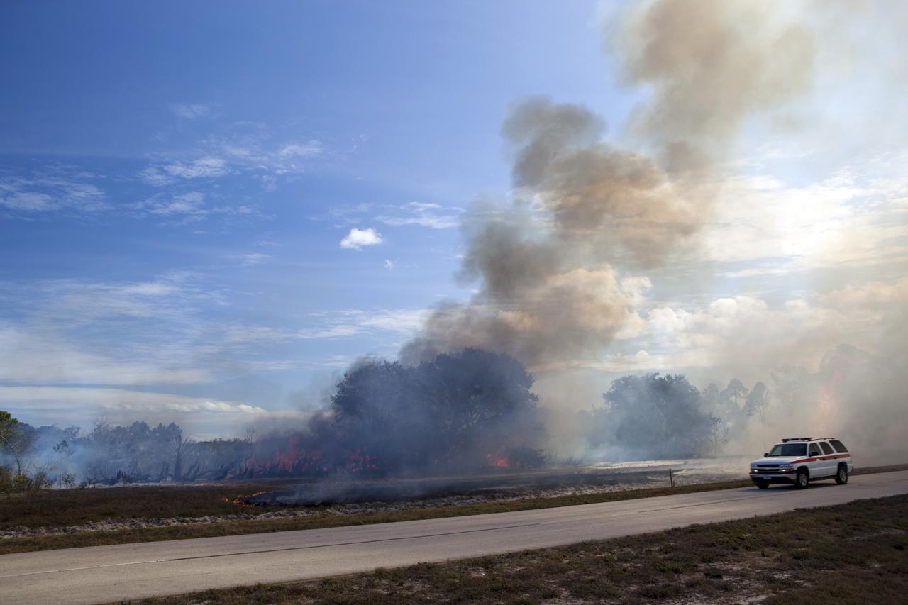
CAPE CANAVERAL, Fla. -- A controlled burn in the vicinity of the Industrial Area at NASA's Kennedy Space Center in Florida sends billow of smoke over nearby roadways. The burn, managed by the U.S. Fish and Wildlife Service, targeted 2,174 acres near Kennedy's administrative complex. Shifting winds caused the fire to flare up in places to dramatic effect. Limited visibility caused by the smoke required NASA Security to close some roadways. The burn, which began during the 8 o'clock hour this morning, is expected to be extinguished this evening. Controlled burns are commonplace on the center to reduce the likelihood of an unplanned brush fire during Central Florida's dry season. Photo Credit: NASA/Dimitri Gerondidakis
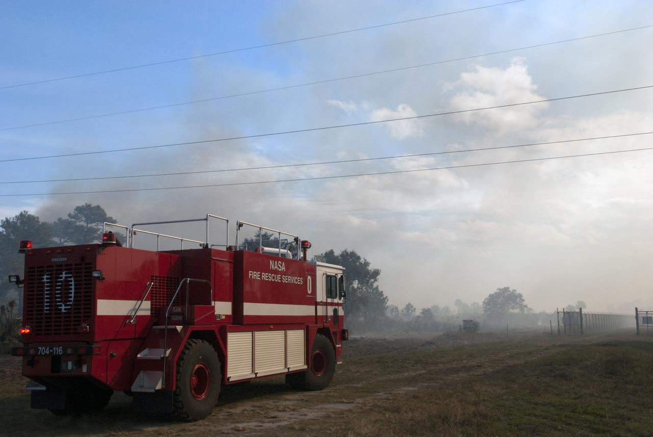
CAPE CANAVERAL, Fla. -- NASA Fire Rescue Services are on the scene to support a controlled burn in the vicinity of the Industrial Area at NASA's Kennedy Space Center in Florida. The burn, managed by the U.S. Fish and Wildlife Service, targeted 2,174 acres near Kennedy's administrative complex. Shifting winds caused the fire to flare up in places to dramatic effect. Limited visibility caused by the smoke required NASA Security to close some roadways. The burn, which began during the 8 o'clock hour this morning, is expected to be extinguished this evening. Controlled burns are commonplace on the center to reduce the likelihood of an unplanned brush fire during Central Florida's dry season. Photo Credit: NASA/Jim Grossmann

As firefighters continue to work toward full containment of the rash of wildfires burning in Northern California, a new image from the Advanced Spaceborne Thermal Emission and Reflection Radiometer (ASTER) instrument on NASA's Terra satellite shows the growing fire scar on the landscape. In this ASTER image, acquired Oct. 21, 2017, vegetation is red, while burned areas appear dark gray. The image covers an area of 38 by 39 miles (60.5 by 63 kilometers) and is located near 38.5 degrees north, 122.4 degrees west. https://photojournal.jpl.nasa.gov/catalog/PIA22049
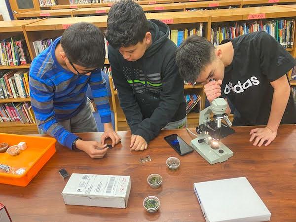
jsc2023e065216 (10/19/2023) --- Seventh grade student researchers Nirav Neupane, Kevontae Espada, and Max Gaylor work on their experiment, Do Tardigrades Develop Properly in Microgravity, which will be included in the Nanoracks-National Center for Earth and Space Science Education-Orbiter-Student Spaceflight Experiments Program Mission 17 to ISS (Nanoracks-NCESSE-Orbiter-SSEP).
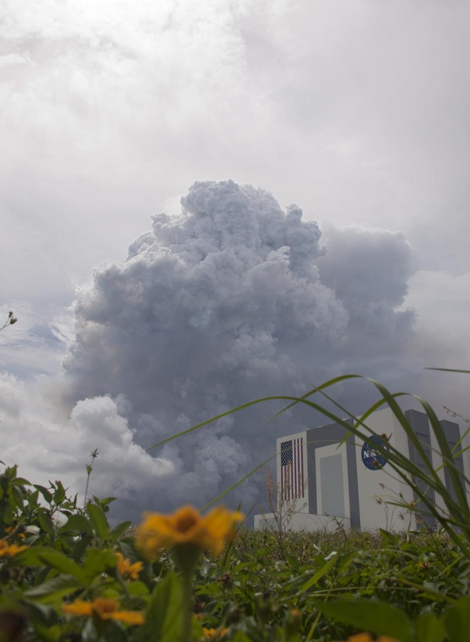
SMOKE NEAR VAB FROM CONTROLLED BURN
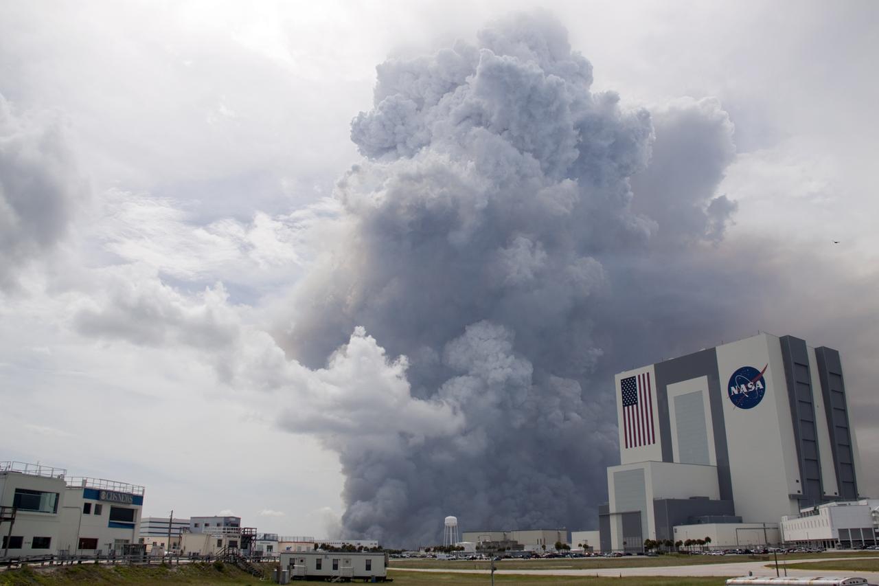
SMOKE NEAR VAB FROM CONTROLLED BURN
SMOKE NEAR VAB FROM CONTROLLED BURN
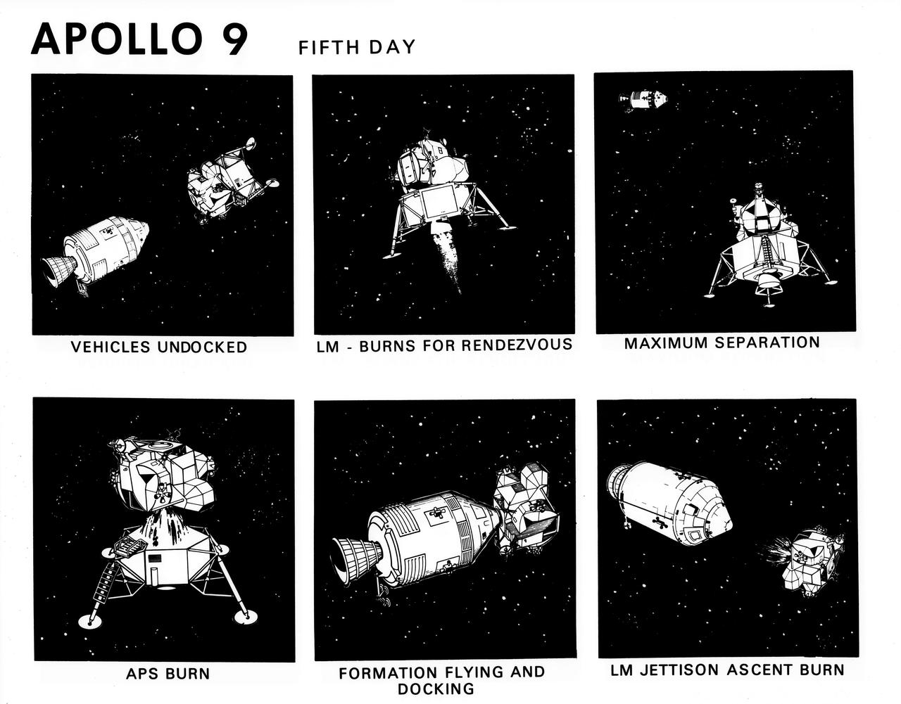
S69-19796 (February 1969) --- Composite of six artist's concepts illustrating key events, tasks and activities on the fifth day of the Apollo 9 mission, including vehicles undocked, Lunar Module burns for rendezvous, maximum separation, ascent propulsion system burn, formation flying and docking, and Lunar Module jettison ascent burn. The Apollo 9 mission will evaluate spacecraft lunar module systems performance during manned Earth-orbital flight.

(jsc2022e089094_alt) (Nov. 21, 2022) During day 6 of the 25.5 day mission, Vanessa Wyche, Johnson Space Center, Center Director and Flight Director Rick LaBrode, inside the Artemis Mission Control Room or the White Flight Control Room at the Johnson Space Center during the Outbound Powered Flyby (OPF) burn. The Outbound Powered Flyby burn, targeted the DRI burn and was performed as Orion flew by the Moon around 62 mi (100 km)
More than 2 million acres were consumed by hundreds of fires between December 2002 and February 2003 in southeastern Australia national parks, forests, foothills and city suburbs as seen by NASA Terra spacecraft.

NASA Office of Communications Deputy Chief Patrick Lynch, left, introduces, from left to right, NASA Program Executive Melissa Morris, NASA Project Manager Rich Burns, Lockheed Martin Program Manager Sandy Freund, OSIRIS-REx Deputy Curation Lead Kevin Righter, and University of Arizona OSIRIS-REx Principal Investigator Dante Lauretta, during an OSIRIS-REx sample return press conference, Wednesday, Aug. 30, 2023, at the Department of Defense's Utah Test and Training Range. The sample was collected from the asteroid Bennu in October 2020 by NASA’s OSIRIS-REx spacecraft and will return to Earth on September 24th, landing under parachute at the Utah Test and Training Range. Photo Credit: (NASA/Keegan Barber)
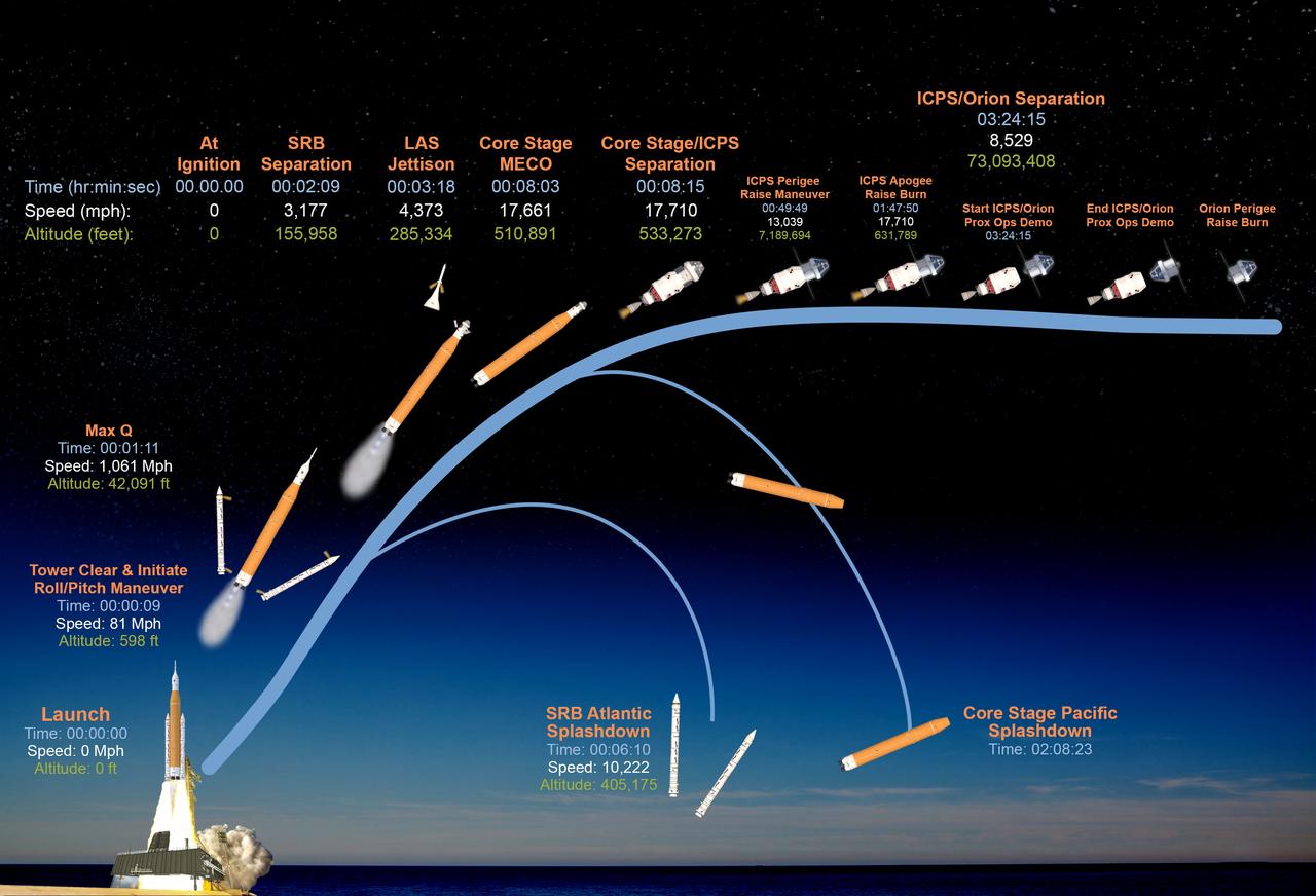
This graphic shows the time, speed, and altitude of key events from launch of the SLS (Space Launch System) rocket and Orion spacecraft and ascent to space, through Orion's perigee raise burn during the Artemis II test flight.
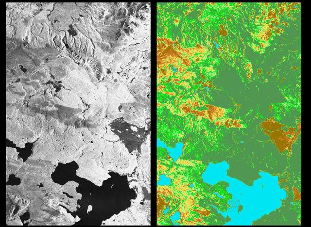
These two radar images show the majestic Yellowstone National Park, Wyoming, the oldest national park in the United States and home to the world's most spectacular geysers and hot springs. The region supports large populations of grizzly bears, elk and bison. In 1988, the park was burned by one of the most widespread fires to occur in the northern Rocky Mountains in the last 50 years. Surveys indicated that 793,880 acres of land burned. Of that, 41 percent was burned forest, with tree canopies totally consumed by the fire; 35 percent was a combination of unburned, scorched and blackened trees; 13 percent was surface burn under an unburned canopy; 6 percent was non-forest burn; and 5 percent was undifferentiated burn. Six years later, the burned areas are still clearly visible in these false-color radar images obtained by the Spaceborne Imaging Radar-C/X-band Synthetic Aperture Radar on board the space shuttle Endeavour. The image at the left was obtained using the L-band radar channel, horizontally received and vertically transmitted, on the shuttle's 39th orbit on October 2, 1994. The area shown is 45 kilometers by 71 kilometers (28 miles by 44 miles) in size and centered at 44.6 degrees north latitude, 110.7 degrees west longitude. North is toward the top of the image (to the right). Most trees in this area are lodge pole pines at different stages of fire succession. Yellowstone Lake appears as a large dark feature at the bottom of the scene. At right is a map of the forest crown, showing its biomass, or amount of vegetation, which includes foliage and branches. The map was created by inverting SIR-C data and using in situ estimates of crown biomass gathered by the Yellowstone National Biological Survey. The map is displayed on a color scale from blue (rivers and lakes with no biomass) to brown (non-forest areas with crown biomass of less than 4 tons per hectare) to light brown (areas of canopy burn with biomass of between 4 and 12 tons per hectare). Yellow indicates areas of canopy burn and mixed burn with a biomass of between 12 to 20 tons per hectare; light green is mixed burn and on-burn forest with a biomass of 20 to 35 tons per hectare; and green is non-burned forest with a biomass of greater than 35 tons per hectare. Forest recovery from the fire seems to depend on fire intensity and soil conditions. In areas of severe canopy burn and poor soil conditions, crown biomass was still low in 1994 (indicated by the brown areas at the center left), whereas in areas of mixed burn with nutrient-rich soils, seen west of Yellowstone Lake, crown biomass has increased significantly in six years (indicated by the yellow and light green areas). Imaging fire-affected regions with spaceborne radar illustrates SIR-C/X-SAR's keen abilities to monitor regrowth after a fire. Knowing the amount of carbon accumulated in the atmosphere by regenerating forest in the 20 to 50 years following a fire disturbance is also a significant factor in understanding the global carbon cycle. Measuring crown biomass is necessary to evaluate the effects of past and future fires in specific regions. http://photojournal.jpl.nasa.gov/catalog/PIA01741

iss071e439834 (Aug. 8, 2024) --- The Yangtze River beams in the Sun's glint as wildfires burn in the surrounding forestland near the city of Wuhan in China's province of Hubei. The International Space Station was orbiting 262 miles above the Asian nation at the time of this photograph.
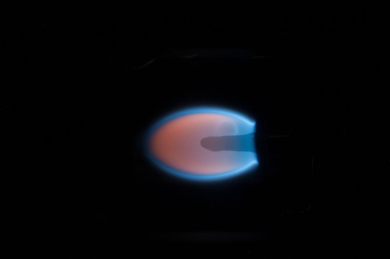
Image taken during BASS-II flame test session -card 2 - conducted on GMT 203. Burned a 4 mm thick, 1 cm wide acrylic slab at multiple velocities. At high flows, the flame was long and sooty. When the flow was reduced, the flame stabilized. The Burning and Suppression of Solids II (BASS-II) investigation examines the burning and extinction characteristics of a wide variety of fuel samples in microgravity. The BASS-II experiment will guide strategies for materials flammability screening for use in spacecraft as well as provide valuable data on solid fuel burning behavior in microgravity. BASS-II results contribute to the combustion computational models used in the design of fire detection and suppression systems in microgravity and on Earth.
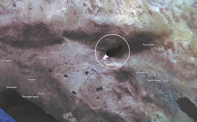
This observation shows the burn area and smoke plume created by the Apple fire in Southern California on Aug. 1, 2020. The observation was made possible by NASA's Ecosystem Spaceborne Thermal Radiometer Experiment on Space Station (ECOSTRESS). Data gathered by the mission can be further refined to measure the temperature of the wildfire, smoke plume and surrounding landscape. ECOSTRESS collected this data when the space station passed over the region at about 1:15 p.m. PST on Saturday, Aug. 1, 2020, when the burn area was approximately 4,000 acres in size. As of Aug. 3, it was more than 26,000 acres. Black smoke can be seen drifting east and over Joshua Tree National Park in the Mojave Desert. With a resolution of about 77 by 77 yards (70 by 70 meters), the image enables surface-temperature conditions down to the size of a football field to be studied. Tasked with detecting plant water use and stress, ECOSTRESS measures the temperature of plants as they heat up when they run out of water. But it can also measure and track heat-related phenomena like fires, heat waves, and volcanoes. https://photojournal.jpl.nasa.gov/catalog/PIA23799
jsc2023e046375 (7/25/2023) --- A sample of fabric burns inside Spacecraft Fire Experiment-IV (Saffire-IV). The sample is a composite fabric made of cotton and fiberglass and is 40 cm wide. The image appears green because green LED lights are used to illuminate the sample during a burn. The flame appears orange in this image and the black region to the right of the flame is the cotton in the sample beginning to heat and char. The bright specks to the left of the flame are smoldering cotton that remains on the fiberglass substrate after the flame passes. In Saffire-VI, this fabric is burned at higher oxygen concentrations. Researchers aim to study realistic flame spread to aid the development of fire safety equipment and strategies for future spacecraft.
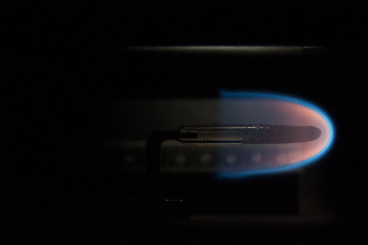
Image taken on card 15 during BASS-II flame test session with reduced O2 partial pressure. Session conducted on GMT 214. The Burning and Suppression of Solids - II (BASS-II) investigation examines the burning and extinction characteristics of a wide variety of fuel samples in microgravity. The BASS-II experiment will guide strategies for materials flammability screening for use in spacecraft as well as provide valuable data on solid fuel burning behavior in microgravity. BASS-II results contribute to the combustion computational models used in the design of fire detection and suppression systems in microgravity and on Earth.
ISS039-E-005726 (27 March 2014) --- Expedition 39 Flight Engineer Rick Mastracchio performs inflight maintenance on an experiment called Burning and Suppression of Solids (BASS)-II. The investigation examines the burning and extinction characteristics of a wide variety of fuel samples in microgravity. The BASS-II experiment will guide strategies for materials flammability screening for use in spacecraft as well as provide valuable data on solid fuel burning behavior in microgravity. BASS-II results contribute to the combustion computational models used in the design of fire detection and suppression systems in microgravity and on Earth.
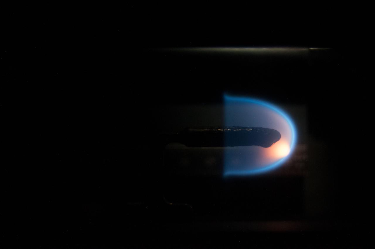
Image taken on card 8 during BASS-II flame test session with reduced O2 partial pressure. Session conducted on GMT 213. The Burning and Suppression of Solids - II (BASS-II) investigation examines the burning and extinction characteristics of a wide variety of fuel samples in microgravity. The BASS-II experiment will guide strategies for materials flammability screening for use in spacecraft as well as provide valuable data on solid fuel burning behavior in microgravity. BASS-II results contribute to the combustion computational models used in the design of fire detection and suppression systems in microgravity and on Earth.
In early August 2017, the Cinder Butte fire burned 9 miles (15 kilometers) outside of the town of Riley, Oregon, and consumed more than 82 square miles (53,000 acres) of forest and brushland. The fire threatened tribal archaeological sites with strong significance to the Burns Paiute and Klamath tribes. Firefighters were able to contain the fire before it could damage the historic sites. On the image, the burned area is gray-brown, and cloud shadows are dark gray-to-black. The image was acquired Aug. 23, 2017, covers an area of 20 by 25 miles (31.5 by 39.9 kilometers), and is located at 43.5 degrees north, 119.9 degrees west. https://photojournal.jpl.nasa.gov/catalog/PIA21879
On November 18, 2003, the Advanced Spaceborne Thermal Emission and Reflection Radiometer (ASTER) on NASA's Terra satellite acquired this image of the Old Fire/Grand Prix fire east of Los Angeles. The image is being processed by NASA's Wildfire Response Team and will be sent to the United States Department of Agriculture's Forest Service Remote Sensing Applications Center (RSAC) which provides interpretation services to Burned Area Emergency Response (BAER) teams to assist in mapping the severity of the burned areas. The image combines data from the visible and infrared wavelength regions to highlight the burned areas. http://photojournal.jpl.nasa.gov/catalog/PIA04879
ISS017-E-010310 (4 July 2008) --- The Piute fire in California is featured in this image photographed by an Expedition 17 crewmember on the International Space Station. The Piute fire, burning south of Lake Isabella in the Sequoia National Forest in the southern Sierra Nevada Mountains, is one of the more than 300 wildfires burning across the state of California. The fire started June 28 just north of Twin Oaks, California, and has burned nearly 14,000 acres so far. Current estimates by fire officials suggest the fire may not be brought under control for another two weeks.
![ISS031-E-146306 (27 June 2012) --- An Expedition 31 crew member aboard the International Space Station, flying approximately 240 miles (386 kilometers) above Earth, captured this view of the Fontenelle fire on June 27, 2012. The fire, burning in Wyoming 18 miles (29 kilometers) west of Big Piney, was discovered on June 24. [Editor?s update --- By the morning of June 28, the fire had burned 25,000 acres (101 square kilometers). By July 6, the area burned had more than doubled to 57,324 acres (232 square kilometers), and the fire was 25 percent contained].](https://images-assets.nasa.gov/image/iss031e146306/iss031e146306~medium.jpg)
ISS031-E-146306 (27 June 2012) --- An Expedition 31 crew member aboard the International Space Station, flying approximately 240 miles (386 kilometers) above Earth, captured this view of the Fontenelle fire on June 27, 2012. The fire, burning in Wyoming 18 miles (29 kilometers) west of Big Piney, was discovered on June 24. [Editor?s update --- By the morning of June 28, the fire had burned 25,000 acres (101 square kilometers). By July 6, the area burned had more than doubled to 57,324 acres (232 square kilometers), and the fire was 25 percent contained].
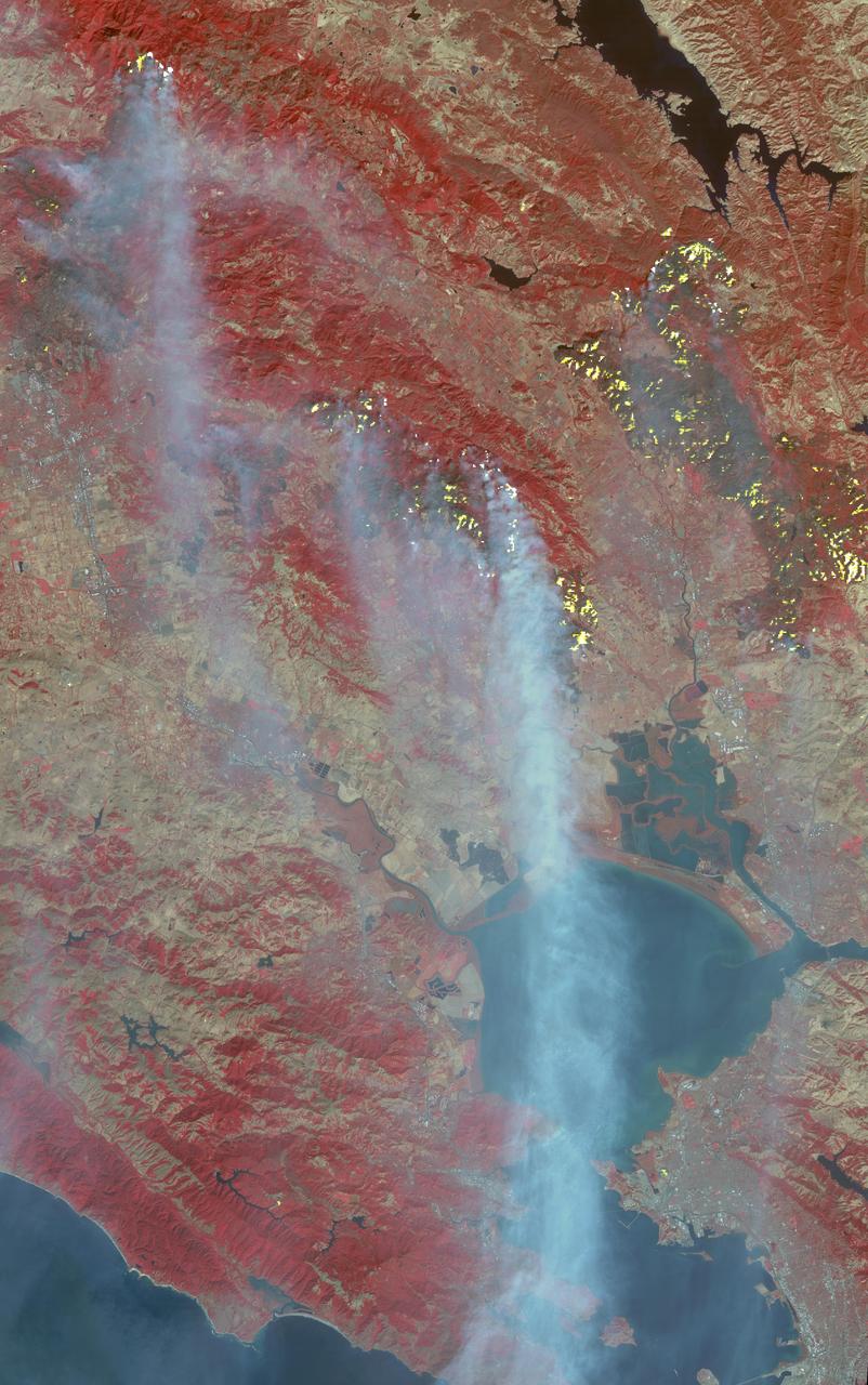
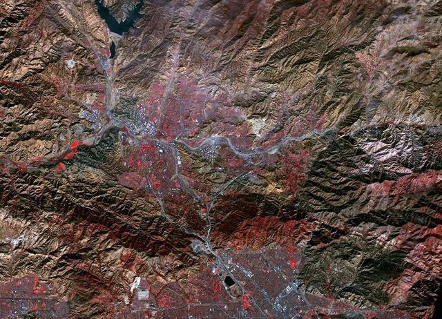
The major fires burning in Northern California's wine country continue to burn relentlessly, forcing additional mass evacuations. The Advanced Spaceborne Thermal Emission and Reflection Radiometer (ASTER) instrument on NASA's Terra satellite acquired this image the morning of Oct. 12, 2017. The fires have consumed hundreds of thousands of acres, resulting in significant loss of life, injuries and heavy property losses. The city of Santa Rosa is in the upper left corner; Napa is in the upper right; and Sonoma is in the center. In the image, vegetation is depicted in red and smoke is blue-gray. Active fires and hotspots, detected on ASTER's thermal infrared channels, are in yellow. The background colors have been subdued to make the yellow hotspots more apparent. The image covers an area of 35 by 57 miles (57 by 91 kilometers) and is located near 38.3 degrees north, 122.5 degrees west. https://photojournal.jpl.nasa.gov/catalog/PIA22046
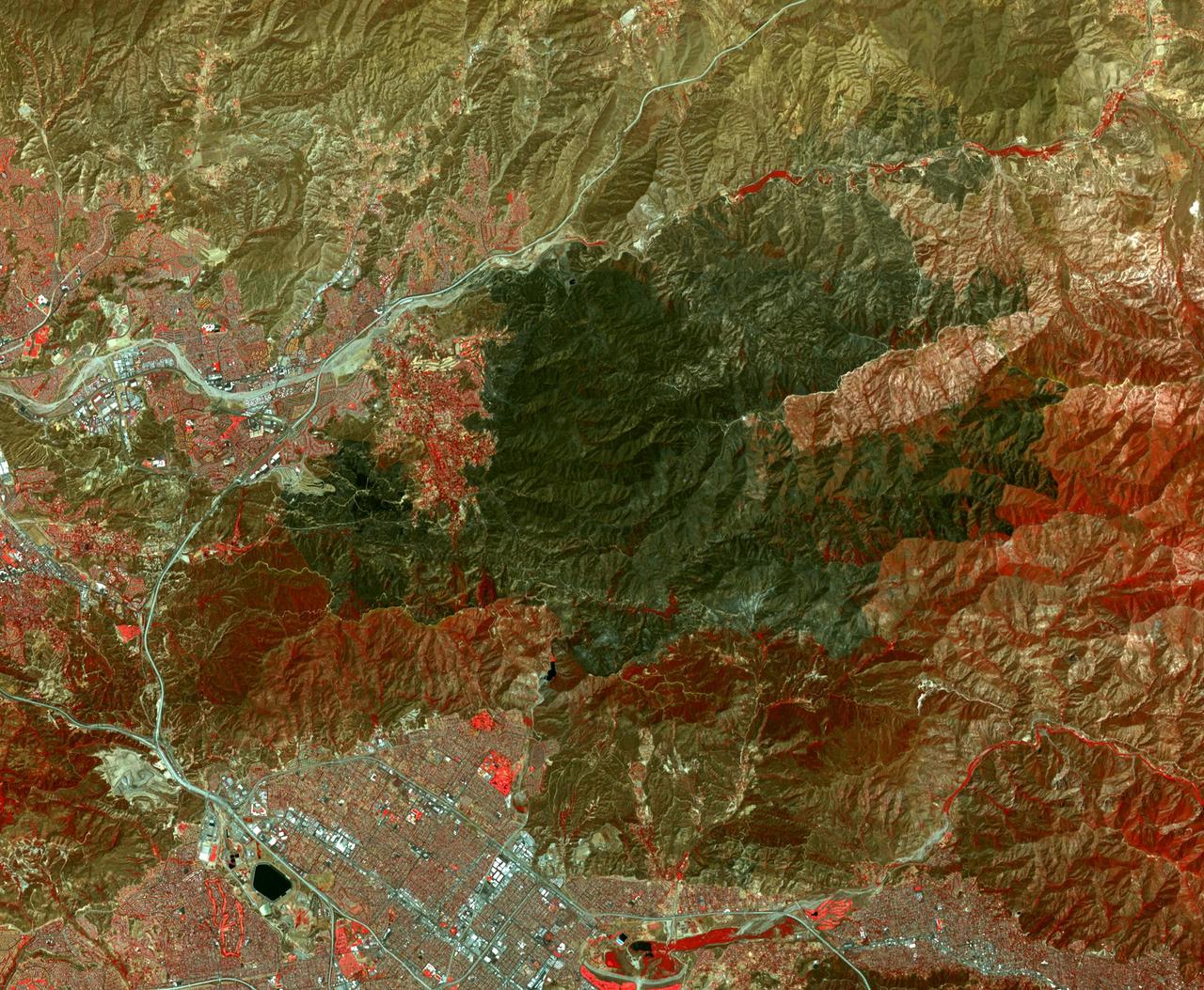
The Sand fire, in the mountains northwest of Los Angeles, has burned more than 39,000 acres, destroyed 18 houses, and caused one fatality. By August 1, 2016, when the Advanced Spaceborne Thermal Emission and Reflection Radiometer (ASTER) instrument on NASA's Terra spacecraft acquired this image, the fire was more than 90 percent contained. The fire began 10 days earlier in a brushy area near Highway 14. It grew explosively to thousands of acres, driven by high winds and temperatures over 100 degrees Fahrenheit. At one time, more than 20,000 residents were evacuated from their homes. In this image, vegetation is displayed in red, and the burn area is dark grey to black. The image covers an area of 16.4 by 19.4 miles (26.4 by 31.3 kilometers), and is located at 34.4 degrees north, 118.3 degrees west. http://photojournal.jpl.nasa.gov/catalog/PIA20723
STS-80 Mission Specialist Tom Jones is seated in the flight deck commander's seat and conducts stationkeeping burns.
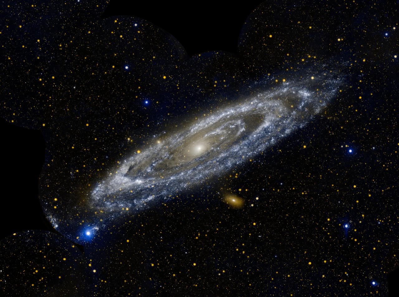
Hot stars burn brightly in this new image from NASA Galaxy Evolution Explorer, showing the ultraviolet side of a familiar face. Approximately 2.5 million light-years away, the Andromeda galaxy, or M31, is our Milky Way largest galactic neighbor.
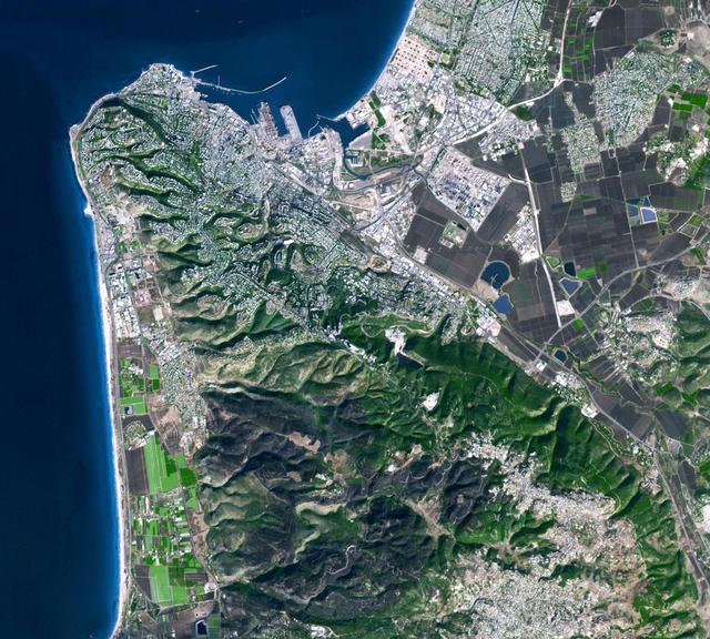
This image from NASA Terra spacecraft was acquired on Dec. 9, 2010 and shows Israel Carmel region near the city of Haifa where a deadly forest fire raged from Dec.3 to Dec.6, 2010; the burned areas appear in dark gray.
NASA Mars Exploration Rover Opportunity used its navigation camera to acquire this view looking toward the southwest. The scene includes tilted rocks at the edge of a bench surrounding Cape York, with Burns formation rocks exposed in Botany Bay.