Oh Canada!

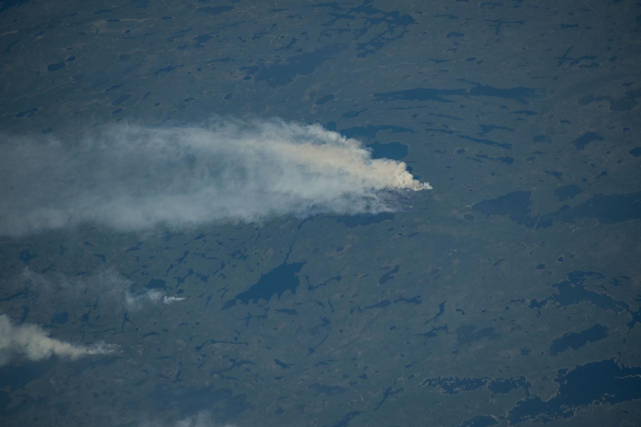
iss071e439719 (Aug. 6, 2024) --- A wildfire in Canada and its smoke spreading in the atmosphere are pictured from the Intenational Space Station as it orbited 263 miles above North Dakota.

NASA astronaut Drew Feustel speaks about his experience on two shuttle missions, STS-125 and STS-134, as well as Expeditions 55 and 56 on the International Space Station, at the Embassy of Canada, Monday, May 6, 2019 in Washington. Photo Credit: (NASA/Aubrey Gemignani)

NASA astronaut Drew Feustel speaks about his experience on two shuttle missions, STS-125 and STS-134, as well as Expeditions 55 and 56 on the International Space Station, at the Embassy of Canada, Monday, May 6, 2019 in Washington. Photo Credit: (NASA/Aubrey Gemignani)
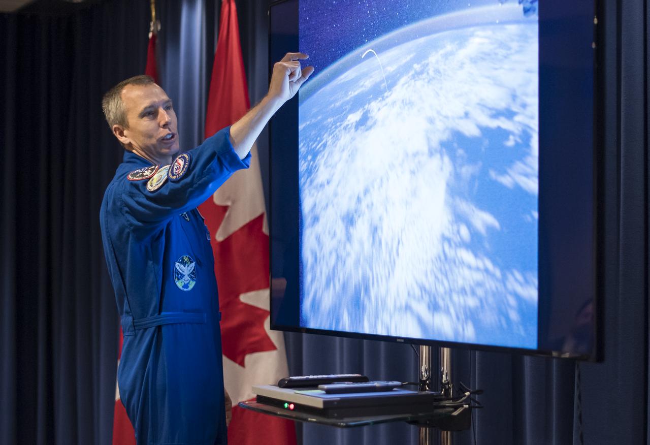
NASA astronaut Drew Feustel speaks about his experience on two shuttle missions, STS-125 and STS-134, as well as Expeditions 55 and 56 on the International Space Station, at the Embassy of Canada, Monday, May 6, 2019 in Washington. Photo Credit: (NASA/Aubrey Gemignani)
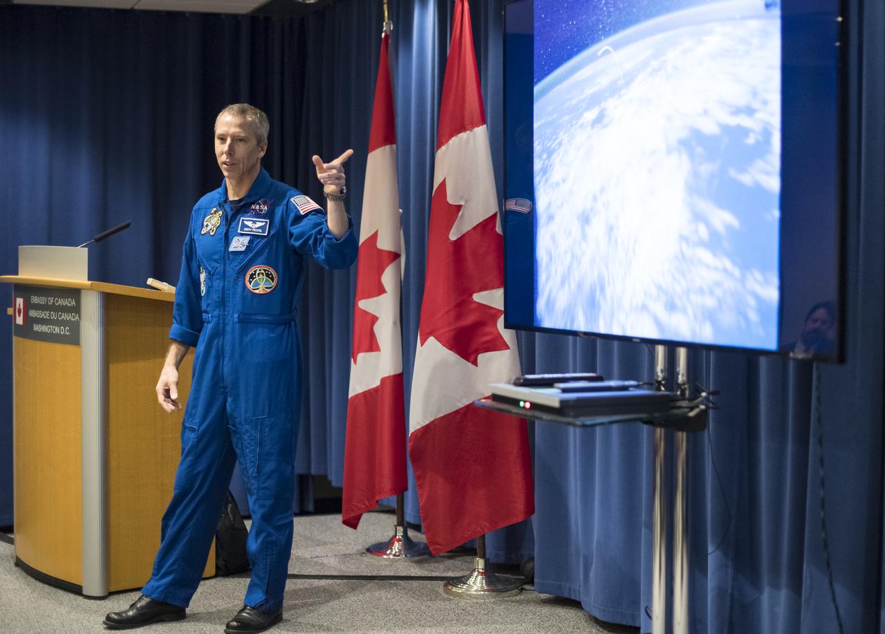
NASA astronaut Drew Feustel speaks about his experience on two shuttle missions, STS-125 and STS-134, as well as Expeditions 55 and 56 on the International Space Station, at the Embassy of Canada, Monday, May 6, 2019 in Washington. Photo Credit: (NASA/Aubrey Gemignani)

NASA astronaut Drew Feustel speaks about his experience on two shuttle missions, STS-125 and STS-134, as well as Expeditions 55 and 56 on the International Space Station, at the Embassy of Canada, Monday, May 6, 2019 in Washington. Photo Credit: (NASA/Aubrey Gemignani)

NASA astronaut Drew Feustel speaks about his experience on two shuttle missions, STS-125 and STS-134, as well as Expeditions 55 and 56 on the International Space Station, at the Embassy of Canada, Monday, May 6, 2019 in Washington. Photo Credit: (NASA/Aubrey Gemignani)

NASA astronaut Drew Feustel speaks about his experience on two shuttle missions, STS-125 and STS-134, as well as Expeditions 55 and 56 on the International Space Station, at the Embassy of Canada, Monday, May 6, 2019 in Washington. Photo Credit: (NASA/Aubrey Gemignani)
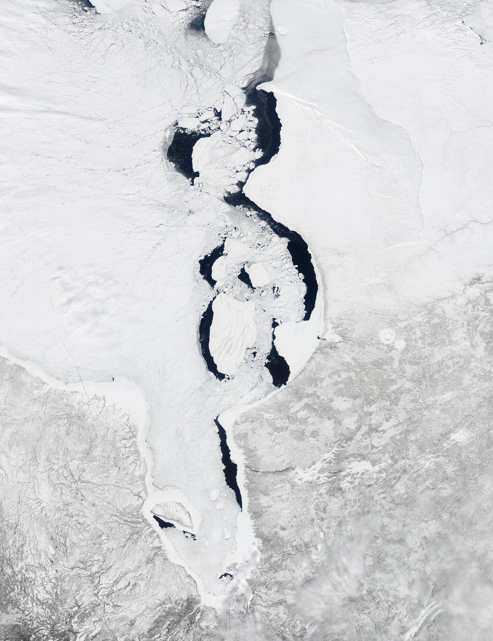
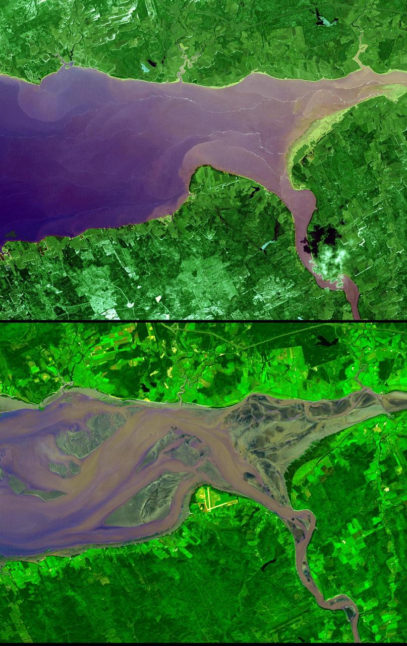
Each winter sea ice forms over the salty waters of frigid northeastern Canada's Hudson Bay. As sunlight lengthens and weather warms, ice begins to break up and melt, with retreat typically starting in May and melt-out completed sometime in July. Since the 1970s, the timing of sea ice breakup in Hudson Bay has changed, with melting beginning earlier in the spring. The Moderate Resolution Imaging Spectroradiometer (MODIS) aboard NASA’s Aqua satellite captured this a true-color image of Hudson Bay on March 26, 2013. Although snow still covers the surrounding land, ice has already begun to retreat from much of the eastern shore of the Bay visible in the image. A ring of bright white ice remains solidly frozen around the Belcher Islands in the southeast section of the Bay, but this ring is surrounded by blue waters and large chunks of ice. In the southwest, a similar situation is seen at Akimiski Island. The shelf of bright white ice gives way to open water in the south, as well as fractured, blue-tinted ice. The blue tint generally indicates water logging as ice begins to soften. The Aqua satellite captured a similar image of early ice melt on Hudson Bay on April 6, 2012. That image can be viewed at: <a href="http://modis.gsfc.nasa.gov/gallery/individual.php?db_date=2012-04-19" rel="nofollow">modis.gsfc.nasa.gov/gallery/individual.php?db_date=2012-0...</a> <b><a href="http://www.nasa.gov/audience/formedia/features/MP_Photo_Guidelines.html" rel="nofollow">NASA image use policy.</a></b> <b><a href="http://www.nasa.gov/centers/goddard/home/index.html" rel="nofollow">NASA Goddard Space Flight Center</a></b> enables NASA’s mission through four scientific endeavors: Earth Science, Heliophysics, Solar System Exploration, and Astrophysics. Goddard plays a leading role in NASA’s accomplishments by contributing compelling scientific knowledge to advance the Agency’s mission. <b>Follow us on <a href="http://twitter.com/NASA_GoddardPix" rel="nofollow">Twitter</a></b> <b>Like us on <a href="http://www.facebook.com/pages/Greenbelt-MD/NASA-Goddard/395013845897?ref=tsd" rel="nofollow">Facebook</a></b> <b>Find us on <a href="http://instagram.com/nasagoddard?vm=grid" rel="nofollow">Instagram</a></b>

NASA astronaut Drew Feustel speaks with Canadian Deputy Ambassador to the U.S., Kirsten Hillman, about spaceflight at the Embassy of Canada, Monday, May 6, 2019 in Washington. Photo Credit: (NASA/Aubrey Gemignani)

NASA astronaut Drew Feustel speaks with Canadian Deputy Ambassador to the U.S., Kirsten Hillman, about spaceflight at the Embassy of Canada, Monday, May 6, 2019 in Washington. Photo Credit: (NASA/Aubrey Gemignani)
NASA Terra spacecraft acquired this image of Dawson, Canada. A boom town in 1898, discovery of gold in the Klondike fueled the massive influx of miners, merchants, and other support professions to this town on the Yukon River.
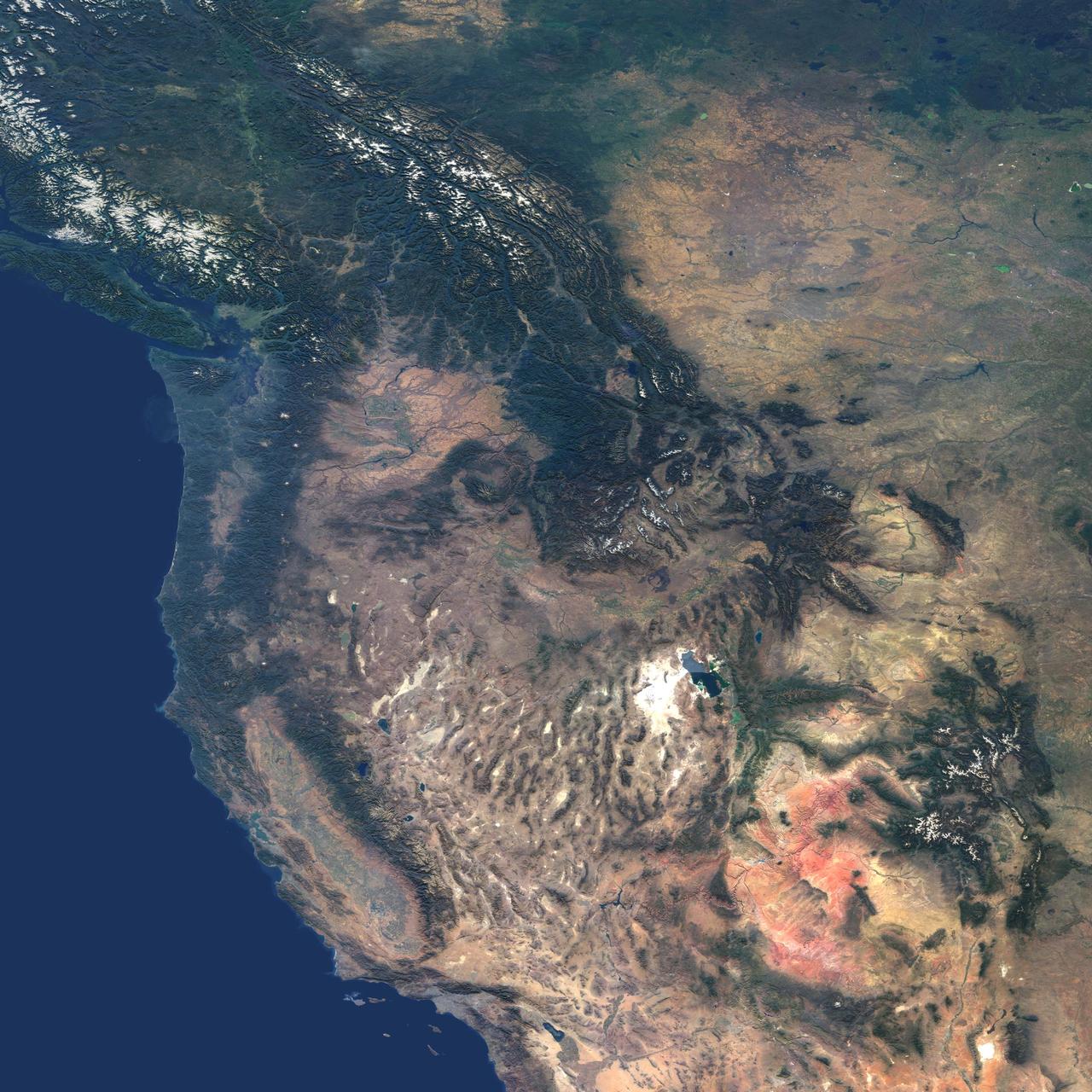
This natural-color image from NASA Terra spacecraft captures the beauty of the western United States and Canada.
This image from NASA Terra spacecraft shows Nunavut, in northern Canada, the largest and newest federal territory of the country. The name means our land in Inuktitut.
This image from NASA Terra spacecraft shows Ellesmere Island, which is part of the Qikiqtaaluk Region of the Canadian territory of Nunavut, with the most northerly point of land in Canada.
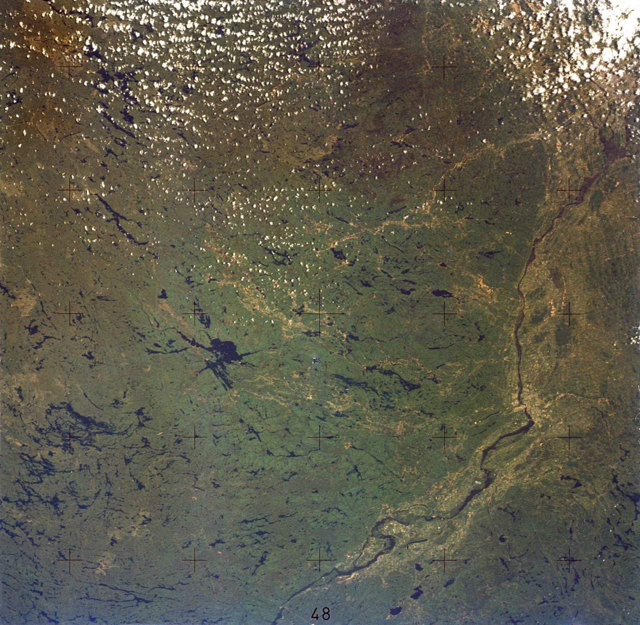
SL2-05-380 (22 June 1973) --- Ottawa, in the province of Ontario, (46.5N, 75.5W) is the capital of Canada and can be seen near the bottom of this scene on the Ottawa River. The region shown lies within the Canadian Shield. The glaciated surface of the land is underlain by lower Precambrian granite and sedimentary rock. Long fractures within these crystalline rocks have, in places, been carved out by glacial action. The resultant depressions are often water filled bogs and lakes. Photo credit: NASA
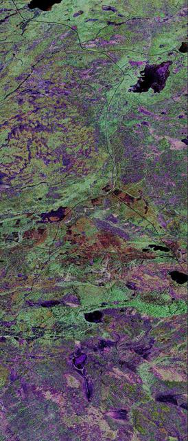
This is a false-color composite of Prince Albert, Canada, centered at 53.91 north latitude and 104.69 west longitude.
The Belcher Islands are an archipelago in Hudson Bay in Canada, belonging to the territory of Nunavit. The hamlet of Sanikiluaq is on the north coast of Flaherty Island. This image was acquired by NASA Terra satellite on 18 September 2006.
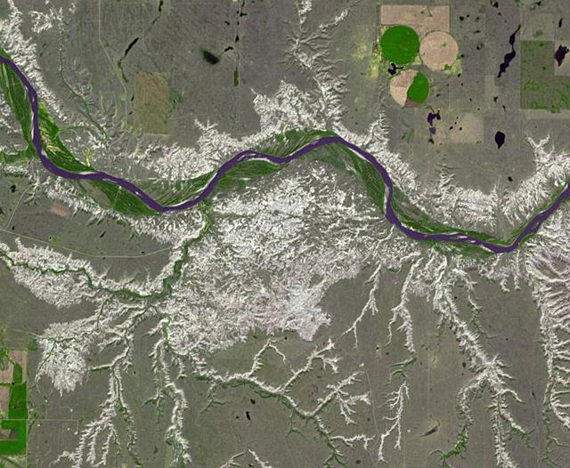
The Mackenzie River in the Northwest Territories, Canada, with its headstreams the Peace and Finley, is the longest river in North America. This image was acquired by NASA Terra satellite on August 4, 2005.
Dinosaur Provincial Park is a UNESCO World Heritage Site east of Calgary, Alberta, Canada. Located in the Red River Valley, it is noted for its badland topography and rich abundance of dinosaur fossils. Found in Late Cretaceous rocks, over 60 dinosaur species have been discovered. The image was acquired June 6, 2018, covers an area of 10.9 by 13.2 km, and is located at 50.6 degrees north, 111.5 degrees west. https://photojournal.jpl.nasa.gov/catalog/PIA26290
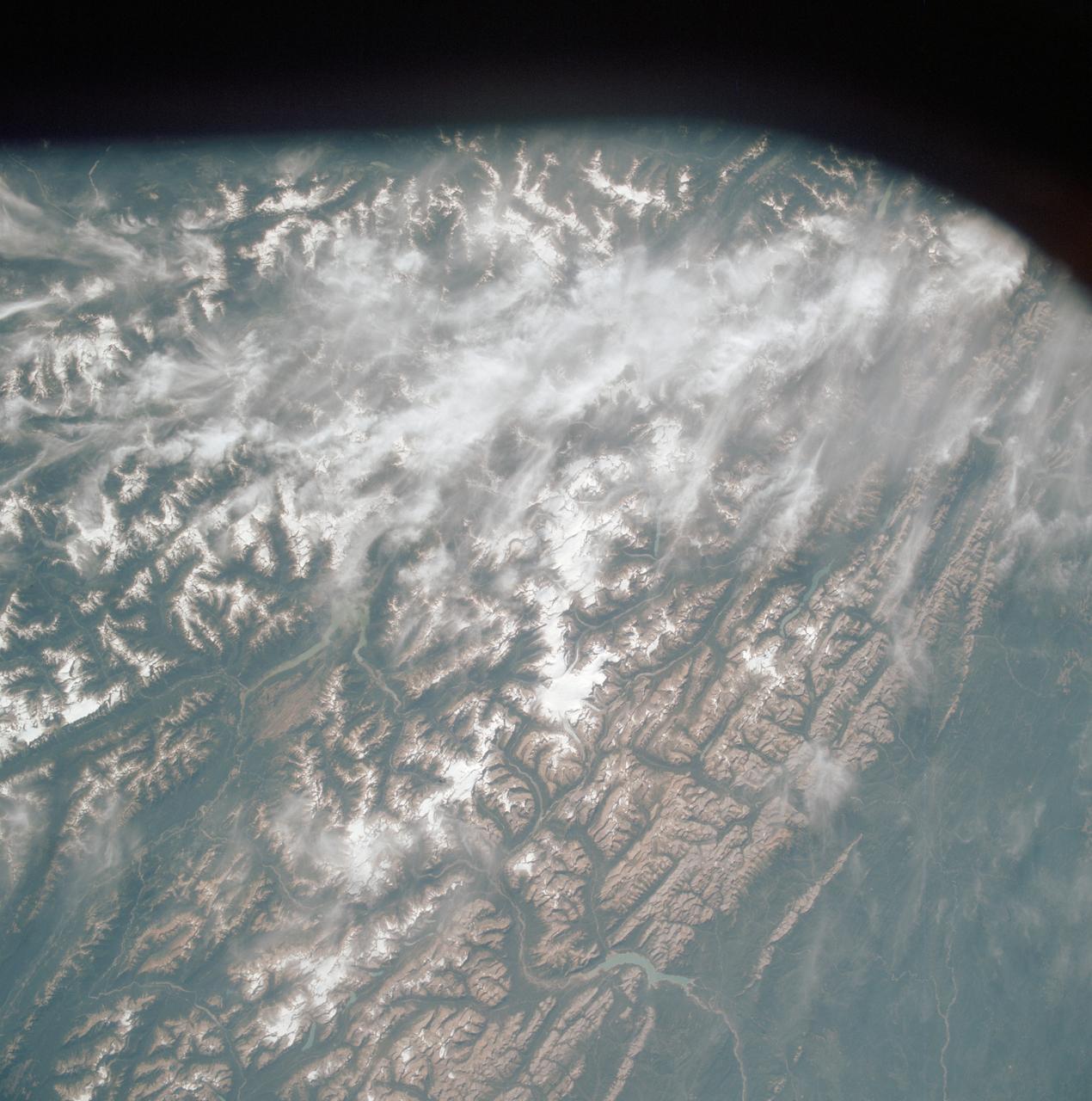
AST-19-1570 (24 July 1975) --- An oblique view of the Rocky Mountains area of British Columbia and Alberta in Canada, as photographed from the Apollo spacecraft in Earth orbit during the joint U.S.-USSR Apollo-Soyuz Test Project mission. This picture was taken at an altitude of 222 kilometers (138 statute miles) with a 70mm Hasselblad camera using medium-speed Ektachrome QX-807 type film.
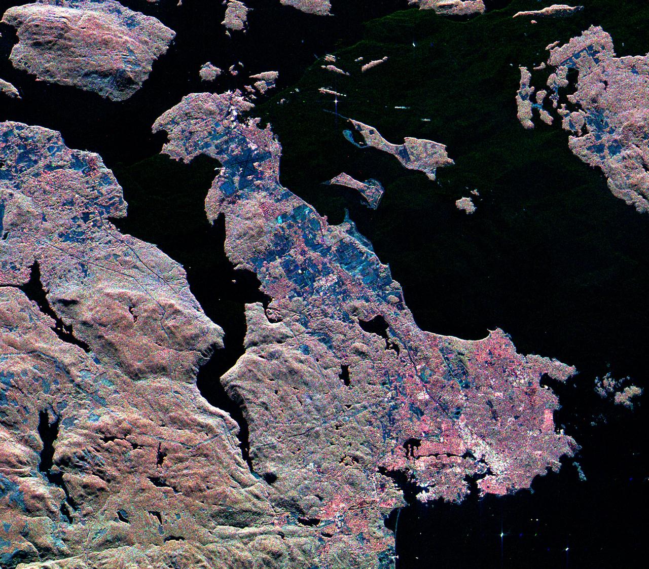
This three-frequency spaceborne radar image shows the southern end of Vancouver Island on the west coast of Canada. The white area in the lower right is the city of Victoria, the capital of the province of British Columbia.
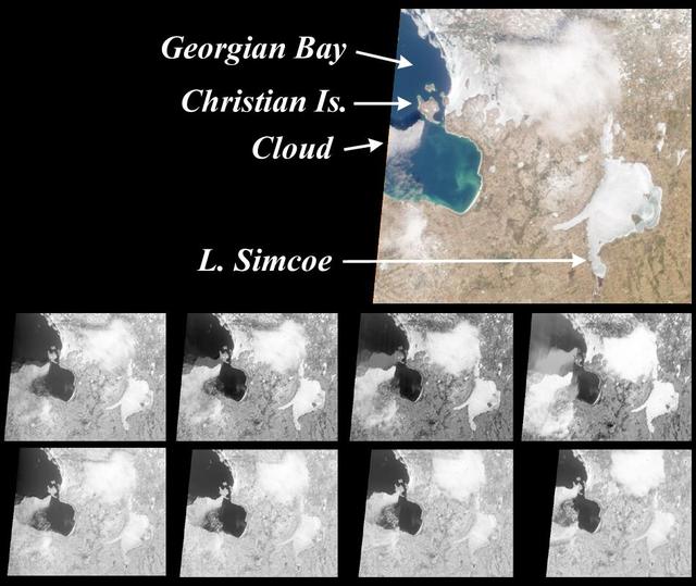
These images from NASA Terra satellite are of the southeast portion of Georgian Bay in Ontario, Canada, acquired on March 6, 2000, during Terra orbit 1155.
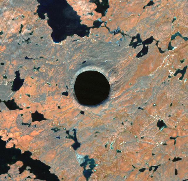
In Nunavik Province, far northern Canada, the Pingualuit Crater is known as the "Crystal Eye" to the Inuit. Once thought to be a possible diamond-bearing kimberlite pipe, the 3.5 km diameter circular structure is now known to be a meteor crater, formed about 1.4 million years ago. The image was acquired October 1, 2021, covers an area of 14.9 by 15.2 km, and is located at 61.3 degrees north, 73.7 degrees west. https://photojournal.jpl.nasa.gov/catalog/PIA25276
The Thematic Mapper on the Landsat 5 satellite captured this image of Vancouver on September 7, 2011. Flowing through braided channels, the Fraser River meanders toward the sea, emptying through multiple outlets. Moe info: <a href="http://earthobservatory.nasa.gov/IOTD/view.php?id=77368" rel="nofollow">earthobservatory.nasa.gov/IOTD/view.php?id=77368</a> NASA Earth Observatory image created by Robert Simmon and Jesse Allen, using Landsat data provided by the United States Geological Survey. Instrument: Landsat 5 - TM Credit: <b><a href="http://www.earthobservatory.nasa.gov/" rel="nofollow"> NASA Earth Observatory</a></b> <b><a href="http://www.nasa.gov/audience/formedia/features/MP_Photo_Guidelines.html" rel="nofollow">NASA image use policy.</a></b> <b><a href="http://www.nasa.gov/centers/goddard/home/index.html" rel="nofollow">NASA Goddard Space Flight Center</a></b> enables NASA’s mission through four scientific endeavors: Earth Science, Heliophysics, Solar System Exploration, and Astrophysics. Goddard plays a leading role in NASA’s accomplishments by contributing compelling scientific knowledge to advance the Agency’s mission. <b>Follow us on <a href="http://twitter.com/NASAGoddardPix" rel="nofollow">Twitter</a></b> <b>Like us on <a href="http://www.facebook.com/pages/Greenbelt-MD/NASA-Goddard/395013845897?ref=tsd" rel="nofollow">Facebook</a></b> <b>Find us on <a href="http://instagram.com/nasagoddard?vm=grid" rel="nofollow">Instagram</a></b>

View of NASA Technical Services personnel working in Canada Dry bldg.

This image from NASA Terra spacecraft shows Prince Patrick Island, which is located in the Canadian Arctic Archipelago, and is the westernmost Elizabeth Island in the Northwest Territories of Canada. The island is underlain by sedimentary rocks, cut by still-active faults. The streams follow a dendritic drainage system: there are many contributing streams (analogous to the twigs of a tree), which are then joined together into the tributaries of the main river (the branches and the trunk of the tree, respectively). They develop where the river channel follows the slope of the terrain. The image covers an area of 22 by 27 km, was acquired July 2, 2011, and is located at 76.9 degrees north, 118.9 degrees west. http://photojournal.jpl.nasa.gov/catalog/PIA19222
The first images taken by NASA Multi-angle Imaging SpectroRadiometer MISR on February 24, 2000, show the winter landscape of James Bay, Ontario, Canada from three of the instrument nine cameras.
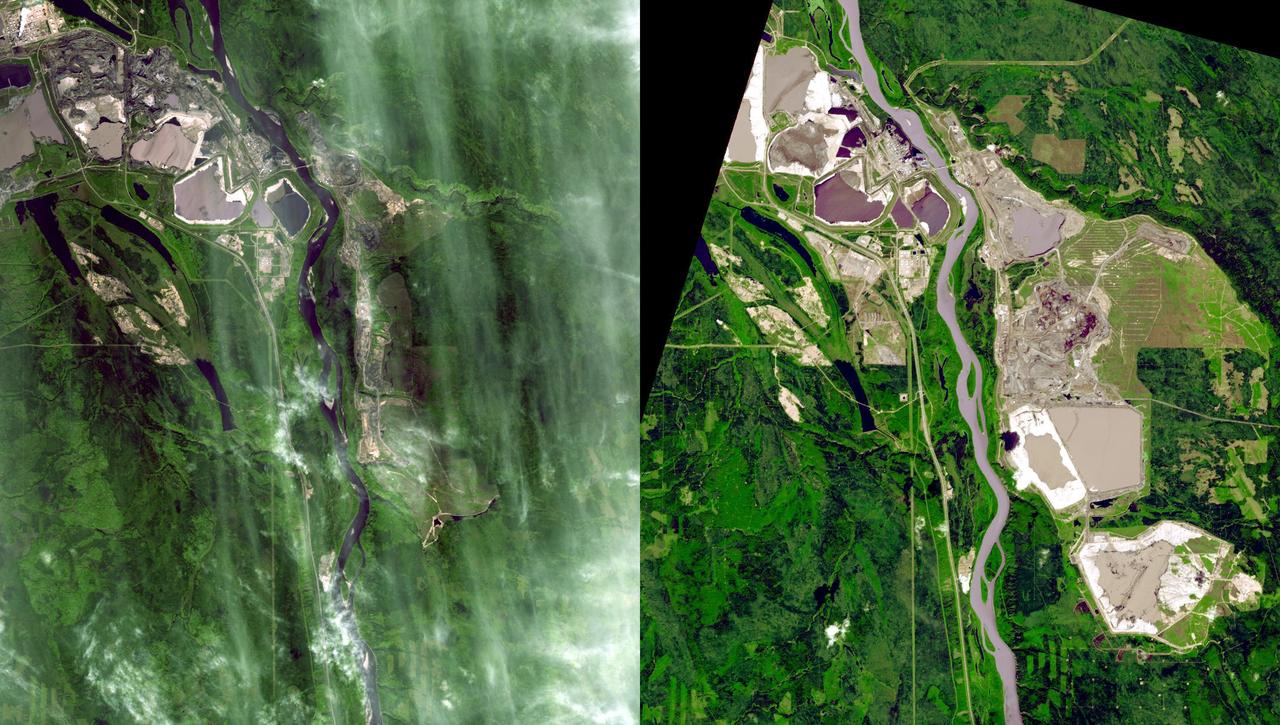
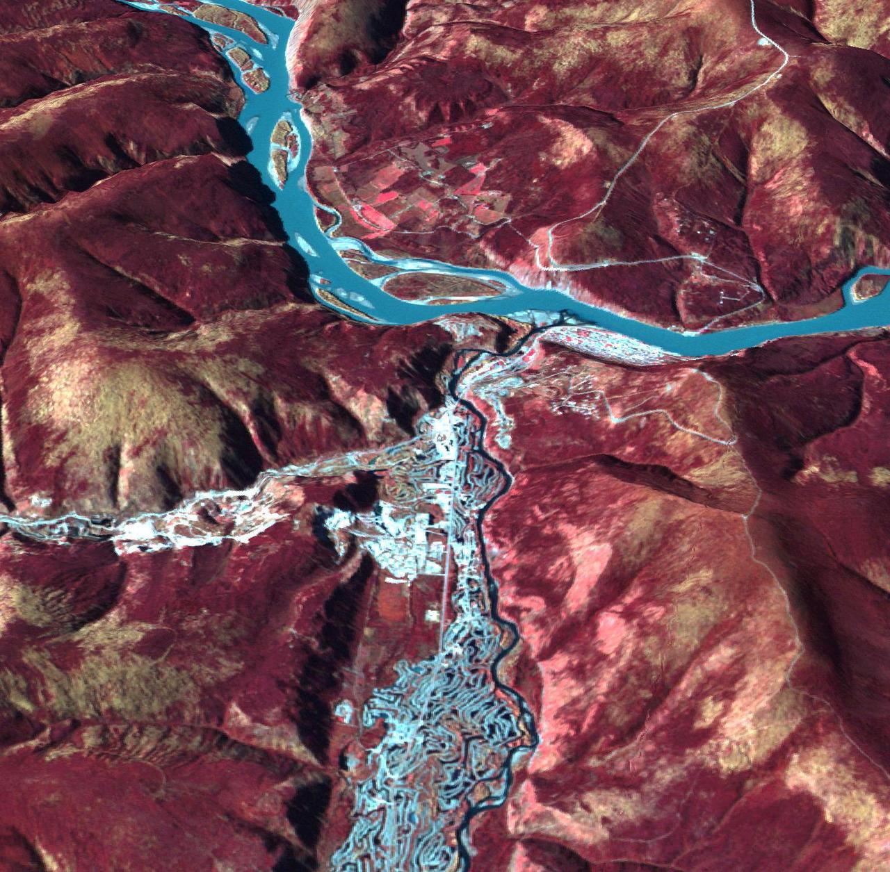
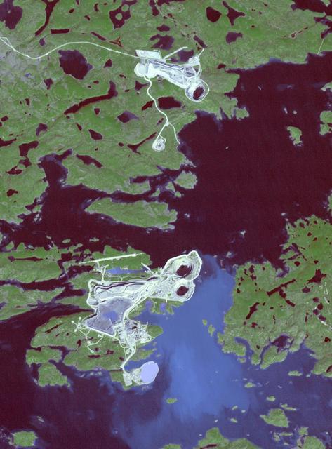
Near Fort McMurray, Alberta, Canada, on the east bank of the Athabasca River, are found the Steepbank and Millennium open pit mines. These images were acquired by NASA Terra satellite on September 22, 2000 and July 31, 2007.
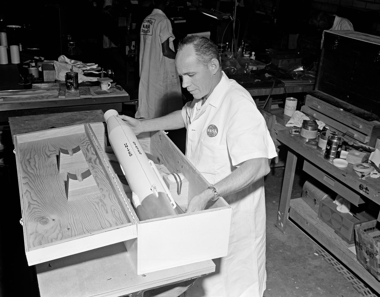
View of NASA Technical Services personnel packing model of rocket in the Canada Dry Bldg.
STS047-151-488 (12 - 20 Sept 1992) --- In this large format camera image, the forested Cascade Range appears along the left side; the Pacific Ocean, on the right. The frame was photographed as the Space Shuttle Endeavour flew north to south over Vancouver and Seattle. Many peaks in the Cascades reach altitudes greater than 9,000 feet and remain snowcapped even in mid-summer. The Strait of Juan de Fuca separates the Olympic Peninsula (top right) from Vancouver Island (bottom right). Snowcapped Mt. Olympus (7,965 feet) is one of the wettest places in the continental United States, with rainfall in excess of 120 inches per year. The port cities of Seattle and Tacoma occupy the heavily indented coastline of Puget Sound (top center). They appear as light-colored areas on the left side of the Sound. The angular street pattern of Tacoma is visible at the top of the picture. The international boundary between Canada and the United States of America runs across the middle of the view. The city of Victoria (center) is the light patch on the tip of Vancouver Island. Canada's Fraser River Delta provides flat topography on which the cities of Vancouver, Burnaby, and New Westminster were built. These cities appear as the light-colored area just left of center. The Fraser River can be seen snaking its way out of the mountains at the apex of the delta. Numerous ski resorts dot the slopes of the mountains (bottom left) that rise immediately to the north of Vancouver. In the same area the blue water of Harrison and other, smaller lakes fills some of the valleys that were excavated by glaciers in the "recent" geological past, according to NASA scientists studying the photography. A Linhof camera was used to expose the frame.
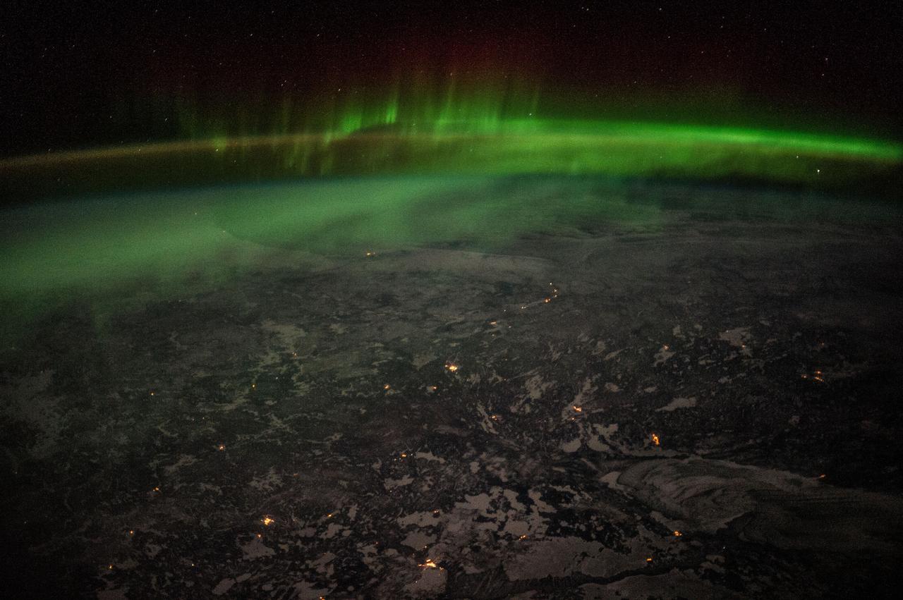
Earth observations taken by Expedition 38 crewmember. Aurora over Canada is visible. Image was released by astronaut on Twitter.
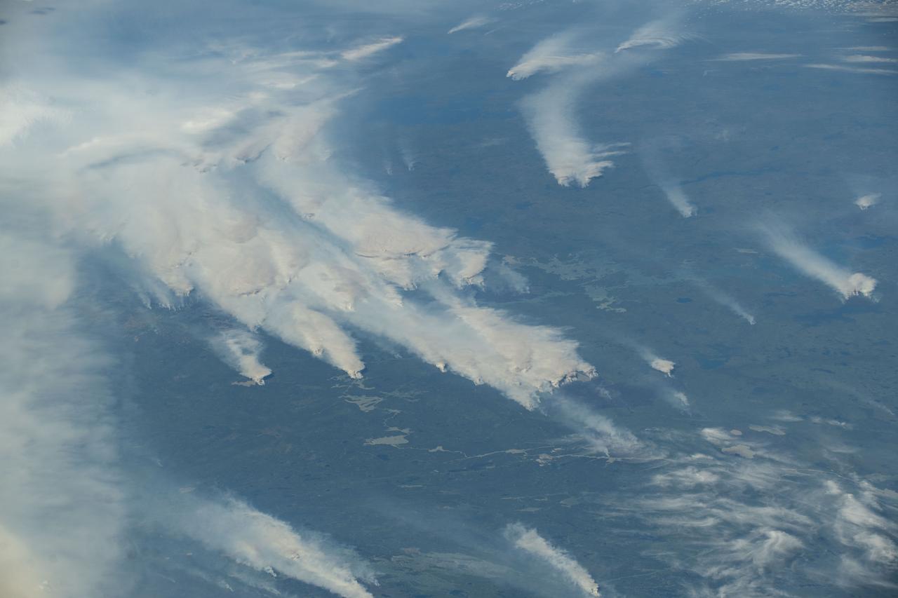
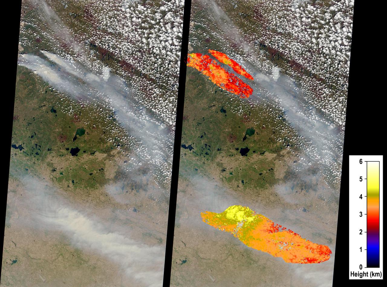
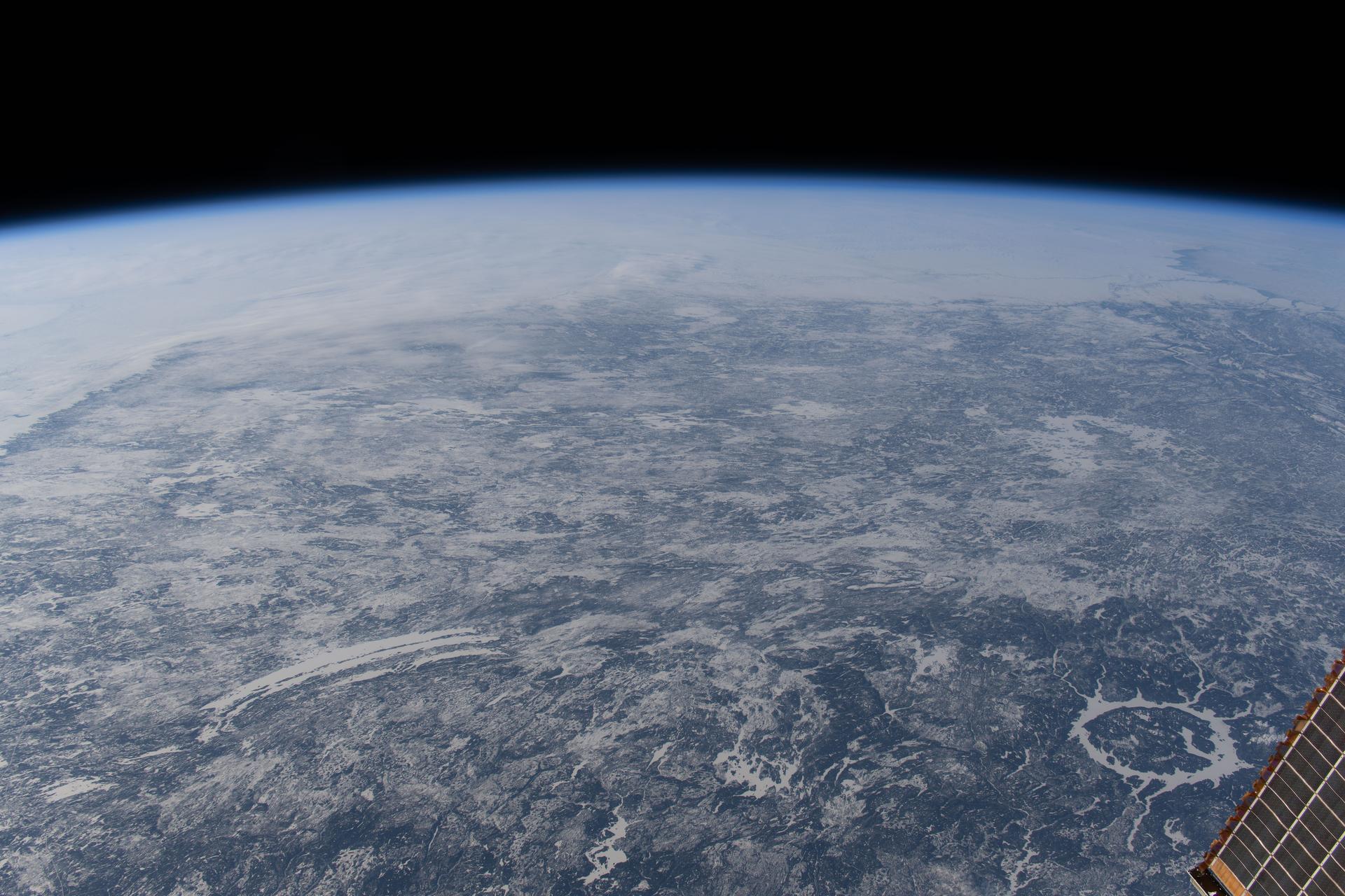
iss073e0420617 (Aug. 3, 2025) --- Wildfires burn throughout Canada's central provinces sending smoke drifting into the United States' Great Lakes and Northeast regions impacting air quality. The International Space Station was orbiting 262 miles above Canada at the time of this photograph.
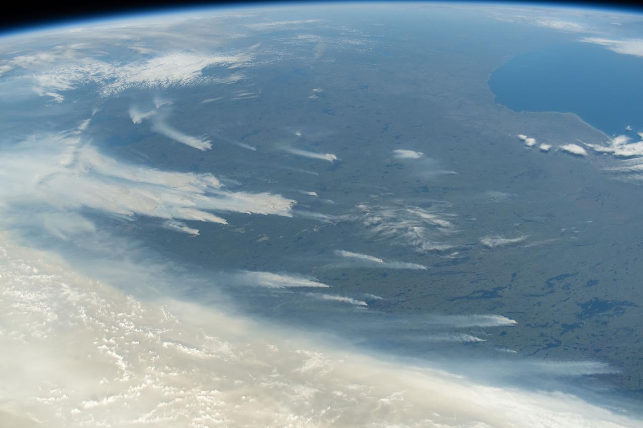
iss073e0420604 (Aug. 3, 2025) --- Wildfires burn throughout Canada's central provinces sending smoke drifitng into the United States' Great Lakes and Northeast regions impacting air quality. The International Space Station was orbiting 262 miles above Canada at the time of this photograph.
iss073e0420614 (Aug. 3, 2025) --- Wildfires burn throughout Canada's central provinces sending smoke drifitng into the United States' Great Lakes and Northeast regions impacting air quality. The International Space Station was orbiting 262 miles above Canada at the time of this photograph.

Canadian Space Agency President Steve MacLean signs a framework agreement on civil space cooperation between the U.S. and Canada, Wednesday, Sept. 9, 2009, at the Canadian Embassy in Washington, DC. Photo Credit: (NASA/Bill Ingalls)

NASA Administrator Charles Bolden signs a framework agreement on civil space cooperation between the U.S. and Canada, Wednesday, Sept. 9, 2009, at the Canadian Embassy in Washington, DC. Photo Credit: (NASA/Bill Ingalls)

iss072e423413 (Dec. 29, 2024) --- The city lights of Winnipeg in Manitoba, Canada, contrast with the Red River in this photograph taken at approximately 3:04 a.m. local time from the International Space Station as it orbited 261 miles above.
This image shows how a partial solar eclipse darkened clouds over the Yukon and British Columbia in western Canada. It was taken on Oct. 23 at 21:20 UTC (5:20 p.m. EDT) by the Moderate Resolution Imaging Spectroradiometer instrument that flies aboard NASA's Aqua satellite. Credit: NASA Goddard MODIS Rapid Response Team Unlabeled image <b><a href="http://www.nasa.gov/audience/formedia/features/MP_Photo_Guidelines.html" rel="nofollow">NASA image use policy.</a></b> <b><a href="http://www.nasa.gov/centers/goddard/home/index.html" rel="nofollow">NASA Goddard Space Flight Center</a></b> enables NASA’s mission through four scientific endeavors: Earth Science, Heliophysics, Solar System Exploration, and Astrophysics. Goddard plays a leading role in NASA’s accomplishments by contributing compelling scientific knowledge to advance the Agency’s mission. <b>Follow us on <a href="http://twitter.com/NASAGoddardPix" rel="nofollow">Twitter</a></b> <b>Like us on <a href="http://www.facebook.com/pages/Greenbelt-MD/NASA-Goddard/395013845897?ref=tsd" rel="nofollow">Facebook</a></b> <b>Find us on <a href="http://instagram.com/nasagoddard?vm=grid" rel="nofollow">Instagram</a></b>
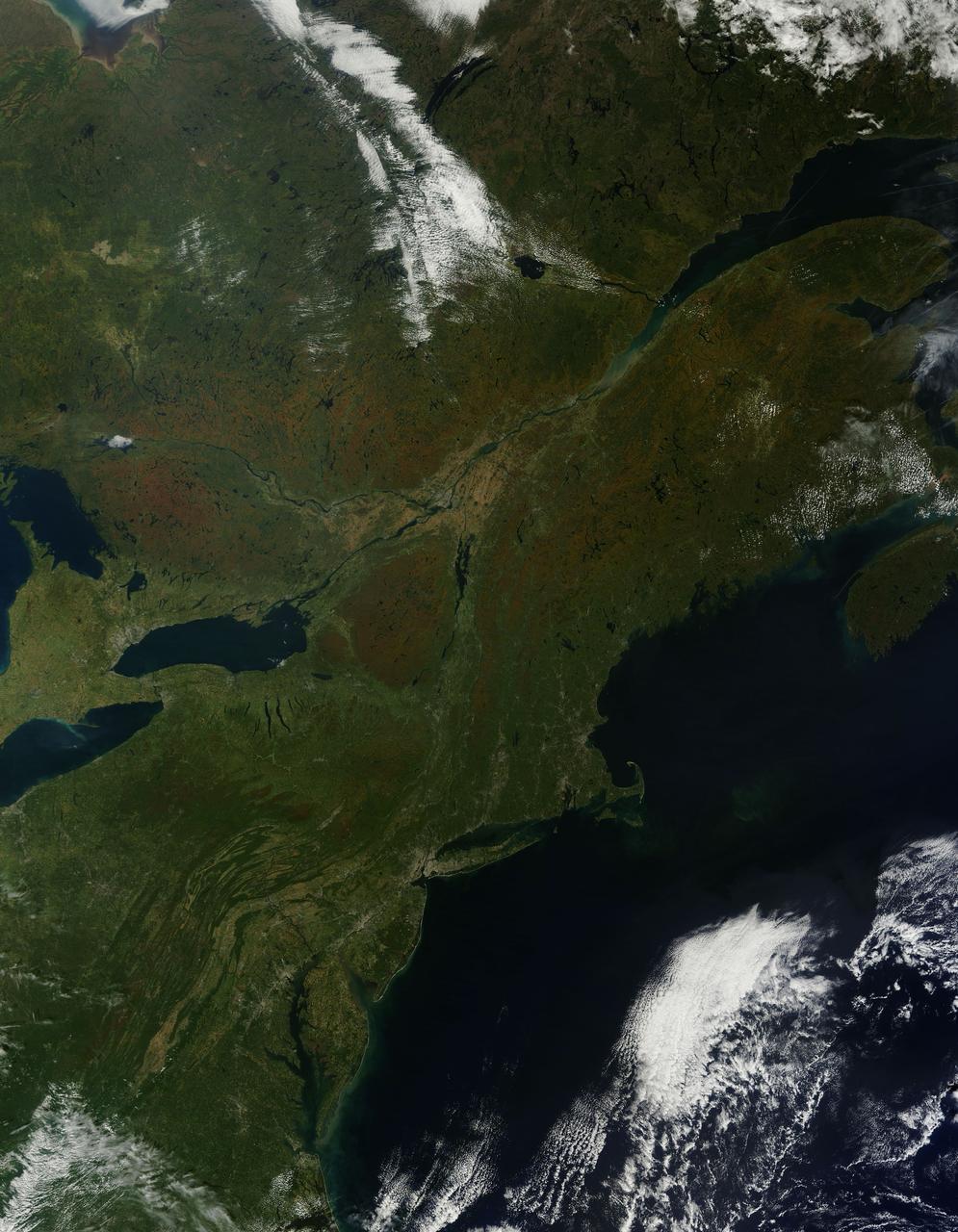
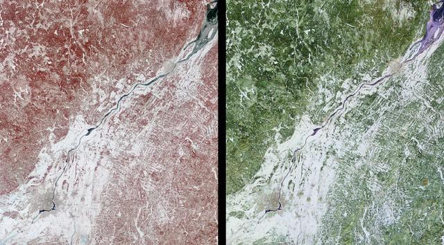
As temperatures dropped and daylight began to shorten, autumn colors began to wash over the deciduous forests of North America. The Moderate Resolution Imaging Spectroradiometer (MODIS) aboard NASA’s Terra satellite captured this true-color image of the northeastern United States and Canada on September 27, 2014. Washes of orange, brown and yellow are brightest in the Upper Peninsula of Michigan, upstate New York, New Hampshire, Vermont, Maine, and southern Quebec and Ontario. Also, faint traces of phytoplankton blooms can be seen in the offshore waters of the Atlantic Ocean. The transition of autumn leaves from green, to glowing with colors, to browning and dropping to the ground, involve several complex interactions and reactions. However, length of sunlight and the temperature changes are dominant factors. Topography also plays a role, as does latitude. Temperature tends to drop faster at higher elevations and at higher latitudes, and day length shortens more quickly at higher latitudes. Color change tends to begin in the north and sweep southward, and change begins at mountain tops then moves into valleys. As explained by the U.S. Forest Service, certain species of trees produce certain colors. Oaks generally turn red, brown, or russet; hickories become golden bronze; aspen and yellow-poplar turn golden. Maples differ by species. Red maple turns brilliant scarlet; sugar maple, orange-red; and black maple, yellow. Leaves of some trees, such as elms, simply become brown. Credit: NASA/GSFC/Jeff Schmaltz/MODIS Land Rapid Response Team <b><a href="http://www.nasa.gov/audience/formedia/features/MP_Photo_Guidelines.html" rel="nofollow">NASA image use policy.</a></b> <b><a href="http://www.nasa.gov/centers/goddard/home/index.html" rel="nofollow">NASA Goddard Space Flight Center</a></b> enables NASA’s mission through four scientific endeavors: Earth Science, Heliophysics, Solar System Exploration, and Astrophysics. Goddard plays a leading role in NASA’s accomplishments by contributing compelling scientific knowledge to advance the Agency’s mission. <b>Follow us on <a href="http://twitter.com/NASAGoddardPix" rel="nofollow">Twitter</a></b> <b>Like us on <a href="http://www.facebook.com/pages/Greenbelt-MD/NASA-Goddard/395013845897?ref=tsd" rel="nofollow">Facebook</a></b> <b>Find us on <a href="http://instagram.com/nasagoddard?vm=grid" rel="nofollow">Instagram</a></b>

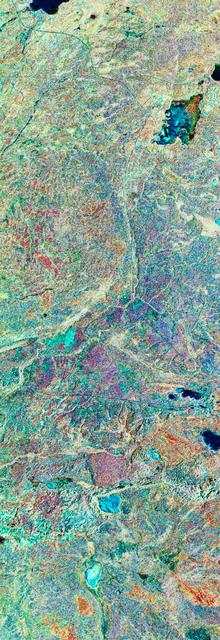
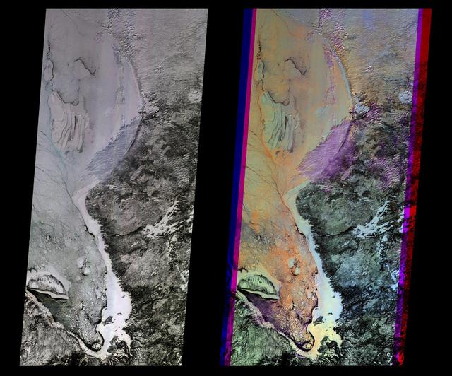
STS059-S-039 (11 April 1994) --- This is a false-color composite of Prince Albert, Canada, centered at 53.91 north latitude and 104.69 west longitude. This image was acquired by the Spaceborne Imaging Radar-C and X-Band Synthetic Aperture Radar (SIR-C/X-SAR) aboard the Space Shuttle Endeavour on its 20th orbit. The area is located 40 kilometers (25 miles) north and 30 kilometers (20 miles) east of the town of Prince Albert in the Saskatchewan province of Canada. The image covers the area east of the Candle Lake, between gravel surface Highways 120 and 106 and west of 106. The area in the middle of the image covers the entire Nipawin (Narrow Hills) provincial park. The look angle of the radar is 30 degrees and the size of the image is approximately 20 kilometers by 50 kilometers (12 by 30 miles). The image was produced by using only the L-Band. The three polarization channels HH, HV and VV are illustrated by red, green and blue respectively. The changes in the intensity of each color are related to various surface conditions such as variations in forest stands, frozen or thawed condition of the surface, disturbances (fire and deforestation), and areas of re-growth. Most of the dark areas in the image are the ice-covered lakes in the region. The dark area on the top right corner of the image is the White Gull Lake north of the intersection of Highway 120 and 913. The right middle part of the image shows Lake Ispuchaw and Lower Fishing Lake. The deforested areas are also shown by dark areas in the image. Since most of the logging practice at the Prince Albert area is around the major highways, the deforested areas can be easily detected as small geometrically shaped dark regions along the roads. At the time of the SIR-C/X-SAR overpass, a major part of the forest is either frozen or undergoing the spring thaw. The L-Band HH shows a high return in the jack pine forest. The reddish areas in the image are old jack pine forest, 12-17 meters (40-55 feet) in height and 60-75 years old. The orange-greenish areas are young jack pine trees, 3-5 meters (10-16 feet) in height and 11-16 years old. The green areas are due to the relative high intensity of the HV channel which is strongly correlated with the amount of biomass. L-Band HV channel shows the biomass variations over the entire region. Most of the green areas, when compared to the forest cover maps are identified as black spruce trees. The dark blue and dark purple colors show recently harvested or re-growth areas respectively. SIR-C/X-SAR is part of NASA's Mission to Planet Earth (MTPE). SIR-C/X-SAR radars illuminate Earth with microwaves allowing detailed observations at any time, regardless of weather or sunlight conditions. SIR-C/X-SAR uses three microwave wavelengths: L-Band (24 cm), C-Band (6 cm), and X-Band (3 cm). The multi-frequency data will be used by the international scientific community to better understand the global environment and how it is changing. The SIR-C/X-SAR data, complemented by aircraft and ground studies, will give scientists clearer insights into those environmental changes which are caused by nature and those changes which are induced by human activity. SIR-C was developed by NASA's Jet Propulsion Laboratory (JPL). X-SAR was developed by the Dornire and Alenia Spazio Companies for the German Space Agency, Deutsche Agentur fuer Raumfahrtangelegenheiten (DARA), and the Italian Space Agency, Agenzia Spaziale Italiana (ASI). JPL Photo ID: P-43886
On May 6, 2016, NASA Terra spacecraft captured this image of devastating wildfires in Alberta Province, Canada, near the city of Fort McMurray which began on May 1, 2016.

JPL Uninhabited Aerial Vehicle Synthetic Aperture Radar collected this composite radar image around Québec City, Canada, during an 11-day campaign to study the structure of temperate and boreal forests.

The TELESAT-1, also known as ANIK C-1, satellite is being released from the cargo bay of the Space Shuttle Orbiter Discovery during STS-51D, the 16th Shuttle mission. TELESAT-1 is a communication satellite built for Telesat Canada to provide voice and TV coverage of the Earth stations to trans-Canada network. Also shows in this photograph is an anterna for SYNCOM IV-3, also known as LEASAT-3, folded in a stowage. The SYNCOM is the Hughes Geosynchronous Communication Satellite and provides communication services from geosynchronous orbits principally to the U.S. Government. Both satellites were launched on April 12, 1985, aboard the Space Shuttle Orbiter Discovery.

NASA astronaut Drew Feustel presents Canadian Deputy Ambassador to the U.S., Kirsten Hillman, a montage from Expeditions 55 and 56 to the International Space Station, Monday, May 6, 2019 in Washington. Photo Credit: (NASA/Aubrey Gemignani)
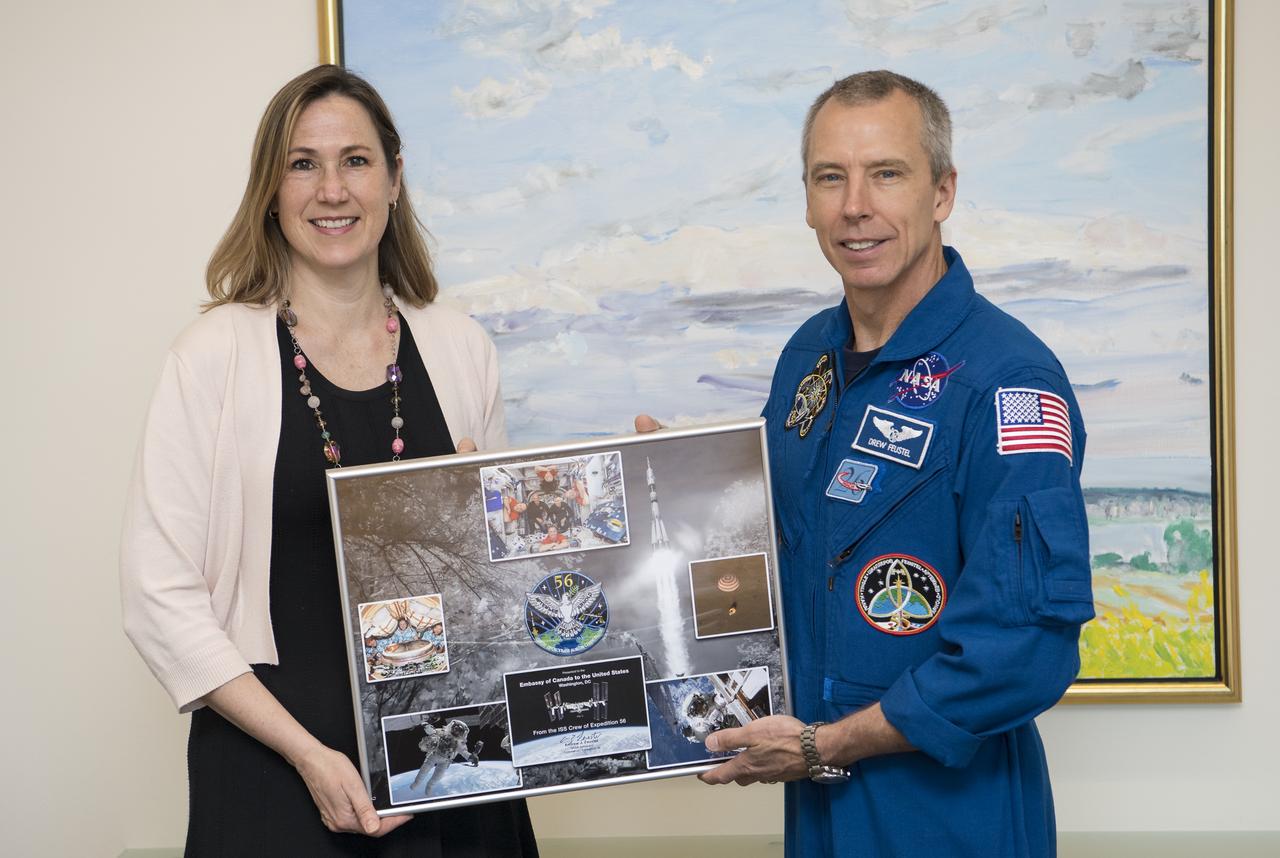
NASA astronaut Drew Feustel poses for a photo after presenting Canadian Deputy Ambassador to the U.S., Kirsten Hillman, a montage from Expeditions 55 and 56 to the International Space Station, Monday, May 6, 2019 in Washington. Photo Credit: (NASA/Aubrey Gemignani)
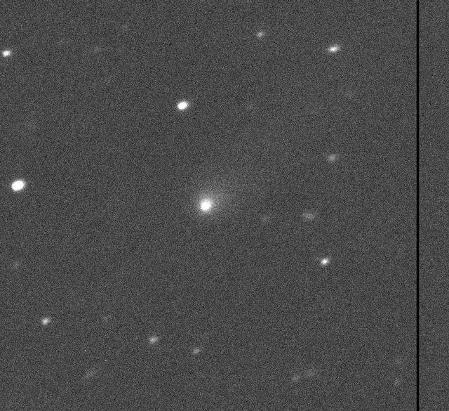
Comet C/2019 Q4 as imaged by the Canada-France-Hawaii Telescope on Hawaii's Big Island on Sept. 10, 2019. https://photojournal.jpl.nasa.gov/catalog/PIA23462
STS059-S-079 (18 April 1994) --- This is a false-color, three frequency image of Prince Albert, Canada, centered at 53.91 north latitude and 104.69 west longitude. It was produced using data from the X-Band, C-Band and L-Band radars that comprise the Spaceborne Imaging Radar-C and X-Band Synthetic Aperture Radar (SIR-C/X-SAR). SIR-C/X-SAR acquired this image on the 20th orbit of the Space Shuttle Endeavour. The area is located 40 kilometers north and 30 kilometers east of the town of Prince Albert in the Saskatchewan province of Canada. The image covers the area east of the Candle Lake, between gravel surface Highways 120 and 106 and west of 106. The area in the middle of the image covers the entire Nipawin (Narrow Hills) provincial park. The look angle of the radar is 30 degrees and the size of the image is approximately 20 by 50 kilometers. The red, green, and blue colors represent L-Band total power, C-Band total power, and XVV respectively. The changes in the intensity of each color are related to various surface conditions such as frozen or thawed forest, fire, deforestation and areas of regrowth. Most of the dark blue areas in the image are the ice covered lakes. The dark area on the top right corner of the image is the White Gull Lake north of the intersection of Highway 120 and 913. The right middle part of the image shows Lake Ispuchaw and Lower Fishing Lake. The deforested areas are shown by light blue in the image. Since most of the logging practice at the Prince Albert area is around the major highways, the deforested areas can be easily detected as small geometrically shaped dark regions along the roads. At the time these data were taken, a major part of the forest was either frozen or undergoing the spring thaw. In such conditions, due to low volume of water in the vegetation, a deeper layer of the canopy is imaged by the radar, revealing valuable information about the type of trees, the amount of vegetation biomass and the condition of the surface. As the frequency increases, the penetration depth in the canopy decreases. Over forest canopies, the X-Band radar contains information about the top of the canopy. Whereas, C-Band and L-Band radar returns show contributions from the crown and trunk areas respectively. The bright areas in the image are dense mixed aspen and old jackpine forests where the return from all three bands is high. The reddish area corresponds to more sparse old jack pine (12 to 17 meters in height and 60 to 75 years old) where the L-Band signal penetrates deeper in the canopy and dominates C-Band and X-Band returns. Comparison of the image with the forest cover map of the area indicates that the three band radar can be used to classify various stands. SIR-C/X-SAR is part of NASA's Mission to Planet Earth (MTPE). SIR-C/X-SAR radars illuminate Earth with microwaves allowing detailed observations at any time, regardless of weather or sunlight conditions. SIR-C/X-SAR uses three microwave wavelengths: L-Band (24 cm), C-Band (6 cm), and X-Band (3 cm). The multi-frequency data will be used by the international scientific community to better understand the global environment and how it is changing. The SIR-C/X-SAR data, complemented by aircraft and ground studies, will give scientists clearer insights into those environmental changes which are caused by nature and those changes which are induced by human activity. SIR-C was developed by NASA's Jet Propulsion Laboratory (JPL). X-SAR was developed by the Dornire and Alenia Spazio Companies for the German Space Agency, Deutsche Agentur fuer Raumfahrtangelegenheiten (DARA), and the Italian Space Agency, Agenzia Spaziale Italiana (ASI). JPL Photo ID: P-43929
iss072e501410 (Jan. 4, 2025) --- An aurora shimmers and dances above the city lights of Canada in this photograph from the International Space Station as it orbited 259 miles above Vancouver, British Columbia, about 1:55 a.m. local time. Credit: NASA/Don Pettit
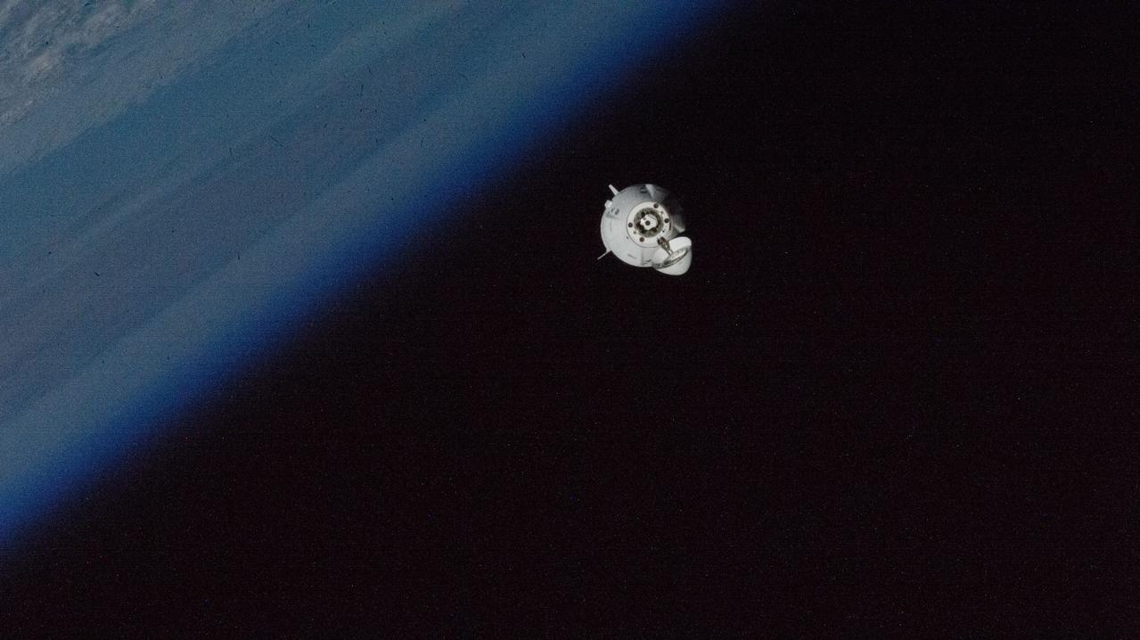
iss072e004109 (Sept. 29, 2024) --- The SpaceX Dragon Freedom spacecraft carrying NASA astronaut Nick Hague and Roscosmos cosmonaut Aleksandr Gorbunov approaches the International Space Station 261 miles above Ontario, Canada, near the coast of James Bay.
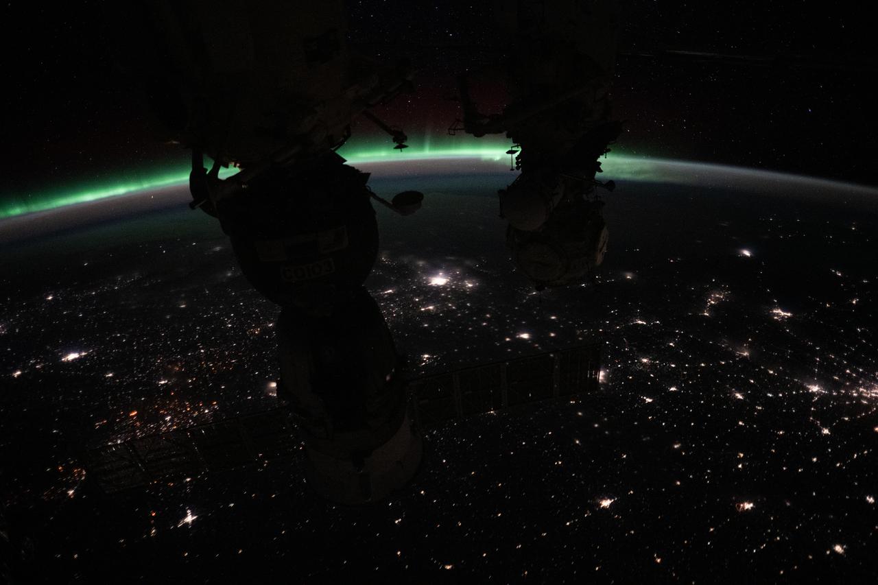
iss072e709711 (March 2, 2025) --- The aurora borealis crowns Earth's horizon with the city lights of Canada dotting the landscape below in this photograph from the International Space Station as it orbited 262 miles above North America. (From left) The Soyuz MS-26 spacecraft and the Pirs docking compartment silhouette the foreground.
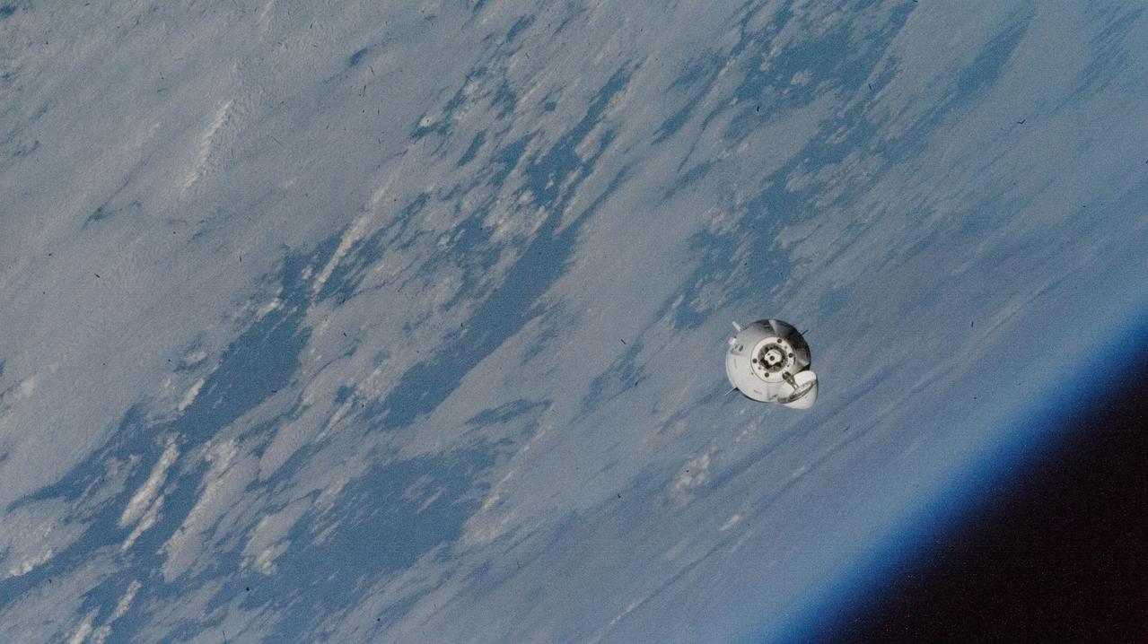
iss072e004108 (Sept. 29, 2024) --- The SpaceX Dragon Freedom spacecraft carrying NASA astronaut Nick Hague and Roscosmos cosmonaut Aleksandr Gorbunov approaches the International Space Station 260 miles above Wabakimi Provincial Park in Ontario, Canada.

The InciWeb Incident Information System is following 18 fires in Alaska that are contributing, along with 49 uncontrolled fires under surveillance by the Canadian Wildland Fire Information System, to vast areas of visible smoke throughout Canadian provinces and stretching into northern U.S. states. This image from the Suomi NPP satellite's VIIRS instrument was taken from NOAA View on June 28, 2015. The smoke from these fires can also be seen in NOAA View as Aerosol Optical Thickness, a measure of how aerosols, such as smoke from wildfires, scatter and absorb sunlight. <b><a href="http://goes.gsfc.nasa.gov/" rel="nofollow">Credit: NOAA/NASA GOES Project</a></b> <b><a href="http://www.nasa.gov/audience/formedia/features/MP_Photo_Guidelines.html" rel="nofollow">NASA image use policy.</a></b> <b><a href="http://www.nasa.gov/centers/goddard/home/index.html" rel="nofollow">NASA Goddard Space Flight Center</a></b> enables NASA’s mission through four scientific endeavors: Earth Science, Heliophysics, Solar System Exploration, and Astrophysics. Goddard plays a leading role in NASA’s accomplishments by contributing compelling scientific knowledge to advance the Agency’s mission. <b>Follow us on <a href="http://twitter.com/NASAGoddardPix" rel="nofollow">Twitter</a></b> <b>Like us on <a href="http://www.facebook.com/pages/Greenbelt-MD/NASA-Goddard/395013845897?ref=tsd" rel="nofollow">Facebook</a></b> <b>Find us on <a href="http://instagrid.me/nasagoddard/?vm=grid" rel="nofollow">Instagram</a></b>
These multi-angle images of Hudson Bay and James Bay, Canada, taken 24 February 2000 from NASA Terra spacecraft, come from the downward-looking nadir camera on the MISR instrument onboard NASA Terra satellite.
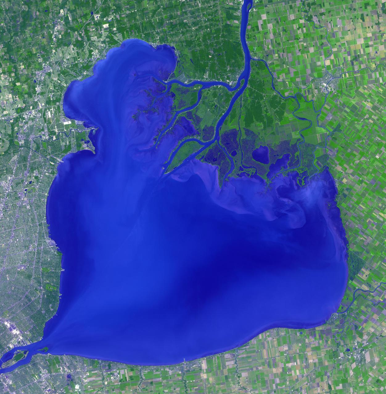
Lake St. Clair connects Lake Huron, via the St. Clair River, to Lake Erie, via the Detroit River. It is named after Claire of Assisi, on whose feast day it was first navigated by French explorers in 1679. The lake covers an area of about 1100 square kilometers, with an average depth of 3.5 meters. Both the U.S. and Canada maintain a deep shipping channel through the lake. The image was acquired September 9, 2002, covers an area of 51.4 by 52.5 kilometers, and is located at 42.5 degrees north, 82.7 degrees west. https://photojournal.jpl.nasa.gov/catalog/PIA23234
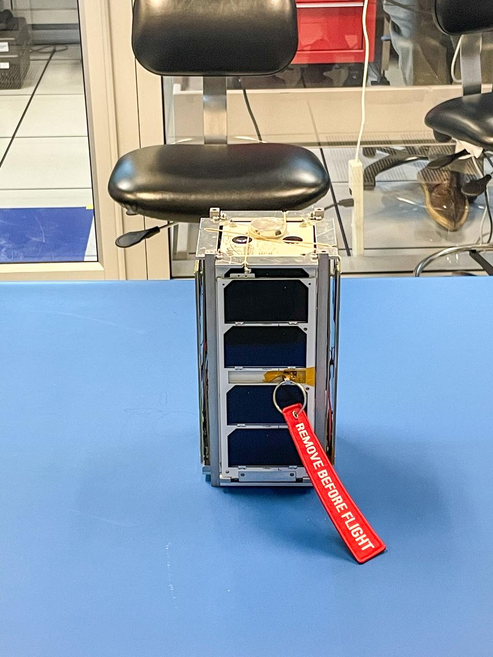
jsc2022e084490 (6/27/2022) --- A prefligjt image of the Low Orbit Reconnaissance Imagery Satellite (LORIS) CubeSat. Image courtesy of Dalhousie University, Nova Scotia, Canada.
iss072e451060 (Jan. 4, 2025) --- A red and green aurora borealis shimmers in this photograph from the International Space Station as it orbited 260 miles above Canada's Gulf of St. Lawrence.
iss072e451023 (Jan. 4, 2025) --- A red and green aurora shimmers brightly above Ontario, Canada, near James Bay in this photograph from the International Space Station as it orbited 260 miles above North America.

iss072e034816 (Oct. 11, 2024) -- NASA astronaut and Expedition 72 Flight Engineer Nick Hague is photographed while talking with students from Quebec, Canada, during an ISS Ham Radio session.

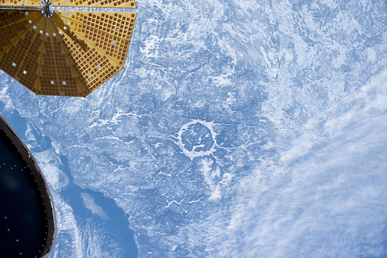
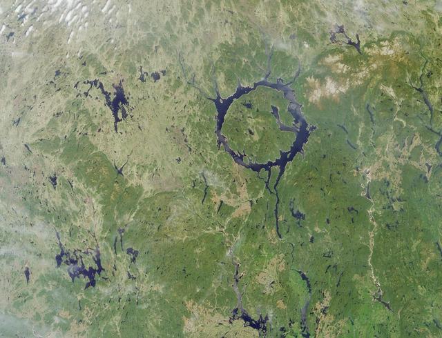
iss074e0538268 (April 26, 2026) --- Canada's Manicouagan Crater, located in the province of Quebec, is a massive meteorite impact structure formed about 214 million years ago and is one of the largest craters on Earth. The ring‑shaped lake surrounding the crater, known as the Manicouagan Reservoir, is part of a major hydroelectric system that contributes significantly to the region's energy supply. Credit: NASA/Chris Williams

iss074e0623393 (May 31, 2026) --- Surrey in British Columbia, Canada, is southeast of Vancouver across the Fraser River and part of the city's metropolitan area. Surrey's surging population growth puts the city on pace to surpass Vancouver to become the province’s most populous city in a few years. The International Space Station was orbiting 261 miles above North America at the time of this photograph. Credit: NASA/Chris Williams
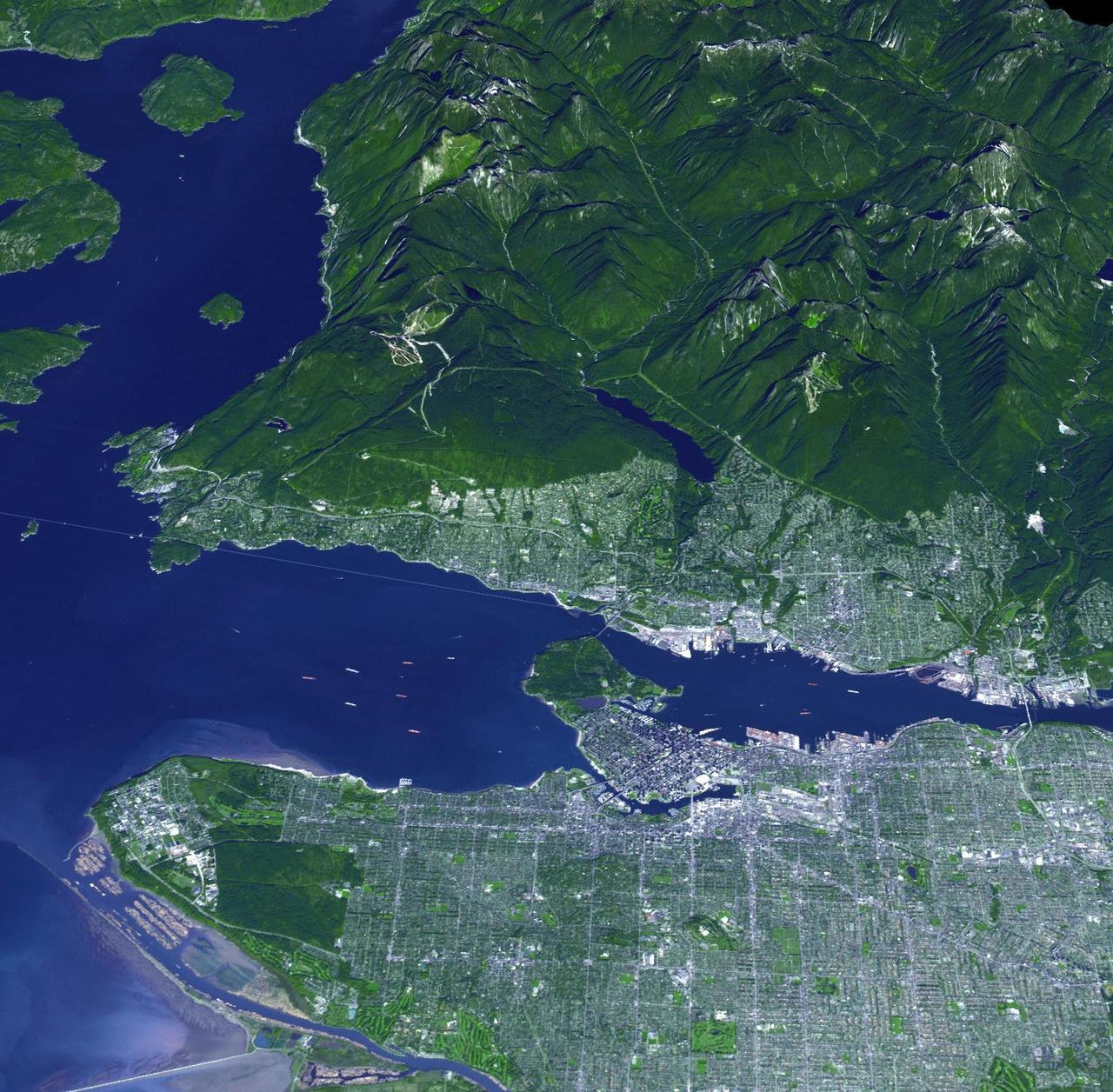
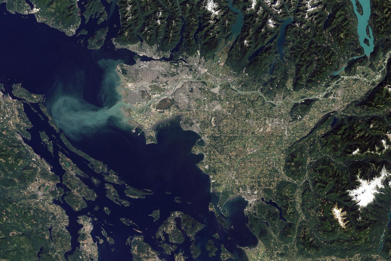
On Feb. 12, 2010, the 21st Winter Olympic Games opened in the city of Vancouver, British Columbia, Canada. NASA Terra spacecraft acquired this image of the city of Vancouver, British Columbia, Canada, on Sept. 29, 2008.
iss072e597519 (Jan. 31, 2025) --- An UltraFex solar array, one of two cymbal-shaped solar arrays on the Northrop Grumman Cygnus space freighter, is pictured in the foreground as the International Space Station orbited 261 miles above the 214 million-year-old Manicouagan crater in Quebec, Canada.
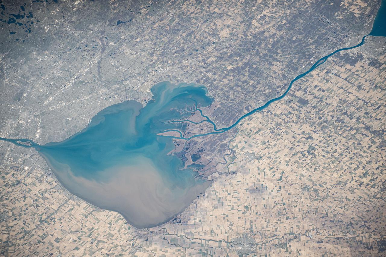
iss073e0000553 (April 22, 2025) --- The freshwater Lake St. Clair rests in between Detroit, Michigan (left), and Ontario, Canada, and connects Lake Huron and Lake Erie in North America in this photograph from the International Space Station as it orbited 260 miles above.

iss072e597522 (Jan. 31, 2025) --- An UltraFex solar array, one of two cymbal-shaped solar arrays on the Northrop Grumman Cygnus space freighter, is pictured in the foreground as the International Space Station orbited 261 miles above the 214 million-year-old Manicouagan crater in Quebec, Canada.
iss074e0494293 (April 19, 2026) --- Canada’s uninhabited Pie Island—surrounded by partial ice cover in the northwestern part of Lake Superior just south of Thunder Bay, Ontario—is pictured from the International Space Station as it orbited 267 miles above the great lake. Credit: ESA/Sophie Adenot

iss074e0623368 (May 30, 2026) --- The Red Deer River runs through central Alberta, Canada, where the landscape transitions from rugged valleys to open prairie and supports a variety of agricultural and livestock activities. The International Space Station was orbiting 261 miles above North America at the time of this photograph. Credit: NASA/Chris Williams
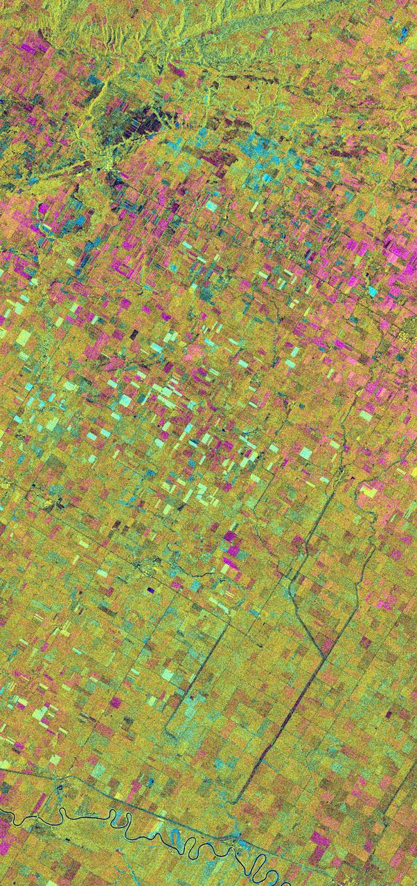
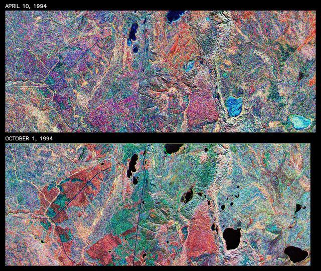
This is an X-band seasonal image of the Altona test site in Manitoba, Canada, about 80 kilometers (50 miles) south of Winnipeg. The image is centered at approximately 49 degrees north latitude and 97.5 degrees west longitude. This image was acquired by the Spaceborne Imaging Radar-C and X-band Synthetic Aperture Radar (SIR-C/X-SAR) aboard the space shuttle Endeavour on April 11, 1994, during the first flight of the radar system, and on October 2, 1994, during the second flight of SIR-C/X-SAR. The image channels have the following color assignments: red represents data acquired on April 11, 1994; green represents data acquired on October 2, 1994; blue represents the ratio of the two data sets. The test site is located in the Red River Basin and is characterized by rich farmland where a variety of crops are grown, including wheat, barley, canola, corn, sunflowers and sugar beets. This SIR-C/X-SAR research site is applying radar remote sensing to study the characteristics of vegetation and soil moisture. The seasonal comparison between the April and October 1994 data show the dramatic differences between surface conditions on the two dates. At the time of the April acquisition, almost all agricultural fields were bare and soil moisture levels were high. In October, however, soils were drier and while most crops had been harvested, some standing vegetation was still present. The areas which are cyan in color are dark in April and bright in October. These represent fields of standing biomass (amount of vegetation in a specified area) and the differences in brightness within these cyan fields represent differences in vegetation type. The very bright fields in October represent standing broadleaf crops such as corn, which had not yet been harvested. Other standing vegetation which has less biomass, such as hay and grain fields, are less bright. The magenta indicates bare soil surfaces which were wetter (brighter) in April than in October. The variations in brightness of the magenta indicate differences in the degree of soil moisture change and differences in surface roughness. This seasonal composite demonstrates the sensitivity of radar to changes in agricultural surface conditions such as soil moisture, tillage, cropping and harvesting. http://photojournal.jpl.nasa.gov/catalog/PIA01742

Minister, Congressional, Public and Intergovernmental Affairs, Embassy of Canada, Carrie Goodge O'Brien, provides remarks at a Moon tree dedication ceremony, Tuesday, June 4, 2024 at the United States Capitol in Washington. The American Sweetgum tree planted on the southwestern side of the Capitol, was grown from a seed that was flown around the Moon during the Artemis I mission. Photo Credit: (NASA/Aubrey Gemignani)

Minister, Congressional, Public and Intergovernmental Affairs, Embassy of Canada, Carrie Goodge O'Brien, provides remarks at a Moon tree dedication ceremony, Tuesday, June 4, 2024 at the United States Capitol in Washington. The American Sweetgum tree planted on the southwestern side of the Capitol, was grown from a seed that was flown around the Moon during the Artemis I mission. Photo Credit: (NASA/Aubrey Gemignani)
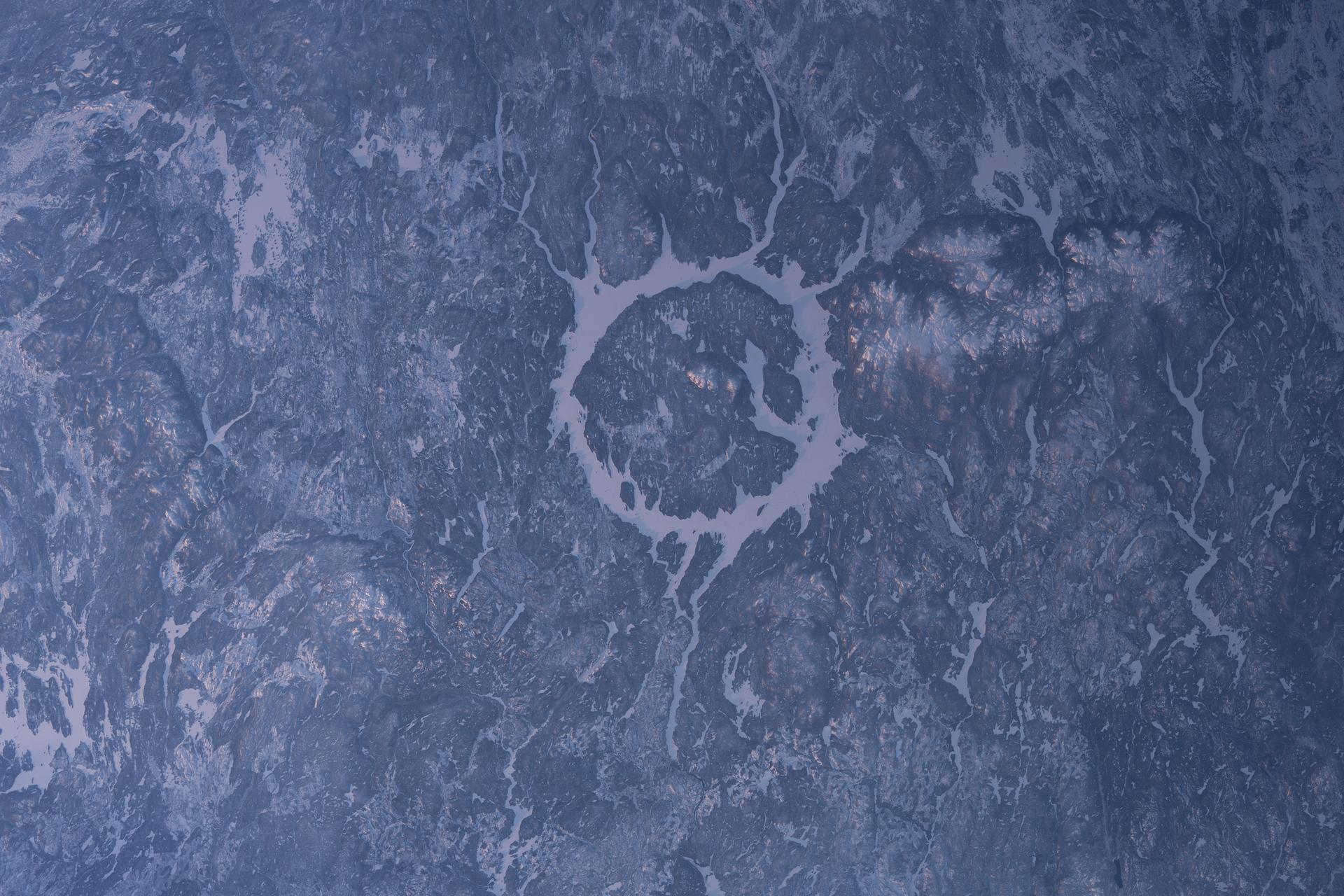
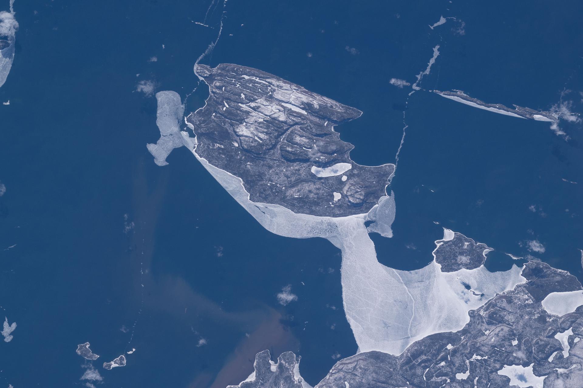
iss074e0153228 (Jan. 25, 2026) --- The Manicouagan Crater in Quebec, formed about 214 million years ago by a massive meteorite impact, is one of the largest craters on Earth. It is surrounded by a ring-shaped lake called the Manicouagan Reservoir and is part of a major hydroelectric system that contributes significantly to Quebec’s energy supply. The International Space Station was orbiting 263 miles above Canada's cold, dry wintry landscape at the time of this photograph. Credit: NASA/Chris Williams
iss074e0432034 (April 1, 2026) --- Canada’s icy landscape is pictured from the International Space Station as it orbited 266 miles above North America. At bottom right, is the Manicouagan Crater in Quebec, formed about 214 million years ago by a massive meteorite impact and one of the largest craters on Earth. It is surrounded by a ring‑shaped lake called the Manicouagan Reservoir and is part of a major hydroelectric system that contributes significantly to Quebec’s energy supply. Credit: NASA/Chris Williams
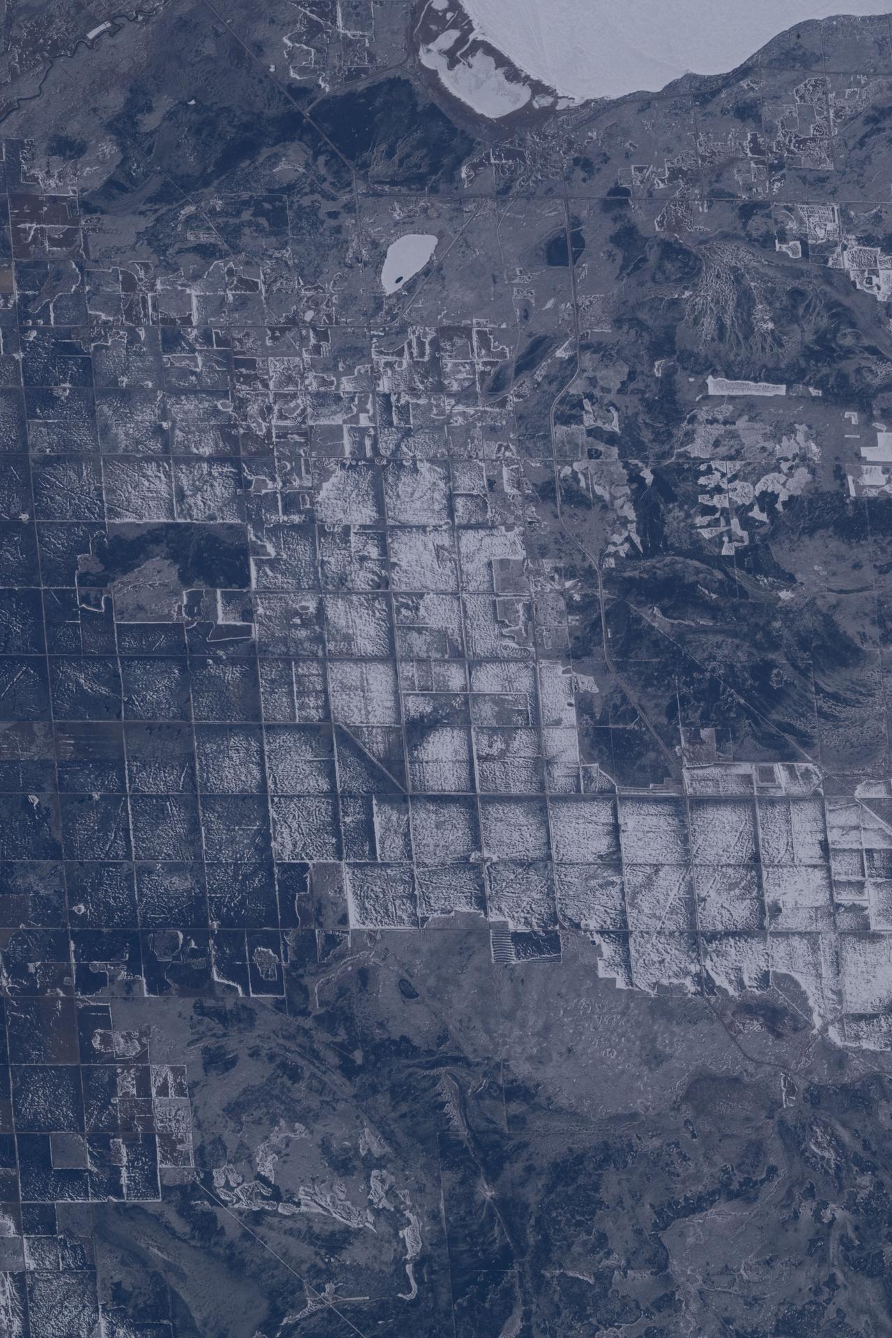
iss074e0494100 (April 19, 2026) --- The sub-freezing landscape at the southern tip of Canada’s Lake Winnipeg (top right), where ice fishing is popular, reveals crop fields that will be ready for the seeding of wheat, barley, oats, and canola in late spring and early summer. Cattle and sheep are also raised in the region. The International Space Station was orbiting 267 miles above Ontario when this photograph was taken. Credit: ESA/Sophie Adenot
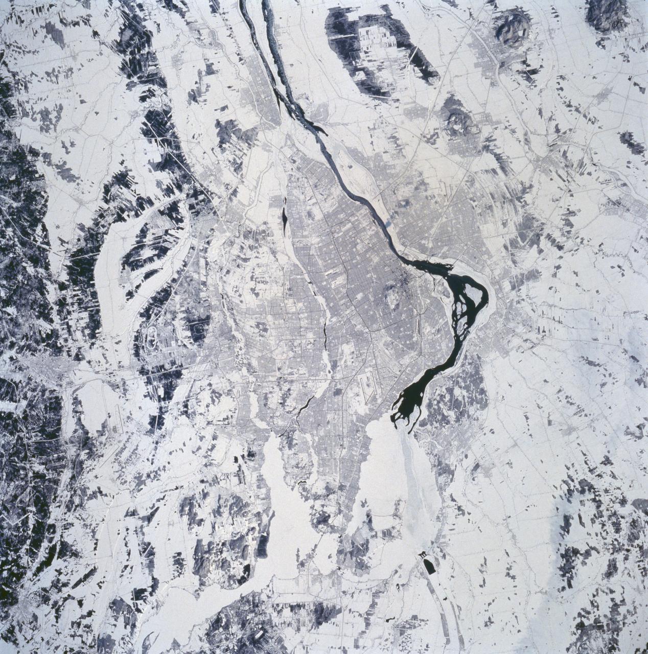
STS060-94-072 (3-11 Feb 1994) --- The city of Montreal is located on the island of Montreal at the confluence of the St. Lawrence and Ottawa Rivers. Despite its distance from the sea (1,000 miles) Montreal is a large inland port. It is also Canada's largest city and the second largest French speaking city in the world. This particular snow covered scene highlights the major highways and street patterns throughout the metropolitan Montreal area. The runways of the two large international airports of Mirabel (located 25 miles northwest of downtown Montreal) and Dorval (located approximately 8 miles west of the downtown area) are clearly visible on this photograph. Even the outline of Mount Royal Park, an imposing hilly feature near the downtown central business district, can be seen. Patches of open, ice-free (very dark areas) are detectable as the St. Lawrence River (Seaway) makes its way along the south and southeastern side of Montreal.
Lake Manicouagan in northern Quebec, Canada, as seen by NASA Terra satellite on June 1, 2001, during Terra orbit 7737.
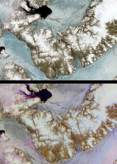
![NASA researchers have new [sic] insights into the mysteries of Arctic sea ice, thanks to the unique abilities of Canada Radarsat satellite.](https://images-assets.nasa.gov/image/PIA02971/PIA02971~thumb.jpg)
NASA researchers have new [sic] insights into the mysteries of Arctic sea ice, thanks to the unique abilities of Canada Radarsat satellite.
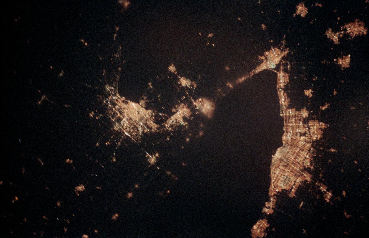
STS060-06-037 (3-11 Feb 1994) --- The city lights of Buffalo and Toronto outline the shores of the east end of Lake Erie and the west end of Lake Ontario in this night scene of western New York and southern Ontario. Between the two major cities are the cities of Niagara Falls, New York and Niagara Falls, Canada, which straddle the Niagara River just north of the actual falls. This photograph was taken with a special ASA-1600 film that is normally used for night-time photography of aurora, noctilucent clouds, biomass burning, and city lights.

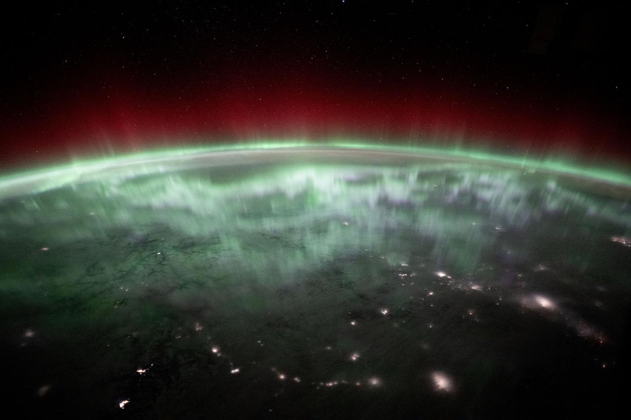
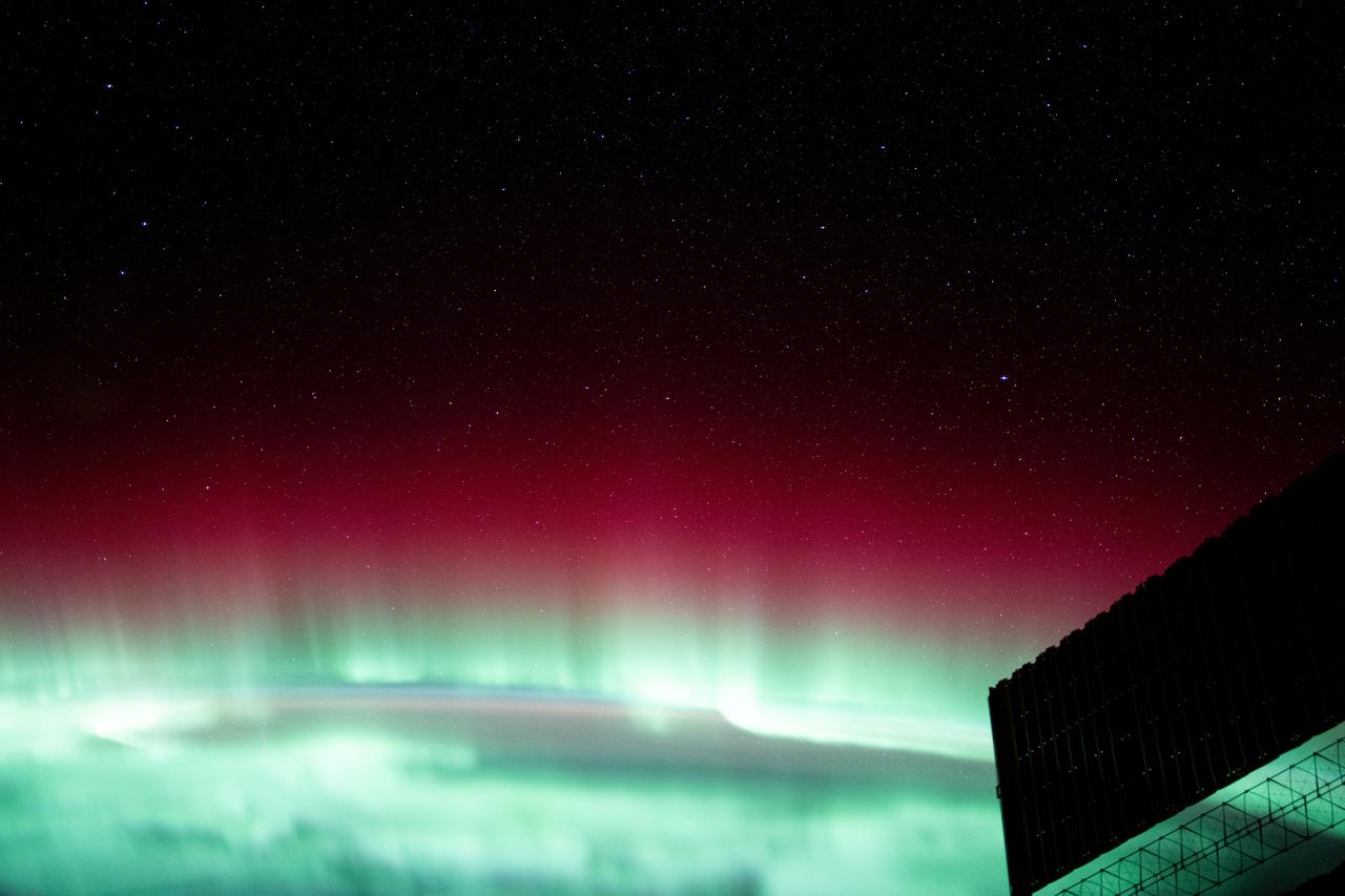
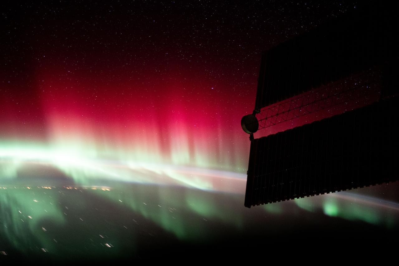
iss073e0780439 (Sept. 2, 2025) --- A diffuse aurora glows above Earth's horizon over Canada as its red and green hues shimmer like neon lights—an effect created by excited oxygen atoms high in the atmosphere. The city lights of the U.S.-Canadian Pacific Northwest (toward upper right) trace the continent eastward. The red aurora is produced by high-altitude oxygen atoms (~300 km), while the green glow comes from lower-altitude oxygen (~100 km), both excited by energetic electrons guided into the atmosphere by Earth's magnetic field during solar activity.

SL4-139-4072 (February 1974) --- A high oblique view of the North Atlantic coast of Canada as seen from the Skylab space station in Earth orbit. A Skylab 4 crewman used a hand-held 70mm Hasselblad camera to take this picture. The Strait of Belle Isle, near the center of the picture, separates the Island of Newfoundland from the Canadian mainland. The Strait also connects the Gulf of St. Lawrence with North Atlantic Ocean. The elongated land mass (lower center) is the northern-most peninsula of the Island of Newfoundland. The large land mass at left center is mainland Newfoundland and Quebec. Note the sea ice in the Atlantic. Snow and some ice intermittently cover the land masses, and ice plumes of brash ice or pancake ice can be seen in various shapes and formations. General terrain and ice conditions can be distinguished and evaluated up to at least 55 degrees north latitude in this north looking view. Dr. William Campbell, sea and ice expert with the U.S. Geological Survey, will use this photograph in the study of ice dynamics. Photo credit: NASA
The highest tides on Earth occur in the Minas Basin, the eastern extremity of the Bay of Fundy, Nova Scotia, Canada. This image was acquired by NASA Terra spacecraft.
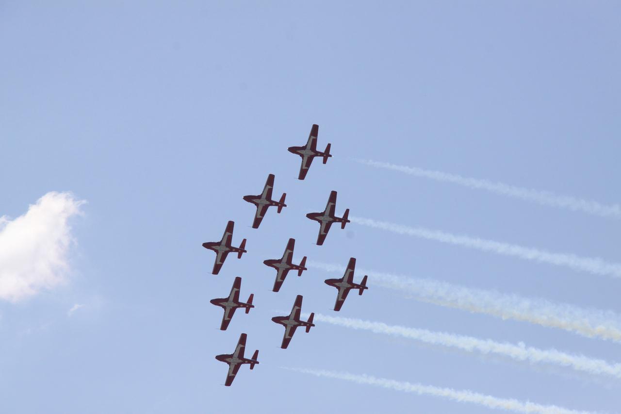
CAPE CANAVERAL, Fla. - The Royal Canadian Air Force Snowbird pilots flew their jets in tight formation over NASA's Kennedy Space Center in Florida. Photo credit: NASA/Jack Pfaller
This is a comparison of images over Prince Albert, produced by NASA Spaceborne Imaging Radar-C and X-band Synthetic Aperture Radar aboard the space shuttle Endeavour on its 20th orbit on April 10, 1994. The area is centered at 53.91 degrees north latitude and 104.69 degrees west longitude and is located 40 kilometers (25 miles) north and 30 kilometers (18.5 miles) east of the town of Prince Albert in the Saskatchewan province of Canada. The image covers the area east of Candle Lake, between the gravel highway of 120 and west of highway 106. The area imaged is near the southern limit of the boreal forest. The boreal forest of North America is a continuous vegetation belt at high latitudes stretching across the continent from the Atlantic shoreline of central Labrador and then westward across Canada to the interior mountains and central coastal plains of Alaska. The forest is also part of a larger northern hemisphere circumpolar boreal forest belt. Coniferous trees dominate the entire forest but deciduous trees are also present. During the month of April, the forest experiences seasonal changes from a frozen condition to a thawed condition. The trees are completely frozen over the winter season and the forest floor is covered by snow. As the average temperature rises in the spring, the trees are thawed and the snow melts. This transition has an impact on the rate of moisture evaporation and release of carbon dioxide into the atmosphere. In late September and early October, the boreal forest experiences a relatively different seasonal change. At this time, the leaves on deciduous trees start changing color and dropping off. The soil and trees are quite often moist due to frequent rainfall and cloud cover. The evaporation of moisture and carbon dioxide into the atmosphere also diminishes at this time. SIR-C/X-SAR is sensitive to the moisture of soil and vegetation and can sense this freeze-thaw cycle and the summer-fall seasonal transition over forested areas in particular. Optical sensors, by contrast, are blind to these regions, which are perpetually obscured by thick cloud cover. These changes were detected by comparing the April and October color composite images of L-band data in red, C-band data in green and X-band (vertically received and transmitted) in blue. The changes in intensity of each color over lakes, various forest stands and clear cuts in the two images is striking. Lakes such as Lake Heiberg, Crabtree Lake and Williams Lake, in the right middle part of the image, are frozen in April (appearing in bright blue) and melted (appearing in black) in October. The higher intensity of blue over lakes in April is due to low penetration of the X-band (vertically received and transmitted) and the radar's high sensitivity to surface features. Forest stands also exhibit major changes between the two images. The red areas in the October image are old jack pine canopies that cause higher return at L-band because of their moist condition in late summer compared to their partially frozen condition in April (in purple). Similarly, in the areas near the middle of the image, where black spruce and mixed aspen and jack pine trees dominate, the contrast between blue in October and red and green in April is an indication that the top of the canopy (needles and branches) were frozen in April and moist in October. The changes due to deforestation by logging companies or natural fires can also be detected by comparing the images. For example, the small blue area near the intersection of Harding Road and Highway 120 is the result of logging which occurred after the April data was acquired. The surface area of clear cut is approximately 4 hectares, which is calculated from the high-resolution capability of the radar images and verified by scientists participating in field work during the mission. http://photojournal.jpl.nasa.gov/catalog/PIA01732
SL4-141-4316 (20 Jan. 1974) --- An oblique view of ice formations in Canada's Hudson Bay, as photographed from the Skylab space station in Earth orbit by one of the Skylab 4 crewmen. The camera used was a hand-held 70mm Hasselblad, with SO-368 medium-speed Ektachrome film. The southwestern part of the bay is prominent with the Nelson River in Manitoba flowing into it. Skylab never flew this far north in latitude. However, its orbital vantage point allowed observations and photography while over a point some 600 miles away as in the case of this picture. The ice formation along the southwest portion of Hudson Bay can be studied from photographs such as this one. The buildup of ice along the windward shore (very white) followed by the clear water gap (dark) caused by the wind blowing the newly formed ice toward the opposite shore, and finally the patterns in the ice structure itself are studied to learn more of the nature of the "winterization" of this area. Photo credit: NASA
This image from NASA Terra spacecraft shows the Diavik Mine in northern Canada.The largest diamond found in North America came from the Diavik Mine. The Foxfire diamond weighs an impressive 187 carats, and was discovered in August 2015; it has been displayed in several museums throughout North America. The Diavik mine is located on an island in Lac de Gras, within the Lac de Gras kimberlite field, among other diamond mines. The image was acquired September 23, 2016, covers an area of 13.8 by 19.4 km, and is located at 64.5 degrees north, 110.2 degrees west. https://photojournal.jpl.nasa.gov/catalog/PIA21536
These images of Canada Québec province were acquired by NASA Terra satelliteon March 4, 2001.The region forests are a mixture of coniferous and hardwood trees, and ugar-shack festivities are held at this time of year to celebrate the beginning o
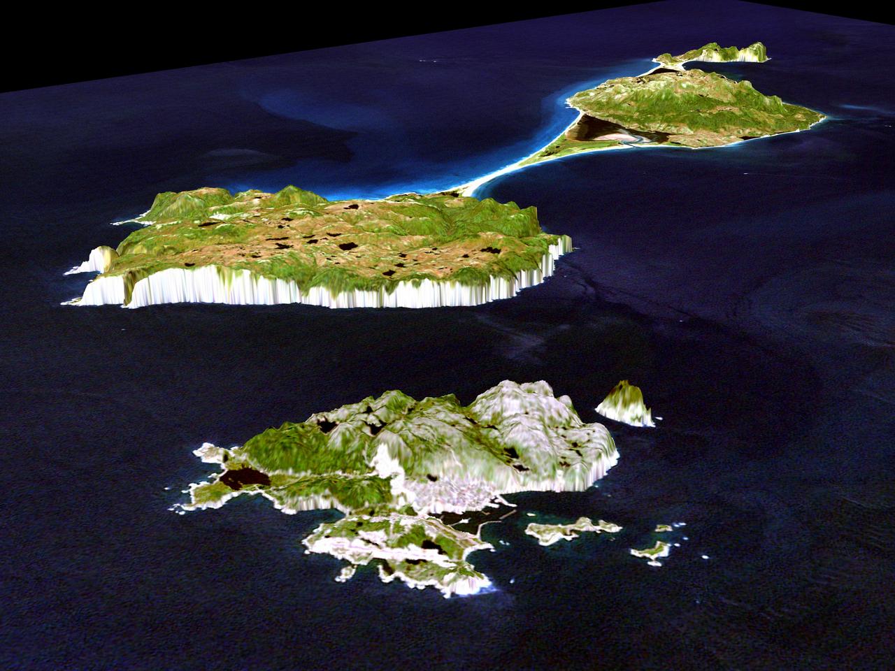
This image shows Miquelon and Saint Pierre Islands, located south of Newfoundland, Canada. These islands, along with five smaller islands, are a self-governing territory of France. North is in the top right corner of the image.

LAnse aux Meadows is a site on the northernmost tip of the island of Newfoundland, located in the Province of Newfoundland and Labrador, Canada, where the remains of a Viking village were discovered in 1960. This image is from NASA Terra satellite.

Grad student Nicholas Boyd left and Principal Investigator Ralf Gellert, both of the University of Guelph, Ontario, Canada, prepare for the installation of the Alpha Particle X-ray Spectrometer sensor head during testing at NASA JPL.
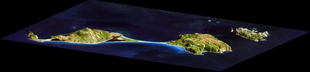
This image acquired by NASA Shuttle Radar Topography Mission SRTM from data collected on February 12, 2000 shows two islands, Miquelon and Saint Pierre, located south of Newfoundland, Canada.
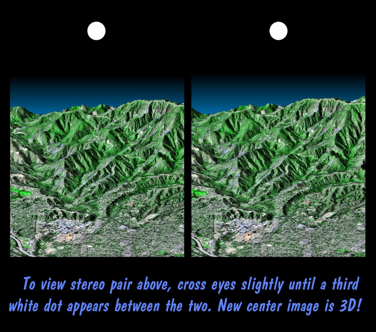
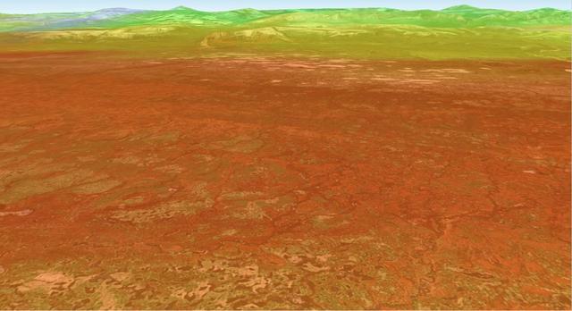
This stereoscopic image pair is a perspective view that shows the western part of the city of Pasadena, California, looking north toward the San Gabriel Mountains. Portions of the cities of Altadena and La Canada Flintridge are also shown.
A look at smoke from the Chisholm forest fire, which ignited on May 23, 2001 about 160 kilometers north of Edmonton in Alberta, Canada, as seen by NASA Terra spacecraft.
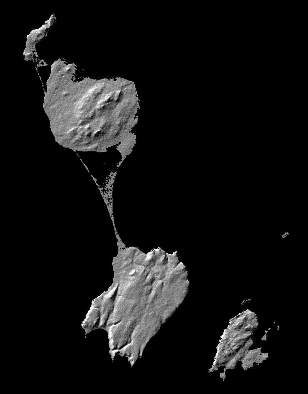
This image acquired by NASA Shuttle Radar Topography Mission SRTM from data collected on February 12, 2000 shows two islands, Miquelon and Saint Pierre, located south of Newfoundland, Canada.

iss058e012965 (Feb. 12, 2019) --- The frozen terrain of Anticosti Island in the Gulf of St. Lawrence and the coastal areas of Quebec in Canada are pictured as the International Space Station orbited 255 miles above the North American continent.
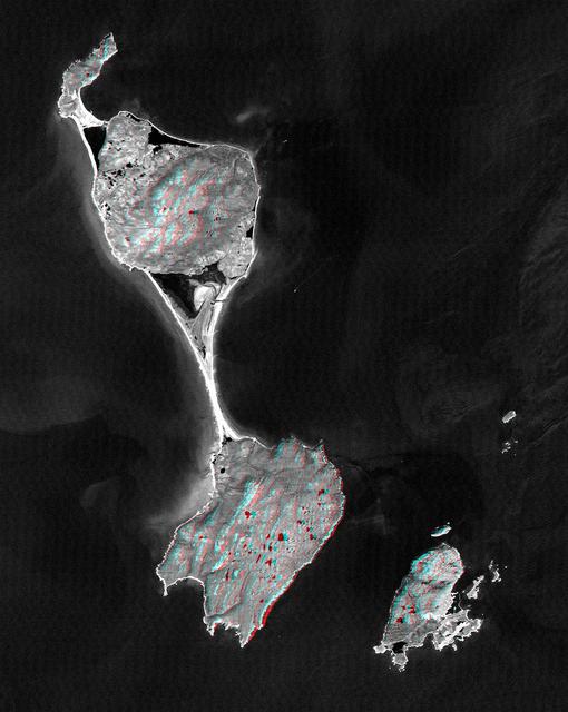
This anaglyph, from NASA Shuttle Radar Topography Mission, shows Miquelon and Saint Pierre Islands, located south of Newfoundland, Canada. 3D glasses are necessary to view this image.
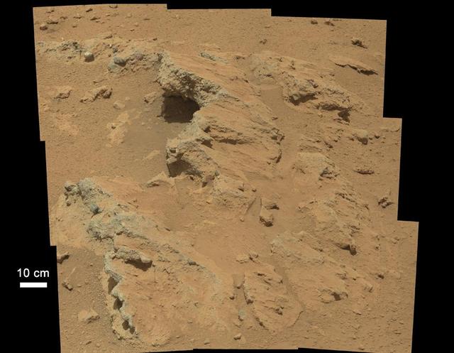
NASA Curiosity rover found evidence for an ancient, flowing stream on Mars at a few sites, including the rock outcrop pictured here, which the science team has named Hottah after Hottah Lake in Canada Northwest Territories.
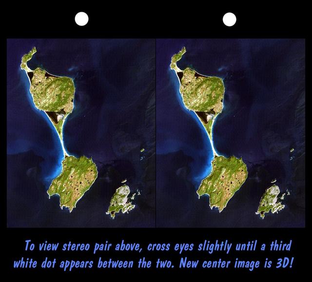
This stereoscopic satellite image showing Miquelon and Saint Pierre Islands, located south of Newfoundland, Canada, was generated by draping NASA Landsat satellite image over a preliminary Shuttle Radar Topography Mission SRTM elevation model.

Sault Ste. Marie is the name of two cities on Saint Mary River, separating Canada and the State of Michigan in the United States. This image was acquired by NASA Terra spacecraft on June 10, 2007.
JPL-led study shows bromine explosion on March 13, 2008 across the western Northwest Territories in Canada looking toward the Mackenzie Mountains at the horizon, which prevented the bromine from crossing over into Alaska.
Devon Island is situated in an isolated part of Canada Nunavut Territory, and is usually considered to be the largest uninhabited island in the world. These images were acquired by NASA Terra satellite on June 28, 2001.