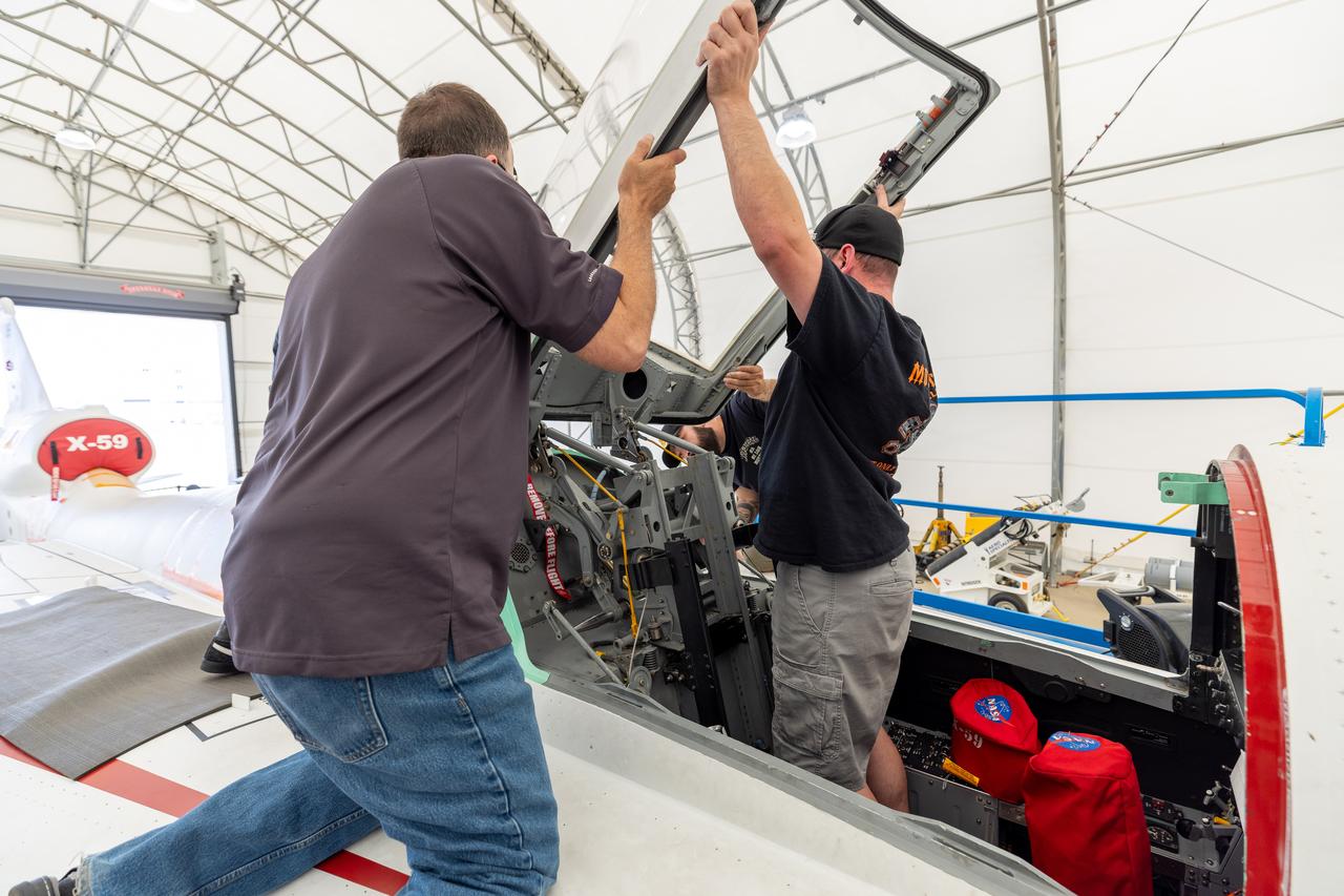
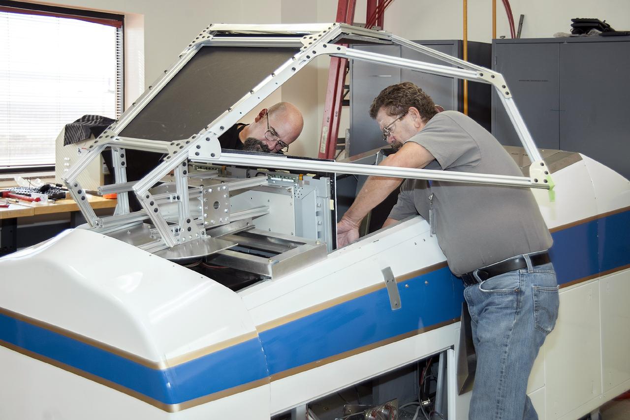
Lockheed Martin technicians temporarily remove the canopy from the X-59 in preparation for final installation of the ejection seat into the aircraft.

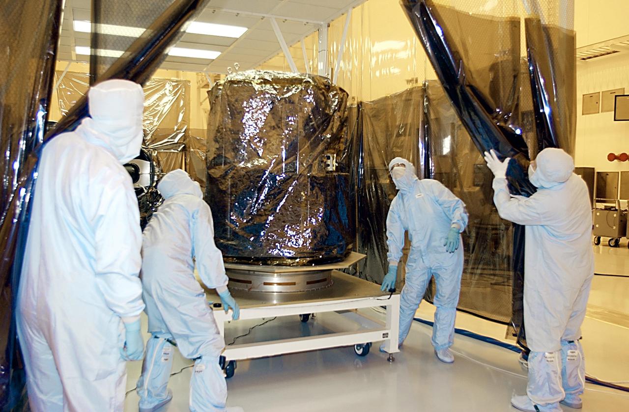
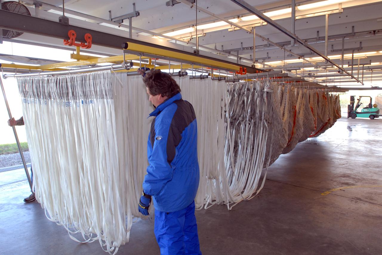
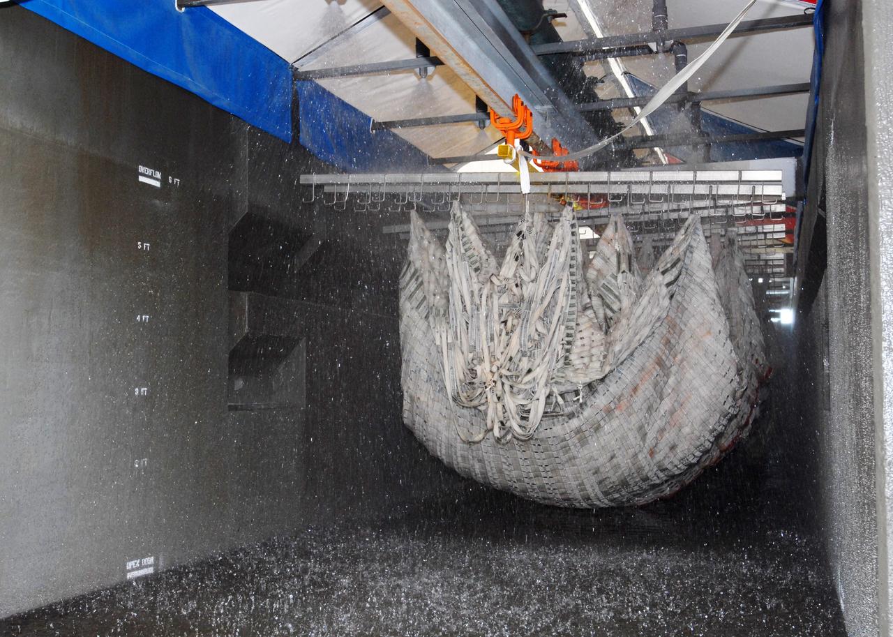
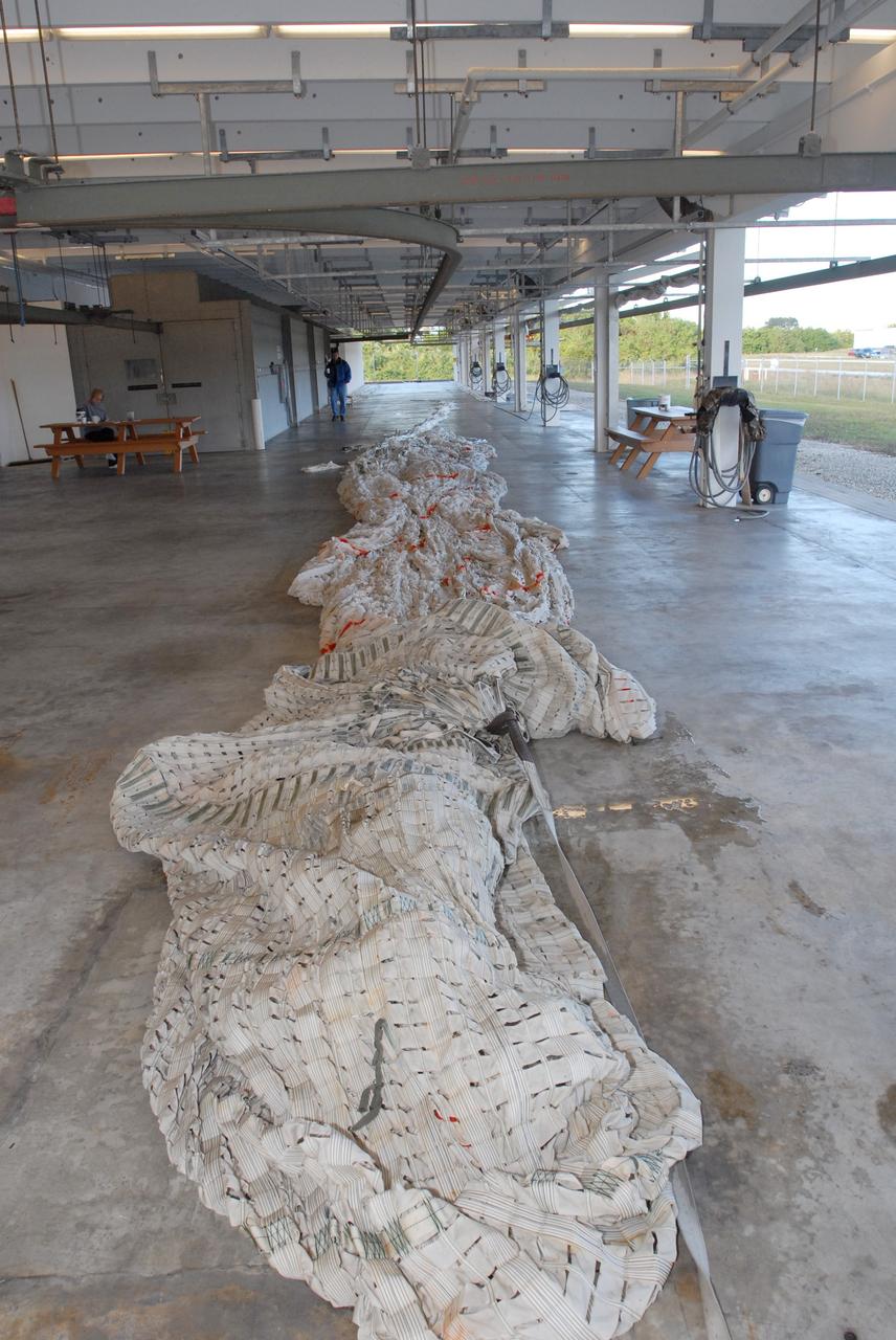
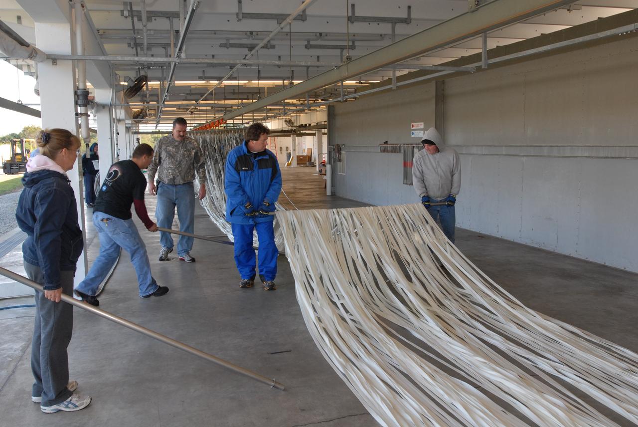
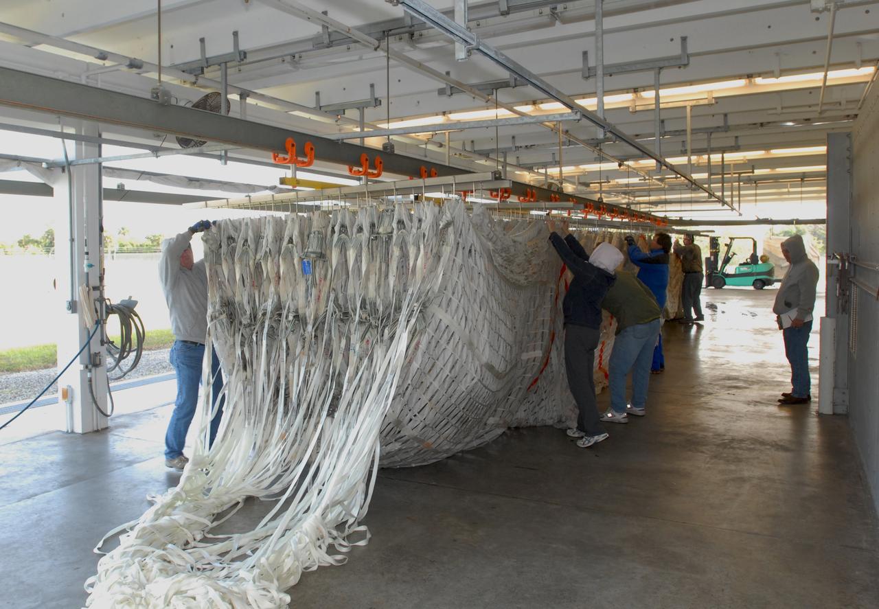
Mars Science Laboratory (MSL) Flexible Canopy Testing in the Glenn Research Center, 10x10 Supersonic Wind Tunnel
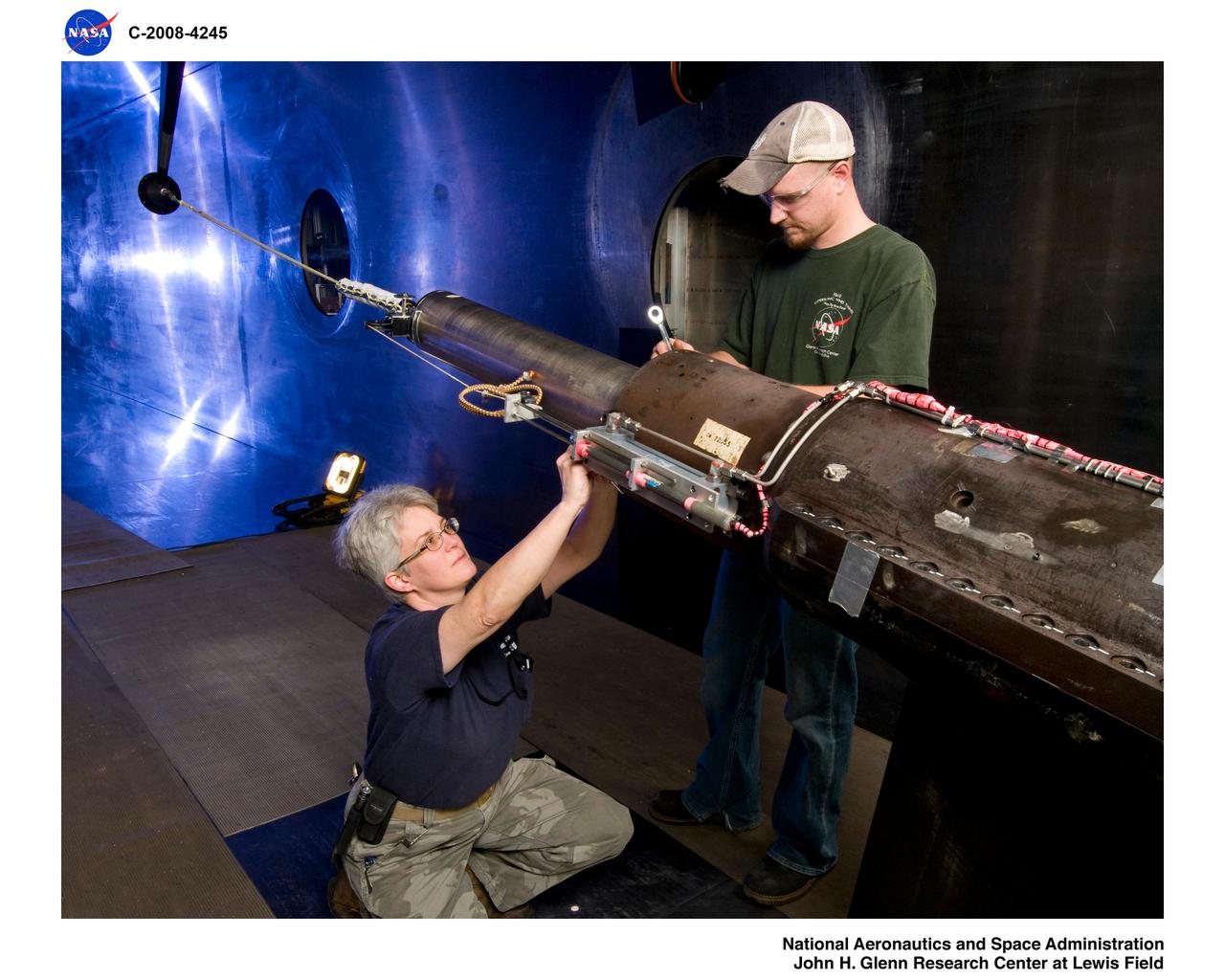
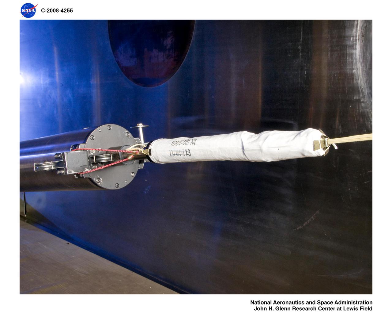
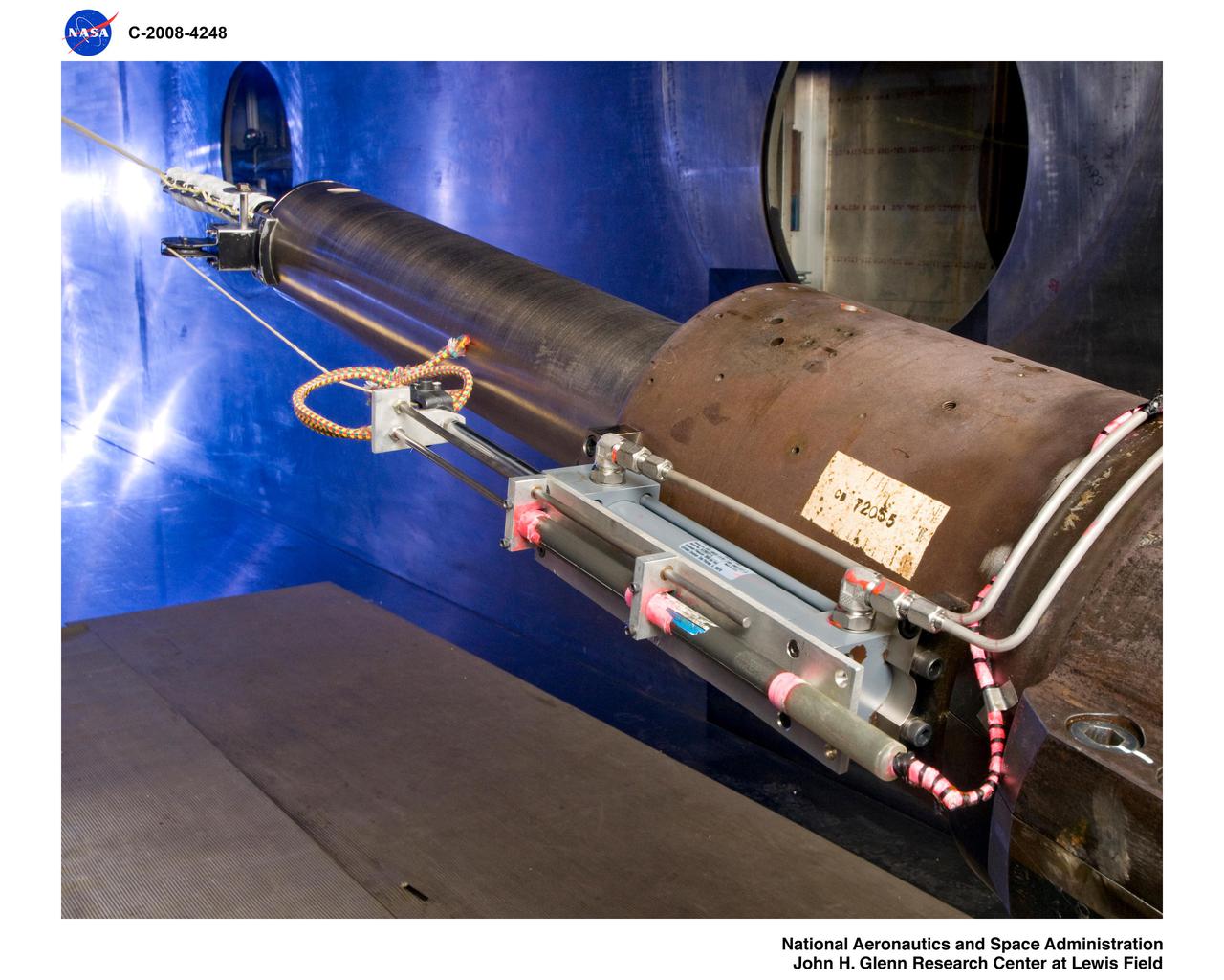
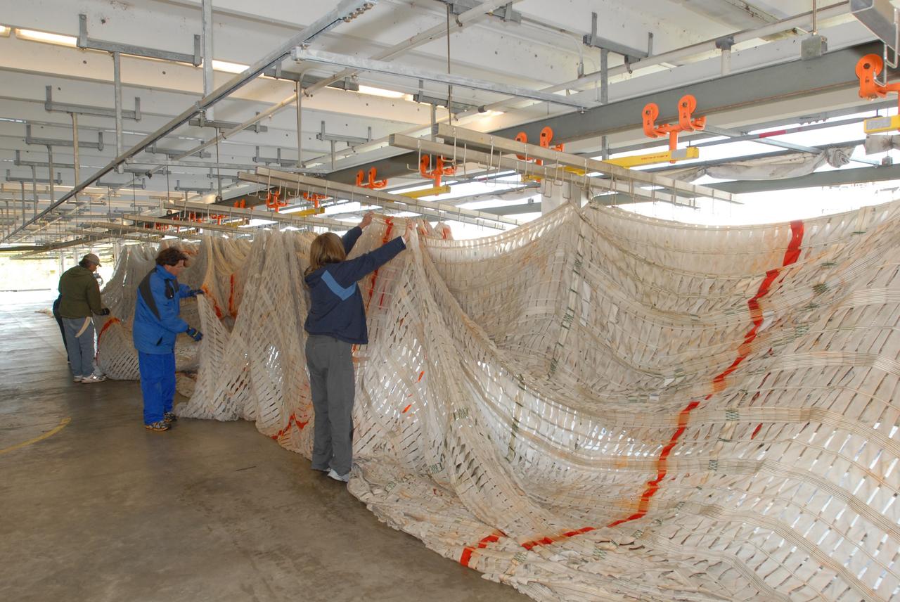
Mars Science Laboratory (MSL) Flexible Canopy Test
Mars Science Laboratory (MSL) Flexible Canopy Test
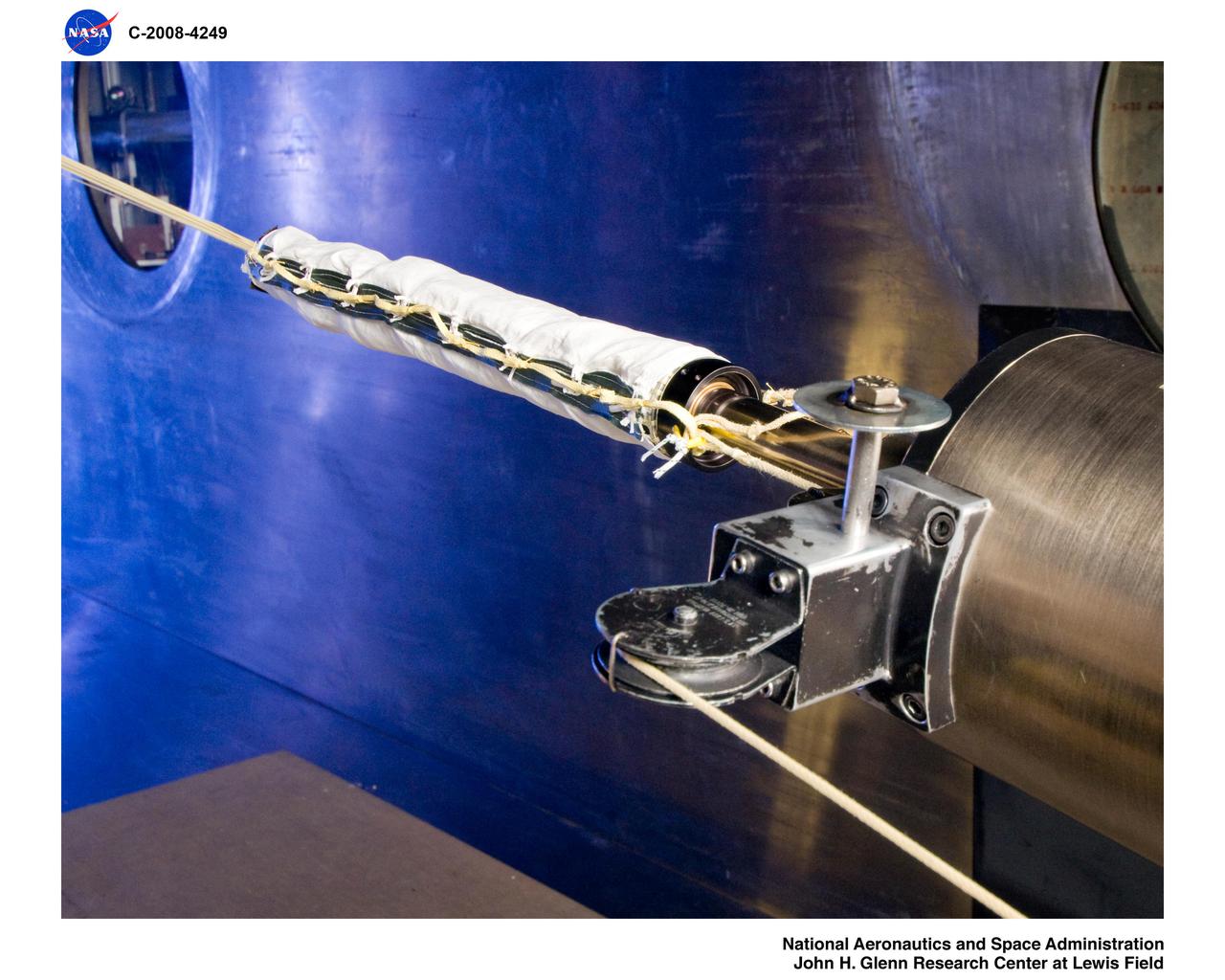
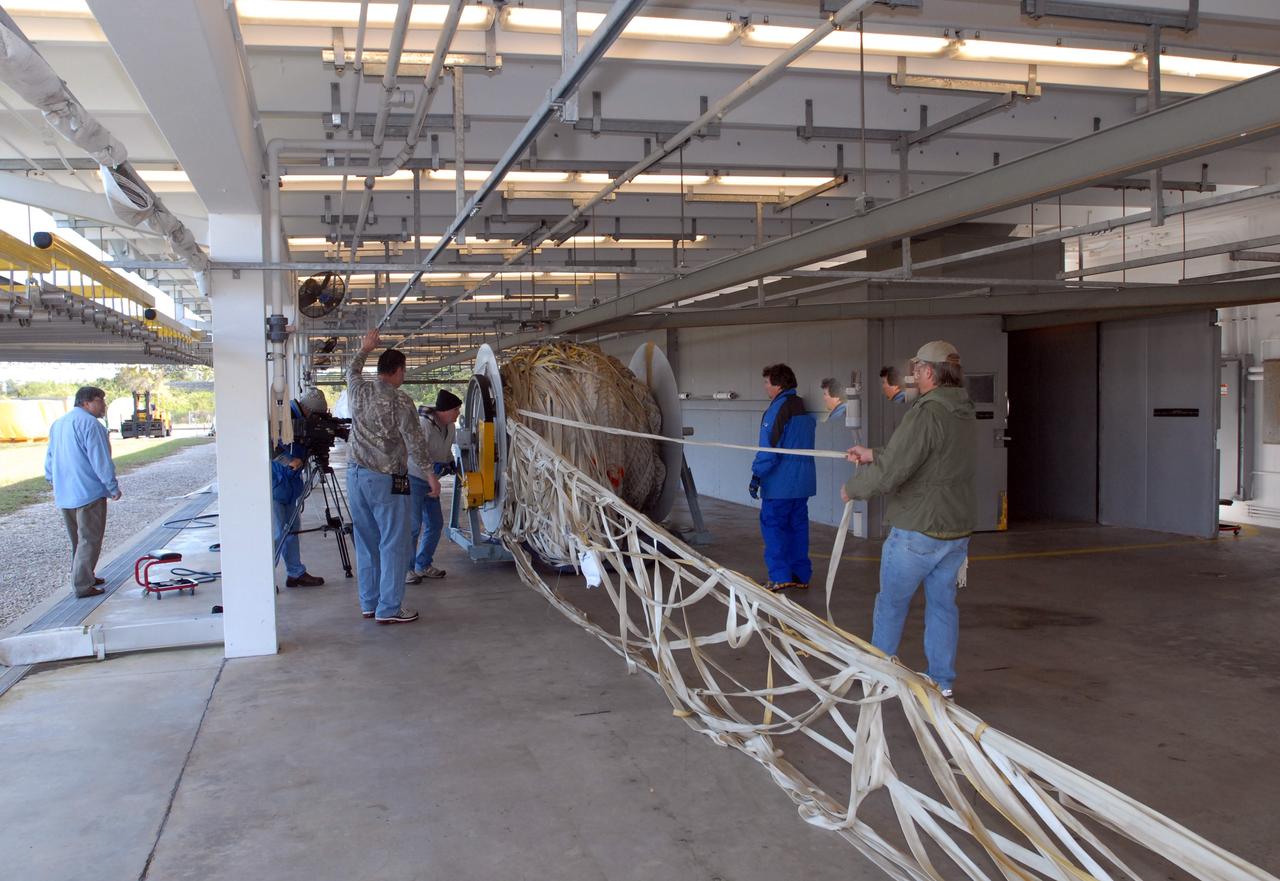
Mars Science Laboratory, MSL Flexible Canopy Test in the Glenn Research Center, 10x10 Supersonic Wind Tunnel

Mars Science Laboratory (MSL) Flexible Canopy Test
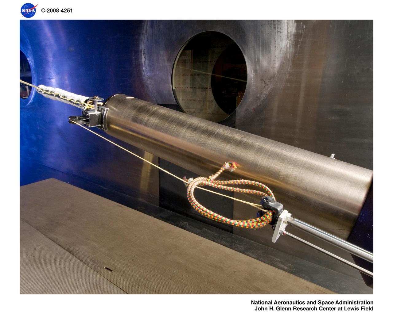
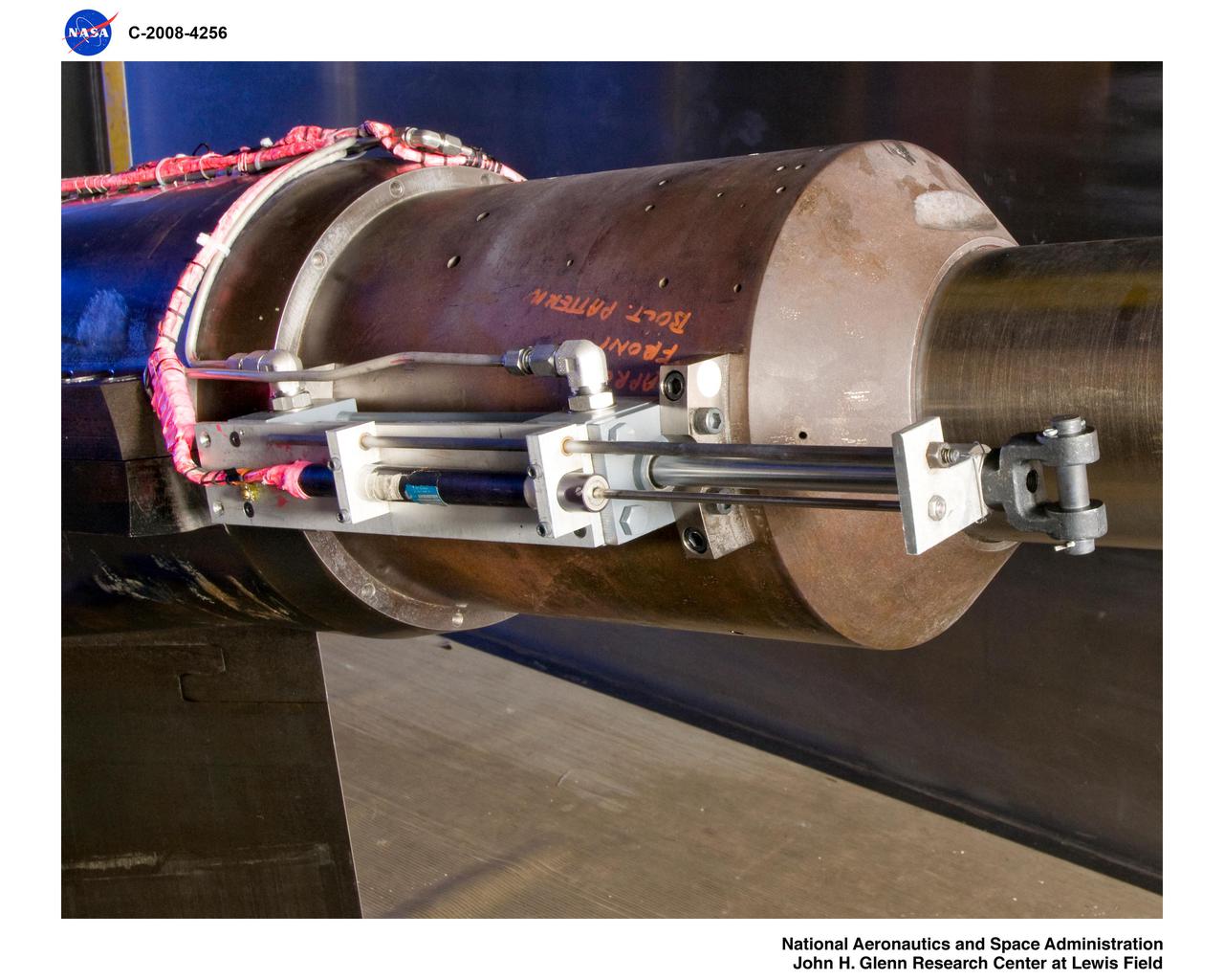
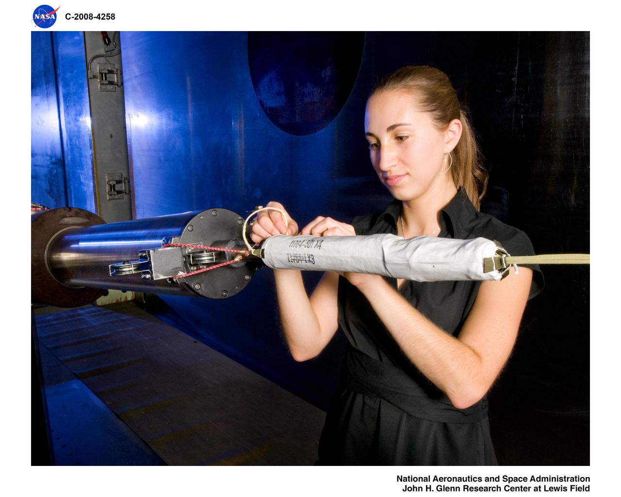
Mars Science Laboratory, MSL Flexible Canopy Test
Mars Science Laboratory, MSL Flexible Canopy Test
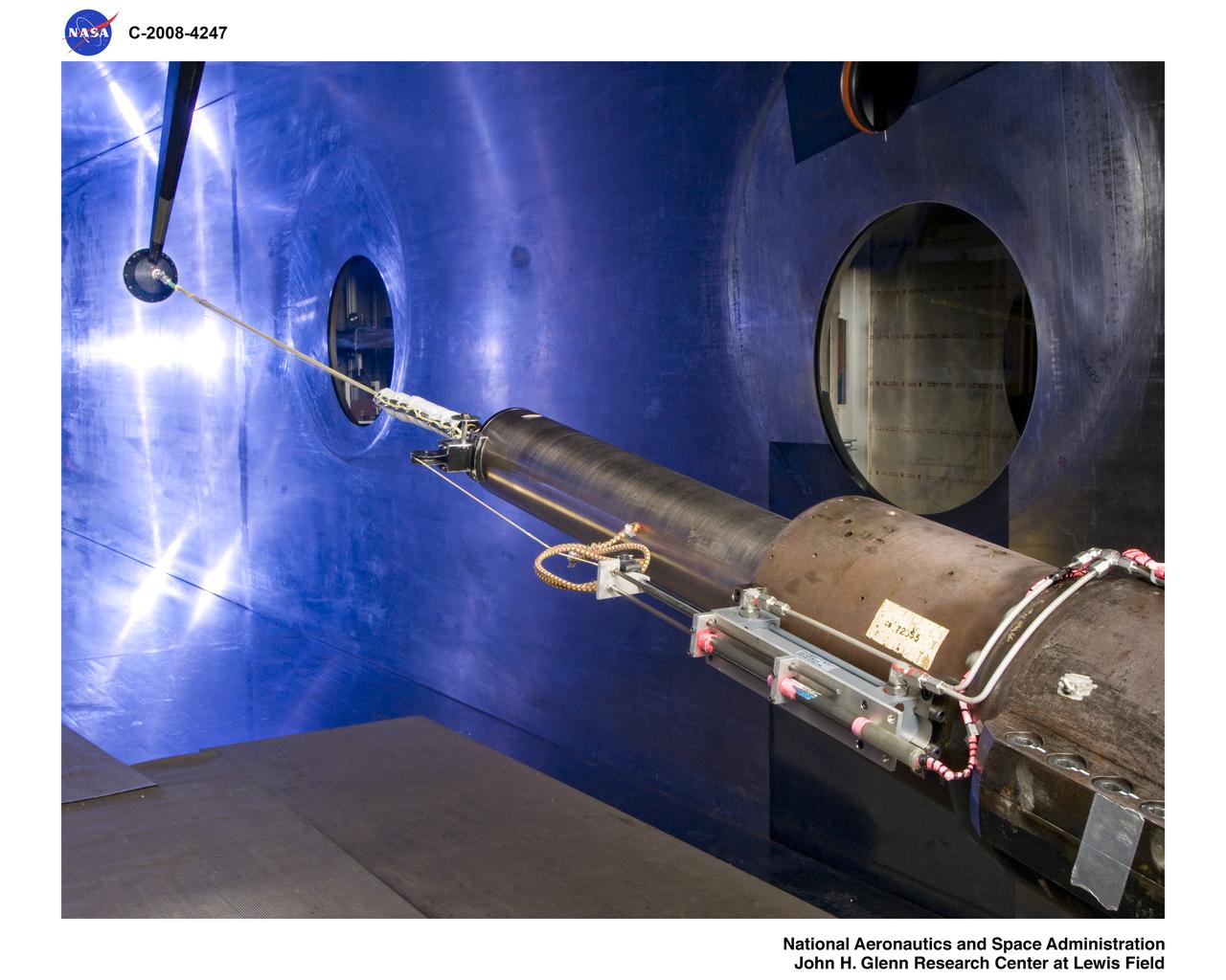
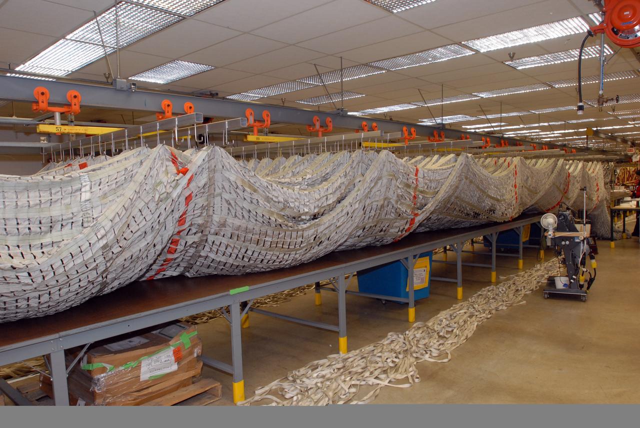
Mars Science Laboratory, MSL Flexible Canopy Test in the Glenn Research Center, 10x10 Supersonic Wind Tunnel
Mars Science Laboratory, MSL Flexible Canopy Test in the Glenn Research Center, 10x10 Supersonic Wind Tunnel
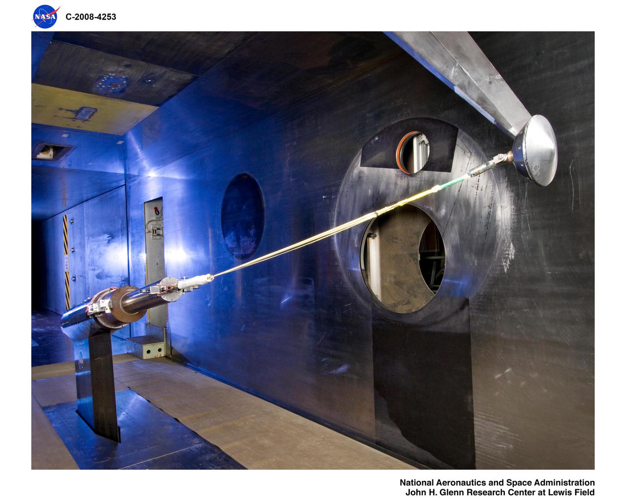
Mars Science Laboratory, MSL Flexible Canopy Test in the Glenn Research Center, 10x10 Supersonic Wind Tunnel
Mars Science Laboratory, MSL Flexible Canopy Test in the Glenn Research Center, 10x10 Supersonic Wind Tunnel
Mars Science Laboratory, MSL Flexible Canopy Test in the Glenn Research Center, 10x10 Supersonic Wind Tunnel
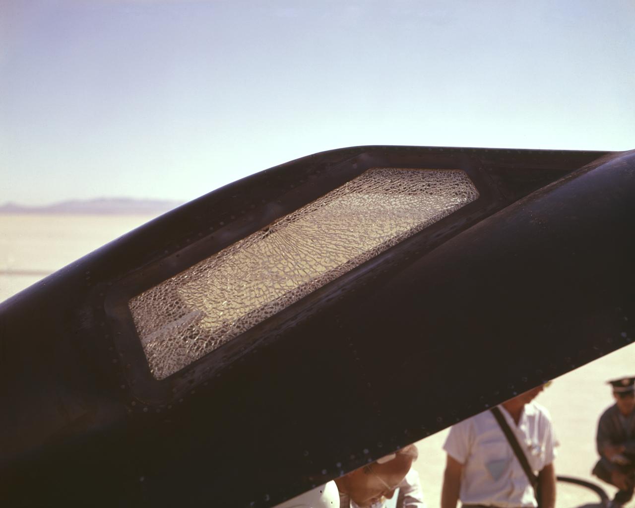
Cracked canopy glass on right side of X-15 #2 after flt. 2-21-37 on Nov. 9 1961. Robert White-pilot. First flight to mach 6.
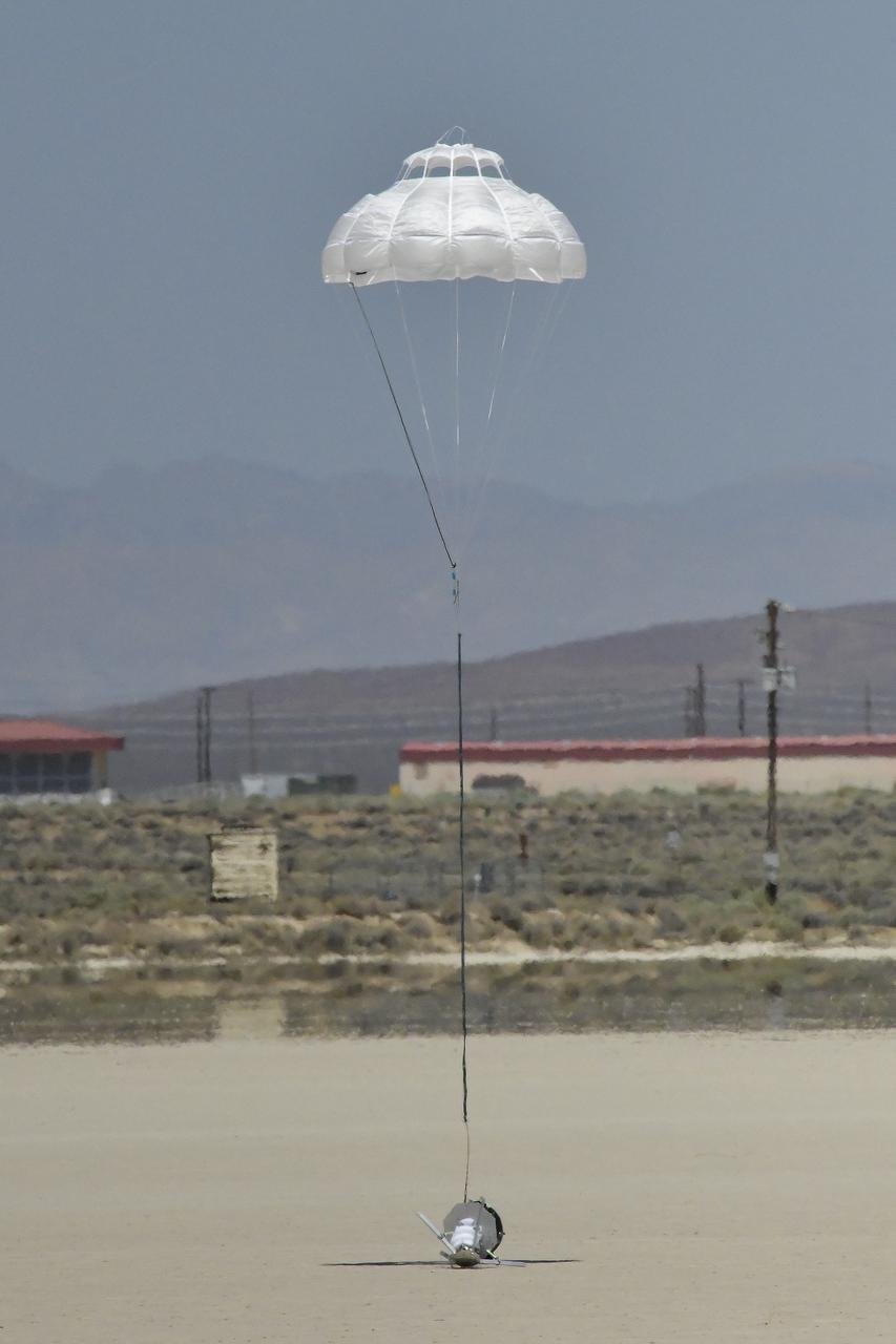
The Enhancing Parachutes by Instrumenting the Canopy test experiment lands following an air launch from an Alta X drone on June 4, 2025, at NASA’s Armstong Flight Research Center in Edwards, California. NASA researchers are developing technology to make supersonic parachutes safer and more reliable for delivering science instruments and payloads to Mars.
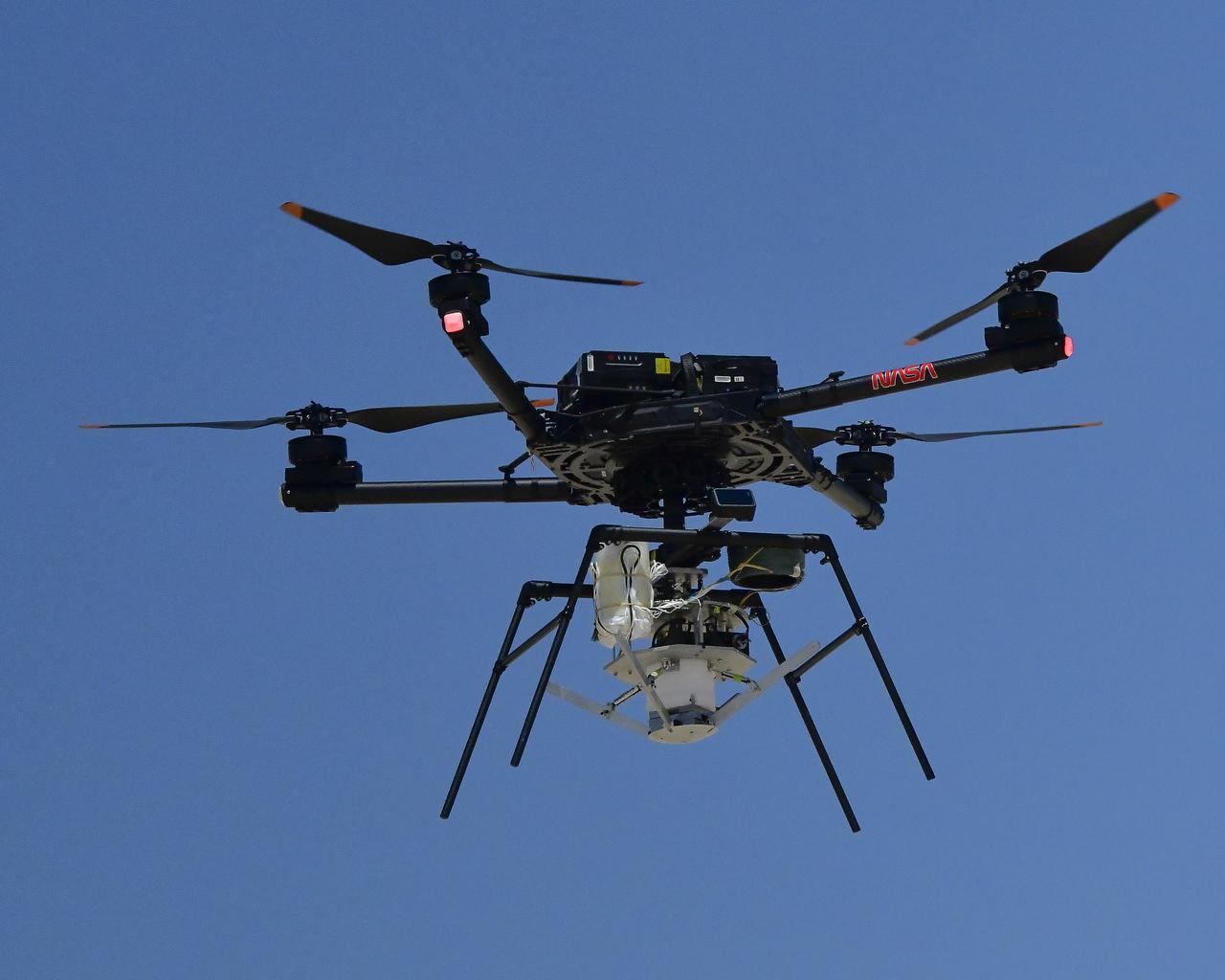
An Alta X drone is positioned at altitude for an air launch of the Enhancing Parachutes by Instrumenting the Canopy test experiment on June 4, 2025, at NASA’s Armstong Flight Research Center in Edwards, California. NASA researchers are developing technology to make supersonic parachutes safer and more reliable for delivering science instruments and payloads to Mars.
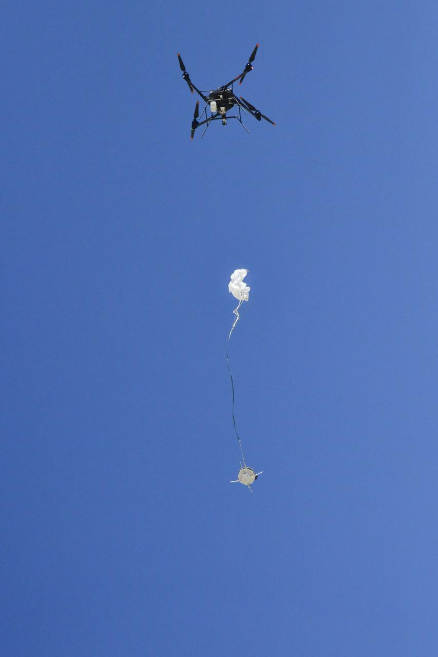
An Alta X drone air launches the Enhancing Parachutes by Instrumenting the Canopy test experiment on June 4, 2025, at NASA’s Armstong Flight Research Center in Edwards, California. NASA researchers are developing technology to make supersonic parachutes safer and more reliable for delivering science instruments and payloads to Mars.
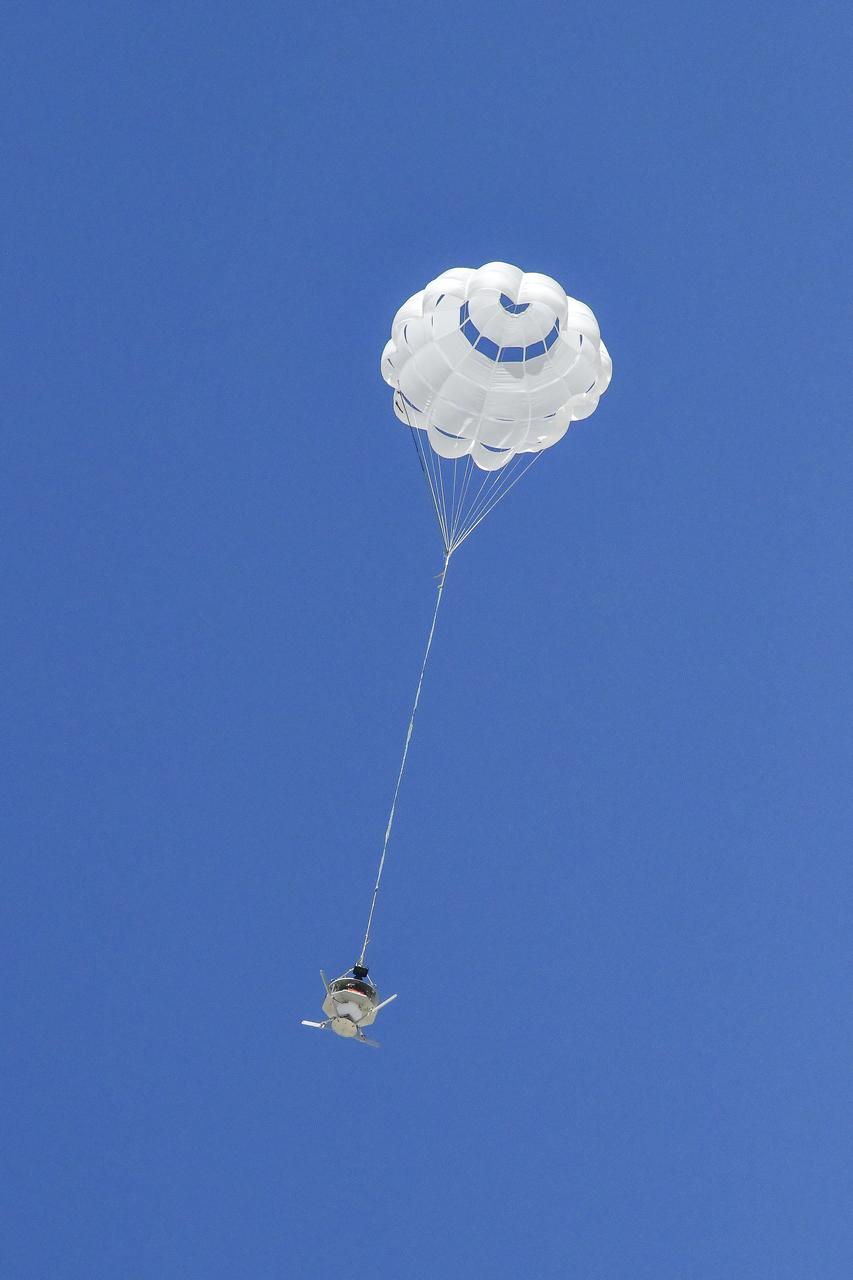
The parachute of the Enhancing Parachutes by Instrumenting the Canopy test experiment deploys following an air launch from an Alta X drone on June 4, 2025, at NASA’s Armstong Flight Research Center in Edwards, California. NASA researchers are developing technology to make supersonic parachutes safer and more reliable for delivering science instruments and payloads to Mars.
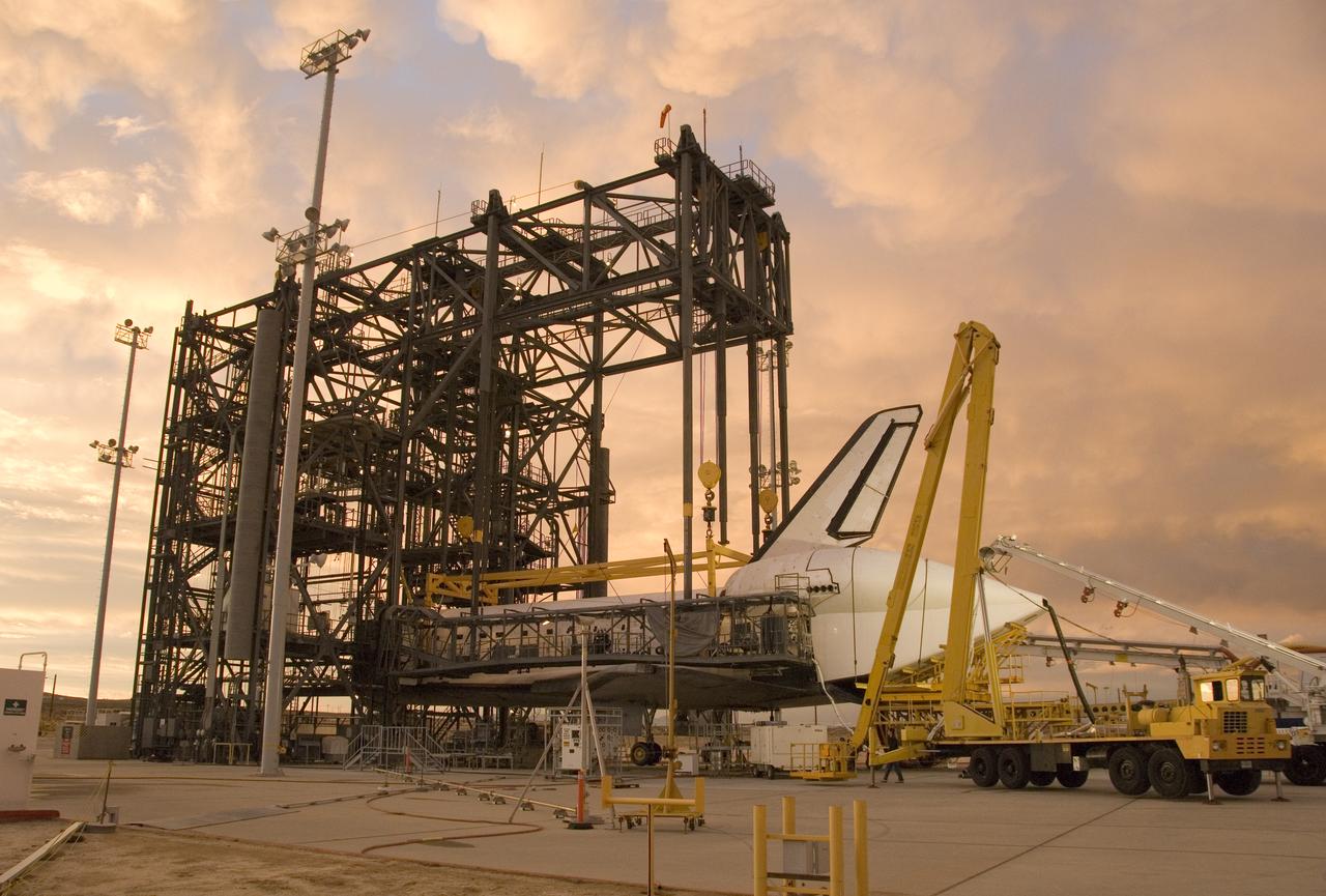
Puffy pink clouds form a canopy over the Space Shuttle Endeavour as processing continues in the Mate-Demate Device at NASA Dryden Flight Research Center in preparation for its ferry flight back to the Kennedy Space Center.
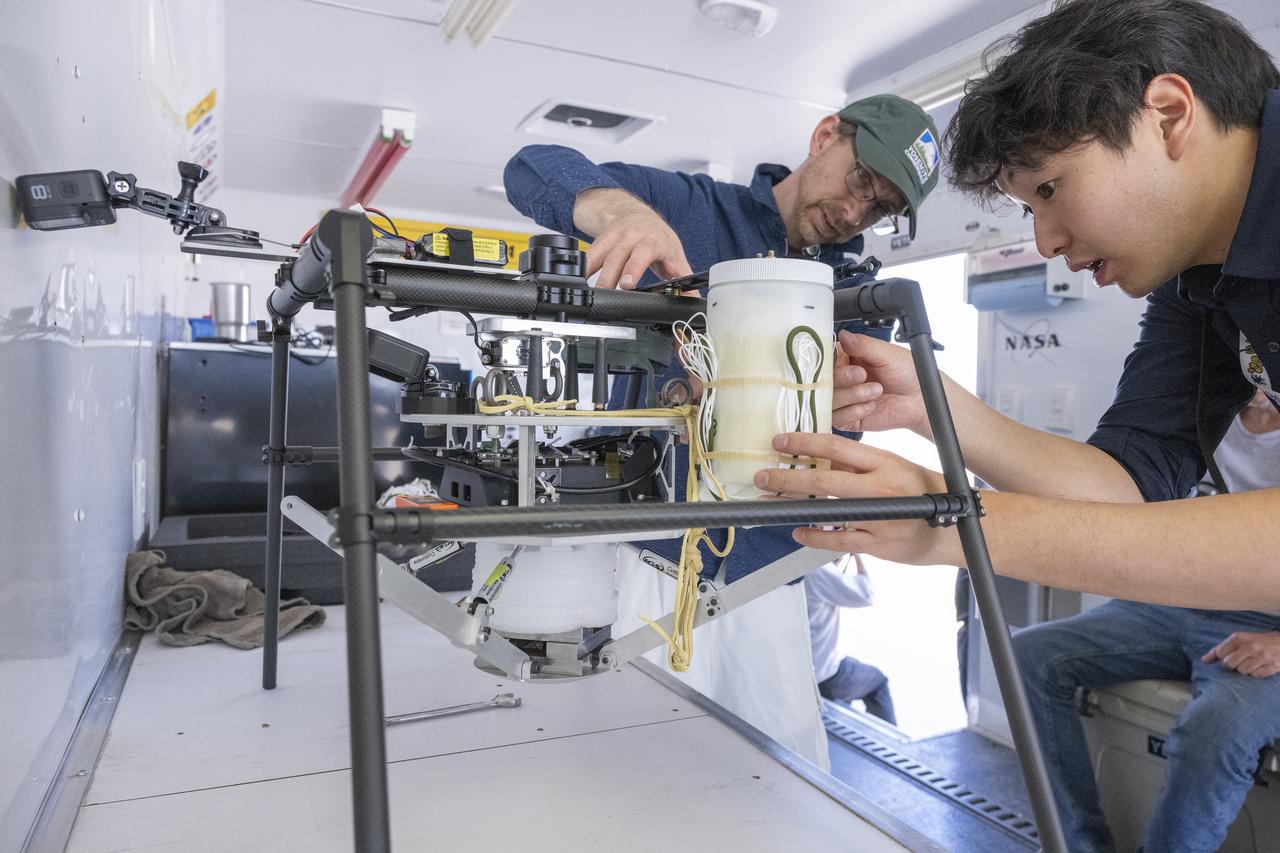
NASA researchers Paul Bean, center, and Mark Hagiwara, right, attach the capsule with parachute system to the Enhancing Parachutes by Instrumenting the Canopy test experiment on June 4, 2025, at NASA’s Armstong Flight Research Center in Edwards, California. NASA researchers are developing technology to make supersonic parachutes safer and more reliable for delivering science instruments and payloads to Mars.
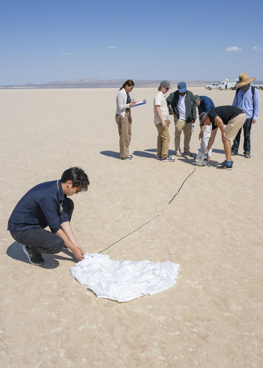
The Enhancing Parachutes by Instrumenting the Canopy project team examines a capsule and parachute following an air launch from an Alta X drone on June 4, 2025, at NASA’s Armstong Flight Research Center in Edwards, California. NASA researchers are developing technology to make supersonic parachutes safer and more reliable for delivering science instruments and payloads to Mars.
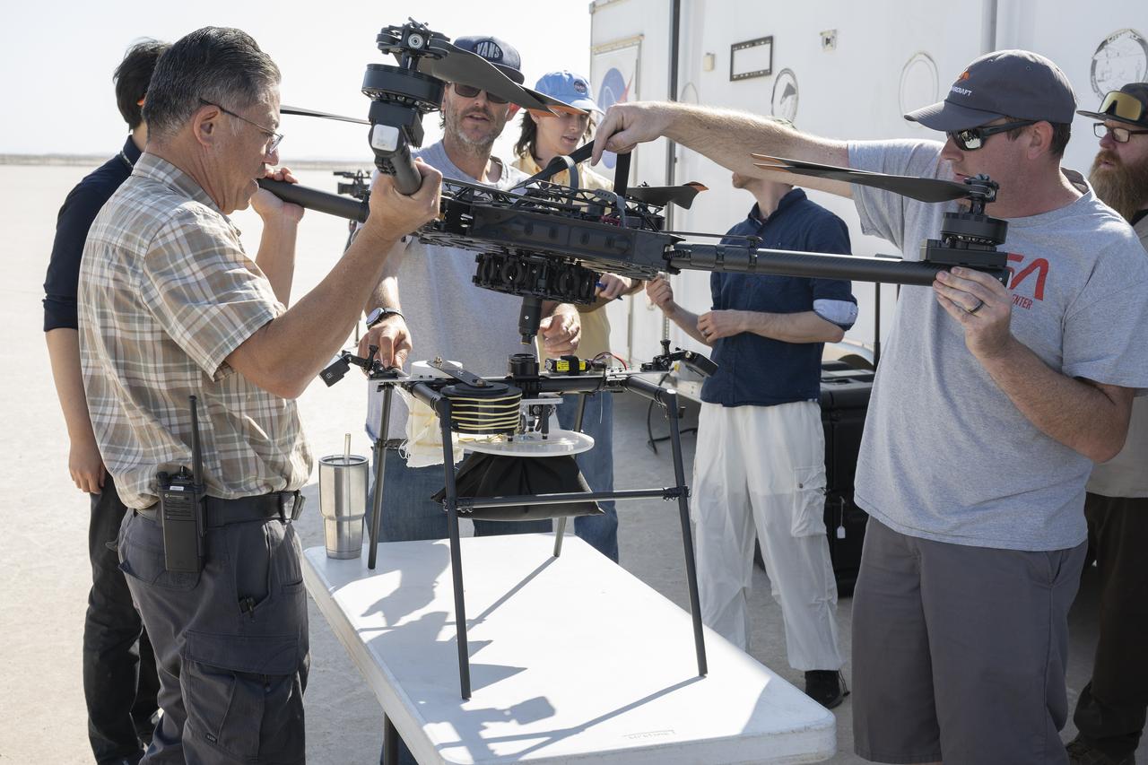
Derek Abramson, left, and Justin Link, right, attach an Alta X drone to the Enhancing Parachutes by Instrumenting the Canopy test experiment on June 4, 2025, at NASA’s Armstong Flight Research Center in Edwards, California. Abramson is NASA chief engineer at the center’s Dale Reed Subscale Flight Research Laboratory, where Link also works as a pilot for small uncrewed aircraft systems. NASA researchers are developing technology to make supersonic parachutes safer and more reliable for delivering science instruments and payloads to Mars.
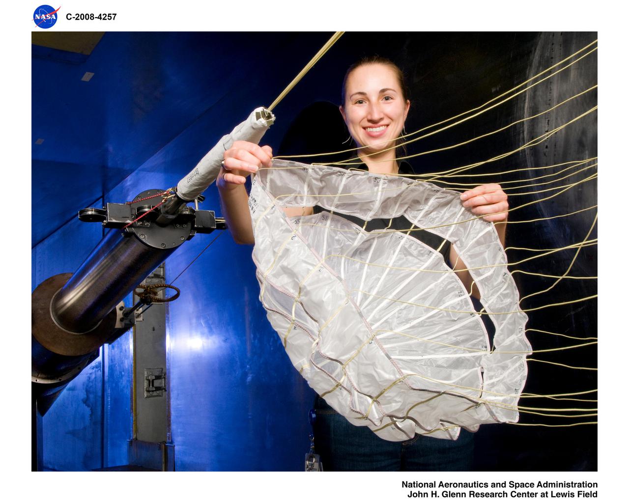
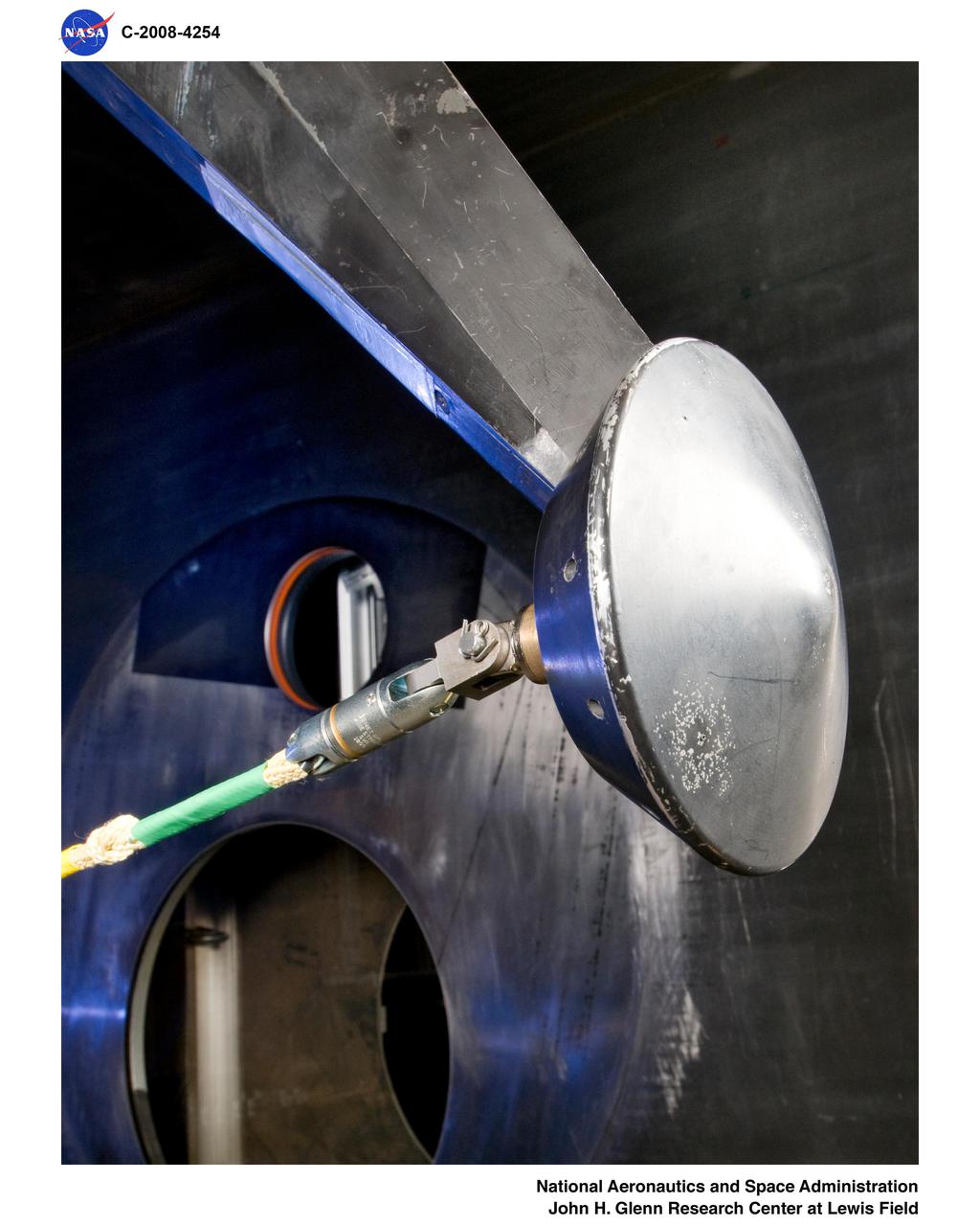
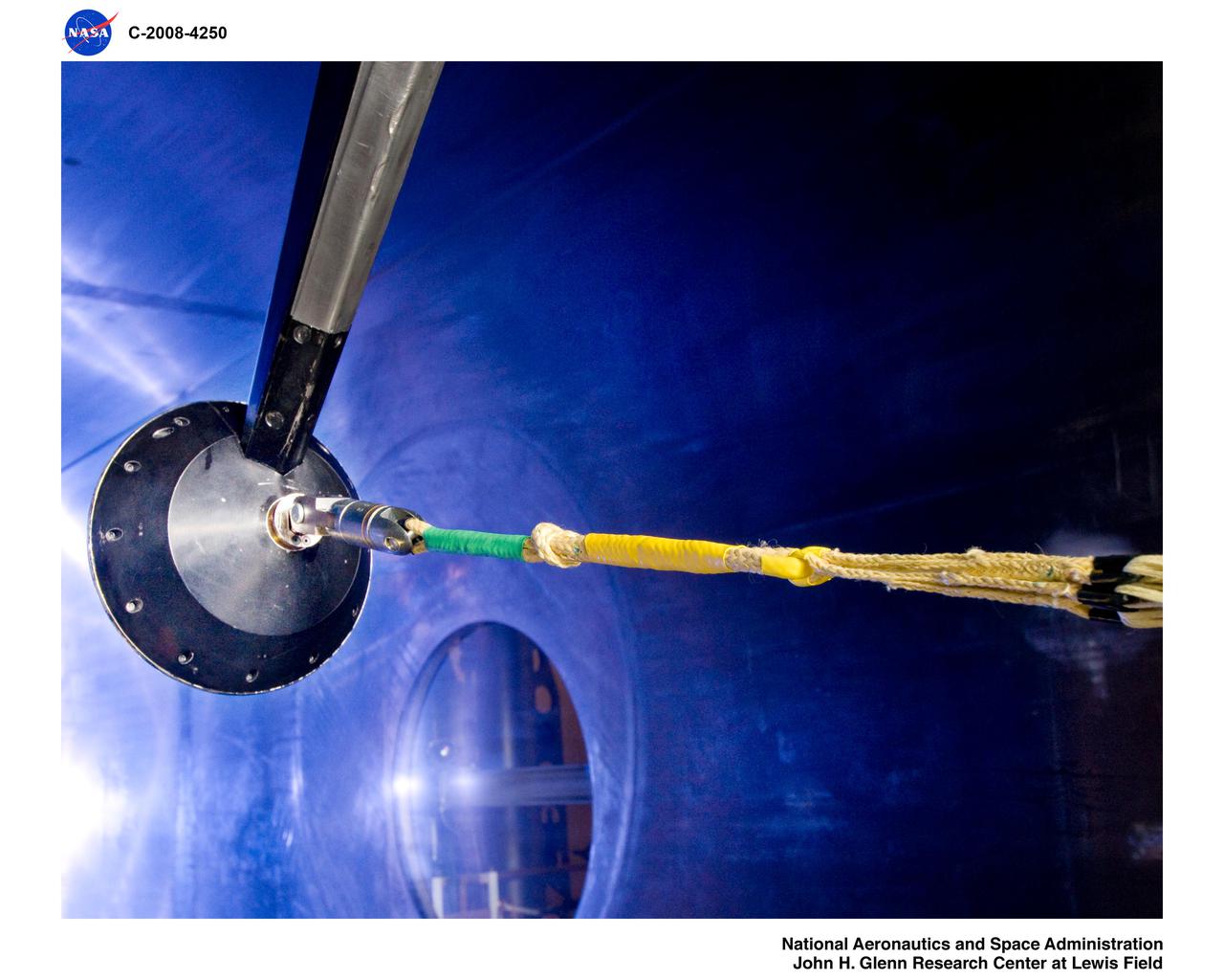
Mars Science Laboratory, MSL Flexible Canopy Test
Mars Science Laboratory, MSL Flexible Canopy Test in the Glenn Research Center, 10x10 Supersonic Wind Tunnel
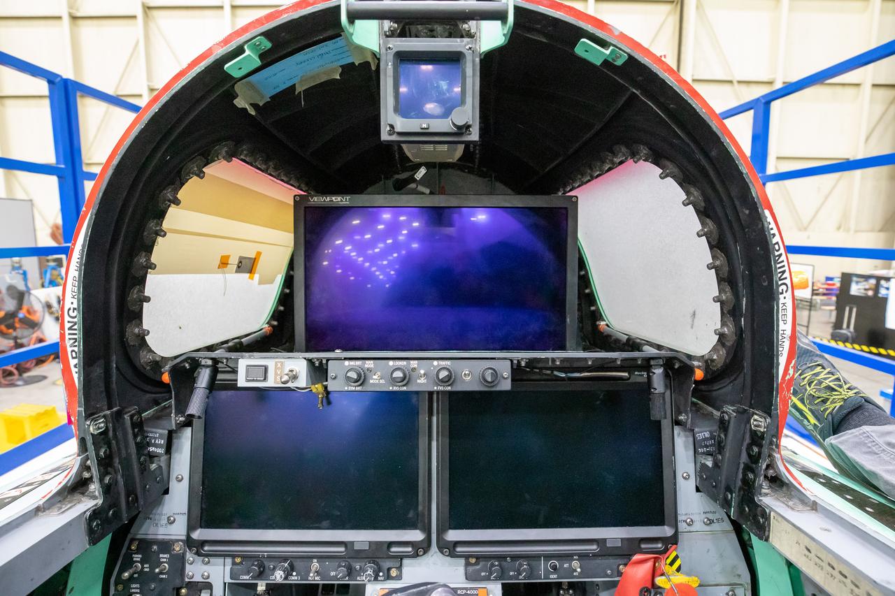
This image shows the forward view of the X-59’s cockpit with the canopy open. The aircraft will not have a forward-facing window and will use an eXternal Vision System (XVS) made up of a high definition 4K monitor (located in the center) and two monitors below to help the pilots safely fly through the skies.
This 8,800-square-foot canopy area was demolished during the refurbishment of the east side of Building 4826, the future home of the X-59 Quiet SuperSonic Technology aircraft, at NASA's Armstrong Flight Research Center in Edwards, California.
The F-15 ACTIVE touches down on the Edwards runway following its April 14, 1998 flight. The nose is high while the canards have their rear edge raised. the aircraft's speed brake, located on the top of the aircraft behind the canopy, is also raised.
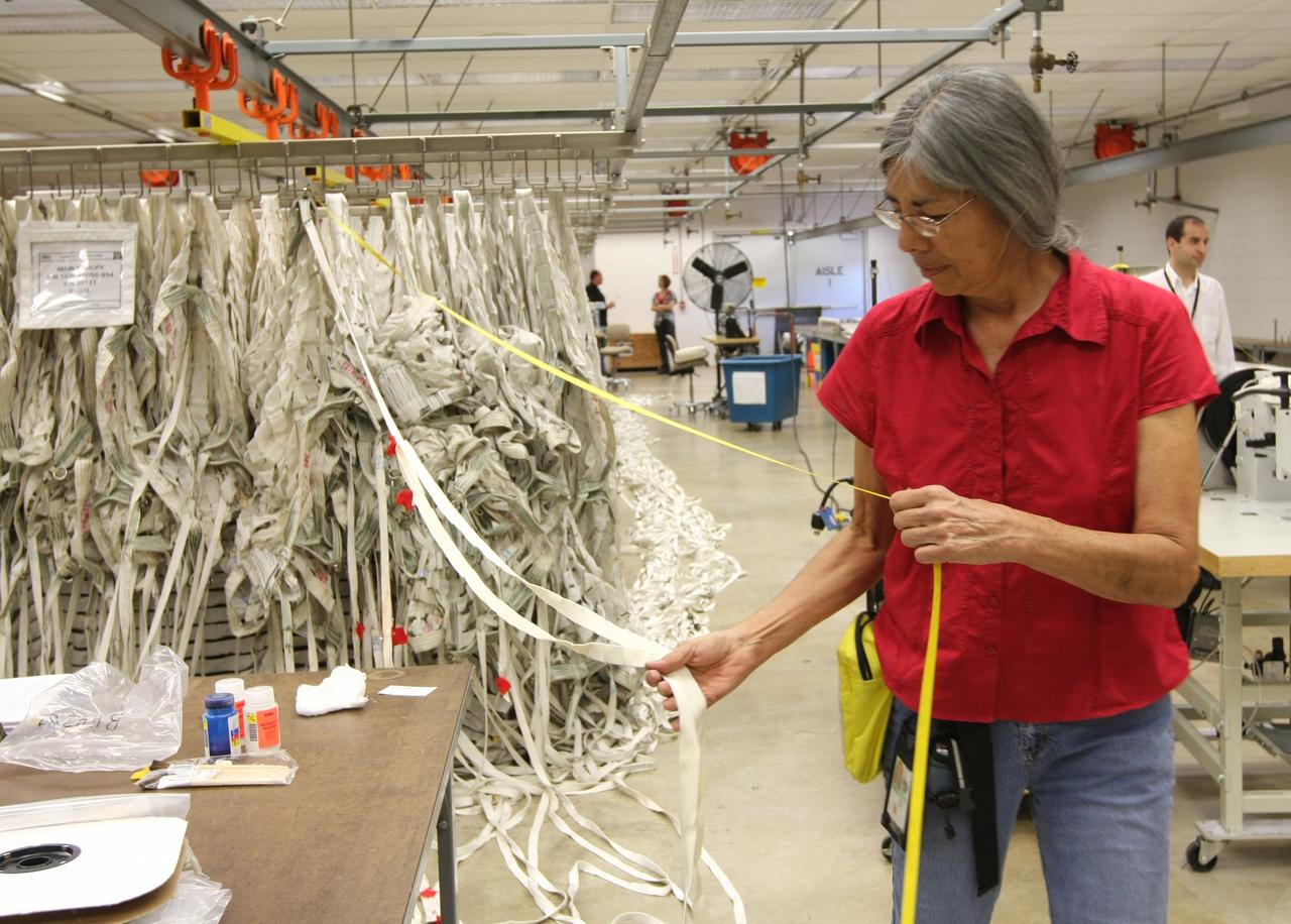
CAPE CANAVERAL, Fla. – In the Parachute Refurbishment Facility at NASA's Kennedy Space Center in Florida, workers repair the parachutes recovered from sea after the launch of space shuttle Endeavour on the STS-126 mission. Typically, each main canopy requires hundreds of repairs after each use. The smaller chutes and the parachute deployment bags they are packed in also require repairs. The parachutes are used to slow the descent of the solid rocket boosters that are jettisoned during liftoff. One pilot, one drogue and three main canopies per booster slow the booster’s fall from about 360 mph to 50 mph. After the chutes are cleaned and repaired, they must be carefully packed into their bags so they will deploy correctly the next time they are used. Photo credit: NASA/Jim Grossmann
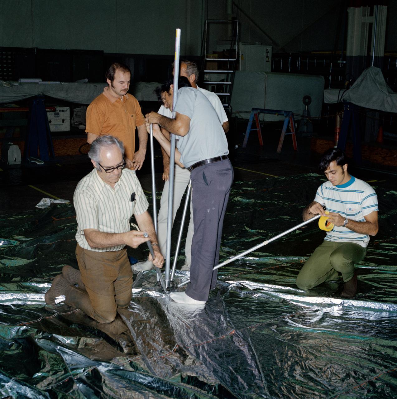
S73-26380 (23 May 1973) --- Technicians in the Technical Services shop in Building 10 work on the fabrication of the umbrella-like mechanical device called the “parasol” during Skylab 2 preflight preparations at NASA's Johnson Space Center. Here, they are attaching the telescoping extension rods to the canopy. The “parasol” is designed to fit into the TO27 experiment photometer canister. The canopy is 24 feet by 22 feet. The sunshade device will be deployed through the solar scientific airlock in the side of the OWS. The “parasol” solar shield is considered the prime possibility for use as the OWS sunshade because it will not require EVA by the Skylab 2 crewmen, because of the operational ease of using it, and because of the simplicity of the device which minimizes crew training. Photo credit: NASA
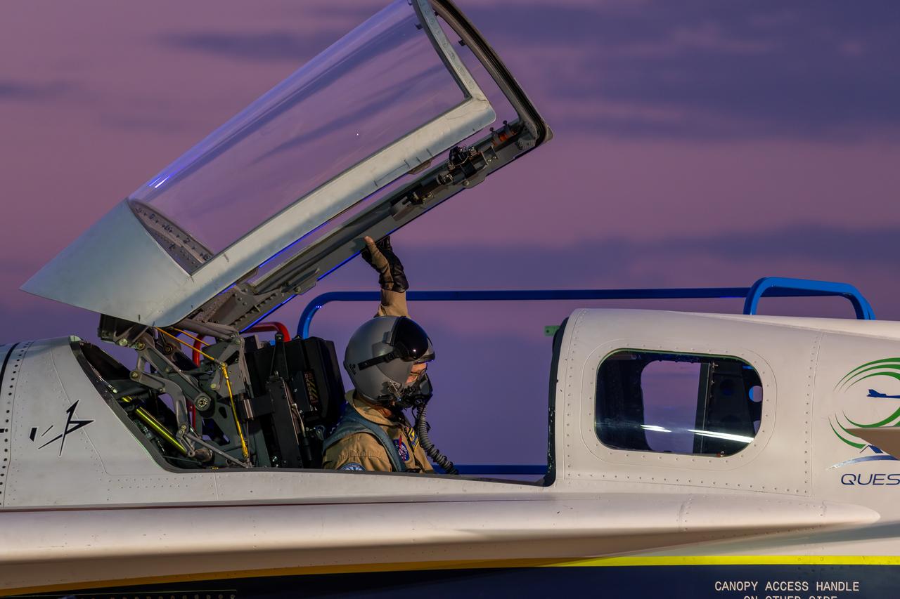
NASA test pilot Nils Larson lowers the canopy of the X-59 quiet supersonic research aircraft during ground tests at Lockheed Martin’s Skunk Works facility in Palmdale, California, on July 18, 2025. The X-59 is the centerpiece of NASA’s Quesst mission to demonstrate quiet supersonic flight and the aircraft is scheduled to make its first flight later this year.
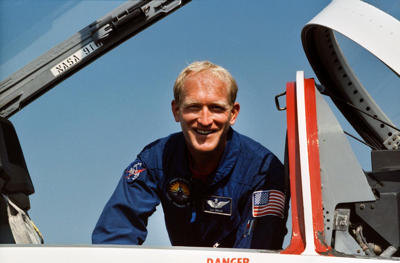
S90-41527 (August 1990) --- Astronaut Charles D. (Sam) Gemar, prepares to climb aboard on of NASA's T-38 jet trainers, located near the Johnson Space Center (JSC). Gemar began training as an astronaut candidate in summer of 1985.

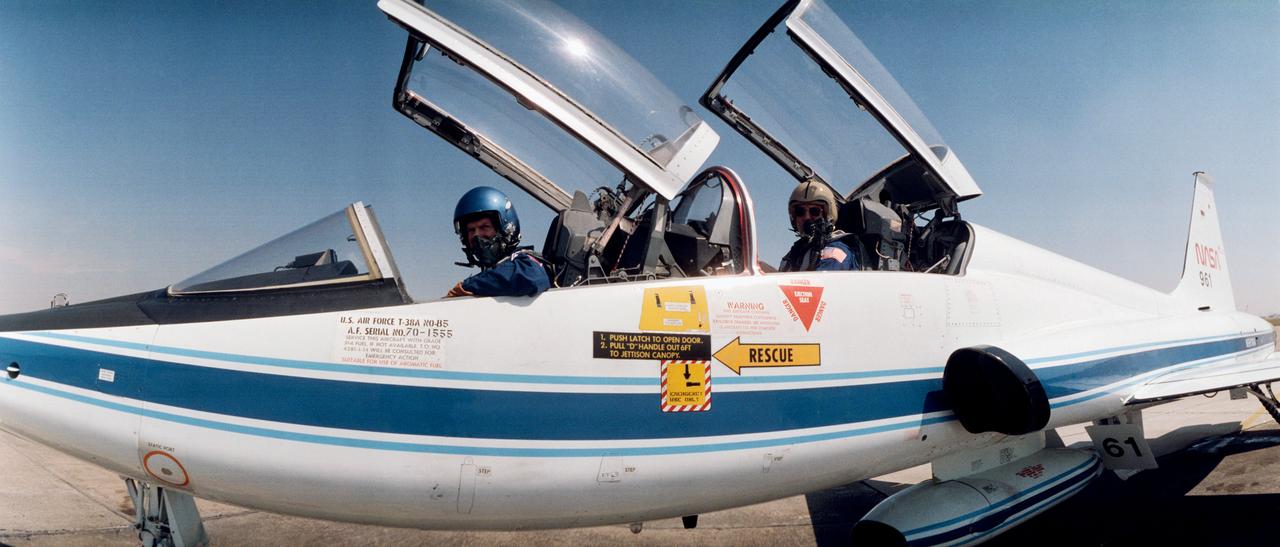
STS-38 Pilot Frank L. Culbertson waves from T-38A NASA 955 forward cockpit prior to Ellington Field departure. Astronaut Curtis L. Brown, Jr is stationed in the aft cockpit behind Culbertson.
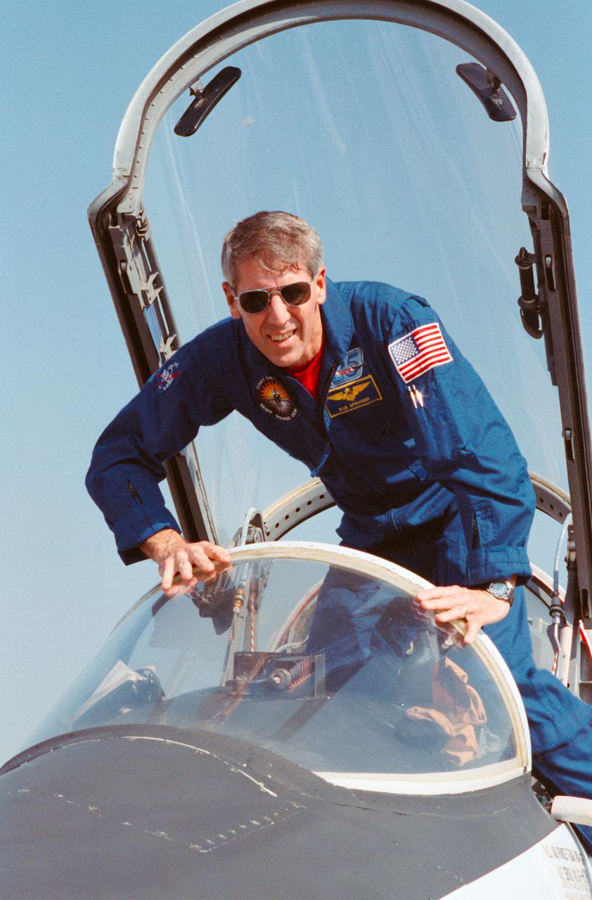
STS-38 Mission Specialist (MS) Robert C. Springer climbs into T-38A forward cockpit prior to Ellington Field departure for the Kennedy Space Center (KSC).
S73-26401 (23 May 1973) --- An umbrella-like mechanical device called the "parasol", one of the several sunscreen possibilities being considered for use in shading the overheated Skylab 1 Orbital Workshop (OWS), receives a checkout in the Technical Services shop in Bldg. 10 at Johnson Space Center. Here, a technician starts to deploy the "parasol" sunshade. The "parasol" is designed to fit into the T027 experiment photometer canister. The canopy portion of the "parasol" measures 24 feet by 22 feet. Photo credit: NASA
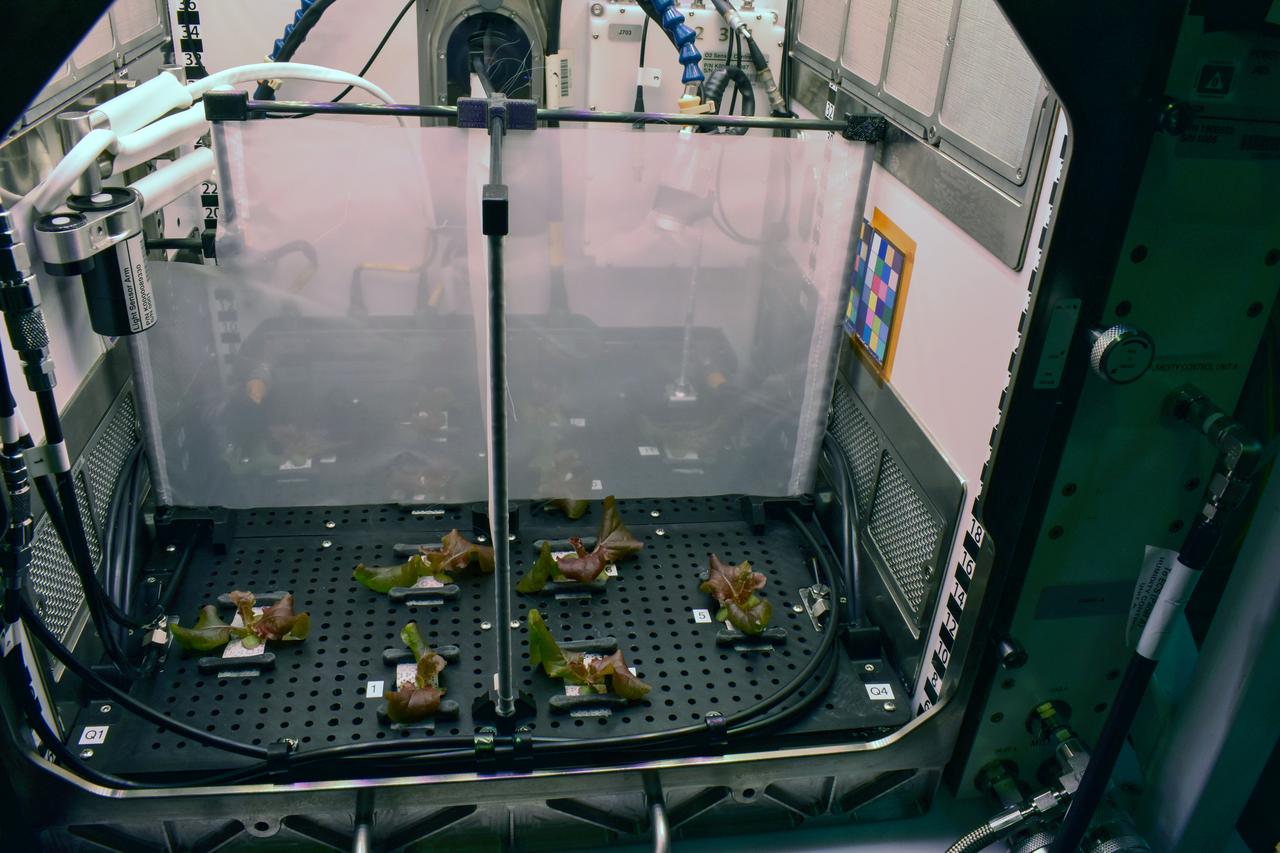
jsc2025e047408 (2/13/2024) --- Dividers installed on day 14 to separate the canopies and microbiomes of lettuce plants grown with different moisture treatments as part of a ground experiment for The Spaceflight Microbiome of a Food Crop Grown Using Different Substrate Moisture Levels (Plant Habitat-07). This investigation studies how plants, and their communities of microorganisms respond to different levels of water. Results could support development of systems for growing food crops on future missions. Image courtesy of the PH-07 Team.
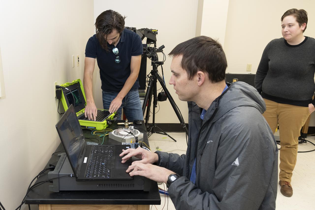
Coby Asselin, from left, Adam Curry, and L. J. Hantsche set up the data acquisition systems used during testing of a senor to determine parachute canopy material strength at NASA’s Armstrong Flight Research Center in Edwards, California. The sensor tests seek to quantify the limits of the material to improve computer models and make more reliable supersonic parachutes.
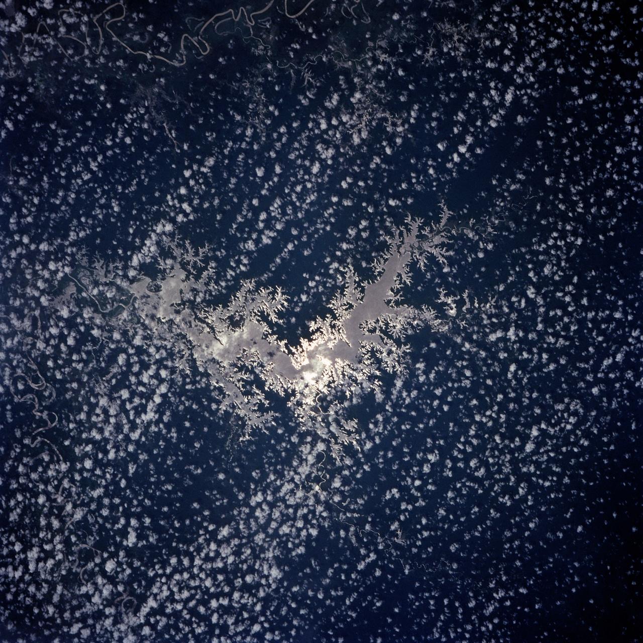
Lake Murray, a manmade reservoir, lies between the Fly and Strickland River Basins, Papua, New Guinea (7.0S, 141.5E). The region, photographed in sunglint, shows the water level in the reservoir and the full extent of the drainage basins of both river systems as the rivers meander through wide alluvial floodplains. Some forest clearing can be seen in places throughout the region, but most of the area remains in closed canopy forest.

The main gate (Gate 7) of the Michoud Assembly Facility has been demolished and replaced following the tornado that struck the area in February 2017. The project included moving the gate to a position of 300 feet off the property line (away from Old Gentilly Blvd). The configuration included expanding the entrance to the gate from 2 lanes to 3 while maintaining 2 exit lanes. This layout provides for a guard post shelter rain canopy over two of the entrance lanes. Assessments and repairs continue on various structures and facilities across the facility.

The main gate (Gate 7) of the Michoud Assembly Facility has been demolished and replaced following the tornado that struck the area in February 2017. The project included moving the gate to a position of 300 feet off the property line (away from Old Gentilly Blvd). The configuration included expanding the entrance to the gate from 2 lanes to 3 while maintaining 2 exit lanes. This layout provides for a guard post shelter rain canopy over two of the entrance lanes. Assessments and repairs continue on various structures and facilities across the facility.
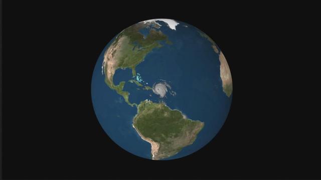
NASA's CloudSat satellite flew over Hurricane Irma on Sept. 6, 2017 at 1:45 p.m. EDT (17:45 UTC) as the storm was approaching Puerto Rico in the Atlantic Ocean. Hurricane Irma contained estimated maximum sustained winds of 185 miles per hour (160 knots) with a minimum pressure of 918 millibars. CloudSat transected the eastern edge of Hurricane Irma's eyewall, revealing details of the storm's cloud structure beneath its thick canopy of cirrus clouds. The CloudSat Cloud Profiling Radar excels in detecting the organization and placement of cloud layers beneath a storm's cirrus canopy, which are not readily detected by other satellite sensors. The CloudSat overpass reveals the inner details beneath the cloud tops of this large system; intense areas of convection with moderate to heavy rainfall (deep red and pink colors), cloud-free areas (moats) in between the inner and outer cloud bands of Hurricane Irma and cloud top heights averaging around 9 to 10 miles (15 to 16 kilometers). Lower values of reflectivity (areas of green and blue) denote smaller-sized ice and water particle sizes typically located at the top of a storm system (in the anvil area). The Cloud Profiling Radar loses signal at around 3 miles (5 kilometers) in height (in the melting layer) due to water (ice) particles larger than 0.12 inches (3 millimeters) in diameter. Moderate to heavy rainfall occurs in these areas where signal weakening is detectable. Smaller cumulus and cumulonimbus cloud types are evident as CloudSat moves farther south, beneath the thick cirrus canopy. An animation is available at https://photojournal.jpl.nasa.gov/catalog/PIA21947
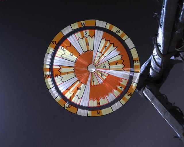
This annotated image was taken by a parachute-up-look camera aboard the protective back shell of NASA's Perseverance rover during its descent toward Mars' Jezero Crater on February 18, 2021. Using binary code, two messages have been encoded in the neutral white and international-orange parachute gores (the sections that make up the canopy's hemispherical shape). The inner portion spells out "DARE MIGHTY THINGS," with each word located on its own ring of gores. The outer band of the canopy provides GPS coordinates for NASA's Jet Propulsion Laboratory in Southern California, where the rover was built and the project is managed. Mars 2020 Perseverance Systems Engineer Ian Clark designed the binary code pattern. The saying is JPL's motto and is an abridgement of a quote from Teddy Roosevelt's "Strenuous Life" speech: "Far better is it to dare mighty things, to win glorious triumphs, even though checkered by failure ... than to rank with those poor spirits who neither enjoy nor suffer much, because they live in a gray twilight that knows not victory nor defeat." https://photojournal.jpl.nasa.gov/catalog/PIA24431
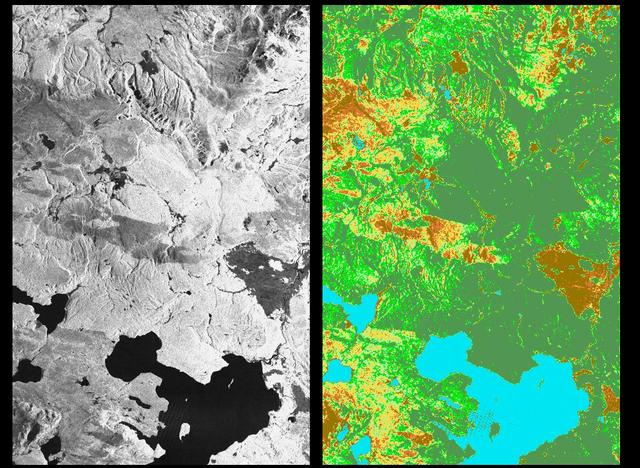
These two radar images show the majestic Yellowstone National Park, Wyoming, the oldest national park in the United States and home to the world's most spectacular geysers and hot springs. The region supports large populations of grizzly bears, elk and bison. In 1988, the park was burned by one of the most widespread fires to occur in the northern Rocky Mountains in the last 50 years. Surveys indicated that 793,880 acres of land burned. Of that, 41 percent was burned forest, with tree canopies totally consumed by the fire; 35 percent was a combination of unburned, scorched and blackened trees; 13 percent was surface burn under an unburned canopy; 6 percent was non-forest burn; and 5 percent was undifferentiated burn. Six years later, the burned areas are still clearly visible in these false-color radar images obtained by the Spaceborne Imaging Radar-C/X-band Synthetic Aperture Radar on board the space shuttle Endeavour. The image at the left was obtained using the L-band radar channel, horizontally received and vertically transmitted, on the shuttle's 39th orbit on October 2, 1994. The area shown is 45 kilometers by 71 kilometers (28 miles by 44 miles) in size and centered at 44.6 degrees north latitude, 110.7 degrees west longitude. North is toward the top of the image (to the right). Most trees in this area are lodge pole pines at different stages of fire succession. Yellowstone Lake appears as a large dark feature at the bottom of the scene. At right is a map of the forest crown, showing its biomass, or amount of vegetation, which includes foliage and branches. The map was created by inverting SIR-C data and using in situ estimates of crown biomass gathered by the Yellowstone National Biological Survey. The map is displayed on a color scale from blue (rivers and lakes with no biomass) to brown (non-forest areas with crown biomass of less than 4 tons per hectare) to light brown (areas of canopy burn with biomass of between 4 and 12 tons per hectare). Yellow indicates areas of canopy burn and mixed burn with a biomass of between 12 to 20 tons per hectare; light green is mixed burn and on-burn forest with a biomass of 20 to 35 tons per hectare; and green is non-burned forest with a biomass of greater than 35 tons per hectare. Forest recovery from the fire seems to depend on fire intensity and soil conditions. In areas of severe canopy burn and poor soil conditions, crown biomass was still low in 1994 (indicated by the brown areas at the center left), whereas in areas of mixed burn with nutrient-rich soils, seen west of Yellowstone Lake, crown biomass has increased significantly in six years (indicated by the yellow and light green areas). Imaging fire-affected regions with spaceborne radar illustrates SIR-C/X-SAR's keen abilities to monitor regrowth after a fire. Knowing the amount of carbon accumulated in the atmosphere by regenerating forest in the 20 to 50 years following a fire disturbance is also a significant factor in understanding the global carbon cycle. Measuring crown biomass is necessary to evaluate the effects of past and future fires in specific regions. http://photojournal.jpl.nasa.gov/catalog/PIA01741
STS059-S-079 (18 April 1994) --- This is a false-color, three frequency image of Prince Albert, Canada, centered at 53.91 north latitude and 104.69 west longitude. It was produced using data from the X-Band, C-Band and L-Band radars that comprise the Spaceborne Imaging Radar-C and X-Band Synthetic Aperture Radar (SIR-C/X-SAR). SIR-C/X-SAR acquired this image on the 20th orbit of the Space Shuttle Endeavour. The area is located 40 kilometers north and 30 kilometers east of the town of Prince Albert in the Saskatchewan province of Canada. The image covers the area east of the Candle Lake, between gravel surface Highways 120 and 106 and west of 106. The area in the middle of the image covers the entire Nipawin (Narrow Hills) provincial park. The look angle of the radar is 30 degrees and the size of the image is approximately 20 by 50 kilometers. The red, green, and blue colors represent L-Band total power, C-Band total power, and XVV respectively. The changes in the intensity of each color are related to various surface conditions such as frozen or thawed forest, fire, deforestation and areas of regrowth. Most of the dark blue areas in the image are the ice covered lakes. The dark area on the top right corner of the image is the White Gull Lake north of the intersection of Highway 120 and 913. The right middle part of the image shows Lake Ispuchaw and Lower Fishing Lake. The deforested areas are shown by light blue in the image. Since most of the logging practice at the Prince Albert area is around the major highways, the deforested areas can be easily detected as small geometrically shaped dark regions along the roads. At the time these data were taken, a major part of the forest was either frozen or undergoing the spring thaw. In such conditions, due to low volume of water in the vegetation, a deeper layer of the canopy is imaged by the radar, revealing valuable information about the type of trees, the amount of vegetation biomass and the condition of the surface. As the frequency increases, the penetration depth in the canopy decreases. Over forest canopies, the X-Band radar contains information about the top of the canopy. Whereas, C-Band and L-Band radar returns show contributions from the crown and trunk areas respectively. The bright areas in the image are dense mixed aspen and old jackpine forests where the return from all three bands is high. The reddish area corresponds to more sparse old jack pine (12 to 17 meters in height and 60 to 75 years old) where the L-Band signal penetrates deeper in the canopy and dominates C-Band and X-Band returns. Comparison of the image with the forest cover map of the area indicates that the three band radar can be used to classify various stands. SIR-C/X-SAR is part of NASA's Mission to Planet Earth (MTPE). SIR-C/X-SAR radars illuminate Earth with microwaves allowing detailed observations at any time, regardless of weather or sunlight conditions. SIR-C/X-SAR uses three microwave wavelengths: L-Band (24 cm), C-Band (6 cm), and X-Band (3 cm). The multi-frequency data will be used by the international scientific community to better understand the global environment and how it is changing. The SIR-C/X-SAR data, complemented by aircraft and ground studies, will give scientists clearer insights into those environmental changes which are caused by nature and those changes which are induced by human activity. SIR-C was developed by NASA's Jet Propulsion Laboratory (JPL). X-SAR was developed by the Dornire and Alenia Spazio Companies for the German Space Agency, Deutsche Agentur fuer Raumfahrtangelegenheiten (DARA), and the Italian Space Agency, Agenzia Spaziale Italiana (ASI). JPL Photo ID: P-43929
KENNEDY SPACE CENTER, FLA. - The turbulent weather common to a Florida afternoon in the summer subsides into a serene canopy of cornflower blue, and a manmade "bird" takes flight. The Space Shuttle Discovery soars skyward from Launch Pad 39B on Mission STS-64 at 6:22:35 p.m. EDT, Sept. 9. On board are a crew of six: Commander Richard N. Richards; Pilot L. Blaine Hammond Jr.; and Mission Specialists Mark C. Lee, Carl J. Meade, Susan J. Helms and Dr. J.M. Linenger. Payloads for the flight include the Lidar In-Space Technology Experiment (LITE), the Shuttle Pointed Autonomous Research Tool for Astronomy-201 (SPARTAN-201) and the Robot Operated Material Processing System (ROMPS). Mission Specialists Lee and Meade also are scheduled to perform an extravehicular activity during the 64th Shuttle mission.
KENNEDY SPACE CENTER, FLA. - Workers move the SORCE satellite back under the protective canopy for mating to the Pegasus launch vehicle. The satellite will be rotated before the mating to Pegasus. SORCE is equipped with four instruments that will measure variations in solar radiation and observe some spectral properties of solar radiation for the first time. With data from NASA's SORCE mission, researchers should be able to follow how the Sun affects our climate now and in the future. Launch of SORCE aboard the Pegasus XL rocket is scheduled for Jan. 25, 2003, at approximately 3:14 p.m. EST, from Cape Canaveral Air Force Station, Fla.
KENNEDY SPACE CENTER, FLA. - Workers move the SORCE satellite from underneath a canopy during its transfer to a rotating workstand for mating to the Pegasus launch vehicle. SORCE is equipped with four instruments that will measure variations in solar radiation and observe some spectral properties of solar radiation for the first time. With data from NASA's SORCE mission, researchers should be able to follow how the Sun affects our climate now and in the future. Launch of SORCE aboard the Pegasus XL rocket is scheduled for Jan. 25, 2003, at approximately 3:14 p.m. EST, from Cape Canaveral Air Force Station, Fla.
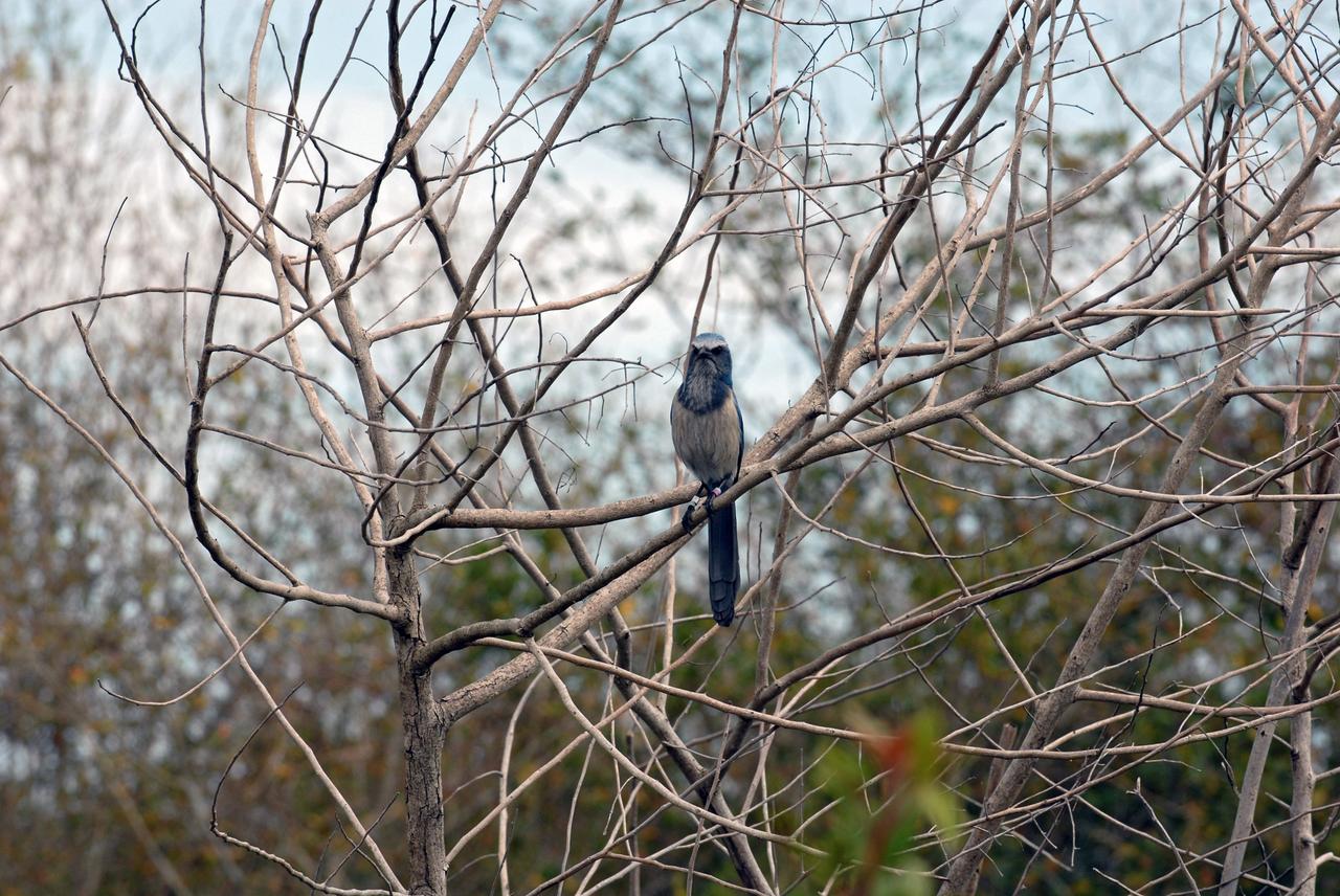
CAPE CANAVERAL, Fla. – A Florida scrub jay perches on a branch in a wooded area at NASA's Kennedy Space Center in Florida. As the name implies, the Florida scrub jay thrives in a scrub, which is an extremely dry habitat. Their ideal environment is a relatively open flatwoods of oak or sand pine scrub with trees less than 10 feet tall, wide apart and providing minimal canopy cover. The last recorded population count of Florida scrub jays is just a little over 2,000, mostly located at Kennedy but also in some scattered scrubs all over central and southern Florida. Photo credit: NASA/Ben Smegelsky
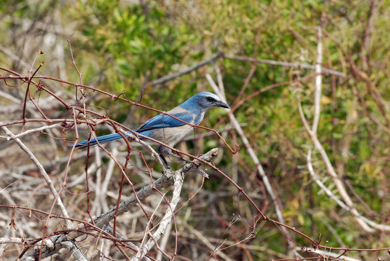
CAPE CANAVERAL, Fla. – Close-up of a Florida scrub jay in the woods near NASA's Kennedy Space Center in Florida. As the name implies, the Florida scrub jay thrives in a scrub, which is an extremely dry habitat. Their ideal environment is a relatively open flatwoods of oak or sand pine scrub with trees less than 10 feet tall, wide apart and providing minimal canopy cover. The last recorded population count of Florida scrub jays is just a little over 2,000, mostly located at Kennedy but also in some scattered scrubs all over central and southern Florida. Photo credit: NASA/Ben Smegelsky
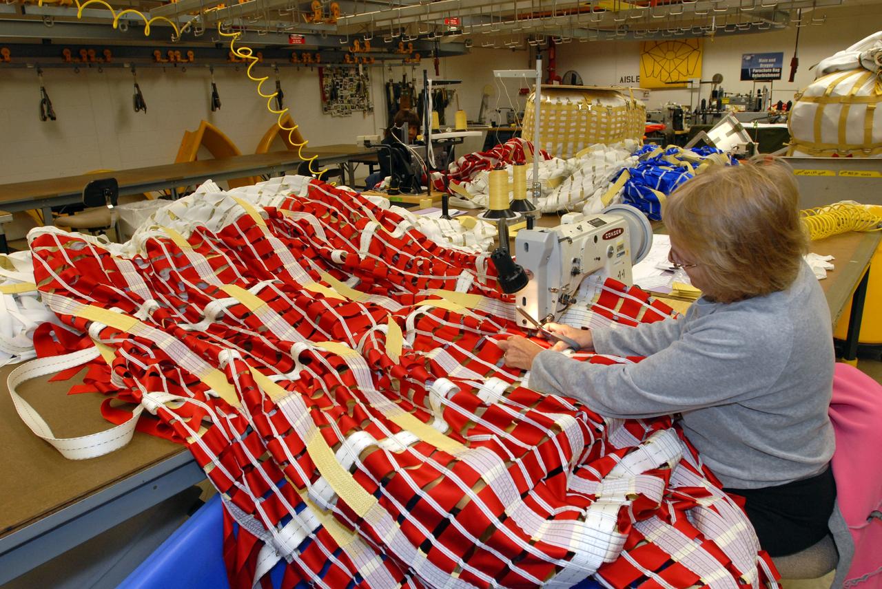
CAPE CANAVERAL, Fla. – In the Parachute Refurbishment Facility at NASA's Kennedy Space Center, Deborah Coombs, senior parachute technician, measures suspension lines for the Ares-I main canopy. Ares I is an in-line, two-stage rocket that will transport the Orion crew exploration vehicle to low-Earth orbit. The Ares I first stage will be a five-segment solid rocket booster based on the four-segment design used for the shuttle. As with the shuttle, this booster will fall away when spent, lowered by parachute into the Atlantic Ocean where it can be retrieved for re-use. Photo credit: NASA/Dimitri Gerondidakis
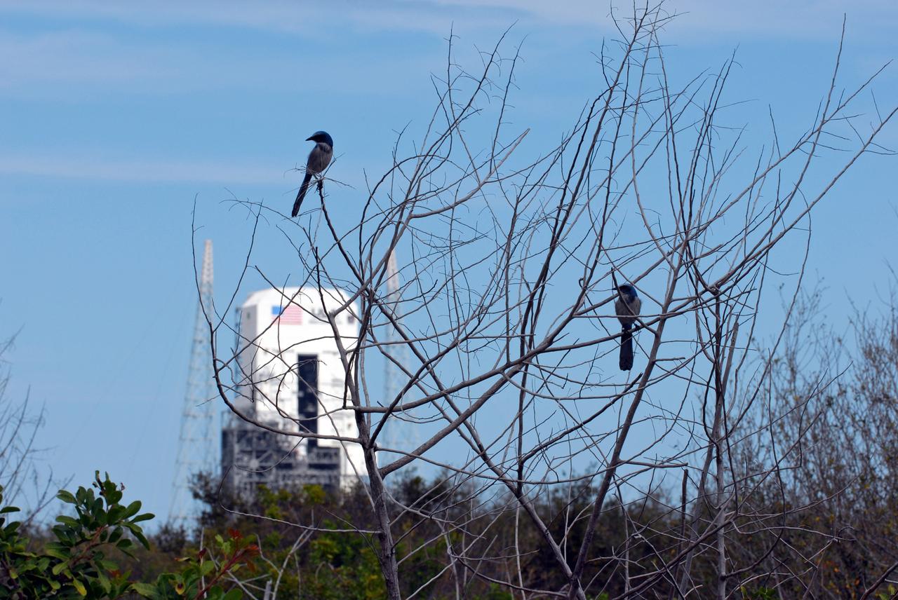
CAPE CANAVERAL, Fla. – Florida scrub jays scan their territory from a bush at NASA's Kennedy Space Center in Florida. As the name implies, the Florida scrub jay thrives in a scrub, which is an extremely dry habitat. Their ideal environment is a relatively open flatwoods of oak or sand pine scrub with trees less than 10 feet tall, wide apart and providing minimal canopy cover. The last recorded population count of Florida scrub jays is just a little over 2,000, mostly located at Kennedy but also in some scattered scrubs all over central and southern Florida. Photo credit: NASA/Ben Smegelsky
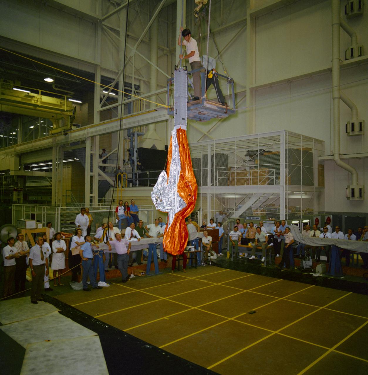
S73-26394 (23 May 1973) --- Dr. Christopher C. Kraft Jr. (left), JSC Director, and George A. Post, JSC Crew Systems Division, look over the packaged "parasol" during fabrication and checkout of the umbrella-like mechanical device in the Technical Services shop in building 10 at Johnson Space Center. The "parasol" is designed to fit into the T027 experiment photometer canister. The canopy portion of the "parasol" measures 24 feet by 22 feet. The "parasol" is one of several sunscreen possibilities being considered for use in shading the overheated Skylab 1 Orbital Workshop. Photo credit: NASA
S73-26773 (26 May 1973) --- The deployment of the ?parasol? solar shield, a sunshade to help cool the overheated Orbital Workshop of the Skylab 1 space station cluster in Earth orbit, can be seen in the reproduction taken from a color television transmission made by a TV camera aboard the space station. The camera is in the Command Module; and the view is looking through the truss of the Apollo Telescope Mount. The sunshade is only partially deployed in this picture. The solar shield was pushed up through the OWS solar scientific airlock. The canopy of the ?parasol? measures 24 feet by 22 feet. Photo credit: NASA
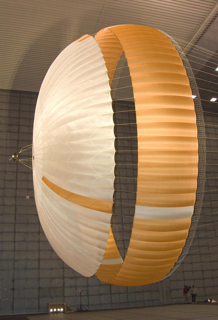
The parachute for NASA Mars Science Laboratory mission opens to a diameter of nearly 16 meters 51 feet. This image shows a duplicate qualification-test parachute inside the world's largest wind tunnel, at NASA Ames Research Center, Moffett Field, Calif. The Mars Science Laboratory will be launched in 2011 for a landing on Mars in 2012. Its parachute is the largest ever built to fly on an extraterrestrial mission. The parachute uses a configuration called disk-gap-band, with 80 suspension lines. Most of the orange and white fabric is nylon, though a small disk of heavier polyester is used near the vent in the apex of the canopy due to higher stresses there. http://photojournal.jpl.nasa.gov/catalog/PIA11994
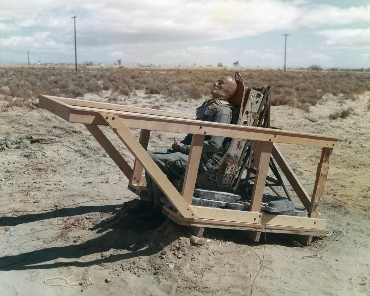
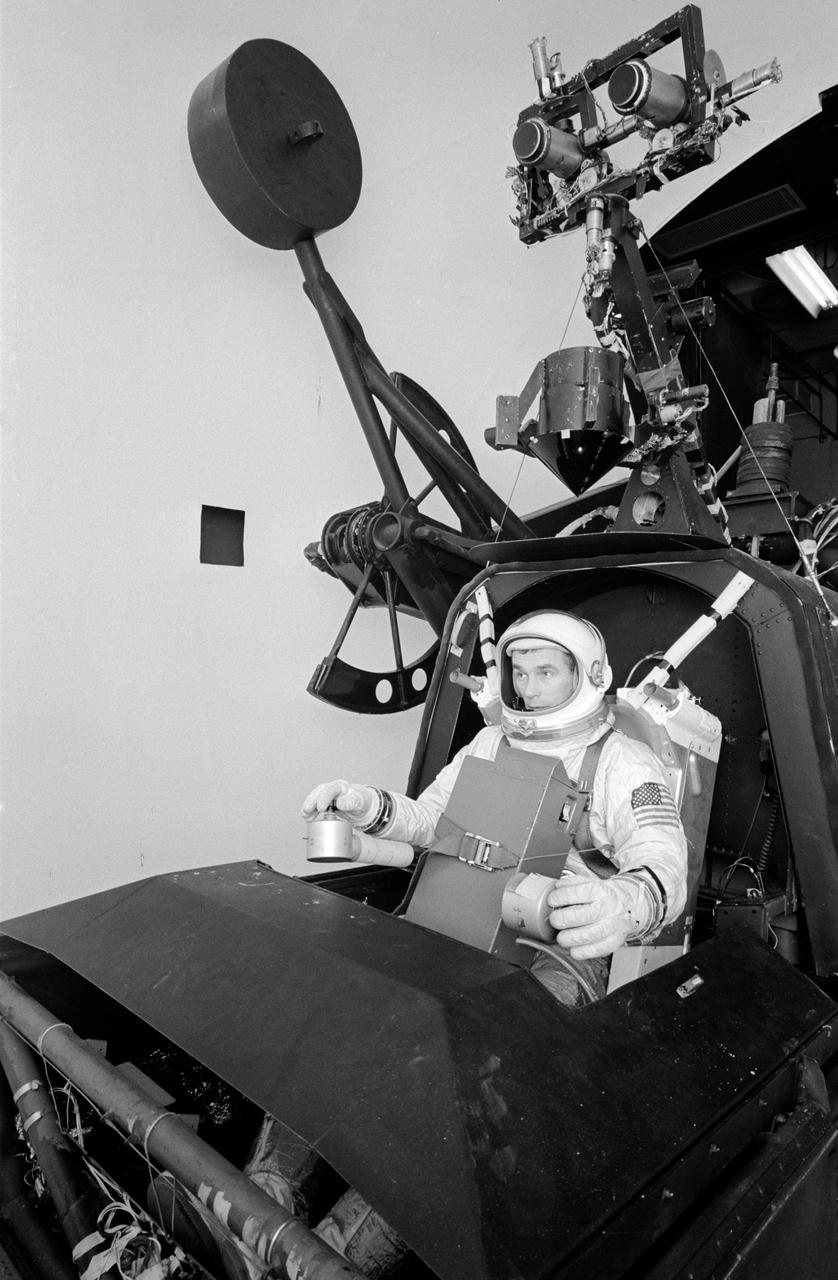
The M2-F1 was fitted with an ejection seat before the airtow flights began. The project selected the seat used in the T-37 as modified by the Weber Company to use a rocket rather than a ballistic charge for ejection. To test the ejection seat, the Flight Research Center's Dick Klein constructed a plywood mockup of the M2-F1's top deck and canopy. On the first firings, the test was unsuccessful, but on the final test the dummy in the seat landed safely. The M2-F1 ejection seat was later used in the two Lunar Landing Research Vehicles and the three Lunar Landing Training Vehicles. Three of them crashed, but in each case the pilot ejected from the vehicle successfully.
STS049-91-079 (7 - 16 May 1992) --- This 70mm frame, photographed from the Earth-orbiting Space Shuttle Endeavour, features a dendritic drainage pattern in Zaire. Cleared pasture land shows light green in this color photograph, in contrast to the dark, closed-canopy forest of Zaire. Remnant woodland along minor streams indicates the intricate drainage network of this hilly region. Scattered vegetation-free spots show the deep red, tropical soil of the region. The sediment-laden stream is the Vele River just west of the village of Niangara. A crew member used a 70mm handheld Hasselblad camera with a 250mm lens to record the image.

CAPE CANAVERAL, Fla. – In the Parachute Refurbishment Facility at NASA's Kennedy Space Center, Deborah Coombs, senior parachute technician, measures suspension lines for the Ares-I main canopy. Ares I is an in-line, two-stage rocket that will transport the Orion crew exploration vehicle to low-Earth orbit. The Ares I first stage will be a five-segment solid rocket booster based on the four-segment design used for the shuttle. As with the shuttle, this booster will fall away when spent, lowered by parachute into the Atlantic Ocean where it can be retrieved for re-use. Photo credit: NASA/Dimitri Gerondidakis
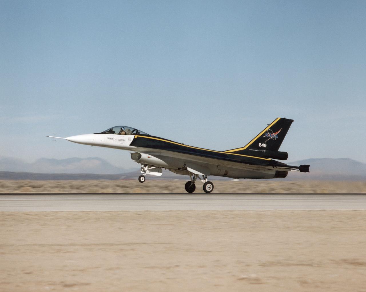
The F-16XL #1 (NASA 849) takes off for the first flight of the Digital Flight Control System (DFCS) on December 16, 1997. Like most first flight, the DFCS required months of preparations. During July 1997, crews worked on the engine, cockpit, canopy, seat, and instrumentation. By late August, the aircraft began combined systems tests and a flight readiness review. Although the Air Force Safety Review Board (AFSRB)- a group that provided double checks on all flight operations - approved the program in late November 1997, a problem with the aircraft flight computer delayed the functional check flight until mid-December.
The main gate (Gate 7) of the Michoud Assembly Facility has been demolished and replaced following the tornado that struck the area in February 2017. The project included moving the gate to a position of 300 feet off the property line (away from Old Gentilly Blvd). The configuration included expanding the entrance to the gate from 2 lanes to 3 while maintaining 2 exit lanes. This layout provides for a guard post shelter rain canopy over two of the entrance lanes. Assessments and repairs continue on various structures and facilities across the facility.
DRYDEN FLIGHT RESEARCH CENTER, Calif. - Simulation technicians Brent Bieber, left, and Dennis Pitts install a boilerplate Dream Chaser canopy structure over the cockpit of a flight simulator in the simulation laboratory at NASA's Dryden Flight Research Center in California. The modification will give Dream Chaser pilot-astronauts a more representative view of the actual flight profiles the spacecraft would fly during piloted approach and landing tests. Sierra Nevada Corporation's Space Systems division is conducting uncrewed captive- and free-flight approach and landing tests of its Dream Chaser at Dryden during the summer and fall. Photo credit: NASA/Ken Ulbrich
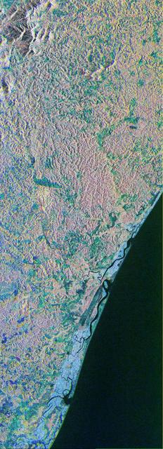
STS043-151-043 (8 August 1991) --- The Rio Grande extends across the center of this photograph from Falcon Reservoir to its bulging delta, joining the Gulf of Mexico. Sediment brought down by the river is spread northward and southward by alongshore currents to form the barrier chain of Padre Island and its protected Laguna Madre Speckled agricultural land use patterns in the river valley contrast with range land northward from the white cloud, and with closed canopy forest on hills in Mexico. A Linhof camera with a 90mm lens, was used to expose the frame at 14:43 GMT, Aug. 8, 1991.
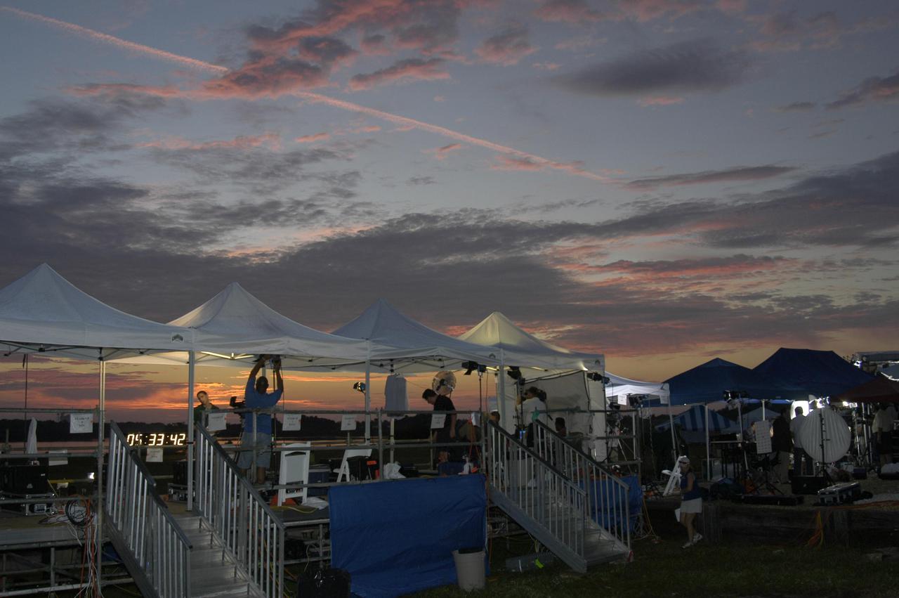
KENNEDY SPACE CENTER, FLA. - Dawn creeps over the horizon revealing canopies going up for some of the media in preparation for launch coverage at NASA Kennedy Space Center. Thousands of journalists, photographers and television media have descended upon KSC to capture the Return to Flight mission STS-114 to the International Space Station. This is the first Space Shuttle flight since the loss of Columbia, STS-107, on Feb. 1, 2003. Launch is scheduled for 3:51 p.m. EDT from Launch Pad 39B. The 12-day mission is expected to end with touchdown at NASA Kennedy Space Center’s Shuttle Landing Facility at 11:06 a.m. July 25.

CAPE CANAVERAL, Fla. – Florida scrub jays scan their territory from a bush at NASA's Kennedy Space Center in Florida. As the name implies, the Florida scrub jay thrives in a scrub, which is an extremely dry habitat. Their ideal environment is a relatively open flatwoods of oak or sand pine scrub with trees less than 10 feet tall, wide apart and providing minimal canopy cover. The last recorded population count of Florida scrub jays is just a little over 2,000, mostly located at Kennedy but also in some scattered scrubs all over central and southern Florida. Photo credit: NASA/Ben Smegelsky
CAPE CANAVERAL, Fla. – At the Parachute Refurbishment Facility at NASA's Kennedy Space Center in Florida, workers spread out the parachutes recovered from sea after the launch of space shuttle Endeavour on the STS-126 mission to detangle them. The parachutes are used to slow the descent of the solid rocket boosters that are jettisoned during liftoff. One pilot, one drogue and three main canopies per booster slow the booster’s fall from about 360 mph to 50 mph. After the chutes are cleaned and repaired, they must be carefully packed into their bags so they will deploy correctly the next time they are used. Photo credit: NASA/Jim Grossmann

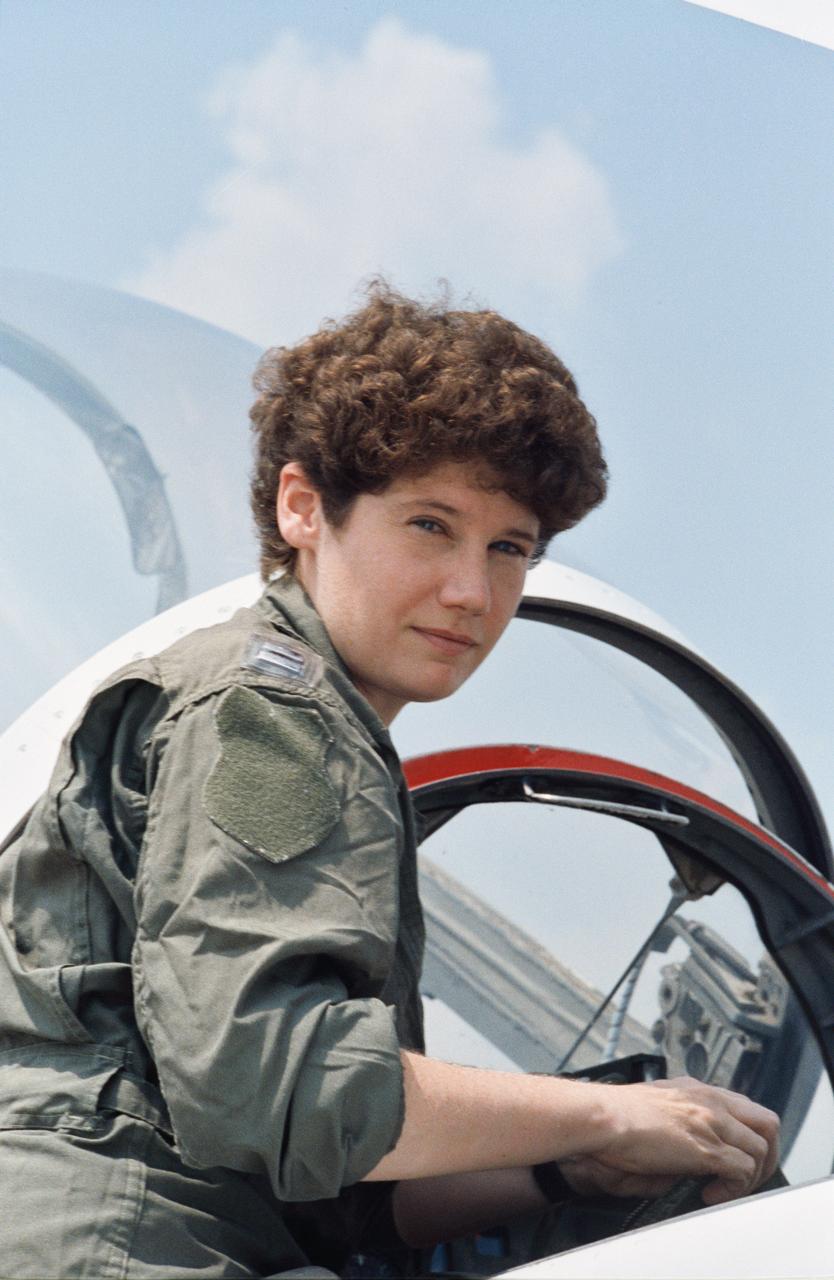
S90-45809 (July 1990) --- Susan J. Helms, one of the 23 astronaut candidates who began a year's training and evaluation program recently, sits in the cockpit of a NASA T-38 jet trainer at Ellington Field near the Johnson Space Center.

STS-38 Pilot Frank L. Culberston, smiling and wearing his helmet with breathing apparatus attached, sits in T-38A NASA 955 forward cockpit at Ellington Field and prepares for departure.
S90-45810 (29-31 July 1990) --- Susan J. Helms, one of 23 astronaut candidate who began a year's training and evaluation in July, climbs into a T-38 jet trainer during a survival training school at Vance Air Force Base in Oklahoma.
STS029-S-005 (10 March 1989) --- A wide angle view of a T-38 on the flight line at Ellington Field near the Johnson Space Center (JSC). Astronauts Michael L. Coats, mission commander; and James F. Buchli, STS-29 mission specialist, moments later were en route to Florida's Kennedy Space Center. In three days, they and three fellow STS-29 crew members are scheduled to lift off aboard the space shuttle Discovery from Launch Pad 39B. Photo credit: NASA
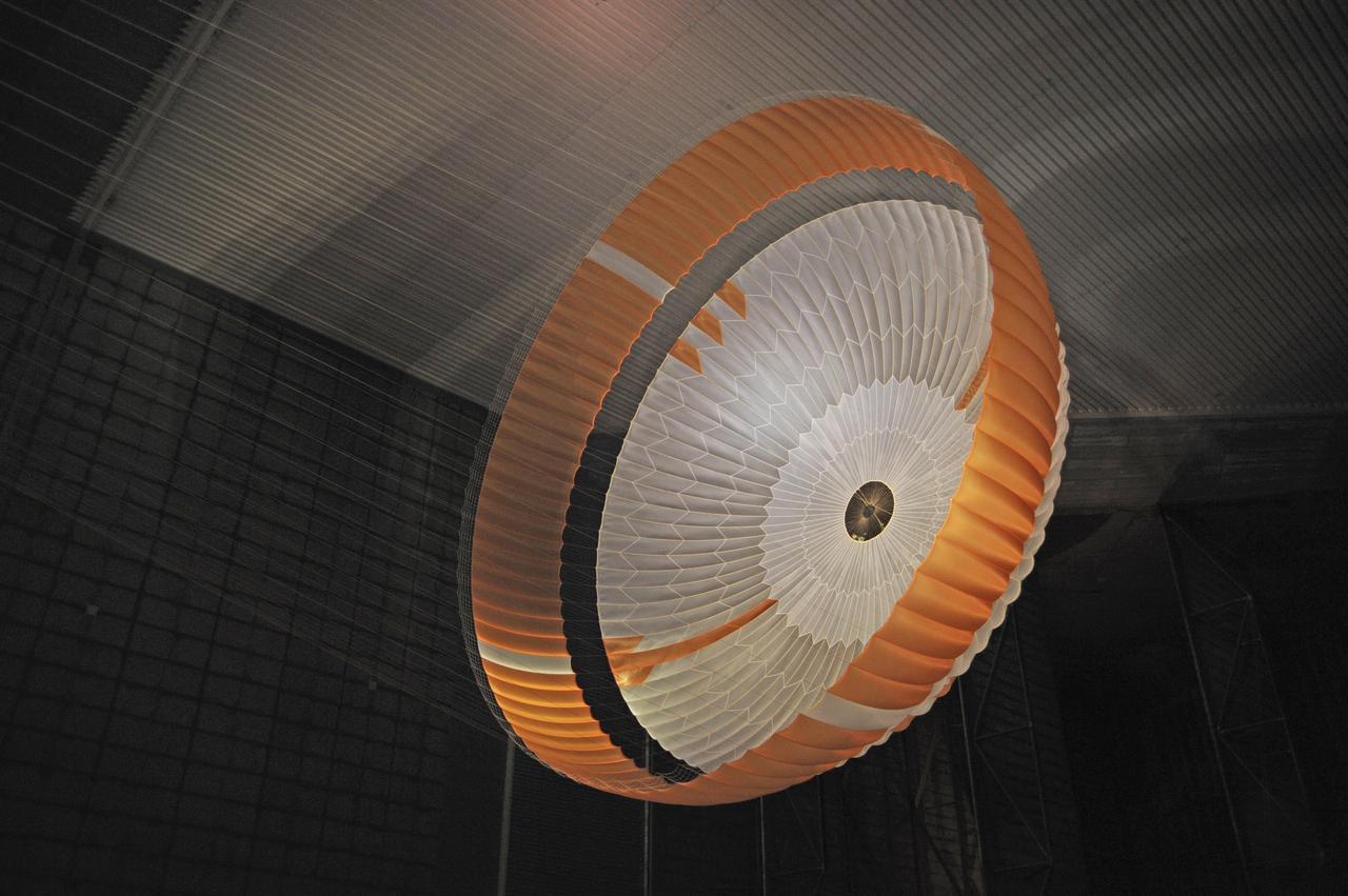
Testing during March and April 2009 inside the world largest wind tunnel, at NASA Ames Research Center, Moffett Field, Calif., qualified the parachute for NASA next Mars rover. The parachute for NASA's Mars Science Laboratory mission, to be launched in 2011 and land on Mars in 2012, is the largest ever built to fly on an extraterrestrial mission. This image shows the qualification-test parachute beginning to open a few seconds after it was launched from a mortar into an 80-mile-per-hour (36-meter-per-second) wind. The parachute uses a configuration called disk-gap-band. It has 80 suspension lines, measures more than 50 meters (165 feet) in length, and opens to a diameter of nearly 16 meters (51 feet). Most of the orange and white fabric is nylon, though a small disk of heavier polyester is used near the vent in the apex of the canopy due to higher stresses there. http://photojournal.jpl.nasa.gov/catalog/PIA11993
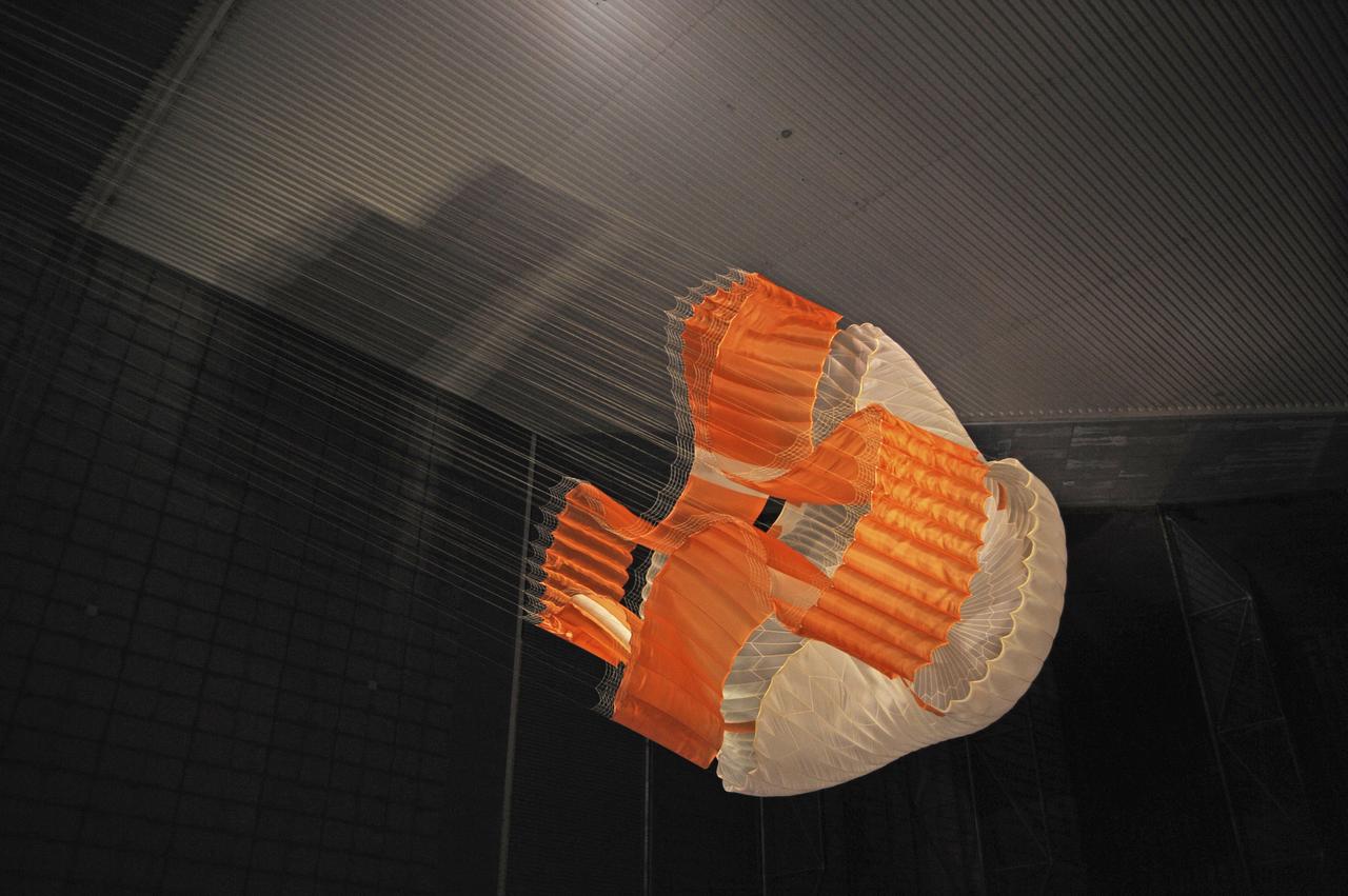
Testing during March and April 2009 inside the world largest wind tunnel, at NASA Ames Research Center, Moffett Field, Calif., qualified the parachute for NASA next Mars rover. The parachute for NASA's Mars Science Laboratory mission, to be launched in 2011 and land on Mars in 2012, is the largest ever built to fly on an extraterrestrial mission. This image shows the qualification-test parachute beginning to open a few seconds after it was launched from a mortar into an 80-mile-per-hour (36-meter-per-second) wind. The parachute uses a configuration called disk-gap-band. It has 80 suspension lines, measures more than 50 meters (165 feet) in length, and opens to a diameter of nearly 16 meters (51 feet). Most of the orange and white fabric is nylon, though a small disk of heavier polyester is used near the vent in the apex of the canopy due to higher stresses there. http://photojournal.jpl.nasa.gov/catalog/PIA11992
CAPE CANAVERAL, Fla. – At the Parachute Refurbishment Facility at NASA's Kennedy Space Center in Florida, a worker checks the parachute lines suspended from the monorail system. The parachutes were recovered from sea after the launch of space shuttle Endeavour on the STS-126 mission The parachutes are used to slow the descent of the solid rocket boosters that are jettisoned during liftoff. The monorail will transport each parachute into a 30,000-gallon washer and a huge dryer heated with 140-degree air at 13,000 cubic feet per minute. One pilot, one drogue and three main canopies per booster slow the booster’s fall from about 360 mph to 50 mph. After the chutes are cleaned and repaired, they must be carefully packed into their bags so they will deploy correctly the next time they are used. Photo credit: NASA/Jim Grossmann
CAPE CANAVERAL, Fla. – At the Parachute Refurbishment Facility at NASA's Kennedy Space Center in Florida, the parachutes recovered from sea after the launch of space shuttle Endeavour on the STS-126 mission are moved through the 30,000-gallon washer. The parachutes are used to slow the descent of the solid rocket boosters that are jettisoned during liftoff. After washing, the monorail will move the parachutes into a huge dryer heated with 140-degree air at 13,000 cubic feet per minute. One pilot, one drogue and three main canopies per booster slow the booster’s fall from about 360 mph to 50 mph. After the chutes are cleaned and repaired, they must be carefully packed into their bags so they will deploy correctly the next time they are used. Photo credit: NASA/Jim Grossmann
STS072-722-004 (11-20 Jan. 1996) --- Mount Kilimanjaro in Tanzania is featured in this 70mm frame exposed from the Earth-orbiting Space Shuttle Endeavour. Orient with the clouds trailing to the left; then the view is southwest from Kenya past Kilimanjaro to Mount Meru, in Tanzania. Mount Kilimanjaro is about three degrees south of the Equator, but at nearly 6,000 meters has a permanent snowfield. The mountain displays a classic zonation of vegetation types from seasonally dry savannah on the plains at 1,000 meters, to the cloud forest near the top. The mountain is being managed experimentally as an international biosphere reserve. A buffer zone of "traditional" agriculture and pastoral land use is designated around the closed-canopy forest reserve. Specialists familiar with this area say management is partially successful so far, but cleared areas of the forest can be seen on this photograph as light green "nibbles" or "cookie cuts" extending into the dark forest region.
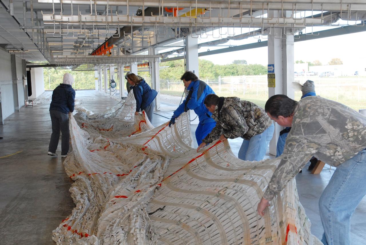
CAPE CANAVERAL, Fla. – Parachutes recovered from sea after the launch of space shuttle Endeavour on the STS-126 mission are stretched out at the Parachute Refurbishment Facility at NASA's Kennedy Space Center in Florida to detangle them. The parachutes are used to slow the descent of the solid rocket boosters that are jettisoned during liftoff. After the chutes are returned to the facility following launch, a hanging monorail system is used to transport each parachute into a 30,000-gallon washer and then into a huge dryer heated with 140-de¬gree air at 13,000 cubic feet per minute. One pilot, one drogue and three main canopies per booster slow the booster’s fall from about 360 mph to 50 mph. After the chutes are cleaned and repaired, they must be care¬fully packed into their bags so they will deploy correctly the next time they are used. Photo credit: NASA/Jim Grossmann
CAPE CANAVERAL, Fla. – At the Parachute Refurbishment Facility at NASA's Kennedy Space Center in Florida, workers begin hanging the parachutes recovered from sea after the launch of space shuttle Endeavour on the STS-126 mission onto a monorail system. The parachutes are used to slow the descent of the solid rocket boosters that are jettisoned during liftoff. The monorail will transport each parachute into a 30,000-gallon washer and a huge dryer heated with 140-degree air at 13,000 cubic feet per minute One pilot, one drogue and three main canopies per booster slow the booster’s fall from about 360 mph to 50 mph. After the chutes are cleaned and repaired, they must be carefully packed into their bags so they will deploy correctly the next time they are used. Photo credit: NASA/Jim Grossmann
CAPE CANAVERAL, Fla. – Parachutes recovered from sea after the launch of space shuttle Endeavour on the STS-126 mission are suspended from a hanging monorail system at the Parachute Refurbishment Facility at NASA's Kennedy Space Center in Florida. The parachutes are used to slow the descent of the solid rocket boosters that are jettisoned during liftoff. The monorail will transport each parachute into a 30,000-gallon washer and a huge dryer heated with 140-degree air at 13,000 cubic feet per minute. One pilot, one drogue and three main canopies per booster slow the booster’s fall from about 360 mph to 50 mph. After the chutes are cleaned and repaired, they must be carefully packed into their bags so they will deploy correctly the next time they are used. Photo credit: NASA/Jim Grossmann
CAPE CANAVERAL, Fla. – At the Parachute Refurbishment Facility at NASA's Kennedy Space Center in Florida, another parachute recovered from sea after the launch of space shuttle Endeavour on the STS-126 mission is unwound from a large turnstile. After their recovery, the parachutes are untangled, hung on a monorail system and transported into a 30,000-gallon washer and a huge dryer heated with 140-degree air at 13,000 cubic feet per minute. The parachutes are used to slow the descent of the solid rocket boosters that are jettisoned during liftoff. One pilot, one drogue and three main canopies per booster slow the booster’s fall from about 360 mph to 50 mph. After the chutes are cleaned and repaired, they must be carefully packed into their bags so they will deploy correctly the next time they are used. Photo credit: NASA/Jim Grossmann
A new three-place North American O-47A observation airplane with Army Air Corps marking was the first ircraft to arrive at Ames. The Circular antenna on top of the canopy is for direction finding. A close look show that help from the front cockpit was needed for directional control when using a rope (instead of a tow bar) to tow the aircraft. (Sept 1940). W.H. McAvoy Ames test pilot returning from an early flight of first test airplane at Ames, a North American O-47A-1 (or 0-47 AAC37-323) This aircraft severed for a short time upon arrival as a research aircraft for heated-wing deicing. NOTE: printed in NASA Ames Publications: Adventures in Research - SP-4320 57 Years - Flight Research at AMES - NASA SP-1998-3300
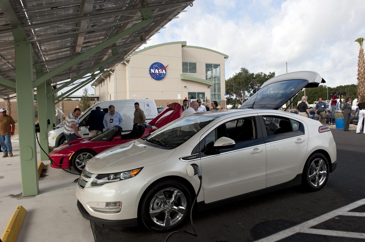
CAPE CANAVERAL, Fla. -- NASA's Kennedy Space Center in Florida hosts a ribbon-cutting ceremony for its new environmentally friendly Propellants North Administrative and Maintenance Facility. This is a view of the parking lot where a solar-powered charging canopy is available for powering government or privately owned electric vehicles. Propellants North consists of two buildings, one to store cryogenic fuel transfer equipment and one to house personnel who support fueling spacecraft. The recently rebuilt buildings will be NASA's first carbon neutral facility, which means it will produce enough energy on site from renewable sources to offset what it requires to operate. The facility also will reach for the U.S. Green Building Council's Leadership in Environmental and Energy Design (LEED) Platinum status, which is the highest LEED rating. Photo credit: NASA/Kim Shiflett
CAPE CANAVERAL, Fla. – At the Parachute Refurbishment Facility at NASA's Kennedy Space Center in Florida, workers place rods under the lines of the parachutes recovered from sea after the launch of space shuttle Endeavour on the STS-126 mission to hang them on a monorail system. Behind them, the parachutes are suspended from the monorail. The parachutes are used to slow the descent of the solid rocket boosters that are jettisoned during liftoff. The monorail will transport each parachute into a 30,000-gallon washer and a huge dryer heated with 140-degree air at 13,000 cubic feet per minute. One pilot, one drogue and three main canopies per booster slow the booster’s fall from about 360 mph to 50 mph. After the chutes are cleaned and repaired, they must be carefully packed into their bags so they will deploy correctly the next time they are used. Photo credit: NASA/Jim Grossmann
CAPE CANAVERAL, Fla. – At the Parachute Refurbishment Facility at NASA's Kennedy Space Center in Florida, workers begin hanging the parachutes recovered from sea after the launch of space shuttle Endeavour on the STS-126 mission onto a monorail system. The parachutes are used to slow the descent of the solid rocket boosters that are jettisoned during liftoff. The monorail will transport each parachute into a 30,000-gallon washer and a huge dryer heated with 140-degree air at 13,000 cubic feet per minute. One pilot, one drogue and three main canopies per booster slow the booster’s fall from about 360 mph to 50 mph. After the chutes are cleaned and repaired, they must be carefully packed into their bags so they will deploy correctly the next time they are used. Photo credit: NASA/Jim Grossmann
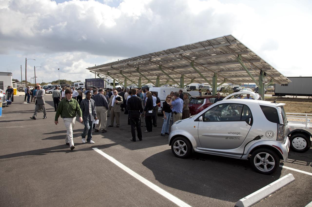
CAPE CANAVERAL, Fla. -- NASA's Kennedy Space Center in Florida hosts a ribbon-cutting ceremony for its new environmentally friendly Propellants North Administrative and Maintenance Facility. This is a view of the parking lot where a solar-powered charging canopy is available for powering government or privately owned electric vehicles. Propellants North consists of two buildings, one to store cryogenic fuel transfer equipment and one to house personnel who support fueling spacecraft. The recently rebuilt buildings will be NASA's first carbon neutral facility, which means it will produce enough energy on site from renewable sources to offset what it requires to operate. The facility also will reach for the U.S. Green Building Council's Leadership in Environmental and Energy Design (LEED) Platinum status, which is the highest LEED rating. Photo credit: NASA/Frankie Martin

CAPE CANAVERAL, Fla. – At the Parachute Refurbishment Facility at NASA's Kennedy Space Center in Florida, a worker checks the parachute lines, recovered from sea after the launch of space shuttle Endeavour on the STS-126 mission, as they move into the 30,000-gallon washer. The parachutes are used to slow the descent of the solid rocket boosters that are jettisoned during liftoff. After washing, the monorail will move the parachutes into a huge dryer heated with 140-degree air at 13,000 cubic feet per minute. One pilot, one drogue and three main canopies per booster slow the booster’s fall from about 360 mph to 50 mph. After the chutes are cleaned and repaired, they must be carefully packed into their bags so they will deploy correctly the next time they are used. Photo credit: NASA/Jim Grossmann
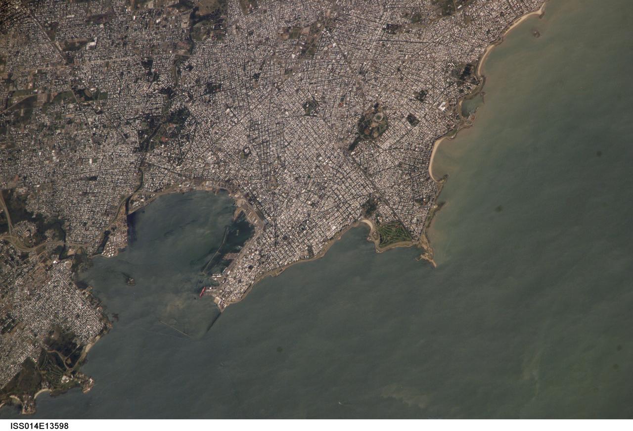
ISS014-E-13598 (29 Jan. 2007) --- Montevideo, Uruguay is featured in this image photographed by an Expedition 14 crewmember on the International Space Station. Reflective roofing materials and dark asphalt streets outline the urban grid pattern of Uruguay's capital city of Montevideo in this image. The city may be viewed as a precursor of the predicted global population shift from dominantly rural to urban environments (by 2030, according to recent United Nations estimates) -- nearly half of Uruguay's total population now lives in the Montevideo metropolitan area. Located on the southern coastline of Uruguay along the Rio de la Plata, Montevideo Bay provides an important harbor and port facilities for transport of South American agricultural products. This view is of sufficient resolution (approximately 7 meters/pixel) to discriminate between dark green canopied tree cover and light green grass - important information for study of urban ecology and climate, as well as city water use planning - in a large golf course located at the southern edge of the city (near center right). Sediment plumes along the coastline to the southeast of the city are also visible; rough patterns in the water surface of Montevideo Bay and the Rio de la Plata are a combination of wind disturbance and sediments.
A model of the General Dynamics YF-16 Fighting Falcon in the test section of the 8- by 6-Foot Supersonic Wind Tunnel at the National Aeronautics and Space Administration (NASA) Lewis Research Center. The YF-16 was General Dynamics response to the military’s 1972 request for proposals to design a new 20,000-pound fighter jet with exceptional acceleration, turn rate, and range. The aircraft included innovative design elements to help pilots survive turns up to 9Gs, a new frameless bubble canopy, and a Pratt and Whitney 24,000-pound thrust F-100 engine. The YF-16 made its initial flight in February 1974, just six weeks before this photograph, at Edwards Air Force Base. Less than a year later, the Air Force ordered 650 of the aircraft, designated as F-16 Fighting Falcons. The March and April 1974 tests in the 8- by 6-foot tunnel analyzed the aircraft’s fixed-shroud ejector nozzle. The fixed-nozzle area limited drag, but also limited the nozzle’s internal performance. NASA researchers identified and assessed aerodynamic and aerodynamic-propulsion interaction uncertainties associated the prototype concept. YF-16 models were also tested extensively in the 11- by 11-Foot Transonic Wind Tunnel and 9- by 7-Foot Supersonic Wind Tunnel at Ames Research Center and the 12-Foot Pressure Wind Tunnel at Langley Research Center.
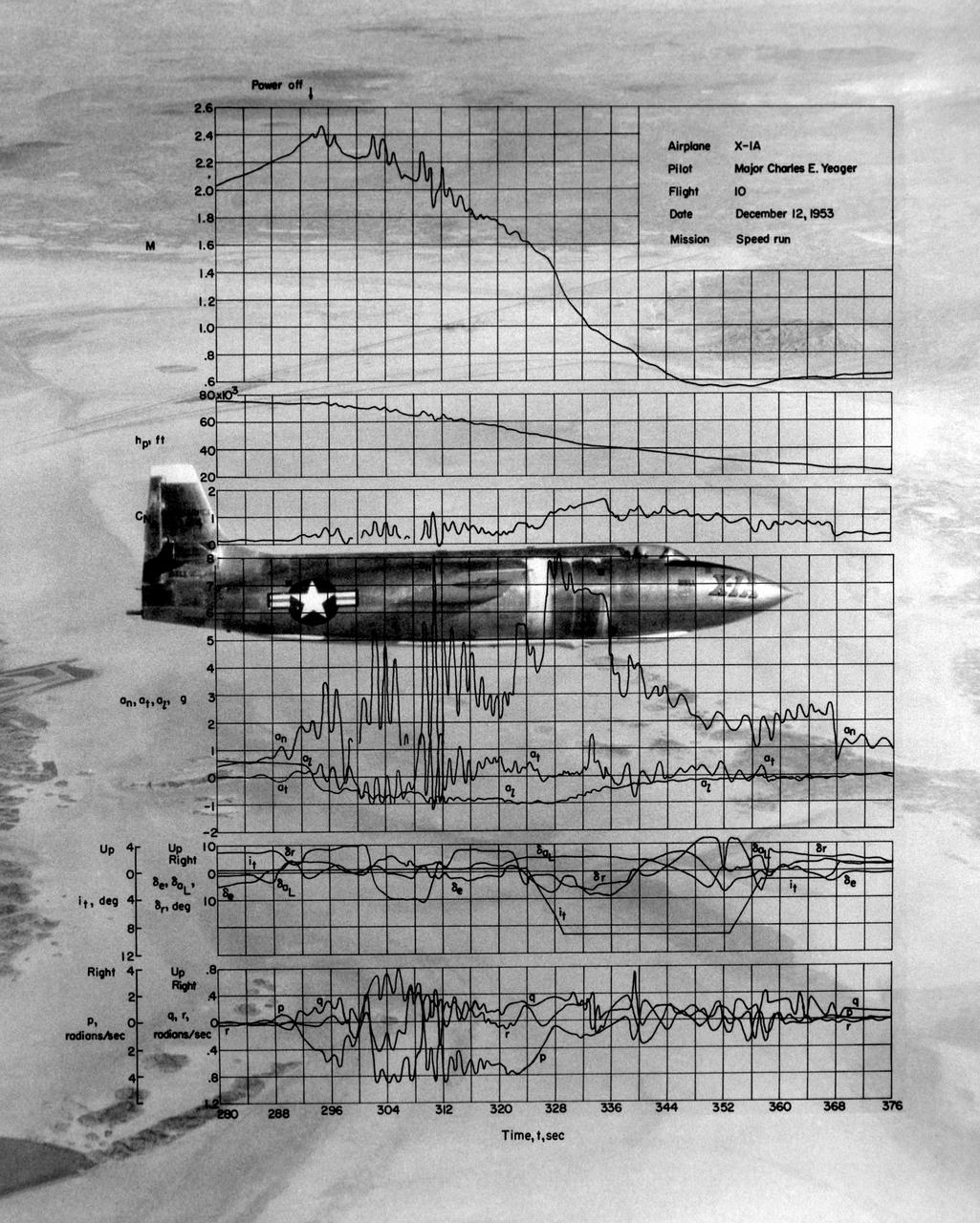
This photo of the X-1A includes graphs of the flight data from Maj. Charles E. Yeager's Mach 2.44 flight on December 12, 1953. (This was only a few days short of the 50th anniversary of the Wright brothers' first powered flight.) After reaching Mach 2.44, then the highest speed ever reached by a piloted aircraft, the X-1A tumbled completely out of control. The motions were so violent that Yeager cracked the plastic canopy with his helmet. He finally recovered from a inverted spin and landed on Rogers Dry Lakebed. Among the data shown are Mach number and altitude (the two top graphs). The speed and altitude changes due to the tumble are visible as jagged lines. The third graph from the bottom shows the G-forces on the airplane. During the tumble, these twice reached 8 Gs or 8 times the normal pull of gravity at sea level. (At these G forces, a 200-pound human would, in effect, weigh 1,600 pounds if a scale were placed under him in the direction of the force vector.) Producing these graphs was a slow, difficult process. The raw data from on-board instrumentation recorded on oscillograph film. Human computers then reduced the data and recorded it on data sheets, correcting for such factors as temperature and instrument errors. They used adding machines or slide rules for their calculations, pocket calculators being 20 years in the future.
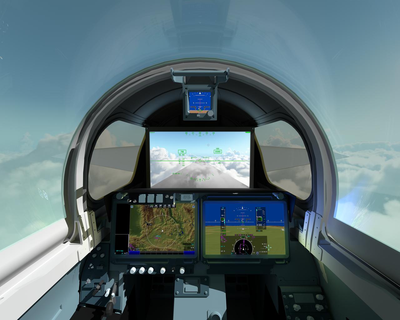
The pilot of NASAÕs X-59 Quiet SuperSonic Technology, or QueSST, aircraft will navigate the skies in a cockpit unlike any other. There wonÕt be a forward-facing window. ThatÕs right; itÕs actually a 4K monitor that serves as the central window and allows the pilot to safely see traffic in his or her flight path, and provides additional visual aids for airport approaches, landings and takeoffs. The 4K monitor, which is part of the aircraftÕs eXternal Visibility System, or XVS, displays stitched images from two cameras outside the aircraft combined with terrain data from an advanced computing system. The two portals and traditional canopy are real windows however, and help the pilot see the horizon. The displays below the XVS will provide a variety of aircraft systems and trajectory data for the pilot to safely fly. The XVS is one of several innovative solutions to help ensure the X-59Õs design shape reduces a sonic boom to a gentle thump heard by people on the ground. Though not intended to ever carry passengers, the X-59 boom-suppressing technology and community response data could help lift current bans on supersonic flight over land and enable a new generation of quiet supersonic commercial aircraft.
STS039-S-001 (October 1990) --- The arrowhead shape of the STS-39 crew patch represents a skyward aim to learn more about our planet's atmosphere and space environment in support of the Department of Defense. Our national symbol is represented by the star constellation Aguila (the eagle) as its brightest star, Altair, lifts a protective canopy above Earth. The space shuttle encircles the spectrum which represents x-ray, ultraviolet, visible and infrared electromagnetic radiation to be measured by a variety of scientific instruments. Experiments will be operated within the payload bay and aboard a free-flying satellite which will be deployed and retrieved during the mission. The patch was designed by the STS-39 crew. The NASA insignia design for space shuttle flights is reserved for use by the astronauts and for other official use as the NASA Administrator may authorize. Public availability has been approved only in the form of illustrations by the various news media. When and if there is any change in this policy, which we do not anticipate, it will be publicly announced. Photo credit: NASA
A development rover that is part of NASA's CADRE (Cooperative Autonomous Distributed Robotic Exploration) technology demonstration drives over a rock during its first autonomous drive around the Mars Yard at the agency's Jet Propulsion Laboratory in Southern California in June 2023. Under a canopy behind the rover are, from left, graduate student intern Natalie Deo and CADRE verification and validation lead Sawyer Brooks of JPL. The CADRE team successfully tested a new wheel design, surface navigation software, and mobility capabilities, among other aspects of the project. The rover being tested is similar in size and appearance to the flight models of the CADRE rovers, which are still being built. Slated to arrive at the Moon in spring 2024 as part of NASA's CLPS (Commercial Lunar Payload Services) initiative, CADRE is designed to demonstrate that multiple robots can cooperate and explore together autonomously – without direct input from human mission controllers. A trio of the miniature solar-powered rovers, each about the size of a carry-on suitcase, will explore the Moon as a team, communicating via radio with each other and a base station aboard a lunar lander. By taking simultaneous measurements from multiple locations, CADRE will also demonstrate how multirobot missions can record data impossible for a single robot to achieve – a tantalizing prospect for future missions. Movie available at https://photojournal.jpl.nasa.gov/catalog/PIA25667
The parachute for NASA next mission to Mars passed flight-qualification testing in March and April 2009 inside the world largest wind tunnel, at NASA Ames Research Center, Moffett Field, Calif. NASA's Mars Science Laboratory mission, to be launched in 2011 and land on Mars in 2012, will use the largest parachute ever built to fly on an extraterrestrial mission. This image shows a duplicate qualification-test parachute inflated in an 80-mile-per-hour (36-meter-per-second) wind inside the test facility. The parachute uses a configuration called disk-gap-band. It has 80 suspension lines, measures more than 50 meters (165 feet) in length, and opens to a diameter of nearly 16 meters (51 feet). Most of the orange and white fabric is nylon, though a small disk of heavier polyester is used near the vent in the apex of the canopy due to higher stresses there. It is designed to survive deployment at Mach 2.2 in the Martian atmosphere, where it will generate up to 65,000 pounds of drag force. The wind tunnel is 24 meters (80 feet) tall and 37 meters (120 feet) wide, big enough to house a Boeing 737. It is part of the National Full-Scale Aerodynamics Complex, operated by the Arnold Engineering Development Center of the U.S. Air Force. http://photojournal.jpl.nasa.gov/catalog/PIA11995
ISS016-E-022772 (11 Jan. 2008) --- Perth, Australia is featured in this image photographed by an Expedition 16 crewmember on the International Space Station (ISS). Perth is the capital of the state of Western Australia, and the largest city of the southwestern continent of Australia with an estimated population of over 1.5 million (December 2006). The downtown area of Perth and the surrounding suburbs are located on flood plain deposits of the Swan and Canning Rivers that flow through the center of the metropolitan area. Perth enjoys a Mediterranean climate, where the summers are hot and dry and winters are cool and moist. Wildfires can develop during the summer months; several large fires threatened the eastern portion of the metropolitan area in 2005. This view captures variations in urban land cover in the visible wavelengths to which the human eye is sensitive (visible red, green, and blue). The downtown center of Perth at left is characterized by large buildings (such as skyscrapers) with white reflective rooftops. Suburbs to the south (across the Swan River) are characterized by higher density of small buildings with predominantly reddish-purple roofs. Several areas of green vegetation are visible in the image. Parks and golf courses comprised mainly of grass present an even green coloration, while the dense tree canopy of Kings Park appears dark green. Variations in the coloration of the Swan and Canning Rivers is due to sunglint, or light reflected off the water surface back to the observer (in this case, a crewmember onboard the ISS).
S66-27990 (March 1966) --- Astronaut Eugene A. Cernan, pilot for the Gemini-9 spaceflight, works out procedures for his historic space excursion in a unique manned Aerospace Flight Simulator at LTV Corp. at Dallas, Texas. The LTV simulator is used frequently by NASA astronauts for a variety of space programs maneuvers to provide many of the sensations and visual scenes of actual spaceflight. Controlled through a complex of computers, the device makes it possible for the astronauts to work out procedures, solve problems and simulate missions in real time with great accuracy. The astronaut rides in a spacecraft-like gondola which moves in roll, pitch and yaw in response to his controls and accurate computer inputs. The simulator's usual spacecraft displays and canopy have been removed and AMU backpack complete with control electronics installed. The astronaut makes his simulated flight in an inflated pressure suit and with the NASA-developed Extravehicular Life Support system chest pack which will be used in the Gemini flight. Photo credit: NASA
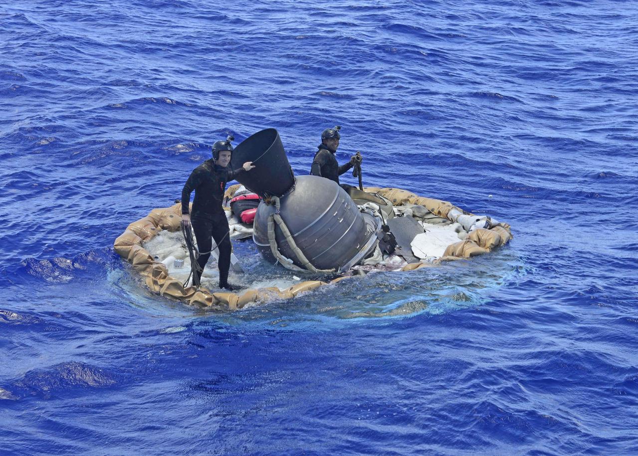
Two members of the U.S. Navy's Mobile Diving Salvage Unit (MDSU) 1 Explosive Ordnance Detachment work on recovering the test vehicle for NASA's Low-Density Supersonic Decelerator (LDSD) project. The saucer-shaped LDSD craft splashed down at 11:49 a.m. HST (2:49 PDT/5:49 p.m. EDT) Monday, June 8, 2015, in the Pacific Ocean off the west coast of the Kauai, Hawaii, after a four-hour experimental flight test that investigated new technologies for landing future robotic and human Mars missions. During the flight test, a Supersonic Inflatable Aerodynamic Decelerator (SIAD) and a supersonic parachute were deployed. The SIAD operated as expected, dramatically slowing the test vehicle's velocity. When the parachute was deployed into the supersonic slipstream, it appeared to blossom to full inflation prior to the emergence of a tear which then propagated and destroyed the parachute's canopy. As a result, the saucer's splashdown in the Pacific Ocean was hard, resulting in fracturing parts of the structure. Memory cards containing comprehensive test data -- including high-speed, high-resolution imagery recorded during the flight -- were successfully recovered. Also recovered were the test vehicle and its components, the supersonic parachute, the ballute used to deploy the parachute, and a large weather balloon that initially carried the saucer to an altitude of 120,000 feet. http://photojournal.jpl.nasa.gov/catalog/PIA19684
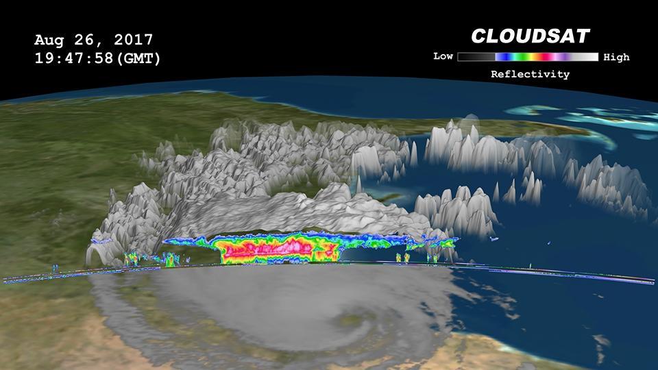
Click on the image for larger animation NASA's CloudSat satellite flew over then-Tropical Storm Harvey on Aug. 26, 2017, at 2:45 p.m. CDT (19:45 UTC) as the storm was nearly stationary over south Texas. At that time, Harvey contained estimated maximum sustained winds of 69 miles per hour (60 knots). CloudSat flew over Harvey northeast of the storm center through an area of moderate to heavy rainfall in the outer rainbands. As seen in the image and animation, large amounts of liquid and ice water (denoted by the red and pink colors) are visible beneath the cloud tops. The lack of a radar signal (attenuation) beneath the melting layer (located around 3 miles, or 5 kilometers, above ground) can be seen in the heavier areas of precipitation, since CloudSat's cloud profiling radar (CPR) signal dampens when precipitation particles are larger than 0.12 inches (3 millimeters) in size. Smaller cumulus and cumulonimbus clouds are seen north of the area of moderate to heavy precipitation. The cirrus canopy (anvil clouds) extends outward from the storm system (shown in blue and green colors). An animation is available at https://photojournal.jpl.nasa.gov/catalog/PIA17392

The X-1E research aircraft provides a striking view at the entrance of NASA's Dryden Flight Research Center, Edwards, California. The X-1E, one of the three original X-1 aircraft modified with a raised cockpit canopy and an ejection seat, was flown at the facility between 1953 and 1958 to investigate speeds at twice that of sound, and also to evaluate a thin wing designed for high-speed flight. The Dryden complex was originally established in 1946 as a small high-speed flight station to support the X-1 program. The X-1 was the first aircraft to fly at supersonic speeds. The main administrative building is to the rear of the X-1E and is the center of a research installation that has grown to more than 450 government employees and nearly 400 civilian contractors. Located on the northwest "shore" of Rogers Dry Lake, the Dryden Center was built around the original administrative-hangar building constructed in 1954 at a cost of $3.8 million. Since then many additional support and operational facilities have been built including a number of unique test facilities such as the Thermalstructures Research Facility, Flow Visualization Facility, and the newest addition, the Integrated Test Facility.
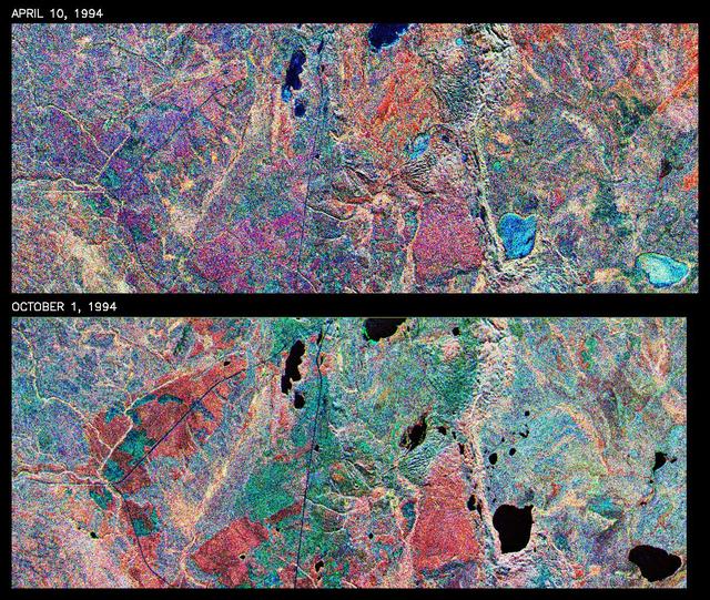
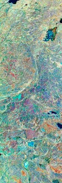
This is a comparison of images over Prince Albert, produced by NASA Spaceborne Imaging Radar-C and X-band Synthetic Aperture Radar aboard the space shuttle Endeavour on its 20th orbit on April 10, 1994. The area is centered at 53.91 degrees north latitude and 104.69 degrees west longitude and is located 40 kilometers (25 miles) north and 30 kilometers (18.5 miles) east of the town of Prince Albert in the Saskatchewan province of Canada. The image covers the area east of Candle Lake, between the gravel highway of 120 and west of highway 106. The area imaged is near the southern limit of the boreal forest. The boreal forest of North America is a continuous vegetation belt at high latitudes stretching across the continent from the Atlantic shoreline of central Labrador and then westward across Canada to the interior mountains and central coastal plains of Alaska. The forest is also part of a larger northern hemisphere circumpolar boreal forest belt. Coniferous trees dominate the entire forest but deciduous trees are also present. During the month of April, the forest experiences seasonal changes from a frozen condition to a thawed condition. The trees are completely frozen over the winter season and the forest floor is covered by snow. As the average temperature rises in the spring, the trees are thawed and the snow melts. This transition has an impact on the rate of moisture evaporation and release of carbon dioxide into the atmosphere. In late September and early October, the boreal forest experiences a relatively different seasonal change. At this time, the leaves on deciduous trees start changing color and dropping off. The soil and trees are quite often moist due to frequent rainfall and cloud cover. The evaporation of moisture and carbon dioxide into the atmosphere also diminishes at this time. SIR-C/X-SAR is sensitive to the moisture of soil and vegetation and can sense this freeze-thaw cycle and the summer-fall seasonal transition over forested areas in particular. Optical sensors, by contrast, are blind to these regions, which are perpetually obscured by thick cloud cover. These changes were detected by comparing the April and October color composite images of L-band data in red, C-band data in green and X-band (vertically received and transmitted) in blue. The changes in intensity of each color over lakes, various forest stands and clear cuts in the two images is striking. Lakes such as Lake Heiberg, Crabtree Lake and Williams Lake, in the right middle part of the image, are frozen in April (appearing in bright blue) and melted (appearing in black) in October. The higher intensity of blue over lakes in April is due to low penetration of the X-band (vertically received and transmitted) and the radar's high sensitivity to surface features. Forest stands also exhibit major changes between the two images. The red areas in the October image are old jack pine canopies that cause higher return at L-band because of their moist condition in late summer compared to their partially frozen condition in April (in purple). Similarly, in the areas near the middle of the image, where black spruce and mixed aspen and jack pine trees dominate, the contrast between blue in October and red and green in April is an indication that the top of the canopy (needles and branches) were frozen in April and moist in October. The changes due to deforestation by logging companies or natural fires can also be detected by comparing the images. For example, the small blue area near the intersection of Harding Road and Highway 120 is the result of logging which occurred after the April data was acquired. The surface area of clear cut is approximately 4 hectares, which is calculated from the high-resolution capability of the radar images and verified by scientists participating in field work during the mission. http://photojournal.jpl.nasa.gov/catalog/PIA01732
This is a color composite image of southern Bahia, Brazil, centered at 15.22 degree south latitude and 39.07 degrees west longitude. The image was acquired by the Spaceborne Imaging Radar-C/X-band Synthetic Aperture Radar aboard the space shuttle Endeavour on its 38th orbit of Earth on October 2, 1994. The image covers an area centered over the Una Biological Reserve, one the largest protected areas in northeastern Brazil. The 7,000-hectare reserve is administered by the Brazilian Institute for the Environment and is part of the larger Atlantic coastal forest, a narrow band of rain forest extending along the eastern coast of Brazil. The Atlantic coastal forest of southern Bahia is one of the world's most threatened and diverse ecosystems. Due to widespread settlement, only 2 to 5 percent of the original forest cover remains. Yet the region still contains an astounding variety of plants and animals, including a large number of endemic species. More than half of the region's tree species and 80 percent of its animal species are indigenous and found nowhere else on Earth. The Una Reserve is also the only federally protected habitat for the golden-headed lion tamarin, the yellow-breasted capuchin monkey and many other endangered species. In the past few years, scientists from Brazilian and international conservation organizations have coordinated efforts to study the biological diversity of this region and to develop practical and economically viable options for preserving the remaining primary forests in southern Bahia. The shuttle imaging radar is used in this study to identify various land uses and vegetation types, including remaining patches of primary forest, cabruca forest (cacao planted in the understory of the native forest), secondary forest, pasture and coastal mangrove. Standard remote-sensing technology that relies on light reflected from the forest canopy cannot accurately distinguish between cabruca and undisturbed forest. Optical remote sensing is also limited by the nearly continuous cloud cover in the region and heavy rainfall, which occurs more than 150 days each year. The ability of the shuttle radars to "see" through the forest canopy to the cultivated cacao below -- independent of weather or sunlight conditions --will allow researchers to distinguish forest from cabruca in unprecedented detail. This SIR-C/X-SAR image was produced by assigning red to the L-band, green to the C-band and blue to the X-band. The Una Reserve is located in the middle of the image west of the coastline and slightly northwest of Comandatuba River. The reserve's primary forests are easily detected by the pink areas in the image. The intensity of red in these areas is due to the high density of forest vegetation (biomass) detected by the radar's L-band (horizontally transmitted and vertically received) channel. Secondary forest is visible along the reserve's eastern border. The Serrado Mar mountain range is located in the top left portion of the image. Cabruca forest to the west of Una Reserve has a different texture and a yellow color. The removal of understory in cabruca forest reduces its biomass relative to primary forest, which changes the L-band and C-band penetration depth and returns, and produces a different texture and color in the image. The region along the Atlantic is mainly mangrove swamp, agricultural fields and urban areas. The high intensity of blue in this region is a result of increasing X-band return in areas covered with swamp and low vegetation. The image clearly separates the mangrove region (east of coastal Highway 001, shown in blue) from the taller and dryer forest west of the highway. The high resolution capability of SIR-C/X-SAR imaging and the sensitivity of its frequency and polarization channels to various land covers will be used for monitoring and mapping areas of importance for conservation. http://photojournal.jpl.nasa.gov/catalog/PIA01764
This is a false-color L-band image of an area near Glasgow, Missouri, centered at about 39.2 degrees north latitude and 92.8 degrees west longitude. The image was acquired by the Spaceborne Imaging Radar-C and X-band Synthetic Aperture Radar (SIR-C/X-SAR) aboard the space shuttle Endeavour on its 50th orbit on October 3, 1994. The false-color composite was made by displaying the L-band (horizontally transmitted and received) return in red; the L-band (horizontally transmitted and vertically received) return in green; and the sum of the two channels in blue. The area shown is approximately 37 kilometers by 25 kilometers (23 miles by 16 miles). The radar data, coupled with pre-flood aerial photography and satellite data and post-flood topographic and field data, are being used to evaluate changes associated with levee breaks in landforms, where deposits formed during the widespread flooding in 1993 along the Missouri and Mississippi Rivers. The distinct radar scattering properties of farmland, sand fields and scoured areas will be used to inventory floodplains along the Missouri River and determine the processes by which these areas return to preflood conditions. The image shows one such levee break near Glasgow, Missouri. In the upper center of the radar image is a region covered by several meters of sand, shown as blue regions below the bend in the river. West (left) of this dark area, a blue gap in the levee tree canopy can be seen, showing the area where the levee failed. Radar data such as these can help scientists more accurately assess the potential for future flooding in this region and how that might impact surrounding communities. http://photojournal.jpl.nasa.gov/catalog/PIA01744
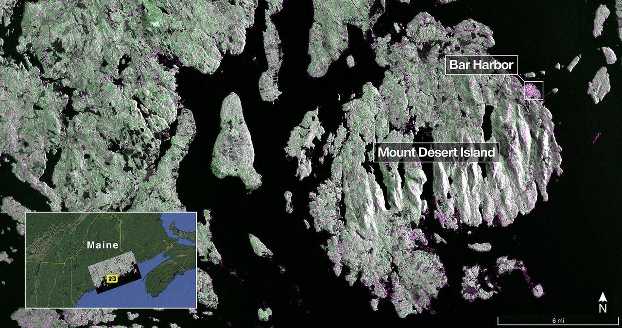
The NISAR (NASA-ISRO Synthetic Aperture Radar) Earth-observing radar satellite's L-band synthetic aperture radar (SAR) system captured this image of Mount Desert Island off the Maine coast on Aug. 21, 2025. Dark areas represent water, green areas are forest, and magenta areas are hard or regular surfaces, such as bare ground or buildings. The bright magenta area on the island's northeast end is the town of Bar Harbor. The satellite is a joint effort between NASA and the Indian Space Research Organisation (ISRO) and is the first satellite to combine L-band and S-band radar systems. The L-band system uses a 10-inch (25-centimeter) wavelength that enables its signal to penetrate forest canopies and measure soil moisture as well as motion of ice surfaces and land down to fractions of an inch – a key measurement in understanding how the land surface moves before, during, and after earthquakes, volcanic eruptions, and landslides. The S-band radar, provided by ISRO's Space Applications Centre, uses a 4-inch (10-centimeter) microwave signal that's more sensitive to small vegetation, which makes it effective at monitoring certain types of agriculture and grassland ecosystems. Data used to create the image was collected during NISAR's commissioning phase, when the spacecraft's systems and instruments are powered on and tested. The NISAR mission will begin science operations in November, roughly 90 days after its July 30, 2025, launch from Satish Dhawan Space Centre on India's southeastern coast. Observations from NISAR will benefit humanity by helping researchers around the world better understand changes in our planet's surface, including its ice sheets, glaciers, and sea ice. It also will capture changes in forest and wetland ecosystems and track movement and deformation of our planet's crust by phenomena such as earthquakes, landslides, and volcanic activity. The global and rapid coverage from NISAR will provide unprecedented support for disaster response, producing data to assist in mitigating and assessing damage, with observations before and after catastrophic events available in short time frames. https://photojournal.jpl.nasa.gov/catalog/PIA26616
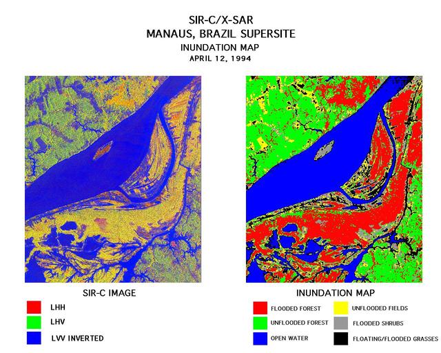
These two images were created using data from the Spaceborne Imaging Radar-C/X-Band Synthetic Aperture Radar (SIR-C/X-SAR). On the left is a false-color image of Manaus, Brazil acquired April 12, 1994, onboard space shuttle Endeavour. In the center of this image is the Solimoes River just west of Manaus before it combines with the Rio Negro to form the Amazon River. The scene is around 8 by 8 kilometers (5 by 5 miles) with north toward the top. The radar image was produced in L-band where red areas correspond to high backscatter at HH polarization, while green areas exhibit high backscatter at HV polarization. Blue areas show low backscatter at VV polarization. The image on the right is a classification map showing the extent of flooding beneath the forest canopy. The classification map was developed by SIR-C/X-SAR science team members at the University of California,Santa Barbara. The map uses the L-HH, L-HV, and L-VV images to classify the radar image into six categories: Red flooded forest Green unflooded tropical rain forest Blue open water, Amazon river Yellow unflooded fields, some floating grasses Gray flooded shrubs Black floating and flooded grasses Data like these help scientists evaluate flood damage on a global scale. Floods are highly episodic and much of the area inundated is often tree-covered. http://photojournal.jpl.nasa.gov/catalog/PIA01712
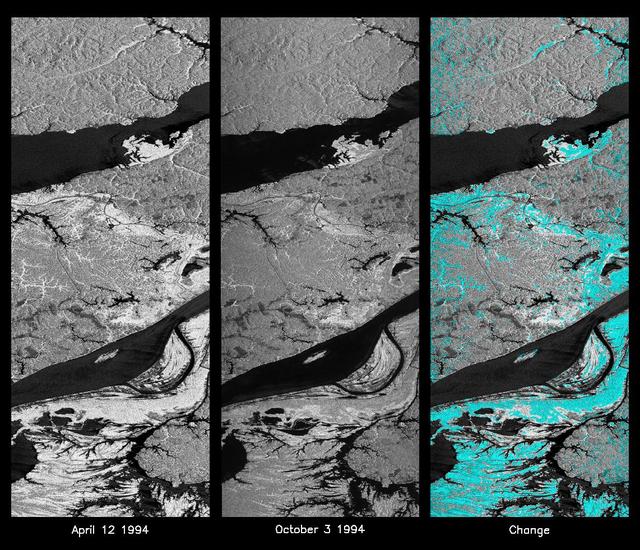
These L-band images of the Manaus region of Brazil were acquired by the Spaceborne Imaging Radar-C and X-band Synthetic Aperture Radar (SIR-C/X-SAR) aboard the space shuttle Endeavour. The left image was acquired on April 12, 1994, and the middle image was acquired on October 3, 1994. The area shown is approximately 8 kilometers by 40 kilometers (5 miles by 25 miles). The two large rivers in this image, the Rio Negro (top) and the Rio Solimoes (bottom), combine at Manaus (west of the image) to form the Amazon River. The image is centered at about 3 degrees south latitude and 61 degrees west longitude. North is toward the top left of the images. The differences in brightness between the images reflect changes in the scattering of the radar channel. In this case, the changes are indicative of flooding. A flooded forest has a higher backscatter at L-band (horizontally transmitted and received) than an unflooded river. The extent of the flooding is much greater in the April image than in the October image, and corresponds to the annual, 10-meter (33-foot) rise and fall of the Amazon River. A third image at right shows the change in the April and October images and was created by determining which areas had significant decreases in the intensity of radar returns. These areas, which appear blue on the third image at right, show the dramatic decrease in the extent of flooded forest, as the level of the Amazon River falls. The flooded forest is a vital habitat for fish and floating meadows are an important source of atmospheric methane. This demonstrates the capability of SIR-C/X-SAR to study important environmental changes that are impossible to see with optical sensors over regions such as the Amazon, where frequent cloud cover and dense forest canopies obscure monitoring of floods. Field studies by boat, on foot and in low-flying aircraft by the University of California at Santa Barbara, in collaboration with Brazil's Instituto Nacional de Pesguisas Estaciais, during the first and second flights of the SIR-C/X-SAR system have validated the interpretation of the radar images. http://photojournal.jpl.nasa.gov/catalog/PIA01740