
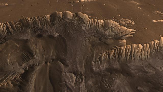
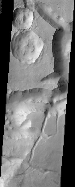
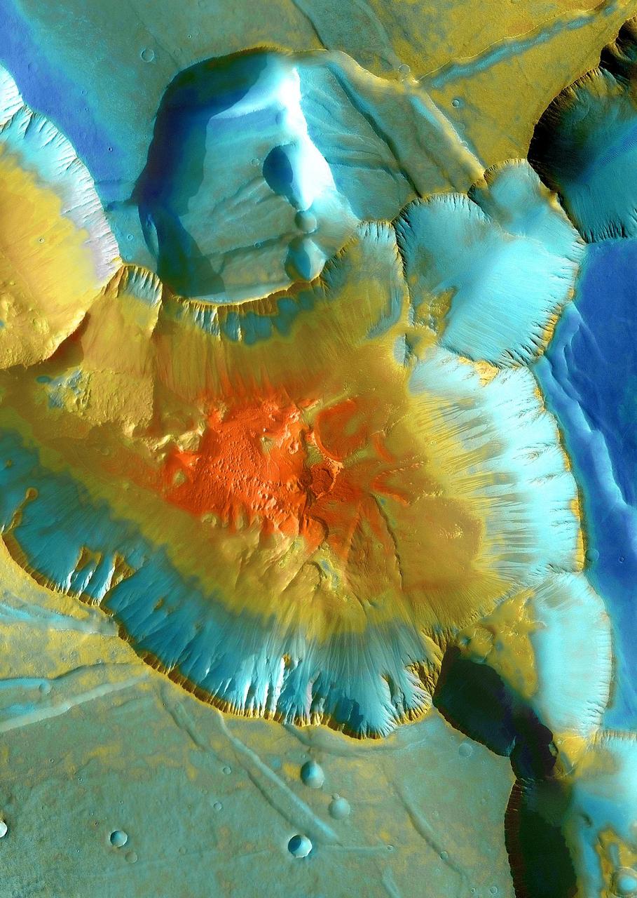
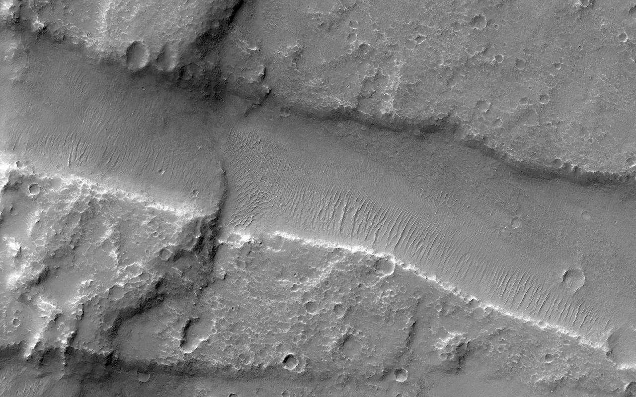
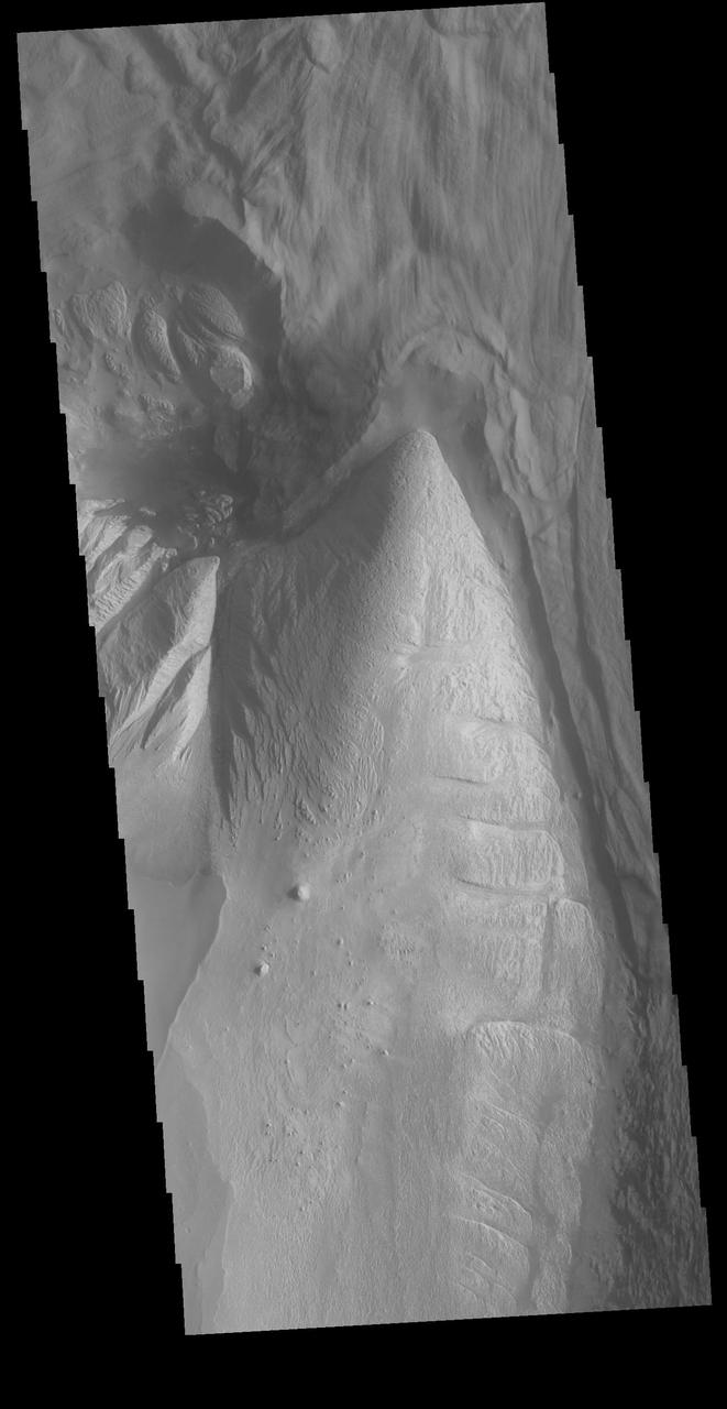
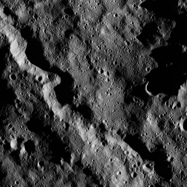
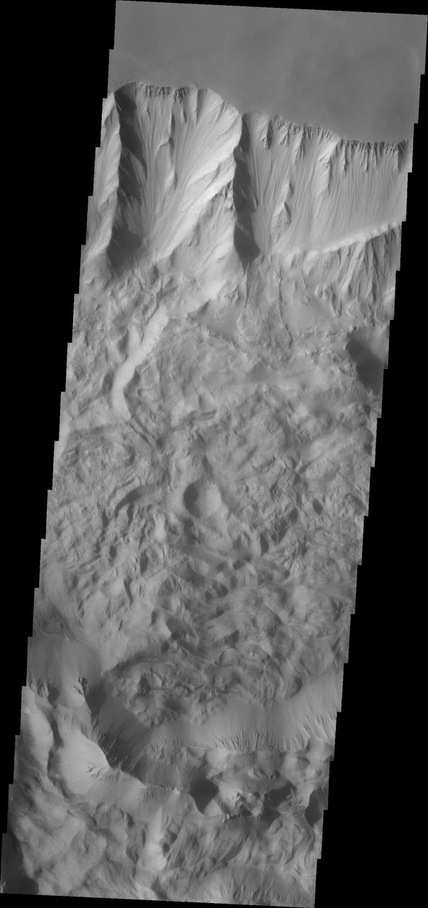
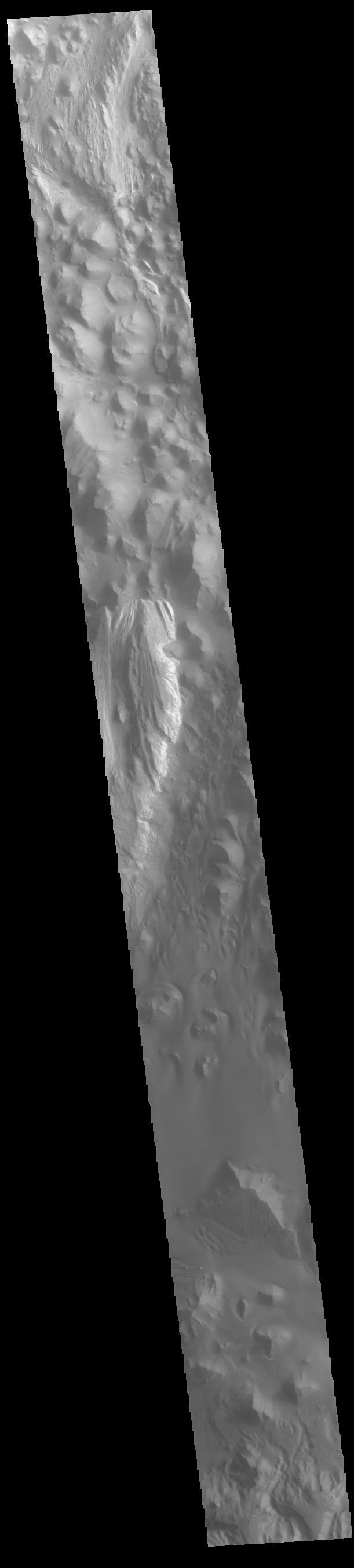
Crater and Canyon
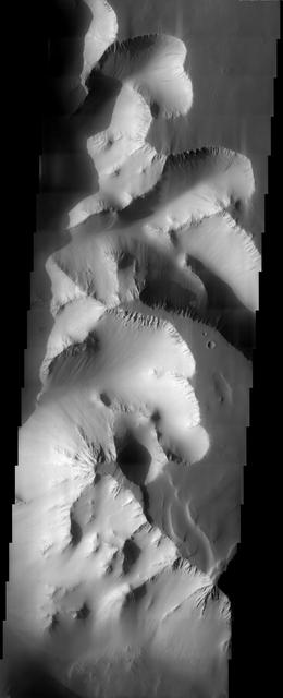
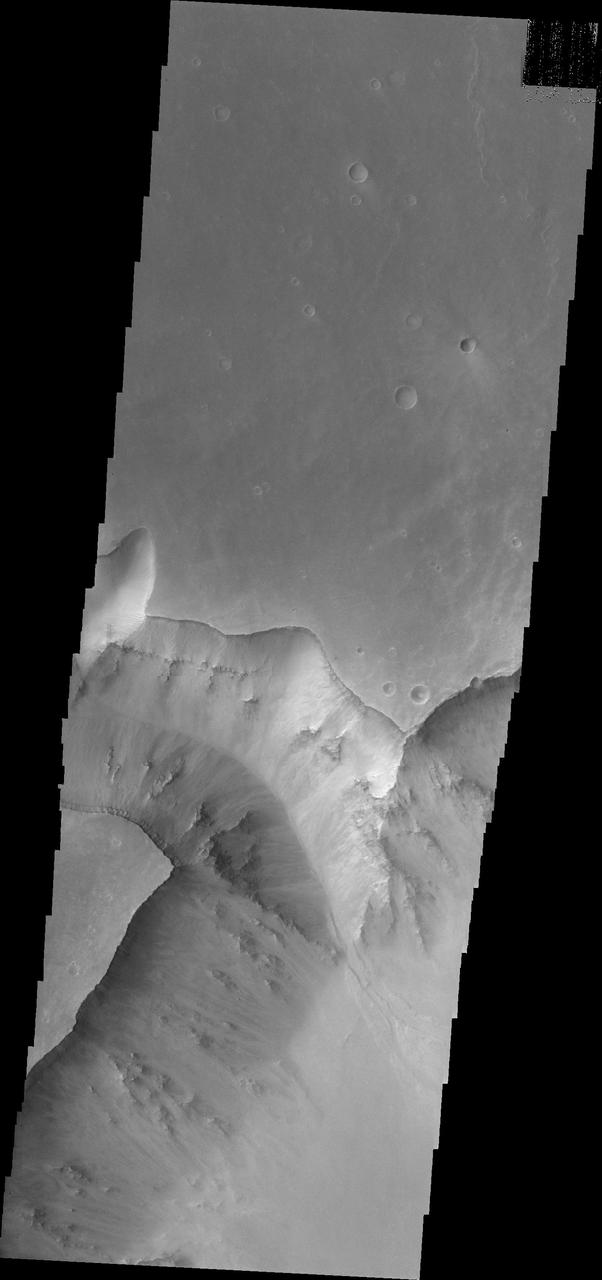
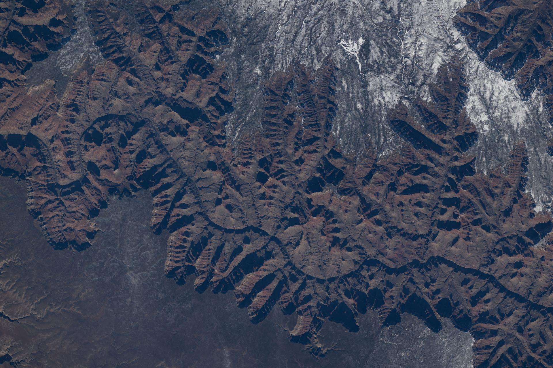
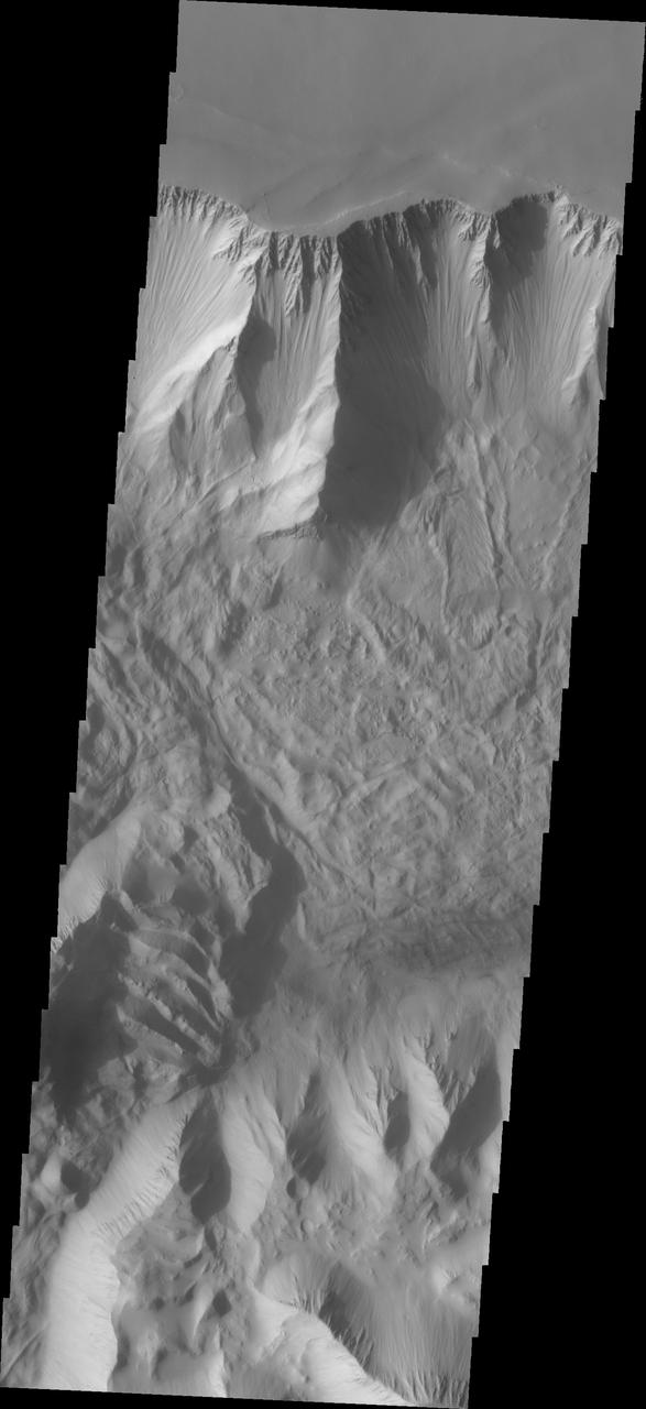
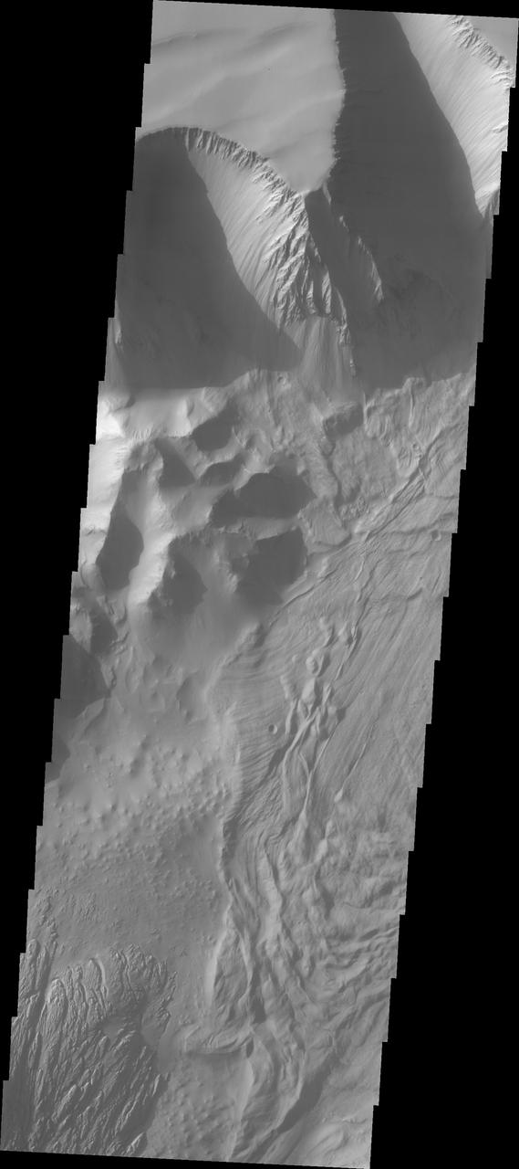
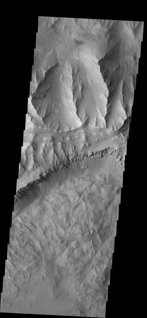
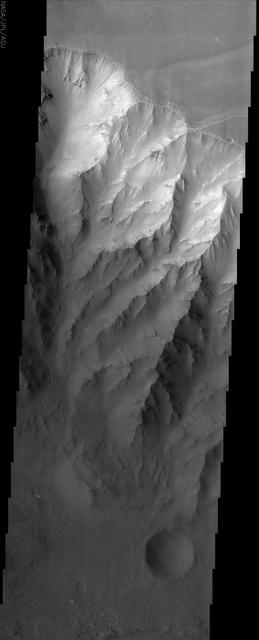
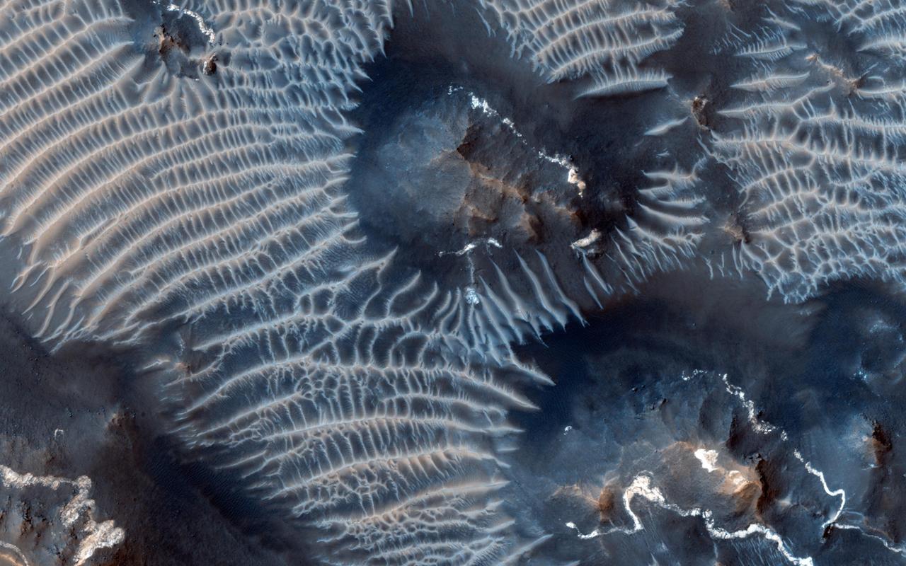
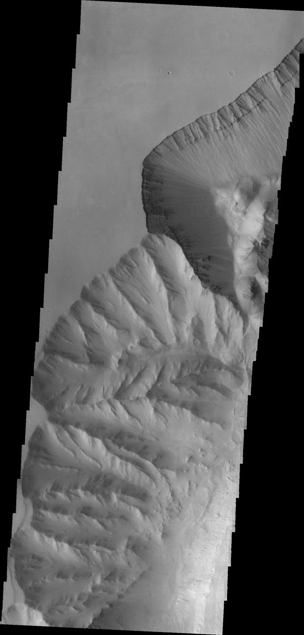
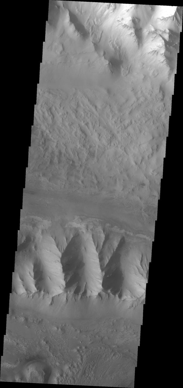
Canyon Ridges
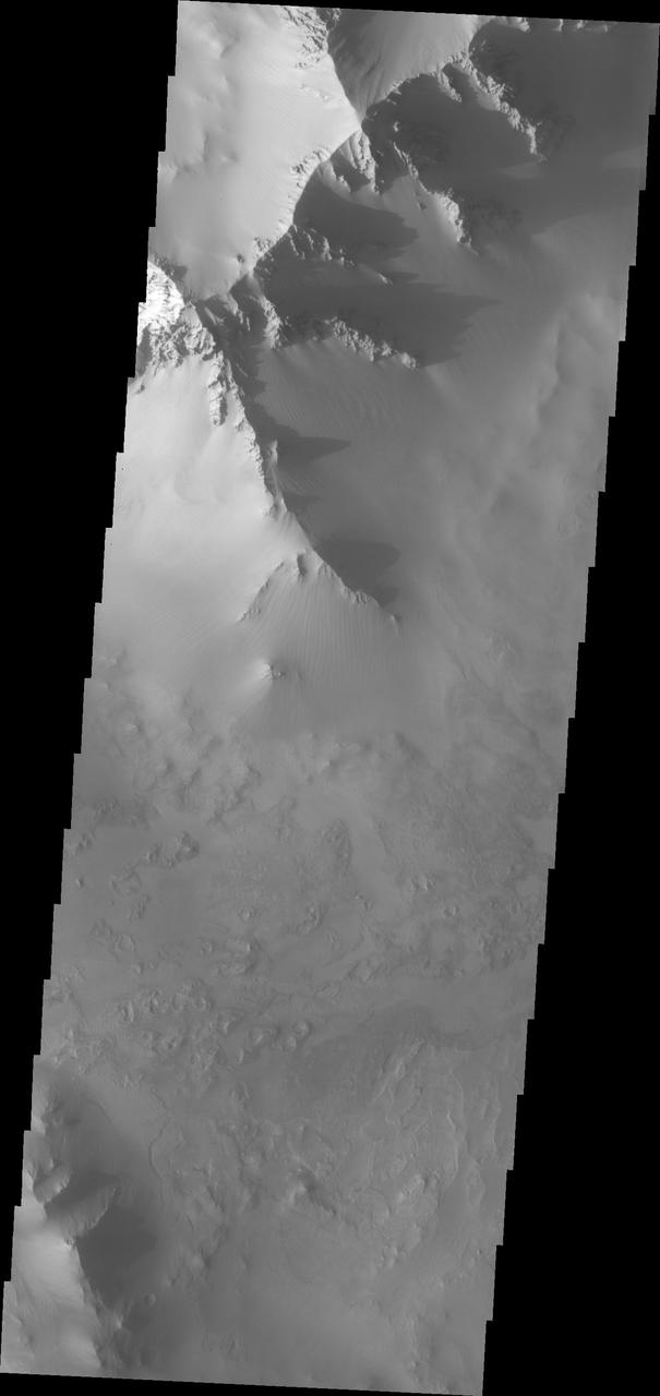
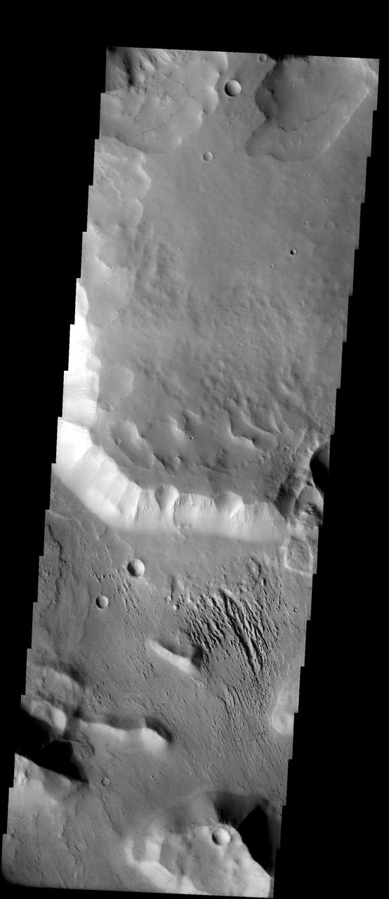
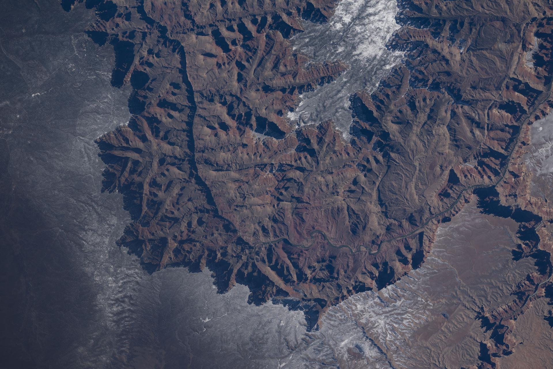
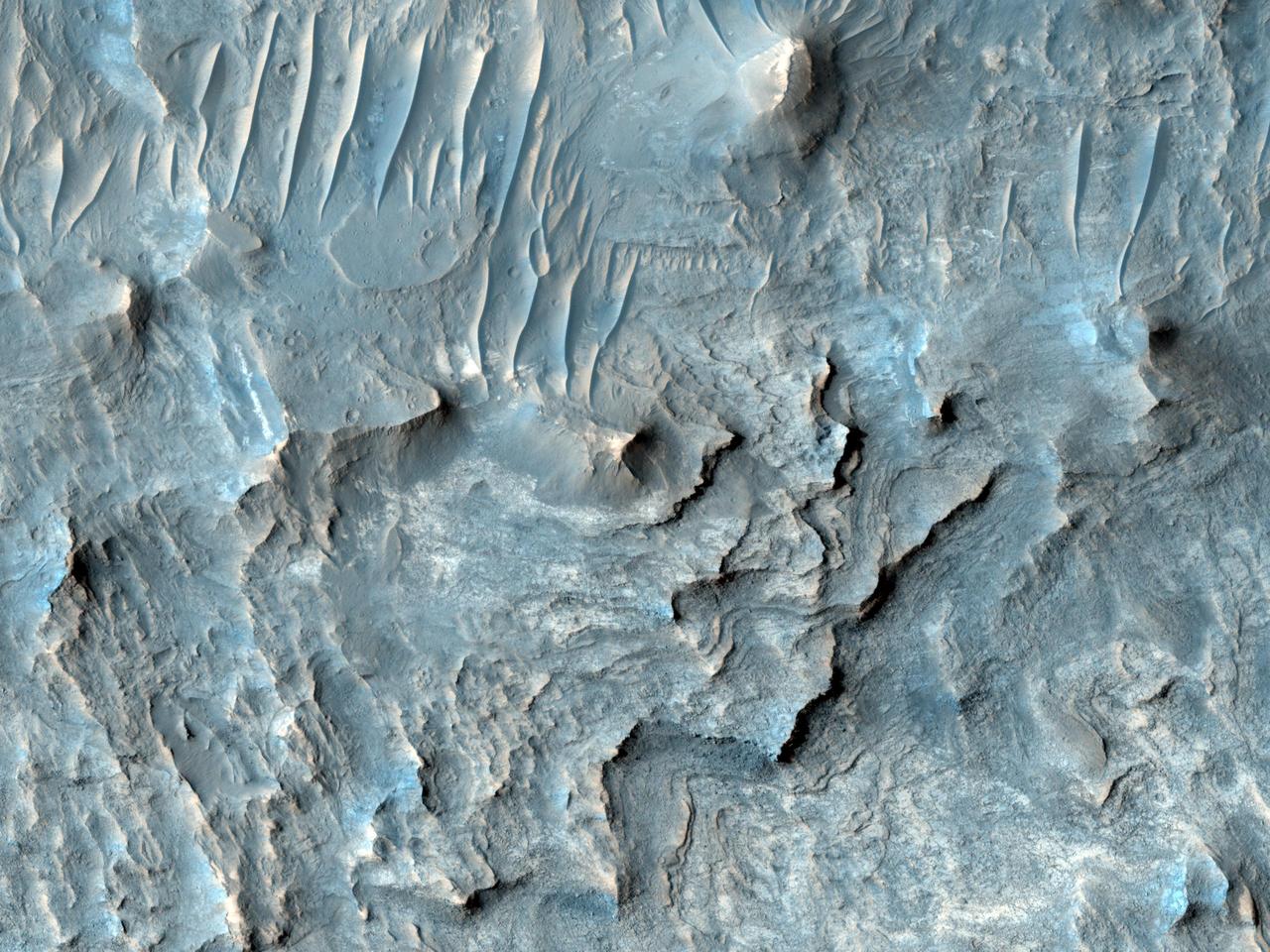
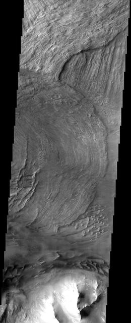
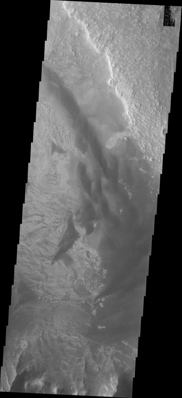
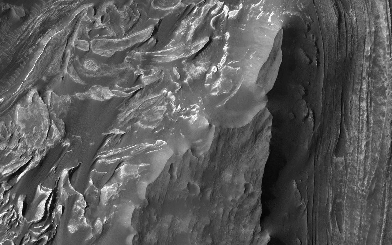
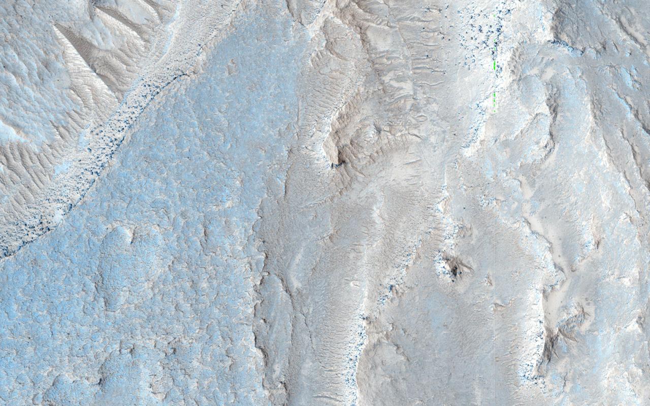
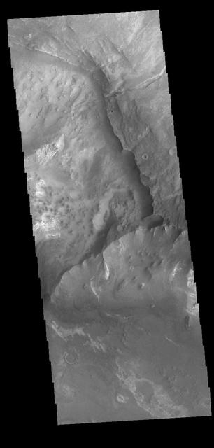
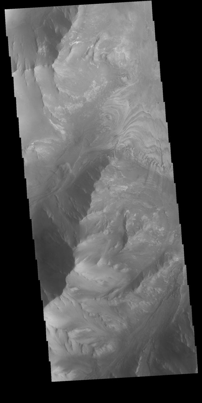
Canyon Walls
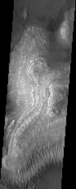
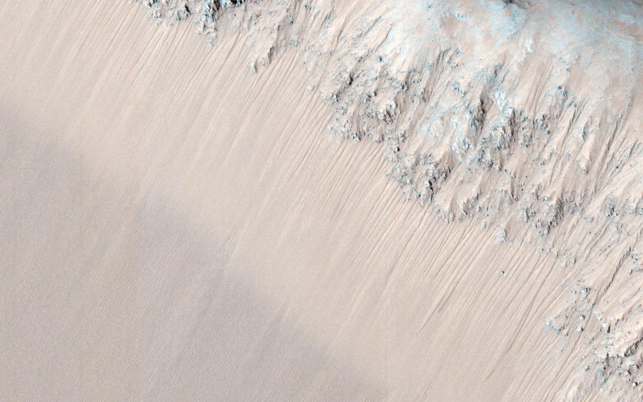
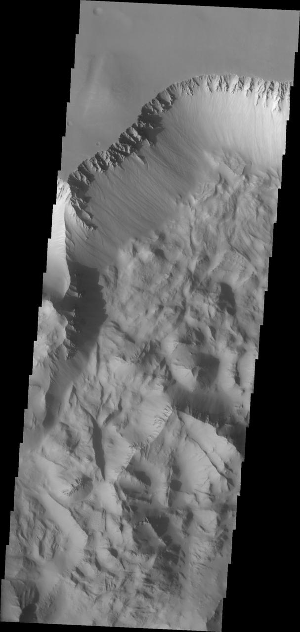
Bright Canyons
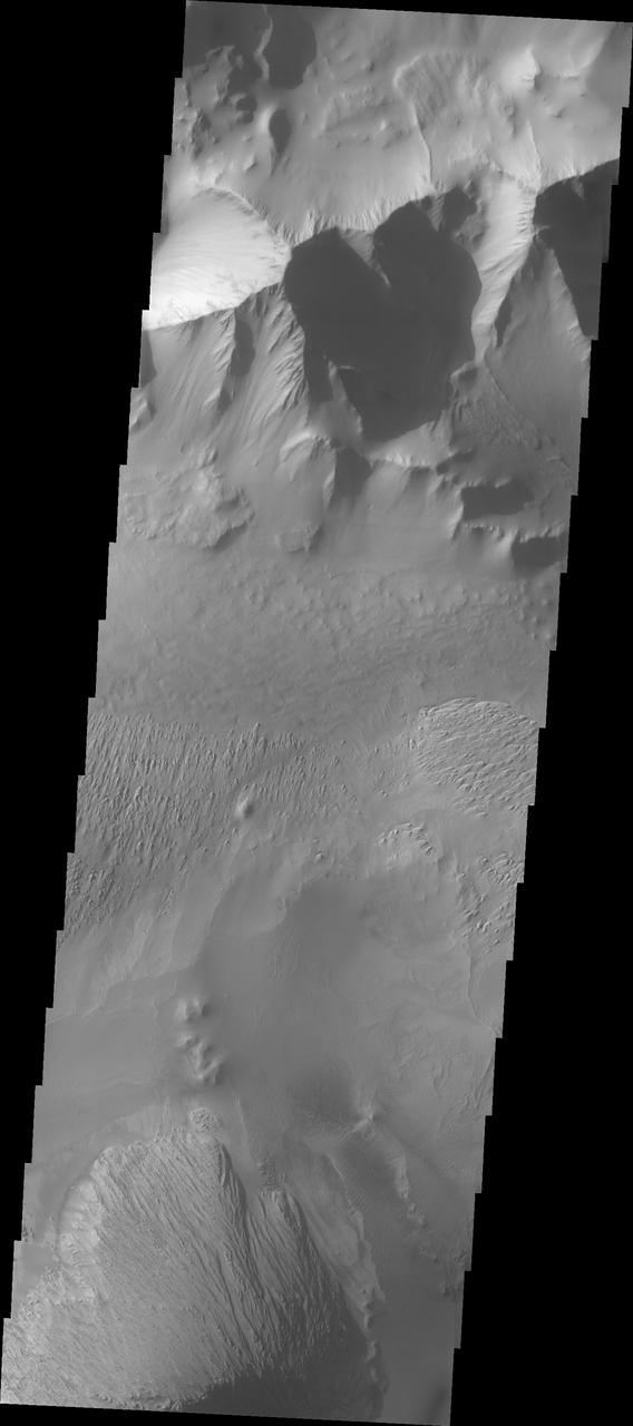
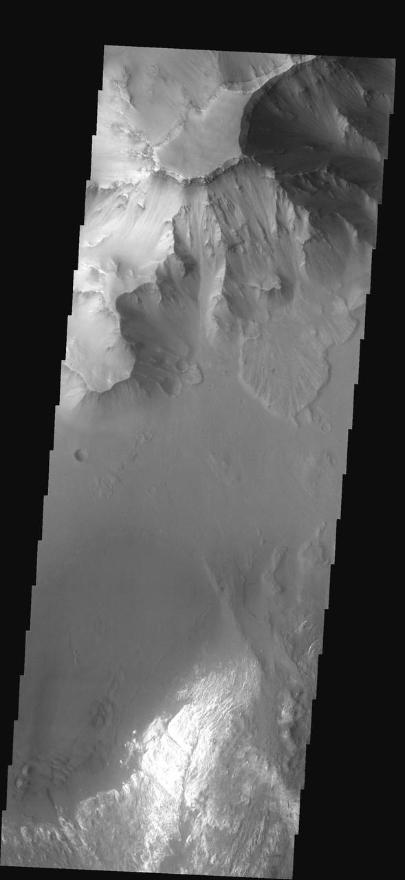
Canyons End
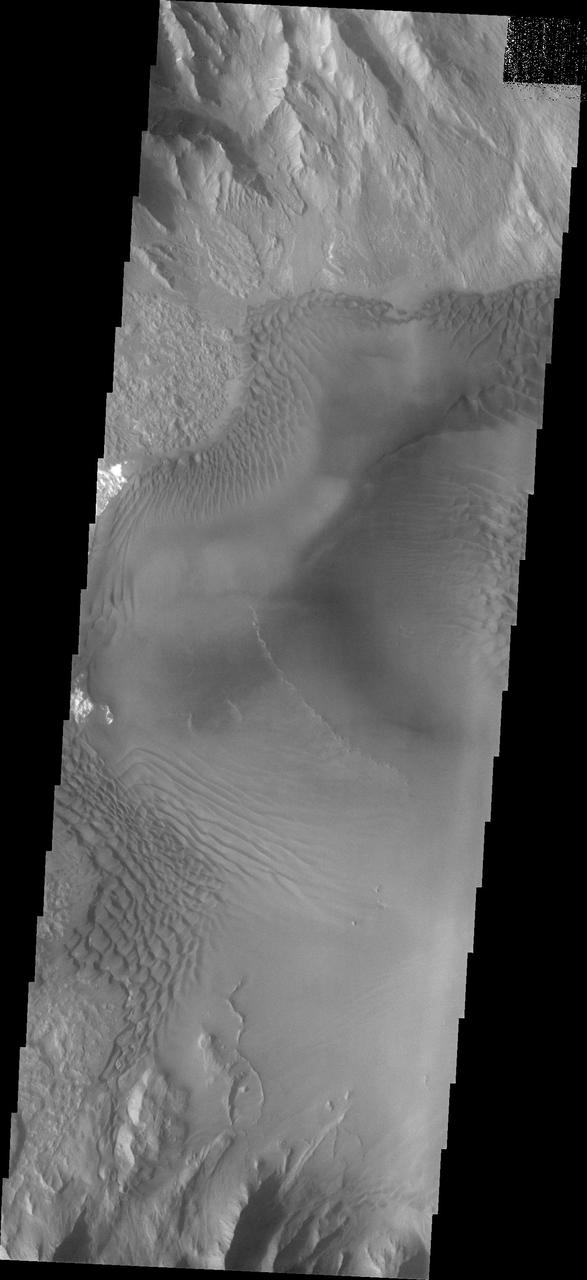
Beyond the Canyons
Gazing at Icy Canyons
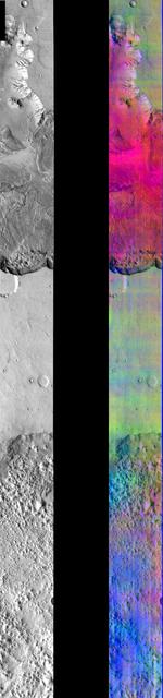
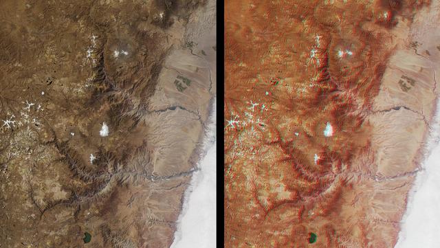
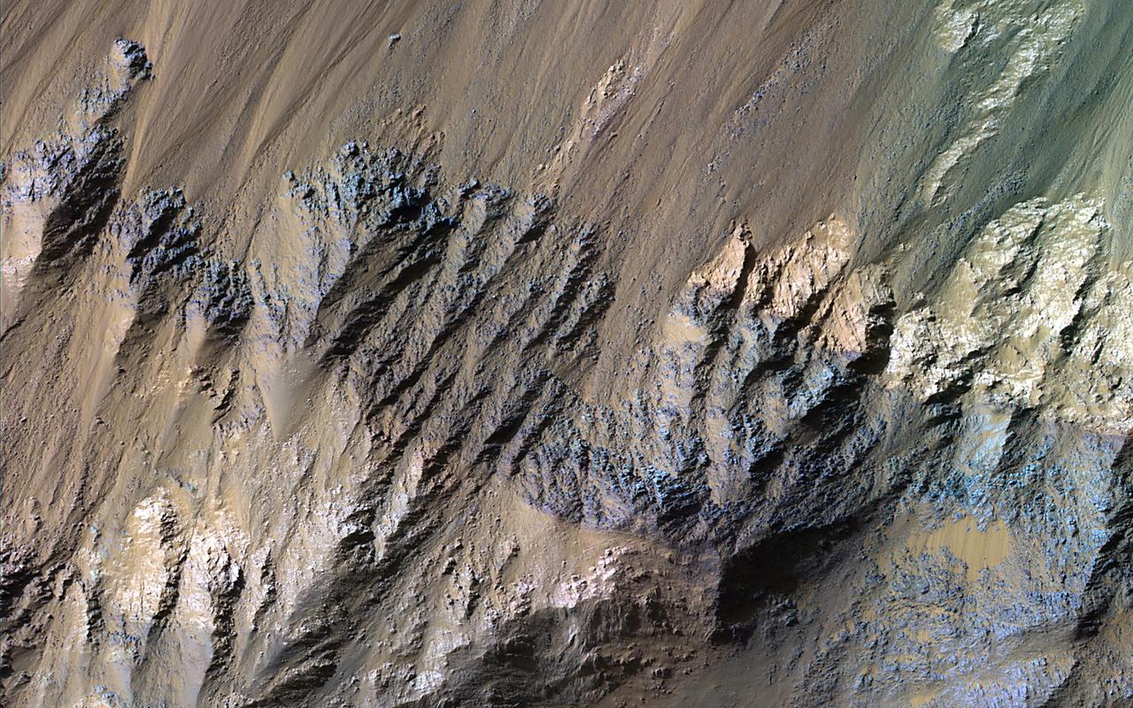
Canyon in DCS Color
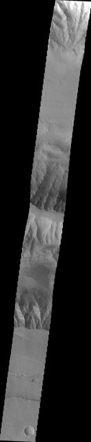
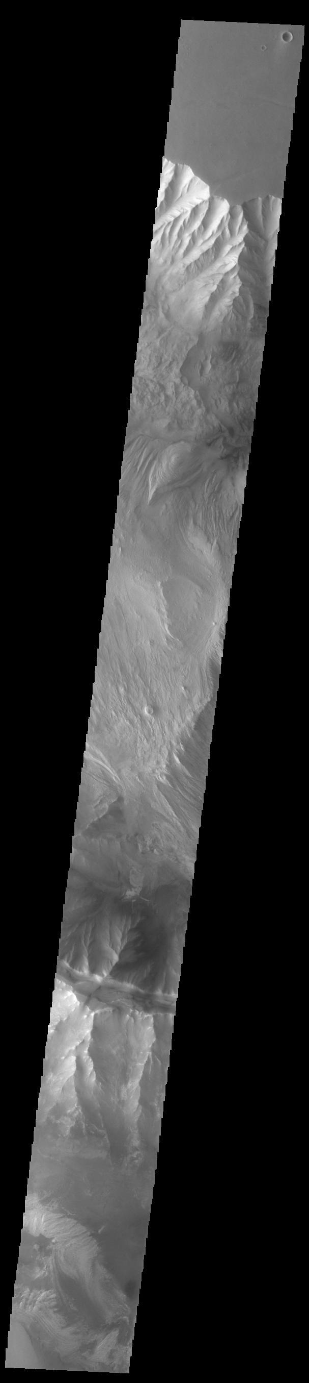
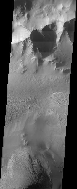
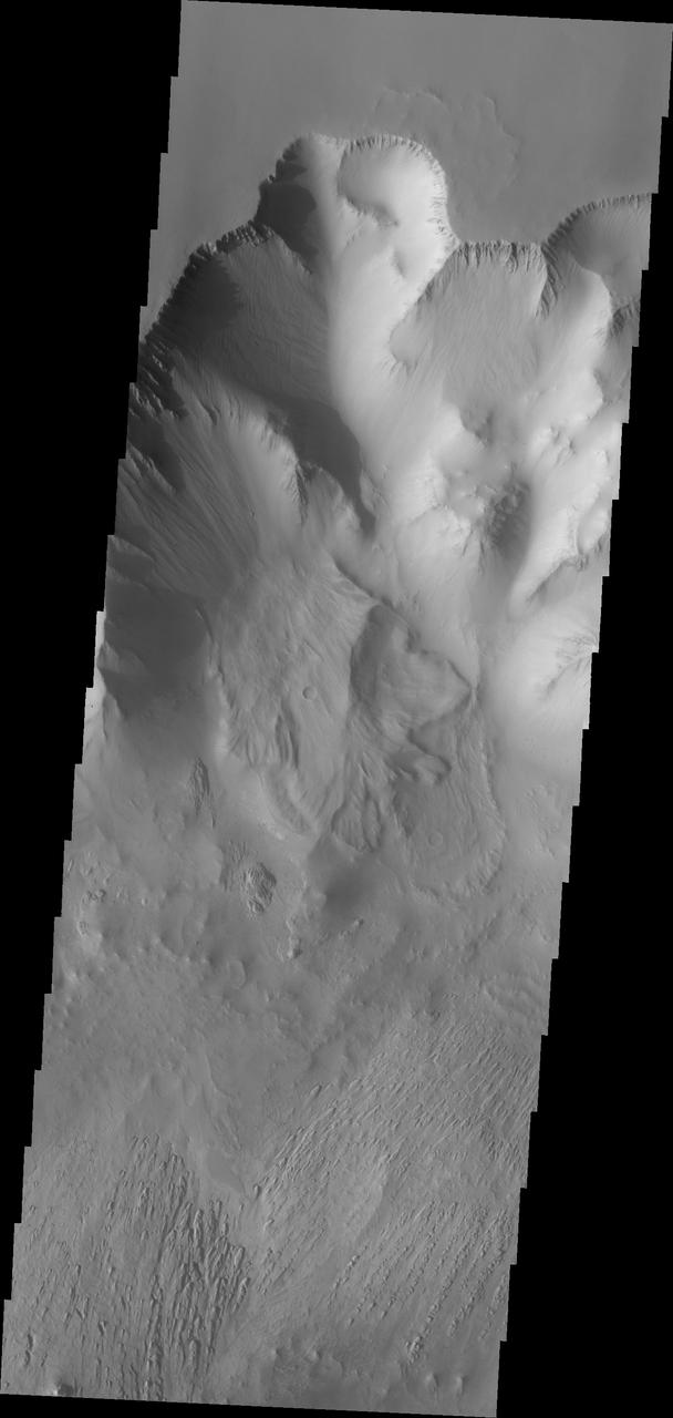
Canyons of Aeolis Mensae
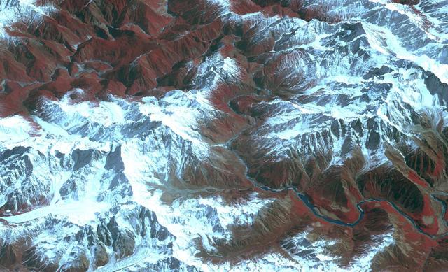
Acquired by NASA Terra spacecraft, this image shows the Yarlung Zangpo Grand Canyon or Tsangpo Gorge in Tibet, the deepest canyon in the world, and longer than the Grand Canyon.
A Grand Canyon of Mars slices across the Red Planet near its equator. This canyon -- Valles Marineris, or the Mariner Valley -- is 10 times longer and deeper than Arizona Grand Canyon, and 20 times wider
Cotahuasi Canyon, near the city of Arequipa, Peru, is one of the deepest canyons in the world. It reaches a maximum depth of 3,350 m, twice as deep as the Grand Canyon. Volcanic peaks nearby reach altitudes of over 6,000 meters. The perspective view is draped over an ASTER DEM, and projected with no vertical exaggeration. The image was acquired August 30, 2019, and is located at 15.3 degrees south, 73 degrees west. https://photojournal.jpl.nasa.gov/catalog/PIA24943
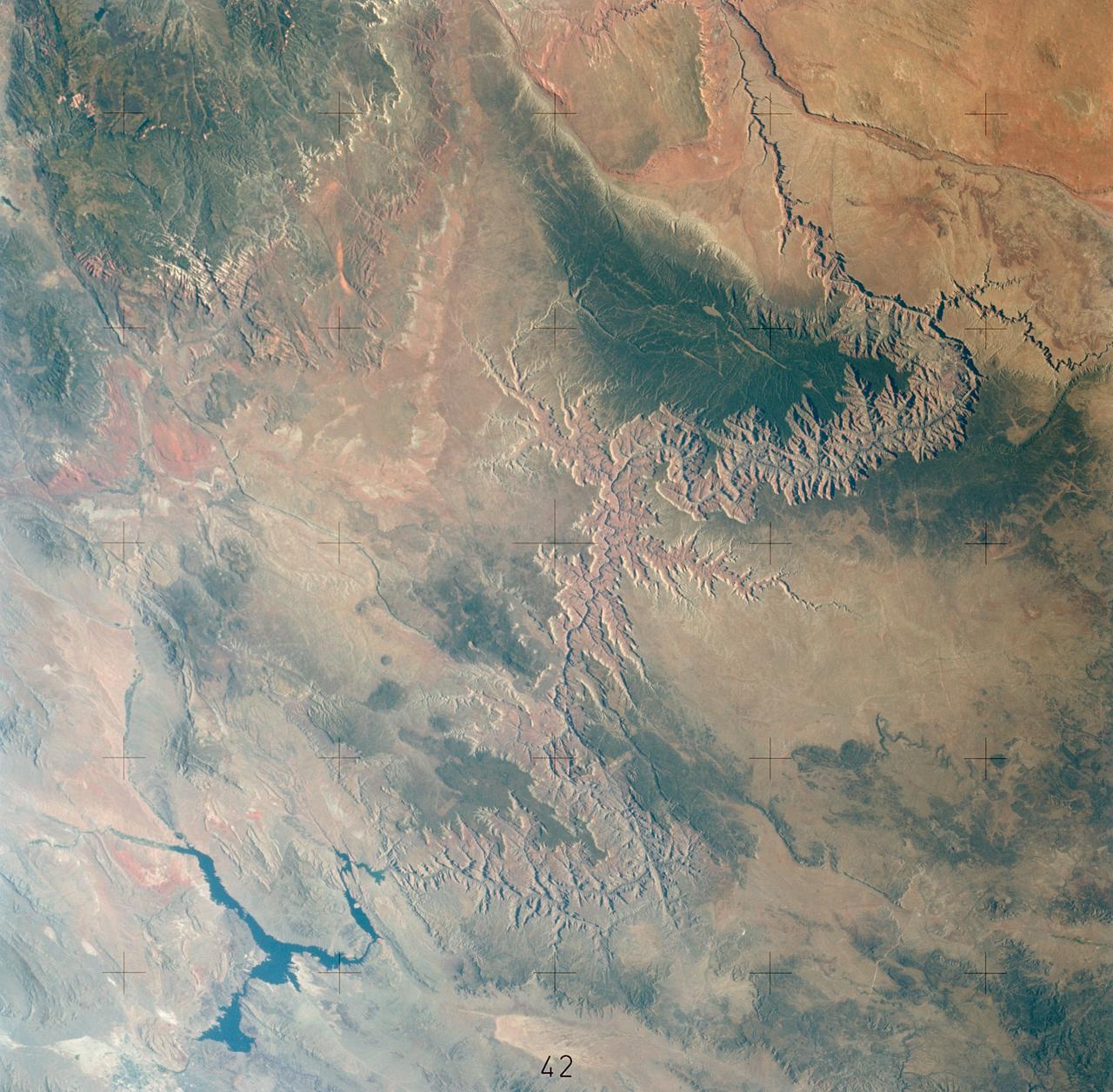
SL2-04-018 (June 1973) --- A vertical view of the Arizona-Utah border area showing the Colorado River and Grand Canyon photographed from the Skylab 1/2 space station in Earth orbit. This picture was taken by one of the six lenses of the Itek-furnished S190-A Multispectral Photographic Facility Experiment in the Multiple Docking Adapter of the space station. Type S0-356 film was used. The row of white clouds extend north-south over the dark colored Kaibab Plateau. The junction of the Colorado and Little Colorado rivers is in the southwest corner of the picture. The body of water is Lake Powell on the Colorado River upstream from the Grand Canyon. The lone peak at the eastern edge of the photograph south of Colorado River is the 10,416-foot Navajo Mountain. The S190-A experiment is part of the Skylab Earth Resources Experiments Package(EREP). Photo credit: NASA
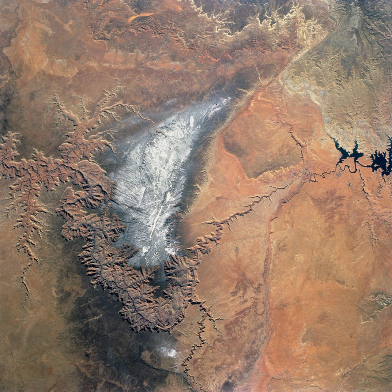
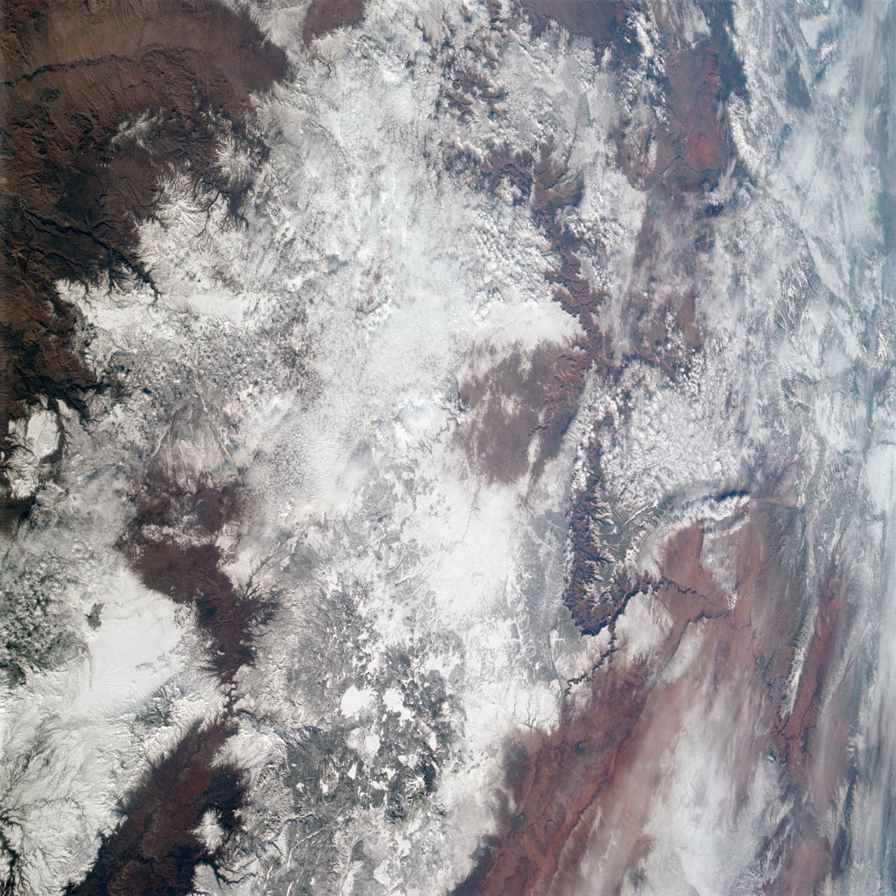
Snow covers the Kaibab Plateau on the northern side of the Colorado River in this November, 1994 view of the Grand Canyon. North is to the bottom of this view. The Colorado River has created a canyon which cuts through billions of years of geologic time. The Grand Canyon is 446 kilometers (277 miles) long, averages 16 kilometers (10 miles) wide, and is approximately 1.6 kilometers (1 mile) deep. The Coconino Plateau is located on the upper left side of the view, or to the south of the Colorado River. The direction of the flow of the Colorado River is from the east to the west. Eventually the river turns south and empties into the Gulf of California. The southern portion of Lake Powell in Utah can be seen at the bottom center of the view.
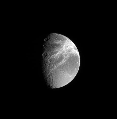
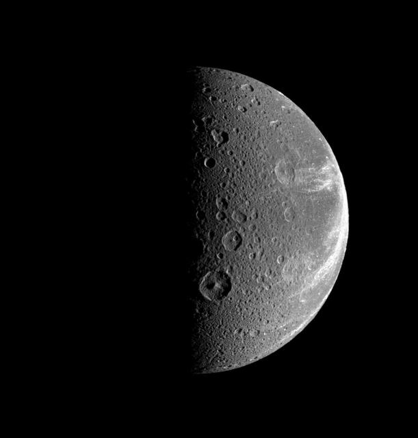
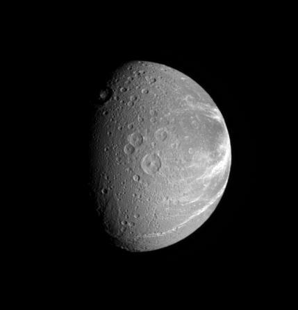
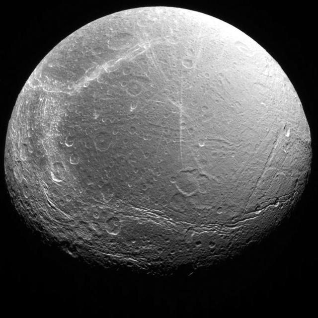
Bright lines creep across the face of Dione. The lines are systems of geologically fresh-looking canyons with bright, icy walls
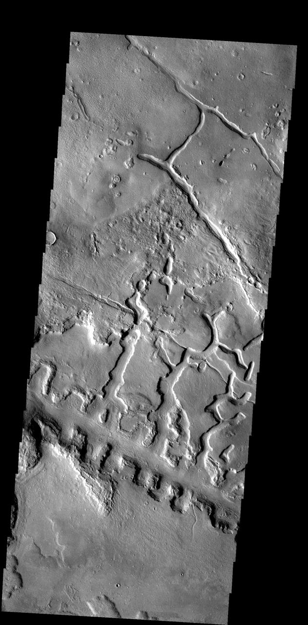
The line of box canyons in the middle of this image are part of a large region of collapse features called Galaxias Fossae

A magnetic filament of solar material erupted on the sun in late September, breaking the quiet conditions in a spectacular fashion. The 200,000 mile long filament ripped through the sun's atmosphere, the corona, leaving behind what looks like a canyon of fire. The glowing canyon traces the channel where magnetic fields held the filament aloft before the explosion. Visualizers at NASA's Goddard Space Flight Center in Greenbelt, Md. combined two days of satellite data to create a short movie of this gigantic event on the sun: <a href="http://bit.ly/166CncU" rel="nofollow">bit.ly/166CncU</a> In reality, the sun is not made of fire, but of something called plasma: particles so hot that their electrons have boiled off, creating a charged gas that is interwoven with magnetic fields. These images were captured on Sept. 29-30, 2013, by NASA's Solar Dynamics Observatory, or SDO, which constantly observes the sun in a variety of wavelengths. Read more/download video: <a href="http://1.usa.gov/1dnrsjF" rel="nofollow">1.usa.gov/1dnrsjF</a> Credit: NASA/SDO <b><a href="http://www.nasa.gov/audience/formedia/features/MP_Photo_Guidelines.html" rel="nofollow">NASA image use policy.</a></b> <b><a href="http://www.nasa.gov/centers/goddard/home/index.html" rel="nofollow">NASA Goddard Space Flight Center</a></b> enables NASA’s mission through four scientific endeavors: Earth Science, Heliophysics, Solar System Exploration, and Astrophysics. Goddard plays a leading role in NASA’s accomplishments by contributing compelling scientific knowledge to advance the Agency’s mission. <b>Follow us on <a href="http://twitter.com/NASA_GoddardPix" rel="nofollow">Twitter</a></b> <b>Like us on <a href="http://www.facebook.com/pages/Greenbelt-MD/NASA-Goddard/395013845897?ref=tsd" rel="nofollow">Facebook</a></b> <b>Find us on <a href="http://instagram.com/nasagoddard?vm=grid" rel="nofollow">Instagram</a></b>
iss074e0301902 (Feb. 3, 2026) --- The Grand Canyon stretches about 277 miles across Arizona in the southwestern corner of the Colorado Plateau. The Colorado River began carving the Grand Canyon—one of the Seven Natural Wonders of the World and a UNESCO World Heritage Site—about 5 to 6 million years ago. The International Space Station was orbiting 259 miles above the United States when this photograph was taken.
AS09-20-3137 (3-13 March 1969) --- The Grand Canyon is sharply etched on the snow-covered Colorado Plateau in Arizona in this photograph from the Apollo 9 spacecraft during its Earth-orbital mission. Lake Powell behind Glen Canyon Dam is in the upper right corner. Humphreys Peak and the many volcanic craters around the San Francisco Mountains near Flagstaff, Arizona, are right of center. Prescott is under clouds at lower center.

Northern Arizona and the Grand Canyon are captured in this pair of images from December 31, 2000 as seen by NASA Terra satellite Terra orbit 5525.
Arguably one of America most magnificent national parks is the Grand Canyon in northern Arizona. NASA Terra spacecraft captured this image looking to the northeast, the buildings and roads in the center foreground are Grand Canyon Village.
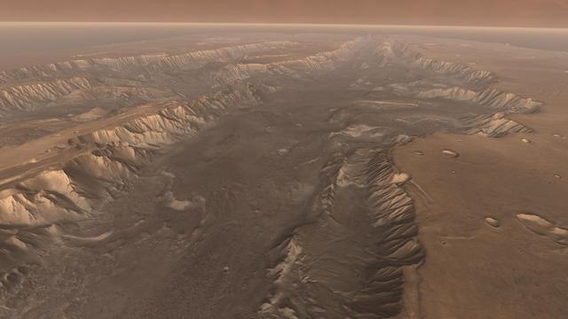
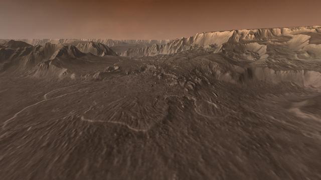
Flying through the canyons and over the ridges of Valles Marineris, viewers can experience some of the thrills that gripped explorers who pushed into unknown regions on Earth
This image from NASA 2001 Mars Odyssey spacecraft shows part of the Valles Marineris canyon system -- a mega gully enters Capri Chasma.
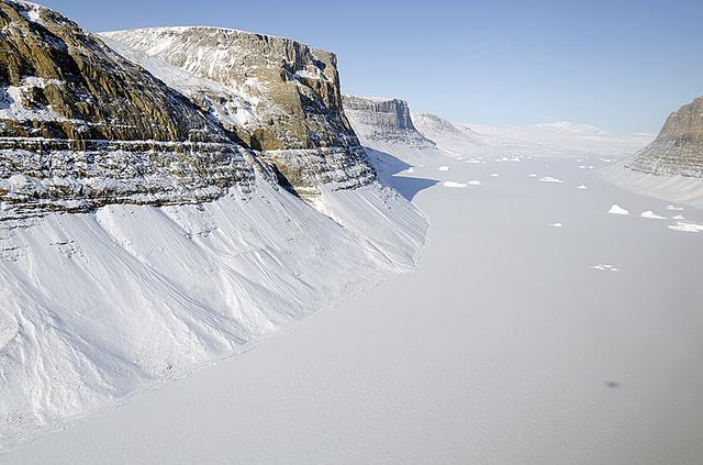
A glacial canyon in northern Greenland as seen by NASA's P-3B aircraft on May 3, 2012. Credit: Michael Studinger/NASA =========== IceBridge, a six-year NASA mission, is the largest airborne survey of Earth's polar ice ever flown. It will yield an unprecedented three-dimensional view of Arctic and Antarctic ice sheets, ice shelves and sea ice. These flights will provide a yearly, multi-instrument look at the behavior of the rapidly changing features of the Greenland and Antarctic ice. Data collected during IceBridge will help scientists bridge the gap in polar observations between NASA's Ice, Cloud and Land Elevation Satellite (ICESat) -- in orbit since 2003 -- and ICESat-2, planned for early 2016. ICESat stopped collecting science data in 2009, making IceBridge critical for ensuring a continuous series of observations. IceBridge will use airborne instruments to map Arctic and Antarctic areas once a year. IceBridge flights are conducted in March-May over Greenland and in October-November over Antarctica. Other smaller airborne surveys around the world are also part of the IceBridge campaign. To read more about IceBridge - Arctic 2012 go to: <a href="http://www.nasa.gov/mission_pages/icebridge/index.html" rel="nofollow">www.nasa.gov/mission_pages/icebridge/index.html</a> <b><a href="http://www.nasa.gov/audience/formedia/features/MP_Photo_Guidelines.html" rel="nofollow">NASA image use policy.</a></b> <b><a href="http://www.nasa.gov/centers/goddard/home/index.html" rel="nofollow">NASA Goddard Space Flight Center</a></b> enables NASA’s mission through four scientific endeavors: Earth Science, Heliophysics, Solar System Exploration, and Astrophysics. Goddard plays a leading role in NASA’s accomplishments by contributing compelling scientific knowledge to advance the Agency’s mission. <b>Follow us on <a href="http://twitter.com/NASA_GoddardPix" rel="nofollow">Twitter</a></b> <b>Like us on <a href="http://www.facebook.com/pages/Greenbelt-MD/NASA-Goddard/395013845897?ref=tsd" rel="nofollow">Facebook</a></b> <b>Find us on <a href="http://instagrid.me/nasagoddard/?vm=grid" rel="nofollow">Instagram</a></b>

Mariner 9 views Canyon System emerging from Martian Dust Storm
NASA Terra spacecraft provided this view of the eastern part of Grand Canyon National Park in northern Arizona in this image on July 14, 2011. This view looks to the west, with tourist facilities of Grand Canyon Village visible in the upper left.
Viewers experience roller-coaster twists and turns as they fly up a winding tributary valley that feeds into Valles Marineris, the Grand Canyon of Mars.
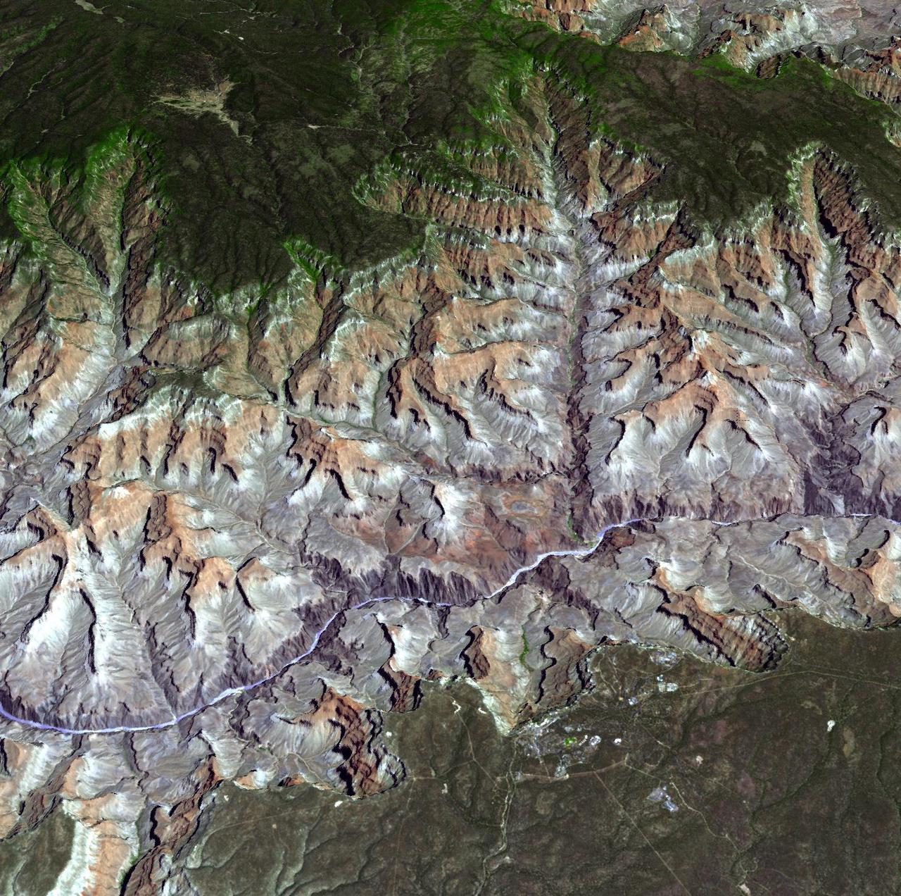
The Grand Canyon is one of North America's most spectacular geologic features. Carved primarily by the Colorado River over the past six million years, the canyon sports vertical drops of 5,000 feet and spans a 445-kilometer-long stretch of Arizona desert. The strata along the steep walls of the canyon form a record of geologic time from the Paleozoic Era (250 million years ago) to the Precambrian (1.7 billion years ago). The above view was acquired by the Advanced Spaceborne Thermal Emission and Reflection Radiometer (ASTER) instrument aboard the Terra spacecraft. Visible and near infrared data were combined to form an image that simulates the natural colors of water and vegetation. Rock colors, however, are not accurate. The image data were combined with elevation data to produce this perspective view, with no vertical exaggeration, looking from above the South Rim up Bright Angel Canyon towards the North Rim. The light lines on the plateau at lower right are the roads around the Canyon View Information Plaza. The Bright Angel Trail, which reaches the Colorado in 11.3 kilometers, can be seen dropping into the canyon over Plateau Point at bottom center. The blue and black areas on the North Rim indicate a forest fire that was smoldering as the data were acquired on May 12, 2000. http://photojournal.jpl.nasa.gov/catalog/PIA02668
iss074e0208848 (Jan. 26, 2026) --- The Colorado River began carving the Grand Canyon—one of the Seven Natural Wonders of the World and a UNESCO World Heritage Site in Arizona—about 5 to 6 million years ago. This photograph was taken from the International Space Station as it orbited 260 miles above the Colorado Plateau in the southwestern United States.
iss074e0208838 (Jan. 26, 2026) --- The Colorado River began carving the Grand Canyon—one of the Seven Natural Wonders of the World and a UNESCO World Heritage Site in Arizona—about 5 to 6 million years ago. This photograph was taken from the International Space Station as it orbited 260 miles above the Colorado Plateau in the southwestern United States.
This image from NASA Mars Odyssey shows a portion of Aureum Chaos located just south of the Martian equator. This fractured landscape contains canyons and mesas with two large impact craters in the upper left.
Spectacular canyons of the central Andes, in the Peruvian department of Arequipa, are seen in this anaglyph from the MISR instrument aboard NASA Terra spacecraft. 3D glasses are necessary to view this image.
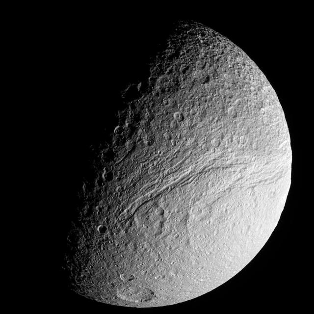
Bright fractures creep across the surface of icy Dione. This extensive canyon system is centered on a region of terrain that is significantly darker that the rest of the moon. Part of the darker terrain is visible at right

This simulated true color perspective view over the Grand Canyon was created from Advanced Spaceborne Thermal Emission and Reflection Radiometer (ASTER) data acquired on May 12, 2000. The Grand Canyon Village is in the lower foreground; the Bright Angel Trail crosses the Tonto Platform, before dropping down to the Colorado Village and then to the Phantom Ranch (green area across the river). Bright Angel Canyon and the North Rim dominate the view. At the top center of the image the dark blue area with light blue haze is an active forest fire. http://photojournal.jpl.nasa.gov/catalog/PIA01908
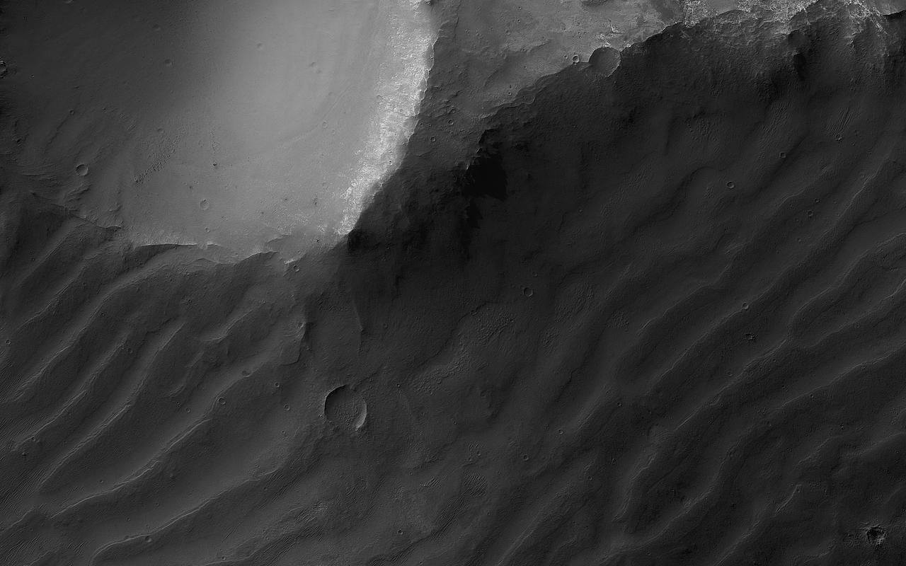
This image shows a cross-section of ancient canyon systems in east Coprates Chasma, and displays several orders and generations of wind-driven dunes and ripples, also called bedforms. Some areas display more modern bedforms, often termed mega-ripples, which have likely been active over long timescales and have migrated in the recent past. Other areas along the canyon wall have larger bedforms that show a very different appearance. Although they have a spacing that would make them similar to typical Martian sand dunes, many display superposed craters, indicating they have not migrated for a very long time, possibly hundreds of thousands of years. https://photojournal.jpl.nasa.gov/catalog/PIA23530
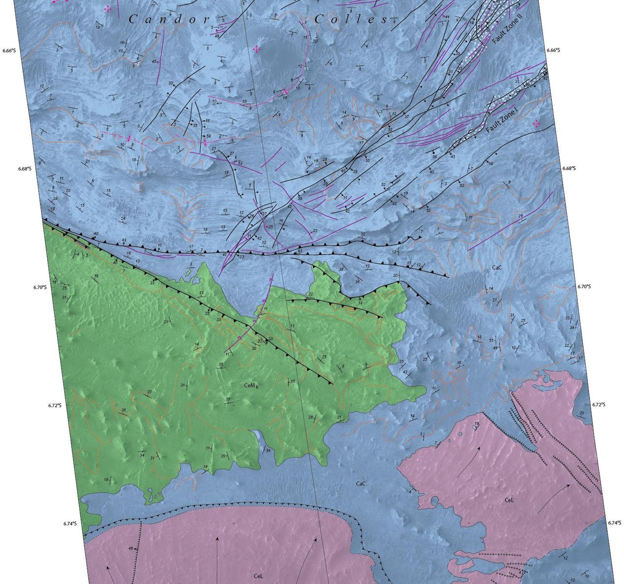
Details of hilly terrain within a large Martian canyon are shown on a geological map based on observations from NASA Mars Reconnaissance Orbiter and produced by the U.S. Geological Survey.
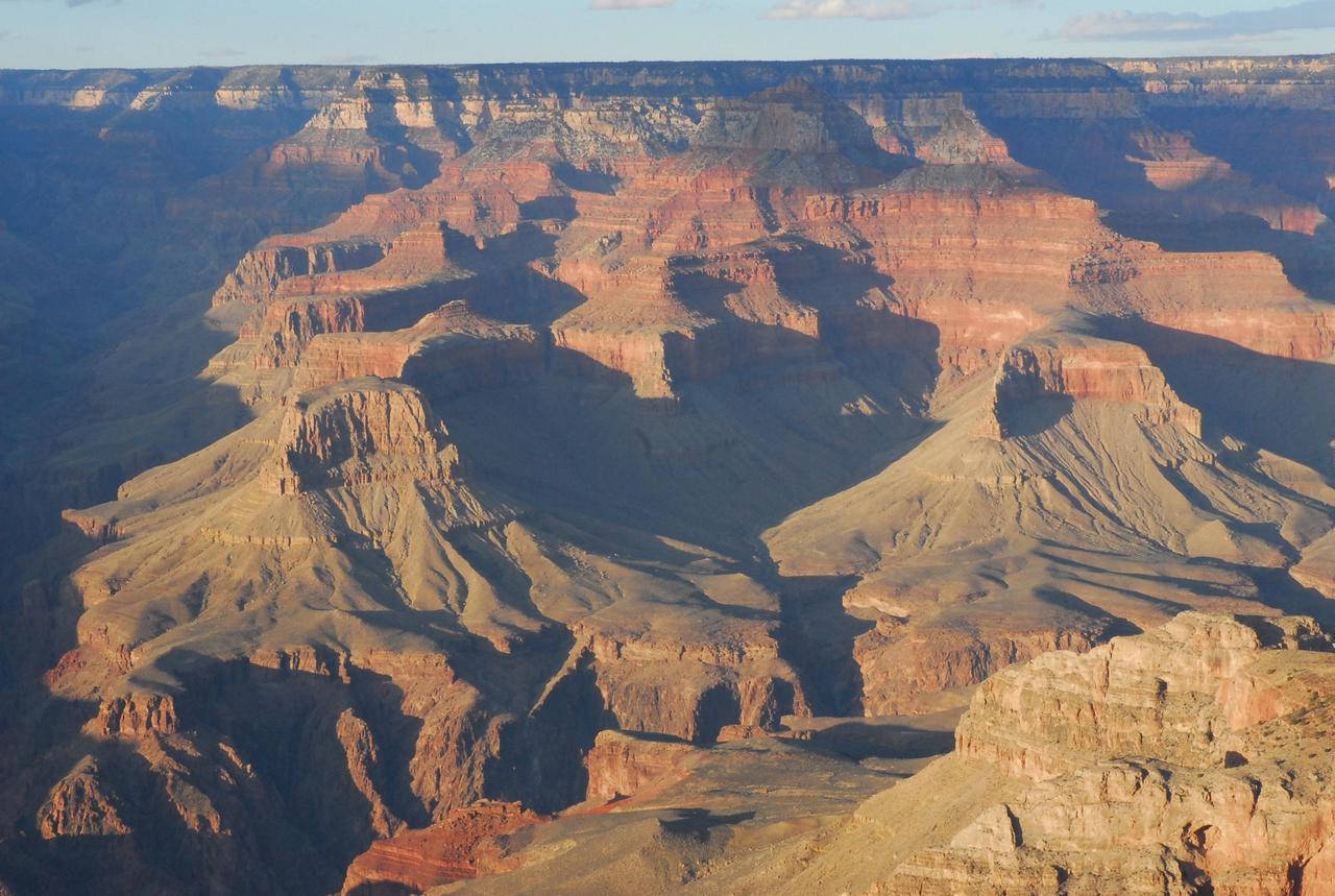
Before NASA Curiosity rover landed on Mars, the strata exposed in Mount Sharp were compared to those in the Grand Canyon of the western United States, shown here. Scientists are surprised by just how close the similarities are.
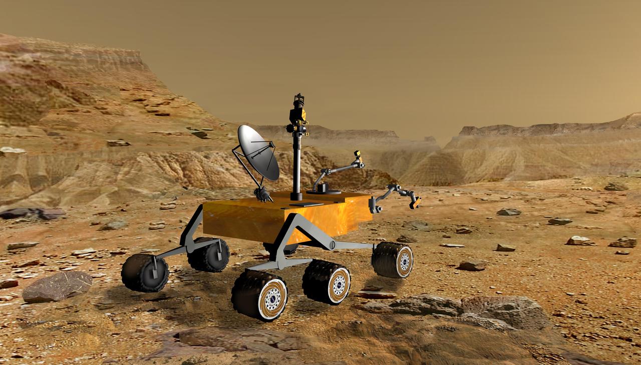
NASA Mars Science Laboratory travels near a canyon on Mars in this artist concept. The mission is under development for launch in 2009 and a precision landing on Mars in 2010.
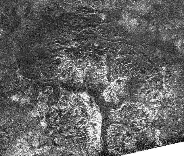
Complex and unique canyon systems appear to have been intricately carved into older terrain by the ample flow of liquid methane rivers on Saturn moon Titan, as seen in this radar image taken by NASA Cassini spacecraft on May 21, 2009.
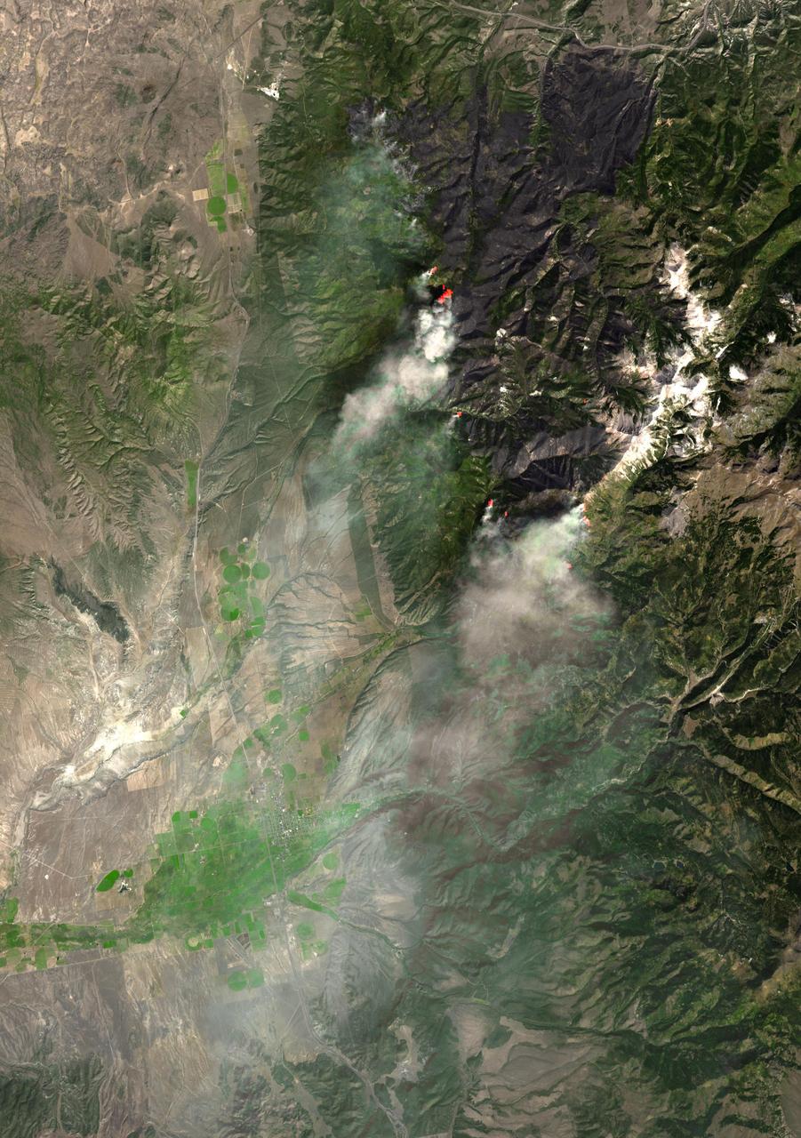
NASA Terra spacecraft captured this image of the Twitchell Canyon fire, a lightning-caused blaze burning in Utah, which has consumed more than 40,000 acres since it began on July 20, 2010.

This frame from an animation simulates a flyover of a portion of a Martian canyon detailed in a geological map produced by the U.S. Geological Survey and based on observations by the HiRISE camera on NASA Mars Reconnaissance Orbiter.
Light blue clouds fill Coprates Chasma on Mars, part of Valles Marineris, the vast Grand Canyon of Mars. The clouds are mostly ice crystals and they appear blue in color in this image from NASA Mars Odyssey.
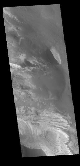
This false-color mosaic focuses on one junction in Noctis Labyrinthus where canyons meet to form a depression 4,000 meters 13,000 feet deep. This image is from NASA Mars Odyssey, one of an All Star set.
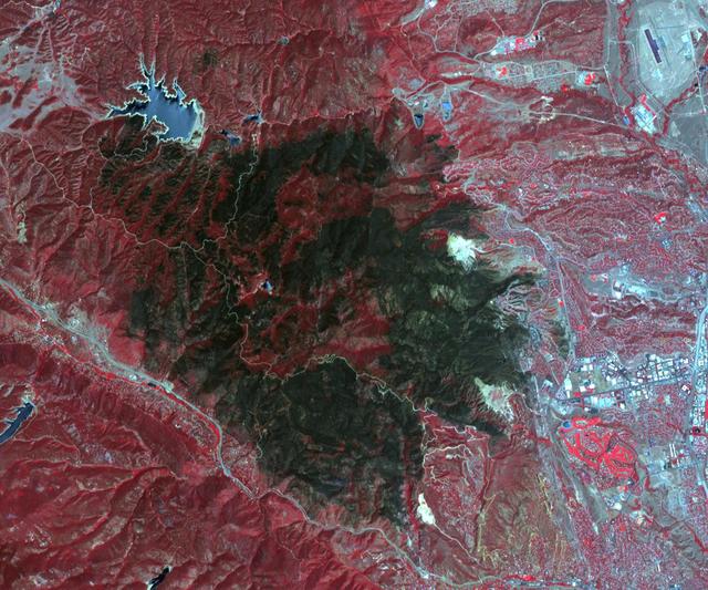
NASA Terra spacecraft acquired this image of the Waldo Canyon Fire, west of Colorado Springs, Colo., being called the worst fire in Colorado history. Healthy vegetation is red, water is dark blue, streets and buildings are gray, and the burned areas are
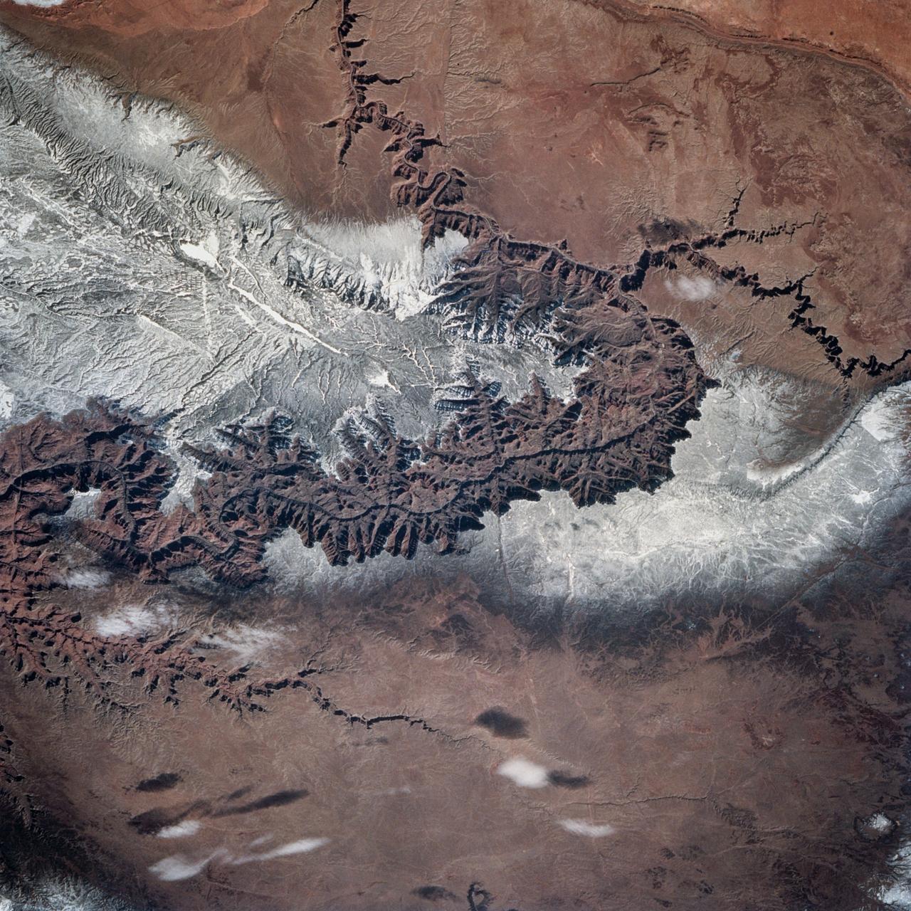
STS060-83-004 (3-11 Feb 1994) --- In this winter scene of the Grand Canyon of Arizona, the canyon is particularly well revealed because snow lies on the rims of the canyon, and exits mid-right; the Little Colorado River enters from the left, joining the Colorado just upstream of its big bend. Visitors to the South Rim can view the canyon in both the east-west and north-south reaches. The South Rim is closer to centers of transportation so that tourists mostly see the canyon from this area, that is from about 7,000 feet. The canyon floor lies at 2,000 feet in this sector. The most heavily snow covered area is the highest, reaching more than 9,000 feet (bottom right). Visitors see this protected area by hiking and mule and helicopter rides. The ecology of this part of the Colorado has been changed since the building of a lake upstream: river water is now derived from snow melt water from the bottom of the lake. This water is much colder than the water which used to flow through the canyon. According to NASA scientists, the view is unusual because the snow also reveals so well the higher country around the canyon, a swath stretching from bottom right to middle left of the view. This higher swath is an arch of uplifted rocks known as the Kaibab Plateau, raised vertically by tectonic forces in the recent geologic past. Despite this up parching, the Colorado River managed to maintain its course to the sea by cutting an ever deeper canyon into the Plateau. The white snow cover hides the fact that the Kaibab Plateau is thickly forested and thus appears dark green in summer, except in areas of clear-cutting. Since the Plateau reaches altitudes of 6 to 9,000 feet, it is both cooler and moister than the surrounding lower desert floor (top and bottom in this view) - where sparse vegetation and rocky country appear as brown colors. The zone of dark color running parallel to the snow line is all that can be seen of the pine forest on the south flanks of the Plateau.
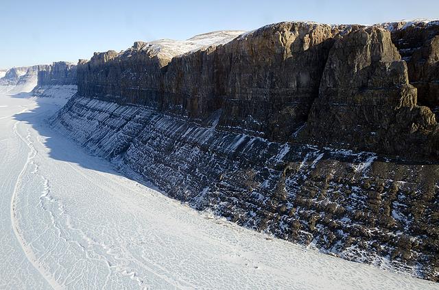
A northern Greenland glacier as seen by NASA's P-3B aircraft on May 3, 2012. Credit: Michael Studinger/NASA =========== IceBridge, a six-year NASA mission, is the largest airborne survey of Earth's polar ice ever flown. It will yield an unprecedented three-dimensional view of Arctic and Antarctic ice sheets, ice shelves and sea ice. These flights will provide a yearly, multi-instrument look at the behavior of the rapidly changing features of the Greenland and Antarctic ice. Data collected during IceBridge will help scientists bridge the gap in polar observations between NASA's Ice, Cloud and Land Elevation Satellite (ICESat) -- in orbit since 2003 -- and ICESat-2, planned for early 2016. ICESat stopped collecting science data in 2009, making IceBridge critical for ensuring a continuous series of observations. IceBridge will use airborne instruments to map Arctic and Antarctic areas once a year. IceBridge flights are conducted in March-May over Greenland and in October-November over Antarctica. Other smaller airborne surveys around the world are also part of the IceBridge campaign. To read more about IceBridge - Arctic 2012 go to: <a href="http://www.nasa.gov/mission_pages/icebridge/index.html" rel="nofollow">www.nasa.gov/mission_pages/icebridge/index.html</a> <b><a href="http://www.nasa.gov/audience/formedia/features/MP_Photo_Guidelines.html" rel="nofollow">NASA image use policy.</a></b> <b><a href="http://www.nasa.gov/centers/goddard/home/index.html" rel="nofollow">NASA Goddard Space Flight Center</a></b> enables NASA’s mission through four scientific endeavors: Earth Science, Heliophysics, Solar System Exploration, and Astrophysics. Goddard plays a leading role in NASA’s accomplishments by contributing compelling scientific knowledge to advance the Agency’s mission. <b>Follow us on <a href="http://twitter.com/NASA_GoddardPix" rel="nofollow">Twitter</a></b> <b>Like us on <a href="http://www.facebook.com/pages/Greenbelt-MD/NASA-Goddard/395013845897?ref=tsd" rel="nofollow">Facebook</a></b> <b>Find us on <a href="http://instagrid.me/nasagoddard/?vm=grid" rel="nofollow">Instagram</a></b>

Hubble Look at Mars Shows Canyon Dust Storm, Cloudy Conditions for Pathfinder Landing
SL3-122-2581 (July-September 1973) --- Skylab 3 Earth view of the Grand Canyon, Lake Mead and Kaibab. Photo credit: NASA
The Advanced Spaceborne Thermal Emission and Reflection Radiometer ASTER instrument aboard NASA Terra spacecraft captured this image of the Fourmile Canyon fire west of Boulder Colo., on Sept. 17, 2010; it was 100 percent contained.
This dramatic view looks west along the Cucharas River Canyon in Colorado toward the 4,152 meter 13,623 ft high Spanish Peaks, in the foothills of the Sangre De Cristo Mountains.
This narrow canyon is part of Coprates Chasma. On the east side of the canyon a landslide is visible. The southern wall of the canyon is marked by bright and dark streaks where dust has slid down the cliff face
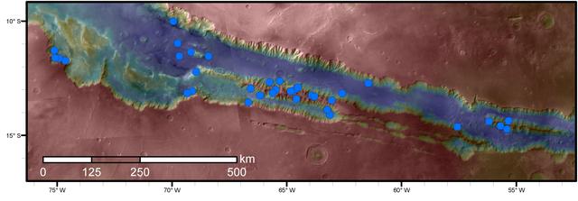
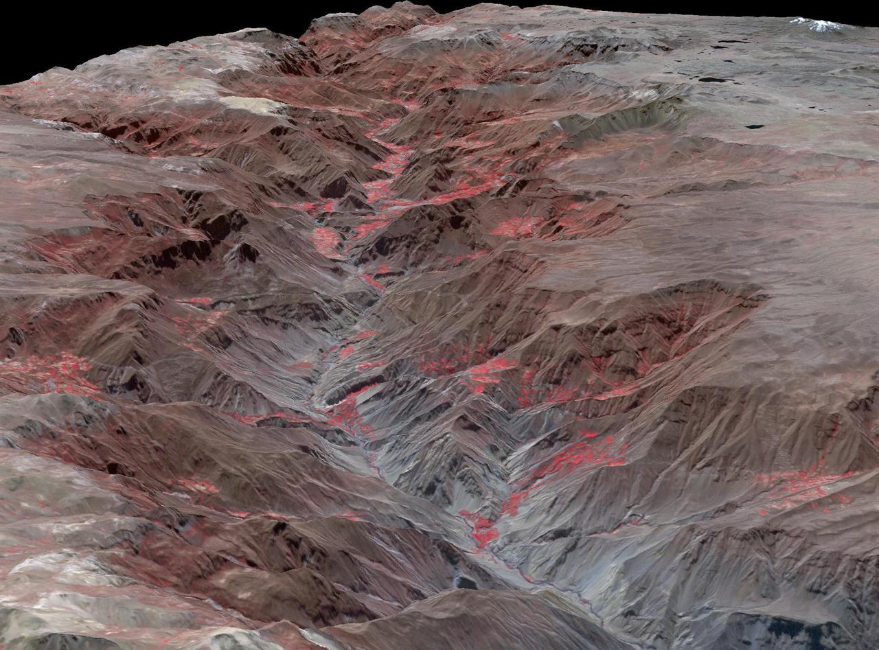
Blue dots on this map indicate sites of recurring slope lineae (RSL) in part of the Valles Marineris canyon network on Mars. RSL are seasonal dark streaks regarded as the strongest evidence for the possibility of liquid water on the surface of modern Mars. The area mapped here has the highest density of known RSL on the Red Planet. The RSL were identified by repeated observations of the sites using the High Resolution Imaging Science Experiment (HiRISE) camera on NASA's Mars Reconnaissance Orbiter. Map colors represent elevation, where red is high and blue is low. Valles Marineris is the largest canyon system in the solar system. The region shown here includes Melas Chasma and Coprates Chasma, in the central and eastern portions of Valles Marineris. The mapped area extends about 1,500 miles (2,400 kilometers) east to west and about 280 miles (450 kilometers) north to south, at latitudes from 9 to 17 degrees south of Mars' equator. The base map uses data from the Mars Orbiter Camera and Mars Orbiter Laser Altimeter of NASA's Mars Global Surveyor mission. RSL extend downslope during a warm season, fade in the colder part of the year, and repeat the process in a subsequent Martian year. A study of 41 RSL sites in this canyon area, published July 7, 2016, provides support for the notion that significant amounts of near-surface water can be found on modern Mars, though the work also indicates that puzzles remain unsolved in understanding how these seasonal features form. Each site includes anywhere from a few to more than 1,000 individual "lineae." http://photojournal.jpl.nasa.gov/catalog/PIA20756
Melas Chasma is part of the Valles Marineris canyon system, the largest canyon in the Solar System. This image was taken by NASA Mars Reconnaissance Orbiter.
Ius Chasma is one of several canyons that make up Valles Marineris, the largest canyon system in the Solar System as seen by NASA Mars Reconnaissance Orbiter.
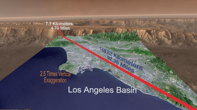
STS058-74-000R (18 Oct-1 Nov 1993) --- A broad view westward along the Colorado River from just below Glen Canyon Dam (out of picture), through the entire Grand Canyon to Lake Mead and Las Vegas, and westward to include southern Nevada and much of California. The Salton Sea, Los Angeles Basin, and Great Valley rim the Pacific Coast in the distance. Photo credit: NASA

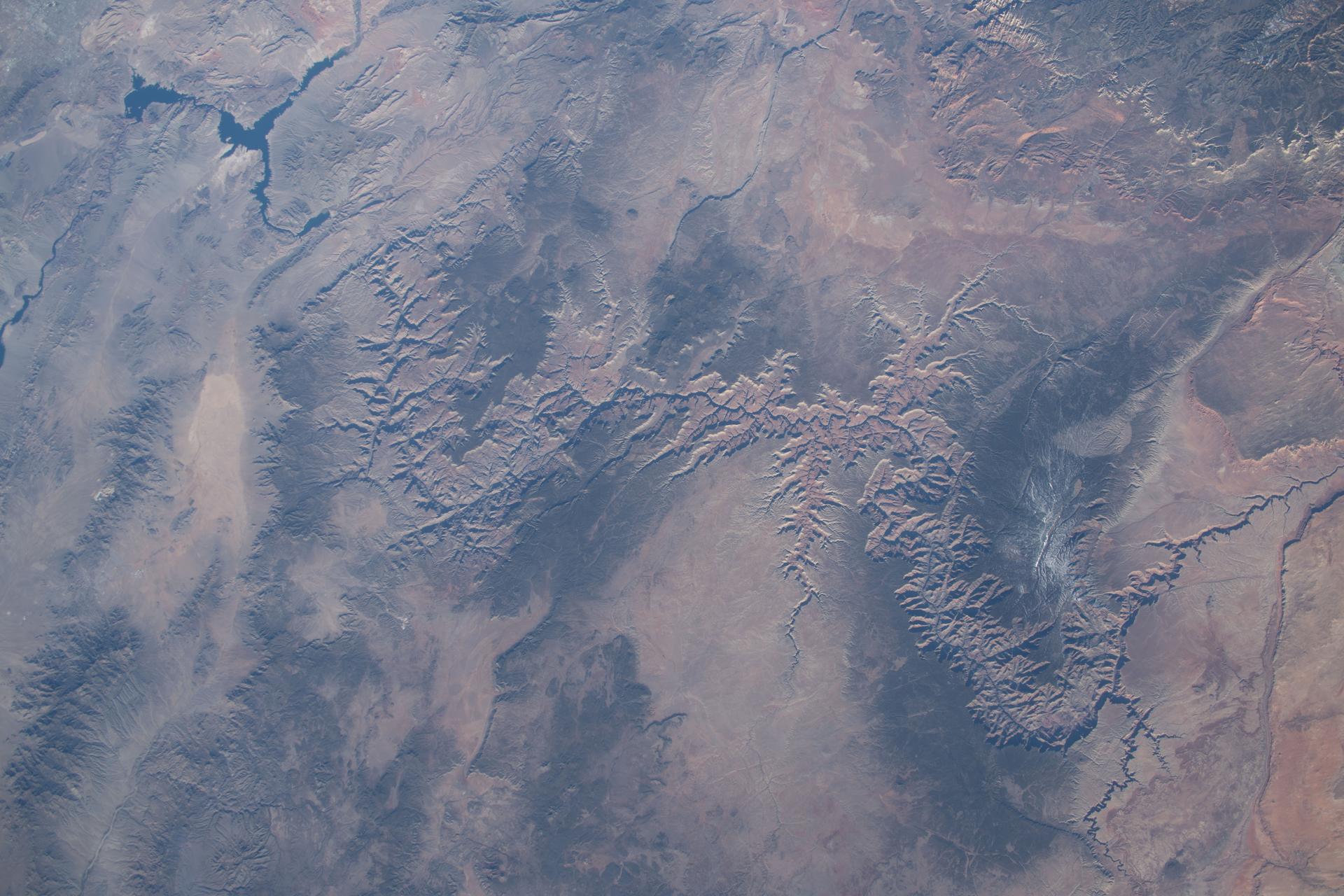
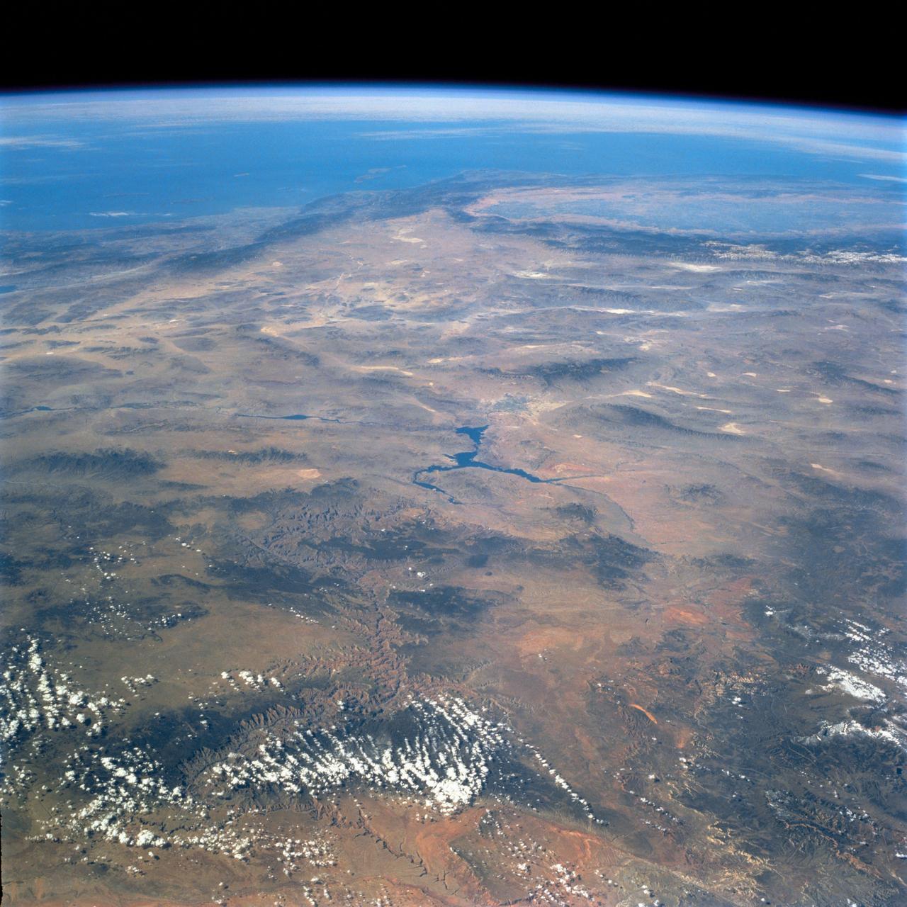
iss074e0002559 (Dec. 13, 2025) --- Glen Canyon National Recreation Area in Utah—featuring Lake Powell, Good Hope Rock, and Mt. Pennell (top), popular spots for sightseeing, fishing, and hiking—is pictured from the International Space Station as it orbited 262 miles above North America.

jsc2024e067106 (10/15/2024) --- Nematodes to the Rescue! - Space worms as an integral component of space agriculture is part of the Nanoracks-National Center for Earth and Space Science Education-Surveyor-Student Spaceflight Experiments Program Mission 18 to the ISS (Nanoracks-NCESSE-Surveyor-SSEP). Image courtesy of Canyons School District.

This Mars Odyssey image transects Candor Chasma and Melas Chasma. Many canyon features are clearly visible in the image, including the steep cliff faces, landslides, and layered canyon floor deposits.

This MOC image shows gullies a portion of a flood-carved canyon within the larger Kasei Valles system on Mars. This canyon is the result of the very last flood event that poured through the Kasei valleys, long ago
Today's VIS image shows part of Ophir Chasma. Ophir Chasma is part of Valles Marineris, the largest canyon system on Mars. At the top of the image is a portion of a large landslide deposit which originate at the northern wall of the canyon. The bright toned part at the bottom of the image is the northern extent of Beatis Mensa, a large layered deposit within the canyon. Orbit Number: 72429 Latitude: -3.9913 Longitude: 288.136 Instrument: VIS Captured: 2018-04-12 23:52 https://photojournal.jpl.nasa.gov/catalog/PIA22602

Mamers Valles is a long sinuous canyon beginning in Arabia Terra and ending in the Northern lowlands of Deuteronilus Mensae. This image from NASA Mars Reconnaissance Orbiter features the southern facing slope of the canyon wall. The northern half (top) has a rough, pitted texture with numerous impact craters, while the middle section shows the steep canyon wall. Streaks of slightly different colors show slope material eroding onto the canyon floor. Though the canyon itself was formed long ago, the material deposited on the canyon floor has been laid down over time, creating a much younger surface. The difference in age of the surfaces can also be indicated by the presence or absence of impact craters. The longer a surface has been exposed, the more impact craters it will accumulate. Counting craters to determine age estimates of planetary surfaces has been used throughout the solar system. This method is based on the assumption that the youngest, freshly formed surfaces will have no impact craters, and as time progresses crater impacts will accumulate at a predictable rate. This concept has been calibrated using crater counts on the Moon and the measured age of the rocks brought back by the Apollo missions. https://photojournal.jpl.nasa.gov/catalog/PIA21603
Soaring high above Valles Marineris, the Grand Canyon of Mars, viewers look down and catch a sight resembling parts of the desert West of the United States, but on a vastly greater scale. Here the canyon averages over a hundred miles wide.
This canyon system imaged here by NASA Mars Odyssey was named Valles Marineris in honor of its discoverer, NASA Mariner 9 spacecraft. The image covers a portion of the canyon system called Melas Chasma. http://photojournal.jpl.nasa.gov/catalog/PIA04003

NASA DC-8 airborne laboratory flying over Mint Canyon near the snow-covered San Gabriel Mountains of California. The mostly white aircraft is silhouetted against the darker mountains in the background.
This VIS image of Tithonium Chasma shows the canyon wall at the top of the frame and the cliff face of the opposite side of the canyon at the bottom of the image. Most of the floor has been covered with the deposits of large volume landslides. Near the top-right portion of the canyon wall several smaller lobate landslide deposits are visible. Tithonium Chasma has numerous large landslide deposits. The resistant material of the plateau surface forms the linear ridges of the canyon wall. Large landslides have changed the walls and floor of the canyon. A landslide is a failure of slope due to gravity. They initiate due to several reasons. A lower layer of poorly cemented/resistant material may have been eroded, undermining the wall above which then collapses; earth quake seismic waves can cause the slope to collapse; and even an impact event near the canyon wall can cause collapse. As millions of tons of material fall and slide down slope a scalloped cavity forms at the upper part where the slope failure occurred. At the material speeds downhill it will pick up more of the underlying slope, increasing the volume of material entrained into the landslide. Whereas some landslides spread across the canyon floor forming lobate deposits, very large volume slope failures will completely fill the canyon floor in a large complex region of chaotic blocks. Tithonium Chasma is at the western end of Valles Marineris. Valles Marineris is over 4000 kilometers long, wider than the United States. Tithonium Chasma is almost 810 kilometers long (499 miles), 50 kilometers wide and over 6 kilometers deep. In comparison, the Grand Canyon in Arizona is about 175 kilometers long, 30 kilometers wide, and only 2 kilometers deep. The canyons of Valles Marineris were formed by extensive fracturing and pulling apart of the crust during the uplift of the vast Tharsis plateau. Landslides have enlarged the canyon walls and created deposits on the canyon floor. Weathering of the surface and influx of dust and sand have modified the canyon floor, both creating and modifying layered materials. The Odyssey spacecraft has spent over 15 years in orbit around Mars, circling the planet more than 71,000 times. It holds the record for longest working spacecraft at Mars. THEMIS, the IR/VIS camera system, has collected data for the entire mission and provides images covering all seasons and lighting conditions. Over the years many features of interest have received repeated imaging, building up a suite of images covering the entire feature. From the deepest chasma to the tallest volcano, individual dunes inside craters and dune fields that encircle the north pole, channels carved by water and lava, and a variety of other feature, THEMIS has imaged them all. For the next several months the image of the day will focus on the Tharsis volcanoes, the various chasmata of Valles Marineris, and the major dunes fields. We hope you enjoy these images! Orbit Number: 26775 Latitude: -4.54217 Longitude: 274.121 Instrument: VIS Captured: 2007-12-27 21:24 https://photojournal.jpl.nasa.gov/catalog/PIA22274

This VIS image shows part of Ophir Chasma. Ophir Chasma is part of Valles Marineris, the largest canyon system on Mars. At the top of the image is a portion of a large landslide deposit which originate at the northern wall of the canyon. The bright toned part at the bottom of the image is the northern extent of Beatis Mensa, a large layered deposit within the canyon. Orbit Number: 79116 Latitude: -3.66498 Longitude: 288.151 Instrument: VIS Captured: 2019-10-15 17:28 https://photojournal.jpl.nasa.gov/catalog/PIA23569
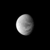
This view from NASA Dawn spacecraft shows a sinuous canyon in the southern hemisphere of Ceres, south of Yalode Crater.

This image shows part of the floor of Melas Chasma. Layered materials and sand are common in this section of canyon
This 2001 Mars Odyssey THEMIS VIS image crosses Coprates Chasma, showing both floor and wall features of the canyon.
NASA's Mars Reconnaissance Orbiter (MRO) observed this image of Ganges Chasma in the northeast portion of Valles Marineris, and opens into outflow channels that flowed to the north. Scattered hills on the canyon floor may be remnants of chaos terrain that formed from collapse of the canyon. Some of the bedrock has diverse colors. More information is available at https://photojournal.jpl.nasa.gov/catalog/PIA22536
Today's VIS image shows part of the interior of Candor Chasma. At the bottom of the frame is a bright feature formed by layers of material deposited in the canyon after it formed. Additional darker material is likely sand blown into the canyon and eroded from rocks within the chasma. Candor Chasma is just one of the canyons that make up Valles Marineris. Orbit Number: 71344 Latitude: -6.20728 Longitude: 285.115 Instrument: VIS Captured: 2018-01-13 14:41 https://photojournal.jpl.nasa.gov/catalog/PIA22388
Melas Chasma is part of the largest canyon system on Mars, Valles Marineris. At only 563 km long (349 miles) it is not the longest canyon, but it is the widest. Located in the center of Valles Marineris, it has depths up to 9 km below the surrounding plains, and is the location of many large landslide deposits, as will as layered materials and sand dunes. There is evidence of both water and wind action as modes of formation for many of the interior deposits. Today's image contains a large region of dunes between the canyon cliff face and the large ridge of material at the mid-elevation of the canyon. Fine materials have been concentrated into the dunes. The Odyssey spacecraft has spent over 15 years in orbit around Mars, circling the planet more than 69000 times. It holds the record for longest working spacecraft at Mars. THEMIS, the IR/VIS camera system, has collected data for the entire mission and provides images covering all seasons and lighting conditions. Over the years many features of interest have received repeated imaging, building up a suite of images covering the entire feature. From the deepest chasma to the tallest volcano, individual dunes inside craters and dune fields that encircle the north pole, channels carved by water and lava, and a variety of other feature, THEMIS has imaged them all. For the next several months the image of the day will focus on the Tharsis volcanoes, the various chasmata of Valles Marineris, and the major dunes fields. We hope you enjoy these images! Orbit Number: 26525 Latitude: -11.3125 Longitude: 285.57 Instrument: VIS Captured: 2007-12-07 07:23 https://photojournal.jpl.nasa.gov/catalog/PIA22134
This VIS image shows part of the central region of Tithonium Chasma. The steep wall of the canyon is visible at the top of the image. The top of the canyon walls are layered, mostly likely by numerous volcanic flows. This material is more resistant and forms the ridges extending down the canyon walls. A large landslide deposit covers the right side of the image. An eroded mound on the floor of the canyon exists at the bottom left of the image. The initial formation of the mound was possibly created of air fall of dust, sand, and volcanic materials and water lain materials. Tithonium Chasma is at the western end of Valles Marineris. Valles Marineris is over 4000 kilometers long, wider than the United States. Tithonium Chasma is almost 810 kilometers long (499 miles), 50 kilometers wide and over 6 kilometers deep. In comparison, the Grand Canyon in Arizona is about 175 kilometers long, 30 kilometers wide, and only 2 kilometers deep. The canyons of Valles Marineris were formed by extensive fracturing and pulling apart of the crust during the uplift of the vast Tharsis plateau. Landslides have enlarged the canyon walls and created deposits on the canyon floor. Weathering of the surface and influx of dust and sand have modified the canyon floor. The Odyssey spacecraft has spent over 15 years in orbit around Mars, circling the planet more than 71,000 times. It holds the record for longest working spacecraft at Mars. THEMIS, the IR/VIS camera system, has collected data for the entire mission and provides images covering all seasons and lighting conditions. Over the years many features of interest have received repeated imaging, building up a suite of images covering the entire feature. From the deepest chasma to the tallest volcano, individual dunes inside craters and dune fields that encircle the north pole, channels carved by water and lava, and a variety of other feature, THEMIS has imaged them all. For the next several months the image of the day will focus on the Tharsis volcanoes, the various chasmata of Valles Marineris, and the major dunes fields. We hope you enjoy these images! Orbit Number: 3187 Latitude: -4.15004 Longitude: 272.043 Instrument: VIS Captured: 2002-09-02 21:33 https://photojournal.jpl.nasa.gov/catalog/PIA22267
Today's VIS image crosses both Ophir Chasma (top) and Candor Chasma (bottom). Layered and eroded material covers the floors of both chasmata. Both canyons are part of Valles Marineris. Often called the grand canyon of Mars, Valles Marineris extends over 3,000 kilometers (1864 miles) long, spans as much as 600 kilometers across, and as deep as 8 kilometers. By comparison, the Earth's Grand Canyon in Arizona, USA is 800 kilometers long, 30 kilometers across, and 1.8 kilometers deep. Orbit Number: 84551 Latitude: -4.18643 Longitude: 286.548 Instrument: VIS Captured: 2021-01-05 04:50 https://photojournal.jpl.nasa.gov/catalog/PIA24404
This VIS image shows part of Tithonium Chasma. The ridge visible at the top of the image is not the top of the canyon. The top of the canyon is off the image to the north. A lobate "tongue" visible between the ridge and the top of the canyon is the deposit left by a landslide event. This material is more resistant and forms the ridges extending down the canyon walls. Eroded materials cover much of the canyon floor. The initial formation of layered floor desposits was possibly created of air fall of dust, sand, and volcanic materials and water lain materials. The weathering of these deposits is probably by the wind. Loose sand and dust can be seen in other portions of this image. Tithonium Chasma is at the western end of Valles Marineris. Valles Marineris is over 4000 kilometers long, wider than the United States. Tithonium Chasma is almost 810 kilometers long (499 miles), 50 kilometers wide and over 6 kilometers deep. In comparison, the Grand Canyon in Arizona is about 175 kilometers long, 30 kilometers wide, and only 2 kilometers deep. The canyons of Valles Marineris were formed by extensive fracturing and pulling apart of the crust during the uplift of the vast Tharsis plateau. Landslides have enlarged the canyon walls and created deposits on the canyon floor. Weathering of the surface and influx of dust and sand have modified the canyon floor, both creating and modifying layered materials. The Odyssey spacecraft has spent over 15 years in orbit around Mars, circling the planet more than 71,000 times. It holds the record for longest working spacecraft at Mars. THEMIS, the IR/VIS camera system, has collected data for the entire mission and provides images covering all seasons and lighting conditions. Over the years many features of interest have received repeated imaging, building up a suite of images covering the entire feature. From the deepest chasma to the tallest volcano, individual dunes inside craters and dune fields that encircle the north pole, channels carved by water and lava, and a variety of other feature, THEMIS has imaged them all. For the next several months the image of the day will focus on the Tharsis volcanoes, the various chasmata of Valles Marineris, and the major dunes fields. We hope you enjoy these images! Orbit Number: 3212 Latitude: -4.46108 Longitude: 271.004 Instrument: VIS Captured: 2002-09-04 22:56 https://photojournal.jpl.nasa.gov/catalog/PIA22268
Tithonium Chasma has numerous large landslide deposits. The resistant material of the plateau surface forms the linear ridges of the canyon wall. Large landslides have changed the walls and floor of the canyon. A landslide is a failure of slope due to gravity. They initiate due to several reasons. A lower layer of poorly cemented/resistant material may have been eroded, undermining the wall above which then collapses; earth quake seismic waves can cause the slope to collapse; and even an impact event near the canyon wall can cause collapse. As millions of tons of material fall and slide down slope a scalloped cavity forms at the upper part where the slope failure occurred. At the material speeds downhill it will pick up more of the underlying slope, increasing the volume of material entrained into the landslide. Whereas some landslides spread across the canyon floor forming lobate deposits, very large volume slope failures will completely fill the canyon floor in a large complex region of chaotic blocks. This VIS image shows the result of this type of landslide. Tithonium Chasma is at the western end of Valles Marineris. Valles Marineris is over 4000 kilometers long, wider than the United States. Tithonium Chasma is almost 810 kilometers long (499 miles), 50 kilometers wide and over 6 kilometers deep. In comparison, the Grand Canyon in Arizona is about 175 kilometers long, 30 kilometers wide, and only 2 kilometers deep. The canyons of Valles Marineris were formed by extensive fracturing and pulling apart of the crust during the uplift of the vast Tharsis plateau. Landslides have enlarged the canyon walls and created deposits on the canyon floor. Weathering of the surface and influx of dust and sand have modified the canyon floor, both creating and modifying layered materials. The Odyssey spacecraft has spent over 15 years in orbit around Mars, circling the planet more than 71,000 times. It holds the record for longest working spacecraft at Mars. THEMIS, the IR/VIS camera system, has collected data for the entire mission and provides images covering all seasons and lighting conditions. Over the years many features of interest have received repeated imaging, building up a suite of images covering the entire feature. From the deepest chasma to the tallest volcano, individual dunes inside craters and dune fields that encircle the north pole, channels carved by water and lava, and a variety of other feature, THEMIS has imaged them all. For the next several months the image of the day will focus on the Tharsis volcanoes, the various chasmata of Valles Marineris, and the major dunes fields. We hope you enjoy these images! Orbit Number: 18239 Latitude: -4.4678 Longitude: 273.788 Instrument: VIS Captured: 2006-01-24 01:55 https://photojournal.jpl.nasa.gov/catalog/PIA22271
Cracks, canyons, craters, and streaks are seen in this image of Saturn icy moon, Dione, taken from Voyager 2 on August 3, 2005.
These layered deposits are located on the floor of a large canyon called Ganges Chasma which is a part of the Valles Marineris in this image captured by NASA 2001 Mars Odyssey spacecraft.
This image from NASA Mars Odyssey spacecraft covers part of Tithonium Chasma, which is part of the Valles Marineris system of canyons that stretch for thousands of kilometers.
Melas Chasma is the widest segment of the Valles Marineris canyon, and is an area where NASA Mars Reconnaissance Orbiter has detected the presence of sulfates.
This image from NASA 2001 Mars Odyssey spacecraft shows part of Coprates Chasma, which is just one part of the extensive Valles Marineris canyon system.
This image shows part of Ganges Chasma. Several landslides occur at the top of the image, while dunes and canyon floor deposits are visible at the bottom of the image
This image from NASA Mars Odyssey spacecraft shows the northern interior wall of Coprates Chasma, one of the major canyons that form Valles Marineris.

This image taken by NASA 2001 Mars Odyssey of Ganges Chasma shows where a large portion of the canyon wall has given way and formed a landslide deposit.
This colorful scene is situated in the Noctis Labyrinthus, perched high on the Tharsis rise in the upper reaches of the Valles Marineris canyon system as seen by NASA Mars Reconnaissance Orbiter.
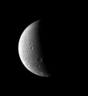
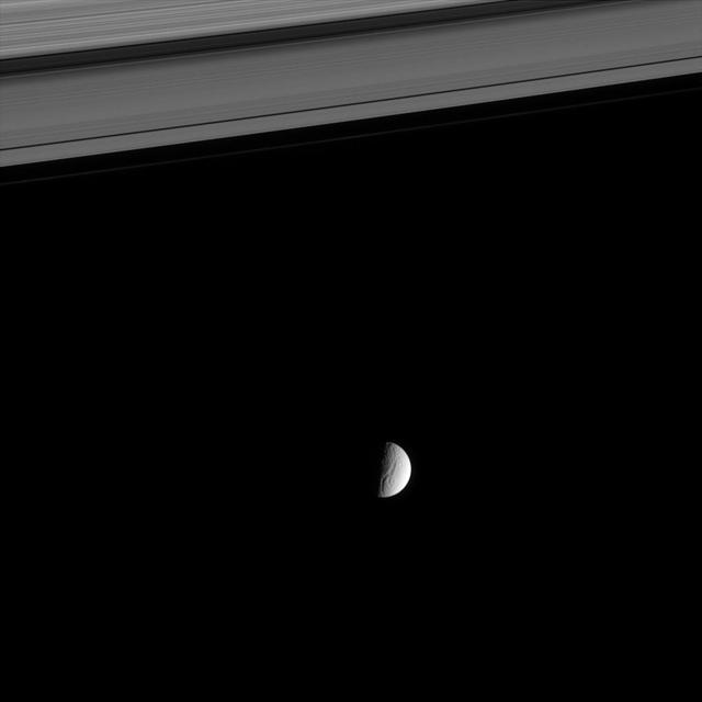
Dione looks lovely half lit in this portrait from the Cassini spacecraft. Just visible is a long canyon running southward just left of the terminator
Juventae Chasma is a giant box canyon, yet a relatively small segment of the enormous Valles Marineris system, seen here by NASA Mars Reconnaissance Orbiter.
Ages ago, a giant earthquake shook the walls of Valles Marineris, the Grand Canyon of Mars, and triggered a catastrophic landslide that crashed down 15,000 feet.
This image captured by NASA 2001 Mars Odyssey spacecraft shows a portion of the western margin of Ophir Chasma. Layering can be seen in the upper walls of the canyon.
The image from NASA Mars Reconnaissance Orbiter is approximately 6 by 6 kilometers and is located east of Noctis Labyrinthus, in a portion the large canyon system Valles Marineris.
Dune forms cover the top of this sand sheet on the floor of Juventae Chasma, a chasma north of the Valles Marineris canyon system in this image from NASA Mars Odyssey.
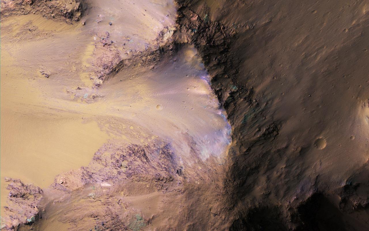
This image shows the southern wall of Coprates Chasma, in the equatorial canyon system of Valles Marineris. While much of the lower slopes are covered by sand, exposed bedrock is clearly visible in the upper canyon walls. In an enhanced color image, the varying colors – shades of white, cyan, and purple – are suggestive of multiple minerals being present within the bedrock, indicating a complicated geologic history, possibly involving alteration by water. (In this cutout, north is down.) https://photojournal.jpl.nasa.gov/catalog/PIA25985
This VIS image runs from northern Juventae Chasma to just short of the southern canyon wall. Illustrating the variety of landforms within the chasma, this image contains the rough canyon floor at the northern extent of the chasma, layered materials in the center of the image and dunes located in the southern, deepest section of the chasma. Orbit Number: 71356 Latitude: -3.55335 Longitude: 298.389 Instrument: VIS Captured: 2018-01-14 14:25 https://photojournal.jpl.nasa.gov/catalog/PIA22381
Today's VIS image shows part of the canyon wall of Melas Chasma. Orbit Number: 65682 Latitude: -9.38343 Longitude: 289.417 Instrument: VIS Captured: 2016-10-04 02:52 http://photojournal.jpl.nasa.gov/catalog/PIA21181
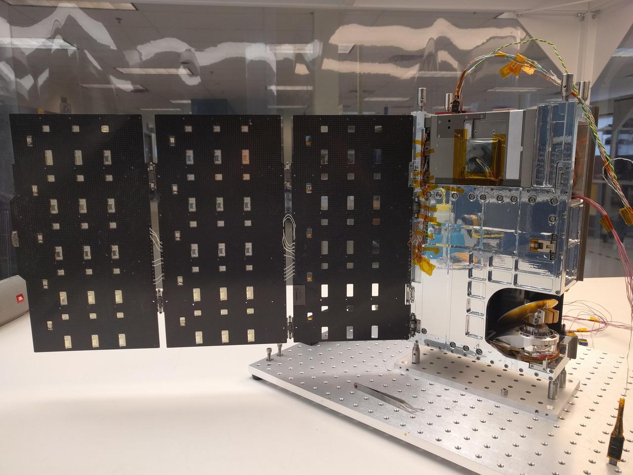
The complete TEMPEST-D spacecraft shown with the solar panels deployed. RainCube, CubeRRT and TEMPEST-D are currently integrated aboard Orbital ATKs Cygnus spacecraft and are awaiting launch on an Antares rocket. After the CubeSats have arrived at the station, they will be deployed into low-Earth orbit and will begin their missions to test these new technologies useful for predicting weather, ensuring data quality, and helping researchers better understand storms. https://photojournal.jpl.nasa.gov/catalog/PIA22458

Today's VIS image shows a cross section of Coprates Chasma. The floor of the canyon is covered by large landslide deposits. Coprates Chasma is one of the numerous canyons that make up Valles Marineris. The chasma stretches for 960 km (600 miles) from Melas Chasma to the west and Capri Chasma to the east. Paralleling the chasma to the south runs a narrower and shallower chain of linked pits and depressions called Coprates Catena. Orbit Number: 93011 Latitude: -14.3186 Longitude: 299.989 Instrument: VIS Captured: 2022-12-02 19:04 https://photojournal.jpl.nasa.gov/catalog/PIA25811
Continuing eastward along Ius Chasma, this section of the canyon floor has been completely filled by blocky deposits from large volume landslides. A landslide is a failure of slope due to gravity. They initiate due to several reasons. A lower layer of poorly cemented/resistant material may have been eroded, undermining the wall above which then collapses; earth quake seismic waves can cause the slope to collapse; and even an impact event near the canyon wall can cause collapse. As millions of tons of material fall and slide down slope a scalloped cavity forms at the upper part where the slope failure occurred. At the material speeds downhill it will pick up more of the underlying slope, increasing the volume of material entrained into the landslide. Whereas some landslides spread across the canyon floor forming lobate deposits, very large volume slope failures will completely fill the canyon floor in a large complex region of chaotic blocks. Ius Chasma is at the western end of Valles Marineris, south of Tithonium Chasma. Valles Marineris is over 4000 kilometers long, wider than the United States. Ius Chasma is almost 850 kilometers long (528 miles), 120 kilometers wide and over 8 kilometers deep. In comparison, the Grand Canyon in Arizona is about 175 kilometers long, 30 kilometers wide, and only 2 kilometers deep. The canyons of Valles Marineris were formed by extensive fracturing and pulling apart of the crust during the uplift of the vast Tharsis plateau. Landslides have enlarged the canyon walls and created deposits on the canyon floor. Weathering of the surface and influx of dust and sand have modified the canyon floor, both creating and modifying layered materials. There are many features that indicate flowing and standing water played a part in the chasma formation. The Odyssey spacecraft has spent over 15 years in orbit around Mars, circling the planet more than 71,000 times. It holds the record for longest working spacecraft at Mars. THEMIS, the IR/VIS camera system, has collected data for the entire mission and provides images covering all seasons and lighting conditions. Over the years many features of interest have received repeated imaging, building up a suite of images covering the entire feature. From the deepest chasma to the tallest volcano, individual dunes inside craters and dune fields that encircle the north pole, channels carved by water and lava, and a variety of other feature, THEMIS has imaged them all. For the next several months the image of the day will focus on the Tharsis volcanoes, the various chasmata of Valles Marineris, and the major dunes fields. We hope you enjoy these images! Orbit Number: 17041 Latitude: -6.50422 Longitude: 272.124 Instrument: VIS Captured: 2005-10-17 10:40 https://photojournal.jpl.nasa.gov/catalog/PIA22278
This VIS image of Tithonium Chasma shows the canyon wall at the top of the frame, a series of landslide deposits in the middle, and an eroded mound of materials at the bottom. The mound has been eroded, most likely by wind action. Tithonium Chasma has numerous large landslide deposits. The resistant material of the plateau surface forms the linear ridges of the canyon wall. Large landslides have changed the walls and floor of the canyon. A landslide is a failure of slope due to gravity. They initiate due to several reasons. A lower layer of poorly cemented/resistant material may have been eroded, undermining the wall above which then collapses; earth quake seismic waves can cause the slope to collapse; and even an impact event near the canyon wall can cause collapse. As millions of tons of material fall and slide down slope a scalloped cavity forms at the upper part where the slope failure occurred. At the material speeds downhill it will pick up more of the underlying slope, increasing the volume of material entrained into the landslide. Whereas some landslides spread across the canyon floor forming lobate deposits, very large volume slope failures will completely fill the canyon floor in a large complex region of chaotic blocks. Tithonium Chasma is at the western end of Valles Marineris. Valles Marineris is over 4000 kilometers long, wider than the United States. Tithonium Chasma is almost 810 kilometers long (499 miles), 50 kilometers wide and over 6 kilometers deep. In comparison, the Grand Canyon in Arizona is about 175 kilometers long, 30 kilometers wide, and only 2 kilometers deep. The canyons of Valles Marineris were formed by extensive fracturing and pulling apart of the crust during the uplift of the vast Tharsis plateau. Landslides have enlarged the canyon walls and created deposits on the canyon floor. Weathering of the surface and influx of dust and sand have modified the canyon floor, both creating and modifying layered materials. The Odyssey spacecraft has spent over 15 years in orbit around Mars, circling the planet more than 71,000 times. It holds the record for longest working spacecraft at Mars. THEMIS, the IR/VIS camera system, has collected data for the entire mission and provides images covering all seasons and lighting conditions. Over the years many features of interest have received repeated imaging, building up a suite of images covering the entire feature. From the deepest chasma to the tallest volcano, individual dunes inside craters and dune fields that encircle the north pole, channels carved by water and lava, and a variety of other feature, THEMIS has imaged them all. For the next several months the image of the day will focus on the Tharsis volcanoes, the various chasmata of Valles Marineris, and the major dunes fields. We hope you enjoy these images! Orbit Number: 25964 Latitude: -4.26209 Longitude: 270.721 Instrument: VIS Captured: 2007-10-22 02:44 https://photojournal.jpl.nasa.gov/catalog/PIA22273
Moving into the central part of Ius Chasma, the canyon profile changes. What started as a large graben south of the main chasma wall, has widened to create a central high ridge separating the chasm into two parallel sections. This interior ridge is called Geryon Montes. The northern canyon wall is at the top of the image, including several tongue shaped landslide deposits. The floor has been covered in deposits that may include landslide material and later materials such as air fall particles like dust and water lain layered deposits. The Geryon Montes are in the lower 1/3 of the image. Just to the top of the Montes are materials with different "colors". These are part of the layered materials inside the canyon. At the very bottom of the image a highly eroded landslide deposit exists. The materials on this side of Geryon Montes are at a higher elevation than the floor on the opposite side. The unusual texture of the canyon floor also points to layered materials that may have been laid down in standing water. A landslide is a failure of slope due to gravity. They initiate due to several reasons. A lower layer of poorly cemented/resistant material may have been eroded, undermining the wall above which then collapses; earth quake seismic waves can cause the slope to collapse; and even an impact event near the canyon wall can cause collapse. As millions of tons of material fall and slide down slope a scalloped cavity forms at the upper part where the slope failure occurred. At the material speeds downhill it will pick up more of the underlying slope, increasing the volume of material entrained into the landslide. Whereas some landslides spread across the canyon floor forming lobate deposits, very large volume slope failures will completely fill the canyon floor in a large complex region of chaotic blocks. Ius Chasma is at the western end of Valles Marineris, south of Tithonium Chasma. Valles Marineris is over 4000 kilometers long, wider than the United States. Ius Chasma is almost 850 kilometers long (528 miles), 120 kilometers wide and over 8 kilometers deep. In comparison, the Grand Canyon in Arizona is about 175 kilometers long, 30 kilometers wide, and only 2 kilometers deep. The canyons of Valles Marineris were formed by extensive fracturing and pulling apart of the crust during the uplift of the vast Tharsis plateau. Landslides have enlarged the canyon walls and created deposits on the canyon floor. Weathering of the surface and influx of dust and sand have modified the canyon floor, both creating and modifying layered materials. There are many features that indicate flowing and standing water played a part in the chasma formation. The Odyssey spacecraft has spent over 15 years in orbit around Mars, circling the planet more than 71,000 times. It holds the record for longest working spacecraft at Mars. THEMIS, the IR/VIS camera system, has collected data for the entire mission and provides images covering all seasons and lighting conditions. Over the years many features of interest have received repeated imaging, building up a suite of images covering the entire feature. From the deepest chasma to the tallest volcano, individual dunes inside craters and dune fields that encircle the north pole, channels carved by water and lava, and a variety of other feature, THEMIS has imaged them all. For the next several months the image of the day will focus on the Tharsis volcanoes, the various chasmata of Valles Marineris, and the major dunes fields. We hope you enjoy these images! Orbit Number: 26151 Latitude: -7.12079 Longitude: 275.703 Instrument: VIS Captured: 2007-11-06 12:17 https://photojournal.jpl.nasa.gov/catalog/PIA22280
This VIS image shows part of the southern cliffside of Melas Chasma. Melas Chasma is part of the largest canyon system on Mars, Valles Marineris. At only 563 km long (349 miles) it is not the longest canyon, but it is the widest. Located in the center of Valles Marineris, it has depths up to 9 km below the surrounding plains, and is the location of many large landslide deposits, as will as layered materials and sand dunes. There is evidence of both water and wind action as modes of formation for many of the interior deposits. Orbit Number: 81537 Latitude: -11.3482 Longitude: 284.901 Instrument: VIS Captured: 2020-05-02 01:42 https://photojournal.jpl.nasa.gov/catalog/PIA23992