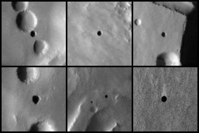
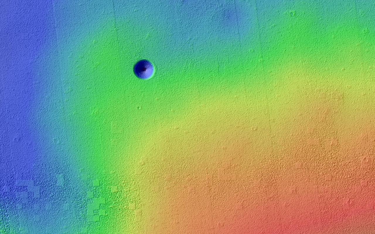
Seven Possible Cave Skylights on Mars
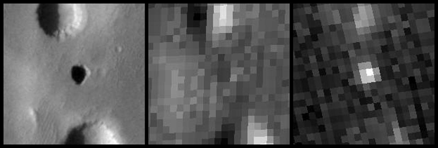
Temperature Behavior of Possible Cave Skylight on Mars
Computer Automatic Virtual Environment, CAVE Tours to Mark the 30th Anniversary of the Graphics and Visualization Lab, GVIS

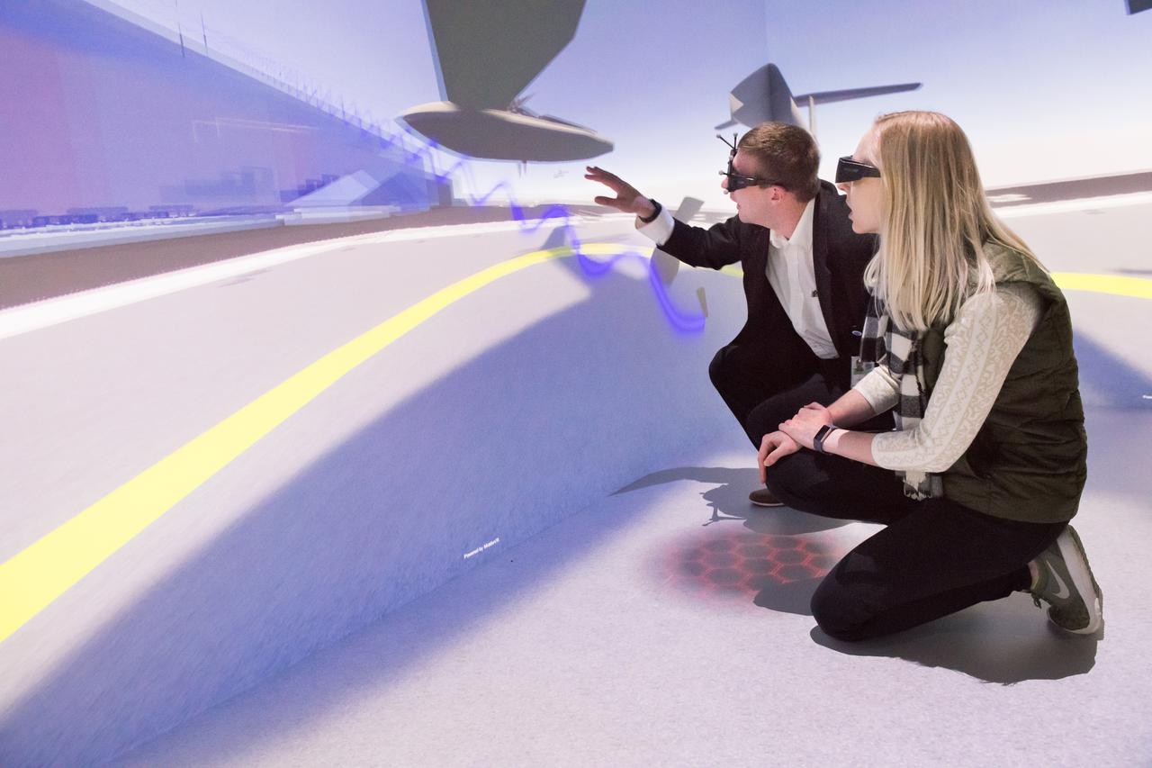
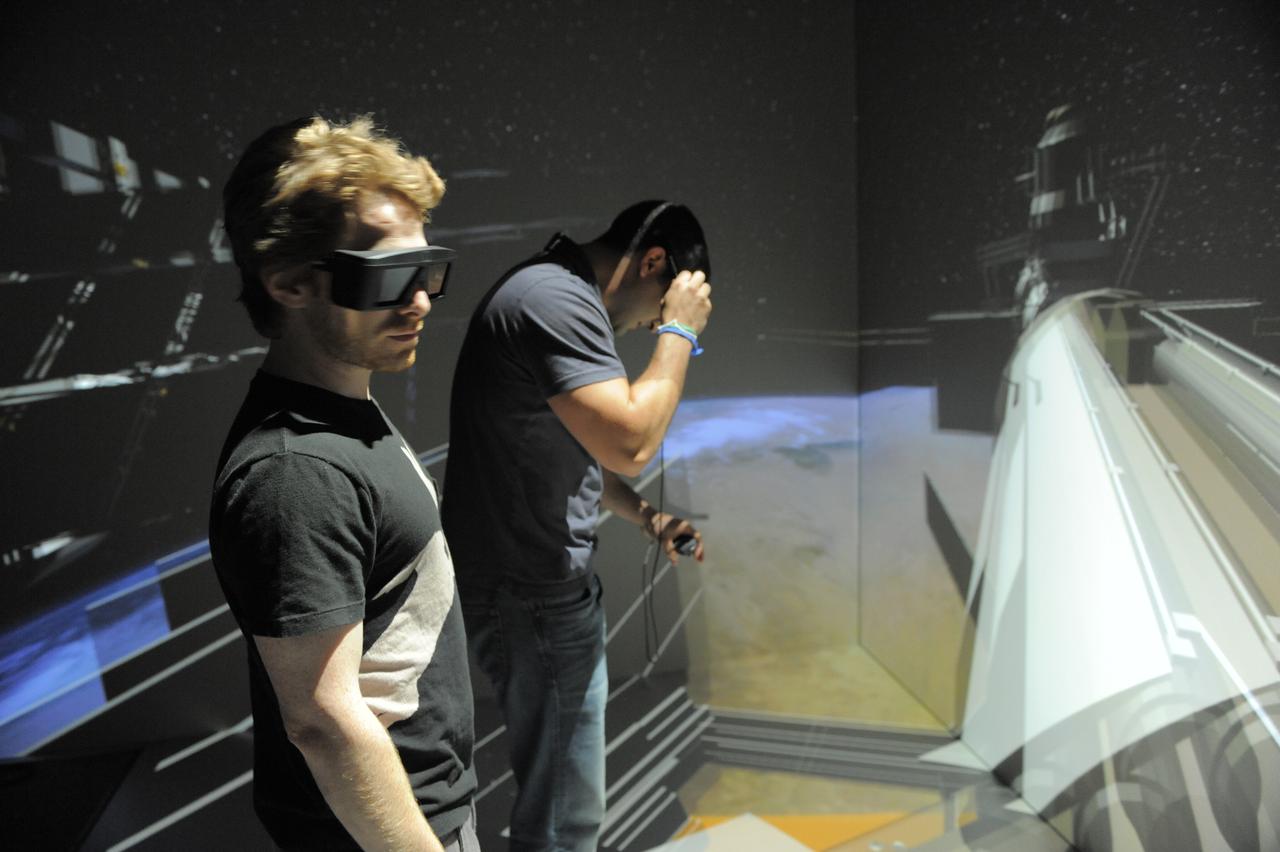
Virtual Reality (VR) can provide cost effective methods to design and evaluate components and systems for maintenance and refurbishment operations. Marshall SPace Flight Center (MSFC) is begirning to utilize VR for design analysis in the X-34 experimental reusable space vehicle. Analysts at MSFC's Computer Applications and Virtual Environments (CAVE) used Head Mounted Displays (HMD) (pictured), spatial trackers and gesture inputs as a means to animate or inhabit a properly sized virtual human model. These models are used in a VR scenario as a way to determine functionality of space and maintenance requirements for the virtual X-34. The primary functions of the virtual X-34 mockup is to support operations development and design analysis for engine removal, the engine compartment and the aft fuselage. This capability provides general visualization support to engineers and designers at MSFC and to the System Design Freeze Review at Orbital Sciences Corporation (OSC).

Virtual Reality (VR) can provide cost effective methods to design and evaluate components and systems for maintenance and refurbishment operations. Marshall Spce Flight Center (MSFC) is begirning to utilize VR for design analysis in the X-34 experimental reusable space vehicle. Analysts at MSFC's Computer Applications and Virtual Environments (CAVE) used Head Mounted Displays (HMD) (pictured), spatial trackers and gesture inputs as a means to animate or inhabit a properly sized virtual human model. These models are used in a VR scenario as a way to determine functionality of space and maintenance requirements for the virtual X-34. The primary functions of the virtual X-34 mockup is to support operations development and design analysis for engine removal, the engine compartment and the aft fuselage. This capability provides general visualization support to engineers and designers at MSFC and to the System Design Freeze Review at Orbital Sciences Corporation (OSC).

This image of the Eagle nebula shows the self-emission of the intensely cold nebula gas and dust as never seen before; the nebula intricate tendril nature, with vast cavities forms an almost cave-like surrounding to the famous pillars.

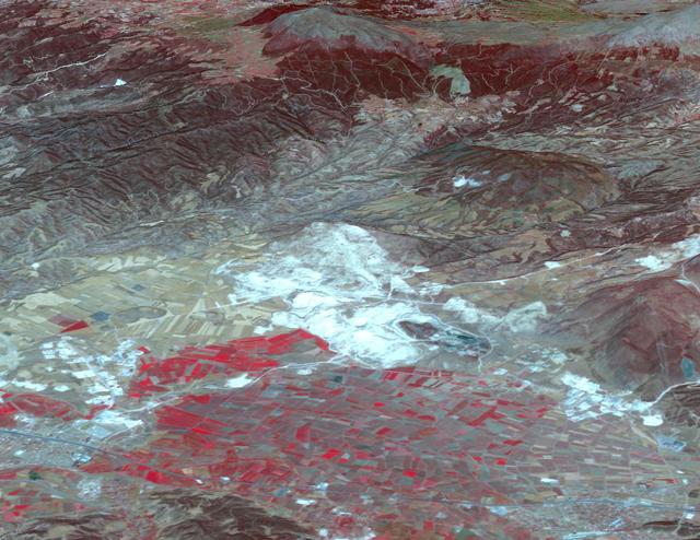
The Naica mine in Chihuahua, Mexico, with its enormous gypsum crystals, may well be called the "Queen of the Giant Crystals localities." Though the Naica mine is no show mine, but still a working lead-zinc mine hosted in layered limestones, the first of several crystal caves was discovered in 1910. This "Cave of the Swords" contained extraordinary large sword-like selenite (gypsum) crystals up to 2 m long. In 2000 another crystal cave system was discovered at 300 m depth, even more spectacular than the original cave. Inside were free growing gypsum crystals up to 12 m long and 2 m in diameter. The ASTER image uses SWIR bands 4, 6, and 8 in RGB. Limestone is displayed in yellow-green colors, vegetation is red. The image was acquired February 16, 2004, covers an area of 26 x 23.5 km, and is located near 27.8 degrees north latitude, 105.5 degrees west longitude. The photo of crystals was taken from: http://www.thatcrystalsite.com/. http://photojournal.jpl.nasa.gov/catalog/PIA10615
Pavonis Mons is a giant shield volcano similar to although larger than those on the Big Island of Hawaii. This image is from NASA Mars Reconnaissance Orbiter.
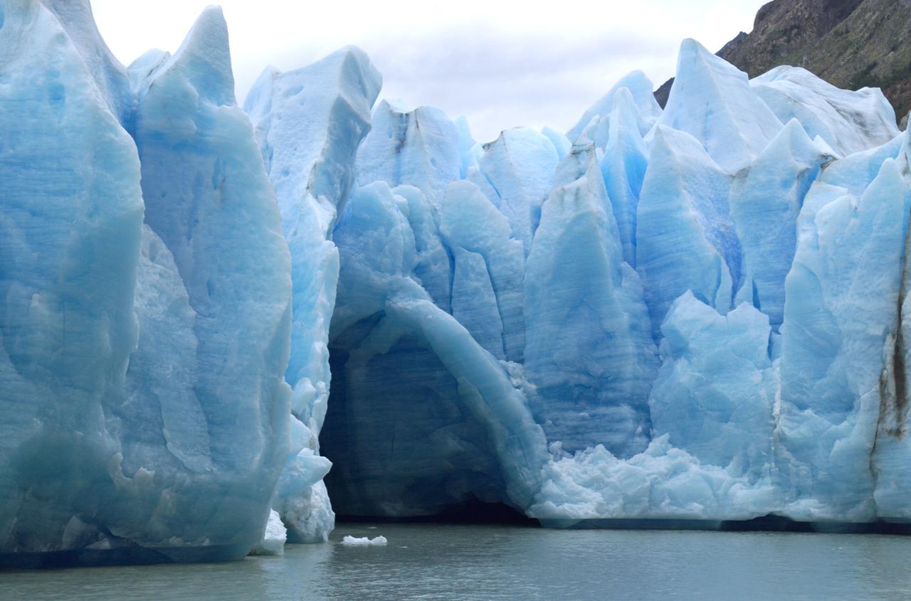
A cave in Glacier Grey in Torres del Paine National Park, seen during NASA's AirSAR 2004 campaign in Chile. AirSAR 2004 is a three-week expedition in Central and South America by an international team of scientists that is using an all-weather imaging tool, called the Airborne Synthetic Aperture Radar (AirSAR), located onboard NASA's DC-8 airborne laboratory. Scientists from many parts of the world are combining ground research with NASA's AirSAR technology to improve and expand on the quality of research they are able to conduct. Founded in 1959, Torres del Paine National Park encompasses 450,000 acres in the Patagonia region of Chile. This region is being studied by NASA using a DC-8 equipped with an Airborne Synthetic Aperture Radar (AirSAR) developed by scientists from NASA’s Jet Propulsion Laboratory. This is a very sensitive region that is important to scientists because the temperature has been consistently rising causing a subsequent melting of the region’s glaciers. AirSAR will provide a baseline model and unprecedented mapping of the region. This data will make it possible to determine whether the warming trend is slowing, continuing or accelerating. AirSAR will also provide reliable information on ice shelf thickness to measure the contribution of the glaciers to sea level.
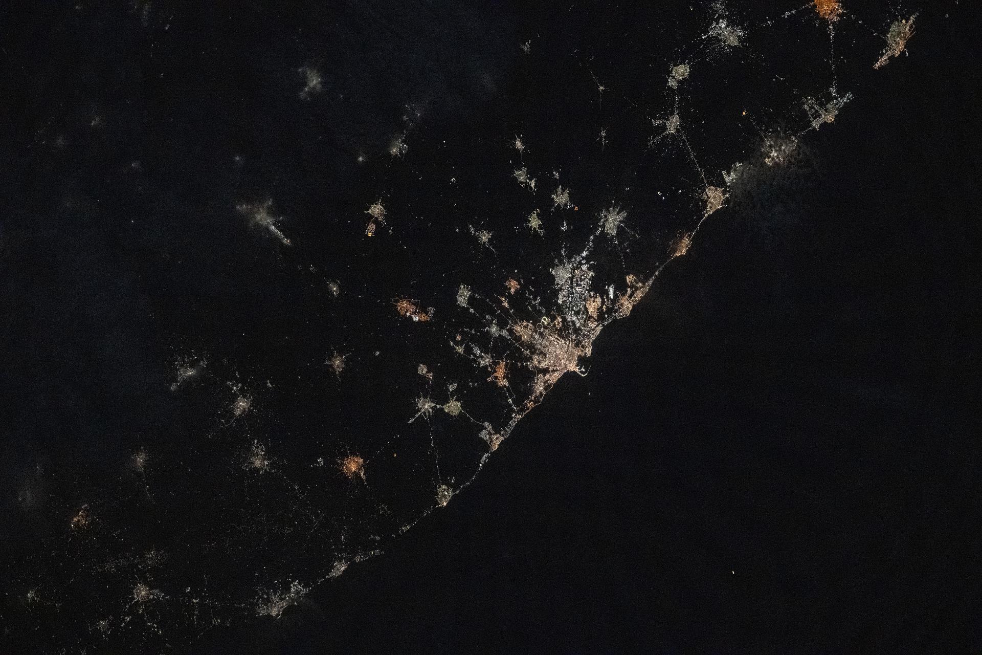
iss073e1047143 (Nov. 2, 2025) --- The city lights of Bari, Italy, and its surrounding suburbs dot the nation's Adriatic Sea coast in this photograph taken from the International Space Station at approximately 10:13 p.m. local time as it orbited 260 miles above the Mediterranean Sea. Founded around 2,700 years ago, Bari is known for its olive groves, vineyards, spectacular caves, and rugged coastal cliffs.

The reproduction process of all strains of influenza are dependent on the same enzyme neuraminidase. Pharmaceutical companies have been developing drugs that can inhibit the function of neuraminidase hoping to create an effective weapon against the flu. Researchers from the pharmaceutical industry and from the Center for Macromolecular Crystallography have grown crystals of neuraminidase in space. These improved, space-grown crystals have provided information that have helped design drugs which form a stronger interaction with the enzyme. These drugs inhibit neuraminidase by attaching themselves to the enzyme. Since the drugs are less likely to detach from the enzyme, they are more effective, require smaller dosages, and have fewer side effects. Shown here is a segmented representation of the neuraminidase inhibitor compound sitting inside a cave-like contour of the neuraminidase enzyme surface. This cave-like formation present in every neuraminidase enzyme is the active site crucial to the flu's ability to infect. The space-grown crystals of neuraminidase have provided significant new details about the three-dimensional characteristics of this active site thus allowing researchers to design drugs that fit tighter into the site. Principal Investigator: Dr. Larry DeLucas

Ribbons is a program developed at UAB used worldwide to graphically depict complicated protein structures in a simplified format. The program uses sophisticated computer systems to understand the implications of protein structures. The Influenza virus remains a major causative agent for a large number of deaths among the elderly and young children and huge economic losses due to illness. Finding a cure will have a general impact both on the basic research of viral pathologists of fast evolving infectious agents and clinical treatment of influenza virus infection. The reproduction process of all strains of influenza are dependent on the same enzyme neuraminidase. Shown here is a segmented representation of the neuraminidase inhibitor compound sitting inside a cave-like contour of the neuraminidase enzyme surface. This cave-like formation present in every neuraminidase enzyme is the active site crucial to the flu's ability to infect. The space-grown crystals of neuraminidase have provided significant new details about the three-dimensional characteristics of this active site thus allowing researchers to design drugs that fit tighter into the site. Principal Investigator: Dr. Larry DeLucas
This image from NASA Mars Reconnaissance Orbiter shows a lava channel, which lies just to the east of the largest volcano in the solar system: Olympus Mons. The channel appears to be discontinuous, meaning it disappears several times throughout its length, but in fact, it is likely that the channel continues underground as a lava tube. These are relatively common features at terrestrial volcanic centers, such as the Big Island of Hawai'i. The channel appears to have been infilled with dust and sand, so that the entrance to a lava tube cave is no longer visible at this particular location; fortunately this has been observed elsewhere on Mars. http://photojournal.jpl.nasa.gov/catalog/PIA19299
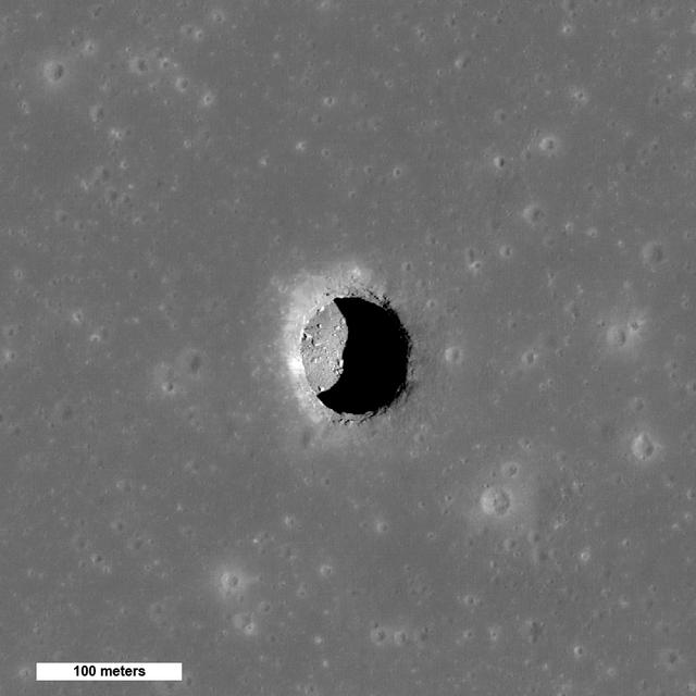
While the moon's surface is battered by millions of craters, it also has over 200 holes – steep-walled pits that in some cases might lead to caves that future astronauts could explore and use for shelter, according to new observations from NASA's Lunar Reconnaissance Orbiter (LRO) spacecraft. This is a spectacular high-Sun view of the Mare Tranquillitatis pit crater revealing boulders on an otherwise smooth floor. This image from LRO's NAC is 400 meters (1,312 feet) wide, north is up. Read more here: <a href="http://1.usa.gov/1ruEYXj" rel="nofollow">1.usa.gov/1ruEYXj</a> Credit: NASA/GSFC/Arizona State University

Local area girl scouts competed in a "Girl Scouts to the Moon and Back" essay contest. The essay contest gave the girls scouts a chance to win a Space Science badge that has actually been to space on NASA's Artemis I mission. After the award ceremony the girl scouts got to tour some of the NASA Glenn facilities. Picture is the "cave" at the Graphics and Visualization Lab, also known as the GRUVE Lab. Looking on is Richard Rinehart who is an engineer who works in the GRUVE LAB and creates 3D simulated experiences that demonstrate NASA's technology.
In western Turkey, Pamukkale travertine pools and terraces form the largest such complex in the world. For thousands of years, people have visited the area due to the attraction of the thermal pools. The ancient Greco-Roman city of Hierapolis was built on top of the travertine formation. The volcanic activity which causes the hot springs, forced carbon dioxide into a cave, which was called the place of the god Pluto, and instantly killed any animals (and people) that ventured in. The perspective image was acquired May 25, 2021, and is located at 37.9 degrees north, 29.1 degrees east. https://photojournal.jpl.nasa.gov/catalog/PIA24868
STS089-703-007 (22-32 Jan. 1998) --- This picture of southern Australia was photographed with a 70mm handheld camera from the Earth-orbiting space shuttle Endeavour. The Nullarbor Plain (behind the boom of Russia’s Mir Space Station) has been one of the least photographed features of the continents. The coastal escarpment rises abruptly to 500 feet above sea level. The limestone bedrock has been dissolved away along fractures and joints. In this photo of the western Australian Bight, solution grooves can be seen to have localized sand deposits in long bands. Both inland and along the coast, rounded sinkholes and depressions attest to solution of the surficial limestone’s; "karst" is the term for this kind of terrain. Caves such as Cocklebiddy and Weebubbie are common along the coast and linear passages, formed by dissolution of joints, commonly connect rooms. Photo credit: NASA

Virtual Reality (VR) can provide cost effective methods to design and evaluate components and systems for maintenance and refurbishment operations. The Marshall Space Flight Centerr (MSFC) in Huntsville, Alabama began to utilize VR for design analysis in the X-34 experimental reusable space vehicle. Analysts at MSFC's Computer Applications and Virtual Environments (CAVE) used Head Mounted Displays (HMD) (pictured), spatial trackers and gesture inputs as a means to animate or inhabit a properly sized virtual human model. These models were used in a VR scenario as a way to determine functionality of space and maintenance requirements for the virtual X-34. The primary functions of the virtual X-34 mockup was to support operations development and design analysis for engine removal, the engine compartment and the aft fuselage. This capability provided general visualization support to engineers and designers at MSFC and to the System Design Freeze Review at Orbital Sciences Corporation (OSC). The X-34 program was cancelled in 2001.
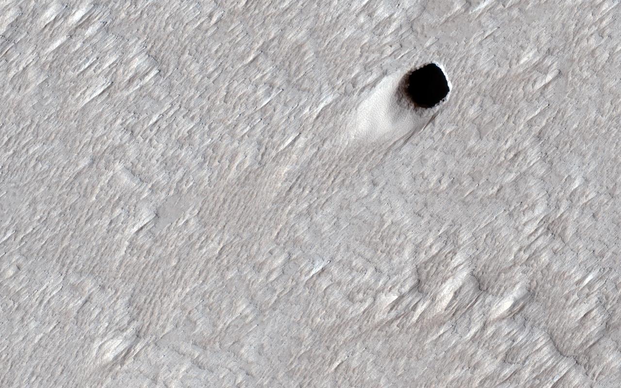
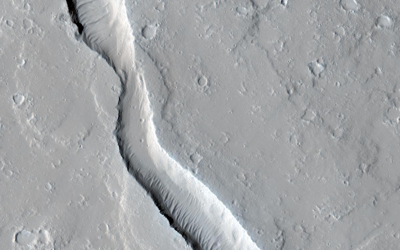
Some types of lava can squeeze underneath older rock and lift it up so it can continue to flow underground. Large underground rivers of lava can form this way and when the volcano stops erupting, the lava can drain out of these underground tubes. These empty underground tubes are common on the Earth and may criss-cross the giant volcanoes of Mars like in this location on the flanks of Arsia Mons. In this image, the ceiling of the lava tube collapsed in one spot and made this pit crater. The pit is about 50 meters (150 feet) across, so it's likely that the underground tube is also at least this big (much bigger than similar caves on the Earth). HiRISE can't see inside these steep pits because it's always late afternoon when we pass overhead and the inside is shadowed at that time of day. https://photojournal.jpl.nasa.gov/catalog/PIA24149
Seth Green in NASA Goddard’s CAVE – an immersive stereographic (3-D) visualization environment. Seth and his wife, Clare Grant visited Goddard Space Flight Center on Tuesday, May 24, 2011. Credit: NASA/GSFC/Pat Izzo <b><a href="http://www.nasa.gov/centers/goddard/home/index.html" rel="nofollow">NASA Goddard Space Flight Center</a></b> enables NASA’s mission through four scientific endeavors: Earth Science, Heliophysics, Solar System Exploration, and Astrophysics. Goddard plays a leading role in NASA’s accomplishments by contributing compelling scientific knowledge to advance the Agency’s mission. <b>Follow us on <a href="http://twitter.com/NASA_GoddardPix" rel="nofollow">Twitter</a></b> <b>Join us on <a href="http://www.facebook.com/pages/Greenbelt-MD/NASA-Goddard/395013845897?ref=tsd" rel="nofollow">Facebook</a></b>
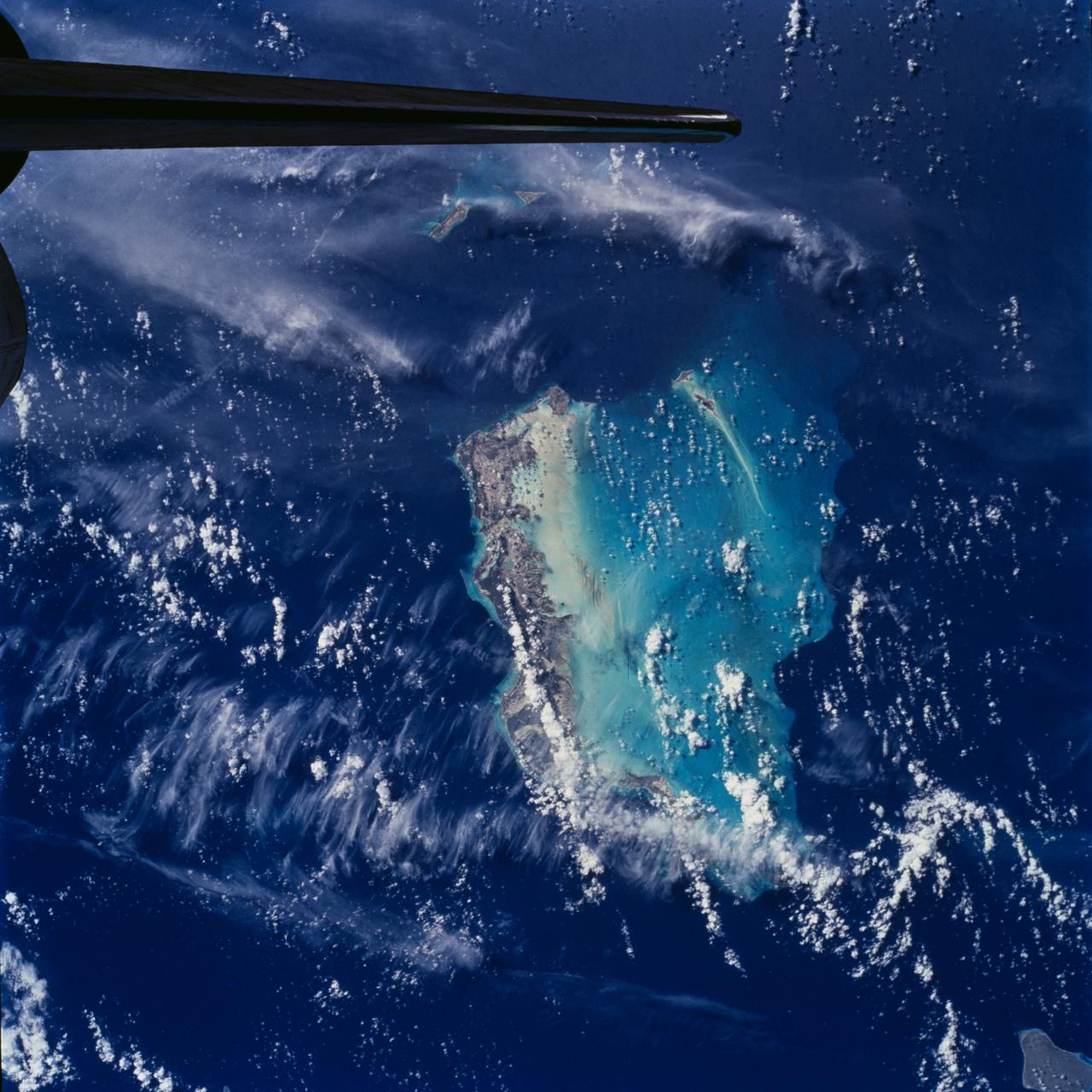
STS100-708-78 (19 April-1 May 2001) --- Southwest of the Bahamas and north of Hispaniola lie the Turks and Caicos Islands, photographed by the astronaut/cosmonaut crew aboard the Earth-orbiting Space Shuttle Endeavour. In this view, the extensive shallow water areas of Caicos Bank (turquoise blue) dominate to the south of the Caicos Islands. Caicos Bank covers an area of 7,680 square kilometers (1.9 million acres). The coral reefs of Caicos are primarily along the north deep water edge of the islands, and in a barrier along the south margin of the bank. The area is known for its marine caves and blowholes. To the east of Caicos Bank, near the tail of the Shuttle, is the island of Grand Turk, part of the much smaller Turks Bank. The channel that runs between the two banks is more than 2,200 meters (1.4 miles) deep.

Virtual Reality (VR) can provide cost effective methods to design and evaluate components and systems for maintenance and refurbishment operations. The Marshall Space Flight Center (MSFC) in Huntsville, Alabama began to utilize VR for design analysis in the X-34 experimental reusable space vehicle. Analysts at MSFC's Computer Applications and Virtual Environments (CAVE) used Head Mounted Displays (HMD) (pictured), spatial trackers and gesture inputs as a means to animate or inhabit a properly sized virtual human model. These models were used in a VR scenario as a way to determine functionality of space and maintenance requirements for the virtual X-34. The primary functions of the virtual X-34 mockup was to support operations development and design analysis for engine removal, the engine compartment and the aft fuselage. This capability providedgeneral visualization support to engineers and designers at MSFC and to the System Design Freeze Review at Orbital Sciences Corporation (OSC). The X-34 program was cancelled in 2001.

A burner rig heats up a material sample in the Materials and Stresses Building at the National Aeronautics and Space Administration (NASA) Lewis Research Center. Materials technology is an important element in the successful development of advanced airbreathing and rocket propulsion systems. Different types of engines operate in different environments so an array of dependable materials is needed. NASA Lewis began investigating the characteristics of different materials shortly after World War II. In 1949 the materials group was expanded into its own division. The Lewis researchers sought to study and test materials in environments that simulate the environment in which they would operate. The Materials and Stresses Building, built in 1949, contained a number of laboratories to analyze the materials. They are subjected to high temperatures, high stresses, corrosion, irradiation, and hot gasses. The Physics of Solids Laboratory included a cyclotron, cloud chamber, helium cryostat, and metallurgy cave. The Metallographic Laboratory possessed six x-ray diffraction machines, two metalloscopes, and other equipment. The Furnace Room had two large induction machines, a 4500⁰ F graphite furnace, and heat treating equipment. The Powder Laboratory included 60-ton and 3000-ton presses. The Stresses Laboratory included stress rupture machines, fatigue machines, and tensile strength machines.
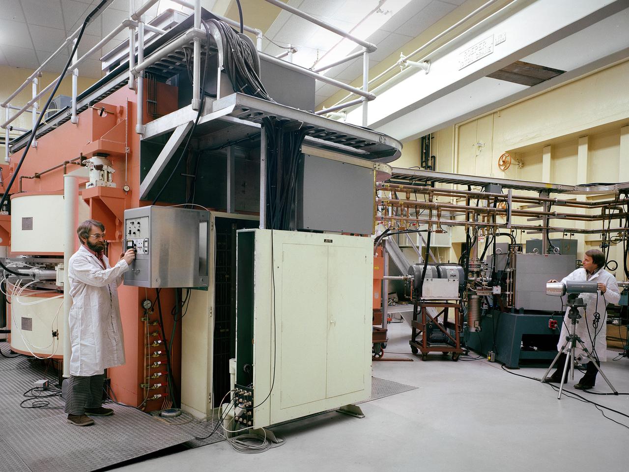
Researchers check the cyclotron in the Materials and Stresses Building at the National Aeronautics and Space Administration (NASA) Lewis Research Center. The Materials and Stresses Building, built in 1949, contained a number of laboratories to test the strength, diffusion, and other facets of materials. The materials could be subjected to high temperatures, high stresses, corrosion, irradiation, and hot gasses. The Physics of Solids Laboratory included a cyclotron, cloud chamber, helium cryostat, and metallurgy cave. The cyclotron was built in the early 1950s to test the effects of radiation on different materials so that the proper materials could be used to construct a nuclear aircraft engine and other components. By the late 1950s, the focus had shifted to similar studies for rockets. NASA cancelled its entire nuclear program in January 1973, and the cyclotron was mothballed. In 1975 the Cleveland Clinic Foundation partnered with NASA Lewis to use the cyclotron to treat cancer patients with a new type of radiation therapy. The cyclotron split beryllium atoms which caused neutrons to be released. The neutrons were streamed directly at the patient’s tumor. Over the course of five years, the cyclotron was used to treat 1200 patients. The program was terminated in 1980 as the Clinic shifted its efforts to concentrate on non-radiation treatments. The Lewis cyclotron was mothballed for a number of years before being demolished.
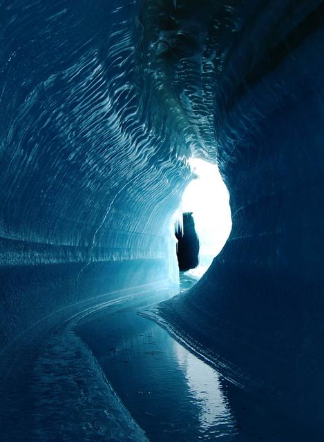
This ice cave in Belcher Glacier (Devon Island, Canada) was formed by melt water flowing within the glacier ice. To learn about the contributions of glaciers to sea level rise, visit: <a href="http://www.nasa.gov/topics/earth/features/glacier-sea-rise.html" rel="nofollow">www.nasa.gov/topics/earth/features/glacier-sea-rise.html</a> Credit: Angus Duncan, University of Saskatchewan <b><a href="http://www.nasa.gov/audience/formedia/features/MP_Photo_Guidelines.html" rel="nofollow">NASA image use policy.</a></b> <b><a href="http://www.nasa.gov/centers/goddard/home/index.html" rel="nofollow">NASA Goddard Space Flight Center</a></b> enables NASA’s mission through four scientific endeavors: Earth Science, Heliophysics, Solar System Exploration, and Astrophysics. Goddard plays a leading role in NASA’s accomplishments by contributing compelling scientific knowledge to advance the Agency’s mission. <b>Follow us on <a href="http://twitter.com/NASA_GoddardPix" rel="nofollow">Twitter</a></b> <b>Like us on <a href="http://www.facebook.com/pages/Greenbelt-MD/NASA-Goddard/395013845897?ref=tsd" rel="nofollow">Facebook</a></b> <b>Find us on <a href="http://instagram.com/nasagoddard?vm=grid" rel="nofollow">Instagram</a></b>
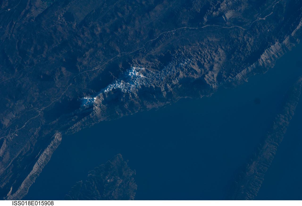
ISS018-E-015908 (29 Dec. 2008) --- The Biokovo Range in Croatia is featured in this image photographed by an Expedition 18 crewmember on the International Space Station. The Biokovo Range in Croatia is part of the Dinaric Alps extending northwest-southeast along the coastline of the Adriatic Sea. The Range itself is the location of a national park; the nearby city of Makarska, located between the mountains and the sea, is a popular tourist destination. The highest peak in the Biokovo Range, Sveti Jure (1762 meters above sea level), is reachable by road or hiking. The Range is comprised mainly of Mesozoic age carbonate rocks ? primarily limestone, a sedimentary rock type rich in calcium carbonate ? deposited in relatively warm, shallow waters. Later tectonic processes uplifted and exposed the carbonate rocks to erosion ? leading to a distinctive geological surface known as karst topography. Karst topography originates due to the chemical erosion of carbonate rocks by acids formed in surface and subsurface water; as the rock is dissolved, underground networks of drainages and caves form. As more underground void space develops through time, the overlaying rock and soil collapses to form a variety of landforms including sinkholes, blind valleys, and towers. In the Biokovo Range, much of the karst surface has a pitted appearance, made easily visible by early morning light in this astronaut photograph. The pitted appearance is produced by numerous circular or semi-circular collapse valleys known locally as vrtace. While this image captures Sveti Jure covered with snow, there are no glaciers or ice fields in the Biokovo Range.
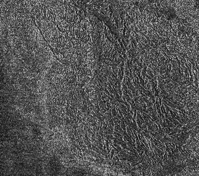
This synthetic-aperture radar image was obtained by NASA's Cassini spacecraft during its T-120 pass over Titan's southern latitudes on June 7, 2016. The image is centered near 47 degrees south, 153 degrees west. It covers an area of 87 by 75 miles (140 by 120 kilometers) and has a resolution of about 1,300 feet (400 meters). Radar illuminates the scene from the left at a 35-degree incidence angle. The features seen here are an excellent example of "labyrinth terrain." Labyrinth terrains on Titan are thought to be higher areas that have been cut apart by rivers of methane, eroded or dissolved as they were either lifted up or left standing above as the region around them lowered. (Other examples of labyrinth terrain can be seen in PIA10219.) In this image, several obvious valley systems have developed, draining liquids from methane rainfall toward the southeast (at top). Several of these systems are near parallel (running from upper left to lower right), suggesting that either the geological structure of the surface or the local topographic gradient (the general slope across the area) may be influencing their direction. Also presented here is an annotated version of the image, along with an aerial photograph of a region in southern Java known as Gunung Kidul that resembles this Titan labyrinth. This region is limestone that has been dissolved and eroded by water, creating a system of canyons called polygonal karst. Like on Titan, the canyons show a trend from upper left to lower right, in this case controlled by faults or joints. (Java photo from Haryono and Day, Journal of Cave and Karst Studies 66 (2004) 62-69, courtesy of Eko Haryono.) http://photojournal.jpl.nasa.gov/catalog/PIA20708
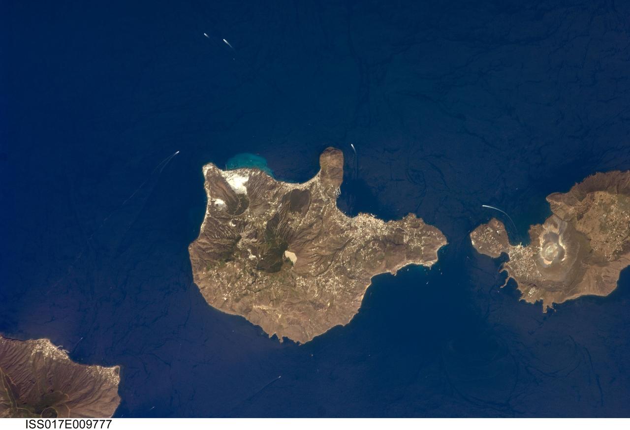
ISS017-E-009777 (24 June 2008) --- Aeolian Islands, Italy are featured in this image photographed by an Expedition 17 crewmember on the International Space Station. The Aeolian Islands formed from a chain of volcanoes in the Tyrrhenian Sea to the north of the island of Sicily. The islands have been studied by geologists and vulcanologists since the 18th century, and were accorded UNESCO World Heritage Site status in 2000 in recognition of their continuing value to study of volcanic processes. Two types of volcanic eruption, Vulcanian and Strombolian, were defined based on study and observation of geologic processes on the islands of Vulcano and Stromboli (not shown). This detailed view features the island of Lipari and the northern portion of the island of Vulcano. Tan, speckled areas on both islands are urban areas and towns. Lipari is the largest of the Aeolian Islands, and is a popular tourist destination due to its rugged volcanic topography and beaches (several boat wakes are visible in the image around the islands). White pumice beaches and caves are located along the northern and northeastern coastlines of Lipari; black sand beaches derived from lava flows can also be found on the island. The most recent eruptive activity on Lipari took place between approximately 580-729. The island of Vulcano (right) is comprised of two calderas -- large craters formed when explosive eruptions empty a magma chamber, followed by collapse of the overlying material into the newly-formed void -- the Caldera della Fossa to the north and the Caldera del Piano to the south. The volcanic cone of La Fossa, located with the Caldera della Fossa, has been the site of much of the historical eruptive activity on the island. The last eruption on Vulcano Island took place during 1898-1900.

On February 4, 2014 the Moderate Resolution Imaging Spectroradiometer (MODIS) flying aboard NASA’s Aqua satellite captured a true-color image of sea ice off of western Alaska. In this true-color image, the snow and ice covered land appears bright white while the floating sea ice appears a duller grayish-white. Snow over the land is drier, and reflects more light back to the instrument, accounting for the very bright color. Ice overlying oceans contains more water, and increasing water decreases reflectivity of ice, resulting in duller colors. Thinner ice is also duller. The ocean waters are tinted with green, likely due to a combination of sediment and phytoplankton. Alaska lies to the east in this image, and Russia to the west. The Bering Strait, covered with ice, lies between to two. South of the Bering Strait, the waters are known as the Bering Sea. To the north lies the Chukchi Sea. The bright white island south of the Bering Strait is St. Lawrence Island. Home to just over 1200 people, the windswept island belongs to the United States, but sits closer to Russia than to Alaska. To the southeast of the island a dark area, loosely covered with floating sea ice, marks a persistent polynya – an area of open water surrounded by more frozen sea ice. Due to the prevailing winds, which blow the sea ice away from the coast in this location, the area rarely completely freezes. The ice-covered areas in this image, as well as the Beaufort Sea, to the north, are critical areas for the survival of the ringed seal, a threatened species. The seals use the sea ice, including ice caves, to rear their young, and use the free-floating sea ice for molting, raising the young and breeding. In December 2014, the National Oceanic and Atmospheric Administration (NOAA) proposed that much of this region be set aside as critical, protected habitat for the ringed seal. Credit: NASA/GSFC/Jeff Schmaltz/MODIS Land Rapid Response Team <b><a href="http://www.nasa.gov/audience/formedia/features/MP_Photo_Guidelines.html" rel="nofollow">NASA image use policy.</a></b> <b><a href="http://www.nasa.gov/centers/goddard/home/index.html" rel="nofollow">NASA Goddard Space Flight Center</a></b> enables NASA’s mission through four scientific endeavors: Earth Science, Heliophysics, Solar System Exploration, and Astrophysics. Goddard plays a leading role in NASA’s accomplishments by contributing compelling scientific knowledge to advance the Agency’s mission. <b>Follow us on <a href="http://twitter.com/NASAGoddardPix" rel="nofollow">Twitter</a></b> <b>Like us on <a href="http://www.facebook.com/pages/Greenbelt-MD/NASA-Goddard/395013845897?ref=tsd" rel="nofollow">Facebook</a></b> <b>Find us on <a href="http://instagram.com/nasagoddard?vm=grid" rel="nofollow">Instagram</a></b>
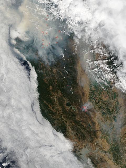
This satellite image shows smoke from several fires in Oregon and California on Aug. 2, 2015. The Moderate Resolution Imaging Spectroradiometer (MODIS) instrument that flies aboard NASA's Aqua satellite captured an image of smoke from these fires Aug. 2 at 21:05 UTC (5:05 p.m. EDT). The multiple red pixels are heat signatures detected by MODIS. The smoke appears to be a light brown color. InciWeb is an interagency all-risk incident information management system that coordinates with federal, state and local agencies to manage wildfires. In Oregon smoke from the Cable Crossing Fire, the Stouts Fire and the Potter Mountain Complex Fire commingle. The Cable Crossing Fire was reported burning on forestlands protected by the Douglas Forest Protective Association (DFPA) at approximately 3:25 p.m. on Tuesday, July 28, 2015, near Oregon Highway 138 East, near Mile Post 23, east of Glide. South of the Cable Crossing Fire is the Stouts Fire also in forestlands of the DFPA. This fire was reported on Thursday, July 30, 2015, burning approximately 11 miles east of Canyonville near the community of Milo. East of the other fires is the Potter Mountain Complex Fire. These fires are located in the Deschutes Forest consists of eight fires. According to Inciweb they were started by dry lightning on Saturday, Aug. 2, at approximately 5:30 p.m. about five miles north of Toketee Lake. In northern California, smoke from the River Complex Fire, the Fork Complex Fire and the Shf July Lightning Fire was visible in the MODIS image. The River Complex currently consists of seven reported and observed fires on the Six Rivers and Shasta Trinity National Forests. Originally identified as 18 fires, some have burned together. Inciweb noted that in the Six Rivers National Forest there are fires in the Trinity Alps Wilderness. Those fires include the Groves Fire and the Elk Fire. In the Shasta-Trinity National Forest the fires include the Happy Fire at 2,256 acres, Daily Fire at 16 acres, the Look Fire at 7 acres, Onion Fire at 136 acres and Smokey Fire at 1 acre. In the same forest, south of the River Complex is the Fork Complex fire. Inciweb reported that the Fork Complex consists of (at current count) over 40 fires, all of which were ignited by lightning between July 29 and 31, 2015. To the southwest of this complex is the Mad River Complex. This is a series of seven lightning fires that started on July 30, 2015 after a lightning storm moved through Northern California. To the east of this and the other fires, burns another near Redding, California, called the Shf July Lightning Fire. This is also under the Shasta-Trinity National Forest management. At 8 p.m. PDT on Aug. 2, Inciweb reported that approximately 15 lightning strikes occurred within 24 hours throughout the Shasta Trinity National Forest and resulted in two new fires. The Caves fire, east of Mt. Shasta, is approximately one-tenth of an acre. The Bluejay fire, east of Shasta Lake, is approximately four acres. Image credit: NASA Goddard's MODIS Rapid Response Team, Jeff Schmaltz <b><a href="http://www.nasa.gov/audience/formedia/features/MP_Photo_Guidelines.html" rel="nofollow">NASA image use policy.</a></b> <b><a href="http://www.nasa.gov/centers/goddard/home/index.html" rel="nofollow">NASA Goddard Space Flight Center</a></b> enables NASA’s mission through four scientific endeavors: Earth Science, Heliophysics, Solar System Exploration, and Astrophysics. Goddard plays a leading role in NASA’s accomplishments by contributing compelling scientific knowledge to advance the Agency’s mission. <b>Follow us on <a href="http://twitter.com/NASAGoddardPix" rel="nofollow">Twitter</a></b> <b>Like us on <a href="http://www.facebook.com/pages/Greenbelt-MD/NASA-Goddard/395013845897?ref=tsd" rel="nofollow">Facebook</a></b> <b>Find us on <a href="http://instagrid.me/nasagoddard/?vm=grid" rel="nofollow">Instagram</a></b>