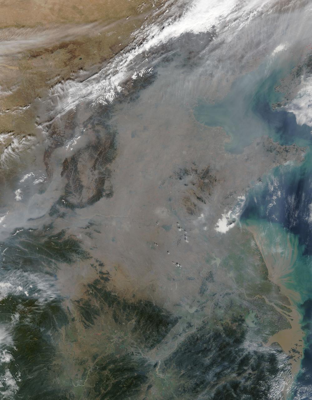
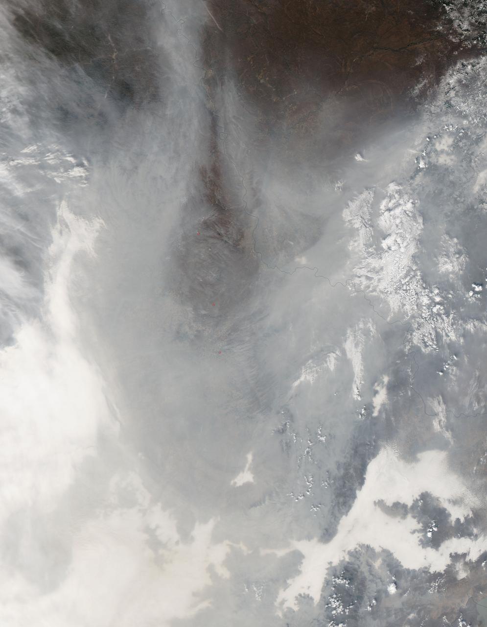
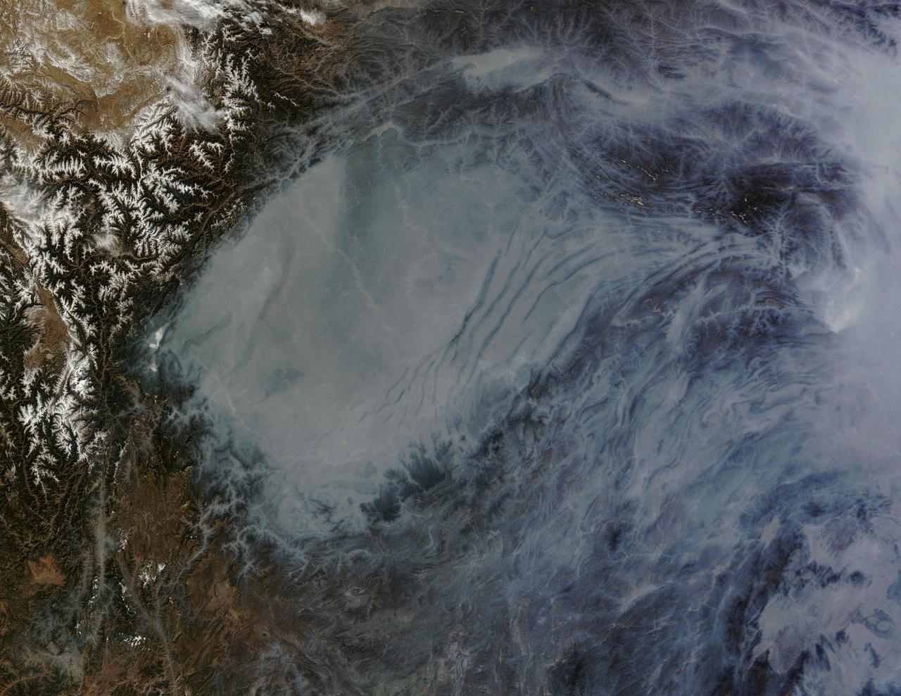
On October 17, 2015, the Moderate Resolution Imaging Spectroradiometer (MODIS) aboard NASA’s Terra satellite captured this true-color image of a thick haze hanging over eastern China. In the north, the large city of Beijing is completely obscured from view, as is much of the landscape. The haze thins slightly over the Bohai Sea. Further south, sediment pours into the East China Sea near the city of Shanghai. Heavy haze is common in this region, and tends to worsen in October through January, when cold, heavy air traps pollutants near the surface of the Earth. It is likely that this scene was caused by such a temperature inversion. Normally, air is warmest near the surface of the Earth. But sometimes a mass of warm air will move the cooler air, so the atmosphere actually warms with the altitude. Cool air does not have energy to rise through the warm air, vertical circulation slows and air becomes trapped near the surface. Any pollution that is emitted into the cooler air will also get trapped, increasing low-level air pollution and haze. Credit: NASA/GSFC/Jeff Schmaltz/MODIS Land Rapid Response Team
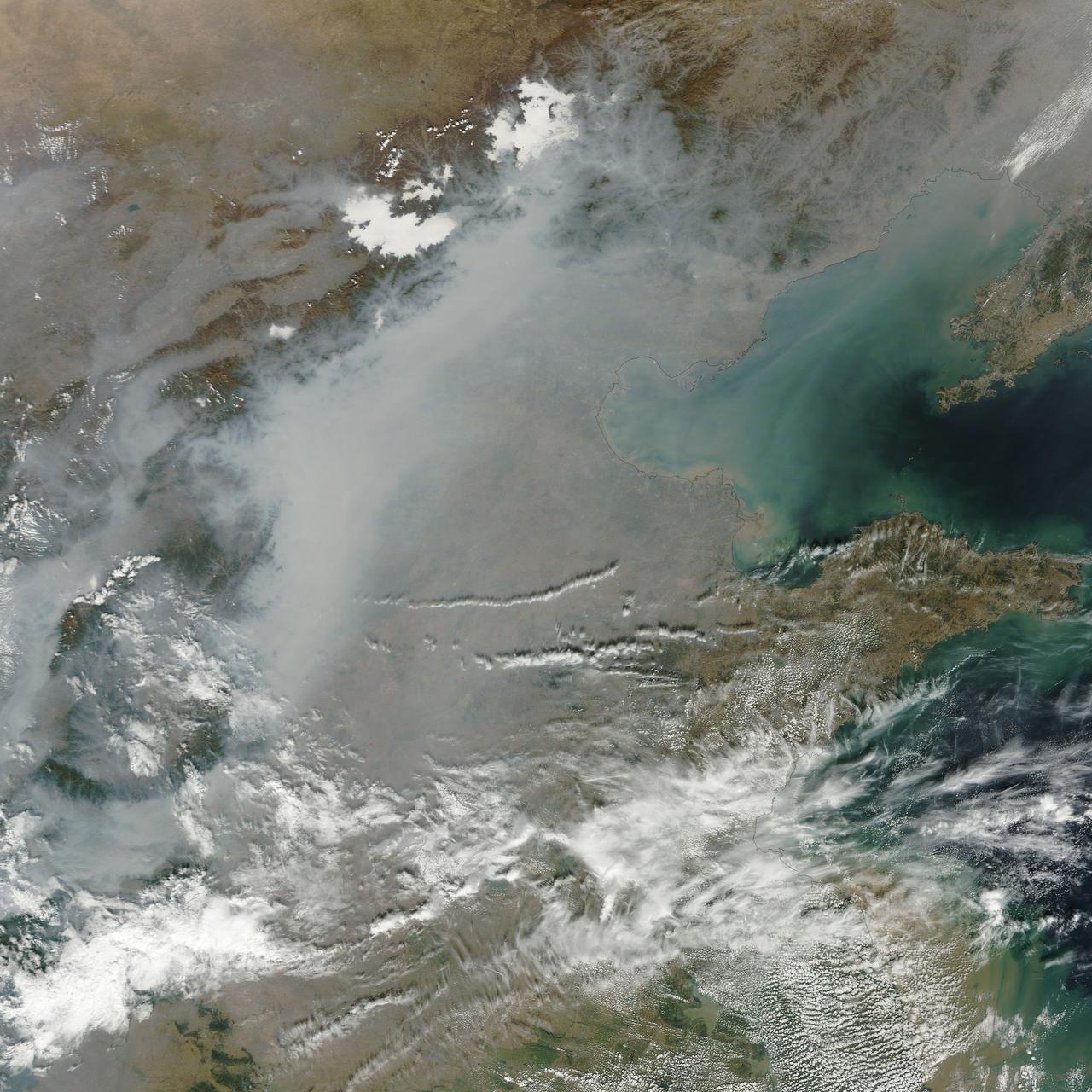
A thick layer of haze blanketed the North China Plain on October 9, 2014, when the Moderate Resolution Imaging Spectroradiometer (MODIS) on NASA’s Terra satellite acquired this natural-color image at 2:50 Coordinated Universal Time (10:50 a.m. local time). The haze obscured many features usually visible in MODIS imagery of the area, including China’s largest city, Beijing. On the day this image was acquired, measurements from ground-based sensors at the U.S. Consulate in Beijing reported PM2.5 measurements of 334 micrograms per cubic meter of air. Fine, airborne particulate matter (PM) that is smaller than 2.5 microns (about one thirtieth the width of a human hair) is considered dangerous because it is small enough to enter the passages of the human lungs. Most PM2.5 aerosol particles come from the burning of fossil fuels and biomass (wood fires and agricultural burning). The World Health Organization considers PM2.5 to be safe when it is below 25. Haze in this region tends to worsen in the fall and winter, when cold, heavy air traps pollutants near the surface. In this case, the haze was likely trapped by a temperature inversion. Normally, air is warmest near the surface of the Earth. Occasionally, a mass of warm air will move over cooler air so that the atmosphere actually warms with altitude. Since the cool air does not have the energy to rise through the warm air, vertical circulation slows and air becomes trapped near the surface. Any pollutant that enters the air gets trapped as well, and haze builds up over time. Daily satellite images of the North China Plain show that visible haze began to accumulate on October 7, 2014. NASA image courtesy Jeff Schmaltz, LANCE MODIS Rapid Response. Caption by Adam Voiland. Read more: <a href="http://earthobservatory.nasa.gov/NaturalHazards/view.php?id=84530&eocn=home&eoci=nh" rel="nofollow">earthobservatory.nasa.gov/NaturalHazards/view.php?id=8453...</a> Credit: <b><a href="http://www.earthobservatory.nasa.gov/" rel="nofollow"> NASA Earth Observatory</a></b> <b><a href="http://www.nasa.gov/audience/formedia/features/MP_Photo_Guidelines.html" rel="nofollow">NASA image use policy.</a></b> <b><a href="http://www.nasa.gov/centers/goddard/home/index.html" rel="nofollow">NASA Goddard Space Flight Center</a></b> enables NASA’s mission through four scientific endeavors: Earth Science, Heliophysics, Solar System Exploration, and Astrophysics. Goddard plays a leading role in NASA’s accomplishments by contributing compelling scientific knowledge to advance the Agency’s mission. <b>Follow us on <a href="http://twitter.com/NASAGoddardPix" rel="nofollow">Twitter</a></b> <b>Like us on <a href="http://www.facebook.com/pages/Greenbelt-MD/NASA-Goddard/395013845897?ref=tsd" rel="nofollow">Facebook</a></b> <b>Find us on <a href="http://instagram.com/nasagoddard?vm=grid" rel="nofollow">Instagram</a></b>
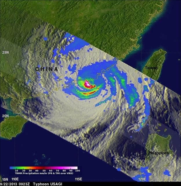
On Sept. 22 at 0923 UTC/5:23 a.m. EDT, just south of Usagi's eye where rain was falling at a rate of over 169mm/~6.7 inches per hour along China's coast. TRMM radar sliced through Usagi and found that heights of some thunderstorms were reaching only about 12 km /7.4 miles. Credit: NASA/SSAI, Hal Pierce <b><a href="http://www.nasa.gov/audience/formedia/features/MP_Photo_Guidelines.html" rel="nofollow">NASA image use policy.</a></b> <b><a href="http://www.nasa.gov/centers/goddard/home/index.html" rel="nofollow">NASA Goddard Space Flight Center</a></b> enables NASA’s mission through four scientific endeavors: Earth Science, Heliophysics, Solar System Exploration, and Astrophysics. Goddard plays a leading role in NASA’s accomplishments by contributing compelling scientific knowledge to advance the Agency’s mission. <b>Follow us on <a href="http://twitter.com/NASA_GoddardPix" rel="nofollow">Twitter</a></b> <b>Like us on <a href="http://www.facebook.com/pages/Greenbelt-MD/NASA-Goddard/395013845897?ref=tsd" rel="nofollow">Facebook</a></b> <b>Find us on <a href="http://instagram.com/nasagoddard?vm=grid" rel="nofollow">Instagram</a></b>
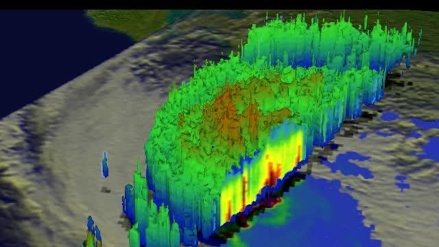
This simulated 3-D flyby animation over Typhoon Usagi on Sept. 22 at 0923 UT showed heavy rain south of the center a rate of over 169mm/~6.7 inches per hour along China's coast. Cloud heights of some thunderstorms were reaching only about 12 km /7.4 miles. Credit: SSAI/NASA, Hal Pierce <b><a href="http://www.nasa.gov/audience/formedia/features/MP_Photo_Guidelines.html" rel="nofollow">NASA image use policy.</a></b> <b><a href="http://www.nasa.gov/centers/goddard/home/index.html" rel="nofollow">NASA Goddard Space Flight Center</a></b> enables NASA’s mission through four scientific endeavors: Earth Science, Heliophysics, Solar System Exploration, and Astrophysics. Goddard plays a leading role in NASA’s accomplishments by contributing compelling scientific knowledge to advance the Agency’s mission. <b>Follow us on <a href="http://twitter.com/NASA_GoddardPix" rel="nofollow">Twitter</a></b> <b>Like us on <a href="http://www.facebook.com/pages/Greenbelt-MD/NASA-Goddard/395013845897?ref=tsd" rel="nofollow">Facebook</a></b> <b>Find us on <a href="http://instagram.com/nasagoddard?vm=grid" rel="nofollow">Instagram</a></b>

The Moderate Resolution Imaging Spectroradiometer or MODIS instrument that flies aboard NASA's Terra satellite captured this image of Typhoon Usagi on Sept. 22 at 02:45 UTC/Sept. 21 at 10:45 p.m. EDT on its approach to a landfall in China. Credit: NASA Goddard MODIS Rapid Response Team <b><a href="http://www.nasa.gov/audience/formedia/features/MP_Photo_Guidelines.html" rel="nofollow">NASA image use policy.</a></b> <b><a href="http://www.nasa.gov/centers/goddard/home/index.html" rel="nofollow">NASA Goddard Space Flight Center</a></b> enables NASA’s mission through four scientific endeavors: Earth Science, Heliophysics, Solar System Exploration, and Astrophysics. Goddard plays a leading role in NASA’s accomplishments by contributing compelling scientific knowledge to advance the Agency’s mission. <b>Follow us on <a href="http://twitter.com/NASA_GoddardPix" rel="nofollow">Twitter</a></b> <b>Like us on <a href="http://www.facebook.com/pages/Greenbelt-MD/NASA-Goddard/395013845897?ref=tsd" rel="nofollow">Facebook</a></b> <b>Find us on <a href="http://instagram.com/nasagoddard?vm=grid" rel="nofollow">Instagram</a></b>
Chinese authorities shut down much of Harbin – a city of more than 10 million people – as unusually high levels of pollution shrouded the city and the surrounding region in mid-October, 2013. Measurements taken on October 20, 2013 scored the air quality index in the city at 500, the highest possible reading. Levels above 300 are considered hazardous to human health. The Moderate Resolution Imaging Spectroradiometer (MODIS) on NASA’s Aqua satellite acquired this true-color image of northeastern China on October 21. The brightest areas are fog, which is tinged with gray or yellow due to the air pollution. Other cloud-free areas have a pall of gray and brown smog that blots out the city and surrounding towns. Harbin lies under the Y-shaped patch of fog and smog in the south-central section of the image, completely obscured from view. Some neighborhoods experienced concentrations of fine particulate matter (PM 2.5) as high as 1,000 micrograms per cubic meter. For comparison the U.S. Environmental Protection Agency’s air quality standards state that PM 2.5 should remain below 35 micrograms per cubic meter. It is extremely rare for particulate levels to reach such high levels in the absence of a dust storm or forest fire. Chinese authorities grounded airplanes, shuttered thousands of schools and closed major roads in response to the surge in pollution. A few days after pollution levels started to rise, Harbin hospitals reported a 30 percent increase in admissions related to respiratory problems, and several Harbin pharmacies were sold out of pollution facemasks, according to media reports. Cold weather and lack of wind helped fuel the pollution outbreak, but human factors also played an important role. Wheat and corn farmers in the region light fires in the fall to burn off debris following the harvest. Also, city officials turned on Harbin’s city-wide, coal-powered heating system just prior to the pollution outbreak, according to China’s state-run Xinhua News Agency. Credit: NASA/GSFC/Jeff Schmaltz/MODIS Land Rapid Response Team <b><a href="http://www.nasa.gov/audience/formedia/features/MP_Photo_Guidelines.html" rel="nofollow">NASA image use policy.</a></b> <b><a href="http://www.nasa.gov/centers/goddard/home/index.html" rel="nofollow">NASA Goddard Space Flight Center</a></b> enables NASA’s mission through four scientific endeavors: Earth Science, Heliophysics, Solar System Exploration, and Astrophysics. Goddard plays a leading role in NASA’s accomplishments by contributing compelling scientific knowledge to advance the Agency’s mission. <b>Follow us on <a href="http://twitter.com/NASA_GoddardPix" rel="nofollow">Twitter</a></b> <b>Like us on <a href="http://www.facebook.com/pages/Greenbelt-MD/NASA-Goddard/395013845897?ref=tsd" rel="nofollow">Facebook</a></b> <b>Find us on <a href="http://instagram.com/nasagoddard?vm=grid" rel="nofollow">Instagram</a></b>
STS007-05-245 (18-24 June 1983) --- A rare view of internal waves in the South China Sea. Several different series of internal waves are represented in the 70mm frame, exposed with a handheld camera by members of the STS-7 astronaut crew aboard the Earth-orbiting Challenger. The land area visible in the lower left is part of the large island of Hainan, China.
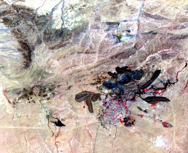
Acquired by NASA Terra spacecraft, this image shows a mine in Baiyun Ebo, Inner Mongolia, China, the site of almost half the world rare earth production. China is responsible for over 95% of global production of rare earth elements.
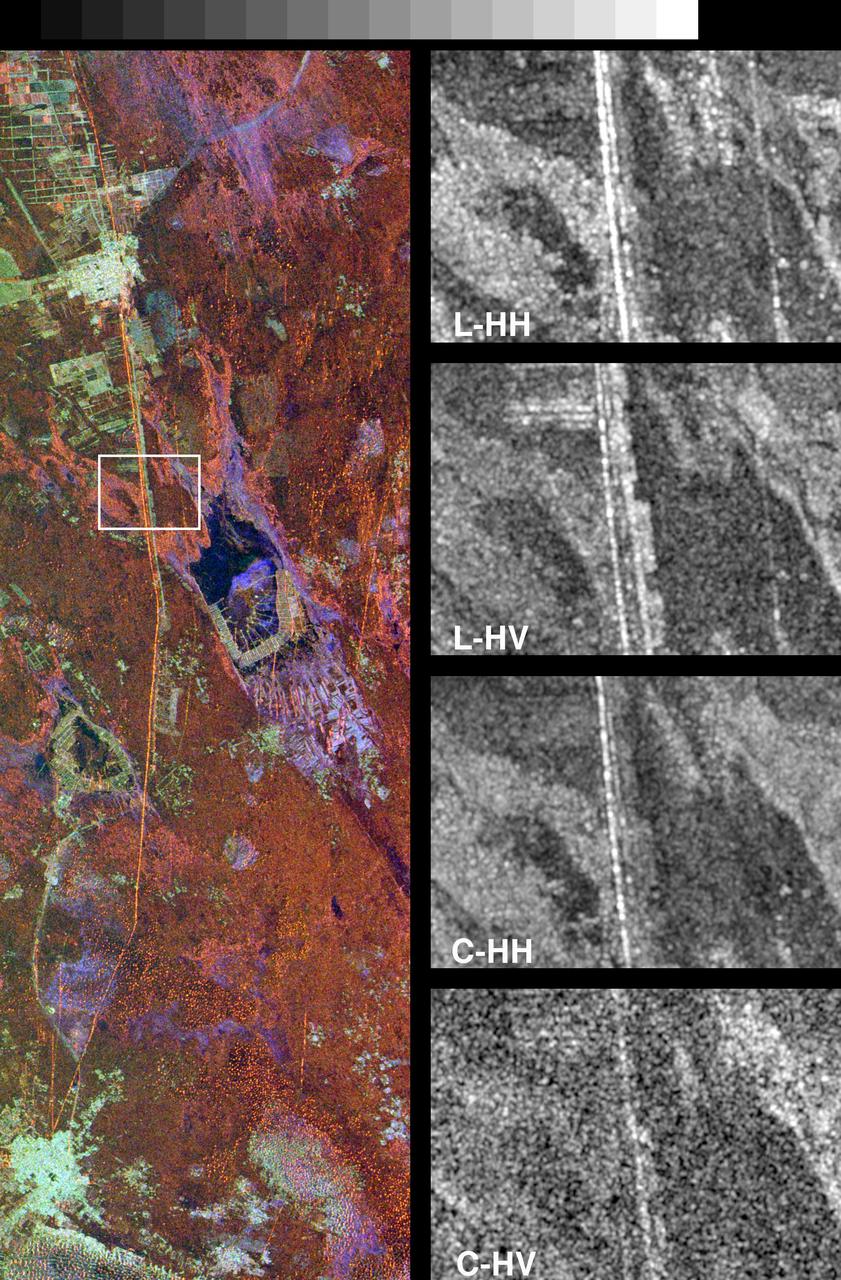
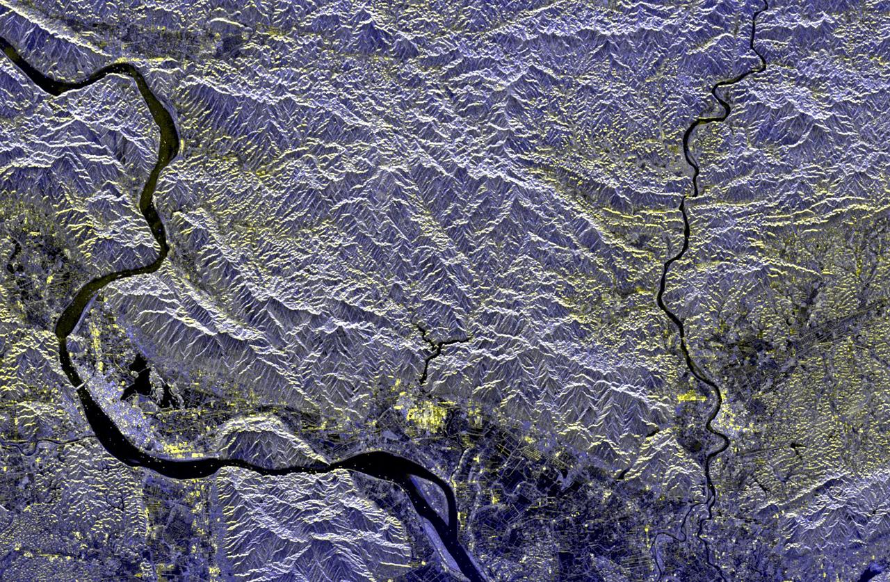
These spaceborne radar images show a segment of the Great Wall of China in a desert region of north-central China, about 700 kilometers 434 miles west of Beijing.
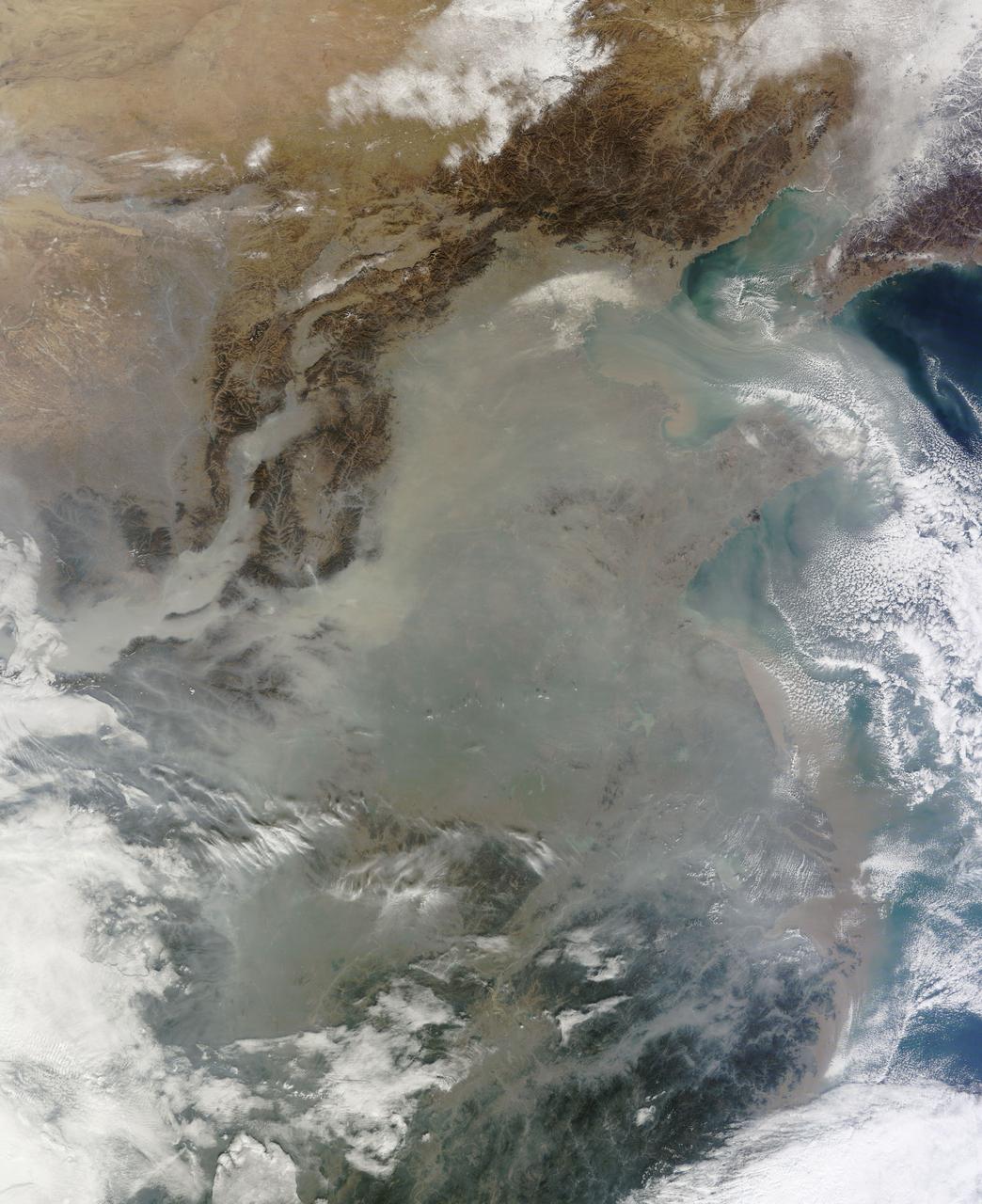
The Moderate Resolution Imaging Spectroradiometer (MODIS) on NASA’s Terra satellite acquired this natural-color image of central China on January 23, 2013 at 04:05 UTC. The image shows extensive haze over the region. In areas where the ground is visible, some of the landscape is covered with lingering snow. Credit: NASA/GSFC/Jeff Schmaltz/MODIS Land Rapid Response Team <b><a href="http://www.nasa.gov/audience/formedia/features/MP_Photo_Guidelines.html" rel="nofollow">NASA image use policy.</a></b> <b><a href="http://www.nasa.gov/centers/goddard/home/index.html" rel="nofollow">NASA Goddard Space Flight Center</a></b> enables NASA’s mission through four scientific endeavors: Earth Science, Heliophysics, Solar System Exploration, and Astrophysics. Goddard plays a leading role in NASA’s accomplishments by contributing compelling scientific knowledge to advance the Agency’s mission. <b>Follow us on <a href="http://twitter.com/NASAGoddardPix" rel="nofollow">Twitter</a></b> <b>Like us on <a href="http://www.facebook.com/pages/Greenbelt-MD/NASA-Goddard/395013845897?ref=tsd" rel="nofollow">Facebook</a></b> <b>Find us on <a href="http://instagram.com/nasagoddard?vm=grid" rel="nofollow">Instagram</a></b>
NASA image acquired May 17, 2011 Located in China’s resource-rich but moisture-poor Xinjiang autonomous region, Lop Nur is an uninviting location for any kind of agriculture. It sits at the eastern end of the Taklimakan Desert, where marching sand dunes can reach heights of 200 meters (650 feet), and dust storms rage across the landscape. Yet for all it lacks in agricultural appeal, Lop Nur offers something valuable to farmers the world over: potash. This potassium salt provides a major nutrient required for plant growth, making it a key ingredient in fertilizer. The discovery of potash at Lop Nur in the mid-1990s turned the area into a large-scale mining operation. The Advanced Land Imager (ALI) on NASA’s Earth Observing-1 (EO-1) satellite captured this natural-color image of Lop Nur on May 17, 2011. The rectangular shapes in this image show the bright colors characteristic of solar evaporation ponds. Around the evaporation ponds are the earth tones typical of sandy desert. During the early and middle Pleistocene epoch, this area held a large brackish lake. Uplift of the northern part of the lake in the late Pleistocene created hollows that became receptacles for potash deposition. The main potash deposits found at Lop Nur today are brine potash, and this site is the second-largest source of potash in China. Lop Nur slowly dried up in the Holocene. The area now receives average annual precipitation of just 31.2 millimeters (1.2 inches), and experiences annual evaporation of 2,901 millimeters (114 inches), according to a study published in 2008. The study found, however, that this area has experienced seven major climate changes since the end of the Pleistocene, including climatic conditions far more favorable to farming and settlement than today. Examination of plant and mollusk remains at the lake, as well as studies of sediments, indicate that the Lop Nur region experienced a severe drought about 3,000 years ago, followed by wetter conditions. Between 1,250 and 400 years ago, Lop Nur likely experienced the conditions most favorable to farming and settlement, and red willow trees grew in the area. Pottery dating from the Tang and Song dynasties further testifies to welcoming conditions at the lake centuries ago. Starting around 400 years ago, however, a more arid climate took hold, completely drying out Lop Nur. Today, by providing potash, the desiccated lake still supports agriculture, but it does so for farming efforts further afield. NASA Earth Observatory image created by Jesse Allen and Robert Simmon, using EO-1 ALI data provided courtesy of the NASA EO-1 team. Caption by Michon Scott. Instrument: EO-1 - ALI Credit: <b><a href="http://www.earthobservatory.nasa.gov/" rel="nofollow"> NASA Earth Observatory</a></b> <b><a href="http://www.nasa.gov/centers/goddard/home/index.html" rel="nofollow">NASA Goddard Space Flight Center</a></b> enables NASA’s mission through four scientific endeavors: Earth Science, Heliophysics, Solar System Exploration, and Astrophysics. Goddard plays a leading role in NASA’s accomplishments by contributing compelling scientific knowledge to advance the Agency’s mission. <b>Follow us on <a href="http://twitter.com/NASA_GoddardPix" rel="nofollow">Twitter</a></b> <b>Like us on <a href="http://www.facebook.com/pages/Greenbelt-MD/NASA-Goddard/395013845897?ref=tsd" rel="nofollow">Facebook</a></b> <b>Find us on <a href="http://web.stagram.com/n/nasagoddard/?vm=grid" rel="nofollow">Instagram</a></b>
The skies over northern China were shrouded with a thick haze in late December, 2013. The Moderate Resolution Imaging Spectroradiometer (MODIS) aboard the Terra satellite captured this true-color image on December 23. The dense, gray haze obscures almost all the land and much of the coastal waters from view south and east of the Taihang Mountains. Clearer air covers the region north of the mountains, although fingers of haze roll through most river valleys. The cities of Beijing and Hebei, both west of the Bohai Sea are complete enshrouded. By December 24 the smog levels in some area exceeded World Health Organization-recommended levels by 30 times, according to Bloomberg News. The concentration of PM2.5, which are fine air particulates, were reported at 421 micrograms per cubic meter at 2 p.m. near Tiananmen Square in Beijing, while levels were 795 in Xi’an and 740 in Zhengzhou. The World Health Organization (WHO) recommends 24-hour exposure to PM2.5 concentrations no higher than 25 micrograms per cubic meter. While not the sole cause of haze and pollution, the use of coal as a very cheap energy source adds to the problem, particularly north of the Huai River. Prior to 1980, the government policy provided free coal for fuel boilers for all people living north of the Huai River. The widespread use of coal allows people in the north to stay warm in winter, but they have paid a price in air quality. According to Michael Greenstone, a Professor of Environmental Economics at Massachusetts Institute of Technology (MIT), whose research team published a paper on sustained exposure to air pollution on life expectancy in the region, air pollution, as measured by total suspended particulates, was about 55% higher north of the Huai River than south of it, for a difference of around 184 micrograms of particulate matter per cubic meter. The research, published in Proceedings of the National Academy of Sciences in July, 2013, also noted life expectancies were about 5.5 years lower in the north, owing to an increased incidence of cardiorespiratory mortality. Air pollution is an on-going issue for the government of China, and Beijing’s Five-Year Clean Air Action Plan aims to reduce overall particle density by over 25 percent on the PM2.5 scale by 2017, and also takes aim at shutting down all coal-burning plants. Credit: NASA/GSFC/Jeff Schmaltz/MODIS Land Rapid Response Team <b><a href="http://www.nasa.gov/audience/formedia/features/MP_Photo_Guidelines.html" rel="nofollow">NASA image use policy.</a></b> <b><a href="http://www.nasa.gov/centers/goddard/home/index.html" rel="nofollow">NASA Goddard Space Flight Center</a></b> enables NASA’s mission through four scientific endeavors: Earth Science, Heliophysics, Solar System Exploration, and Astrophysics. Goddard plays a leading role in NASA’s accomplishments by contributing compelling scientific knowledge to advance the Agency’s mission. <b>Follow us on <a href="http://twitter.com/NASA_GoddardPix" rel="nofollow">Twitter</a></b> <b>Like us on <a href="http://www.facebook.com/pages/Greenbelt-MD/NASA-Goddard/395013845897?ref=tsd" rel="nofollow">Facebook</a></b> <b>Find us on <a href="http://instagram.com/nasagoddard?vm=grid" rel="nofollow">Instagram</a></b>
Image taken 5/2/2002 by ASTER: A vast alluvial fan blossoms across the desolate landscape between the Kunlun and Altun mountain ranges that form the southern border of the Taklimakan Desert in China's XinJiang Province. This image can be found on ASTER Path 143 Row 34, center: 37.43 N, 84.30 E. To learn more about the Landsat satellite go to: <a href="http://landsat.gsfc.nasa.gov/" rel="nofollow">landsat.gsfc.nasa.gov/</a>
This image from NASA Terra spacecraft shows Poyang Lake, which was once China largest freshwater lake.
This image from NASA Terra spacecraft shows Beihai, a city in the south of Guangxi, People republic of China.

On Nov. 10 at 03:30 UTC/Nov. 9 at 10:30 p.m. EDT, the MODIS instrument aboard NASA's Terra satellite showed the center of Typhoon Haiyan just south of Hainan Island, China in the South China Sea. Credit: NASA Goddard MODIS Rapid Response Team <b><a href="http://www.nasa.gov/audience/formedia/features/MP_Photo_Guidelines.html" rel="nofollow">NASA image use policy.</a></b> <b><a href="http://www.nasa.gov/centers/goddard/home/index.html" rel="nofollow">NASA Goddard Space Flight Center</a></b> enables NASA’s mission through four scientific endeavors: Earth Science, Heliophysics, Solar System Exploration, and Astrophysics. Goddard plays a leading role in NASA’s accomplishments by contributing compelling scientific knowledge to advance the Agency’s mission. <b>Follow us on <a href="http://twitter.com/NASA_GoddardPix" rel="nofollow">Twitter</a></b> <b>Like us on <a href="http://www.facebook.com/pages/Greenbelt-MD/NASA-Goddard/395013845897?ref=tsd" rel="nofollow">Facebook</a></b> <b>Find us on <a href="http://instagrid.me/nasagoddard/?vm=grid" rel="nofollow">Instagram</a></b>
The objective of NASA Shuttle Imaging Radar A SIR-A was to observe the Earth by use of radar imagery, acquire and transmit data of different geologic regions. This is a view of China in 2000.
In Heilongjiang province, northeast China, shade covers shelter farmed ginseng from the effects of direct sunlight. China is the world's leading producer of ginseng, a plant believed to have curative properties. It is just as popular in the US as in Asian countries. The image was acquired August 29, 2016, covers an area of 16.7 by 21.2 km, and is located at 47.2 degrees north, 127.9 degrees east. https://photojournal.jpl.nasa.gov/catalog/PIA25895
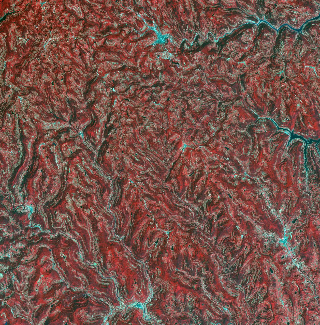
In the northeast Sichuan province of China lies the Sichuan Basin, surrounded by mountains on all sides and drained by the Yangtzee River. The basin is considered the breadbasket of China. On the northeast edge, flat-lying Jurassic to Cretaceous sandstones have been eroded to form an intricately carved landscape of upland fields and lowland streams and valleys. The image was acquired September 11, 2016, covers an area of 36 by 37 kilometers, and is located at 31.9 degrees north, 105.4 degrees east. https://photojournal.jpl.nasa.gov/catalog/PIA23532
This ASTER sub-image covers a 12 x 12 km area in northern Shanxi Province, China, and was acquired January 9, 2001. The low sun angle, and light snow cover highlight a section of the Great Wall, visible as a black line running diagonally through the image from lower left to upper right. The Great Wall is over 2000 years old and was built over a period of 1000 years. Stretching 4500 miles from Korea to the Gobi Desert it was first built to protect China from marauders from the north. This image is located at 40.2 degrees north latitude and 112.8 degrees east longitude. http://photojournal.jpl.nasa.gov/catalog/PIA02669

On Saturday, Sept. 21, TRMM captured rainfall data on Typhoon Usagi as it passed between the northern Philippines and southern Taiwan. TRMM found rain falling at a rate of over 134 mm/hr (~5.2 inches) in USAGI's eye wall. Credit: SSAI/NASA, Hal Pierce <b><a href="http://www.nasa.gov/audience/formedia/features/MP_Photo_Guidelines.html" rel="nofollow">NASA image use policy.</a></b> <b><a href="http://www.nasa.gov/centers/goddard/home/index.html" rel="nofollow">NASA Goddard Space Flight Center</a></b> enables NASA’s mission through four scientific endeavors: Earth Science, Heliophysics, Solar System Exploration, and Astrophysics. Goddard plays a leading role in NASA’s accomplishments by contributing compelling scientific knowledge to advance the Agency’s mission. <b>Follow us on <a href="http://twitter.com/NASA_GoddardPix" rel="nofollow">Twitter</a></b> <b>Like us on <a href="http://www.facebook.com/pages/Greenbelt-MD/NASA-Goddard/395013845897?ref=tsd" rel="nofollow">Facebook</a></b> <b>Find us on <a href="http://instagram.com/nasagoddard?vm=grid" rel="nofollow">Instagram</a></b>
S66-54839 (14 Sept. 1966) --- China, India, and Nepal, looking east, as seen from the Gemini-11 spacecraft during its 37th revolution of Earth. The Great Himalaya Mountain Range is clearly visible. Photo credit: NASA
In far western China is Xinjiang Prefecture, with its capital of Kashgar (bottom right on image). The area has a rich history of over 2,000 years; Kashgar has served as a trading post and important city on the Silk Road. The folded sedimentary rocks outline valleys that contain oases, cultivated for thousands of years. The image was acquired 23 July 2014, covers an area of 37.3 by 46.3 kilometers, and is located at 39.8 degrees north, 75.8 degrees east. http://photojournal.jpl.nasa.gov/catalog/PIA21189

STS059-220-041 (9-20 April 1994) --- View to the south by southwest across the southern Gobi Desert (China) across the Chi-Lien-Shan or Quilienshan or Nanshan (Mountains) in Gansu Province to Lake Quinghai or Ch'ing-Hai (orthography varies with political conditions and scholarship) in Quinghai Province. The lake has a surface elevation of 10,450 feet, partially filling one of the easternmost closed drainage basins of Central Asia. Hasselblad photograph.
Heavy snowfall on March 12, 2004, across north China Inner Mongolia Autonomous Region, Mongolia and Russia, caused train and highway traffic to stop for several days along the Russia-China border shown here by NASA Terra spacecraft.
This image from the NASA Terra spacecraft shows extensive flooding resulting from Typhoon Rammasun in Ningming, China. This ASTER image was acquired on July 24, 2014.
NASA Terra spacecraft captured these views of the dust and sand that swept over northeast China on March 10, 2004.
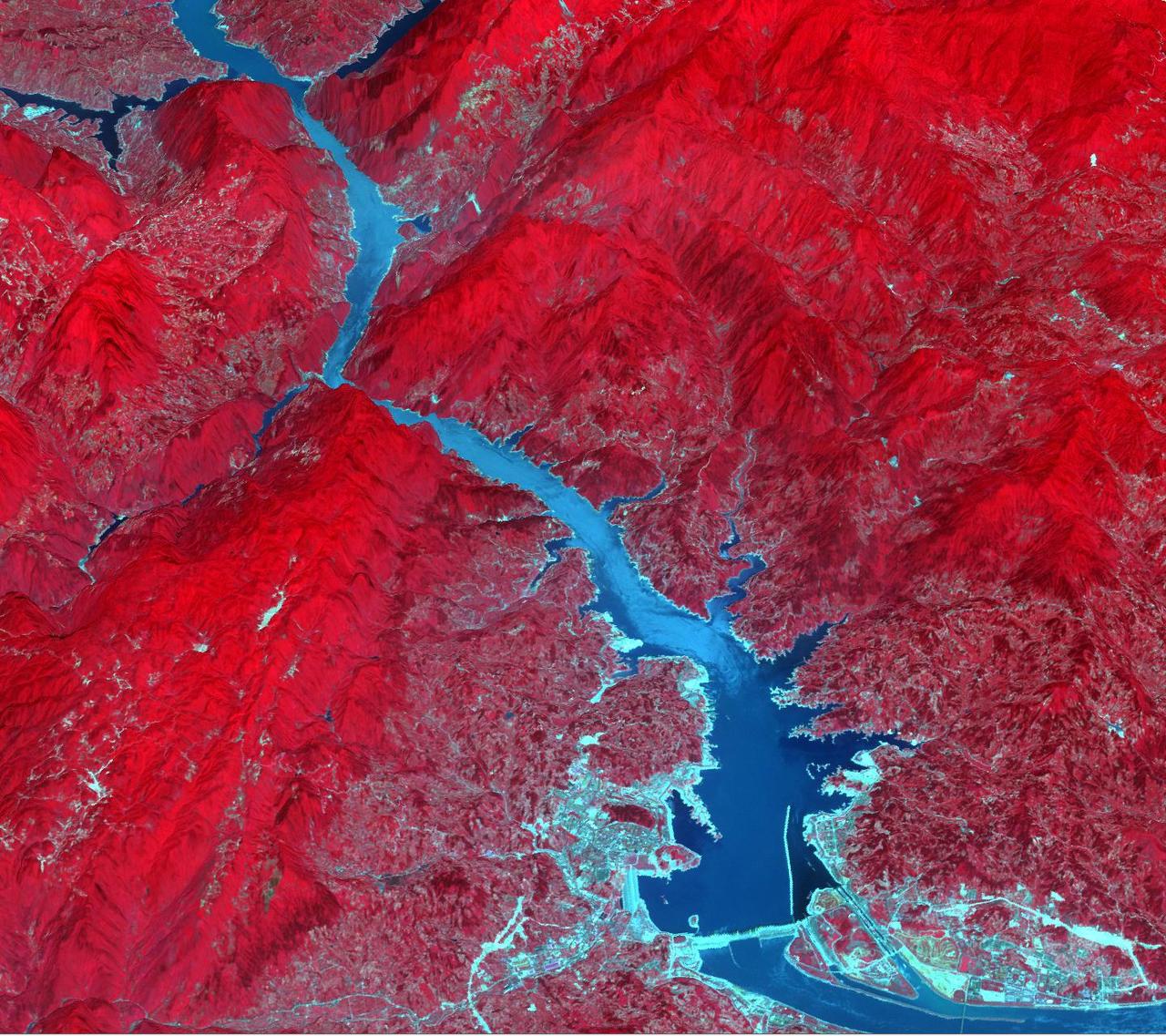
Acquired by NASA Terra spacecraft, this image shows the Three Gorges Dam which spans the Yangtze River in east-central China, and is the world largest power station in terms of installed capacity.
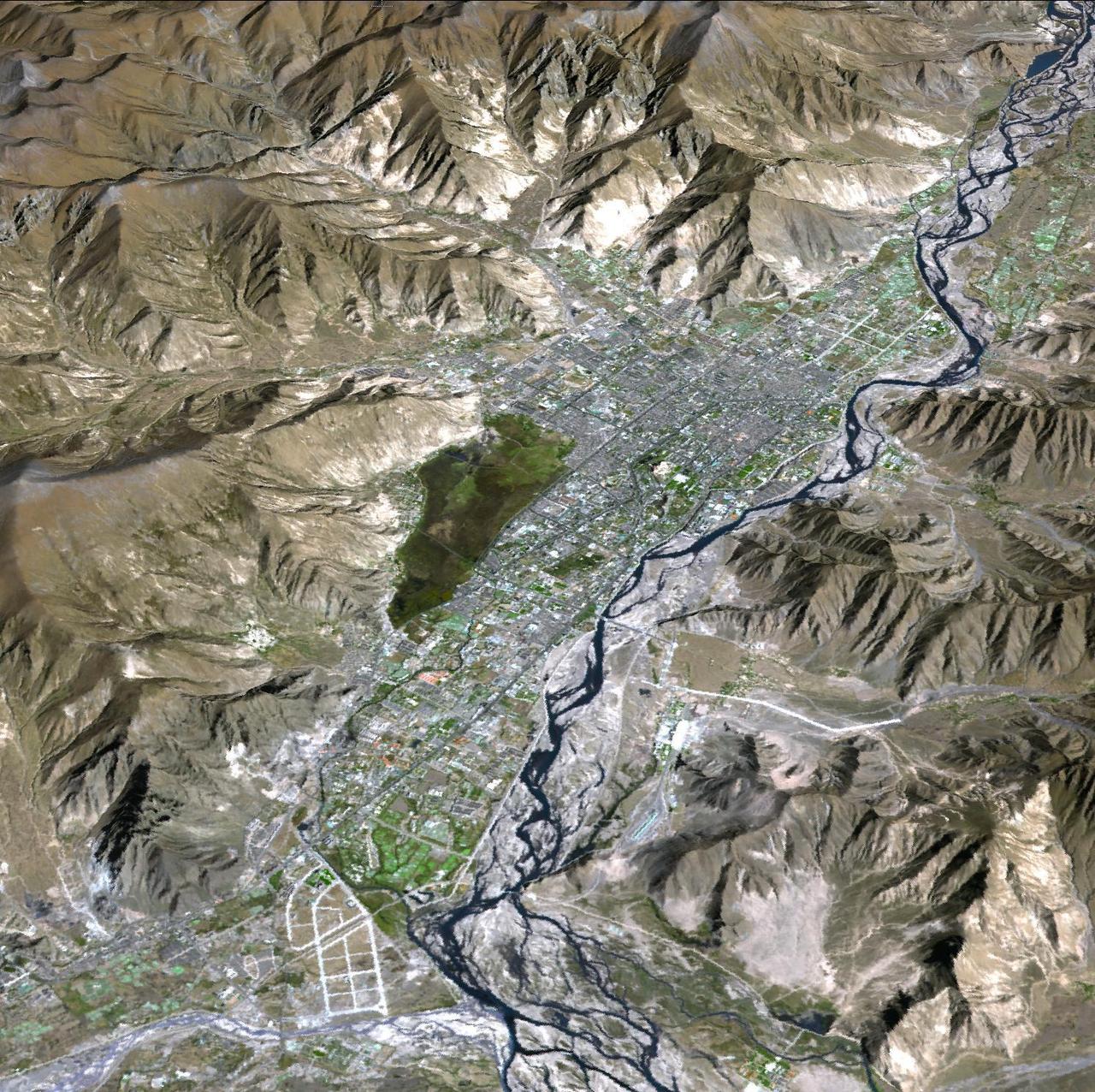
JPL Advanced Spaceborne Thermal Emission and Reflection Radiometer aboard NASA Terra satellite, shows Lhasa, the traditional seat of the Dalai Lama and capital of the Tibet Autonomous Region in China.
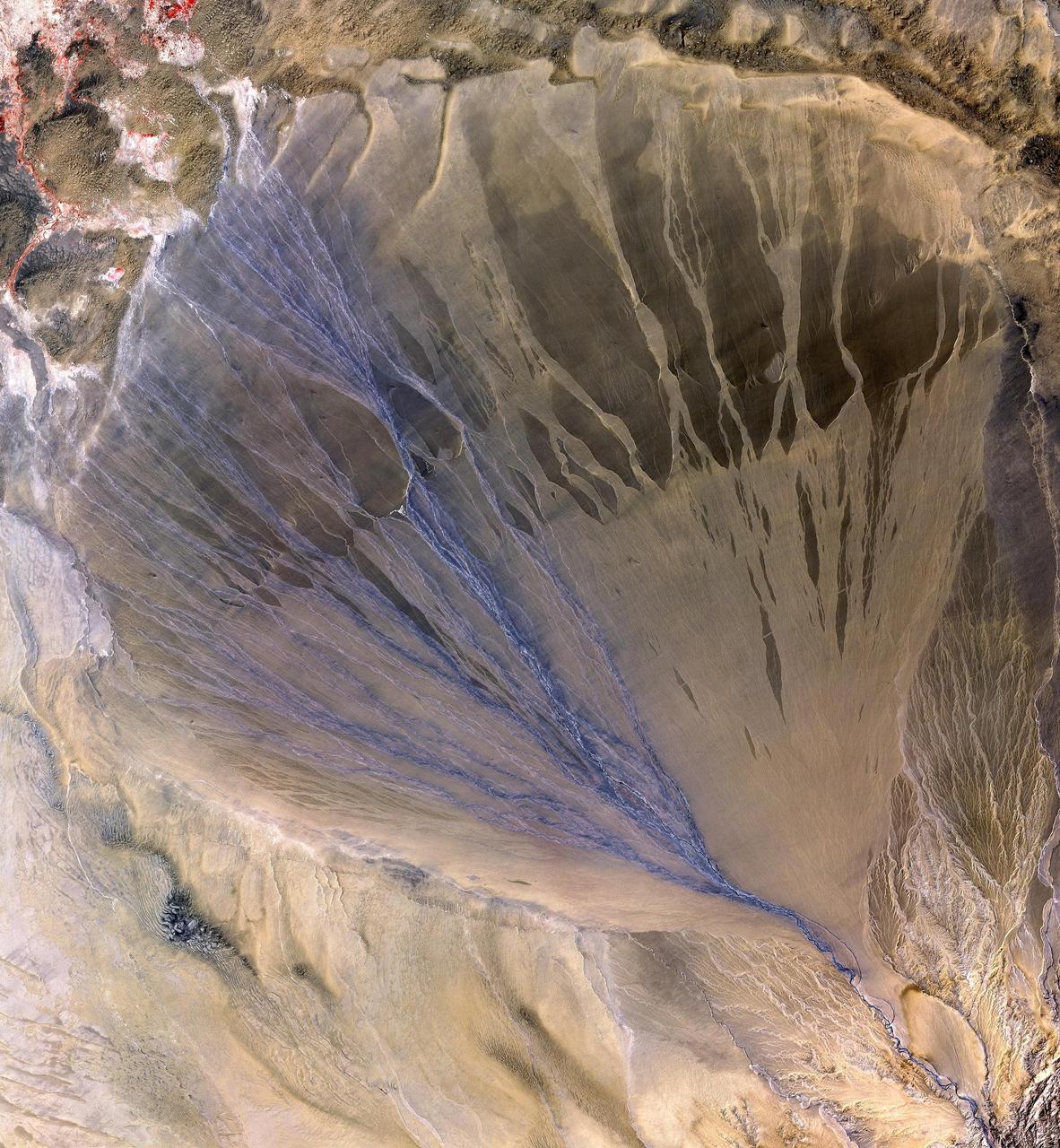
NASA Terra spacecraft shows vast alluvial fan blossoms across the desolate landscape between two mountain ranges that form the southern border of the Taklimakan Desert in China XinJiang Province.
Karst topography is a geological formation shaped by the dissolution of layers of soluble rock such as limestone. A good example is found in Guangxi Province in southeast China, as seen by NASA Terra spacecraft.
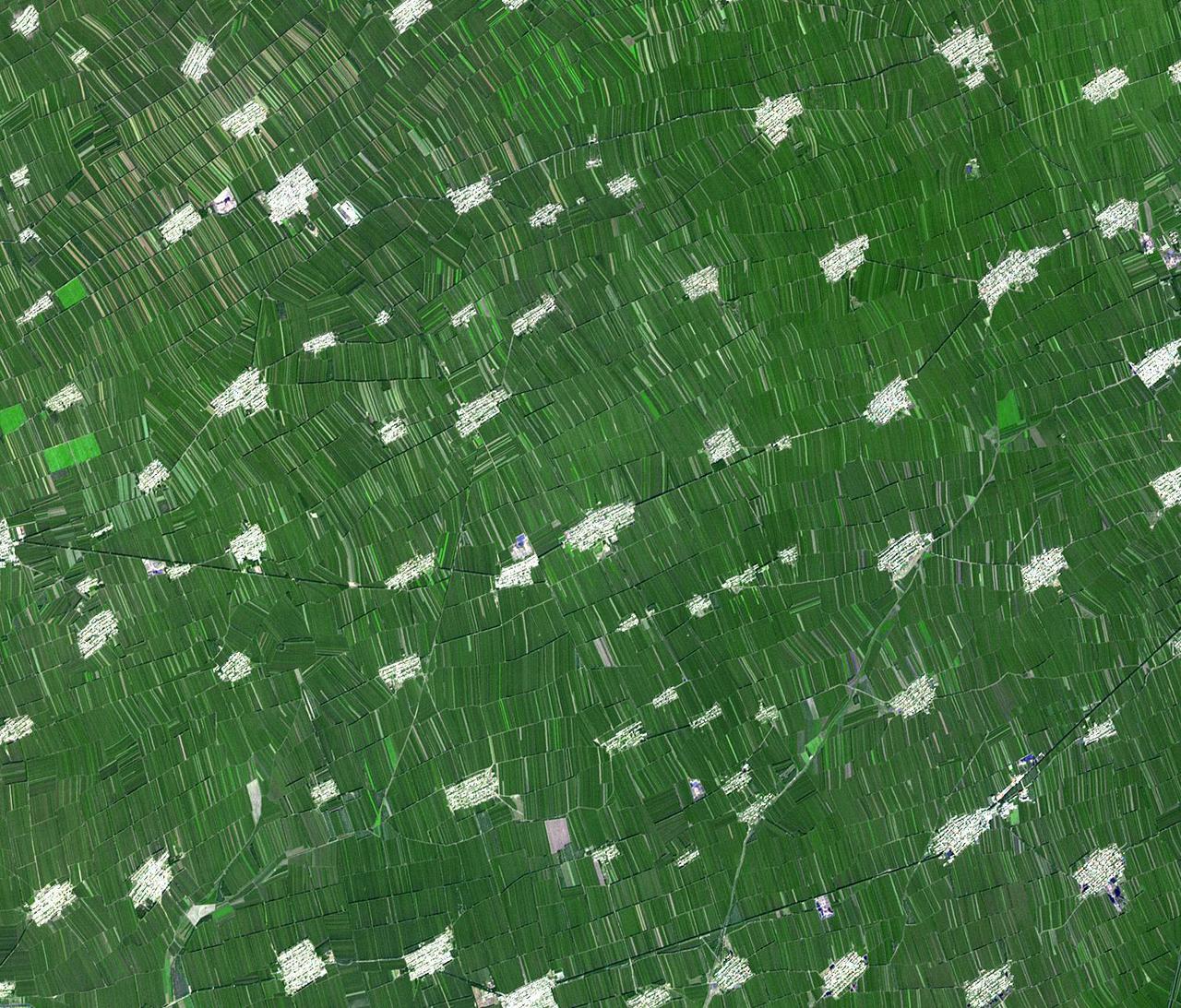
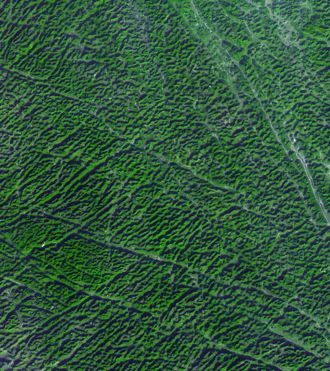
Acquired by NASA Terra spacecraft, this image shows Heilongjiang, a province of China located in the northeastern part of the country. Farms are small and long skinny rectangles in shape, surrounding regularly spaced villages.
The Yellow River is the second-longest river in China, and the sixth longest in the world and makes many dramatic shifts over time. This image was taken with the ASTER instrument aboard NASA Terra spacecraft in 2009.
This image captures the beauty of a major alluvial fan in Tsinghai, a province located in Northwestern China. This archival image was taken from NASA Space Shuttle in 1997 as part of its ISS EarthKAM mission.
The northwest-southeast trending, snow-covered, linear mountain range is the King Ata Tag Mountain, located in extreme western most China. Highest peaks are just over 20,100 feet above sea level. The town or village of Muji is located in the largest river valley that is south of this range of mountains. This area includes part of the country of Tajikistan. The center point of the photo is approximately 39.30 degrees north and 74.30 degrees easth.
This image from NASA EarthKAM captures almost all of Quinghai, the largest lake in China. It is located in the Quinghai Province on the Quinghai Tibetan Plateau.
This spaceborne radar image of a mineral-rich region in southern China is being used by geologists to identify potential new areas for mineral exploration.
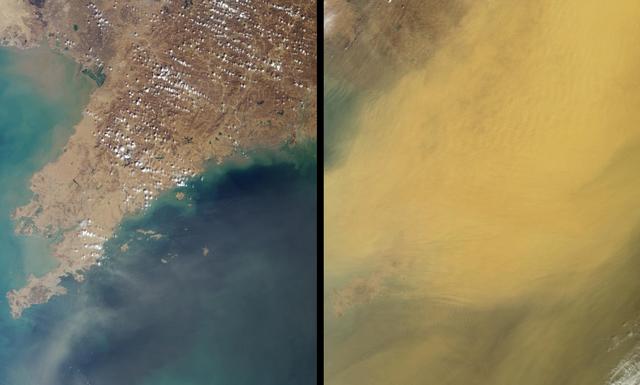
This pair of images, acquired 16 days apart by NASA Terra satellite in 2002 and 2007, covers the Liaoning region of China and parts of northern and western Korea, comparing a relatively clear day and an extremely dusty day.
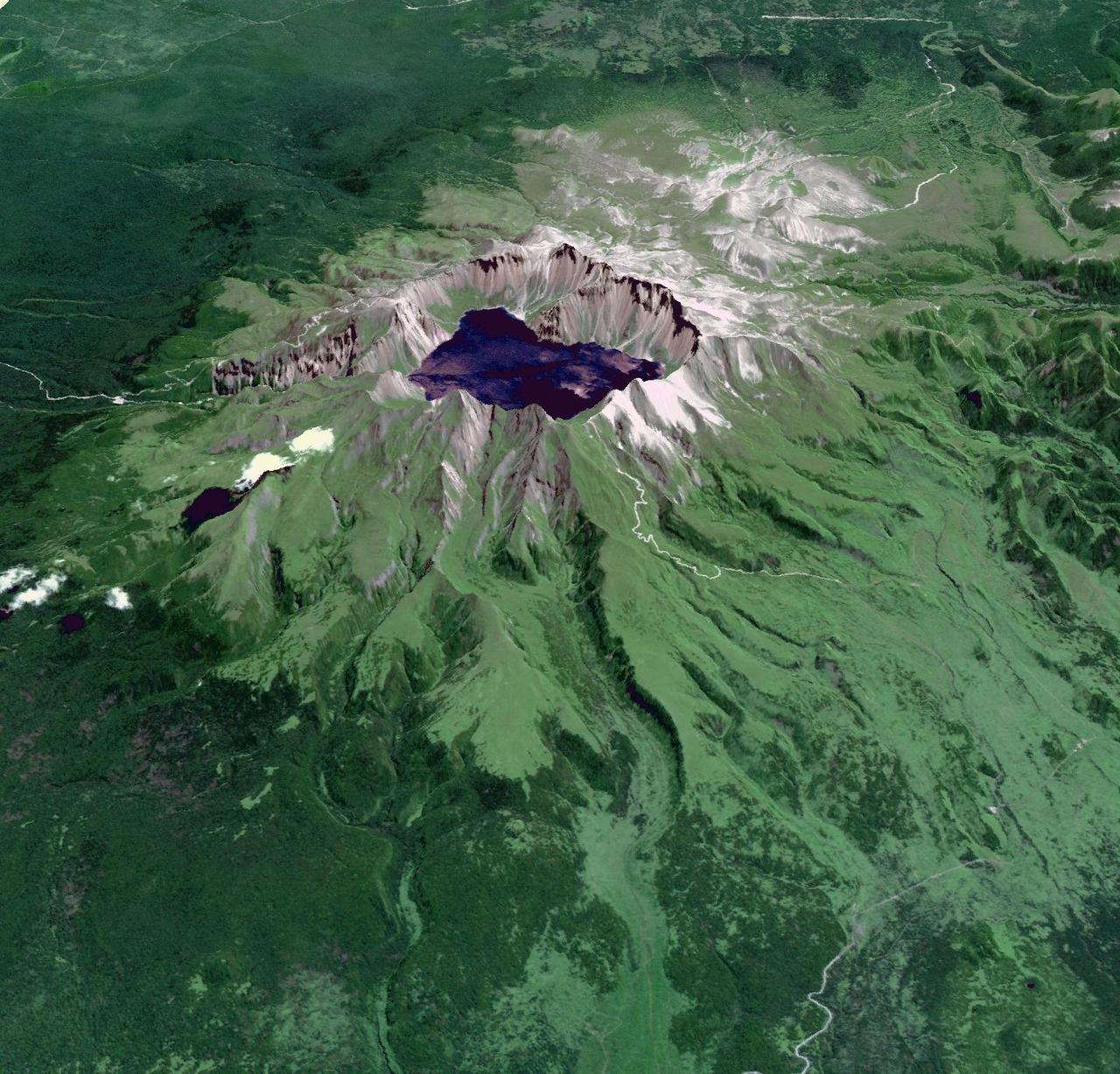
This image from NASA Terra spacecraft shows Baektu Mountain, an active volcano on the border between North Korea and China. Rising to 2744 m, its summit caldera is filled with a crater lake, Heaven Lake.
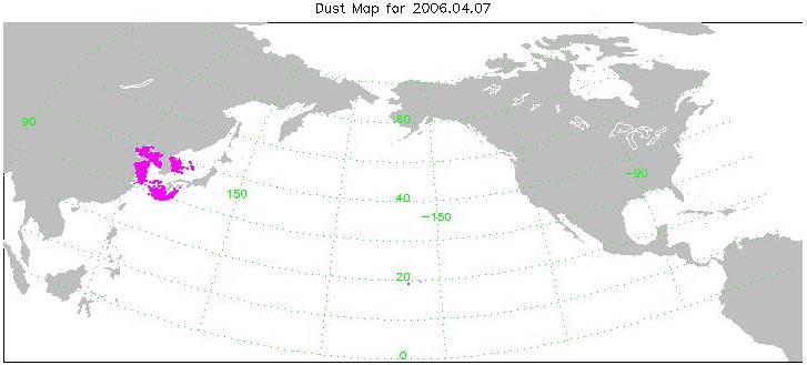
Transport of dust from China Dust Storm of April 2006, from the Atmospheric Infrared Sounder AIRS on NASA Aqua satellite.
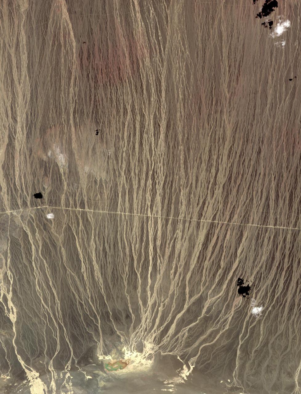
On the border between Mongolia and China, southward draining ephemeral streams have carved a series of parallel channels. Mountains to the north have an elevation of 1800 m; the catchment lake for the streams lies at 500 m elevation. The flat, featureless, homogeneous plain between the source and sink controls the geometry of the drainage pattern. The image was acquired August 17, 2014, covers an area of 17.7 by 36.3 kilometers, and is located at 42.7 degrees north, 100.9 degrees east. https://photojournal.jpl.nasa.gov/catalog/PIA23196
The terracotta army, was buried near the mausoleum of Qin Shi Huang, the first emperor of China, in about 220 BCE. The 8,000 figures, chariots and horses were discovered by farmers in 1974 outside of Xian. The unexcavated pyramidal tomb is about 300 by 300 m, and over 75 m high. The image was acquired July 25, 2023, covers an area of 8.5 by 9.2 km, and is located at 34.4 degrees north, 109.2 degrees east. Map (Figure 1) from: https://commons.wikimedia.org/w/index.php?curid=139439886 https://photojournal.jpl.nasa.gov/catalog/PIA26394
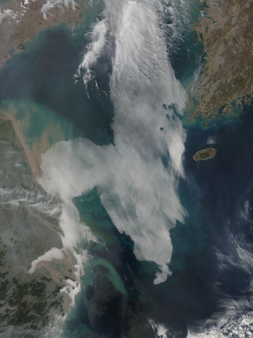
Low clouds over the Yellow Sea and the East China Sea was captured by the MODIS instrument on the Aqua satellite on April 1, 2016 at 4:55 UTC. Credit: NASA/Goddard/Jeff Schmaltz/MODIS Land Rapid Response Team <b><a href="http://www.nasa.gov/audience/formedia/features/MP_Photo_Guidelines.html" rel="nofollow">NASA image use policy.</a></b> <b><a href="http://www.nasa.gov/centers/goddard/home/index.html" rel="nofollow">NASA Goddard Space Flight Center</a></b> enables NASA’s mission through four scientific endeavors: Earth Science, Heliophysics, Solar System Exploration, and Astrophysics. Goddard plays a leading role in NASA’s accomplishments by contributing compelling scientific knowledge to advance the Agency’s mission. <b>Follow us on <a href="http://twitter.com/NASAGoddardPix" rel="nofollow">Twitter</a></b> <b>Like us on <a href="http://www.facebook.com/pages/Greenbelt-MD/NASA-Goddard/395013845897?ref=tsd" rel="nofollow">Facebook</a></b> <b>Find us on <a href="http://instagrid.me/nasagoddard/?vm=grid" rel="nofollow">Instagram</a></b>

This image from NASA Terra spacecraft highlights the epicenter of a powerful magnitude 6.6 earthquake which struck Sichuan Province in southwest China on April 20, 2013. Vegetation is displayed in red; clouds and snow are in white.
The star on this image from the NASA Terra spacecraft indicates the eipcenter of a magnitude 6.1 earthquake which truck in southern China Yunnan province, toppling thousands of homes and causing numerous casualties.
iss072e067740 (Oct. 12, 2024) --- The Tashkurgan River in western China's Hindu Kush mountains near the nations of Tajikistan and Afghanistan is pictured from the International Space Station as it orbited 259 miles above Asia.
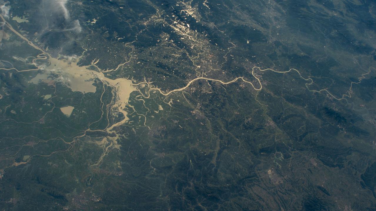
iss071e439833 (Aug. 8, 2024) --- Xiang River runs through the city of Changsha (center) in China's province of Hunan. At far left, the city of Yueyang lies on the bank of Dongdongting Lake in Hunan's humid, subtropical region. The International Space Station was orbiting 262 miles above the Asian nation at the time of this photograph.

The MODIS instrument on NASA's Aqua satellite captured Typhoon Neoguri in the East China Sea at 05:00 UTC (1:00 AM EDT) on July 8, 2014. Typhoon Neoguri hit Japan’s Okinawa islands on Tuesday local time (July 8, 2014), bringing high winds, huge waves and storm surges. Neoguri packed sustained winds of 175 kilometers (108 miles) per hour with some gusts up to 250 kph (154 mph), according to the Japan Meteorological Agency. Credit: NASA/GSFC/Jeff Schmaltz/MODIS Land Rapid Response <b><a href="http://www.nasa.gov/audience/formedia/features/MP_Photo_Guidelines.html" rel="nofollow">NASA image use policy.</a></b> <b><a href="http://www.nasa.gov/centers/goddard/home/index.html" rel="nofollow">NASA Goddard Space Flight Center</a></b> enables NASA’s mission through four scientific endeavors: Earth Science, Heliophysics, Solar System Exploration, and Astrophysics. Goddard plays a leading role in NASA’s accomplishments by contributing compelling scientific knowledge to advance the Agency’s mission. <b>Follow us on <a href="http://twitter.com/NASAGoddardPix" rel="nofollow">Twitter</a></b> <b>Like us on <a href="http://www.facebook.com/pages/Greenbelt-MD/NASA-Goddard/395013845897?ref=tsd" rel="nofollow">Facebook</a></b> <b>Find us on <a href="http://instagram.com/nasagoddard?vm=grid" rel="nofollow">Instagram</a></b>

iss073e0515603 (Aug. 24, 2025) --- Shanghai, China, situated on the Yangtze River where it meets the East China Sea, is pictured at approximately 1:32 a.m. local time from the International Space Station as it orbited 261 miles above the nation's eastern coastline. Visible landmarks include Shanghai Hongqiao International Airport near the top of the frame and Shanghai Pudong International Airport at the bottom. The city's lights appear dimmer from orbit due to the widespread use of modern, downward-facing, energy-efficient lighting that reduces light pollution. Credit: JAXA (Japan Aerospace Exploration Agency)

On August 9 at 03:00 UTC (Aug. 8 at 11 p.m. EDT) the MODIS instrument aboard NASA's Terra satellite passed over the remnant clouds of Typhoon Soudelor when it was over eastern China. By 22:35 UTC (6:35 p.m. EDT) on August 8, 2015, Typhoon Soudelor had made landfall in eastern China and was rapidly dissipating. Maximum sustained winds had dropped to 45 knots (51.7 mph/83.3 kph) after landfall, making it a tropical storm. Image credit: NASA Goddard MODIS Rapid Response Team/Jeff Schmaltz..<b><a href="http://www.nasa.gov/audience/formedia/features/MP_Photo_Guidelines.html" rel="nofollow">NASA image use policy.</a></b> <b><a href="http://www.nasa.gov/centers/goddard/home/index.html" rel="nofollow">NASA Goddard Space Flight Center</a></b> enables NASA’s mission through four scientific endeavors: Earth Science, Heliophysics, Solar System Exploration, and Astrophysics. Goddard plays a leading role in NASA’s accomplishments by contributing compelling scientific knowledge to advance the Agency’s mission. <b>Follow us on <a href="http://twitter.com/NASAGoddardPix" rel="nofollow">Twitter</a></b> <b>Like us on <a href="http://www.facebook.com/pages/Greenbelt-MD/NASA-Goddard/395013845897?ref=tsd" rel="nofollow">Facebook</a></b> <b>Find us on <a href="http://instagrid.me/nasagoddard/?vm=grid" rel="nofollow">Instagram</a></b>
This ASTER image shows a 60 km stretch of the Yangtze River in China, including the Xiling Gorge, the eastern of the three gorges. In the left part of the image is the construction site of the Three Gorges Dam, the world's largest. This image was acquired on July 20, 2000 by the Advanced Spaceborne Thermal Emission and Reflection Radiometer (ASTER) on NASA's Terra satellite. With its 14 spectral bands from the visible to the thermal infrared wavelength region, and its high spatial resolution of 15 to 90 meters (about 50 to 300 feet), ASTER will image Earth for the next 6 years to map and monitor the changing surface of our planet. http://photojournal.jpl.nasa.gov/catalog/PIA03852

The largest city wall in the world is in Nanjing, China. It was built between 1366 and 1386 by the Ming Dynasty Emperor Zhu Yuangzhang to enclose and fortify his capital city. The wall is over 33 km long, is constructed from 350 million bricks, and is 14 meters wide, and 14-20 meters high. Its 13 massive gates today have been restored and house museums telling the story of the city of Nanjing. The ASTER image was acquired October 25, 2014, covers an area of 20.5 by 21.6 kilometers, and is located at 32.1 degrees north and 118.7 degrees east. https://photojournal.jpl.nasa.gov/catalog/PIA22735
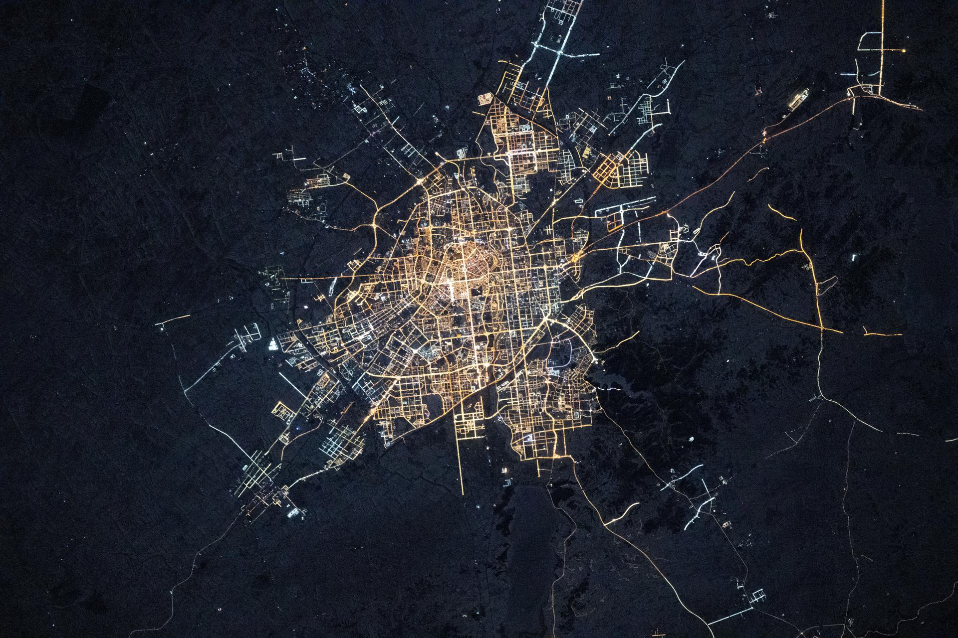
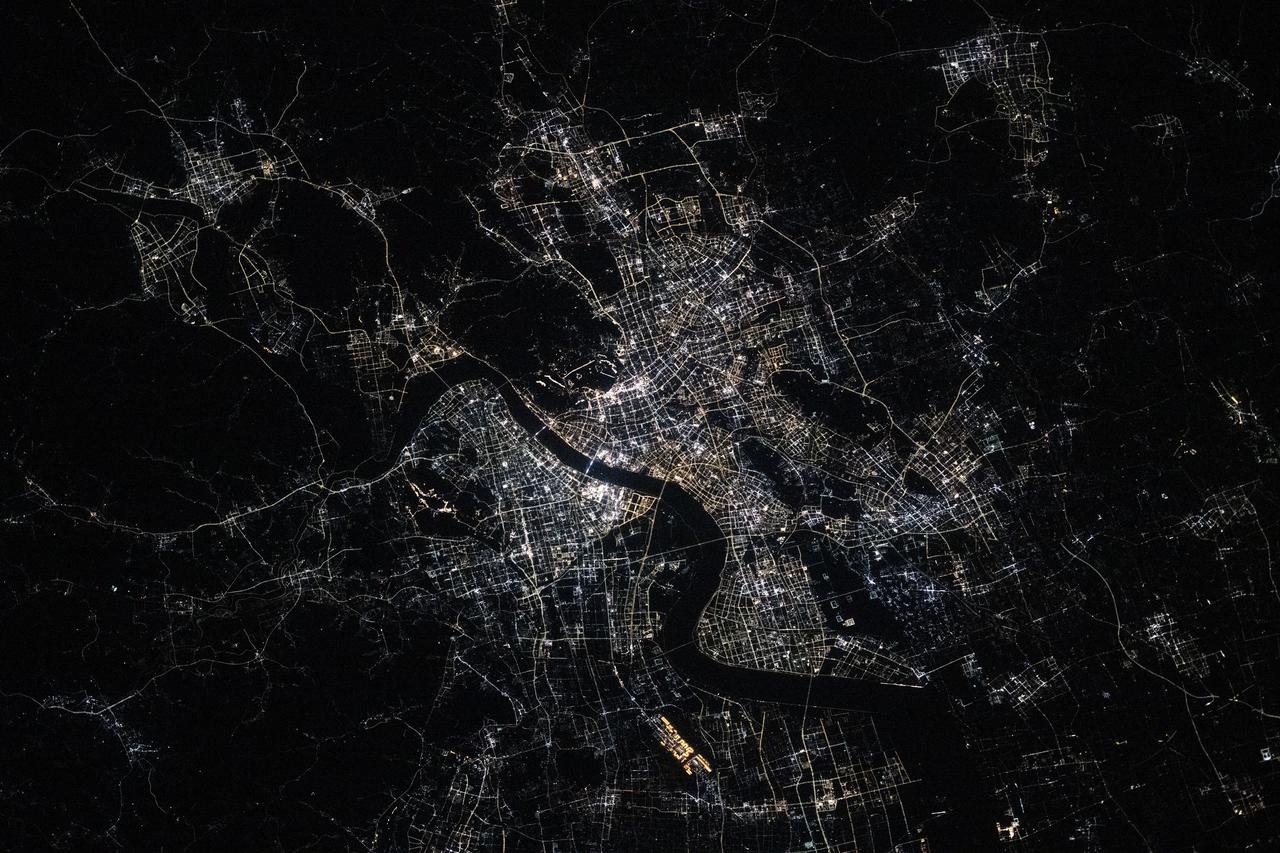
iss072e445027 (Dec. 28, 2024) --- The city lights of Harbin, the capital of China's northernmost province of Heilongjiang with a population of about 10 million and split by the Songhua River, are pictured at approximately 1:33 a.m. local time from the International Space Station.
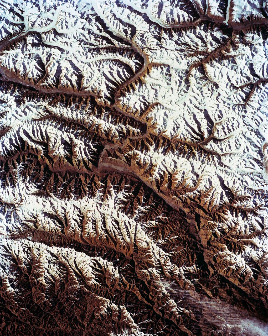
STS-56 Earth observation shows of some of the highest mountain peaks in the world taken from Discovery, Orbiter Vehicle (OV) 103, as it passed over India and China. The top of the view shows one of the snow and ice-covered massifs in the great Karakorum Range of north India. A star-shaped peak at top left reaches 23,850 feet. Glaciers can be seen in valleys at these high elevations. The international border between India to the south (top) and China (bottom) snakes left to right along a river near the top of the scene, then veers into the muntains at top left. Larger valleys, despite their elevation (all in excess of 14,000 feet), are occupied by transport routes joining points in India, China and the southern republics of the CIS. The ancient Silk Route between China and the Middle East lies not far to the north (outside the bottom of the frame).
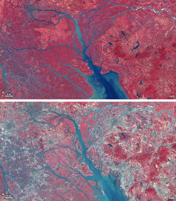
In 1979, China established two special economic zones around the Pearl River Delta, north of Hong Kong. This image, taken by Landsat 3 on October 19, 1973, shows that the region was rural when the zone was established. Plant-covered land, which is red in this false-color image, dominates the scene. Square grids are agriculture. By January 10, 2003, when Landsat 7 took this image, the Pearl River Delta was a densely populated urban corridor with several large cities. The urban areas are gray in this image. The region is a major manufacturing center with an economy the size of Taiwan’s. As of 2010, the Pearl River Economic Zone had a population of 36 million people. ---- NASA and the U.S. Department of the Interior through the U.S. Geological Survey (USGS) jointly manage Landsat, and the USGS preserves a 40-year archive of Landsat images that is freely available over the Internet. The next Landsat satellite, now known as the Landsat Data Continuity Mission (LDCM) and later to be called Landsat 8, is scheduled for launch in 2013. In honor of Landsat’s 40th anniversary in July 2012, the USGS released the LandsatLook viewer – a quick, simple way to go forward and backward in time, pulling images of anywhere in the world out of the Landsat archive. <b><a href="http://www.nasa.gov/audience/formedia/features/MP_Photo_Guidelines.html" rel="nofollow">NASA image use policy.</a></b> <b><a href="http://www.nasa.gov/centers/goddard/home/index.html" rel="nofollow">NASA Goddard Space Flight Center</a></b> enables NASA’s mission through four scientific endeavors: Earth Science, Heliophysics, Solar System Exploration, and Astrophysics. Goddard plays a leading role in NASA’s accomplishments by contributing compelling scientific knowledge to advance the Agency’s mission. <b>Follow us on <a href="http://twitter.com/NASA_GoddardPix" rel="nofollow">Twitter</a></b> <b>Like us on <a href="http://www.facebook.com/pages/Greenbelt-MD/NASA-Goddard/395013845897?ref=tsd" rel="nofollow">Facebook</a></b> <b>Find us on <a href="http://instagrid.me/nasagoddard/?vm=grid" rel="nofollow">Instagram</a></b>

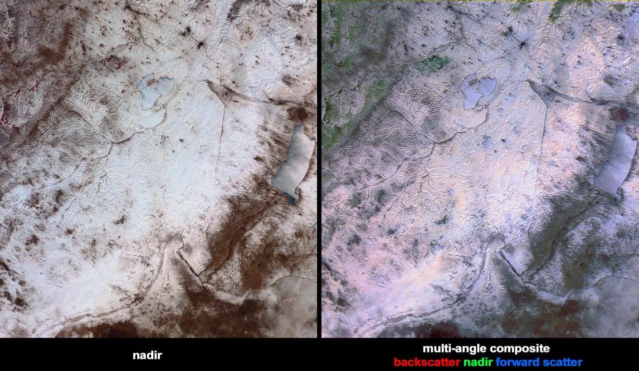
This image of the Shandong Province, China was acquired by the Multi-angle Imaging SpectroRadiometer instrument aboard NASA Terra spacecraft. This image is from the MISR Where on Earth...? Mystery Quiz #24.

iss071e439834 (Aug. 8, 2024) --- The Yangtze River beams in the Sun's glint as wildfires burn in the surrounding forestland near the city of Wuhan in China's province of Hubei. The International Space Station was orbiting 262 miles above the Asian nation at the time of this photograph.
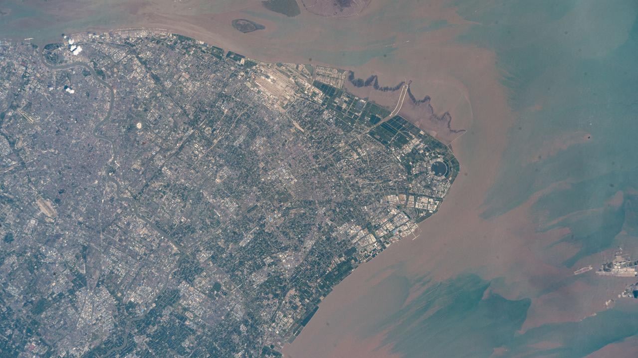
iss073e0513927 (Aug. 22, 2025) --- Shanghai, China's most populous city with over 24 million citizens and sitting on the East China Sea at the mouth of the Yangtze River, is pictured from the International Space Station as it orbited 260 miles above. Highlights include Shanghai Pudong International Airport (at top), the second busiest airport in the world by cargo traffic, and the circular Dishui Lake (center right), the largest artificial freshwater lake in China, hosting business and recreational activities.
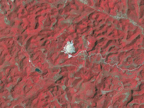
The Five-hundred-meter Aperture Spherical Telescope (FAST) is a radio telescope in China's Guizhou Province. When it is completed in September, it will be the world's second largest radio telescope, with a diameter of 500m.The largest telescope is the operating Russian RATAN-600, with a diameter of 576m. The image was acquired April 14, 2013, covers an area of 6.2 by 8.2 km, and is located at 25.7 degrees north, 106.9 degrees east. http://photojournal.jpl.nasa.gov/catalog/PIA20986
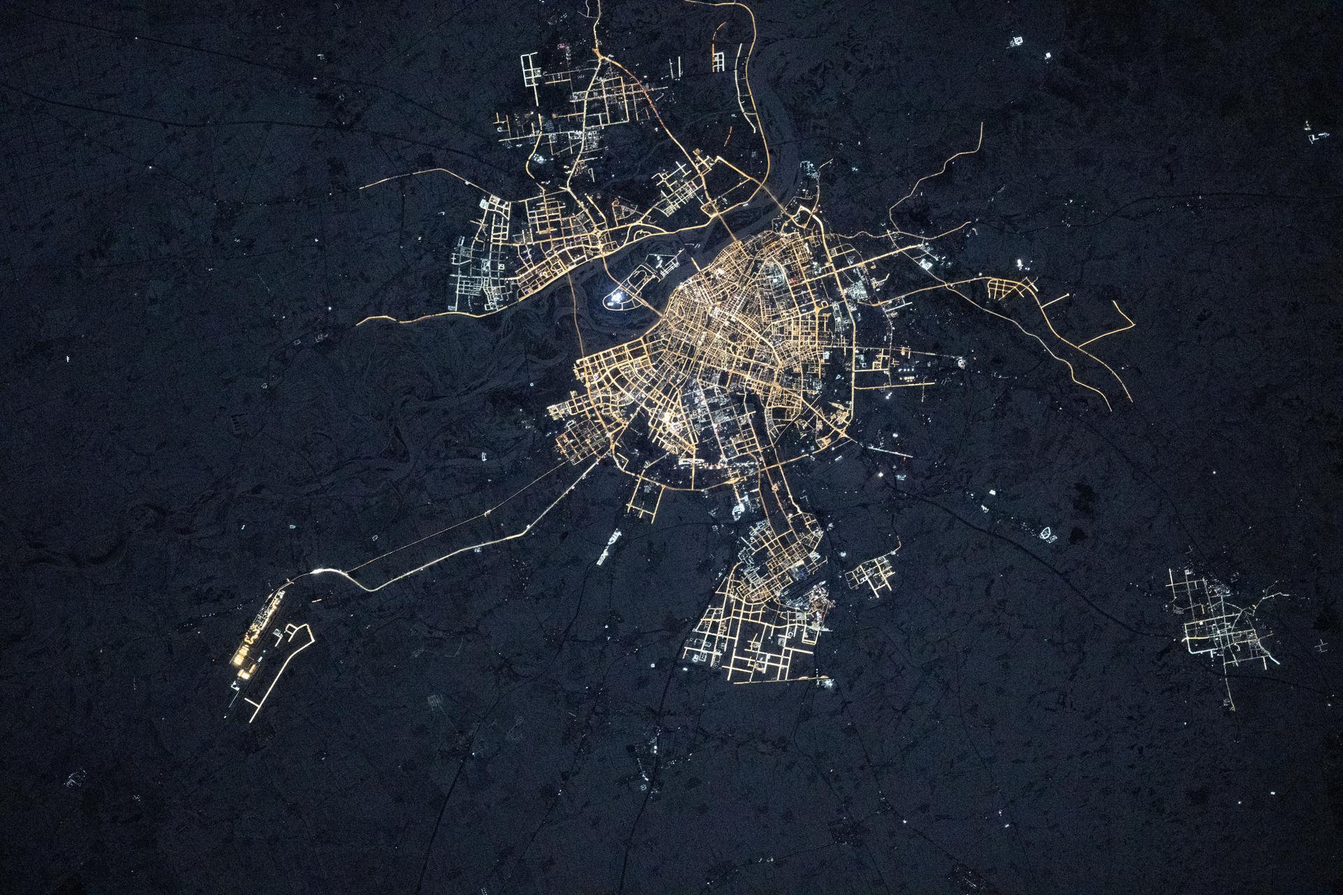
iss074e0044341 (Jan. 3, 2026) --- Changchun, China—whose name translates to “Long Spring” for its pleasant spring season and home to about nine million people—is pictured at approximately 3:28 a.m. local time from the International Space Station as it orbited 266 miles above the Asian continent. Changchun is also the birthplace of China’s automotive and film industries. Credit: JAXA/Kimiya Yui
This spaceborne radar image shows part of the British territory of Hong Kong, adjacent to mainland China. The South China Sea is shown in dark blue and red on the image.
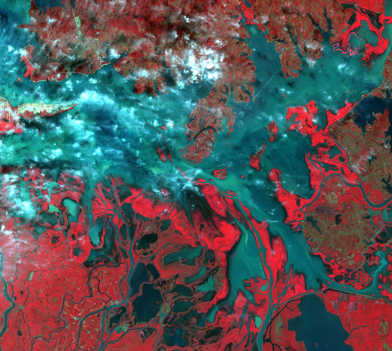
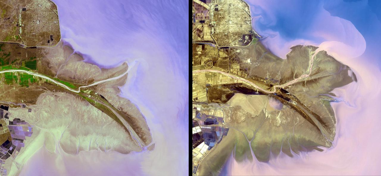
These images show dramatic change in the water at Dongting Lake in Hunan province, China. A flood crest surged down the Yangtze River in late August of this year, but the embankments made by residents there held. The left image was acquired on September 2, 2002 and shows the extent of the lake. The right image was obtained March 19, 2002 before the flooding began. These images were acquired on September 2, 2002 and March 19, 2002 by the Advanced Spaceborne Thermal Emission and Reflection Radiometer (ASTER) on NASA's Terra satellite. With its 14 spectral bands from the visible to the thermal infrared wavelength region, and its high spatial resolution of 15 to 90 meters (about 50 to 300 feet), ASTER will image Earth for the next 6 years to map and monitor the changing surface of our planet. http://photojournal.jpl.nasa.gov/catalog/PIA03858
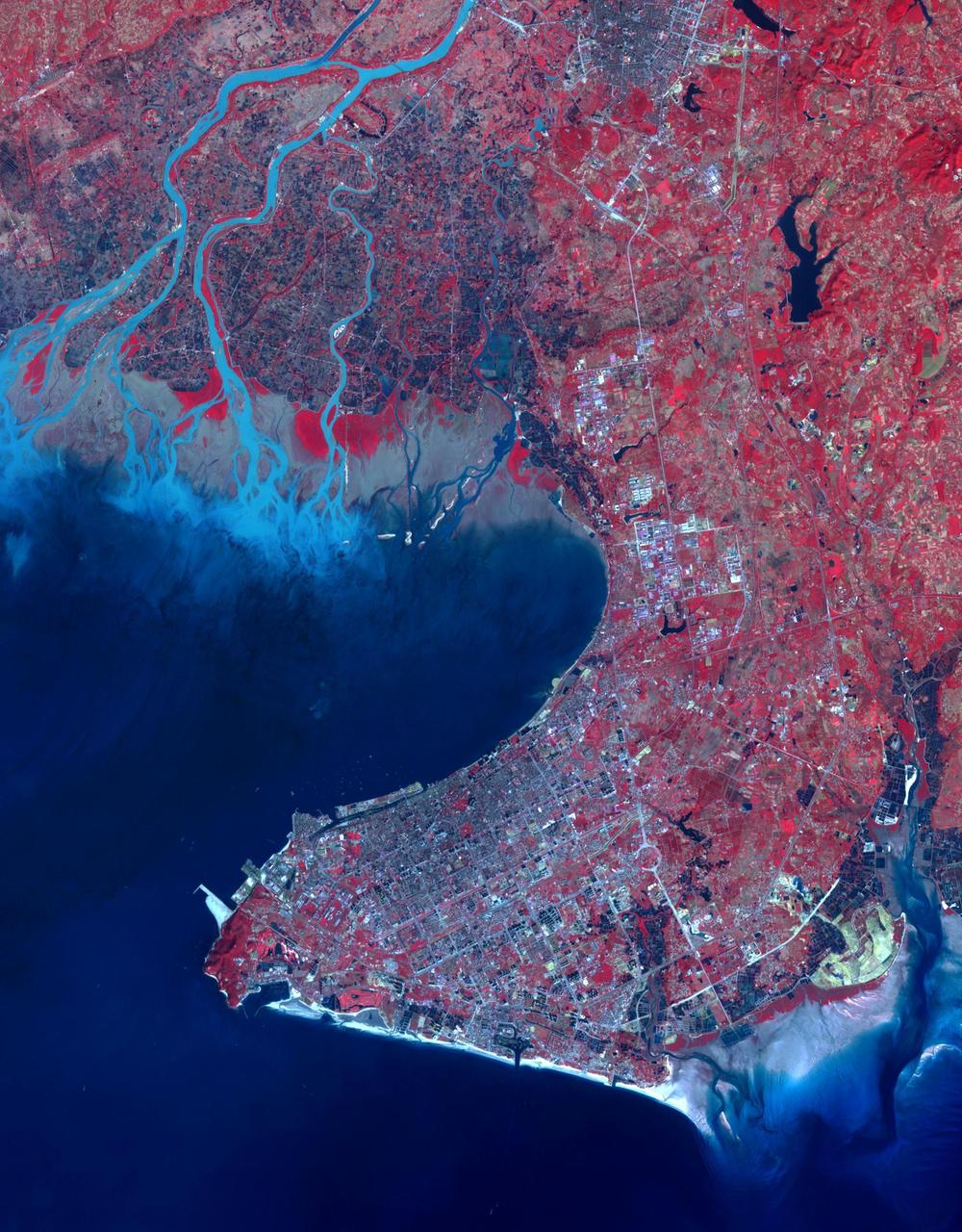
Suzhou is a major city located in southeastern Jiangsu Province of East China, about 100 km northwest of Shanghai. It is a major economic center and focal point of trade and commerce. The city is situated on the lower reaches of the Yangtze River and the shores of Lake Tai. Founded in 514 BCE, Suzhou has over 2,500 years of history, with an abundant display of relics and sites of historical interest. Since major economic reforms began in 1978, Suzhou has become one of the fastest growing major cities in the world. The population has grown from 0.9 million in 1990, 2.2 million in 2000, 4.1 million in 2010, to 5.3 million in 2017. The Landsat TM image was acquired August 4, 1984, and the Aster image was acquired August 2, 2015. The images cover an area of 48 by 53 km, and are located at 31.2 degrees north, 120.4 degrees east. https://photojournal.jpl.nasa.gov/catalog/PIA22266

iss072e397138 (Dec. 19, 2024) --- The Himalayas separate the arid steppe of China's Tibetan Plateau from a cloudy Indian subcontinent in this photograph from the International Space Station as it soared 261 miles above Asia.
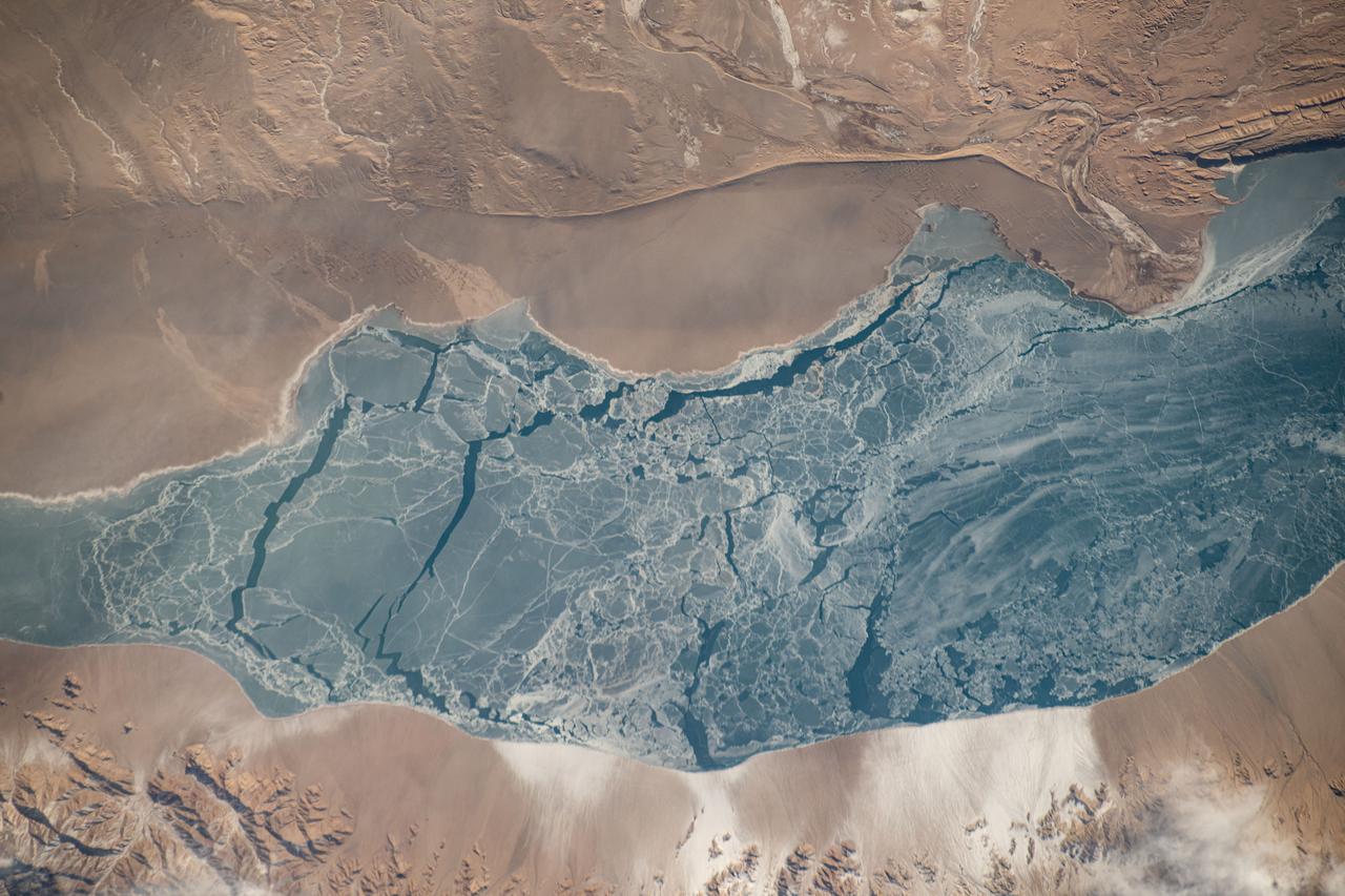
iss072e363445 (Dec. 13, 2024) --- An icy lake in southwestern China's high plateau region north of the Himalayas is pictured from the International Space Station as it orbited 262 miles above the Asian continent.
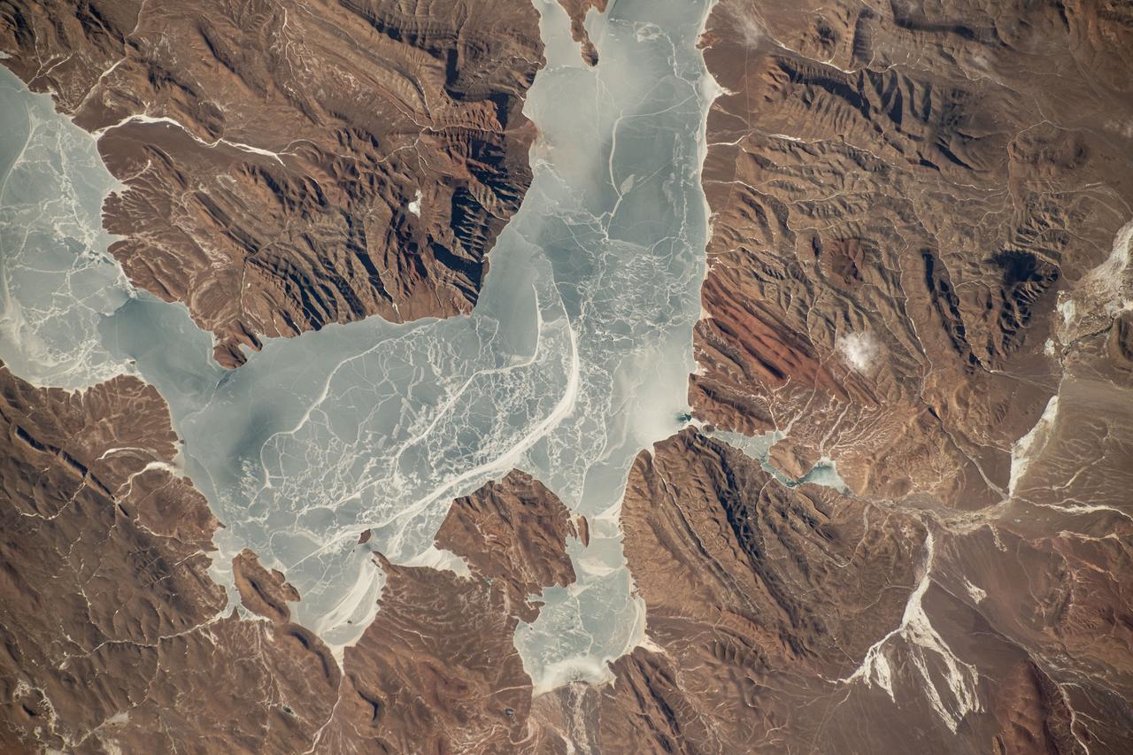
iss072e363454 (Dec. 13, 2024) --- An icy lake in southwestern China's high plateau region north of the Himalayas is pictured from the International Space Station as it orbited 262 miles above the Asian continent.
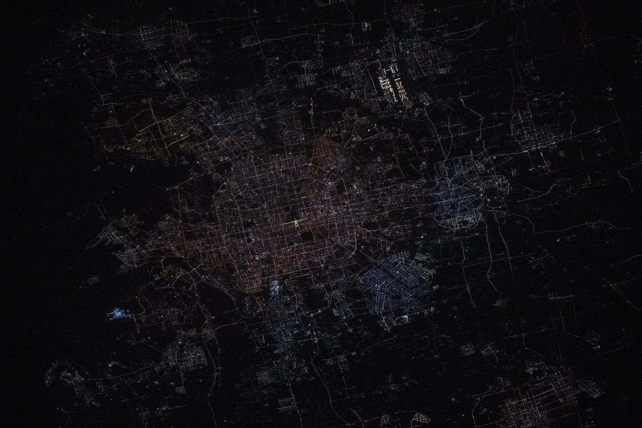
iss072e444944 (Dec. 28, 2024) --- Beijing, China's capital city with a population of about 21.9 million residents, is pictured at approximately 1:31 a.m. local time from the International Space Station as it orbited 259 miles above. Highlights in this photograph include the Forbidden City's well-lit Meridian Gate (center) and the Beijing Capital International Airport (upper right).

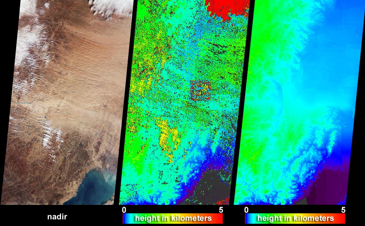
The mighty river featured in this image is called the Yarlung Tsangpo in China, and is then known as the Dikrong during its passage through India state of Arunachal Pradesh. This image from NASA Terra satellite is MISR Mystery Image Quiz #8.
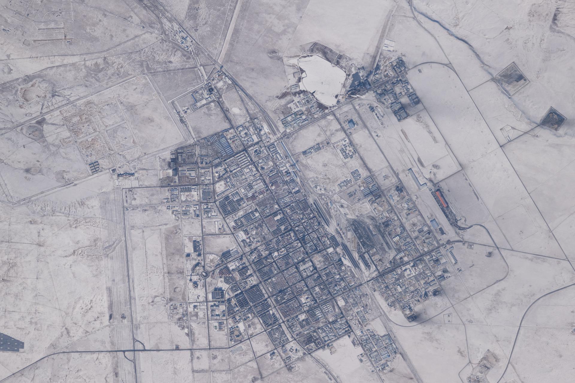
iss074e0000788 (Dec. 13, 2025) --- The county-level city of Erenhot in China's autonomous region of Inner Mongolia is pictured during a dry, deep winter from the International Space Station as it orbited 263 miles above Earth. Erenhot is a key border town for trade and international railway crossings between China and Mongolia. The city is also known for its paleontological history and numerous discoveries of dinosaur fossils.

iss073e0688699 (Aug. 26, 2025) --- The blue-green lights of fishing boats, designed to lure squid, sardines, or mackerel, dot the East China Sea and the Taiwan Strait contrasting with the coastal city lights of Taiwan and China. The International Space Station was orbiting 259 miles above the South China Sea just south of Taiwan at approximately 11:53 p.m. local time when this photograph was taken.
iss073e0134286 (June 2, 2025) --- The north central Vietnamese coast on the South China Sea, in between the cities of Thanh Hóa on the Nam River (left) and Vinh on the Cá River (right), is pictured from the International Space Station as it orbited 260 miles above Southeast Asia.
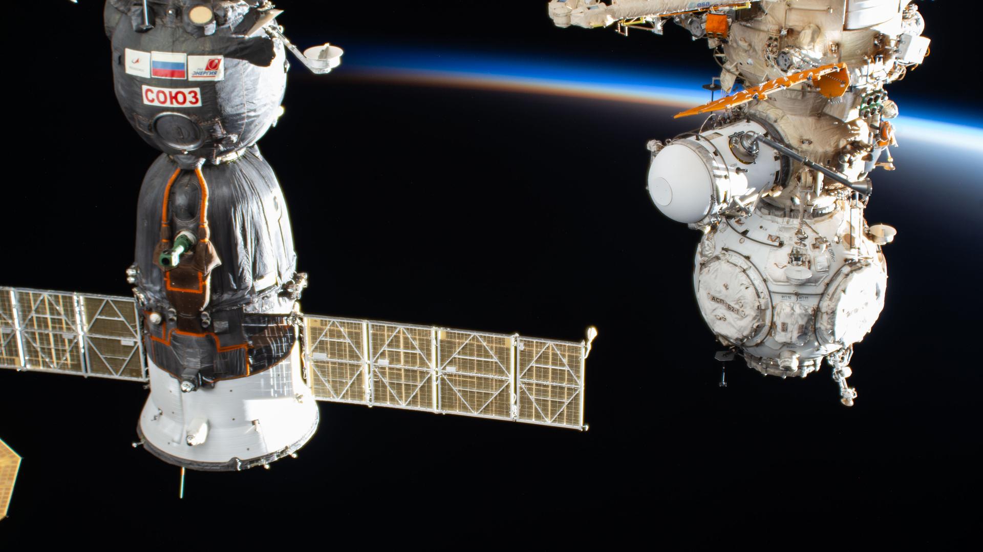
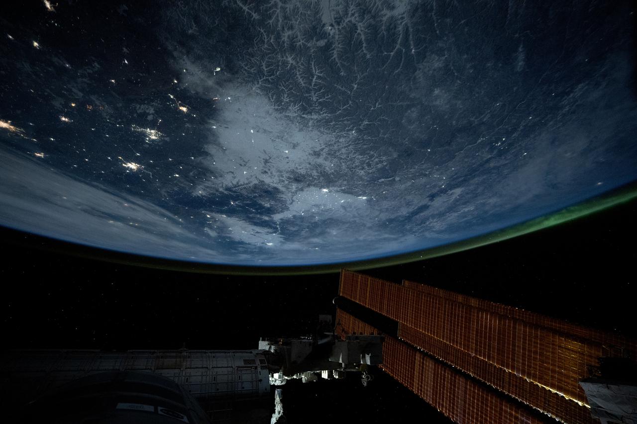
iss074e0089785 (Jan. 25, 2026) --- The International Space Station orbits into a sunset 260 miles above China near the Yellow Sea. In the foreground, are the Soyuz MS-28 crew spacecraft (left) and the Prichal docking module (right) attached to the Nauka science module.
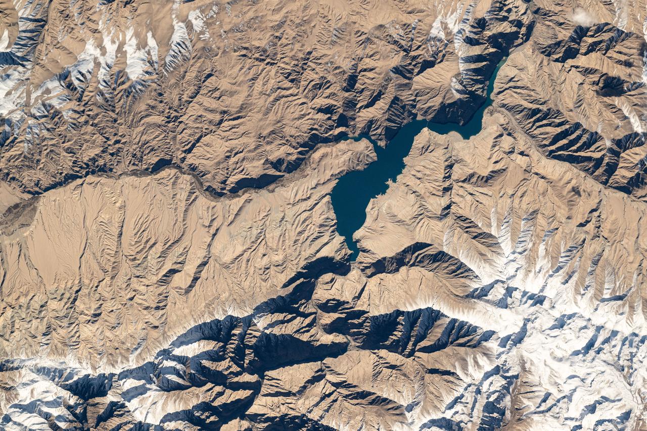
iss074e0325251 (Feb. 22, 2026) --- Peiku Lake in southwest China is surrounded by Himalayan peaks and contains both freshwater and saltwater due to differing sources of meltwater and evaporation patterns. The International Space Station was orbiting 260 miles above the Asian continent when this photograph was taken. Credit: NASA

iss073e0420094 (July 3, 2025) --- Shanghai, China—the nation's largest city with a metropolitan population of approximately 24.9 million—is seen from the International Space Station at around 9:55 p.m. local time. Located where the Yangtze River meets the Yellow Sea, the city glows with urban energy. Notable landmarks include Shanghai Hongqiao International Airport near the top center and Shanghai Pudong International Airport at the bottom. The Huangpu River winds through the heart of downtown, dividing the historic Bund from the futuristic skyline of Lujiazui.
STS001-12-350 (12-14 April 1981) --- India and China, the Ladokh and Zaskar Ranges of the Great Himalaya are clearly etched by snow and shadow. A detailed view shows the glaciation process over a wide area. Photo credit: NASA
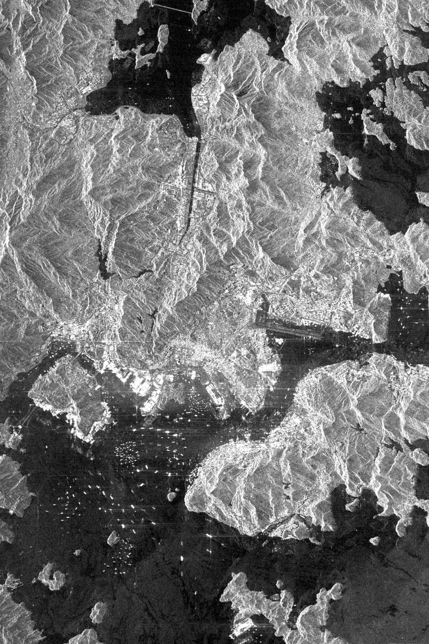
This is an X-SAR image spanning an area of approximately 20 kilometers by 40 kilometers (12 miles by 25 miles) of the island of Hong Kong, the Kowloon Peninsula and the new territories in southern China, taken by the imaging radar on board the space shuttle Endeavour on October 4, 1994. North is toward the top left corner of the image. The Kaitak Airport runway on Kowloon Peninsula (center right of image) was built on reclaimed land and extends almost 3 kilometers (nearly 2 miles) into Victoria Harbor. To the south of the harbor lies the island of Hong Kong. The bright areas around the harbor are the major residential and business districts. Housing more than six million residents, Hong Kong is the most densely populated area in the world. The large number of objects visible in the harbor and surrounding waters are a variety of sea-going vessels, anchored in one of the busiest seaports in the Far East. http://photojournal.jpl.nasa.gov/catalog/PIA01750
STS068-220-033 (30 September-11 October 1994) --- Photographed through the Space Shuttle Endeavour's flight deck windows, this 70mm frame shows a small section of China's Yellow River (Huang Ho) highlighted by sunglint reflection off the surface of the water. The river flows northeastward toward the village of Tung-lin-tzu. The low dissected mountains that cover more than half of this scene rise some 2,000 feet (on the average) above the valley floor. A major east-west transportation corridor (both railway and automobile) is observed traversing the landscape north of the river. This entire region is considered to be part of the Ordos Desert, actually part of the greater Gobi located just north of this area. Approximate center coordinates of this scene are 37.5 degrees north latitude and 105.0 degrees east longitude.

iss074e0044338 (Jan. 3, 2026) --- Shenyang, China—settled for over 7,000 years and famed for its ancient imperial palaces and emperors’ tombs, with a population of over 8 million—is pictured at approximately 3:28 a.m. local time from the International Space Station as it orbited 266 miles above the Asian continent. Credit: JAXA/Kimiya Yui
iss074e0002506 (Dec. 13, 2025) --- The Himalayas—separating the moisture-laden portion of the Indian subcontinent from the arid geography of Tibet, China—are pictured from the International Space Station as it orbited 261 miles above Nepal. At upper right is one of two UltraFlex solar arrays that power the Cygnus XL cargo craft from Northrop Grumman.
iss073e0420079 (July 3, 2025) --- Hangzhou, China—home to approximately 13 million people and the southern end of the Grand Canal, the longest artificial river in the world—glows in this nighttime view from the International Space Station. The canal stretches over 1,200 miles from its starting point in Beijing. This photograph was taken at approximately 9:55 p.m. local time while the station was orbiting 259 miles above Earth.
iss073e0818426 (Oct. 2, 2025) --- The Kelantan River flows through one of Malaysia’s most densely populated floodplains before emptying into the South China Sea. On its eastern bank, where the river meets the sea, lies Kota Bharu, a city founded in the late 19th century and home to approximately 570,000 people. This photograph was taken from the International Space Station as it orbited 260 miles above Earth.
iss074e0603570 (May 20, 2026) --- The snow‑capped Himalayas separate Nepal from China in this photograph from the International Space Station as it orbited 259 miles above the Asian mountain range. The range acts as a climate barrier, trapping cooler, moisture‑laden air on the Nepal side and creating a sharp contrast between Nepal’s lush forests and the much drier Tibetan Plateau to the north. Credit: NASA/Jessica Meir
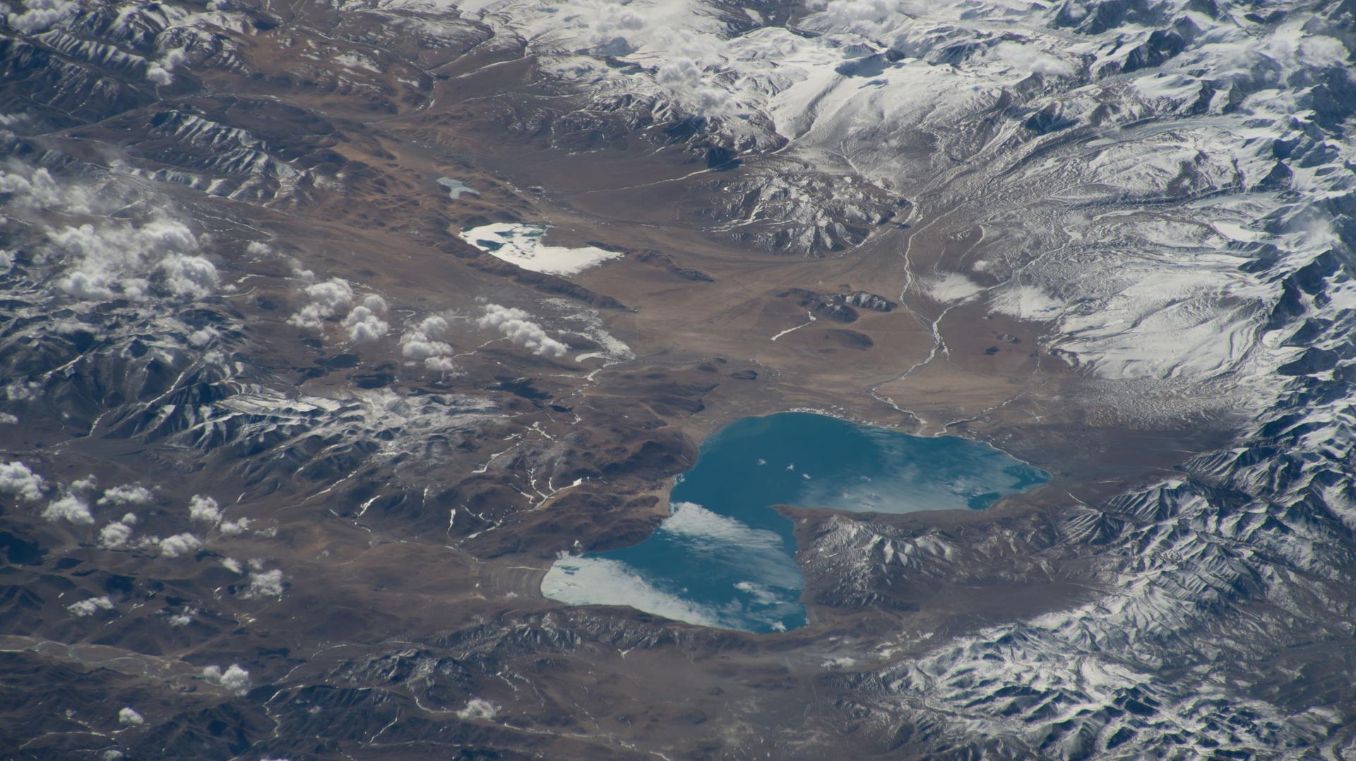
iss074e0603590 (May 20, 2026) --- Lakes on China’s rugged western Tibetan Plateau—an area known for high altitude, extreme weather, and limited infrastructure—are pictured from the International Space Station as it orbited 259 miles above Asia. The lakes’ colors, ranging from turquoise to deep indigo, depend on sunlight and weather, and most are saline. Credit: NASA/Jessica Meir

iss073e0384097 (July 18, 2025) --- The sun's glint beams off the Yellow Sea coast of Jiangsu Province, China, in this photograph taken from the International Space Station as it orbited 260 miles above. In the right foreground, a set of the station's main solar arrays extends into the frame.

iss073e0983013 (Oct. 21, 2025) --- The Taiwan Strait separates the eastern coast of China’s Fujian Province (right) from the island nation of Taiwan (lower left) in this photograph taken from the International Space Station as it orbited 257 miles above Earth. The strait is a vital waterway in East Asia, supporting the fishing, shipping, and communications industries.

iss072e401952 (Dec. 21, 2024) --- The city lights (from left) of Tianjin, Langfang, and Beijing, three cities in China with a combined population of about 41.2 million, are pictured at approximately 4 a.m. local time from the International Space Station as it orbited 259 miles above the Asian nation.
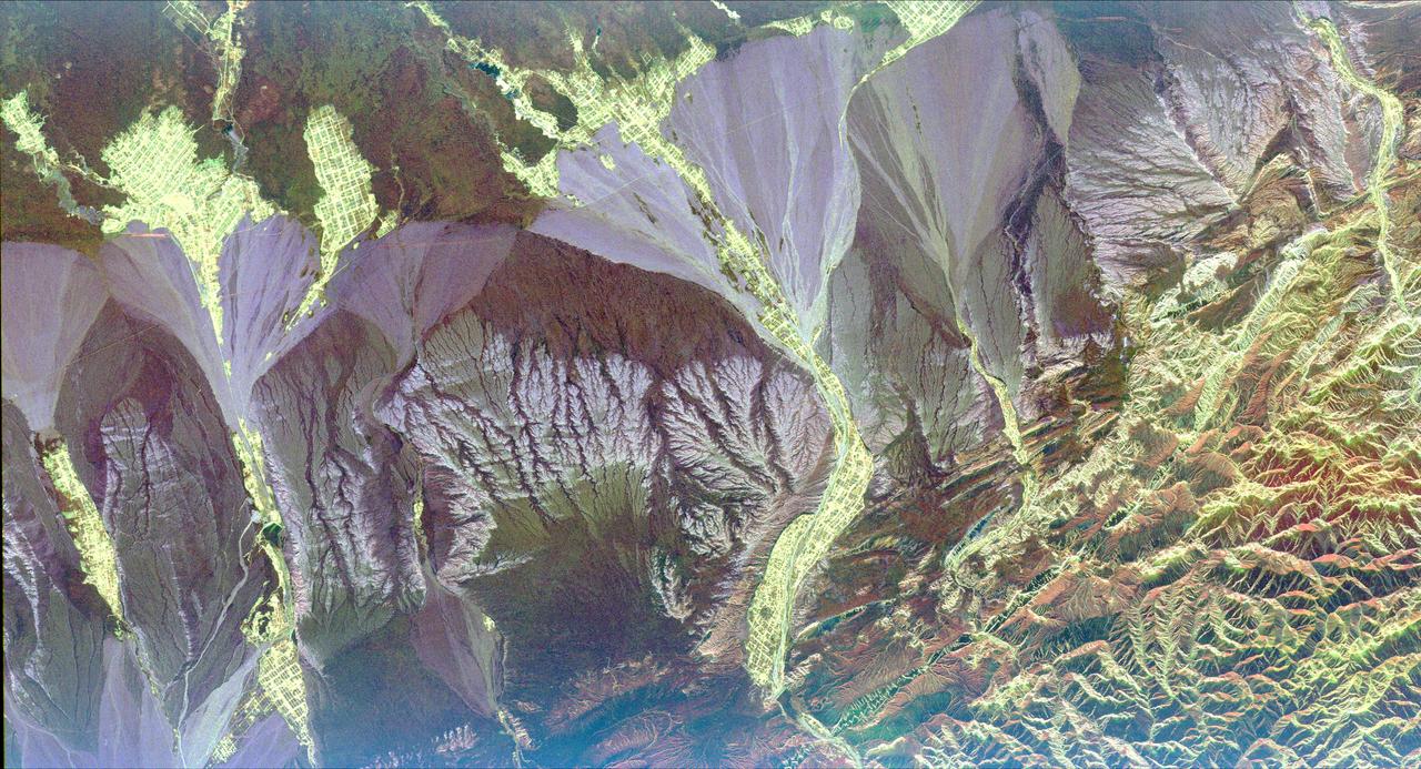
iss074e0316083 (Feb. 18, 2026) --- The far western edge of the Taklamakan Desert—the world’s second-largest shifting sand desert—meets the Pamir Mountains in China, where scorching desert conditions transition to frigid alpine terrain. The International Space Station was orbiting 259 miles above Central Asia when this photograph was taken.

iss073e0824130 (Sept. 14, 2025) --- The Korean Peninsula—highlighted by Seoul, South Korea (bottom left)—and Northeast China—illuminated by the Beijing Municipality (top left)—are pictured from the International Space Station as it orbited 262 miles above Asia at approximately 12:42 a.m. local time.
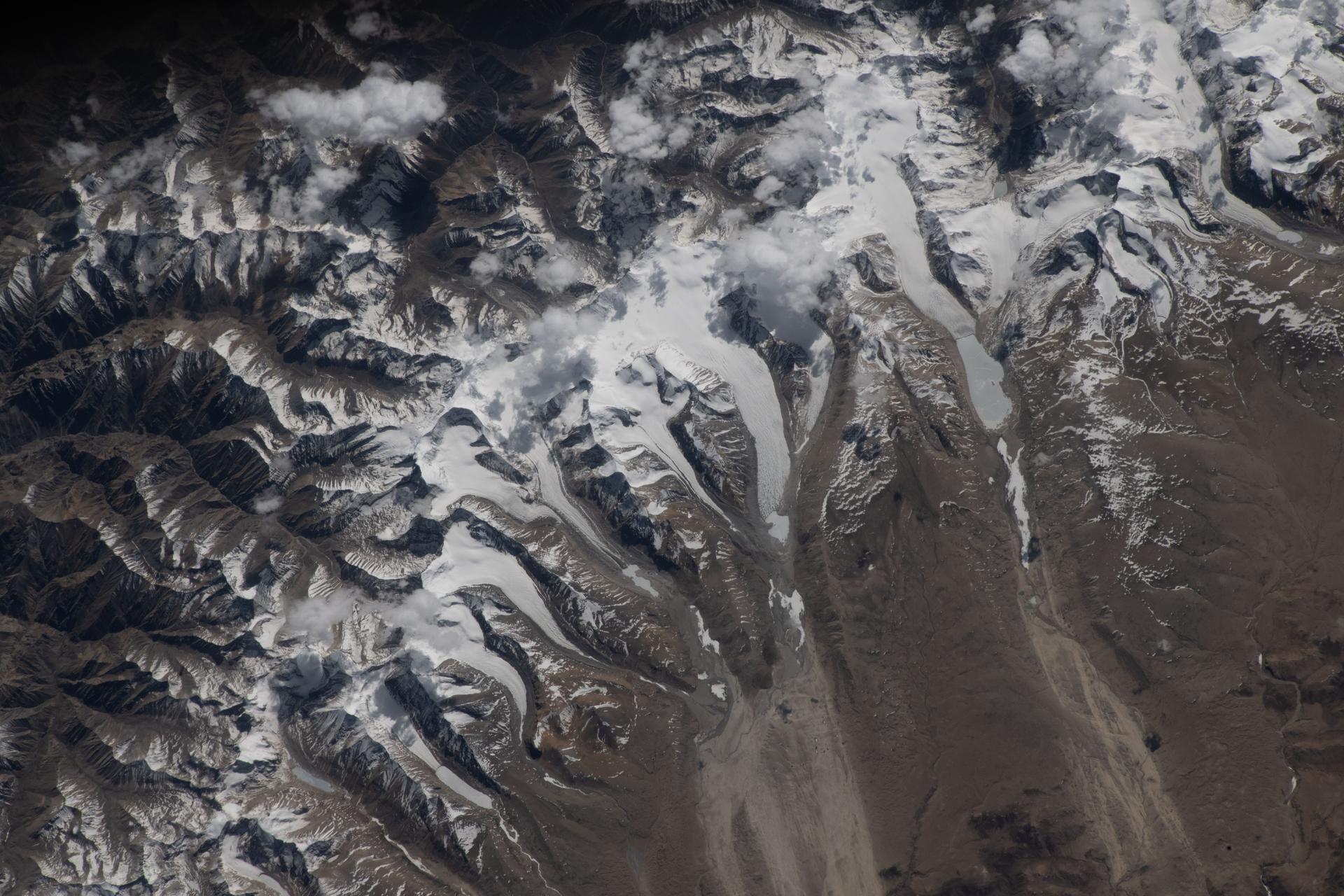
iss074e0603582 (May 20, 2026) --- The Himalayas separate Nepal from China in this photograph from the International Space Station as it orbited 259 miles above the western Tibetan Plateau. Glaciers—slow‑moving rivers of ice that carve paths into mountainsides—flow downhill from the Himalayas’ northern slopes onto China's Tibetan Plateau. Credit: NASA/Jessica Meir
This composite image is of an area thought to contain the ruins of the ancient settlement of Niya. It is located in the southwest corner of the Taklamakan Desert in China Sinjiang Province. This region was part of some of China's earliest dynasties and from the third century BC on was traversed by the famous Silk Road. The Silk Road, passing east-west through this image, was an ancient trade route that led across Central Asia's desert to Persia, Byzantium and Rome. The multi-frequency, multi-polarized radar imagery was acquired on orbit 106 of the space shuttle Endeavour on April 16, 1994 by the Spaceborne Imaging Radar-C/X-band Synthetic Aperture Radar. The image is centered at 37.78 degrees north latitude and 82.41 degrees east longitude. The area shown is approximately 35 kilometers by 83 kilometers (22 miles by 51 miles). The image is a composite of an image from an Earth-orbiting satellite called Systeme Probatoire d'Observation de la Terre (SPOT) and a SIR-C multi-frequency, multi-polarized radar image. The false-color radar image was created by displaying the C-band (horizontally transmitted and received) return in red, the L-band (horizontally transmitted and received) return in green, and the L-band (horizontally transmitted and vertically received) return in blue. The prominent east/west pink formation at the bottom of the image is most likely a ridge of loosely consolidated sedimentary rock. The Niya River -- the black feature in the lower right of the French satellite image -- meanders north-northeast until it clears the sedimentary ridge, at which point it abruptly turns northwest. Sediment and evaporite deposits left by the river over millennia dominate the center and upper right of the radar image (in light pink). High ground, ridges and dunes are seen among the riverbed meanderings as mottled blue. Through image enhancement and analysis, a new feature probably representing a man-made canal has been discovered and mapped. http://photojournal.jpl.nasa.gov/catalog/PIA01726
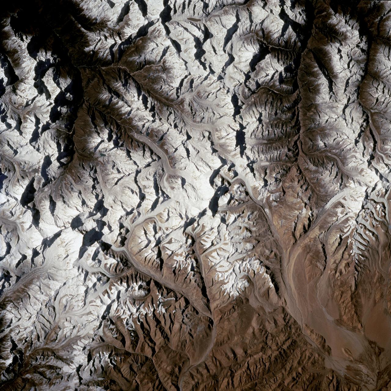
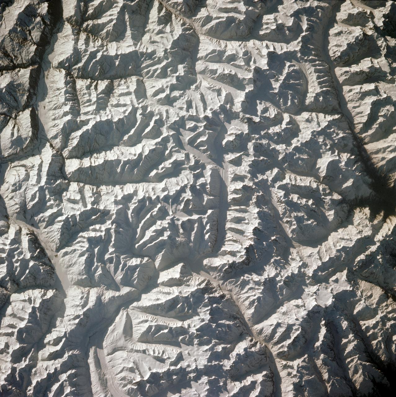
STS066-124-059 (3-14 Nov. 1994) --- Mount Everest region, Nepal and China. Low morning Sun highlights Mount Everest (the highest mountain in the world at 8,848 meters), Cho Oyu (8,153 meters) to the northwest, and other peaks of "The Roof of the World". New snow seems to be confined to the highest peaks. Abundant details of glacier surfaces, including moraines, crevasse fields, and ice falls are displayed for study.
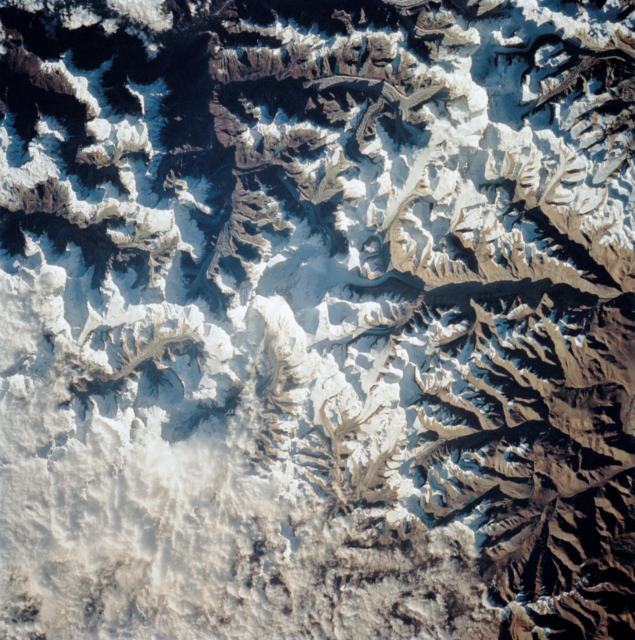
STS058-101-014 (18 Oct-1 Nov 1993) --- The best, most-nearly cloud-free, shuttle view yet of Mount Everest, the highest mountain in the world at 29,028 feet. The peak, on the border between Nepal and China, is almost exactly in the center of the photograph. The challenging North Face is in shadow; valley glaciers radiate in all directions from the central massif.
This radar image is centered near the small town of Pishan in northwest China, about 280 km (174 miles) southeast of the city of Kashgar along the ancient Silk Route in the Taklamakan desert of the Xinjiang Province. Geologists are using this radar image as a map to study past climate changes and tectonics of the area. The irregular lavender branching patterns in the center of the image are the remains of ancient alluvial fans, gravel deposits that have accumulated at the base of the mountains during times of wetter climate. The subtle striped pattern cutting across the ancient fans are caused by thrusting of the Kun Lun Mountains north. This motion is caused by the continuing plate-tectonic collision of India with Asia. Modern fans show up as large lavender triangles above the ancient fan deposits. Yellow areas on the modern fans are vegetated oases. The gridded pattern results from the alignment of poplar trees that have been planted as wind breaks. The reservoir at the top of the image is part of a sophisticated irrigation system that supplies water to the oases. This image was acquired by the Spaceborne Imaging Radar-C/X-band Synthetic Aperture Radar (SIR-C/X-SAR) aboard the space shuttle Endeavour in April 1994. This image is centered at 37.4 degrees north latitude, 78.3 degrees east longitude and shows an area approximately 50 km by 100 km (31 miles by 62 miles). The colors are assigned to different frequencies and polarizations of the radar as follows: Red is L-band horizontally transmitted, horizontally received; green is L-band horizontally transmitted, vertically received; and blue is C-band horizontally transmitted and vertically received. SIR-C/X-SAR, a joint mission of the German, Italian, and the United States space agencies, is part of NASA's Mission to Planet Earth. http://photojournal.jpl.nasa.gov/catalog/PIA01796
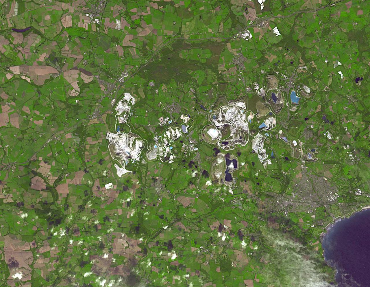
The British porcelain industry began with the discovery of china clay (kaolinite) at Tregonning Hill, Cornwall, in 1745. By the early 19th century, the St Austell deposits were the largest in the world. By 1910, Cornwall was producing fifty percent of the world's china clay. Today, the St Austell deposits have largely been abandoned in favor of other deposits, mainly in Brazil. The image was acquired September 10, 2014, covers an area of 15.7 by 20.3 km, and is located at 50.4 degrees north, 4.9 degrees west. https://photojournal.jpl.nasa.gov/catalog/PIA24865

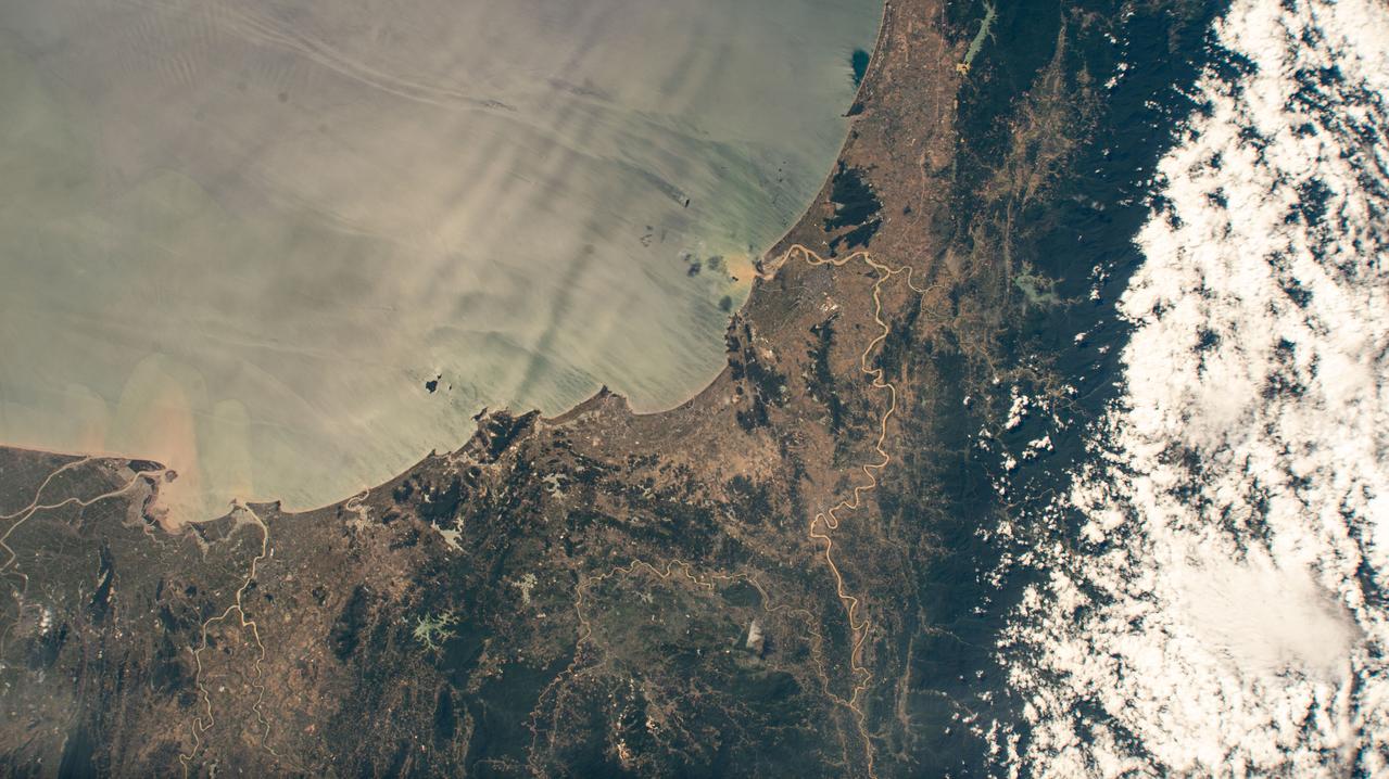
iss073e0820756 (Sept. 14, 2025) --- The densely urbanized region surrounding the Bohai Sea (center) on China's east coast includes several major metropolitan areas, from Beijing (left center) to Changchun (top right), and Seoul, South Korea (far right). A yellow-green airglow blankets Earth's horizon in this image captured from the International Space Station as it orbited 263 miles above the surface at approximately 11:06 p.m. local time.
iss074e0044347 (Jan. 3, 2026) --- Harbin, China—nicknamed the “Ice City” for its long, harsh winters and home to about 10.6 million people—is pictured at approximately 3:28 a.m. local time from the International Space Station as it orbited 266 miles above the Asian continent. The city hosts the world-famous Harbin International Ice and Snow Festival and serves as an economic hub for manufacturing, energy, and education. Credit: JAXA/Kimiya Yui
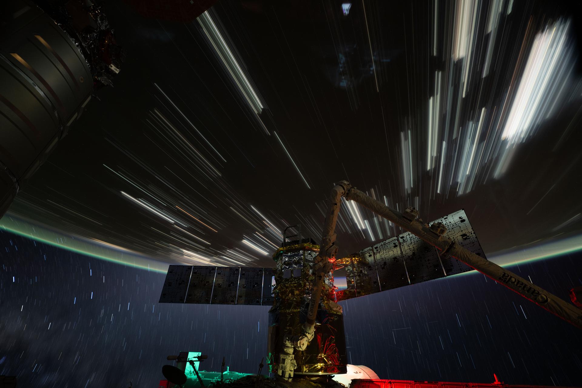
iss074e0319682 (Feb. 19, 2026) --- Star trails and city lights streak across this long-duration photograph taken from the International Space Station as it orbited 261 miles above the China–Mongolia border at approximately 4:42 a.m. local time. In the foreground is JAXA’s (Japan Aerospace Exploration Agency) HTV-X1 cargo craft, berthed to the Harmony module’s Earth-facing port, with the Canadarm2 robotic arm perched on a portable data grapple fixture in front. Credit: NASA/Chris Williams

iss072e435710 (Dec. 28, 2024) --- The Taiwan Strait separates China's southeast coast from Taiwan in this photograph from the International Space Station as it orbited 257 miles above Asia. From bottom center toward the upper left, the city lights from Quanzhuo to Shanghai light up the Chinese coast. Toward right center, the city lights from Taipei to Tainan (bottom right) illuminate Taiwan's western coast. This frame was captured approximately 12:51 a.m. local time.
iss072e843309 (March 15, 2025) --- City lights dot the northeastern landscape of China with a wispy aurora above Earth's horizon in this photograph from the International Space Station as it orbited 262 miles above Asia. In the bottom foreground, is the Kibo laboratory module's Exposed Facility, an external research platform, and the orbital outpost's main solar arrays.

NASA satellite imagery from July 10 revealed a very clear and cloudless eye in the Northwestern Pacific’s Typhoon Soulik as it moves toward a landfall in China by the end of the week. The Moderate Resolution Imaging Spectroradiometer (MODIS) instrument aboard NASA’s Terra satellite captured a visible image of Typhoon Soulik and its clear eye on July 10, 2013 at 2:10 UTC as it continues to move through the northwestern Pacific Ocean. Soulik’s round eye is about 25 nautical miles (28.7 miles/46.3 km) wide. Typhoon Soulik’s maximum sustained winds have increased dramatically over the last 24 hours and at 1500 UTC (11 a.m. EDT) on July 10, were blowing at 120 knots (138 mph/222 kph). According to the Joint Typhoon Warning Center, Soulik’s powerful winds are creating seas over 40 feet (12.2 meters) high in the northwestern Pacific Ocean. Soulik’s center was near 21.9 north latitude and 132.9 east longitude, about 420 nautical miles (483.3 miles/777.7 km) southeast of Kadena Air Base, Japan. Soulik is moving to the west-northwest at 13 knots (15 mph/24 kph). Soulik is tracking west-northwest along the southern edge of a subtropical ridge (elongated area) of high pressure. The ridge of high pressure stretches from east to west and westward over the Ryukyu Islands and into the East China Sea along about 30 north latitude. Soulik is still expected to make a landfall in southeastern China on July 12 or 13 after passing north of Taiwan. Text credit: Rob Gutro More info about the storm: <a href="http://1.usa.gov/12mvQcC" rel="nofollow">1.usa.gov/12mvQcC</a> <b><a href="http://www.nasa.gov/audience/formedia/features/MP_Photo_Guidelines.html" rel="nofollow">NASA image use policy.</a></b> <b><a href="http://www.nasa.gov/centers/goddard/home/index.html" rel="nofollow">NASA Goddard Space Flight Center</a></b> enables NASA’s mission through four scientific endeavors: Earth Science, Heliophysics, Solar System Exploration, and Astrophysics. Goddard plays a leading role in NASA’s accomplishments by contributing compelling scientific knowledge to advance the Agency’s mission. <b>Follow us on <a href="http://twitter.com/NASA_GoddardPix" rel="nofollow">Twitter</a></b> <b>Like us on <a href="http://www.facebook.com/pages/Greenbelt-MD/NASA-Goddard/395013845897?ref=tsd" rel="nofollow">Facebook</a></b> <b>Find us on <a href="http://instagram.com/nasagoddard?vm=grid" rel="nofollow">Instagram</a></b>