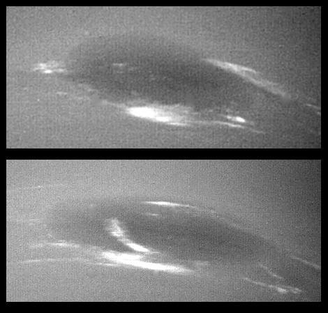
The bright cirrus-like clouds of Neptune change rapidly, often forming and dissipating over periods of several to tens of hours. In this sequence NASA Voyager 2 observed cloud evolution in the region around the Great Dark Spot GDS.
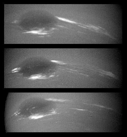
The bright cirrus-like clouds of Neptune change rapidly, often forming and dissipating over periods of several to tens of hours as seen in this sequence spanning two rotations of Neptune about 36 hours by NASA Voyager 2. http://photojournal.jpl.nasa.gov/catalog/PIA00047
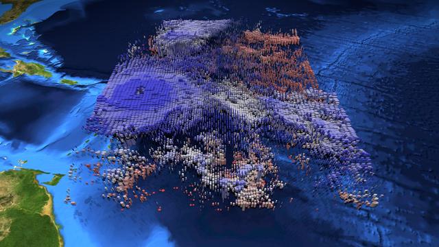
The large-scale structure of clouds in and around Hurricane Irma is seen in this animation and still image created with data from the Atmospheric Infrared Sounder (AIRS) instrument on NASA's Aqua satellite. The clouds are typical of tropical areas both nearby and away from tropical cyclones. Observations were taken at 1 p.m. EDT (5 p.m. UTC) on Tuesday, Sept. 5, 2017, as Irma approached the Caribbean islands and was just becoming a powerful Category 5 storm. Each cylinder represents a volume of cloud detected by AIRS. The oval cylinder ends represent a region viewed by AIRS, with the oval sizes adjusted to reflect the proportion of clouds filling the area viewed. The largest ovals are about 30 miles (45 kilometers) across. The height of the cylinders indicates the cloud thickness, with thickest clouds reaching down to the surface. The vertical scale is exaggerated 15 times. Colors represent temperatures at the tops of the clouds. The perspective views the storm diagonally from above with an initial view toward the north-northwest, with the perspective rotating clockwise for a full circle. The area depicted is about 1,000 miles by 800 miles across (1,600 by 1,300 kilometers). At the start of the loop, North America is seen at the top of the image, and coastal Venezuela at the lower right. In the initial perspective, cirrus clouds (thin and blue), associated with flow outward from the top of the hurricane, overlie warmer (pink and red) shallow clouds. About five seconds into the loop, the deep clouds in the middle of Irma are easily seen. The most dangerous parts of Irma are within the region of high and cold (blue), thick clouds surrounding the central eye. The clouds are cold because they are carried to high, cold altitudes by vigorous thunderstorms within the hurricane. The eye itself is nearly cloud free, but the few clouds within it are low and warm. As the perspective shift toward the south-southeast around seven seconds into the loop, another storm system well north of Irma can be seen. It contains high, thick clouds, with more cirrus carried outward over shallow clouds. At about nine seconds, more outflow from Irma is seen, with high, thin clouds over shallow clouds once again apparent. Shortly afterward when the view is toward the southwest, yet more deep clouds and their outflowing cirrus clouds are apparent. This image depicts many of the clouds typical of the tropics even when cyclones are not present: high, cold thunderstorms pushing cirrus clouds over nearby regions containing many warm, shallow clouds. The animation also shows the structure typical of tropical cyclones around the world: very strong thunderstorms lifting clouds into cold parts of the atmosphere, with strong outflow at upper levels carrying cirrus clouds away from the storm center, and the storm organized symmetrically around a central eye. https://photojournal.jpl.nasa.gov/catalog/PIA21950
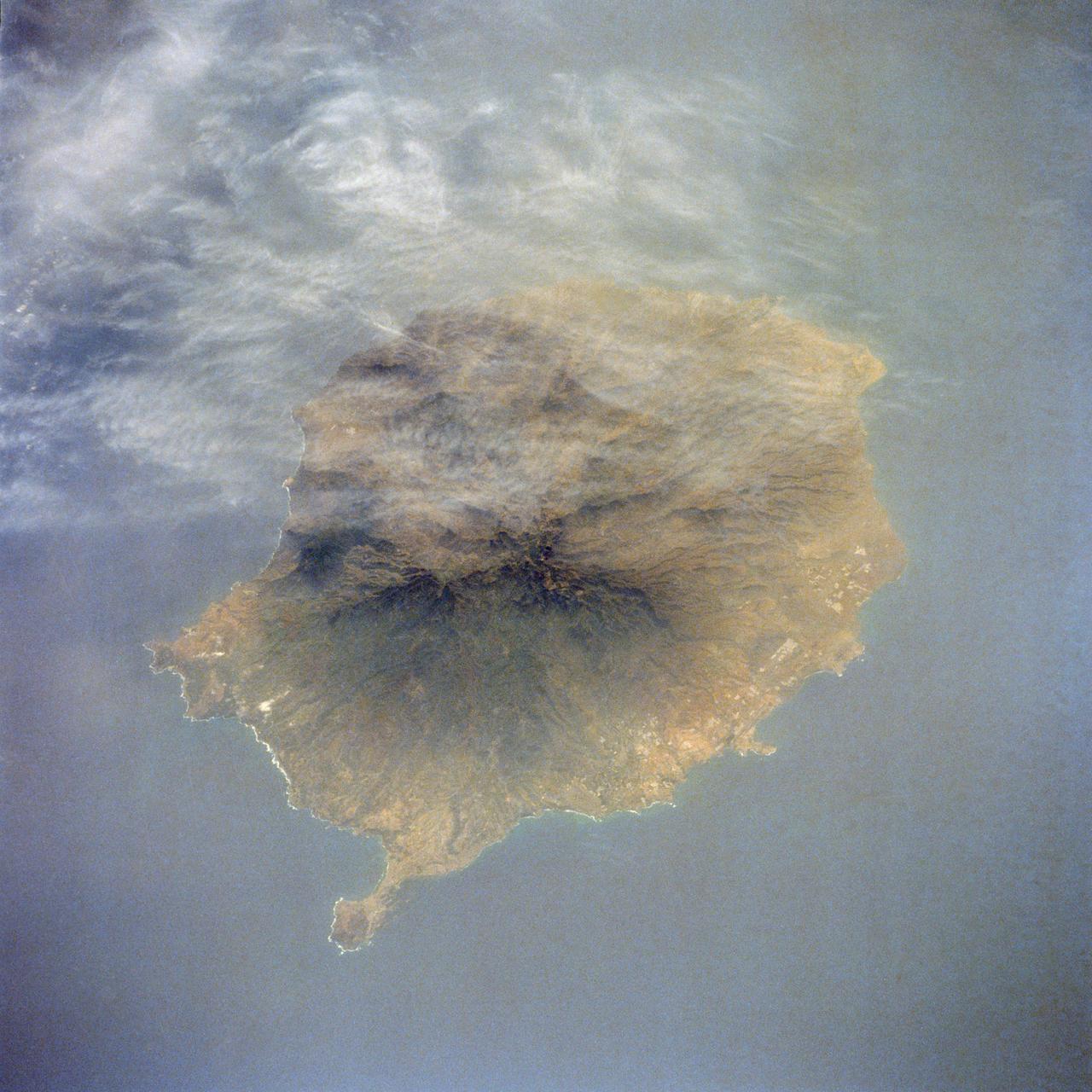
41G-38-084 (5-13 Oct 1984) --- A light, thin cirrus cloud layer partially obscures the island of Gran Canaria in the Canary Islands (15.5 degrees west, 28 degrees north).
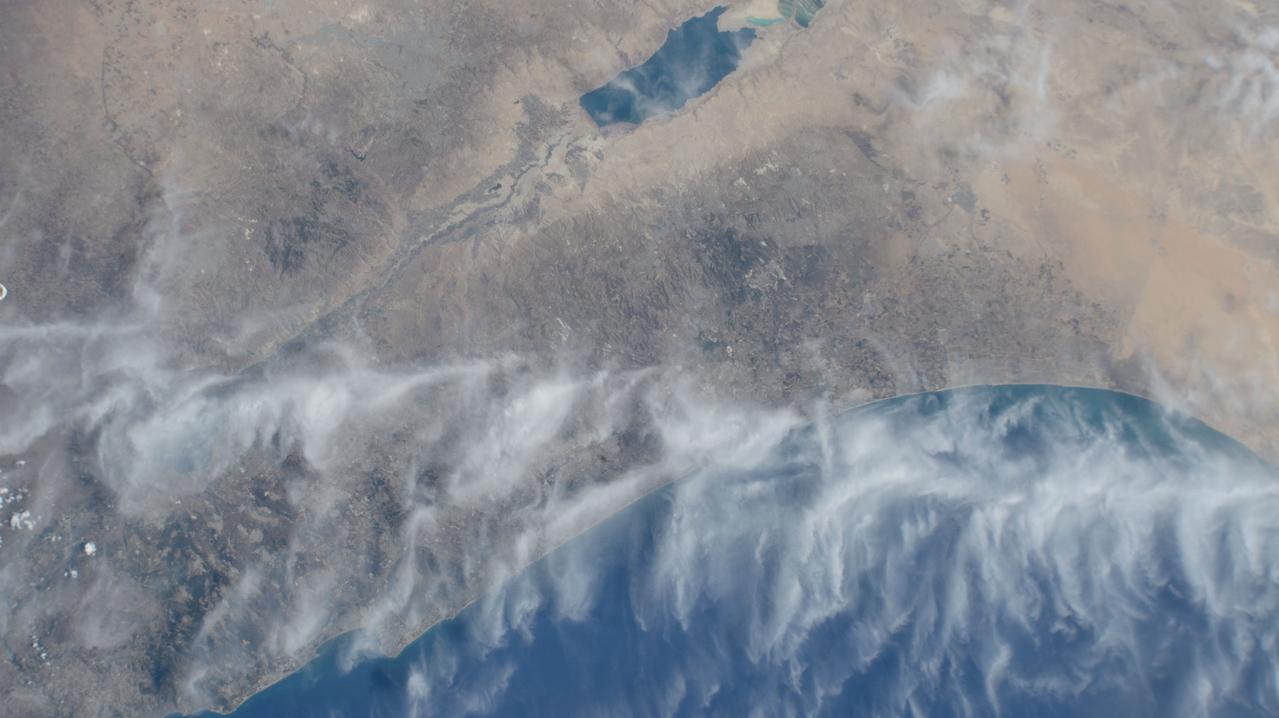
iss071e113334 (May 26, 2024) --- Cirrus clouds cross the Meditteranean coast from Israel and into Jordan in this photograph from the International Space Station as it orbited 262 miles above.

STS111-E-5451 (17 June 2002) --- Sharp air mass boundaries, such as this one photographed by astronauts on board the Space Shuttle Endeavour on June 17, 2002, often are the focus of development for severe thunderstorms. According to meteorologists, this storm formed in the late afternoon over Eastern China. The sunlit anvil tops of thunderstorms here are estimated to be in excess of 60,000 feet (18,300 meters) where icy cirrus clouds form near the top of the troposphere. The distribution and impact of such high clouds are a significant challenge to scientists modeling the Earth’s energy budget and climate. The crew of the International Space Station is attempting to acquire such imagery over Florida this summer in support of a large, multi-agency experiment CRYSTAL - FACE (Cirrus Regional Study of Tropical Anvils and Cirrus Layers - Florida Area Cirrus Experiment). This experiment is designed to collect measurements of clouds that will help improve climate models. Such photos have the potential to provide profound, synoptic visuals for use in describing and interpreting these measurements. More information on CRYSTAL - FACE as well as other images of the atmosphere are available at http://cloud1.arc.nasa.gov/crystalface/.

The bright cirrus-like clouds of Neptune change rapidly, often forming and dissipation over periods of several to tens of hours. In this sequence spanning two rotations of Neptune (about 36 hours) Voyager 2 observed cloud evolution in the region around the Great Dark Spot (GDS) at an effective resolution of about 100 km (62 miles) per pixel. The surprisingly rapid changes which occur over the 18 hours separating each panel shows that in this region Neptune's weather is perhaps as dynamic and variable as that of the Earth. However, the scale is immense by our standards--the Earth and the GDS are of similar size -- and in Neptune's frigid atmosphere, where temperatures are as low as 55 degree Kelvin (-360F), the cirrus clouds are composed of frozen methane rather than Earth's crystalse of water ice.
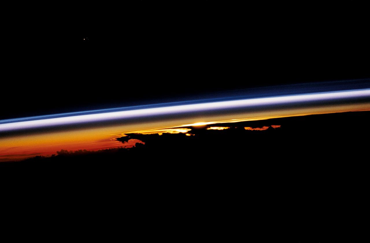
STS047-54-018 (12-20 Sept. 1992) --- The colors in this photograph provide insight into the relative density of the atmosphere. The crew members had many opportunities to witness sunrises and sunsets, considering they orbit the Earth every 90 minutes, but few, they said, compared to this scene. It captures the silhouette of several mature thunderstorms with their cirrus anvil tops spreading out against the tropopause (the top of the lowest layer of Earth's atmosphere) at sunset. The lowest layer (troposphere) is the densest and refracts light at the red end of the visible spectrum (7,400 Angstroms), while the blues (4,000 Angstroms) are separated in the least dense portion of the atmosphere (middle and upper atmosphere, or stratosphere and mesosphere). Several layers of blue can be seen. NASA scientists studying the photos believe this stratification to be caused by the scattering of light by particulate trapped in the stratosphere and mesosphere particulate that generally originate from volcanic eruptions, such as those of Mt. Pinatubo in the Philippines and, most recently, Mt. Spurr in Alaska.
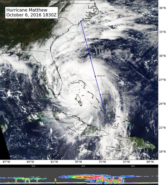
NASA's CloudSat flew east of Hurricane Matthew's center on Oct. 6 at 11:30 a.m. PDT (2:30 p.m. EDT), intersecting parts of Matthew's outer rain bands and revealing Matthew's anvil clouds (thick cirrus cloud cover), with cumulus and cumulonimbus clouds beneath (lower image). Reds/pinks are larger water/ice droplets. http://photojournal.jpl.nasa.gov/catalog/PIA21095
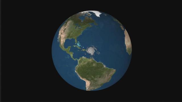
NASA's CloudSat satellite flew over Hurricane Irma on Sept. 6, 2017 at 1:45 p.m. EDT (17:45 UTC) as the storm was approaching Puerto Rico in the Atlantic Ocean. Hurricane Irma contained estimated maximum sustained winds of 185 miles per hour (160 knots) with a minimum pressure of 918 millibars. CloudSat transected the eastern edge of Hurricane Irma's eyewall, revealing details of the storm's cloud structure beneath its thick canopy of cirrus clouds. The CloudSat Cloud Profiling Radar excels in detecting the organization and placement of cloud layers beneath a storm's cirrus canopy, which are not readily detected by other satellite sensors. The CloudSat overpass reveals the inner details beneath the cloud tops of this large system; intense areas of convection with moderate to heavy rainfall (deep red and pink colors), cloud-free areas (moats) in between the inner and outer cloud bands of Hurricane Irma and cloud top heights averaging around 9 to 10 miles (15 to 16 kilometers). Lower values of reflectivity (areas of green and blue) denote smaller-sized ice and water particle sizes typically located at the top of a storm system (in the anvil area). The Cloud Profiling Radar loses signal at around 3 miles (5 kilometers) in height (in the melting layer) due to water (ice) particles larger than 0.12 inches (3 millimeters) in diameter. Moderate to heavy rainfall occurs in these areas where signal weakening is detectable. Smaller cumulus and cumulonimbus cloud types are evident as CloudSat moves farther south, beneath the thick cirrus canopy. An animation is available at https://photojournal.jpl.nasa.gov/catalog/PIA21947

Apollo 7,Cumulus,alto-cumulus,cirrus clouds. Very high oblique. Cloud Cover 50%. Original film magazine was labeled S. Camera Data: Hasselblad 500-C; Lens: Zeiss Planar,F/2.8,80mm; Film Type: Kodak SO-121,Aerial Ektachrome; Filter: Wratten 2A. Flight Date: October 11-12. 1968.

ISS009-E-18129 (21:08:57 GMT, 12 August 2004) --- Less than a minute after ISS009-E-18123, the Expedition 9 crew captured this more detailed view of Hurricane Charley looking southward. The small eye is visible, but not cloud-free yet. Spiraling streaks of high cirrus clouds around the south southern and western edges of the storm indicate the pronounced outflow of air above the storm.
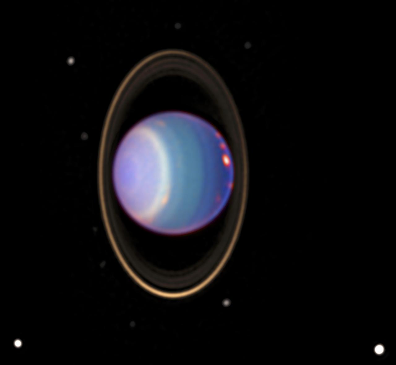
A recent Hubble Space Telescope (HST) view reveals Uranus surrounded by its 4 major rings and 10 of its 17 known satellites. This false color image was generated by Erich Karoschka using data taken with Hubble's Near Infrared Camera and Multi-Object Spectrometer. The HST recently found about 20 clouds. The colors in the image indicate altitude. The green and blue regions show where the atmosphere is clear and can be penetrated by sunlight. In yellow and grey regions, the sunlight reflects from a higher haze or cloud layer. The orange and red colors indicate very high clouds, such as cirrus clouds on Earth.
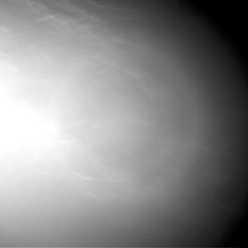
Wispy clouds float across the Martian sky in this accelerated sequence of images from NASA's Curiosity Mars rover. The rover's Navigation Camera (Navcam) took these eight images over a span of four minutes early in the morning of the mission's 1,758th Martian day, or sol (July 17, 2017), aiming nearly straight overhead. This sequence uses raw images, which include a bright ring around the center of the frame that is an artifact of sunlight striking the camera lens even though the Sun is not in the shot. A processed version removing that artifact and emphasizing changes between images is also available. The clouds resemble Earth's cirrus clouds, which are ice crystals at high altitudes. These Martian clouds are likely composed of crystals of water ice that condense onto dust grains in the cold Martian atmosphere. Cirrus wisps appear as ice crystals fall and evaporate in patterns known as "fall streaks" or "mare's tails." Such patterns have been seen before at high latitudes on Mars, for instance by the Phoenix Mars Lander in 2008, and seasonally nearer the equator, for instance by the Opportunity rover. However, Curiosity has not previously observed such clouds so clearly visible from the rover's study area about five degrees south of the equator. The Hubble Space Telescope and spacecraft orbiting Mars have observed a band of clouds to appear near the Martian equator around the time of the Martian year when the planet is farthest from the Sun. With a more elliptical orbit than Earth's, Mars experiences more annual variation than Earth in its distance from the Sun. The most distant point in an orbit around the Sun is called the aphelion. The near-equatorial Martian cloud pattern observed at that time of year is called the "aphelion cloud belt." These new images from Curiosity were taken about two months before aphelion, but the morning clouds observed may be an early stage of the aphelion cloud belt. An animation is available at https://photojournal.jpl.nasa.gov/catalog/PIA21842
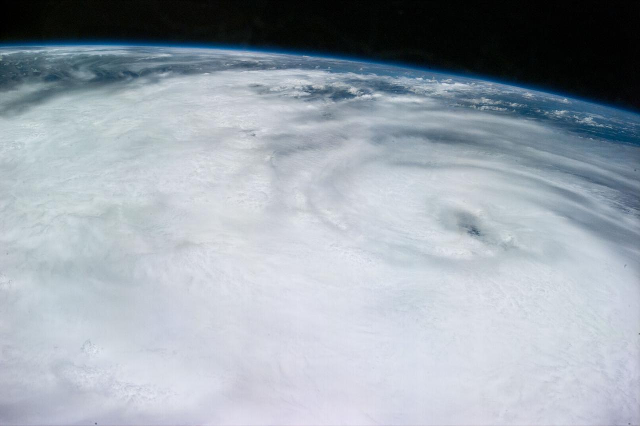
S94-E-5027 (9 July 1997)--- Hurricane Dolores located about 20 degrees southwest of the tip of the Baja Peninsula in the eastern Pacific supported winds of 90 knots with gust of 100 knots on July 9, 1997. The photograph was taken through overhead windows on the aft flight deck of the Earth-orbiting Space Shuttle Columbia. Notice the thunderstorms in the bands leading into the eye at lower levels and the lighter cirrus clouds coming from the outflow out of the eye at higher levels.
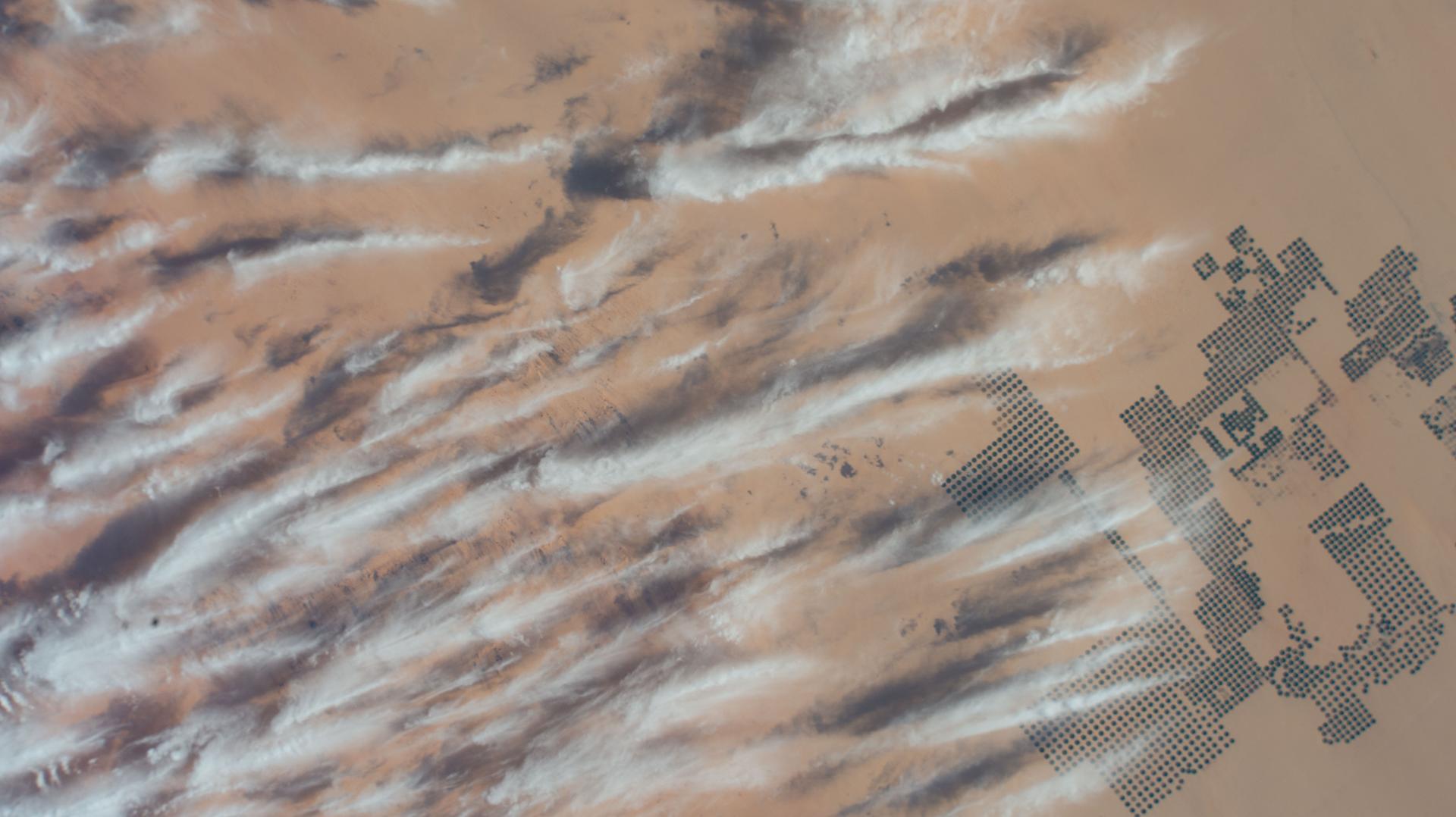
iss074e0247459 (Feb. 1, 2026) --- Large-scale agricultural projects (right) in southern Egypt near the Sudan border—known as center-pivot irrigation systems because they use an irrigation arm that rotates 360°, forming a perfect circle of crops such as potatoes and wheat—are pictured from the International Space Station as it orbited 258 miles above the African nation. Wispy cirrus clouds partly cover the cultivated land in the barren, extremely arid Western Desert.
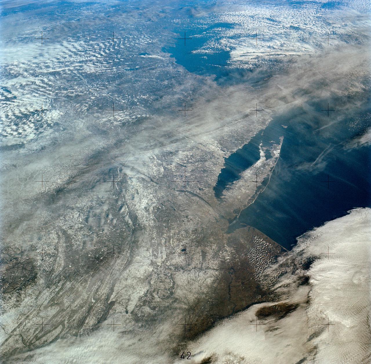
SL4-138-3894 (5 Jan. 1974) --- An oblique view of a portion of the northeastern part of the United States, as photographed from the Skylab space station in Earth orbit by one of the Skylab 4 crewmen. The camera used was a hand-held 70mm Hasselblad, and with SO-368 medium-speed Ektachrome film. This is an excellent example of the regional view which is available from space. The entire area of New Jersey, eastern Pennsylvania, southeastern New York, and southern New England can be examined in one view. Long Island, New York City and the lower Hudson River Valley are readily seen in their regional framework. The Boston area, although blurred by clouds, is also included. The spackling of the snow enhances the contrast, especially of terrain and cultural features. Different levels of clouds can be studies, especially the crossing layers of cirrus in the center of the photograph, with the lower cirrus trending north-south and the upper (probably associated with a jet stream) trending east-west. Photo credit: NASA
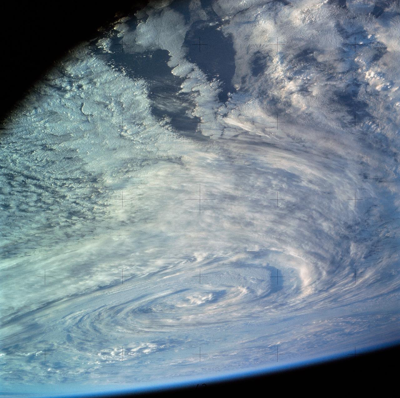
SL4-136-3388 (2 Dec. 1973) --- This excellent view of a South Pacific storm was photographed from the Skylab space station in Earth orbit by one of the Skylab 4 crewmen. The camera used was a hand-held 70mm Hasselblad, with SO-368 medium-speed Ektachrome film. This photograph of a low pressure area and associated frontal activity was taken for studying the development of such storm systems. The low sun angle enhances the relief, giving much of the picture a three-dimensional appearance. The good definition of the clouds with the cumulonimbus (thunderstorm clouds) penetrating the cirrus cloud layer makes this an interesting photograph to study. This storm, located east of New Zealand at 170 degrees west longitude and 50 degrees south latitude, is not and never became a typhoon. However, in some ways it may look similar. Photo credit: NASA
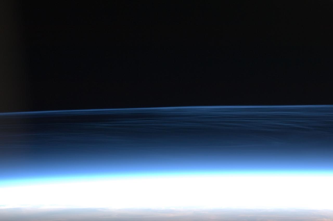
ISS028-E-020276 (2 Aug. 2011) --- This photograph of polar mesospheric clouds was acquired at an altitude of just over 202 nautical miles (about 322 kilometers) in the evening hours (03:19:54 Greenwich Mean Time) on Aug. 2, 2011, as the International Space Station was passing over the English Channel. The nadir coordinates of the station were 49.1 degrees north latitude and 5.5 degrees west longitude. Polar mesospheric clouds (also known as noctilucent, or ?night-shining? clouds) are transient, upper atmospheric phenomena that are usually observed in the summer months at high latitudes (greater than 50 degrees) of both the Northern and Southern Hemispheres. They appear bright and cloudlike while in deep twilight. They are illuminated by sunlight when the lower layers of the atmosphere are in the darkness of Earth?s shadow. The horizon of Earth appears at the bottom of the image, with some layers of the lower atmosphere already illuminated by the rising sun. The higher, bluish-colored clouds look much like wispy cirrus clouds, which can be found as high as 60,000 feet (18 kilometers) in the atmosphere. However noctilucent clouds, as seen here, are observed in the mesosphere at altitudes of 250,000 to 280,000 feet (about 76 to 85 kilometers). Astronaut observations of polar mesospheric clouds over northern Europe in the summer are not uncommon.
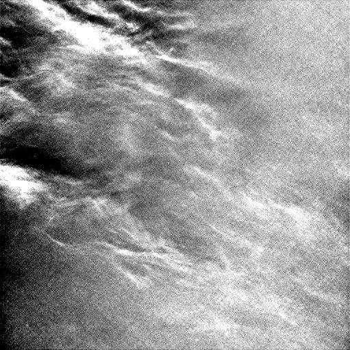
Wispy clouds float across the Martian sky in this accelerated sequence of enhanced images from NASA's Curiosity Mars rover. The rover's Navigation Camera (Navcam) took these eight images over a span of four minutes early in the morning of the mission's 1,758th Martian day, or sol (July 17, 2017), aiming nearly straight overhead. They have been processed by first making a "flat field' adjustment for known differences in sensitivity among pixels and correcting for camera artifacts due to light reflecting within the camera, and then generating an "average" of all the frames and subtracting that average from each frame. This subtraction results in emphasizing any changes due to movement or lighting. The clouds are also visible, though fainter, in a raw image sequence from these same observations. On the same Martian morning, Curiosity also observed clouds near the southern horizon. The clouds resemble Earth's cirrus clouds, which are ice crystals at high altitudes. These Martian clouds are likely composed of crystals of water ice that condense onto dust grains in the cold Martian atmosphere. Cirrus wisps appear as ice crystals fall and evaporate in patterns known as "fall streaks" or "mare's tails." Such patterns have been seen before at high latitudes on Mars, for instance by the Phoenix Mars Lander in 2008, and seasonally nearer the equator, for instance by the Opportunity rover. However, Curiosity has not previously observed such clouds so clearly visible from the rover's study area about five degrees south of the equator. The Hubble Space Telescope and spacecraft orbiting Mars have observed a band of clouds to appear near the Martian equator around the time of the Martian year when the planet is farthest from the Sun. With a more elliptical orbit than Earth's, Mars experiences more annual variation than Earth in its distance from the Sun. The most distant point in an orbit around the Sun is called the aphelion. The near-equatorial Martian cloud pattern observed at that time of year is called the "aphelion cloud belt." These new images from Curiosity were taken about two months before aphelion, but the morning clouds observed may be an early stage of the aphelion cloud belt. An animation is available at https://photojournal.jpl.nasa.gov/catalog/PIA21841
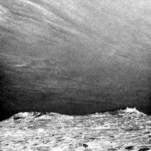
Clouds drift across the sky above a Martian horizon in this accelerated sequence of enhanced images from NASA's Curiosity Mars rover. The rover's Navigation Camera (Navcam) took these eight images over a span of four minutes early in the morning of the mission's 1,758th Martian day, or sol (July 17, 2017), aiming toward the south horizon. They have been processed by first making a "flat field' adjustment for known differences in sensitivity among pixels and correcting for camera artifacts due to light reflecting within the camera, and then generating an "average" of all the frames and subtracting that average from each frame. This subtraction emphasizes changes whether due to movement -- such as the clouds' motion -- or due to lighting -- such as changing shadows on the ground as the morning sunlight angle changed. On the same Martian morning, Curiosity also observed clouds nearly straight overhead. The clouds resemble Earth's cirrus clouds, which are ice crystals at high altitudes. These Martian clouds are likely composed of crystals of water ice that condense onto dust grains in the cold Martian atmosphere. Cirrus wisps appear as ice crystals fall and evaporate in patterns known as "fall streaks" or "mare's tails." Such patterns have been seen before at high latitudes on Mars, for instance by the Phoenix Mars Lander in 2008, and seasonally nearer the equator, for instance by the Opportunity rover. However, Curiosity has not previously observed such clouds so clearly visible from the rover's study area about five degrees south of the equator. The Hubble Space Telescope and spacecraft orbiting Mars have observed a band of clouds to appear near the Martian equator around the time of the Martian year when the planet is farthest from the Sun. With a more elliptical orbit than Earth's, Mars experiences more annual variation than Earth in its distance from the Sun. The most distant point in an orbit around the Sun is called the aphelion. The near-equatorial Martian cloud pattern observed at that time of year is called the "aphelion cloud belt." These new images from Curiosity were taken about two months before aphelion, but the morning clouds observed may be an early stage of the aphelion cloud belt. An animation is available at https://photojournal.jpl.nasa.gov/catalog/PIA21840
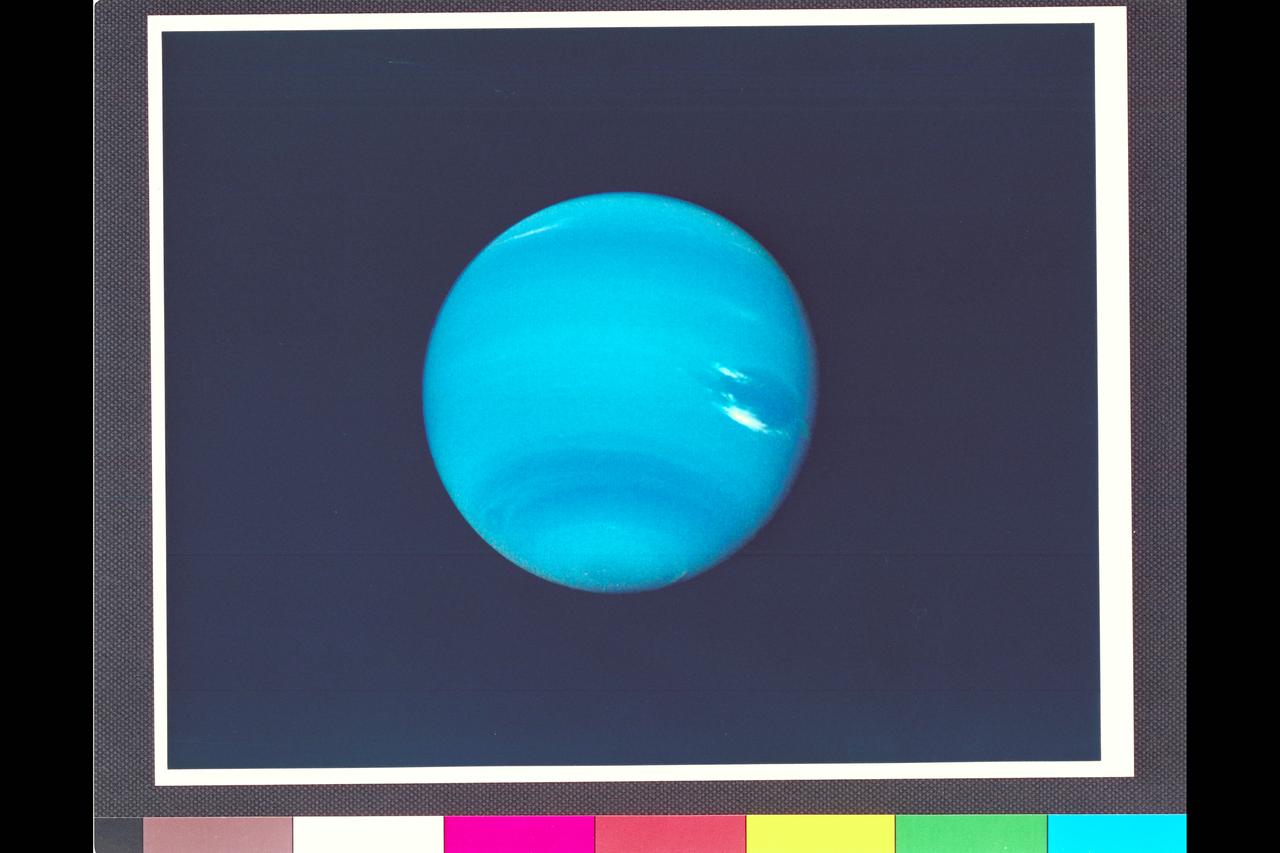
Range : 14.8 million km. ( 9.2 million miles) P-34595C This contrast enhanced color photograph of Neptune was produced from images taken through the orange, green, and violet filters of the narrow angle camera. As Voyager 2 approaches Neptune, rapidly increasing image resolution is revealing striking new details in the planet's atmosphere, and this pictureshows features as small as a few hundred kilometers in extent. Bright, wispy 'cirrus-type' clouds are seen overlying the Great Dark Spot (GDS) at its southern (lower) margin and over its northwest ( upper left) boundary. This is the first evidence that the GDS lies lower in the atmosphere than these bright clouds, which have remained in its vicinity for several months. Increasing detail in global banding, and the south polar can also be seen. A smaller dark spot at high southern latitudes is dimly visible near the limb at lower left.
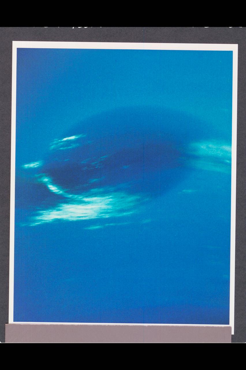
P-34668 Range : 2.8 million km. ( 1.7 million miles ) Smallest Resolvable Feature : 50 km or 31 miles This Voyager 2 image shows the last face on view of the Great Dark Spot that Voyager 2 will take with the narrow angle camera. It was made 45 hours before the closest approach to Neptune. the image shows feathery white clouds that overlie the boundary of the dark and light blue regions. the pinwheel ( spiral ) structure of both the dark boundary and the white cirrus suggest a storm system rotating counterclockwise. Periodic, small-scale patterns in the white clouds, possibly waves, are short-lived and do not persist from one Neptunian rotation to the next. This color composite was made from the clear and green filter images.

This photograph shows the last face on view of the Great Dark Spot that Voyager will make with the narrow angle camera. The image was shuttered 45 hours before closest approach at a distance of 2.8 million kilometers (1.7 million miles). The smallest structures that can be seen are of an order of 50 kilometers (31 miles). The image shows feathery white clouds that overlie the boundary of the dark and light blue regions. The pinwheel (spiral) structure of both the dark boundary and the white cirrus suggest a storm system rotating counterclockwise. Periodic small scale patterns in the white cloud, possibly waves, are short lived and do not persist from one Neptunian rotation to the next. This color composite was made from the clear and green filters of the narrow-angle camera. http://photojournal.jpl.nasa.gov/catalog/PIA00052

Neptune's blue-green atmosphere is shown in greater detail than ever before by the Voyager 2 spacecraft as it rapidly approaches its encounter with the giant planet. This color image, produced from a distance of about 16 million kilometers, shows several complex and puzzling atmospheric features. The Great Dark Spot (GDS) seen at the center is about 13,000 km by 6,600 km in size -- as large along its longer dimension as the Earth. The bright, wispy "cirrus-type" clouds seen hovering in the vicinity of the GDS are higher in altitude than the dark material of unknown origin which defines its boundaries. A thin veil often fills part of the GDS interior, as seen on the image. The bright cloud at the southern (lower) edge of the GDS measures about 1,000 km in its north-south extent. The small, bright cloud below the GDS, dubbed the "scooter," rotates faster than the GDS, gaining about 30 degrees eastward (toward the right) in longitude every rotation. Bright streaks of cloud at the latitude of the GDS, the small clouds overlying it, and a dimly visible dark protrusion at its western end are examples of dynamic weather patterns on Neptune, which can change significantly on time scales of one rotation (about 18 hours). https://photojournal.jpl.nasa.gov/catalog/PIA02245
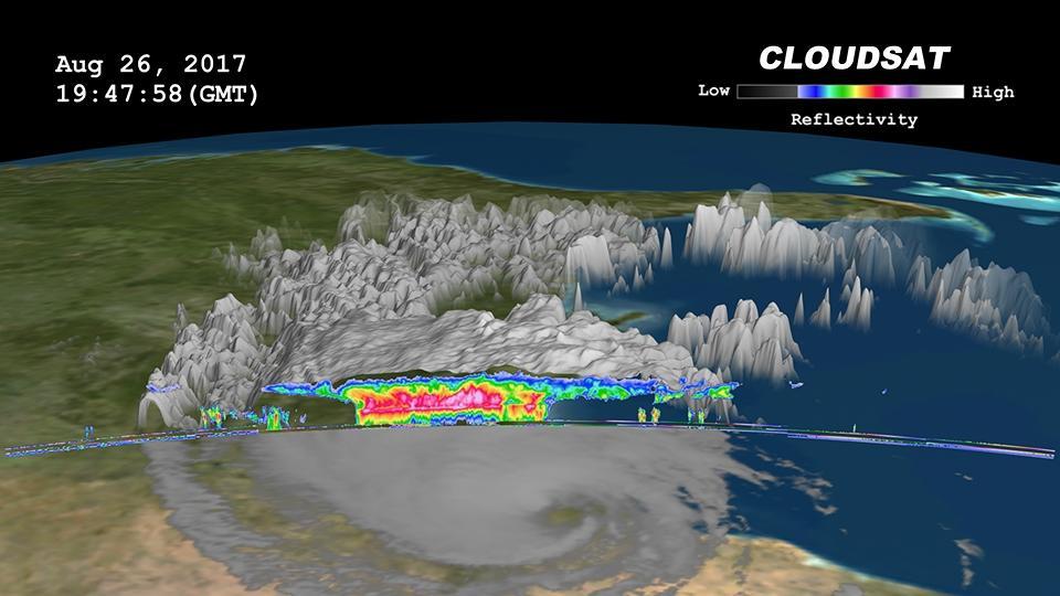
Click on the image for larger animation NASA's CloudSat satellite flew over then-Tropical Storm Harvey on Aug. 26, 2017, at 2:45 p.m. CDT (19:45 UTC) as the storm was nearly stationary over south Texas. At that time, Harvey contained estimated maximum sustained winds of 69 miles per hour (60 knots). CloudSat flew over Harvey northeast of the storm center through an area of moderate to heavy rainfall in the outer rainbands. As seen in the image and animation, large amounts of liquid and ice water (denoted by the red and pink colors) are visible beneath the cloud tops. The lack of a radar signal (attenuation) beneath the melting layer (located around 3 miles, or 5 kilometers, above ground) can be seen in the heavier areas of precipitation, since CloudSat's cloud profiling radar (CPR) signal dampens when precipitation particles are larger than 0.12 inches (3 millimeters) in size. Smaller cumulus and cumulonimbus clouds are seen north of the area of moderate to heavy precipitation. The cirrus canopy (anvil clouds) extends outward from the storm system (shown in blue and green colors). An animation is available at https://photojournal.jpl.nasa.gov/catalog/PIA17392
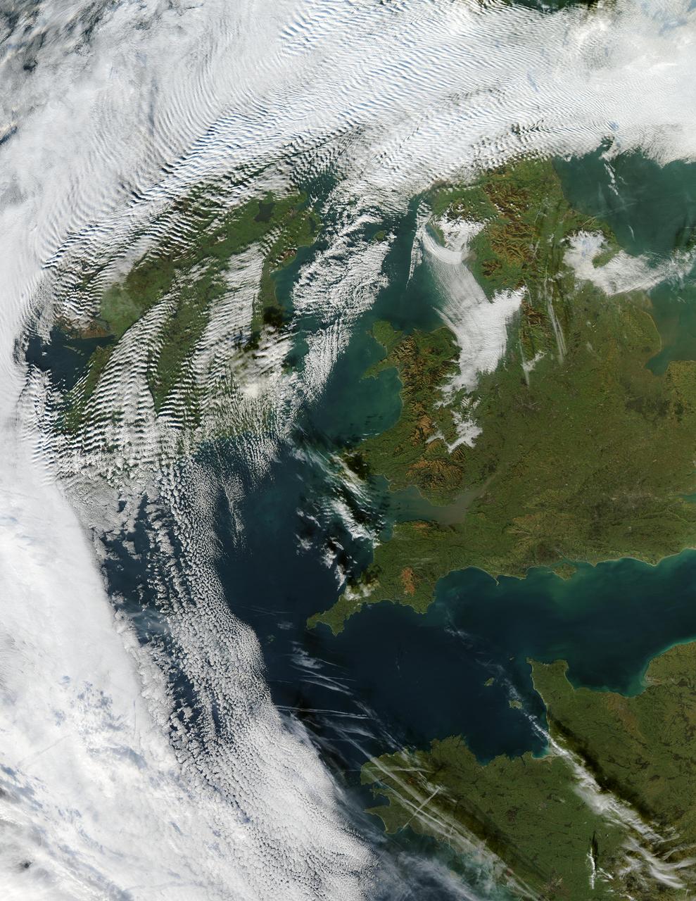
Visualization Date 2003-12-18 Clouds ripple over Ireland and Scotland in a wave pattern, similar to the pattern of waves along a seashore. The similarity is not coincidental — the atmosphere behaves like a fluid, so when it encounters an obstacle, it must move around it. This movement forms a wave, and the wave movement can continue for long distances. In this case, the waves were caused by the air moving over and around the mountains of Scotland and Ireland. As the air crested a wave, it cooled, and clouds formed. Then, as the air sank into the trough, the air warmed, and clouds did not form. This pattern repeated itself, with clouds appearing at the peak of every wave. Other types of clouds are also visible in the scene. Along the northwestern and southwestern edges of this true-color image from December 17, 2003, are normal mid-altitude clouds with fairly uniform appearances. High altitude cirrus-clouds float over these, casting their shadows on the lower clouds. Open- and closed-cell clouds formed off the coast of northwestern France, and thin contrail clouds are visible just east of these. Contrail clouds form around the particles carried in airplane exhaust. Fog is also visible in the valleys east of the Cambrian Mountains, along the border between northern/central Wales and England. This is an Aqua MODIS image. Sensor Aqua/MODIS Credit Jacques Descloitres, MODIS Rapid Response Team, NASA/GSFC For more information go to: <a href="http://visibleearth.nasa.gov/view_rec.php?id=6146" rel="nofollow">visibleearth.nasa.gov/view_rec.php?id=6146</a>

ISS017-E-012583 (4 Aug. 2008) --- Cape Farewell, Greenland is featured in this image photographed by an Expedition 17 crewmember on the International Space Station (ISS). This view illustrates the southernmost tip of Greenland, known as Kap Farvel in Danish and Nunap Isua in Inuit. The viewing direction is towards the northeast; the image was taken when the space station was located near its most northerly orbital latitude of 52 degrees, off the northern coast of the Island of Newfoundland approximately 1160 kilometers to the southwest. Greenland is the world's largest island with an area of over 2 million square kilometers; however much of the island is covered by an ice cap that can reach thicknesses of 3 kilometers. The image is highly oblique -- taken from an angle looking outwards from the ISS, rather than straight down towards the Earth -- and this provides a sense of topography along the southern edge of Greenland. The exposed dark grey bedrock along the southwestern coastline has been carved by glaciers into numerous fjords -- steep-sided valleys that drain directly into the ocean; the white cloud cover surrounding the island doubtless contains some sea ice and icebergs calved from glaciers. A band of high-altitude cirrus clouds (light grey) cast shadows on the lower stratus cloud deck in the lower third of the image. The thin blue layer of Earth's atmosphere is visible.

KENNEDY SPACE CENTER, FLA. - Its fiery tail casting a pink glow on cirrus clouds and water below, Space Shuttle Endeavour roars into space on mission STS-111 to the International Space Station. Liftoff occurred at 5:22:49 p.m. EDT. The STS-111 crew includes Commander Kenneth Cockrell, Pilot Paul Lockhart, and Mission Specialists Franklin Chang-Diaz and Philippe Perrin (CNES), as well as the Expedition Five crew members Valeri Korzun, Peggy Whitson and Sergei Treschev. This mission marks the 14th Shuttle flight to the International Space Station and the third Shuttle mission this year. Mission STS-111 is the 18th flight of Endeavour and the 110th flight overall in NASA's Space Shuttle program. [Photo by Anita Barrett
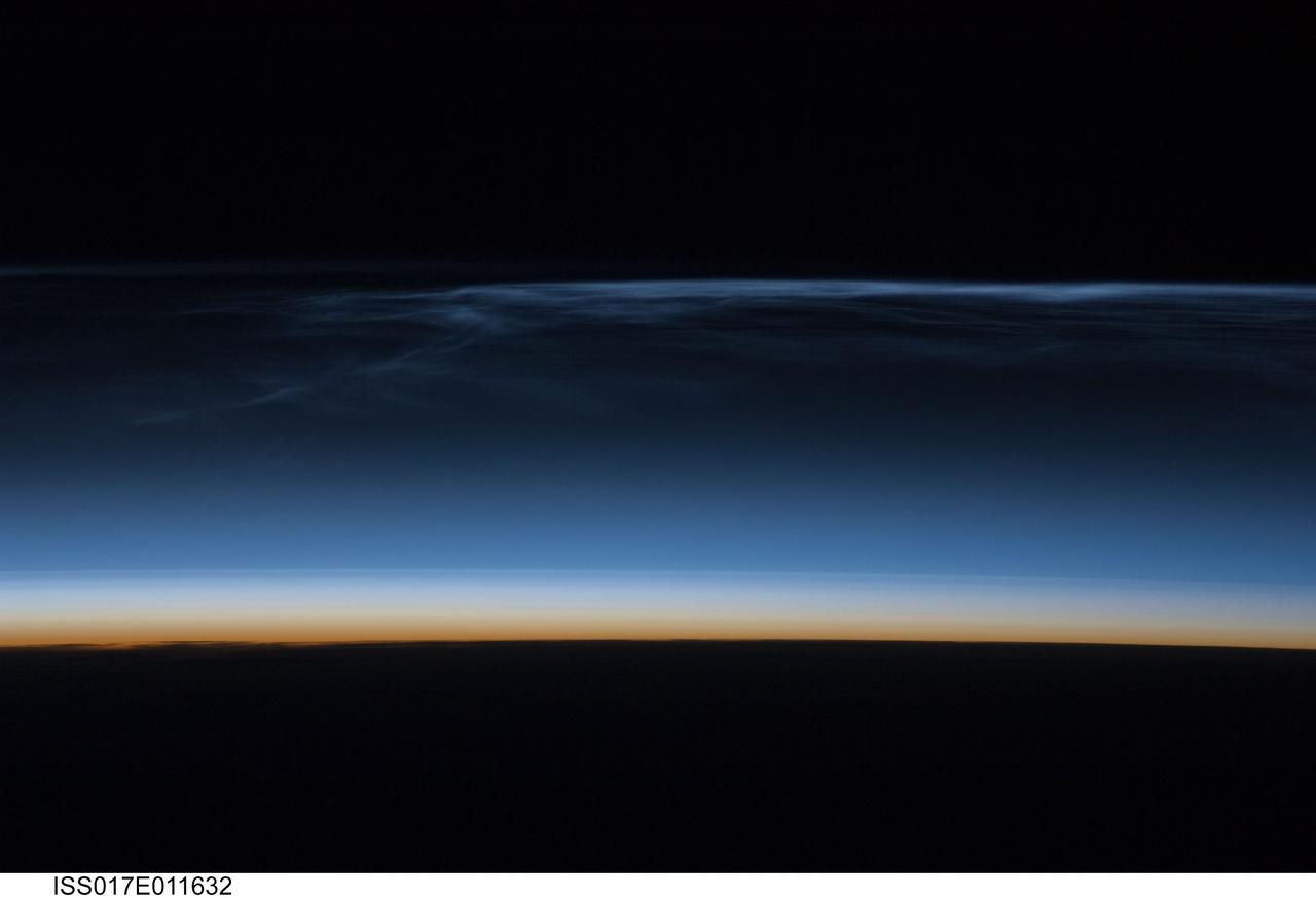
ISS017-E-011632 (22 July 2008) --- Polar Mesospheric Clouds (also known as noctilucent clouds) are transient, upper atmospheric phenomena observed usually in the summer months at high latitudes (greater than 50 degrees) of both the Northern and Southern Hemispheres. They are bright and cloudlike in appearance while in deep twilight. They are illuminated by sunlight when the lower layers of the atmosphere are in the darkness of the Earth's shadow. This image was acquired at an altitude of just over 200 miles in the pre-dawn hours of July 22, 2008 as the International Space Station was passing over western Mongolia in central Asia. The dark horizon of the Earth appears below with some layers of the lower atmosphere already illuminated. The higher, bluish-colored clouds look much like wispy cirrus clouds which can be found in the troposphere as high as 60,000 feet. However noctilucent clouds, as seen here, are observed in the mesosphere at altitudes of 250,000 to 280,000 feet. Astronaut observations of Polar Mesospheric Clouds (PMC) over northern Asia in June and July are not uncommon. The Expedition 17 crew of the International Space Station acquired this image, and more, in support of research for the International Polar Year. Some researchers link increased observations of PMC to changes in global climate; PMC have been the subject of extensive observation and research from space by the Swedish satellite Odin launched in 2001 and more recently by NASA's Aeronomy of Ice in the Mesosphere (AIM) satellite system beginning in 2007.

ISS040-E-088891 (5 Aug. 2014) --- Thunderheads near Borneo, Indonesia are featured in this image photographed by an Expedition 40 crew member on the International Space Station. Late afternoon sun casts long shadows from high thunderhead anvils over southern Borneo. Crews aboard the space station have recently concentrated on panoramic views of clouds?taken with lenses similar to the focal length of the human eye. These images reveal the kinds of views crews see -- huge areas of the planet, with a strong three-dimensional sense of what it is like to fly 350 kilometers above Earth. Winds usually blow in different directions at different altitudes. High-altitude winds are clearly sweeping the tops off the many tallest thunderclouds, generating long anvils of diffuse cirrus plumes that trail south. At low levels, ?streets? of white dots -- fair-weather cumulus clouds -- are aligned with west-moving winds (lower left). Small smoke plumes from forest fires onshore are also aligned west. Storm formation near the horizon -- more than 1,000 kilometers away (center) -- is assisted by air currents rising over the central mountains of Borneo.
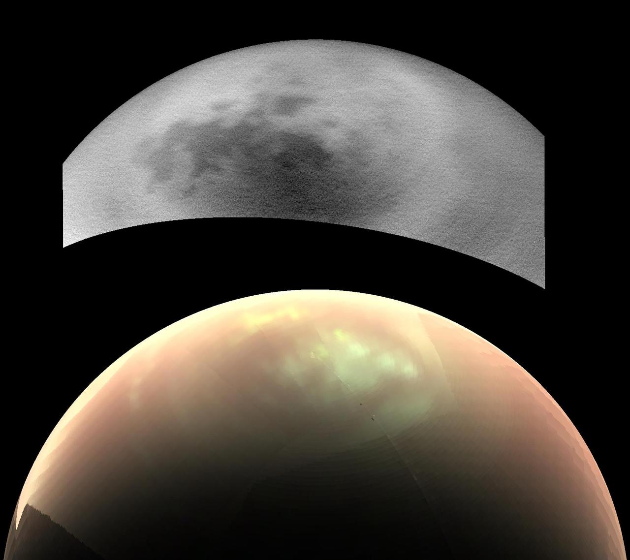
This comparison of two views from NASA's Cassini spacecraft, taken fairly close together in time, illustrates a peculiar mystery: Why would clouds on Saturn's moon Titan be visible in some images, but not in others? In the top view, a near-infrared image from Cassini's imaging cameras, the skies above Saturn's moon Titan look relatively cloud free. But in the bottom view, at longer infrared wavelengths, Cassini sees a large field of bright clouds. Even though these views were taken at different wavelengths, researchers would expect at least a hint of the clouds to show up in the upper image. Thus they have been trying to understand what's behind the difference. As northern summer approaches on Titan, atmospheric models have predicted that clouds will become more common at high northern latitudes, similar to what was observed at high southern latitudes during Titan's late southern summer in 2004. Cassini's Imaging Science Subsystem (ISS) and Visual and Infrared Mapping Spectrometer (VIMS) teams have been observing Titan to document changes in weather patterns as the seasons change, and there is particular interest in following the onset of clouds in the north polar region where Titan's lakes and seas are concentrated. Cassini's "T120" and "T121" flybys of Titan, on June 7 and July 25, 2016, respectively, provided views of high northern latitudes over extended time periods -- more than 24 hours during both flybys. Intriguingly, the ISS and VIMS observations appear strikingly different from each other. In the ISS observations (monochrome image at top), surface features are easily identifiable and only a few small, isolated clouds were detected. In contrast, the VIMS observations (color image at bottom) suggest widespread cloud cover during both flybys. The observations were made over the same time period, so differences in illumination geometry or changes in the clouds themselves are unlikely to be the cause for the apparent discrepancy: VIMS shows persistent atmospheric features over the entire observation period and ISS consistently detects surface features with just a few localized clouds. The answer to what could be causing the discrepancy appears to lie with Titan's hazy atmosphere, which is much easier to see through at the longer infrared wavelengths that VIMS is sensitive to (up to 5 microns) than at the shorter, near-infrared wavelength used by ISS to image Titan's surface and lower atmosphere (0.94 microns). High, thin cirrus clouds that are optically thicker than the atmospheric haze at longer wavelengths, but optically thinner than the haze at the shorter wavelength of the ISS observations, could be detected by VIMS and simultaneously lost in the haze to ISS -- similar to trying to see a thin cloud layer on a hazy day on Earth. This phenomenon has not been seen again since July 2016, but Cassini has several more opportunities to observe Titan over the last months of the mission in 2017, and scientists will be watching to see if and how the weather changes. These two images were taken as part of the T120 flyby on June 7 (VIMS) and 8 (ISS), 2016. The distance to Titan was about 28,000 miles (45,000 kilometers) for the VIMS image and about 398,000 miles (640,000 kilometers) for the ISS image. The VIMS image has been processed to enhance the visibility of the clouds; in this false-color view, clouds appear nearly white, atmospheric haze is pink, and surface areas would appear green. http://photojournal.jpl.nasa.gov/catalog/PIA21054
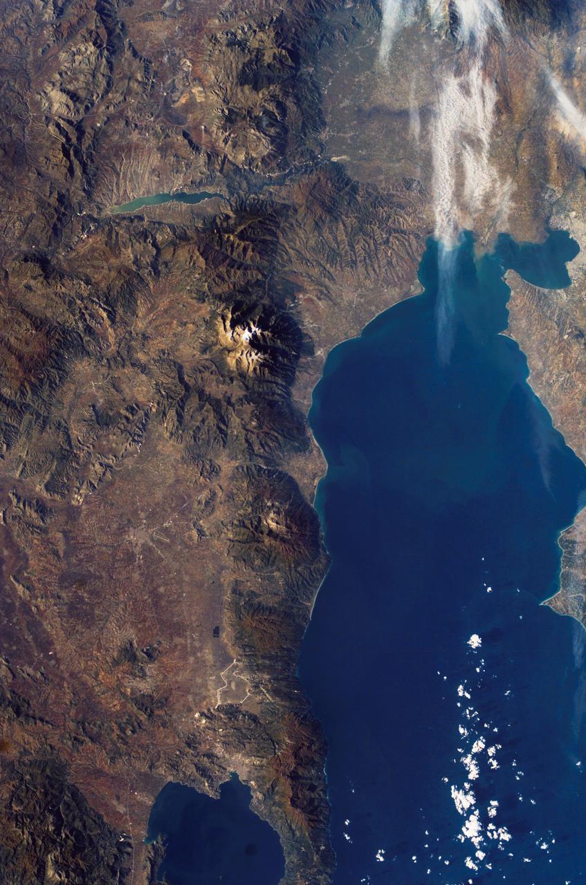
ISS010-E-08224 (22 November 2004) --- Mount Olympus, Greece is featured in this image photographed by an Expedition 10 crewmember on the International Space Station (ISS). Mount Olympus is the highest peak (2917 meters) in Greece, as well as the mountain chain that runs north into Bulgaria and south, via the Cyclades Islands, into Turkey. In this winter view, Olympus is the only peak with a dusting of snow—perhaps for this reason its name in classical Greek means “the luminous one.” In Greek mythology the peak was inhabited by the Twelve Olympians, the most famous gods of the ancient Greeks. North of Mount Olympus lies Macedonia, the homeland of Alexander the Great. Climbing the mountain is a favorite tourist activity today. The slopes of the peaks of Olympus and its neighboring peaks drop sheer into the Thermaikos Gulf, a northern arm of the Aegean Sea. White cirrus clouds obscure the shoreline near the city of Thessaloniki. This major port is spread along the shores of a small and well protected bay at the north end of the gulf. On the plains inland of the Olympus chain lie a lake, on the Aliakmon River, and the town of Larisa, at the focus point of a series of transport routes.
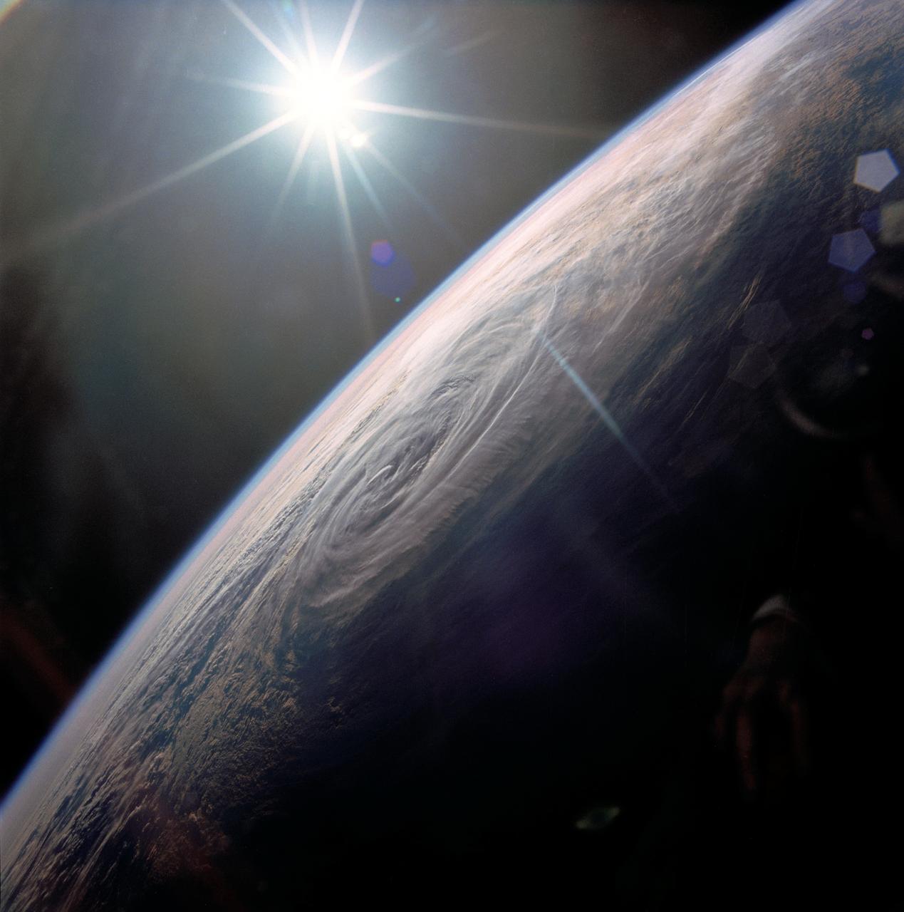
STS032-80-036 (9-20 Jan. 1990) --- This oblique view of Tropical Storm Sam in the eastern Indian Ocean off the western coast of Australia was photographed with a 70mm camera by the astronauts. Tropical Storm Sam (known as Willy-Willy in Australia) was born in the eastern Indian Ocean near the islands of Timor and Sumba in Indonesia. The storm tracked southwestward attaining sustained winds in excess of 60 knots (70 miles per hour). Other than on Christmas Island and the Cocos (Keeling) Islands south of Java, and for strong swells along the western Australia coast, the storm had little impact on land areas. At the time this photograph was taken, the storm was beginning to dissipate in the south Indian Ocean. The eye of the storm is still visible near center, with the swirling bands of the storm propagating in a clockwise direction toward the center. Winds aloft have begun to shear the tops of thunderstorms associated with the storm, forming a high cirrus cloud cover over the center portions of the storm. This picture was used by the crew at their January 30, 1990 Post-Flight Press Conference (PFPC).

ISS017-E-013856 (19 Aug. 2008) --- Amazon River, Brazil is featured in this image photographed by an Expedition 17 crewmember on the International Space Station. This image shows the huge sunglint zone, common to oblique views from space, of the setting sun shining off the Amazon River and numerous lakes on its floodplain. About 150 kilometers of the sinuous Amazon course is shown here, as it appears about 1,000 kilometers from the Atlantic Ocean. The Uatuma River enters on the north side of the Amazon (top). A small side channel of the very large Madeira River enters the view from the left. Tupinambarama Island occupies the swampy wetlands between the Amazon and Madeira rivers. Sunglint images reveal great detail in waterbodies -- in this case the marked difference between the smooth outline of the Amazon and the jagged shoreline of the Uatuma River. The jagged shoreline results from valley sides being eroded in relatively hard rocks. The Uatuma River has since been dammed up by the sediment mass of the Amazon floodplain. Because the Amazon flows in its own soft sediment, its huge water discharge smooths the banks. Another dammed valley (known as a ria) is visible beneath the cirrus cloud of a storm (bottom). Although no smoke plumes from forest fires are visible in the view, two kinds of evidence show that there is smoke in the atmosphere. The coppery color of the sunglint is typically produced by smoke particles and other aerosols scattering yellow and red light. Second, a small patch of cloud (top right) casts a distinct shadow. The shadow, say scientists, is visible because so many particles in the surrounding sunlit parts of the atmosphere reflect light to the camera.