
iss036e016840 (7/9/2013) --- Close-up view of the COLUMBUS External Platform Facility (CEPF) and the Solar facility taken during extravehicular activity (EVA) 22 on the International Space Station. The Sun Monitoring on the External Payload Facility of Columbus (Solar) is a monitoring observatory that will measure the solar spectral irradiance, which is of great importance for atmospheric modeling, atmospheric chemistry and climatology.
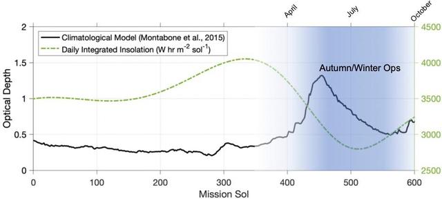
This graphic depicts the environmental conditions at Jezero Crater from the day NASA's Perseverance Mars rover landed there – on Feb. 18, 2021, the first Martian day, or sol, of the mission – through Sol 600. The black line indicates a climatological model of atmospheric opaqueness (a measurement known as "tau") over a Martian year. The expected daily insolation, or the amount of Sun's rays reaching the solar panel, is illustrated by the green dotted line. While a year on Earth lasts 365 days, on Mars a year lasts 668 sols. https://photojournal.jpl.nasa.gov/catalog/PIA25322

NASA's New Horizons spacecraft captured this high-resolution enhanced color view of Pluto on July 14, 2015. The image combines blue, red and infrared images taken by the Ralph/Multispectral Visual Imaging Camera (MVIC). Pluto's surface sports a remarkable range of subtle colors, enhanced in this view to a rainbow of pale blues, yellows, oranges, and deep reds. Many landforms have their own distinct colors, telling a complex geological and climatological story that scientists have only just begun to decode. The image resolves details and colors on scales as small as 0.8 miles (1.3 kilometers). http://photojournal.jpl.nasa.gov/catalog/PIA19952
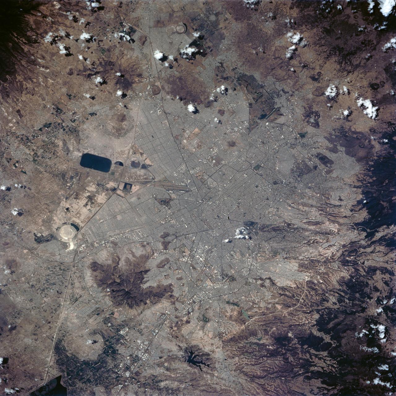
STS062-84-028 (4-18 March 1994) --- According to NASA scientists this image is the clearest photo of Mexico City taken from United States manned spacecraft. North is to the upper right. Mexico City sits in a basin surrounded by large volcanoes. The restricted atmospheric circulation in the basin, coupled with the inevitable air emissions produced by a city of 20 million people has created a critical air pollution problem for the city. In most photographs of the region, Mexico City is obscured by haze. Scientists feel the clear atmosphere in this photograph may be due, in part, to the stringent air emission restrictions now in place. The clarity of the photograph allows many key cultural features to be identified, including all of the major boulevards, the horse track (western part of the city), the university (south of the city), and the museum areas. Large, man-made ponds east of the city also stand out.
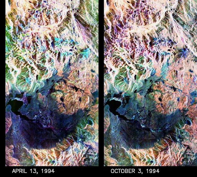
These two false-color composite images of the Mammoth Mountain area in the Sierra Nevada Mountains, Calif., show significant seasonal changes in snow cover. The image at left was acquired by the Spaceborne Imaging Radar-C and X-band Synthetic Aperture Radar aboard the space shuttle Endeavour on its 67th orbit on April 13, 1994. The image is centered at 37.6 degrees north latitude and 119 degrees west longitude. The area is about 36 kilometers by 48 kilometers (22 miles by 29 miles). In this image, red is L-band (horizontally transmitted and vertically received) polarization data; green is C-band (horizontally transmitted and vertically received) polarization data; and blue is C-band (horizontally transmitted and received) polarization data. The image at right was acquired on October 3, 1994, on the space shuttle Endeavour's 67th orbit of the second radar mission. Crowley Lake appears dark at the center left of the image, just above or south of Long Valley. The Mammoth Mountain ski area is visible at the top right of the scene. The red areas correspond to forests, the dark blue areas are bare surfaces and the green areas are short vegetation, mainly brush. The changes in color tone at the higher elevations (e.g. the Mammoth Mountain ski area) from green-blue in April to purple in September reflect changes in snow cover between the two missions. The April mission occurred immediately following a moderate snow storm. During the mission the snow evolved from a dry, fine-grained snowpack with few distinct layers to a wet, coarse-grained pack with multiple ice inclusions. Since that mission, all snow in the area has melted except for small glaciers and permanent snowfields on the Silver Divide and near the headwaters of Rock Creek. On October 3, 1994, only discontinuous patches of snow cover were present at very high elevations following the first snow storm of the season on September 28, 1994. For investigations in hydrology and land-surface climatology, seasonal snow cover and alpine glaciers are critical to the radiation and water balances. SIR-C/X-SAR is a powerful tool because it is sensitive to most snowpack conditions and is less influenced by weather conditions than other remote sensing instruments, such as Landsat. In parallel with the operational SIR-C data processing, an experimental effort is being conducted to test SAR data processing using the Jet Propulsion Laboratory's massively parallel supercomputing facility, centered around the Cray Research T3D. These experiments will assess the abilities of large supercomputers to produce high throughput SAR processing in preparation for upcoming data-intensive SAR missions. The images released here were produced as part of this experimental effort. http://photojournal.jpl.nasa.gov/catalog/PIA01753