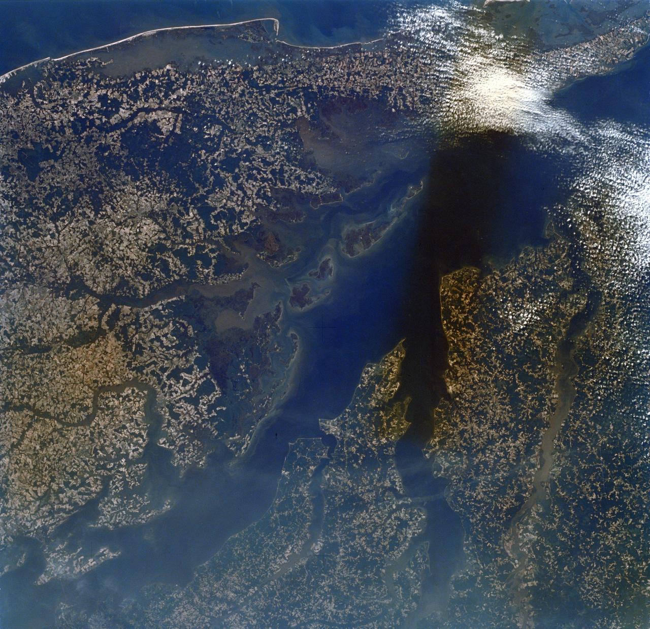
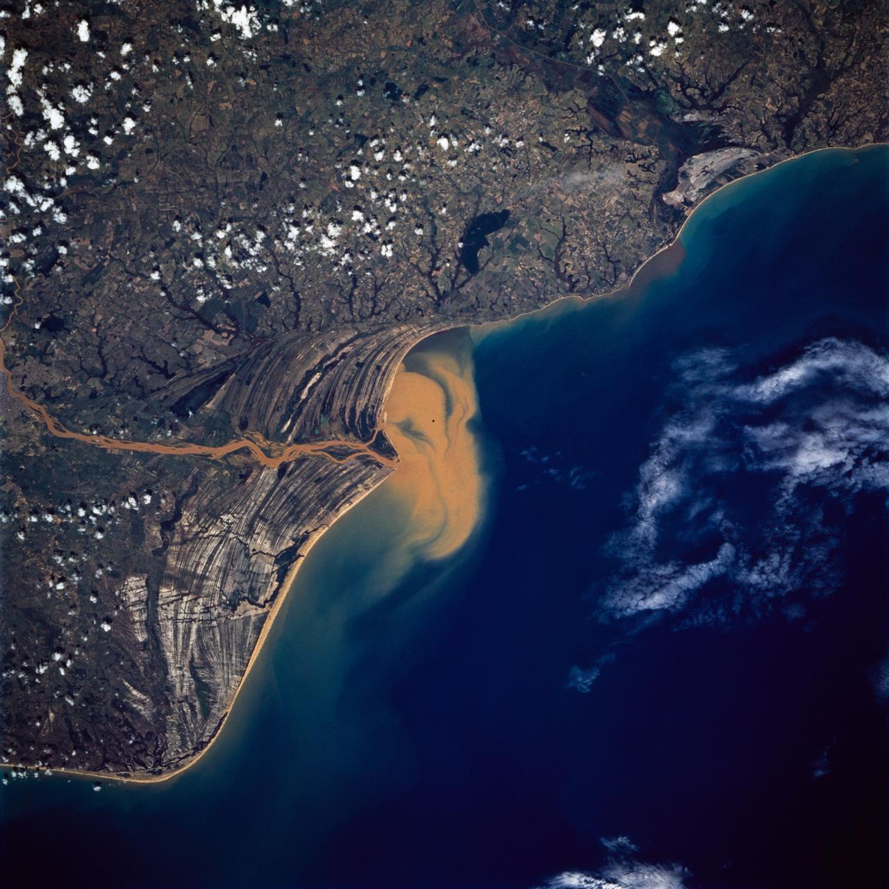
SL2-16-174 (22 June 1973) --- Norfolk and the lower Chesapeake Bay, VA (37.5N, 75.5W) at the interface of the Atlantic Ocean can be seen to be a mixture of complex currents. Outgoing tides from the bay generate considerable turbulence as they encounter coastal currents and can be observed by the sediment plumes stirred up as a result of current dynamics. Smooth flowing water has less sediment and appears darker. Turbulent water has lots of sediment and appears lighter in color. Photo credit: NASA
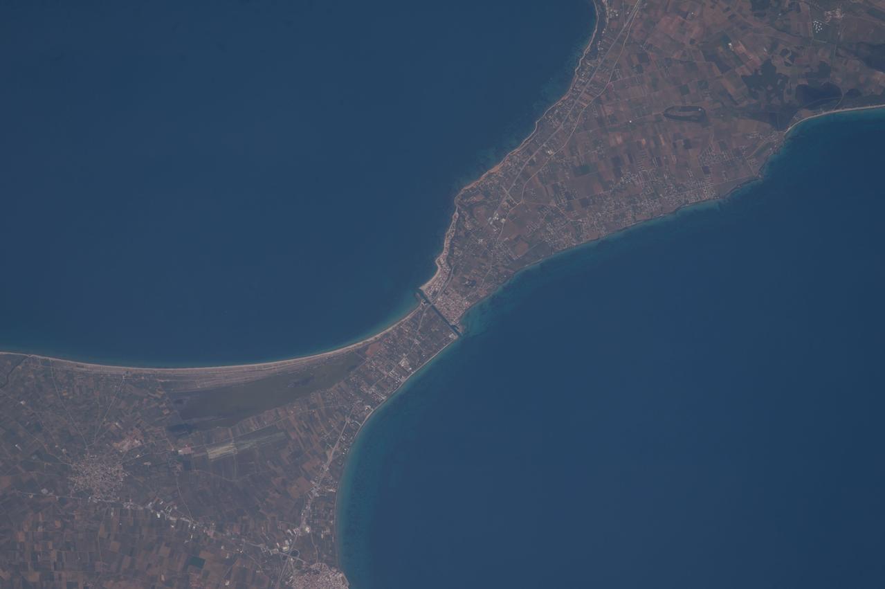
ISS047e115879 (05/13/2016) --- NASA astronaut Jeff Williams captured this image of the ancient Potidea canal in Greece from the International Space Station. For 2,000 years this canal has connected the Thermaikos and Toronaios Gulfs. Williams posted the photograph to his Twitter account May 13, 2016 saying, "Coastal currents and erosion over 2,000 years appear to have displaced the two sides of this isthmus," which may explain the coastline's misalignment".
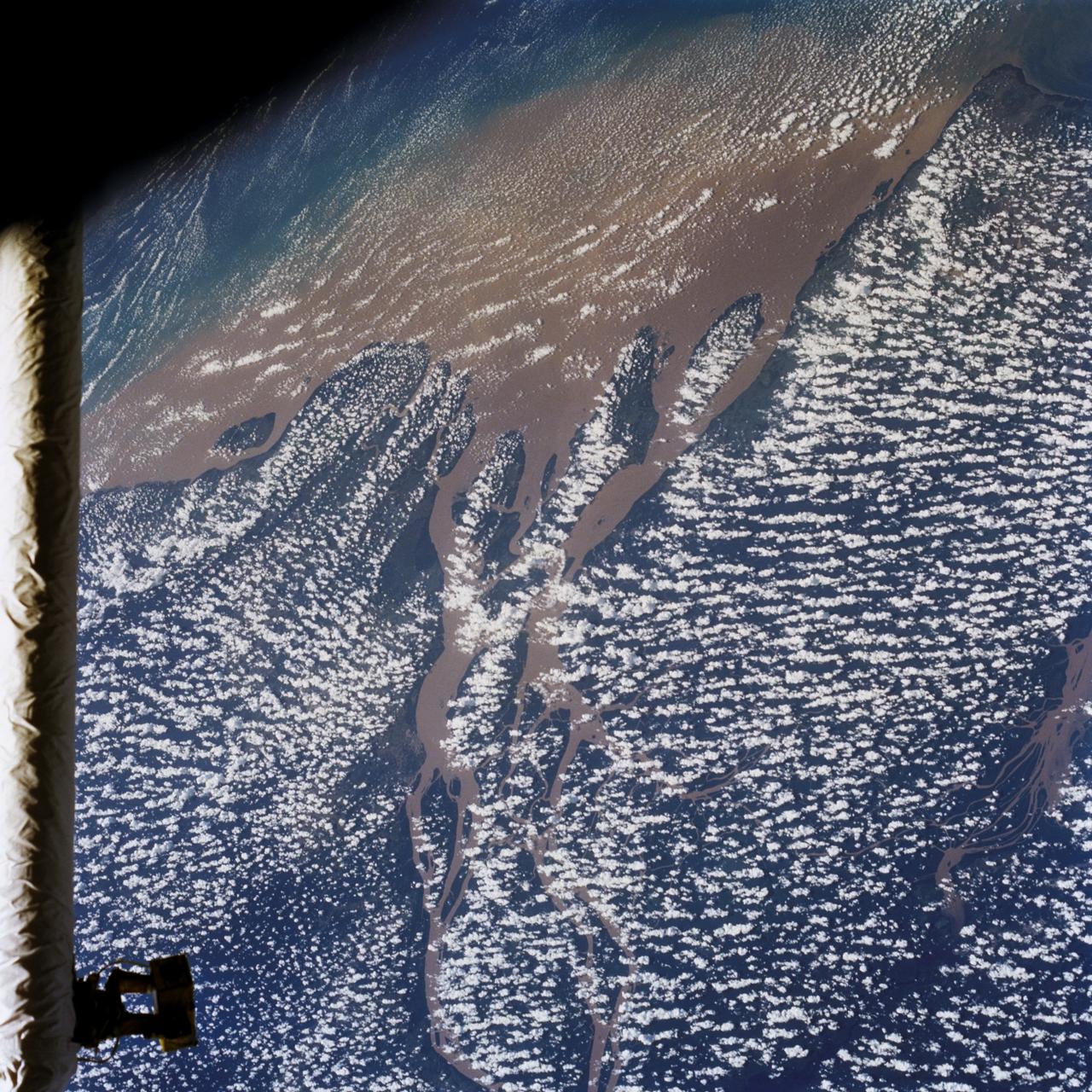
STS046-80-009 (31 July-8 Aug. 1992) --- A view of the mouth of the Amazon River and the Amazon Delta shows a large sediment plume expanding outward into the Atlantic Ocean. The sediment plume can be seen hugging the coast north of the Delta. This is caused by the west-northwest flowing Guyana Current. The large island of Marajo is partially visible through the clouds.
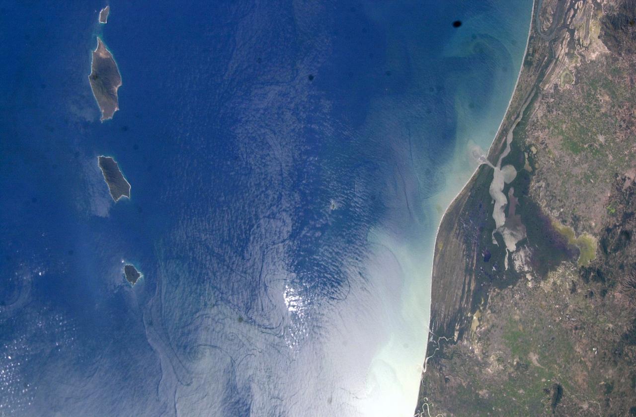
ISS006-E-51456 (2003) --- Marias Islands, Mexico is featured in this image photographed by an Expedition Six crewmember on the International Space Station. The view shows the land-sea interactions along a section of Mexico's west coast just south of Mazatlan and the Isla Marias archipelago. The islands are a manifestation of intersecting plate boundaries -- the East Pacific Rise spreading center that traces south from the Gulf of California, and the subduction zone that consumes the Cocos plate beneath southern Mexico. These islands are biologically important: they comprise the Islas Marias Biosphere Reserve and contain endemic species of raccoons and rabbits, and important habitat for birds and marine life. Between the islands and the mainland, swirling surface currents are highlighted by the sun glint reflecting off the ocean surface. Along the Mexican coast, water flows out from a coastal lagoon, and near shore currents carry sediment (light colored water) along the beach front.
STS072-738-019 (11-20 Jan. 1996) --- The Delta of the Paraiba do Sul River, northeast of Rio de Janeiro, Brazil, stands out in this 70mm frame exposed from the Earth-orbiting Space Shuttle Endeavour. The brown color of the river water and offshore sediment plume show that the river is in flood stage. This delta attracts much attention from orbit because of its prominent beach ridges either side of the river mouth. River sediment from inland supplies the material which is redistributed by coastal currents to form the parallel beach ridges. The lower 20 miles of the river appear in this scene. The river flows into the Atlantic in an easterly direction.
STS054-80-024 (13-19 Jan 1993) --- As the Shuttle was passing southeast over the coast of India, approaching the Bay of Bengal, Endeavour's crew took this picture of the Godavari River Delta. The sun glint pattern was centered directly over the delta and highlighted well the intricate drainage pattern. Offshore, water features associated with current boundaries and river plumes are readily visible. The line of clouds along the coast south of the delta suggest that surface winds are blowing onshore from the Bay of Bengal. As the air passes over the warmer coastal water and land, it is warmed and begins to rise. The moisture in the air condenses, forming a line of low-level clouds.
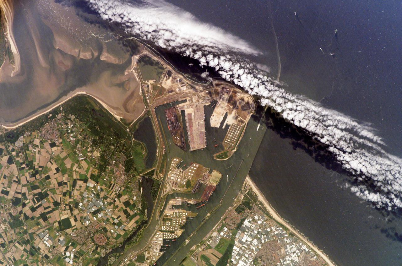
ISS011-E-07380 (28 May 2005) --- The Port of Rotterdam, Netherlands, is featured in this image photographed by an Expedition 11 crewmember on the International Space Station (ISS). The Port of Rotterdam, also known as Europoort (Eurogate), has been an important trading center since approximately 1250 A.D. This image illustrates the close proximity of the Europoort with the surrounding cities of Hoek van Holland, Oostvoorne, Brielle, and agricultural fields to the south. The presence of the port and its seawalls interrupts southward-flowing coastal currents, leading to accumulation of sediment to the south (upper left of image). Numerous ship wakes are visible within the port complex itself and in the upper right of the image.
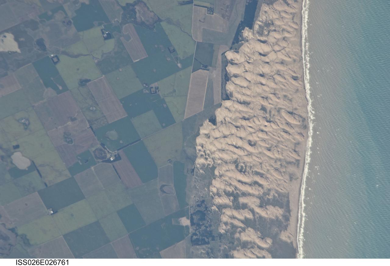
ISS026-E-026761 (13 Feb. 2011) --- Medano Blanco coastal dunes in Buenos Aires Province, Argentina are featured in this image photographed by an Expedition 26 crew member on the International Space Station. The Medano Blanco (White Dunes) are a well known recreational area 35 kilometers west of the twin cities of Nicochea-Quequen, one of the biggest ports in the province of Buenos Aires, central Argentina. The Medano Blanco dunes separate the Atlantic Ocean from intensive sunflower agricultural cropland, visible as the angular pattern of green and brown fields at left. The dune field extends 3.5 kilometers at its widest part. Narrow cordons of coastal dunes stretch along this part of Argentina’s coastline for hundreds of kilometers. Small streams, oriented towards the coast, cross the farmland at upper left. Water from these is dammed behind the dunes, and even within the dunes, where wetlands flourish. This is the drier southern part of Buenos Aires province near the more arid and windier border with Patagonia—one of the windiest places on Earth. The effect of strong westerly winds (blowing bottom to top in this slightly oblique image) can be seen everywhere in this detailed photograph. The dune sand is blown from local beaches onshore where it forms the dunes. The prominent dune ridge crests are oriented at right angles to the prevailing wind. Geologists suspect that erosion by wind has excavated numerous hollows which now dot the farmland as small shallow lakes. A stand of dark green trees has been planted on the upwind side of a health spa—located at the white dot (center left) which is the roof of a stately building—as a protective barrier against the wind. The white fringe along the seashore is formed from lines of breaking waves. Crossing swell trains can be seen offshore in the Atlantic Ocean. The curvature of the swell pattern offshore also shows the effect of the westerly wind, and indeed drives the local sea current in this area—slightly more prominent onshore swells approach the coast from the southeast. The light brown tint of seawater nearer the shore is the fine muddy fraction of the coastal sediment being washed seaward (after being stirred up by wave action) and then east by the current.
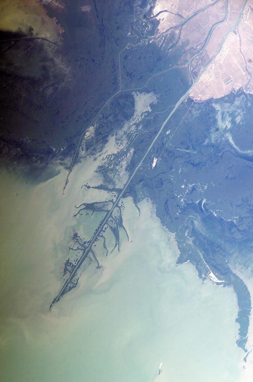
ISS009-E-18679 (17 August 2004) --- Ural River Delta, Kazakhstan is featured in this image photographed by an Expedition 9 crewmember on the International Space Station (ISS). The Ural River is one of two major rivers (the other river is the Volga) that empty into the northern coast of the Caspian Sea, creating extensive wetlands. This image shows details of the Ural's tree-like (or “digitate”) delta. According to NASA scientists studying the Space Station imagery, this type of delta forms when wave action is low and sediment content in the river is high. New distributary channels form in the delta when the river breaches natural levees formed by sediment deposition. The dark regions running along the coast are the wetlands that support high biodiversity due to the unique environment and relative isolation of the Caspian Sea. The coastal wetlands are especially important to migrating birds as an important stop-over along the Asian flyway. The Ural River's trek to the Caspian is long — roughly 2400 kilometers (1500 miles) from the Ural Mountains in Russia south to empty into the northern Caspian Sea in Kazakhstan. Although the current sea level of the Caspian is more than 26 meters below global mean sea level the water levels have risen roughly 2 meters since 1980. This has lead to flooding of much of the coastal region, including the Ural delta, and endangers these coastal wetland environments. The coastal flooding has also impacted the oil exploration infrastructure bordering the Caspian coastline, scientists report.
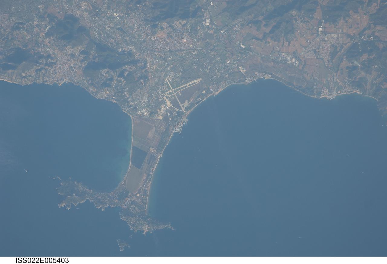
ISS022-E-005403 (2 Dec. 2009) --- Giens Peninsula, France is featured in this image photographed by an Expedition 22 crew member on the International Space Station. This detailed image depicts the Giens Peninsula located along the Mediterranean coastline of France. The peninsula is part of the Cote d?Azur, also known as the French Riviera, the coastal region bounded by the Rhone River to the west, to the north by the Rhone Alps, and the east by the Italian border. The peninsula itself, extended out southwards from the city of Hyeres to the resort community of Giens, is formed from two tombolos. A tombolo is a ridge of beach material (typically sand) built by wave action that connects an island to the mainland. Tombolos, like many coastal features, typically change dramatically over geologic time due to fluctuating sediment supply, coastal currents, sea levels and storm events. The tombolos of the Giens Peninsula have been modified by human activities including sand dune removal, construction of roadways, and replacement of the original sand by other materials. The long-term survival of these tombolos will be determined by the effects of these changes on the natural coastal processes, with potential sea level rise presenting an additional threat. In addition to Giens, three other urban areas are visible in this image; Carqueiranne, Hyeres, and La Londe-les-Maures. The urban areas are recognizable by both light pink rooftops and grey street grids. These contrast with green to brown vegetated areas including agricultural fields (between Hyeres and La Londe-les-Maures, top center) and dark green vegetated hillslopes (between Hyeres and Carqueiranne, top left). Small white dots and streaks in the Mediterranean Sea are actually yachts and other pleasure craft.
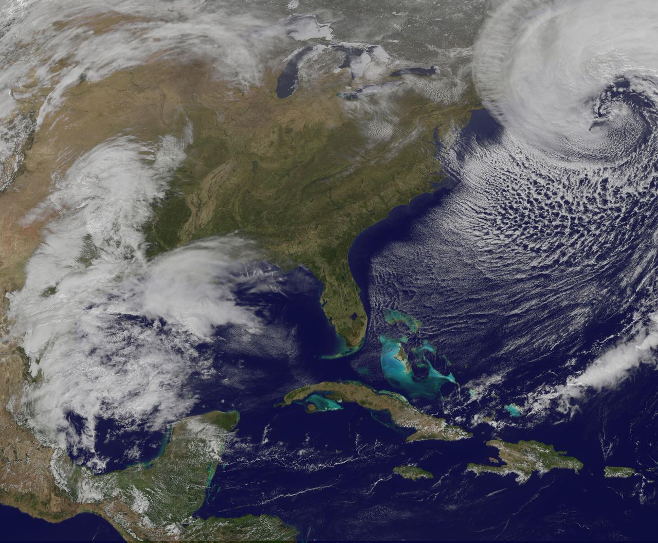
The strong coastal storm currently off the coast of New England will continue to bring strong winds and heavy snow to coastal portions of the Northeast on Wednesday. The storm will move into the Canadian Maritimes by Thursday. This image was taken by GOES East at 17:31 UTC on March 26, 2014. <b><a href="http://goes.gsfc.nasa.gov/" rel="nofollow">Credit: NOAA/NASA GOES Project</a></b> <b><a href="http://www.nasa.gov/audience/formedia/features/MP_Photo_Guidelines.html" rel="nofollow">NASA image use policy.</a></b> <b><a href="http://www.nasa.gov/centers/goddard/home/index.html" rel="nofollow">NASA Goddard Space Flight Center</a></b> enables NASA’s mission through four scientific endeavors: Earth Science, Heliophysics, Solar System Exploration, and Astrophysics. Goddard plays a leading role in NASA’s accomplishments by contributing compelling scientific knowledge to advance the Agency’s mission. <b>Follow us on <a href="http://twitter.com/NASAGoddardPix" rel="nofollow">Twitter</a></b> <b>Like us on <a href="http://www.facebook.com/pages/Greenbelt-MD/NASA-Goddard/395013845897?ref=tsd" rel="nofollow">Facebook</a></b> <b>Find us on <a href="http://instagram.com/nasagoddard?vm=grid" rel="nofollow">Instagram</a></b>
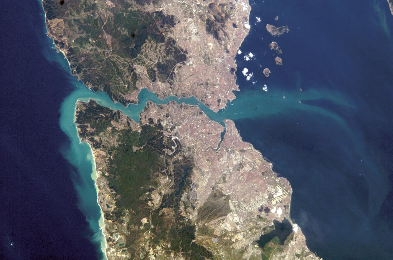
ISS008-E-21752 (16 April 2004) --- This image featuring Istanbul, Turkey was photographed by an Expedition 8 crewmember on the International Space Station (ISS). This metropolis of 15 million occupies both sides of the entrance to the narrow, 20-mile long Bosporus Strait connecting the Mediterranean and Sea of Marmara (south) to the Black Sea (north). When this image was taken, strong currents carried turbid coastal waters from the Black Sea through the Strait and into the Sea of Marmara. The rugged uplands to the north of the city are forested and contain vital reservoirs. Note Ataturk airport southwest of the city near the bottom of the image, the picturesque Prince Islands in the Sea of Marmara, and the sinuous waterway and harbor on the western shore known as the Golden Horn.
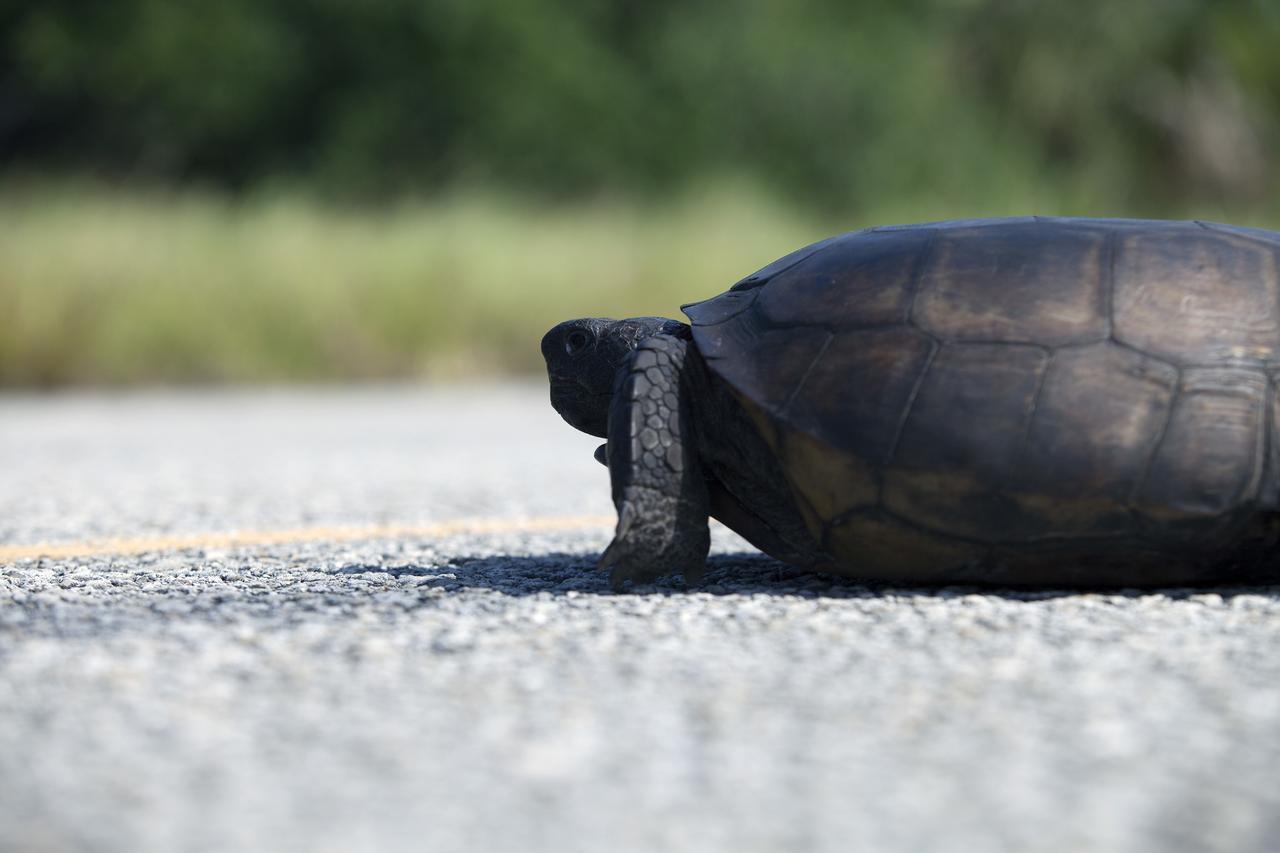
CAPE CANAVERAL, Fla. -- A gopher tortoise lumbers down the roadway at NASA's Kennedy Space Center in Florida. Gopher tortoises are dry-land turtles that live in scrub, dry hammock, pine flatwood, coastal grassland and dune habitats. The undeveloped property on Kennedy Space Center is managed by the U.S. Fish and Wildlife Service through the Merritt Island National Wildlife Refuge. Currently, gopher tortoises are protected in some states by federal law under the Endangered Species Act ESA. The refuge provides a habitat for 14 species federally listed as threatened or endangered, including the leatherback, green, Kemps Ridley, loggerhead and Atlantic hawksbill turtles. For information on the refuge, visit http://www.fws.gov/merrittisland/Index.html. For more information on the gopher tortoise, visit http://www.fws.gov/northflorida/GopherTortoise/Gopher_Tortoise_Fact_Sheet.html. Photo credit: NASA/Daniel Casper
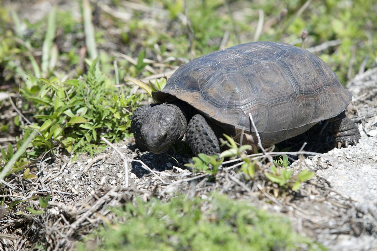
CAPE CANAVERAL, Fla. -- A gopher tortoise stops for lunch beside the Launch Pad 39B beach road on NASA's Kennedy Space Center in Florida. Gopher tortoises are dry-land turtles that live in scrub, dry hammock, pine flatwood, coastal grassland and dune habitats. The undeveloped property on Kennedy Space Center is managed by the U.S. Fish and Wildlife Service through the Merritt Island National Wildlife Refuge. Currently, gopher tortoises are protected in some states by federal law under the Endangered Species Act ESA. The refuge provides a habitat for 14 species federally listed as threatened or endangered, including the leatherback, green, Kemps Ridley, loggerhead and Atlantic hawksbill turtles. For information on the refuge, visit http://www.fws.gov/merrittisland/Index.html. For more information on the gopher tortoise, visit http://www.fws.gov/northflorida/GopherTortoise/Gopher_Tortoise_Fact_Sheet.html. Photo credit: NASA/Daniel Casper
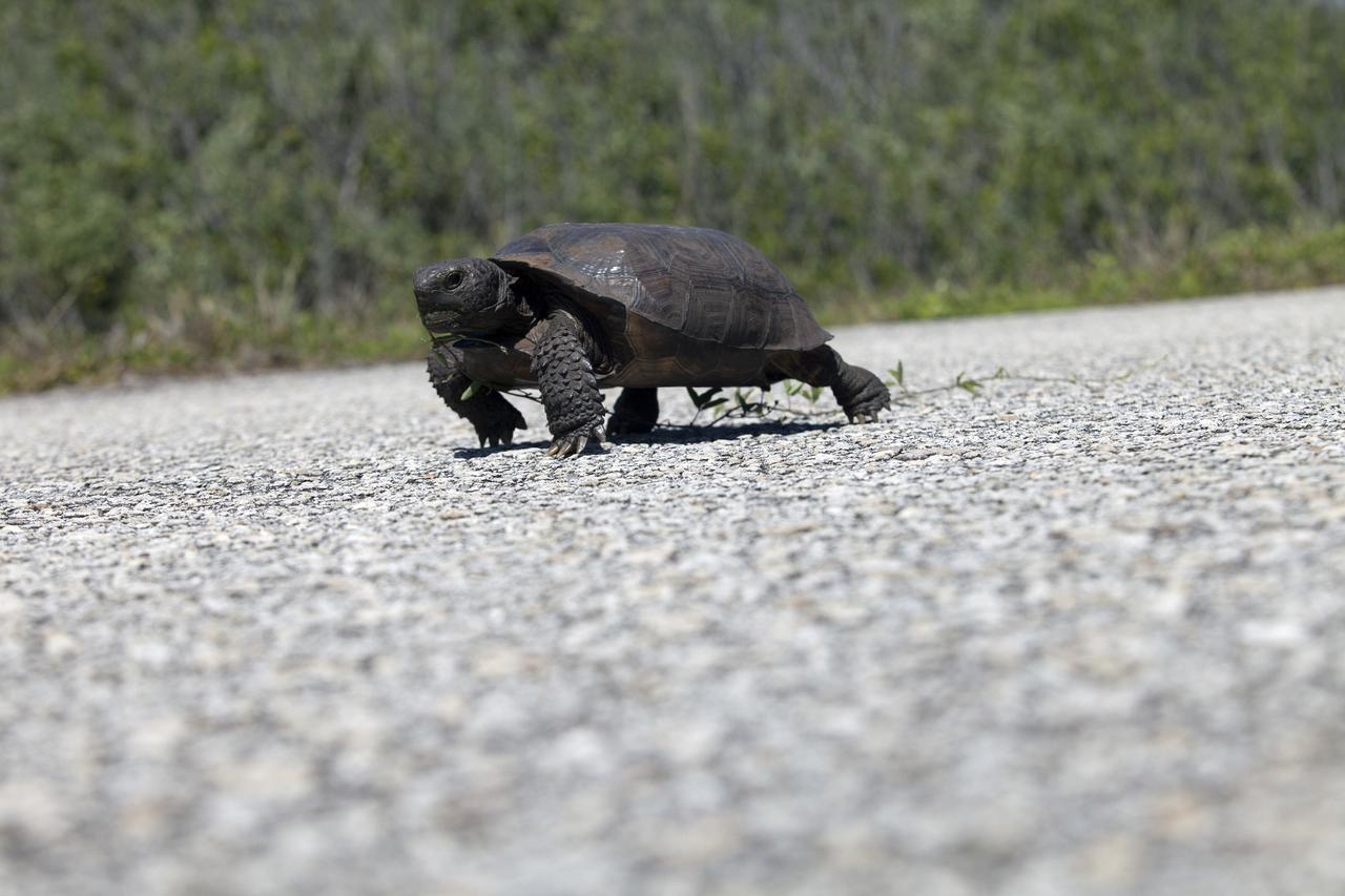
CAPE CANAVERAL, Fla. -- A gopher tortoise ambles along the Launch Pad 39B beach road on NASA's Kennedy Space Center in Florida. Gopher tortoises are dry-land turtles that live in scrub, dry hammock, pine flatwood, coastal grassland and dune habitats. The undeveloped property on Kennedy Space Center is managed by the U.S. Fish and Wildlife Service through the Merritt Island National Wildlife Refuge. Currently, gopher tortoises are protected in some states by federal law under the Endangered Species Act ESA. The refuge provides a habitat for 14 species federally listed as threatened or endangered, including the leatherback, green, Kemps Ridley, loggerhead and Atlantic hawksbill turtles. For information on the refuge, visit http://www.fws.gov/merrittisland/Index.html. For more information on the gopher tortoise, visit http://www.fws.gov/northflorida/GopherTortoise/Gopher_Tortoise_Fact_Sheet.html. Photo credit: NASA/Daniel Casper

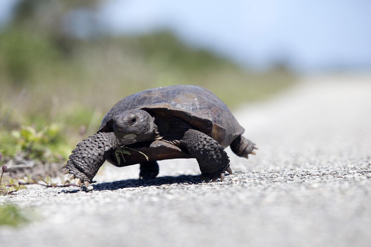
CAPE CANAVERAL, Fla. -- This gopher tortoise almost seems to float above the pavement as it hastens along the road at NASA's Kennedy Space Center in Florida. Gopher tortoises are dry-land turtles that live in scrub, dry hammock, pine flatwood, coastal grassland and dune habitats. The undeveloped property on Kennedy Space Center is managed by the U.S. Fish and Wildlife Service through the Merritt Island National Wildlife Refuge. Currently, gopher tortoises are protected in some states by federal law under the Endangered Species Act ESA. The refuge provides a habitat for 14 species federally listed as threatened or endangered, including the leatherback, green, Kemps Ridley, loggerhead and Atlantic hawksbill turtles. For information on the refuge, visit http://www.fws.gov/merrittisland/Index.html. For more information on the gopher tortoise, visit http://www.fws.gov/northflorida/GopherTortoise/Gopher_Tortoise_Fact_Sheet.html. Photo credit: NASA/Daniel Casper
CAPE CANAVERAL, Fla. -- Slow and steady wins the race for this gopher tortoise, ambling along the Launch Pad 39B beach road on NASA's Kennedy Space Center in Florida. Gopher tortoises are dry-land turtles that live in scrub, dry hammock, pine flatwood, coastal grassland and dune habitats. The undeveloped property on Kennedy Space Center is managed by the U.S. Fish and Wildlife Service through the Merritt Island National Wildlife Refuge. Currently, gopher tortoises are protected in some states by federal law under the Endangered Species Act ESA. The refuge provides a habitat for 14 species federally listed as threatened or endangered, including the leatherback, green, Kemps Ridley, loggerhead and Atlantic hawksbill turtles. For information on the refuge, visit http://www.fws.gov/merrittisland/Index.html. For more information on the gopher tortoise, visit http://www.fws.gov/northflorida/GopherTortoise/Gopher_Tortoise_Fact_Sheet.html. Photo credit: NASA/Daniel Casper
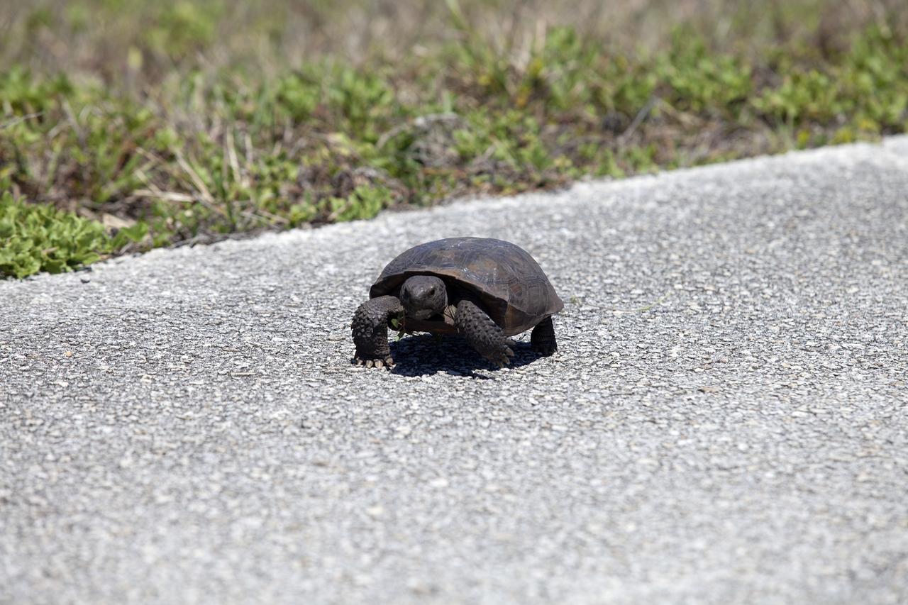
CAPE CANAVERAL, Fla. -- Why did the gopher tortoise cross the road? To get to the other side of the Launch Pad 39B beach road on NASA's Kennedy Space Center in Florida, of course. Gopher tortoises are dry-land turtles that live in scrub, dry hammock, pine flatwood, coastal grassland and dune habitats. The undeveloped property on Kennedy Space Center is managed by the U.S. Fish and Wildlife Service through the Merritt Island National Wildlife Refuge. Currently, gopher tortoises are protected in some states by federal law under the Endangered Species Act ESA. The refuge provides a habitat for 14 species federally listed as threatened or endangered, including the leatherback, green, Kemps Ridley, loggerhead and Atlantic hawksbill turtles. For information on the refuge, visit http://www.fws.gov/merrittisland/Index.html. For more information on the gopher tortoise, visit http://www.fws.gov/northflorida/GopherTortoise/Gopher_Tortoise_Fact_Sheet.html. Photo credit: NASA/Daniel Casper
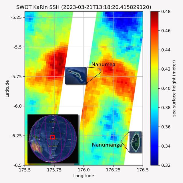
The recently launched Surface Water and Ocean Topography (SWOT) mission collected data on sea levels around two of the inhabited islands of Tuvalu, a nation in the South Pacific Ocean that has been threatened with sea level rise that substantially exceeds the global average. The image shows two areas of red that indicate higher than normal sea levels around two of Tuvalu's inhabited islands, Nanumanga and Nanumea. The higher sea levels were likely caused by internal tides or circular currents called eddies. The SWOT data illuminates for the first time these small ocean features that, when they occur on top of rising sea levels, can lead to episodic flooding along coastlines. The Tuvalu data was collected March 21, 2023. Rising seas are a direct consequence of climate change. On a global scale, the combination of warming ocean waters and ice melt from glaciers and ice sheets is leading to sea level rise that is occurring at an ever-increasing rate. The current rate of rise is more than 0.15 inches (4 millimeters) per year, an increase from 0.08 inches (2 millimeters) per year in 1993. This seemingly small increase holds great significance for coastal communities that have seen more than a century of persistent sea level rise. The gap between the average high tide and flooding conditions has narrowed, and coastal impacts driven by sea level rise have increased in frequency and severity in recent years. This is particularly true for low-lying island nations like Tuvalu, located about 620 miles (1,000 kilometers) north of Fiji. Sea level rise does not occur at the same rate everywhere across the globe, and can be exacerbated by natural ocean fluctuations that occur over time periods from years to decades. For Tuvalu, the amount of sea level rise has been substantially higher than the global average over the past three decades. The amount of rise, when coupled with Tuvalu's low land elevations, places the country increasingly under threat. In the near term, sea level rise will combine with naturally occurring ocean variability and storms to exacerbate events like coastal flooding. Monitoring and understanding sea level change is critical for Tuvalu and other low-lying island nations. Launched on Dec. 16, 2022, from Vandenberg Space Force Base in central California, SWOT collected the Tuvalu sea level data during a period of commissioning, calibration, and validation. Engineers are checking out the performance of the satellite's systems and science instruments before the planned start of science operations in summer 2023. https://photojournal.jpl.nasa.gov/catalog/PIA25777
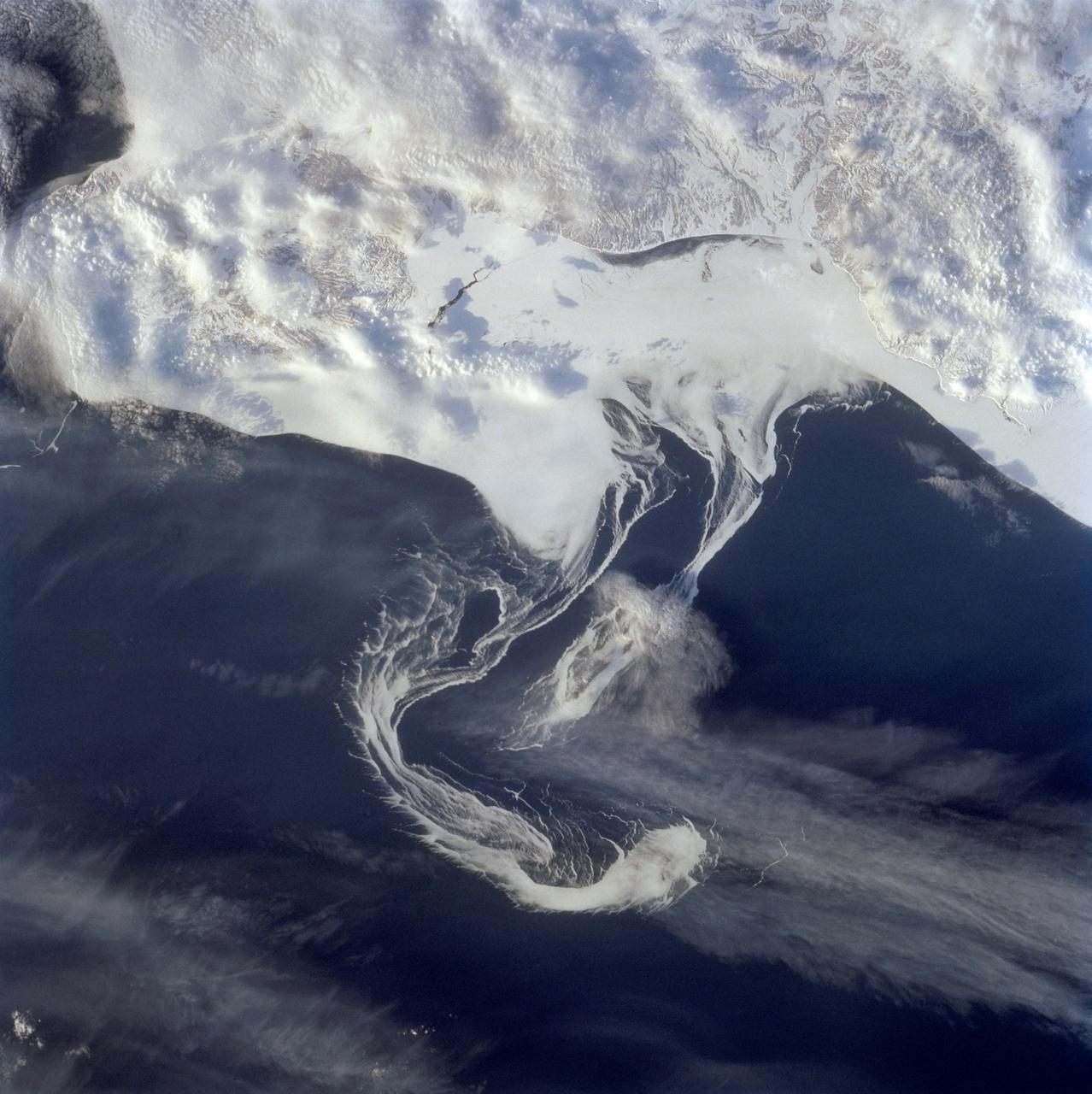
STS060-73-038 (3-11 Feb 1994) --- Pack ice is documented in this photograph along the coast of the Kamchatka Peninsula of Russia in Zaliv Ozernoj. Newly formed ice continually breaks away from the land and takes the form imposed by coastal currents. Detailed photographs of the ice provide information to scientists in both Russia and the united States about the location and fluctuation of ice edges, and how this new sea ice interacts with ocean and littoral currents. This information results in better ice warnings to shipping traffic and provides data points for long-range climate change research for both the Mission-To-Planet Earth and the Russian Priroda ("Nature") monitoring and assessment programs that are respectively coordinated by NASA and the Russian Academy of Sciences. This photography of ice development in the North Pacific, North Atlantic, the Southern Ocean, the Baltic and North Seas, and the Great Lakes is of great interest to the international scientific community. NASA scientists feel high-resolution analog and digital photography from the Space Shuttle and future craft can be a particularly important component in satisfying their data needs on both an operational and a long-term research basis.
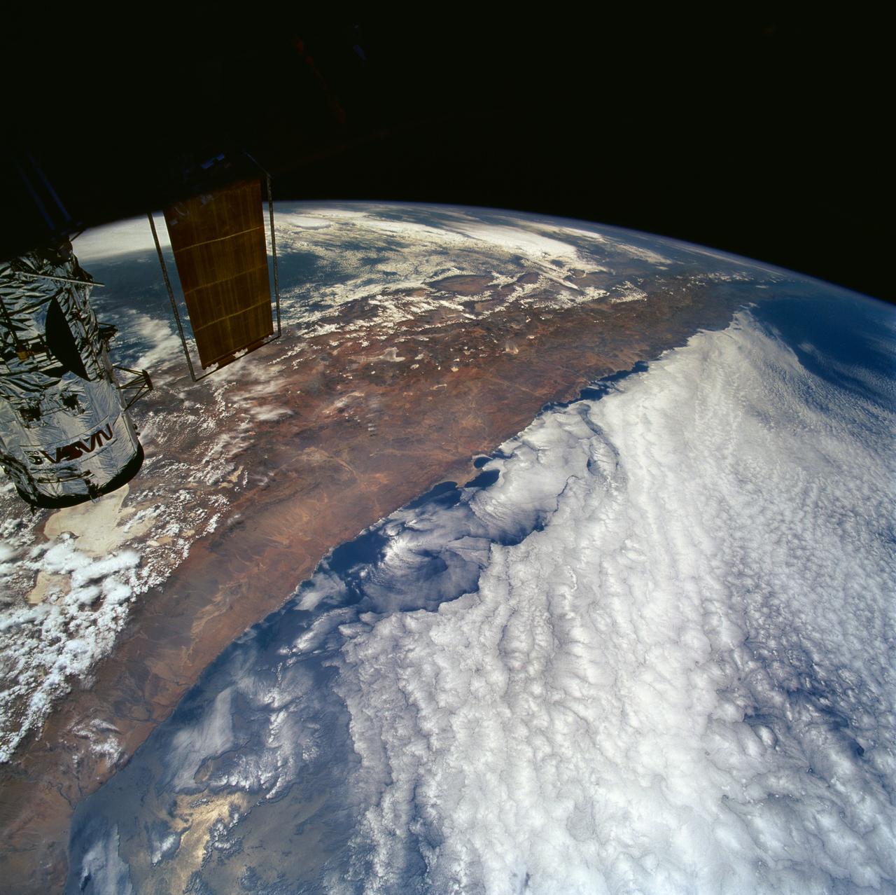
STS061-101-023 (8 Dec 1993) --- This color photograph is a spectacular, panoramic (southeastern view) shot that features the northern half of the country of Chile and the Andes Mountains of South America. The Atacama Desert, one of the driest regions on earth, is clearly visible along the northern Chilean coast. This desert extends from roughly Arica in the north to the city of Caldera in the south, a distance of six hundred miles. Some parts of this very arid region go for more than twenty years without measurable precipitation. It is an area of dramatic and abrupt elevation changes. For example, from the waters edge there is an escarpment of the coastal plateau that rises like an unbroken wall two or three thousand feet above the Pacific Ocean. From the coastal plateau, there is an even more dramatic increase in elevation -- from two thousand feet above sea level to an average elevation of thirteen thousand feet above sea level in the Bolivian Altiplano. This elevation change occurs within a one hundred to two hundred mile distance from the Pacific Ocean. The north-south trending spine of the Andes Mountains can be seen on this photograph. Several of the volcanic peaks in this mountain chain exceed 20,000 feet above sea level. Interspersed with these volcanic peaks, numerous dry lake beds (salars) can be seen as highly reflective surfaces. The largest of these salars (Salar de Uyuni) is visible at the edge of the Hubble Space Telescope (HST). Offshore, the cold Peruvian current produces low stratus clouds that can be found along this coastline at certain times of the year. This is the same type of meteorological phenomena that is found along the southern California coast and the Skeleton coast of southwestern Africa.
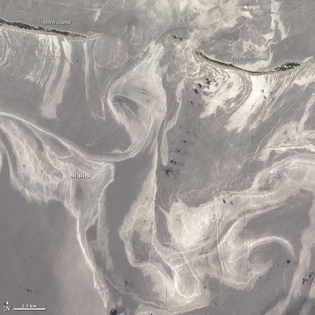
NASA image acquired June 26, 2010 As of June 27, 2010, the entire gulf-facing beachfront of several barrier islands in eastern Mississippi (offshore of Pascagoula) had received a designation of at least “lightly oiled” by the interagency Shoreline Cleanup Assessment Team that is responding to the disaster in the Gulf of Mexico. A few small stretches of Petit Bois Island had been labeled heavily or moderately oiled. (To view this image without a description go to: This high-resolution image shows Petit Bois Island (top right) and the eastern end of Horn Island (top left) on June 26. In general, oil-covered waters are silvery and cleaner waters are blue-gray. This pattern is especially consistent farther from the islands. The intensely bright patches of water directly offshore of the barrier islands, however, may be from a combination of factors, including sediment and organic material, coastal currents and surf, and oil. The islands provide a sense of scale for the ribbons of oil swirling into the area from the south. Petit Bois Island is about 10 kilometers (6 miles) long. It is one of seven barrier islands that, along with some mainland areas of Mississippi and Florida, make up the Gulf Islands National Seashore. According to the National Park Service Gulf Islands National Seashore Website, all the islands remained open to the public as of June 28, 2010, and clean-up crews were on hand to respond to any oil coming ashore. The large version of this image, which was captured by the Advanced Land Imager on NASA’s Earth Observing-1 (EO-1) satellite, shows a larger area, including the Mississippi Sound and parts of mainland Mississippi. Although oil has been observed in the Sound, it is unlikely that all the bright patches of water in that area are thickly oil-covered. Differences in brightness in coastal area waters may be due to other factors, including freshwater runoff, strong currents, and water depth and clarity. NASA Earth Observatory image created by Jesse Allen and Robert Simmon, using EO-1 ALI data provided courtesy of the NASA EO-1 team. Caption by Rebecca Lindsey. Instrument: EO-1 - ALI To see more images go to: <a href="http://earthobservatory.nasa.gov/" rel="nofollow">earthobservatory.nasa.gov/</a> <b><a href="http://www.nasa.gov/centers/goddard/home/index.html" rel="nofollow">NASA Goddard Space Flight Center</a></b> is home to the nation's largest organization of combined scientists, engineers and technologists that build spacecraft, instruments and new technology to study the Earth, the sun, our solar system, and the universe.
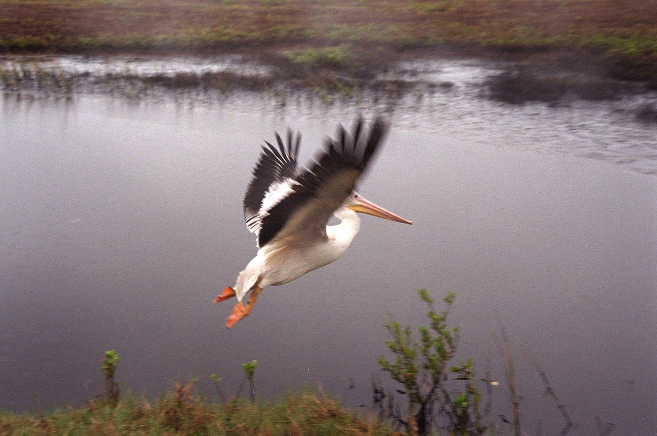
A white pelican named "Fisheater" by its rescuers, beats its wings as it flies to freedom at the Merritt Island National Wildlife Refuge. The pelican was found covered in crude oil from a contaminated ditch in northern Indiana in November, and was rescued by a local Police Department, treated, and flown to the Back to Nature Wildlife Refuge in Orlando, Fla. for care and rest. It is being released today to join a flock of about 30 other white pelicans that are wintering on the refuge. Before its release, however, Kat Royer, with the U.S. Fish and Wildlife Service, placed on it a leg band issued by the U.S. Department of the Interior's Bird Banding Laboratory. White pelicans inhabit marshy lakes and along the Pacific and Texas coasts. They winter from Florida and southern California south to Panama, chiefly in coastal lagoons. They are frequently seen flying in long lines, flapping and sailing in unison, but also ride rising air currents to soar gracefully in circles. The Merritt Island National Wildlife Refuge, which encompasses 92,000 acres that are a habitat for more than 331 species of birds, 31 mammals, 117 fishes, and 65 amphibians and reptiles. The marshes and open water of the refuge provide wintering areas for 23 species of migratory waterfowl, as well as a year-round home for great blue herons, great egrets, wood storks, cormorants, brown pelicans and other species of marsh and shore birds, as well as a variety of insects
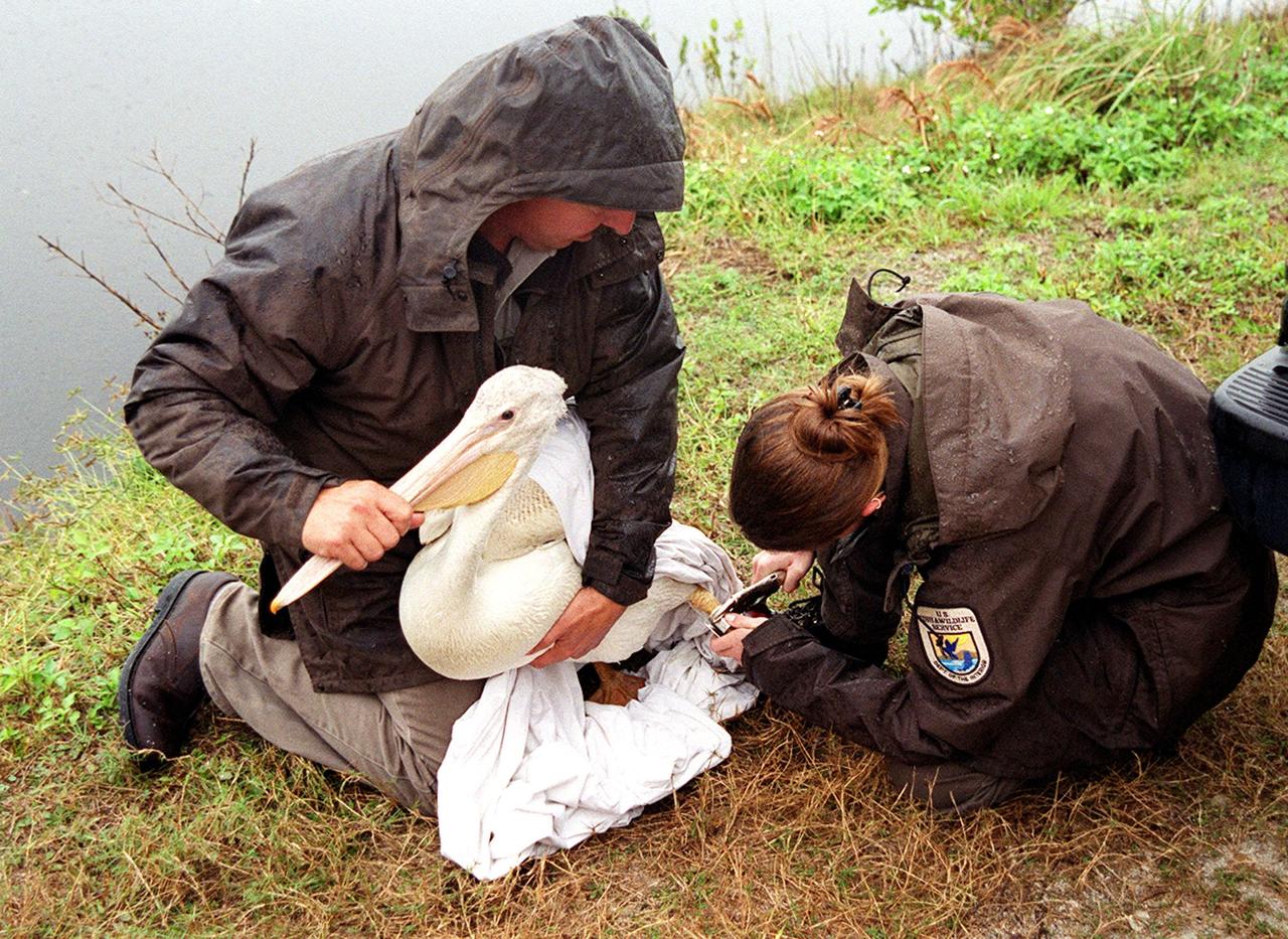
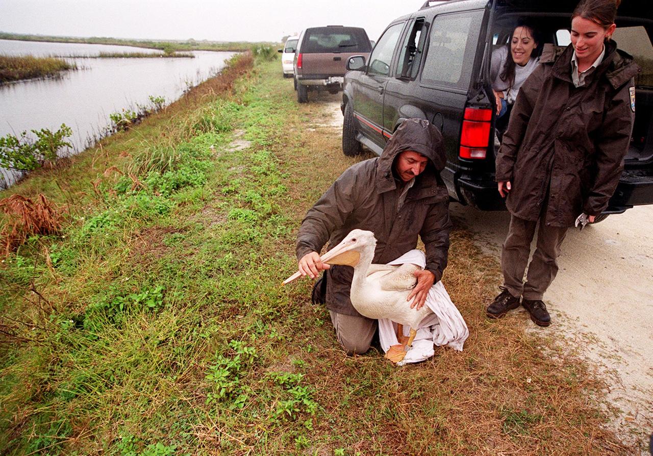
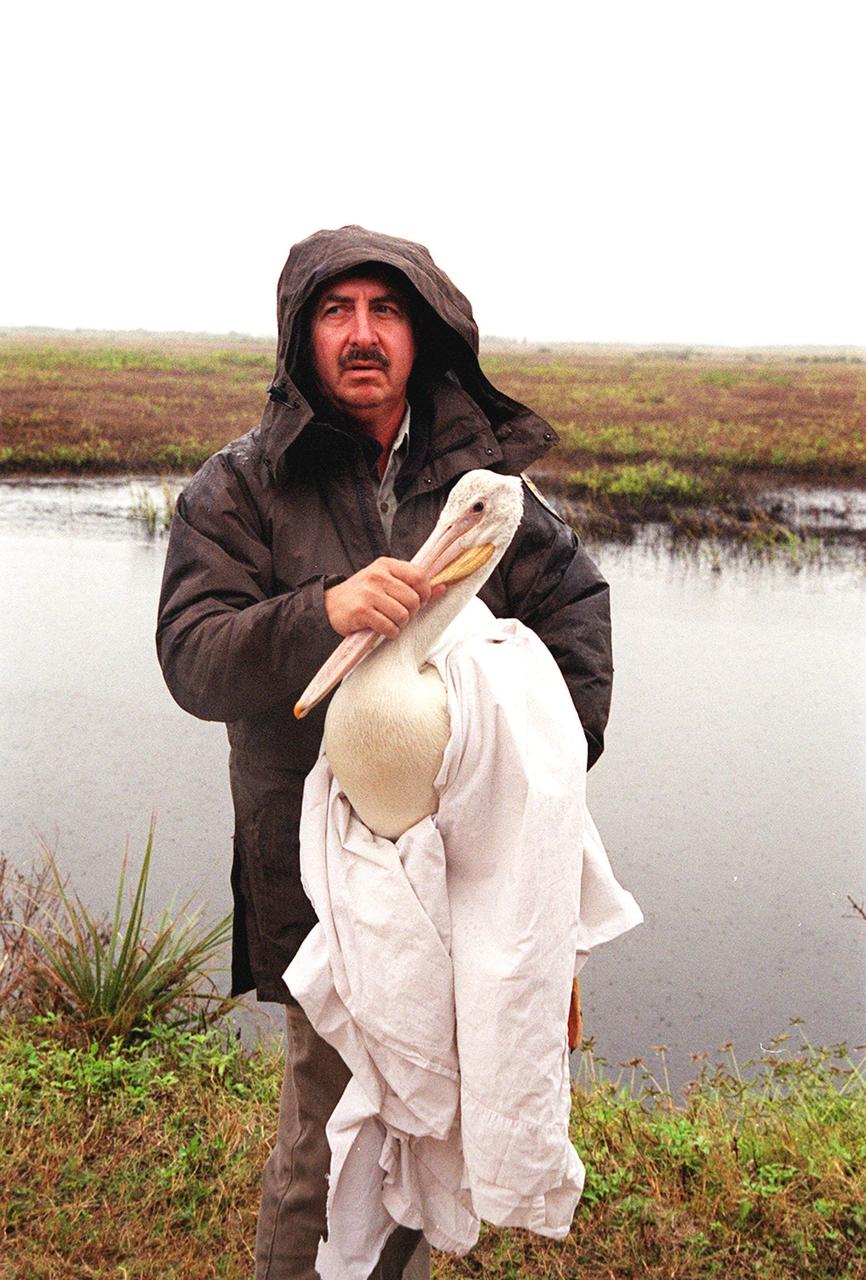
Under a rain-filled sky, Mark Epstein holds a rescued white pelican while Kat Royer fixes a leg band on it before releasing it at the Merritt Island National Wildlife Refuge. Epstein and Royer are with the U.S. Fish and Wildlife Service. The bird was found covered in crude oil from a contaminated ditch in northern Indiana in November, and was rescued by a local Police Department, treated, and flown to the Back to Nature Wildlife Refuge in Orlando, Fla. for care and rest. The pelican, dubbed "Fisheater" by its rescuers, will be let go to join a flock of about 30 other white pelicans that are wintering on the refuge. White pelicans inhabit marshy lakes and along the Pacific and Texas coasts. They winter from Florida and southern California south to Panama, chiefly in coastal lagoons. They are frequently seen flying in long lines, flapping and sailing in unison, but also ride rising air currents to soar gracefully in circles. The Merritt Island National Wildlife Refuge, which encompasses 92,000 acres that are a habitat for more than 331 species of birds, 31 mammals, 117 fishes, and 65 amphibians and reptiles. The marshes and open water of the refuge provide wintering areas for 23 species of migratory waterfowl, as well as a year-round home for great blue herons, great egrets, wood storks, cormorants, brown pelicans and other species of marsh and shore birds, as well as a variety of insects

KENNEDY SPACE CENTER, FLA. -- A white pelican and several small egrets rest on the bank of a pond in in the waters of the Merritt Island National Wildlife Refuge, which shares a boundary with Kennedy Space Center. White pelicans inhabit marshy lakes and along the Pacific and Texas coasts. They winter from Florida and southern California south to Panama, chiefly in coastal lagoons. They are frequently seen flying in long lines, flapping and sailing in unison, but also ride rising air currents to soar gracefully in circles. The range of the egret includes southern and eastern states, Mexico, Central and South America, and the West Indies. The Refuge encompasses 92,000 acres that are a habitat for more than 331 species of birds, 31 mammals, 117 fishes, and 65 amphibians and reptiles. The marshes and open water of the refuge provide wintering areas for 23 species of migratory waterfowl, as well as a year-round home for great blue herons, great egrets, wood storks, cormorants, brown pelicans and other species of marsh and shore birds, as well as a variety of insects
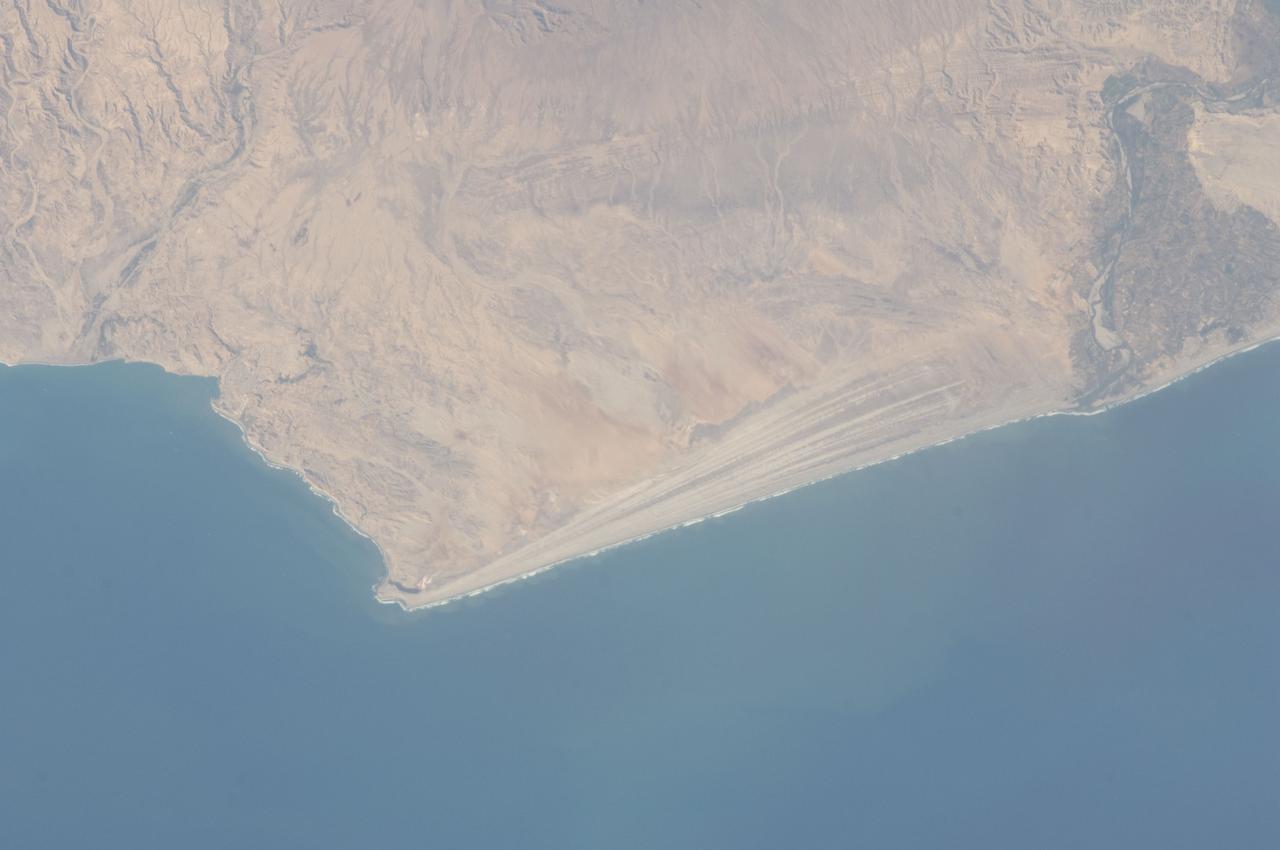
ISS032-E-016579 (11 Aug. 2012) --- A strandplain on coastal Peru is featured in this image photographed by an Expedition 32 crew member on the International Space Station. The scale and orientation of landscape features that are difficult to see on the ground often become readily visible from orbit. Numerous subparallel lines (center) along the arid, northern coast of Peru (about five degrees south of the Equator) are close-packed beach ridges, known collectively as a strandplain (for scale, the strandplain is 30 kilometers long). Each ridge shows the position of a prior shoreline. The Chira River delta appears at right, with dark green agricultural fields occupying the delta of the river. A smaller river reaches the sea, without forming a delta, at extreme left. The prominent cape at lower left is Punta Balcones, a region with many oil wells. Strandplains are built by successive additions of beach sand usually from some nearby source. Currents on this coast of South America come from the south, suggesting to scientists that the Chira River delta (right) is the source of the sand. The newest beach is being formed today by the waves?which appear as the thin ragged white line along the strandplain?supplied by the north-flowing current. The regularity of the spacing of the beaches suggests that some episodic influx of sediment controls beach formation. This influx may be determined by floods coming down the Chira River, possibly controlled by the heavy rains of El Nino events which occur irregularly every few years. Two other sets of faint parallel lines can be seen on higher ground inland (between arrows, center and top right), the upper set stretching all the way from the Chira river floodplain. Seen in many places along the coast of Peru, scientists believe these may also be strandplains (i.e. formed at sea level) generated when the land surface was at a lower altitude; both also may have been produced by sand from the Chira River. The land surface is known to be rising along this coast with the rise of the Andes Mts. (outside the top of the image), explaining why the upper shorelines now lie 120 meters above sea level.
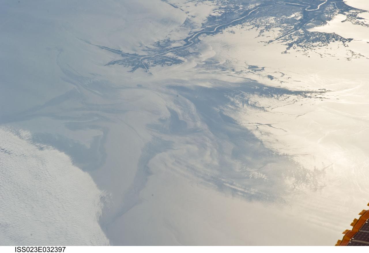
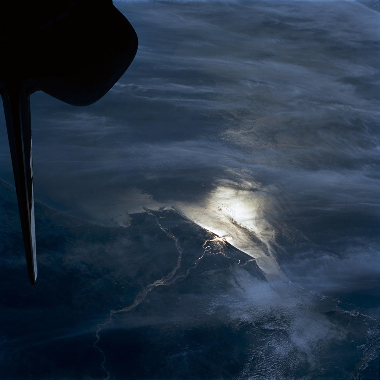
ISS023-E-032397 (4 May 2010) --- The Gulf of Mexico oil spill is featured in this image photographed by an Expedition 23 crew member on the International Space Station. On April 20, 2010 the oil rig Deepwater Horizon suffered an explosion and sank two days later. Shortly thereafter oil began leaking into the Gulf of Mexico from ruptured pipes as safety cutoff mechanisms failed to operate. Automated nadir-viewing orbital NASA sensors have been tracking the growth of the oil spill as it has spread towards the northern Gulf Coast. This detailed photograph provides a different viewing perspective on the ongoing event. The image is oblique, meaning that it was taken with a sideways viewing angle from the space station, rather than the ?straight down? or nadir view typical of automated satellite sensors. The view is towards the west; the ISS was located over the eastern edge of the Gulf of Mexico when the image was taken. The Mississippi River Delta and nearby Louisiana coast (top) appear dark in the sunglint that illuminates most of the image. This phenomenon is caused by sunlight reflecting off the water surface ? much like a mirror ? directly back towards the astronaut observer onboard the orbital complex. The sunglint improves the identification of the oil spill (colored dark to light gray) which is creating a different water texture, and therefore a contrast, between the smooth and rougher water of the reflective ocean surface (colored silver to white). Wind and water current patterns have modified the oil spill?s original shape into streamers and elongated masses. Efforts are ongoing to contain the spill and protect fragile coastal ecosystems and habitats such as the Chandeleur Islands (right center). Other features visible in the image include a solid field of low cloud cover at the lower left corner of the image. A part of one of the ISS solar arrays is visible at lower right. Wave patterns at lower right are most likely caused by tidal effects.
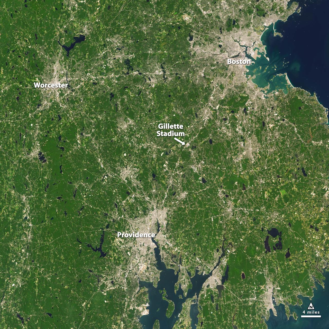
Landsat 7 image of Boston/Providence area acquired August 25, 2014. Landsat 7 is a U.S. satellite used to acquire remotely sensed images of the Earth's land surface and surrounding coastal regions. It is maintained by the Landsat 7 Project Science Office at the NASA Goddard Space Flight Center in Greenbelt, MD. Landsat satellites have been acquiring images of the Earth’s land surface since 1972. Currently there are more than 2 million Landsat images in the National Satellite Land Remote Sensing Data Archive. For more information visit: <a href="http://landsat.usgs.gov/" rel="nofollow">landsat.usgs.gov/</a>..To learn more about the Landsat satellite go to:.<a href="http://landsat.gsfc.nasa.gov/" rel="nofollow">landsat.gsfc.nasa.gov/</a> Credit: NASA/GSFC/Landsat 7 <b><a href="http://www.nasa.gov/audience/formedia/features/MP_Photo_Guidelines.html" rel="nofollow">NASA image use policy.</a></b> <b><a href="http://www.nasa.gov/centers/goddard/home/index.html" rel="nofollow">NASA Goddard Space Flight Center</a></b> enables NASA’s mission through four scientific endeavors: Earth Science, Heliophysics, Solar System Exploration, and Astrophysics. Goddard plays a leading role in NASA’s accomplishments by contributing compelling scientific knowledge to advance the Agency’s mission. <b>Follow us on <a href="http://twitter.com/NASAGoddardPix" rel="nofollow">Twitter</a></b> <b>Like us on <a href="http://www.facebook.com/pages/Greenbelt-MD/NASA-Goddard/395013845897?ref=tsd" rel="nofollow">Facebook</a></b> <b>Find us on <a href="http://instagrid.me/nasagoddard/?vm=grid" rel="nofollow">Instagram</a></b>
Under a rain-filled sky, Mark Epstein, with the U.S. Fish and Wildlife Service, gets ready to release a rescued white pelican. At right is Kat Royer, also with the U.S. Fish and Wildlife Service, who has fixed on it a leg band issued by the U.S. Department of the Interior's Bird Banding Laboratory. In the background is Christine Wise who is involved with rescue and rehabilitation of Florida wild animals. Wise brought the pelican to the Merritt Island National Wildlife Refuge for its release. The bird was found covered in crude oil from a contaminated ditch in northern Indiana in November, and was rescued by a local Police Department, treated, and flown to the Back to Nature Wildlife Refuge in Orlando, Fla. for care and rest. The pelican, dubbed "Fisheater" by its rescuers, is being let go to join a flock of about 30 other white pelicans that are wintering on the refuge. White pelicans inhabit marshy lakes and along the Pacific and Texas coasts. They winter from Florida and southern California south to Panama, chiefly in coastal lagoons. They are frequently seen flying in long lines, flapping and sailing in unison, but also ride rising air currents to soar gracefully in circles. The Merritt Island National Wildlife Refuge, which encompasses 92,000 acres that are a habitat for more than 331 species of birds, 31 mammals, 117 fishes, and 65 amphibians and reptiles. The marshes and open water of the refuge provide wintering areas for 23 species of migratory waterfowl, as well as a year-round home for great blue herons, great egrets, wood storks, cormorants, brown pelicans and other species of marsh and shore birds, as well as a variety of insects
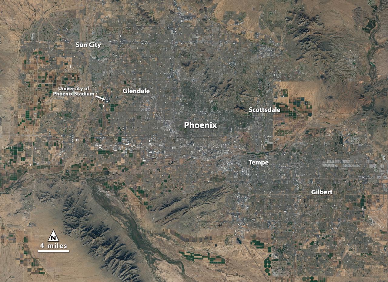
Landsat 7 image of Phoenix, Arizona acquired November 28, 2014. Landsat 7 is a U.S. satellite used to acquire remotely sensed images of the Earth's land surface and surrounding coastal regions. It is maintained by the Landsat 7 Project Science Office at the NASA Goddard Space Flight Center in Greenbelt, MD. Landsat satellites have been acquiring images of the Earth’s land surface since 1972. Currently there are more than 2 million Landsat images in the National Satellite Land Remote Sensing Data Archive. For more information visit: <a href="http://landsat.usgs.gov/" rel="nofollow">landsat.usgs.gov/</a>..To learn more about the Landsat satellite go to:.<a href="http://landsat.gsfc.nasa.gov/" rel="nofollow">landsat.gsfc.nasa.gov/</a> Credit: NASA/GSFC/Landsat 7 <b><a href="http://www.nasa.gov/audience/formedia/features/MP_Photo_Guidelines.html" rel="nofollow">NASA image use policy.</a></b> <b><a href="http://www.nasa.gov/centers/goddard/home/index.html" rel="nofollow">NASA Goddard Space Flight Center</a></b> enables NASA’s mission through four scientific endeavors: Earth Science, Heliophysics, Solar System Exploration, and Astrophysics. Goddard plays a leading role in NASA’s accomplishments by contributing compelling scientific knowledge to advance the Agency’s mission. <b>Follow us on <a href="http://twitter.com/NASAGoddardPix" rel="nofollow">Twitter</a></b> <b>Like us on <a href="http://www.facebook.com/pages/Greenbelt-MD/NASA-Goddard/395013845897?ref=tsd" rel="nofollow">Facebook</a></b> <b>Find us on <a href="http://instagrid.me/nasagoddard/?vm=grid" rel="nofollow">Instagram</a></b>
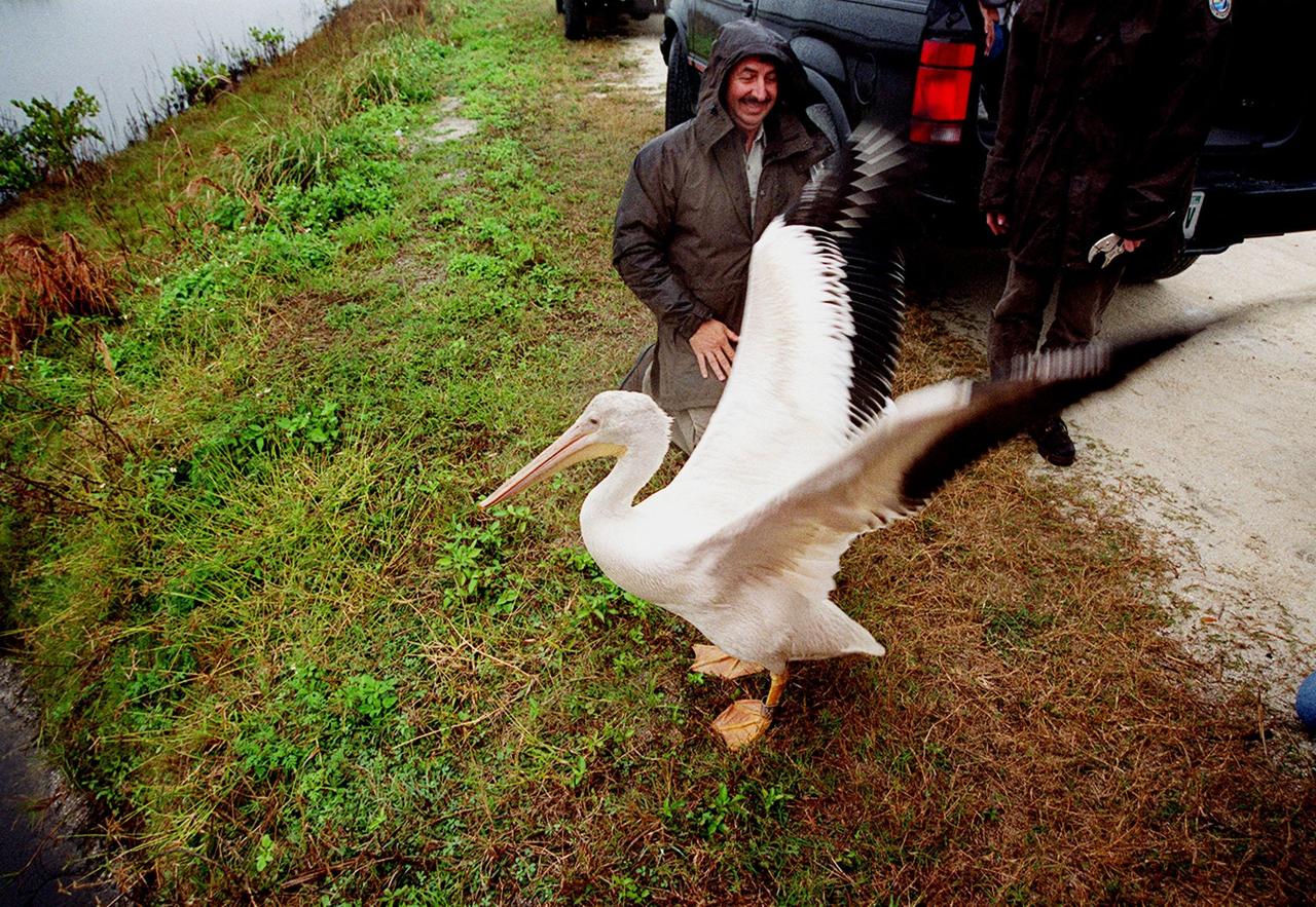
A rescued white pelican, dubbed "Fisheater" by his rescuers, takes a tentative step and stretches its wings after being let go at the Merritt Island National Wildlife Refuge. Looking on is Mark Epstein, with the U.S. Fish and Wildlife Service, who had held the bird while Kat Royer, also with the U.S. Fish and Wildlife Service, placed on it a leg band issued by the U.S. Department of the Interior's Bird Banding Laboratory. The pelican was found covered in crude oil from a contaminated ditch in northern Indiana in November, and was rescued by a local Police Department, treated, and flown to the Back to Nature Wildlife Refuge in Orlando, Fla. for care and rest. It is being released to join a flock of about 30 other white pelicans that are wintering on the refuge. White pelicans inhabit marshy lakes and along the Pacific and Texas coasts. They winter from Florida and southern California south to Panama, chiefly in coastal lagoons. They are frequently seen flying in long lines, flapping and sailing in unison, but also ride rising air currents to soar gracefully in circles. The Merritt Island National Wildlife Refuge, which encompasses 92,000 acres that are a habitat for more than 331 species of birds, 31 mammals, 117 fishes, and 65 amphibians and reptiles. The marshes and open water of the refuge provide wintering areas for 23 species of migratory waterfowl, as well as a year-round home for great blue herons, great egrets, wood storks, cormorants, brown pelicans and other species of marsh and shore birds, as well as a variety of insects

Landsat 7 image of Phoenix, Arizona acquired November 28, 2014. Landsat 7 is a U.S. satellite used to acquire remotely sensed images of the Earth's land surface and surrounding coastal regions. It is maintained by the Landsat 7 Project Science Office at the NASA Goddard Space Flight Center in Greenbelt, MD. Landsat satellites have been acquiring images of the Earth’s land surface since 1972. Currently there are more than 2 million Landsat images in the National Satellite Land Remote Sensing Data Archive. For more information visit: <a href="http://landsat.usgs.gov/" rel="nofollow">landsat.usgs.gov/</a>..To learn more about the Landsat satellite go to:.<a href="http://landsat.gsfc.nasa.gov/" rel="nofollow">landsat.gsfc.nasa.gov/</a> Credit: NASA/GSFC/Landsat 7 <b><a href="http://www.nasa.gov/audience/formedia/features/MP_Photo_Guidelines.html" rel="nofollow">NASA image use policy.</a></b> <b><a href="http://www.nasa.gov/centers/goddard/home/index.html" rel="nofollow">NASA Goddard Space Flight Center</a></b> enables NASA’s mission through four scientific endeavors: Earth Science, Heliophysics, Solar System Exploration, and Astrophysics. Goddard plays a leading role in NASA’s accomplishments by contributing compelling scientific knowledge to advance the Agency’s mission. <b>Follow us on <a href="http://twitter.com/NASAGoddardPix" rel="nofollow">Twitter</a></b> <b>Like us on <a href="http://www.facebook.com/pages/Greenbelt-MD/NASA-Goddard/395013845897?ref=tsd" rel="nofollow">Facebook</a></b> <b>Find us on <a href="http://instagrid.me/nasagoddard/?vm=grid" rel="nofollow">Instagram</a></b>
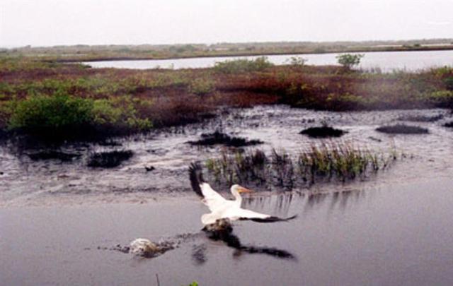
KENNEDY SPACE CENTER, FLA. -- A white pelican named "Fisheater" by its rescuers soars to open water in the Merritt Island National Wildlife Refuge as it flies to freedom. The pelican was found covered in crude oil from a contaminated ditch in northern Indiana in November, and was rescued by a local Police Department, treated, and flown to the Back to Nature Wildlife Refuge in Orlando, Fla. for care and rest. It is being released today to join a flock of about 30 other white pelicans that are wintering on the refuge, some of which are nearby. Before its release, however, Kat Royer, with the U.S. Fish and Wildlife Service, placed on it a leg band issued by the U.S. Department of the Interior's Bird Banding Laboratory. White pelicans inhabit marshy lakes and along the Pacific and Texas coasts. They winter from Florida and southern California south to Panama, chiefly in coastal lagoons. They are frequently seen flying in long lines, flapping and sailing in unison, but also ride rising air currents to soar gracefully in circles. The Merritt Island National Wildlife Refuge, which encompasses 92,000 acres that are a habitat for more than 331 species of birds, 31 mammals, 117 fishes, and 65 amphibians and reptiles. The marshes and open water of the refuge provide wintering areas for 23 species of migratory waterfowl, as well as a year-round home for great blue herons, great egrets, wood storks, cormorants, brown pelicans and other species of marsh and shore birds, as well as a variety of insects.
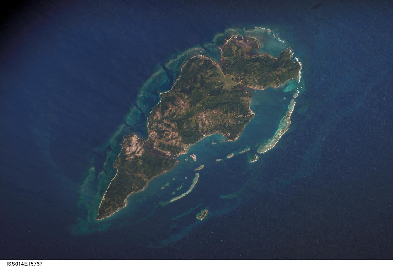
ISS014-E-15767 (1 March 2007) --- Guanaja Island, Honduras is featured in this image photographed by an Expedition 14 crewmember on the International Space Station. Guanaja Island is located along the southwestern margin of the Gulf of Mexico, approximately 60 kilometers north of mainland Honduras. The island is situated near the western edge of the Cayman Ridge, a topographic feature comprised of rock types indicative of ancient volcanic islands, sedimentary layers, and ocean crust. The Ridge formed as a result of tectonic interactions between the North American, South American, and Caribbean Plates. Guanaja and the nearby islands of Roatan and Utila (not shown) comprise the only portions of the western Cayman Ridge currently exposed above water. The island is also notable for its largely undeveloped character -- the exception being highly concentrated development on Bonacca Cay, a small island (roughly 0.5 kilometers by 0.3 kilometers) located along the southeastern coastline of the main island. The main island has little in the way of roads or other infrastructure -- a canal is the major means of traversing the island - making it an attractive destination for hikers and eco-tourists. The clear waters and reefs that almost completely encircle Guanaja also attract divers. In 1998, hurricane Mitch destroyed almost all (97 percent) of the island's mangrove forests, impacting coastal habitats and resulting in soil erosion. Regeneration of mangroves is slow and active reseeding efforts have been suggested as the only means to restore the forests.
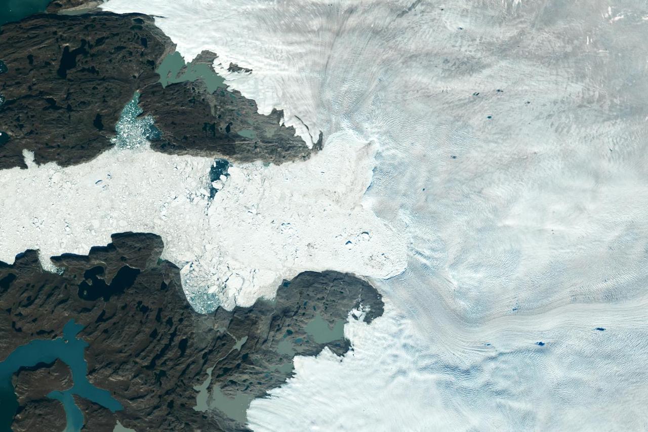
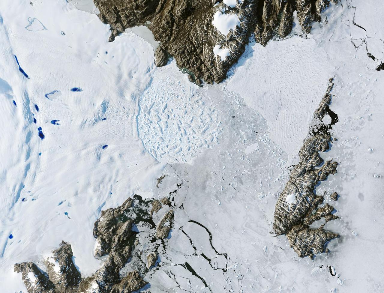
Satellite images from 2022 (Main image) and 1985 (Figure A) capture the retreat of Jakobshavn Isbrae, a glacier on Greenland's western coast, as icebergs broke off its edge over nearly four decades. In a recent study in Nature, researchers from NASA's Jet Propulsion Laboratory in Southern California calculated that Jakobshavn lost an estimated 97 billion tons (88 billion metric tons) of ice in the period between the two images. The earlier image was taken by the Thematic Mapper instrument on the Landsat 5 satellite on Sept. 5, 1985, while the later image was captured by the Operational Land Imager on the Landsat 8 satellite on Sept. 4, 2022. Of the 207 glaciers analyzed in the study, Jakobshavn lost the second most ice mass, trailing only Zachariae Isstrom, a glacier in northeast Greenland. The study took a comprehensive look at glacial retreat around the edges of the entire Greenland Ice Sheet from 1985 to 2022 and found that 179 glaciers retreated significantly since 1985, 27 held steady, and just one advanced slightly. The study found that overall the ice sheet shed about 1,140 billion tons (1,034 billion metric tons) of ice from 1985 to 2022, one-fifth more mass than previously estimated, as icebergs fell into the ocean at an accelerating rate. Most of the ice loss came from below sea level, in fjords on Greenland's periphery. Once occupied by ancient glacial ice, many of these deep coastal valleys have filled with seawater – meaning the ice that broke off made little net contribution to sea level. But the loss likely accelerated the movement of ice flowing down from higher elevations, which in turn added to sea level rise. It also added previously unaccounted-for fresh water to the North Atlantic Ocean, which could have impacts on global ocean currents. https://photojournal.jpl.nasa.gov/catalog/PIA26117

Landsat 7 image of the Santa Clara area acquired Nov 16, 2015. Landsat 7 is a U.S. satellite used to acquire remotely sensed images of the Earth's land surface and surrounding coastal regions. It is maintained by the Landsat 7 Project Science Office at the NASA Goddard Space Flight Center in Greenbelt, MD...Landsat satellites have been acquiring images of the Earth’s land surface since 1972. Currently there are more than 2 million Landsat images in the National Satellite Land Remote Sensing Data Archive. For more information visit: <a href="http://landsat.usgs.gov/" rel="nofollow">landsat.usgs.gov/</a>..To learn more about the Landsat satellite go to:.<a href="http://landsat.gsfc.nasa.gov/" rel="nofollow">landsat.gsfc.nasa.gov/</a> Credit: NASA/GSFC/Landsat 7 <b><a href="http://www.nasa.gov/audience/formedia/features/MP_Photo_Guidelines.html" rel="nofollow">NASA image use policy.</a></b> <b><a href="http://www.nasa.gov/centers/goddard/home/index.html" rel="nofollow">NASA Goddard Space Flight Center</a></b> enables NASA’s mission through four scientific endeavors: Earth Science, Heliophysics, Solar System Exploration, and Astrophysics. Goddard plays a leading role in NASA’s accomplishments by contributing compelling scientific knowledge to advance the Agency’s mission. <b>Follow us on <a href="http://twitter.com/NASAGoddardPix" rel="nofollow">Twitter</a></b> <b>Like us on <a href="http://www.facebook.com/pages/Greenbelt-MD/NASA-Goddard/395013845897?ref=tsd" rel="nofollow">Facebook</a></b> <b>Find us on <a href="http://instagrid.me/nasagoddard/?vm=grid" rel="nofollow">Instagram</a></b>
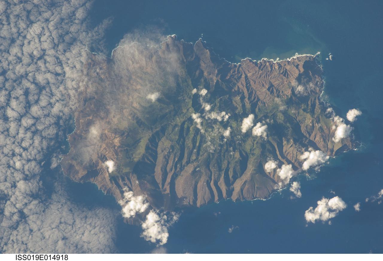
ISS019-E-014918 (7 May 2009) --- Saint Helena Island is featured in this image photographed by an Expedition 19 crewmember on the International Space Station. This isolated island, located in the South Atlantic Ocean approximately 1860 kilometers to the west of the African coastline, is perhaps best known as the final resting place of Napoleon Bonaparte I of France. Bonaparte was exiled to the island following his defeat at the Battle of Waterloo in 1815; he died on the island six years later in 1821. Today, the island is a British Overseas Territory, with access provided thirty times a year by a single ship, the RMS St. Helena. The rugged topography evident in this photograph is the result of erosion of the volcanic rocks that make up the island into sharp peaks and deep ravines. A climatic gradient related to elevation is also evident ? the higher, wetter central portion of the island is covered with green vegetation, whereas the lower coastal areas are drier and hotter with little vegetation cover. Human presence on the island has also caused dramatic changes to the original flora and fauna of the island. Only approximately 10 percent of the forest cover observed by the first explorers now remains in a semi-natural state, and that is concentrated in the interior highlands. Saint Helena Island was also visited by Charles Darwin during his scientific voyages in the 19th century. He visited the island in 1836 aboard HMS Beagle, recording observations of the flora, fauna, and geology that would inform his theory of evolution. This image was acquired by crew members onboard the International Space Station as part of an ongoing project (the HMS Beagle Project) to document current biodiversity in areas visited by Charles Darwin.
Mark Epstein, with the U.S. Fish and Wildlife Service, holds a white pelican that will be released under a rain-filled sky at the Merritt Island National Wildlife Refuge. The bird was found covered in crude oil from a contaminated ditch in northern Indiana in November, and was rescued by a local Police Department, treated, and flown to the Back to Nature Wildlife Center in Orlando, Fla. for care and rest. After Kat Royer, who is with the U.S. Fish and Wildlife Service, fits the bird with a leg band issued by the U.S. Department of the Interior's Bird Banding Laboratory, the pelican will be let go to join a flock of about 30 other white pelicans that are wintering on the refuge. White pelicans inhabit marshy lakes and along the Pacific and Texas coasts. They winter from Florida and southern California south to Panama, chiefly in coastal lagoons. They are frequently seen flying in long lines, flapping and sailing in unison, but also ride rising air currents to soar gracefully in circles. The Merritt Island National Wildlife Refuge, which encompasses 92,000 acres that are a habitat for more than 331 species of birds, 31 mammals, 117 fishes, and 65 amphibians and reptiles. The marshes and open water of the refuge provide wintering areas for 23 species of migratory waterfowl, as well as a year-round home for great blue herons, great egrets, wood storks, cormorants, brown pelicans and other species of marsh and shore birds, as well as a variety of insects
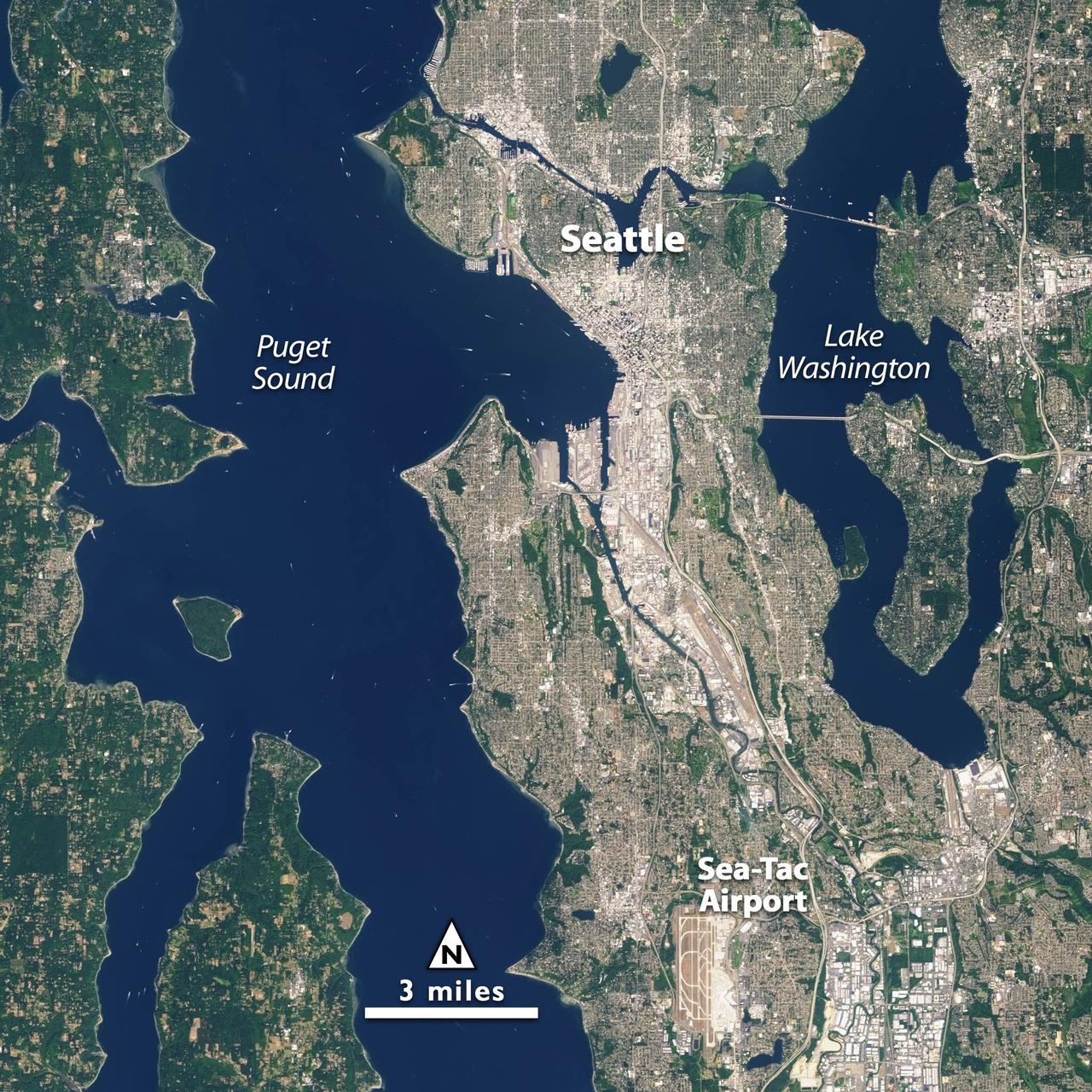
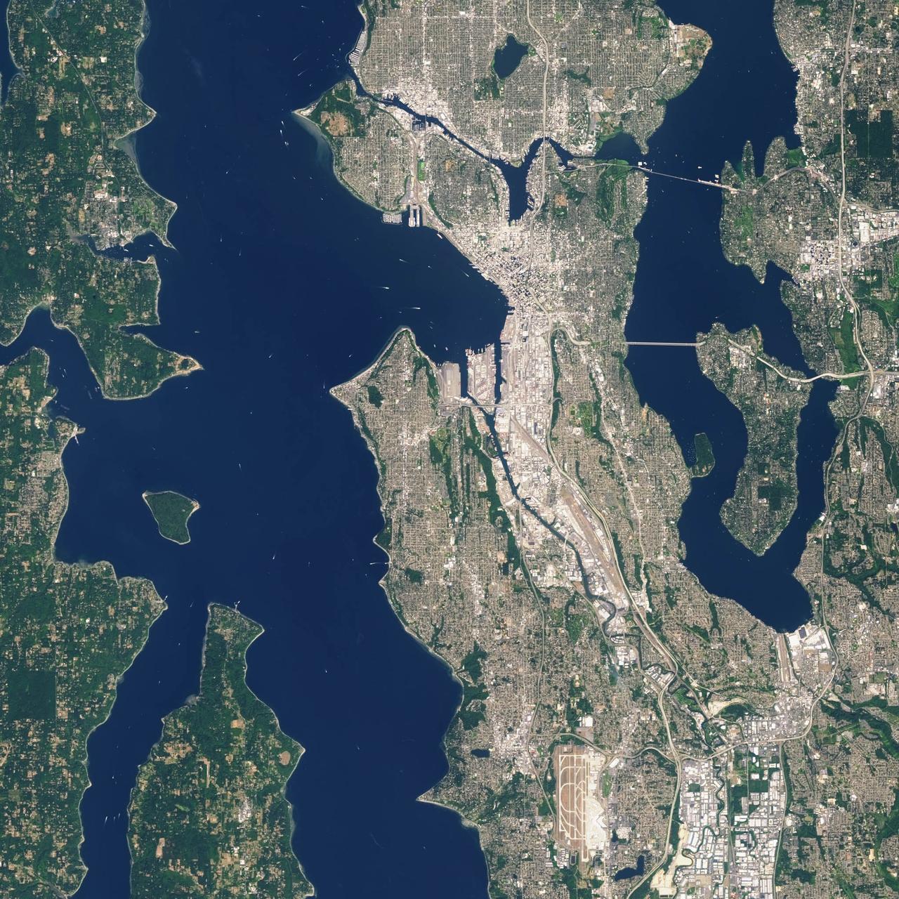
Landsat 7 image of Seattle, Washington acquired August 23, 2014. Landsat 7 is a U.S. satellite used to acquire remotely sensed images of the Earth's land surface and surrounding coastal regions. It is maintained by the Landsat 7 Project Science Office at the NASA Goddard Space Flight Center in Greenbelt, MD. Landsat satellites have been acquiring images of the Earth’s land surface since 1972. Currently there are more than 2 million Landsat images in the National Satellite Land Remote Sensing Data Archive. For more information visit: <a href="http://landsat.usgs.gov/" rel="nofollow">landsat.usgs.gov/</a>..To learn more about the Landsat satellite go to:.<a href="http://landsat.gsfc.nasa.gov/" rel="nofollow">landsat.gsfc.nasa.gov/</a> Credit: NASA/GSFC/Landsat 7 <b><a href="http://www.nasa.gov/audience/formedia/features/MP_Photo_Guidelines.html" rel="nofollow">NASA image use policy.</a></b> <b><a href="http://www.nasa.gov/centers/goddard/home/index.html" rel="nofollow">NASA Goddard Space Flight Center</a></b> enables NASA’s mission through four scientific endeavors: Earth Science, Heliophysics, Solar System Exploration, and Astrophysics. Goddard plays a leading role in NASA’s accomplishments by contributing compelling scientific knowledge to advance the Agency’s mission. <b>Follow us on <a href="http://twitter.com/NASAGoddardPix" rel="nofollow">Twitter</a></b> <b>Like us on <a href="http://www.facebook.com/pages/Greenbelt-MD/NASA-Goddard/395013845897?ref=tsd" rel="nofollow">Facebook</a></b> <b>Find us on <a href="http://instagrid.me/nasagoddard/?vm=grid" rel="nofollow">Instagram</a></b>

STS060-88-070 (3-11 Feb 1994) --- This view shows sunglint in the Strait of Gibralter. In this photograph a high pressure atmospheric system over the Iberian Peninsula has set the conditions for seeing a plankton bloom along the Moroccan coast in the Alboran Sea (Western Mediterranean) coastal counter current as well as illumining the influence of winds in the sunglint pattern near the Strait of Gibraltar. Where the water is ruffled from a wind gust, such as off Cadiz, Spain, the surface is less reflective and thus appears dark. A combination of the effects of the tide and the surface winds through the Strait of Gibraltar have created a unique sunglint pattern at the entrance of the Mediterranean. The Atlantic Ocean waters are flowing with the tide through the Strait of Gibraltar into the Mediterranean Sea and are probably smoothing out some of the smaller waves at the surface. The incoming tide generates internal waves as can be faintly seen in this photograph. The incoming relatively cooler, less dense Atlantic water flows over the warm, more saline Mediterranean water. As the tide moves into the Strait of Gibraltar it encounters the Camarinal Sill, which is like a cliff under the water, south of Camarinal Point, Spain. Internal waves are generated at this sill and they travel along the density boundary between the Atlantic water and the Mediterranean water masses. There is little evidence of the internal waves at the surface of the ocean. We can see them in spacecraft photography because of the sunglint which reflects off the different water layers in differential patterns. The internal waves also smooth out some of the bands of capillary waves at the surface. That is, the sun reflects more brightly from these smooth areas, showing the pattern of the underwater waves more prominently than do the surface waves. The Bay of Cadiz on the southwest coast of Spain, the Rock of Gibraltar, and the Moroccan coast are also beautifully illustrated in this photography. The focus for scientists, however, remains the high clarity and spatial resolution given by sunglint studies to physical phenomena in the ocean.
Satellite images from 2022 (Main image) and 1999 (Figure A) capture the retreat of Zachariae Isstrom, a glacier in northeast Greenland, as icebergs broke off its edge over the course of 23 years. In a recent study in Nature, researchers from NASA's Jet Propulsion Laboratory in Southern California calculated that Zachariae lost an estimated 176 billion tons (160 billion metric tons) of ice in the period between 1985 and 2022. That was the greatest mass lost for the period of any of the 207 glaciers analyzed in the paper. The earlier image was taken by the Enhanced Thematic Mapper Plus on the Landsat 7 satellite on Aug. 5, 1999, while the later image was captured by the Operational Land Imager on the Landsat 8 satellite on Aug. 22, 2022. The study took a comprehensive look at glacial retreat around the edges of the entire Greenland Ice Sheet from 1985 to 2022 and found that 179 glaciers retreated significantly since 1985, 27 held steady, and just one advanced slightly. The study found that overall the ice sheet shed about 1,140 billion tons (1,034 billion metric tons) of ice from 1985 to 2022, one-fifth more mass than previously estimated, as icebergs fell into the ocean at an accelerating rate. Most of the ice loss came from below sea level, in fjords on Greenland's periphery. Once occupied by ancient glacial ice, many of these deep coastal valleys have filled with seawater – meaning the ice that broke off made little net contribution to sea level. But the loss likely accelerated the movement of ice flowing down from higher elevations, which in turn added to sea level rise. It also added previously unaccounted-for fresh water to the North Atlantic Ocean, which could have impacts on global ocean currents. https://photojournal.jpl.nasa.gov/catalog/PIA26118
Landsat 7 image of Seattle, Washington acquired August 23, 2014. Landsat 7 is a U.S. satellite used to acquire remotely sensed images of the Earth's land surface and surrounding coastal regions. It is maintained by the Landsat 7 Project Science Office at the NASA Goddard Space Flight Center in Greenbelt, MD. Landsat satellites have been acquiring images of the Earth’s land surface since 1972. Currently there are more than 2 million Landsat images in the National Satellite Land Remote Sensing Data Archive. For more information visit: <a href="http://landsat.usgs.gov/" rel="nofollow">landsat.usgs.gov/</a>..To learn more about the Landsat satellite go to:.<a href="http://landsat.gsfc.nasa.gov/" rel="nofollow">landsat.gsfc.nasa.gov/</a> Credit: NASA/GSFC/Landsat 7 <b><a href="http://www.nasa.gov/audience/formedia/features/MP_Photo_Guidelines.html" rel="nofollow">NASA image use policy.</a></b> <b><a href="http://www.nasa.gov/centers/goddard/home/index.html" rel="nofollow">NASA Goddard Space Flight Center</a></b> enables NASA’s mission through four scientific endeavors: Earth Science, Heliophysics, Solar System Exploration, and Astrophysics. Goddard plays a leading role in NASA’s accomplishments by contributing compelling scientific knowledge to advance the Agency’s mission. <b>Follow us on <a href="http://twitter.com/NASAGoddardPix" rel="nofollow">Twitter</a></b> <b>Like us on <a href="http://www.facebook.com/pages/Greenbelt-MD/NASA-Goddard/395013845897?ref=tsd" rel="nofollow">Facebook</a></b> <b>Find us on <a href="http://instagrid.me/nasagoddard/?vm=grid" rel="nofollow">Instagram</a></b>
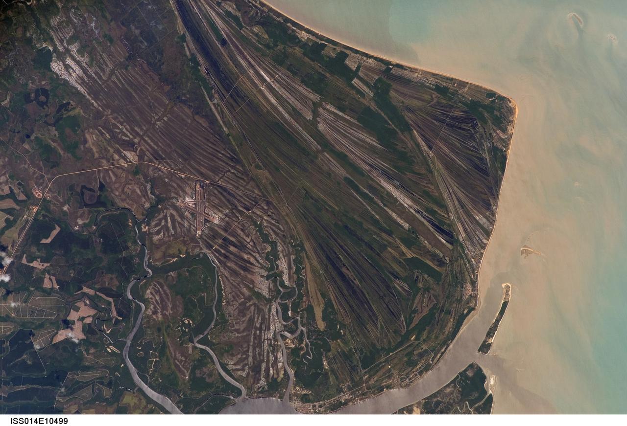
ISS014-E-10499 (23 Dec. 2006) --- Caravelas strandplain, Bahia Province, Brazil is featured in this image photographed by an Expedition 14 crewmember on the International Space Station. This view highlights a flat coastal landform known as a strandplain, or ancient shoreline. The image is dominated by numerous, fine parallel lines (trending diagonally from upper left to lower right), each of which is an ancient shoreline made up of sand transported from rivers to the north. The strandplain has been generated by these narrow shorelines accumulating against one another, line by line in their dozens or even hundreds, over thousands of years. The shorelines can be grouped into at least four packets depending on the crosscutting relationships - younger packets will cut into or stratigraphically overlay older packets. These relationships indicate that the youngest packet lies nearest the coast (furthest right) and the oldest packet lies north of the city of Caravelas (bottom). The Caravelas River flows into the Atlantic Ocean at the bottom of the view. Sediment from this river, and from the current shoreline, produces the light browns and dun colors visible offshore. On the day this image was taken the river water was relatively clear; clear water (gray) is visible flowing out of the main river mouth, and also off to one side to the south over a levee. The Caravelas airport appears near the middle of the view, and is built on one of the ancient shoreline packets. Caravelas itself, a fishing town of about 20,000 inhabitants, lies on an estuary and was once a flourishing whaling center--the prominent cape at top right is known as Ponta da Baleia (Whale Point).
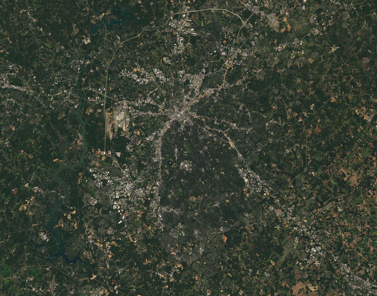
Landsat 7 image of the Charlotte, NC area acquired Oct 18, 2015. Landsat 7 is a U.S. satellite used to acquire remotely sensed images of the Earth's land surface and surrounding coastal regions. It is maintained by the Landsat 7 Project Science Office at the NASA Goddard Space Flight Center in Greenbelt, MD...Landsat satellites have been acquiring images of the Earth’s land surface since 1972. Currently there are more than 2 million Landsat images in the National Satellite Land Remote Sensing Data Archive. For more information visit: <a href="http://landsat.usgs.gov/" rel="nofollow">landsat.usgs.gov/</a>..To learn more about the Landsat satellite go to:.<a href="http://landsat.gsfc.nasa.gov/" rel="nofollow">landsat.gsfc.nasa.gov/</a> Credit: NASA/GSFC/Landsat 7 <b><a href="http://www.nasa.gov/audience/formedia/features/MP_Photo_Guidelines.html" rel="nofollow">NASA image use policy.</a></b> <b><a href="http://www.nasa.gov/centers/goddard/home/index.html" rel="nofollow">NASA Goddard Space Flight Center</a></b> enables NASA’s mission through four scientific endeavors: Earth Science, Heliophysics, Solar System Exploration, and Astrophysics. Goddard plays a leading role in NASA’s accomplishments by contributing compelling scientific knowledge to advance the Agency’s mission. <b>Follow us on <a href="http://twitter.com/NASAGoddardPix" rel="nofollow">Twitter</a></b> <b>Like us on <a href="http://www.facebook.com/pages/Greenbelt-MD/NASA-Goddard/395013845897?ref=tsd" rel="nofollow">Facebook</a></b> <b>Find us on <a href="http://instagrid.me/nasagoddard/?vm=grid" rel="nofollow">Instagram</a></b>
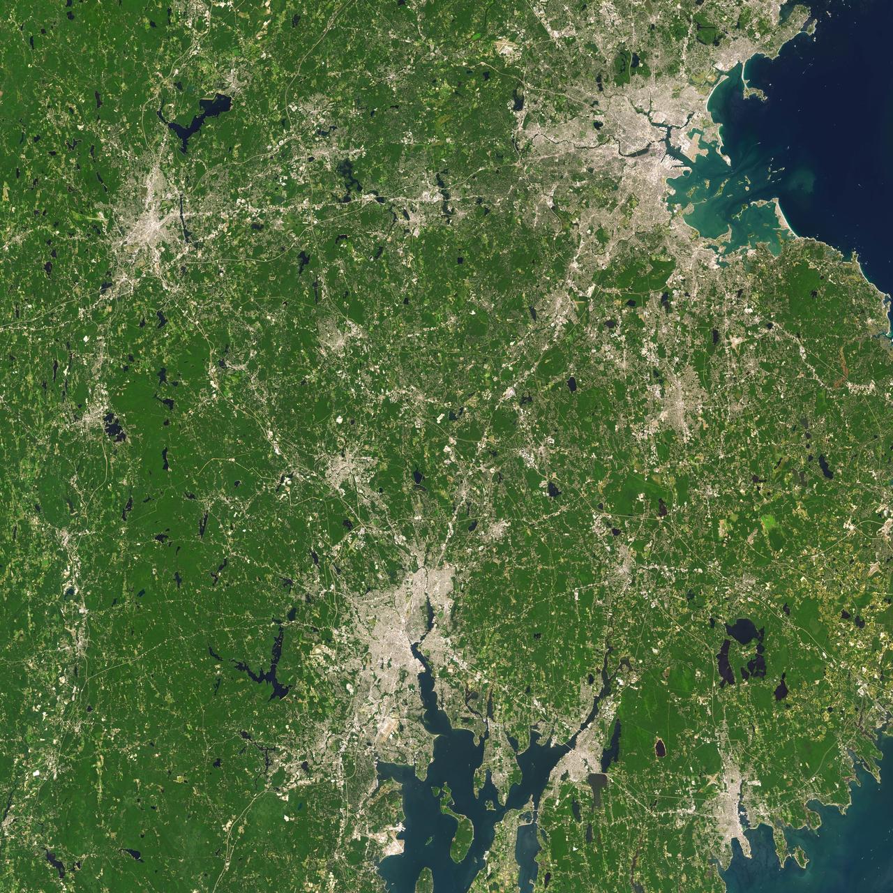
Landsat 7 image of Boston/Providence area acquired August 25, 2014. Landsat 7 is a U.S. satellite used to acquire remotely sensed images of the Earth's land surface and surrounding coastal regions. It is maintained by the Landsat 7 Project Science Office at the NASA Goddard Space Flight Center in Greenbelt, MD...Landsat satellites have been acquiring images of the Earth’s land surface since 1972. Currently there are more than 2 million Landsat images in the National Satellite Land Remote Sensing Data Archive. For more information visit: <a href="http://landsat.usgs.gov/" rel="nofollow">landsat.usgs.gov/</a>..To learn more about the Landsat satellite go to:.<a href="http://landsat.gsfc.nasa.gov/" rel="nofollow">landsat.gsfc.nasa.gov/</a> Credit: NASA/GSFC/Landsat 7 <b><a href="http://www.nasa.gov/audience/formedia/features/MP_Photo_Guidelines.html" rel="nofollow">NASA image use policy.</a></b> <b><a href="http://www.nasa.gov/centers/goddard/home/index.html" rel="nofollow">NASA Goddard Space Flight Center</a></b> enables NASA’s mission through four scientific endeavors: Earth Science, Heliophysics, Solar System Exploration, and Astrophysics. Goddard plays a leading role in NASA’s accomplishments by contributing compelling scientific knowledge to advance the Agency’s mission. <b>Follow us on <a href="http://twitter.com/NASAGoddardPix" rel="nofollow">Twitter</a></b> <b>Like us on <a href="http://www.facebook.com/pages/Greenbelt-MD/NASA-Goddard/395013845897?ref=tsd" rel="nofollow">Facebook</a></b> <b>Find us on <a href="http://instagrid.me/nasagoddard/?vm=grid" rel="nofollow">Instagram</a></b>
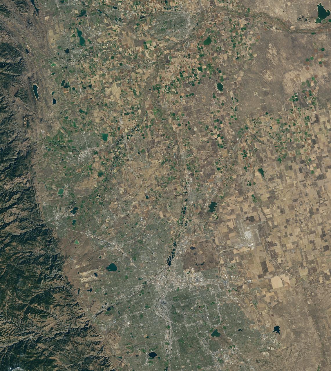
Landsat 7 image of Denver area acquired Nov 3, 2015. Landsat 7 is a U.S. satellite used to acquire remotely sensed images of the Earth's land surface and surrounding coastal regions. It is maintained by the Landsat 7 Project Science Office at the NASA Goddard Space Flight Center in Greenbelt, MD...Landsat satellites have been acquiring images of the Earth’s land surface since 1972. Currently there are more than 2 million Landsat images in the National Satellite Land Remote Sensing Data Archive. For more information visit: <a href="http://landsat.usgs.gov/" rel="nofollow">landsat.usgs.gov/</a>..To learn more about the Landsat satellite go to:.<a href="http://landsat.gsfc.nasa.gov/" rel="nofollow">landsat.gsfc.nasa.gov/</a> Credit: NASA/GSFC/Landsat 7 <b><a href="http://www.nasa.gov/audience/formedia/features/MP_Photo_Guidelines.html" rel="nofollow">NASA image use policy.</a></b> <b><a href="http://www.nasa.gov/centers/goddard/home/index.html" rel="nofollow">NASA Goddard Space Flight Center</a></b> enables NASA’s mission through four scientific endeavors: Earth Science, Heliophysics, Solar System Exploration, and Astrophysics. Goddard plays a leading role in NASA’s accomplishments by contributing compelling scientific knowledge to advance the Agency’s mission. <b>Follow us on <a href="http://twitter.com/NASAGoddardPix" rel="nofollow">Twitter</a></b> <b>Like us on <a href="http://www.facebook.com/pages/Greenbelt-MD/NASA-Goddard/395013845897?ref=tsd" rel="nofollow">Facebook</a></b> <b>Find us on <a href="http://instagrid.me/nasagoddard/?vm=grid" rel="nofollow">Instagram</a></b>
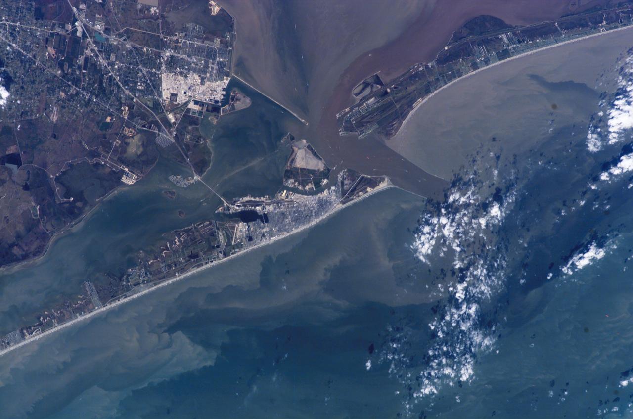
ISS014-E-07258 (4 Nov. 2006) --- Galveston, Texas is featured in this image photographed by an Expedition 14 crewmember on the International Space Station (ISS). Mexico established a port of entry (known as Galveston) in 1825, and following the Texas Revolution it was the capital of the Republic of Texas during 1836. The modern-day city of Galveston was incorporated in 1839, and became the major trading seaport of Texas during the latter half of the 19th century. The city was largely destroyed in early September of 1900 by a powerful hurricane; this, coupled with construction of the Houston Ship Channel and discovery of oil in eastern Texas shifted the center of trade northwest to Houston. Many human footprints are easily observed from the vantage point of low Earth orbit. The eastern half of Galveston Island is dominated by the city of Galveston (gray-white region at center). A large seawall along the Gulf of Mexico (southern coastline of Galveston Island) protects most of the city. To the west of Galveston, coastal wetlands are largely submerged by regional subsidence--a result of ground water withdrawal by the petrochemical industry of Houston and Texas City. The entrance to Galveston Bay and the Houston Ship Channel is located between Galveston Island and the Bolivar Peninsula (upper right). Numerous ship wakes are visible along the Houston Ship Channel. Other visible features of the entrance to Galveston Bay include the five-mile long Texas City Dike, a structure that protects the Texas City channel and includes a fishing pier that extends 600 feet beyond the end of the Dike. Extensive petroleum processing facilities are located to the west of the Dike in Texas City. The Intracoastal Waterway runs through western Galveston Bay; new subdivisions built on dredge spoils are visible along the northern boundary of the Waterway. Geologists studying the ISS collection of down linked still imagery observe that complex estuarine sediment patterns are visible in this image. Dark brown to tan waters adjacent to the Bolivar Peninsula and Texas City Dike reflect increased sediment loads following heavy rains in mid-to-late October, coupled with northerly winds moving Bay water southwards. Turbidity currents to both the northwest and southeast of Galveston Island produce a more chaotic pattern of sediment-laden (light green to tan) and relatively sediment-free (dark green) water leading into the dark green Gulf of Mexico (lower right).
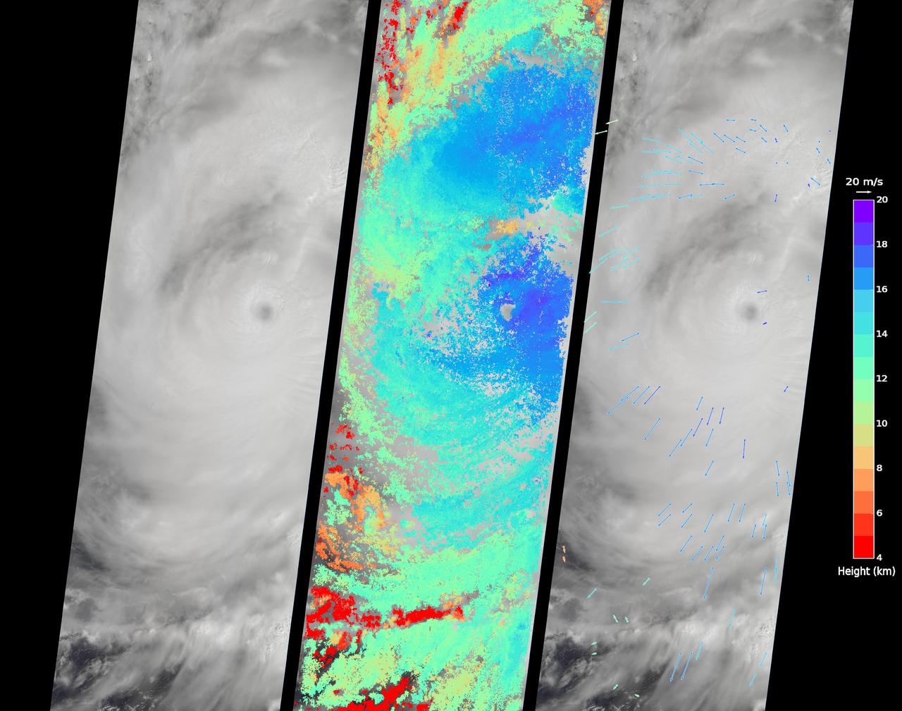
On Sept. 14, 2016, the eye of Super Typhoon Meranti passed just south of Taiwan. The enormous storm, classified as a Category 5 typhoon at the time, still caused much disruption on the island. Nearly 500,000 homes lost power, schools were closed, and most flights were cancelled. Maximum wind speeds were 180 miles per hour (290 kilometers per hour) as the storm passed, and more than 25 inches (64 centimeters) of rain fell on some areas of the country. However, the storm did not pass over Taiwan's mountainous landscape, which would have weakened it. That means it will remain strong as it heads toward mainland China, unlike Super Typhoon Nepartak in July, which weakened from a Category 5 typhoon to a tropical storm after crossing Taiwan. Meranti is currently maintaining Category 4 strength and is expected to make landfall near Shantou, Guangdong province, on Thursday, September 15. The coast of China is more vulnerable to storm surges than Taiwan due to shallower coastal waters and recent rainfall. There is risk of substantial flooding. On Sept. 14, at 10:45 AM local time, the Multi-angle Imaging SpectroRadiometer (MISR) instrument aboard NASA's Terra satellite passed directly over the eye of Meranti. On the left is a natural-color image from MISR's nadir-pointing camera. At this time the eye of Meranti was just off the southern tip of Taiwan, which is invisible under the clouds. The coast of China is barely visible through the clouds in the upper left portion of the image. The small eye and dense high clouds are both markers of the storm's power. MISR's nine cameras, each pointed at a different angle, can be used to determine the heights of clouds based on geometric shifts among the nine images. The middle panel shows these stereo-derived cloud top heights superimposed on the natural color image. The clouds of the central core of Typhoon Meranti have heights ranging between 16 and 20 kilometers (10 and 12.5 miles). It takes about seven minutes for all nine cameras to image the same location on the ground, and wind velocity can be calculated from the motion of the clouds over this seven-minute period. The right panel plots these wind velocities as vectors which indicate both direction and speed. The length of the arrow corresponds to the wind speed, which can be compared to the reference 20 meters per second (45 miles per hour) arrow in the key. Hurricanes and typhoons in the Northern Hemisphere rotate counterclockwise due to the Earth's rotation, but these wind vectors mainly show motion outward from the eye at the storm tops. This is due to the fact that hurricanes draw in moist air at low altitudes, which then flows upwards and outwards around the eye reversing direction. These data were acquired during Terra orbit 88865. http://photojournal.jpl.nasa.gov/catalog/PIA17309

ISS019-E-005501 (9 April 2009) --- Split Region in Croatia is featured in this image photographed by an Expedition 19 crewmember on the International Space Station. One the world?s most rugged coastlines are located in Croatia along the Adriatic Sea. This view features the Dalmatian coastline of Croatia around the city of Split. Much of the region can be characterized by northwest-southeast oriented linear islands and embayments of the Adriatic Sea. This distinctive coastal geomorphology is the result of faulting caused by tectonic activity in the region and sea level rise. Split has a long history - the Roman Emperor Diocletian retired to Spalatum (the present-day Split) in 305, and his palace constitutes the core of the city today. The city is a popular resort destination for its historic sites, Mediterranean climate, and ready access to the Adriatic islands (such as Brac to the south). Other large cities in the region include Kastela and Trogir; together with Split, these form an almost continuous urban area bordering the coast (visible as pink regions). A thin zone marking a water boundary is visible in this image between Split and the island of Brac. It may represent a local plankton bloom, or a line of convergence between water masses creating rougher water. A unique combination of geography -- including dramatic topography that channels local winds, the complicated coastline, input of fresh water from rivers, and ample nutrients and surface oils -- makes for interesting mesoscale surface dynamics throughout the Adriatic Sea. Over the years, astronauts have taken images of the Split region using sunglint and changes in water color to highlight features like eddies, water boundaries and mixing zones between fresh waters flowing into the saltier (denser) waters of the Adriatic, and wind-driven surface currents. Split is an important transit center connecting islands in the Adriatic Sea to the Italian peninsula, and an important regional manufacturing center of goods such as solar cells, plastics, and paper products. The city was heavily industrialized during the post World War II period as a member state of Yugoslavia. By the 1980s, the marine environment bordered by Split, Kastela, and Trogir (known as Kastela Bay) had been identified as one of the most polluted areas of the Adriatic from both sewage and industrial wastes. Concerted efforts by the Croatian government and international partners to improve waste handling and treatment infrastructure over the past 10 years seem to have been successful ? both marine species and water polo players have returned to the area.
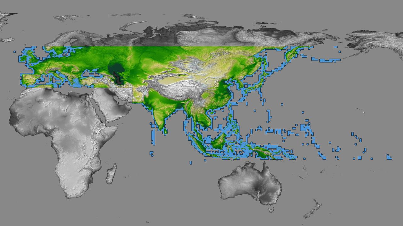
inal Caption Released with Image: The colored regions of this map show the extent of digital elevation data recently released by the Shuttle Radar Topography Mission (SRTM). This release includes data for most of Europe and Asia plus numerous islands in the Indian and Pacific Oceans. SRTM flew on board the Space Shuttle Endeavour in February 2000 and used an interferometric radar system to map the topography of Earth's landmass between latitudes 56 degrees south and 60 degrees north. The data were processed into geographic "tiles," each of which represents one by one degree of latitude and longitude. A degree of latitude measures 111 kilometers (69 miles) north-south, and a degree of longitude measures 111 kilometers or less east-west, decreasing away from the equator. The data are being released to the public on a continent-by-continent basis. This Eurasia segment includes 5,940 tiles, more than a third of the total data set. Previous releases covered North America and South America. Forthcoming releases will include Africa-Arabia and Australia plus an "Islands" release for those islands not included in the continental releases. Together these data releases constitute the world's first high-resolution, near-global elevation model. The resolution of the publicly released data is three arcseconds (1/1,200 of a degree of latitude and longitude), which is about 90 meters (295 feet). European coverage in the current data release stretches eastward from the British Isles and the Iberian Peninsula in the west, across the Alps and Carpathian Mountains, as well as the Northern European Plain, to the Ural and Caucasus Mountains bordering Asia. The Asian coverage includes a great diversity of landforms, including the Tibetan Plateau, Tarin Basin, Mongolian Plateau, and the mountains surrounding Lake Baikal, the world's deepest lake. Mt. Everest in the Himalayas, at 8,848 meters (29,029 feet) is the world's highest mountain. From India's Deccan Plateau, to Southeast Asia, coastal China, and Korea, various landforms place constraints upon land use planning for a great population. Volcanoes in the East Indies, the Philippines, Japan, and the Kamchatka Peninsula form the western part of the "Ring of Fire" around the Pacific Ocean. Many of these regions were previously very poorly mapped due to persistent cloud cover or the inaccessibility of the terrain. Digital elevation data, such as provided by SRTM, are particularly in high demand by scientists studying earthquakes, volcanism, and erosion patterns for use in mapping and modeling hazards to human habitation. But the shape of Earth's surface affects nearly every natural process and human endeavor that occurs there, so elevation data are used in a wide range of applications. In this index map color-coding is directly related to topographic height, with green at the lower elevations, rising through yellow and tan, to white at the highest elevations. The large, very dark green feature in western Asia is the Caspian Sea, which is below sea level. Blue areas on the map represent water within the mapped tiles, each of which includes shorelines or islands. http://photojournal.jpl.nasa.gov/catalog/PIA03398
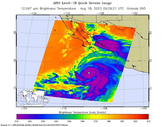
NASA's Atmospheric Infrared Sounder (AIRS) captured Hurricane Hilary on the morning of Aug. 18, 2023, when it was a Category 4 storm roughly 470 miles (760 kilometers) south of Baja California. Hilary could be the first tropical storm to make landfall in California since 1939, according to the National Weather Service. Hilary grew from a tropical storm into a Category 2 hurricane within 24 hours on Aug. 17. Another period of rapid intensification – an increase in maximum sustained wind speed of at least 30 knots (35 mph) within 24 hours – occurred Aug. 17-18. The animation shows some of this rapid growth, with images taken by AIRS Aug. 15-18. This intensification was driven by very warm ocean surface waters and weak wind shear, a term for vertical changes in wind speed. Strong wind shear can keep hurricanes from forming, or can tear them apart. AIRS measures cloud temperatures in infrared wavelengths, which can reveal information about the atmosphere not visible to the human eye. Hilary shows several indicators of a powerful hurricane: a well-defined eye surrounded by a ring of very cold clouds in purple, with warmer outer regions seen in yellows and oranges. Purple and violet areas are colder, between about minus 82 degrees Fahrenheit and minus 46 F (minus 63 degrees Celsius to minus 44 C). Blue and green regions are roughly minus 28 F to 26 F (minus 33 C to minus 3 C). The cooler parts of the clouds are associated with very heavy rainfall. Most hurricanes in the Pacific Ocean off Mexico travel westward, following tropical trade winds. Occasionally, one of these storms will head northward. Hurricane Hilary is being steered by a weak low-pressure system off the coast of California, an area normally dominated by high pressure and an atmospheric circulation pattern that would deflect storms from the region. The current forecast from the National Hurricane Center has Hilary closely following the western coastline of the Baja California peninsula, weakening as it moves north. Rainfall projections for Southern California range from 2 inches (5 centimeters) in coastal areas to 8 or more inches (20 or more centimeters) in local mountains. For comparison, San Diego and Los Angeles receive no rain in August most years, and the wettest parts of the local mountains receive about 1 inch (3 centimeters) of rain over a normal summer. In conjunction with the Advanced Microwave Sounding Unit (AMSU), AIRS senses emitted infrared and microwave radiation from Earth to provide a 3D look at the planet's weather and climate. Working in tandem, the two instruments make simultaneous observations down to Earth's surface. With more than 2,000 channels sensing different regions of the atmosphere, the system creates a global, 3D map of atmospheric temperature and humidity, cloud amounts and heights, greenhouse gas concentrations, and many other atmospheric phenomena. Launched into Earth orbit in 2002 aboard NASA's Aqua spacecraft, the AIRS and AMSU instruments are managed by NASA's Jet Propulsion Laboratory in Southern California, under contract to NASA. JPL is a division of Caltech. Animation available at https://photojournal.jpl.nasa.gov/catalog/PIA25779
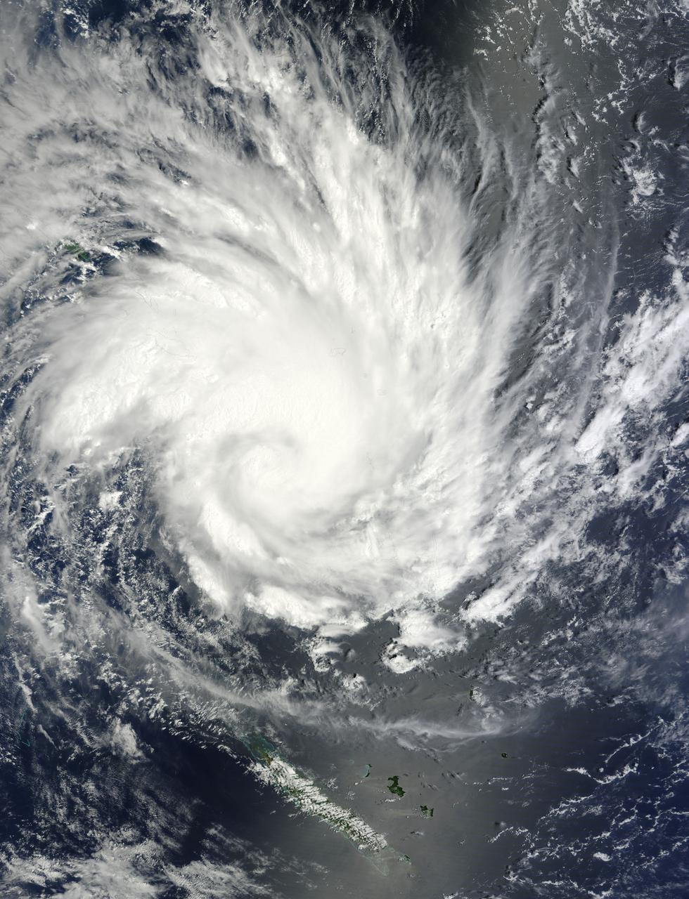
NASA image acquired January 30, 2011 at 23:20 UTC. Satellite: Terra <b> Click here to see the most recent image captured Feb. 1: <a href="http://www.flickr.com/photos/gsfc/5407540724/">www.flickr.com/photos/gsfc/5407540724/</a></b> Tropical Storm Anthony made landfall in Queensland, Australia this past weekend, and now the residents are watching a larger, more powerful cyclone headed their way. NASA's Terra satellite captured a visible image of the large Tropical Cyclone Yasi late yesterday as it makes its way west through the Coral Sea toward Queensland. The Moderate Resolution Imaging Spectroradiometer (MODIS) instrument that flies aboard NASA's Terra satellite captured an image of Cyclone Yasi on Jan. 30 at 23:20 UTC (6:20 p.m. EST/09:20 a.m., Monday, January 31 in Australia/Brisbane local time). Although the image did not reveal a visible eye, the storm appears to be well-formed and also appears to be strengthening. Warnings and watches are already in effect throughout the Coral Sea. The Solomon Islands currently have a Tropical Cyclone warning for the provinces of Temotu, Rennell & Bellona, Makira and Guadalcanal. The Australian Bureau of Meteorology has already posted a Tropical Cyclone Watch from Cooktown to Yeppoon and inland to between Georgetown and Moranbah in Queensland, Australia. The Australian Bureau of Meteorology expects damaging winds to develop in coastal and island communities between Cooktown and Yeppoon Wednesday morning, and inland areas on Wednesday afternoon. Updates from the Australian Bureau of Meteorology can be monitored at the Bureau's website at <a href="http://www.bom.gov.au" rel="nofollow">www.bom.gov.au</a>. On January 31 at 1500 UTC (10 a.m. EST/ 1:00 a.m. Tuesday February 1, 2011 in Australia/Brisbane local time), Tropical Cyclone Yasi had maximum sustained winds near 90 knots (103 mph/166 kmh). Yasi is a Category Two Cyclone on the Saffir-Simpson Scale. It was centered about 875 miles E of Cairns, Australia, near 13.4 South latitude and 160.4 East longitude. It was moving west near 19 knots (22 mph/35 kmh). Cyclone-force winds extend out to 30 miles (48 km) from the center. Animated infrared satellite imagery, such as that from the Atmospheric Infrared Sounder (AIRS) that flies on NASA's Aqua satellite, showed deep convective (thunderstorm) bands wrapping tighter into the low level circulation center. Wrapping bands of thunderstorms indicate strengthening. Yasi is forecast to move west then southwestward into an area of low vertical wind shear (strong wind shear can weaken a storm). Forecasters at the Joint Typhoon Warning Center (JTWC) expect Yasi to continue strengthening over the next 36 hours. JTWC forecasts a landfall just south of Cairns as a large 100-plus knot (115 mph/185 kmh)n system by Wednesday. Residents along the Queensland coast should now be making preparations now for the storm's arrival. Rob Gutro NASA's Goddard Space Flight Center Credit: NASA/GSFC/Jeff Schmaltz/MODIS Land Rapid Response Team Click here to see more images from <b><a href="http://rapidfire.sci.gsfc.nasa.gov/gallery/?latest" rel="nofollow">MODIS</a></b> <b><a href="http://www.nasa.gov/centers/goddard/home/index.html" rel="nofollow">NASA Goddard Space Flight Center</a></b> enables NASA’s mission through four scientific endeavors: Earth Science, Heliophysics, Solar System Exploration, and Astrophysics. Goddard plays a leading role in NASA’s accomplishments by contributing compelling scientific knowledge to advance the Agency’s mission. <b>Follow us on <a href="http://twitter.com/NASA_GoddardPix" rel="nofollow">Twitter</a></b> <b>Join us on <a href="http://www.facebook.com/pages/Greenbelt-MD/NASA-Goddard/395013845897?ref=tsd" rel="nofollow">Facebook</a></b>
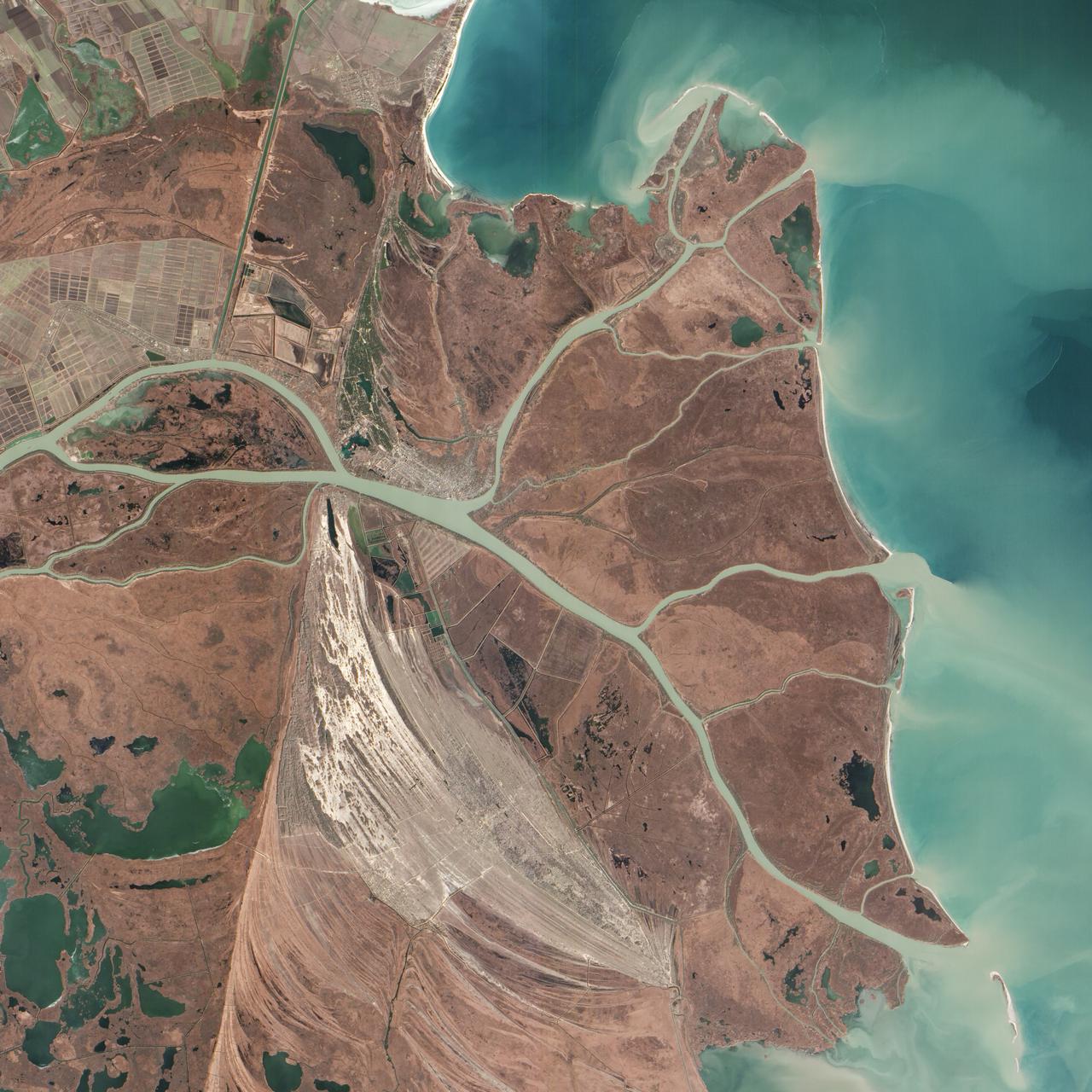
Acquired February 5, 2013 The Danube River is the largest in the European Union, its watershed draining 801,463 square kilometers (309,447 square miles) of land across 19 countries. Where that great river reaches the Black Sea, a remarkable delta has formed—the “Everglades” of Europe. The Danube Delta is home to more than 300 species of bird and 45 species of freshwater fish. The Danube Delta has been home to human settlements since the end of the Stone Age (the Neolithic Period), and the ancient Greeks, Romans, and Byzantines all built trading ports and military outposts along this coast. Today, the border between Romania and Ukraine cuts through the northern part of the delta. The area is a United Nations World Heritage Site, both for its natural and human history, and for the traditional maritime culture that persists in its marshes. All the while, the landscape has been shaped and re-shaped by nature and man. The image above was acquired on February 5, 2013, by the Advanced Land Imager (ALI) on NASA’s Earth Observing-1 (EO-1) satellite. The Danube Delta has a number of lobes formed over the past several thousand years, and this image is focused largely on the northernmost Chilia (or Kilia) lobe. It is the youngest section of the delta—somewhere between 300 to 400 years old—and lies mostly within Ukraine. Much of the land in the image above is officially considered part of the Danube Biosphere Reserve. Near the center of the image, the small city of Vylkove is known as the “Ukranian Venice,” due to its canals. To the lower left, the older Sulina lobe of the delta stretches to the south and further inland into Romania. White and brown curved lines reveal beach ridges and former shorelines, with the whiter ridges composed almost entirely of pure quartz sand in high dunes. To the east of the ridges, most of the landscape is flat marshland that is mostly brown in the barren days of winter. The Bystroye Canal through the center of the Chilia lobe has been the subject of heated debate over the past two decades. Over the centuries, damming and channeling of the Danube throughout Europe has reduced its water flow and sediment load to roughly 30 percent of what it once was, according to coastal geologist Liviu Giosan of the Woods Hole Oceanographic Institution. In recent years, the Ukrainian government has dredged some delta channels (including Bystroye) and proposed extensive dredging of others in order to provide navigational channels for large ships. Proponents argue for the economic needs of water transportation routes. Opponents note that deeper, faster channels mean less mud and sand is deposited in the delta; in some places, more is carried away by swifter currents. Both affect the sensitive ecosystems and the ability of the delta to restore itself and grow. In a 2012 report led by Giosan, scientists noted that the shape, water chemistry, and biology of Danube Delta was being altered long before the modern Industrial Era. Land use practices—particularly farming and forest clearing—added significant amounts of nutrients into the water and reduced salinity in the Black Sea, changing the dominant species of phytoplankton and sending a ripple of effects through the entire food web. NASA Earth Observatory image by Jesse Allen and Robert Simmon, using EO-1 ALI data provided courtesy of the NASA EO-1 team and the U.S. Geological Survey. Caption by Mike Carlowicz. Instrument: EO-1 - ALI More info: <a href="http://earthobservatory.nasa.gov/IOTD/view.php?id=80459" rel="nofollow">earthobservatory.nasa.gov/IOTD/view.php?id=80459</a> Credit: <b><a href="http://www.earthobservatory.nasa.gov/" rel="nofollow"> NASA Earth Observatory</a></b> <b><a href="http://www.nasa.gov/audience/formedia/features/MP_Photo_Guidelines.html" rel="nofollow">NASA image use policy.</a></b> <b><a href="http://www.nasa.gov/centers/goddard/home/index.html" rel="nofollow">NASA Goddard Space Flight Center</a></b> enables NASA’s mission through four scientific endeavors: Earth Science, Heliophysics, Solar System Exploration, and Astrophysics. Goddard plays a leading role in NASA’s accomplishments by contributing compelling scientific knowledge to advance the Agency’s mission. <b>Follow us on <a href="http://twitter.com/NASA_GoddardPix" rel="nofollow">Twitter</a></b> <b>Like us on <a href="http://www.facebook.com/pages/Greenbelt-MD/NASA-Goddard/395013845897?ref=tsd" rel="nofollow">Facebook</a></b> <b>Find us on <a href="http://instagram.com/nasagoddard?vm=grid" rel="nofollow">Instagram</a></b>