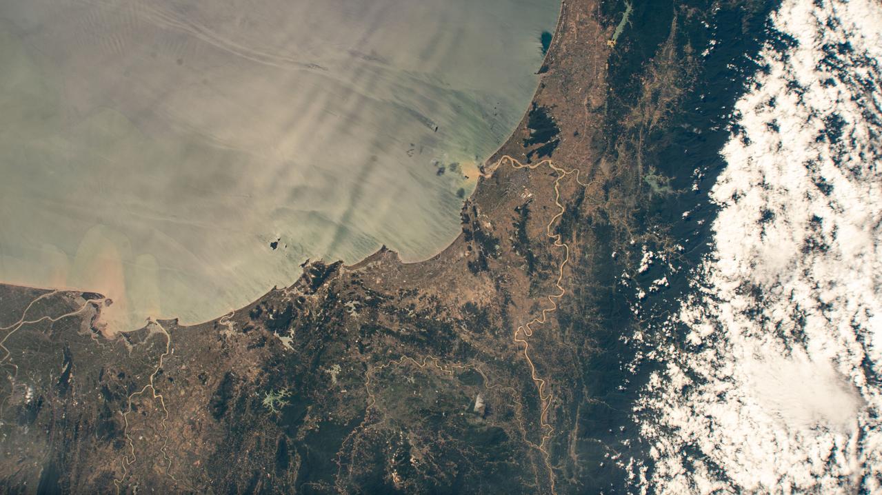
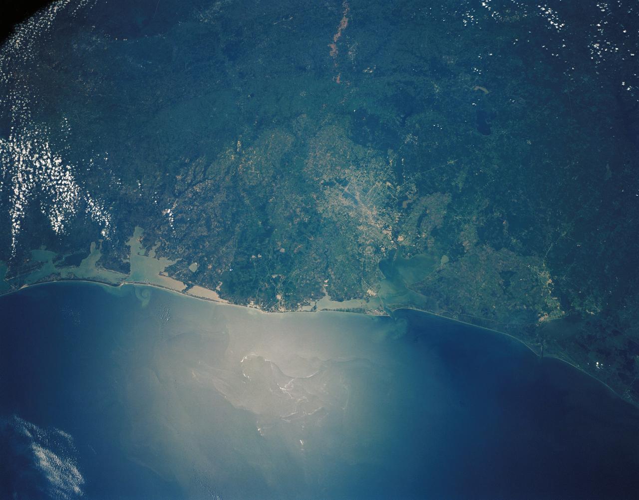
Coasts and Drowned Mountains
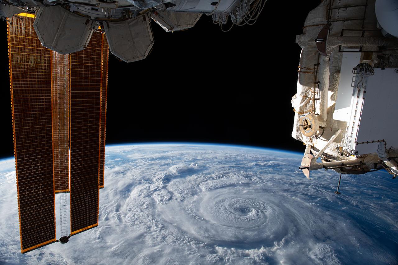
iss063e074380 (Aug. 19, 2020) --- Hurricane Genevieve is pictured off the Pacific coast of Mexico from the International Space Station.

Leaders from NASA’s Commercial Crew Program and Exploration Ground Systems at the agency’s Kennedy Space Center in Florida, and members of the U.S. Coast Guard Sector Jacksonville pose for photos during a NASA Silver Group Achievement award ceremony held inside Kennedy’s headquarters building on Thursday, March 14, 2024. The agency’s Silver Group Achievement Award is presented to U.S. Coast Guard Admiral Linda Fagan to recognize the commitment of the U.S. Coast Guard Sector Jacksonville in providing splashdown and recovery support for the safe return of crew and cargo space capsules.

U.S. Coast Guard Admiral Linda Fagan receives NASA’s Silver Group Achievement Award from NASA’s Kennedy Space Center Director Janet Petro in a ceremony held at Kennedy’s headquarters building on Thursday, March 14, 2024. The Silver Group Achievement Award recognizes the commitment of the U.S. Coast Guard Sector Jacksonville in providing splashdown and recovery support for the safe return of crew and cargo space capsules.

U.S. Coast Guard Admiral Linda Fagan receives NASA’s Silver Group Achievement Award during a ceremony held the headquarters building at NASA’s Kennedy Space Center in Florida on Thursday, March 14, 2024. The Silver Group Achievement Award recognizes the commitment of the U.S. Coast Guard Sector Jacksonville in providing splashdown and recovery support for the safe return of crew and cargo space capsules.

On April 5, 2015, the Moderate Resolution Imaging Spectroradiometer (MODIS) on NASA’s Terra satellite acquired this natural-color image of sea ice off the coast of East Antarctica’s Princess Astrid Coast. White areas close to the continent are sea ice, while white areas in the northeast corner of the image are clouds. One way to better distinguish ice from clouds is with false-color imagery. In the false-color view of the scene here, ice is blue and clouds are white. The image was acquired after Antarctic sea ice had passed its annual minimum extent (reached on February 20, 2015), and had resumed expansion toward its maximum extent (usually reached in September). Credit: NASA image by Jeff Schmaltz, LANCE/EOSDIS Rapid Response. Caption by Kathryn Hansen via NASA's Earth Observatory Read more: <a href="http://www.nasa.gov/content/sea-ice-off-east-antarcticas-princess-astrid-coast/" rel="nofollow">www.nasa.gov/content/sea-ice-off-east-antarcticas-princes...</a> <b><a href="http://www.nasa.gov/audience/formedia/features/MP_Photo_Guidelines.html" rel="nofollow">NASA image use policy.</a></b> <b><a href="http://www.nasa.gov/centers/goddard/home/index.html" rel="nofollow">NASA Goddard Space Flight Center</a></b> enables NASA’s mission through four scientific endeavors: Earth Science, Heliophysics, Solar System Exploration, and Astrophysics. Goddard plays a leading role in NASA’s accomplishments by contributing compelling scientific knowledge to advance the Agency’s mission. <b>Follow us on <a href="http://twitter.com/NASAGoddardPix" rel="nofollow">Twitter</a></b> <b>Like us on <a href="http://www.facebook.com/pages/Greenbelt-MD/NASA-Goddard/395013845897?ref=tsd" rel="nofollow">Facebook</a></b> <b>Find us on <a href="http://instagrid.me/nasagoddard/?vm=grid" rel="nofollow">Instagram</a></b>
NASA and NOAA satellites are providing various views of the major winter storm marching toward the U.S. East coast on March 13. The storm is forecast to merge with another system and is expected to bring large snowfall totals from the Mid-Atlantic to New England. NASA's Aqua satellite gathered infrared data from the storm system and the area ahead of the storm for cloud and ground temperatures. NOAA's GOES-East satellite provided visible and infrared imagery that showed the extent and the movement of the system. Forecasters at the National Weather Service's Weather Prediction Center (WPC) noted that the low pressure system crossing the Midwest states and Ohio Valley is expected to merge with another low off the southeast U.S. coast. WPC stated "This will allow for a strong nor'easter to develop near the coast and cause a late-season snowstorm from the central Appalachians to New England, including many of the big cities in the Northeast U.S." Credits: NASA/NOAA GOES Project
AST-16-1268 (20 July 1975) --- A near vertical view of a portion of the Mediterranean coast of Turkey and Syria, as photographed from the Apollo spacecraft in Earth orbit during the joint U.S-USSR Apollo-Soyuz Test Project mission. This view covers the Levant Coast north of Beirut, showing the cities of Aleppo, Hamah, Homs and Latakia. The Levantine rift bends to the northeast. This picture was taken with a 70mm Hasselblad camera using high-definition aerial Ektachrome SO-242 type film. The altitude of the spacecraft was 225 kilometers (140 statute miles) when this photograph was taken.
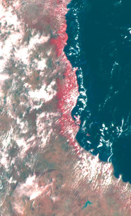
This false color image of the Eastern Coast of Australia was obtained by NASA’s Galileo spacecraft at about 3:00 p.m. PST, Dec. 8, 1990, at a range of more than 35,000 miles. http://photojournal.jpl.nasa.gov/catalog/PIA00121
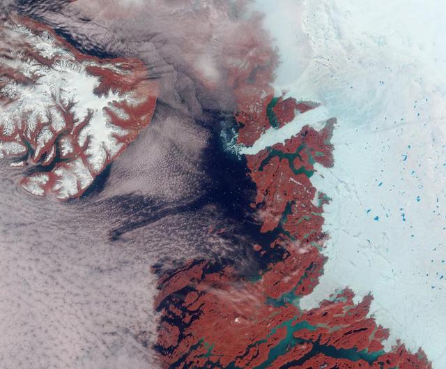
Vibrant reds, emerald greens, brilliant whites, and pastel blues adorn this view of the area surrounding the Jakobshavn Glacier on the western coast of Greenland captured by NASA Terra spacecraft on June 18, 2003.

The Orion team visits Coast Aerospace Manufacturing in Placentia, CA on Jan. 28, 2014. Part of Batch image transfer from Flickr.

The Orion team visits Coast Aerospace Manufacturing in Placentia, CA on Jan. 28, 2014. Part of Batch image transfer from Flickr.

The Orion team visits Coast Aerospace Manufacturing in Placentia, CA on Jan. 28, 2014. Part of Batch image transfer from Flickr.

The Orion team visits Coast Aerospace Manufacturing in Placentia, CA on Jan. 28, 2014. Part of Batch image transfer from Flickr.

The Orion team visits Coast Aerospace Manufacturing in Placentia, CA on Jan. 28, 2014. Part of Batch image transfer from Flickr.

The Orion team visits Coast Aerospace Manufacturing in Placentia, CA on Jan. 28, 2014. Part of Batch image transfer from Flickr.
iss069e004768 (April 20, 2023) --- The southern coast of Yemeni's island of Socotra in the Arabian Sea was pictured by NASA astronaut and Expedition 69 Flight Engineer Woody Hoburg as the International Space Station orbited 257 miles above.
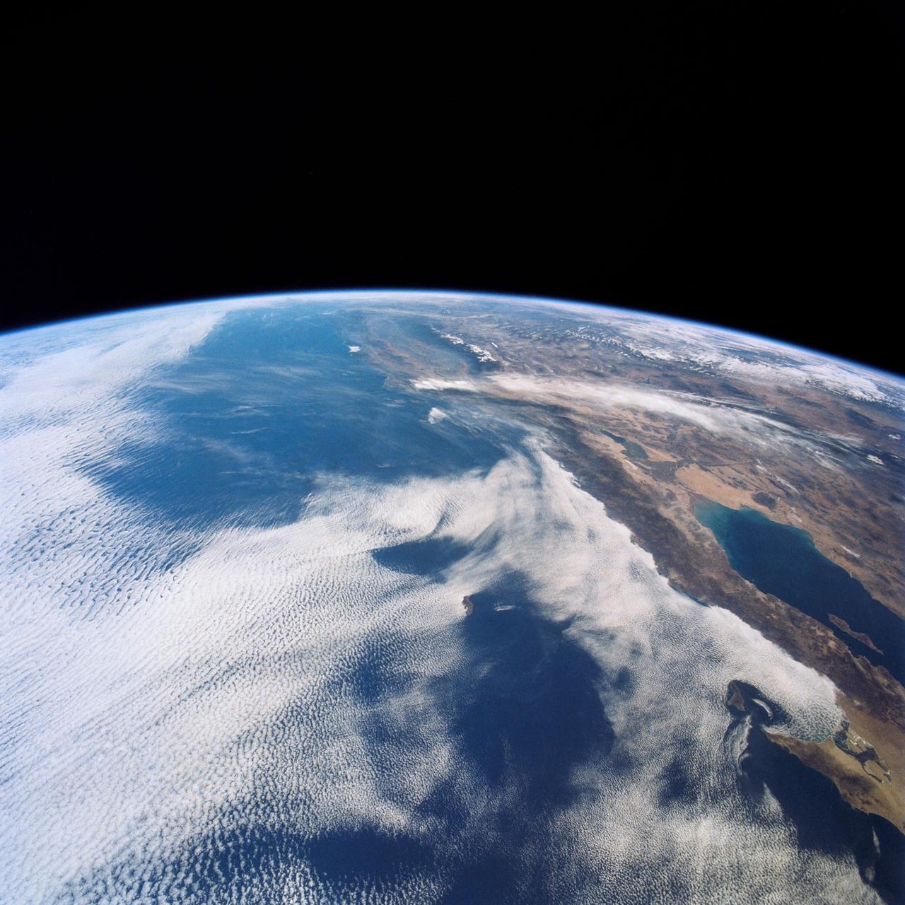
SL4-142-4542 (November 1973-February 1974) --- An oblique view of the Pacific Coast of Southern California, including the Los Angeles and San Diego areas, as seen from the Skylab space station in Earth orbit. This picture was taken by one of the Skylab 4 crewmen using a hand-held 70mm Hasselblad camera with a 100mm lens and SO-368 medium-speed Ektachrome film. The visible coastline extends from San Diego northwesterly to Santa Barbara. The Mojave Desert occupies much of the photograph. This view also includes the Channel Islands off the coast. Note that the higher elevations of the mountains are covered with snow. Photo credit: NASA
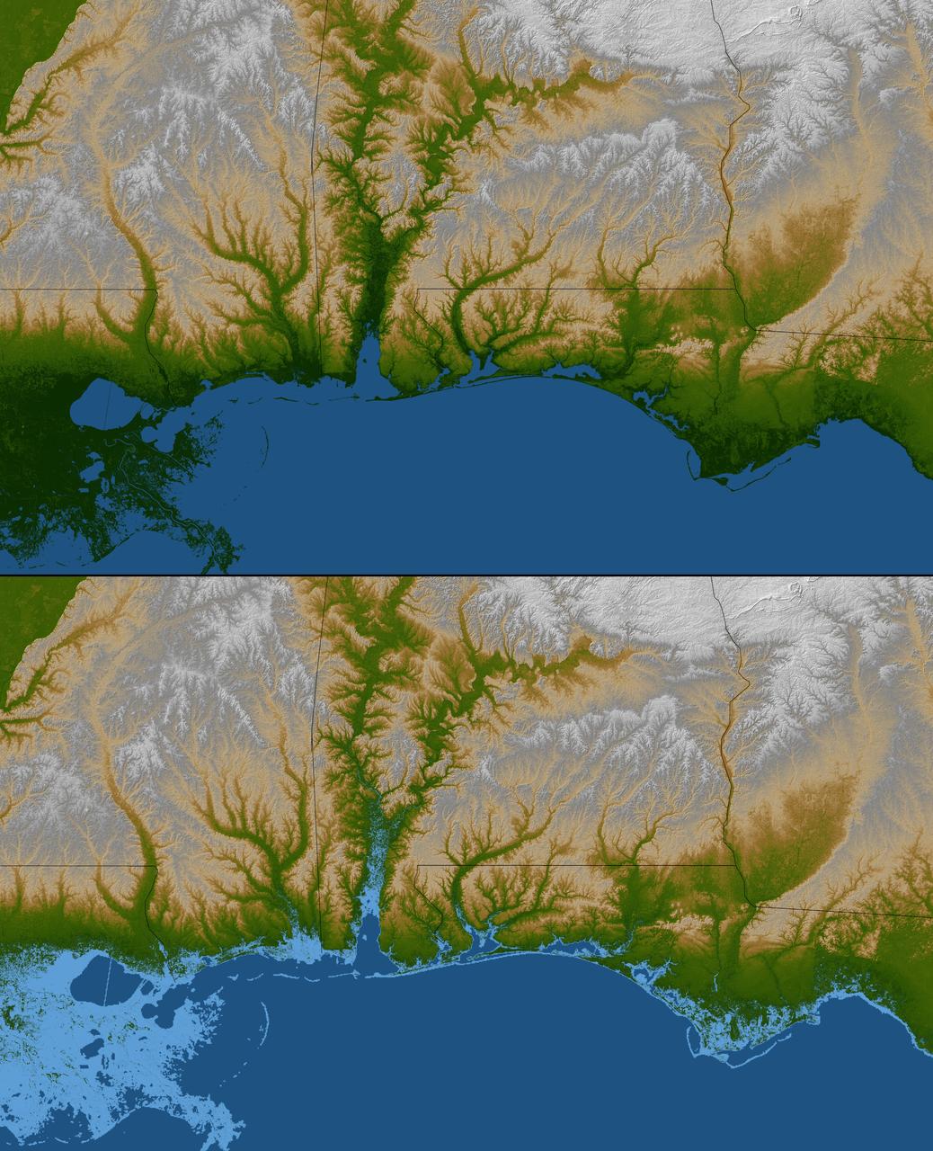
The topography of the Gulf Coast states is well shown in this color-coded shaded relief map generated with data from NASA Shuttle Radar Topography Mission.
On 26 December 2004, a magnitude 9.0 earthquake occurred off the west coast of Sumatra, Indonesia. These views were acquired by NASA Terra spacecraft.
The smoke from the Canadian wildfires that was in the middle of the U.S. on June 30 has drifted its way to the East Coast obscuring parts of the coast from New Jersey to North Carolina. Images taken on June 30 showed the smoke covering states from Minnesota to Tennessee. The jet stream has pushed the smoke along so that by July 1 it reached the U.S. East Coast. Residents of the area will get a preview of July 4th fireworks with redder than usual sunrises and sunsets due to particulates in the air. This natural-color satellite image was collected by the Moderate Resolution Imaging Spectroradiometer (MODIS) aboard the Aqua satellite on July 1, 2015. Credit: NASA/GSFC/Jeff Schmaltz/MODIS Land Rapid Response Team <b><a href="http://www.nasa.gov/audience/formedia/features/MP_Photo_Guidelines.html" rel="nofollow">NASA image use policy.</a></b> <b><a href="http://www.nasa.gov/centers/goddard/home/index.html" rel="nofollow">NASA Goddard Space Flight Center</a></b> enables NASA’s mission through four scientific endeavors: Earth Science, Heliophysics, Solar System Exploration, and Astrophysics. Goddard plays a leading role in NASA’s accomplishments by contributing compelling scientific knowledge to advance the Agency’s mission. <b>Follow us on <a href="http://twitter.com/NASAGoddardPix" rel="nofollow">Twitter</a></b> <b>Like us on <a href="http://www.facebook.com/pages/Greenbelt-MD/NASA-Goddard/395013845897?ref=tsd" rel="nofollow">Facebook</a></b> <b>Find us on <a href="http://instagrid.me/nasagoddard/?vm=grid" rel="nofollow">Instagram</a></b>
NOAA's GOES-East satellite captured this visible image of Hurricane Joaquin east of the Bahamas on Oct. 3 at 1615 UTC (12:15 p.m. EDT). The national weather forecast for October 3, 2015: Joaquin is no threat for now, but the nor'easter on the East Coast is causing massive flooding. Heavy rain hit Charleston, South Carolina., and much of the Southeast on Saturday, giving the region little relief from the threat of Hurricane Joaquin as it moved to the northeast away from the East Coast. Credit: NASA/NOAA GOES Project <b><a href="http://www.nasa.gov/audience/formedia/features/MP_Photo_Guidelines.html" rel="nofollow">NASA image use policy.</a></b> <b><a href="http://www.nasa.gov/centers/goddard/home/index.html" rel="nofollow">NASA Goddard Space Flight Center</a></b> enables NASA’s mission through four scientific endeavors: Earth Science, Heliophysics, Solar System Exploration, and Astrophysics. Goddard plays a leading role in NASA’s accomplishments by contributing compelling scientific knowledge to advance the Agency’s mission. <b>Follow us on <a href="http://twitter.com/NASAGoddardPix" rel="nofollow">Twitter</a></b> <b>Like us on <a href="http://www.facebook.com/pages/Greenbelt-MD/NASA-Goddard/395013845897?ref=tsd" rel="nofollow">Facebook</a></b> <b>Find us on <a href="http://instagrid.me/nasagoddard/?vm=grid" rel="nofollow">Instagram</a></b>
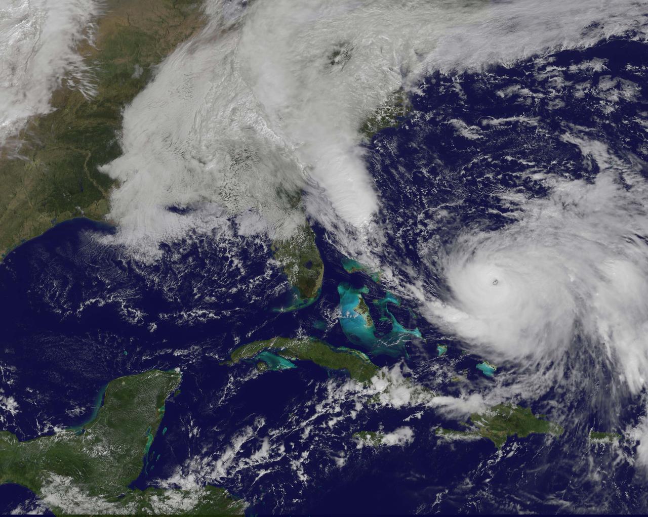
NOAA's GOES-East satellite captured this visible image of Hurricane Joaquin east of the Bahamas on Oct. 3 at 1615 UTC (12:15 p.m. EDT). The national weather forecast for October 3, 2015: Joaquin is no threat for now, but the nor'easter on the East Coast is causing massive flooding. Heavy rain hit Charleston, South Carolina., and much of the Southeast on Saturday, giving the region little relief from the threat of Hurricane Joaquin as it moved to the northeast away from the East Coast. Credit: NASA/NOAA GOES Project <b><a href="http://www.nasa.gov/audience/formedia/features/MP_Photo_Guidelines.html" rel="nofollow">NASA image use policy.</a></b> <b><a href="http://www.nasa.gov/centers/goddard/home/index.html" rel="nofollow">NASA Goddard Space Flight Center</a></b> enables NASA’s mission through four scientific endeavors: Earth Science, Heliophysics, Solar System Exploration, and Astrophysics. Goddard plays a leading role in NASA’s accomplishments by contributing compelling scientific knowledge to advance the Agency’s mission. <b>Follow us on <a href="http://twitter.com/NASAGoddardPix" rel="nofollow">Twitter</a></b> <b>Like us on <a href="http://www.facebook.com/pages/Greenbelt-MD/NASA-Goddard/395013845897?ref=tsd" rel="nofollow">Facebook</a></b> <b>Find us on <a href="http://instagrid.me/nasagoddard/?vm=grid" rel="nofollow">Instagram</a></b>
AS07-07-1800 (15 Oct. 1968) --- Matagorda Bay area on the Gulf Coast of Texas as seen from the Apollo 7 spacecraft during its 62nd revolution of Earth. Photographed from an altitude of 90 nautical miles, at ground elapsed time of 98 hours and 38 minutes.
Mangoro River on Madagascar's east coast leads to the Indian Ocean in this photograph from the Indian Ocean as it orbited 263 miles above

SL3-87-355 (July-September 1973) --- A vertical view of the eastern coast of Sicily area is seen in this Skylab 3 Earth Resources Experiments Package S190-B (five-inch earth terrain camera) infrared photograph taken from the Skylab space station in Earth orbit. Mount Etna, the highest volcano in Europe (10,958 feet), is still active as evidenced by the thin plume of smoke emanating from its crest. (The altitude is approximate because the height of the volcano changes with each eruption). On the flanks of Etna recent lava flows appear black in contrast to the older flows and volcanic debris that are red. Numerous small, circular cinder cones on the flanks represent sites of previous eruptions. Catania, on the Mediterranean coast south of Etna, is the largest of several cities and villages which appear as light-gray patches on the lower slopes of the volcano. Plano de Catania, south of the city of Catania, is outlined by polygonal light and dark agricultural tracts. Several lakes, the largest of which is Lake Pozzillo, show up as dark blue in the photograph. The unusual colors in the picture are due to the use of color infrared film in which vegetation appears red. This is very evident on the slopes of Etna, in the Monti Nebrodi area at upper let, and in the local areas in the lower part of the picture. Studies of Mount Etna and related volcanic features will be undertaken by Professor Roberto Cassinis of Servizio Geologio d?Italia, Rome. Federal agencies participating with NASA on the EREP project are the Departments of Agriculture, Commerce, Interior, the Environmental Protection Agency and the Corps of Engineers. All EREP photography is available to the public through the Department of Interior?s Earth Resources Observation Systems Data Center, Sioux Falls, South Dakota, 57198. Photo credit: NASA
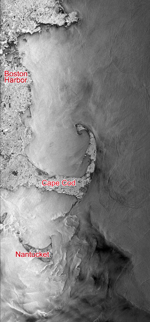
This Seasat synthetic aperture radar image from Aug. 27, 1978, shows the Massachusetts coast from Nantucket Island in the south past Cape Cod and Boston to Cape Ann in the north.
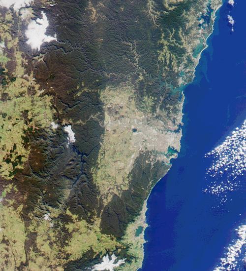
This image from NASA Terra satellite was acquired on July 11, 2000 Terra orbit 3009 and shows a 200-kilometer section of the eastern Australian coast, centered around the Sydney metropolitan area.
SL4-138-3756 (28 Dec. 1973) --- The northern half of Mauritania's Atlantic Coast, as photographed from the Skylab space station in Earth orbit by one of the Skylab 4 crewmen. The camera used was a hand-held 70mm Hasselblad, with SO-368 medium-speed Ektachrome. Spanish Sahara is just out of the picture to the north. The linear chains of sand dunes leading to the sea were the objects of study in an effort to better understand deserts and their formations. Photographs such as this were compared with similar ones taken over the drought-stricken areas including Mali and Niger in an attempt to understand the desertification processes which may be occurring there. Photo credit: NASA

AS07-05-1652 (13 Oct. 1968) --- Pacific coast area of southwestern Mexico, State of Guerrero, from Acapulco to Tecoanapa, as seen from the Apollo 7 spacecraft during its 34th revolution of Earth. Photographed from an altitude of 125 nautical miles, at ground elapsed time of 54 hours and 10 minutes. Much cloud cover in area.
AS07-05-1635 (13 Oct. 1968) --- Gulf of Mexico, coast of Yucatan, Mexico, as seen from the Apollo 7 spacecraft during its 33rd revolution of Earth. Note road leading to city of Merida which is under cloud cover. Photographed from an altitude of 123 nautical miles, at ground elapsed time of 52 hours and 37 minutes.
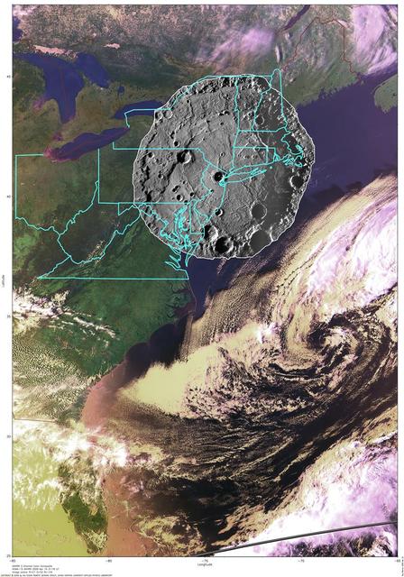
To put the size of Mercury Rembrandt basin into a familiar context, a NAC mosaic of the basin is overlaid on an AVHRR image of the east coast of the United States

These images of mixing waters and moving ships off the North Carolina Coast were acquired by NASA Terra satellite on October 11, 2000 Terra orbit 4344.

Abu Dhabi, the capital of the United Arab Emirates on the Persian Gulf coast, is pictured from the International Space Station as it soared 257 miles above the Middle East.
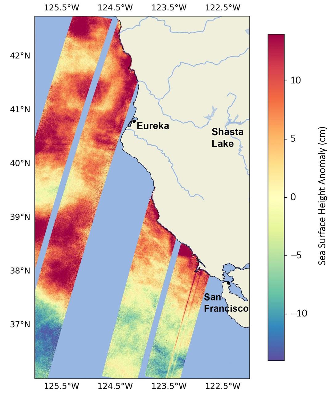
This data visualization image above shows sea surface heights off the northern California coast in August 2023 as measured by the Surface Water and Ocean Topography (SWOT) satellite. Red indicates higher-than-average ocean heights, while blue represents lower-than-average heights. Warm ocean waters from the developing El Niño are shifting north along coastlines in the eastern Pacific Ocean. Along the coast of California, these warm waters are interacting with a persistent marine heat wave that recently influenced the development of Hurricane Hilary. SWOT is able to spot the movement of these warm ocean waters in unprecedented detail. The SWOT science team made the measurements with the Ka-band Radar Interferometer (KaRIn) instrument. With two antennas spread 33 feet (10 meters) apart on a boom, KaRIn produces a pair of data swaths as it circles the globe, bouncing radar pulses off the water's surface to collect water-height measurements. The visualization combines data from two passes of the SWOT satellite. https://photojournal.jpl.nasa.gov/catalog/PIA26091
On September 13 at 07:10 UTC (3:10 a.m. EDT) the Moderate Resolution Imaging Spectroradiometer or MODIS instrument aboard NASA's Terra satellite captured the sunlight and shadows over ice over Princess Ragnhild Coast, Antarctica during the partial solar eclipse. Sunlight can be seen over the Antarctic while the Southern Ocean (top) is darkened. The Princess Ragnhild Coast is part of the Queen Maud Land coast. Image Credit: NASA Goddard MODIS Rapid Response Team/Jeff Schmaltz Text: NASA Goddard Space Flight Center/Rob Gutro <b><a href="http://www.nasa.gov/audience/formedia/features/MP_Photo_Guidelines.html" rel="nofollow">NASA image use policy.</a></b> <b><a href="http://www.nasa.gov/centers/goddard/home/index.html" rel="nofollow">NASA Goddard Space Flight Center</a></b> enables NASA’s mission through four scientific endeavors: Earth Science, Heliophysics, Solar System Exploration, and Astrophysics. Goddard plays a leading role in NASA’s accomplishments by contributing compelling scientific knowledge to advance the Agency’s mission. <b>Follow us on <a href="http://twitter.com/NASAGoddardPix" rel="nofollow">Twitter</a></b> <b>Like us on <a href="http://www.facebook.com/pages/Greenbelt-MD/NASA-Goddard/395013845897?ref=tsd" rel="nofollow">Facebook</a></b> <b>Find us on <a href="http://instagrid.me/nasagoddard/?vm=grid" rel="nofollow">Instagram</a></b>
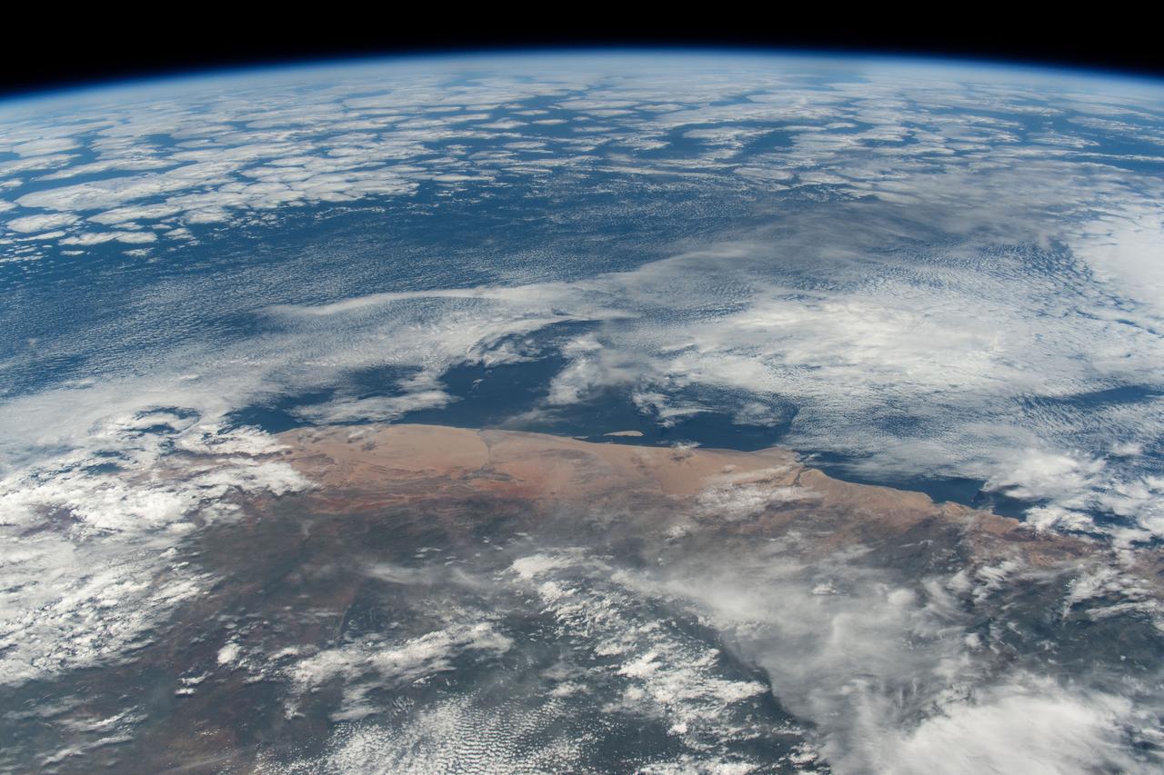
iss071e414090 (July 30, 2024) -- Clouds swirl into the coast of Morocco, hanging low over the Atlantic Ocean, as the International Space Station orbited 258 miles above.
This thunderstorm along the Texas Gulf Coast (29.0N, 95.0W), USA is seen as the trailing edge of a large cloud mass formed along the leading edge of a spring frontal system stretching northwest to southeast across the Texas Gulf Coast. This system brought extensive severe weather and flooding to parts of Texas and surrounding states. Muddy water discharging from coastal streams can be seen in the shallow Gulf of Mexico as far south as Lavaca Bay.
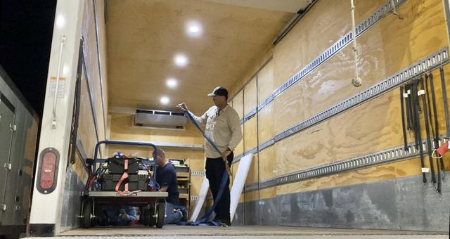
An employee with contractor Jacobs from contractor Jacobs transports research cargo from the International Space Station for processing inside the Space Station Processing Facility (SSPF) at NASA’s Kennedy Space Center in Florida on July 10, 2021. The experiments returned to Earth on SpaceX’s 22nd commercial resupply services mission. After its successful parachute-assisted splashdown off the coast of Tallahassee, Florida at 11:29 p.m. EST on Friday, July 9, the SpaceX cargo Dragon returned more than 5,300 pounds of scientific experiments and other cargo from the International Space Station. Splashing down off the coast of Florida enables quick transportation of the science aboard the capsule to the SSPF, delivering some science back into the hands of the researchers as soon as four to nine hours after splashdown. This shorter transportation timeframe allows researchers to collect data with minimal loss of microgravity effects.
Members of the cold stowage team unpack science experiments inside the Space Station Processing Facility (SSPF) at NASA’s Kennedy Space Center in Florida on July 10, 2021. The experiments returned to Earth on SpaceX’s 22nd commercial resupply services mission. After its successful parachute-assisted splashdown off the coast of Tallahassee, Florida at 11:29 p.m. EST on Friday, July 9, the SpaceX cargo Dragon returned more than 5,300 pounds of scientific experiments and other cargo from the International Space Station. Splashing down off the coast of Florida enables quick transportation of the science aboard the capsule to the SSPF, delivering some science back into the hands of the researchers as soon as four to nine hours after splashdown. This shorter transportation timeframe allows researchers to collect data with minimal loss of microgravity effects.

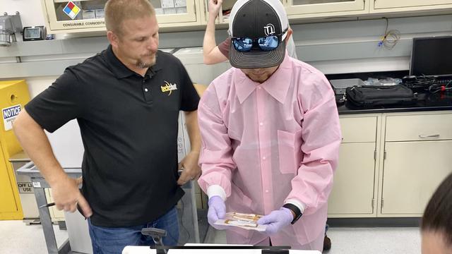
Senior Scientist George Makedonas, from NASA’S Human Immunology and Virology Lab, works with blood samples returned to Earth on SpaceX’s 22nd commercial resupply services mission in the Space Station Processing Facility (SSPF) at Kennedy Space Center in Florida, on July 10, 2021. After its successful parachute-assisted splashdown off the coast of Tallahassee, Florida at 11:29 p.m. EST on Friday, July 9, the SpaceX cargo Dragon returned more than 5,300 pounds of scientific experiments and other cargo from the International Space Station. Splashing down off the coast of Florida enables quick transportation of the science aboard the capsule to the SSPF, delivering some science back into the hands of the researchers as soon as four to nine hours after splashdown. This shorter transportation timeframe allows researchers to collect data with minimal loss of microgravity effects.
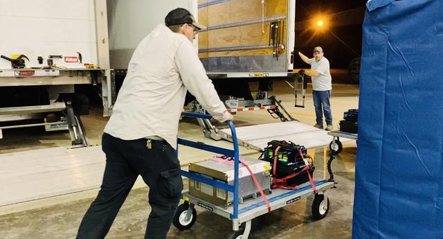
An employee with contractor Jacobs transports research cargo from the International Space Station for processing inside the Space Station Processing Facility (SSPF) at NASA’s Kennedy Space Center in Florida on July 10, 2021. The experiments returned to Earth on SpaceX’s 22nd commercial resupply services mission. After its successful parachute-assisted splashdown off the coast of Tallahassee, Florida at 11:29 p.m. EST on Friday, July 9, the SpaceX cargo Dragon returned more than 5,300 pounds of scientific experiments and other cargo from the International Space Station. Splashing down off the coast of Florida enables quick transportation of the science aboard the capsule to the SSPF, delivering some science back into the hands of the researchers as soon as four to nine hours after splashdown. This shorter transportation timeframe allows researchers to collect data with minimal loss of microgravity effects.
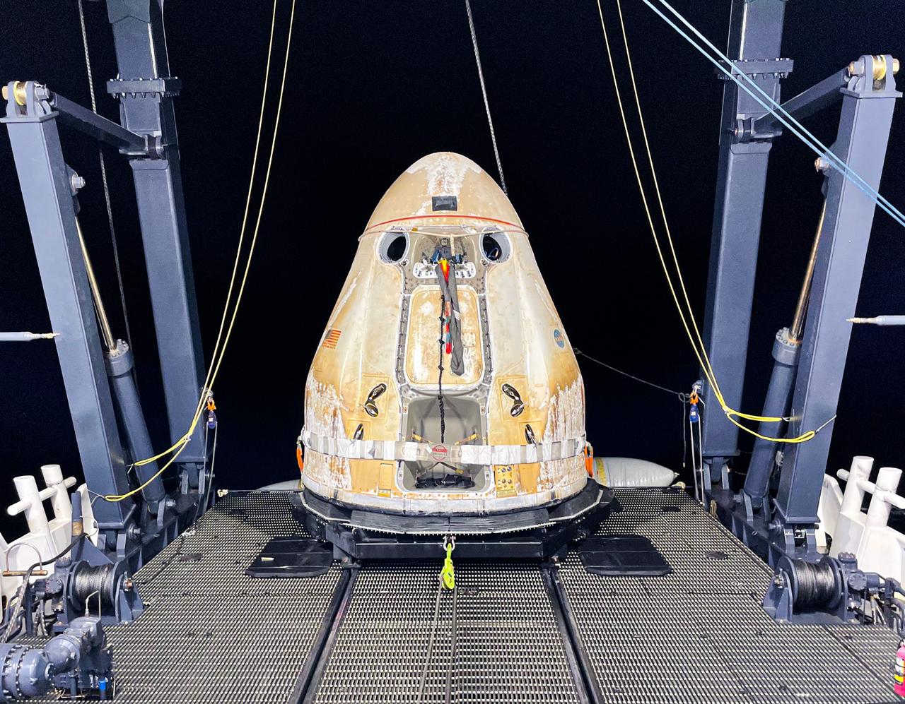
After its successful parachute-assisted splashdown off the coast of Tallahassee, Florida, at 11:29 p.m. EST on July 9, 2021, the cargo Dragon spacecraft was loaded aboard SpaceX’s Go Navigator recovery ship. The SpaceX cargo Dragon returned more than 5,300 pounds of scientific experiments and other cargo from the International Space Station on SpaceX’s 22nd commercial resupply services mission. Splashing down off the coast of Florida enables quick transportation of the science aboard the capsule to NASA Kennedy Space Center’s Space Station Processing Facility, delivering some science back into the hands of the researchers as soon as four to nine hours after splashdown. This shorter transportation timeframe allows researchers to collect data with minimal loss of microgravity effects.

An Airbus H225 helicopter with cargo from SpaceX’s 22nd commercial resupply services mission lands during the early morning on July 10, 2021, at the Launch and Landing Facility at NASA’s Kennedy Space Center in Florida. From there, contractor Jacobs transported the cargo to the center’s Space Station Processing Facility (SSPF). After its successful parachute-assisted splashdown off the coast of Tallahassee, Florida, at 11:29 p.m. EST on Friday, July 9, the SpaceX cargo Dragon returned more than 5,300 pounds of scientific experiments and other cargo from the International Space Station. Splashing down off the coast of Florida enables quick transportation of the science aboard the capsule to the SSPF, delivering some science back into the hands of the researchers as soon as four to nine hours after splashdown. This shorter transportation timeframe allows researchers to collect data with minimal loss of microgravity effects.

Senior Scientist George Makedonas, from NASA’S Human Immunology and Virology Lab, works with blood samples returned to Earth on SpaceX’s 22nd commercial resupply services mission in the Space Station Processing Facility (SSPF) at Kennedy Space Center in Florida, on July 10, 2021. After its successful parachute-assisted splashdown off the coast of Tallahassee, Florida at 11:29 p.m. EST on Friday, July 9, the SpaceX cargo Dragon returned more than 5,300 pounds of scientific experiments and other cargo from the International Space Station. Splashing down off the coast of Florida enables quick transportation of the science aboard the capsule to the SSPF, delivering some science back into the hands of the researchers as soon as four to nine hours after splashdown. This shorter transportation timeframe allows researchers to collect data with minimal loss of microgravity effects.

Senior Scientist George Makedonas, from NASA’S Human Immunology and Virology Lab, works with blood samples returned to Earth on SpaceX’s 22nd commercial resupply services mission in the Space Station Processing Facility (SSPF) at Kennedy Space Center in Florida, on July 10, 2021. After its successful parachute-assisted splashdown off the coast of Tallahassee, Florida at 11:29 p.m. EST on July 9, the SpaceX cargo Dragon returned more than 5,300 pounds of scientific experiments and other cargo from the International Space Station. Splashing down off the coast of Florida enables quick transportation of the science aboard the capsule to the SSPF, delivering some science back into the hands of the researchers as soon as four to nine hours after splashdown. This shorter transportation timeframe allows researchers to collect data with minimal loss of microgravity effects.
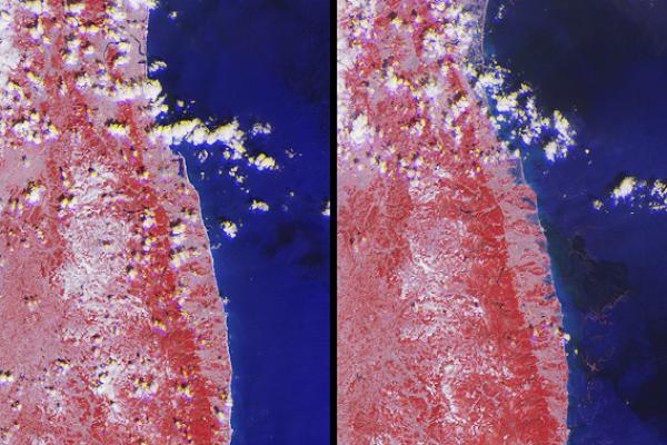
NASA image acquired September 27, 2012 On September 27, 2012, the Visible Infrared Imaging Radiometer Suite (VIIRS) on the Suomi NPP satellite captured this nighttime view of low-lying marine layer clouds along the coast of California. The image was captured by the VIIRS “day-night band,” which detects light in a range of wavelengths from green to near-infrared and uses filtering techniques to observe signals such as gas flares, auroras, wildfires, city lights, and reflected moonlight. An irregularly-shaped patch of high clouds hovers off the coast of California, and moonlight caused the high clouds to cast distinct shadows on the marine layer clouds below. VIIRS acquired the image when the Moon was in its waxing gibbous phase, meaning it was more than half-lit, but less than full. Low clouds pose serious hazards for air and ship traffic, but satellites have had difficulty detecting them in the past. To illustrate this, the second image shows the same scene in thermal infrared, the band that meteorologists generally use to monitor clouds at night. Only high clouds are visible; the low clouds do not show up at all because they are roughly the same temperature as the ground. NASA Earth Observatory image by Jesse Allen and Robert Simmon, using VIIRS Day-Night Band data from the Suomi National Polar-orbiting Partnership. Suomi NPP is the result of a partnership between NASA, the National Oceanic and Atmospheric Administration, and the Department of Defense. Caption by Adam Voiland. Instrument: Suomi NPP - VIIRS Credit: <b><a href="http://www.earthobservatory.nasa.gov/" rel="nofollow"> NASA Earth Observatory</a></b> <b>Click here to view all of the <a href="http://earthobservatory.nasa.gov/Features/NightLights/" rel="nofollow"> Earth at Night 2012 images </a></b> <b>Click here to <a href="http://earthobservatory.nasa.gov/NaturalHazards/view.php?id=79758" rel="nofollow"> read more </a> about this image </b> <b><a href="http://www.nasa.gov/audience/formedia/features/MP_Photo_Guidelines.html" rel="nofollow">NASA image use policy.</a></b> <b><a href="http://www.nasa.gov/centers/goddard/home/index.html" rel="nofollow">NASA Goddard Space Flight Center</a></b> enables NASA’s mission through four scientific endeavors: Earth Science, Heliophysics, Solar System Exploration, and Astrophysics. Goddard plays a leading role in NASA’s accomplishments by contributing compelling scientific knowledge to advance the Agency’s mission. <b>Follow us on <a href="http://twitter.com/NASA_GoddardPix" rel="nofollow">Twitter</a></b> <b>Like us on <a href="http://www.facebook.com/pages/Greenbelt-MD/NASA-Goddard/395013845897?ref=tsd" rel="nofollow">Facebook</a></b> <b>Find us on <a href="http://instagram.com/nasagoddard?vm=grid" rel="nofollow">Instagram</a></b>
AS07-07-1872 (11-22 Oct. 1968) --- The Houston, Texas, and Gulf Coast area, looking southeast, as seen from the Apollo 7 spacecraft at an altitude of 101 nautical miles. This photograph was made during the spacecraft's 91st revolution of Earth, at ground elapsed time of 144 hours and 26 minutes. The morning sun causes a spectacular reflection on water surfaces such as the Gulf of Mexico, Galveston Bay, Buffalo Bayou, and the Brazos River, and causes a unique reflection in the canals and rice fields west of Alvin. Some of the landmarks visible in this picture include highways and freeways, the Astrodome, the new Intercontinental Airport, and the Manned Spacecraft Center.
iss072e095378 (Oct. 20, 2024) --- Lake Poelela (lower right) in Mozambique's tropical climate on the coast of the Mozambique Channel is pictured from the International Space Station as it orbited 265 miles above the African nation.
S66-54559 (14 Sept. 1966) --- Gulf Coast from Corpus Christi, Texas, to mouth of Mississippi River, as seen from the Gemini-11 spacecraft during its 29th revolution of Earth. This photo was taken near sunrise. Photo credit: NASA
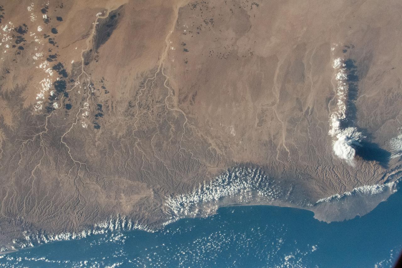
iss069e003275 (April 13, 2023) --- The middle eastern nation of Oman and its Dhofar mountains on the coast of the Arabian Sea were pictured by UAE (United Arab Emirates) astronaut and Expedition 69 Flight Engineer Sultan Alneyadi as the International Space Station orbited 257 miles above.
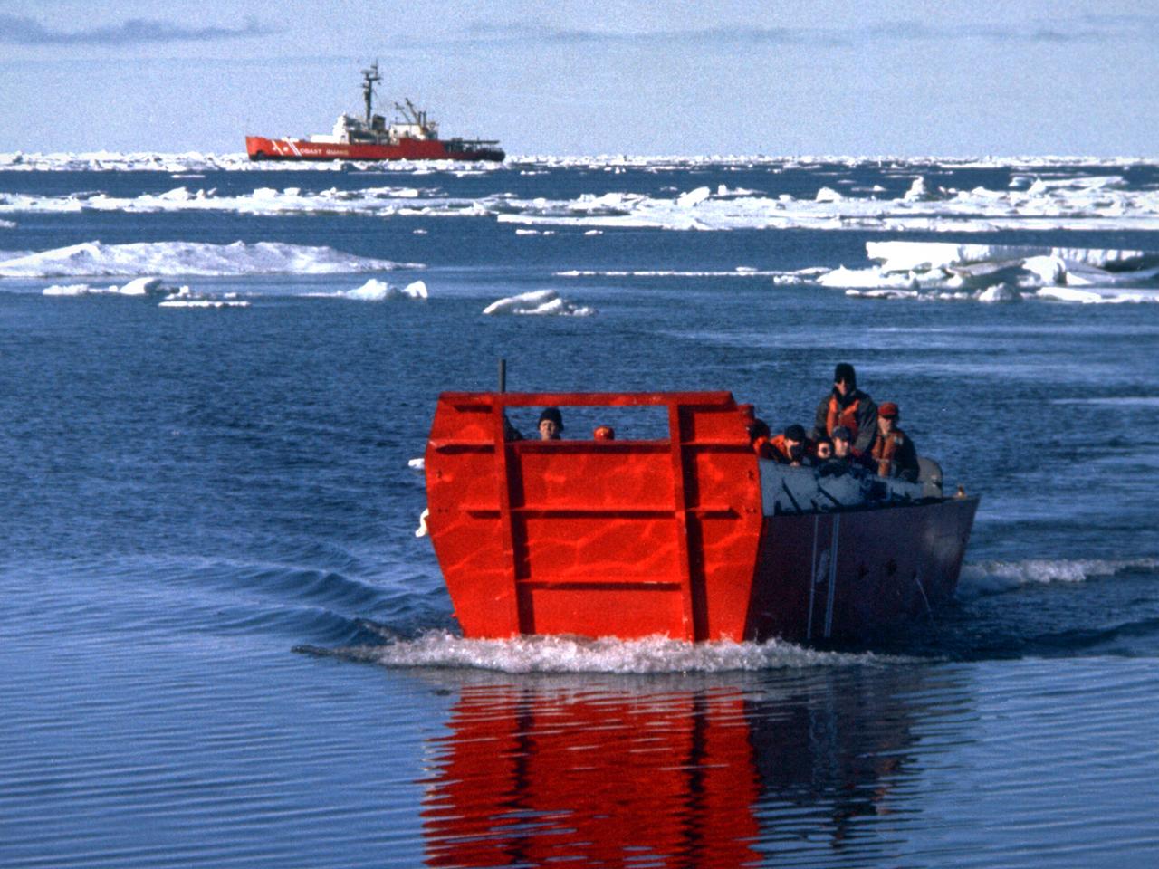
A group of Coast Guard seamen leave their ship to verify ice formations on the Great Lakes as part of an joint effort with the National Aeronautics and Space Administration (NASA) Lewis Research Center and the National Oceanic and Atmospheric Administration. The regular winter freezing of large portions of the Great Lakes stalled the shipping industry. Lewis began working on two complementary systems to monitor the ice. The Side Looking Airborne Radar (SLAR) system used microwaves to measure the ice distribution and electromagnetic systems used noise modulation to determine the thickness of the ice. The images were then transferred via satellite to the Coast Guard station. The Coast Guard then transmitted the pertinent images by VHF to the ship captains to help them select the best route. The Great Lakes ice mapping devices were first tested on NASA aircraft during the winter of 1972 and 1973. The pulsed radar system was transferred to the Coast Guard’s C-130 aircraft for the 1975 and 1976 winter. The SLAR was installed in the rear cargo door, and the small S-band antenna was mounted to the underside of the aircraft. Coast Guard flights began in January 1975 at an altitude of 11,000 feet. Early in the program, teams of guardsmen and NASA researchers frequently set out in boats to take samples and measurements of the ice in order to verify the radar information.
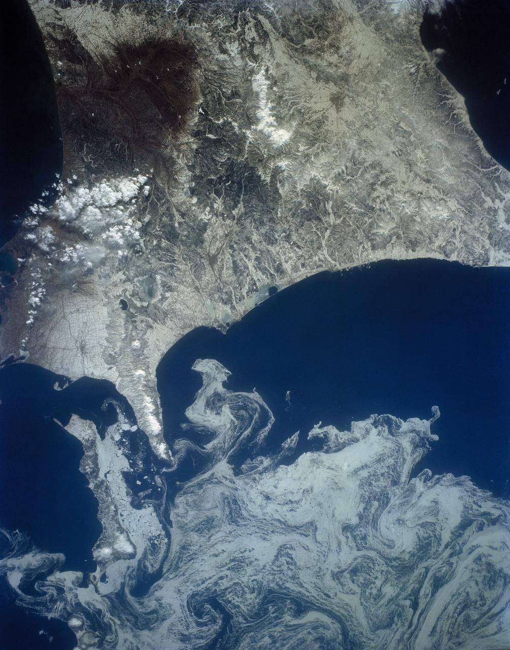
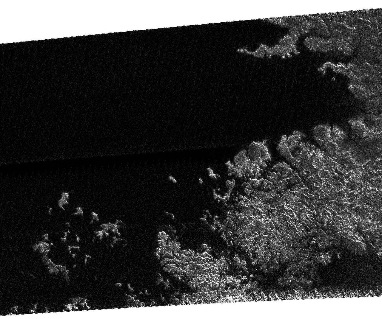
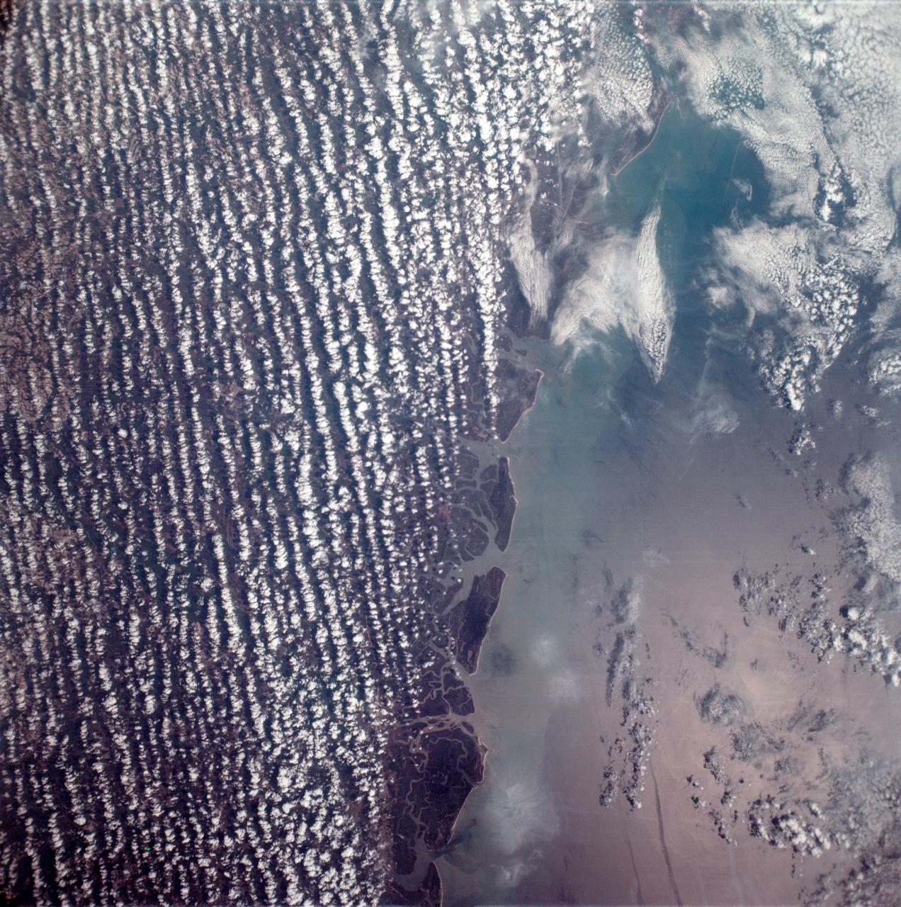
The northeast coast of Hokkaido and Kunashir Island, Japan (44.0N, 143.0E) are seen bordered by drifting sea ice. The sea ice has formed a complex pattern of eddies in response to surface water currents and winds. Photos of this kind aid researchers in describing local ocean current patterns and the effects of wind speed and direction on the drift of surface material, such as ice floes or oil. Kunashir is the southernmost of the Kuril Islands.
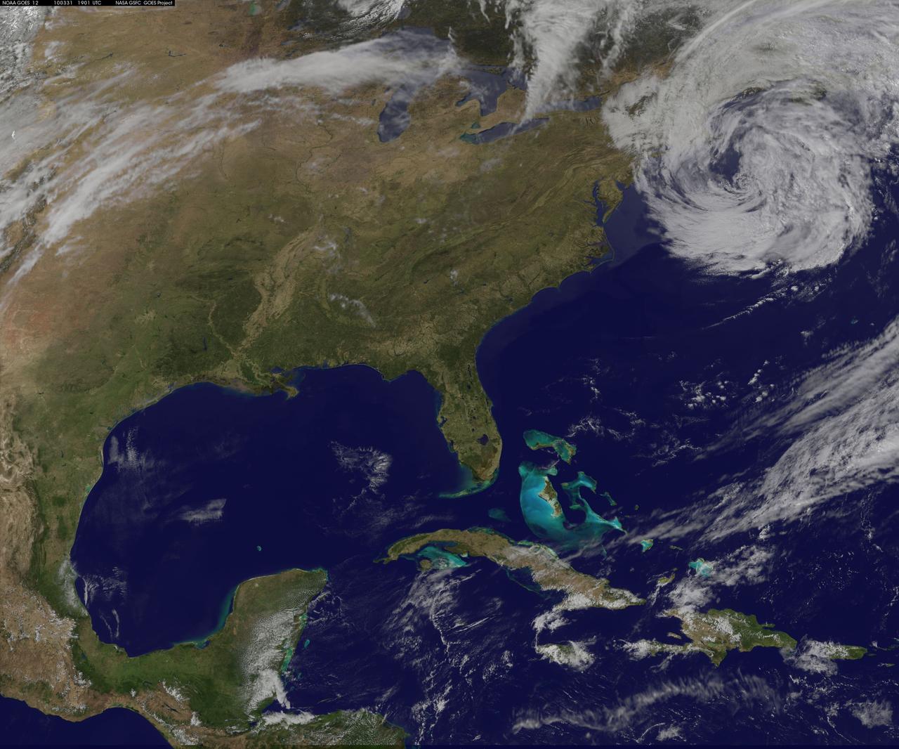
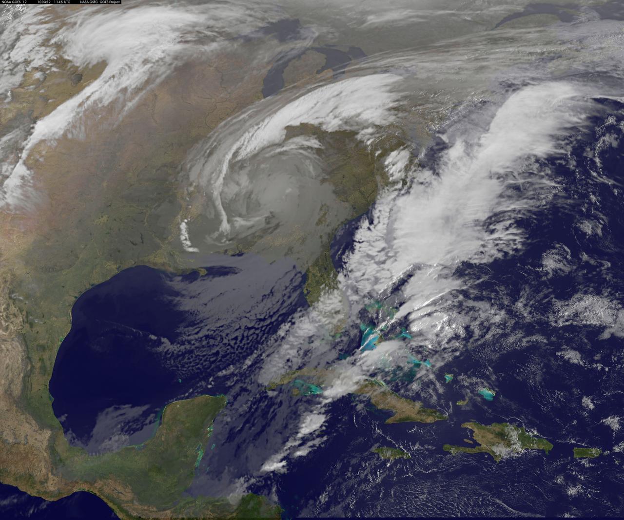
NASA GOES-12 satellite image showing the US east coast on March 31, 2010 3:01 PM EDT. <b><a href="http://goes.gsfc.nasa.gov/" rel="nofollow">Credit: NOAA/NASA GOES Project</a><b> <b><a href="http://www.nasa.gov/centers/goddard/home/index.html" rel="nofollow">NASA Goddard Space Flight Center</a></b> is home to the nation's largest organization of combined scientists, engineers and technologists that build spacecraft, instruments and new technology to study the Earth, the sun, our solar system, and the universe. <b>Follow us on <a href="http://twitter.com/NASA_GoddardPix" rel="nofollow">Twitter</a></b> <b>Join us on <a href="http://www.facebook.com/pages/Greenbelt-MD/NASA-Goddard/395013845897?ref=tsd" rel="nofollow">Facebook</a></b></b></b>
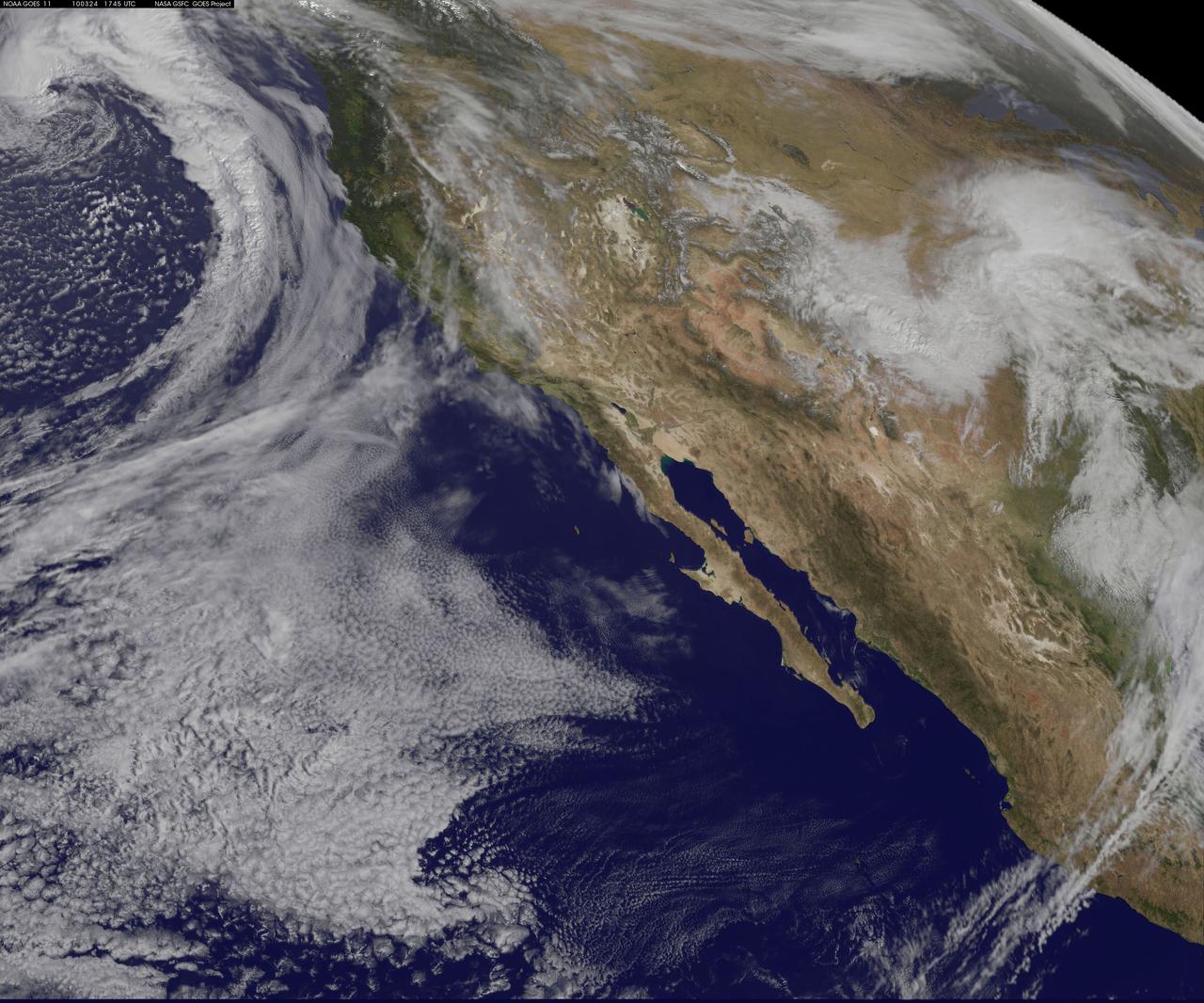
NASA GOES-11 satellite image showing the US west coast on March 24, 2010 1:45 PM EDT. <b><a href="http://goes.gsfc.nasa.gov/" rel="nofollow">Credit: NOAA/NASA GOES Project</a><b> <b><a href="http://www.nasa.gov/centers/goddard/home/index.html" rel="nofollow">NASA Goddard Space Flight Center</a></b> is home to the nation's largest organization of combined scientists, engineers and technologists that build spacecraft, instruments and new technology to study the Earth, the sun, our solar system, and the universe. <b>Follow us on <a href="http://twitter.com/NASA_GoddardPix" rel="nofollow">Twitter</a></b> <b>Join us on <a href="http://www.facebook.com/pages/Greenbelt-MD/NASA-Goddard/395013845897?ref=tsd" rel="nofollow">Facebook</a></b></b></b>
The extent of inundation from the destructive and deadly tsunami triggered by the March 11, 2011, magnitude 8.9 earthquake centered off Japan northeastern coast east of the city of Sendai is revealed in this image pair from NASA Terra spacecraft.
iss072e715420 (March 2, 2025) --- This long-duration photograph looks out a window on the SpaceX Dragon crew spacecraft and down the eastern coast of the United States at approximately 12:34 a.m. local time as the International Space Station orbited 264 miles above Newfoundland, Canada.
iss072e069057 (Oct. 15, 2024) --- Godomey, Benin, with a population of over 250,000, and surrounding towns on the Gulf of Guinea coast, sits next to Lake Nokoué (right) in this photograph from the International Space Station as it orbited 260 miles above the African continent.
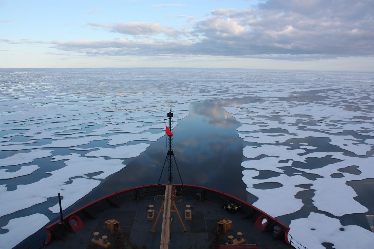
Scientists on board the U.S. Coast Guard Cutter Healy in the Beaufort Sea, northeast of Barrow, Alaska, finished collecting the mission¹s sea ice data and cruised south on July 20, 2011, through thin ice and ultimately into the open ocean. The ICESCAPE mission, or "Impacts of Climate on Ecosystems and Chemistry of the Arctic Pacific Environment," is a NASA shipborne investigation to study how changing conditions in the Arctic affect the ocean's chemistry and ecosystems. The bulk of the research took place in the Beaufort and Chukchi seas in summer 2010 and 2011. Credit: NASA/Kathryn Hansen Credit: NASA/Kathryn Hansen <b><a href="http://www.nasa.gov/audience/formedia/features/MP_Photo_Guidelines.html" rel="nofollow">NASA image use policy.</a></b> <b><a href="http://www.nasa.gov/centers/goddard/home/index.html" rel="nofollow">NASA Goddard Space Flight Center</a></b> enables NASA’s mission through four scientific endeavors: Earth Science, Heliophysics, Solar System Exploration, and Astrophysics. Goddard plays a leading role in NASA’s accomplishments by contributing compelling scientific knowledge to advance the Agency’s mission. <b>Follow us on <a href="http://twitter.com/NASA_GoddardPix" rel="nofollow">Twitter</a></b> <b>Like us on <a href="http://www.facebook.com/pages/Greenbelt-MD/NASA-Goddard/395013845897?ref=tsd" rel="nofollow">Facebook</a></b> <b>Find us on <a href="http://instagrid.me/nasagoddard/?vm=grid" rel="nofollow">Instagram</a></b>

SL4-93-167 (February 1974) --- A vertical view of the Kennedy Space Center and the Florida Atlantic coast area is seen in this Skylab 4 Earth Resources Experiments Package S190-B (five-inch earth terrain camera) infrared photography taken from the Skylab space station in Earth orbit. This photograph shows the major land-ocean features of the Florida coast near Vero Beach northward to Cape Canaveral and the KSC complex. The launch pads for the Skylab missions are clearly visible. Identification of living vegetation is possible through the use of the color infrared film. Various shades of red portray differences in the vegetation such as shown in the patterns in the agricultural area near Vero Beach. In the Kennedy Space Center, the nearly continuous and uniform red color shows that most of the land areas are heavily vegetated. The white coastal beach areas are strongly contrasted to the red land and the blue Atlantic Ocean. Old dunal areas in KSC are visible on Merritt Island which is separated from the Launch areas by the Banana River and the mainland by the Indian River. Federal and state highways and numerous causeways over the rivers are easily identified. The Florida mainland is partly shadowed by small white clouds which cast a pronounced shadow to the east of each cloud indicated the Sun is west of solar noon. Federal agencies participating with NASA on the EREP project are the Departments of Agriculture, Commerce, Interior, the Environmental Protection Agency and the Core of Engineers. All EREP photography is available to the public through the Department of Interior's Earth Resources Observations Systems Data Center, Sioux Falls, South Dakota, 57198. Photo credit: NASA
iss072e394498 (Dec. 18, 2024) --- Venezuala's Falcón Municipality on the coast of the Caribbean Sea is pictured from the International Space Station as it orbited 261 miles above.
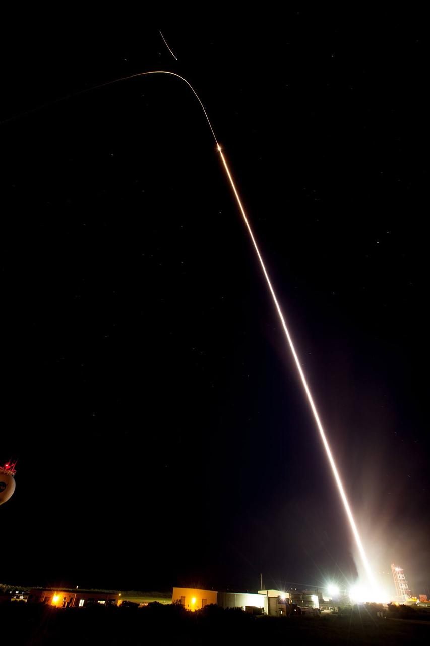
July 4 fireworks came early when a NASA Terrier-Improved Malemute sounding rocket was successfully launched at 4:25 a.m., Thursday, June 29, from the agency’s Wallops Flight Facility in Virginia. During the 8-minute flight, 10 canisters about the size of a soft drink can were ejected in space, 6 to 12 miles away from the 670-pound main payload. The canisters deployed blue-green and red vapor that formed artificial clouds visible from New York to North Carolina. During an ionosphere or aurora science mission, these clouds, or vapor tracers, allow scientists on the ground to visually track particle motions in space. The development of the multi-canister ampoule ejection system will allow scientists to gather information over a much larger area than previously possible when deploying the tracers just from the main payload. Read more here: <a href="https://www.nasa.gov/feature/wallops/2017/nasa-sounding-rocket-will-release-early-morning-artificial-clouds0lighting-up-the-mid-atlantic-coast-may-31" rel="nofollow">www.nasa.gov/feature/wallops/2017/nasa-sounding-rocket-wi...</a> <b><a href="http://www.nasa.gov/audience/formedia/features/MP_Photo_Guidelines.html" rel="nofollow">NASA image use policy.</a></b> <b><a href="http://www.nasa.gov/centers/goddard/home/index.html" rel="nofollow">NASA Goddard Space Flight Center</a></b> enables NASA’s mission through four scientific endeavors: Earth Science, Heliophysics, Solar System Exploration, and Astrophysics. Goddard plays a leading role in NASA’s accomplishments by contributing compelling scientific knowledge to advance the Agency’s mission. <b>Follow us on <a href="http://twitter.com/NASAGoddardPix" rel="nofollow">Twitter</a></b> <b>Like us on <a href="http://www.facebook.com/pages/Greenbelt-MD/NASA-Goddard/395013845897?ref=tsd" rel="nofollow">Facebook</a></b> <b>Find us on <a href="http://instagrid.me/nasagoddard/?vm=grid" rel="nofollow">Instagram</a></b>

NOAA's GOES-15 satellite captured the southern California "June Gloom" on June 10, 2013. That's a weather pattern that creates cloudy, overcast skies and cool temperatures. The "June Gloom" of low lying stratus clouds form over the ocean and can be pushed to coastal areas by wind. It usually happens off the west coast of California during the late spring and early summer. As for the "seam" of blue within the "June Gloom," it appears to be actinoform clouds, a seam in the marine stratocumulus aka "June Gloom" of southern California. Actinoform clouds and marine stratus in general are only marginally stable. Sometimes the cloud deck spontaneously dissolves along a line by drizzling out the moisture. This seam is an unusually long curve that is not identified with a coastline or a weather front. Dennis Chesters/Rob Gutro NASA's Goddard Space Flight Center, Greenbelt, Md. REFERENCES <a href="http://en.wikipedia.org/wiki/Actinoform_cloud" rel="nofollow">en.wikipedia.org/wiki/Actinoform_cloud</a> <a href="http://en.wikipedia.org/wiki/June_Gloom" rel="nofollow">en.wikipedia.org/wiki/June_Gloom</a> <b><a href="http://www.nasa.gov/audience/formedia/features/MP_Photo_Guidelines.html" rel="nofollow">NASA image use policy.</a></b> <b><a href="http://www.nasa.gov/centers/goddard/home/index.html" rel="nofollow">NASA Goddard Space Flight Center</a></b> enables NASA’s mission through four scientific endeavors: Earth Science, Heliophysics, Solar System Exploration, and Astrophysics. Goddard plays a leading role in NASA’s accomplishments by contributing compelling scientific knowledge to advance the Agency’s mission. <b>Follow us on <a href="http://twitter.com/NASA_GoddardPix" rel="nofollow">Twitter</a></b> <b>Like us on <a href="http://www.facebook.com/pages/Greenbelt-MD/NASA-Goddard/395013845897?ref=tsd" rel="nofollow">Facebook</a></b> <b>Find us on <a href="http://instagram.com/nasagoddard?vm=grid" rel="nofollow">Instagram</a></b>
iss073e0089435 (May 16, 2025) --- The International Space Station was soaring 261 miles above the Pacific coast of South America into an orbital sunrise at approximately 4:09 a.m. local time when this photograph was taken. Lima (upper right), Peru's capital and largest city with a population of 10.1 million, represents the brightest lights on the Peruvian coast.
S66-54560 (14 Sept. 1966) --- U.S. Gulf coast area from Aransas Bay, Texas, to Mobile Bay, Alabama, as seen from the Gemini-11 spacecraft during its 29th revolution of Earth. The Galveston Bay and Houston area is in center of photograph. Further eastward along the coast can be seen the Mississippi River delta and New Orleans area. Taken with a modified 70mm Hasselblad camera, using Eastman Kodak, Ektachrome, MS (S.O. 368) color film. Photo credit: NASA
S66-54563 (14 Sept. 1966) --- View of the Gulf Coast area from Atchafalaya Bay to Apalachicola, including the mouth of the Mississippi River, Mobile Bay, New Orleans, Louisiana, and Pensacola, Florida, as seen from the Gemini-11 spacecraft during its 29th revolution of Earth. This photo was taken near sunrise. Photo credit: NASA
This image of part of the Atlantic coast of South America was acquired by the Suomi NPP satellite on the night of July 20, 2012. The image was made possible by the “day-night band” of the Visible Infrared Imaging Radiometer Suite (VIIRS), which detects light in a range of wavelengths from green to near-infrared and uses filtering techniques to observe dim signals such as city lights, gas flares, auroras, wildfires, and reflected moonlight. “Nothing tells us more about the spread of humans across the Earth than city lights,” says Chris Elvidge, who leads the Earth Observation Group at NOAA’s National Geophysical Data Center. Named for satellite meteorology pioneer Verner Suomi, NPP flies over any given point on Earth's surface twice each day at roughly 1:30 a.m. and p.m. The polar-orbiting satellite flies 824 kilometers (512 miles) above the surface, sending its data once per orbit to a ground station in Svalbard, Norway, and continuously to local direct broadcast users distributed around the world. Suomi NPP is managed by NASA with operational support from NOAA and its Joint Polar Satellite System, which manages the satellite's ground system. NASA Earth Observatory image by Jesse Allen and Robert Simmon, using VIIRS Day-Night Band data from the Suomi National Polar-orbiting Partnership. Suomi NPP is the result of a partnership between NASA, the National Oceanic and Atmospheric Administration, and the Department of Defense. Caption by Mike Carlowicz. Instrument: Suomi NPP - VIIRS Credit: <b><a href="http://www.earthobservatory.nasa.gov/" rel="nofollow"> NASA Earth Observatory</a></b> <b>Click here to view all of the <a href="http://earthobservatory.nasa.gov/Features/NightLights/" rel="nofollow"> Earth at Night 2012 images </a></b> <b>Click here to <a href="http://earthobservatory.nasa.gov/NaturalHazards/view.php?id=79822" rel="nofollow"> read more </a> about this image </b> <b><a href="http://www.nasa.gov/audience/formedia/features/MP_Photo_Guidelines.html" rel="nofollow">NASA image use policy.</a></b> <b><a href="http://www.nasa.gov/centers/goddard/home/index.html" rel="nofollow">NASA Goddard Space Flight Center</a></b> enables NASA’s mission through four scientific endeavors: Earth Science, Heliophysics, Solar System Exploration, and Astrophysics. Goddard plays a leading role in NASA’s accomplishments by contributing compelling scientific knowledge to advance the Agency’s mission. <b>Follow us on <a href="http://twitter.com/NASA_GoddardPix" rel="nofollow">Twitter</a></b> <b>Like us on <a href="http://www.facebook.com/pages/Greenbelt-MD/NASA-Goddard/395013845897?ref=tsd" rel="nofollow">Facebook</a></b> <b>Find us on <a href="http://instagram.com/nasagoddard?vm=grid" rel="nofollow">Instagram</a></b>
This image of part of the Atlantic coast of South America was acquired by the Suomi NPP satellite on the night of July 20, 2012. The image was made possible by the “day-night band” of the Visible Infrared Imaging Radiometer Suite (VIIRS), which detects light in a range of wavelengths from green to near-infrared and uses filtering techniques to observe dim signals such as city lights, gas flares, auroras, wildfires, and reflected moonlight. “Nothing tells us more about the spread of humans across the Earth than city lights,” says Chris Elvidge, who leads the Earth Observation Group at NOAA’s National Geophysical Data Center. Named for satellite meteorology pioneer Verner Suomi, NPP flies over any given point on Earth's surface twice each day at roughly 1:30 a.m. and p.m. The polar-orbiting satellite flies 824 kilometers (512 miles) above the surface, sending its data once per orbit to a ground station in Svalbard, Norway, and continuously to local direct broadcast users distributed around the world. Suomi NPP is managed by NASA with operational support from NOAA and its Joint Polar Satellite System, which manages the satellite's ground system. NASA Earth Observatory image by Jesse Allen and Robert Simmon, using VIIRS Day-Night Band data from the Suomi National Polar-orbiting Partnership. Suomi NPP is the result of a partnership between NASA, the National Oceanic and Atmospheric Administration, and the Department of Defense. Caption by Mike Carlowicz. Instrument: Suomi NPP - VIIRS Credit: <b><a href="http://www.earthobservatory.nasa.gov/" rel="nofollow"> NASA Earth Observatory</a></b> <b>Click here to view all of the <a href="http://earthobservatory.nasa.gov/Features/NightLights/" rel="nofollow"> Earth at Night 2012 images </a></b> <b>Click here to <a href="http://earthobservatory.nasa.gov/NaturalHazards/view.php?id=79822" rel="nofollow"> read more </a> about this image </b> <b><a href="http://www.nasa.gov/audience/formedia/features/MP_Photo_Guidelines.html" rel="nofollow">NASA image use policy.</a></b> <b><a href="http://www.nasa.gov/centers/goddard/home/index.html" rel="nofollow">NASA Goddard Space Flight Center</a></b> enables NASA’s mission through four scientific endeavors: Earth Science, Heliophysics, Solar System Exploration, and Astrophysics. Goddard plays a leading role in NASA’s accomplishments by contributing compelling scientific knowledge to advance the Agency’s mission. <b>Follow us on <a href="http://twitter.com/NASA_GoddardPix" rel="nofollow">Twitter</a></b> <b>Like us on <a href="http://www.facebook.com/pages/Greenbelt-MD/NASA-Goddard/395013845897?ref=tsd" rel="nofollow">Facebook</a></b> <b>Find us on <a href="http://instagram.com/nasagoddard?vm=grid" rel="nofollow">Instagram</a></b>
NOAA's GOES-East satellite captured an image of a powerful cold front that triggered flash flood watches and warnings along the U.S. East Coast on May 16. NOAA's National Weather Service noted flash flooding was possible from New England into eastern North Carolina today, May 16. The clouds associated with the long cold front was captured using visible data from NOAA's GOES-East or GOES-13 satellite on at 1900 UTC (3:00 p.m. EDT) and was made into an image by NASA/NOAA's GOES Project at NASA's Goddard Space Flight Center in Greenbelt, Md. The clouds stretched from Maine south through the Mid-Atlantic down to southern Florida with a tail of clouds extending into the western Caribbean Sea. South of Lake Michigan the rounded swirl of clouds indicates another low pressure system. GOES satellites provide the kind of continuous monitoring necessary for intensive data analysis. Geostationary describes an orbit in which a satellite is always in the same position with respect to the rotating Earth. This allows GOES to hover continuously over one position on Earth's surface, appearing stationary. As a result, GOES provide a constant vigil for the atmospheric "triggers" for severe weather conditions such as tornadoes, flash floods, hail storms and hurricanes. For updated information about the storm system, visit NOAA's National Weather Service website: <a href="http://www.weather.gov" rel="nofollow">www.weather.gov</a> For more information about GOES satellites, visit: <a href="http://www.goes.noaa.gov/" rel="nofollow">www.goes.noaa.gov/</a> or <a href="http://goes.gsfc.nasa.gov/" rel="nofollow">goes.gsfc.nasa.gov/</a> Rob Gutro NASA's Goddard Space Flight Center <b><a href="http://www.nasa.gov/audience/formedia/features/MP_Photo_Guidelines.html" rel="nofollow">NASA image use policy.</a></b> <b><a href="http://www.nasa.gov/centers/goddard/home/index.html" rel="nofollow">NASA Goddard Space Flight Center</a></b> enables NASA’s mission through four scientific endeavors: Earth Science, Heliophysics, Solar System Exploration, and Astrophysics. Goddard plays a leading role in NASA’s accomplishments by contributing compelling scientific knowledge to advance the Agency’s mission. <b>Follow us on <a href="http://twitter.com/NASAGoddardPix" rel="nofollow">Twitter</a></b> <b>Like us on <a href="http://www.facebook.com/pages/Greenbelt-MD/NASA-Goddard/395013845897?ref=tsd" rel="nofollow">Facebook</a></b> <b>Find us on <a href="http://instagram.com/nasagoddard?vm=grid" rel="nofollow">Instagram</a></b>
iss072e394484 (Dec. 18, 2024) --- The gleaming New England coast from Massachusetts to Maine is pictured from the International Space Station as it orbited 262 miles above Quebec, Canada.
iss072e424419 (Jan. 4, 2025) --- The Tasman Sea coast on New Zealand's South Island, with Mount Aspiring National Park in the Southern Alps, is pictured from the International Space Station as it orbited 267 miles above.
iss072e007019 (Oct. 1, 2024) --- The hot desert coast of Western Australia's sparsely-populated Pilbara region on the Indian Ocean is pictured from the International Space Station as it orbited 262 miles above.
iss072e891004 (March 22, 2025) --- The Florida peninsula and the eastern coast of the United States, including the Bahamas in the Atlantic Ocean, are pictured at 1:37 a.m. local time from the International Space Station as it orbited 260 miles above.
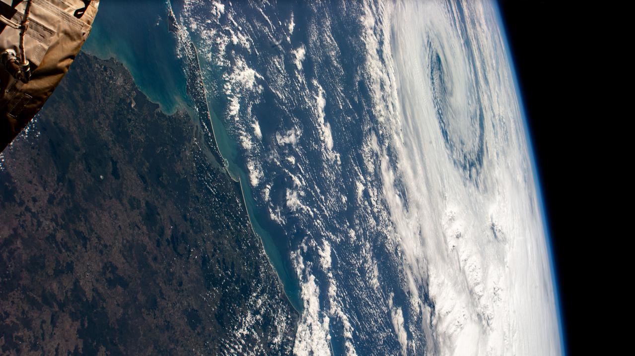
iss072e695137 (March 3, 2025) --- Cyclone Alfred nears the coast of Queensland, Australia, on the Coral Sea in this photograph from the International Space Station as it orbited 265 miles above the island continent.
iss073e0285020 (July 14, 2025) --- Perth, Australia, with a population of about 2.3 million on the island continent's Indian Ocean coast, is pictured from the International Space Station as it orbited 263 miles above. Credit: Roscosmos
iss072e862085 (March 26, 2025) --- The hot and arid desert coast of Angola on the Atlantic Ocean is pictured from the International Space Station as it orbited 261 miles above the Central African nation.

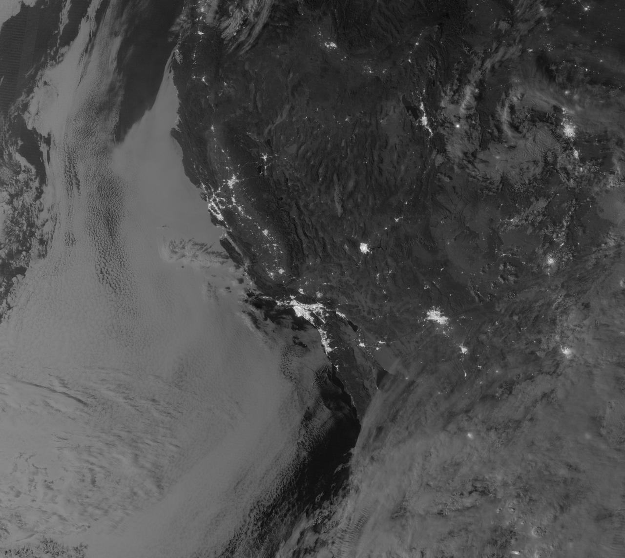
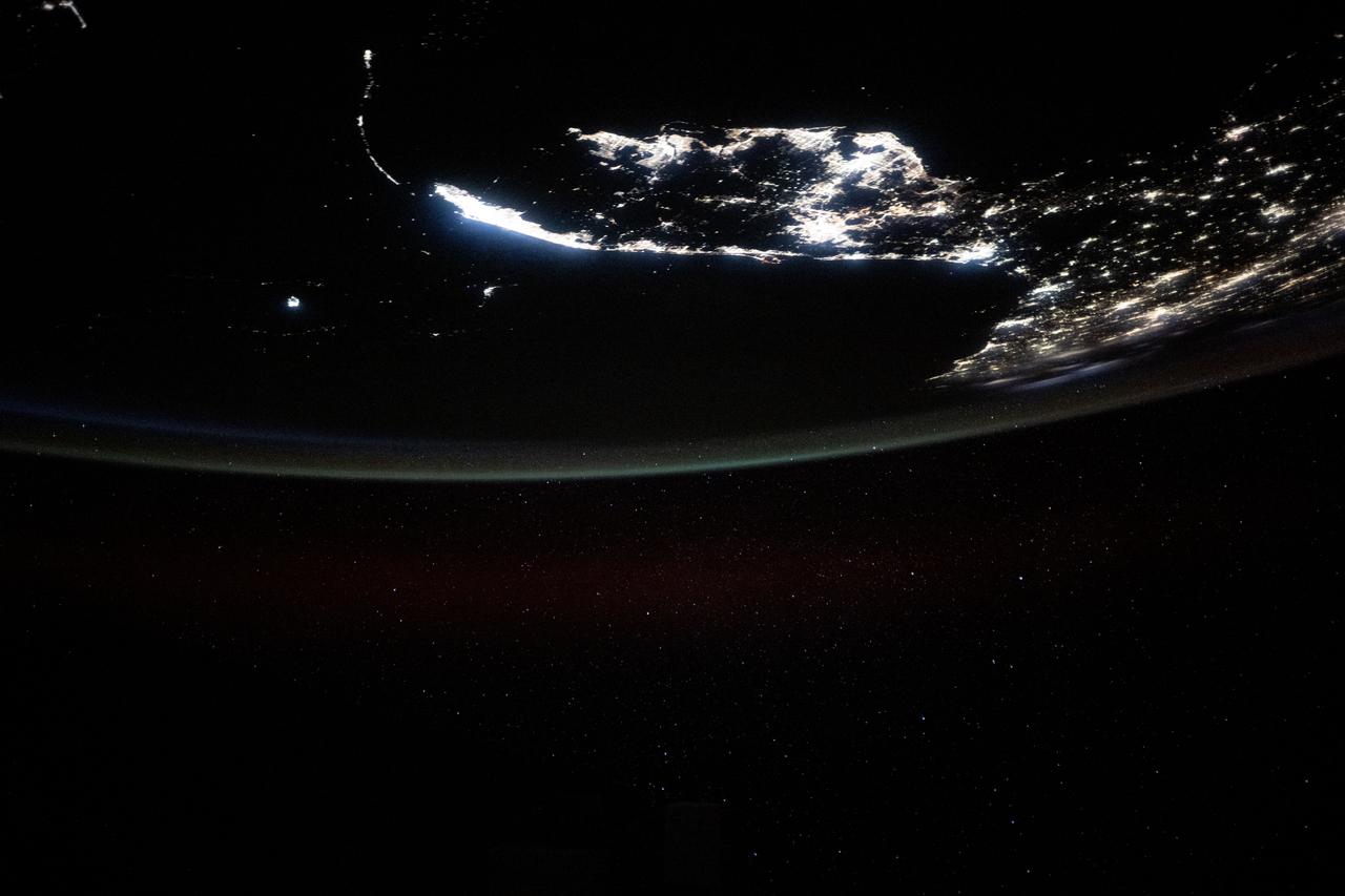
iss072e435710 (Dec. 28, 2024) --- The Taiwan Strait separates China's southeast coast from Taiwan in this photograph from the International Space Station as it orbited 257 miles above Asia. From bottom center toward the upper left, the city lights from Quanzhuo to Shanghai light up the Chinese coast. Toward right center, the city lights from Taipei to Tainan (bottom right) illuminate Taiwan's western coast. This frame was captured approximately 12:51 a.m. local time.
AS6-02-1485 (4 April 1968) --- View of the east coast of the United States as photographed from the National Aeronautics and Space Administration's unmanned Apollo 6 (Spacecraft 020/Saturn 502) space mission. This photograph was taken during a pass over Georgia, between Savannah and Brunswick. Altitude of the spacecraft was 100 nautical miles. Numerous jet aircraft contrails can be seen over the Atlantic Ocean. Sun glint on the surface of the ocean permits oceanographers to determine conditions of the water. This photograph was taken April 4, 1968, three hours and 14 minutes after liftoff, using Eastman Kodak SO-121 high resolution aerial Ektachrome film (exposure setting f/5.6 at 1/500 second), in a J. A. Maurer model 220G camera.
GOES 12 satellite image showing the US east coast on March 22, 2010 6:45 AM EDT. <b><a href="http://goes.gsfc.nasa.gov/" rel="nofollow">Credit: NOAA/NASA GOES Project</a><b> <b><a href="http://www.nasa.gov/centers/goddard/home/index.html" rel="nofollow">NASA Goddard Space Flight Center</a></b> is home to the nation's largest organization of combined scientists, engineers and technologists that build spacecraft, instruments and new technology to study the Earth, the sun, our solar system, and the universe. <b>Follow us on <a href="http://twitter.com/NASA_GoddardPix" rel="nofollow">Twitter</a></b> <b>Join us on <a href="http://www.facebook.com/pages/Greenbelt-MD/NASA-Goddard/395013845897?ref=tsd" rel="nofollow">Facebook</a></b></b></b>
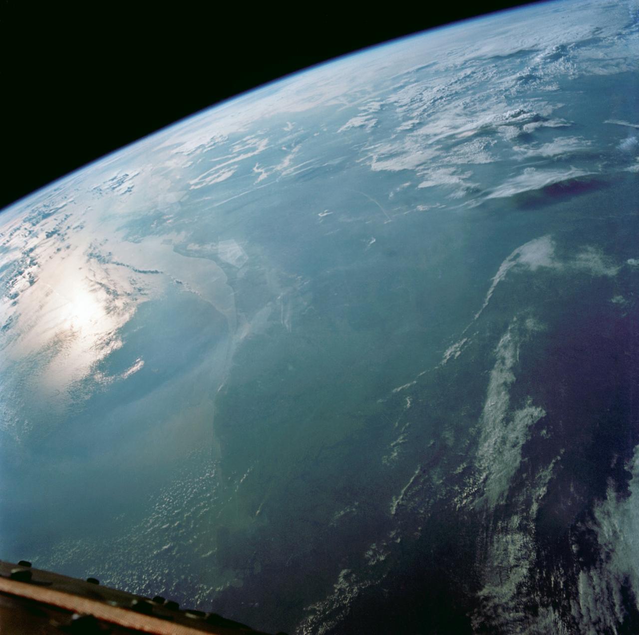
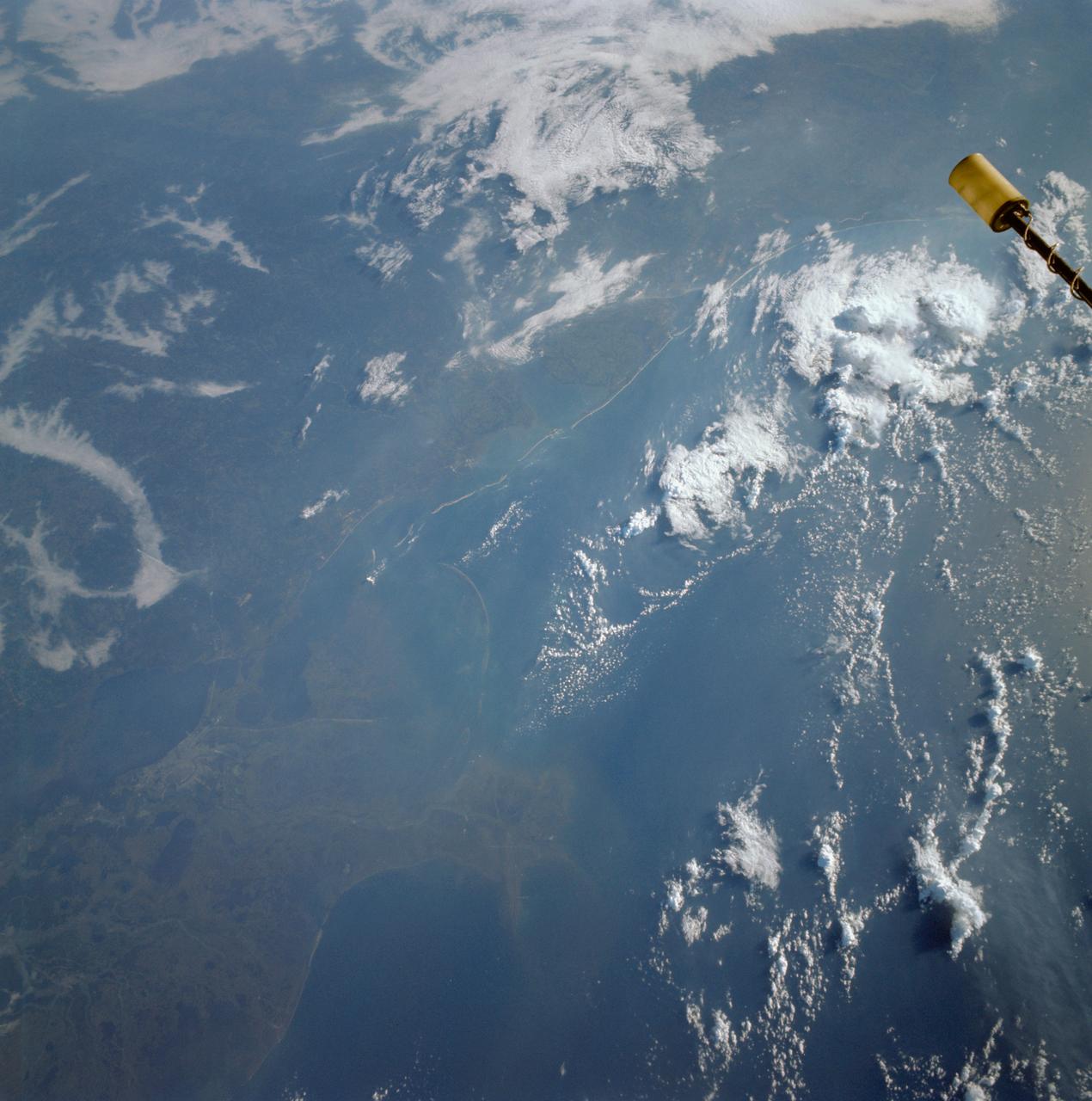
SL4-137-3721 (February 1974) --- Plankton blooms and color variations in the Falkland Current east of the Argentina coast in the South Atlantic Ocean as seen from the Skylab space station in Earth orbit. This picture was taken by one of the Skylab 4 crewmen using a hand-held 70mm Hasselblad camera. The Skylab 4 crew made many observations of the Falkland Current and related phenomena. This current flows north and northeastward along the Argentine coast near 40 degree south latitude where it meets the Brazil Current and the two swing eastward. The study of such photographs as this one can add significantly to our knowledge and understanding of the oceans. Photo credit: NASA

iss073e1047001 (Nov. 2, 2025) --- Tripoli, Libya—a city founded approximately 2,700 years ago on the Mediterranean Sea coast—is pictured at about 11:10 p.m. local time from the International Space Station as it orbited 259 miles above the African nation. The city’s modern, cool white lights reflect a major transition to LED and solar-powered LED lighting, part of efforts to modernize urban design, enhance safety, and support tourism infrastructure.
iss073e0686732 (Aug. 30, 2025) --- The atmospheric glow blankets southern Europe and the northwestern Mediterranean coast, outlined by city lights. At left, the Po Valley urban corridor in Italy shines with the metropolitan areas of Milan and Turin and their surrounding suburbs. This photograph was taken at approximately 1:39 a.m. local time from the International Space Station as it orbited 261 miles above Earth.
This view shows the west coast of the United States and Mexico (32.5N, 118.0W) and gives an indication of the range of view from orbital altitude. The visual range of this particular scene is from Skammon's Lagoon on Baja to the northern tip of California's Central Valley and Sierra Nevada, a range of over 15 degrees of latitude. Coastal fog drapes over southern California and northern Baja California. White Sands, New Mexico is at far right center.
Phytoplankton bloom in the Great Australian Bight captured by the MODIS instrument on the Aqua satellite on December 30, 2013 at 6:05 UTC. The Great Australian Bight is a large bight, or open bay, off the central and western portions of the southern coastline of mainland Australia. Credit: NASA/GSFC/Jeff Schmaltz/MODIS Land Rapid Response Team <b><a href="http://www.nasa.gov/audience/formedia/features/MP_Photo_Guidelines.html" rel="nofollow">NASA image use policy.</a></b> <b><a href="http://www.nasa.gov/centers/goddard/home/index.html" rel="nofollow">NASA Goddard Space Flight Center</a></b> enables NASA’s mission through four scientific endeavors: Earth Science, Heliophysics, Solar System Exploration, and Astrophysics. Goddard plays a leading role in NASA’s accomplishments by contributing compelling scientific knowledge to advance the Agency’s mission. <b>Follow us on <a href="http://twitter.com/NASA_GoddardPix" rel="nofollow">Twitter</a></b> <b>Like us on <a href="http://www.facebook.com/pages/Greenbelt-MD/NASA-Goddard/395013845897?ref=tsd" rel="nofollow">Facebook</a></b> <b>Find us on <a href="http://instagram.com/nasagoddard?vm=grid" rel="nofollow">Instagram</a></b>
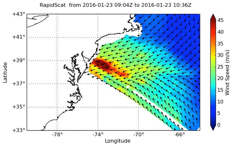
NASA's ISS-RapidScat instrument on the International Space Station provided a look at the strong winds that led to coastal flooding in southern New Jersey during the historic winter storm that blanketed much of the U.S. East Coast, starting Jan. 23, 2016. At 2 a.m. PST on Jan. 23, RapidScat showed sustained winds as strong as 45 meters per second (100 mph/162 kilometers per hour) along the coast of southern New Jersey. Many beachfront towns in this region were flooded as winds pushed ocean waters inland. The town of Cape May, New Jersey, reported a flood level of 8.98 feet (2.74 meters) -- the highest on record. This image shows ocean winds near the surface off the U.S. East Coast, from the hook of Cape Cod at top center to the South Carolina coastline at bottom left. Southern New Jersey and the northern edge of Delaware are directly in the path of the highest wind speeds. http://photojournal.jpl.nasa.gov/catalog/PIA20366
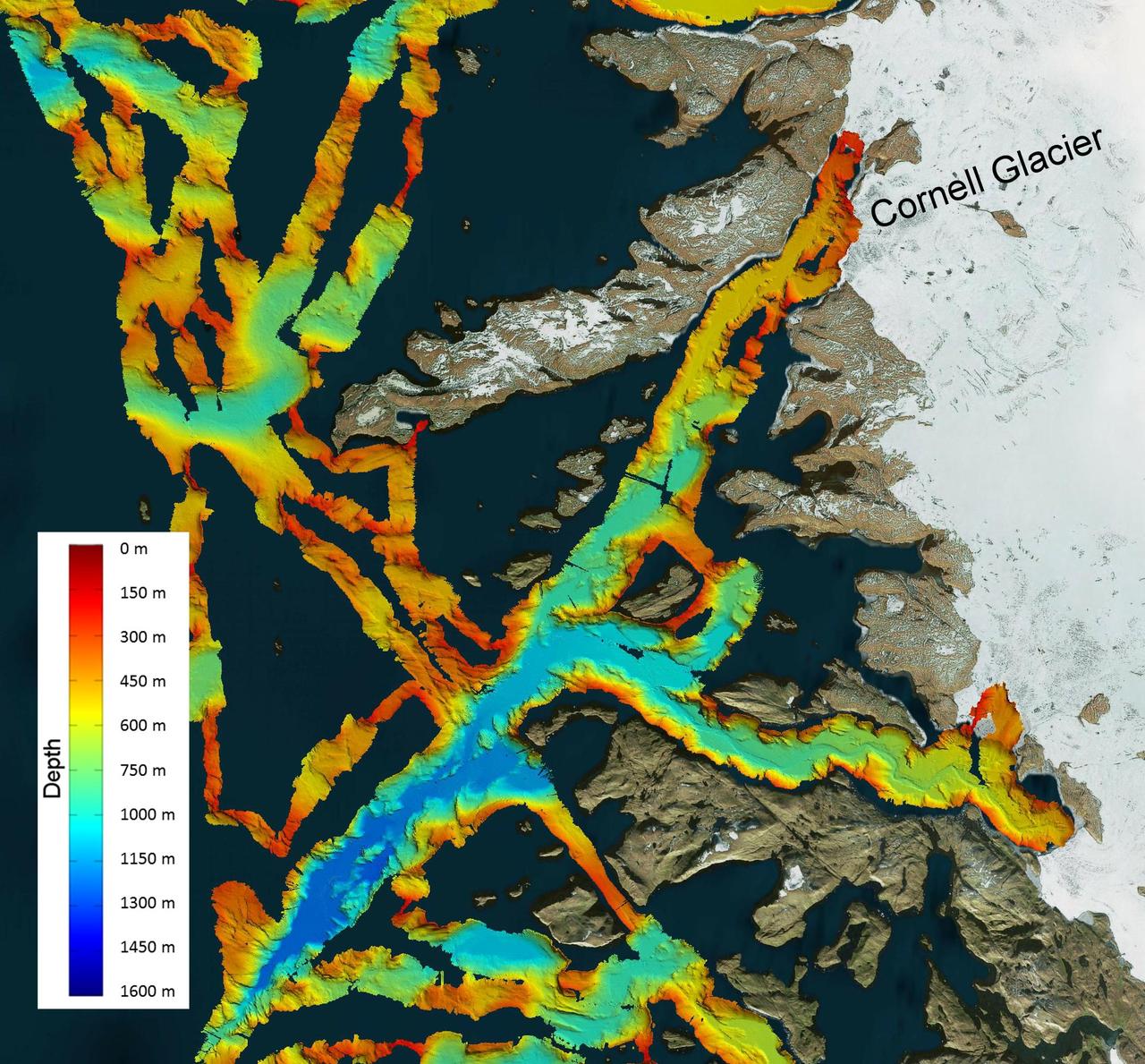
This image shows a region of the sea floor off the coast of northwest Greenland mapped as part of NASA Oceans Melting Greenland OMG mission. The data shown here will be used to understand the pathways by which warm water can reach glacier edges.
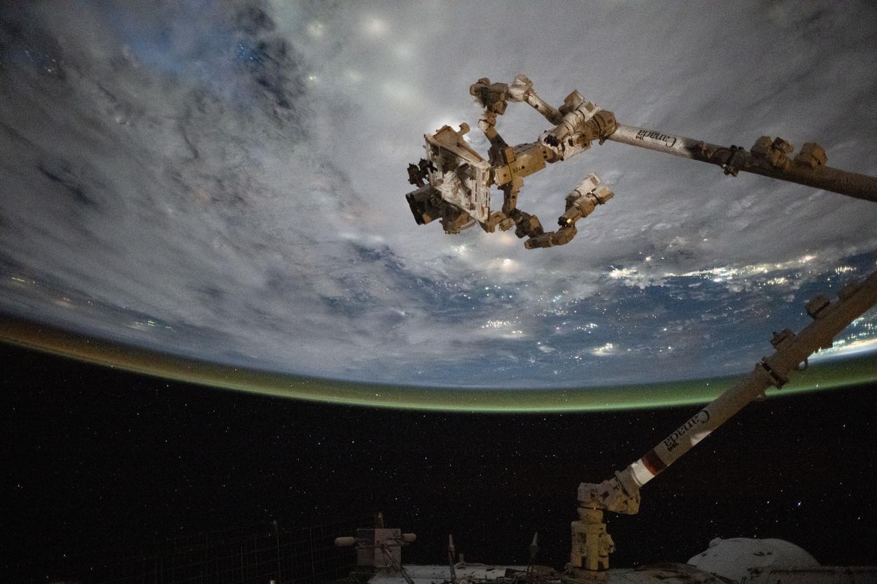
iss073e0695937 (Sept. 1, 2025) --- The Canadarm2 robotic arm with Dextre, its fine-tuned robotic hand attached, is pictured extending from the International Space Station as it orbited 258 miles above the coast of Cambodia on a cloudy Gulf of Thailand.
iss072e629084 (Feb. 14, 2025) --- The east coast of the United States from Massachussetts to Georgia, with the easily distinguishable Delaware Bay and Chesapeake Bay, contrasts with the gleaming Atlantic Ocean in this photograph from the International Space Station as it orbited 263 miles above North America.
iss073e0123876 (May 19, 2025) --- The Gulf of America coast lit by the city lights from Houston, Texas, (upper left) to the Florida peninsula and an atmospheric glow crowning Earth's atmosphere are pictured from the International Space Station as it orbited 260 miles above the Lone Star State.
iss073e0379903 (July 20, 2025) --- Japan's Chūbu region coast on the Sea of Japan, with the city of Joetsu on the far left and the cities of Asahi, Nyuzen, and Kurobe on the far right, is pictured from the International Space Station as it orbited 260 miles above the Asian island nation.
iss073e0134286 (June 2, 2025) --- The north central Vietnamese coast on the South China Sea, in between the cities of Thanh Hóa on the Nam River (left) and Vinh on the Cá River (right), is pictured from the International Space Station as it orbited 260 miles above Southeast Asia.

iss074e0312749 (Feb. 10, 2026) --- An icy Zaliv Terpeniya, translated as the Gulf of Patience, on the frozen southeastern coast of Russia’s Sakhalin Island is pictured from the International Space Station as it orbited 261 miles above the Sea of Okhotsk. Credit: NASA
iss072e399016 (Dec. 19, 2024) --- The city lights of Florida's southern Atlantic coast, with Miami at the bottom and West Palm Beach at the top, are pictured about 4:07 a.m. local time from the International Space Station as it orbited 256 miles above.
iss073e0253315 (June 24, 2025) --- St. Petersburg (upper left) and Tampa (center), cities on Florida's Tampa Bay coast, are pictured at approximately 3:07 a.m. local time from the International Space Station as it orbited 260 miles above.
iss074e0459458 (April 9, 2026) --- Vitoria, Brazil, with a metropolitan population of about 1.8 million, lights up the eastern Atlantic coast of the South American nation in this photograph taken at 3:59 a.m. local time from the International Space Station as it orbited 262 miles above. Credit: NASA/Chris Williams

iss074e0543247 (May 2, 2026) --- Chennai, on India's southern coast along the Bay of Bengal and with a metropolitan population of about 8.7 million, shines with white LED streetlights in this photograph taken at approximately 9:13 p.m. local time from the International Space Station. Credit: NASA/Chris Williams
STS030-152-066 (4-8 May 1989) --- The upper Texas and Louisiana Gulf Coast area was clearly represented in this large format frame photographed by the astronaut crew of the Earth-orbiting Space Shuttle Atlantis. The area covered stretches almost 300 miles from Aransas Pass, Texas to Cameron, Louisiana. The sharp detail of both the natural and cultural features noted throughout the scene is especially evident in the Houston area, where highways, major streets, airport runways and even some neighborhood lanes are easily seen. Other major areas seen are Austin, San Antonio and the Golden Triangle. An Aero Linhof camera was used to expose the frame.
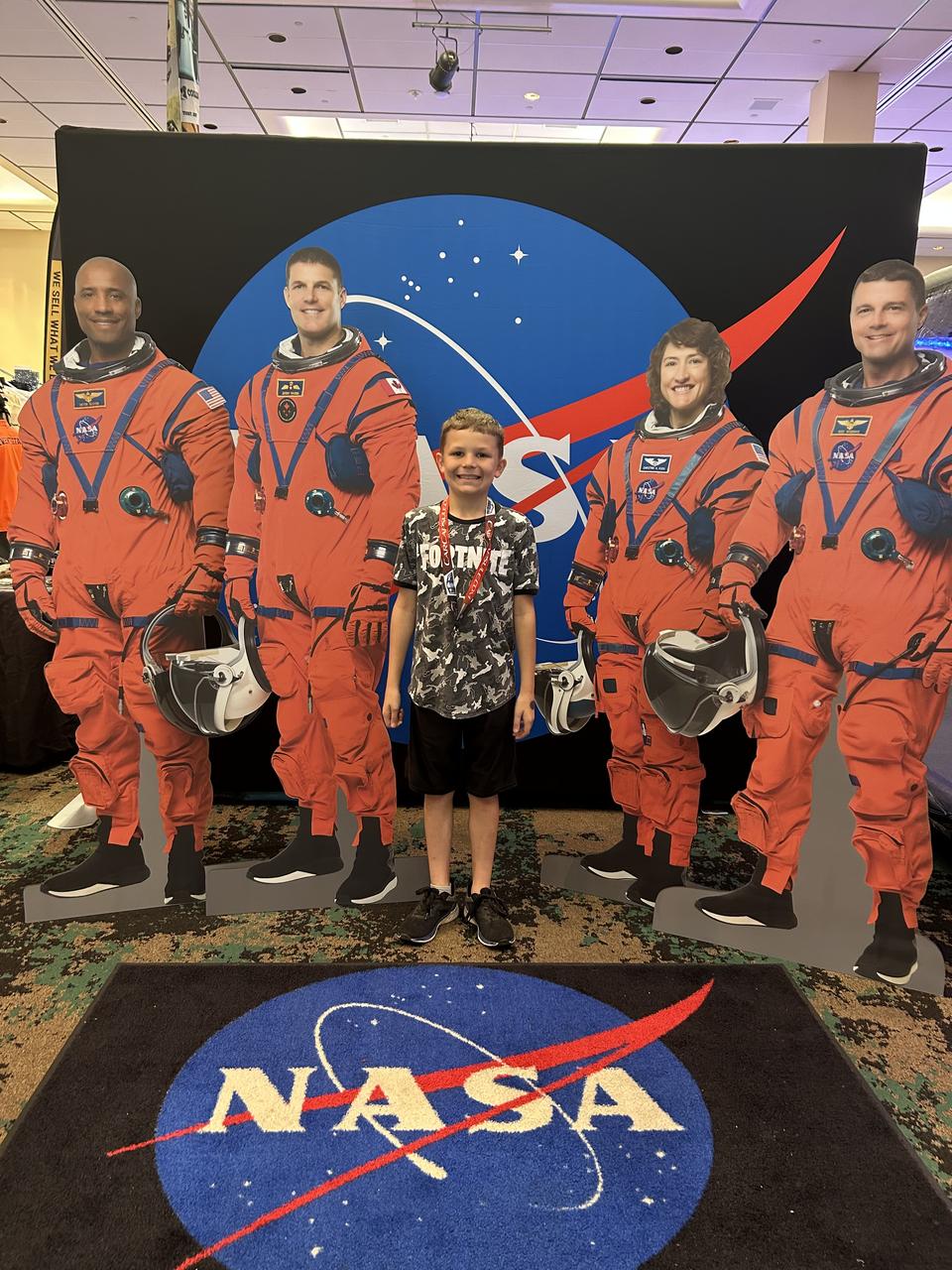
NASA Stennis representatives inspire the Artemis Generation and share NASA Stennis’ rich history of propulsion testing with attendees from over 37 U.S. states and Canada during the 28th Annual Cruisin’ the Coast car show along the Mississippi Gulf Coast Oct. 10-12. NASA provided a virtual reality space experience, and participants were welcomed to the exhibit by life size cardboard cutouts of the Artemis II crew. Artemis II, targeted for 2025, is the first crewed test of the SLS (Space Launch System) rocket and Orion spacecraft, which will carry NASA astronauts Reid Wiseman (commander), Victor Glover (pilot), and Christina Koch (mission specialist), and Canadian Space Agency astronaut Jeremy Hansen (mission specialist) around the Moon. All RS-25 engines that help power NASA’s SLS rocket are tested and proven flightworthy at NASA Stennis prior to use on Artemis missions.
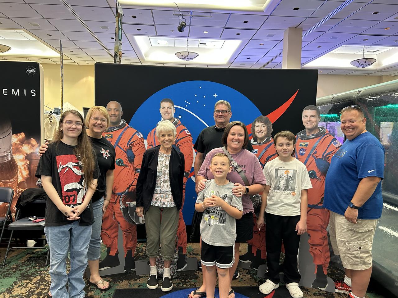
NASA Stennis representatives inspire the Artemis Generation and share NASA Stennis’ rich history of propulsion testing with attendees from over 37 U.S. states and Canada during the 28th Annual Cruisin’ the Coast car show along the Mississippi Gulf Coast Oct. 10-12. NASA provided a virtual reality space experience, and participants were welcomed to the exhibit by life size cardboard cutouts of the Artemis II crew. Artemis II, targeted for 2025, is the first crewed test of the SLS (Space Launch System) rocket and Orion spacecraft, which will carry NASA astronauts Reid Wiseman (commander), Victor Glover (pilot), and Christina Koch (mission specialist), and Canadian Space Agency astronaut Jeremy Hansen (mission specialist) around the Moon. All RS-25 engines that help power NASA’s SLS rocket are tested and proven flightworthy at NASA Stennis prior to use on Artemis missions.

NASA Stennis representatives inspire the Artemis Generation and share NASA Stennis’ rich history of propulsion testing with attendees from over 37 U.S. states and Canada during the 28th Annual Cruisin’ the Coast car show along the Mississippi Gulf Coast Oct. 10-12. NASA provided a virtual reality space experience, and participants were welcomed to the exhibit by life size cardboard cutouts of the Artemis II crew. Artemis II, targeted for 2025, is the first crewed test of the SLS (Space Launch System) rocket and Orion spacecraft, which will carry NASA astronauts Reid Wiseman (commander), Victor Glover (pilot), and Christina Koch (mission specialist), and Canadian Space Agency astronaut Jeremy Hansen (mission specialist) around the Moon. All RS-25 engines that help power NASA’s SLS rocket are tested and proven flightworthy at NASA Stennis prior to use on Artemis missions.