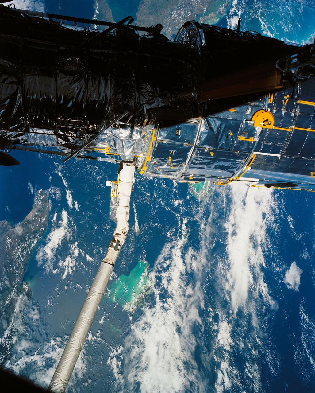
A close up deploy view of the Hubble Space Telescope on the end of the space shuttle remote manipulator system (RMS) with Eastern Cuba, (20.0N, 74.0W) seen on the left side of the telescope and northern Haiti seen on the right side of the telescope. The light colored blue feature in the water north of Haiti is the shallow waters of the Caicos Bank.
S65-63826 (5 Dec. 1965) --- Oriente Province, eastern end of Cuba, as seen from the National Aeronautics and Space Administration's Gemini-7 spacecraft during its 14th revolution of Earth. Guantanamo Bay is in the center of the picture on the southern coast of Cuba. Santiago de Cuba is located about one inch from the bottom edge of the picture, or about three inches westward down the coast from Guantanamo. This photograph was taken with a modified 70mm Hasselblad camera, using Eastman Kodak, Ektachrome MS (S.O. 217) color film. Photo credit: NASA
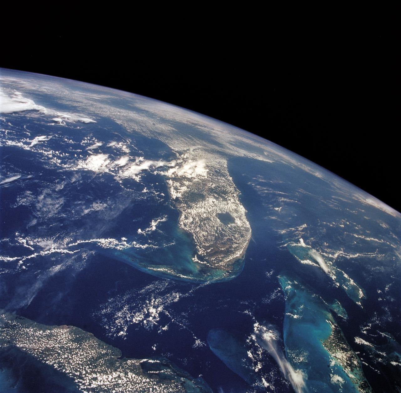
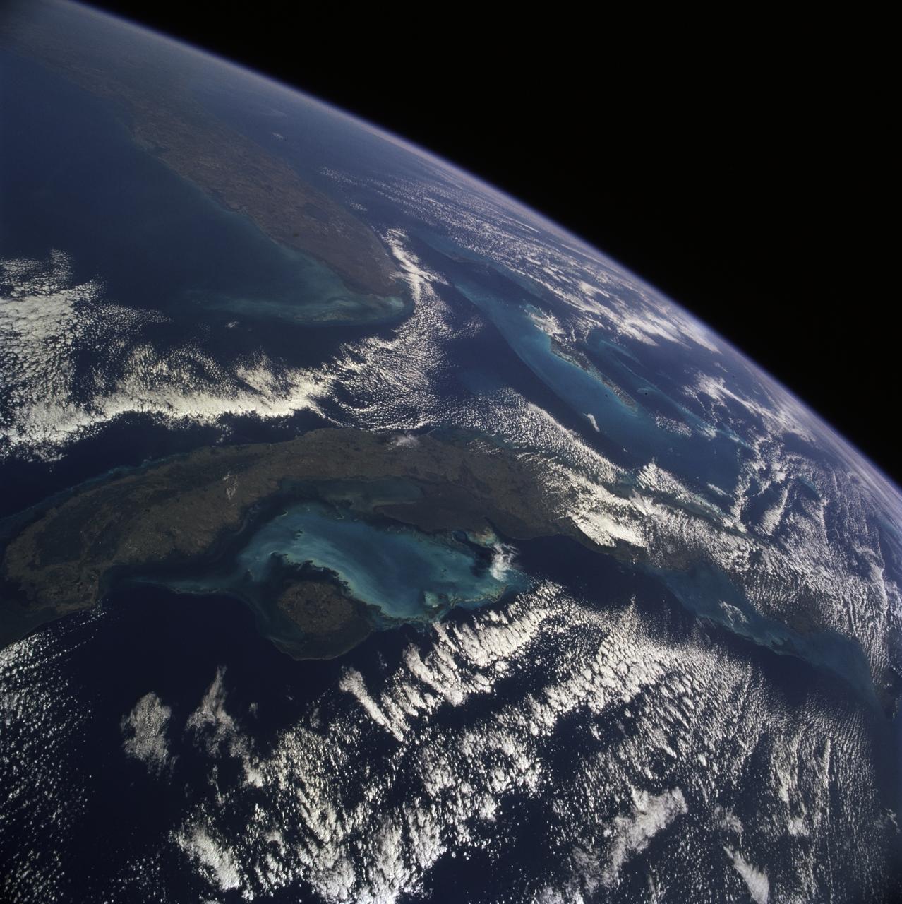
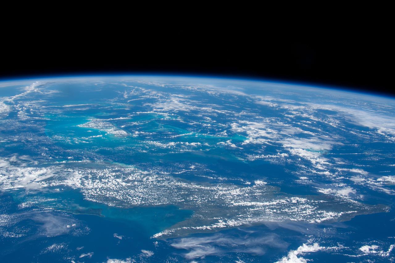
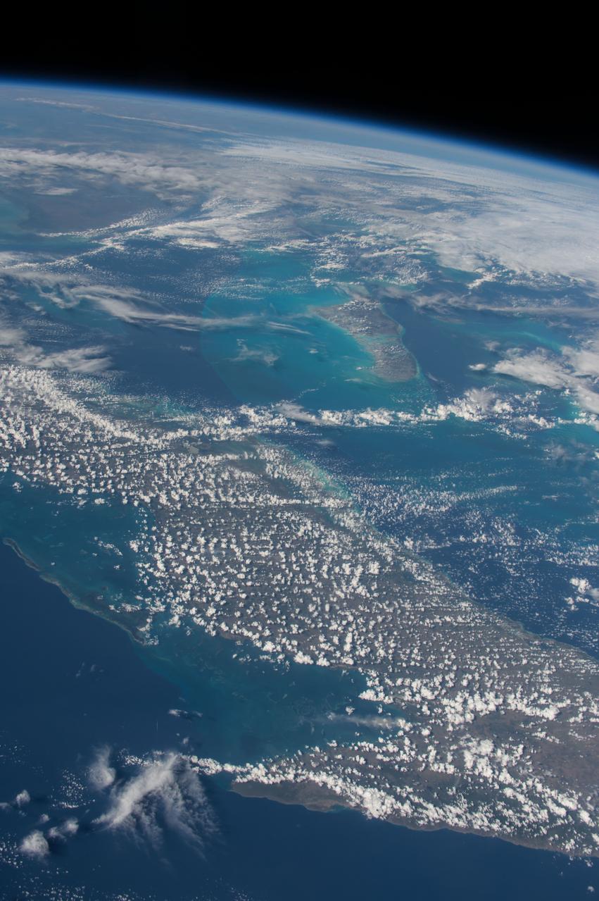
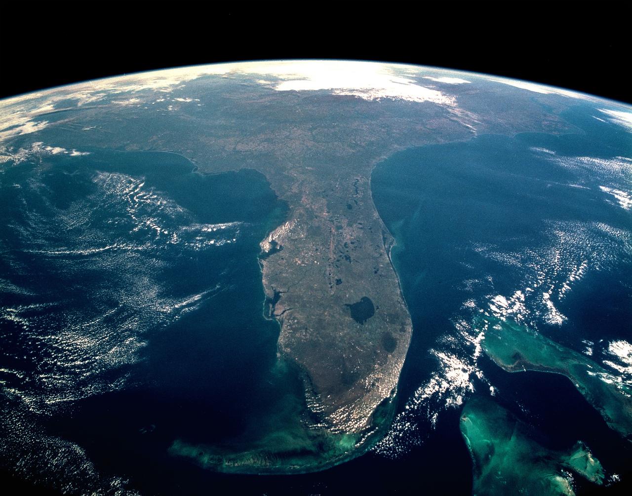
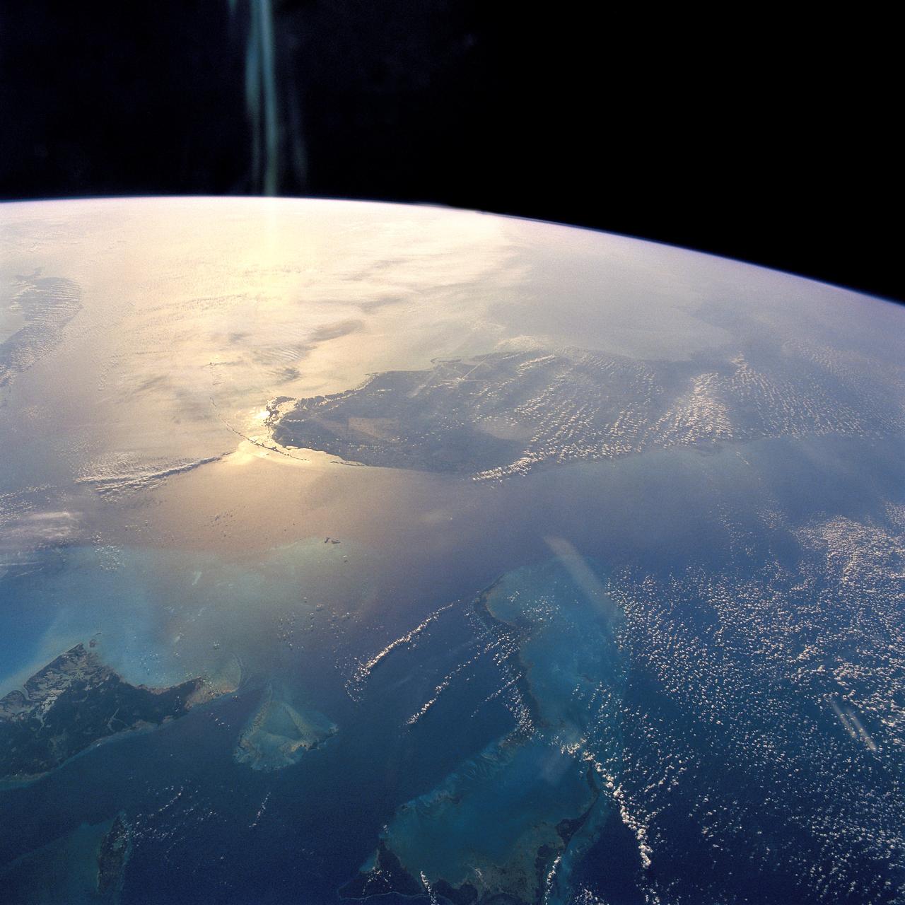
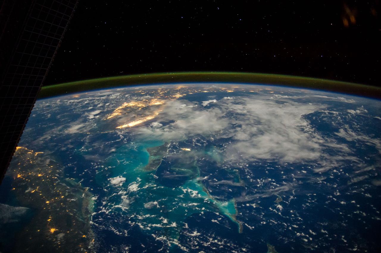
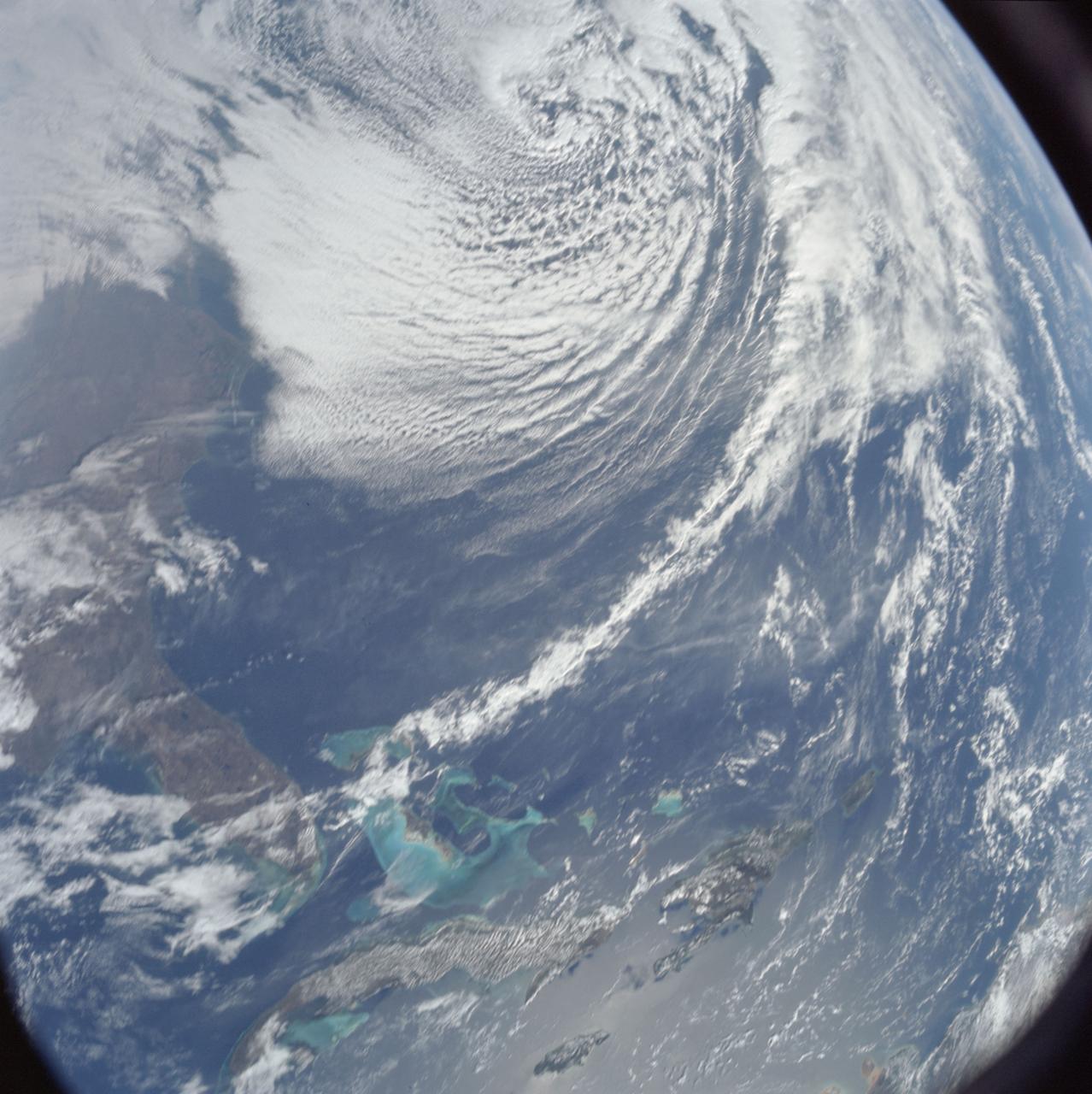
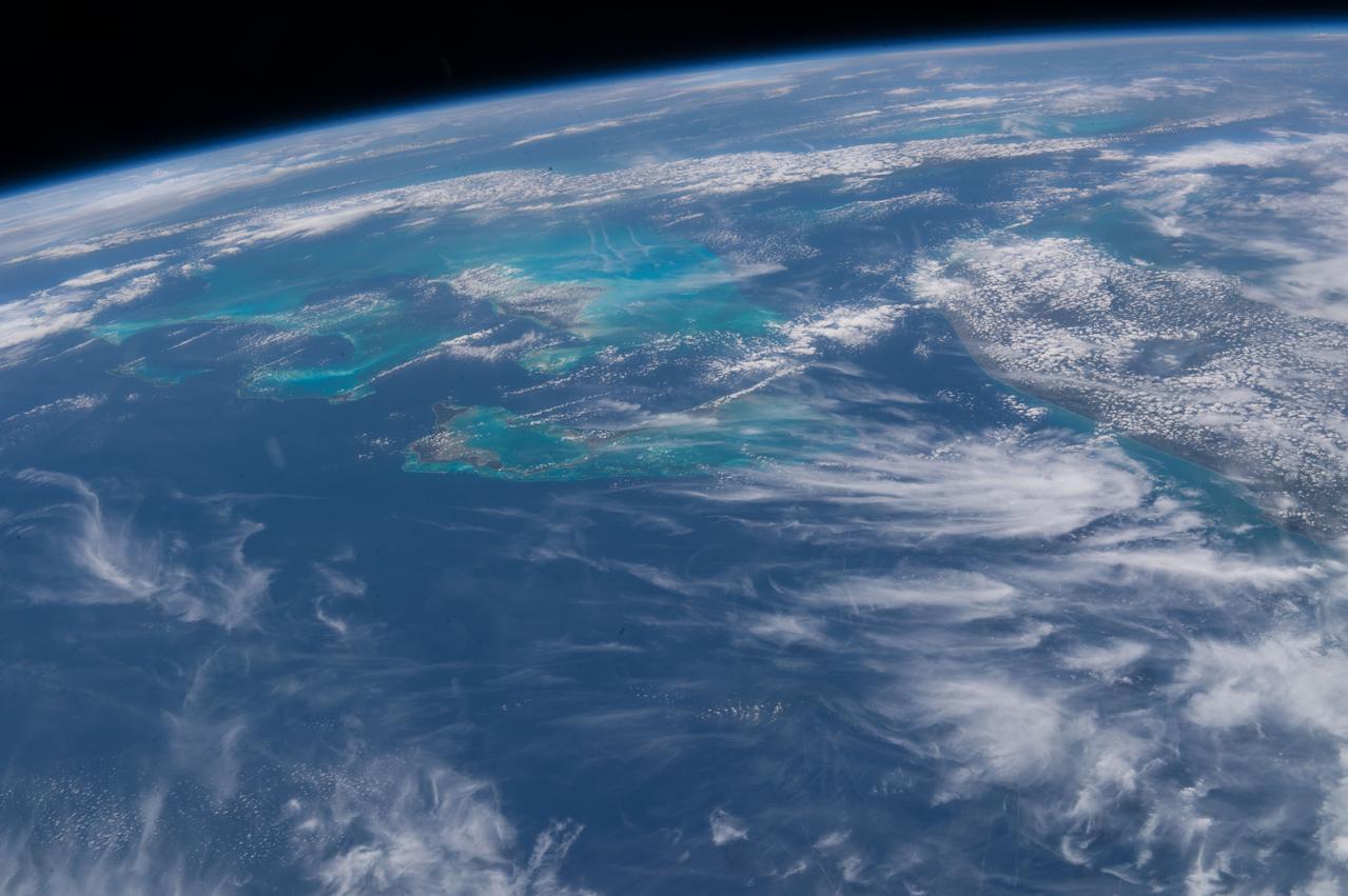
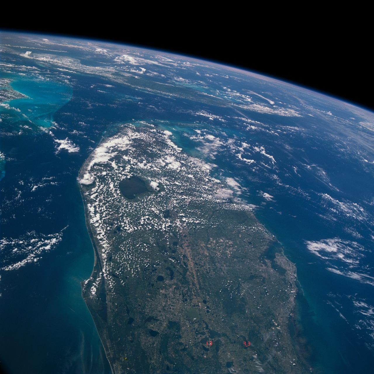
This unique photo offers a view of the Florida peninsula, western Bahamas, north central Cuba and the deep blue waters of the Gulf Stream, that hugs the east coast of Florida (27.0N, 82.0W). In addition to being an excellent photograph for showing the geographical relationships between the variety of landforms in this scene, the typical effect of the land-sea breeze is very much in evidence as few clouds over water, cumulus build up over landmass.
S66-63418 (13 Nov. 1966) --- Florida (south half), Bahamas Islands (Andros-Grand Bahamas-Bimini), and Cuba, looking south as seen from Gemini-12 spacecraft on its 15th revolution of Earth. Photo credit: NASA

iss072e420661 (Jan. 1, 2025) --- New Year's Day dawns on Cuba as the sunlight gleams off its Atlantic and Caribbean coasts in this photograph from the International Space Station as it orbited 260 miles above the Gulf of Mexico.
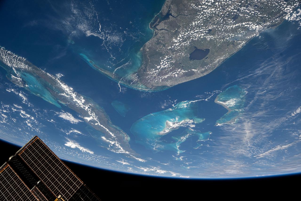
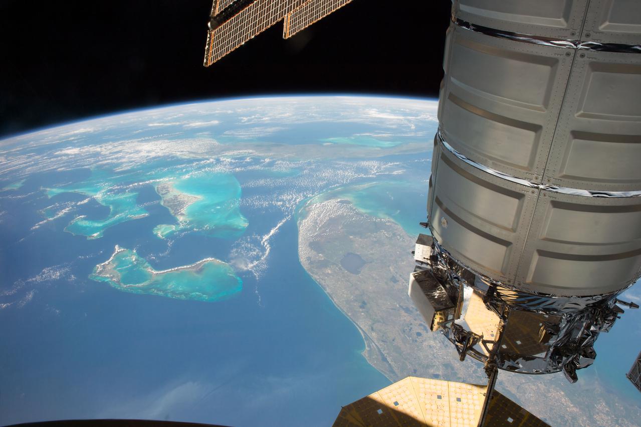
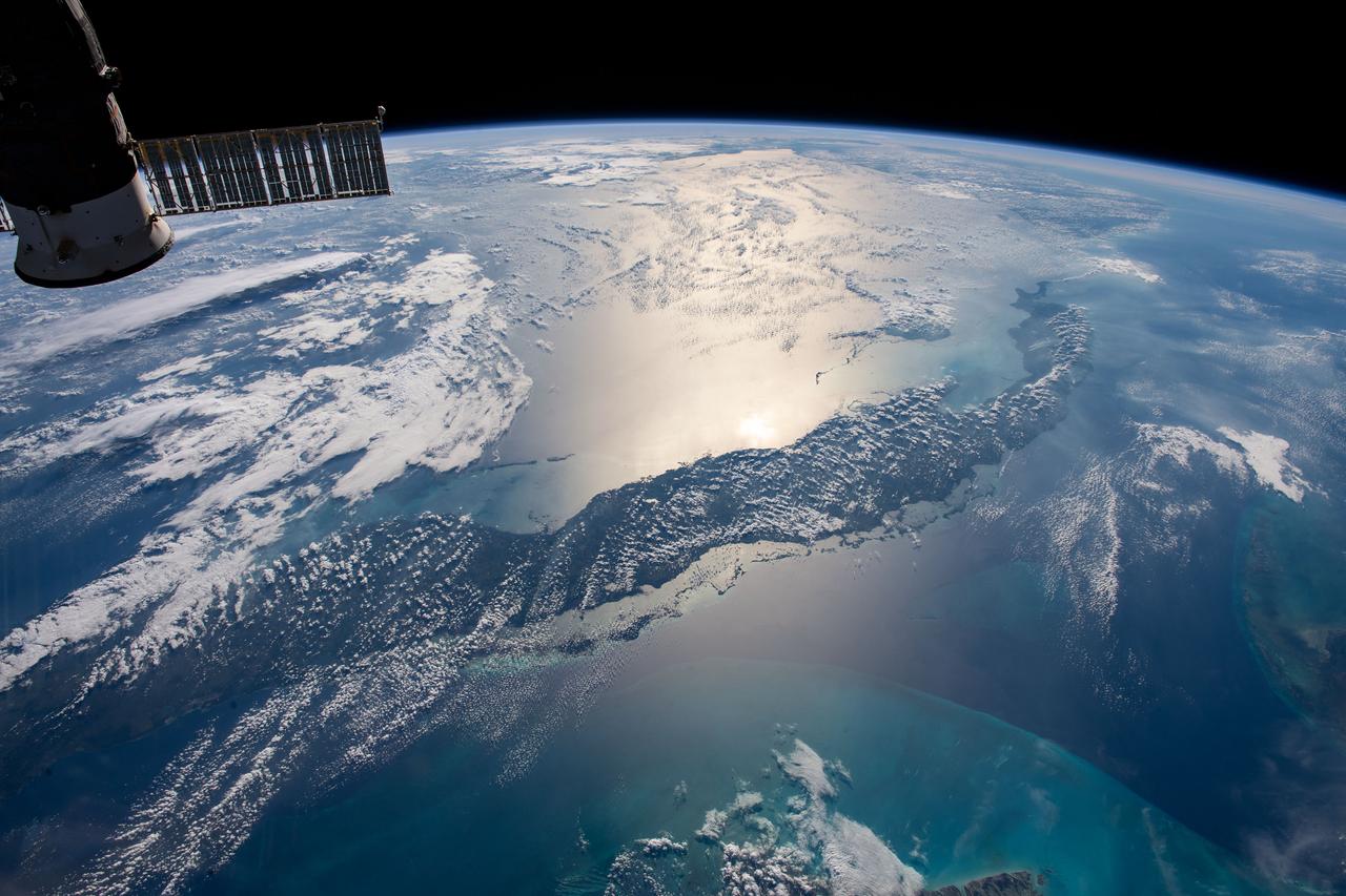
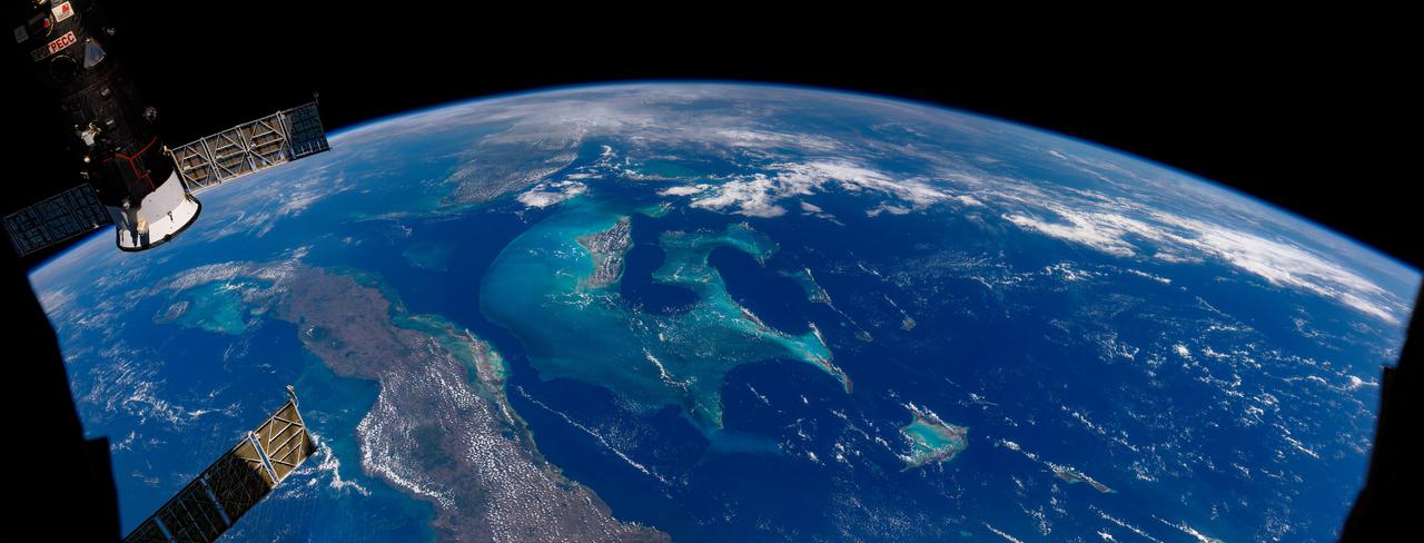
iss073e0134179 (May 20, 2025) --- South Florida, the Bahamas, and Cuba are prominently featured in this photograph from the International Space Station as it orbited 261 miles above the Sunshine State.
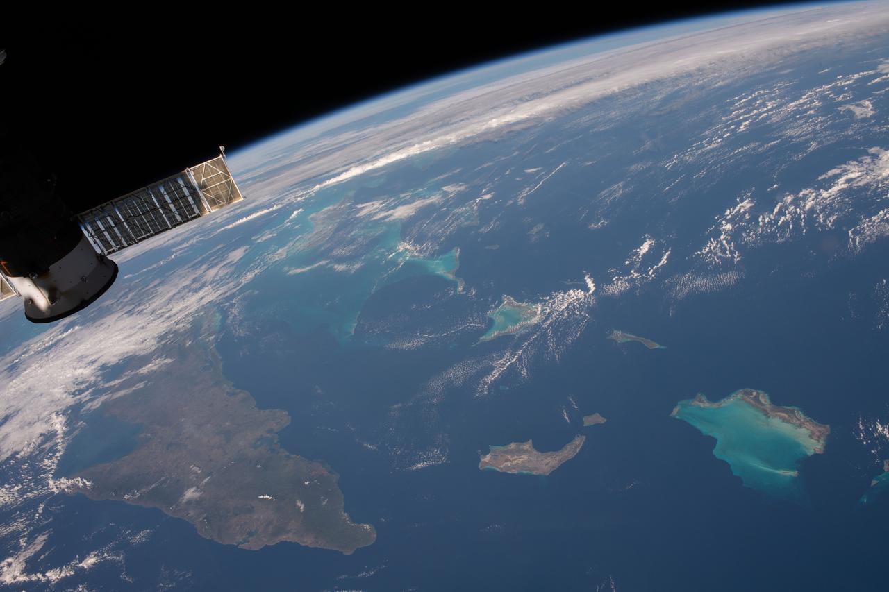
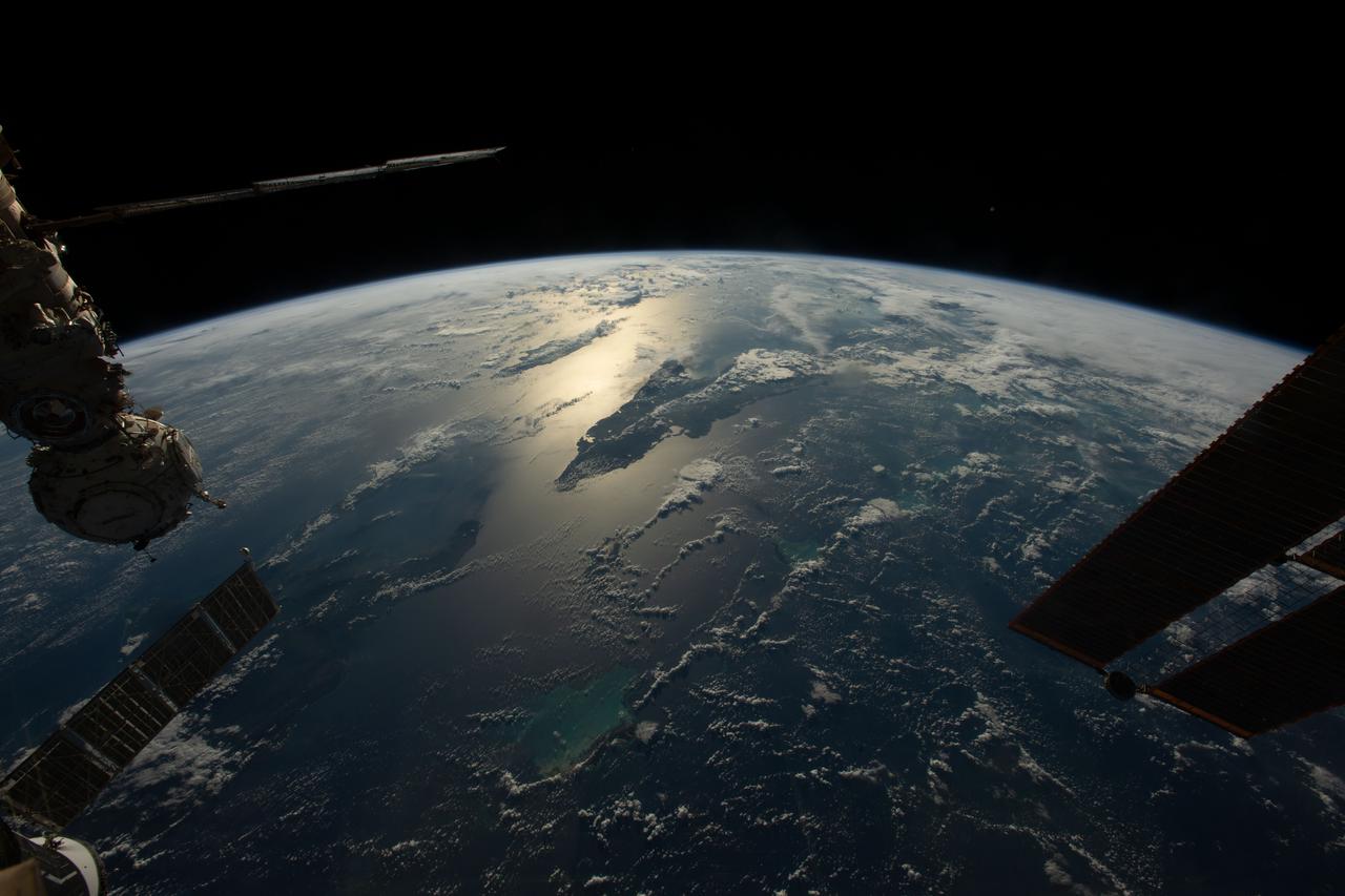
iss058e002206 (Jan. 5, 2018) --- Portions of Cuba, The Bahamas and the Turks and Caicos Islands are viewed from the International Space Station as the orbital complex flew 252 miles above the Atlantic Ocean. At left, is the aft end of the Progress 70 resupply ship from Russia attached to the Pirs docking compartment.
iss072e1000000 (April 11, 2025) --- This is the one-millionth image taken during the Expedition 72 mission aboard the International Space Station. The clouds covering the island nation of Cuba hide its capital and largest city Havana (far left) on the Florida Strait. To the south are the marshlands and forests of Cuba's Zapata Swamp that leads to the Caribbean Sea. NASA astronaut and Expedition 72 Flight Engineer Nichole Ayers took this photograph from the International Space Station as it orbited 261 miles above the Bahamas.
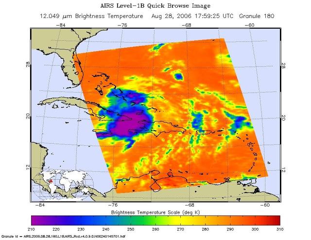
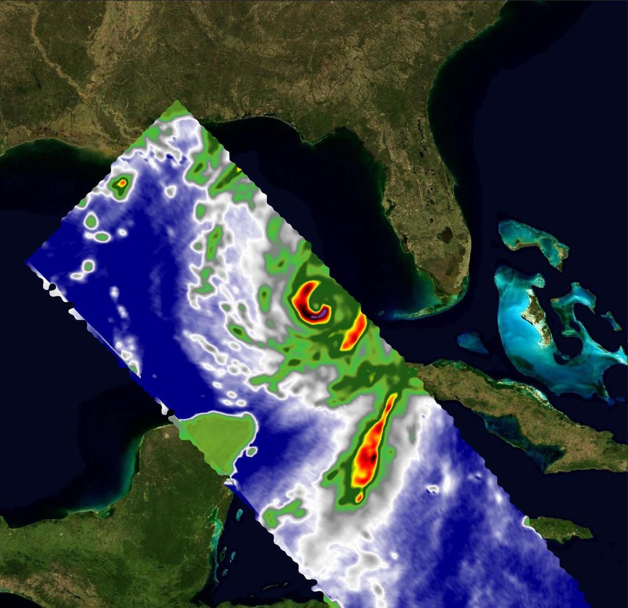
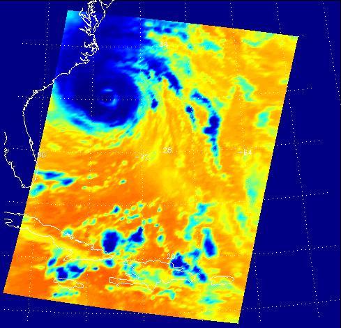
This infrared image shows Tropical Storm Ernesto over Cuba, from the Atmospheric Infrared Sounder AIRS on NASA Aqua satellite in August, 2006. Because infrared radiation does not penetrate through clouds, AIRS infrared images show either the temperature of the cloud tops or the surface of the Earth in cloud-free regions. The lowest temperatures (in purple) are associated with high, cold cloud tops that make up the top of the storm. In cloud-free areas the AIRS instrument will receive the infrared radiation from the surface of the Earth, resulting in the warmest temperatures (orange/red). http://photojournal.jpl.nasa.gov/catalog/PIA00510
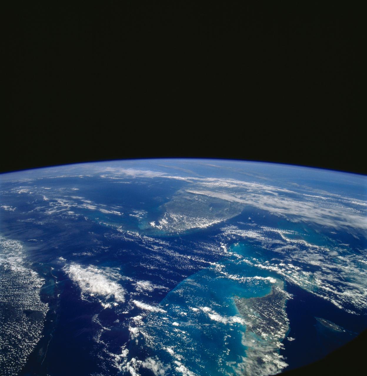
STS058-107-046 (18 Oct-1 Nov 1993) --- Clouds streak across central Florida in this striking photograph which includes the Florida Peninsula, Andros Island of the northern Bahamas and Cuba (lower left). The light blue, shallow bank of the Bahamas contrast with the deeper blue waters of the Florida strait. The city of Miami is obscured by clouds, but one can see the Florida Keys stretching off to the left. Much of the rest of the southeast coast is barely visible under haze.
These views of Hurricane Isidore were acquired by NASA Terra satellite on September 20, 2002 as it flooded western Cuba and swept westward to Mexico Yucatan Peninsula.
iss055e005471 (March 25, 2018) --- This view of Cuba looks from east to west and reaches the cities of Santiago de Cuba on its west coast and Havana on its east coast. The sun's glint is reflected off the Caribbean Sea on Cuba's southern coast.
This image shows JPL Multi-angle Imaging SpectroRadiometer instrument onboard NASA Terra satellite on Sunday, Nov. 8, 2009 as it passed over Hurricane Ida while situated between western Cuba and the Yucatan Peninsula.
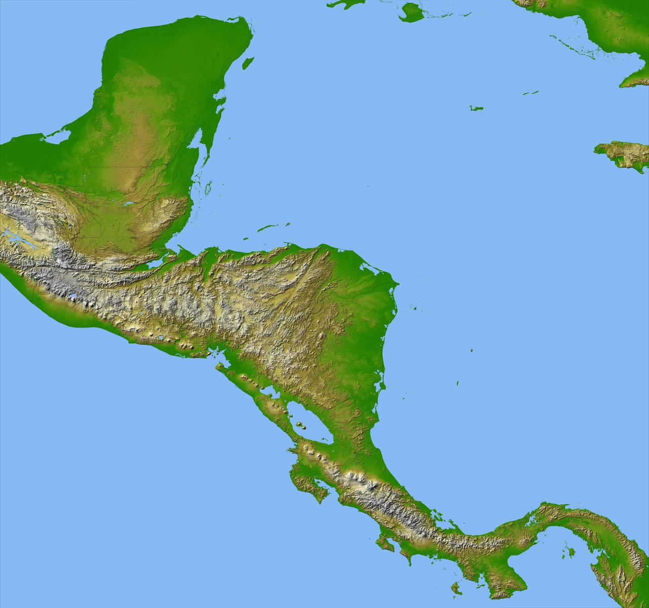
Panama, Costa Rica, Nicaragua, El Salvador, Honduras, Guatemala, Belize, southern Mexico and parts of Cuba and Jamaica are all seen in this image from NASA Shuttle Radar Topography Mission.
STS081-711-009 (12-22 Jan. 1997) --- As photographed with a 70mm handheld camera from the Earth-orbiting Space Shuttle Atlantis, this image provides a northeastward panorama of the Florida peninsula, the northern Bahamas and Cuba as well as a synoptic view of the northern Caribbean region. Lake Okeechobee and the urban region around Miami are the two key visual points in Florida. The turquoise shallow water platforms around the Florida Keys, the Bahamas, and south of Cuba contrast with the deep blue color of the deeper channels which separate Florida from Cuba and the Bahamas. Offshore breezes keep the coastal areas clear of clouds.
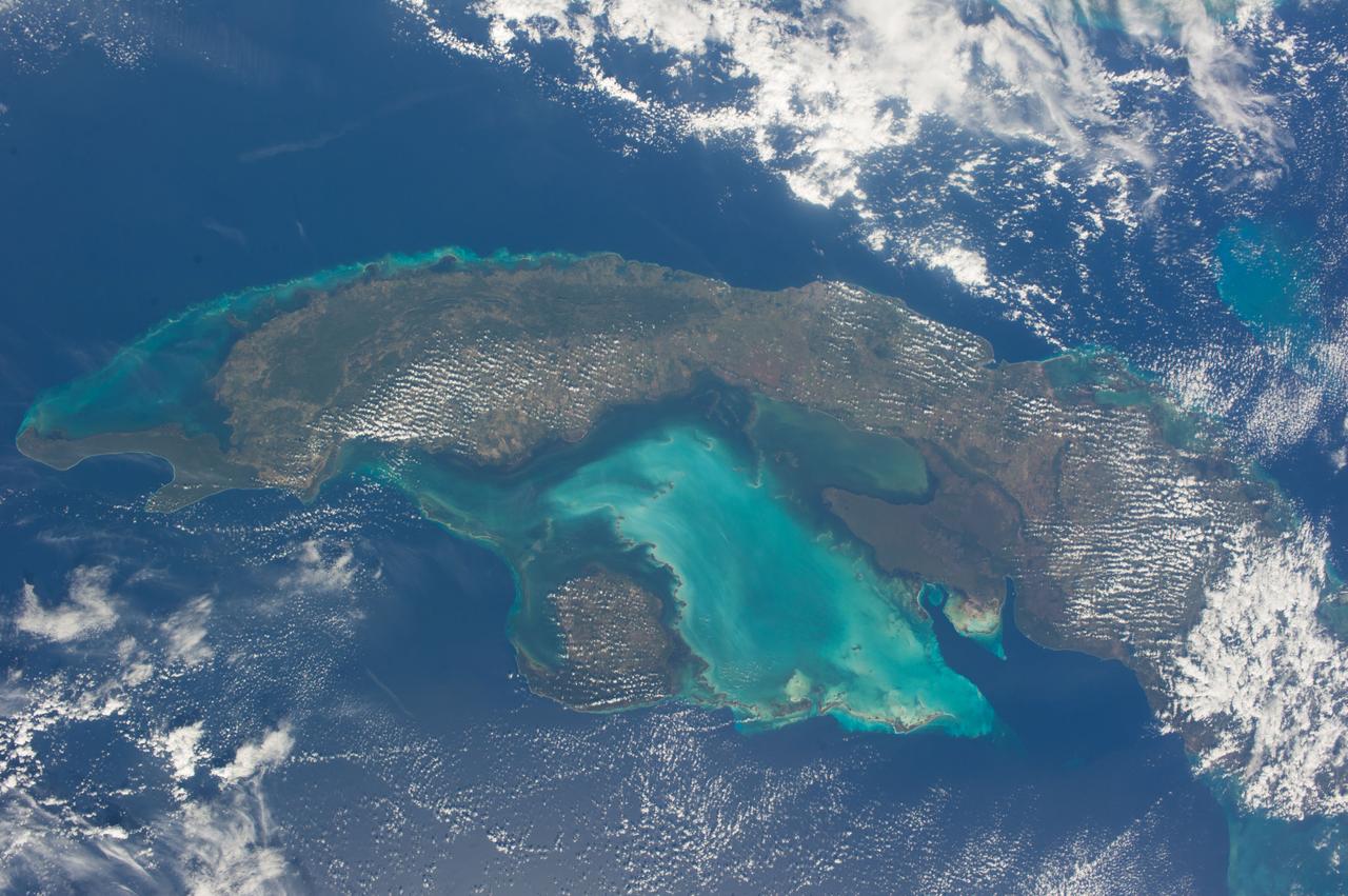
ISS038-E-021397 (24 Dec. 2013) --- The Caribbean country of Cuba is pictured in this nadir image, photographed by one of the Expedition 38 crew members aboard the International Space Station. (Note: North is at the top of the picture.) Cuba is an archipelago of islands in the northern Caribbean Sea at the confluence with the Gulf of Mexico and the Atlantic Ocean. In the southeast, the dark coastal area is home to the Sierra Maestra mountains. It is the highest mountain range on the island, with Pico Turquino reaching nearly 2000 meters. On the central southern coast of the island is the Sierra Del Escambray mountain range, including the 1160 meter-high Pico San Juan, Cuba's second highest peak.
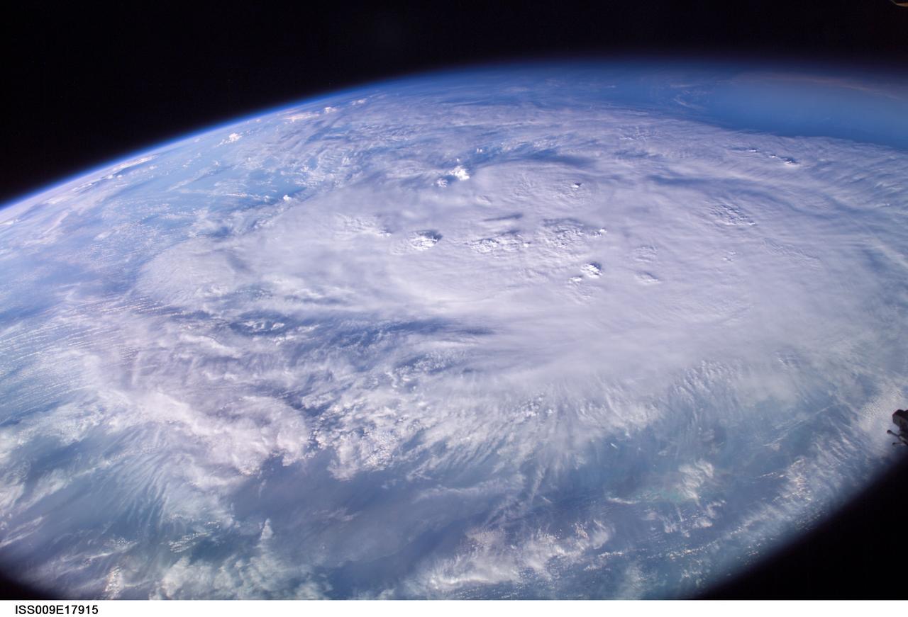
ISS009-E-17915 (12 August 2004) --- This is an early morning view (6:29 a.m., CDT) from the International Space Station, which shows Hurricane Charley centered south of western Cuba over the Cayman Islands in the northwest Caribbean Sea. At the time of this image the storm was reported to be near 19.2N 80.5W with winds of 85 miles per hour as it moved northwest at 16 miles per hour. The north coast of Cuba is barely visible near the bottom of the image, which was taken by astronaut Mike Fincke looking to the south as the spacecraft flew on a track north of Cuba and the storm.
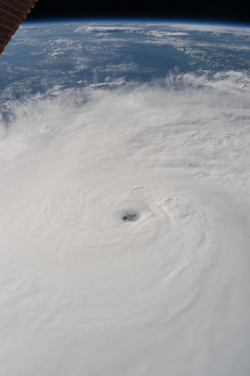
iss053e007343 (Sept. 8, 2017) --- Hurricane Irma was pictured as a Category 4 storm between Cuba and the Turks and Caicos Islands.

Earth observations taken by Expedition 38 crewmember. Crewmember indicates New Orleans and Cuba. Image was released by astronaut on Twitter.
Earth observation taken by the Expedition 39 crew aboard the ISS. Image was released by astronaut on Instagram and downlinked in folder: Bahamas and Cuba.
Earth observations taken by Expedition 38 crewmember. Crewmember indicates New Orleans and Cuba. Image was released by astronaut on Twitter.

iss065e023015 (May 6, 2021) --- Guantanamo Bay in Cuba is pictured from the International Space Station as it orbited 261 miles above the Caribbean Sea.
ISS044E059041 (08/21/2015) --- Hurricane Danny as seen from the International Space Station as it traversed the Caribbean Sea headed for Puerto Rico, the Dominican Republic and Cuba.
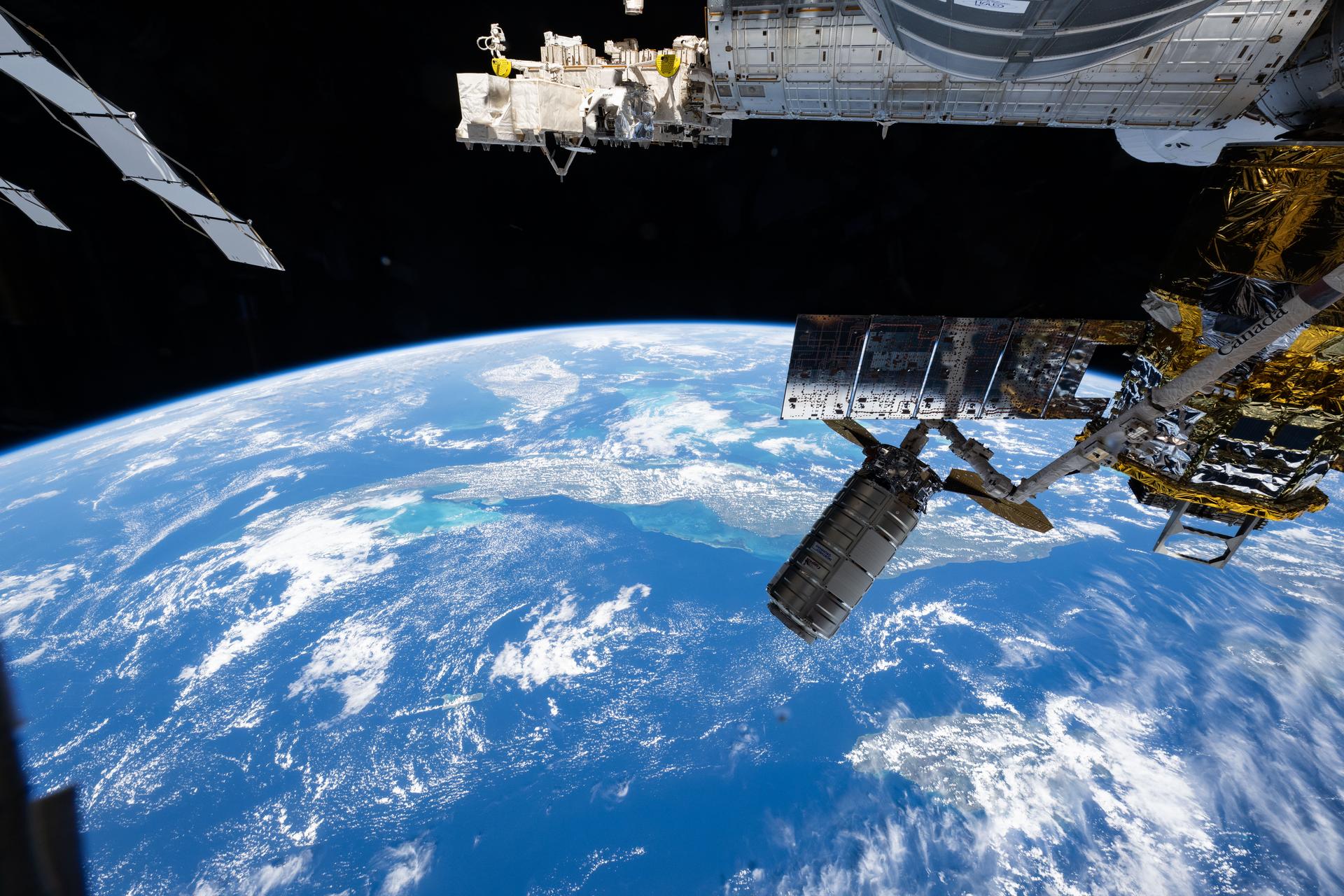
iss051e040813 (May 10, 2017) --- The Orbital ATK Cygnus cargo craft is pictured as the International Space Station orbits above the state of Florida, The Bahamas and the country of Cuba.
iss057e114400 (Dec. 7, 2018) --- The International Space Station flies 252 miles above the island nation of Cuba and the Gulf of Batabano in the Caribbean Sea.
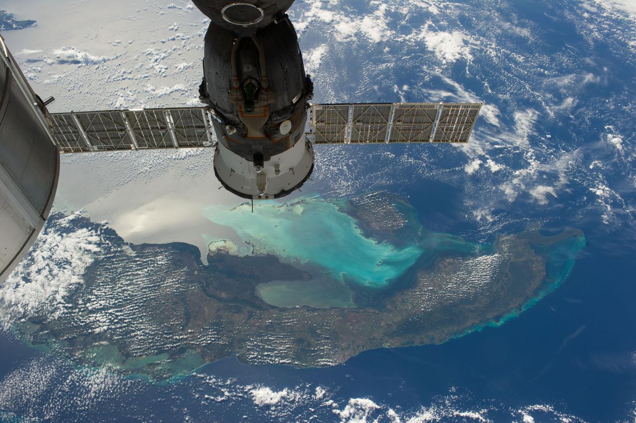
ISS038-E-021401 (24 Dec. 2013) --- The Caribbean country of Cuba is pictured in this high oblique image, photographed by one of the Expedition 38 crew members aboard the International Space Station. Andros ISland, part of the Bahamas, is Cuba is an archipelago of islands in the northern Caribbean Sea at the confluence with the Gulf of Mexico and the Atlantic Ocean. A Russian Soyuz spacecraft is docked to the station.
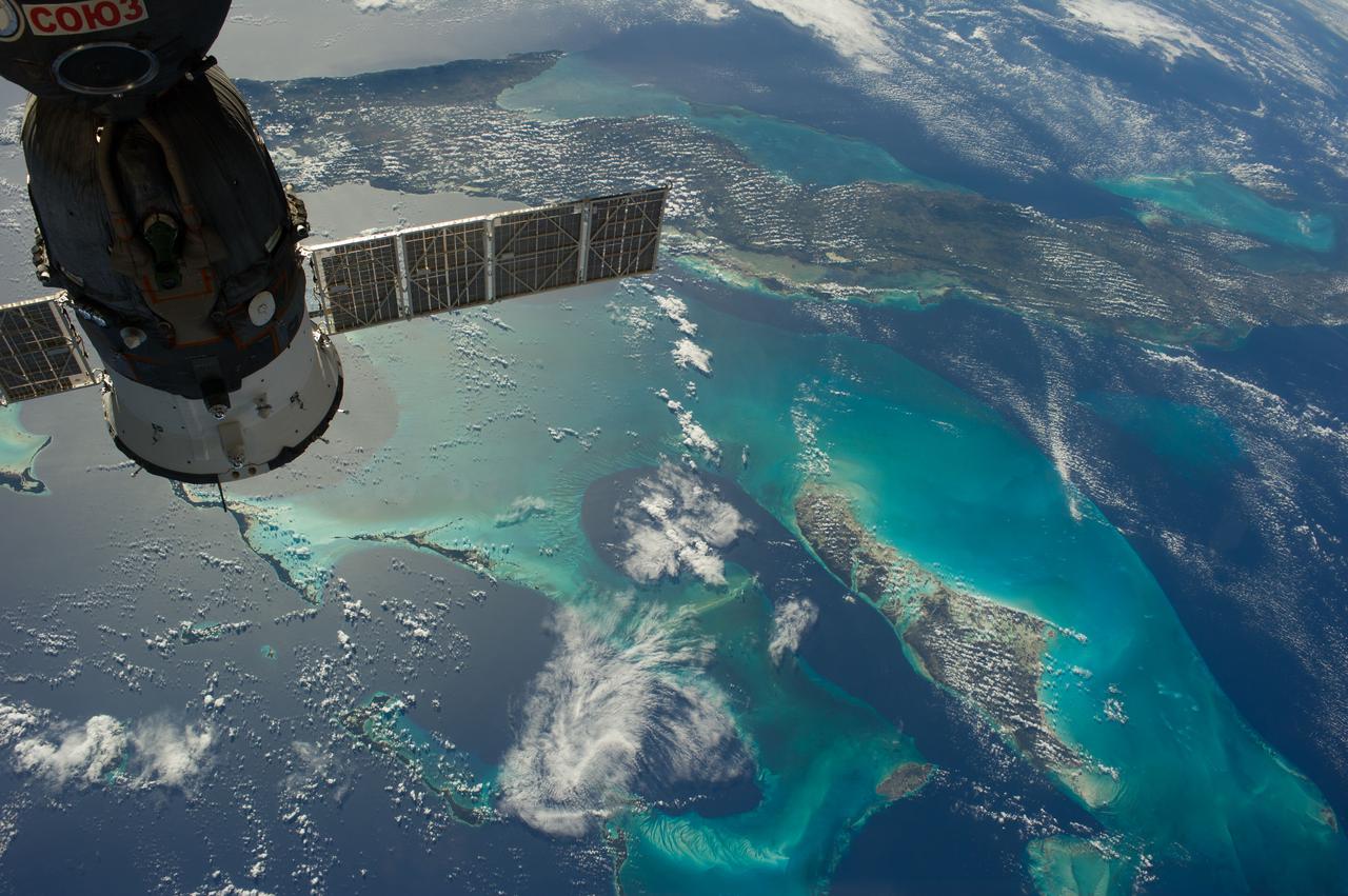
ISS038-E-019899 (23 Dec. 2013) --- The Caribbean country of Cuba appears at the top of this high oblique image, photographed by one of the Expedition 38 crew members aboard the International Space Station. Andros Island, part of the Bahamas, is in the bottom of the frame. Cuba is an archipelago of islands in the northern Caribbean Sea at the confluence with the Gulf of Mexico and the Atlantic Ocean. A Russian Soyuz spacecraft is docked to the station.
iss068e023212 (Nov. 20, 2022) --- The sun's glint beams across the Caribbean Sea and the Atlantic Ocean highlighting Cuba and Haiti in this photograph from the International Space Station as it orbited 258 miles above.
iss061e061245 (Nov. 26, 2019) --- The International Space Station orbits 255 miles above the Atlantic Ocean looking southwest over Cuba as the Sun's glint beams off the Caribbean Sea.
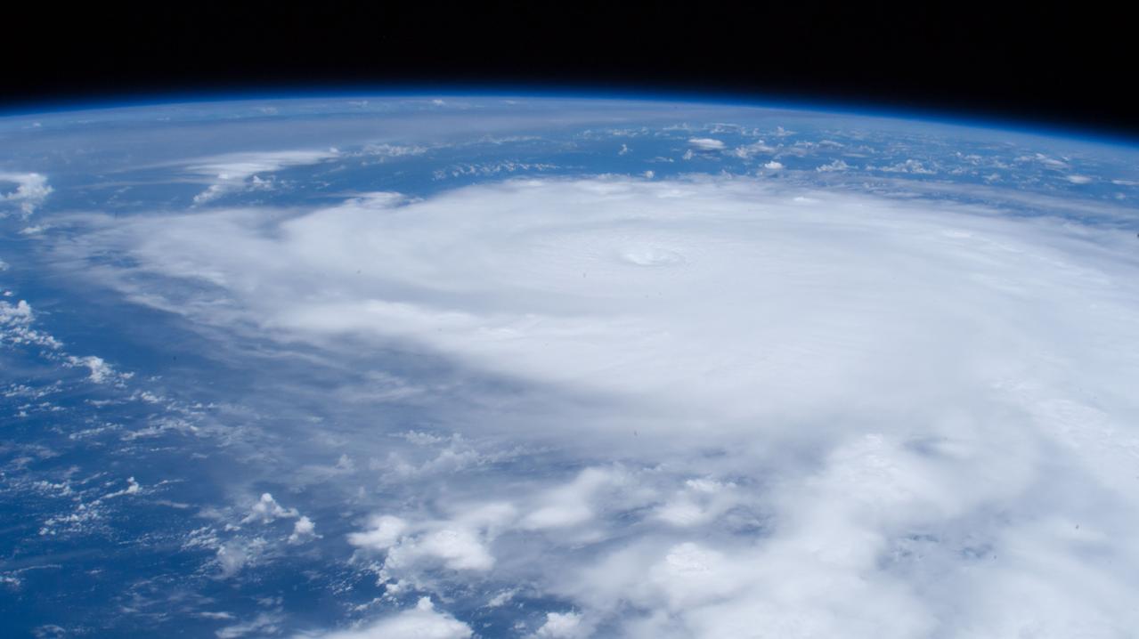
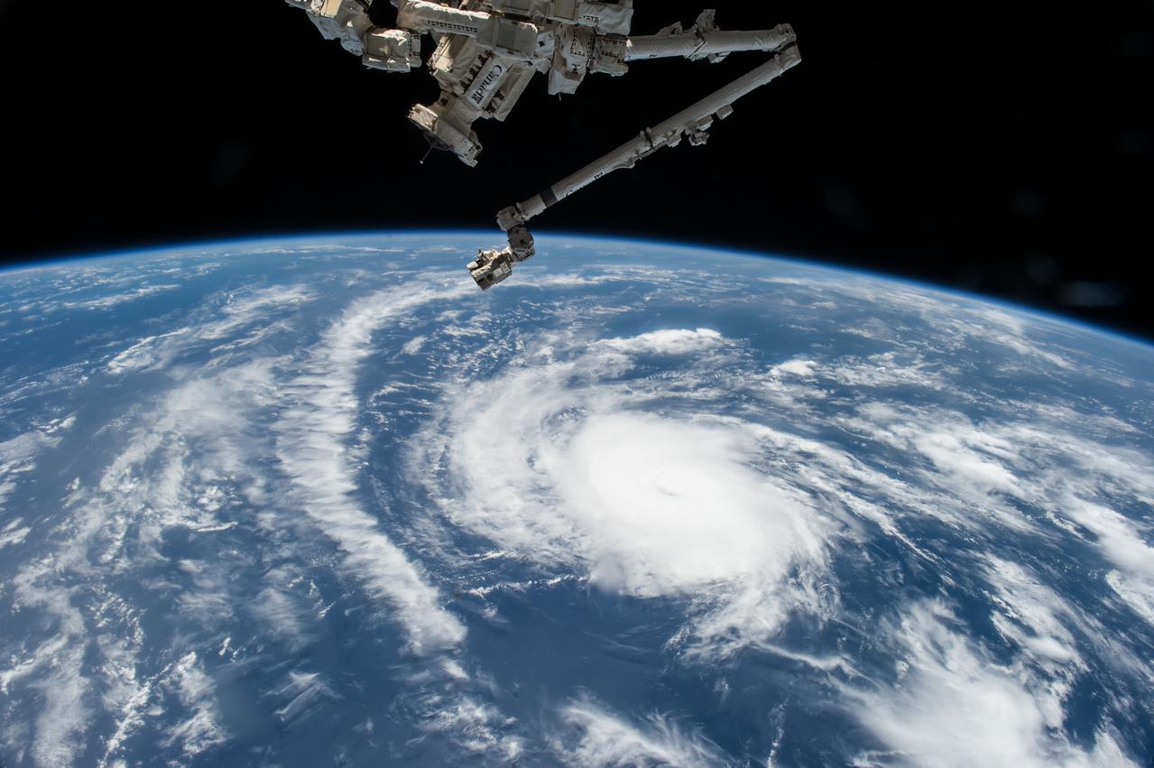
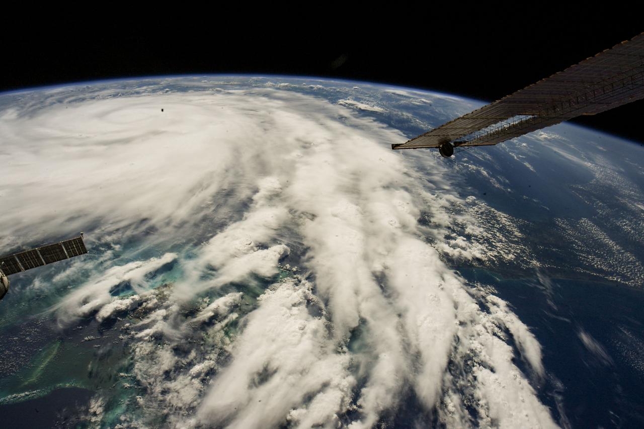
iss071e266892 (July 3, 2024) --- Hurricane Beryl is pictured as a Category 4 storm above the Caribbean Sea from the International Space Station as it orbited 263 miles above western Cuba.
iss061e026166 (Oct. 31, 2019) --- The island nation of Cuba is pictured in the rich blue waters between the Caribbean Sea and the Atlantic Ocean as the International Space Station orbited 255 miles above.
jsc2021e019119 (May 2, 2021) --- This composite photograph, a combination of several distinct photographs, of Cuba, the Bahamas and southern Florida was captured as the International Space Station orbited 263 miles above the Caribbean Sea.

ISS013-E-71899 (28 Aug. 2006) --- The docked Progress 22 spacecraft is featured in this image photographed by an Expedition 13 crewmember from a window on the International Space Station. Western Cuba provided the backdrop for the image.
ISS030-E-260480 (22 April 2012) --- One of the Expedition 30 crew members aboard the International Space Station photographed this nighttime image featuring a Lyrid meteor, just to the left of center. The space station was over the Gulf of Mexico, and many coastal cities in several states can be seen. Florida is above the center of the image with Cuba to the right. Atlanta is on the left side. A line of thunderstorms had just passed Cuba when the photo was taken. The bright bluish blobs are clouds illuminated by lightning. The reddish streaks are city lights blurred by the motion of the station during the five-second exposure.
iss067e381585 (Sept. 26, 2022) --- Hurricane Ian is pictured from the International Space Station as it orbited 258 miles above the Caribbean Sea east of Belize. At the time of this photograph, Ian was just south of Cuba gaining strength and heading toward Florida.
ISS042E300570 (03/04/2015) --- NASA Astronaut Terry Virts on the International Space Station tweeted this sunny day Caribbean image out to his social media fans on Mar. 4, 2015 with this attached comment: "#Cuba is surrounded by some unbelievable beaches and blue-green waters".
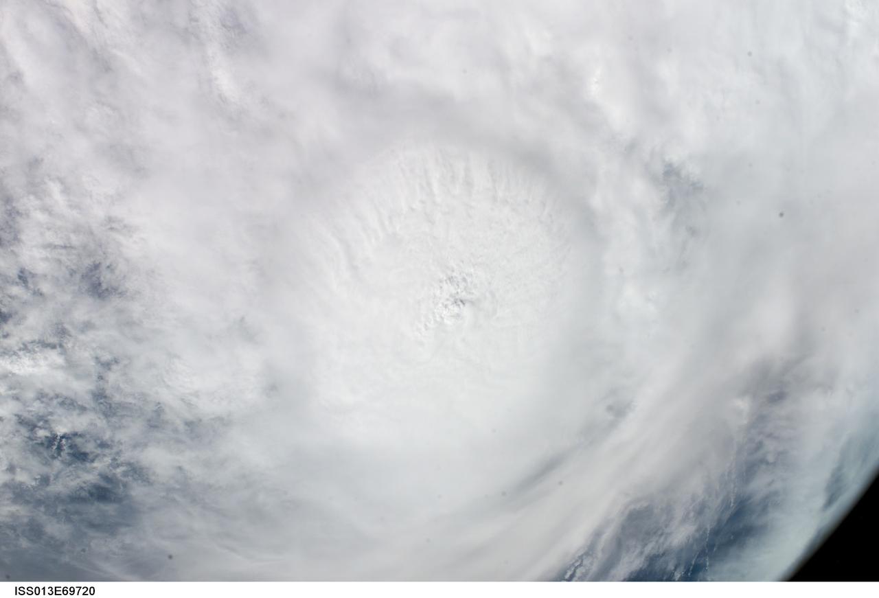
ISS013-E-69720 (27 August 2006) --- This vertical view of Hurricane Ernesto was taken by the crew of the International Space Station on Sunday, Aug. 27, 2006, from an altitude of about 215 miles. At that time, Ernesto was approaching Cuba and was expected to eventually make landfall on the coast of southern Florida.
ISS042E135486 (01/10/2015) --- Just another sunny day in the Caribbean sea as viewed by astronauts aboard the International Space Station. This image was tweeted out by NASA astronaut Terry Virts as he captured the Earth observation of #Cuba and #Bahamas on Jan. 10, 2015.
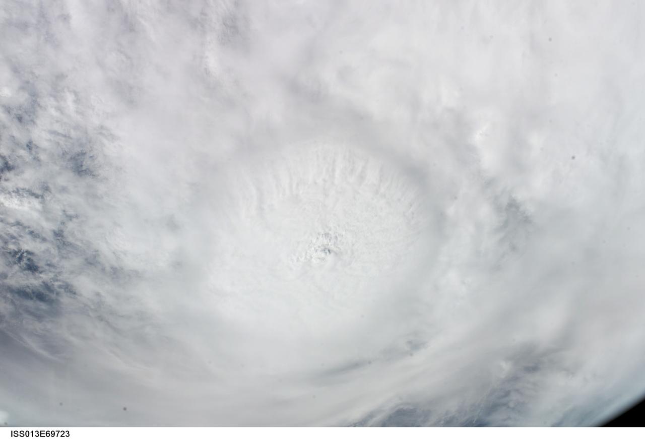
ISS013-E-69723 (27 August 2006) --- This vertical view of Hurricane Ernesto was taken by the crew of the International Space Station on Sunday, Aug. 27, 2006, from an altitude of about 215 miles. At that time, Ernesto was approaching Cuba and was expected to eventually make landfall on the coast of southern Florida.

iss054e012391 (Jan. 1, 2018) --- Despite the cloudiness during this nighttime photograph taken by Expedition 54 crew members aboard the International Space Station, the Caribbean islands of (from top left to bottom right) Puerto Rico, Cuba, Haiti and the Dominican Republic are seen from an altitude of 250 miles.

ISS013-E-69696 (27 August 2006) --- This oblique image of Hurricane Ernesto on the horizon was taken by the crew of the International Space Station on Sunday, Aug. 27, 2006, from an altitude of about 215 miles. At that time, Ernesto was approaching Cuba and was expected to eventually make landfall on the coast of southern Florida.

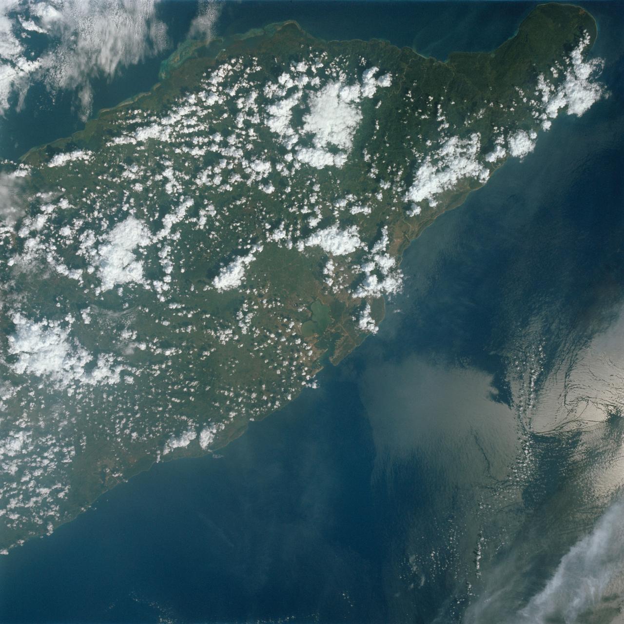
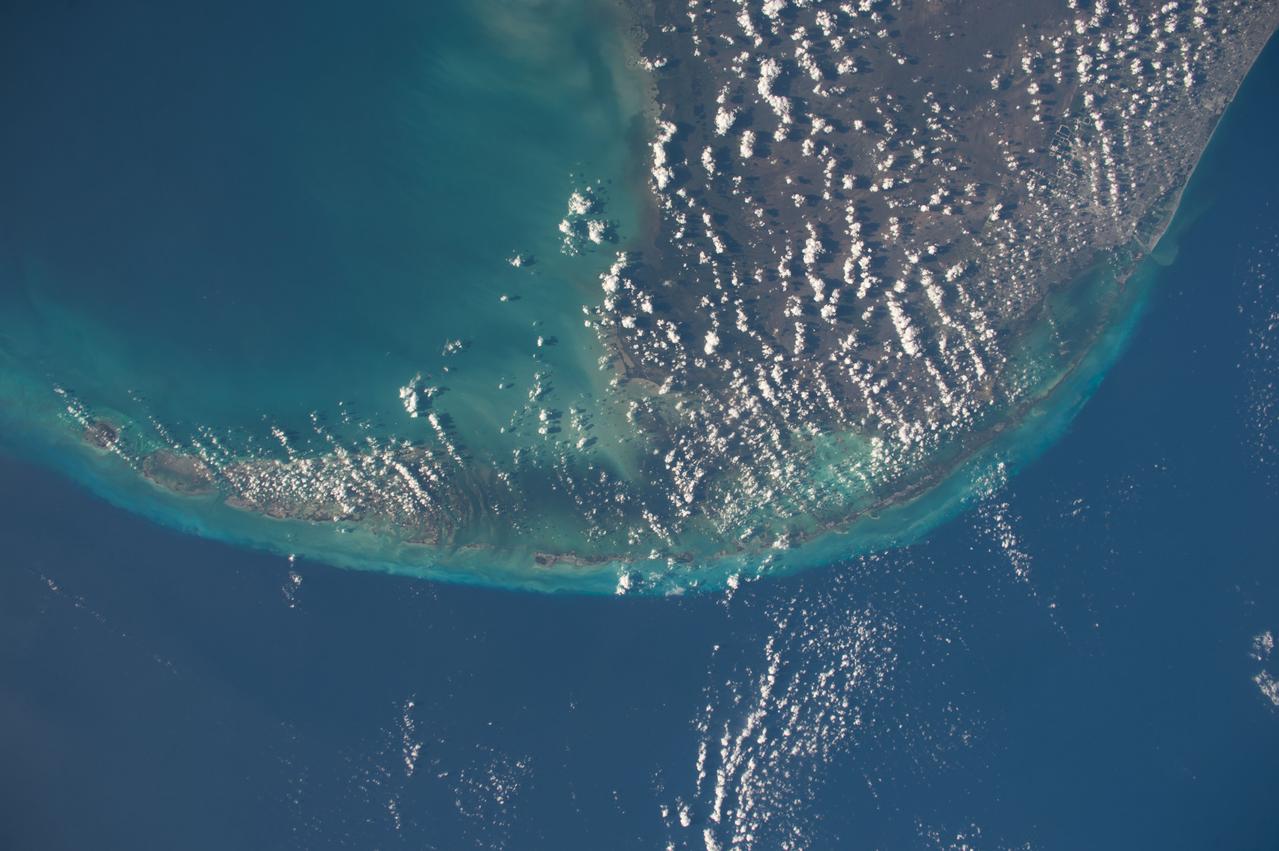
iss071e009021 (April 15, 2024) -- The Zapata Peninsula on the southern coast of Cuba is pictured from the International Space Station as it orbited nearly 260 miles above. Both a Biosphere Reserve and National Park, it's home to diverse ecosystems, including coral reefs in the cove of the Caribbean Sea.
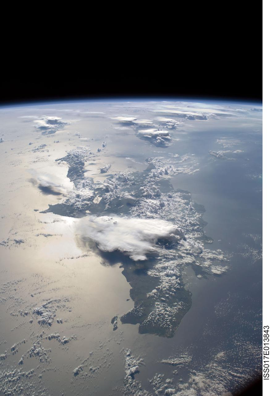
ISS017-E-013843 (19 Aug. 2008) --- A panoramic view of the island of Hispaniola in the foreground and Cuba extending to over the horizon. The sunglint is illuminating Haiti and the Dominican Republic while the thunderstorms persist in the late afternoon of the summertime day. Taken by the Expedition 17 crew onboard the ISS on Aug 19, 2008 with a 28 mm lens.
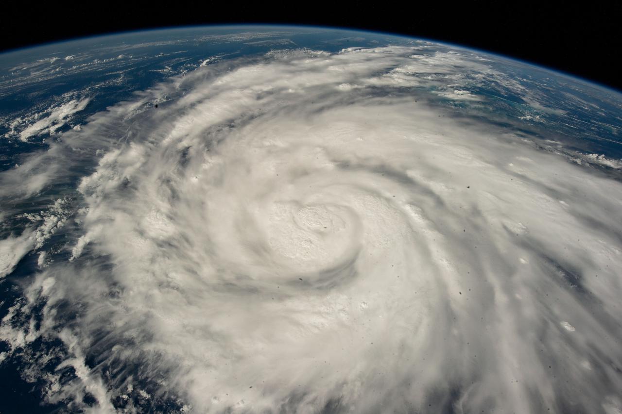
iss067e381585 (Sept. 26, 2022) --- Hurricane Ian is pictured from the International Space Station as it orbited 258 miles above the Caribbean Sea east of Belize. At the time of this photograph, Ian was just south of Cuba gaining strength and heading toward Florida.
CAPE CANAVERAL, Fla. -- Taken during the STS-95 mission from a point over Cuba, this photo shows an oblique, foreshortened view of the Florida Peninsula, with the light blue, shallow seafloor of both the Florida Keys (curving across the bottom of the view) and the Bahama banks (right). "Popcorn" cumulus cloud covers Miami and the Southern Everglades, although the built-up area from Ft. Lauderdale to West Palm Beach can be discerned. Lake Okeechobee is the prominent waterbody in Florida. Cape Canaveral is shown well, half way up the peninsula. Orlando appears as the lighter patch West (left) of Cape Canaveral, near the middle of the peninsula. Cape Hatteras appears top right, with the North part of Chesapeake Bay also visible. This is a visibility of 16 degrees of latitude (23 degrees N over Cuba to 39 degrees at Baltimore), showing unusual atmospheric clarity.
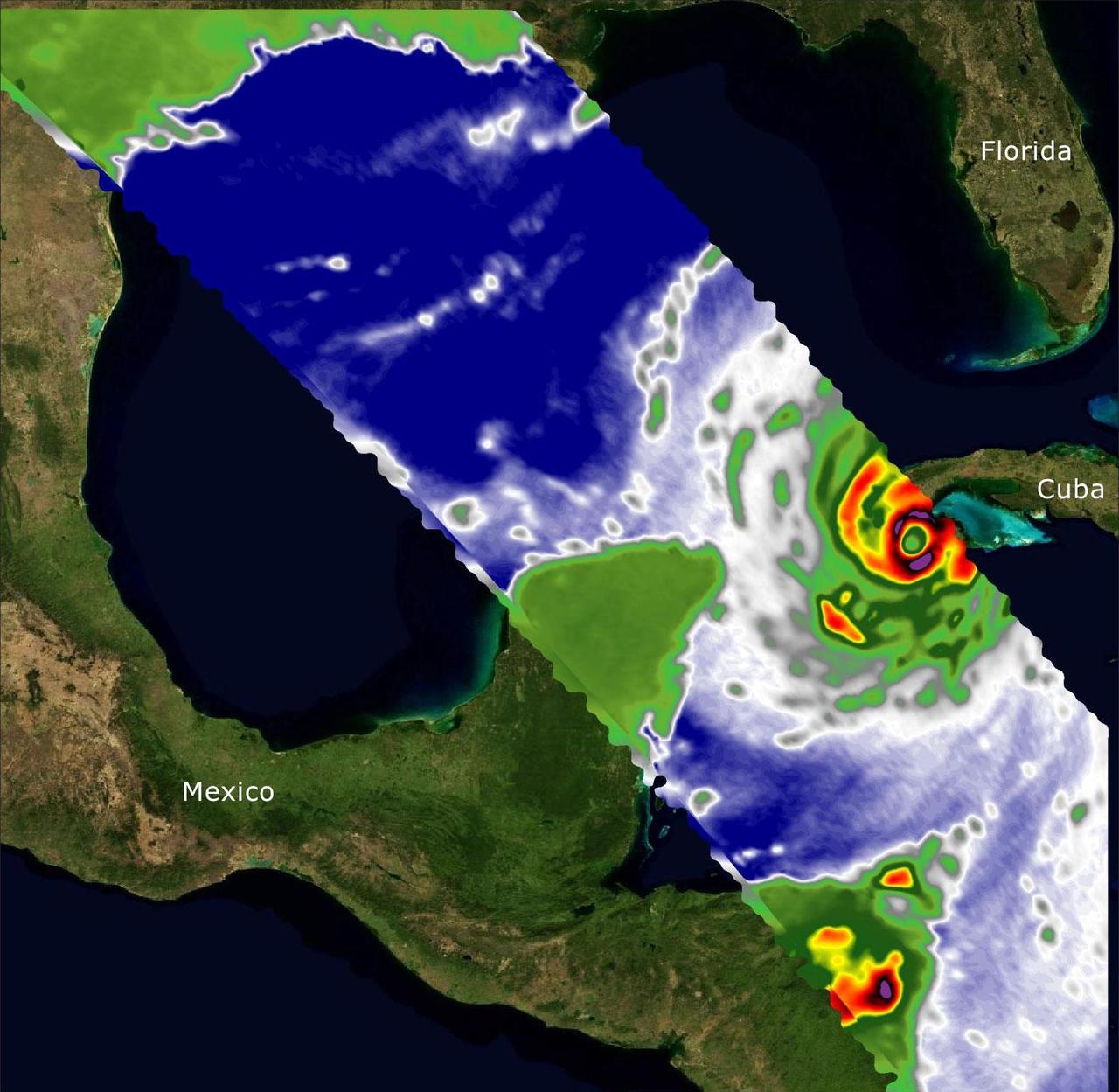
Two recently launched instruments that were designed and built at NASA's Jet Propulsion Laboratory in Southern California to provide forecasters data on weather over the open ocean captured images of Hurricane Ian on Sept. 27, 2022, as the storm approached Cuba on its way north toward the U.S. mainland. The instruments, Compact Ocean Wind Vector Radiometer (COWVR) and Temporal Experiment for Storms and Tropical Systems (TEMPEST), observe the planet's atmosphere and surface from aboard the International Space Station, which passed in low-Earth orbit over the Caribbean Sea at about 12:30 a.m. EDT. Ian made landfall in Cuba's Pinar del Rio province at 4:30 a.m. EDT, according to the National Hurricane Center. At that time, it was a Category 3 hurricane, with estimated wind speeds of 125 mph (205 kph). The image above combines microwave emissions measurements from both COWVR and TEMPEST. White sections indicate the presence of clouds. Green portions indicate rain. Yellow, red, and black indicate where air and water vapor were moving most swiftly. Ian's center is seen just off of Cuba's southern coast, and the storm is shown covering the island with rain and wind. COWVR and TEMPEST sent the data for this image back to Earth in a direct stream via NASA's tracking and data relay satellite (TDRS) constellation. The data were processed at JPL and made available to forecasters less than two hours after collection. About the size of a minifridge, COWVR measures natural microwave emissions over the ocean. The magnitude of the emissions increases with the amount of rain in the atmosphere, and the strongest rain produces the strongest microwave emissions. TEMPEST – comparable in size to a cereal box – tracks microwaves at a much shorter wavelength, allowing it to see ice particles within the hurricane's cloudy regions that are thrust into the upper atmosphere by the storm. Both microwave radiometers were conceived to demonstrate that smaller, more energy-efficient, more simply designed sensors can perform most of the same measurements as current space-based weather instruments that are heavier, consume more power, and cost much more to construct. COWVR's development was funded by the U.S. Space Force, and TEMPEST was developed with NASA funding. The U.S. Space Test Program-Houston 8 (STP-H8) is responsible for hosting the instruments on the space station under Space Force funding in partnership with NASA. Data from the instruments are being used by government and university weather forecasters and scientists. The mission will inform development of future space-based weather sensors, and scientists are working on mission concepts that would take advantage of the low-cost microwave sensor technologies to study long-standing questions, such as how heat from the ocean fuels global weather patterns. https://photojournal.jpl.nasa.gov/catalog/PIA25425
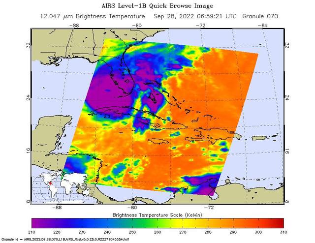
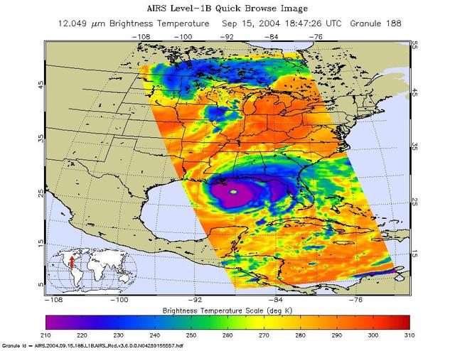
NASA's Atmospheric Infrared Sounder (AIRS) instrument aboard the Aqua satellite captured imagery of Hurricane Ian over the Gulf of Mexico between Cuba and Florida just before 2 a.m. local time Sept. 28, 2022. At that time, the Category 3 storm was in a period of rapid intensification – when a hurricane's wind speeds increase by 35 mph (56 kph) or more within 24 hours – while moving northward toward Florida after having recently made landfall over western Cuba. The image shows cloud or surface temperature measurements taken at infrared wavelengths. The large purple area indicates very cold clouds at about minus 90 degrees Fahrenheit (minus 67 degrees Celsius, or around 210 Kelvin on the map's scale). These clouds are carried high into the atmosphere by tall thunderstorms and are associated with very heavy rainfall. Warmer areas with shallower rain clouds are shown in blue and green. The orange and red areas represent mostly cloud-free air. The eye of the hurricane is seen as a small blue area in the middle of the large purple patch. AIRS, in conjunction with the Advanced Microwave Sounding Unit (AMSU), senses emitted infrared and microwave radiation from Earth to provide a 3D look at the planet's weather and climate. Working in tandem, the two instruments make simultaneous observations down to Earth's surface. With more than 2,000 channels sensing different regions of the atmosphere, the system creates a global, 3D map of atmospheric temperature and humidity, cloud amounts and heights, greenhouse gas concentrations, and many other atmospheric phenomena. Launched into Earth orbit in 2002 aboard NASA's Aqua spacecraft, the AIRS and AMSU instruments are managed by NASA's Jet Propulsion Laboratory in Southern California, under contract to NASA. JPL is a division of Caltech. https://photojournal.jpl.nasa.gov/catalog/PIA24908
STS045-78-016 (24 March-2 April 1992) --- This view is of the Bahamas and Florida looking westward into the sunglint. The Bahama Banks are in the foreground; from left to right, Andros Island, the Berry Islands, and Grand Bahama Island are surrounded by shallow limestone banks. Bimini is the double dark spot on the edge of the Straits of Florida, with the peninsula of Florida within the sunglint. Cuba can be seen to the upper left.
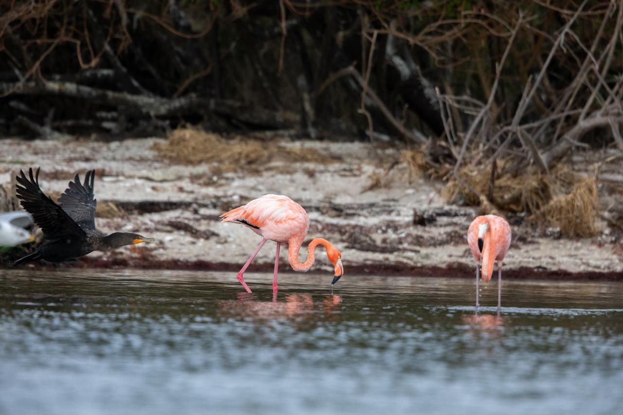
American Flamingos cool off in the Indian River at Haulover Canal on Merritt Island on Thursday, Jan. 11, 2024. The American Flamingos are more common in Mexico and Cuba but the winds from Hurricane Idalia relocated them to Florida in September 2023. Kennedy Space Center in Florida shares a border with the Merritt Island National Wildlife Refuge where more than 310 species of birds inhabit the refuge.
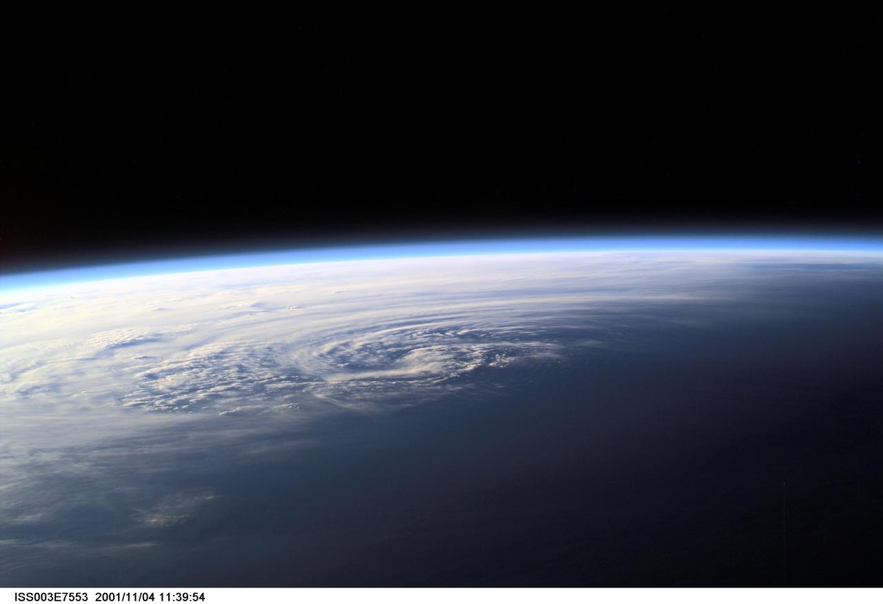
ISS003-E-7553 (4 November 2001) --- Pictured near Earth's horizon, Hurricane Michelle made landfall on Cuba on November 4, 2001, with sustained winds of 135 miles per hour. The most signficant impact was in the Matanzas province near Pinar del Rio. This scene was captured by one of the Expedition Three crew members aboard the International Space Station (ISS)using a digital still camera.
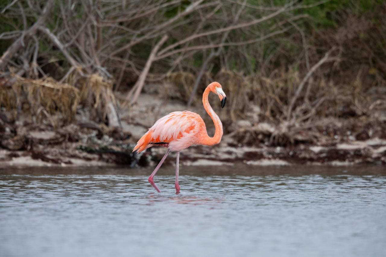
An American Flamingo cools off in the Indian River at Haulover Canal on Merritt Island on Thursday, Jan. 11, 2024. The American Flamingos are more common in Mexico and Cuba but the winds from Hurricane Idalia relocated them to Florida in September 2023. Kennedy Space Center in Florida shares a border with the Merritt Island National Wildlife Refuge where more than 310 species of birds inhabit the refuge.
ISS040-E-063578 (15 July 2014) --- One of the Expedition 40 crew members aboard the Earth-orbiting International Space Station, flying some 225 nautical miles above the Caribbean Sea in the early morning hours of July 15, photographed this north-looking panorama that includes parts of Cuba, the Bahamas and Florida, and even runs into several other areas in the southeastern U.S. The long stretch of lights to the left of center frame gives the shape of Miami.
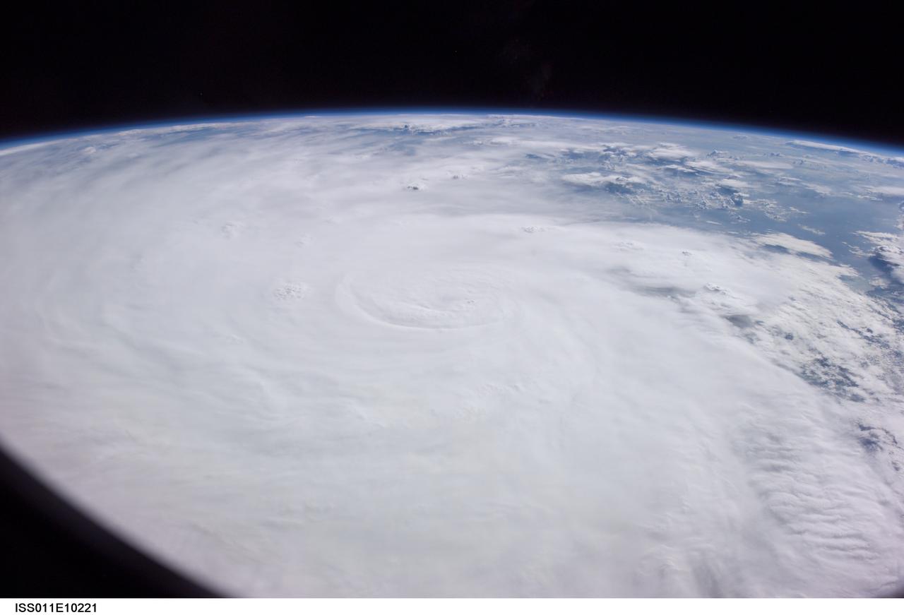
ISS011-E-10221 (7 July 2005) --- At the time of this Expedition 11 digital still camera's image, Hurricane Dennis was churning northwestward through the Caribbean Sea between Jamaica and eastern Cuba packing winds of up to 115 miles per hour. Even though the hurricane had just attained Category 3 intensity, the eye had not yet cleared. This high-oblique, panoramic view, taken through a 28mm lens at 21:14:00 gmt, is looking southwest.
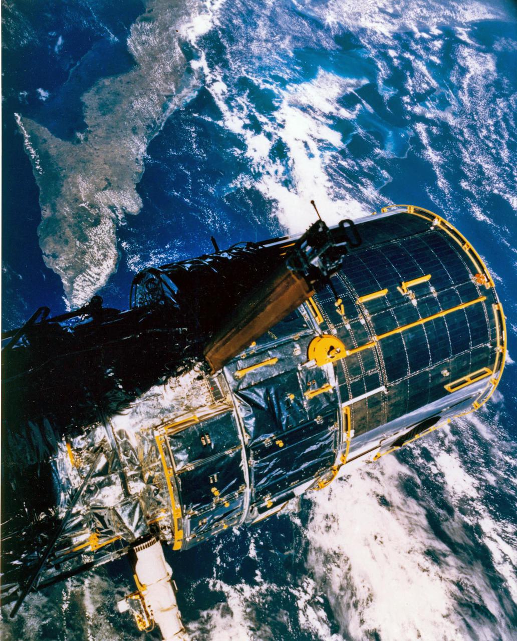
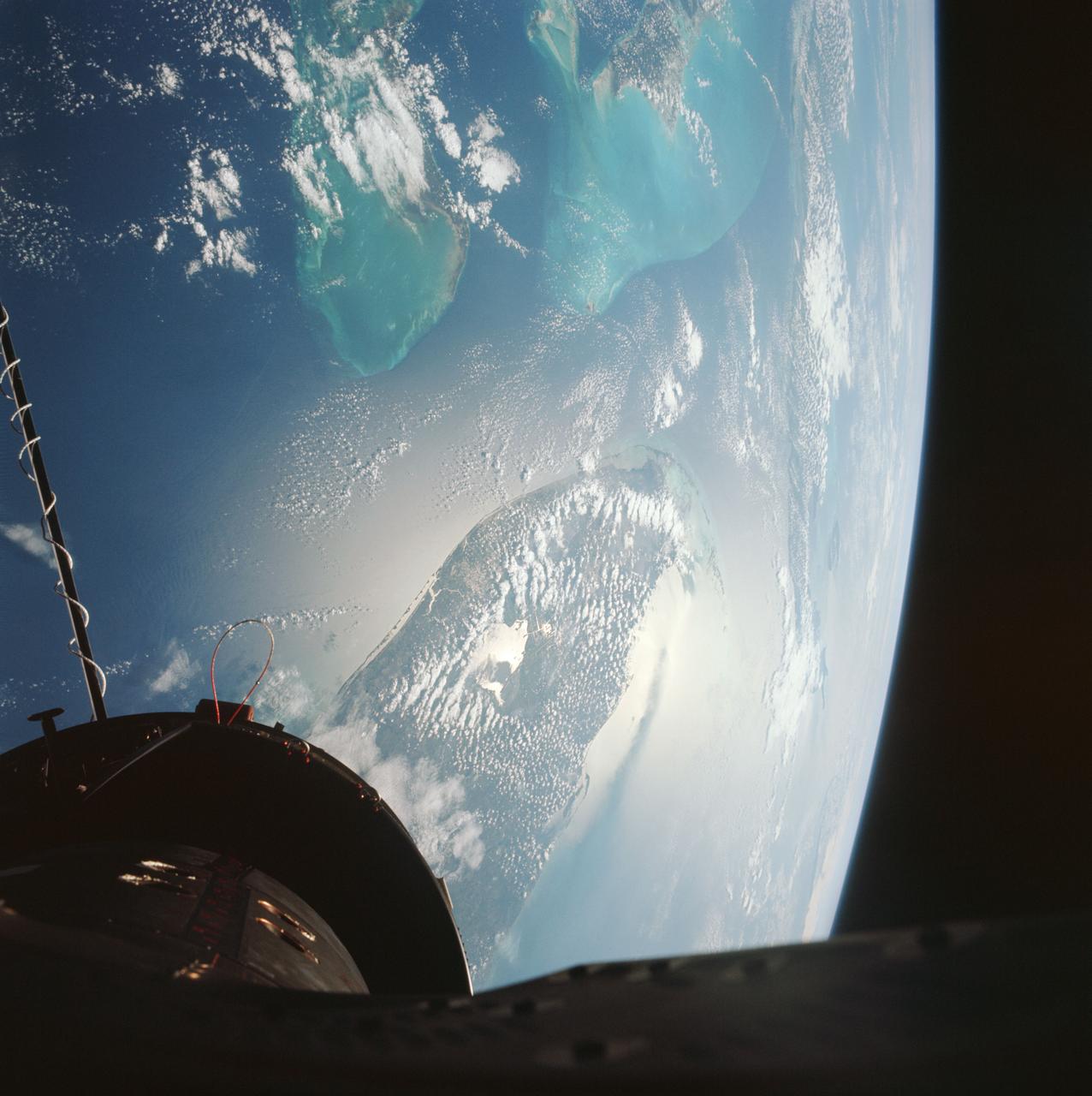
JOHNSON SPACE CENTER, HOUSTON, TEXAS-- The Hubble Space Telescope (HST), still in the grasp of Discovery's remote manipulator system, is backdropped over Cuba and the Bahama Islands. In this scene, it has yet to have deployment of its solar array panels and its high gain antennae. This scene was captured with a large format AeroLinhof camera used by several previous flight crews to record Earth scenes.
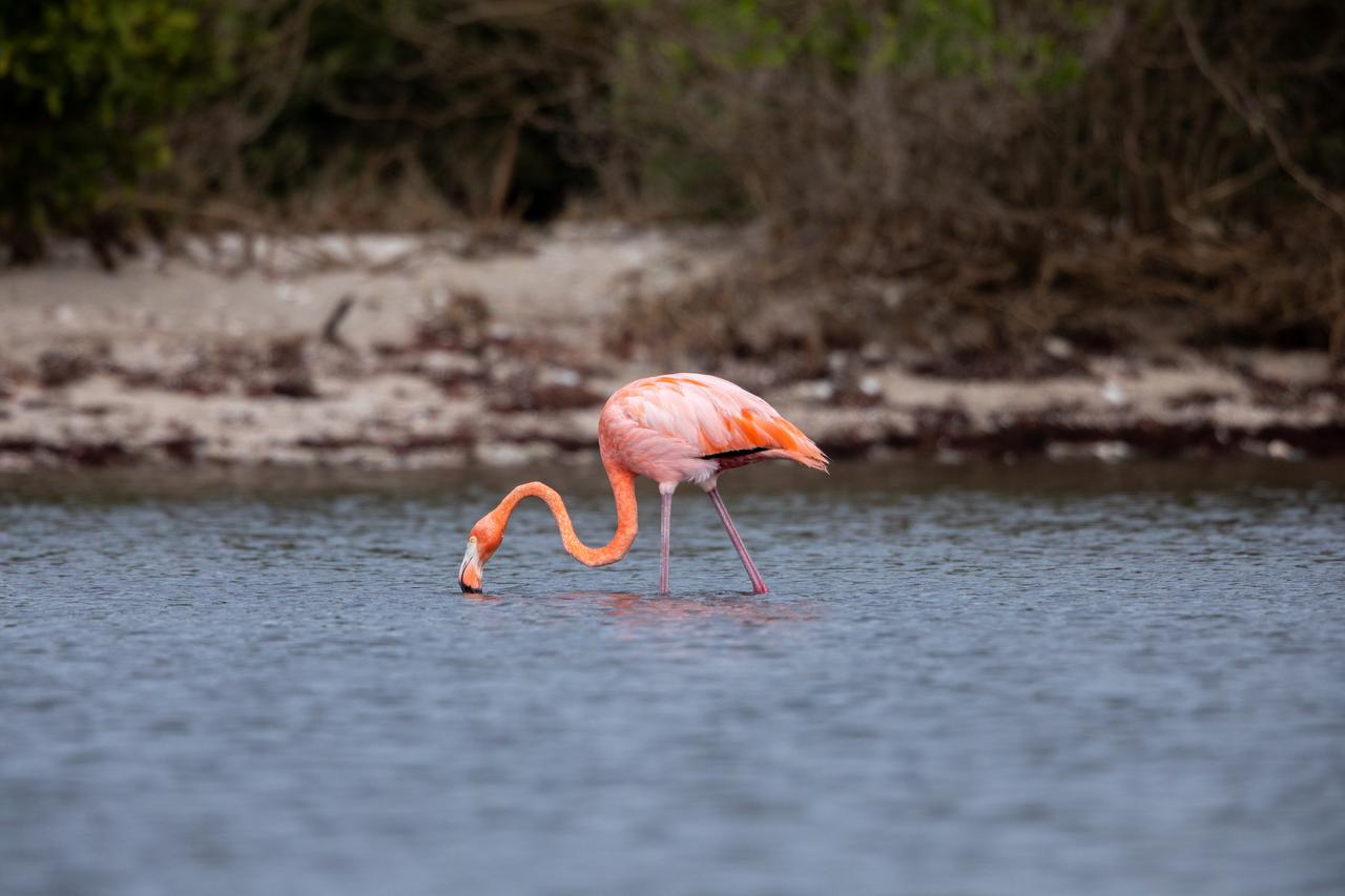
An American Flamingo takes a sip of water in the Indian River at Haulover Canal on Merritt Island on Thursday, Jan. 11, 2024. The American Flamingos are more common in Mexico and Cuba but the winds from Hurricane Idalia relocated them to Florida in September 2023. Kennedy Space Center in Florida shares a border with the Merritt Island National Wildlife Refuge where more than 310 species of birds inhabit the refuge.
AS08-16-2581 (21-27 Dec. 1968) --- This photograph of Earth was taken from the Apollo 8 spacecraft while it was in Earth orbit. Most of the southeastern United States and the Caribbean Sea area, the U.S. coastline from Chesapeake Bay to the Florida Peninsula can be seen. The Bahamas and the islands of Cuba, Jamaica, Hispaniola and Puerto Rico extend across the Caribbean, the light blue of the shallow Bahama banks contrasting sharply with the darker hue of the deeper water, especially in the Tongue of the Ocean area.
iss067e381585 (Sept. 26, 2022) --- Hurricane Ian is pictured from the International Space Station as it orbited 258 miles above the Caribbean Sea east of Belize. At the time of this photograph, Ian was just south of Cuba gaining strength and heading toward Florida. In the foreground (from left), are the Soyuz MS-22 crew ship, docked to the Rassvet module, and the Soyuz MS-21 crew ship, docked to the Prichal module.
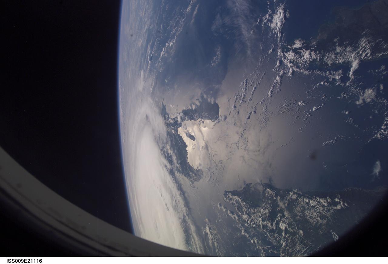
ISS009-E-21116 (1 Sept. 2004) -- Astronaut Edward M. (Mike) Fincke, aboard the International Space Station (ISS) at an altitude of about 230 miles, took this photo of Hurricane Frances early Sept. 1. Part of the large system is obscured by the portal. The Guantanimo Bay area of Cuba appears near frame's edge and part of Hispaniola is pictured near frame center. Sunglint alters the natural colors in this scene.
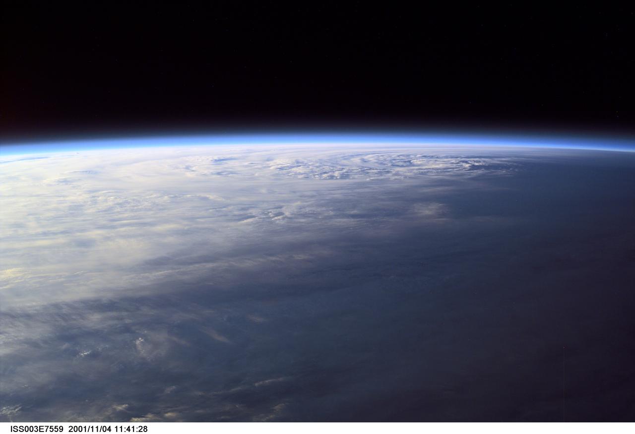
ISS003-E-7559 (4 November 2001) --- Pictured near Earth's horizon, Hurricane Michelle made landfall on Cuba a few hours later on November 4, 2001, with sustained winds of 135 miles per hour. The eye can be seen in the upper right quadrant of this oblique view. The most signficant impact was in the Matanzas province near Pinar del Rio. This scene was captured by one of the Expedition Three crew members aboard the International Space Station (ISS)using a digital still camera.
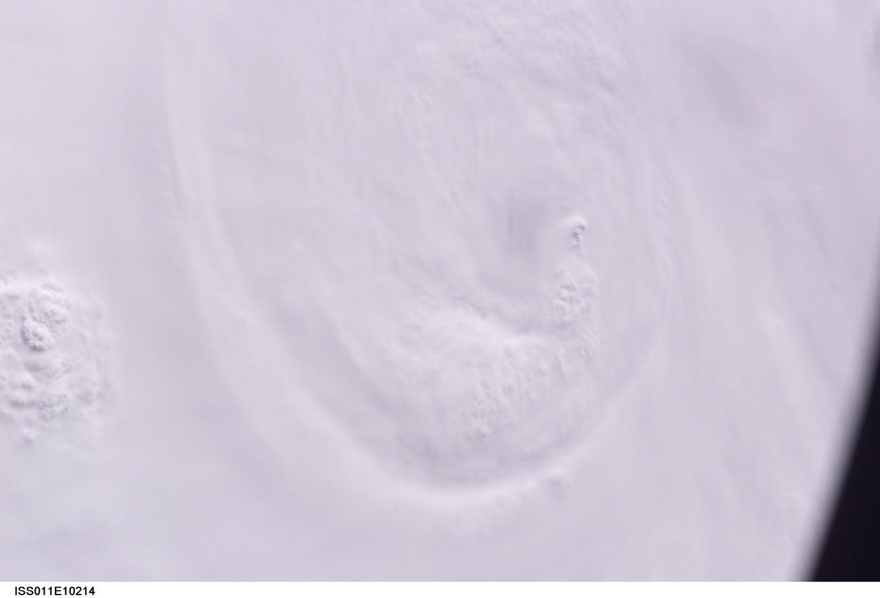
ISS011-E-10214 (7 July 2005) --- At the time of this Expedition 11 digital still camera's image, Hurricane Dennis was churning northwestward through the Caribbean Sea between Jamaica and eastern Cuba packing winds of up to 115 miles per hour. Even though the hurricane had just attained Category 3 intensity, the eye had not yet cleared. This oblique view, captured with a 70mm lens at 21:12:01 gmt, is looking west.
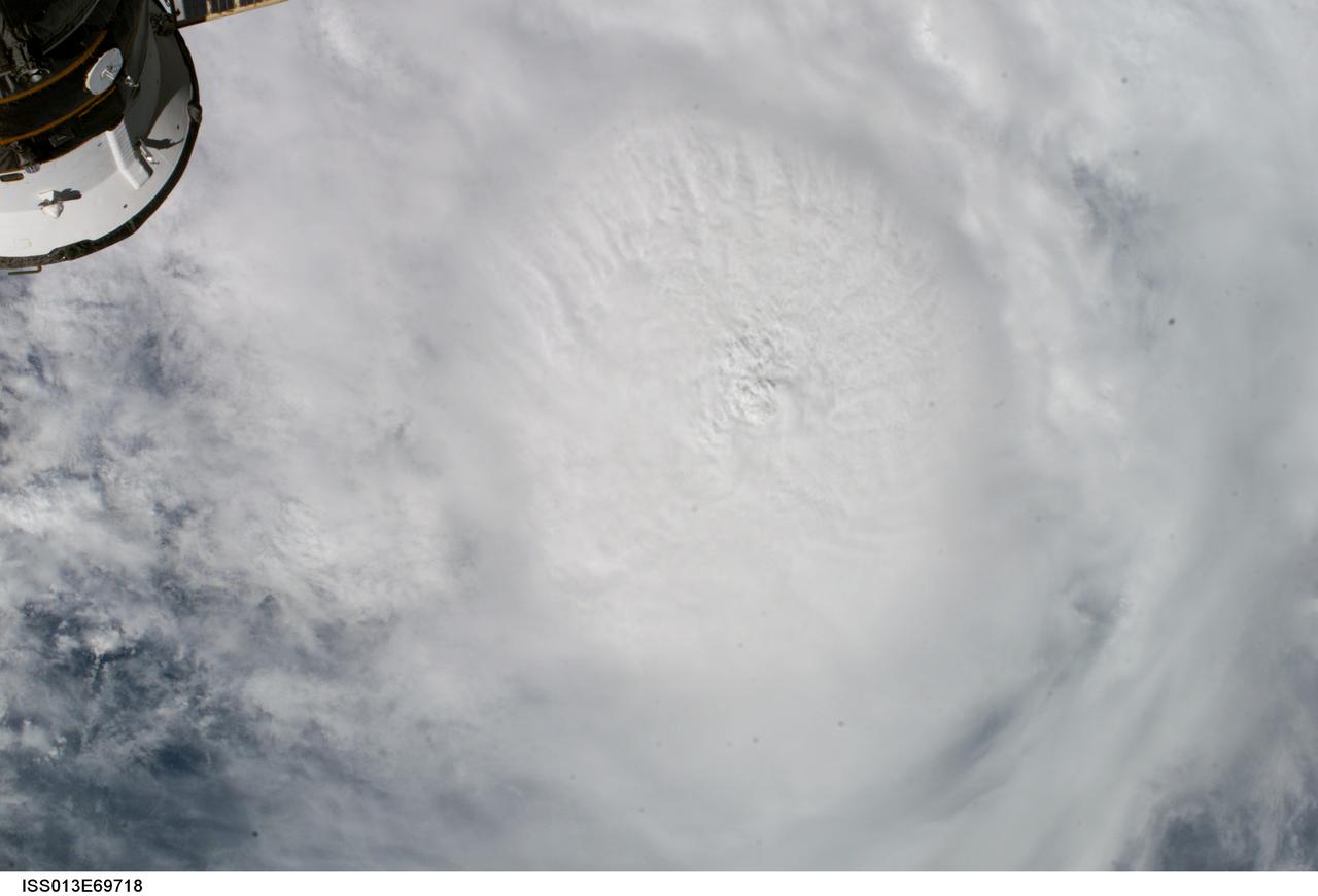
ISS013-E-69718 (27 August 2006) --- This vertical view of Hurricane Ernesto was taken by the crew of the International Space Station on Sunday, Aug. 27, 2006, from an altitude of about 215 miles. At that time, Ernesto was approaching Cuba and was expected to eventually make landfall on the coast of southern Florida. Part of a Russian spacecraft, docked to the orbital outpost, is visible in upper left corner.
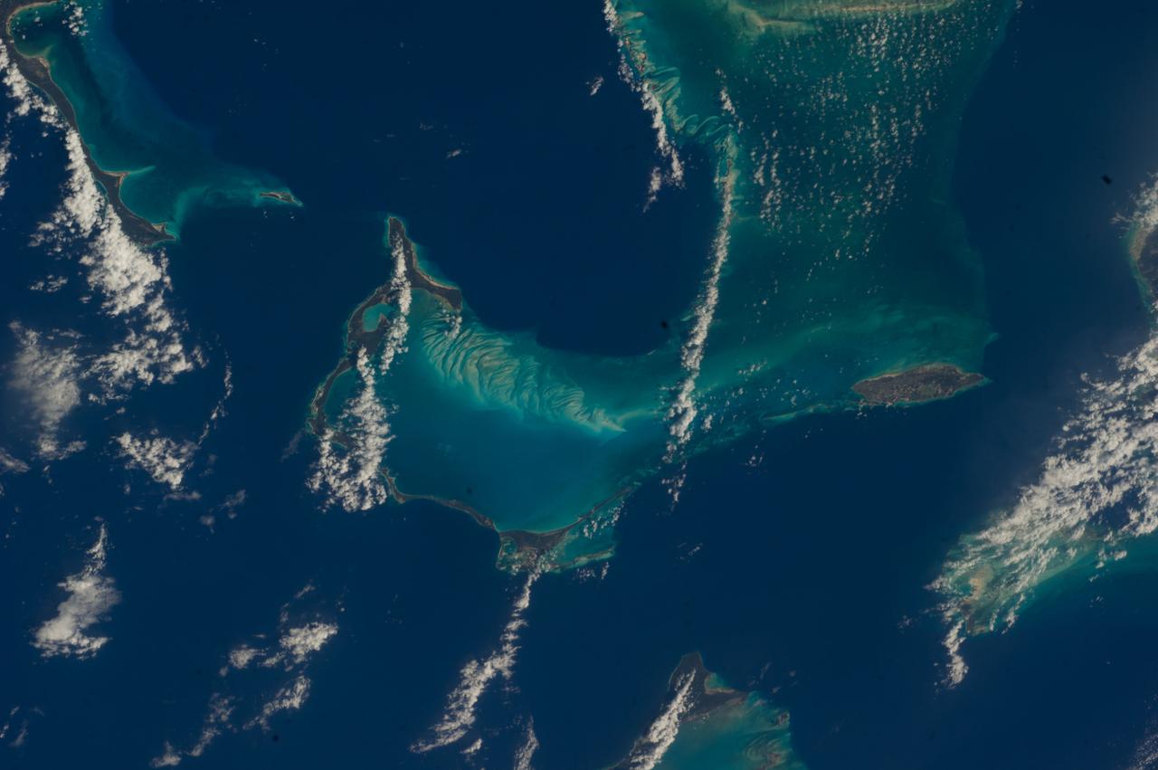
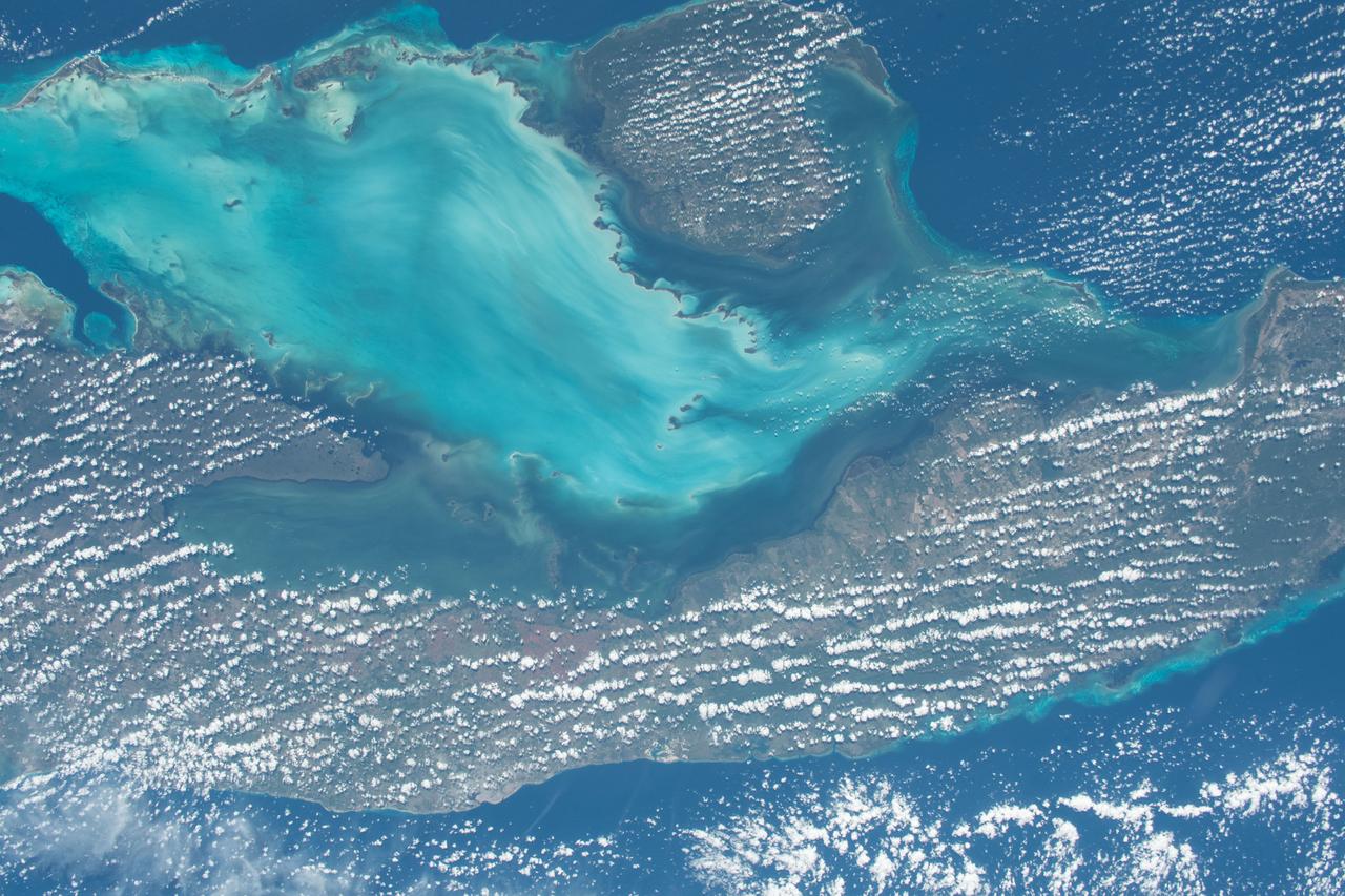
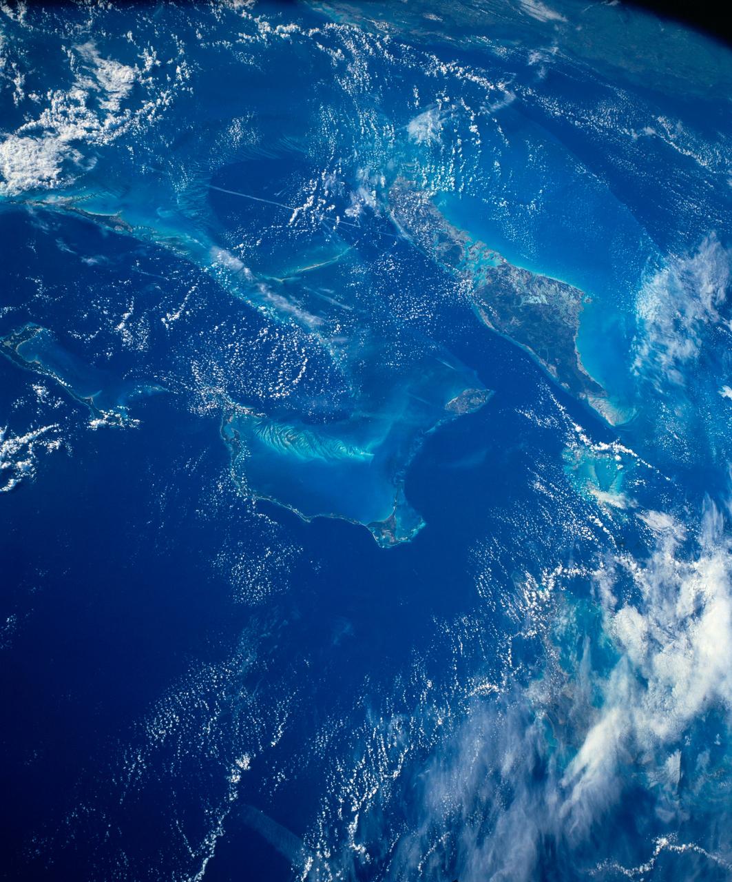
ISS047e069406 (04/20/2016) ---Earth observation image taken by the Expedition 47 crew aboard the International Space Station. This is an oblique south-looking view of the main Bahama island chain. Cuba is across the entire top of the image, the Florida Peninsula on the right margin. In the Bahamas, the main Andros island is just distinguishable under cloud upper left of center. Under less cloud is the Abaco Islands in the foreground (middle of pic nearest camera left of center.)
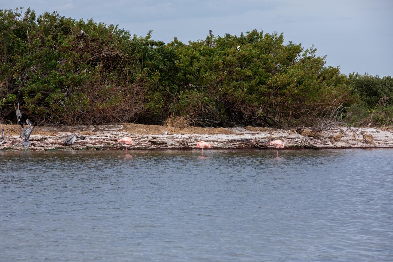
Three American Flamingos cool off in the Indian River at Haulover Canal on Merritt Island on Thursday, Jan. 11, 2024. The American Flamingos are more common in Mexico and Cuba but the winds from Hurricane Idalia relocated them to Florida in September 2023. Kennedy Space Center in Florida shares a border with the Merritt Island National Wildlife Refuge where more than 310 species of birds inhabit the refuge.
ISS049e028067 (10/03/2016) --- Hurricane Matthew, a huge category 4 level storm, as seen from the International Space Station Oct. 3, 2016. Packing winds of 140 miles an hour as a Category 4 hurricane, Matthew passed over western Haiti and eastern Cuba Oct. 4 before charging north over the Bahamas Oct. 5 and potentially threatening the east coast of the United States later in the week.
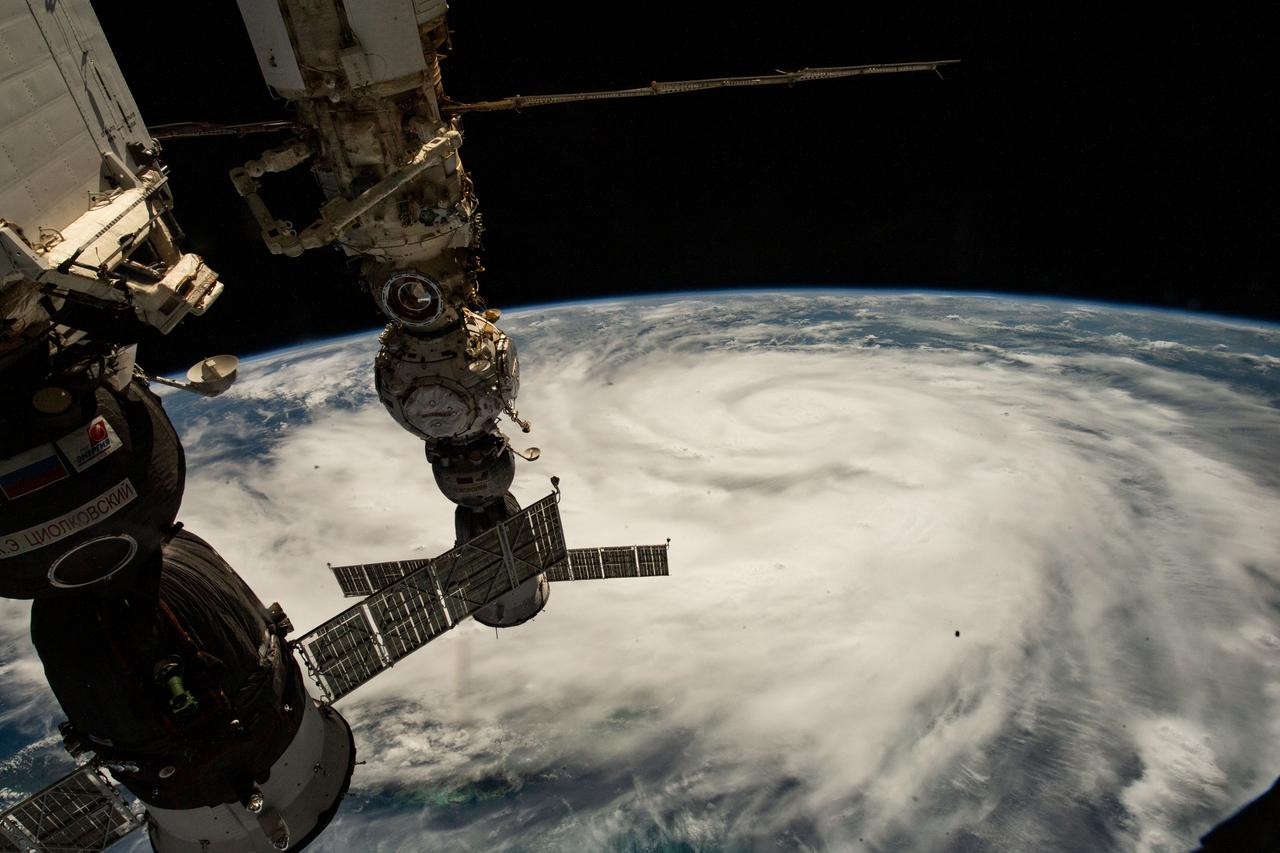
iss073e1196921 (Nov. 25, 2025) --- Northrop Grumman's Cygnus XL cargo craft is pictured in the grips of the International Space Station Canadarm2 robotic arm. Cygnus XL had been temporarily released from its Earth-facing port on the Unity module to make room for the Soyuz MS-28 crew spacecraft, which was scheduled to arrive the next day and dock to the Rassvet module. JAXA's (Japan Aerospace Exploration Agency) HTV-X1 cargo craft, with its solar arrays deployed, is seen berthed to the Earth-facing port of the Harmony module. The orbital outpost was soaring 262 miles above the Caribbean Sea south of Cuba at the time of this photograph.
STS054-152-102 (13-19 Jan. 1993) --- This is a south-looking, wide angle view of the northern Bahamas, featuring the islands (from mid-foreground toward background) of Eleuthera, New Providence, and Andros. The northern shore of Cuba can be seen in the background. The resort city of Nassau occupies much of eastern New Providence. The Bahamas host some very distinctive features -- the deep blue channels and the shallow, light blue platforms, feathery sand bars at the edges of the deep water sounds, and colorful lakes and tidal channels like seen on Andros Island.
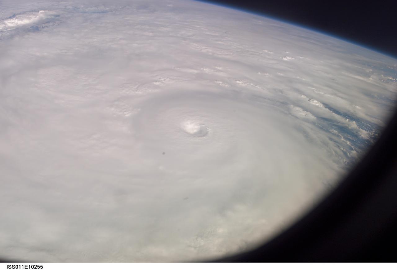
ISS011-E-10255 (9 July 2005) --- This easterly-looking image from the International Space Station shows Hurricane Dennis after the storm had already crossed Cuba and was heading for the northern Gulf of Mexico. Dennis was a Category 3 storm, packing winds of 115 miles per hour, at the time of exposure and located approximately 385 miles southeast of Biloxi, Mississippi or 280 miles south of Panama City, Florida. The eye of the hurricane is in the center of the frame, exposed at 22:06:54 (GMT), July 9, 2005. The dark triangle in loer right corner is part of the Space Station's window.
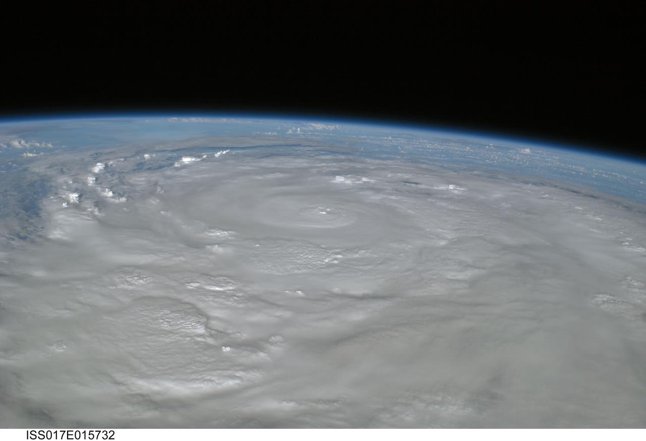
ISS017-E-015732 (9 Sept. 2008) --- Hurricane Ike covers more than half of Cuba in this image, photographed by the crew of ISS-17 aboard the International Space Station from a vantage point of 220 statute miles above Earth. The center of Ike was near 22.4 degrees north latitude and 82.4 degrees west longitude and moving 290 degrees at 11.7 miles per hour. Sustained winds were at 80.6 miles per hour, with gusts to 97.9 miles per hour and were forecast to strengthen as the eye moved back over the warm water in the gulf of Mexico.
STS040-613-049 (5-14 June 1991) --- This oblique scene from the Earth-orbiting Space Shuttle Columbia shows southern Florida, several of the Bahama Islands and parts of the Atlantic Ocean, the Gulf of Mexico and the Caribbean Sea. The nine-day STS-40/Spacelab Life Sciences (SLS-1) mission started with launch from Kennedy Space Center (KSC), visible in lower left. Cuba can be seen at top center. The picture was photographed with a handheld Rolleiflex camera, aimed through Columbia's aft flight deck windows.
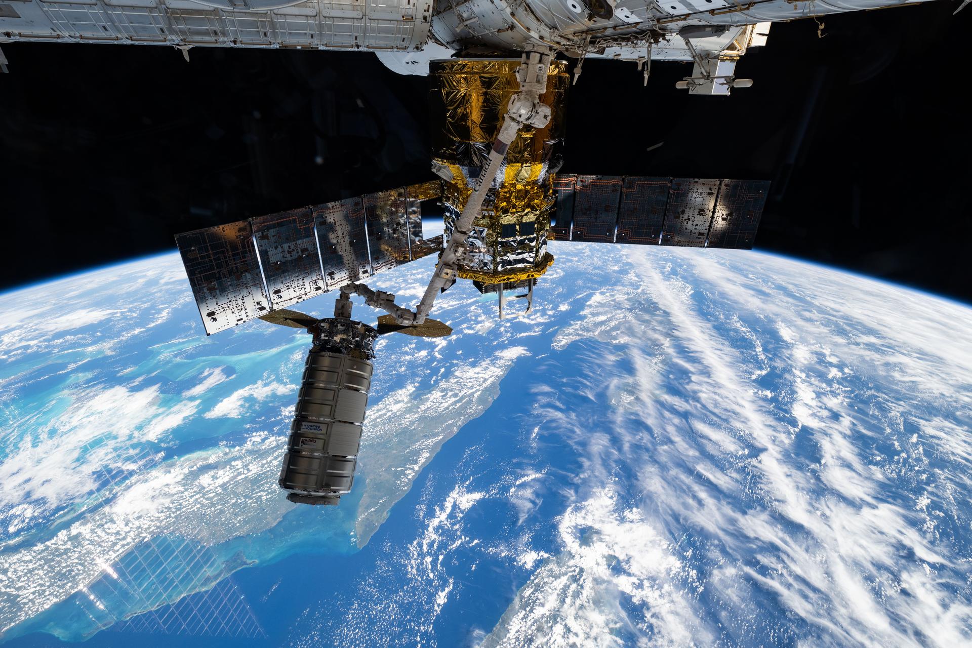
iss073e1196940 (Nov. 25, 2025) --- Northrop Grumman's Cygnus XL cargo craft is pictured in the grips of the International Space Station Canadarm2 robotic arm. Cygnus XL had been temporarily released from its Earth-facing port on the Unity module to make room for the Soyuz MS-28 crew spacecraft, which was scheduled to arrive the next day and dock to the Rassvet module. JAXA's (Japan Aerospace Exploration Agency) HTV-X1 cargo craft, with its solar arrays deployed, is seen berthed to the Earth-facing port of the Harmony module. The orbital outpost was soaring 261 miles above the Caribbean Sea south of Cuba at the time of this photograph.
ISS028-E-030243 (23 Aug. 2011) --- A digital photo from the International Space Station from Aug. 23, 2011, allows the viewer to look toward the southwest at part of Hurricane Irene churning near the northern Bahamas, including Great Abaco Island (lower right), Andros Island under a thunderstorm (center right) and a ?fair? Cuba from left to right (upper center). The outflow and some of the banding of the northwest side of Irene are visible on the lower left. Meteorologists say Irene probably was centered over Acklins Island packing 120 mile per hour winds when the photo was taken.
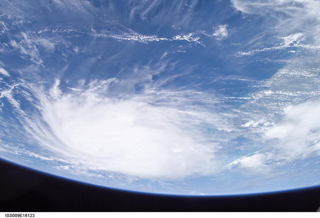
ISS009-E-18123 (21:08:33 GMT, 12 August 2004) --- This panoramic view of Hurricane Charley was taken by the Expedition 9 crew of the International Space Station just after 5PM (EDT), August 12, 2004. The Category Two Hurricane was in the northwest Caribbean Sea, 140 miles south-southeast of Havana, Cuba moving north-northwest at 18mph packing winds of 105mph. In this view looking southeast, the newly formed eye of the storm is just visible and the west coast of Florida from Naples to Tampa Bay may be seen on the right.
ISS017-E-015708 (9 Sept. 2008) --- Hurricane Ike covers more than half of Cuba in this image, photographed by the crew of ISS-17 aboard the International Space Station from a vantage point of 220 statute miles above Earth. The center of Ike was near 22.4 degrees north latitude and 82.4 degrees west longitude and moving 290 degrees at 11.7 miles per hour. Sustained winds were at 80.6 miles per hour, with gusts to 97.9 miles per hour and were forecast to strengthen as the eye moved back over the warm water in the gulf of Mexico.
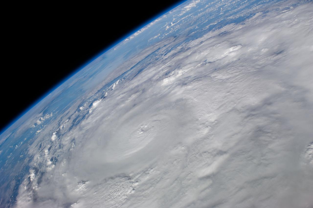
ISS017-E-015718 (9 Sept. 2008) --- Hurricane Ike covers more than half of Cuba in this image, photographed by the crew of ISS-17 aboard the International Space Station from a vantage point of 220 statute miles above Earth. The center of Ike was near 22.4 degrees north latitude and 82.4 degrees west longitude and moving 290 degrees at 11.7 miles per hour. Sustained winds were at 80.6 miles per hour, with gusts to 97.9 miles per hour and were forecast to strengthen as the eye moved back over the warm water in the gulf of Mexico.
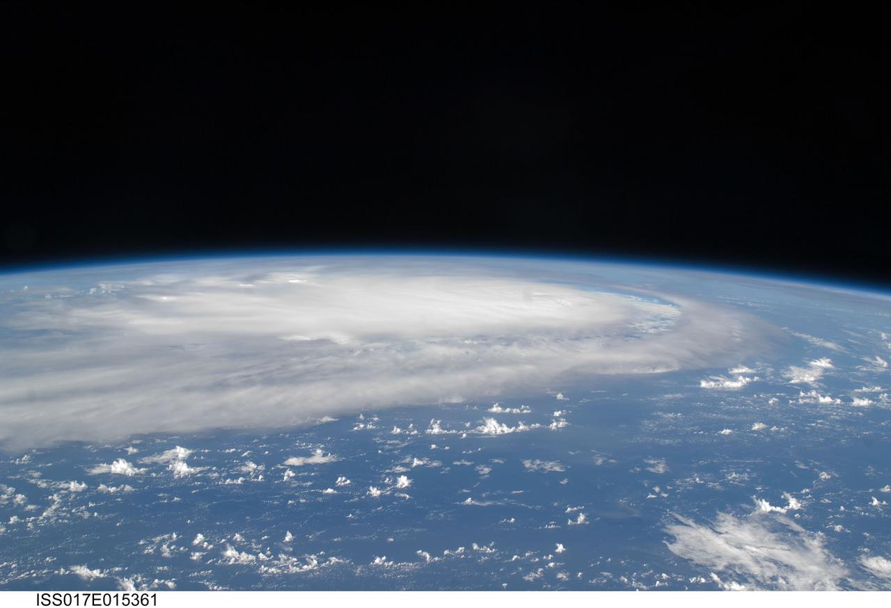
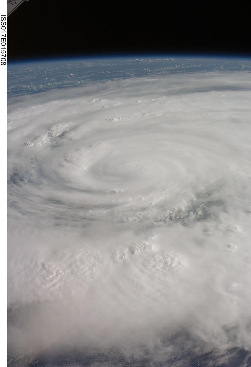
ISS017-E-015361 (5 Sept. 2008) --- When this image was taken of Hurricane Ike from the International Space Station's vantage point of 220 statute miles above Earth on Sept. 5, the eye of it was centered at 23.3 degrees north latitude and 62.0 degrees west longitude and moving 260 degrees at 17.2 miles per hour. The winds were sustained at 121 miles per hour with gusts to 149.8 miles per hour. The hurricane had not yet passed over Cuba and entered the Gulf of Mexico when this photo was taken.
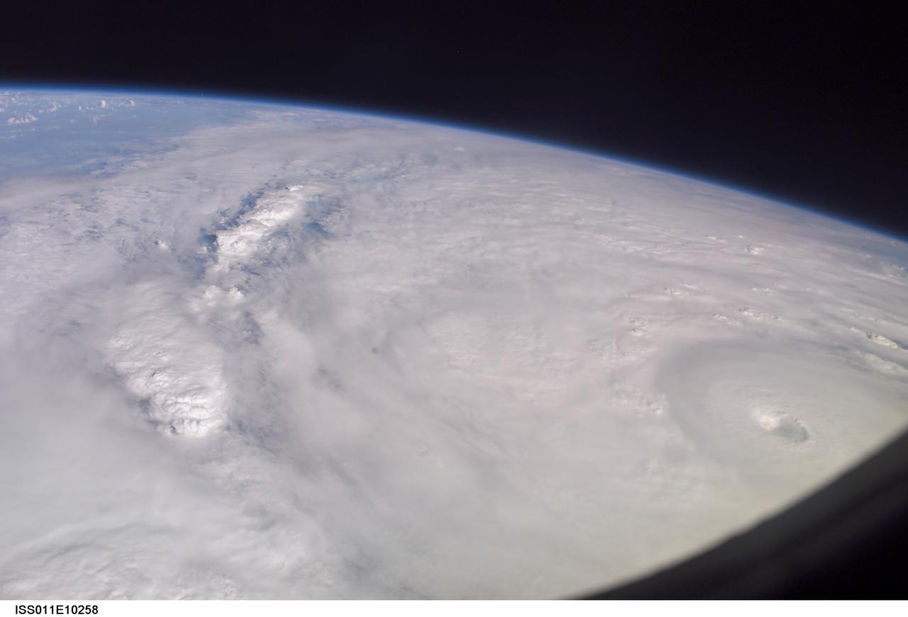
ISS011-E-10258 (9 July 2005) --- This easterly-looking image from the International Space Station shows Hurricane Dennis after the storm had already crossed Cuba and was heading for the northern Gulf of Mexico. Dennis was a Category 3 storm, packing winds of 115 miles per hour, at the time of exposure and located approximately 385 miles southeast of Biloxi, Mississippi or 280 miles south of Panama City, Florida. The ill-defined eye is in the lower right corner. The black triangle in extreme lower right is part of the Space Station's window.
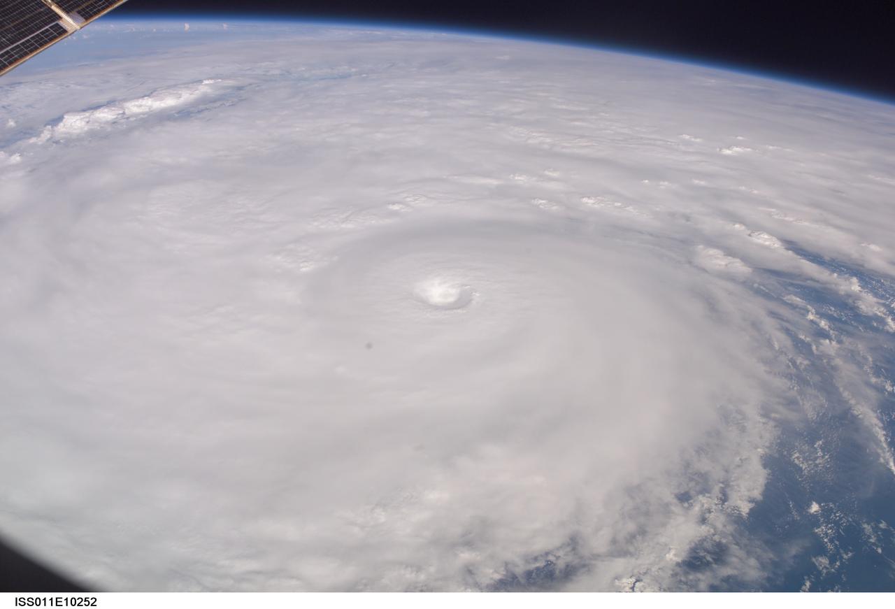
ISS011-E-10252 (9 July 2005) --- This easterly-looking image from the International Space Station shows Hurricane Dennis after the storm had already crossed Cuba and was heading for the northern Gulf of Mexico. Dennis was a Category 3 storm, packing winds of 115 miles per hour, at the time of exposure and located approximately 385 miles southeast of Biloxi, Mississippi or 280 miles south of Panama City, Florida. The image was exposed at 22:06:35 (GMT), July 9, 2005. The storm's eye is at frame center. The black triangle in extreme lower left is part of the Space Station's window.
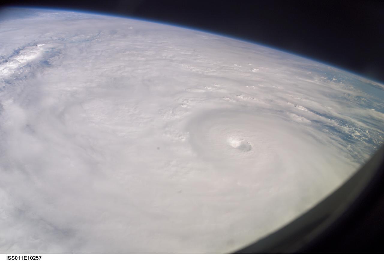
ISS011-E-10257 (9 July 2005) --- This easterly-looking image from the International Space Station shows Hurricane Dennis after the storm had already crossed Cuba and was heading for the northern Gulf of Mexico. Dennis was a Category 3 storm, packing winds of 115 miles per hour, at the time of exposure and located approximately 385 miles southeast of Biloxi, Mississippi or 280 miles south of Panama City, Florida. The image was exposed at 22:07:26 (GMT), July 9, 2005. The storm's eye is just to the right of frame center. The black triangle in extreme lower right is part of the Space Station's window.
SL4-139-4029 (10 Jan. 1974) --- An oblique view of the State of Florida, looking northward up the peninsula, as photographed from the Skylab space station in Earth orbit by one of the Skylab 4 crewman. The camera used was a hand-held 70mm Hasselblad, with SO-368 medium-speed Ektachrome. This view shows almost the entire state, except the panhandle region. The Bahama Banks area appears in the southeast part of the picture as the light blue water. Andros Island in the Bahamas group is the island in the lower right corner. The Gulfstream flows between Florida and the Bahama Banks. This fast-moving, warm-water current transports energy from the tropics to the northern latitudes. The effect of the warmer Gulfstream waters on the atmosphere is seen as increased convection (caused by the warmer water heating the air from below) resulting in the fair weather cumulus seen confined primarily over the Gulfstream. A portion of Cuba is seen in the lower left corner of the picture. Photo credit: NASA
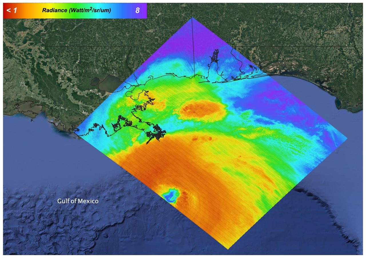
A pair of weather instruments built at NASA's Jet Propulsion Laboratory in Southern California captured images of Hurricane Idalia as the storm approached the Gulf Coast of Florida on Aug. 29, 2023. COWVR (short for Compact Ocean Wind Vector Radiometer) and TEMPEST (Temporal Experiment for Storms and Tropical Systems) observe the planet's atmosphere and surface from aboard the International Space Station, which passed in low Earth orbit over this area at about 11:34 a.m. EDT. Idalia was forecast to make landfall in Florida on Aug. 30. This image combines microwave emissions measurements from both COWVR and TEMPEST. White sections indicate the presence of clouds. Green portions indicate rain. Yellow, red, and black indicate where air and water vapor were moving most vigorously. Idalia's center is seen about 200 miles (322 kilometers) west of the Florida Keys, and rainfall is indicated on the western end of Cuba. https://photojournal.jpl.nasa.gov/catalog/PIA25569
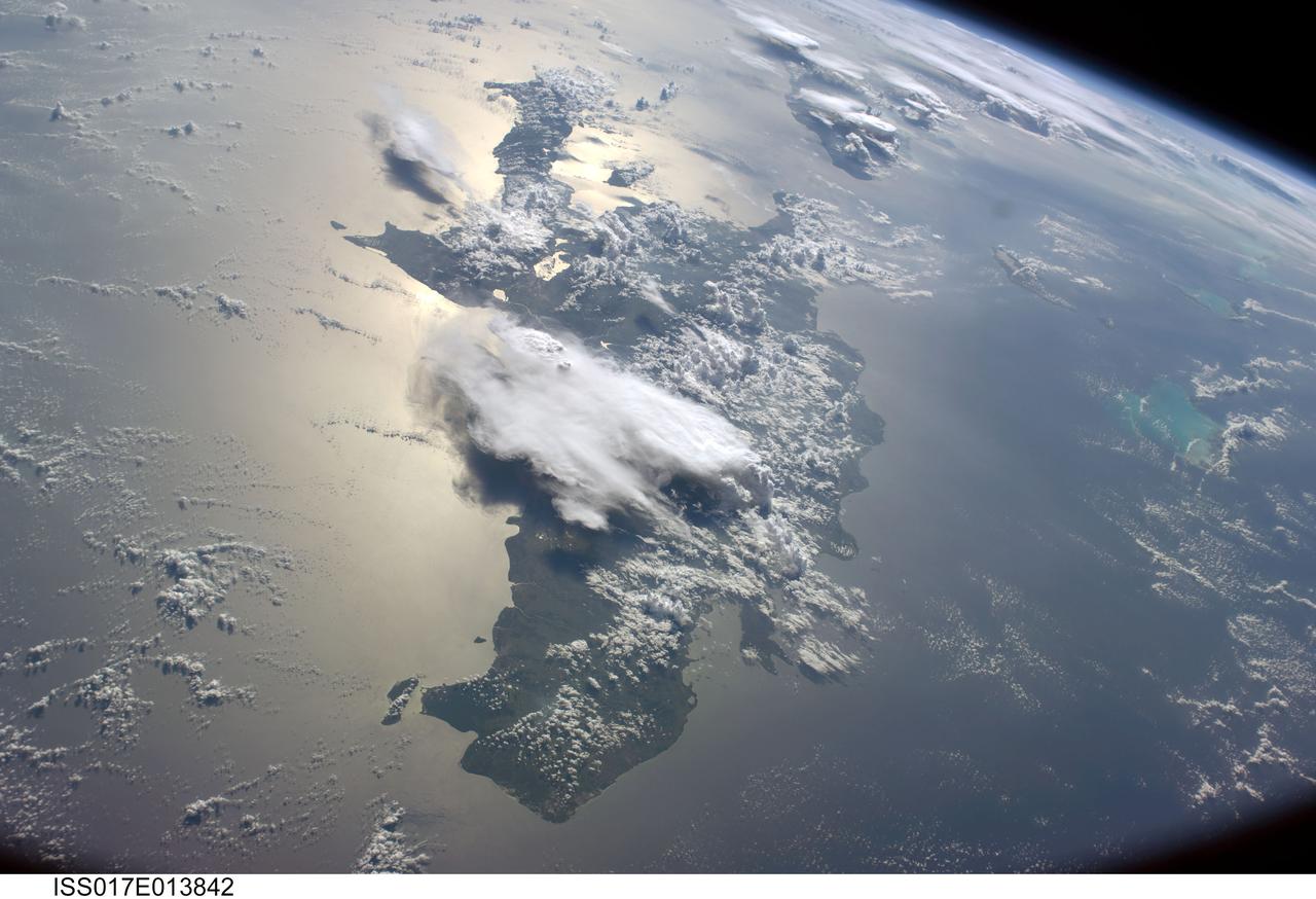
ISS017-E-013842 (19 Aug. 2008) --- A serene view of a portion of the Greater Antilles islands in the Caribbean Sea. The island of Hispaniola is in the foreground, comprised of the Dominican Republic and Haiti (in the sunglint). Looking toward the horizon, the eastern tip of Cuba is seen through the clouds and thunderstorms that are scattered over the islands. The light blue shallower areas, to the right or north of Hispaniola and extending toward the Earths limb, are the Turks and Caicos islands and the Acklins Islands. The Great Inagua island is off the coast of Haiti. These islands are located along the geological border of the North American Plate (to the right) and the Caribbean Plate (to the left). The photo was taken by the Expedition 17 crew onboard the International Space Station on Aug 19, 2008 with a 28 mm lens.

Read more from: <a href="http://go.nasa.gov/2duxEeZ" rel="nofollow">go.nasa.gov/2duxEeZ</a> On October 4, 2016, Hurricane Matthew made landfall on southwestern Haiti as a category-4 storm—the strongest storm to hit the Caribbean nation in more than 50 years. Just hours after landfall, the Moderate Resolution Imaging Spectroradiometer (MODIS) on NASA’s Terra satellite acquired this natural-color image. At the time, Matthew had top sustained winds of about 230 kilometers (145 miles) per hour. Earlier on October 4, temperature data collected by MODIS on NASA’s Aqua satellite revealed that the cloud tops around Matthew were very cold (at least -57° Celsius, or -70° Fahrenheit). Cold cloud tops are known to produce heavy rainfall. The National Hurricane Center called for 380 to 500 millimeters (15 to 20 inches) of rain in Southern Haiti and in the southwestern Dominican Republic. The northward movement of the storm should bring the center of Matthew over eastern Cuba late on October 4. Dangerous conditions can extend far beyond a storm’s center. According to National Hurricane Center forecasters, Matthew is “likely to produce devastating impacts from storm surge, extreme winds, heavy rains, flash floods, and/or mudslides in portions of the watch and warning areas in Haiti, Cuba, and the Bahamas.” NASA Earth Observatory image by Joshua Stevens, using MODIS data from the Land Atmosphere Near real-time Capability for EOS (LANCE). Caption by Kathryn Hansen.
On August 27, 2021 Ida crossed over Cuba as a Category 1 Storm. 48 hours later the storm intensified to a Category 4 before making landfall on the coast of Louisiana. The storm was the second most destructive storm to ever make landfall on the Louisiana coast with sustained winds over 150 mph (240 km/h). The rapid intensification process that the storm system underwent is not well understood. Satellite images such as this are helpful as scientists attempt to understand new weather patterns that are emerging with Global Climate Change. Tasked with detecting plant water use and stress, ECOSTRESS's primary mission is to measure the temperature of plants heating up as they run out of water. But it can also measure and track heat-related phenomena like wildfires, heat waves, and volcanoes. ECOSTRESS observations have a spatial resolution of about 77 by 77 yards (70 by 70 meters), which enables researchers to study surface-temperature conditions down to the size of a football field. Due to the space station's unique orbit, the mission can acquire images of the same regions at different times of the day, as opposed to crossing over each area at the same time of day like satellites in other orbits do. This is advantageous when monitoring plant stress in the same area throughout the day, for example. https://photojournal.jpl.nasa.gov/catalog/PIA24210

KENNEDY SPACE CENTER, FLA. - Crawler-transporter No. 2 makes its way toward Launch Pad 39B (in the background). The crawler is being moved nearby in the event the mission management team decides to roll back Space Shuttle Atlantis due to Hurricane Ernesto. The hurricane has been forecast on a heading north and east from Cuba, taking it along the eastern coast of Florida. NASA's lighted launch window extends to Sept. 13, but mission managers are hoping to launch on mission STS-115 by Sept. 7 to avoid a conflict with a Russian Soyuz rocket also bound for the International Space Station. The crawler is 131 feet long, 113 feet wide and 20 feet high. It weights 5.5 million pounds unloaded. The combined weight of crawler, mobile launcher platform and a space shuttle is 12 million pounds. Unloaded, the crawler moves at 2 mph. Loaded, the snail's pace slows to 1 mph. Photo credit: NASA/Kim Shiflett
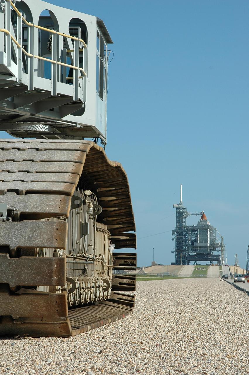
KENNEDY SPACE CENTER, FLA. - Crawler-transporter No. 2 nears Launch Pad 39B (in the background, right). The tip of the orange external tank can be seen above the rotating service structure surrounding the shuttle. The crawler is being moved nearby in the event the mission management team decides to roll back Space Shuttle Atlantis due to Hurricane Ernesto. The hurricane has been forecast on a heading north and east from Cuba, taking it along the eastern coast of Florida. NASA's lighted launch window extends to Sept. 13, but mission managers are hoping to launch on mission STS-115 by Sept. 7 to avoid a conflict with a Russian Soyuz rocket also bound for the International Space Station. The crawler is 131 feet long, 113 feet wide and 20 feet high. It weights 5.5 million pounds unloaded. The combined weight of crawler, mobile launcher platform and a space shuttle is 12 million pounds. Unloaded, the crawler moves at 2 mph. Loaded, the snail's pace slows to 1 mph. Photo credit: NASA/Kim Shiflett
This false-color image shows Hurricane Isabel viewed by the AIRS and AMSU-A instruments at 1:30 EDT in the morning of Thursday September 18, 2003. Isabel will be ashore within 12 hours, bringing widespread flooding and destructive winds. In figure 1 on the left, data retrieved by the AIRS infrared sensor shows the hurricane's eye as the small ring of pale blue near the upper left corner of the image. The dark blue band around the eye shows the cold tops of hundreds of powerful thunderstorms. These storms are embedded in the 120 mile per hour winds swirling counterclockwise around Isabel's eye. Cape Hatteras is the finger of land north-northwest of the eye. Isabel's winds will soon push ashore a 4- to 8-foot high mound of 'storm surge' and accompanying high surf, leading to flooding of Cape Hatteras and other islands of North Carolina's Outer Banks. Also seen in the image are several organized bands of cold, (blue) thunderstorm tops being pulled into the storm center. Other thunderstorm are forming north of the islands of Jamaica, Cuba, Hispaniola and Puerto Rico near the bottom of the picture. http://photojournal.jpl.nasa.gov/catalog/PIA00428
ISS032-E-008976 (15 July 2012) --- Saharan dust reaching the Americas is featured in this image photographed by an Expedition 32 crew member on the International Space Station. Weather satellites frequently document major dust palls blowing from the Sahara Desert westward from Africa out into the tropical Atlantic Ocean. Space station crew members frequently see these Saharan dust masses as very widespread atmospheric haze. Dust palls blowing from Africa can be transported right across the Atlantic Ocean. It takes about a week to reach either North America (in northern hemisphere summer) or South America (in northern hemisphere winter). This puts the Caribbean basin on the receiving end of many of these events. Recently, researchers have linked Saharan dust to coral disease, allergic reactions in humans, and red tides. The margin of the hazy air in this image reaches as far as Haiti (top center) and the nearby Turks and Caicos Islands (top left) ? but the eastern tip of Cuba in the foreground remains in the clear air.
KENNEDY SPACE CENTER, FLA. - Crawler-transporter No. 2 makes its way toward Launch Pad 39B (in the background). The tip of the orange external tank can be seen above the rotating service structure surrounding the shuttle. The crawler is being moved nearby in the event the mission management team decides to roll back Space Shuttle Atlantis due to Hurricane Ernesto. The hurricane has been forecast on a heading north and east from Cuba, taking it along the eastern coast of Florida. NASA's lighted launch window extends to Sept. 13, but mission managers are hoping to launch on mission STS-115 by Sept. 7 to avoid a conflict with a Russian Soyuz rocket also bound for the International Space Station. The crawler is 131 feet long, 113 feet wide and 20 feet high. It weights 5.5 million pounds unloaded. The combined weight of crawler, mobile launcher platform and a space shuttle is 12 million pounds. Unloaded, the crawler moves at 2 mph. Loaded, the snail's pace slows to 1 mph. Photo credit: NASA/Kim Shiflett
On the afternoon of Sept. 1, 2016, Tropical Storm Hermine strengthened into a Category 1 hurricane as it approached the coast of Florida. Hermine began life as Tropical Depression Nine, originating off the coast of Cuba on Aug. 28. After heading northwest into the Gulf of Mexico, it took a right turn toward Florida and on Wednesday, Aug. 31, was upgraded to a tropical storm before strengthening to a hurricane a day later. Winds are currently sustained near 75 miles (121 kilometers) per hour, and the storm is expected to make landfall tonight or early tomorrow. Florida Governor Rick Scott has declared a state of emergency in 51 counties, while Georgia Governor Nathan Deal has done the same for 56 counties in his state. Localized flooding is already occurring in some areas of Florida, which has not had a direct landfall by a hurricane in 11 years. After moving across Florida and Georgia, the storm is currently forecast to continue northward along the coast of the Eastern seaboard. On Sept. 1, at 12:30 p.m. EDT, the Multi-angle Imaging SpectroRadiometer (MISR) instrument aboard NASA's Terra spacecraft passed over the area. This natural-color image from MISR's vertical-pointing camera shows the large, loosely organized hurricane. At the time, the center of the storm was located about 200 miles (325 kilometers) to the west of Sarasota on the Florida coast. The image is 235 miles (378 kilometers) in width. Also included is a 3D stereo anaglyph, made by combining data from MISR's vertical-pointing and 46-degree forward-pointing camera. The image has been rotated so that north is to the left in order to enable stereo viewing. With the aid of red-blue glasses (with the red lens over the left eye), it is possible to observe the storm in three dimensions. Note the towering central thunderstorms around the eye in comparison to the low clouds visible within it. These data were acquired during Terra orbit 88865. http://photojournal.jpl.nasa.gov/catalog/PIA20898
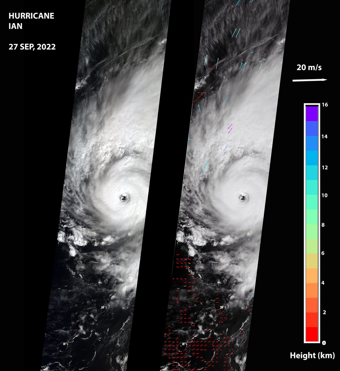
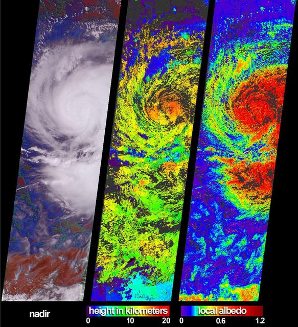
NASA's Multi-angle Imaging SpectroRadiometer (MISR) captured an optical image of Hurricane Ian, as well as measurements of the storm's wind speed, at noon local time Sept. 27, 2022. The storm, a Category 3 hurricane at that time, had maximum sustained winds of 115 mph (185 kph). The eye of the storm was located off the northern coast of Cuba, approximately 70 miles (110 kilometers) west of Havana, after passing over the island in the morning hours. The MISR instrument, flying aboard NASA's Terra satellite, carries nine cameras that observe the Earth at different angles. It takes approximately seven minutes for all the cameras to observe the same location on the Earth, and the motion of clouds during that time is used to calculate wind speed at the cloud tops. The left-hand panel of the first figure shows an image of the storm as viewed by MISR's central, downward-looking camera. The panel on the right shows the wind speeds derived from MISR data superimposed on the image. The length of the arrows is proportional to the wind speed, while their color shows the altitudes of the cloud tops in kilometers. The MISR data shows that the cloud-top winds near the center of the storm reached approximately 108 mph (174 kph), with maximum cloud-top wind speed reaching 123 mph (198 kph). The wind data shows that the lowest clouds are moving counterclockwise, while the high clouds north of the hurricane's center are rotating clockwise. The anaglyph reveals high clouds associated with strong thunderstorms in the eyewall of Hurricane Ian as well as individual strong thunderstorms in the outer rainbands. https://photojournal.jpl.nasa.gov/catalog/PIA24909
Hurricane Ivan is the most powerful hurricane to hit the Caribbean in 10 years. On September 7 and 8 it damaged 90 percent of the homes in Grenada and killed at least 16 people as it swept over Grenada, Barbados and the other islands in the area. By Thursday morning on September 9, Ivan's sustained winds reached 160 mph making it a rare category 5 hurricane on the Saffir-Simpson scale. By Monday September 13, Ivan is blamed for 67 deaths and skirts western Cuba with winds clocked at 156 mph. The National Hurricane Center predicted the eye of Ivan will make landfall across Mobile Bay in Alabama late Wednesday or early Thursday. These images of Hurricane Ivan were acquired by the AIRS infrared, microwave, and visible sensors on September 15 at 1:30 pm local time as the storm moves in to Alabama. Ivan at category 4 strength is about 150 miles south of Mobile, Alabama and is moving north at 14 mph. Maximum sustained winds are reported to be at 135 mph and extend 105 miles from the center, while tropical storm-force winds extend 290 miles from the center. Ivan pounded the Gulf coast all day Wednesday, and is expected to make landfall between midnight and 3am in Mobile Bay, Alabama. This image shows how the storm looks through an AIRS Infrared window channel, and reveals a very large eye - about 75 km (50 miles) across. Window channels measure the temperature of the cloud tops or the surface of the Earth in cloud-free regions. The lowest temperatures are associated with high, cold cloud tops that make up the top of the hurricane. The infrared signal does not penetrate through clouds, so the purple color indicates the cool cloud tops of the storm. In cloud-free areas, the infrared signal is retrieved at the Earth's surface, revealing warmer temperatures. Cooler areas are pushing to purple and warmer areas are pushing to red. http://photojournal.jpl.nasa.gov/catalog/PIA00431
NASA image acquired acquired October 28, 2012 <b>For the latest info from NASA on Hurricane Sandy go to: <a href="http://1.usa.gov/Ti5SgS" rel="nofollow">1.usa.gov/Ti5SgS</a></b> At noon Eastern Daylight Time (16:00 Universal Time) on October 28, 2012, the Moderate Resolution Imaging Spectroradiometer (MODIS) on NASA’s Terra satellite acquired this image of Hurricane Sandy off the southeastern United States. At 11 a.m. local time (one hour before the image was captured), the U.S. National Hurricane Center reported that the storm was located at 32.5° North and 72.6° West, about 250 miles (400 kilometers) southeast of Cape Hatteras, North Carolina, and 575 miles (930 kilometers) south of New York City. Maximum sustained winds were 75 miles (120 kilometers) per hour, and the central pressure was 951 millibars (28.08 inches). Forecasters predicted that the storm would continue heading north-northeast until the morning of October and then take a hard turn to the northwest into the coastaline of Delaware, New Jersey, or New York. The wind field from the storm was said to stretch 500 to 700 miles and was likely to affect an area from South Carolina to Maine, and as far inland as the Great Lakes. The storm has already caused significant damage in the Bahamas, Cuba, Jamaica, Puerto Rico, the Dominican Republic, and Haiti; at least 65 lives have been lost to the storm. NASA image courtesy LANCE MODIS Rapid Response Team at NASA GSFC. Caption by Michael Carlowicz. Instrument: Terra - MODIS Credit: <b><a href="http://www.earthobservatory.nasa.gov/" rel="nofollow"> NASA Earth Observatory</a></b> <b><a href="http://www.nasa.gov/audience/formedia/features/MP_Photo_Guidelines.html" rel="nofollow">NASA image use policy.</a></b> <b><a href="http://www.nasa.gov/centers/goddard/home/index.html" rel="nofollow">NASA Goddard Space Flight Center</a></b> enables NASA’s mission through four scientific endeavors: Earth Science, Heliophysics, Solar System Exploration, and Astrophysics. Goddard plays a leading role in NASA’s accomplishments by contributing compelling scientific knowledge to advance the Agency’s mission. <b>Follow us on <a href="http://twitter.com/NASA_GoddardPix" rel="nofollow">Twitter</a></b> <b>Like us on <a href="http://www.facebook.com/pages/Greenbelt-MD/NASA-Goddard/395013845897?ref=tsd" rel="nofollow">Facebook</a></b> <b>Find us on <a href="http://instagrid.me/nasagoddard/?vm=grid" rel="nofollow">Instagram</a></b>
Hurricane Joaquin continued to intensify in the Bahamas on October 1 and NASA and NOAA satellites have been providing valuable data on the storm. NASA's GPM and Terra satellites and NOAA's GOES-East satellite provided rainfall, cloud extent, cloud height and other data to forecasters. Joaquin became a major hurricane today, October 1, reaching Category 3 status on the Saffir-Simpson Wind Scale. On October 1 at 1330 UTC (9:30 a.m. EDT) NOAA's GOES-East satellite captured this visible image of Hurricane Joaquin covering the southern Bahamas and extending over southeastern Cuba, and the island of Hispaniola (which includes Haiti and the Dominican Republic). Joaquin's eye had become completely visible now that the storm had reached Category 3 status. On October 1, a Hurricane Warning was in effect for the Central Bahamas, Northwestern Bahamas including the Abacos, Berry Islands, Eleuthera, Grand Bahama Island, and New Providence, The Acklins, Crooked Island, and Mayaguana in the southeastern Bahamas. A Hurricane Watch was in effect for Bimini and Andros Island, and a Tropical Storm Warning was in effect for the remainder of the southeastern Bahamas excluding the Turks and Caicos Islands and Andros Island. According to NHC, at 8 a.m. EDT (1200 UTC), the center of Hurricane Joaquin was located near latitude 23.2 North, longitude 73.7 West. That's just 10 miles (15 km) north of Samana Cays, Bahamas and about 75 miles (120 km) southeast of San Salvador, Bahamas. Joaquin was moving toward the west-southwest near 5 mph (7 kph), and this motion is expected to continue today. NHC noted that a turn toward the west- northwest is forecast tonight (Oct. 1), followed by a turn toward the north and an increase in forward speed on Friday, Oct. 2. On the forecast track, the center of Joaquin will move near or over portions of the central Bahamas today and tonight and pass near or over portions of the northwestern Bahamas on Friday. Maximum sustained winds are near 120 mph (195 km/h) with higher gusts. Joaquin is a category 3 hurricane on the Saffir-Simpson Hurricane Wind Scale. Some strengthening is forecast in the next day or so, with some fluctuations in intensity possible on Friday. Hurricane force winds extend outward up to 35 miles (55 km) from the center and tropical storm force winds extend outward up to 140 miles (220 km). The minimum central pressure just extrapolated by an Air Force Reserve Hurricane Hunter aircraft is 942 millibars. For updated forecasts, watches and warnings visit the National Hurricane Center (NHC) website: <a href="http://www.nhc.noaa.gov" rel="nofollow">www.nhc.noaa.gov</a>. Credit: NASA/NOAA GOES Project <b><a href="http://www.nasa.gov/audience/formedia/features/MP_Photo_Guidelines.html" rel="nofollow">NASA image use policy.</a></b> <b><a href="http://www.nasa.gov/centers/goddard/home/index.html" rel="nofollow">NASA Goddard Space Flight Center</a></b> enables NASA’s mission through four scientific endeavors: Earth Science, Heliophysics, Solar System Exploration, and Astrophysics. Goddard plays a leading role in NASA’s accomplishments by contributing compelling scientific knowledge to advance the Agency’s mission. <b>Follow us on <a href="http://twitter.com/NASAGoddardPix" rel="nofollow">Twitter</a></b> <b>Like us on <a href="http://www.facebook.com/pages/Greenbelt-MD/NASA-Goddard/395013845897?ref=tsd" rel="nofollow">Facebook</a></b> <b>Find us on <a href="http://instagrid.me/nasagoddard/?vm=grid" rel="nofollow">Instagram</a></b>