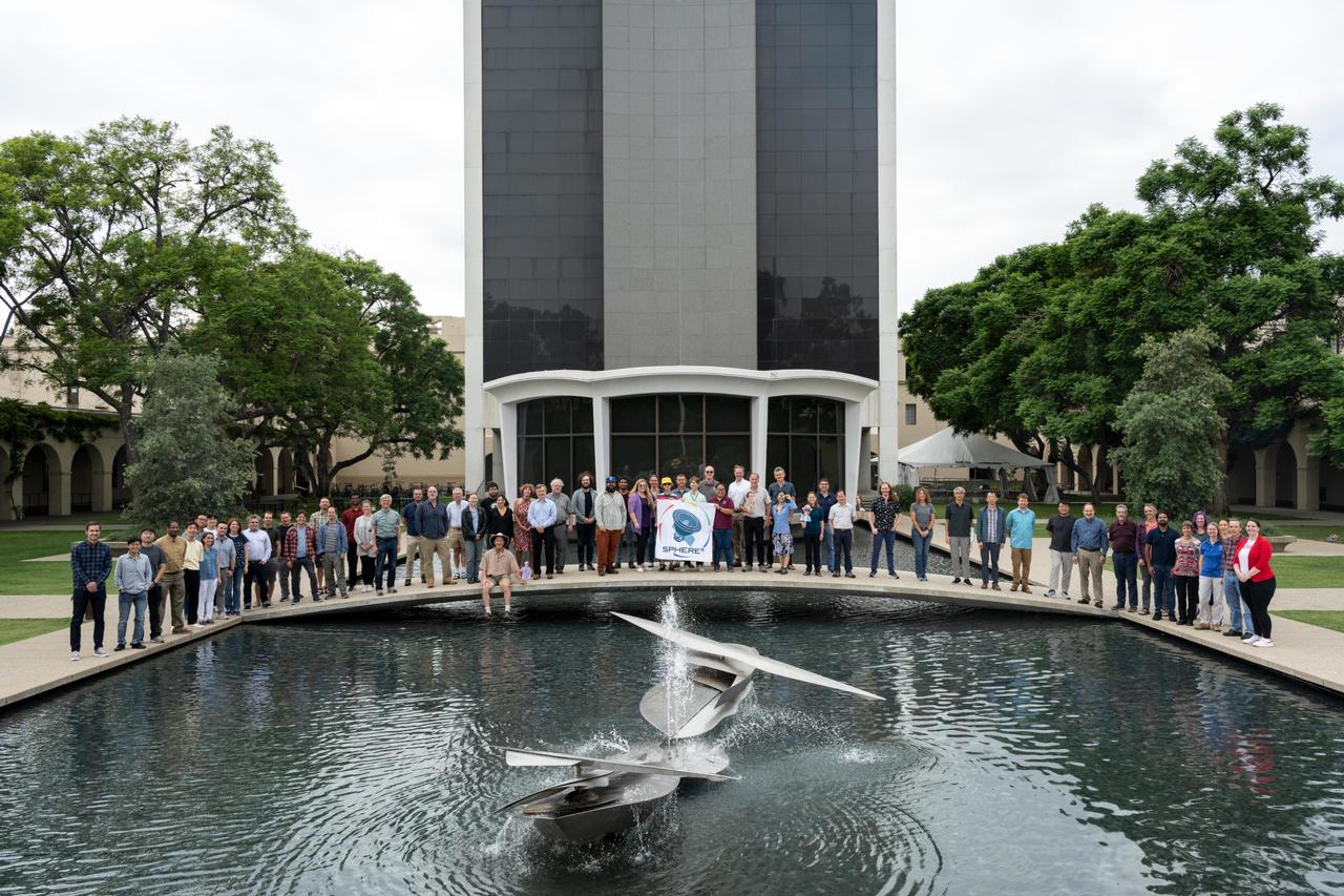
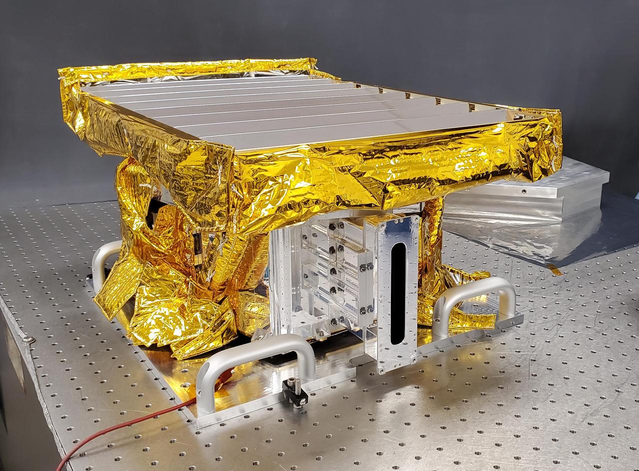
Members of the SPHEREx mission team pose for a photo on the campus of Caltech in Pasadena, California, in October 2023. Short for Spectro-Photometer for the History of the Universe, Epoch of Reionization and Ices Explorer, SPHEREx will create a map of the cosmos like no other. Using a technique called spectroscopy to image the entire sky in 102 wavelengths of infrared light, SPHEREx will gather information about the composition of and distance to millions of galaxies and stars. With this map, scientists will study what happened in the first fraction of a second after the big bang, how galaxies formed and evolved, and the origins of water in planetary systems in our galaxy. https://photojournal.jpl.nasa.gov/catalog/PIA26534

MarCO-B, one of the experimental Mars Cube One (MarCO) CubeSats, took this image of Mars from about 10,900 miles (17,500 kilometers) away just after NASA’s InSight spacecraft landed on Mars on Nov. 26, 2018. MarCO-B flew by Mars with its twin, MarCO-A, to serve as communications relays for InSight as it touched down on the Red Planet around noon PST (3 p.m. EST). This image was taken at 1 p.m. PST (4 p.m. EST). Mars’ south pole is facing the viewer in this image. MarCO-B’s antenna reflector is on the right and antenna feed (white rectangle with gold square) is on the left. The Sun at upper right overexposed part of the image. This image was taken after PIA22833 and shortly before PIA22834. The MarCO and InSight projects are managed for NASA's Science Mission Directorate, Washington, by JPL, a division of Caltech, Pasadena. Credit: NASA/JPL-Caltech
jsc2022e072974 (4/15/2022) --- A preflight sample from the Fabrication of Amorphous Metals in Space (MSL SCA-FAMIS) investigation shows tungsten spheres embedded in a glass-forming alloy loaded into a tungsten crucible. Image courtesy of Douglas Hofmann, NASA JPL/Caltech.

MarCO-B, one of the experimental Mars Cube One (MarCO) CubeSats, took this image of Mars from about 10,900 miles (17,500 kilometers) away just after NASA’s InSight spacecraft landed on Mars on Nov. 26, 2018. MarCO-B flew by Mars with its twin, MarCO-A, to serve as communications relays for InSight as it touched down on the Red Planet around noon PST (3 p.m. EST). This image was taken at 1 p.m. PST (4 p.m. EST). A crescent Mars with its south pole in the 4 o’clock position is visible in this picture. MarCO-B’s antenna reflector mirrors a portion of the illuminated part of Mars on the bottom right. The antenna feed (white rectangle with gold squares) is visible on the left. This image was taken about 50 minutes after PIA22833 and 10 seconds after PIA22832. The MarCO and InSight projects are managed for NASA's Science Mission Directorate, Washington, by JPL, a division of Caltech, Pasadena. Credit: NASA/JPL-Caltech
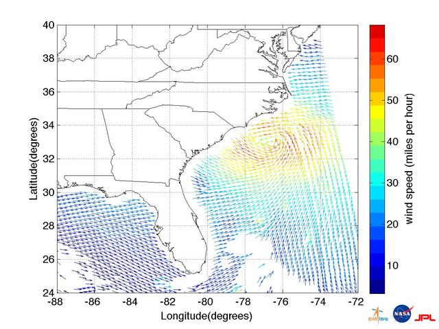
This ISRO-NASA-JPL-Caltech collaborative image shows ocean wind vector data from ISRO OceanSat 2 spacecraft of Hurricane Irene which made landfall early Saturday morning, Aug. 27, just west of Cape Lookout, NC.

The Mars Sample Return Campaign Science Group gathered at the Keck Institute for Space Studies at Caltech for an initial meeting on June 28-29, 2022. This June 28 photo includes team members who attended in person; several others attended virtually or were not able to participate. The committee will provide oversight with the goal of maximizing the scientific potential of Mars rock and sediment samples that would be returned to Earth for in-depth analysis, as part of the Campaign. https://photojournal.jpl.nasa.gov/catalog/PIA25442

The Mars Sample Return Campaign Science Group gathered for their first meeting, at the Keck Institute for Space Studies at Caltech, and took a group photo. This June 28 photo includes team members who attended in person; several others attended virtually or were not able to participate. The committee will provide oversight with the goal of maximizing the scientific potential of Mars rock and sediment samples that would be returned to Earth for in-depth analysis, as part of the Campaign. https://photojournal.jpl.nasa.gov/catalog/PIA25443
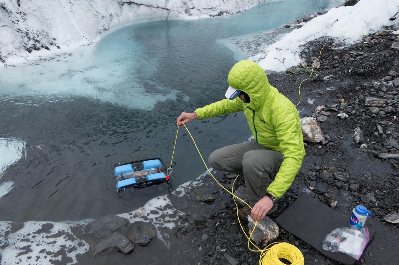
JPL engineer Andy Klesh lowers a robotic submersible into a moulin. Klesh and JPL's John Leichty used robots and probes to explore the Matanuska Glacier in Alaska this past July. Image Credit: NASA/JPL-Caltech

Using a combination of GPS-measured ground motion data, satellite radar data, and seismic observations from instruments distributed around the world, scientists have constructed preliminary estimates of how much the fault responsible for the April 25, 2015, magnitude 7.8 Gorkha earthquake in Nepal moved below Earth's surface (Figure 1). This information is useful for understanding not only what happened in the earthquake but also the potential for future events. It can also be used to infer a map of how Earth's surface moved due to the earthquake over a broader region (Figure 2). The maps created from these data can be viewed at PIA19384. In the first figure, the modeled slip on the fault is shown as viewed from above and indicated by the colors and contours within the rectangle. The peak slip in the fault exceeds 19.7 feet (6 meters). The ground motion measured with GPS is shown by the red and purple arrows and was used to develop the fault slip model. In the second figure, color represents vertical movement and the scaled arrows indicate direction and magnitude of horizontal movement. In both figures, aftershocks are indicated by red dots. Background color and shaded relief reflect regional variations in topography. The barbed lines show where the main fault reaches Earth's surface. The main fault dives northward into the Earth below the Himalaya. http://photojournal.jpl.nasa.gov/catalog/PIA19384
The High-resolution Volatiles and Minerals Moon Mapper (HVM³) sits in a clean room at NASA's Jet Propulsion Laboratory in Southern California in early December 2022. The JPL-built instrument was later shipped to Lockheed Martin Space in Littleton, Colorado, to be integrated with NASA's Lunar Trailblazer spacecraft. HVM³ is an imaging spectrometer that will detect and map water on the Moon's surface to determine its abundance, location, form, and how it changes over time. A second instrument, the Lunar Thermal Mapper infrared multispectral imager, is being developed by the University of Oxford in the U.K. and is scheduled for delivery and integration in early 2023. Lunar Trailblazer was selected under NASA's Small Innovative Missions for Planetary Exploration (SIMPLEx) program in 2019. The Lunar Trailblazer mission is managed by JPL and its science investigation is led by Caltech in Pasadena, California. Managed for NASA by Caltech, JPL also provides system engineering, mission assurance, the HVM³ instrument, as well as navigation. Lockheed Martin Space provides the spacecraft and integrates the flight system, under contract with Caltech. SIMPLEx mission investigations are managed by the Planetary Missions Program Office at NASA's Marshall Space Flight Center in Huntsville, Alabama, as part of the Discovery Program at NASA Headquarters in Washington. The program conducts space science investigations in the Planetary Science Division of NASA's Science Mission Directorate at NASA Headquarters. https://photojournal.jpl.nasa.gov/catalog/PIA25256

In honor of Women’s History Month, the Advisory Council for Women (ACW) organized a "Women of JPL" group photo shoot in the Space Flight Operations Facility on March 4, 2020. Credit: NASA-JPL/Caltech

Directors Colloquium: Dr Charles Beichman, NExSci Caltech/JPL presents 'Using JWST's Near-IR Camera to observe the Universe from 10 AU to Z>10'.

In honor of Women’s History Month, the Advisory Council for Women (ACW) organized a "Women of JPL" group photo shoot in the Space Flight Operations Facility on March 4, 2020. Credit: NASA-JPL/Caltech
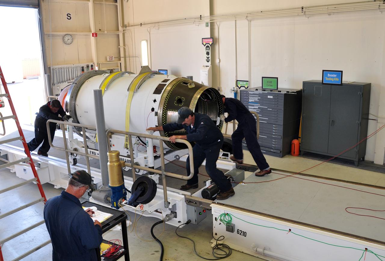
VANDENBERG AIR FORCE BASE, Calif. -- At Vandenberg Air Force Base in California, the second stage of the Pegasus XL rocket that will launch the Nuclear Spectroscopic Telescope Array (NuSTAR) to orbit is moved to a stationary rail in Building 1555 for processing. After the rocket and spacecraft are processed at Vandenberg, they will be shipped to the Ronald Reagan Ballistic Missile Defense Test Site located at the Pacific Ocean’s Kwajalein Atoll for launch. The high-energy X-ray telescope will conduct a census for black holes, map radioactive material in young supernovae remnants, and study the origins of cosmic rays and the extreme physics around collapsed stars. Photo credit: NASA/Randy Beaudoin, VAFB
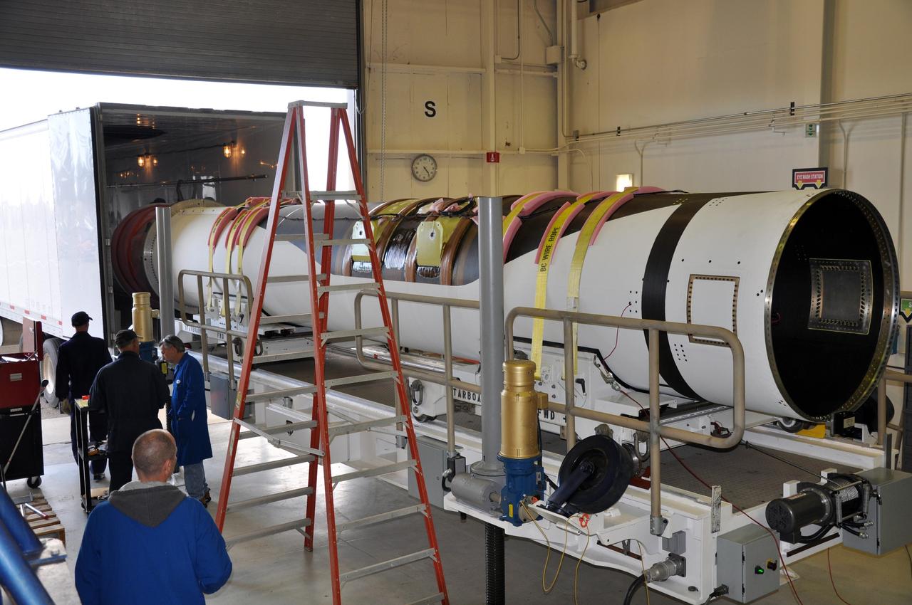
VANDENBERG AIR FORCE BASE, Calif. -- At Vandenberg Air Force Base in California, the first stage of the Pegasus XL rocket that will launch the Nuclear Spectroscopic Telescope Array (NuSTAR) to orbit is offloaded for processing in Building 1555. After the rocket and spacecraft are processed at Vandenberg, they will be shipped to the Ronald Reagan Ballistic Missile Defense Test Site located at the Pacific Ocean’s Kwajalein Atoll for launch. The high-energy X-ray telescope will conduct a census for black holes, map radioactive material in young supernovae remnants, and study the origins of cosmic rays and the extreme physics around collapsed stars. Photo credit: NASA/Randy Beaudoin, VAFB
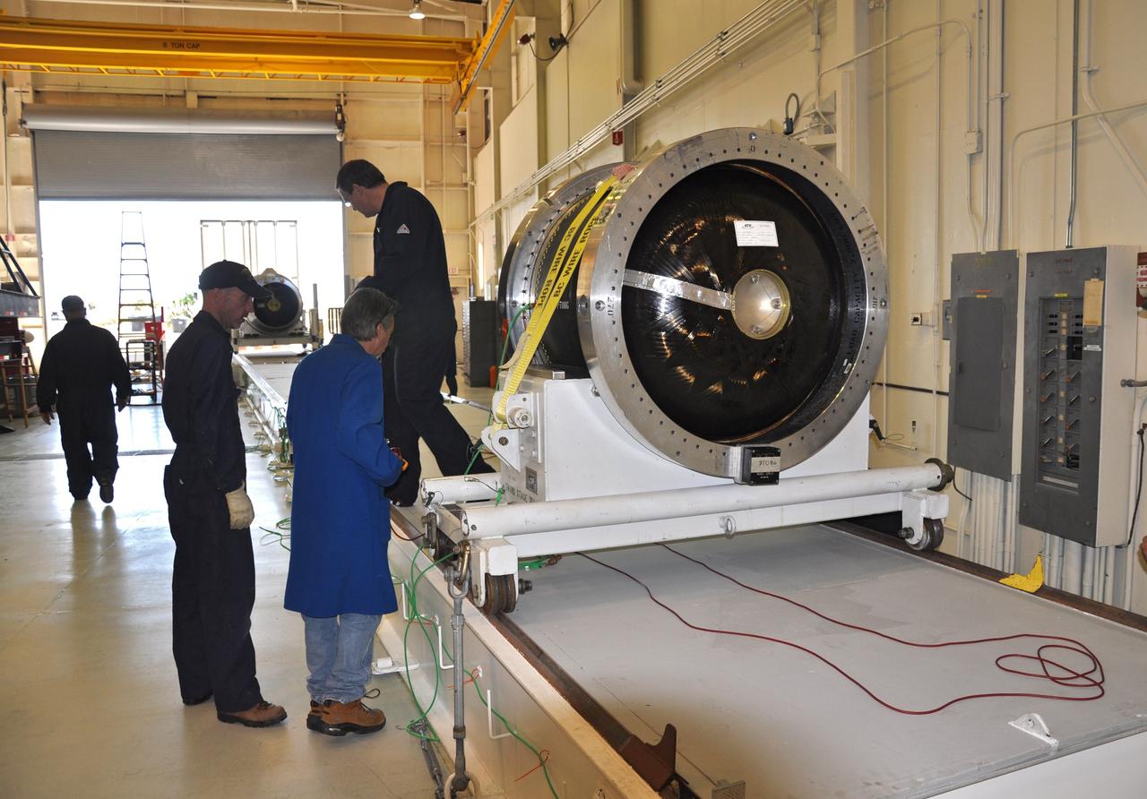
VANDENBERG AIR FORCE BASE, Calif. -- At Vandenberg Air Force Base in California, the second stage of the Pegasus XL rocket that will launch the Nuclear Spectroscopic Telescope Array (NuSTAR) to orbit is moved to a stationary rail in Building 1555 for processing. After the rocket and spacecraft are processed at Vandenberg, they will be shipped to the Ronald Reagan Ballistic Missile Defense Test Site located at the Pacific Ocean’s Kwajalein Atoll for launch. The high-energy X-ray telescope will conduct a census for black holes, map radioactive material in young supernovae remnants, and study the origins of cosmic rays and the extreme physics around collapsed stars. Photo credit: NASA/Randy Beaudoin, VAFB

VANDENBERG AIR FORCE BASE, Calif. -- At Vandenberg Air Force Base in California, the third stage of the Pegasus XL rocket that will launch the Nuclear Spectroscopic Telescope Array (NuSTAR) to orbit is offloaded for processing in Building 1555. After the rocket and spacecraft are processed at Vandenberg, they will be shipped to the Ronald Reagan Ballistic Missile Defense Test Site located at the Pacific Ocean’s Kwajalein Atoll for launch. The high-energy X-ray telescope will conduct a census for black holes, map radioactive material in young supernovae remnants, and study the origins of cosmic rays and the extreme physics around collapsed stars. Photo credit: NASA/Randy Beaudoin, VAFB
VANDENBERG AIR FORCE BASE, Calif. -- At Vandenberg Air Force Base in California, the third stage of the Pegasus XL rocket that will launch the Nuclear Spectroscopic Telescope Array (NuSTAR) to orbit is offloaded for processing in Building 1555. After the rocket and spacecraft are processed at Vandenberg, they will be shipped to the Ronald Reagan Ballistic Missile Defense Test Site located at the Pacific Ocean’s Kwajalein Atoll for launch. The high-energy X-ray telescope will conduct a census for black holes, map radioactive material in young supernovae remnants, and study the origins of cosmic rays and the extreme physics around collapsed stars. Photo credit: NASA/Randy Beaudoin, VAFB
VANDENBERG AIR FORCE BASE, Calif. -- At Vandenberg Air Force Base in California, the second stage of the Pegasus XL rocket that will launch the Nuclear Spectroscopic Telescope Array (NuSTAR) to orbit is ready to move from a jackable rail to a stationary one for processing in Building 1555. After the rocket and spacecraft are processed at Vandenberg, they will be shipped to the Ronald Reagan Ballistic Missile Defense Test Site located at the Pacific Ocean’s Kwajalein Atoll for launch. The high-energy X-ray telescope will conduct a census for black holes, map radioactive material in young supernovae remnants, and study the origins of cosmic rays and the extreme physics around collapsed stars. Photo credit: NASA/Randy Beaudoin, VAFB

A prototype of a robot designed to explore the subsurface oceans of icy moons glides through a pool at Caltech in September 2024, its reflection visible below the water's surface. The prototype was built at NASA's Jet Propulsion Laboratory in Southern California to demonstrate the feasibility of a mission concept called SWIM, short for Sensing With Independent Micro-swimmers. SWIM envisions a swarm of dozens of self-propelled, cellphone-size robots exploring the waters of icy moons like Jupiter's Europa and Saturn's Enceladus. Delivered to the subsurface ocean by an ice-melting cryobot, the tiny robots would zoom away to look for chemical and temperature signals that could point to life. The prototype used in most of the pool tests was about 16.5 inches (42 centimeters) long, weighing 5 pounds (2.3 kilograms). As conceived for spaceflight, the robots would have dimensions about three times smaller – tiny compared to existing remotely operated and autonomous underwater scientific vehicles. In this image, commercial acoustic modules are mounted to the robot for testing: on top, one for communication, and on the bottom, one for underwater GPS. These devices were used during pool testing as stand-ins for what would be a novel wireless underwater acoustic communication system used both to transmit data between the cryobot and the swarm and to help each robot determine its position without the benefit of GPS. Led by JPL, work on SWIM took place from spring 2021 to fall 2024. The project was supported by Phase I and II funding from NASA's Innovative Advanced Concepts program under the agency's Space Technology Mission Directorate. JPL is managed for NASA by Caltech in Pasadena, California. https://photojournal.jpl.nasa.gov/catalog/PIA26423
Shown here is an identical copy of the Deep Space Optical Communications, or DSOC, superconducting nanowire single-photon detector that is coupled to the 200-inch (5.1-meter) Hale Telescope located at Caltech's Palomar Observatory in San Diego County, California. Built by the Microdevices Laboratory at NASA's Jet Propulsion Laboratory in Southern California, the detector is designed to receive near-infrared laser signals from the DSOC flight transceiver traveling with NASA's Psyche mission in deep space as a part of the technology demonstration. DSOC will test key technologies that could enable high-bandwidth optical, or laser, communications from Mars distances. Bolted to the side of the spacecraft and operating for the first two years of Psyche's journey to the asteroid of the same name, the DSOC flight laser transceiver will transmit high-rate data to Caltech's Palomar Observatory in San Diego County, California, which houses the 200-inch (5.1-meter) Hale Telescope. The downlink detector converts optical signals to electrical signals, which can be processed and decoded. The detector is designed to be both sensitive enough to detect single photons (quantum particles of light) and able to detect many photons arriving all at once. At its farthest point during the technology demonstration's operations period, the transceiver will be up to 240 million miles (390 million kilometers) away, meaning that by the time its weak laser pulses arrive at Earth, the detector will need to efficiently detect a trickle of single photons. But when the spacecraft is closer to Earth and the flight transceiver is delivering its highest bit rate to Palomar, the detector is capable of detecting very high numbers of photons without becoming overwhelmed. Because data is encoded in the timing of the laser pulses, the detector must also be able to determine the time of a photon's arrival with a precision of 100 picoseconds (one picosecond is one trillionth of a second). To sense single photons, the detector must be in a superconducting state (when electrical current flows with zero resistance), so it is cryogenically cooled to less than minus 458 degrees Fahrenheit (or 1 Kelvin), which is close to absolute zero, or the lowest temperature possible. A photon absorbed in the detector disrupts its superconducting state, creating a measurable electrical pulse as current leaves the detector. DSOC is the latest in a series of optical communication technology demonstrations funded by NASA's Technology Demonstrations Missions (TDM) program and the agency's Space Communications and Navigation (SCaN) program. JPL, a division of Caltech in Pasadena, California, manages DSOC for TDM within NASA's Space Technology Mission Directorate and SCaN within the agency's Space Operations Mission Directorate. https://photojournal.jpl.nasa.gov/catalog/PIA26141
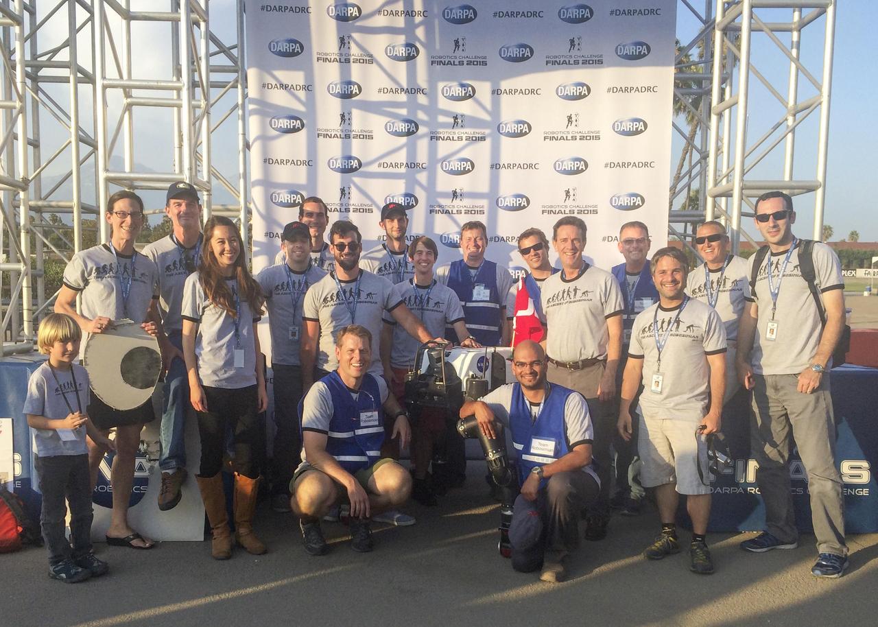
Many members of Team RoboSimian and a few guests gather with competition hardware at a "Meet the Robots" event during the DARPA Robotics Challenge Finals in Pomona, California, on June 6, 2015. The RoboSimian team at JPL is collaborating with partners at the University of California, Santa Barbara, and the California Institute of Technology in Pasadena. Caltech manages JPL for NASA. http://photojournal.jpl.nasa.gov/catalog/PIA19329
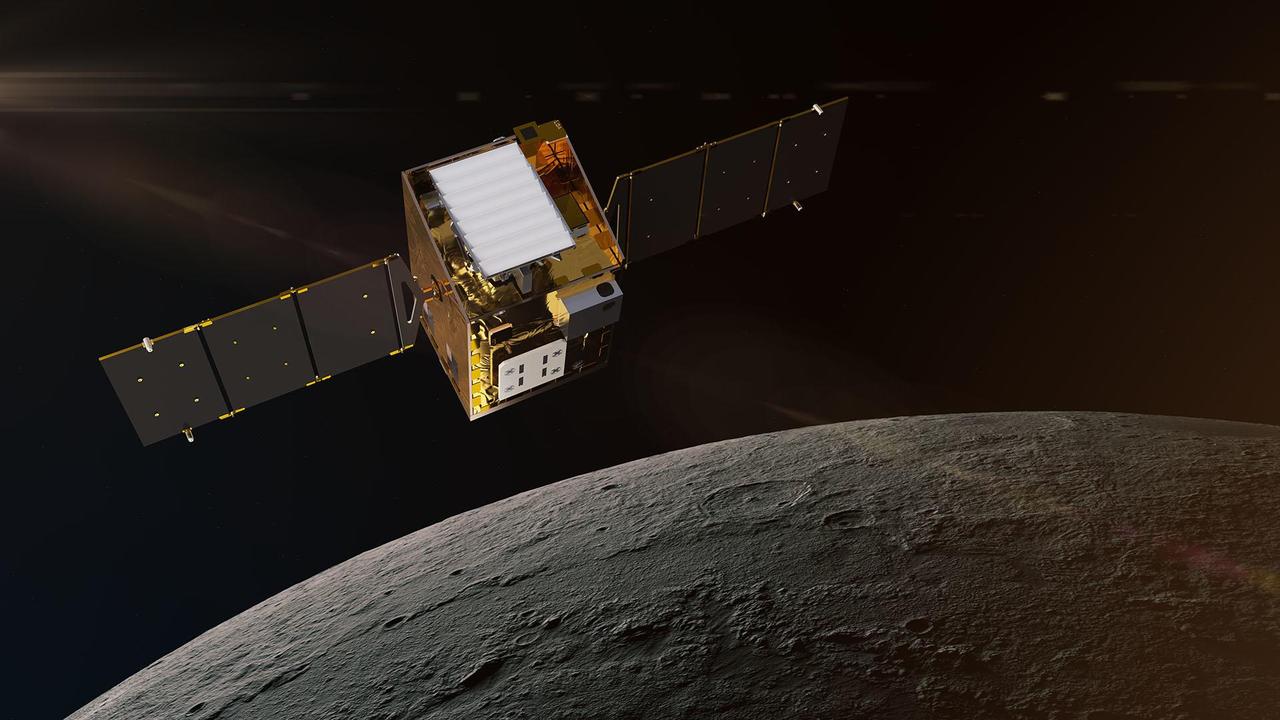
This artist's concept depicts NASA's Lunar Trailblazer in lunar orbit about 60 miles (100 kilometers) from the surface of the Moon. The spacecraft weighs only 440 pounds (200 kilograms) and measures 11.5 feet (3.5 meters) wide when its solar panels are fully deployed. Lunar Trailblazer is managed by NASA's Jet Propulsion Laboratory, and its science investigation and mission operations are led by Caltech with the mission operations center at IPAC. Managed for NASA by Caltech, JPL also provides system engineering, mission assurance, the HVM3 instrument, as well as mission design and navigation. Lockheed Martin Space provides the spacecraft, integrates the flight system, and supports operations under contract with Caltech. Lunar Trailblazer is part of NASA's Small Innovative Missions for Planetary Exploration (SIMPLEx) program, which is managed by the Planetary Missions Program Office at NASA's Marshall Space Flight Center in Huntsville, Alabama, as part of the Discovery Program at NASA Headquarters in Washington. The program conducts space science investigations in the Planetary Science Division of NASA's Science Mission Directorate at NASA Headquarters. https://photojournal.jpl.nasa.gov/catalog/PIA26453
An engineer works on the High-resolution Volatiles and Minerals Moon Mapper (HVM³) for NASA's Lunar Trailblazer spacecraft in a clean room at Lockheed Martin Space in Littleton, Colorado, shortly after the instrument delivered in December 2022. HVM³ is an imaging spectrometer that was developed at NASA's Jet Propulsion Laboratory in Southern California. It was shipped from JPL to Lockheed Martin Space, where it was integrated with the spacecraft. HVM³ is one of two instruments that will be used by the mission to detect and map water on the Moon's surface to determine its abundance, location, form, and how it changes over time. Lunar Trailblazer was selected under NASA's Small Innovative Missions for Planetary Exploration (SIMPLEx) program in 2019. The Lunar Trailblazer mission is managed by JPL and its science investigation is led by Caltech in Pasadena, California. Managed for NASA by Caltech, JPL also provides system engineering, mission assurance, the HVM³ instrument, as well as navigation. Lockheed Martin Space provides the spacecraft and integrates the flight system, under contract with Caltech. SIMPLEx mission investigations are managed by the Planetary Missions Program Office at NASA's Marshall Space Flight Center in Huntsville, Alabama, as part of the Discovery Program at NASA Headquarters in Washington. The program conducts space science investigations in the Planetary Science Division of NASA's Science Mission Directorate at NASA Headquarters. https://photojournal.jpl.nasa.gov/catalog/PIA25255

On Oct. 14, 2021, NASA Administrator (second from left) and Deputy Administrator Pam Melroy (far right) visited the agency's Jet Propulsion Laboratory to discuss NASA's climate efforts and the latest developments with the agency's Perseverance rover and Mars. With them are (from far left) Thomas Rosenbaum, president of Caltech, which manages the Jet Propulsion Laboratory for NASA; JPL Interim Director Larry James; JPL CFO Sammy Kayali; and NASA Office of JPL Management and Oversight Director Marcus Watkins. https://photojournal.jpl.nasa.gov/catalog/PIA24903
Each of NASA's Voyager probes are equipped with three radioisotope thermoelectric generators (RTGs), including the one shown here at NASA's Kennedy Space Center in Florida. The RTGs provide power for the spacecraft by converting the heat generated by the decay of plutonium-238 into electricity. Launched in 1977, the Voyager mission is managed for NASA by the agency's Jet Propulsion Laboratory, a division of Caltech in Pasadena, California. https://photojournal.jpl.nasa.gov/catalog/PIA25782

Deep Space Station 13 (DSS-13) at NASA's Goldstone Deep Space Communications Complex near Barstow, California – part of the agency's Deep Space Network – is a 34-meter (112-foot) experimental antenna that has been retrofitted with an optical terminal (the boxy instrument below the center of the antenna's dish). Since November 2023, DSS-13 has been tracking the downlink laser of the Deep Space Optical Communications (DSOC) experiment that is aboard NASA's Psyche mission, which launched on Oct. 13, 2023. In a first, the antenna also synchronously received radio-frequency signals from the spacecraft as it travels through deep space on its way to investigate the metal-rich asteroid Psyche. The laser signal collected by the camera is then transmitted through optical fiber that feeds into a cryogenically cooled semiconducting nanowire single photon detector. Designed and built by JPL's Microdevices Laboratory, the detector is identical to the one used at Caltech's Palomar Observatory, in San Diego County, California, that acts as DSOC's downlink ground station. Goldstone is one of three complexes that comprise NASA's Deep Space Network, which provides radio communications for all of the agency's interplanetary spacecraft and is also utilized for radio astronomy and radar observations of the solar system and the universe. NASA's Jet Propulsion Laboratory, a division of Caltech in Pasadena, California, manages the DSN for the agency. https://photojournal.jpl.nasa.gov/catalog/PIA26148
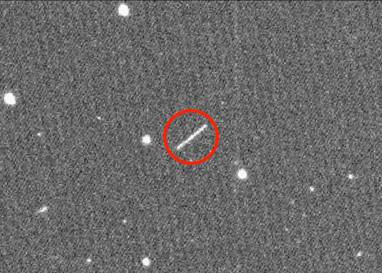
The streak circled in the center of this image is asteroid 2020 QG, which came closer to Earth than any other nonimpacting asteroid on record. It was detected by the Zwicky Transient Facility on Sunday, Aug. 16 at 12:08 a.m. EDT (Saturday, Aug. 15 at 9:08 p.m. PDT). The wide-field camera image of the Zwicky Transient Facility, a sky-scanning survey telescope funded by the National Science Foundation and NASA, and based at Caltech's Palomar Observatory in Southern California. The image was taken six hours after the close approach, as the asteroid was heading away from Earth. https://photojournal.jpl.nasa.gov/catalog/PIA24038

This close-up composite of images captured by NASA's Galileo spacecraft in the 1990s shows the crust of Jupiter's moon Europa. These are the kind of features studied by scientists who recently modeled how moonquakes may trigger landslides on icy moons circling Jupiter and Saturn. Visible here is a juxtaposition of features: possible fault scarps (like those found on Earth when tectonic activity breaks the crust) adjacent to smooth areas that may have been produced by landslide material. NASA's Jet Propulsion Laboratory in Southern California managed the mission for the agency. JPL is a division of Caltech in Pasadena, California. https://photojournal.jpl.nasa.gov/catalog/PIA25499

NASA's twin Voyager spacecraft, launched in 1977, are traveling through interstellar space at around 35,000 mph (56,000 kph). This artist's concept depicts one of the probes speeding away. The Voyager spacecraft were built by NASA's Jet Propulsion Laboratory, which continues to operate both. JPL is a division of Caltech in Pasadena, California. The Voyager missions are a part of the NASA Heliophysics System Observatory, sponsored by the Heliophysics Division of the agency's Science Mission Directorate in Washington. For more information about the Voyager spacecraft, visit https://science.nasa.gov/mission/voyager/. https://photojournal.jpl.nasa.gov/catalog/PIA26353

Alan Cummings, Voyager researcher, Caltech, speaks at an event to celebrate the 40th Anniversary of the launch of the Voyager 1 and 2 missions, Tuesday, September 5, 2017 at Smithsonian's National Air and Space Museum in Washington. Voyager 1 was launched September 5, 1977, with a mission to study Jupiter and Saturn, but now the twin Voyager spacecrafts are on a journey into interstellar space to search for the heliopause, a region never reached by any other spacecraft. Photo Credit: (NASA/Aubrey Gemignani)
This mosaic combines color-enhanced images taken over Jupiter's north pole when the lighting was excellent for detecting high bands of haze. The images were taken in the final hours of Juno's perijove 12 approach on April 1, 2018. Citizen scientists Gerald Eichstädt and John Rogers created this image using data from the spacecraft's JunoCam imager. https://photojournal.jpl.nasa.gov/catalog/PIA22934. - Enhanced image by Gerald Eichstädt and John Rogers based on images provided courtesy of NASA/JPL-Caltech/SwRI/MSSS

This image of the sunlit part of Jupiter and its swirling atmosphere was created by a citizen scientist (Alex Mai) using data from Juno's JunoCam instrument. JunoCam's raw images are available at www.missionjuno.swri.edu/junocam for the public to peruse and process into image products. http://photojournal.jpl.nasa.gov/catalog/PIA21108 . - Enhanced image by Alex Mai (CC-BY) based on images provided courtesy of NASA/JPL-Caltech/SwRI/MSSS

Perseverance project scientist, Caltech, Pasadena, California, Ken Farley, gives remarks during a NASA Perseverance rover mission post-landing update, Thursday, Feb. 18, 2021, at NASA's Jet Propulsion Laboratory in Pasadena, California. A key objective for Perseverance’s mission on Mars is astrobiology, including the search for signs of ancient microbial life. The rover will characterize the planet’s geology and past climate, pave the way for human exploration of the Red Planet, and be the first mission to collect and cache Martian rock and regolith. Photo Credit: (NASA/Bill Ingalls)
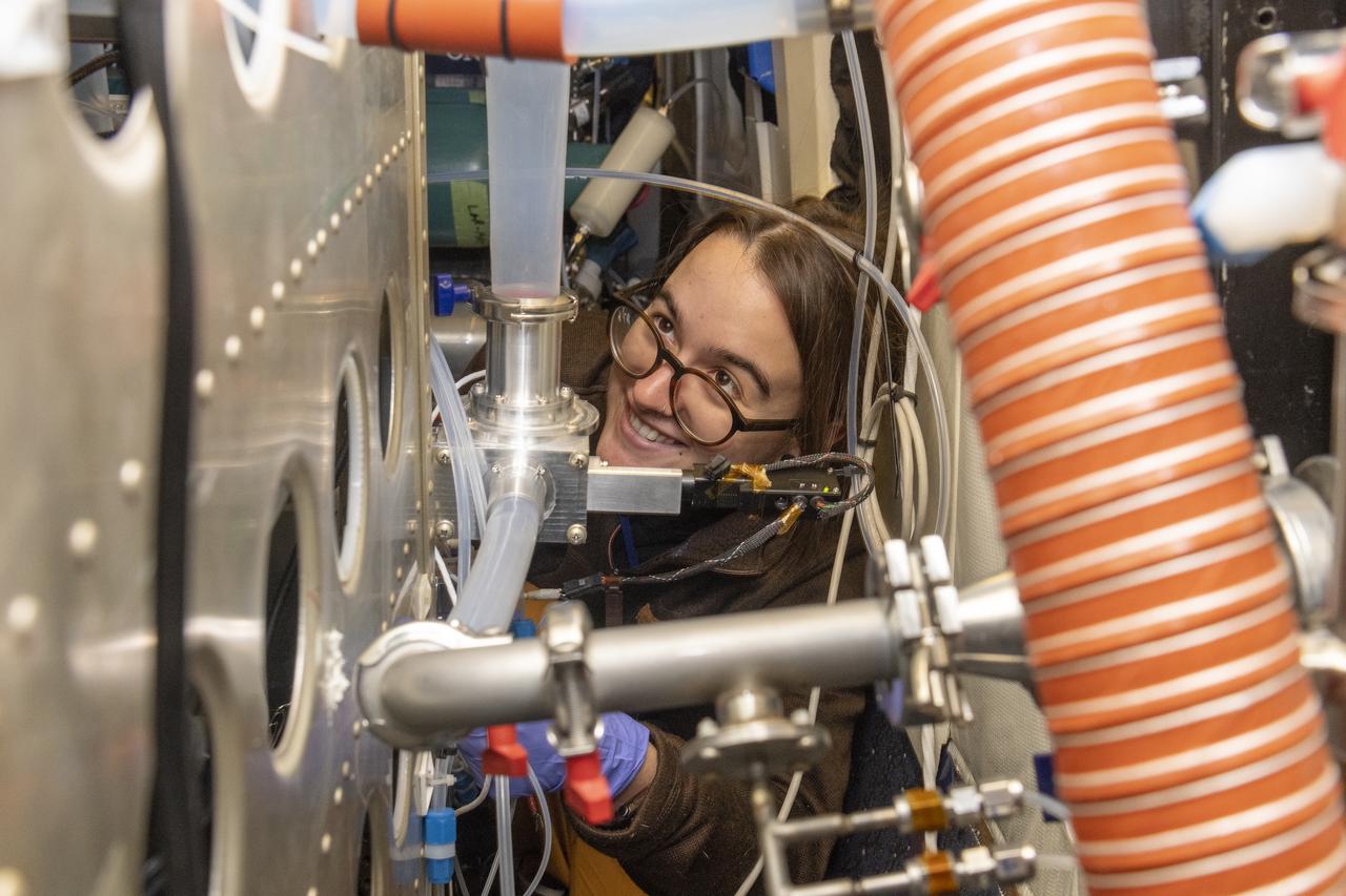
Kat Ball, Chemical Engineering Ph.D candidate at Caltech, attends to the Chemical Ionization Mass Spectrometer (CIMS) rack onboard the DC-8 aircraft at Building 703 in Palmdale, CA. The DC-8 aircraft is prepared for its last mission, ASIA-AQ (Airborne and Satellite Investigation of Asian Air Quality), that will collect detailed air quality data over several locations in Asia to improve the understanding of local air quality in collaboration with local scientists, air quality agencies, and government partners

Citizen scientist Rick Lundh created this abstract Jovian artwork using data from the JunoCam imager onboard NASA's Juno spacecraft. The original image captures a close-up view of numerous storms in the northern hemisphere of Jupiter. To produce this artwork, Lundh selected a more contrasting part of one of Jupiter's storms, then cropped the image and applied an oil-painting filter. https://photojournal.jpl.nasa.gov/catalog/PIA21983 . - Enhanced image by Rick Lundh based on images provided courtesy of NASA/JPL-Caltech/SwRI/MSSS

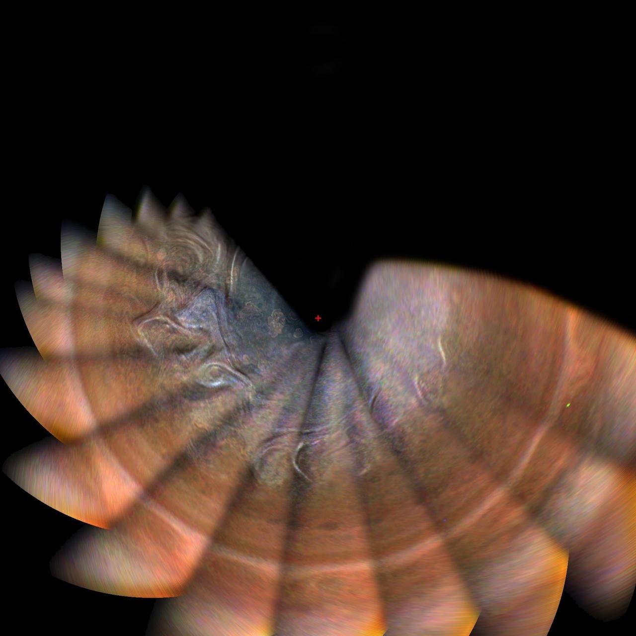
This image shows Jupiter's south pole, as seen by NASA's Juno spacecraft from an altitude of 32,000 miles (52,000 kilometers). The oval features are cyclones, up to 600 miles (1,000 kilometers) in diameter. Multiple images taken with the JunoCam instrument on three separate orbits were combined to show all areas in daylight, enhanced color, and stereographic projection. https://photojournal.jpl.nasa.gov/catalog/PIA21641 . - Enhanced image by Betsy Asher Hall/Gervasio Robles based on images provided courtesy of NASA/JPL-Caltech/SwRI/MSSS

This movie was generated using imagery collected on Oct. 29, 2018, during Juno's 16th perijove (the point at which an orbit comes closest to Jupiter's center). Citizen scientists Gerald Eichstädt created this movie using data from the spacecraft's JunoCam imager. Movie available at https://photojournal.jpl.nasa.gov/catalog/PIA22906. - Enhanced image by Gerald Eichstädt (CC-BY) based on images provided courtesy of NASA/JPL-Caltech/SwRI/MSSS/SPICE

NASA's Juno spacecraft captured this stunning Jovian cloudscape at 5:38 a.m. PST (8:38 a.m. EST) on Feb. 7, 2018, as the spacecraft performed its 11th close flyby of Jupiter. Citizen scientist Kevin M. Gill created this color-enhanced image using data from the spacecraft's JunoCam imager. https://photojournal.jpl.nasa.gov/catalog/PIA22931. - Enhanced image by Kevin M. Gill (CC-BY) based on images provided courtesy of NASA/JPL-Caltech/SwRI/MSSS
Jupiter's northern circumpolar cyclones are captured in this color-enhanced image from NASA's Juno spacecraft. The image was taken at 5:42 p.m. PDT (8:42 p.m. EDT) on Sept. 6, 2018, as the spacecraft performed its 15th close flyby of Jupiter. Citizen scientist Gerald Eichstädt created this image using data from the spacecraft's JunoCam imager. https://photojournal.jpl.nasa.gov/catalog/PIA22932. - Enhanced image by Gerald Eichstädt based on images provided courtesy of NASA/JPL-Caltech/SwRI/MSSS
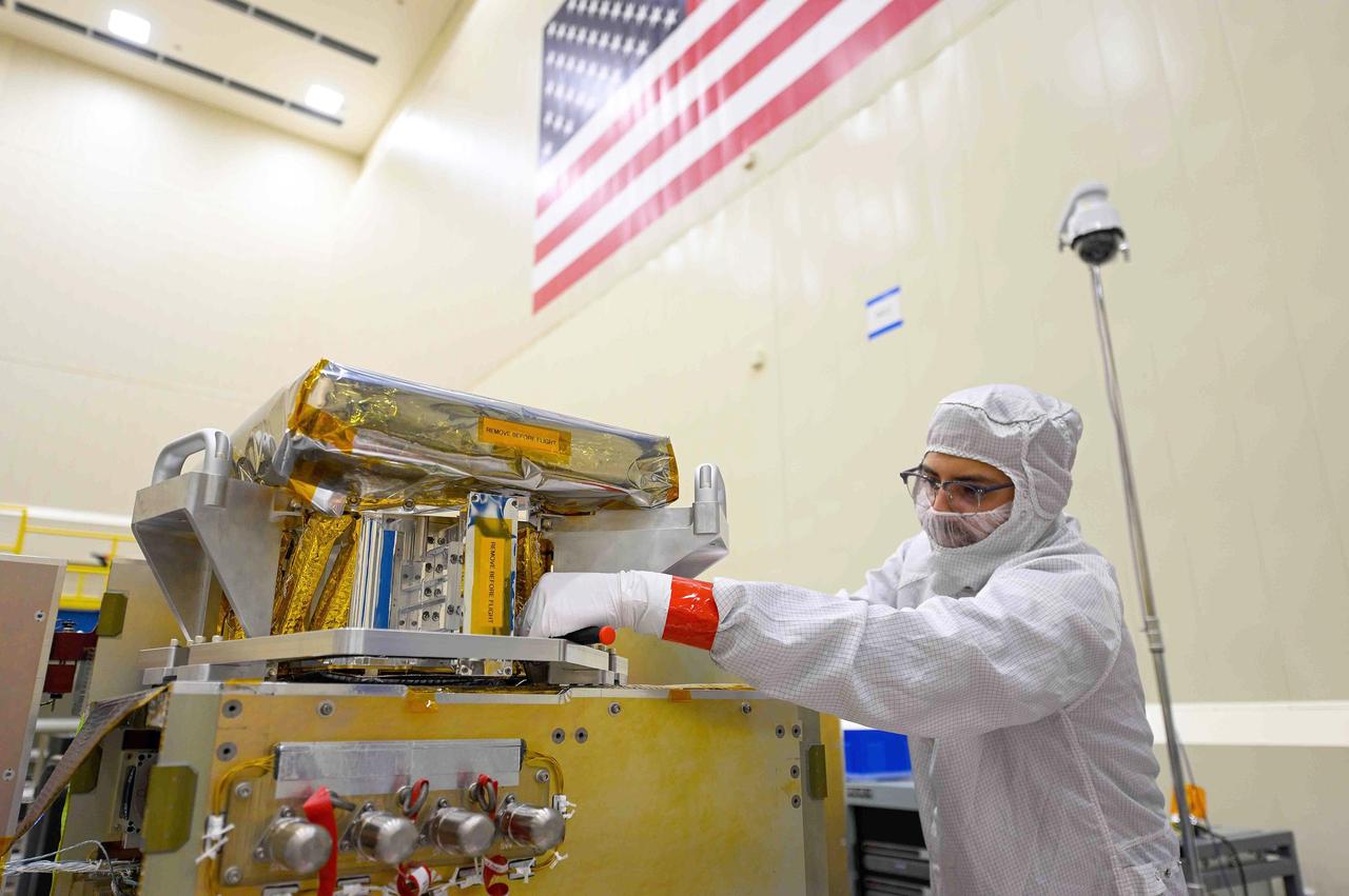
Engineers work on the High-resolution Volatiles and Minerals Moon Mapper (HVM³) for NASA's Lunar Trailblazer spacecraft in a clean room at Lockheed Martin Space in Littleton, Colorado, shortly after the instrument was delivered there in December 2022. The large silver grate wrapped in transparent plastic in the center of the image is the radiator that will maintain the instrument's temperature when in space. HVM³ is an imaging spectrometer that was developed at NASA's Jet Propulsion Laboratory in Southern California. It was shipped from JPL to Lockheed Martin Space, where it was integrated with the spacecraft. HVM³ is one of two instruments that will be used by the mission to detect and map water on the Moon's surface to determine its abundance, location, form, and how it changes over time. Lunar Trailblazer was selected under NASA's Small Innovative Missions for Planetary Exploration (SIMPLEx) program in 2019. The Lunar Trailblazer mission is managed by JPL and its science investigation is led by Caltech in Pasadena, California. Managed for NASA by Caltech, JPL also provides system engineering, mission assurance, the HVM³ instrument, as well as navigation. Lockheed Martin Space provides the spacecraft and integrates the flight system, under contract with Caltech. SIMPLEx mission investigations are managed by the Planetary Missions Program Office at NASA's Marshall Space Flight Center in Huntsville, Alabama, as part of the Discovery Program at NASA Headquarters in Washington. The program conducts space science investigations in the Planetary Science Division of NASA's Science Mission Directorate at NASA Headquarters. https://photojournal.jpl.nasa.gov/catalog/PIA25254
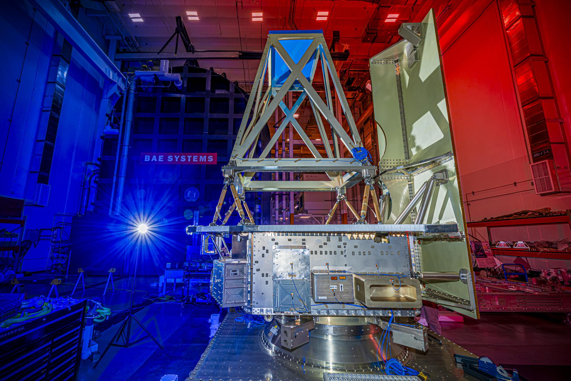
NASA’s Near-Earth Object (NEO) Surveyor sunshade mass simulator (the gray paneling to the right of the photo) is attached to the spacecraft’s bus structure in August 2025 at BAE Systems Space & Mission Systems in Boulder, Colorado. The angular assembly attached to the top of the bus via a system of struts is the instrument mass simulator. Mass simulators are used to replicate the weight and size of flight hardware during testing. Targeting launch in late 2027, the NEO Surveyor mission is led by Professor Amy Mainzer at the University of California, Los Angeles for NASA’s Planetary Defense Coordination Office and is being managed by the agency’s Jet Propulsion Laboratory in Southern California for the Planetary Missions Program Office at NASA’s Marshall Space Flight Center in Huntsville, Alabama. BAE Systems Space & Mission Systems and the Space Dynamics Laboratory in Logan, Utah, and Teledyne are among the companies that were contracted to build the spacecraft and its instrumentation. The Laboratory for Atmospheric and Space Physics at the University of Colorado Boulder will support operations, and IPAC at Caltech in Pasadena, California, is responsible for producing some of the mission’s data products. Caltech manages JPL for NASA. More information about NEO Surveyor is available at: https://science.nasa.gov/mission/neo-surveyor/
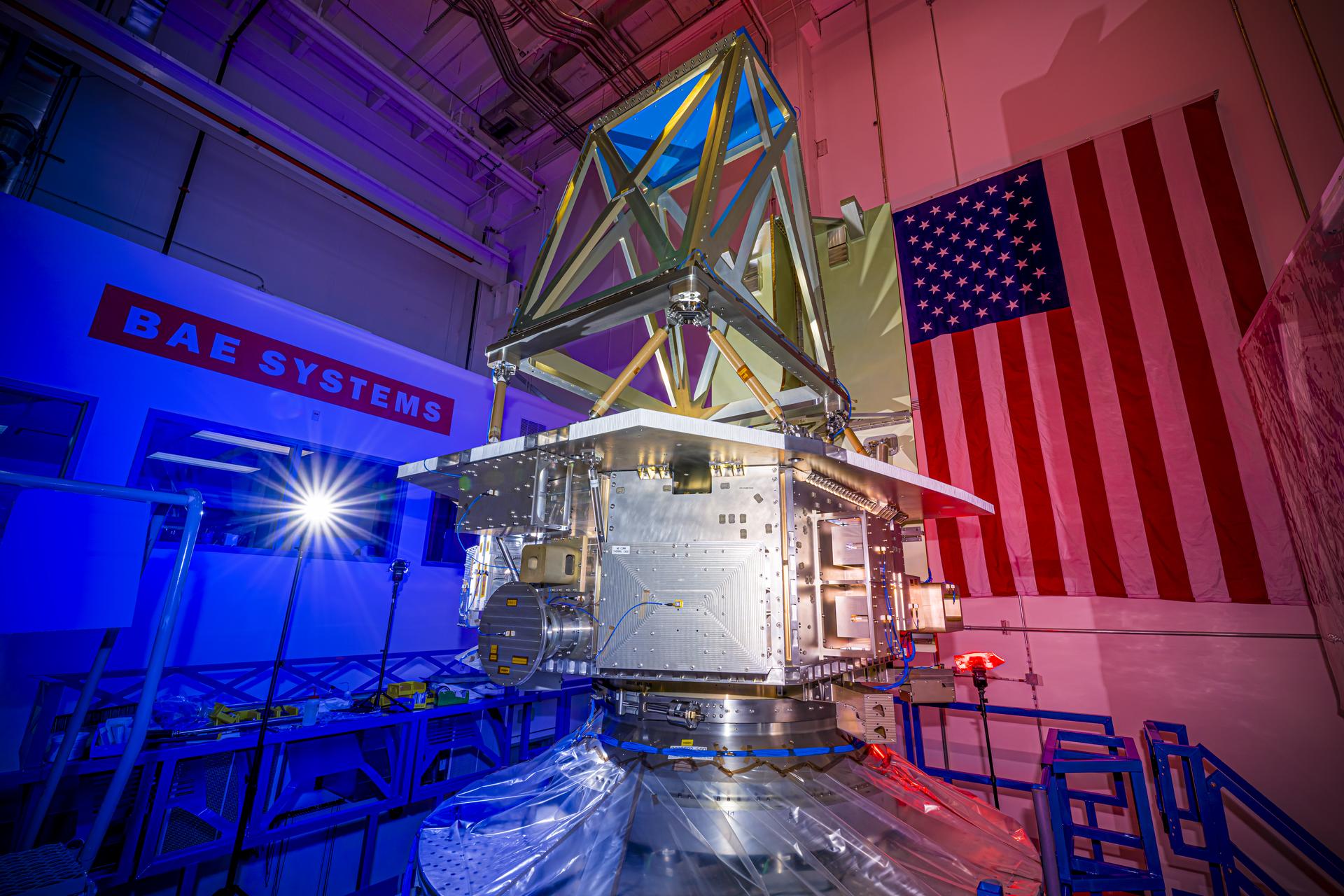
The bus structure for NASA’s Near-Earth Object (NEO) Surveyor is installed on a “shaker table” at BAE Systems Space & Mission Systems in Boulder, Colorado, during vibration testing conducted in August 2025. Mass simulators that mimic the weight and size of the spacecraft’s telescope and sunshade are also attached to the bus for the test. These mass simulators help engineers simulate the conditions flight components will experience during launch so their durability can be verified. Targeting launch in late 2027, the NEO Surveyor mission is led by Professor Amy Mainzer at the University of California, Los Angeles for NASA’s Planetary Defense Coordination Office and is being managed by the agency’s Jet Propulsion Laboratory in Southern California for the Planetary Missions Program Office at NASA’s Marshall Space Flight Center in Huntsville, Alabama. BAE Systems Space & Mission Systems and the Space Dynamics Laboratory in Logan, Utah, and Teledyne are among the companies that were contracted to build the spacecraft and its instrumentation. The Laboratory for Atmospheric and Space Physics at the University of Colorado Boulder will support operations, and IPAC at Caltech in Pasadena, California, is responsible for producing some of the mission’s data products. Caltech manages JPL for NASA. More information about NEO Surveyor is available at: https://science.nasa.gov/mission/neo-surveyor/
This mosaic shows a portion of one of the highest-resolution images captured of Jupiter's moon Europa in the 1990s by NASA's Galileo spacecraft. This picture is cropped from a larger image. These are the kind of features studied by scientists who recently modeled how moonquakes may trigger landslides on icy moons circling Jupiter and Saturn. Visible here are possible fault scarps (like those found on Earth when tectonic activity breaks the crust) with smooth slopes and nearby rubble that may have been produced by small landslides triggered by the faulting activity. These images were obtained on Nov. 6, 1997, when Galileo was approximately 1,983 miles (3,250 kilometers) from Europa. NASA's Jet Propulsion Laboratory in Southern California managed the mission for the agency. JPL is a division of Caltech in Pasadena, California. https://photojournal.jpl.nasa.gov/catalog/PIA25498

This labyrinth – with a silhouette of the fictional detective Sherlock Holmes at its center – is used as a calibration target for the cameras and laser that are part of SHERLOC (Scanning Habitable Environments with Raman & Luminescence for Organics and Chemicals), one of the instruments aboard NASA's Perseverance Mars rover. The image was captured by the Autofocus and Context Imager on SHERLOC on May 11, 2024, the 1,147th day, or sol, of the mission, as the rover team sought to confirm it had successfully addressed an issue with a stuck lens cover. A key objective for Perseverance's mission on Mars is astrobiology, including the search for signs of ancient microbial life. The rover is also characterizing the planet's geology and past climate, which paves the way for human exploration of the Red Planet. JPL, which is managed for NASA by Caltech in Pasadena, California, built and manages operations of the Perseverance rover. https://photojournal.jpl.nasa.gov/catalog/PIA26337

The Advanced Rapid Imaging and Analysis (ARIA) team at NASA's Jet Propulsion Laboratory in Pasadena, California, and Caltech, also in Pasadena, created this Damage Proxy Map (DPM) depicting areas in the southwestern part of Hokkaido, Japan, that are likely damaged as a result of the M6.6 September 5 earthquake in 2018 (shown by red and yellow pixels). The map is derived from synthetic aperture radar (SAR) images from the ALOS-2 satellites, operated by Japan Aerospace Exploration Agency (JAXA). The images were taken before and after the earthquake -- August 23 and September 6, respectively. The map covers an area of 70 by 57 kilometers, shown by the large red polygon. Each pixel measures about 30 meters across. The color variation from yellow to red indicates increasingly more significant ground surface change. Preliminary validation was done by comparing with the high-resolution airborne optical imagery provided by the Geospatial Information Authority of Japan. This damage proxy map should be used as guidance to identify damaged areas, and may be less reliable over vegetated areas. For example, pixels over vegetated areas and farmlands may be false positives, and the lack of colored pixels over vegetated areas does not necessarily mean no damage. The DPM was created by the NASA-JPL/Caltech ARIA team, and the ALOS-2 data were provided by JAXA. The algorithm development was carried out at JPL under a contract with NASA. https://photojournal.jpl.nasa.gov/catalog/PIA22696

A truck arrives at NASA's Jet Propulsion Laboratory in Southern California on June 3, 2024, to deliver the Medium Articulating Transportation System (MATS), which will be used during the construction and transportation of components for NASA's Near-Earth Object Surveyor mission. Originating at the aerospace company Beyond Gravity in Vienna, Austria, the MATS traveled via ship through the Panama Canal to Port Hueneme, California, before arriving by road at JPL. Construction has begun on NEO Surveyor's instrument enclosure in the High Bay 1 clean room at JPL's Spacecraft Assembly Facility. When the enclosure is complete later this year, it will be moved inside the MATS to NASA's Johnson Space Center in Houston for environmental testing. The MATS is a transportable clean room with its own filtration and climate control systems that keep the spacecraft and components clean, stable, and safe while being moved between facilities. NEO Surveyor's instrument enclosure contains the spacecraft's telescope, mirrors, and infrared sensors that will be used to detect, track, and characterize the most hazardous near-Earth objects. BAE Systems, Space Dynamics Laboratory, and Teledyne are among the aerospace and engineering companies contracted to build the spacecraft and its instrumentation. The Laboratory for Atmospheric and Space Physics at the University of Colorado, Boulder will support operations, and IPAC at Caltech in Pasadena, California, is responsible for processing survey data and producing the mission's data products. JPL manages the project; Caltech manages JPL for NASA. Launching no earlier than 2027, NEO Surveyor supports the objectives of NASA's Planetary Defense Coordination Office (PDCO) at NASA Headquarters in Washington. The NASA Authorization Act of 2005 directed NASA to discover and characterize at least 90% of the near-Earth objects more than 140 meters (460 feet) across that come within 30 million miles (48 million kilometers) of our planet's orbit. Objects of this size can cause significant regional damage, or worse, should they impact the Earth. https://photojournal.jpl.nasa.gov/catalog/PIA26381
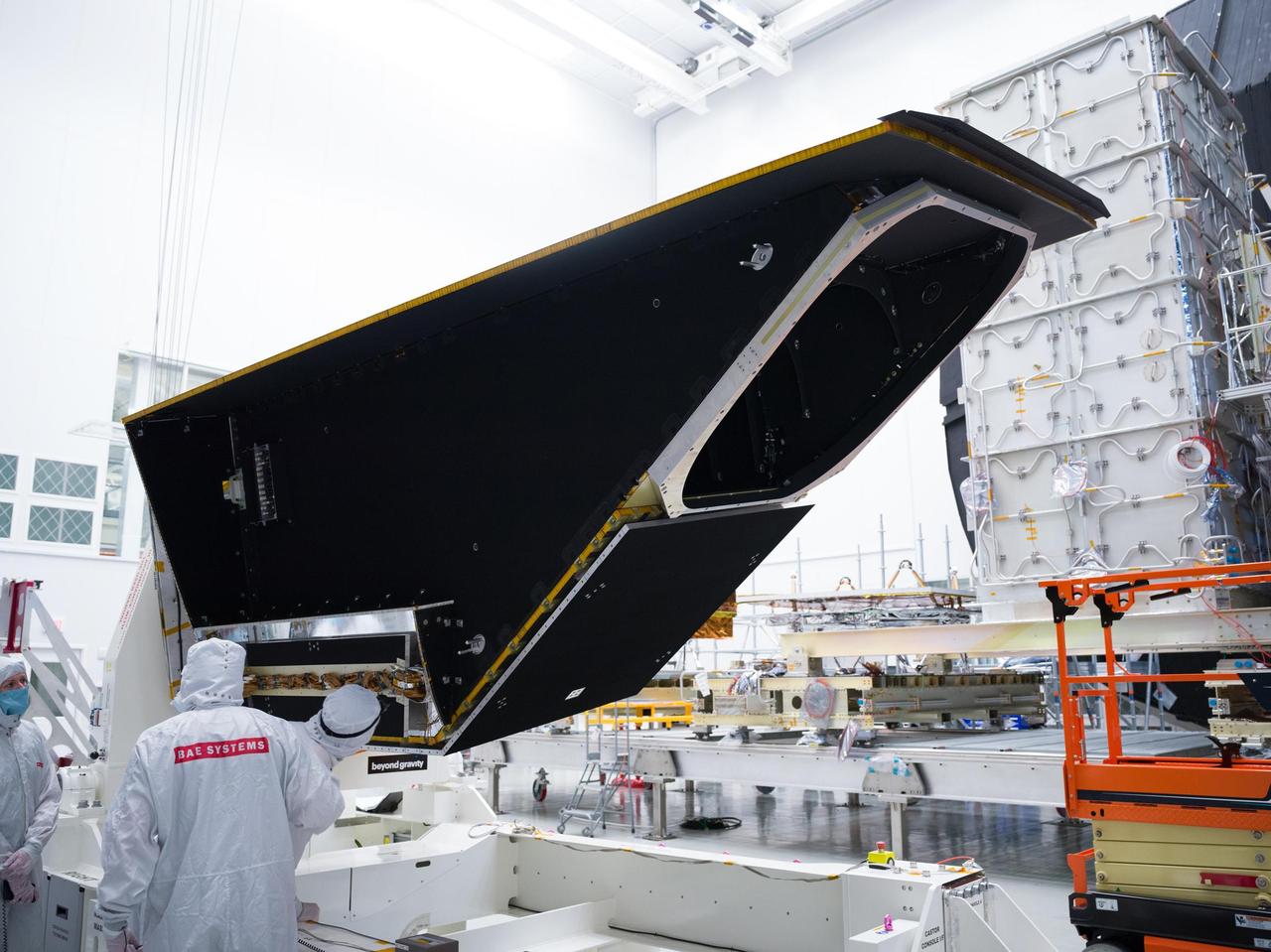
The instrument enclosure for NASA's Near-Earth Object Surveyor is prepared for environmental testing inside the historic Chamber A in the Space Environment Simulation Laboratory at the agency's Johnson Space Center in Houston in December 2024. Mounted to its articulating platform, on which it was securely positioned during assembly, the 12-foot-long (3.7-meter-long) angular structure was inspected by technicians before being placed inside the testing chamber. Figure A shows the reflective side of the instrument enclosure as it was rotated on the assembly dolly before being transferred to a testing platform. The cavernous opening to Chamber A is in the background. The instrument enclosure is designed to protect the spacecraft's infrared telescope while also removing heat from it during operations. After environmental testing was completed, the enclosure returned to NASA's Jet Propulsion Laboratory in Southern California for further work, after which it will ship to the Space Dynamics Laboratory (SDL) in Logan, Utah, and be joined to the telescope. Both the instrument enclosure and telescope were assembled at JPL. As NASA's first space-based detection mission specifically designed for planetary defense, NEO Surveyor will seek out, measure, and characterize the hardest-to-find asteroids and comets that might pose a hazard to Earth. While many near-Earth objects don't reflect much visible light, they glow brightly in infrared light due to heating by the Sun. The spacecraft's telescope, which has an aperture of nearly 20 inches (50 centimeters), features detectors sensitive to two infrared wavelengths in which near-Earth objects re-radiate solar heat. Targeting launch in late 2027, the NEO Surveyor mission is led by Prof. Amy Mainzer at UCLA for NASA's Planetary Defense Coordination Office and is being managed by JPL for the Planetary Missions Program Office at NASA's Marshall Space Flight Center in Huntsville, Alabama. BAE Systems, SDL, and Teledyne are among the companies that were contracted to build the spacecraft and its instrumentation. The Laboratory for Atmospheric and Space Physics at the University of Colorado Boulder will support operations, and Caltech/IPAC in Pasadena, California, is responsible for producing some of the mission's data products. Caltech manages JPL for NASA. https://photojournal.jpl.nasa.gov/catalog/PIA26582

At NASA's Jet Propulsion Laboratory in Southern California, on June 7, 2024, clean room technicians use a crane to lift the lid of the Medium Articulating Transportation System (MATS) that will be used during the construction and transportation of components for NASA's Near-Earth Object Surveyor mission. Inside the MATS is the Medium Articulating Assembly Dolly (MAAD), a platform that will support the spacecraft's instrument enclosure, which is being constructed inside the High Bay 1 clean room at JPL's Spacecraft Assembly Facility. The MAAD is an articulating platform on which a spacecraft (or spacecraft components) can be mounted securely and positioned as required during assembly. It can tilt a spacecraft vertically and horizontally, rotating it 360 degrees. JPL plans to use the MAAD for future missions to reduce the number of crane lifts during assembly, test, and launch operations, known as ATLO. NEO Surveyor is the first mission to use the platform. NEO Surveyor's instrument enclosure contains the spacecraft's telescope, mirrors, and infrared sensors that will be used to detect, track, and characterize the most hazardous near-Earth objects. BAE Systems, Space Dynamics Laboratory, and Teledyne are among the aerospace and engineering companies contracted to build the spacecraft and its instrumentation. The Laboratory for Atmospheric and Space Physics at the University of Colorado, Boulder will support operations, and IPAC at Caltech in Pasadena, California, is responsible for processing survey data and producing the mission's data products. JPL manages the project; Caltech manages JPL for NASA. Launching no earlier than 2027, NEO Surveyor supports the objectives of NASA's Planetary Defense Coordination Office (PDCO) at NASA Headquarters in Washington. The NASA Authorization Act of 2005 directed NASA to discover and characterize at least 90% of the near-Earth objects more than 140 meters (460 feet) across that come within 30 million miles (48 million kilometers) of our planet's orbit. Objects of this size can cause significant regional damage, or worse, should they impact the Earth. https://photojournal.jpl.nasa.gov/catalog/PIA26382
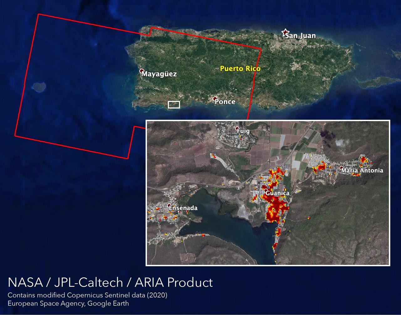
NASA scientists are helping local and federal agencies assess the extent of the damage in Puerto Rico following a 6.4-magnitude earthquake and hundreds of aftershocks. Using synthetic aperture radar data from the Copernicus Sentinel-1 satellites operated by the European Space Agency (ESA), the Advanced Rapid Imaging and Analysis (ARIA) team at NASA's Jet Propulsion Laboratory and Caltech in Pasadena, California created a new damage map that includes the southwestern coast near the main quake's epicenter. The ARIA team compared post-quake satellite data acquired on Jan. 14 with data as far back as Sept. 2019 to produce the map. The color variation from yellow to dark red indicates increasingly more significant damage. Their analysis shows that Guanica, west of the city of Ponce, was particularly hard hit. The map covers an area of 107 by 47 miles (172 by 76 kilometers), shown with the large red polygon, with each pixel measuring about 100 feet (30 meters) across. The data is most sensitive to building damage rather than small scale changes or partial structural damage. It is also less reliable over heavy vegetation. Even with these limitations, the map can still serve an important role in identifying the areas that may need help the most. The map contains modified Copernicus Sentinel data processed by ESA and analyzed by ARIA team scientists at NASA JPL and Caltech. https://photojournal.jpl.nasa.gov/catalog/PIA23429
Shown here is a prototype of the Deep Space Optical Communications, or DSOC, ground receiver detector built by the Microdevices Laboratory at NASA's Jet Propulsion Laboratory in Southern California. The prototype superconducting nanowire single-photon detector was used by JPL technologists to help develop the detector that – from a station on Earth – will receive near-infrared laser signals from the DSOC flight transceiver traveling with NASA's Psyche mission in deep space. DSOC will test key technologies that could enable high-bandwidth optical, or laser, communications from Mars distances. Bolted to the side of the spacecraft and operating for the first two years of Psyche's journey to the asteroid of the same name, the DSOC flight laser transceiver will transmit high-rate data to Caltech's Palomar Observatory in San Diego County, California, which houses the 200-inch (5.1-meter) Hale Telescope. The downlink detector converts optical signals to electrical signals, which can be processed and decoded. The detector is designed to be both sensitive enough to detect single photons (quantum particles of light) and able to detect many photons arriving all at once. At its farthest point during the technology demonstration's operations period, the transceiver will be up to 240 million miles (390 million kilometers) away, meaning that by the time its weak laser pulses arrive at Earth, the detector will need to efficiently detect a trickle of single photons. But when the spacecraft is closer to Earth and the flight transceiver is delivering its highest bit rate to Palomar, the detector is capable of detecting very high numbers of photons without becoming overwhelmed. Because data is encoded in the timing of the laser pulses, the detector must also be able to determine the time of a photon's arrival with a precision of 100 picoseconds (one picosecond is one trillionth of a second). DSOC is the latest in a series of optical communication technology demonstrations funded by NASA's Technology Demonstrations Missions (TDM) program and the agency's Space Communications and Navigation (SCaN) program. JPL, a division of Caltech in Pasadena, California, manages DSOC for TDM within NASA's Space Technology Mission Directorate and SCaN within the agency's Space Operations Mission Directorate. https://photojournal.jpl.nasa.gov/catalog/PIA25840
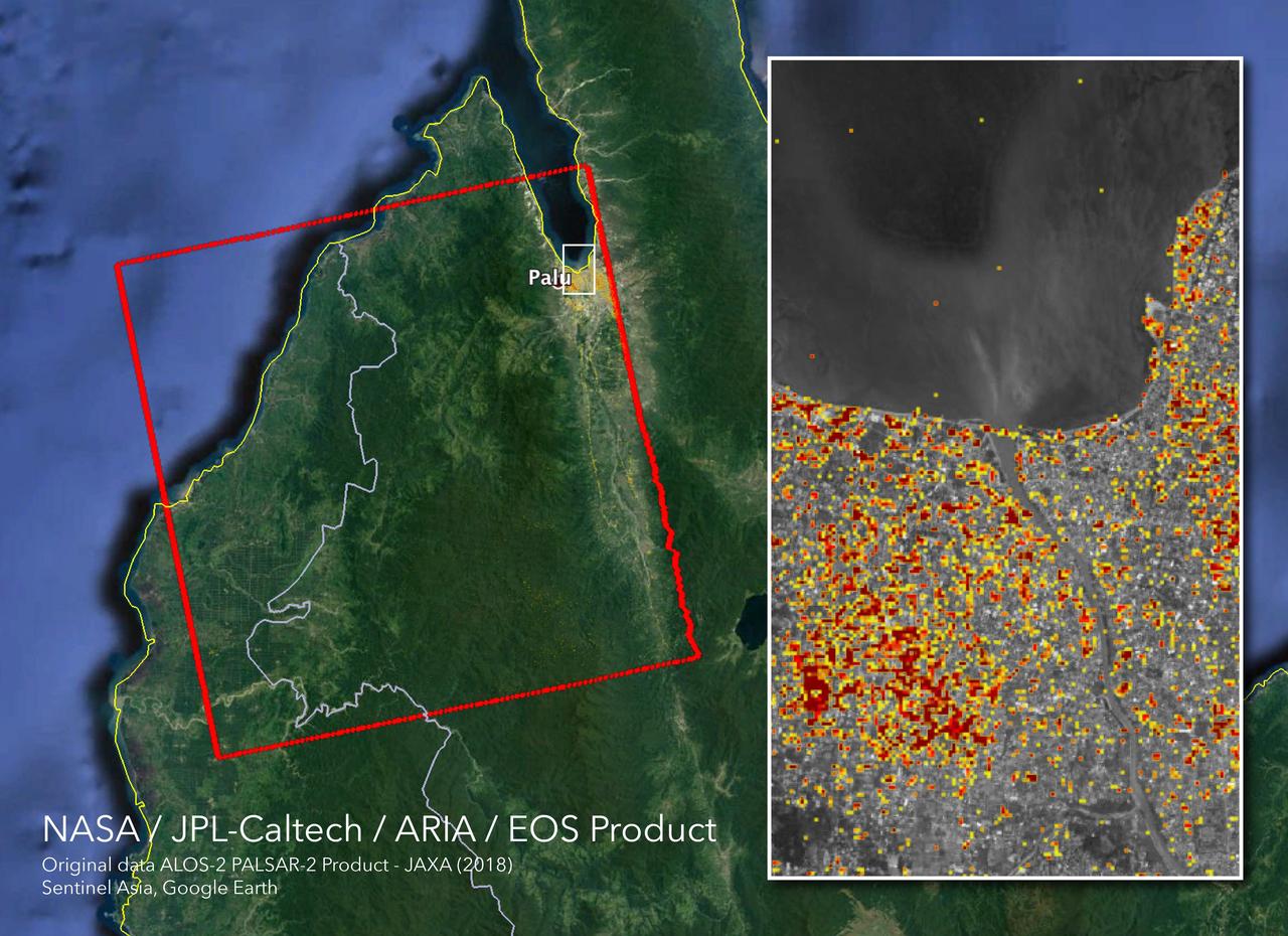
The Advanced Rapid Imaging and Analysis (ARIA) team at NASA's Jet Propulsion Laboratory in Pasadena, California, and Caltech, also in Pasadena, created this Damage Proxy Map (DPM) depicting areas in Central Sulawesi, Indonesia, including the city of Palu, that are likely damaged (shown by red and yellow pixels) as a result of the magnitude 7.5 September 28, 2018 earthquake. The map is derived from synthetic aperture radar (SAR) images from the ALOS-2 satellite, operated by Japan Aerospace Exploration Agency (JAXA). The images were taken before (Aug. 8, 2018) and after (Oct. 3, 2018) the earthquake. The map covers an area of 42 by 44 miles (67 by 70 kilometers), shown by the large red polygon. Each pixel measures about 33 yards (30 meters) across. The color variation from yellow to red indicates increasingly more significant ground surface change. Preliminary validation was done in collaboration with the Earth Observatory of Singapore by comparing with local media information and photos. This damage proxy map should be used as guidance to identify damaged areas, and may be less reliable over vegetated areas. For example, the scattered single colored pixels over vegetated areas may be false positives, and the lack of colored pixels over vegetated areas does not necessarily mean no damage. The DPM was created by the NASA-JPL/Caltech ARIA team, and the ALOS-2 data were provided by JAXA. The Earth Observatory of Singapore coordinated with the Sentinel Asia to timely task the ALOS-2 satellite. The algorithm development was carried out at JPL under a contract with NASA. https://photojournal.jpl.nasa.gov/catalog/PIA22746

The Advanced Rapid Imaging and Analysis (ARIA) team at NASA's Jet Propulsion Laboratory in Pasadena, California, and Caltech, also in Pasadena, created this Damage Proxy Map (DPM) depicting areas in the northeastern part of Lombok Island, Indonesia, that are likely damaged (shown by red and yellow pixels) as a result of the major earthquake sequence (including the M6.4 July 29, the M6.9 August 5, the M5.9 August 9, and the M6.4 August 18 earthquakes) in 2018. The map is derived from synthetic aperture radar (SAR) images from the ALOS-2 satellites, operated by Japan Aerospace Exploration Agency (JAXA). The images were taken before the (May 13, 2018 00:30) and after the (August 19, 2018 00:30, both local time) earthquakes. The map covers an area of 73 by 70 kilometers, shown by the large red polygon. Each pixel measures about 30 meters across. The color variation from yellow to red indicates increasingly more significant ground surface change. Preliminary validation was done by comparing with the DigitalGlobe's high-resolution optical satellite imagery. This damage proxy map should be used as guidance to identify damaged areas, and may be less reliable over vegetated areas. For example, the scattered single colored pixels over vegetated areas may be false positives, and the lack of colored pixels over vegetated areas does not necessarily mean no damage. The DPM was created by the NASA-JPL/Caltech ARIA team, and the ALOS-2 data were provided by JAXA. The Earth Observatory of Singapore coordinated with the Sentinel Asia to timely task the ALOS-2 satellite. The algorithm development was carried out at JPL under a contract with NASA. https://photojournal.jpl.nasa.gov/catalog/PIA22495

Perseverance project scientist, Caltech, Pasadena, California, Ken Farley gives remarks during a NASA Perseverance rover mission landing update, Wednesday, Feb. 17, 2021, at NASA's Jet Propulsion Laboratory in Pasadena, California. The Perseverance Mars rover is due to land on Mars Thursday, Feb. 18, 2021. A key objective for Perseverance’s mission on Mars is astrobiology, including the search for signs of ancient microbial life. The rover will characterize the planet’s geology and past climate, pave the way for human exploration of the Red Planet, and be the first mission to collect and cache Martian rock and regolith. Photo Credit: (NASA/Bill Ingalls)

Perseverance project scientist, Caltech, Pasadena, California, Ken Farley, right, gives remarks during a NASA Perseverance rover mission post-landing update as Perseverance entry, descent, and landing phase lead Allen Chen looks on, Thursday, Feb. 18, 2021, at NASA's Jet Propulsion Laboratory in Pasadena, California. A key objective for Perseverance’s mission on Mars is astrobiology, including the search for signs of ancient microbial life. The rover will characterize the planet’s geology and past climate, pave the way for human exploration of the Red Planet, and be the first mission to collect and cache Martian rock and regolith. Photo Credit: (NASA/Bill Ingalls)

JunoCam images aren't just for art and science -- sometimes they are processed to bring a chuckle. This image, processed by citizen scientist Jason Major, is titled "Jovey McJupiterface." By rotating the image 180 degrees and orienting it from south up, two white oval storms turn into eyeballs, and the "face" of Jupiter is revealed. The original image was acquired by JunoCam on NASA's Juno spacecraft on May 19, 2017 at 11:20 a.m. PT (2: 20 p.m. ET) from an altitude of 12,075 miles (19,433 kilometers). https://photojournal.jpl.nasa.gov/catalog/PIA21394 . - Enhanced image by Jason Major based on images provided courtesy of NASA/JPL-Caltech/SwRI/MSSS
jsc2026e014318 (March 23, 2026) --- Preflight image of the SM-3X module as part of the Cold Atom Lab (CAL). NASA’s CAL hosts multiple experiments that explore the fundamental nature of atoms by cooling them down to nearly absolute zero (the coldest temperature matter can reach). The pink-colored coated mirrors on the front and sides reflect five sets of laser beams to pre-cool atoms before they are loaded into a magnetic trap. Radio frequencies from an internal antenna lower the temperature of the trapped atoms to the extreme cold needed to observe quantum phenomena. Credit: NASA/JPL-Caltech.

jsc2026e014319 (March 23, 2026) --- Preflight image of the SM-3X module during assembly and testing at NASA’s Jet Propulsion Laboratory in Southern California as part of the Cold Atom Lab (CAL). NASA’s CAL hosts multiple experiments that explore the fundamental nature of atoms by cooling them down to nearly absolute zero (the coldest temperature matter can reach). Science Module 3X increases the number of atoms produced for each experiment and allows scientists to gather more data and further expand the Cold Atom Lab’s research capabilities. Credit: NASA/JPL-Caltech.

A "brown barge" in Jupiter's South Equatorial Belt is captured in this color-enhanced image from NASA's Juno spacecraft. This color-enhanced image was taken at 10:28 p.m. PDT on July 15, 2018 (1:28 a.m. EDT on July 16), as the spacecraft performed its 14th close flyby of Jupiter. Citizen scientist Joaquin Camarena created this image using data from the spacecraft's JunoCam imager. https://photojournal.jpl.nasa.gov/catalog/PIA22940. Enhanced image by Joaquin Camarena based on images provided courtesy of NASA/JPL-Caltech/SwRI/MSSS

Detailed structure in the clouds of Jupiter's South Equatorial Belt brown barge is visible in this color-enhanced image taken at 10:28 p.m. PDT on July 15, 2018 (1:28 a.m. EDT on July 16), as the spacecraft performed its 14th close flyby of the gas giant planet. Citizen scientist Kevin M. Gill created this image using data from the spacecraft's JunoCam imager. https://photojournal.jpl.nasa.gov/catalog/PIA22941. Enhanced image by Kevin M. Gill (CC-BY) based on images provided courtesy of NASA/JPL-Caltech/SwRI/MSSS

NASA and Caltech participate in a science briefing on Tuesday, Feb. 25, 2025, to discuss the upcoming launch of NASA’s SPHEREx (Spectro-Photometer for the History of the Universe, Epoch of Reionization and Ices Explorer) observatory and PUNCH (Polarimeter to Unify the Corona and Heliosphere) satellites at Vandenberg Space Force Base in California. SPHEREx will use its telescope to provide an all-sky spectral survey, creating a 3D map of the entire sky to help scientists investigate the origins of our universe. PUNCH will study origins of the Sun’s outflow of material, or the solar wind, capturing continuous 3D images of the Sun’s corona and the solar wind’s journey into the solar system.

This image of Jupiter's southern hemisphere was captured by NASA's Juno spacecraft as it performed a close flyby of the gas giant planet on Dec. 16, 2017. Juno captured this color-enhanced image at 10:24 a.m. PST (1:24 p.m. EST) when the spacecraft was about 19,244 miles (30,970 kilometers) from the tops of Jupiter's clouds at a latitude of 49.9 degrees south -- roughly halfway between the planet's equator and its south pole. Citizen scientist Gerald Eichstädt processed this image using data from the JunoCam imager. https://photojournal.jpl.nasa.gov/catalog/PIA21977. - Enhanced image by Gerald Eichstädt based on images provided courtesy of NASA/JPL-Caltech/SwRI/MSSS

Perseverance project scientist, Caltech, Pasadena, California, Ken Farley, on screen, gives remarks during a NASA Perseverance rover mission landing update, Wednesday, Feb. 17, 2021, at NASA's Jet Propulsion Laboratory in Pasadena, California. The Perseverance Mars rover is due to land on Mars Thursday, Feb. 18, 2021. A key objective for Perseverance’s mission on Mars is astrobiology, including the search for signs of ancient microbial life. The rover will characterize the planet’s geology and past climate, pave the way for human exploration of the Red Planet, and be the first mission to collect and cache Martian rock and regolith. Photo Credit: (NASA/Bill Ingalls)

This enhanced-color image of Jupiter's Great Red Spot was created by citizen scientist Kevin Gill using data from the JunoCam imager on NASA's Juno spacecraft. The image was taken on July 10, 2017 at 07:07 p.m. PDT (10:07 p.m. EDT), as the Juno spacecraft performed its 7th close flyby of Jupiter. At the time the image was taken, the spacecraft was about 6,130 miles (9,866 kilometers) from the tops of the clouds of the planet. https://photojournal.jpl.nasa.gov/catalog/PIA21395 . - Enhanced image by Kevin M. Gill (CC-BY) based on images provided courtesy of NASA/JPL-Caltech/SwRI/MSSS

Rachel Akeson, SPHEREx science data center lead, Caltech/IPAC, participates in a science briefing on Tuesday, Feb. 25, 2025, to discuss the upcoming launch of NASA’s SPHEREx (Spectro-Photometer for the History of the Universe, Epoch of Reionization and Ices Explorer) observatory and PUNCH (Polarimeter to Unify the Corona and Heliosphere) satellites at Vandenberg Space Force Base in California. SPHEREx will use its telescope to provide an all-sky spectral survey, creating a 3D map of the entire sky to help scientists investigate the origins of our universe. PUNCH will study origins of the Sun’s outflow of material, or the solar wind, capturing continuous 3D images of the Sun’s corona and the solar wind’s journey into the solar system.

This enhanced-color image of Jupiter's Great Red Spot was created by citizen scientist Gerald Eichstädt using data from the JunoCam imager on NASA's Juno spacecraft. The image was taken on July 10, 2017 at 07:10 p.m. PDT (10:10 p.m. EDT), as the Juno spacecraft performed its 7th close flyby of Jupiter. At the time the image was taken, the spacecraft was about 8,648 miles (13,917 kilometers) from the tops of the clouds of the planet. https://photojournal.jpl.nasa.gov/catalog/PIA21772. - Enhanced image by Gerald Eichstädt based on images provided courtesy of NASA/JPL-Caltech/SwRI/MSSS

Phil Korngut, SPHEREx instrument scientist, Caltech, participates in a science briefing on Tuesday, Feb. 25, 2025, to discuss the upcoming launch of NASA’s SPHEREx (Spectro-Photometer for the History of the Universe, Epoch of Reionization and Ices Explorer) observatory and PUNCH (Polarimeter to Unify the Corona and Heliosphere) satellites at Vandenberg Space Force Base in California. SPHEREx will use its telescope to provide an all-sky spectral survey, creating a 3D map of the entire sky to help scientists investigate the origins of our universe. PUNCH will study origins of the Sun’s outflow of material, or the solar wind, capturing continuous 3D images of the Sun’s corona and the solar wind’s journey into the solar system.

This striking image of Jupiter was captured by NASA's Juno spacecraft as it performed its eighth flyby of the gas giant planet. The image was taken on Sept. 1, 2017 at 2:58 p.m. PDT (5:58 p.m. EDT). At the time the image was taken, the spacecraft was 4,707 miles (7,576 kilometers) from the tops of the clouds of the planet at a latitude of about -17.4 degrees. Citizen scientist Gerald Eichstädt processed this image using data from the JunoCam imager. Points of interest are "Whale's Tail" and "Dan's Spot." https://photojournal.jpl.nasa.gov/catalog/PIA21966. - Enhanced image by Gerald Eichstädt based on images provided courtesy of NASA/JPL-Caltech/SwRI/MSSS

A south tropical disturbance that has just passed Jupiter's iconic Great Red Spot is captured in this color-enhanced image from NASA's Juno spacecraft. Threads of orange haze are pulled from the Great Red Spot by the turbulence of the south tropical disturbance. The image was taken at 3:04 a.m. PDT (6:04 p.m. EDT) on April 1, 2018, as the spacecraft performed its 12th close flyby of Jupiter. Citizen scientist Kevin M. Gill created this image using data from the spacecraft's JunoCam imager. https://photojournal.jpl.nasa.gov/catalog/PIA22938. - Enhanced image by Kevin M. Gill (CC-BY) based on images provided courtesy of NASA/JPL-Caltech/SwRI/MSSS

NASA Juno spacecraft skimmed the upper wisps of Jupiter atmosphere when JunoCam snapped this image on Feb. 2, 2017. from an altitude of about 9,000 miles 14,500 kilometers above the giant planet swirling cloudtops. Streams of clouds spin off a rotating oval-shaped cloud system in the Jovian southern hemisphere. Citizen scientist Roman Tkachenko reconstructed the color and cropped the image to draw viewers' eyes to the storm and the turbulence around it. http://photojournal.jpl.nasa.gov/catalog/PIA21383 . - Enhanced image by Roman Tkachenko (CC-BY) based on images provided courtesy of NASA/JPL-Caltech/SwRI/MSSS

See intricate cloud patterns in the northern hemisphere of Jupiter in this new view taken by NASA's Juno spacecraft. The color-enhanced image was taken on April 1, 2018 at 2:32 a.m. PST (5:32 a.m. EST), as Juno performed its twelfth close flyby of Jupiter. At the time the image was taken, the spacecraft was about 7,659 miles (12,326 kilometers) from the tops of the clouds of the planet at a northern latitude of 50.2 degrees. Citizen scientist Kevin M. Gill processed this image using data from the JunoCam imager. https://photojournal.jpl.nasa.gov/catalog/PIA21984 . - Enhanced image by Kevin M. Gill (CC-BY) based on images provided courtesy of NASA/JPL-Caltech/SwRI/MSSS
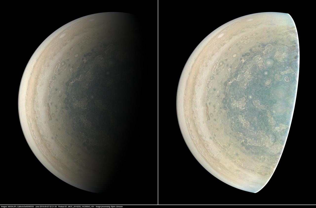
This image was taken at 7:21 p.m. PDT (10:21 p.m. EDT) on Sept. 6, 2018, as the spacecraft performed its 15th close flyby of Jupiter. The version of the image on the left side shows Jupiter in approximate true color, while the same image on the right has been processed to bring out detail close to the terminator and reveals four of the five southern circumpolar cyclones plus the cyclone in the center. Citizen scientist Björn Jónsson created this image using data from the spacecraft's JunoCam imager. https://photojournal.jpl.nasa.gov/catalog/PIA22933. - Enhanced image by Björn Jónsson (CC-NC-SA) based on images provided courtesy of NASA/JPL-Caltech/SwRI/MSSS

This enhanced-color image of Jupiter's Great Red Spot was created by citizen scientist Jason Major using data from the JunoCam imager on NASA's Juno spacecraft. The image was taken on July 10, 2017 at 07:10 p.m. PDT (10:10 p.m. EDT), as the Juno spacecraft performed its 7th close flyby of Jupiter. At the time the image was taken, the spacecraft was about 8,648 miles (13,917 kilometers) from the tops of the clouds of the planet. https://photojournal.jpl.nasa.gov/catalog/PIA21772 . - Enhanced image by Jason Major based on images provided courtesy of NASA/JPL-Caltech/SwRI/MSSS

A multitude of bright white "pop-up" storms in this Jupiter cloudscape appear in this image from NASA's Juno spacecraft. This color-enhanced image was taken at 1:55 p.m. PDT (4:55 p.m. EDT) on Oct. 29, 2018, as the spacecraft performed its 16th close flyby of Jupiter. Citizen scientists Gerald Eichstädt and Seán Doran created this image using data from the spacecraft's JunoCam imager. https://photojournal.jpl.nasa.gov/catalog/PIA22935 **Image Credit: Enhanced Image by Gerald Eichstädt and Seán Doran (CC BY-NC-SA) based on images provided courtesy of NASA/JPL-Caltech/SwRI/MSSS

A long, brown oval known as a "brown barge" in Jupiter's North North Equatorial Belt is captured in this color-enhanced image from NASA's Juno spacecraft. This image was taken at 6:01 p.m. PDT (9:01 p.m. EDT) on Sept. 6, 2018, as the spacecraft performed its 15th close flyby of Jupiter. Citizen scientist Kevin M. Gill created this image using data from the spacecraft's JunoCam imager. https://photojournal.jpl.nasa.gov/catalog/PIA22939. - Enhanced image by Kevin M. Gill (CC-BY) based on images provided courtesy of NASA/JPL-Caltech/SwRI/MSSS

jsc2026e034369 (April 28, 2026) --- Image of RubyRed staining of Staphylococcus aureus biofilm obtained with a confocal 3D microscope during preflight testing of ODYSSEY, an investigation that evaluates biofilm formation and exchange of genetic material among two species of bacteria in spaceflight and in simulated microgravity chambers on the ground. Comparing the results between these sample groups could help researchers determine whether Earth-based simulators can be considered as proxies for spaceflight research and get a better understanding of the mechanisms behind biofilm formation and exchange of genetic material when exposed to space-like conditions. Credit: JPL-Caltech.

jsc2026e034370 (April 28, 2026) --- Preflight image of Syto9 staining of Staphylococcus aureus biofilm as part of ODYSSEY, an investigation that evaluates biofilm formation and exchange of genetic material among two species of bacteria in spaceflight and in simulated microgravity chambers on the ground. Comparing the results between these sample groups could help researchers determine whether Earth-based simulators can be considered as proxies for spaceflight research and get a better understanding of the mechanisms behind biofilm formation and exchange of genetic material when exposed to space-like conditions. Credit: JPL-Caltech.

jsc2026e034367 (April 28, 2026) --- Image of Staphylococcus colonies grown on agar in preparation for ground testing as part of ODYSSEY, an investigation that evaluates biofilm formation and exchange of genetic material among two species of bacteria in spaceflight and in simulated microgravity chambers on the ground. Comparing the results between these sample groups could help researchers determine whether Earth-based simulators can be considered as proxies for spaceflight research and get a better understanding of the mechanisms behind biofilm formation and exchange of genetic material when exposed to space-like conditions. Credit: JPL-Caltech.
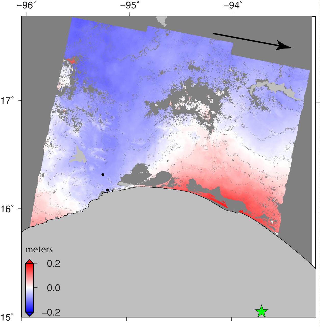
NASA and its partners are contributing important observations and expertise to the ongoing response to the Sept. 7, 2017 (local time), magnitude 8.1 Oaxaca-Chiapas earthquake in Mexico. This earthquake was the strongest in more than a century in Mexico. It has caused a significant humanitarian crisis, with widespread building damage and triggered landslides throughout the region. Scientists with the Advanced Rapid Imaging and Analysis project (ARIA), a collaboration between NASA's Jet Propulsion Laboratory in Pasadena, California; and Caltech, also in Pasadena, analyzed interferometric synthetic aperture radar images from the radar instrument on the Copernicus Sentinel-1A and Sentinel-1B satellites operated by the European Space Agency (ESA) to calculate a map of the deformation of Earth's surface caused by the quake. This false-color map shows the amount of permanent surface movement caused almost entirely by the earthquake, as viewed by the satellite, during a six-day interval between radar images acquired by the two Sentinel-1 satellites on Sept. 7 and Sept. 13, 2017. In this map, the colors of the surface displacements are proportional to the surface motion. The red tones show the areas along the coast of Chiapas and Oaxaca have moved toward the satellite by as much as 9 inches (22 centimeters) in a combination of up and eastward motion. The area in between and farther north with various shades of blue moved away from the satellite, mostly downward or westward, by as much as 6 inches (15 centimeters). Areas without color are open water or heavy vegetation, which prevent the radar from measuring change between the satellite images. Scientists use these maps to build detailed models of the fault slip at depth and associated land movements to better understand the impact on future earthquake activity. The green star shows the location of the earthquake epicenter estimated by the United States Geological Survey (USGS) National Earthquake Information Center. Map contains modified Copernicus Sentinel data 2017, processed by ESA and analyzed by the NASA-JPL/Caltech ARIA team. This research was carried out at JPL under a contract with NASA. Sentinel-1 data were accessed through the Copernicus Open Access Hub. An annotated figures is available at https://photojournal.jpl.nasa.gov/catalog/PIA21962
Scientists with the Advanced Rapid Imaging and Analysis project (ARIA), a collaboration between NASA's Jet Propulsion Laboratory in Pasadena, California, and Caltech, also in Pasadena, used synthetic aperture radar (SAR) data from the European Union's Copernicus Sentinel-1A and -1B satellites, operated by the European Space Agency. They generated a map of the deformation of Earth's surface caused by the Aug. 5, 2018 magnitude 6.9 earthquake under Lombok island, Indonesia. The deformation map is produced from automated interferometric processing of the SAR data using the JPL-Caltech ARIA data system in response to a signal received from the U.S. Geological Survey. The false-color map shows the amount of permanent surface movement that occurred almost entirely due to the quake, as viewed by the satellite, during a 6-day interval between two Sentinel-1 images acquired on July 30 and Aug. 5, 2018. The map shows that the earthquake fault was under the northwest corner of Lombok island, probably extending offshore to the west. Through these maps, NASA and its partners are contributing observations and expertise that can assist with response to earthquakes and other natural or human-produced hazards. From the pattern of deformation in the map, scientists have determined that the earthquake fault slip was on a fault beneath the northwestern part of Lombok Island and caused as much as 10 inches (25 centimeters) of uplift of the ground surface. The map depicts motion towards the satellite (up and west) in the direction of the radar's line-of-sight, with contours every 2 inches (5 centimeters). White areas are places where the radar measurement was not possible, largely due to dense forests in the middle of the islands. https://photojournal.jpl.nasa.gov/catalog/PIA22491
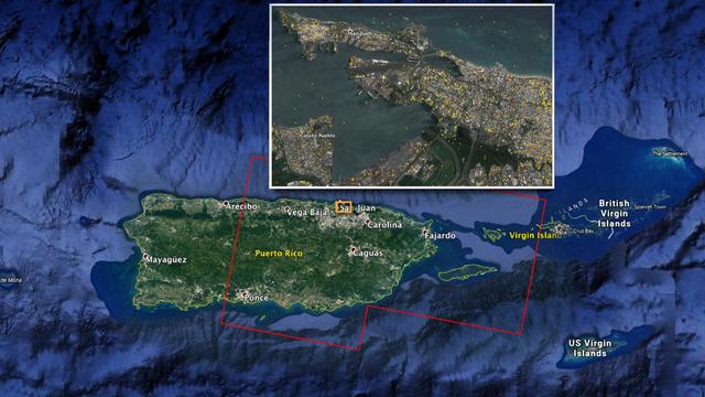
The Advanced Rapid Imaging and Analysis (ARIA) team at NASA's Jet Propulsion Laboratory in Pasadena, California, and Caltech, also in Pasadena, created this Damage Proxy Map (DPM) depicting areas of Eastern Puerto Rico that are likely damaged (shown by red and yellow pixels) as a result of Hurricane Maria (a Category 4 hurricane at landfall in Puerto Rico on Sept. 20, 2017). The map is derived from synthetic aperture radar (SAR) images from the Copernicus Sentinel-1A and Sentinel-1B satellites, operated by the European Space Agency (ESA). The images were taken before (March 25, 2017) and after (Sept. 21, 2017) the storm's landfall. The map was delivered to responding agencies, including the Federal Emergency Management Agency (FEMA), on Sept. 22, 2017. FEMA combined the map with building infrastructure data to estimate a damage density map, which was sent to its Urban Search and Rescue teams in the field in Puerto Rico. The map covers an area of 105 by 60 miles (169 by 96 kilometers), shown by the large red polygon in the figure. The inset, denoted by the orange rectangle, shows the extent of damage in and around the capital city of San Juan. Each pixel measures about 98 feet (30 meters) across. The color variation from yellow to red indicates increasingly more significant ground surface change. Preliminary validation was done by comparing the map with anecdotal reports of damage. This damage proxy map should be used as guidance to identify damaged areas, and may be less reliable over vegetated and flooded areas. Sentinel-1 data were accessed through the Copernicus Open Access Hub. The image contains modified Copernicus Sentinel data (2017), processed by ESA and analyzed by the NASA-JPL/Caltech ARIA team. This research was carried out at JPL under a contract with NASA. https://photojournal.jpl.nasa.gov/catalog/PIA21964
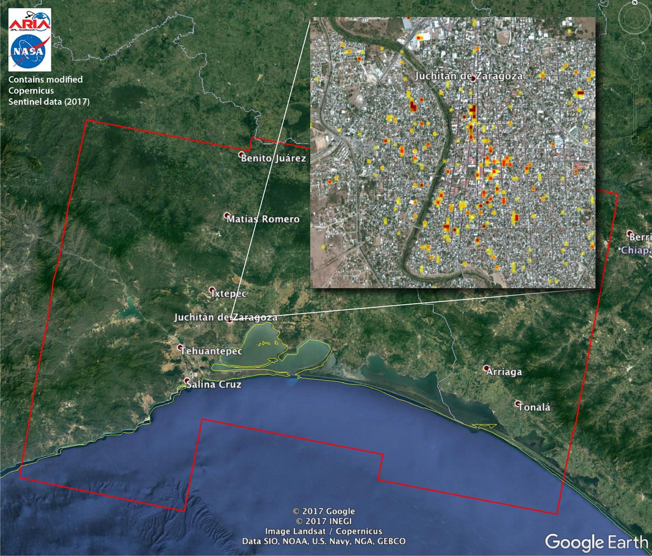
The Advanced Rapid Imaging and Analysis (ARIA) team at NASA's Jet Propulsion Laboratory in Pasadena, California, and Caltech, also in Pasadena, created this Damage Proxy Map (DPM) depicting areas of Southern Mexico that are likely damaged (shown by red and yellow pixels) from the magnitude 8.1 Chiapas earthquake of Sept. 7, 2017 (near midnight local time, early morning on Sept. 8 UTC). The map is derived from synthetic aperture radar (SAR) images from the Copernicus Sentinel-1A and Sentinel-1B satellites, operated by the European Space Agency (ESA). The images were taken before (Sept. 7, 2017 UTC) and after (Sept. 13, 2017 UTC) the earthquake. The map covers an area of 155 by 106 miles (250 by 170 kilometers). Each pixel measures about 33 yards (30 meters) across. The color variation from yellow to red indicates increasingly more significant ground surface change. Preliminary validation was done by comparing the SAR images to optical satellite imagery from DigitalGlobe. This damage proxy map should be used as guidance to identify damaged areas, and may be less reliable over vegetated areas. Sentinel-1 data were accessed through the Copernicus Open Access Hub. The image contains modified Copernicus Sentinel data (2017), processed by ESA and analyzed by the NASA-JPL/Caltech ARIA team. This research was carried out at JPL under a contract with NASA. https://photojournal.jpl.nasa.gov/catalog/PIA21956
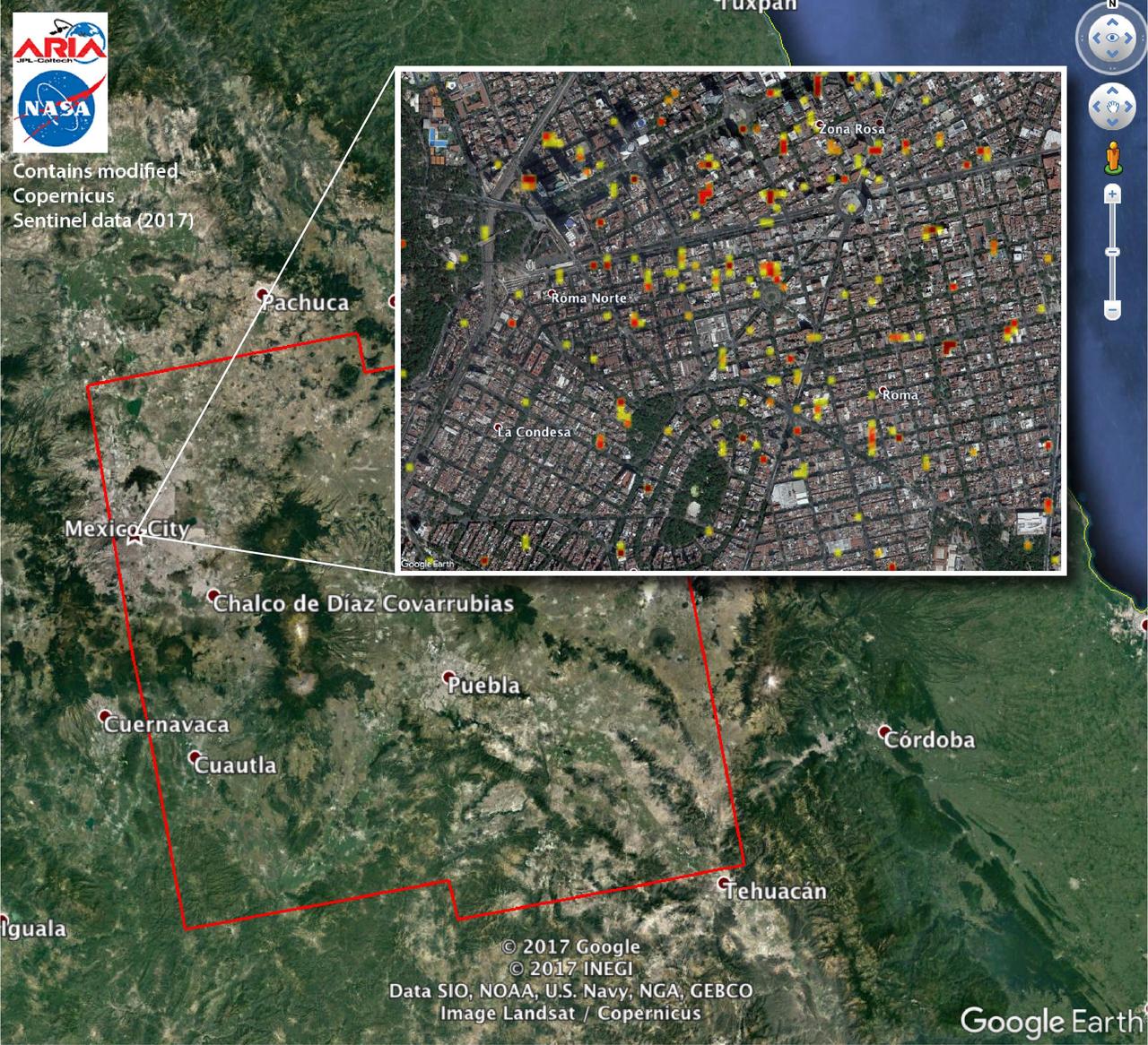
The Advanced Rapid Imaging and Analysis (ARIA) team at NASA's Jet Propulsion Laboratory in Pasadena, California, and Caltech, also in Pasadena, created this Damage Proxy Map (DPM) depicting areas of Central Mexico, including Mexico City, that are likely damaged (shown by red and yellow pixels) from the magnitude 7.1 Raboso earthquake of Sept. 19, 2017 (local time). The map is derived from synthetic aperture radar (SAR) images from the Copernicus Sentinel-1A and Sentinel-1B satellites, operated by the European Space Agency (ESA). The images were taken before (Sept. 8, 2017) and after (Sept. 20, 2017) the earthquake. The map covers an area of 109 by 106 miles (175 by 170 kilometers). Each pixel measures about 33 yards (30 meters) across. The color variation from yellow to red indicates increasingly more significant ground and building surface change. Preliminary validation was done by comparing the DPM to a crowd-sourced Google Map (https://www.google.com/maps/d/u/0/viewer?mid=1_-V97lbdgLFHpx-CtqhLWlJAnYY&ll=19.41452166501326%2C-99.16498240436704&z=16). This damage proxy map should be used as guidance to identify damaged areas, and may be less reliable over vegetated areas. Sentinel-1 data were accessed through the Copernicus Open Access Hub. The image contains modified Copernicus Sentinel data (2017), processed by ESA and analyzed by the NASA-JPL/Caltech ARIA team. This research was carried out at JPL under contract with NASA. https://photojournal.jpl.nasa.gov/catalog/PIA21963
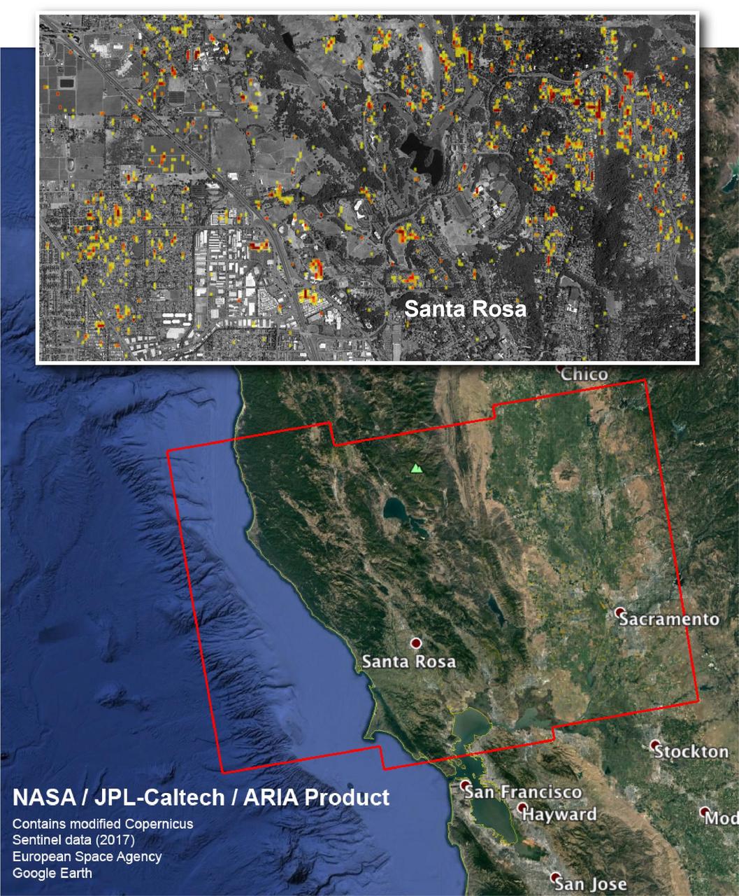
The Advanced Rapid Imaging and Analysis (ARIA) team at NASA's Jet Propulsion Laboratory in Pasadena, California, and Caltech, also in Pasadena, created this Damage Proxy Map depicting areas in Northern California that are likely damaged (shown by red and yellow pixels) as a result of the region's current outbreak of wildfires. The map is derived from synthetic aperture radar (SAR) images from the Copernicus Sentinel-1 satellites, operated by the European Space Agency (ESA). The images were taken before (Sep. 27, 2017, 7 p.m. PDT) and after (Oct. 9, 2017, 7 p.m. PDT) the onset of the fires. The map has been provided to various agencies to aid in the wildfire response. The map covers the area within the large red polygon, and measures 155 by 106 miles (250 by 170 kilometers). The illustrative figure from the map depicted in the inset shows damage in the city of Santa Rosa. Each pixel in the Damage Proxy Map measures about 98 feet (30 meters) across. The color variation from yellow to red indicates increasingly more significant ground surface change. Preliminary validation was done by comparing to optical satellite imagery from DigitalGlobe. This Damage Proxy Map should be used as guidance to identify damaged areas, and may be less reliable over vegetated areas. Sentinel-1 data were accessed through the Copernicus Open Access Hub. The image contains modified Copernicus Sentinel data (2017), processed by ESA and analyzed by the NASA-JPL/Caltech ARIA team. This research was carried out at JPL under a contract with NASA. https://photojournal.jpl.nasa.gov/catalog/PIA22048

The Advanced Rapid Imaging and Analysis (ARIA) team at NASA's Jet Propulsion Laboratory in Pasadena, California, and Caltech, also in Pasadena, created this Damage Proxy Map (DPM) depicting areas including the Commonwealth of Dominica, that are likely damaged (shown by red and yellow pixels) as a result of Hurricane Maria (a Category 5 storm at landfall in Dominica on Sept. 18, 2017). The map is derived from synthetic aperture radar (SAR) images from the Copernicus Sentinel-1 satellites, operated by the European Space Agency (ESA). The images were taken before (March 27, 2017) and after (Sept. 23, 2017) the landfall of the storm. The map covers the area within the large red polygon, which measures 53 by 106 miles (85 by 170 kilometers). Each pixel measures about 98 feet (30 meters) across. The color variation from yellow to red indicates increasingly more significant ground surface change. Preliminary validation was done by comparing the data to a crowdsourced map by Clemson Center for Geospatial Technologies and optical satellite imagery feom DigitalGlobe. This damage proxy map should be used as guidance to identify damaged areas, and may be less reliable over vegetated areas. Sentinel-1 data were accessed through the Copernicus Open Access Hub. The image contains modified Copernicus Sentinel data (2017), processed by ESA and analyzed by the NASA/JPL-Caltech ARIA team. This research was carried out at JPL under a contract with NASA. https://photojournal.jpl.nasa.gov/catalog/PIA22037

Juniper Doucette and her mother Chloe Doucette, head of education at the museum of Idaho Falls, enjoying the 2017 total solar eclipse.

The crowd at a NASA event during the 2017 total solar eclipse in Idaho Falls, Idaho
Two prototypes for a NASA mission concept called SWIM (short for Sensing With Independent Micro-swimmers) are arranged beside a much smaller nonfunctioning model representing the final envisioned size of the robot: about 5 inches (12 centimeters) long. The plastic prototypes were built at NASA's Jet Propulsion Laboratory in Southern California to demonstrate the feasibility of the concept, a swarm of dozens of self-propelled, cellphone-size robots exploring the waters of icy moons like Jupiter's Europa and Saturn's Enceladus. Delivered to the subsurface ocean by an ice-melting cryobot, the tiny robots would zoom away to look for chemical and temperature signals that could point to life. The prototypes were used in more that 20 rounds of underwater testing in a pair of tanks at JPL and in a competition swimming pool at Caltech in Pasadena. Relying on low-cost, commercially made motors and electronics, the robots are pushed along by two propellers and use two to four flaps for steering. The prototype in the center of the image weighs 3.7 pounds (1.7 kilograms) and is 14.5 inches (37 centimeters) long, 6 inches (15 centimeters) wide, and 2.5 inches (6.5 centimeters) tall, with a volume of 104 cubic inches (1.7 liters). The upgraded prototype at left is slightly bigger: 16.5 inches (42 centimeters) long, 3 inches (7.5 centimeters) tall, with a weight of 5 pounds (2.3 kilograms) and a volume of 140 cubic inches (2.3 liters). In pool tests, the prototype at left demonstrated controlled maneuvering, the ability to stay on and correct its course, and a back-and-forth "lawnmower" exploration pattern. It managed all of this autonomously, without the team's direct intervention. The robot even spelled out "J-P-L." As conceived for spaceflight and represented by the model at right, the robots would have dimensions about three times smaller than these prototypes – tiny compared to existing remotely operated and autonomous underwater scientific vehicles. The swimmers would feature miniaturized, purpose-built parts and employ a novel wireless underwater acoustic communication system for transmitting data and triangulating their positions. Several years more of work would be needed to make such an advanced concept ready for spaceflight. Led by JPL, SWIM development took place from spring 2021 to fall 2024. The project was supported by Phase I and II funding from NASA's Innovative Advanced Concepts program under the agency's Space Technology Mission Directorate. JPL is managed for NASA by Caltech in Pasadena, California. https://photojournal.jpl.nasa.gov/catalog/PIA26425

This image captures a close-up view of a storm with bright cloud tops in the northern hemisphere of Jupiter. NASA's Juno spacecraft took this color-enhanced image on Feb. 7 at 5:38 a.m. PST (8:38 a.m. EST) during its 11th close flyby of the gas giant planet. At the time, the spacecraft was 7,578 miles (12,195 kilometers) from the tops of Jupiter's clouds at 49.2 degrees north latitude. Citizen scientist Matt Brealey processed the image using data from the JunoCam imager. Citizen scientist Gustavo B C then adjusted colors and embossed Matt Brealey's processing of this storm. https://photojournal.jpl.nasa.gov/catalog/PIA21981 . - Enhanced image by Matt Brealey / Gustavo B C based on images provided courtesy of NASA/JPL-Caltech/SwRI/MSSS
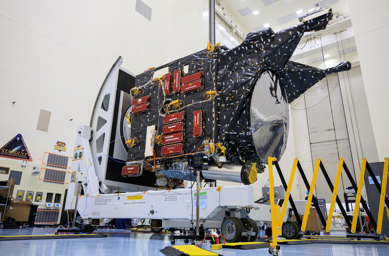
NASA’s Psyche spacecraft undergoes processing and servicing ahead of launch atop a work stand inside the Payload Hazardous Servicing Facility at NASA’s Kennedy Space Center in Florida on May 3, 2022. Psyche is targeting to lift off aboard a SpaceX Falcon Heavy rocket on Aug. 1, 2022. The spacecraft will use solar-electric propulsion to travel approximately 1.5 billion miles to rendezvous with its namesake asteroid in 2026. The Psyche mission is led by Arizona State University. NASA’s Jet Propulsion Laboratory, which is managed for the agency by Caltech in Pasadena, California, is responsible for the mission’s overall management, system engineering, integration and testing, and mission operations. Maxar Technologies in Palo Alto, California, provided the high-power solar electric propulsion spacecraft chassis. NASA’s Launch Services Program (LSP), based at Kennedy, is managing the launch. Psyche will be the 14th mission in the agency's Discovery program and LSP’s 100th primary mission.

In this view of Jupiter, NASA's Juno spacecraft captures swirling clouds in the region of the giant planet's northern hemisphere known as "Jet N4." Jupiter spins once every 10 hours, and this fast rotation creates strong jet streams, separating its clouds into dark belts and bright zones that stretch across the face of the planet. More than a dozen prevailing winds sweep over Jupiter, some reaching more than 300 miles per hour (480 kilometers per hour) at the equator. The raw image was taken on Sept. 11, 2019 at 8:31 p.m. PDT (11:31 p.m. EDT), as Juno performed its 22nd close flyby of Jupiter. At the time the image was taken, the spacecraft was about 7,540 miles (12,140 kilometers) from the cloud tops at a latitude of 45 degrees. Enhanced image by Björn Jónsson (CC-NC-SA) based on images provided courtesy of NASA/JPL-Caltech/SwRI/MSSS.
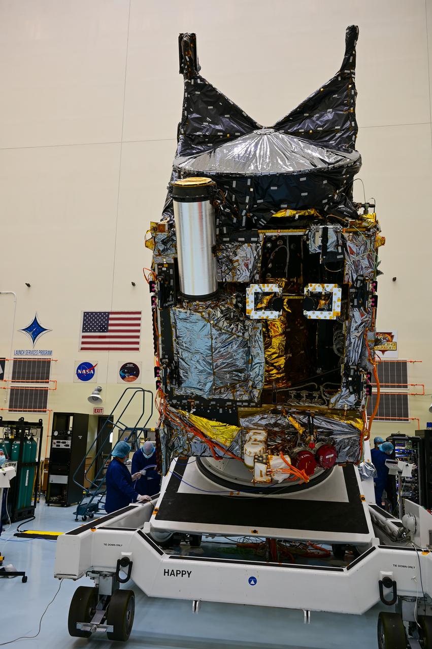
A team working on NASA’s Psyche spacecraft transitioning it from a vertical to horizontal test configuration during prelaunch processing inside the Payload Hazardous Servicing Facility at NASA’s Kennedy Space Center in Florida on May 9, 2022. The mission is targeting an Aug. 1 launch atop a SpaceX Falcon Heavy rocket from Launch Complex 39A at Kennedy. The spacecraft will use solar-electric propulsion to travel approximately 1.5 billion miles to rendezvous with its namesake asteroid in 2026. The Psyche mission is led by Arizona State University. NASA’s Jet Propulsion Laboratory, which is managed for the agency by Caltech in Pasadena, California, is responsible for the mission’s overall management, system engineering, integration and testing, and mission operations. Maxar Technologies in Palo Alto, California, provided the high-power solar electric propulsion spacecraft chassis. NASA’s Launch Services Program (LSP), based at Kennedy, is managing the launch.

This close-up view of Jupiter captures the turbulent region just west of the Great Red Spot in the South Equatorial Belt, with resolution better than any previous pictures from Earth or other spacecraft. NASA's Juno spacecraft captured this image with its JunoCam citizen science instrument when the spacecraft was a mere 5,400 miles (8,700 kilometers) above Jupiter's cloudtops on Dec. 11, 2016 at 9:14 a.m. PT (12:14 p.m. ET). Citizen scientist Sergey Dushkin produced the sublime color processing and cropped the image to draw viewers' eyes to the dynamic clouds. http://photojournal.jpl.nasa.gov/catalog/PIA21384 . - Enhanced image by Sergey Dushkin based on images provided courtesy of NASA/JPL-Caltech/SwRI/MSSS

NASA's Juno spacecraft saw this striking vista during its most recent close flyby of Jupiter. This view highlights the contrast between the colorful South Equatorial Belt and the mostly white Southern Tropical Zone, a latitude that also features Jupiter's most famous phenomenon, the persistent, anticyclonic storm known as the Great Red Spot. Citizen scientist Kevin M. Gill created this image using data from the spacecraft's JunoCam imager. The raw image was taken on July 20, 2019, at 9:37 p.m. PDT (July 21, 2019, at 12:37 a.m. EDT) as the Juno spacecraft performed its 21st close flyby of Jupiter. At the time the image was taken, the spacecraft was 26,697 miles (42,965 kilometers) from the tops of the clouds, above a latitude of 46 degrees south. Enhanced image by Kevin M. Gill (CC-BY) based on images provided courtesy of NASA/JPL-Caltech/SwRI/MSSS.
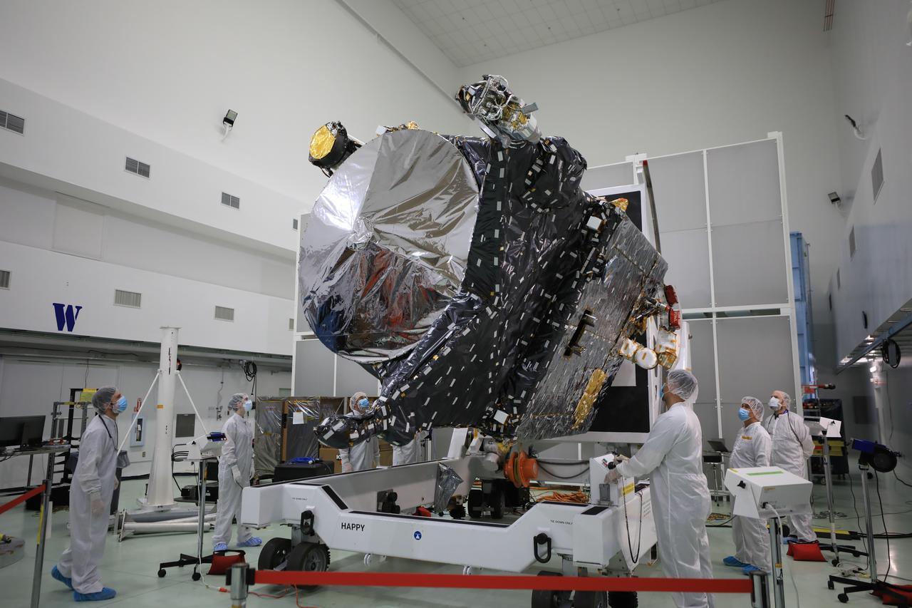
Technicians rotate NASA’s Psyche spacecraft during prelaunch processing inside the Astrotech Space Operations Facility near the agency’s Kennedy Space Center in Florida on Dec. 8, 2022. Psyche will launch atop a SpaceX Falcon Heavy rocket from Launch Complex 39A at Kennedy. Launch is targeted for no earlier than Oct. 10, 2023. The spacecraft will use solar-electric propulsion to travel approximately 1.5 billion miles to rendezvous with its namesake asteroid in 2026. The Psyche mission is led by Arizona State University. NASA’s Jet Propulsion Laboratory, which is managed for the agency by Caltech in Pasadena, California, is responsible for the mission’s overall management, system engineering, integration and testing, and mission operations. Maxar Technologies in Palo Alto, California, provided the high-power solar electric propulsion spacecraft chassis. NASA’s Launch Services Program (LSP), based at Kennedy, is managing the launch.

This image of Jupiter's iconic Great Red Spot (GRS) was created by citizen scientist Björn Jónsson using data from the JunoCam imager on NASA's Juno spacecraft. This true-color image offers a natural color rendition of what the Great Red Spot and surrounding areas would look like to human eyes from Juno's position. The tumultuous atmospheric zones in and around the Great Red Spot are clearly visible. The image was taken on July 10, 2017 at 07:10 p.m. PDT (10:10 p.m. EDT), as the Juno spacecraft performed its seventh close flyby of Jupiter. At the time the image was taken, the spacecraft was about 8,648 miles (13,917 kilometers) from the tops of the clouds of the planet at a latitude of -32.6 degrees. https://photojournal.jpl.nasa.gov/catalog/PIA21775. - Enhanced image by Björn Jónsson (CC-NC-SA) based on images provided courtesy of NASA/JPL-Caltech/SwRI/MSSS
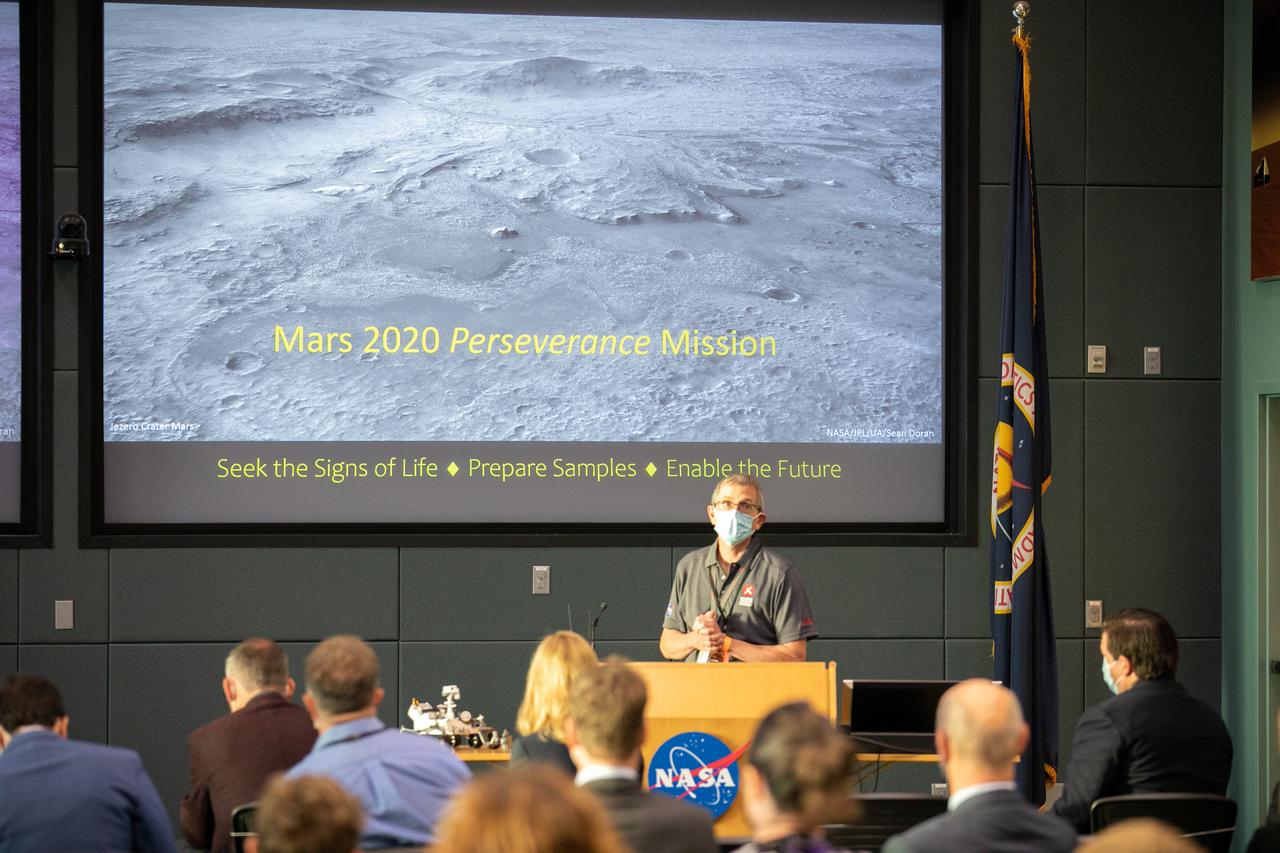
Dr. Kenneth Farley, a project scientist with Caltech, gave a science overview at the Mars 2020 VIP briefing at the Operations and Support Building II at NASA’s Kennedy Space Center in Florida on July 30, 2020, before launch of the Mars Perseverance rover and Ingenuity helicopter on a United Launch Alliance Atlas V 541 rocket from Space Launch Complex 41 at nearby Cape Canaveral Air Force Station. Liftoff occurred at 7:50 a.m. The rover is part of NASA’s Mars Exploration Program, a long-term effort of robotic exploration of the Red Planet. The rover will search for habitable conditions in the ancient past and signs of past microbial life on Mars. The Launch Services Program at Kennedy is responsible for launch management.
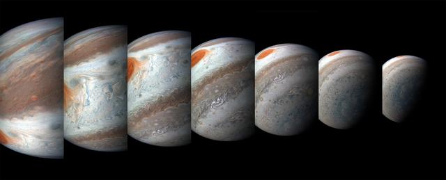
A south tropical disturbance has just passed Jupiter's iconic Great Red Spot and is captured stealing threads of orange haze from the Great Red Spot in this series of color-enhanced images from NASA's Juno spacecraft. From left to right, this sequence of images was taken between 2:57 a.m. and 3:36 a.m. PDT (5:57 a.m. and 6:36 a.m. EDT) on April 1, 2018, as the spacecraft performed its 12th close flyby of Jupiter. Citizen scientists Gerald Eichstädt and Seán Doran created this image using data from the spacecraft's JunoCam imager. https://photojournal.jpl.nasa.gov/catalog/PIA22937 ** Image Credit: Enhanced Image by Gerald Eichstädt and Seán Doran (CC BY-NC-SA) based on images provided courtesy of NASA/JPL-Caltech/SwRI/MSSS

When team members from NASA's Juno mission invited the public to process JunoCam images, they did not anticipate that they would receive back such beautiful, creative expressions of art. The oranges and grayed-out regions of blue-green in this tiled and color-enhanced image resemble a color scheme much like Romantic era paintings, but more abstract. The lack of discreet objects to focus on allows the mind to seek familiar Earthly shapes, and the brightest spots seem to draw the eye. Citizen scientist Eric Jorgensen created this Jovian artwork with a JunoCam image taken when the spacecraft was at an altitude of 11,100 miles (17,800 kilometers) above Jupiter's cloudtops on Dec. 11, 2016 at 9:22 a.m. PT (12:22 p.m. ET). http://photojournal.jpl.nasa.gov/catalog/PIA21385 . - Enhanced image by Eric Jorgensen based on images provided courtesy of NASA/JPL-Caltech/SwRI/MSSS
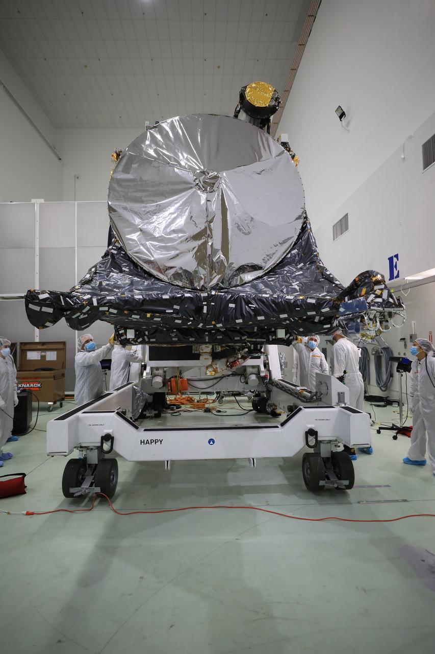
A team prepares NASA’s Psyche spacecraft for launch inside the Astrotech Space Operations Facility near the agency’s Kennedy Space Center in Florida on Dec. 8, 2022. Psyche will launch atop a SpaceX Falcon Heavy rocket from Launch Complex 39A at Kennedy. Launch is targeted for no earlier than Oct. 10, 2023. The spacecraft will use solar-electric propulsion to travel approximately 1.5 billion miles to rendezvous with its namesake asteroid in 2026. The Psyche mission is led by Arizona State University. NASA’s Jet Propulsion Laboratory, which is managed for the agency by Caltech in Pasadena, California, is responsible for the mission’s overall management, system engineering, integration and testing, and mission operations. Maxar Technologies in Palo Alto, California, provided the high-power solar electric propulsion spacecraft chassis. NASA’s Launch Services Program (LSP), based at Kennedy, is managing the launch.