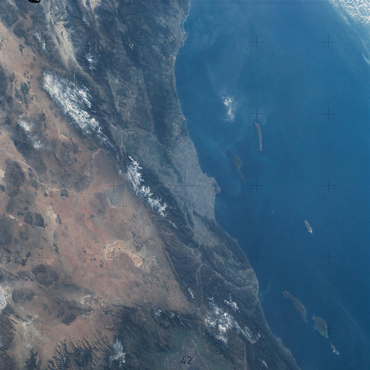
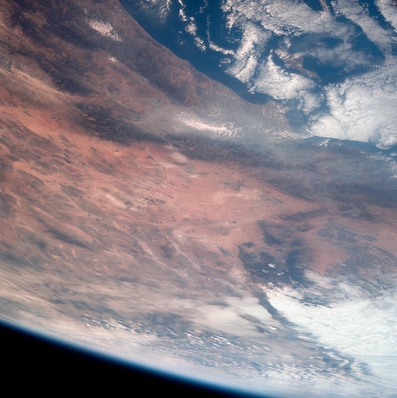
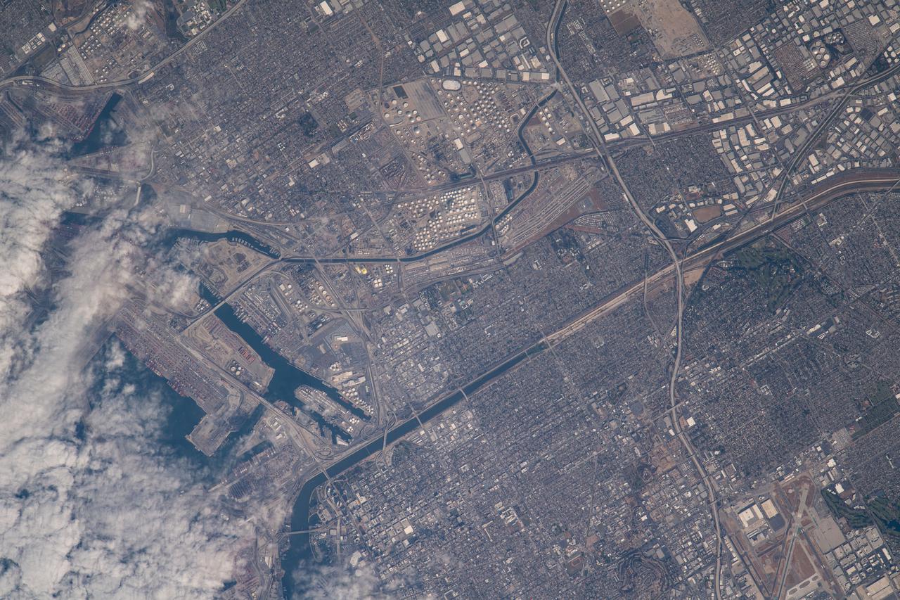
SL4-142-4542 (November 1973-February 1974) --- An oblique view of the Pacific Coast of Southern California, including the Los Angeles and San Diego areas, as seen from the Skylab space station in Earth orbit. This picture was taken by one of the Skylab 4 crewmen using a hand-held 70mm Hasselblad camera with a 100mm lens and SO-368 medium-speed Ektachrome film. The visible coastline extends from San Diego northwesterly to Santa Barbara. The Mojave Desert occupies much of the photograph. This view also includes the Channel Islands off the coast. Note that the higher elevations of the mountains are covered with snow. Photo credit: NASA
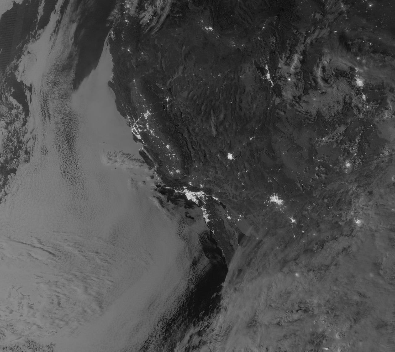
NASA image acquired September 27, 2012 On September 27, 2012, the Visible Infrared Imaging Radiometer Suite (VIIRS) on the Suomi NPP satellite captured this nighttime view of low-lying marine layer clouds along the coast of California. The image was captured by the VIIRS “day-night band,” which detects light in a range of wavelengths from green to near-infrared and uses filtering techniques to observe signals such as gas flares, auroras, wildfires, city lights, and reflected moonlight. An irregularly-shaped patch of high clouds hovers off the coast of California, and moonlight caused the high clouds to cast distinct shadows on the marine layer clouds below. VIIRS acquired the image when the Moon was in its waxing gibbous phase, meaning it was more than half-lit, but less than full. Low clouds pose serious hazards for air and ship traffic, but satellites have had difficulty detecting them in the past. To illustrate this, the second image shows the same scene in thermal infrared, the band that meteorologists generally use to monitor clouds at night. Only high clouds are visible; the low clouds do not show up at all because they are roughly the same temperature as the ground. NASA Earth Observatory image by Jesse Allen and Robert Simmon, using VIIRS Day-Night Band data from the Suomi National Polar-orbiting Partnership. Suomi NPP is the result of a partnership between NASA, the National Oceanic and Atmospheric Administration, and the Department of Defense. Caption by Adam Voiland. Instrument: Suomi NPP - VIIRS Credit: <b><a href="http://www.earthobservatory.nasa.gov/" rel="nofollow"> NASA Earth Observatory</a></b> <b>Click here to view all of the <a href="http://earthobservatory.nasa.gov/Features/NightLights/" rel="nofollow"> Earth at Night 2012 images </a></b> <b>Click here to <a href="http://earthobservatory.nasa.gov/NaturalHazards/view.php?id=79758" rel="nofollow"> read more </a> about this image </b> <b><a href="http://www.nasa.gov/audience/formedia/features/MP_Photo_Guidelines.html" rel="nofollow">NASA image use policy.</a></b> <b><a href="http://www.nasa.gov/centers/goddard/home/index.html" rel="nofollow">NASA Goddard Space Flight Center</a></b> enables NASA’s mission through four scientific endeavors: Earth Science, Heliophysics, Solar System Exploration, and Astrophysics. Goddard plays a leading role in NASA’s accomplishments by contributing compelling scientific knowledge to advance the Agency’s mission. <b>Follow us on <a href="http://twitter.com/NASA_GoddardPix" rel="nofollow">Twitter</a></b> <b>Like us on <a href="http://www.facebook.com/pages/Greenbelt-MD/NASA-Goddard/395013845897?ref=tsd" rel="nofollow">Facebook</a></b> <b>Find us on <a href="http://instagram.com/nasagoddard?vm=grid" rel="nofollow">Instagram</a></b>
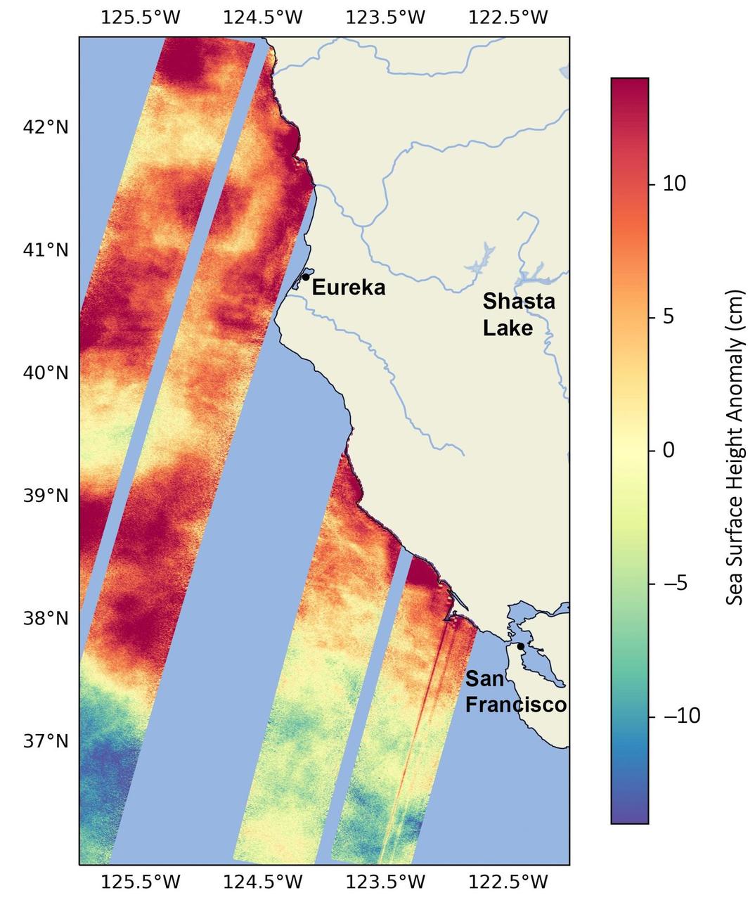
This data visualization image above shows sea surface heights off the northern California coast in August 2023 as measured by the Surface Water and Ocean Topography (SWOT) satellite. Red indicates higher-than-average ocean heights, while blue represents lower-than-average heights. Warm ocean waters from the developing El Niño are shifting north along coastlines in the eastern Pacific Ocean. Along the coast of California, these warm waters are interacting with a persistent marine heat wave that recently influenced the development of Hurricane Hilary. SWOT is able to spot the movement of these warm ocean waters in unprecedented detail. The SWOT science team made the measurements with the Ka-band Radar Interferometer (KaRIn) instrument. With two antennas spread 33 feet (10 meters) apart on a boom, KaRIn produces a pair of data swaths as it circles the globe, bouncing radar pulses off the water's surface to collect water-height measurements. The visualization combines data from two passes of the SWOT satellite. https://photojournal.jpl.nasa.gov/catalog/PIA26091

An oil slick from naturally occurring oil seeps off the coast of Santa Barbara, California. The NASA-NOAA Marine Oil Spill Thickness (MOST) project is using the area to test the ability of a radar instrument called UAVSAR to detect the thickness of oil in oil slicks – important information for first responders to oil spills. Having concluded their second field campaign in Santa Barbara at the end of October, 2021, the MOST team is working to develop a way for NOAA – the lead federal agency for detecting and tracking coastal oil spills – to use remote sensing data to determine not just where oil is, but where the thickest parts of it are. NASA's UAVSAR, or Uninhabited Aerial Vehicle Synthetic Aperture Radar, attaches to the fuselage of an airplane that collects a roughly 12-mile-wide (19-kilometer-wide) image of the area. The instrument sends radar pulses down to the surface of the ocean, and the signals that bounce back are used to detect roughness, caused by waves, at the ocean's surface. Oil dampens the waves, creating areas of smoother water that appear darker than the surrounding clean water in the SAR imagery – the thicker the oil, the darker the area appears. When the project concludes, likely in 2023, scientists hope to have a prototype system for detecting oil spill thickness that can be deployed in emergencies. https://photojournal.jpl.nasa.gov/catalog/PIA23699

STS062-153-226 (4-18 March 1994) --- Though it did not reproduce well, this photo gives scientific information to aid in studying all types of earth's processes. It documents ocean features in the sunglint in the Gulf of California, off the Isla Cerralvo, souther Baja, California. Biological oils collect on the surface and shows current patterns, eddies and ship wakes. The small bright spot on the edge of the eddy is a ship dumping oily water from its bilges. The line in the brighter area is a light wind gust roughening the surface.

AS09-22-3436 (March 1969) --- Los Angeles-Long Beach area of southern California, as photographed from the Apollo 9 spacecraft during its 92nd revolution of Earth. Santa Catalina Island is located off the coast. The California coastline is visible from San Clemente northward to Point Dume. Clouds cover most of the San Gabriel Mountains around Los Angeles.
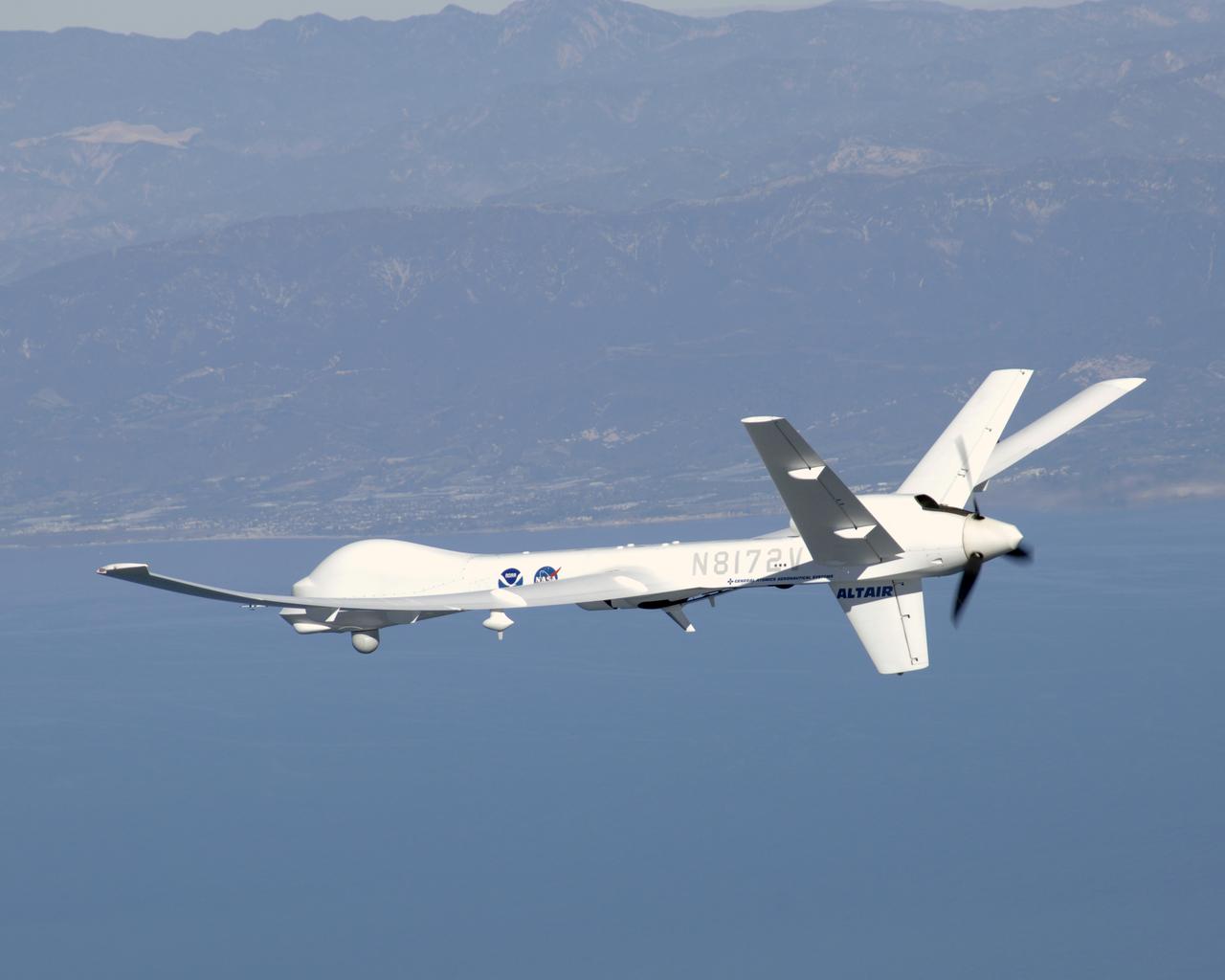
General Atomics' uninhabited Altair flew a NOAA/NASA coastal mapping, mammal observation and marine monitoring mission off the California coast in late 2005.

General Atomics' uninhabited Altair flew a NOAA/NASA coastal mapping, mammal observation and marine monitoring mission off the California coast in late 2005.

General Atomics' uninhabited Altair flew a NOAA/NASA coastal mapping, mammal observation and marine monitoring mission off the California coast in late 2005.
This view of southern California as seen from the Apollo 7 spacecraft during its 18th revolution of the earth. Photographed from an altitude of 124 nautical miles. The coast of California can be seen from Point Mugu southward to Oceanside. Santa Catalina can be seen below the off shore clouds. Details of the Los Angeles area are obscured by pollution which extends from Banning westard for 100 miles to beyond Malibu. In the upper portion of the photograph can be seen (left to right) the San Joaquin Valley beyond Bakersfield, the Techachapi Mountains, the Sierra Nevada, Owens Valley, Death Valley and the Mojave Desert.
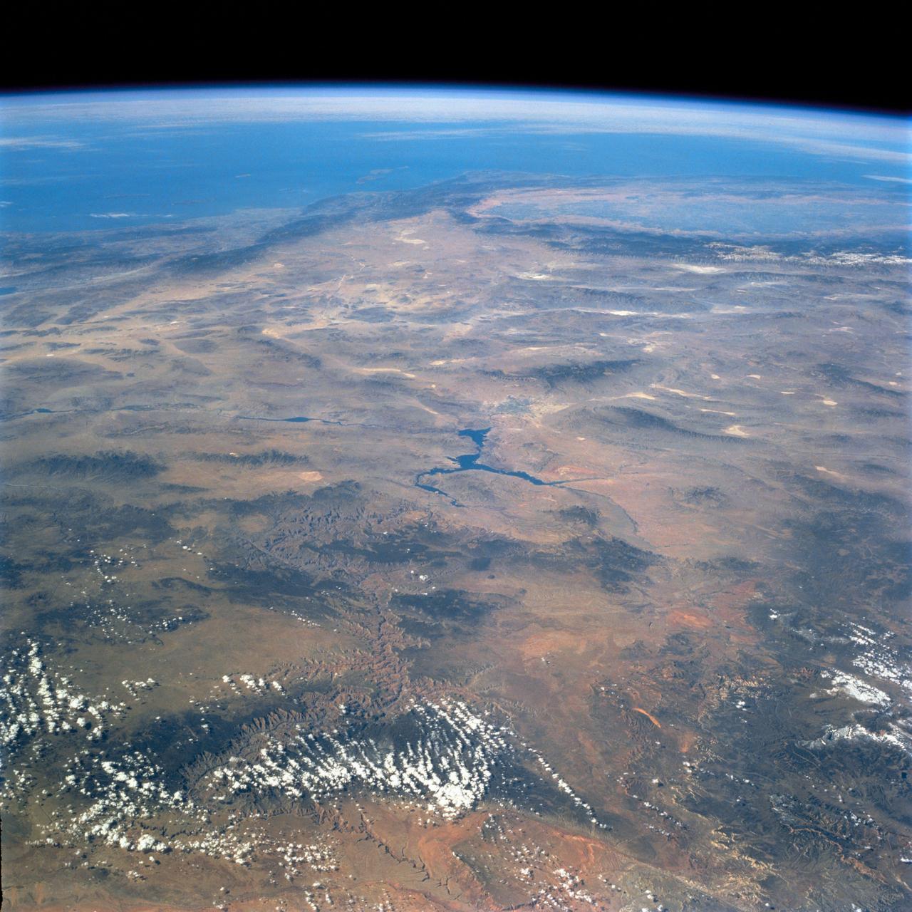
STS058-74-000R (18 Oct-1 Nov 1993) --- A broad view westward along the Colorado River from just below Glen Canyon Dam (out of picture), through the entire Grand Canyon to Lake Mead and Las Vegas, and westward to include southern Nevada and much of California. The Salton Sea, Los Angeles Basin, and Great Valley rim the Pacific Coast in the distance. Photo credit: NASA

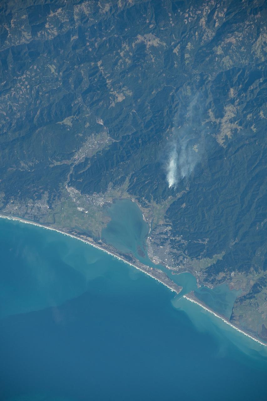
iss071e462173 (Aug. 8, 2024) --- Wildfires in northern California are pictured from the International Space Station as it orbited 261 miles above the Pacific Ocean off the coast of Washington's Olympic National Forest.
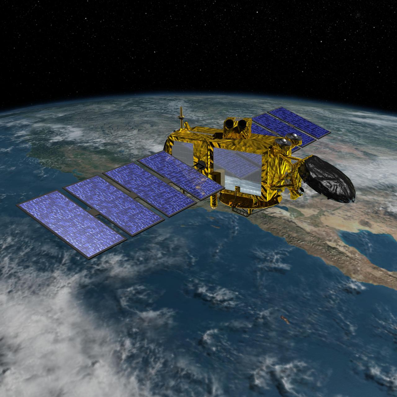
Artist concept of the U.S.-European Jason-3 spacecraft over the California coast. Jason-3 will precisely measure the height of the ocean surface, allowing scientists to monitor ocean circulation and sea level.
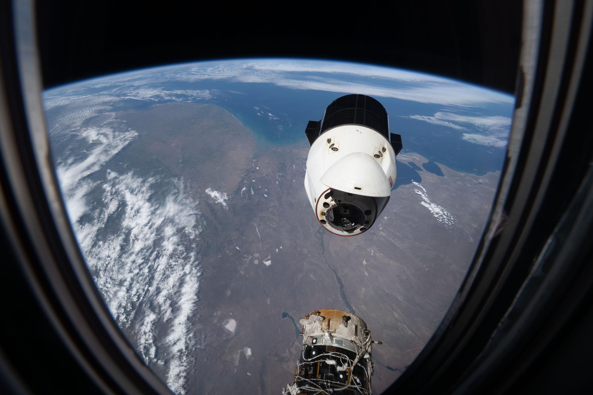
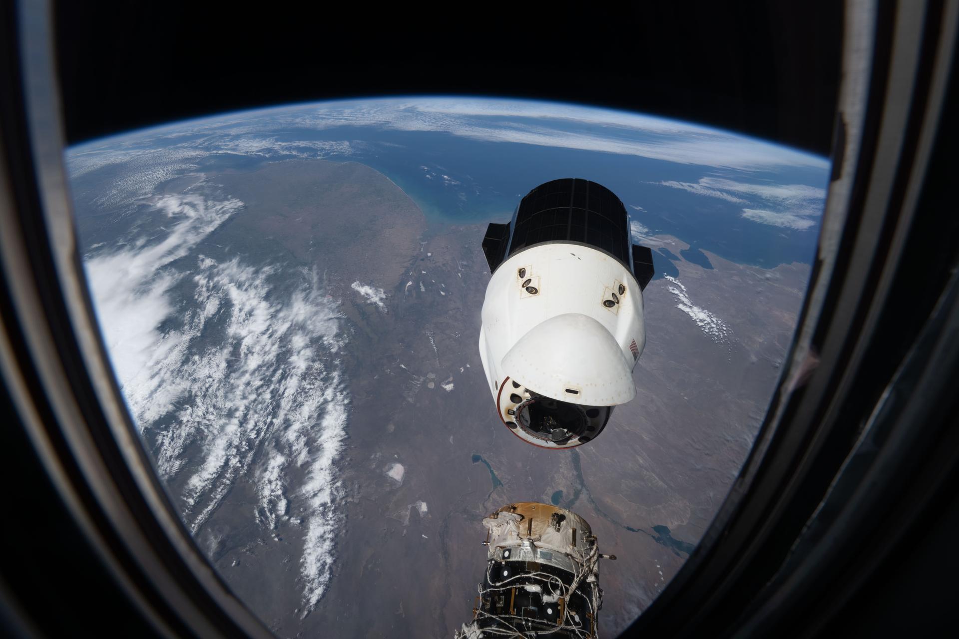
iss055e023287 (April 15, 2018) --- Mexico, Baja California and the southern coast of the state of California are pictured as the International Space Station orbited above the Pacific Ocean. When the SpaceX Dragon cargo craft returns to Earth after completing its mission at the station it splashes down in the Pacific Ocean a few hundred miles off the coast of southern California and Baja California.
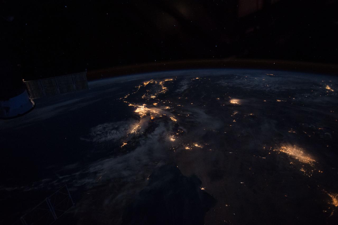
ISS046e026252 (01/28/2016) --- NASA astronaut Tim Kopra aboard the International Space Station tweeted this night image of the west coast of America with the message: " Looking back at the west coast of #California before dawn.".

iss071e479858 (Aug. 13, 2024) --- The Mexican states of Baja California and Baja California Sur are in between the Pacific Ocean and the Gulf of California in this photograph from the International Space Station as it orbited 259 miles above the Pacific off the coast of Los Angeles, California.

iss066e161042 (March 10, 2022) --- The International Space Station orbits into a dawn 261 miles above a cloudy Pacific Ocean off the coast of Baja California.
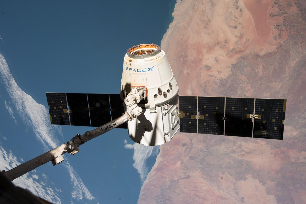
iss055e057155 (May 5, 2018) --- The SpaceX Dragon cargo craft is pictured in the grips of the Canadarm2 robotic arm as the International Space Station was orbiting across the central coast of Namibia. Dragon was later released for its splashdown in the Pacific Ocean off the coast of California on May 5, 2018 ending the SpaceX CRS-14 mission.

iss060e021205 (AUg. 1, 2019) --- Interstate 5 is 1,381 miles long and starts at the southern U.S. border town of San Ysidro, California, runs through the Pacific coast town of San Clemente, California, (pictured here) and ends at the northern U.S. border town of Blaine, Washington.

jsc2026e002116 (Jan. 16, 2025) --- NASA astronaut and SpaceX Crew-11 Pilot Mike Fincke waves to officials at Ellington Field in Houston, Texas. He departed the International Space Station and returned to Earth the day before aboard the Dragon spacecraft for a parachute-assisted splashdown off the coast of San Diego, California. Credit: NASA/Robert Markowitz
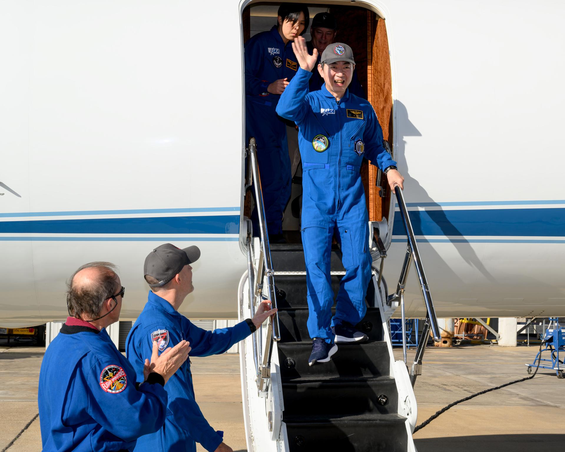
jsc2026e002115 (Jan. 16, 2025) --- JAXA (Japan Aerospace Exploration Agency) astronaut and SpaceX Crew-11 Mission Specialist Kimiya Yui waves to officials at Ellington Field in Houston, Texas. He departed the International Space Station and returned to Earth the day before aboard the Dragon spacecraft for a parachute-assisted splashdown off the coast of San Diego, California. Credit: NASA/Robert Markowitz
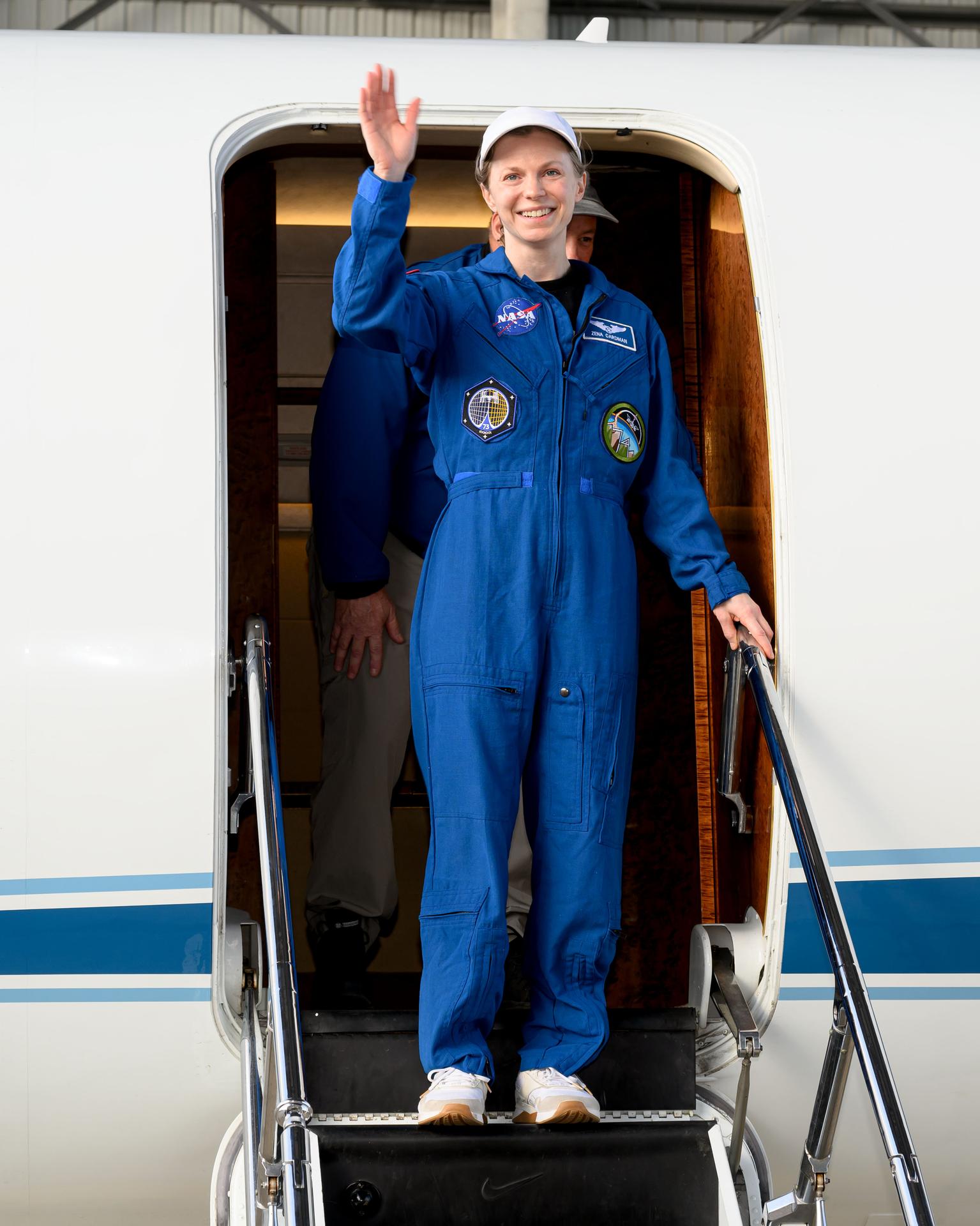
jsc2026e002117 (Jan. 16, 2025) --- NASA astronaut and SpaceX Crew-11 Commander Zena Cardman waves to officials at Ellington Field in Houston, Texas. She departed the International Space Station and returned to Earth the day before aboard the Dragon spacecraft for a parachute-assisted splashdown off the coast of San Diego, California. Credit: NASA/Robert Markowitz
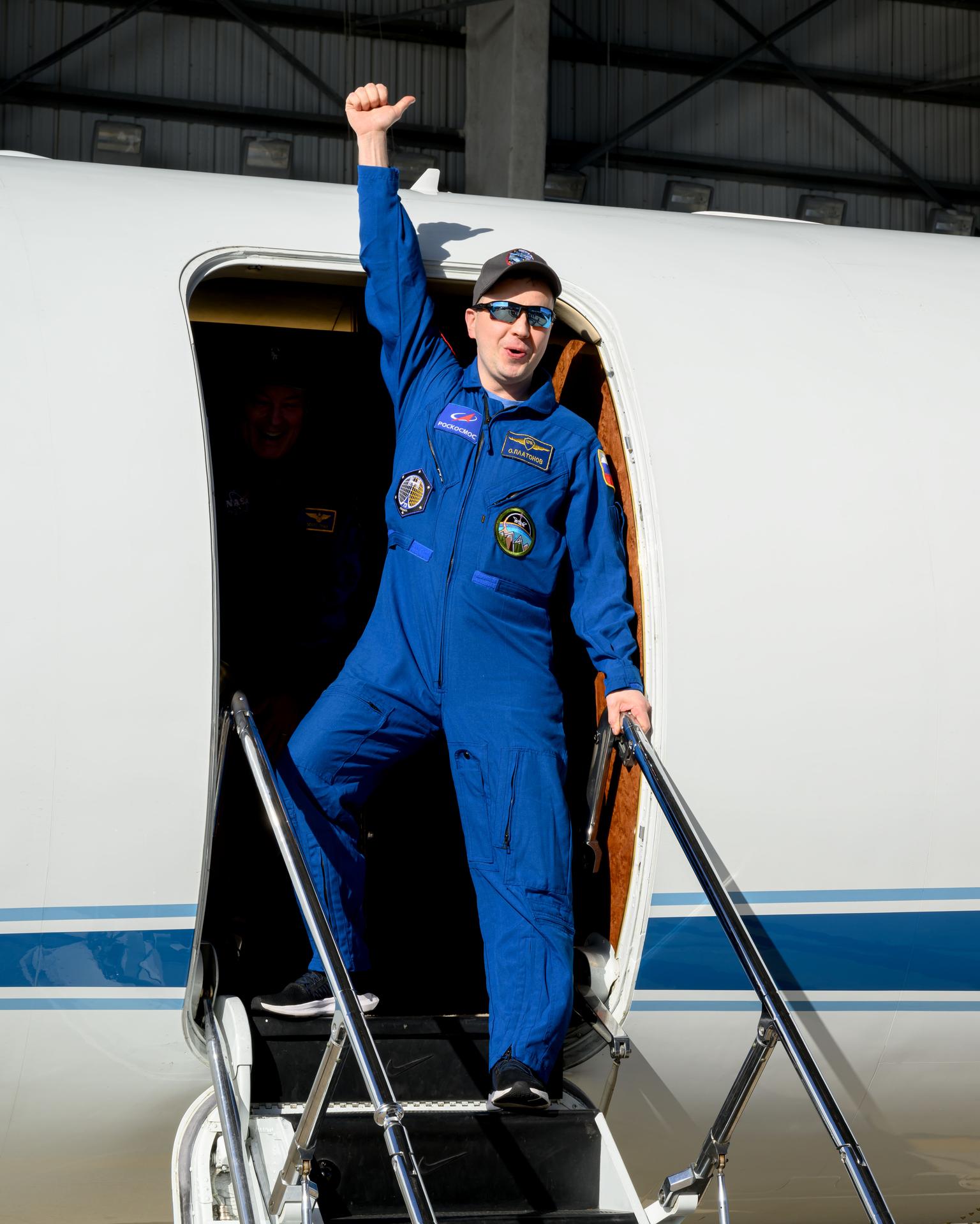
jsc2026e002114 (Jan. 16, 2025) --- Roscosmos cosmonaut and SpaceX Crew-11 Mission Specialist Oleg Platonov waves to officials at Ellington Field in Houston, Texas. He departed the International Space Station and returned to Earth the day before aboard the Dragon spacecraft for a parachute-assisted splashdown off the coast of San Diego, California. Credit: NASA/Robert Markowitz
iss070e022731 (Nov. 11, 2023) --- The sun's first rays begin illuminating Earth's atmosphere in this photograph from the International Space Station as it orbited 262 miles above the Pacific Ocean off the coast of California.
iss059e122328 (June 23, 2019) --- Mount Shasta in California is pictured from the International Space Station as the orbital complex orbited 256 miles above the Pacific Ocean off the west coast of the United States.
iss070e003846 (Oct. 14, 2023) --- The north coast of the Mexican state of Baja California Sur on the Pacific Ocean is pictured from the International Space Station as it orbited 258 miles above.

iss059e101100 (June 11, 2019) --- The International Space Station was flying into an orbital sunset 259 miles above the Pacific Ocean passing 450 miles off the coast of Cabo San Lucas, Baja California.

iss059e101098 (June 11, 2019) --- The International Space Station was flying into an orbital sunset 259 miles above the Pacific Ocean passing 550 miles off the coast of Baja California.
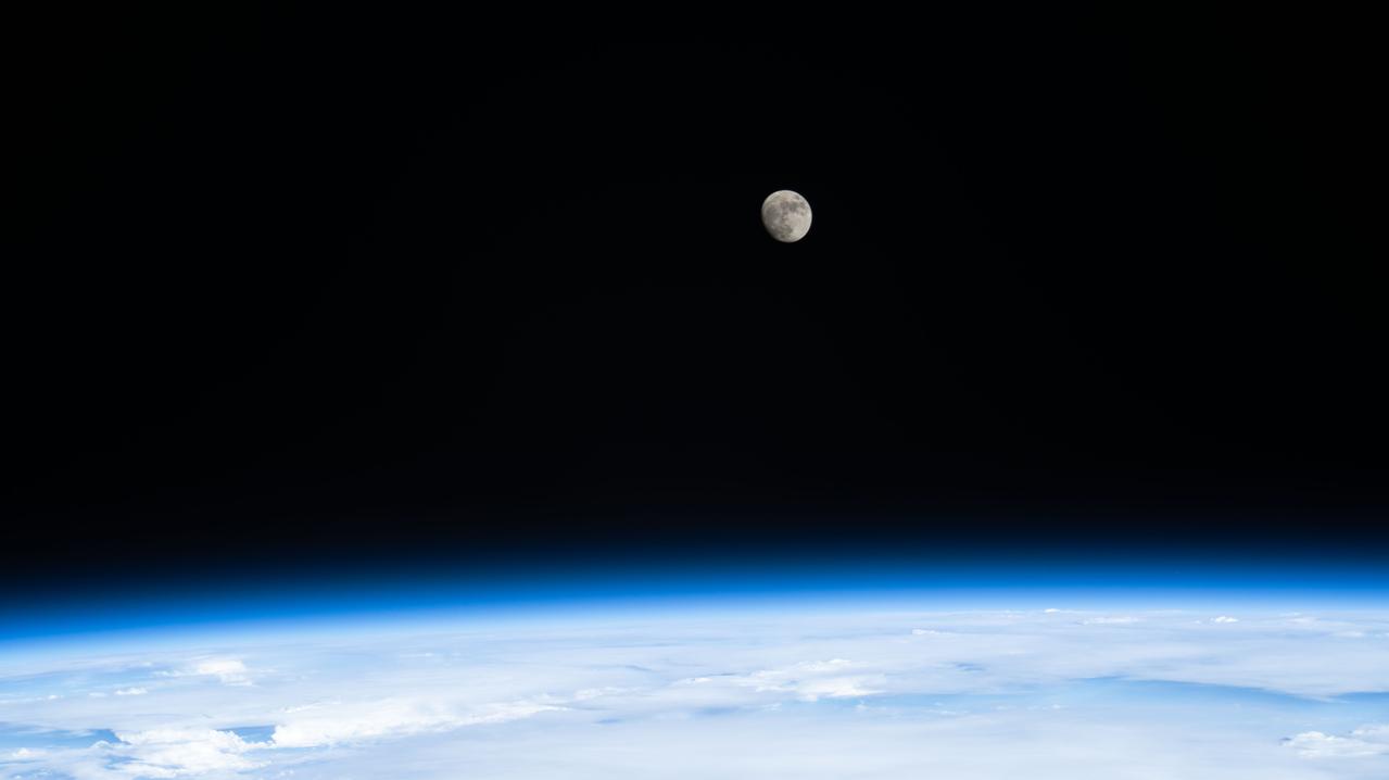
iss067e249811 (Aug. 10, 2022) --- The waxing gibbous Moon is pictured from the International Space Station as it orbited 259 miles above the Pacific Ocean off the coast of north California.
iss064e015102 (Dec. 23, 2020) --- Redwood National and State Parks are pictured on the northern California coast as the International Space Station orbited 262 miles above the Pacific Ocean.
iss059e035253 (April 24, 2019) --- The International Space Station was 257 miles above the Earth off the coast of the northwestern United States when an Expedition 59 crewmember photographed portions of California and Nevada.
Radar operator Alexander Winteer monitors incoming wind data from the DopplerScatt radar instrument during a science flight off the California Coast on March 5, 2018.

S125-E-007774 (15 May 2009) --- One of the crewmembers aboard the Earth-orbiting Space Shuttle Atlantis snapped this photo of heavy cloud cover over the Pacific Ocean off the coast of Baja California, Mexico.

President Joe Biden exits Air Force One at Moffett Federal Airfield before continuing his trip to view consequences of flooding and other storm impacts along California’s central coast.

iss064e002057 (Oct. 28, 2020) --- The Earth's limb, or horizon, with the Sonoran Desert below, is pictured as the International Space Station orbited above the Baja California coast of central Mexico.

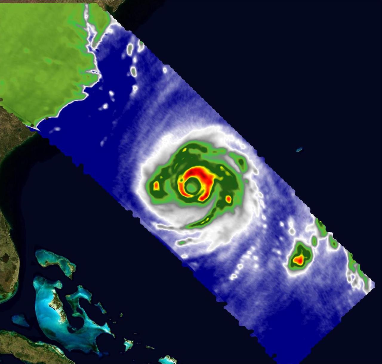
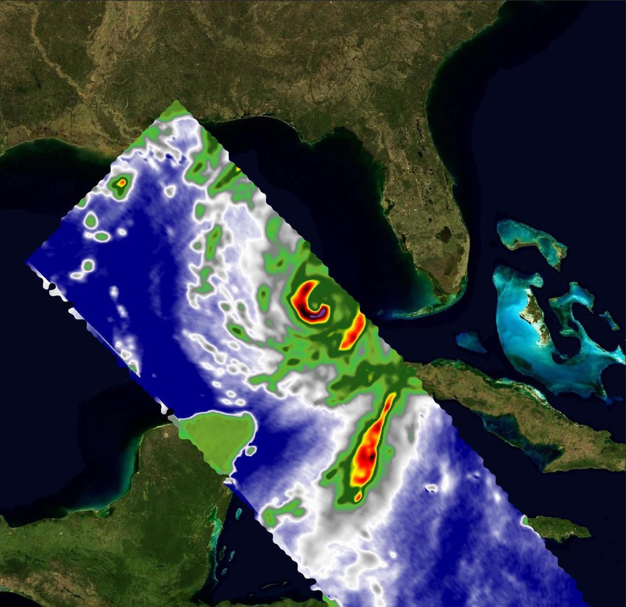
iss069e071155 (Aug. 19, 2023) --- Hurricane Hilary is pictured in the Pacific Ocean off the coast of Baja California from the International Space Station as it orbited 262 miles above.
iss070e033932 (Nov. 29, 2023) --- Wildfires in northern California's Humboldt County off the coast of the Pacific Ocean are pictured from the International Space Station as it orbited 261 miles above.

iss060e003624 (July 4, 2019) --- The International Space Station was orbiting off the coast of California when an Expedition 60 crewmember photographed San Francisco Bay, Treasure Island, Oakland and a cloud-covered San Francisco.
iss064e002872 (Nov. 1, 2020) --- The Earth's limb, or horizon, with the Sun's glint beaming off the Pacific Ocean and San Francisco Bay, is pictured as the International Space Station orbited off the coast of California.

iss059e101096 (June 11, 2019) --- The International Space Station was flying into an orbital sunset 259 miles above the Pacific Ocean passing 650 miles off the coast of San Francisco, California.

iss067e034448 (May 4, 2022) --- The southern tip of Baja California and the western coast of Mexico are pictured from the International Space Station as it orbited 259 miles above a cloudy Pacific Ocean.

iss068e024952 (Nov. 25, 2022) --- Cabo San Lucas, on the Pacific coast of the southern tip of Baja California, is pictured from the International Space Station as it orbited 259 miles above.

iss055e001066 (March 5, 2018) -- Baja California and the northwestern coast of Mexico are pictured with Russian spacecraft solar arrays in the foreground. The International Space Station was orbiting above the Mexican state of Sinaloa at the time this photograph was taken.

President Joe Biden exits Air Force One at Moffett Federal Airfield before continuing his trip to view consequences of flooding and other storm impacts along California’s central coast.

iss055e024450 (April 16, 2018) --- This oblique view shows the southern tip of the Mexican state of South Baja California as the International Space Station orbited off Mexico's Pacific coast

iss071e131885 (May 26, 2024) -- The Western coast of Baja California meets the deep blue waters of the Pacific Ocean as the International Space Station orbited 260 miles above.

Paul Sierpinski, assistant NASA Recovery Director, poses for a portrait onboard USS John P. Murtha, Thursday, April 9, 2026, in the Pacific Ocean off the coast of California. Photo Credit: (NASA/Bill Ingalls)

Dan Flores, Senior NASA Test Director, Rescue and Recovery, poses for a portrait onboard the USS Murtha, Tuesday, April 7, 2026, in the Pacific Ocean off the coast of California. Photo Credit: (NASA/Bill Ingalls)

Lisa Seiler, Artemis Landing and Recovery Deputy Director, poses for a portrait onboard USS John P. Murtha, Thursday, April 9, 2026, in the Pacific Ocean off the coast of California. Photo Credit: (NASA/Bill Ingalls)
STS071-701-098 (27 June-7 July 1995) --- This wide-angle, west-looking view shows all of California, from the Los Angeles basin (left, at the coast), to the Oregon border (far right). A large cloud mass occupies the Pacific Ocean all the way to the horizon. The effect of interaction between the land and sea can be seen by the cloud patterns at the coast. San Francisco lies in the bay where clouds penetrate inland farthest (right of center). The central valley of California stands out very well as a cigar-shaped feature across the center of view - green in the middle, surrounded by a brown line, with dark green (forests) surrounding that.
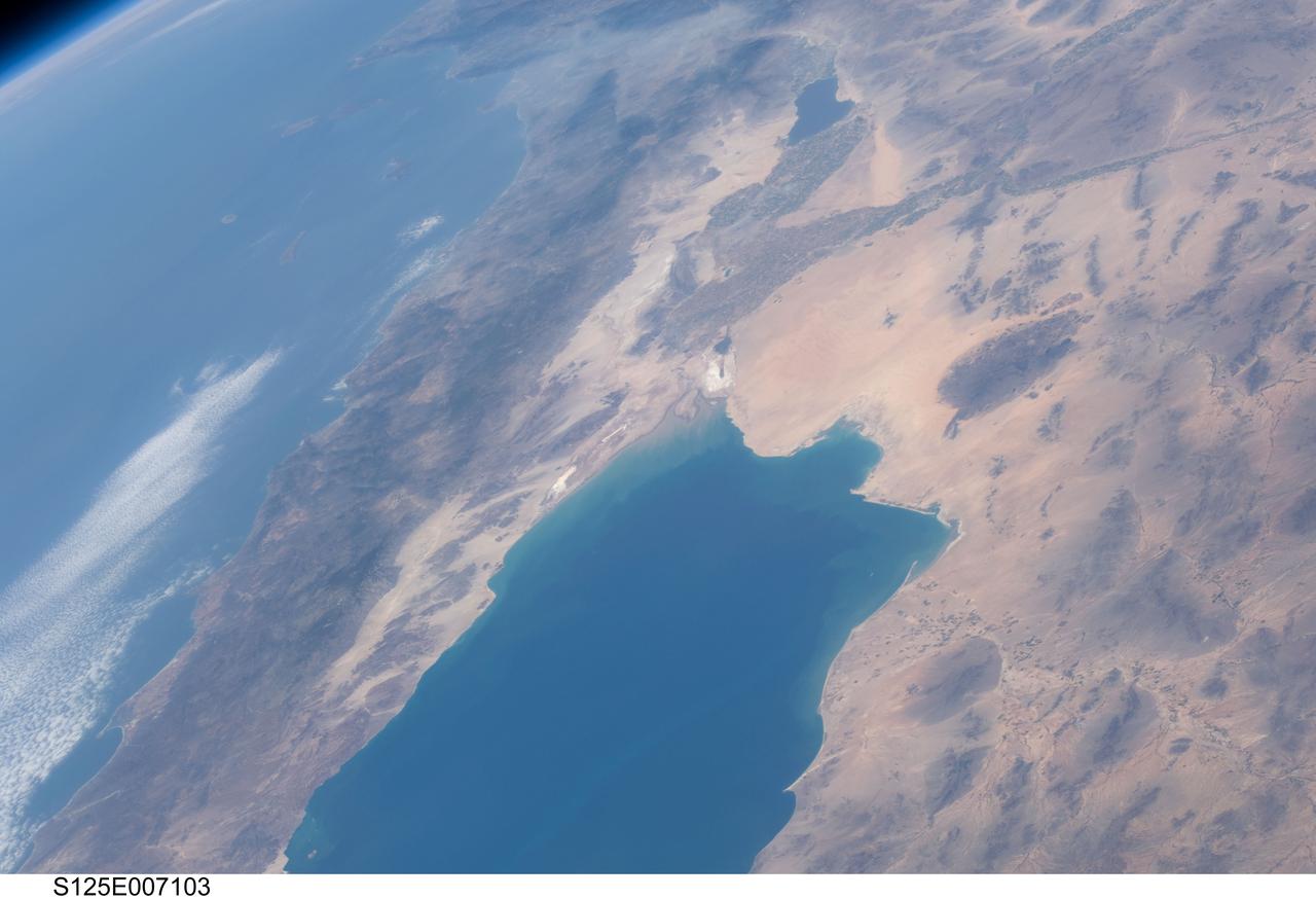
S125-E-007103 (13 May 2009) --- Part of Mexico's Baja California and part of southern California, including the Los Angeles and San Diego areas, can be seen in this STS-125 still photo taken from the Space Shuttle Atlantis as it passed near the Pacific Coast. The Gulf of California is in the foreground. The Salton Sea/Imperial Valley area can be seen at top center.
ISS030-E-254259 (22 April 2012) --- Cloud vortices off the Pacific coast of Mexico's Baja California were captured by one of the six expedition 30 crew members aboard the International Space Station as three of their number ready for their return trip to Earth in a few days. The Gulf of California or Sea of Cortez is completely clear of clouds as are the inland parts of Mexico and California pictured. The Salton Sea is visible at the lower right edge.
This view shows the west coast of the United States and Mexico (32.5N, 118.0W) and gives an indication of the range of view from orbital altitude. The visual range of this particular scene is from Skammon's Lagoon on Baja to the northern tip of California's Central Valley and Sierra Nevada, a range of over 15 degrees of latitude. Coastal fog drapes over southern California and northern Baja California. White Sands, New Mexico is at far right center.
iss074e0335132 (Feb. 26, 2026) --- A SpaceX Dragon spacecraft, packed with several tons of science experiments and lab hardware, backs away from the Harmony module’s forward port shortly after undocking from the International Space Station. The orbital outpost was soaring 271 miles above Argentina’s Atlantic coast at the time of this photograph. Dragon splashed down several hours later in the Pacific Ocean off the coast of San Diego, California, where it was retrieved by NASA and SpaceX personnel. Credit: NASA/Jessica Meir
ISS040-E-016423 (20 June 2014) --- One of the Expedition 40 crew members aboard the International Space Station recorded this view of the central Pacific Coast area of California on June 20, 2014. Monterey and Monterey Bay and part of the Santa Lucia Mountains are in the lower left corner, and the San Francisco Bay area is near frame center, with part of the view of the area being obstructed by coast-hugging clouds.
iss074e0334946 (Feb. 26, 2026) --- A SpaceX Dragon spacecraft, packed with several tons of science experiments and lab hardware, backs away from the Harmony module’s forward port shortly after undocking from the International Space Station. The orbital outpost was soaring 271 miles above Argentina’s Atlantic coast at the time of this photograph. Dragon splashed down several hours later in the Pacific Ocean off the coast of San Diego, California, where it was retrieved by NASA and SpaceX personnel. Credit: NASA/Jessica Meir
iss074e0334823 (Feb. 26, 2026) --- A SpaceX Dragon spacecraft, packed with several tons of science experiments and lab hardware, backs away from the Harmony module’s forward port shortly after undocking from the International Space Station. The orbital outpost was soaring 271 miles above Argentina’s Atlantic coast at the time of this photograph. Dragon splashed down several hours later in the Pacific Ocean off the coast of San Diego, California, where it was retrieved by NASA and SpaceX personnel. Credit: NASA/Jessica Meir
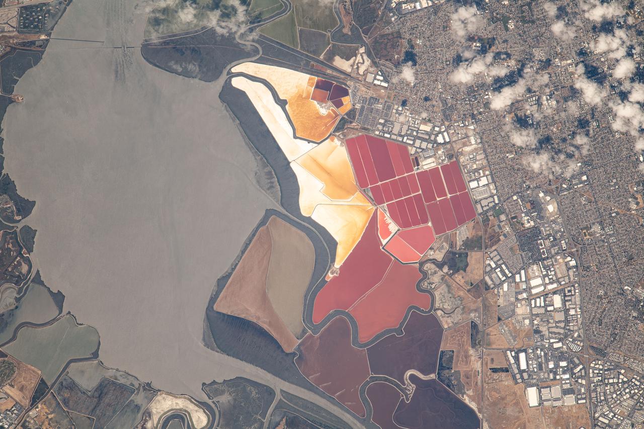
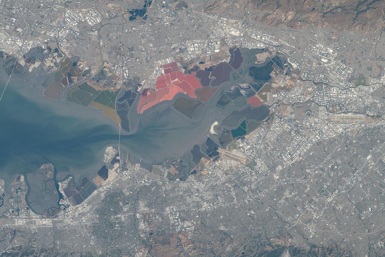
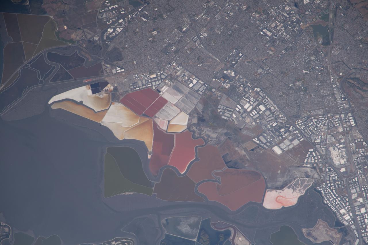
iss069e053745 (August 3, 2023) -- The South Bay Salt Ponds in the city of Newark, California show their vivid red and yellow-orange colors that primarily come from the microorganisms and brine shrimp in the waters. More than 16,500 acres are part of a restoration project— the largest in the West Coast—that includes pollution reduction, habitat expansion, and flood control. Expedition 69 Flight Engineer Woody Hoburg captured this image as the International Space Station orbited 260 miles above the coast of the Bay Area.

A view of the Pacific coast at Vandenberg Air Force Base in California. At the West Coast launch site, the Joint Polar Satellite System-1, or JPSS-1, spacecraft is being prepared for liftoff atop a United Launch Alliance Delta II rocket. Built by Ball Aerospace and Technologies Corp. of Boulder, Colorado, JPSS is the first in a series four next-generation environmental satellites in a collaborative program between the NOAA and NASA. Liftoff is scheduled to take place from Vandenberg's Space Launch Complex 2.
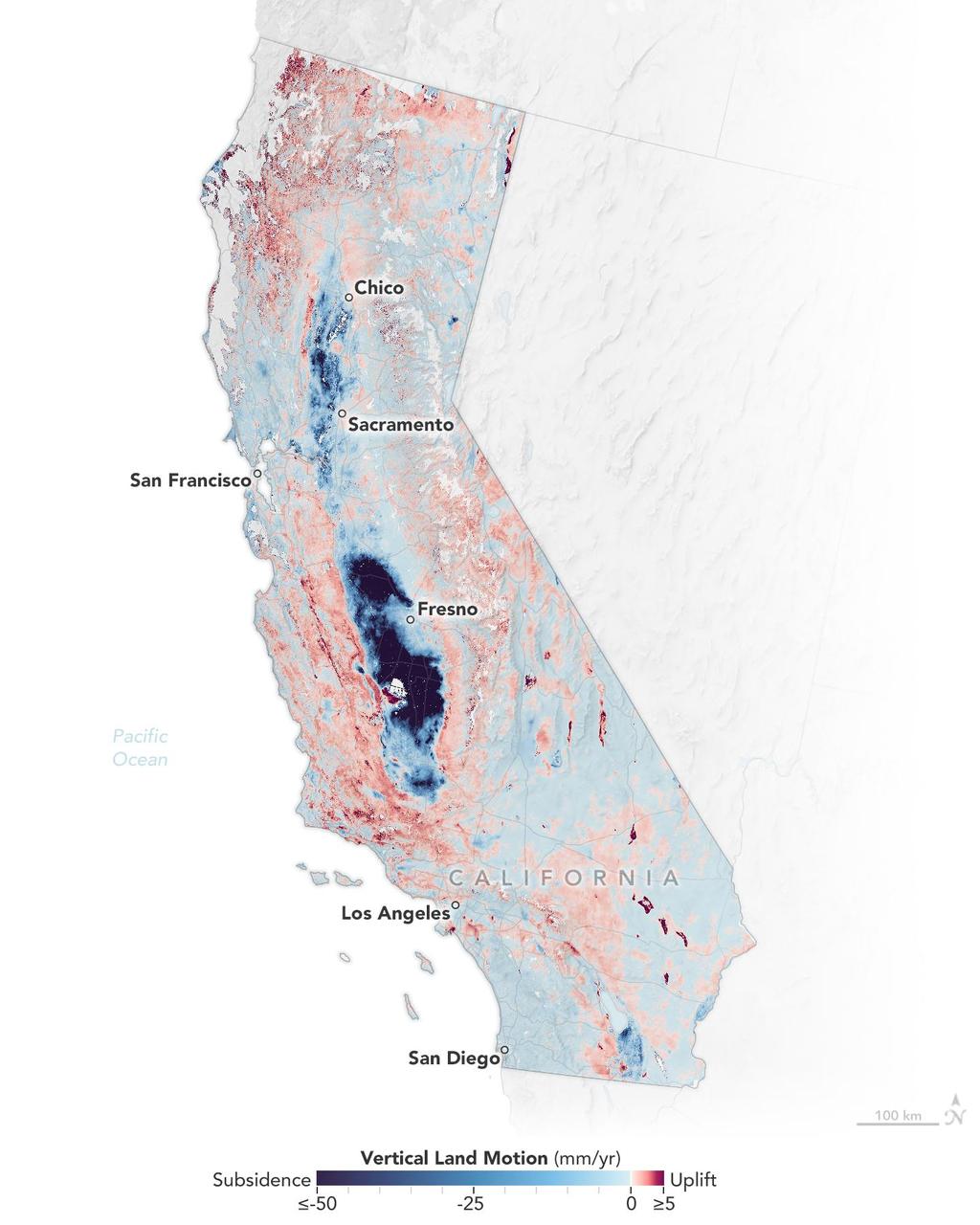
Researchers from NASA's Jet Propulsion Laboratory in Southern California and the National Oceanic and Atmospheric Administration (NOAA) analyzed vertical land motion – also known as uplift and subsidence – along the California coast between 2015 and 2023. They detailed where land beneath major coastal cities, including parts of San Francisco, Los Angeles, and San Diego, is sinking (indicated in blue in this visualization of the data). Locations of uplift (shown in red) were also observed. Causes for the motion include human-driven activities such as groundwater withdrawal and wastewater injection as well as natural dynamics like tectonic activity. Understanding these local elevation changes can help communities adapt to rising sea levels in their area. The researchers pinpointed hot spots – including cities, beaches, and aquifers – at greater exposure to rising seas in coming decades. Sea level rise can exacerbate issues like nuisance flooding and saltwater intrusion. To gather the data, the researchers employed a remote sensing technique called interferometric synthetic aperture radar (InSAR), which combines two or more 3D observations of the same region to reveal surface motion down to fractions of inches. They used the radars on the ESA (European Space Agency) Sentinel-1 satellites, as well as motion velocity data from ground-based receiving stations in the Global Navigation Satellite System. https://photojournal.jpl.nasa.gov/catalog/PIA25530
A pair of weather instruments built at NASA's Jet Propulsion Laboratory in Southern California captured images of Hurricane Franklin as the Category 4 storm moved off the East Coast of the United States on Aug. 29, 2023. COWVR (short for Compact Ocean Wind Vector Radiometer) and TEMPEST (Temporal Experiment for Storms and Tropical Systems) observe the planet's atmosphere and surface from aboard the International Space Station, which passed in low Earth orbit over the storm at about 9:58 a.m. EDT. This image combines microwave emissions measurements from both COWVR and TEMPEST. White sections indicate the presence of clouds. Green portions indicate rain. Yellow, red, and black indicate where air and water vapor were moving most vigorously. Franklin's center is seen about 700 miles (1,127 kilometers) east of Jacksonville, Florida, over the Atlantic Ocean. https://photojournal.jpl.nasa.gov/catalog/PIA25870
A pair of weather instruments built at NASA's Jet Propulsion Laboratory in Southern California captured images of Hurricane Idalia as the storm approached the Gulf Coast of Florida on Aug. 29, 2023. COWVR (short for Compact Ocean Wind Vector Radiometer) and TEMPEST (Temporal Experiment for Storms and Tropical Systems) observe the planet's atmosphere and surface from aboard the International Space Station, which passed in low Earth orbit over this area at about 11:34 a.m. EDT. Idalia was forecast to make landfall in Florida on Aug. 30. This image combines microwave emissions measurements from both COWVR and TEMPEST. White sections indicate the presence of clouds. Green portions indicate rain. Yellow, red, and black indicate where air and water vapor were moving most vigorously. Idalia's center is seen about 200 miles (322 kilometers) west of the Florida Keys, and rainfall is indicated on the western end of Cuba. https://photojournal.jpl.nasa.gov/catalog/PIA25569
STS001-12-305 (12-14 April 1981) --- California, San Francisco Bay photographed by a crew member on the space shuttle Columbia (STS-1). The coast is seen from near Santa Cruz northward to Point Reyes. The great valley is in the foreground. Photo credit: NASA
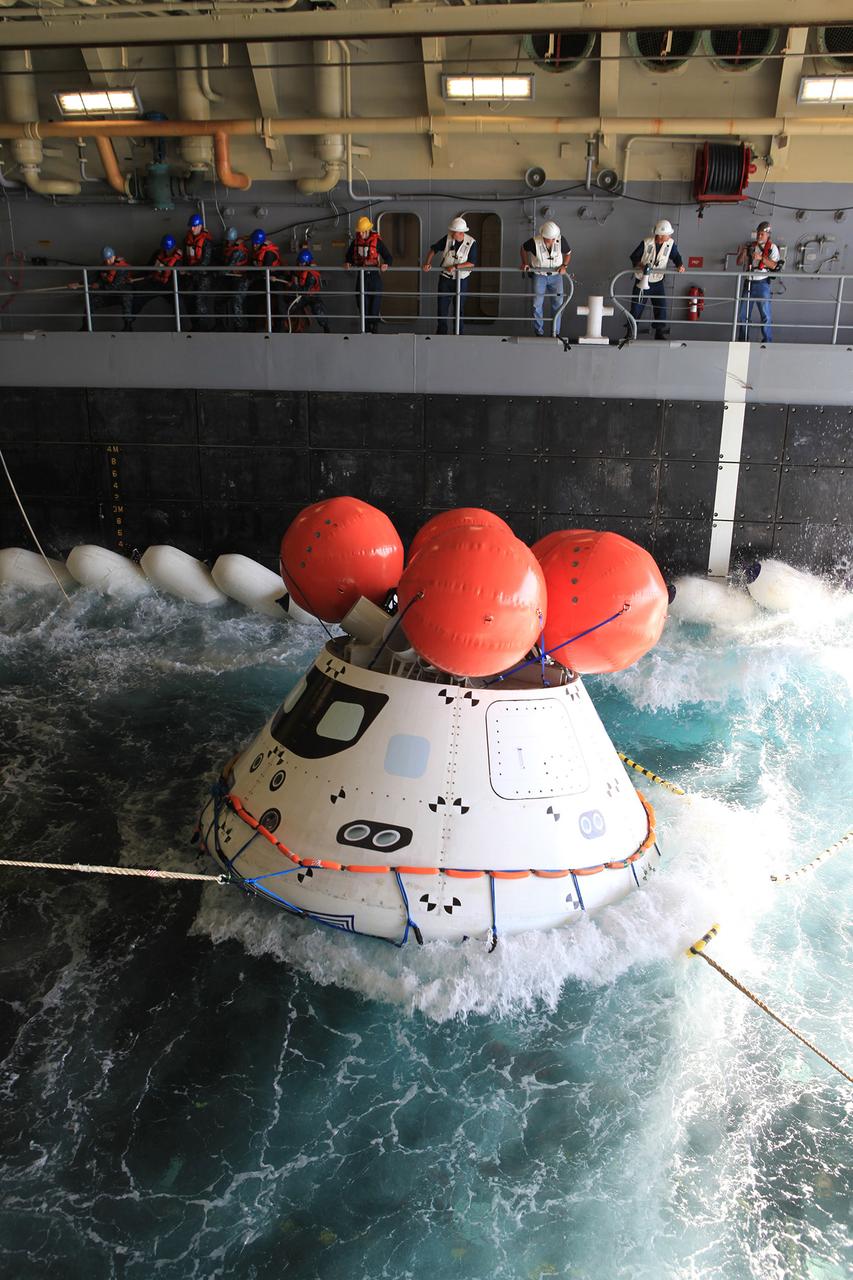
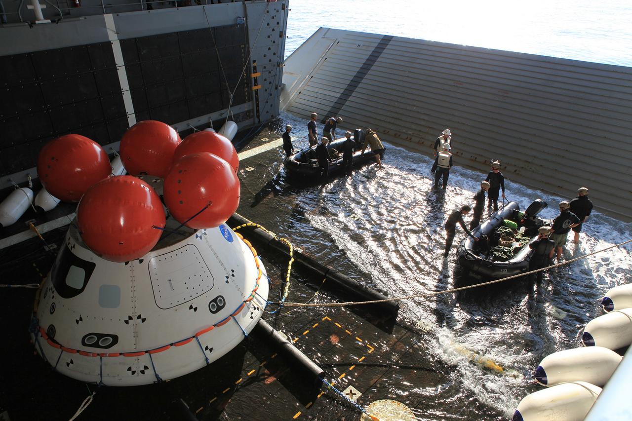
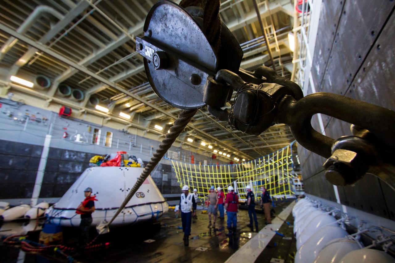
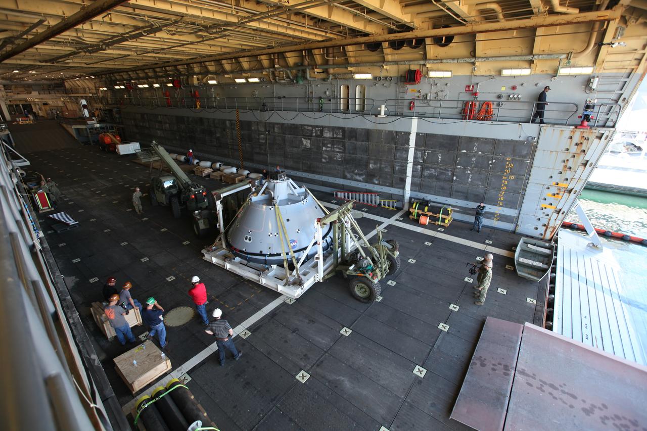
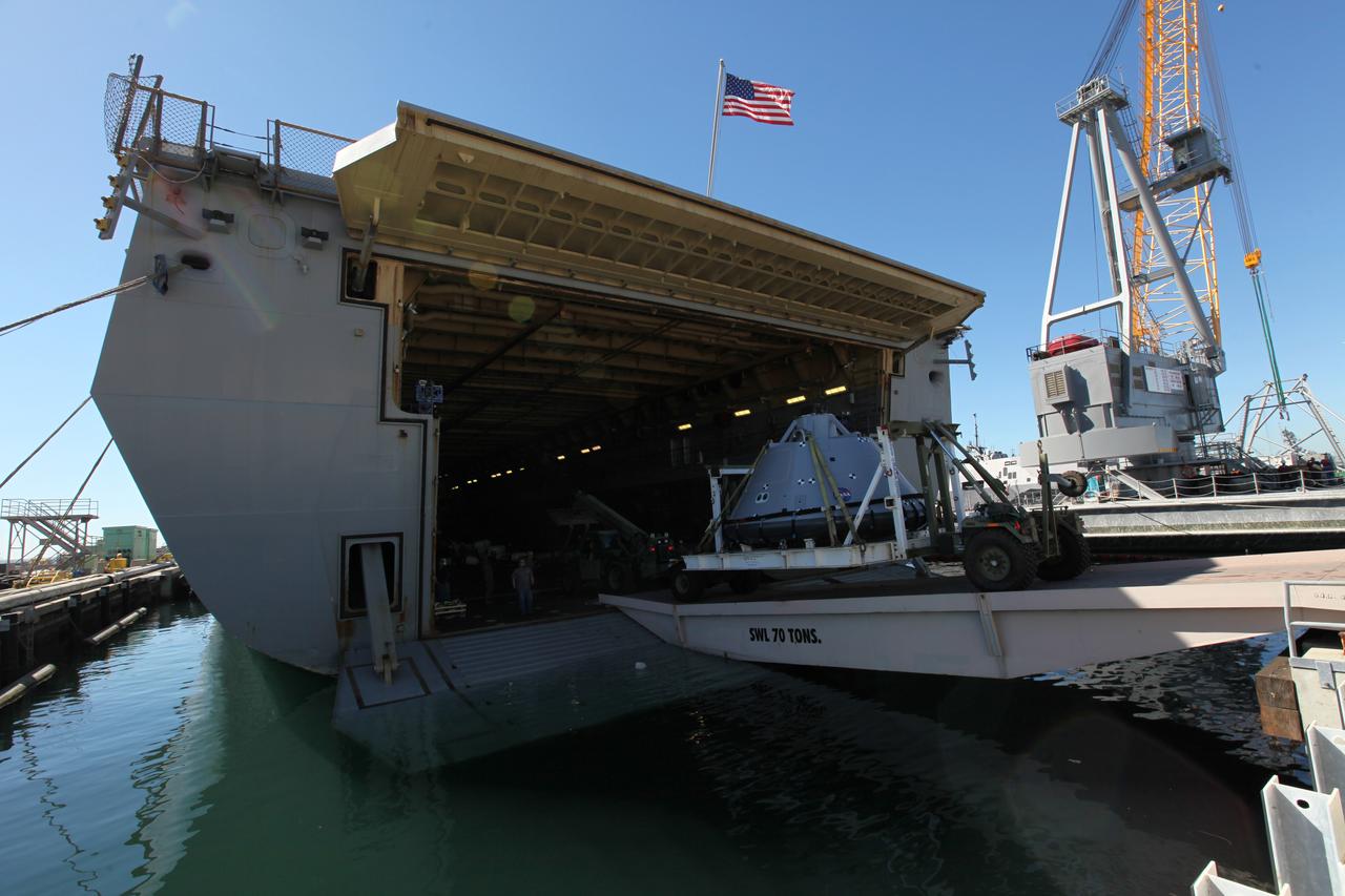
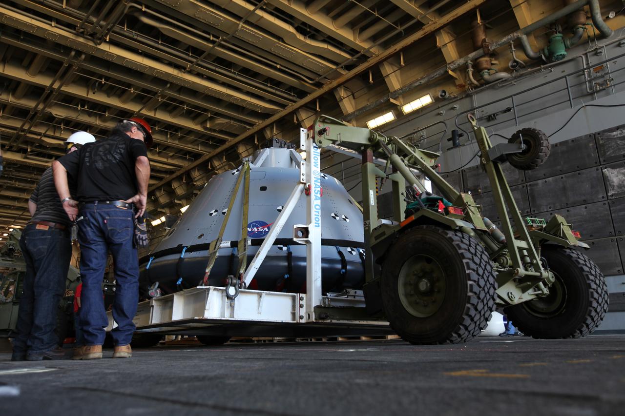
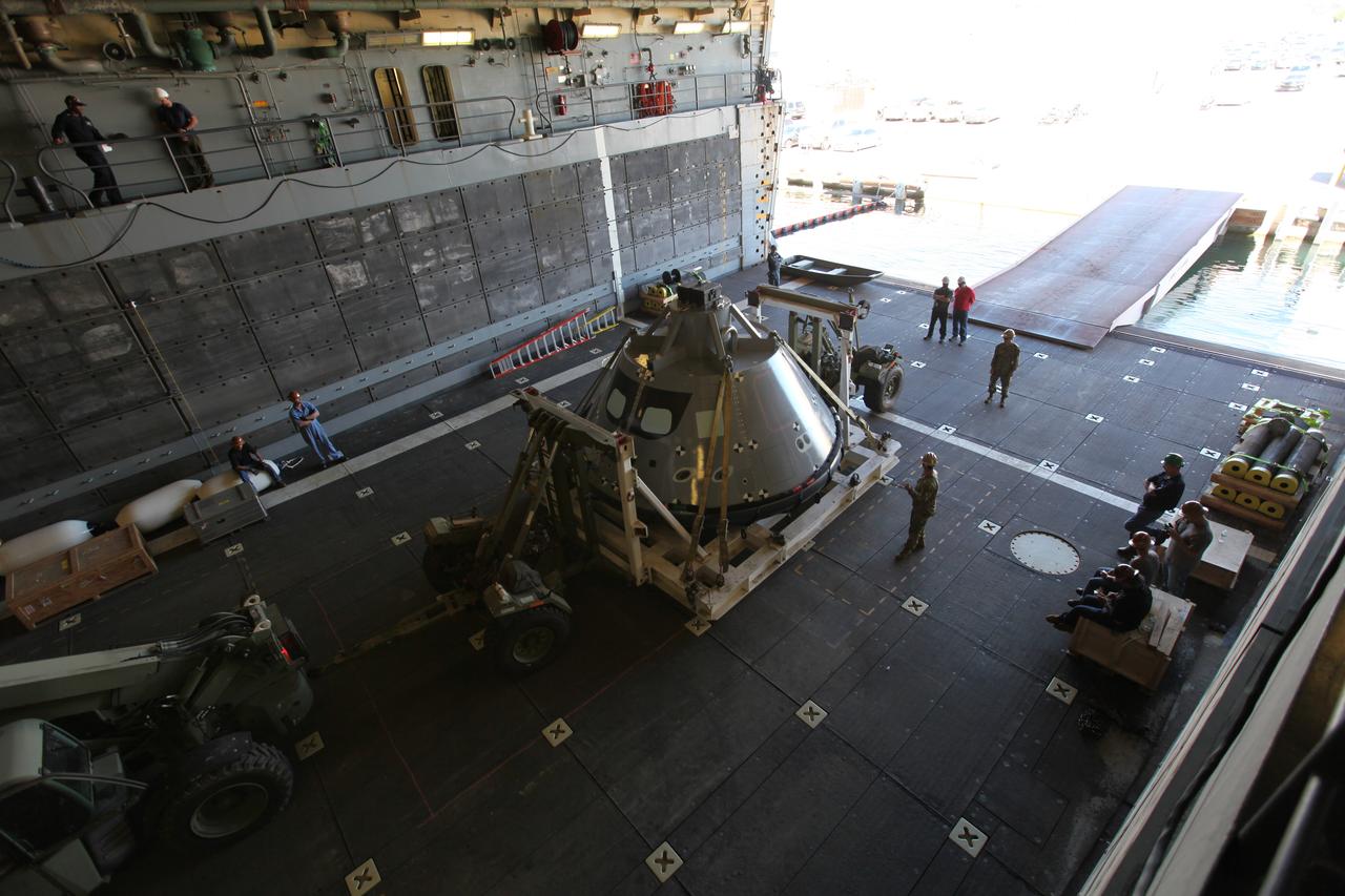
The Orion boilerplate test article inside the well deck of the USS Anchorage during recovery practice operations Aug. 4, 2014. NASA and U.S. Navy practiced recovery techniques off the coast of California, in preparation for Exploration Flight Test-1 (EFT-1). Part of Batch image transfer from Flickr.

iss063e002902 (April 23, 2020) --- The California cities of San Diego, National City and Chula Vista surround San Diego Bay which is just a few miles north of the U.S.-Mexican border. The International Space Station was just off the coast above the Pacific Ocean when this photograph was taken.
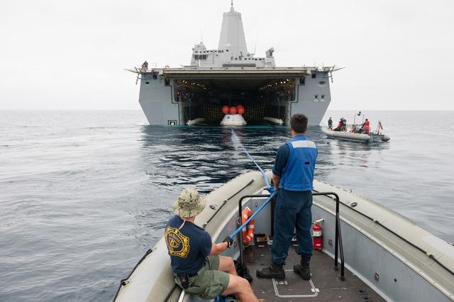
Recovery team members work with a test version of Orion floating in the well deck of the U.S.S. Anchorage on Aug. 2, 2014. A combined NASA and U.S. Navy team practiced recovery techniques off the coast of California in preparation for Exploration Flight Test-1 (EFT-1). Part of Batch image transfer from Flickr.
The Orion boilerplate test article inside the well deck of the USS Anchorage during recovery practice operations on Aug. 4, 2014. NASA and U.S. Navy practiced recovery techniques off the coast of California, in preparation for Exploration Flight Test-1 (EFT-1). Part of Batch image transfer from Flickr.
iss062e004863 (Feb. 9, 2020) --- The International Space Station was orbiting 266 miles above the Pacific Ocean when this picture was taken just off the western coast of North America. At top near the Earth's limb is California's San Francisco Bay. Washington state's Columbia River appears at the bottom of the frame.
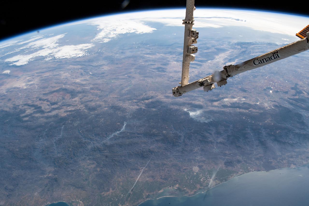
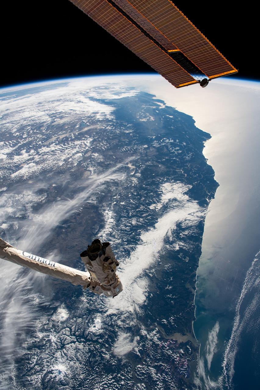
iss059e025434 (April 18, 2019) --- The Mexican state of Sinaloa and its central coast on the Gulf of California are pictured as the International Space Station orbited 255 miles above the Pacific Ocean. The station's Canadarm2 robotic arm is extended in the foreground the day before it would capture and install Northrop Grumman's Cygnus resupply ship to the Unity module.

Recovery team members gather around a test version of Orion, with the U.S.S. Anchorage waiting in the background on Aug. 3, 2014. NASA and U.S. Navy practiced recovery techniques off the coast of California, in preparation for Exploration Flight Test-1 (EFT-1). Part of Batch image transfer from Flickr.

VANDENBERG AFB, Calif. -- The air field at Vandenberg Air Force Base in California. Vandenberg Air Force Base has a mission of placing satellites into polar orbit from the West Coast, using expendable boosters such as the Pegasus, Taurus, Minotaur, Atlas V and Delta IV. Photo credit: NASA_Cory Huston
iss069e016644 (May 31, 2023) --- The southern portion of San Francisco Bay in California is surrounded by the Silicon Valley region, famed for its high technology industries, which includes numerous suburbs such as Stanford, Palo Alto, San Jose, and Fremont. The International Space Station was orbiting 258 miles above the Pacific coast at the time of this photograph.

iss073e0035649 (April 20, 2025) --- An orbital twilight reveals Earth's horizon and contrasts with the well-lit coast of southern California in this photograph from the International Space Station as it orbited 258 miles above the Pacific Ocean at approximately 4:46 a.m. local time.
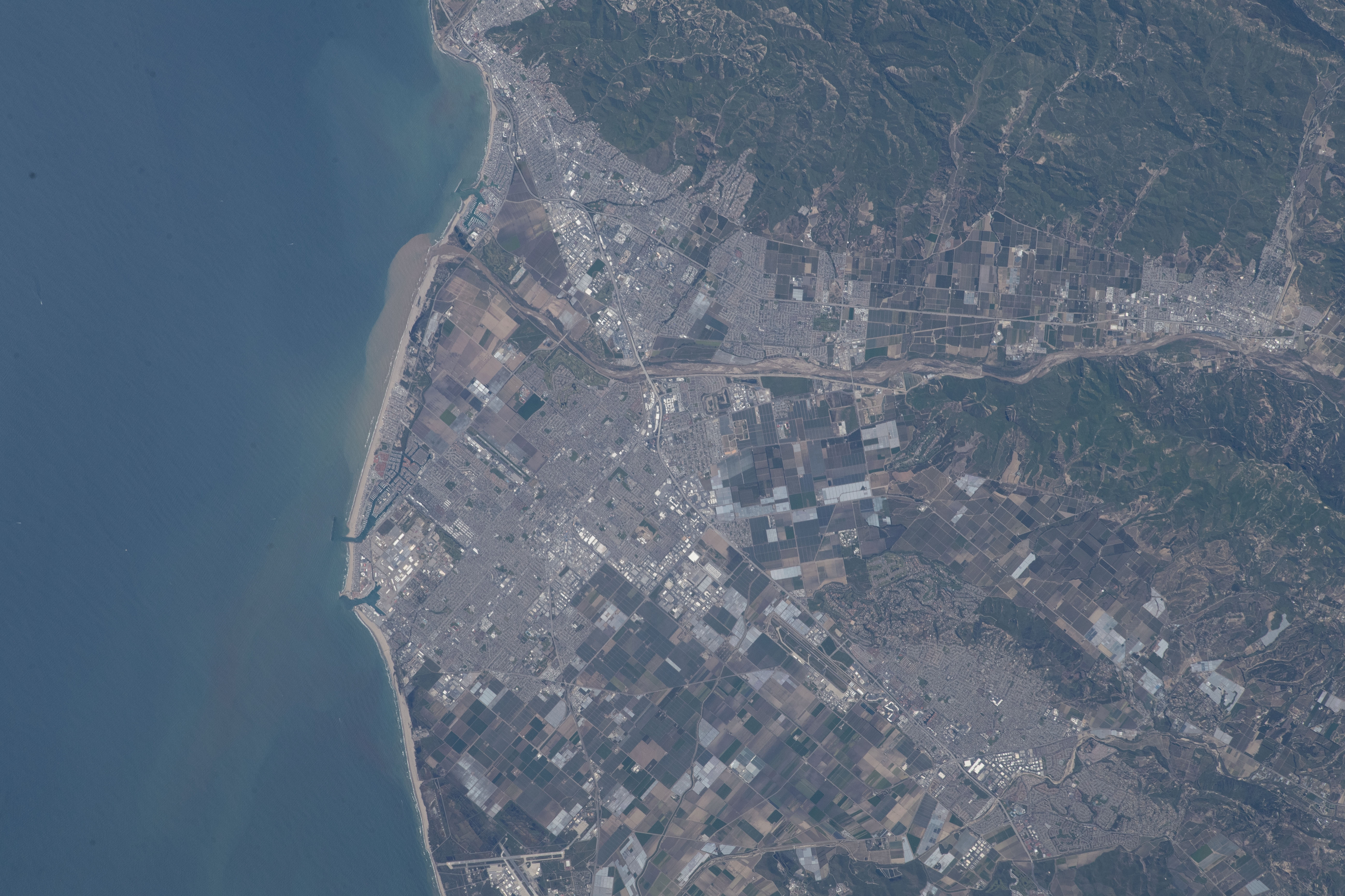
iss069e000692 (April 1, 2023) --- Ventura County, on the Pacific coast of California just north of Los Angeles, is pictured from the International Space Station at an altitude of 262 miles in this photograph from NASA astronaut and Expedition 69 Flight Engineer Woody Hoburg.
Lines secure a test version of Orion inside of the USS Anchorage's well deck during recovery tests off the coast of California on Sept. 15, 2014. The well deck can be flooded with water to allow Orion to float in following its splashdown when it returns from space. Part of Batch image transfer from Flickr.
Recovery team members work with a test version of Orion floating in the well deck of the U.S.S. Anchorage on Aug. 2, 2014. A combined NASA and U.S. Navy team practiced recovery techniques off the coast of California in preparation for Exploration Flight Test-1 (EFT-1). Part of Batch image transfer from Flickr.
iss065e021010 (May 5, 2021) --- A cloud-covered Terminal Island and Long Beach south of Los Angeles, California, is pictured from the International Space Station as it orbited 263 miles above the Pacific Ocean off the coast of San Diego.
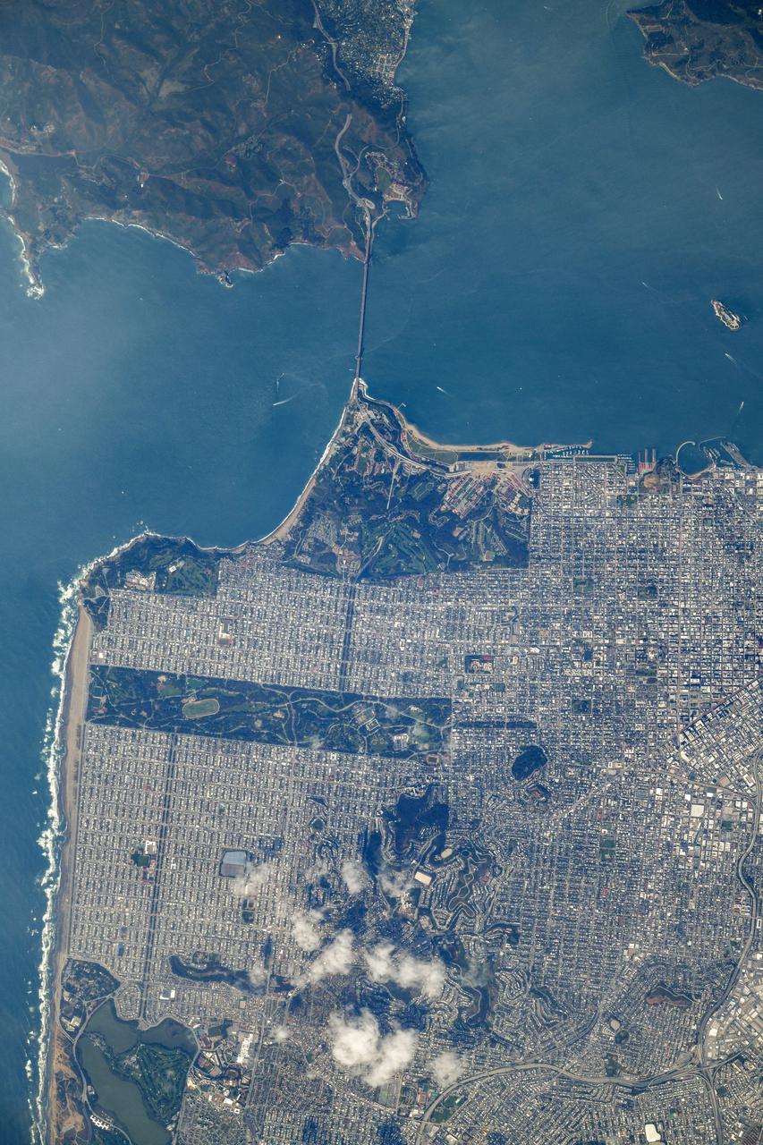
iss064e053178 (April 4, 2021) --- The Golden Gate Bridge links San Francisco with the Golden Gate National Recreation Area in northern California. The International Space Station was orbiting 264 miles above the Pacific Ocean just off the coast when this photograph was taken. Credit: Roscosmos

ISS036-E-039811 (30 Aug. 2013) --- One of the Expedition 36 crew members aboard the International Space Station photographed this unusual image of what appear to be either stratocumulus or altocumulus clouds off the coast of southern California on Aug. 30, 2013.
iss065e007130 (April 27, 2021) --- The southern end of San Francisco Bay hosts Don Edwards San Francisco Bay National Wildlife Refuge and is surrounded by the California cities of Newark and Baylands. This photograph was taken from the International Space Station as it orbited 263 miles above the Pacific Ocean near the coast.
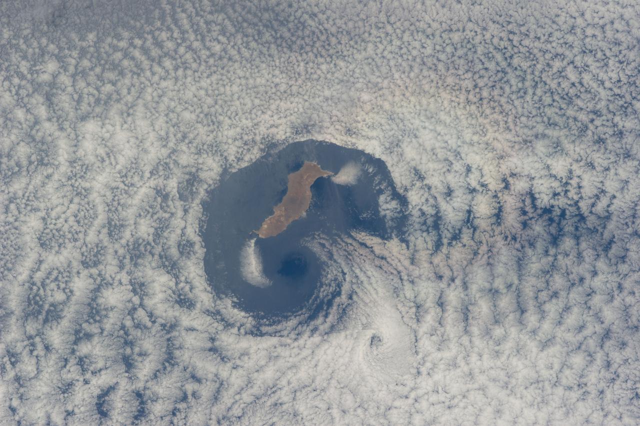
ISS040-E-016570 (21 June 2014) --- From an altitude of 223 nautical miles, one of the Expedition 40 crew members on the International Space Station photographed this nearly vertical image of Guadalupe Island and the Von Karman cloud vortices that are its storied neighbors just off southern California's Pacific Coast.
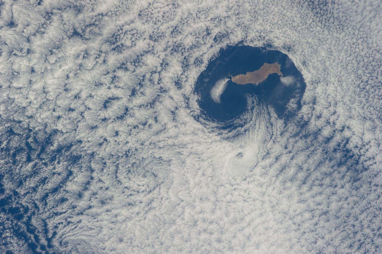
ISS040-E-016569 (21 June 2014) --- From an altitude of 223 nautical miles, one of the Expedition 40 crew members on the International Space Station photographed this nearly vertical image of Guadalupe Island and the Von Karman cloud vortices that are its storied neighbors just off southern California's Pacific Coast.
Recovery team members work with a test version of Orion floating in the well deck of the U.S.S. Anchorage on Aug. 2, 2014. A combined NASA and U.S. Navy team practiced recovery techniques off the coast of California in preparation for Exploration Flight Test-1 (EFT-1). Part of Batch image transfer from Flickr.
STS039-151-181A (28 April-6 May 1991) --- Large format (five-inch) frame of the San Francisco/Oakland Bay Area of northern California. Stratus clouds at 35,000 feet and cumulus clouds at about 15,000 feet are seen over the Pacific Coast, obscuring the Golden Gate Bridge.
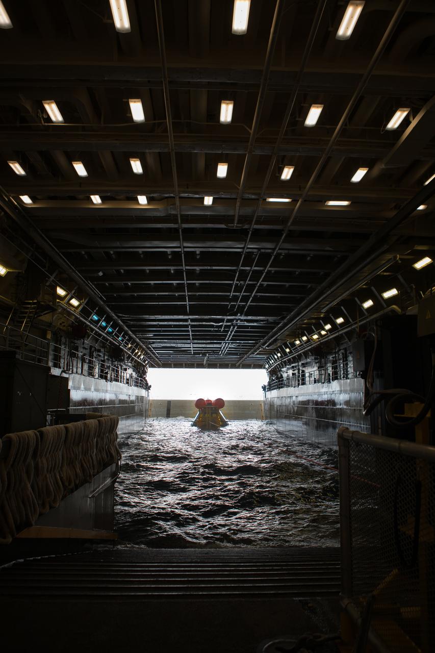
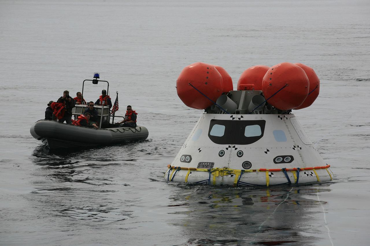
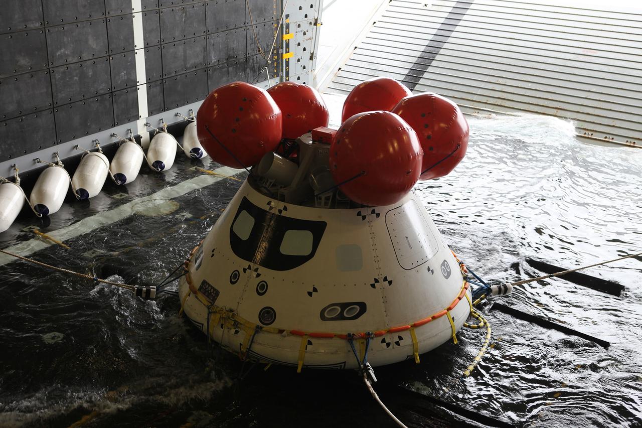
A test version of Orion sits nestled in its cradle during Underway Recovery Test-8 off the coast of California. During the test, the team practiced to ensure recovery procedure timelines are validated as NASA plans to send Artemis I around the Moon and splashdown in the Pacific Ocean.

Lilian Villarreal, Artemis II landing and recovery director for Exploration Ground Systems at NASA's Kennedy Space Center, poses for a portrait onboard USS John P. Murtha, Tuesday, April 7, 2026, in the Pacific Ocean off the coast of California. Photo Credit: (NASA/Bill Ingalls)
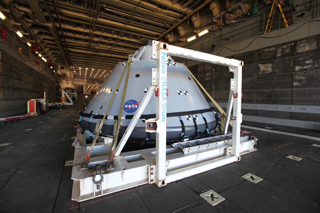
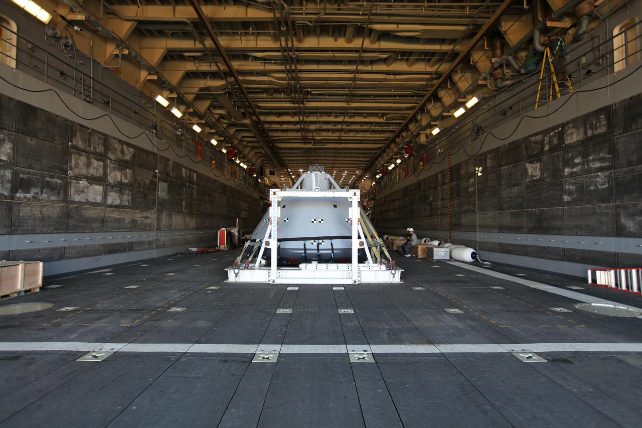
The test version of the Orion crew module is transported into the well deck of the USS San Diego at Naval Base San Diego in California on Oct. 21, 2016. NASA, Orion manufacturer Lockheed Martin and the U.S. Navy will head out to sea with the Orion test spacecraft aboard for Underway Recovery Test 5 (URT-5) in the Pacific Ocean off the coast of California. During URT-5, the team will demonstrate and evaluate the recovery processes, procedures, hardware and personnel necessary for recovery of Orion on its return from a deep space mission.

USS San Diego Commanding Officer Capt. David Walton speaks at a news conference held in San Diego, California on Wednesday, Feb. 28, 2024, about the Underway Recovery Test 11 (URT-11) off the coast of San Diego, California. URT-11 performed by NASA’s Exploration Ground System’s Landing and Recovery team, partners from the Department of Defense, and U.S. Navy personnel aboard the USS San Diego is the eleventh in a series of Artemis recovery tests, and the first the Artemis II recovery procedures involved the astronauts.
The test version of the Orion crew module is transported into the well deck of the USS San Diego at Naval Base San Diego in California on Oct. 21, 2016. NASA, Orion manufacturer Lockheed Martin and the U.S. Navy will head out to sea with the Orion test spacecraft aboard for Underway Recovery Test 5 (URT-5) in the Pacific Ocean off the coast of California. During URT-5, the team will demonstrate and evaluate the recovery processes, procedures, hardware and personnel necessary for recovery of Orion on its return from a deep space mission.

The test version of the Orion crew module is transported into the well deck of the USS San Diego at Naval Base San Diego in California on Oct. 21, 2016. NASA, Orion manufacturer Lockheed Martin and the U.S. Navy will head out to sea with the Orion test spacecraft aboard for Underway Recovery Test 5 (URT-5) in the Pacific Ocean off the coast of California. During URT-5, the team will demonstrate and evaluate the recovery processes, procedures, hardware and personnel necessary for recovery of Orion on its return from a deep space mission.
The test version of the Orion crew module is transported into the well deck of the USS San Diego at Naval Base San Diego in California on Oct. 21, 2016. NASA, Orion manufacturer Lockheed Martin and the U.S. Navy will head out to sea with the Orion test spacecraft aboard for Underway Recovery Test 5 (URT-5) in the Pacific Ocean off the coast of California. During URT-5, the team will demonstrate and evaluate the recovery processes, procedures, hardware and personnel necessary for recovery of Orion on its return from a deep space mission.
The test version of the Orion crew module is transported into the well deck of the USS San Diego at Naval Base San Diego in California on Oct. 21, 2016. NASA, Orion manufacturer Lockheed Martin and the U.S. Navy will head out to sea with the Orion test spacecraft aboard for Underway Recovery Test 5 (URT-5) in the Pacific Ocean off the coast of California. During URT-5, the team will demonstrate and evaluate the recovery processes, procedures, hardware and personnel necessary for recovery of Orion on its return from a deep space mission.
The test version of the Orion crew module is transported into the well deck of the USS San Diego at Naval Base San Diego in California on Oct. 21, 2016. NASA, Orion manufacturer Lockheed Martin and the U.S. Navy will head out to sea with the Orion test spacecraft aboard for Underway Recovery Test 5 (URT-5) in the Pacific Ocean off the coast of California. During URT-5, the team will demonstrate and evaluate the recovery processes, procedures, hardware and personnel necessary for recovery of Orion on its return from a deep space mission.

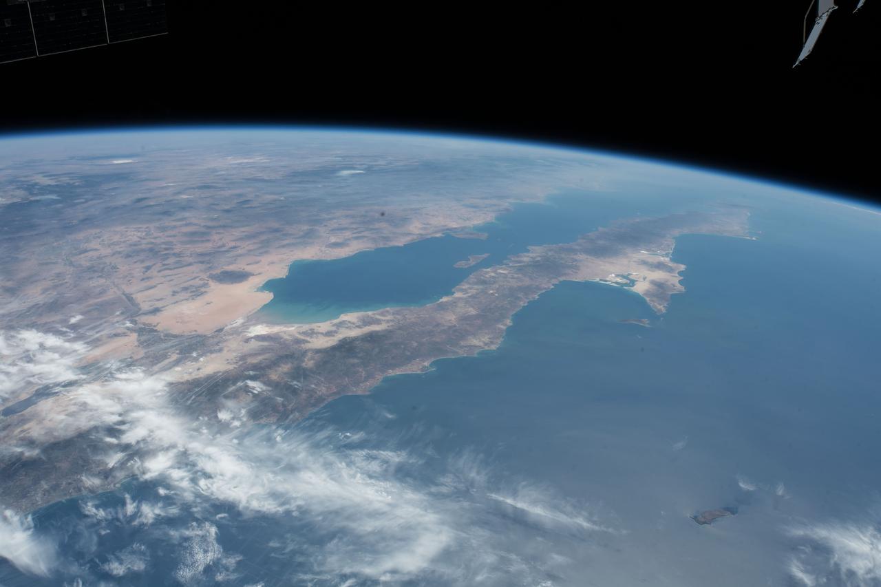
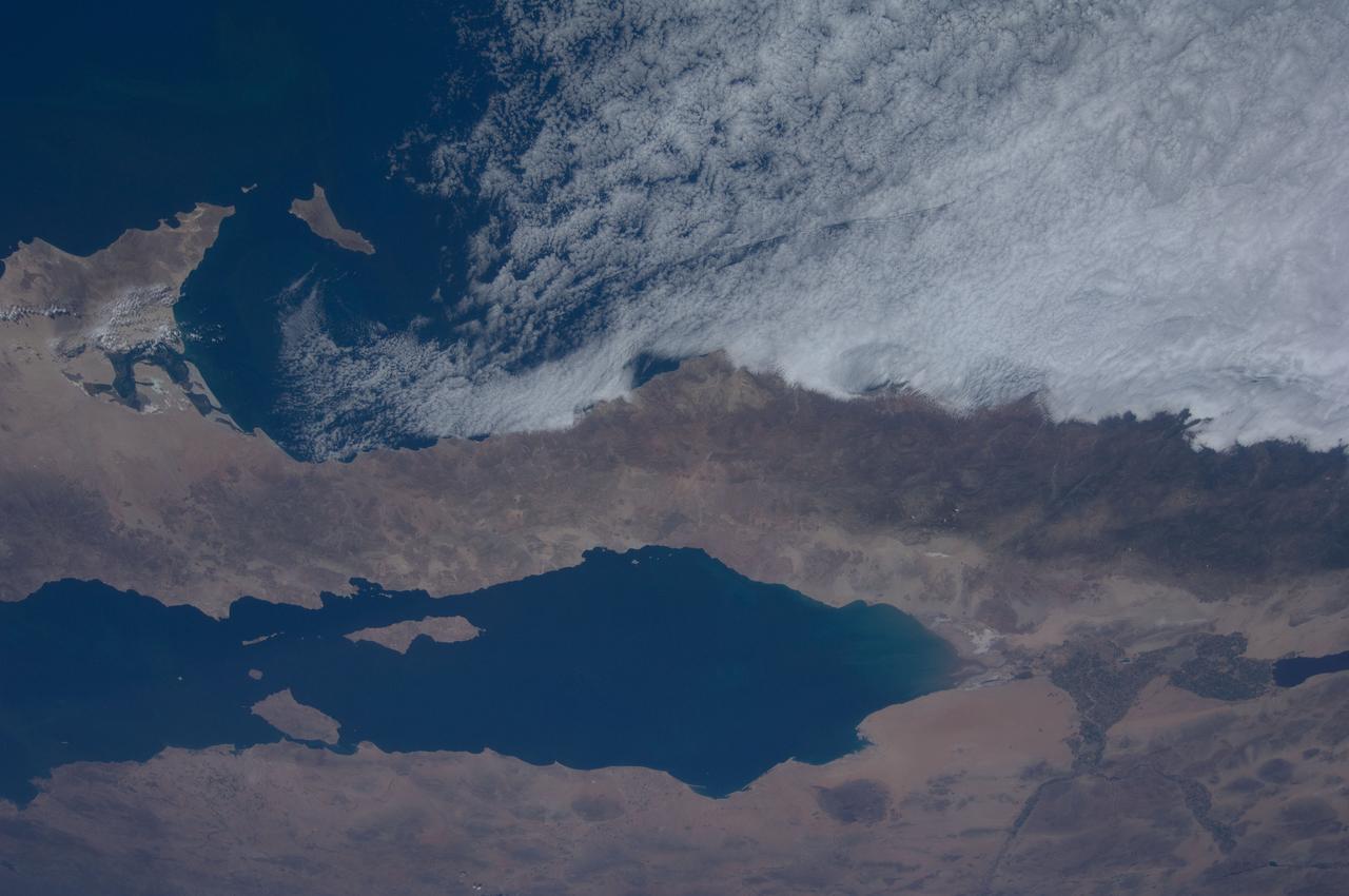
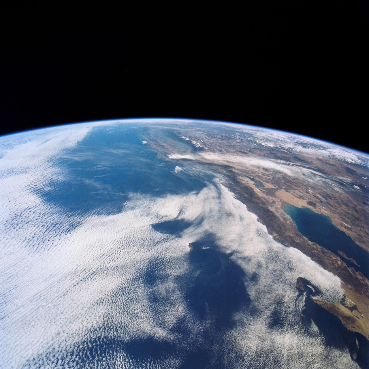
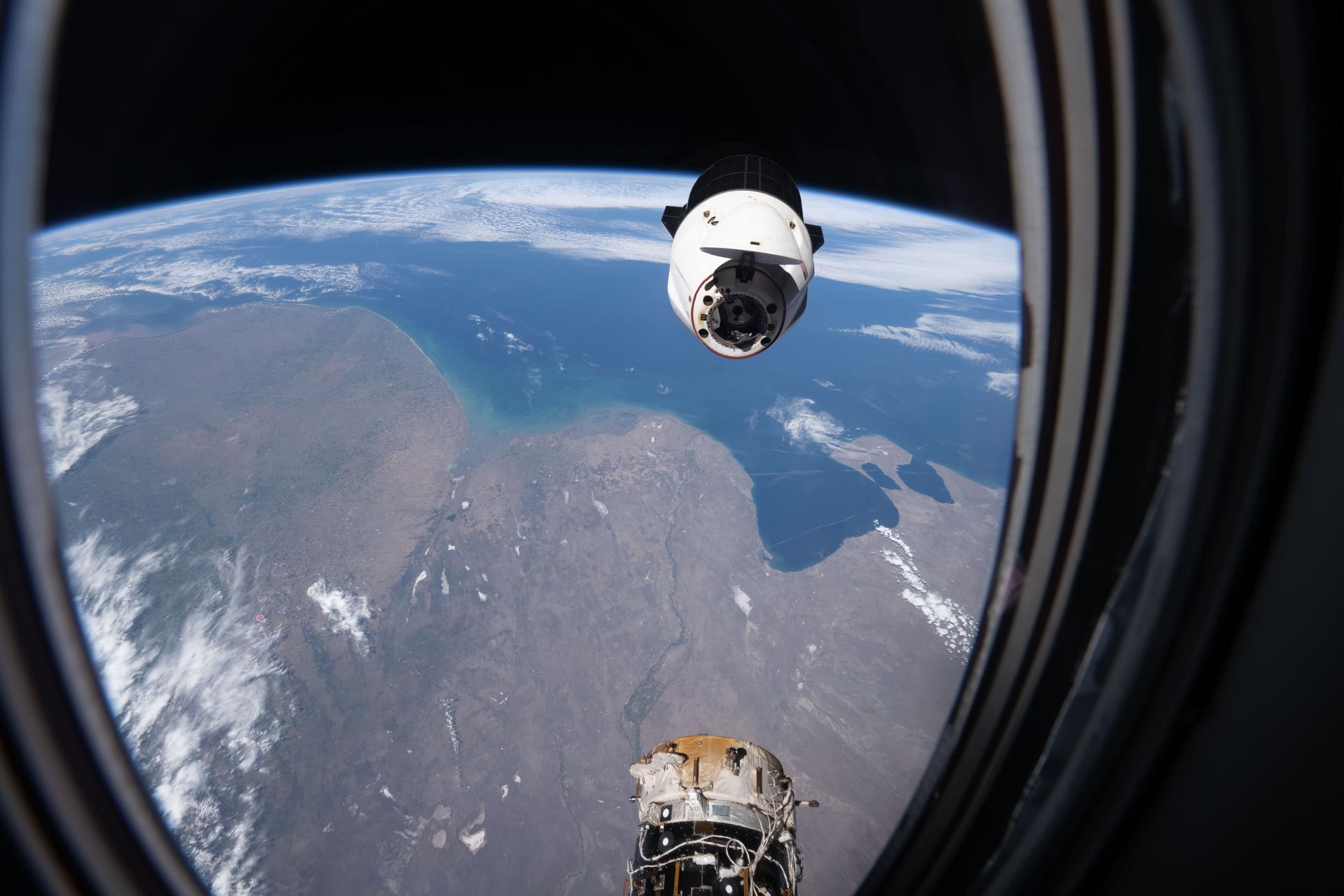
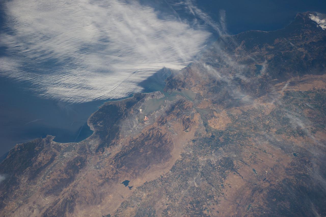
ISS023-E-024576 (15 April 2010) --- One of the Expedition 23 crew members aboard the International Space Station snapped this photo of part of the space shuttle Discovery’s starboard wing, vertical stabilizer and orbital maneuvering system pods backdropped against the cloud-covered Pacific Coast of southern California and northern Baja California, Mexico. The Imperial Valley and Salton Sea can be seen at top center.

The test version of the Orion crew module is transported into the well deck of the USS San Diego at Naval Base San Diego in California on Oct. 21, 2016. NASA, Orion manufacturer Lockheed Martin and the U.S. Navy will head out to sea with the Orion test spacecraft aboard for Underway Recovery Test 5 (URT-5) in the Pacific Ocean off the coast of California. During URT-5, the team will demonstrate and evaluate the recovery processes, procedures, hardware and personnel necessary for recovery of Orion on its return from a deep space mission.
The test version of the Orion crew module is transported into the well deck of the USS San Diego at Naval Base San Diego in California on Oct. 21, 2016. NASA, Orion manufacturer Lockheed Martin and the U.S. Navy will head out to sea with the Orion test spacecraft aboard for Underway Recovery Test 5 (URT-5) in the Pacific Ocean off the coast of California. During URT-5, the team will demonstrate and evaluate the recovery processes, procedures, hardware and personnel necessary for recovery of Orion on its return from a deep space mission.
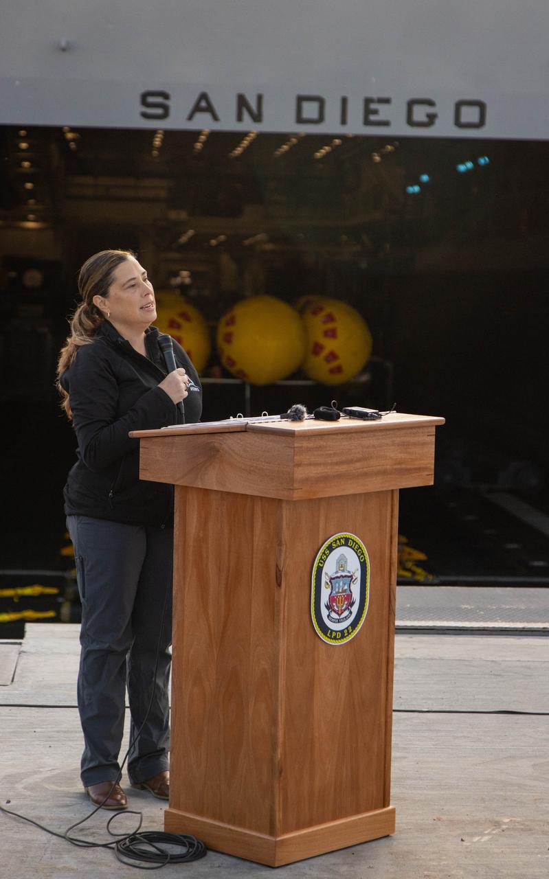
Liliana Villarreal, landing and recovery director in Exploration Ground Systems at NASA’s Kennedy Space Center in Florida speaks in a news conference held in San Diego, California on Wednesday, Feb. 28, 2024, about the Underway Recovery Test 11 (URT-11) performed off the coast of San Diego, California. URT-11 is the eleventh in a series of Artemis recovery tests, and the first time NASA and its partners put their Artemis II recovery procedures in place with the astronauts.

KENNEDY SPACE CENTER, FLA. - Two blue-winged teals swim in a pond near KSC. The species prefers marshes and shallow ponds and lakes for nesting and range from Canada to North Carolina, the Gulf Coast and Southern California, as well as Florida. KSC shares a boundary with the National Merritt Island Wildlife Refuge, which provides wintering areas for 23 species of migratory waterfowl, as well as a year-round home for great blue herons, great egrets, wood storks, cormorants, brown pelicans and other species of marsh and shore birds.
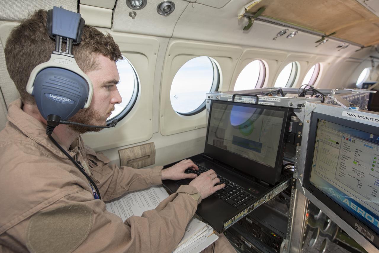
A research plane carrying the AVIRIS-NG (Airborne Visible/Infrared Imaging Spectrometer-Next Generation) instrument flies off the Central Coast of California near Point Conception and the Jack and Laura Dangermond Preserve on Feb. 24, 2022. The flight is part of the Surface Biology and Geology High-Frequency Time Series (SHIFT) campaign, which is jointly led by NASA's Jet Propulsion Laboratory, the University of California, Santa Barbara (UCSB), and The Nature Conservancy. Operating between late February and late May 2022, the aerial portion of SHIFT flies on an approximately weekly basis over a 640-square-mile (1,656-square-kilometer) study area in Santa Barbara County and the nearby ocean, collecting spectral data of plant communities it observes below. SHIFT combines the ability of airborne science instruments to gather data over widespread areas with the more concentrated observations scientists conduct in the field to study the functional characteristics, health, and resilience of plant communities. The sampling and analysis done by researchers on the ground and in the ocean is intended to validate data taken by AVIRIS-NG and help scientists design data collection and processing algorithms for NASA's proposed Surface Biology and Geology (SBG) mission, which would launch no earlier than 2028. The data is also intended to support the research and conservation objectives of The Nature Conservancy, which owns the Dangermond Preserve, and UCSB, which operates the Sedgwick Reserve, another nature preserve within the study area. More than 60 scientists from institutions around the U.S. have indicated they intend to use the SHIFT data in their research. AVIRIS-NG, which was designed at JPL, flies aboard Dynamic Aviation's King Air B-200. https://photojournal.jpl.nasa.gov/catalog/PIA25143
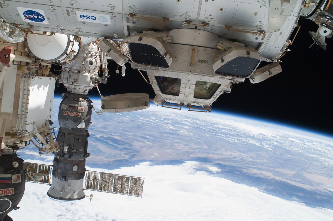
ISS028-E-016225 (12 July 2011) --- Components of the International Space Station, though moving along at 17,500 miles per hour, appear to hover above the Pacific Ocean just off the California coast. Ten cosmonauts and astronauts were working together when this photo was taken -- four of them as STS-135 visitors from the docked space shuttle Atlantis and six as members of the Expedition 28 crew. The Cupola, near center of frame, is attached to Node 3 or Tranquility. A Russian Soyuz and a Russian Progress spacecraft are parked at the station, left side of frame. While much of the coast is obscured by clouds, just inland from left to right, one can see the agriculture of the San Joaquin Valley, the southern Sierra Nevada, the Los Angeles Basin (center), the Mojave Desert, coastal mountains of southern California, the Salton Sea, the Imperial Valley, and the mouth of the Colorado River on the extreme right edge.