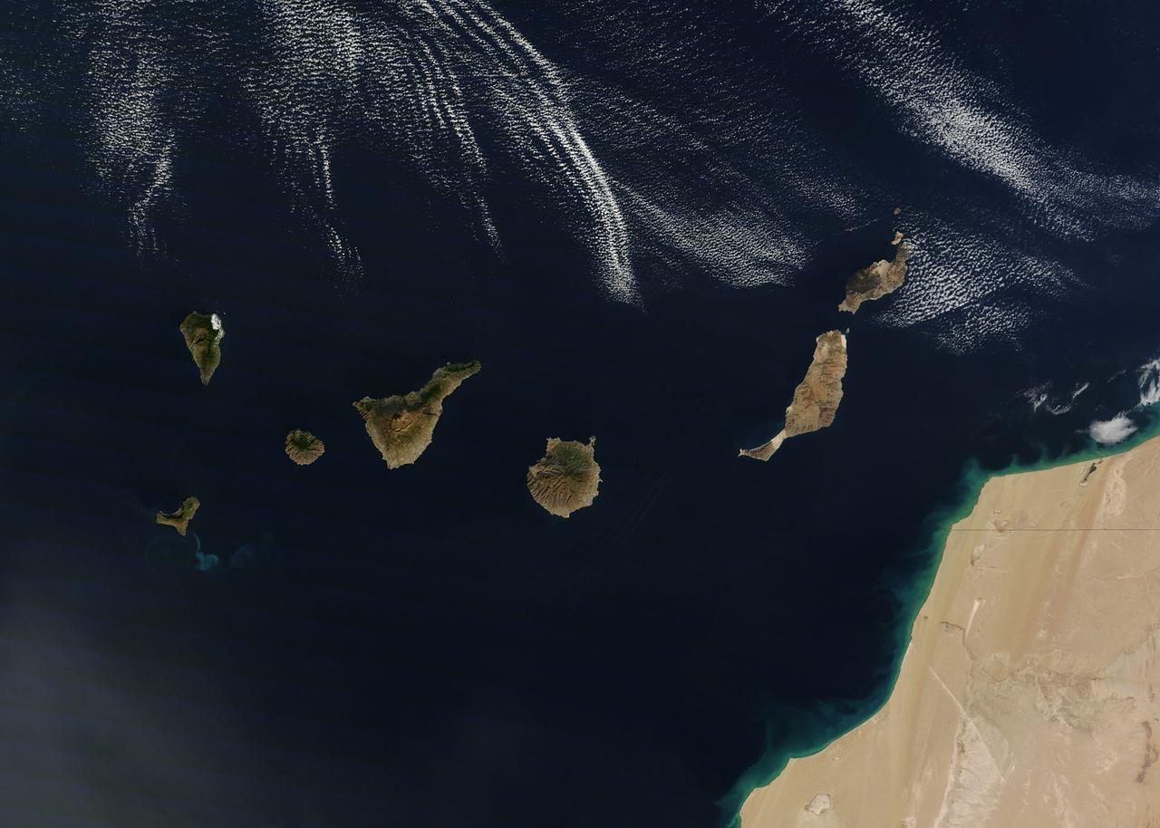
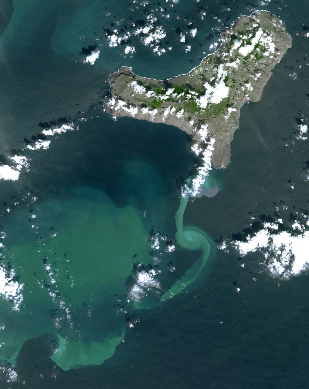
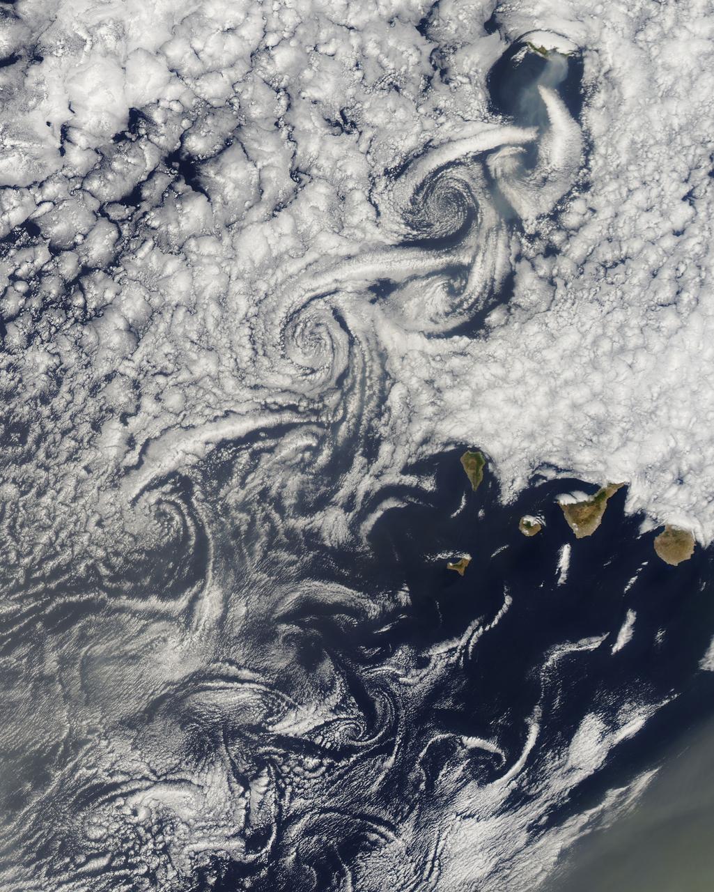
NASA image acquired December 21, 2011 The rugged landscape of the Canary Islands stood out in sharp contrast to the smooth blue waters of the Atlantic Ocean and the flat tan land of northwestern Africa on December 21, 2011, when the Moderate Resolution Imaging Spectroradiometer (MODIS) aboard the Terra satellite captured this true-color image. The Canary Islands are a group of seven large islands and several smaller islets, all volcanic in origin. The eastern edge of the chain lies only 100 kilometers from the coasts of Morocco and Western Sahara, and the chain stretches for about 500 kilometers across the Atlantic. All the islands are mountainous, and Tenerife, the central island in this image is home to Pico de Teinde, the highest peak, which rises 12,198 feet (3,718 meters) above sea level. From east to west, the islands are named Lanzarote, Fuerteventura, Gran Canaria, Tenerife, La Gomera, La Palmera and El Hierro. A bright swirl of peacock blue marks the ocean south of El Hierro, a stain on the sea from an ongoing eruption of a volcano under the waters. Credit: NASA/GSFC/Jeff Schmaltz/MODIS Land Rapid Response Team <b><a href="http://www.nasa.gov/audience/formedia/features/MP_Photo_Guidelines.html" rel="nofollow">NASA image use policy.</a></b> <b><a href="http://www.nasa.gov/centers/goddard/home/index.html" rel="nofollow">NASA Goddard Space Flight Center</a></b> enables NASA’s mission through four scientific endeavors: Earth Science, Heliophysics, Solar System Exploration, and Astrophysics. Goddard plays a leading role in NASA’s accomplishments by contributing compelling scientific knowledge to advance the Agency’s mission. <b>Follow us on <a href="http://twitter.com/NASA_GoddardPix" rel="nofollow">Twitter</a></b> <b>Like us on <a href="http://www.facebook.com/pages/Greenbelt-MD/NASA-Goddard/395013845897?ref=tsd" rel="nofollow">Facebook</a></b> <b>Find us on <a href="http://instagrid.me/nasagoddard/?vm=grid" rel="nofollow">Instagram</a></b>
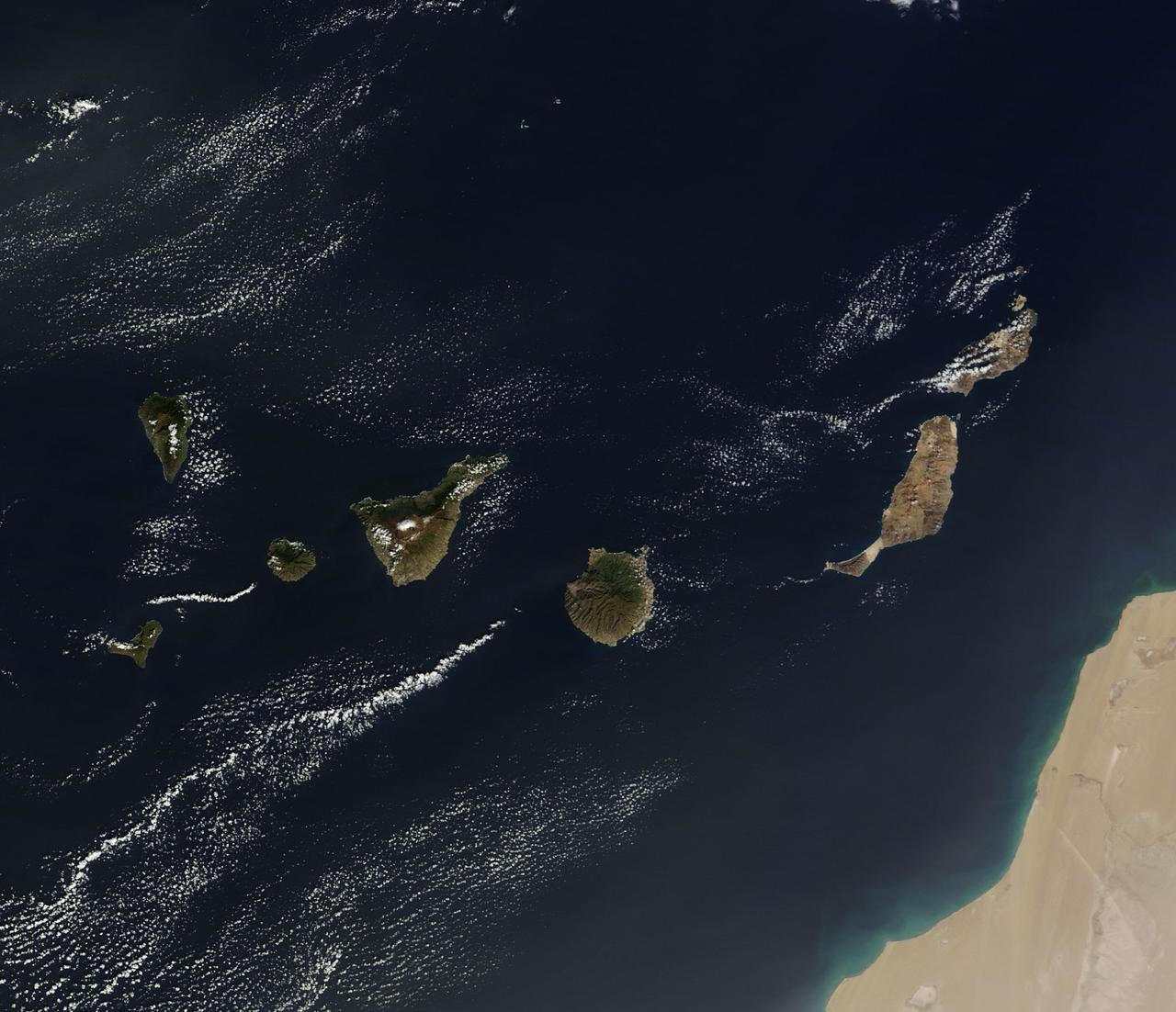
On December 10, 2013 the Moderate Resolution Imaging Spectroradiometer (MODIS) aboard NASA’s Terra satellite flew across the central Atlantic Ocean and captured a true-color image of the Canary Islands. Lying off of the coast of Western Sahara and Morocco, the islands were created by successive submarine volcanic eruptions which raised the ocean floor vertically until some of land rose above sea level. The oldest islands lie in the east and the youngest in the west. From east to west, the major islands seen in this image are: Lanzarote, Fuerteventura, Gran Canaria, Tenerife, La Gomera, La Palmera and El Hierro. While the creation of the islands began in the Late Cretaceous Period (70 – 80 million years ago), active volcanic activity continues. In 2011, a spectacular submarine eruption occurred just off the shore of El Hierro. The volcano became quiet again, but very recently increasing earthquakes and changing height of El Hierro suggested the volcano may again be entering an active eruptive phase. On December 27 the island’s volcano monitoring agency had raised the volcanic eruption risk for El Hierro to “yellow” – a code that means increasing activity but no eruption imminent. That afternoon a magnitude 5.1 earthquake struck offshore at El Hierro. The epicenter was 9 miles (15 km) deep, and it was one of the largest quakes ever recorded at the island. Credit: NASA/GSFC/Jeff Schmaltz/MODIS Land Rapid Response Team <b><a href="http://www.nasa.gov/audience/formedia/features/MP_Photo_Guidelines.html" rel="nofollow">NASA image use policy.</a></b> <b><a href="http://www.nasa.gov/centers/goddard/home/index.html" rel="nofollow">NASA Goddard Space Flight Center</a></b> enables NASA’s mission through four scientific endeavors: Earth Science, Heliophysics, Solar System Exploration, and Astrophysics. Goddard plays a leading role in NASA’s accomplishments by contributing compelling scientific knowledge to advance the Agency’s mission. <b>Follow us on <a href="http://twitter.com/NASA_GoddardPix" rel="nofollow">Twitter</a></b> <b>Like us on <a href="http://www.facebook.com/pages/Greenbelt-MD/NASA-Goddard/395013845897?ref=tsd" rel="nofollow">Facebook</a></b> <b>Find us on <a href="http://instagram.com/nasagoddard?vm=grid" rel="nofollow">Instagram</a></b>
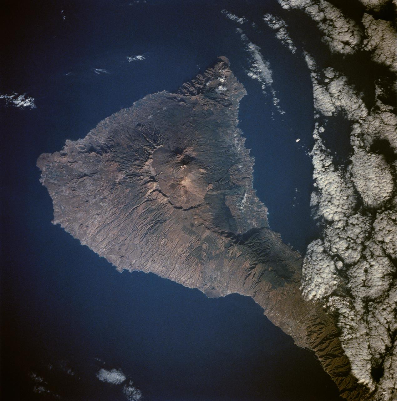
Tenarife Island is one of the most volcanically active of the Canary Island archipelago, Atlantic Ocean, just off the NW coast of Africa, (28.5N, 16.5W). The old central caldera, nearly filled in by successive volcanic activity culminating in two stratocones. From those two peaks, a line of smaller cinder cones extend to the point of the island. Extensive gullies dissect the west side of the island and some forests still remain on the east side.
S65-63150 (16 Dec. 1965) --- Eddies in stratocumulus clouds over the Canary Islands as seen from the Gemini-6 spacecraft during its 14th revolution of Earth. Photo credit: NASA or National Aeronautics and Space Administration
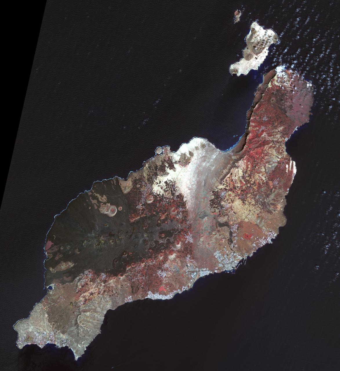
Lanzarote is the easternmost of the Canary Islands, 125 km off the coast of Africa, and is the fourth largest of the archipelago, with an area of 846 square kilometers. Like all of the Canary Islands, its volcanic origin dates to about 15 million years ago. The largest historic eruption occurred in the 1730s. The island was first recorded by Pliny the Elder, though it may have been originally settled by the Phoenicians (Wikipedia). The image was acquired 12 March 2015, covers an area of 50.5 by 55.1 km, and is located near 29 degrees north, 13.6 degrees west. http://photojournal.jpl.nasa.gov/catalog/PIA21284
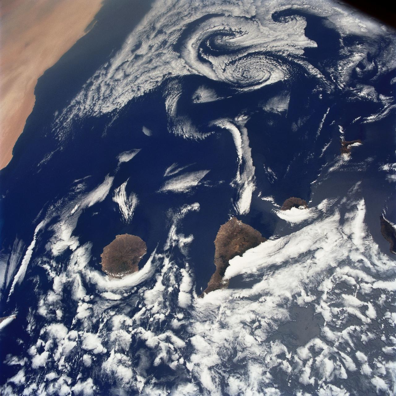
STS040-75-003 (5-14 June 1991) --- This image shows several of the Canary Islands, located in the North Atlantic Ocean just west of Africa. Low level stratus clouds often form here (and along the west coast of continents at these latitudes) are trapped in vertical movement due to an overlying atmospheric temperature inversion. The islands are generating disturbances in the low-level wind flow which is generally from the north-northeast or from top to bottom in the image. These disturbances travel downstream from the islands and manifest themselves as cloud swirls which are called von Karman vortices. The northern extent of a large dust storm moving off the coast of Africa is apparent at the lower right of the image. The dust, extended across the Atlantic Ocean as far west as the Dominican Republic later in the mission.
In July 2011, volcanic tremors began on the Island of El Hierro in the Canary Islands; by September, many tourists evacuated the resort island, fearing a volcanic eruption. This image is from NASA Terra spacecraft.
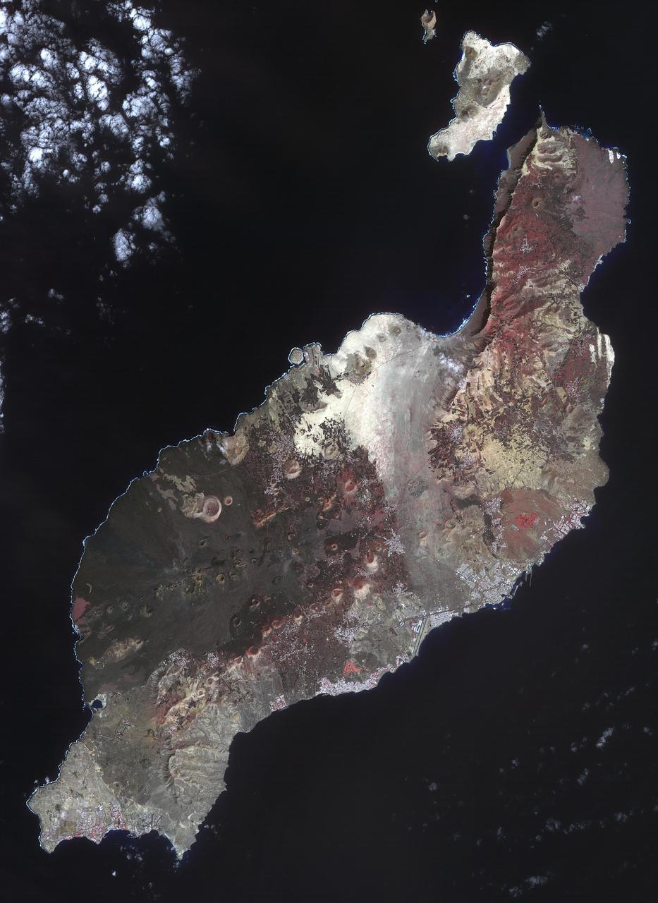
Los Volcanes Natural Park on Lanzarote in the Spanish Canary Islands is serving as a training ground to prepare for the next mission to the Moon and Mars. NASA and ESA use it for astronaut training and testing Mars Rovers. Astronauts are taught to become effective field geologists and geo-microbiologists in a planetary science context. The image was acquired February 14, 2014, covers an area of 32.7 by 58.5 km, and is located at 29 degrees north, 13.6 degrees west. https://photojournal.jpl.nasa.gov/catalog/PIA23526
NASA image acquired August 14, 2010 at 14:55 UTC Cloud vortices off Madeira and Canary Islands Satellite: Aqua Credit: NASA/GSFC/Jeff Schmaltz/MODIS Land Rapid Response Team Click here to see more images from <b><a href="http://rapidfire.sci.gsfc.nasa.gov/gallery/?latest" rel="nofollow">MODIS</a></b> <b><a href="http://www.nasa.gov/centers/goddard/home/index.html" rel="nofollow">NASA Goddard Space Flight Center</a></b> is home to the nation's largest organization of combined scientists, engineers and technologists that build spacecraft, instruments and new technology to study the Earth, the sun, our solar system, and the universe. <b>Follow us on <a href="http://twitter.com/NASA_GoddardPix" rel="nofollow">Twitter</a></b> <b>Join us on <a href="http://www.facebook.com/pages/Greenbelt-MD/NASA-Goddard/395013845897?ref=tsd" rel="nofollow">Facebook</a><b></b></b>
NASA Terra spacecraft acquired this image, a birdseye view of the Canary Islands wildfire, on Aug. 17, 2012. The main town of San Sebastian can be seen on the eastern shore of the island.
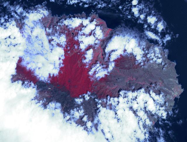
This radar image shows the Teide volcano on the island of Tenerife in the Canary Islands. The Canary Islands, part of Spain, are located in the eastern Atlantic Ocean off the coast of Morocco. Teide has erupted only once in the 20th Century, in 1909, but is considered a potentially threatening volcano due to its proximity to the city of Santa Cruz de Tenerife, shown in this image as the purple and white area on the lower right edge of the island. The summit crater of Teide, clearly visible in the left center of the image, contains lava flows of various ages and roughnesses that appear in shades of green and brown. Different vegetation zones, both natural and agricultural, are detected by the radar as areas of purple, green and yellow on the volcano's flanks. Scientists are using images such as this to understand the evolution of the structure of Teide, especially the formation of the summit caldera and the potential for collapse of the flanks. The volcano is one of 15 identified by scientists as potentially hazardous to local populations, as part of the international The image was acquired by the Spaceborne Imaging Radar-C/X-Band Synthetic Aperture Radar (SIR-C/X-SAR) onboard the space shuttle Endeavour on October 11, 1994. SIR-C/X-SAR, a joint mission of the German, Italian and the United States space agencies, is part of NASA's Mission to Planet Earth. The image is centered at 28.3 degrees North latitude and 16.6 degrees West longitude. North is toward the upper right. The area shown measures 90 kilometers by 54.5 kilometers (55.8 miles by 33.8 miles). The colors in the image are assigned to different frequencies and polarizations of the radar as follows: red is L-band horizontally transmitted, horizontally received; green is L-band horizontally transmitted, vertically received; blue is C-band horizontally transmitted, vertically received. http://photojournal.jpl.nasa.gov/catalog/PIA01779
41G-38-084 (5-13 Oct 1984) --- A light, thin cirrus cloud layer partially obscures the island of Gran Canaria in the Canary Islands (15.5 degrees west, 28 degrees north).
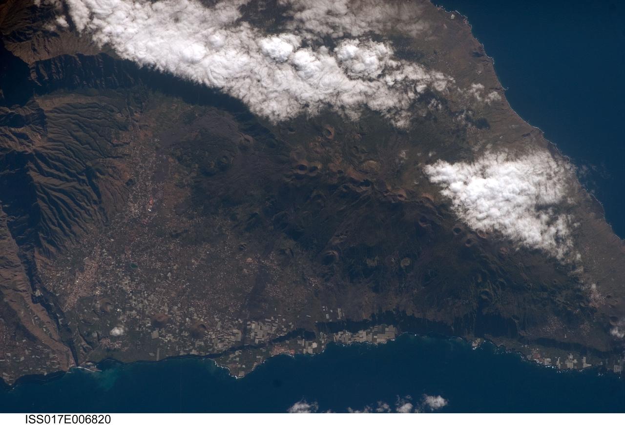
ISS017-E-006820 (13 May 2008) --- Isla de la Palma in the Canary Islands is featured in this image photographed by an Expedition 17 crewmember on the International Space Station. The Canary Islands, a group of volcanic islands, lie just off the west coast of Morocco in the Atlantic Ocean; at the northwest end of the chain of islands is Isla de la Palma. According to scientists, the island started forming as a submarine volcano approximately 3-4 million years ago. Subaerial (above the water surface) volcanic activity and island formation began around 2 million years ago. Most geologists believe the Canary Islands formed over the remnants of an old "hotspot" in the mantle, or mantle plume. The residual hotspot melting produced the magma that resulted in the Canary Island volcanoes. While there is little evidence to support the current existence of a mantle plume, volcanic activity is still taking place -- the most recent lava flows on Isla de Palma were erupted in 1971. In addition to volcanic hazards, the Canary Islands are also subject to occasional dust storms originating in the Sahara Desert. This view highlights volcanic landforms on the southern portion of Isla de Palma. The elongated, 1949-meter high Cumbre Vieja volcanic center is characterized by numerous cinder cones, craters, and gray lava flows that punctuate the green vegetated hillslopes. To the north, the cities of El Paso and Los Llanos de Aridanes nestle against collapsed fragments of the Caldera Taburiente (left), formed by massive slope failure of an older volcanic center to the north. Tourism is a major component of the local economy, but the high mountains and clear air of Isla de la Palma are also attractive to astronomers -- several large observatories (not shown) are located along the northern edge of the Caldera Taburiente.
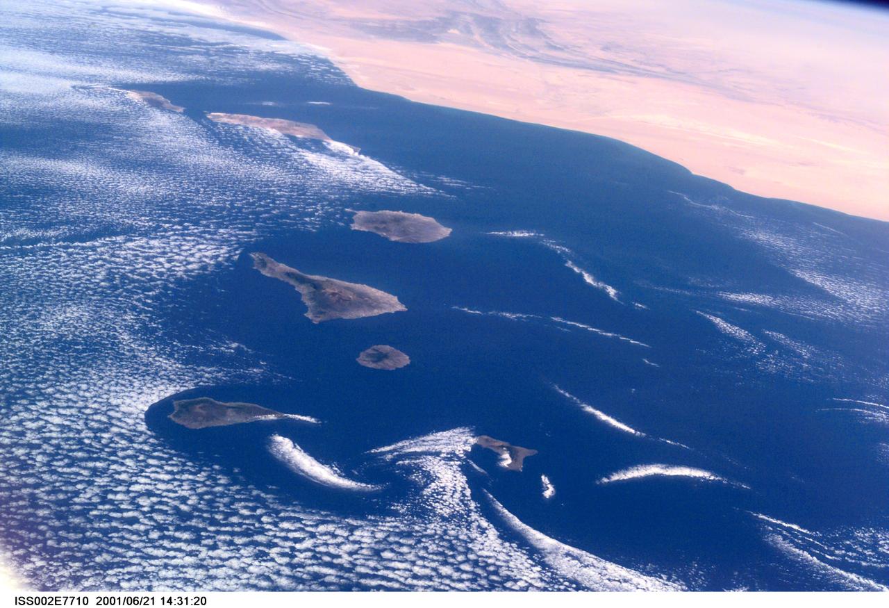
ISS002-E-7710 (21 June 2001) --- Commonly visible cloud vortices hover in the area of the Canary Islands off the coast of Morocco in this Expedition Two digital still camera's view from the International Space Station (ISS).
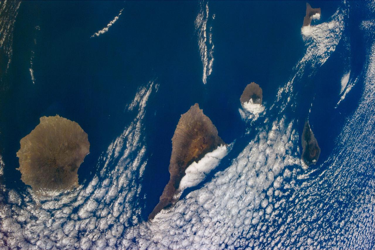
S94-E-5059 (July 1997) --- Several islands in the Canary chain and the cloud formations that are generally associated with this chain were captured with the STS-94 electronic still camera (ESC) in this nadir view from the Space Shuttle Columbia.
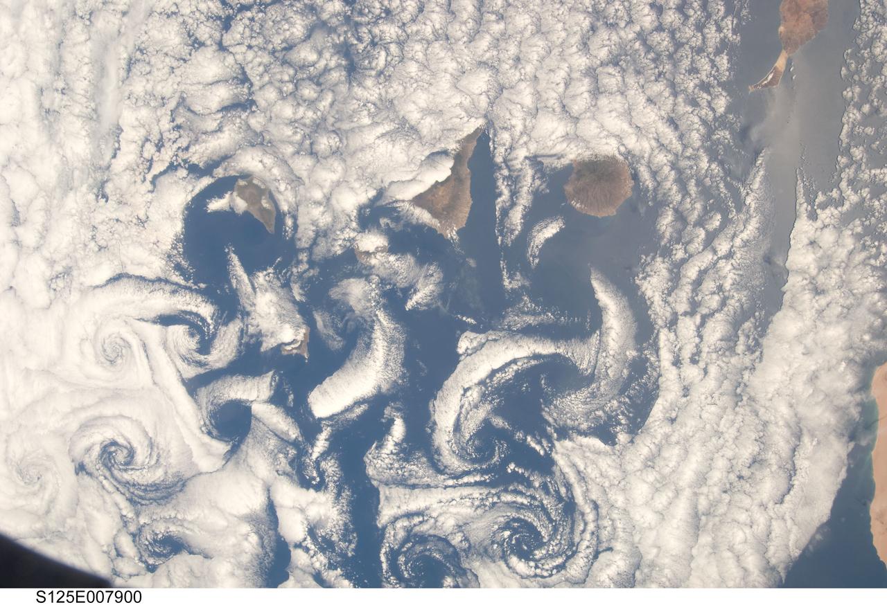
S125-E-007900 (16 May 2009) --- A nadir view of cloud vortices in the area of the Canary Islands in the North Atlantic Ocean was recorded by one of the STS-125 crewmembers on a busy flight day six.
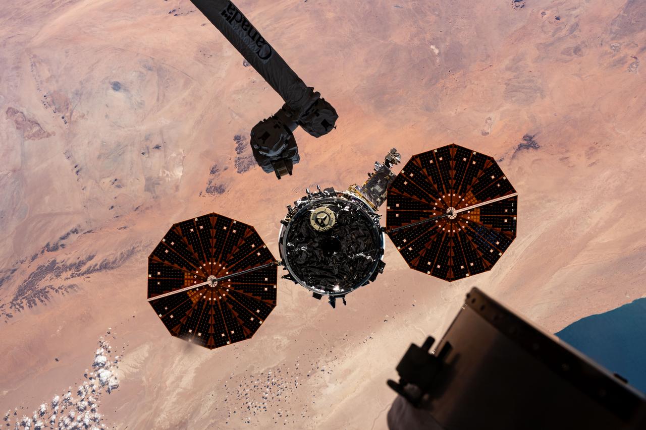
iss070e044302 (Dec. 22, 2023) --- Northrop Grumman's Cygnus space freighter is pictured moments after being released from the Canadarm2 robotic arm. The orbital complex was soaring 259 miles above the Atlantic Ocean near the Canary Islands at the time of this photograph.

iss070e044150 (Dec. 22, 2023) --- Northrop Grumman's Cygnus space freighter is pictured moments after being released from the Canadarm2 robotic arm. The orbital complex was soaring 259 miles above the Atlantic Ocean near the Canary Islands at the time of this photograph.
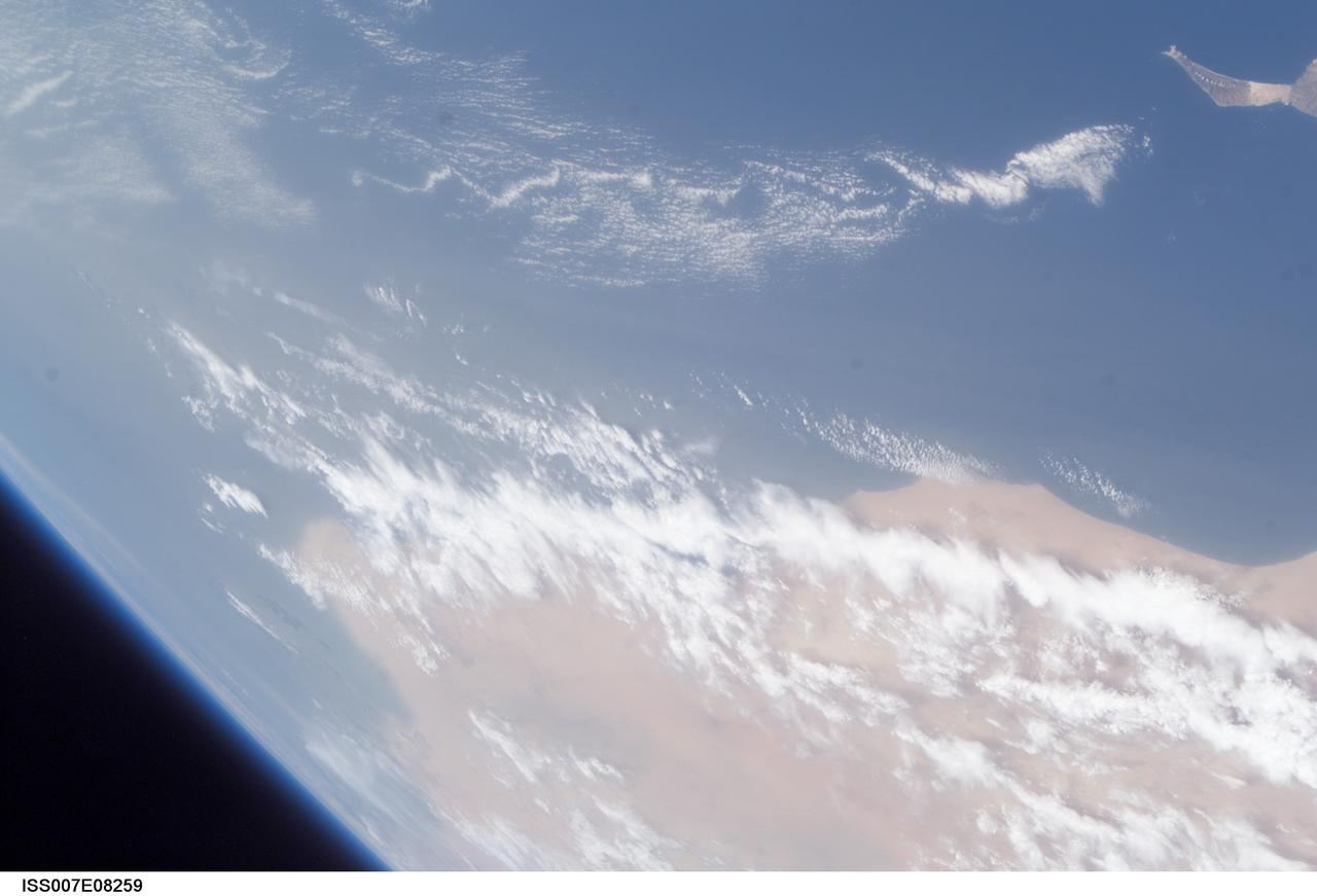
ISS007-E-08259 (25 June 2003) --- This view was taken by an Expedition 7 crewmember onboard the International Space Station (ISS) while in orbit over the Atlantic Ocean. Dust blowing from the Sahara Desert obscures the country of Western Sahara. Fuerteventura, one of the Canary Islands, is at upper right.
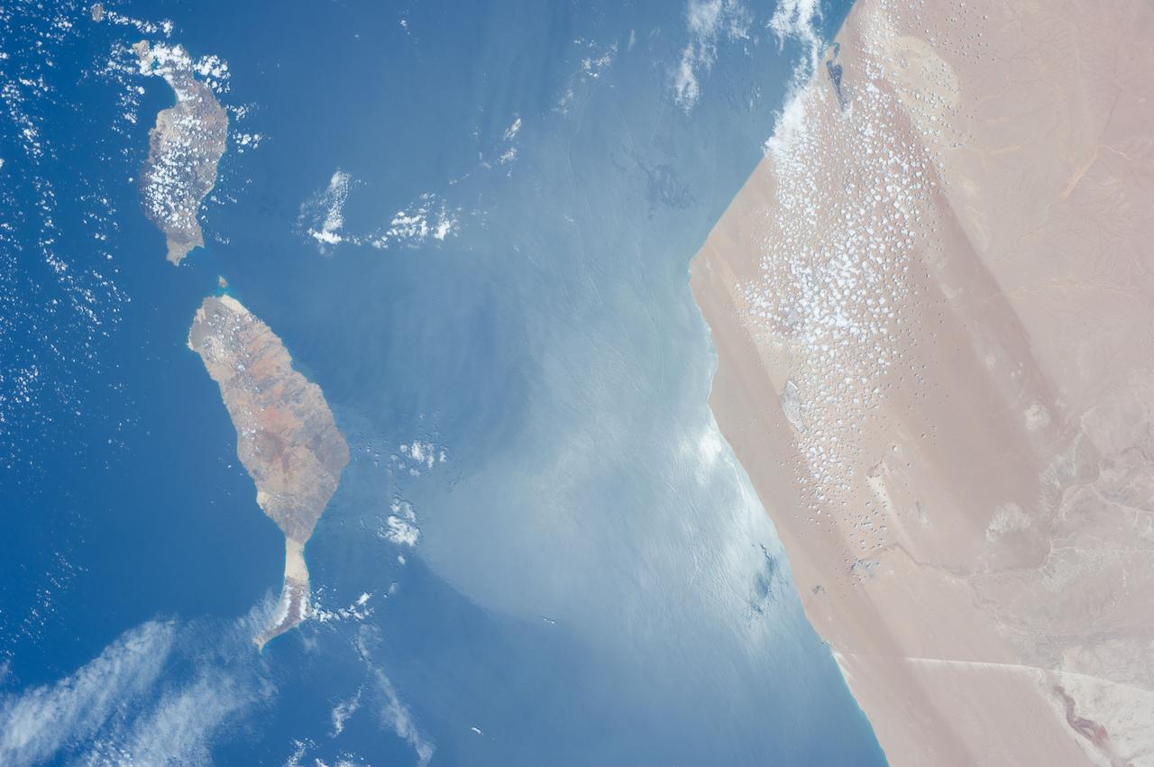
ISS040-E-017303 (23 June 2014) --- One of the Expedition 40 crew members aboard the Earth-orbiting International Space Station, flying approximately 223 nautical miles above the Atlantic Ocean photographed this image featuring the Atlantic coasts of the northwest African nation of Morocco and the disputed territory of Western Sahara. Two islands in the Canary Islands chain are pictured. Gran Canaria is just out of the frame at left.
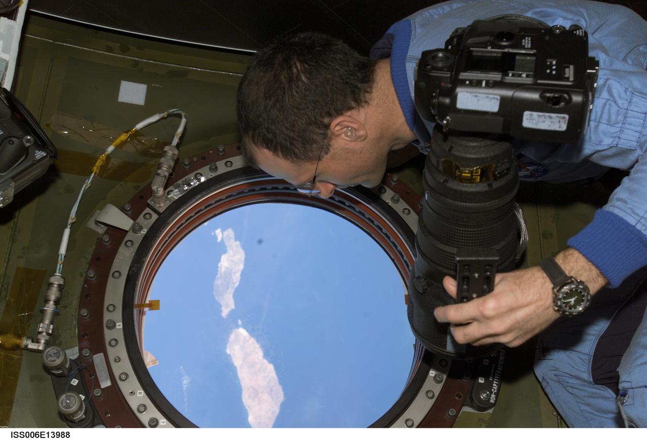
ISS006-E-13988 (2 January 2003) --- Astronaut Donald R. Pettit, Expedition Six NASA ISS science officer, holds a still camera as he looks through the nadir window in the Destiny laboratory on the International Space Station (ISS). The islands of Lanzarote and Fuerteventura of the Canary Island chain in the Atlantic Ocean off the coast of Morocco are visible.
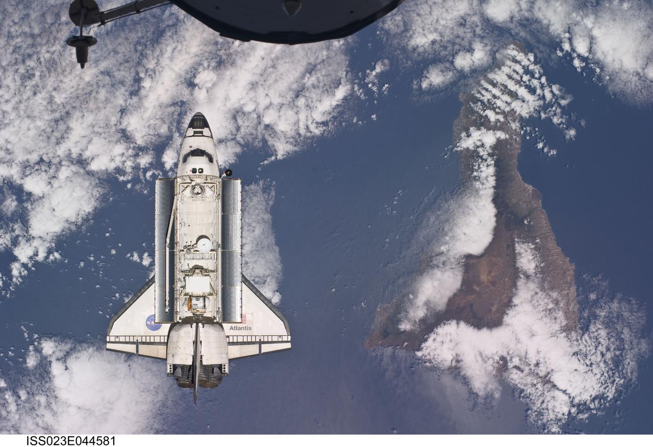
ISS023-E-044581 (16 May 2010) --- Backdropped by a colorful Earth, space shuttle Atlantis is featured in this image photographed by an Expedition 23 crew member as the shuttle approaches the International Space Station during STS-132 rendezvous and docking operations. Docking occurred at 9:28 a.m. (CDT) on May 16, 2010. A portion of a docked Russian spacecraft is visible at top. Tenerife in the Canary Island chain is visible below.
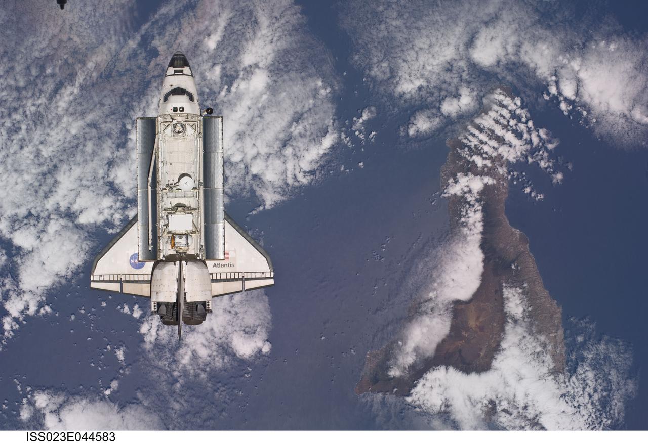
ISS023-E-044583 (16 May 2010) --- Backdropped by a colorful Earth, space shuttle Atlantis is featured in this image photographed by an Expedition 23 crew member as the shuttle approaches the International Space Station during STS-132 rendezvous and docking operations. Docking occurred at 9:28 a.m. (CDT) on May 16, 2010. Tenerife in the Canary Island chain is visible below.
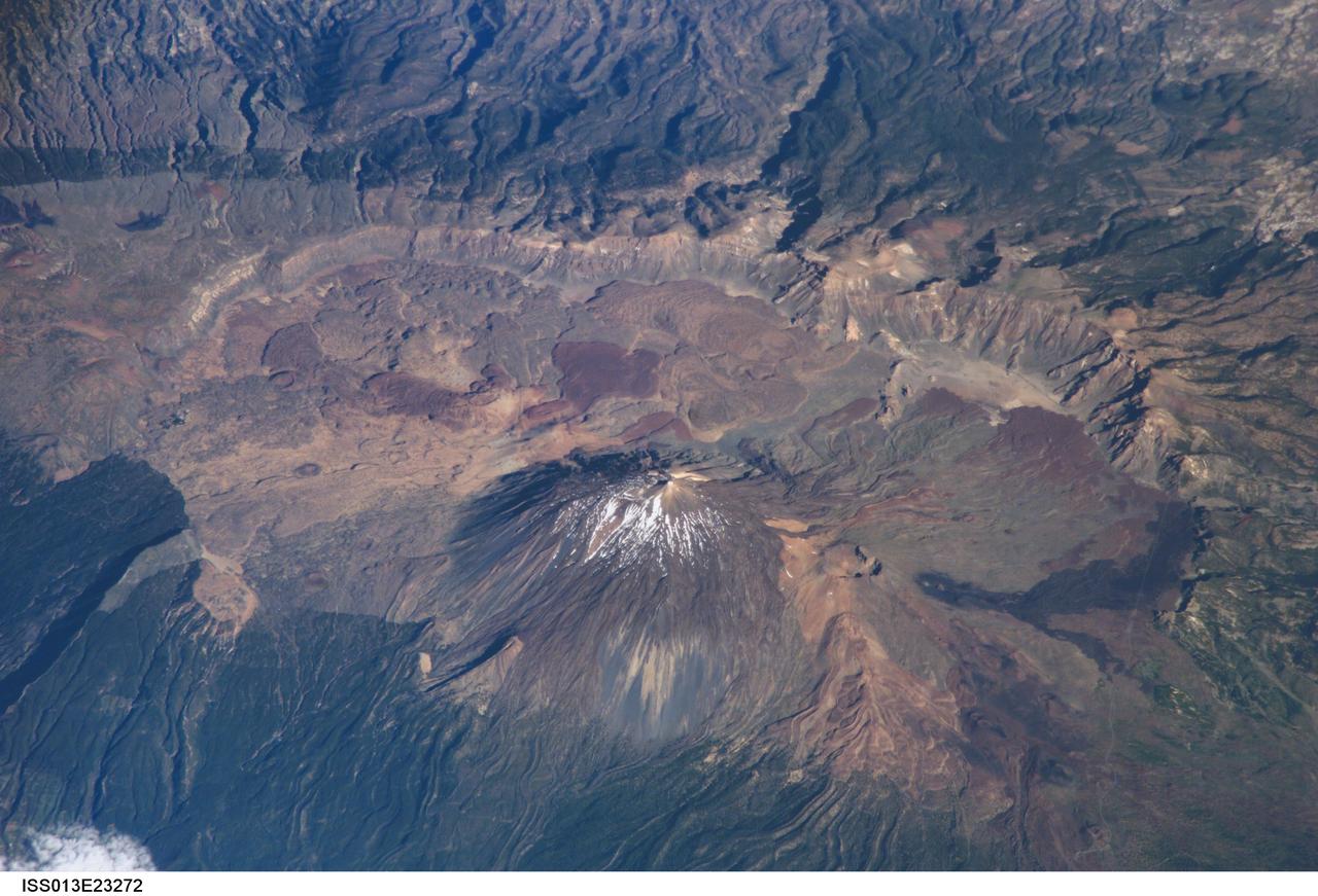
ISS013-E-23272 (8 June 2006) --- Tenerife Island, Spain is featured in this image photographed by an Expedition 13 crewmember on the International Space Station. Tenerife is the largest of the Canary Islands, a Spanish possession located off the northwestern coast of Africa. According to scientists, the islands in the chain could have been produced by eruptions of basaltic shield volcanoes as the African tectonic plate moved over a stationary "hot spot" much like the formation of the Hawaiian Islands. A different hypothesis relates the Canary Islands to magma rise along underwater faults during the uplift of the Atlas Mountains in northern Africa. The island of Tenerife exhibits many excellent volcanic features. The central feature of this image is the elliptical depression of the Las Ca?adas caldera that measures 170 square kilometers in area. A caldera is typically formed when the magma chamber underneath a volcano is completely emptied (usually following a massive eruptive event), and the overlying materials collapse into the newly formed void beneath the surface. A large landslide may have also contributed to (or been the primary cause of) formation of the caldera structure. In this model, part of the original shield volcano forming the bedrock of the island collapsed onto the adjacent sea floor, forming the large depression of the caldera. According to scientists, following formation of the caldera approximately 0.17 million years ago, the composite volcanoes of Mount Teide and Pico Viejo formed. Teide is the highest peak in the Atlantic Ocean with a summit elevation of 3,715 meters. This type of volcano is formed by alternating layers of dense lava flows and more fragmented explosive eruption products, and can build high cones. Many linear flow levees are visible along the flanks of Teide volcano extending from the summit to the base, while a large circular explosion crater marks the summit of Pico Viejo. The floor of the Las Ca?adas caldera is covered with tan, red-brown, and black irregularly-lobed lava flows, the eruptions of which have been observed by settlers and seamen since 1402. The most recent eruption occurred in 1909. The island of Tenerife is actively monitored for further activity.
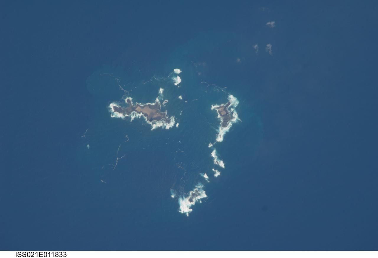
ISS021-E-011833 (22 Oct. 2009) --- The southern Savage Islands in the Atlantic Ocean are featured in this image photographed by an Expedition 21 crew member on the International Space Station. The Savage Islands, or Ilhas Selvagens in Portuguese, comprise a small archipelago in the eastern North Atlantic Ocean between the archipelago of Madeira to the north and the Canary Islands to the south. Like other island groups, the Savage Islands are thought to have been produced by volcanism related to a mantle plume or ?hot spot?. Mantle plumes are relatively fixed regions of upwelling magma that can feed volcanoes on an overlying tectonic plate. Active volcanoes form over the plume, and become dormant as they are carried away on the moving tectonic plate. Scientists believe that over geologic time, this creates a line of older extinct volcanoes, seamounts, and islands extending from the leading active volcanoes that are currently over the plume. This view illustrates the smaller and more irregularly-shaped Ilheus do Norte, Ilheu de Fora, and Selvagem Pequena. Spain and Portugal both claim sovereignty over the Savage Islands. All of the islands of the archipelago are ringed by bright white breaking waves along the fringing beaches. Coral reefs that surround the Savage Islands make it very difficult to land boats there, and there is no permanent settlement on the islands.
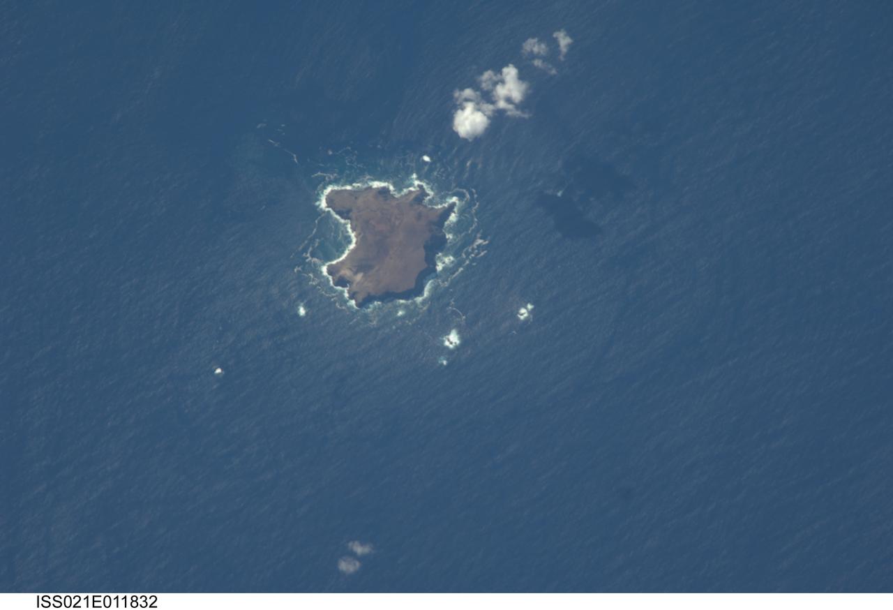
ISS021-E-011832 (22 Oct. 2009) --- The northern Savage Islands in the Atlantic Ocean are featured in this image photographed by an Expedition 21 crew member on the International Space Station. The Savage Islands, or Ilhas Selvagens in Portuguese, comprise a small archipelago in the eastern North Atlantic Ocean between the archipelago of Madeira to the north and the Canary Islands to the south. Like other island groups, the Savage Islands are thought to have been produced by volcanism related to a mantle plume or “hot spot”. Mantle plumes are relatively fixed regions of upwelling magma that can feed volcanoes on an overlying tectonic plate. Active volcanoes form over the plume, and become dormant as they are carried away on the moving tectonic plate. Scientists believe that over geologic time, this creates a line of older extinct volcanoes, seamounts, and islands extending from the leading active volcanoes that are currently over the plume. This view illustrates Selvagem Grande, the largest of the islands with an approximate area of four square kilometers. All of the islands of the archipelago are ringed by bright white breaking waves along the fringing beaches. Coral reefs that surround the Savage Islands make it very difficult to land boats there, and there is no permanent settlement on the islands.
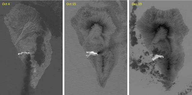
The major volcanic eruption of Cumbre Vieja volcano on La Palma, Canary Islands, began on September 21, 2021. For three months, lava poured out of the volcanic ridge, and flowed to the sea, engulfed 3000+ dwellings. The October 4 ASTER thermal infrared image shows the first flow reaching the coast. On October 15, a second flow followed to the north. By December 19, activity had stopped, and the flows are cooling. The images cover an area of 32.5 by 49.3 km, and are located at 28.6 degrees north, 17.9 degrees west. With its 14 spectral bands from the visible to the thermal infrared wavelength region and its high spatial resolution of about 50 to 300 feet (15 to 90 meters), ASTER images Earth to map and monitor the changing surface of our planet. ASTER is one of five Earth-observing instruments launched Dec. 18, 1999, on Terra. The instrument was built by Japan's Ministry of Economy, Trade and Industry. A joint U.S./Japan science team is responsible for validation and calibration of the instrument and data products. The broad spectral coverage and high spectral resolution of ASTER provides scientists in numerous disciplines with critical information for surface mapping and monitoring of dynamic conditions and temporal change. Example applications are monitoring glacial advances and retreats; monitoring potentially active volcanoes; identifying crop stress; determining cloud morphology and physical properties; wetlands evaluation; thermal pollution monitoring; coral reef degradation; surface temperature mapping of soils and geology; and measuring surface heat balance. https://photojournal.jpl.nasa.gov/catalog/PIA25085
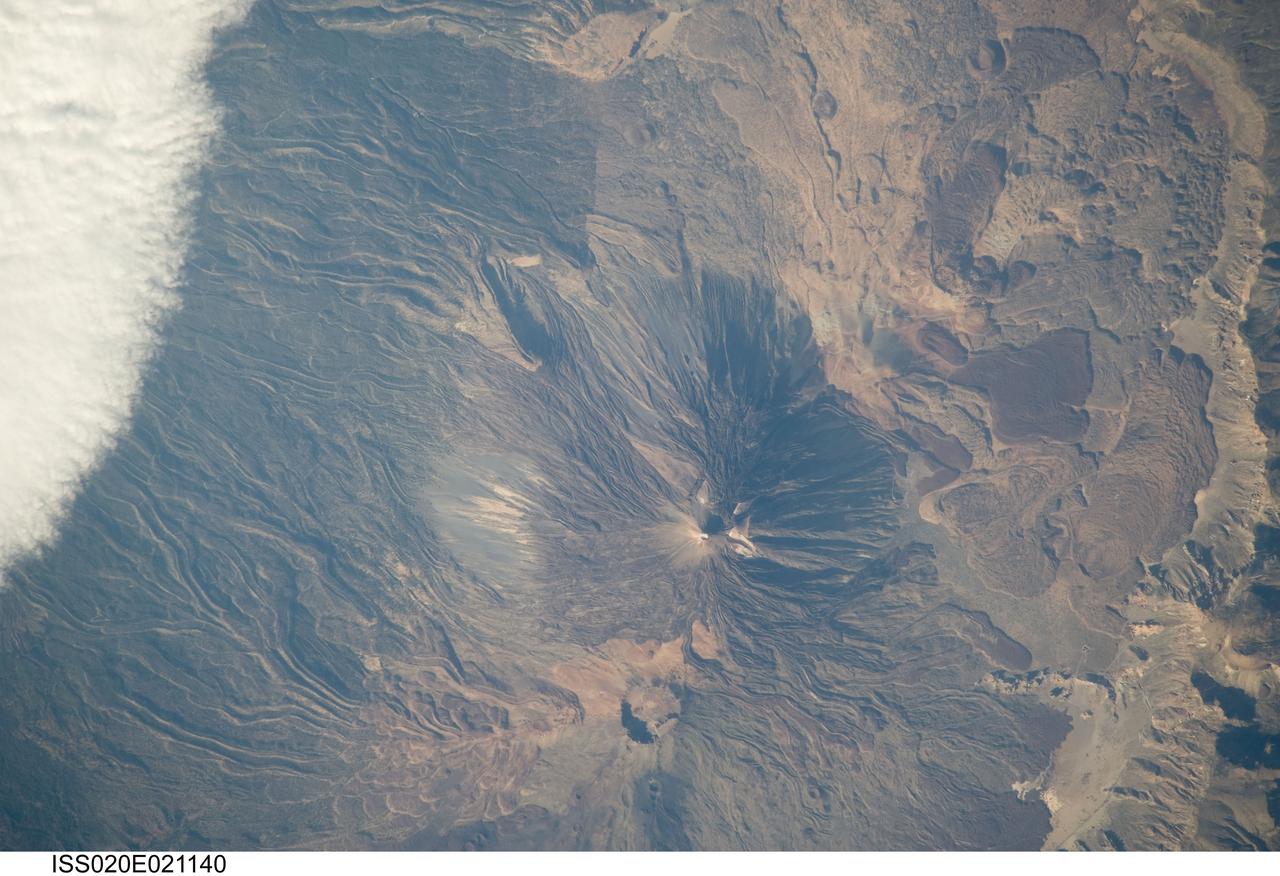
ISS020-E-021140 (15 July 2009) --- Teide Volcano on the Canary Islands of Spain is featured in this image photographed by an Expedition 20 crew member on the International Space Station. This detailed photograph features two stratovolcanoes ? Pico de Teide and Pico Viejo ? located on Tenerife Island, part of the Canary Islands of Spain. Stratovolcanoes are steep-sided; typically conical structures formed by interlayered lavas and fragmented rock material from explosive eruptions. Pico de Teide has a relatively sharp peak, whereas an explosion crater forms the summit of Pico Viejo. The two stratovolcanoes formed within an even larger volcanic structure known as the Las Ca?adas caldera ? a large collapse depression typically formed when a major eruption completely empties the underlying magma chamber of a volcano. The last eruption of Teide occurred in 1909. NASA scientists point out sinuous flow levees marking individual lava flows. The scientists consider the flow levees as perhaps the most striking volcanic features visible in the image. Flow levees are formed when the outer edges of a channelized lava flow cool and harden while the still-molten interior continues to flow downhill ? numerous examples radiate outwards from the peaks of both Pico de Teide and Pico Viejo. Brown to tan overlapping lava flows and domes are visible to the east-southeast of the Teide stratovolcano. Increased seismicity, carbon dioxide emissions, and fumarolic activity within the Las Ca?adas caldera and along the northwestern flanks of the volcano were observed in 2004. Monitoring of the volcano to detect renewal of activity is ongoing.
This artist's conception shows the silhouette of a rocky planet, dubbed HD 219134b, as it passes in front of its star. At 21 light-years away, the planet is the closest outside of our solar system that can be seen crossing, or transiting, its star -- a bonus for astronomers because transiting planets make ideal specimens for detailed studies of their atmospheres. It was discovered using the HARPS-North instrument on the Italian 3.6-meter National Galileo Telescope in the Canary Islands, and NASA's Spitzer Space Telescope. The planet, which is about 1.6 times the size of Earth, is also the nearest confirmed rocky planet outside our solar system. It orbits a star that is cooler and smaller than our sun, whipping closely around it in a mere three days. The proximity of the planet to the star means that it would be scorching hot and not habitable. Transiting planets are ideal targets for astronomers wanting to know more about planetary compositions and atmospheres. As a planet passes in front of its star, it causes the starlight to dim, and telescopes can measure this effect. If molecules are present in the planet's atmosphere, they can absorb certain wavelengths of light, leaving imprints in the starlight. This type of technique will be used in the future to investigate potentially habitable planets and search for signs of life. http://photojournal.jpl.nasa.gov/catalog/PIA19831

Fireworks shows are not just confined to Earth’s skies. NASA’s Hubble Space Telescope has captured a spectacular fireworks display in a small, nearby galaxy, which resembles a July 4th skyrocket. A firestorm of star birth is lighting up one end of the diminutive galaxy Kiso 5639. The dwarf galaxy is shaped like a flattened pancake, but because it is tilted edge-on, it resembles a skyrocket, with a brilliant blazing head and a long, star-studded tail. Kiso 5639 is a rare, nearby example of elongated galaxies that occur in abundance at larger distances, where we observe the universe during earlier epochs. Astronomers suggest that the frenzied star birth is sparked by intergalactic gas raining on one end of the galaxy as it drifts through space. “I think Kiso 5639 is a beautiful, up-close example of what must have been common long ago,” said lead researcher Debra Elmegreen of Vassar College, in Poughkeepsie, New York. “The current thinking is that galaxies in the early universe grow from accreting gas from the surrounding neighborhood. It’s a stage that galaxies, including our Milky Way, must go through as they are growing up.” Observations of the early universe, such as Hubble’s Ultra-Deep Field, reveal that about 10 percent of all galaxies have these elongated shapes, and are collectively called “tadpoles.” But studies of the nearby universe have turned up only a few of these unusual galaxies, including Kiso 5639. The development of the nearby star-making tadpole galaxies, however, has lagged behind that of their peers, which have spent billions of years building themselves up into many of the spiral galaxies seen today. Elmegreen used Hubble’s Wide Field Camera 3 to conduct a detailed imaging study of Kiso 5639. The images in different filters reveal information about an object by dissecting its light into its component colors. Hubble’s crisp resolution helped Elmegreen and her team analyze the giant star-forming clumps in Kiso 5639 and determine the masses and ages of the star clusters. The international team of researchers selected Kiso 5639 from a spectroscopic survey of 10 nearby tadpole galaxies, observed with the Grand Canary Telescope in La Palma, Spain, by Jorge Sanchez Almeida and collaborators at the Instituto de Astrofisica de Canarias. The observations revealed that in most of those galaxies, including Kiso 5639, the gas composition is not uniform. The bright gas in the galaxy’s head contains fewer heavier elements (collectively called “metals”), such as carbon and oxygen, than the rest of the galaxy. Stars consist mainly of hydrogen and helium, but cook up other “heavier” elements. When the stars die, they release their heavy elements and enrich the surrounding gas. “The metallicity suggests that there has to be rather pure gas, composed mostly of hydrogen, coming into the star-forming part of the galaxy, because intergalactic space contains more pristine hydrogen-rich gas,” Elmegreen explained. “Otherwise, the starburst region should be as rich in heavy elements as the rest of the galaxy.” Hubble offers a detailed view of the galaxy’s star-making frenzy. The telescope uncovered several dozen clusters of stars in the galaxy’s star-forming head, which spans 2,700 light-years across. These clusters have an average age of less than 1 million years and masses that are three to six times larger than those in the rest of the galaxy. Other star formation is taking place throughout the galaxy but on a much smaller scale. Star clusters in the rest of the galaxy are between several million to a few billion years old. “There is much more star formation going on in the head than what you would expect in such a tiny galaxy,” said team member Bruce Elmegreen of IBM’s Thomas J. Watson’s Research Center, in Yorktown Heights, New York. “And we think the star formation is triggered by the ongoing accretion of metal-poor gas onto a part of an otherwise quiescent dwarf galaxy.” Hubble also revealed giant holes peppered throughout the galaxy’s starburst head. These cavities give the galaxy’s head a Swiss-cheese appearance because numerous supernova detonations – like firework aerial bursts – have carved out holes of rarified superheated gas. The galaxy, located 82 million light-years away, has taken billions of years to develop because it has been drifting through an isolated “desert” in the universe, devoid of much gas. What triggered the starburst in such a backwater galaxy? Based on simulations by Daniel Ceverino of the Center for Astronomy at Heidelberg University in Germany, and other team members, the observations suggest that less than 1 million years ago, Kiso 5639’s leading edge encountered a filament of gas. The filament dropped a large clump of matter onto the galaxy, stoking the vigorous star birth. Debra Elmegreen expects that in the future other parts of the galaxy will join in the star-making fireworks show. “Galaxies rotate, and as Kiso 5639 continues to spin, another part of the galaxy may receive an infusion of new gas from this filament, instigating another round of star birth,” she said. The team’s results have been accepted for publication in The Astrophysical Journal. Other team members include Casiana Munoz-Tunon and Mercedes Filho (Instituto de Astrofísica de Canarias, Canary Islands), Jairo Mendez-Abreu (University of St. Andrews, United Kingdom), John Gallagher (University of Wisconsin-Madison), and Marc Rafelski (NASA's Goddard Space Flight Center, Greenbelt, Maryland). The Hubble Space Telescope is a project of international cooperation between NASA and the European Space Agency. NASA's Goddard Space Flight Center in Greenbelt, Maryland, manages the telescope. The Space Telescope Science Institute (STScI) in Baltimore, Maryland, conducts Hubble science operations. STScI is operated for NASA by the Association of Universities for Research in Astronomy in Washington, D.C.

Fireworks shows are not just confined to Earth’s skies. NASA’s Hubble Space Telescope has captured a spectacular fireworks display in a small, nearby galaxy, which resembles a July 4th skyrocket. A firestorm of star birth is lighting up one end of the diminutive galaxy Kiso 5639. The dwarf galaxy is shaped like a flattened pancake, but because it is tilted edge-on, it resembles a skyrocket, with a brilliant blazing head and a long, star-studded tail. Kiso 5639 is a rare, nearby example of elongated galaxies that occur in abundance at larger distances, where we observe the universe during earlier epochs. Astronomers suggest that the frenzied star birth is sparked by intergalactic gas raining on one end of the galaxy as it drifts through space. “I think Kiso 5639 is a beautiful, up-close example of what must have been common long ago,” said lead researcher Debra Elmegreen of Vassar College, in Poughkeepsie, New York. “The current thinking is that galaxies in the early universe grow from accreting gas from the surrounding neighborhood. It’s a stage that galaxies, including our Milky Way, must go through as they are growing up.” Observations of the early universe, such as Hubble’s Ultra-Deep Field, reveal that about 10 percent of all galaxies have these elongated shapes, and are collectively called “tadpoles.” But studies of the nearby universe have turned up only a few of these unusual galaxies, including Kiso 5639. The development of the nearby star-making tadpole galaxies, however, has lagged behind that of their peers, which have spent billions of years building themselves up into many of the spiral galaxies seen today. Elmegreen used Hubble’s Wide Field Camera 3 to conduct a detailed imaging study of Kiso 5639. The images in different filters reveal information about an object by dissecting its light into its component colors. Hubble’s crisp resolution helped Elmegreen and her team analyze the giant star-forming clumps in Kiso 5639 and determine the masses and ages of the star clusters. The international team of researchers selected Kiso 5639 from a spectroscopic survey of 10 nearby tadpole galaxies, observed with the Grand Canary Telescope in La Palma, Spain, by Jorge Sanchez Almeida and collaborators at the Instituto de Astrofisica de Canarias. The observations revealed that in most of those galaxies, including Kiso 5639, the gas composition is not uniform. The bright gas in the galaxy’s head contains fewer heavier elements (collectively called “metals”), such as carbon and oxygen, than the rest of the galaxy. Stars consist mainly of hydrogen and helium, but cook up other “heavier” elements. When the stars die, they release their heavy elements and enrich the surrounding gas. “The metallicity suggests that there has to be rather pure gas, composed mostly of hydrogen, coming into the star-forming part of the galaxy, because intergalactic space contains more pristine hydrogen-rich gas,” Elmegreen explained. “Otherwise, the starburst region should be as rich in heavy elements as the rest of the galaxy.” Hubble offers a detailed view of the galaxy’s star-making frenzy. The telescope uncovered several dozen clusters of stars in the galaxy’s star-forming head, which spans 2,700 light-years across. These clusters have an average age of less than 1 million years and masses that are three to six times larger than those in the rest of the galaxy. Other star formation is taking place throughout the galaxy but on a much smaller scale. Star clusters in the rest of the galaxy are between several million to a few billion years old. “There is much more star formation going on in the head than what you would expect in such a tiny galaxy,” said team member Bruce Elmegreen of IBM’s Thomas J. Watson’s Research Center, in Yorktown Heights, New York. “And we think the star formation is triggered by the ongoing accretion of metal-poor gas onto a part of an otherwise quiescent dwarf galaxy.” Hubble also revealed giant holes peppered throughout the galaxy’s starburst head. These cavities give the galaxy’s head a Swiss-cheese appearance because numerous supernova detonations – like firework aerial bursts – have carved out holes of rarified superheated gas. The galaxy, located 82 million light-years away, has taken billions of years to develop because it has been drifting through an isolated “desert” in the universe, devoid of much gas. What triggered the starburst in such a backwater galaxy? Based on simulations by Daniel Ceverino of the Center for Astronomy at Heidelberg University in Germany, and other team members, the observations suggest that less than 1 million years ago, Kiso 5639’s leading edge encountered a filament of gas. The filament dropped a large clump of matter onto the galaxy, stoking the vigorous star birth. Debra Elmegreen expects that in the future other parts of the galaxy will join in the star-making fireworks show. “Galaxies rotate, and as Kiso 5639 continues to spin, another part of the galaxy may receive an infusion of new gas from this filament, instigating another round of star birth,” she said. The team’s results have been accepted for publication in The Astrophysical Journal. Other team members include Casiana Munoz-Tunon and Mercedes Filho (Instituto de Astrofísica de Canarias, Canary Islands), Jairo Mendez-Abreu (University of St. Andrews, United Kingdom), John Gallagher (University of Wisconsin-Madison), and Marc Rafelski (NASA's Goddard Space Flight Center, Greenbelt, Maryland). The Hubble Space Telescope is a project of international cooperation between NASA and the European Space Agency. NASA's Goddard Space Flight Center in Greenbelt, Maryland, manages the telescope. The Space Telescope Science Institute (STScI) in Baltimore, Maryland, conducts Hubble science operations. STScI is operated for NASA by the Association of Universities for Research in Astronomy in Washington, D.C. For images and more information about Kiso 5639 and Hubble, visit: <a href="http://hubblesite.org/news/2016/23" rel="nofollow">hubblesite.org/news/2016/23</a> <a href="http://www.nasa.gov/hubble" rel="nofollow">www.nasa.gov/hubble</a> Image credit: NASA, ESA, and D. Elmegreen (Vassar College) <b><a href="http://www.nasa.gov/audience/formedia/features/MP_Photo_Guidelines.html" rel="nofollow">NASA image use policy.</a></b> <b><a href="http://www.nasa.gov/centers/goddard/home/index.html" rel="nofollow">NASA Goddard Space Flight Center</a></b> enables NASA’s mission through four scientific endeavors: Earth Science, Heliophysics, Solar System Exploration, and Astrophysics. Goddard plays a leading role in NASA’s accomplishments by contributing compelling scientific knowledge to advance the Agency’s mission. <b>Follow us on <a href="http://twitter.com/NASAGoddardPix" rel="nofollow">Twitter</a></b> <b>Like us on <a href="http://www.facebook.com/pages/Greenbelt-MD/NASA-Goddard/395013845897?ref=tsd" rel="nofollow">Facebook</a></b> <b>Find us on <a href="http://instagrid.me/nasagoddard/?vm=grid" rel="nofollow">Instagram</a></b>