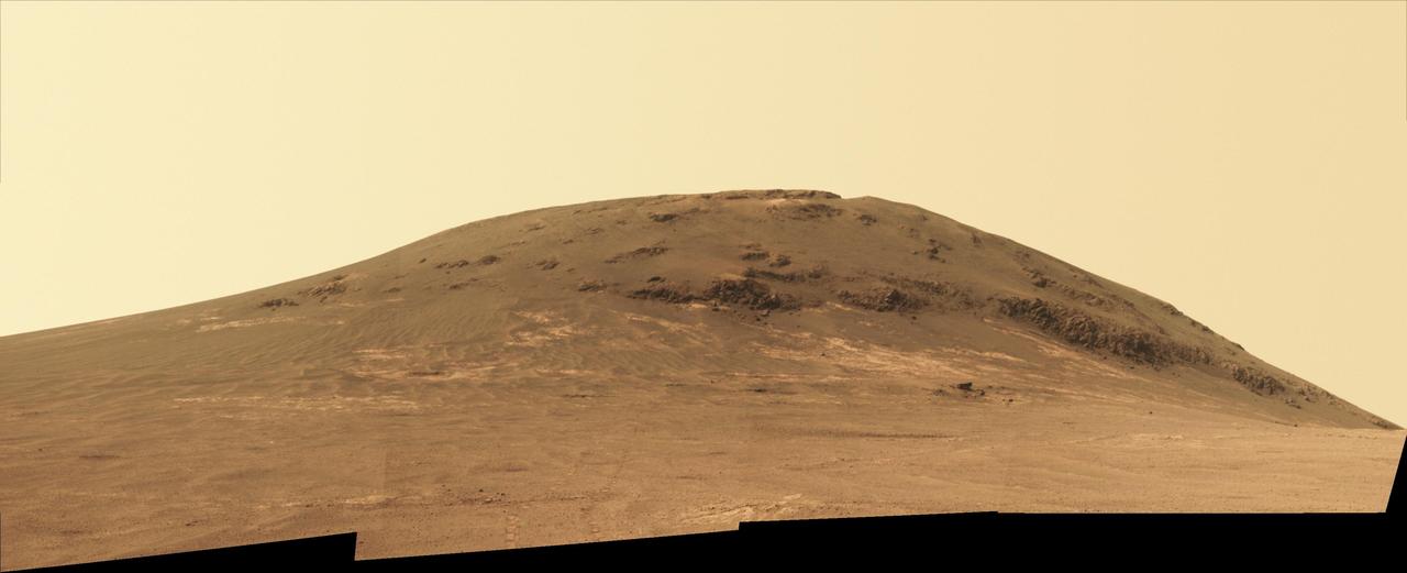
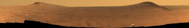
NASA Mars Exploration Rover Opportunity recorded this view of the summit of Cape Tribulation, on the western rim of Endeavour Crater on the day before the rover drove to the top.
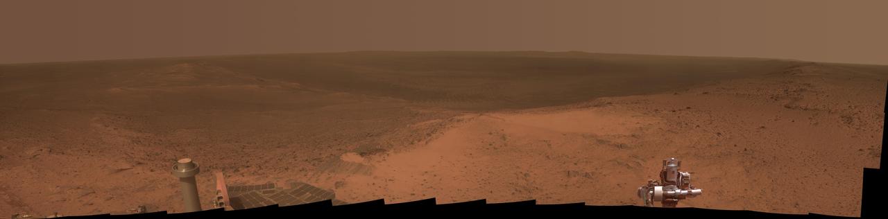
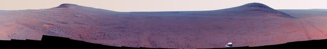
NASA's Mars Exploration Rover Opportunity worked for 30 months on a raised segment of Endeavour Crater's rim called "Cape Tribulation" until departing that segment in mid-April 2017, southbound toward a new destination. This view looks back at the southern end of Cape Tribulation from about two football fields' distance away. The component images were taken by the rover's Panoramic Camera (Pancam) on April 21, during the 4,707th Martian day, or sol, of Opportunity's mission on Mars. Wheel tracks can be traced back to see the rover's route as it descended and departed Cape Tribulation. For scale, the distance between the two parallel tracks is about 3.3 feet (1 meter). The rover drove from the foot of Cape Tribulation to the head of "Perseverance Valley" in seven drives totaling about one-fifth of a mile (one-third of a kilometer). The elevation difference between the highest point visible in this scene and the rover's location when the images were taken is about 180 feet (55 meters). This view looks northward. It merges exposures taken through three of the Pancam's color filters, centered on wavelengths of 753 nanometers (near-infrared), 535 nanometers (green) and 432 nanometers (violet). It is presented in approximately true color. https://photojournal.jpl.nasa.gov/catalog/PIA21497
NASA Mars Exploration Rover Opportunity recorded this view of the summit of Cape Tribulation, on the western rim of Endeavour Crater on the day before the rover drove to the top.
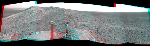
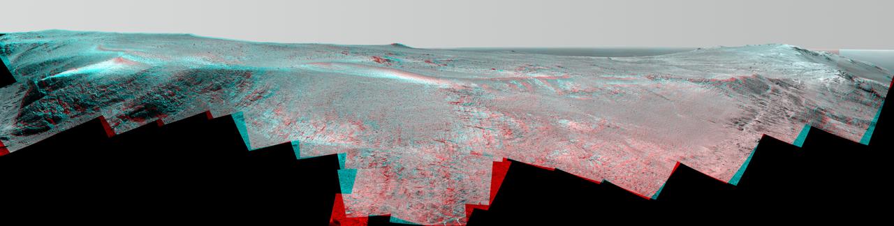
NASA Mars Exploration Rover Opportunity recorded this view of the summit of Cape Tribulation, on the western rim of Endeavour Crater on the day before the rover drove to the top. You need 3D glasses to view this image.

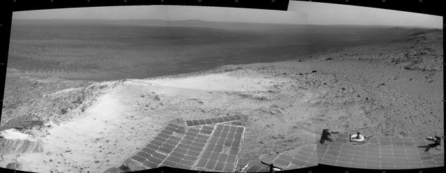
Rising highest above the horizon in the right half of the image, captured by NASA Mars Exporation Rover, is a portion of the western rim of Endeavour Crater including a ridge informally named Cape Tribulation.
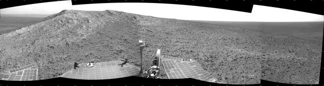
This panorama is the view NASA Mars Exploration Rover Opportunity gained from the top of the Cape Tribulation segment of the rim of Endeavour Crater.

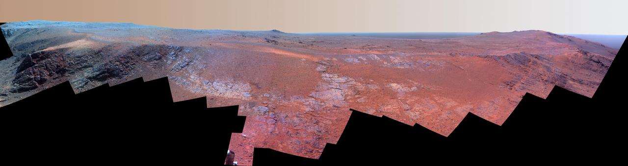
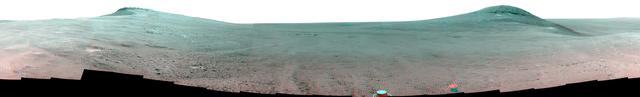
NASA's Mars Exploration Rover Opportunity worked for 30 months on a raised segment of Endeavour Crater's rim called "Cape Tribulation" until departing that segment in mid-April 2017, southbound toward a new destination. This view looks back at the southern end of Cape Tribulation from about two football fields' distance away. In this version of the scene the landscape is presented in enhanced color to make differences in surface materials more easily visible. The component images were taken by the rover's Panoramic Camera (Pancam) on April 21, during the 4,707th Martian day, or sol, of Opportunity's mission on Mars. Wheel tracks can be traced back to see the rover's route as it descended and departed Cape Tribulation. For scale, the distance between the two parallel tracks is about 3.3 feet (1 meter). The rover drove from the foot of Cape Tribulation to the head of "Perseverance Valley" in seven drives totaling about one-fifth of a mile (one-third of a kilometer). The elevation difference between the highest point visible in this scene and the rover's location when the images were taken is about 180 feet (55 meters). This view looks northward. It merges exposures taken through three of the Pancam's color filters, centered on wavelengths of 753 nanometers (near-infrared), 535 nanometers (green) and 432 nanometers (violet). https://photojournal.jpl.nasa.gov/catalog/PIA21498

NASA Mars Exploration Rover Opportunity obtained this view from the top of the Cape Tribulation segment of the rim of Endeavour Crater. The rover reached this point three weeks before the 11th anniversary of its January 2004 landing on Mars.
A ridge called "Rocheport" on the western rim of Mars' Endeavour Crater spans this mosaic of images from the panoramic camera (Pancam) on NASA's Mars Exploration Rover Opportunity. In this version of the scene the landscape is presented in enhanced color to make differences in surface materials more easily visible. The view extends from south-southeast on the left to north on the right. Rocheport is near the southern end of an Endeavour rim segment called "Cape Tribulation." The Pancam took the component images for this panorama on Feb. 25, 2017, during the 4,654th Martian day, or sol, of Opportunity's work on Mars. Opportunity began exploring the western rim of Endeavour Crater in 2011 and reached the north end of Cape Tribulation in 2014. This ridge bears some grooves on its side, such as between the two dark shoulders angling down near the left edge of the scene. For scale, those shoulders are about 10 to 16 feet (3 to 5 meters) long. The grooves might have been carved long ago by water or ice or wind. The Rocheport name comes from a riverbank town in Missouri along the route of Lewis and Clark's "Corps of Discovery" Expedition. The view merges exposures taken through three of the Pancam's color filters, centered on wavelengths of 753 nanometers (near-infrared), 535 nanometers (green) and 432 nanometers (violet). https://photojournal.jpl.nasa.gov/catalog/PIA21492
A ridge called "Rocheport" on the western rim of Mars' Endeavour Crater spans this stereo scene from the panoramic camera (Pancam) on NASA's Mars Exploration Rover Opportunity. The mosaic combines views from the left eye and right eye of the Pancam to appear three-dimensional when seen through blue-red glasses with the red lens on the left. The view extends from south-southeast on the left to north on the right. Rocheport is near the southern end of an Endeavour rim segment called "Cape Tribulation." The Pancam took the component images for this panorama on Feb. 25, 2017, during the 4,654th Martian day, or sol, of Opportunity's work on Mars. Opportunity began exploring the western rim of Endeavour Crater in 2011 and reached the north end of Cape Tribulation in 2014. This ridge bears some grooves on its side, such as between the two dark shoulders angling down near the left edge of the scene. For scale, those shoulders are about 10 to 16 feet (3 to 5 meters) long. The grooves might have been carved long ago by water or ice or wind. The Rocheport name comes from a riverbank town in Missouri along the route of Lewis and Clark's "Corps of Discovery" Expedition. https://photojournal.jpl.nasa.gov/catalog/PIA21491

A ridge called "Rocheport" on the western rim of Mars' Endeavour Crater spans this mosaic of images from the panoramic camera (Pancam) on NASA's Mars Exploration Rover Opportunity. The view extends from south-southeast on the left to north on the right. Rocheport is near the southern end of an Endeavour rim segment called "Cape Tribulation." The Pancam took the component images for this panorama on Feb. 25, 2017, during the 4,654th Martian day, or sol, of Opportunity's work on Mars. Opportunity began exploring the western rim of Endeavour Crater in 2011 and reached the north end of Cape Tribulation in 2014. This ridge bears some grooves on its side, such as between the two dark shoulders angling down near the left edge of the scene. For scale, those shoulders are about 10 to 16 feet (3 to 5 meters) long. The grooves might have been carved long ago by water or ice or wind. The view merges exposures taken through three of the Pancam's color filters, centered on wavelengths of 753 nanometers (near-infrared), 535 nanometers (green) and 432 nanometers (violet). It is presented in approximately true color. The Rocheport name comes from a riverbank town in Missouri along the route of Lewis and Clark's "Corps of Discovery" Expedition. https://photojournal.jpl.nasa.gov/catalog/PIA21493
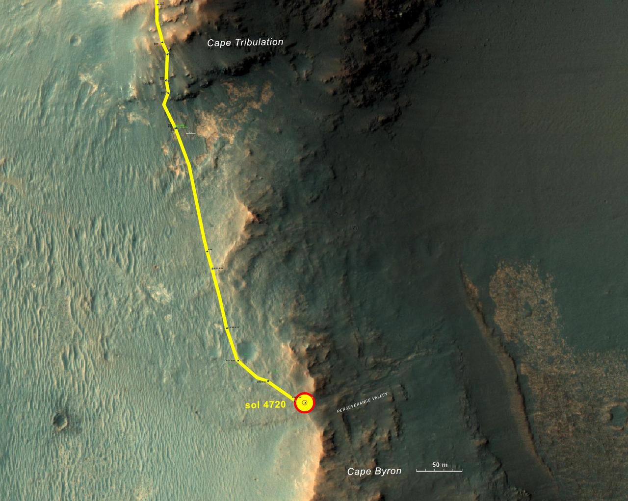
This graphic shows the route that NASA's Mars Exploration Rover Opportunity drove in its final approach to 'Perseverance Valley' on the western rim of Endeavour Crater. The map covers an area about four-tenths of a mile (two-thirds of a kilometer) wide, with the interior of the crater on the right. Opportunity entered this mapped area from the north along the gold traverse line on March 21, 2017, approaching the southern tip of the "Cape Tribulation" segment of Endeavour's rim. It reached the top of "Perseverance Valley" with a drive on Sol 4720 (the 4,720th Martian day) of the mission, on May 4, 2017. https://photojournal.jpl.nasa.gov/catalog/PIA21496
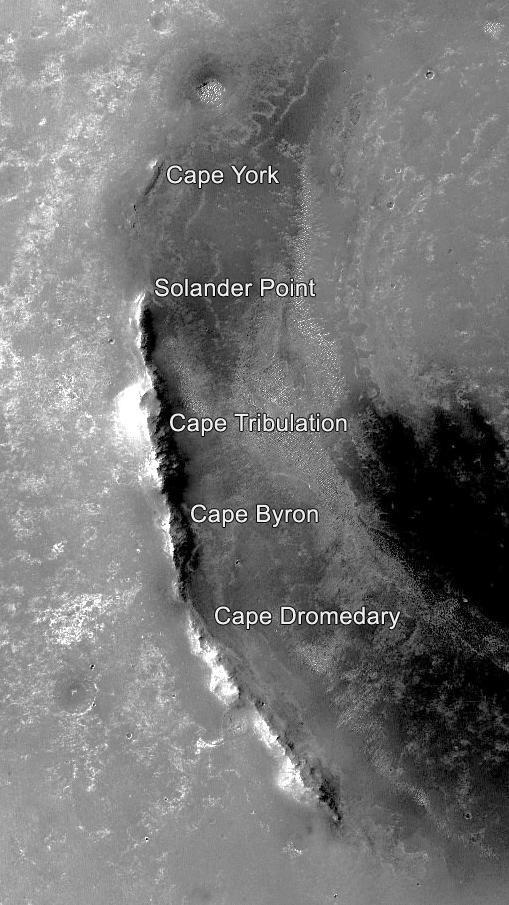
This orbital image of the western rim of Mars' Endeavour Crater covers an area about 5 miles (8 kilometers) east-west by about 9 miles (14 kilometers) north-south and indicates the names of some of the raised segments of the rim. NASA's Mars Exploration Rover Opportunity arrived at Endeavour in 2011 after exploring smaller craters to the northwest during its first six years on Mars. It initially explored the "Cape York" segment, then headed south. It reached the northern end of "Cape Tribulation" in late 2014 and the southern tip of that segment in April 2017. A key destination in the "Cape Byron" segment is "Perseverance Valley," where the rover team plans to investigate whether the valley was carved by water, wind or a debris flow initiated by water. This image is from the Context Camera on NASA's Mars Reconnaissance Orbiter. Malin Space Science Systems, San Diego, California, built and operates that camera. NASA's Jet Propulsion Laboratory, a division of Caltech in Pasadena, California, built and operates Opportunity. https://photojournal.jpl.nasa.gov/catalog/PIA21490
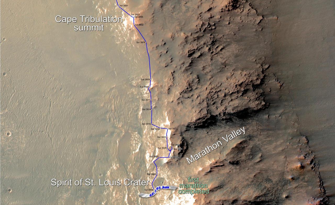
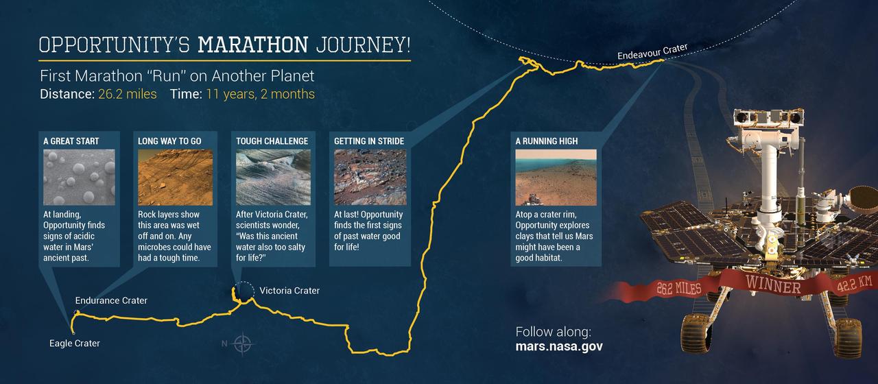
Eleven years and two months after its landing on Mars, the total driving distance of NASA's Mars Exploration Rover Opportunity surpassed the length of a marathon race: 26.219 miles (42.195 kilometers). This map shows the southward path driven by Opportunity from late December 2014 until it passed marathon distance on March 24, 2015, during the 3,968th Martian day, or sol, of the rover's work on Mars. Recent drives bring the vehicle close to a science destination called "Marathon Valley" on the west rim of Endeavour Crater. The rover team is using instruments on Opportunity to study "Spirit of St. Louis Crater" before entry into Marathon Valley. Opportunity reached the Sol 3881 location near the top of the map on Dec. 24, 2015. A map showing wider context of Opportunity's route from its January 2004 landing in Eagle Crater to Endeavour Crater is at PIA18404. A view from the Sol 3893 location at the summit of "Cape Tribulation," taken the following sol, is at PIA19109. The rover's traverse shown here has been mapped onto an image from the High Resolution Imaging Science Experiment (HiRISE) camera on NASA's Mars Reconnaissance Orbiter. http://photojournal.jpl.nasa.gov/catalog/PIA19157
Eleven years and two months after its landing on Mars, the total driving distance of NASA's Mars Exploration Rover Opportunity surpassed the length of a marathon race: 26.219 miles (42.195 kilometers). This map shows the southward path driven by Opportunity from late December 2014 until it passed marathon distance on March 24, 2015, during the 3,968th Martian day, or sol, of the rover's work on Mars. Recent drives bring the vehicle close to a science destination called "Marathon Valley" on the west rim of Endeavour Crater. The rover team is using instruments on Opportunity to study "Spirit of St. Louis Crater" before entry into Marathon Valley. Opportunity reached the Sol 3881 location near the top of the map on Dec. 24, 2015. A map showing wider context of Opportunity's route from its January 2004 landing in Eagle Crater to Endeavour Crater is at PIA18404. A view from the Sol 3893 location at the summit of "Cape Tribulation," taken the following sol, is at PIA19109. The rover's traverse shown here has been mapped onto an image from the High Resolution Imaging Science Experiment (HiRISE) camera on NASA's Mars Reconnaissance Orbiter. http://photojournal.jpl.nasa.gov/catalog/PIA19158
Toward the right side of this enhanced-color scene is a broad notch in the crest of the western rim of Endeavour Crater. Wheel tracks in that area were left by NASA's Mars Exploration Rover Opportunity as it observed "Perseverance Valley" from above in the spring of 2017. The valley is a major destination for the rover's extended mission. It descends out of sight on the inner slope of the rim, extending down and eastward from that notch. Opportunity's panoramic camera (Pancam) took the component images for this view from a position outside the crater during the span of June 7 to June 19, 2017, sols 4753 to 4765 of the rover's work on Mars. This scene includes features that might have been ancient channels from water, ice or wind moving toward the notch in the rim, which might have been a spillway. Perseverance Valley, just on the other side, was likely carved by action of some fluid, such as water, water-lubricated debris, or wind. The mission is investigating to learn more about that process from evidence in place. The panorama spans about three-fourths of a full-circle view, from southeastward on the left, through westward in the middle, to northeastward on the right. High points visible on the rim of Endeavour Crater include "Winnemucca" on the left and "Cape Tribulation" on the right. Winnemucca is part of the "Cape Byron" portion of the crater rim. The horizon at far right extends across the floor of Endeavour Crater, which is about 14 miles (22 kilometers) in diameter. Opportunity has been investigating sites on and near the western rim of Endeavour since 2011, following seven years of exploring smaller craters after its 2004 landing. This view merges exposures taken through three of the Pancam's color filters, centered on wavelengths of 753 nanometers (near-infrared), 535 nanometers (green) and 432 nanometers (violet). Color is enhanced in this version to make differences in surface materials more easily visible. The rover team calls this the "Sprained Ankle" panorama because the images were collected during a driving moratorium while engineers diagnosed a temporary steering stall with one front wheel pointed outward more than 30 degrees. The team was able to straighten the wheel to point straight ahead, and then resumed driving. The location from which this scene was recorded is labeled as "Sol 4752" on a later traverse map. Opportunity subsequently entered the upper end of Perseverance Valley and returned views looking down the valley and back up toward the rim crest from the location it reached on July 7 (Sol 4782). https://photojournal.jpl.nasa.gov/catalog/PIA21722
This June 2017 stereo scene from NASA's Mars Exploration Rover Opportunity rover shows the area just above "Perseverance Valley" on the rim of Endeavour Crater. The view combines images from the left eye and right eye of the rover's panoramic camera (Pancam) to appear three-dimensional when seen through blue-red glasses with the red lens on the left. Toward the right side of the scene is a broad notch in the crest of the crater's rim. Opportunity left wheel tracks in that area as it observed Perseverance Valley from above in the spring of 2017. The valley is a major destination for the rover's extended mission. It descends out of sight on the inner slope of the rim, extending down and eastward from that notch. Opportunity's Pancam took the component images for this view from a position outside the crater during the span of June 7 to June 19, 2017, sols 4753 to 4765 of the rover's work on Mars. This scene includes features that might have been ancient channels from water, ice or wind moving toward the notch in the rim, which might have been a spillway. Perseverance Valley, just on the other side, was likely carved by action of some fluid, such as water, water-lubricated debris, or wind. The mission is investigating to learn more about that process from evidence in place. The panorama spans about three-fourths of a full-circle view, from southeastward on the left, through westward in the middle, to northeastward on the right. High points visible on the rim of Endeavour Crater include "Winnemucca" on the left and "Cape Tribulation" on the right. Winnemucca is part of the "Cape Byron" portion of the crater rim. The horizon at far right extends across the floor of Endeavour Crater, which is about 14 miles (22 kilometers) in diameter. Opportunity has been investigating sites on and near the western rim of Endeavour since 2011, following seven years of exploring smaller craters after its 2004 landing The rover team calls this the "Sprained Ankle" panorama because the images were collected during a driving moratorium while engineers diagnosed a temporary steering stall with one front wheel pointed outward more than 30 degrees. The team was able to straighten the wheel to point straight ahead, and then resumed driving. The location from which this scene was recorded is labeled as "Sol 4752" on a later traverse map. Opportunity subsequently entered the upper end of Perseverance Valley and returned views looking down the valley and back up toward the rim crest from the location it reached on July 7 (Sol 4782). You need 3D glasses to view this image. https://photojournal.jpl.nasa.gov/catalog/PIA21721
Toward the right side of this enhanced-color scene is a broad notch in the crest of the western rim of Endeavour Crater. Wheel tracks in that area were left by NASA's Mars Exploration Rover Opportunity as it observed "Perseverance Valley" from above in the spring of 2017. The valley is a major destination for the rover's extended mission. It descends out of sight on the inner slope of the rim, extending down and eastward from that notch. Opportunity's panoramic camera (Pancam) took the component images for this view from a position outside the crater during the span of June 7 to June 19, 2017, sols 4753 to 4765 of the rover's work on Mars. This scene includes features that might have been ancient channels from water, ice or wind moving toward the notch in the rim, which might have been a spillway. Perseverance Valley, just on the other side, was likely carved by action of some fluid, such as water, water-lubricated debris, or wind. The mission is investigating to learn more about that process from evidence in place. The panorama spans about three-fourths of a full-circle view, from southeastward on the left, through westward in the middle, to northeastward on the right. High points visible on the rim of Endeavour Crater include "Winnemucca" on the left and "Cape Tribulation" on the right. Winnemucca is part of the "Cape Byron" portion of the crater rim. The horizon at far right extends across the floor of Endeavour Crater, which is about 14 miles (22 kilometers) in diameter. Opportunity has been investigating sites on and near the western rim of Endeavour since 2011, following seven years of exploring smaller craters after its 2004 landing. This view merges exposures taken through three of the Pancam's color filters, centered on wavelengths of 753 nanometers (near-infrared), 535 nanometers (green) and 432 nanometers (violet). Color is enhanced in this version to make differences in surface materials more easily visible. The rover team calls this the "Sprained Ankle" panorama because the images were collected during a driving moratorium while engineers diagnosed a temporary steering stall with one front wheel pointed outward more than 30 degrees. The team was able to straighten the wheel to point straight ahead, and then resumed driving. The location from which this scene was recorded is labeled as "Sol 4752" on a later traverse map. Opportunity subsequently entered the upper end of Perseverance Valley and returned views looking down the valley and back up toward the rim crest from the location it reached on July 7 (Sol 4782). https://photojournal.jpl.nasa.gov/catalog/PIA21722