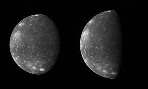
Capturing Callisto
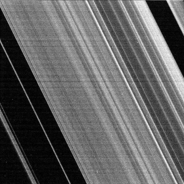
Cassini Captures the Cassini Division
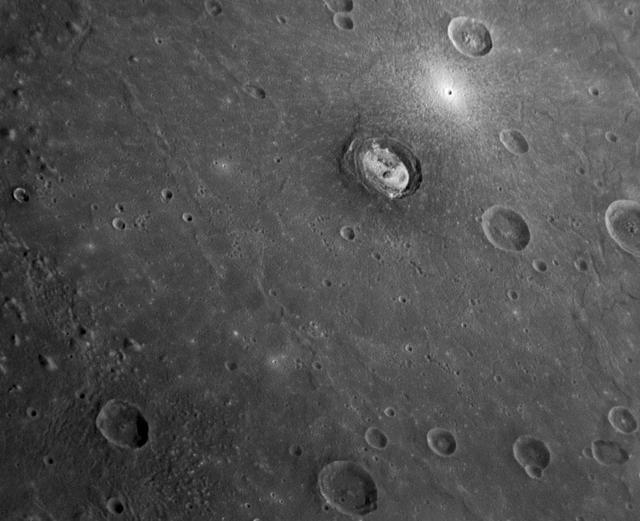
MESSENGER Captures a Shot of Kertész
Joaquin became a tropical storm Monday evening (EDT) midway between the Bahamas and Bermuda and has now formed into Hurricane Joaquin, the 3rd of the season--the difference is Joaquin could impact the US East Coast. NASA's GPM satellite captured Joaquin Tuesday, September 29th at 21:39 UTC (5:39 pm EDT). Credit: NASA's Scientific Visualization Studio Data provided by the joint NASA/JAXA GPM mission. Download/read more: <a href="http://svs.gsfc.nasa.gov/cgi-bin/details.cgi?aid=4367" rel="nofollow">svs.gsfc.nasa.gov/cgi-bin/details.cgi?aid=4367</a> <b><a href="http://www.nasa.gov/audience/formedia/features/MP_Photo_Guidelines.html" rel="nofollow">NASA image use policy.</a></b> <b><a href="http://www.nasa.gov/centers/goddard/home/index.html" rel="nofollow">NASA Goddard Space Flight Center</a></b> enables NASA’s mission through four scientific endeavors: Earth Science, Heliophysics, Solar System Exploration, and Astrophysics. Goddard plays a leading role in NASA’s accomplishments by contributing compelling scientific knowledge to advance the Agency’s mission. <b>Follow us on <a href="http://twitter.com/NASAGoddardPix" rel="nofollow">Twitter</a></b> <b>Like us on <a href="http://www.facebook.com/pages/Greenbelt-MD/NASA-Goddard/395013845897?ref=tsd" rel="nofollow">Facebook</a></b> <b>Find us on <a href="http://instagrid.me/nasagoddard/?vm=grid" rel="nofollow">Instagram</a></b>
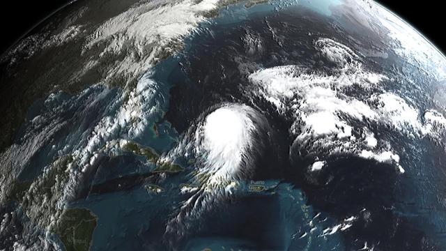
Joaquin became a tropical storm Monday evening (EDT) midway between the Bahamas and Bermuda and has now formed into Hurricane Joaquin, the 3rd of the season--the difference is Joaquin could impact the US East Coast. NASA's GPM satellite captured Joaquin Tuesday, September 29th at 21:39 UTC (5:39 pm EDT). Credit: NASA's Scientific Visualization Studio Data provided by the joint NASA/JAXA GPM mission. Download/read more: <a href="http://svs.gsfc.nasa.gov/cgi-bin/details.cgi?aid=4367" rel="nofollow">svs.gsfc.nasa.gov/cgi-bin/details.cgi?aid=4367</a> <b><a href="http://www.nasa.gov/audience/formedia/features/MP_Photo_Guidelines.html" rel="nofollow">NASA image use policy.</a></b> <b><a href="http://www.nasa.gov/centers/goddard/home/index.html" rel="nofollow">NASA Goddard Space Flight Center</a></b> enables NASA’s mission through four scientific endeavors: Earth Science, Heliophysics, Solar System Exploration, and Astrophysics. Goddard plays a leading role in NASA’s accomplishments by contributing compelling scientific knowledge to advance the Agency’s mission. <b>Follow us on <a href="http://twitter.com/NASAGoddardPix" rel="nofollow">Twitter</a></b> <b>Like us on <a href="http://www.facebook.com/pages/Greenbelt-MD/NASA-Goddard/395013845897?ref=tsd" rel="nofollow">Facebook</a></b> <b>Find us on <a href="http://instagrid.me/nasagoddard/?vm=grid" rel="nofollow">Instagram</a></b>
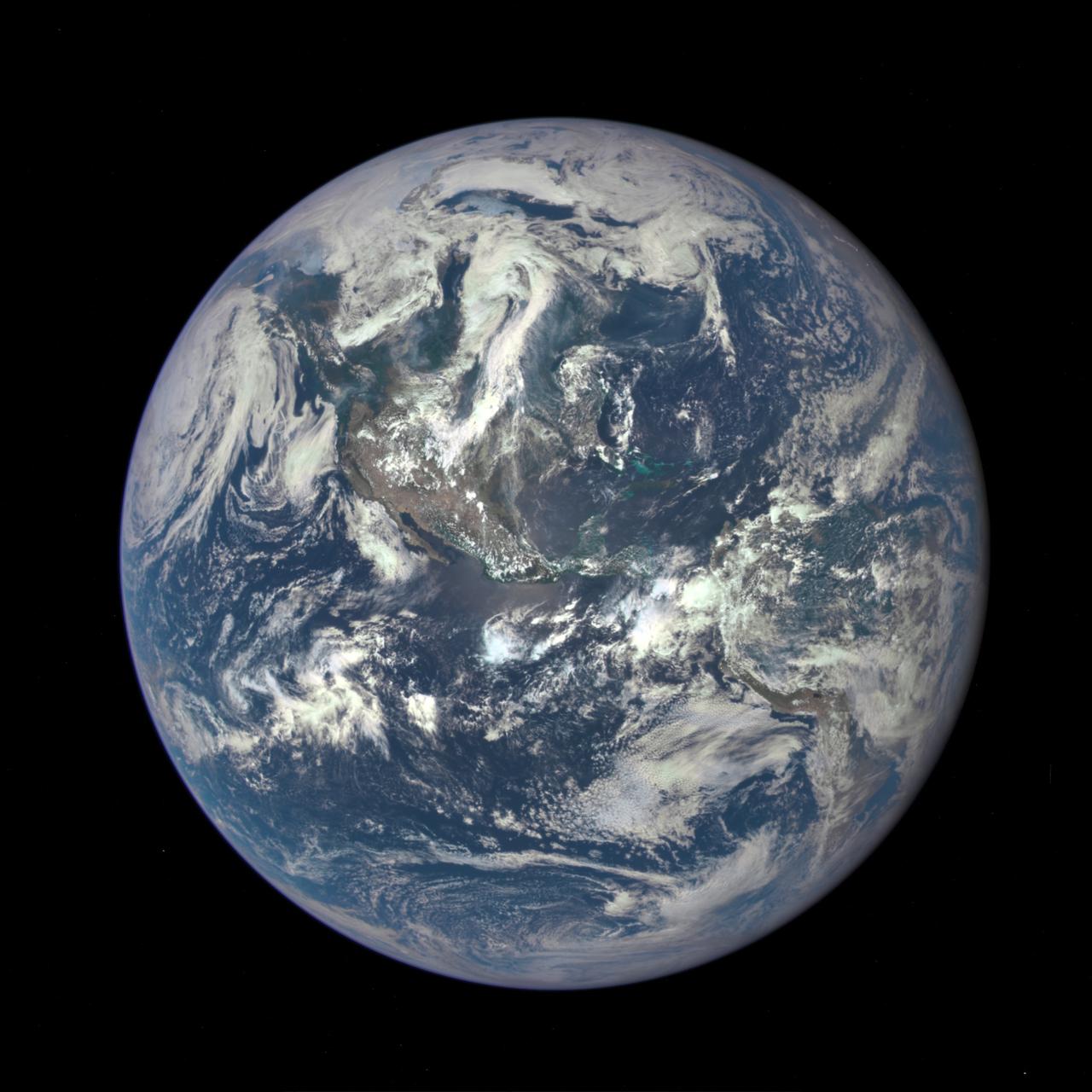
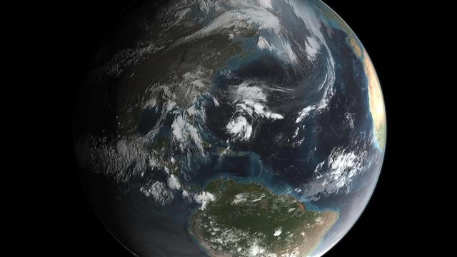
A NASA camera on the Deep Space Climate Observatory satellite has returned its first view of the entire sunlit side of Earth from one million miles away. This color image of Earth was taken by NASA’s Earth Polychromatic Imaging Camera (EPIC), a four megapixel CCD camera and telescope. The image was generated by combining three separate images to create a photographic-quality image. The camera takes a series of 10 images using different narrowband filters -- from ultraviolet to near infrared -- to produce a variety of science products. The red, green and blue channel images are used in these color images. The image was taken July 6, 2015, showing North and Central America. The central turquoise areas are shallow seas around the Caribbean islands. This Earth image shows the effects of sunlight scattered by air molecules, giving the image a characteristic bluish tint. The EPIC team is working to remove this atmospheric effect from subsequent images. Once the instrument begins regular data acquisition, EPIC will provide a daily series of Earth images allowing for the first time study of daily variations over the entire globe. These images, available 12 to 36 hours after they are acquired, will be posted to a dedicated web page by September 2015. The primary objective of DSCOVR, a partnership between NASA, the National Oceanic and Atmospheric Administration (NOAA) and the U.S. Air Force, is to maintain the nation’s real-time solar wind monitoring capabilities, which are critical to the accuracy and lead time of space weather alerts and forecasts from NOAA. For more information about DSCOVR, visit: <a href="http://www.nesdis.noaa.gov/DSCOVR/" rel="nofollow">www.nesdis.noaa.gov/DSCOVR/</a>

Hubble Captures A Full Rotation Of Mars
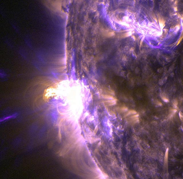
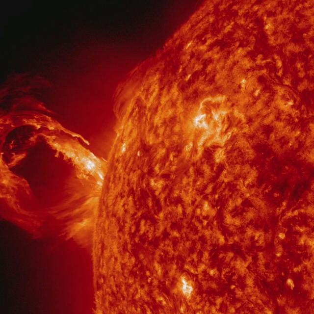
On Aug. 24, 2014, the sun emitted a mid-level solar flare, peaking at 8:16 a.m. EDT. NASA's Solar Dynamics Observatory captured images of the flare, which erupted on the left side of the sun. Solar flares are powerful bursts of radiation. Harmful radiation from a flare cannot pass through Earth's atmosphere to physically affect humans on the ground, however -- when intense enough -- they can disturb the atmosphere in the layer where GPS and communications signals travel. This close-up of a moderate flare on Aug. 24, 2014, shows light in the 131 and 171 Angstrom wavelengths. The former wavelength, usually colorized in teal, highlights the extremely hot material of a flare. The latter, usually colorized in gold, highlights magnet loops in the sun's atmosphere. To see how this event may affect Earth, please visit NOAA's Space Weather Prediction Center at <a href="http://spaceweather.gov" rel="nofollow">spaceweather.gov</a>, the U.S. government's official source for space weather forecasts, alerts, watches and warnings. This flare is classified as an M5 flare. M-class flares are ten times less powerful than the most intense flares, called X-class flares. Credit: NASA/Goddard/SDO <b><a href="http://www.nasa.gov/audience/formedia/features/MP_Photo_Guidelines.html" rel="nofollow">NASA image use policy.</a></b> <b><a href="http://www.nasa.gov/centers/goddard/home/index.html" rel="nofollow">NASA Goddard Space Flight Center</a></b> enables NASA’s mission through four scientific endeavors: Earth Science, Heliophysics, Solar System Exploration, and Astrophysics. Goddard plays a leading role in NASA’s accomplishments by contributing compelling scientific knowledge to advance the Agency’s mission. <b>Follow us on <a href="http://twitter.com/NASAGoddardPix" rel="nofollow">Twitter</a></b> <b>Like us on <a href="http://www.facebook.com/pages/Greenbelt-MD/NASA-Goddard/395013845897?ref=tsd" rel="nofollow">Facebook</a></b> <b>Find us on <a href="http://instagram.com/nasagoddard?vm=grid" rel="nofollow">Instagram</a></b>

Peering deep into the core of the Crab Nebula, this close-up image reveals the beating heart of one of the most historic and intensively studied remnants of a supernova, an exploding star. The inner region sends out clock-like pulses of radiation and tsunamis of charged particles embedded in magnetic fields. The neutron star at the very center of the Crab Nebula has about the same mass as the sun but compressed into an incredibly dense sphere that is only a few miles across. Spinning 30 times a second, the neutron star shoots out detectable beams of energy that make it look like it's pulsating. The NASA Hubble Space Telescope snapshot is centered on the region around the neutron star (the rightmost of the two bright stars near the center of this image) and the expanding, tattered, filamentary debris surrounding it. Hubble's sharp view captures the intricate details of glowing gas, shown in red, that forms a swirling medley of cavities and filaments. Inside this shell is a ghostly blue glow that is radiation given off by electrons spiraling at nearly the speed of light in the powerful magnetic field around the crushed stellar core. The neutron star is a showcase for extreme physical processes and unimaginable cosmic violence. Bright wisps are moving outward from the neutron star at half the speed of light to form an expanding ring. It is thought that these wisps originate from a shock wave that turns the high-speed wind from the neutron star into extremely energetic particles. When this "heartbeat" radiation signature was first discovered in 1968, astronomers realized they had discovered a new type of astronomical object. Now astronomers know it's the archetype of a class of supernova remnants called pulsars - or rapidly spinning neutron stars. These interstellar "lighthouse beacons" are invaluable for doing observational experiments on a variety of astronomical phenomena, including measuring gravity waves. Observations of the Crab supernova were recorded by Chinese astronomers in 1054 A.D. The nebula, bright enough to be visible in amateur telescopes, is located 6,500 light-years away in the constellation Taurus. Credits: NASA and ESA, Acknowledgment: J. Hester (ASU) and M. Weisskopf (NASA/MSFC) <b><a href="http://www.nasa.gov/audience/formedia/features/MP_Photo_Guidelines.html" rel="nofollow">NASA image use policy.</a></b> <b><a href="http://www.nasa.gov/centers/goddard/home/index.html" rel="nofollow">NASA Goddard Space Flight Center</a></b> enables NASA’s mission through four scientific endeavors: Earth Science, Heliophysics, Solar System Exploration, and Astrophysics. Goddard plays a leading role in NASA’s accomplishments by contributing compelling scientific knowledge to advance the Agency’s mission. <b>Follow us on <a href="http://twitter.com/NASAGoddardPix" rel="nofollow">Twitter</a></b> <b>Like us on <a href="http://www.facebook.com/pages/Greenbelt-MD/NASA-Goddard/395013845897?ref=tsd" rel="nofollow">Facebook</a></b> <b>Find us on <a href="http://instagrid.me/nasagoddard/?vm=grid" rel="nofollow">Instagram</a></b>
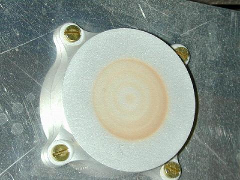
This image of a model capture magnet was taken after an experiment in a Mars simulation chamber at the University of Aarhus, Denmark. It has some dust on it, but not as much as that on the Mars Exploration Rover Spirit capture magnet.
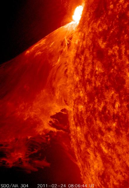
NASA image captured Feb. 24, 2011 To see an image showing the size of the prominence in comparison to the <b><a href="http://www.flickr.com/photos/gsfc/5492781335/">size of earth click here.</a></b> To view a video of this event go to: <a href="http://www.flickr.com/photos/gsfc/5483193591">www.flickr.com/photos/gsfc/5483193591</a> When a rather large-sized (M 3.6 class) flare occurred near the edge of the Sun, it blew out a gorgeous, waving mass of erupting plasma that swirled and twisted over a 90-minute period (Feb. 24, 2011). This event was captured in extreme ultraviolet light by NASA's Solar Dynamics Observatory spacecraft . Some of the material blew out into space and other portions fell back to the surface. Because SDO images are super-HD, we can zoom in on the action and still see exquisite details. And using a cadence of a frame taken every 24 seconds, the sense of motion is, by all appearances, seamless. Sit back and enjoy the jaw-dropping solar show. Credit: NASA/GSFC/SDO <b><a href="http://www.nasa.gov/centers/goddard/home/index.html" rel="nofollow">NASA Goddard Space Flight Center</a></b> enables NASA’s mission through four scientific endeavors: Earth Science, Heliophysics, Solar System Exploration, and Astrophysics. Goddard plays a leading role in NASA’s accomplishments by contributing compelling scientific knowledge to advance the Agency’s mission. <b>Follow us on <a href="http://twitter.com/NASA_GoddardPix" rel="nofollow">Twitter</a></b> <b>Join us on <a href="http://www.facebook.com/pages/Greenbelt-MD/NASA-Goddard/395013845897?ref=tsd" rel="nofollow">Facebook</a></b>
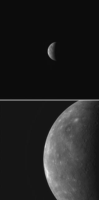
Capturing Mercury through MESSENGER Dual Cameras
Spirit Captures Two Dust Devils On the Move

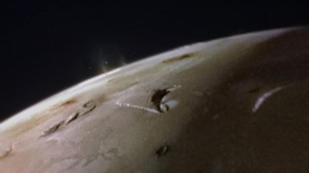
Hubble Captures Volcanic Eruption Plume From Io

Astronomers are using the NASA/ESA Hubble Space Telescope to study auroras — stunning light shows in a planet’s atmosphere — on the poles of the largest planet in the solar system, Jupiter. This observation program is supported by measurements made by NASA’s Juno spacecraft, currently on its way to Jupiter. Jupiter, the largest planet in the solar system, is best known for its colorful storms, the most famous being the Great Red Spot. Now astronomers have focused on another beautiful feature of the planet, using Hubble's ultraviolet capabilities. The extraordinary vivid glows shown in the new observations are known as auroras. They are created when high-energy particles enter a planet’s atmosphere near its magnetic poles and collide with atoms of gas. As well as producing beautiful images, this program aims to determine how various components of Jupiter’s auroras respond to different conditions in the solar wind, a stream of charged particles ejected from the sun. This observation program is perfectly timed as NASA’s Juno spacecraft is currently in the solar wind near Jupiter and will enter the orbit of the planet in early July 2016. While Hubble is observing and measuring the auroras on Jupiter, Juno is measuring the properties of the solar wind itself; a perfect collaboration between a telescope and a space probe. “These auroras are very dramatic and among the most active I have ever seen”, said Jonathan Nichols from the University of Leicester, U.K., and principal investigator of the study. “It almost seems as if Jupiter is throwing a firework party for the imminent arrival of Juno.” Read more: <a href="http://go.nasa.gov/294QswK" rel="nofollow">go.nasa.gov/294QswK</a> Credits: NASA, ESA, and J. Nichols (University of Leicester)
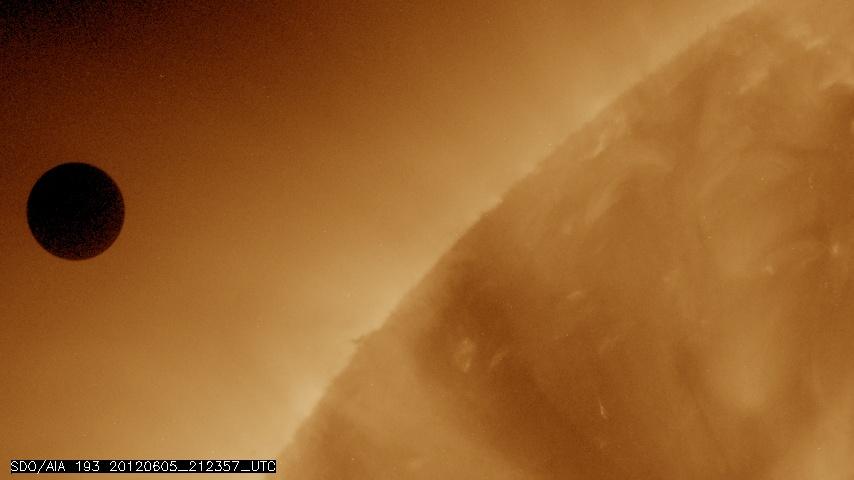
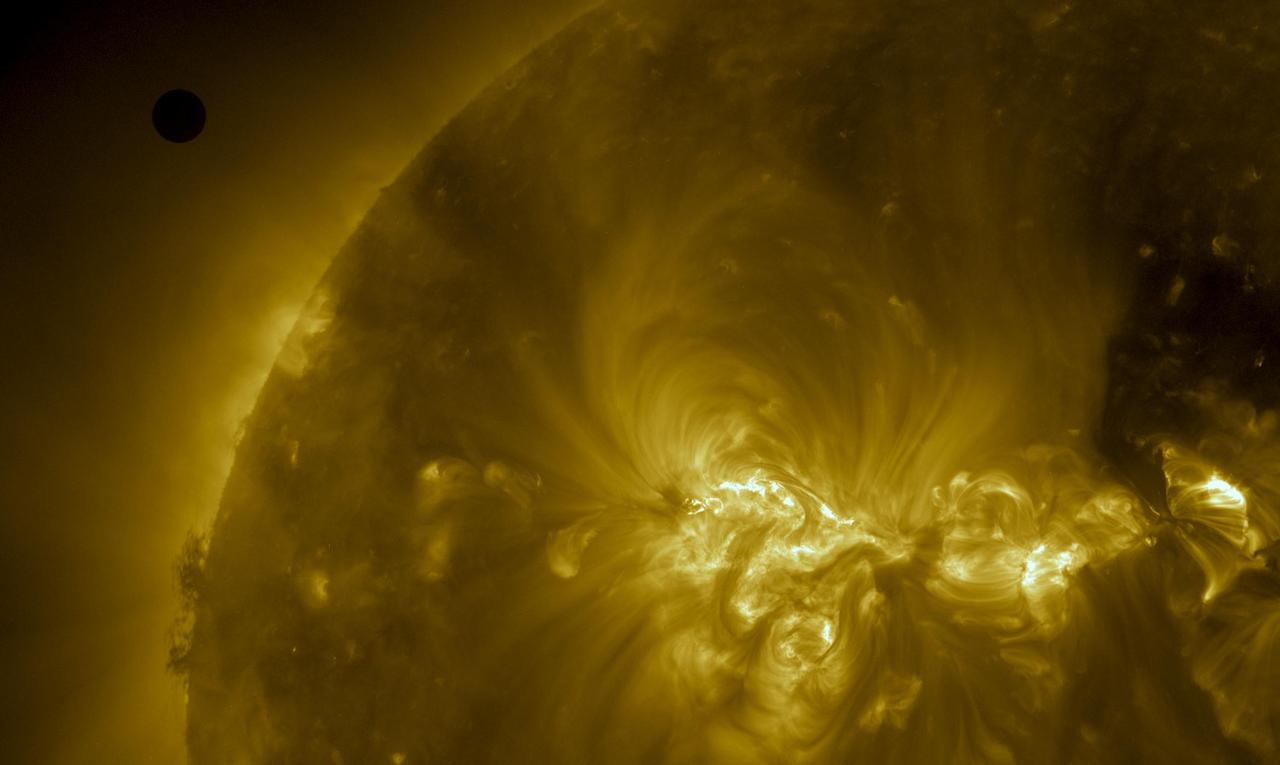
NASA image captured June 5, 2012 at 212357 UTC (about 5:24 p.m. EDT). On June 5-6 2012, SDO is collecting images of one of the rarest predictable solar events: the transit of Venus across the face of the sun. This event happens in pairs eight years apart that are separated from each other by 105 or 121 years. The last transit was in 2004 and the next will not happen until 2117. This image was captured by SDO's AIA instrument at 193 Angstroms. <i>Credit: NASA/SDO, AIA</i> <b>To read more about the 2012 Venus Transit go to: <a href="http://sunearthday.nasa.gov/transitofvenus" rel="nofollow">sunearthday.nasa.gov/transitofvenus</a> </b> <b>Add your photos of the Transit of Venus to our Flickr Group here: <a href="http://www.flickr.com/groups/venustransit/">www.flickr.com/groups/venustransit/</a> </b> <b><a href="http://www.nasa.gov/audience/formedia/features/MP_Photo_Guidelines.html" rel="nofollow">NASA image use policy.</a></b> <b><a href="http://www.nasa.gov/centers/goddard/home/index.html" rel="nofollow">NASA Goddard Space Flight Center</a></b> enables NASA’s mission through four scientific endeavors: Earth Science, Heliophysics, Solar System Exploration, and Astrophysics. Goddard plays a leading role in NASA’s accomplishments by contributing compelling scientific knowledge to advance the Agency’s mission. <b>Follow us on <a href="http://twitter.com/NASA_GoddardPix" rel="nofollow">Twitter</a></b> <b>Like us on <a href="http://www.facebook.com/pages/Greenbelt-MD/NASA-Goddard/395013845897?ref=tsd" rel="nofollow">Facebook</a></b> <b>Find us on <a href="http://instagrid.me/nasagoddard/?vm=grid" rel="nofollow">Instagram</a></b>
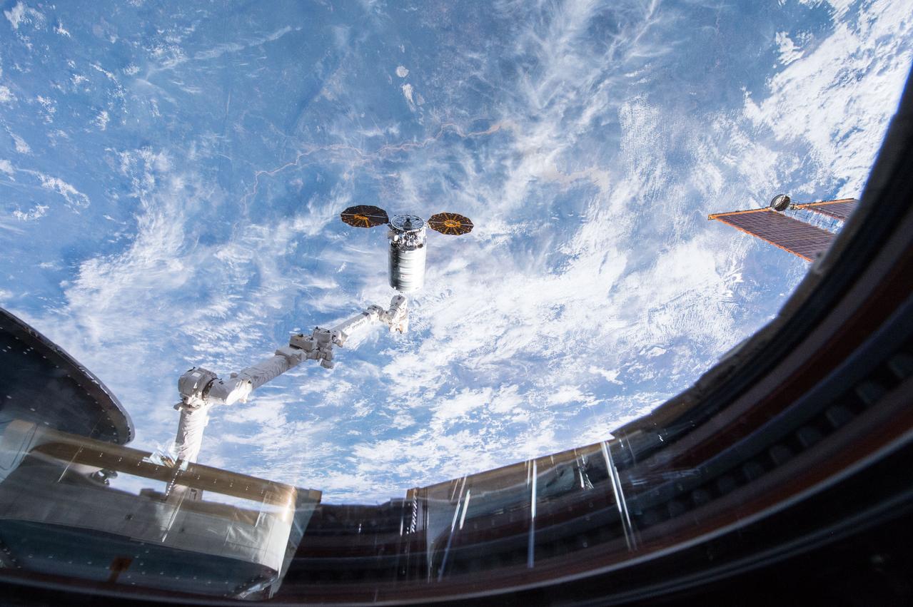
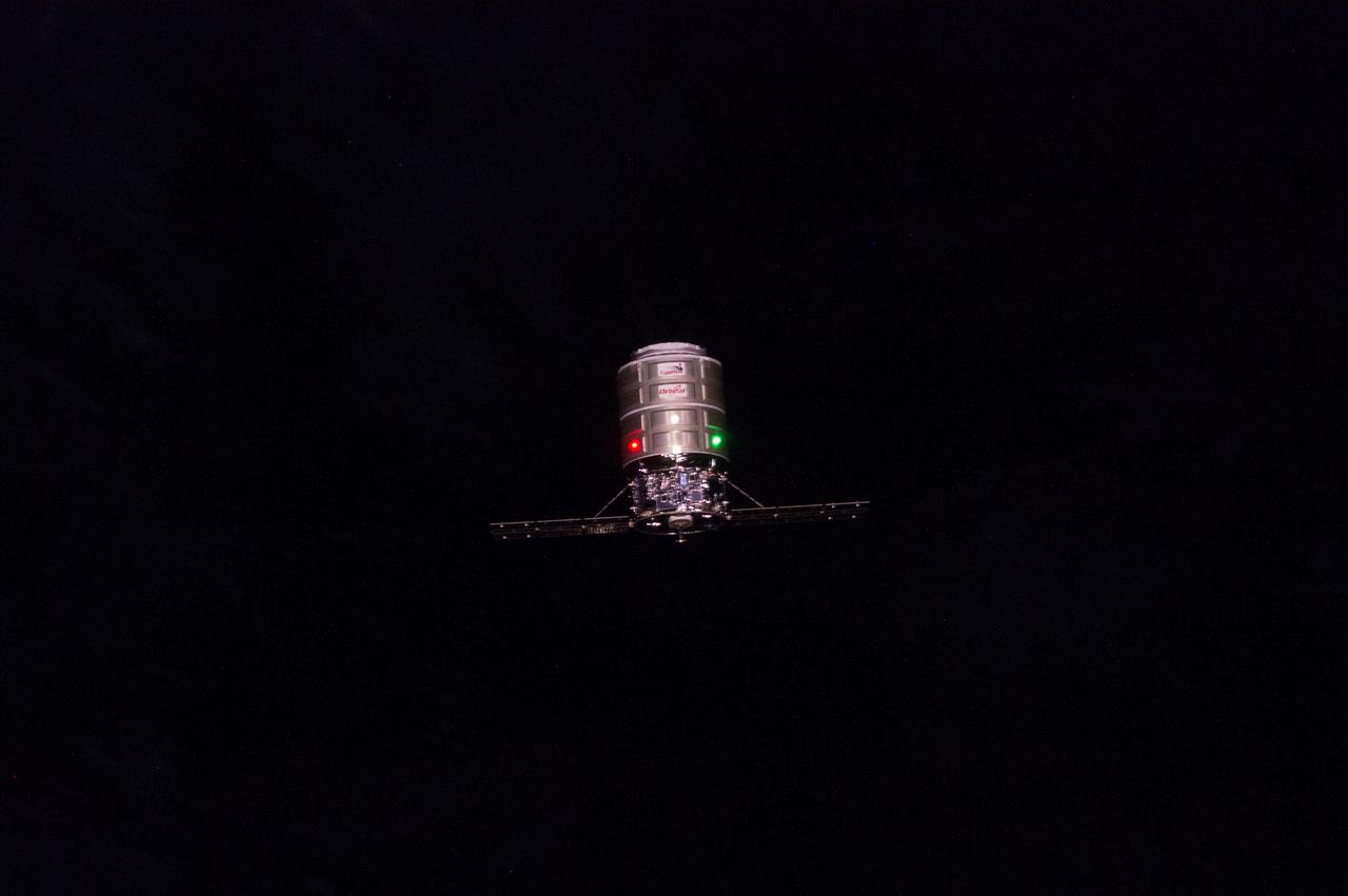
ISS047e021586 03/26/2016) --- Cygnus capture March 26, 2016. Expedition 47 robotic arm operator NASA astronaut Tim Kopra commanded the International Space Station’s Canadarm2 robotic arm to capture the Cygnus spacecraft .
UT154 solar test CO 934_0253 This is a sample low res test image from NASA Astronaut Don Petttit shot from onboard the International Space Station on June 5, 2012. Petttit, who had the foresight to bring a solar filter for his camera, will be capturing the June 5 Venus Transit from the International Space Station with the images downloading in almost real-time. He will photograph through the European Space Agency-built "cupola", removing the scratch panes to get crisp, clear images. Credit: NASA <b>To read more about the 2012 Venus Transit go to: <a href="http://sunearthday.nasa.gov/transitofvenus" rel="nofollow">sunearthday.nasa.gov/transitofvenus</a> </b> <b>Add your photos of the Transit of Venus to our Flickr Group here: <a href="http://www.flickr.com/groups/venustransit/">www.flickr.com/groups/venustransit/</a> </b> <b><a href="http://www.nasa.gov/audience/formedia/features/MP_Photo_Guidelines.html" rel="nofollow">NASA image use policy.</a></b> <b><a href="http://www.nasa.gov/centers/goddard/home/index.html" rel="nofollow">NASA Goddard Space Flight Center</a></b> enables NASA’s mission through four scientific endeavors: Earth Science, Heliophysics, Solar System Exploration, and Astrophysics. Goddard plays a leading role in NASA’s accomplishments by contributing compelling scientific knowledge to advance the Agency’s mission. <b>Follow us on <a href="http://twitter.com/NASA_GoddardPix" rel="nofollow">Twitter</a></b> <b>Like us on <a href="http://www.facebook.com/pages/Greenbelt-MD/NASA-Goddard/395013845897?ref=tsd" rel="nofollow">Facebook</a></b> <b>Find us on <a href="http://instagrid.me/nasagoddard/?vm=grid" rel="nofollow">Instagram</a></b>

A coronal mass ejection (CME) erupted from just around the edge of the sun on May 1, 2013, in a gigantic rolling wave. CMEs can shoot over a billion tons of particles into space at over a million miles per hour. This CME occurred on the sun’s limb and is not headed toward Earth. The video (seen here: <a href="http://bit.ly/103whUl" rel="nofollow">bit.ly/103whUl</a>), taken in extreme ultraviolet light by NASA’s Solar Dynamics Observatory (SDO), covers about two and a half hours. Credit: NASA/Goddard/SDO <b><a href="http://www.nasa.gov/audience/formedia/features/MP_Photo_Guidelines.html" rel="nofollow">NASA image use policy.</a></b> <b><a href="http://www.nasa.gov/centers/goddard/home/index.html" rel="nofollow">NASA Goddard Space Flight Center</a></b> enables NASA’s mission through four scientific endeavors: Earth Science, Heliophysics, Solar System Exploration, and Astrophysics. Goddard plays a leading role in NASA’s accomplishments by contributing compelling scientific knowledge to advance the Agency’s mission. <b>Follow us on <a href="http://twitter.com/NASA_GoddardPix" rel="nofollow">Twitter</a></b> <b>Like us on <a href="http://www.facebook.com/pages/Greenbelt-MD/NASA-Goddard/395013845897?ref=tsd" rel="nofollow">Facebook</a></b> <b>Find us on <a href="http://instagram.com/nasagoddard?vm=grid" rel="nofollow">Instagram</a></b>
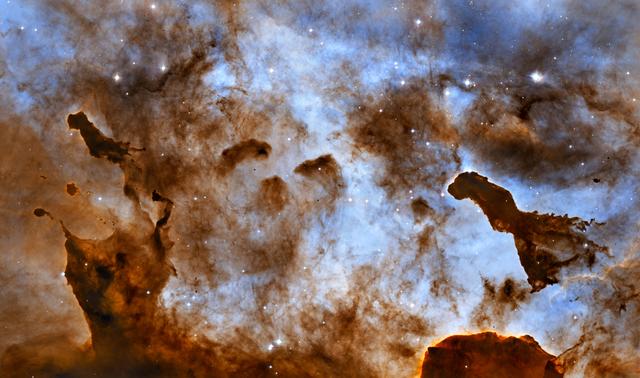
NASA image release September 16, 2010 Enjoying a frozen treat on a hot summer day can leave a sticky mess as it melts in the Sun and deforms. In the cold vacuum of space, there is no edible ice cream, but there is radiation from massive stars that is carving away at cold molecular clouds, creating bizarre, fantasy-like structures. These one-light-year-tall pillars of cold hydrogen and dust, imaged by the Hubble Space Telescope, are located in the Carina Nebula. Violent stellar winds and powerful radiation from massive stars are sculpting the surrounding nebula. Inside the dense structures, new stars may be born. This image of dust pillars in the Carina Nebula is a composite of 2005 observations taken of the region in hydrogen light (light emitted by hydrogen atoms) along with 2010 observations taken in oxygen light (light emitted by oxygen atoms), both times with Hubble's Advanced Camera for Surveys. The immense Carina Nebula is an estimated 7,500 light-years away in the southern constellation Carina. The Hubble Space Telescope is a project of international cooperation between NASA and the European Space Agency. NASA's Goddard Space Flight Center manages the telescope. The Space Telescope Science Institute (STScI) conducts Hubble science operations. STScI is operated for NASA by the Association of Universities for Research in Astronomy, Inc. in Washington, D.C. <b><a href="http://www.nasa.gov/centers/goddard/home/index.html" rel="nofollow">NASA Goddard Space Flight Center</a></b> is home to the nation's largest organization of combined scientists, engineers and technologists that build spacecraft, instruments and new technology to study the Earth, the sun, our solar system, and the universe. <b>Follow us on <a href="http://twitter.com/NASA_GoddardPix" rel="nofollow">Twitter</a></b> <b>Join us on <a href="http://www.facebook.com/pages/Greenbelt-MD/NASA-Goddard/395013845897?ref=tsd" rel="nofollow">Facebook</a></b>
ISS047e021582 (03/26/2016) --- Cygnus capture on 26 March 2016. Expedition 47 robotic arm operator NASA astronaut Tim Kopra of NASA commanded the International Space Station’s Canadarm2 robotic arm to capture and dock the Cygnus spacecraft. He was assisted by ESA (European Space Agency) astronaut Tim Peake.
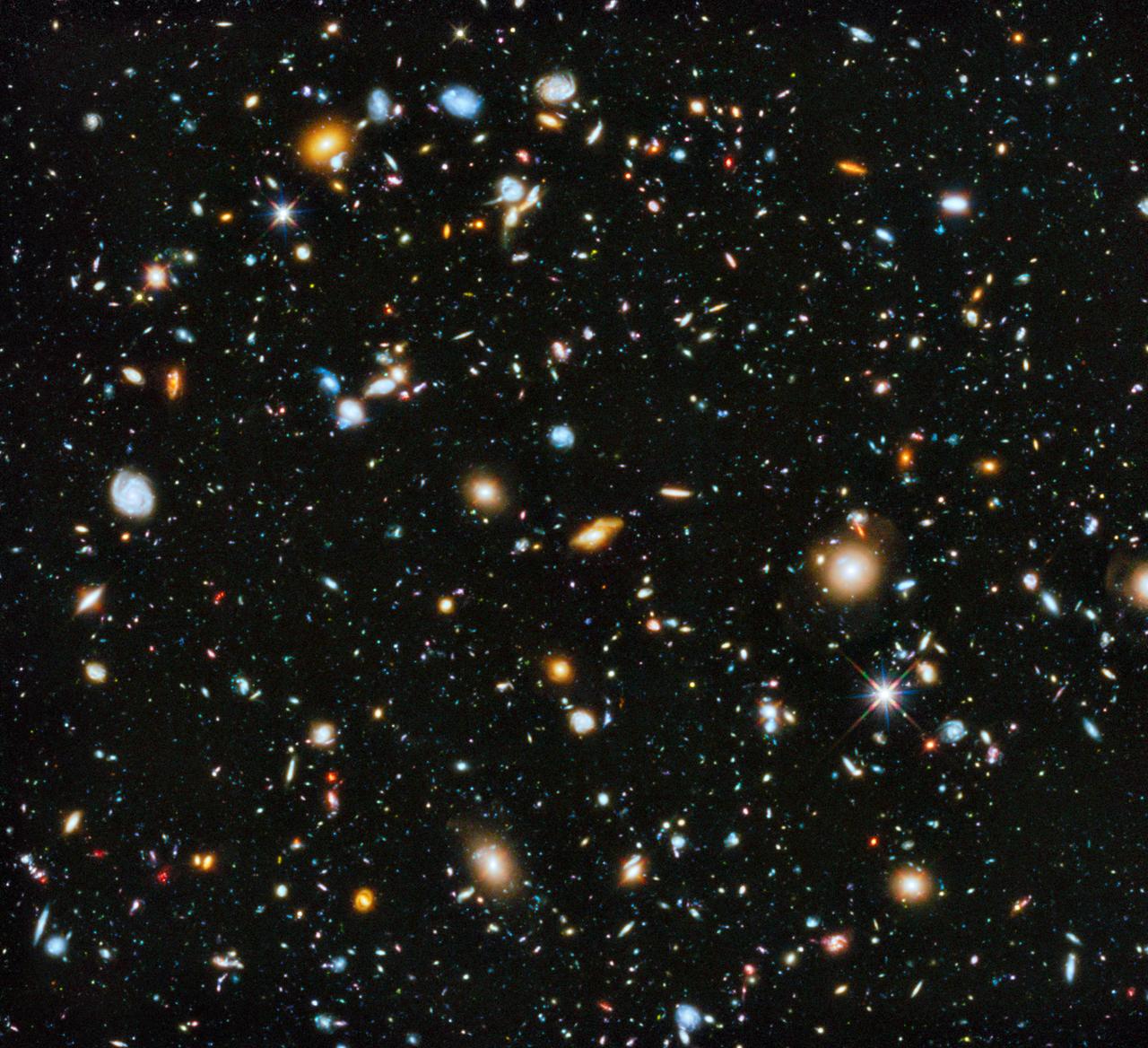
Astronomers using NASA's Hubble Space Telescope have assembled a comprehensive picture of the evolving universe – among the most colorful deep space images ever captured by the 24-year-old telescope. Researchers say the image, in new study called the Ultraviolet Coverage of the Hubble Ultra Deep Field, provides the missing link in star formation. The Hubble Ultra Deep Field 2014 image is a composite of separate exposures taken in 2003 to 2012 with Hubble's Advanced Camera for Surveys and Wide Field Camera 3. Credit: NASA/ESA Read more: <a href="http://1.usa.gov/1neD0se" rel="nofollow">1.usa.gov/1neD0se</a> <b><a href="http://www.nasa.gov/audience/formedia/features/MP_Photo_Guidelines.html" rel="nofollow">NASA image use policy.</a></b> <b><a href="http://www.nasa.gov/centers/goddard/home/index.html" rel="nofollow">NASA Goddard Space Flight Center</a></b> enables NASA’s mission through four scientific endeavors: Earth Science, Heliophysics, Solar System Exploration, and Astrophysics. Goddard plays a leading role in NASA’s accomplishments by contributing compelling scientific knowledge to advance the Agency’s mission. <b>Follow us on <a href="http://twitter.com/NASAGoddardPix" rel="nofollow">Twitter</a></b> <b>Like us on <a href="http://www.facebook.com/pages/Greenbelt-MD/NASA-Goddard/395013845897?ref=tsd" rel="nofollow">Facebook</a></b> <b>Find us on <a href="http://instagram.com/nasagoddard?vm=grid" rel="nofollow">Instagram</a></b>
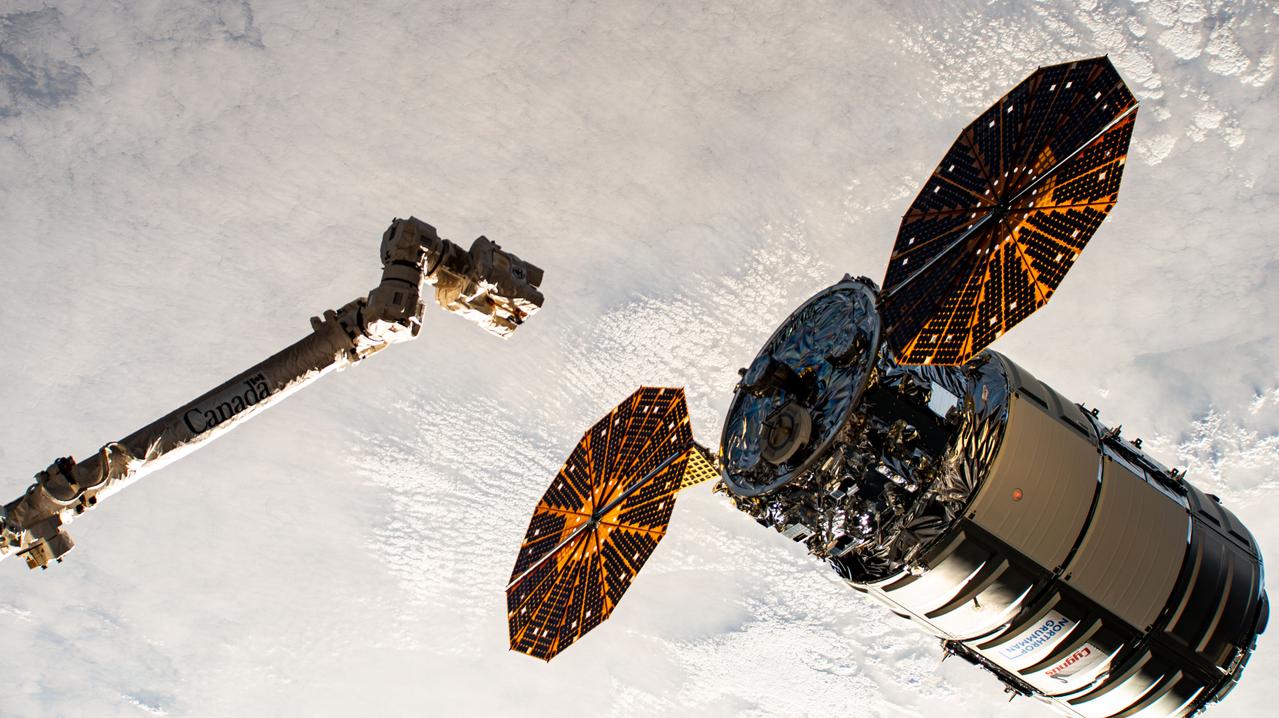
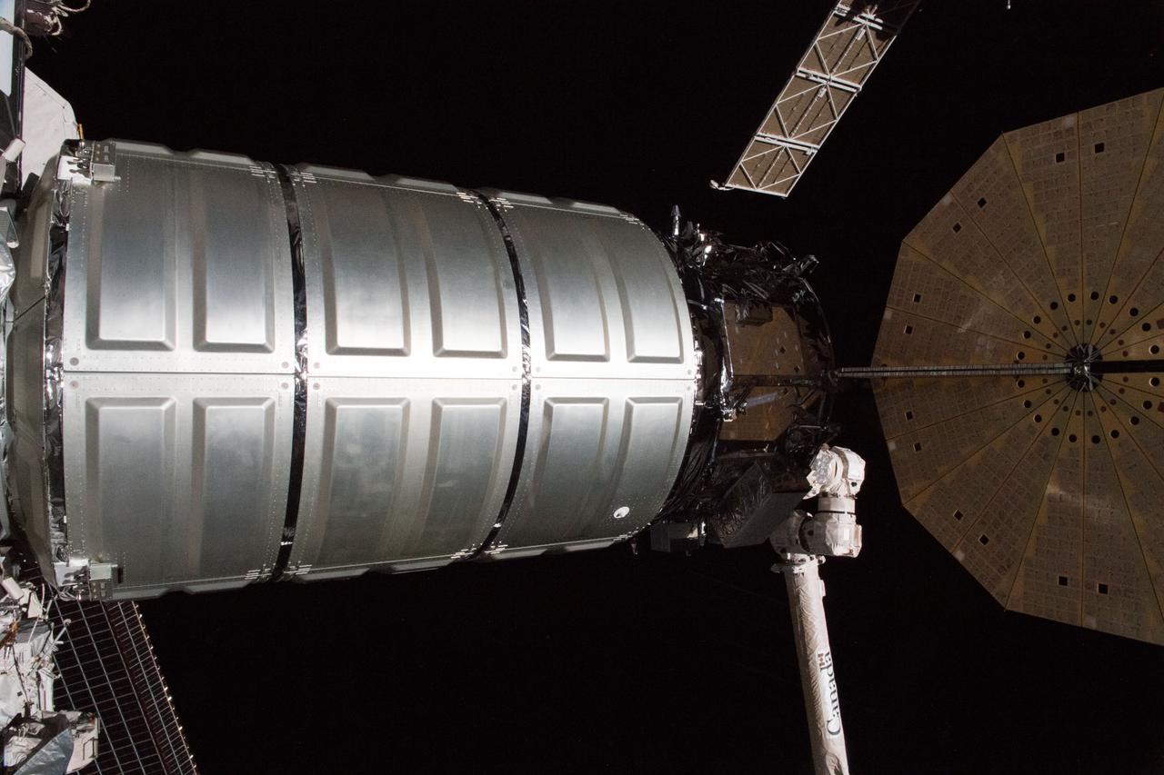
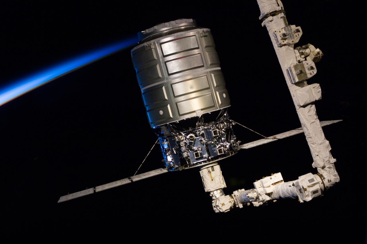
iss071e418233 (Aug. 6, 2024) --- Northrop Grumman's Cygnus cargo craft, with its prominent cymbal-shaped UltraFlex solar arrays, is pictured awaiting its capture by the Canadarm2 robotic arm commanded by Expedition 71 Flight Engineer Matthew Dominick of NASA. The maneuver marked the 50th free-flying capture for the Canadarm2 robotic arm.
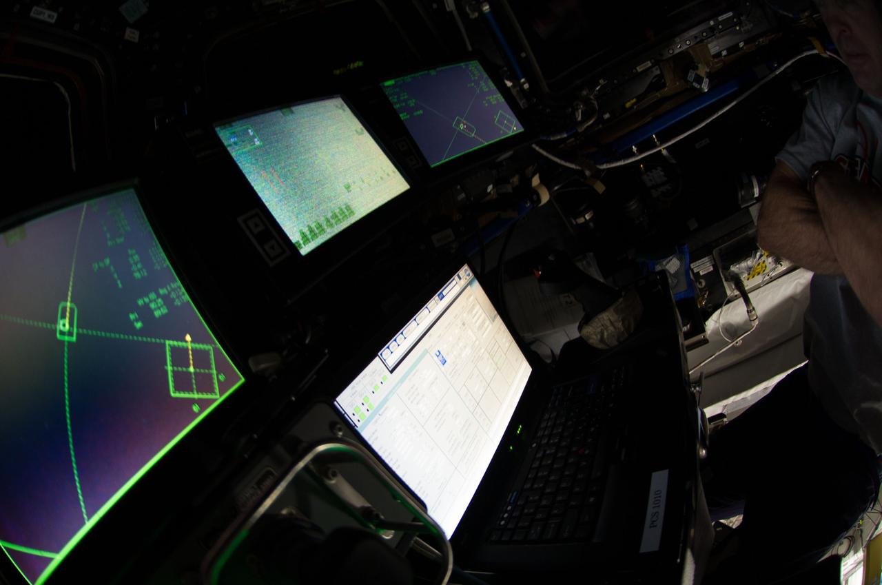
Control boards pictured in the International Space Stations Cupola during rendezvous and capture operations of the Orbital Sciences Cygnus cargo craft.

Less than once per decade, Mercury passes between the Earth and the sun in a rare astronomical event known as a planetary transit. The 2016 Mercury transit occurred on May 9th, between roughly 7:12 a.m. and 2:42 p.m. EDT. The images in this video are from NASA’s Solar Dynamics Observatory Music: Encompass by Mark Petrie For more info on the Mercury transit go to: <a href="http://www.nasa.gov/transit" rel="nofollow">www.nasa.gov/transit</a> This video is public domain and may be downloaded at: <a href="http://svs.gsfc.nasa.gov/12235" rel="nofollow">svs.gsfc.nasa.gov/12235</a> <b><a href="http://www.nasa.gov/audience/formedia/features/MP_Photo_Guidelines.html" rel="nofollow">NASA image use policy.</a></b> <b><a href="http://www.nasa.gov/centers/goddard/home/index.html" rel="nofollow">NASA Goddard Space Flight Center</a></b> enables NASA’s mission through four scientific endeavors: Earth Science, Heliophysics, Solar System Exploration, and Astrophysics. Goddard plays a leading role in NASA’s accomplishments by contributing compelling scientific knowledge to advance the Agency’s mission. <b>Follow us on <a href="http://twitter.com/NASAGoddardPix" rel="nofollow">Twitter</a></b> <b>Like us on <a href="http://www.facebook.com/pages/Greenbelt-MD/NASA-Goddard/395013845897?ref=tsd" rel="nofollow">Facebook</a></b> <b>Find us on <a href="http://instagrid.me/nasagoddard/?vm=grid" rel="nofollow">Instagram</a></b>
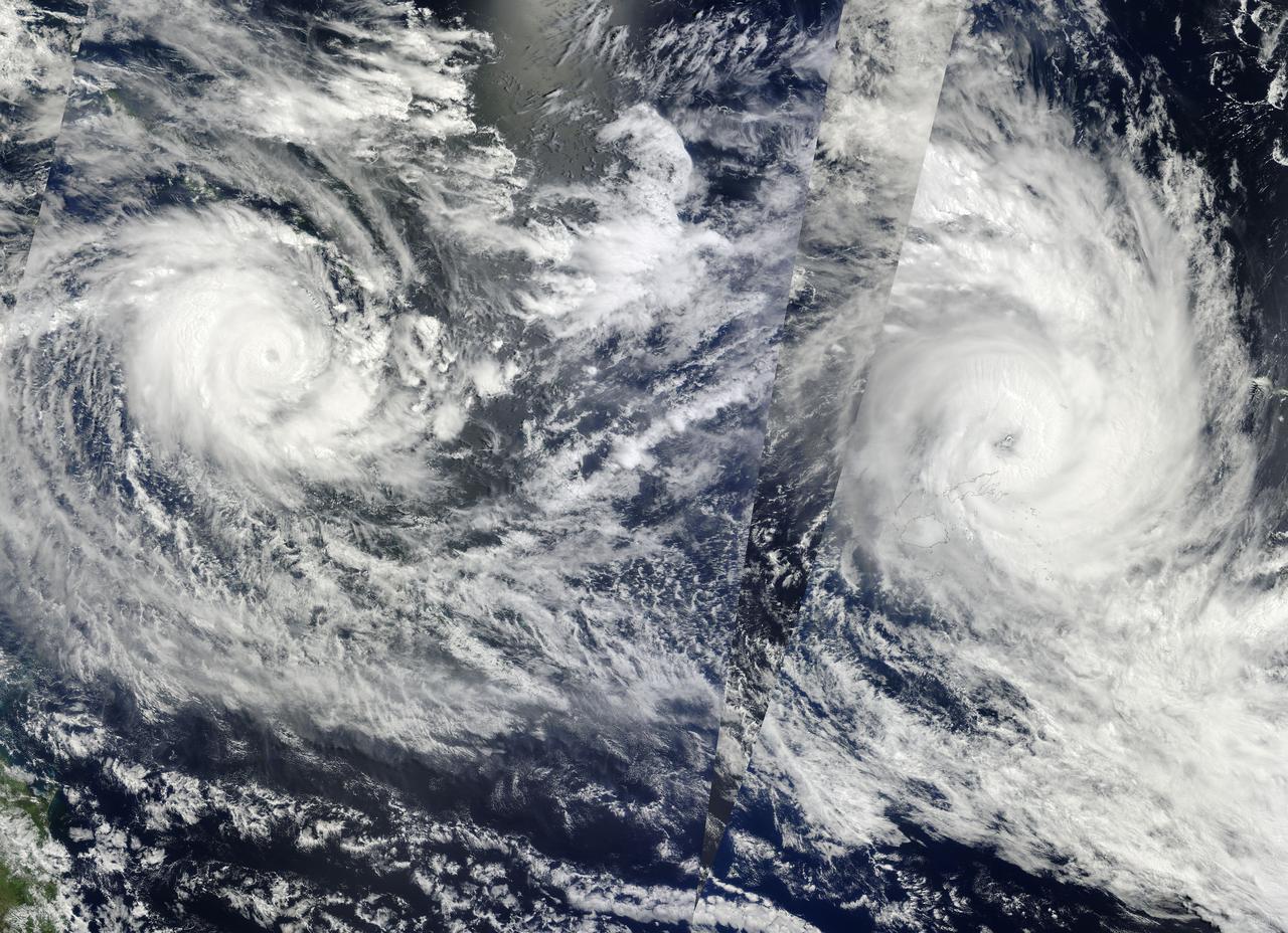
NASA Image acquired March 14 - 15, 2010 Two fierce tropical cyclones raged over the South Pacific Ocean in mid-March 2010, the U.S. Navy’s Joint Typhoon Warning Center (JTWC) reported. Over the Solomon Islands, Tropical Cyclone Ului had maximum sustained winds of 130 knots (240 kilometers per hour, 150 miles per hour) and gusts up to 160 knots (300 km/hr, 180 mph). Over Fiji, Tropical Cyclone Tomas had maximum sustained winds of 115 knots (215 km/hr, 132 mph) and gusts up to 140 knots (260 km/hr, 160 mph). The Moderate Resolution Imaging Spectroradiometer (MODIS) on NASA’s Terra and Aqua satellites captured both storms in multiple passes over the South Pacific on March 15, 2010, local time. The majority of the image is from the morning of March 15 (late March 14, UTC time) as seen by MODIS on the Terra satellite, with the right portion of the image having been acquired earliest. The wedge-shaped area right of center is from Aqua MODIS, and it was taken in the early afternoon of March 15 (local time). Although it packs less powerful winds, according to the JTWC, Tomas stretches across a larger area. It was moving over the northern Fiji islands when Terra MODIS captured the right portion of the image. According to early reports, Tomas forced more than 5,000 people from their homes while the islands sustained damage to crops and buildings. The JTWC reported that Tomas had traveled slowly toward the south and was passing over an area of high sea surface temperatures. (Warm seas provide energy for cyclones.) This storm was expected to intensify before transitioning to an extratropical storm. Ului is more compact and more powerful. A few hours before this image was taken, the storm had been an extremely dangerous Category 5 cyclone with sustained winds of 140 knots (260 km/hr, 160 mph). Ului degraded slightly before dealing the southern Solomon Islands a glancing blow. Initial news reports say that homes were damaged on the islands, but no one was injured. Like Tomas, Ului had been moving westward over an area of high sea surface temperatures. This storm was expected to continue moving westward before turning south and eventually weakening. The high-resolution image provided above is at 500 meters per pixel. The MODIS Rapid Response System provides this image at additional resolutions. NASA image by Jeff Schmaltz, MODIS Rapid Response Team, Goddard Space Flight Center. Caption by Michon Scott and Holli Riebeek. Instrument: Terra - MODIS To learn more about this image go here: <a href="http://earthobservatory.nasa.gov/IOTD/view.php?id=43154." rel="nofollow">earthobservatory.nasa.gov/IOTD/view.php?id=43154.</a>.
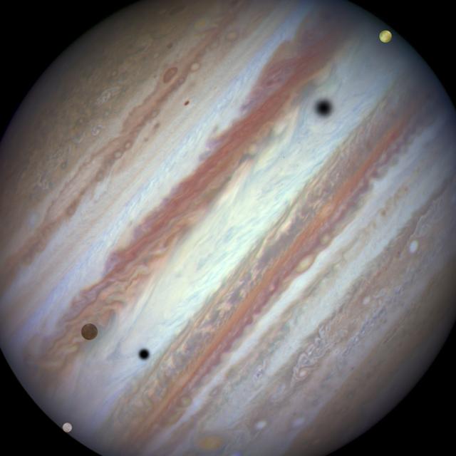
Three moons and their shadows parade across Jupiter near the end of the event at 07:10 UT on January 24, 2015. Europa has entered the frame at lower left. Slower-moving Callisto is above and to the right of Europa. Fastest-moving Io is approaching the eastern limb of the planet. Europa's shadow is toward the left side of the image and Callisto's shadow to the right. (The moons' orbital velocities are proportionally slower with increasing distance from the planet.) Credit: NASA, ESA, and the Hubble Heritage Team (STScI/AURA) More info: Firing off a string of snapshots like a sports photographer at a NASCAR race, NASA's Hubble Space Telescope captured a rare look at three of Jupiter's largest moons zipping across the banded face of the gas-giant planet: Europa, Callisto, and Io. Jupiter's four largest moons can commonly be seen transiting the face of the giant planet and casting shadows onto its cloud tops. However, seeing three moons transiting the face of Jupiter at the same time is rare, occurring only once or twice a decade. Missing from the sequence, taken on January 24, 2015, is the moon Ganymede that was too far from Jupiter in angular separation to be part of the conjunction. <b><a href="http://www.nasa.gov/audience/formedia/features/MP_Photo_Guidelines.html" rel="nofollow">NASA image use policy.</a></b> <b><a href="http://www.nasa.gov/centers/goddard/home/index.html" rel="nofollow">NASA Goddard Space Flight Center</a></b> enables NASA’s mission through four scientific endeavors: Earth Science, Heliophysics, Solar System Exploration, and Astrophysics. Goddard plays a leading role in NASA’s accomplishments by contributing compelling scientific knowledge to advance the Agency’s mission. <b>Follow us on <a href="http://twitter.com/NASAGoddardPix" rel="nofollow">Twitter</a></b> <b>Like us on <a href="http://www.facebook.com/pages/Greenbelt-MD/NASA-Goddard/395013845897?ref=tsd" rel="nofollow">Facebook</a></b> <b>Find us on <a href="http://instagram.com/nasagoddard?vm=grid" rel="nofollow">Instagram</a></b>
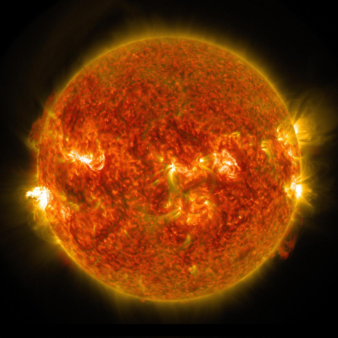
On Aug. 24, 2014, the sun emitted a mid-level solar flare, peaking at 8:16 a.m. EDT. NASA's Solar Dynamics Observatory captured images of the flare, which erupted on the left side of the sun. Solar flares are powerful bursts of radiation. Harmful radiation from a flare cannot pass through Earth's atmosphere to physically affect humans on the ground, however -- when intense enough -- they can disturb the atmosphere in the layer where GPS and communications signals travel. To see how this event may affect Earth, please visit NOAA's Space Weather Prediction Center at <a href="http://spaceweather.gov" rel="nofollow">spaceweather.gov</a>, the U.S. government's official source for space weather forecasts, alerts, watches and warnings. This flare is classified as an M5 flare. M-class flares are ten times less powerful than the most intense flares, called X-class flares. Credit: NASA/Goddard/SDO <b><a href="http://www.nasa.gov/audience/formedia/features/MP_Photo_Guidelines.html" rel="nofollow">NASA image use policy.</a></b> <b><a href="http://www.nasa.gov/centers/goddard/home/index.html" rel="nofollow">NASA Goddard Space Flight Center</a></b> enables NASA’s mission through four scientific endeavors: Earth Science, Heliophysics, Solar System Exploration, and Astrophysics. Goddard plays a leading role in NASA’s accomplishments by contributing compelling scientific knowledge to advance the Agency’s mission. <b>Follow us on <a href="http://twitter.com/NASAGoddardPix" rel="nofollow">Twitter</a></b> <b>Like us on <a href="http://www.facebook.com/pages/Greenbelt-MD/NASA-Goddard/395013845897?ref=tsd" rel="nofollow">Facebook</a></b> <b>Find us on <a href="http://instagram.com/nasagoddard?vm=grid" rel="nofollow">Instagram</a></b>
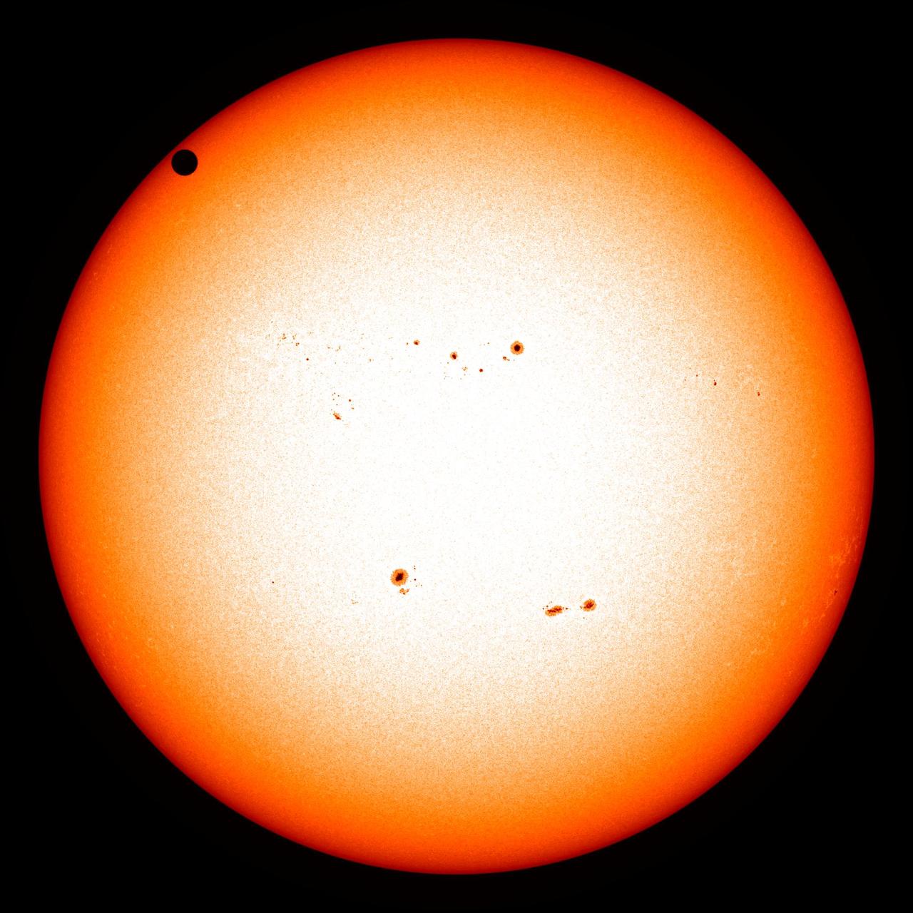
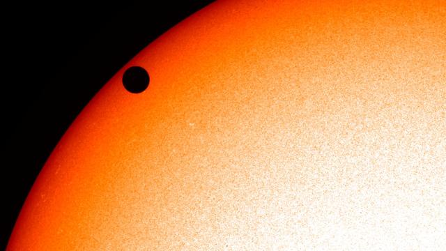
NASA image captured June 5, 2012. On June 5-6 2012, SDO is collecting images of one of the rarest predictable solar events: the transit of Venus across the face of the sun. This event happens in pairs eight years apart that are separated from each other by 105 or 121 years. The last transit was in 2004 and the next will not happen until 2117. <i>Credit: NASA/SDO, HMI</i> <b>To read more about the 2012 Venus Transit go to: <a href="http://sunearthday.nasa.gov/transitofvenus" rel="nofollow">sunearthday.nasa.gov/transitofvenus</a> </b> <b>Add your photos of the Transit of Venus to our Flickr Group here: <a href="http://www.flickr.com/groups/venustransit/">www.flickr.com/groups/venustransit/</a> </b> <b><a href="http://www.nasa.gov/audience/formedia/features/MP_Photo_Guidelines.html" rel="nofollow">NASA image use policy.</a></b> <b><a href="http://www.nasa.gov/centers/goddard/home/index.html" rel="nofollow">NASA Goddard Space Flight Center</a></b> enables NASA’s mission through four scientific endeavors: Earth Science, Heliophysics, Solar System Exploration, and Astrophysics. Goddard plays a leading role in NASA’s accomplishments by contributing compelling scientific knowledge to advance the Agency’s mission. <b>Follow us on <a href="http://twitter.com/NASA_GoddardPix" rel="nofollow">Twitter</a></b> <b>Like us on <a href="http://www.facebook.com/pages/Greenbelt-MD/NASA-Goddard/395013845897?ref=tsd" rel="nofollow">Facebook</a></b> <b>Find us on <a href="http://instagrid.me/nasagoddard/?vm=grid" rel="nofollow">Instagram</a></b>
This artist's concept shows the proposed Capture, Containment, and Return System, a NASA payload on the European Space Agency's Earth Return Orbiter. The payload is tasked with capturing the Orbiting Sample container, orienting it, sterilizing its exterior, and transferring it into a clean zone for secondary containment, toward safe return to Earth. The Capture, Containment, and Return System is part of the multi-mission Mars Sample Return program being planned by NASA and European Space Agency (ESA). https://photojournal.jpl.nasa.gov/catalog/PIA25894
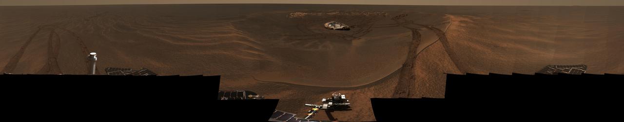
Opportunity Captures Lion
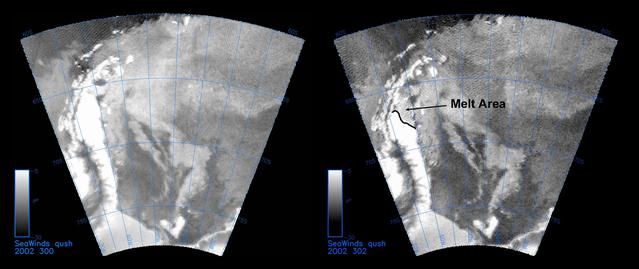
The SeaWinds instrument on NASA Quick Scatterometer QuikScat spacecraft captured these near-real-time backscatter images of melting on the Larsen C ice shelf in Antarctica Weddell Sea between October 27 left and October 29 right.
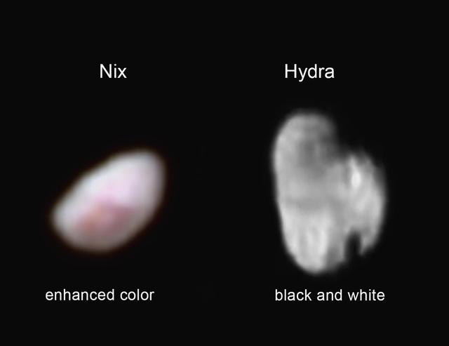
NASA New Horizons spacecraft captured these images of Pluto moon Nix which shows a reddish spot that has attracted the interest of the mission scientists left, and the small, irregularly shaped moon Hydra right.
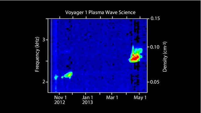
This visual represents sounds captured of interstellar space by NASA Voyager 1 spacecraft. Voyager 1 plasma wave instrument detected the vibrations of dense interstellar plasma.

NASA image release April 22, 2010 NASA's Hubble Space Telescope captured this billowing cloud of cold interstellar gas and dust rising from a tempestuous stellar nursery located in the Carina Nebula, 7,500 light-years away in the southern constellation Carina. This pillar of dust and gas serves as an incubator for new stars and is teeming with new star-forming activity. Hot, young stars erode and sculpt the clouds into this fantasy landscape by sending out thick stellar winds and scorching ultraviolet radiation. The low-density regions of the nebula are shredded while the denser parts resist erosion and remain as thick pillars. In the dark, cold interiors of these columns new stars continue to form. In the process of star formation, a disk around the proto-star slowly accretes onto the star's surface. Part of the material is ejected along jets perpendicular to the accretion disk. The jets have speeds of several hundreds of miles per second. As these jets plow into the surround nebula, they create small, glowing patches of nebulosity, called Herbig-Haro (HH) objects. Long streamers of gas can be seen shooting in opposite directions off the pedestal on the upper right-hand side of the image. Another pair of jets is visible in a peak near the top-center of the image. These jets (known as HH 901 and HH 902, respectively) are common signatures of the births of new stars. This image celebrates the 20th anniversary of Hubble's launch and deployment into an orbit around Earth. Hubble's Wide Field Camera 3 observed the pillar on Feb. 1-2, 2010. The colors in this composite image correspond to the glow of oxygen (blue), hydrogen and nitrogen (green), and sulfur (red). Object Names: HH 901, HH 902 Image Type: Astronomical Credit: NASA, ESA, and M. Livio and the Hubble 20th Anniversary Team (STScI) To read learn more about this image go to: <a href="http://www.nasa.gov/mission_pages/hubble/science/hubble20th-img.html" rel="nofollow">www.nasa.gov/mission_pages/hubble/science/hubble20th-img....</a> <b><a href="http://www.nasa.gov/centers/goddard/home/index.html" rel="nofollow">NASA Goddard Space Flight Center</a></b> is home to the nation's largest organization of combined scientists, engineers and technologists that build spacecraft, instruments and new technology to study the Earth, the sun, our solar system, and the universe.

Hubble Captures Best View of Mars Ever Obtained from Earth
iss055e109714 (May 24, 2018) --- The Northrop Grumman (formerly Orbital ATK) Cygnus resupply ship with its round, brass-colored UltraFlex solar arrays is guided to its port on the Unity module shortly after it was captured with the Canadarm2 robotic arm.
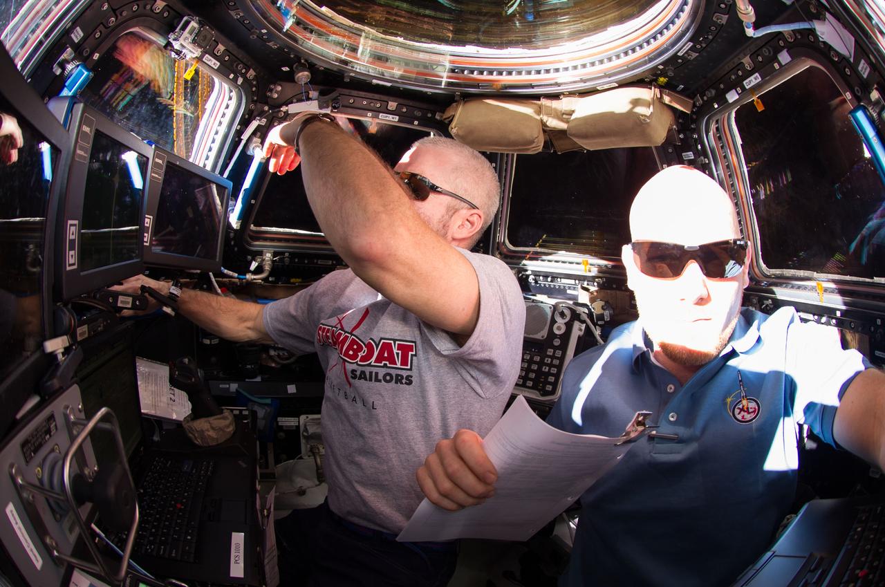
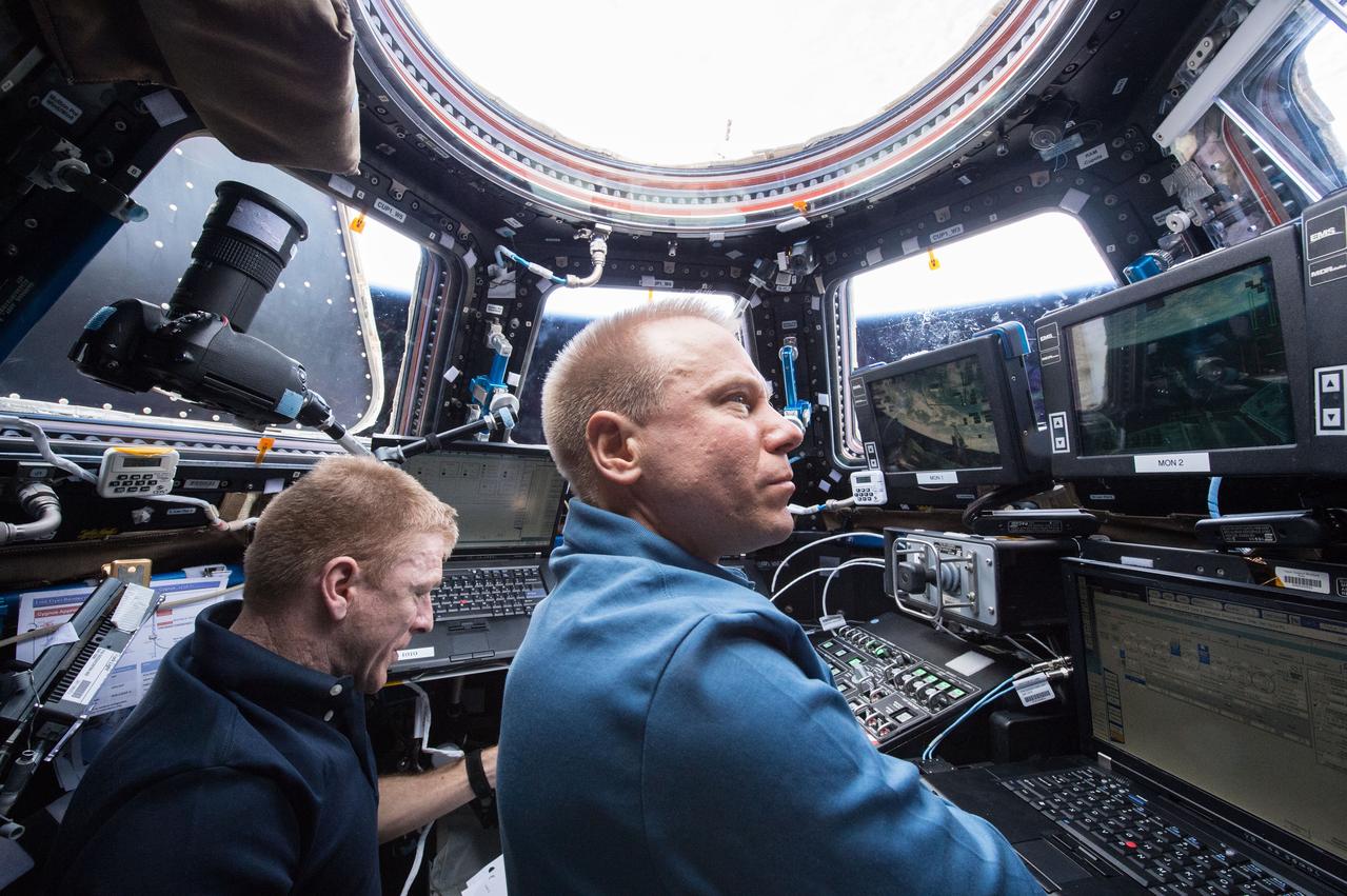
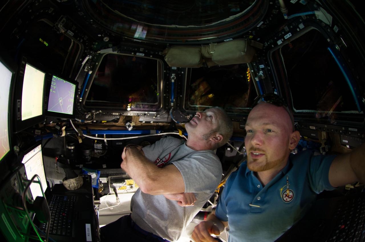
NASA astronaut Steve Swanson (left), Expedition 40 commander; and European Space Agency astronaut Alexander Gerst, flight engineer, are pictured in the International Space Station's Cupola during rendezvous and capture operations of the Orbital Sciences' Cygnus cargo craft.
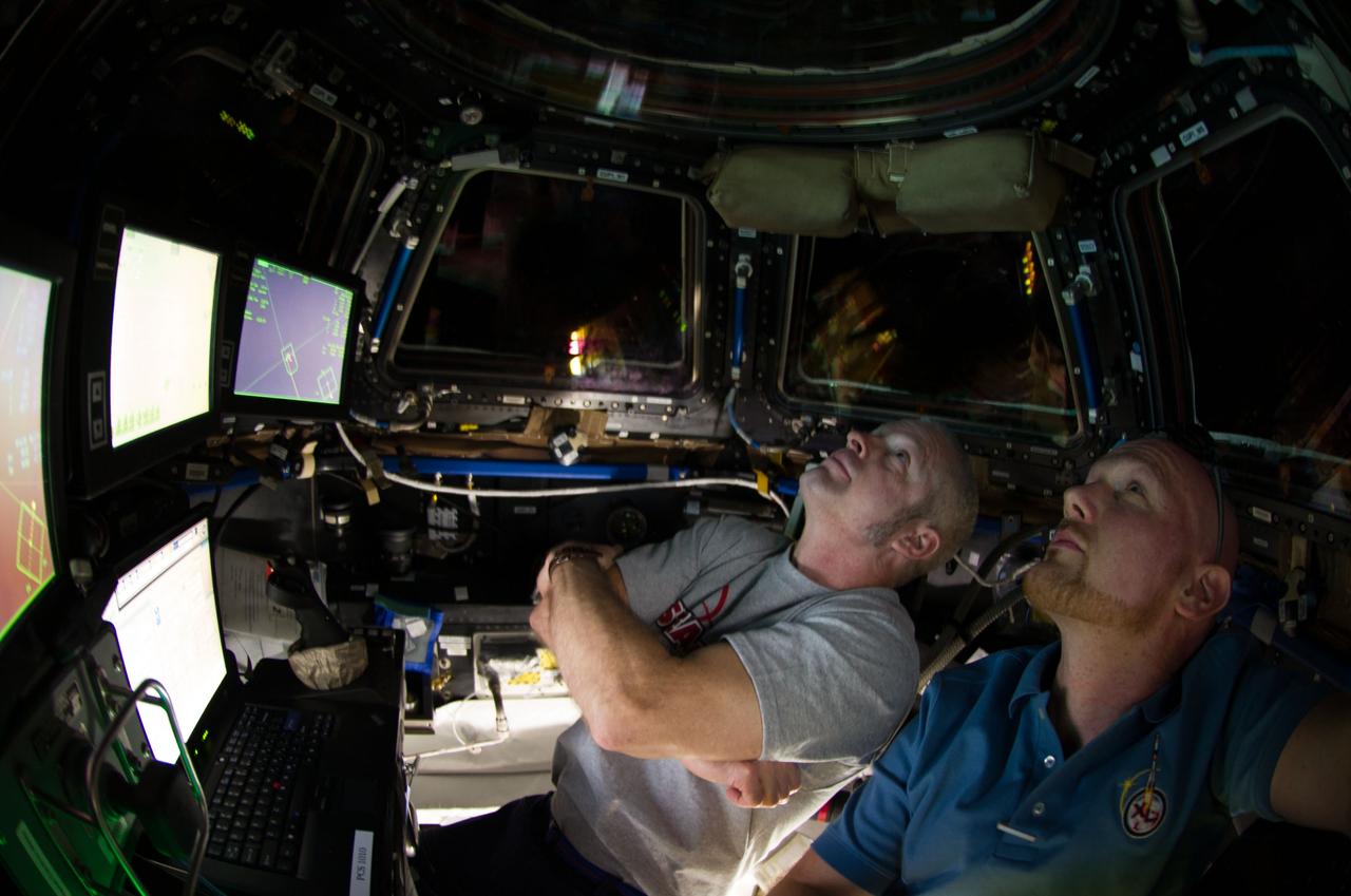
ISS040-E-067869 (16 July 2014) --- NASA astronaut Steve Swanson (left), Expedition 40 commander; and European Space Agency astronaut Alexander Gerst, flight engineer, are pictured in the International Space Station?s Cupola during rendezvous and capture operations of the Orbital Sciences? Cygnus cargo craft.
ISS040-E-067864 (16 July 2014) --- NASA astronaut Steve Swanson (left), Expedition 40 commander; and European Space Agency astronaut Alexander Gerst, flight engineer, are pictured in the International Space Station?s Cupola during rendezvous and capture operations of the Orbital Sciences? Cygnus cargo craft.

Image release June 22, 2010 A spectacular new NASA/ESA Hubble Space Telescope image — one of the largest ever released of a star-forming region — highlights N11, part of a complex network of gas clouds and star clusters within our neighbouring galaxy, the Large Magellanic Cloud. This region of energetic star formation is one of the most active in the nearby Universe. The Large Magellanic Cloud contains many bright bubbles of glowing gas. One of the largest and most spectacular has the name LHA 120-N 11, from its listing in a catalogue compiled by the American astronomer and astronaut Karl Henize in 1956, and is informally known as N11. Close up, the billowing pink clouds of glowing gas make N11 resemble a puffy swirl of fairground candy floss. From further away, its distinctive overall shape led some observers to nickname it the Bean Nebula. The dramatic and colourful features visible in the nebula are the telltale signs of star formation. N11 is a well-studied region that extends over 1000 light-years. It is the second largest star-forming region within the Large Magellanic Cloud and has produced some of the most massive stars known. It is the process of star formation that gives N11 its distinctive look. Three successive generations of stars, each of which formed further away from the centre of the nebula than the last, have created shells of gas and dust. These shells were blown away from the newborn stars in the turmoil of their energetic birth and early life, creating the ring shapes so prominent in this image. Beans are not the only terrestrial shapes to be found in this spectacular high resolution image from the NASA/ESA Hubble Space Telescope. In the upper left is the red bloom of nebula LHA 120-N 11A. Its rose-like petals of gas and dust are illuminated from within, thanks to the radiation from the massive hot stars at its centre. N11A is relatively compact and dense and is the site of the most recent burst of star development in the region. Other star clusters abound in N11, including NGC 1761 at the bottom of the image, which is a group of massive hot young stars busily pouring intense ultraviolet radiation out into space. Although it is much smaller than our own galaxy, the Large Magellanic Cloud is a very vigorous region of star formation. Studying these stellar nurseries helps astronomers understand a lot more about how stars are born and their ultimate development and lifespan. Both the Large Magellanic Cloud and its small companion, the Small Magellanic Cloud, are easily seen with the unaided eye and have always been familiar to people living in the southern hemisphere. The credit for bringing these galaxies to the attention of Europeans is usually given to Portuguese explorer Fernando de Magellan and his crew, who viewed it on their 1519 sea voyage. However, the Persian astronomer Abd Al-Rahman Al Sufi and the Italian explorer Amerigo Vespucci recorded the Large Magellanic Cloud in 964 and 1503 respectively. Credit: NASA, ESA and Jesús Maíz Apellániz (Instituto de Astrofísica de Andalucía, Spain) To learn more about Hubble go to: <a href="http://www.nasa.gov/mission_pages/hubble/main/index.html" rel="nofollow">www.nasa.gov/mission_pages/hubble/main/index.html</a> <b><a href="http://www.nasa.gov/centers/goddard/home/index.html" rel="nofollow">NASA Goddard Space Flight Center</a></b> is home to the nation's largest organization of combined scientists, engineers and technologists that build spacecraft, instruments and new technology to study the Earth, the sun, our solar system, and the universe.
Within that narrow window during a solar eclipse where one on Earth can watch the Moon shadow obscure more than 90% of the Sun, NASA Terra spacecraft captured these views of the Antarctic surface during the total solar eclipse of November 23, 2003.

iss050e015683 (Dec. 13, 2016) --- JAXA's (Japan Aerospace Exploration Agency) H-II Transfer Vehicle-6, also known as the "Kounotori," is pictured moments away from being captured by the International Space Station's Canadarm2 robotic arm. Expedition 50 Commander Shane Kimbrough of NASA and Flight Engineer Thomas Pesquet of ESA (European Space Agency) successfully captured Kounotori on Dec. 13, 2016.
NASA image captured June 5, 2012. On June 5-6 2012, SDO is collecting images of one of the rarest predictable solar events: the transit of Venus across the face of the sun. This event happens in pairs eight years apart that are separated from each other by 105 or 121 years. The last transit was in 2004 and the next will not happen until 2117. <i>Credit: NASA/SDO, AIA</i> <b>To read more about the 2012 Venus Transit go to: <a href="http://sunearthday.nasa.gov/transitofvenus" rel="nofollow">sunearthday.nasa.gov/transitofvenus</a> </b> <b>Add your photos of the Transit of Venus to our Flickr Group here: <a href="http://www.flickr.com/groups/venustransit/">www.flickr.com/groups/venustransit/</a> </b> <b><a href="http://www.nasa.gov/audience/formedia/features/MP_Photo_Guidelines.html" rel="nofollow">NASA image use policy.</a></b> <b><a href="http://www.nasa.gov/centers/goddard/home/index.html" rel="nofollow">NASA Goddard Space Flight Center</a></b> enables NASA’s mission through four scientific endeavors: Earth Science, Heliophysics, Solar System Exploration, and Astrophysics. Goddard plays a leading role in NASA’s accomplishments by contributing compelling scientific knowledge to advance the Agency’s mission. <b>Follow us on <a href="http://twitter.com/NASA_GoddardPix" rel="nofollow">Twitter</a></b> <b>Like us on <a href="http://www.facebook.com/pages/Greenbelt-MD/NASA-Goddard/395013845897?ref=tsd" rel="nofollow">Facebook</a></b> <b>Find us on <a href="http://instagrid.me/nasagoddard/?vm=grid" rel="nofollow">Instagram</a></b>
NASA image captured June 5, 2012. On June 5-6 2012, SDO is collecting images of one of the rarest predictable solar events: the transit of Venus across the face of the sun. This event happens in pairs eight years apart that are separated from each other by 105 or 121 years. The last transit was in 2004 and the next will not happen until 2117. <i>Credit: NASA/SDO, HMI</i> <b>To read more about the 2012 Venus Transit go to: <a href="http://sunearthday.nasa.gov/transitofvenus" rel="nofollow">sunearthday.nasa.gov/transitofvenus</a> </b> <b>Add your photos of the Transit of Venus to our Flickr Group here: <a href="http://www.flickr.com/groups/venustransit/">www.flickr.com/groups/venustransit/</a> </b> <b><a href="http://www.nasa.gov/audience/formedia/features/MP_Photo_Guidelines.html" rel="nofollow">NASA image use policy.</a></b> <b><a href="http://www.nasa.gov/centers/goddard/home/index.html" rel="nofollow">NASA Goddard Space Flight Center</a></b> enables NASA’s mission through four scientific endeavors: Earth Science, Heliophysics, Solar System Exploration, and Astrophysics. Goddard plays a leading role in NASA’s accomplishments by contributing compelling scientific knowledge to advance the Agency’s mission. <b>Follow us on <a href="http://twitter.com/NASA_GoddardPix" rel="nofollow">Twitter</a></b> <b>Like us on <a href="http://www.facebook.com/pages/Greenbelt-MD/NASA-Goddard/395013845897?ref=tsd" rel="nofollow">Facebook</a></b> <b>Find us on <a href="http://instagrid.me/nasagoddard/?vm=grid" rel="nofollow">Instagram</a></b>
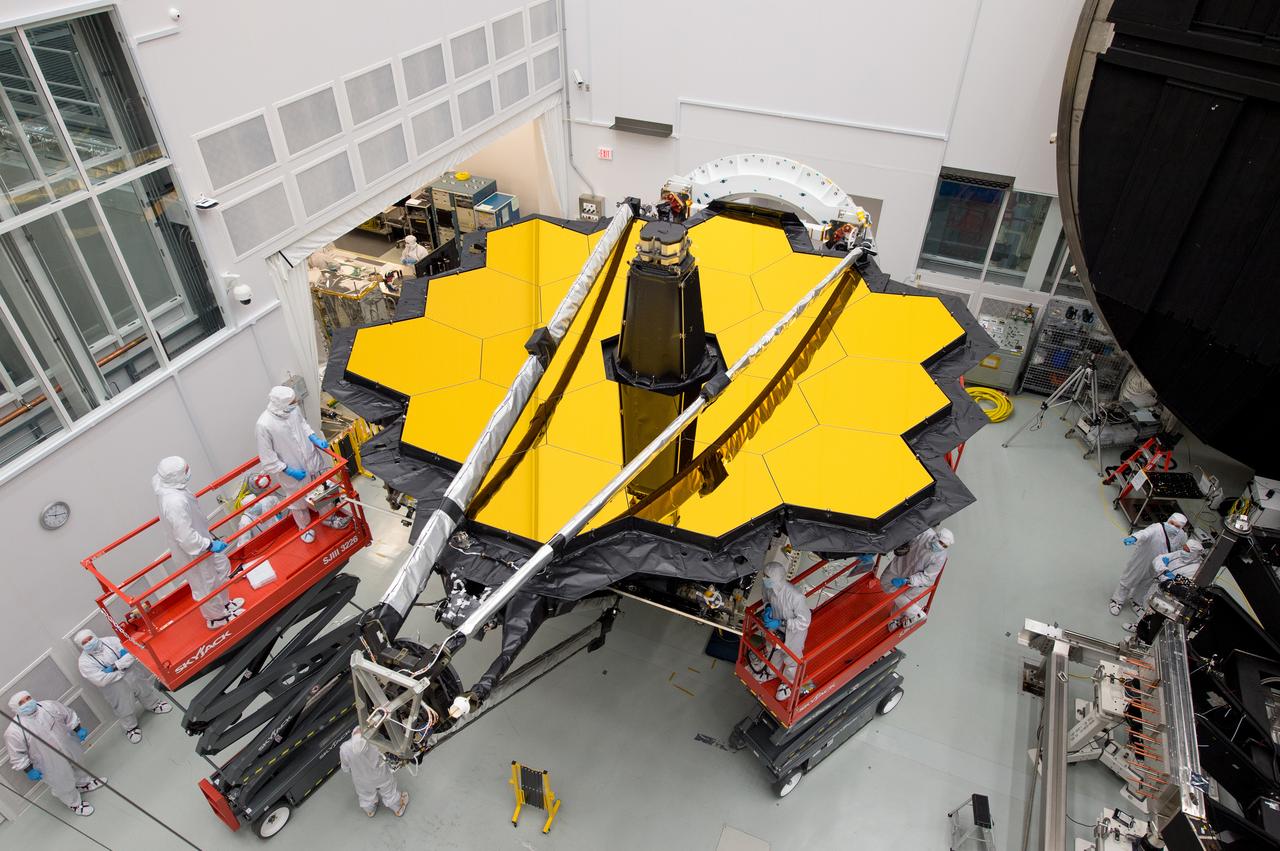
Now that NASA's James Webb Space Telescope has moved to NASA's Johnson Space Center in Houston, Texas, a special Webb camera was installed there to continue providing daily video feeds on the telescope's progress. Space enthusiasts, who are fascinated to see how this next generation space telescope has come together and how it is being tested, are able to see the telescope’s progress as it happens by watching the Webb-cam feed online. The Web camera at NASA’s Johnson Space Center can be seen online at: <a href="http://jwst.nasa.gov/" rel="nofollow">jwst.nasa.gov/</a>, with larger views of the cams available at: <a href="http://jwst.nasa.gov/webcam.html" rel="nofollow">jwst.nasa.gov/webcam.html</a>. Read more: <a href="https://go.nasa.gov/2rQYpT2" rel="nofollow">go.nasa.gov/2rQYpT2</a> <b><a href="http://www.nasa.gov/audience/formedia/features/MP_Photo_Guidelines.html" rel="nofollow">NASA image use policy.</a></b> <b><a href="http://www.nasa.gov/centers/goddard/home/index.html" rel="nofollow">NASA Goddard Space Flight Center</a></b> enables NASA’s mission through four scientific endeavors: Earth Science, Heliophysics, Solar System Exploration, and Astrophysics. Goddard plays a leading role in NASA’s accomplishments by contributing compelling scientific knowledge to advance the Agency’s mission. <b>Follow us on <a href="http://twitter.com/NASAGoddardPix" rel="nofollow">Twitter</a></b> <b>Like us on <a href="http://www.facebook.com/pages/Greenbelt-MD/NASA-Goddard/395013845897?ref=tsd" rel="nofollow">Facebook</a></b> <b>Find us on <a href="http://instagrid.me/nasagoddard/?vm=grid" rel="nofollow">Instagram</a></b>
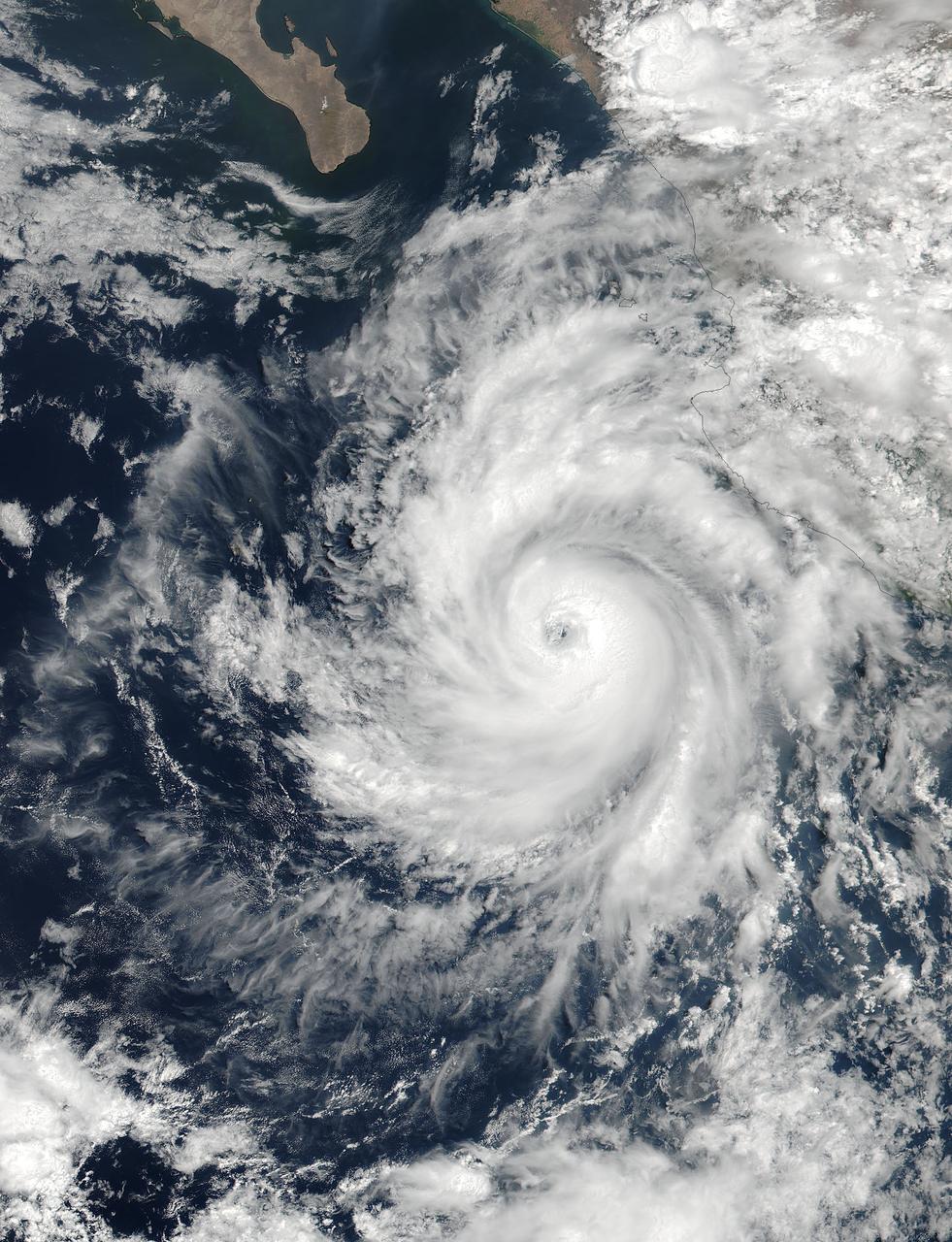
At 19:36 UTC (3:36 p.m. EDT) on June 26, the Visible Infrared Imaging Radiometer Suite (VIIRS) instrument aboard NASA-NOAA's Suomi NPP satellite provided a visible-light image of Hurricane Dora. The VIIRS imagery showed a small hurricane with a visible pinhole eye surrounded by a thick band of powerful thunderstorms. That strength didn't last long as Dora moved over cooler waters and began to weaken early on June 27. Dora appeared degraded in satellite imagery as strong convection and thunderstorms were diminishing, although the storm still maintained a visible eye. At 11 a.m. EDT (1500 UTC) on Tuesday, June 27, Dora's maximum sustained winds have decreased slightly to near 75 mph (120 kph) with higher gusts. Dora is a small tropical cyclone, as hurricane-force winds extended outward up to 15 miles (30 km) from the center. The NHC said the eye of Hurricane Dora was located near latitude 19.3 degrees north and longitude 110.2 degrees west. That's about 250 miles (400 km) south of the southern tip of Baja California, Mexico. Dora was moving toward the west-northwest near 13 mph (20 kph). The NHC said the center of Dora is expected to pass just north of Socorro Island later today, and remain well south of the Baja California Peninsula. Ocean swells generated by Dora are affecting portions of the coast of southwest Mexico and are expected to spread northwestward and begin affecting portions of the coast of the southern Baja California peninsula through Wednesday, June 28. Dora is moving over sea surface temperatures cooler than 26.6 degrees Celsius or 80 degrees Fahrenheit, which is the threshold to maintain a tropical cyclone. Temperatures cooler than that weaken tropical cyclones. The NHC said that the waters beneath Dora will continue to cool for the next couple of days so Dora is expected to weaken to a tropical storm later today, June 27, and degenerate to a remnant low pressure area over the next two days. For updated forecasts, visit: <a href="http://www.nhc.noaa.gov" rel="nofollow">www.nhc.noaa.gov</a>. Credit: NASA/NOAA <b><a href="http://www.nasa.gov/audience/formedia/features/MP_Photo_Guidelines.html" rel="nofollow">NASA image use policy.</a></b> <b><a href="http://www.nasa.gov/centers/goddard/home/index.html" rel="nofollow">NASA Goddard Space Flight Center</a></b> enables NASA’s mission through four scientific endeavors: Earth Science, Heliophysics, Solar System Exploration, and Astrophysics. Goddard plays a leading role in NASA’s accomplishments by contributing compelling scientific knowledge to advance the Agency’s mission. <b>Follow us on <a href="http://twitter.com/NASAGoddardPix" rel="nofollow">Twitter</a></b> <b>Like us on <a href="http://www.facebook.com/pages/Greenbelt-MD/NASA-Goddard/395013845897?ref=tsd" rel="nofollow">Facebook</a></b> <b>Find us on <a href="http://instagrid.me/nasagoddard/?vm=grid" rel="nofollow">Instagram</a></b>
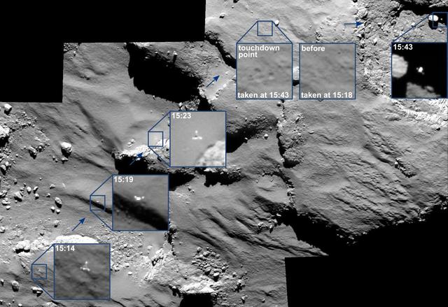
The descent of its comet lander Philae was captured by ESA Rosetta spacecraft main camera as the lander approached -- and then rebounded off -- the comet surface.

The sun emitted a trio of mid-level solar flares on April 2-3, 2017. The first peaked at 4:02 a.m. EDT on April 2, the second peaked at 4:33 p.m. EDT on April 2, and the third peaked at 10:29 a.m. EDT on April 3. NASA’s Solar Dynamics Observatory, which watches the sun constantly, captured images of the three events. Solar flares are powerful bursts of radiation. Harmful radiation from a flare cannot pass through Earth's atmosphere to physically affect humans on the ground, however — when intense enough — they can disturb the atmosphere in the layer where GPS and communications signals travel. Learn more: <a href="https://go.nasa.gov/2oQVFju" rel="nofollow">go.nasa.gov/2oQVFju</a> Caption: NASA's Solar Dynamics Observatory captured this image of a solar flare peaking at 10:29 a.m. EDT on April 3, 2017, as seen in the bright flash near the sun’s upper right edge. The image shows a subset of extreme ultraviolet light that highlights the extremely hot material in flares and which is typically colorized in teal. Credits: NASA/SDO <b><a href="http://www.nasa.gov/audience/formedia/features/MP_Photo_Guidelines.html" rel="nofollow">NASA image use policy.</a></b> <b><a href="http://www.nasa.gov/centers/goddard/home/index.html" rel="nofollow">NASA Goddard Space Flight Center</a></b> enables NASA’s mission through four scientific endeavors: Earth Science, Heliophysics, Solar System Exploration, and Astrophysics. Goddard plays a leading role in NASA’s accomplishments by contributing compelling scientific knowledge to advance the Agency’s mission. <b>Follow us on <a href="http://twitter.com/NASAGoddardPix" rel="nofollow">Twitter</a></b> <b>Like us on <a href="http://www.facebook.com/pages/Greenbelt-MD/NASA-Goddard/395013845897?ref=tsd" rel="nofollow">Facebook</a></b> <b>Find us on <a href="http://instagrid.me/nasagoddard/?vm=grid" rel="nofollow">Instagram</a></b>
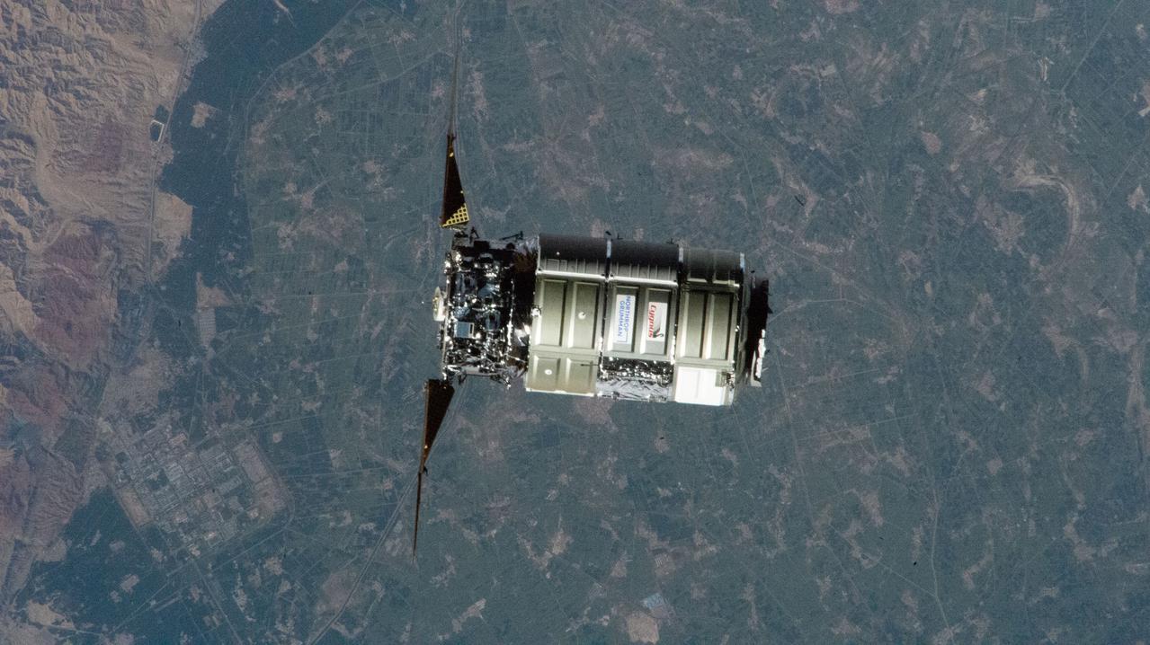
iss065e238816 (Aug. 12, 2021) --- Northrop Grumman's Cygnus space freighter, carrying over 8,200 pounds of cargo to resupply the Expedition 65 crew, approaches the International Space Station for a capture with the Canadarm2 robotic arm operated by NASA Flight Engineer Megan McArthur. The orbital lab was flying 264 miles above China near the border of Mongolia at the time of this photograph.

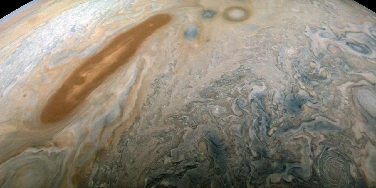
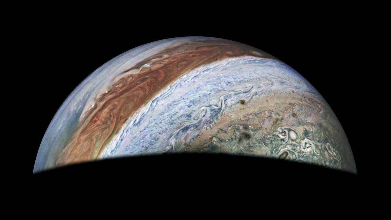
New imagery from the Hubble Space Telescope is revealing details never before seen on Jupiter. Hubble’s new Jupiter maps were used to create this Ultra HD animation. These new maps and spinning globes of Jupiter were made from observations performed with NASA’s Hubble Space Telescope. They are the first products to come from a program to study the solar system’s outer planets – Jupiter, Uranus, Neptune and, later, Saturn – each year using Hubble. The observations are designed to capture a broad range of features, including winds, clouds, storms and atmospheric chemistry. These annual studies will help current and future scientists see how these giant worlds change over time. Scientists at NASA’s Goddard Space Flight Center, the Jet Propulsion Laboratory, and the University of California at Berkeley produced two global maps of Jupiter from the observations, which were made using Hubble’s high-performance Wide Field Camera 3. The two maps represent nearly back-to-back rotations of the planet, making it possible to determine the speeds of Jupiter’s winds. Already, the images have revealed a rare wave just north of the planet’s equator and a unique filament-like feature in the core of the Great Red Spot that had not been seen previously. In addition, the new images confirm that the Great Red Spot continues to shrink and become more circular, as it has been doing for years. The long axis of this characteristic storm is about 150 miles (240 kilometers) shorter now than it was in 2014. Recently, the storm had been shrinking at a faster-than-usual rate, but the latest change is consistent with the long-term trend. Read more:http://www.nasa.gov/press-release/goddard/hubble-s-planetary-portrait-captures-new-changes-in-jupiter-s-great-red-spot Credits: NASA/ESA/Goddard/UCBerkeley/JPL-Caltech/STScI <b><a href="http://www.nasa.gov/audience/formedia/features/MP_Photo_Guidelines.html" rel="nofollow">NASA image use policy.</a></b> <b><a href="http://www.nasa.gov/centers/goddard/home/index.html" rel="nofollow">NASA Goddard Space Flight Center</a></b> enables NASA’s mission through four scientific endeavors: Earth Science, Heliophysics, Solar System Exploration, and Astrophysics. Goddard plays a leading role in NASA’s accomplishments by contributing compelling scientific knowledge to advance the Agency’s mission. <b>Follow us on <a href="http://twitter.com/NASAGoddardPix" rel="nofollow">Twitter</a></b> <b>Like us on <a href="http://www.facebook.com/pages/Greenbelt-MD/NASA-Goddard/395013845897?ref=tsd" rel="nofollow">Facebook</a></b> <b>Find us on <a href="http://instagrid.me/nasagoddard/?vm=grid" rel="nofollow">Instagram</a></b>
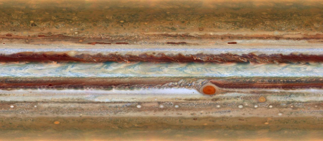
New imagery from the Hubble Space Telescope is revealing details never before seen on Jupiter. Hubble’s new Jupiter maps were used to create this Ultra HD animation. These new maps and spinning globes of Jupiter were made from observations performed with NASA’s Hubble Space Telescope. They are the first products to come from a program to study the solar system’s outer planets – Jupiter, Uranus, Neptune and, later, Saturn – each year using Hubble. The observations are designed to capture a broad range of features, including winds, clouds, storms and atmospheric chemistry. These annual studies will help current and future scientists see how these giant worlds change over time. Scientists at NASA’s Goddard Space Flight Center, the Jet Propulsion Laboratory, and the University of California at Berkeley produced two global maps of Jupiter from the observations, which were made using Hubble’s high-performance Wide Field Camera 3. The two maps represent nearly back-to-back rotations of the planet, making it possible to determine the speeds of Jupiter’s winds. Already, the images have revealed a rare wave just north of the planet’s equator and a unique filament-like feature in the core of the Great Red Spot that had not been seen previously. In addition, the new images confirm that the Great Red Spot continues to shrink and become more circular, as it has been doing for years. The long axis of this characteristic storm is about 150 miles (240 kilometers) shorter now than it was in 2014. Recently, the storm had been shrinking at a faster-than-usual rate, but the latest change is consistent with the long-term trend. Read more: <a href="http://www.nasa.gov/press-release/goddard/hubble-s-planetary-portrait-captures-new-changes-in-jupiter-s-great-red-spot" rel="nofollow">www.nasa.gov/press-release/goddard/hubble-s-planetary-por...</a> Credits: NASA/ESA/Goddard/UCBerkeley/JPL-Caltech/STScI <b><a href="http://www.nasa.gov/audience/formedia/features/MP_Photo_Guidelines.html" rel="nofollow">NASA image use policy.</a></b> <b><a href="http://www.nasa.gov/centers/goddard/home/index.html" rel="nofollow">NASA Goddard Space Flight Center</a></b> enables NASA’s mission through four scientific endeavors: Earth Science, Heliophysics, Solar System Exploration, and Astrophysics. Goddard plays a leading role in NASA’s accomplishments by contributing compelling scientific knowledge to advance the Agency’s mission. <b>Follow us on <a href="http://twitter.com/NASAGoddardPix" rel="nofollow">Twitter</a></b> <b>Like us on <a href="http://www.facebook.com/pages/Greenbelt-MD/NASA-Goddard/395013845897?ref=tsd" rel="nofollow">Facebook</a></b> <b>Find us on <a href="http://instagrid.me/nasagoddard/?vm=grid" rel="nofollow">Instagram</a></b>
A long, brown oval known as a "brown barge" in Jupiter's North North Equatorial Belt is captured in this color-enhanced image from NASA's Juno spacecraft. This image was taken at 6:01 p.m. PDT (9:01 p.m. EDT) on Sept. 6, 2018, as the spacecraft performed its 15th close flyby of Jupiter. Citizen scientist Kevin M. Gill created this image using data from the spacecraft's JunoCam imager. https://photojournal.jpl.nasa.gov/catalog/PIA22939. - Enhanced image by Kevin M. Gill (CC-BY) based on images provided courtesy of NASA/JPL-Caltech/SwRI/MSSS
NASA's Aqua satellite passed over Japan one hour and 41 minutes before the quake hit. At the time Aqua passed overhead, the Moderate Resolution Imaging Spectroradiometer (MODIS) instrument captured a visible of Japan covered by clouds. The image was taken at 0405 UTC on March 11 (1:05 p.m. local time Japan /11:05 p.m. EST March 10). The quake hit at 2:46 p.m. local time/Japan. Satellite: Aqua Credit: NASA/GSFC/Aqua <b><a href="http://www.nasa.gov/centers/goddard/home/index.html" rel="nofollow">NASA Goddard Space Flight Center</a></b> enables NASA’s mission through four scientific endeavors: Earth Science, Heliophysics, Solar System Exploration, and Astrophysics. Goddard plays a leading role in NASA’s accomplishments by contributing compelling scientific knowledge to advance the Agency’s mission. <b>Follow us on <a href="http://twitter.com/NASA_GoddardPix" rel="nofollow">Twitter</a></b> <b>Join us on <a href="http://www.facebook.com/pages/Greenbelt-MD/NASA-Goddard/395013845897?ref=tsd" rel="nofollow">Facebook</a></b>

This illustration shows the proposed Capture, Containment, and Return System, a NASA payload on the European Space Agency's Earth Return Orbiter. As part of the Mars Sample Return Campaign, samples collected by NASA's Mars Perseverance Rover would be launched into Mars orbit within sealed tubes inside an Orbiting Sample container. The Earth Return Orbiter would then rendezvous with this container, and the Capture, Containment, and Return System would be tasked with capturing the Orbiting Sample container, orienting it, sterilizing its exterior, and transferring it into a clean zone for secondary containment, toward safe return to Earth. The Capture, Containment, and Return System is part of the multi-mission Mars Sample Return program being planned by NASA and European Space Agency (ESA). https://photojournal.jpl.nasa.gov/catalog/PIA25860
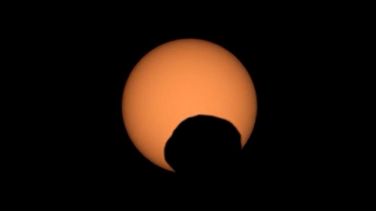
NASA's Perseverance Mars rover used its Mastcam-Z camera to capture the silhouette of Phobos, one of the two Martian moons, as it passed in front of the Sun on Sept. 30, 2024, the 1,285th Martian day, or sol, of the mission. Perseverance has captured several Phobos transits since its landing at Mars' Jezero Crater in February 2021. By comparing the various recordings, scientists can refine their understanding of the potato-shaped moon's orbit, learning how it is changing. Eons from now, Phobos' orbit is expected to eventually send the moon toward the Red Planet's surface. Arizona State University leads the operations of the Mastcam-Z instrument, working in collaboration with Malin Space Science Systems in San Diego, on the design, fabrication, testing, and operation of the cameras, and in collaboration with the Niels Bohr Institute of the University of Copenhagen on the design, fabrication, and testing of the calibration targets. A key objective for Perseverance's mission on Mars is astrobiology, including the search for signs of ancient microbial life. The rover will characterize the planet's geology and past climate, pave the way for human exploration of the Red Planet, and be the first mission to collect and cache Martian rock and regolith (broken rock and dust). Subsequent NASA missions, in cooperation with ESA (European Space Agency), would send spacecraft to Mars to collect these sealed samples from the surface and return them to Earth for in-depth analysis. The Mars 2020 Perseverance mission is part of NASA's Moon to Mars exploration approach, which includes Artemis missions to the Moon that will help prepare for human exploration of the Red Planet. Video available at https://photojournal.jpl.nasa.gov/catalog/PIA26380

NASA Terra spacecraft captures a clear sky image of the region of the recent Haiti earthquake.
As MESSENGER passes progressively closer to Mercury, we see ever more resolved features in the images the spacecraft returns. Here, at a pixel scale of 9 meters, we see the eastern portion of an unnamed crater 13 km (8 mi.) in diameter. The wall of the crater is replete with smaller, superposed craters, some of which appear elongate possibly because they impacted on the larger crater's inclined wall. Interestingly, there are bright spots on the sunlight portion of this crater's wall -- which is where we might expect hollows to form. This image was acquired as a high-resolution targeted observation. Targeted observations are images of a small area on Mercury's surface at resolutions much higher than the 200-meter/pixel morphology base map. It is not possible to cover all of Mercury's surface at this high resolution, but typically several areas of high scientific interest are imaged in this mode each week. Date acquired: March 3, 2014 Image Mission Elapsed Time (MET): 36136338 Image ID: 5862963 Instrument: Narrow Angle Camera (NAC) of the Mercury Dual Imaging System (MDIS) Center Latitude: 56.3° Center Longitude: 301.6° E Resolution: 9 meters/pixel Scale: The field of view in this image is 11 km (7 mi.) across Incidence Angle: 59.3° Emission Angle: 43.0° Phase Angle: 102.3° North is to the right in this scene. http://photojournal.jpl.nasa.gov/catalog/PIA18372

NASA's Atmospheric Infrared Sounder (AIRS) instrument captures a polar vortex moving from Central Canada into the U.S. Midwest from January 20 through January 29, 2019. The images show air temperatures at 600 millibars, around 2.5 miles (4 kilometers) high in Earth's troposphere. This polar vortex is responsible for surface air temperatures as low as -40 degrees Fahrenheit (also -40 degrees Celsius) and wind chill readings as low as the -50s and -60s Fahrenheit (-46 and -51 Celsius). Animation available at https://photojournal.jpl.nasa.gov/catalog/PIA22823
This view of Jupiter was captured by the JunoCam instrument aboard NASA's Juno spacecraft during the mission's 62nd close flyby of the giant planet on June 13, 2024. Citizen scientist Jackie Branc made the image using raw JunoCam data. https://photojournal.jpl.nasa.gov/catalog/PIA26350

NASA Hubble Space Telescope captures the chaotic activity atop a three-light-year-tall pillar of gas and dust that is being eaten away by the brilliant light from nearby bright stars in a tempestuous stellar nursery called the Carina Nebula.

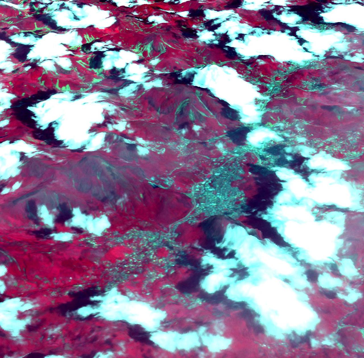
Landsat 7 image of Phoenix, Arizona acquired November 28, 2014. Landsat 7 is a U.S. satellite used to acquire remotely sensed images of the Earth's land surface and surrounding coastal regions. It is maintained by the Landsat 7 Project Science Office at the NASA Goddard Space Flight Center in Greenbelt, MD. Landsat satellites have been acquiring images of the Earth’s land surface since 1972. Currently there are more than 2 million Landsat images in the National Satellite Land Remote Sensing Data Archive. For more information visit: <a href="http://landsat.usgs.gov/" rel="nofollow">landsat.usgs.gov/</a>..To learn more about the Landsat satellite go to:.<a href="http://landsat.gsfc.nasa.gov/" rel="nofollow">landsat.gsfc.nasa.gov/</a> Credit: NASA/GSFC/Landsat 7 <b><a href="http://www.nasa.gov/audience/formedia/features/MP_Photo_Guidelines.html" rel="nofollow">NASA image use policy.</a></b> <b><a href="http://www.nasa.gov/centers/goddard/home/index.html" rel="nofollow">NASA Goddard Space Flight Center</a></b> enables NASA’s mission through four scientific endeavors: Earth Science, Heliophysics, Solar System Exploration, and Astrophysics. Goddard plays a leading role in NASA’s accomplishments by contributing compelling scientific knowledge to advance the Agency’s mission. <b>Follow us on <a href="http://twitter.com/NASAGoddardPix" rel="nofollow">Twitter</a></b> <b>Like us on <a href="http://www.facebook.com/pages/Greenbelt-MD/NASA-Goddard/395013845897?ref=tsd" rel="nofollow">Facebook</a></b> <b>Find us on <a href="http://instagrid.me/nasagoddard/?vm=grid" rel="nofollow">Instagram</a></b>

Landsat 7 image of Seattle, Washington acquired August 23, 2014. Landsat 7 is a U.S. satellite used to acquire remotely sensed images of the Earth's land surface and surrounding coastal regions. It is maintained by the Landsat 7 Project Science Office at the NASA Goddard Space Flight Center in Greenbelt, MD. Landsat satellites have been acquiring images of the Earth’s land surface since 1972. Currently there are more than 2 million Landsat images in the National Satellite Land Remote Sensing Data Archive. For more information visit: <a href="http://landsat.usgs.gov/" rel="nofollow">landsat.usgs.gov/</a>..To learn more about the Landsat satellite go to:.<a href="http://landsat.gsfc.nasa.gov/" rel="nofollow">landsat.gsfc.nasa.gov/</a> Credit: NASA/GSFC/Landsat 7 <b><a href="http://www.nasa.gov/audience/formedia/features/MP_Photo_Guidelines.html" rel="nofollow">NASA image use policy.</a></b> <b><a href="http://www.nasa.gov/centers/goddard/home/index.html" rel="nofollow">NASA Goddard Space Flight Center</a></b> enables NASA’s mission through four scientific endeavors: Earth Science, Heliophysics, Solar System Exploration, and Astrophysics. Goddard plays a leading role in NASA’s accomplishments by contributing compelling scientific knowledge to advance the Agency’s mission. <b>Follow us on <a href="http://twitter.com/NASAGoddardPix" rel="nofollow">Twitter</a></b> <b>Like us on <a href="http://www.facebook.com/pages/Greenbelt-MD/NASA-Goddard/395013845897?ref=tsd" rel="nofollow">Facebook</a></b> <b>Find us on <a href="http://instagrid.me/nasagoddard/?vm=grid" rel="nofollow">Instagram</a></b>
A corona mass ejection (CME) erupted from just around the edge of the sun on May 1, 2013, in a gigantic rolling wave. CMEs can shoot over a billion tons of particles into space at over a million miles per hour. This CME occurred on the sun’s limb and is not headed toward Earth. The video, taken in extreme ultraviolet light by NASA’s Solar Dynamics Observatory (SDO), covers about two and a half hours. Credit: NASA/Goddard/SDO <b><a href="http://www.nasa.gov/audience/formedia/features/MP_Photo_Guidelines.html" rel="nofollow">NASA image use policy.</a></b> <b><a href="http://www.nasa.gov/centers/goddard/home/index.html" rel="nofollow">NASA Goddard Space Flight Center</a></b> enables NASA’s mission through four scientific endeavors: Earth Science, Heliophysics, Solar System Exploration, and Astrophysics. Goddard plays a leading role in NASA’s accomplishments by contributing compelling scientific knowledge to advance the Agency’s mission. <b>Follow us on <a href="http://twitter.com/NASA_GoddardPix" rel="nofollow">Twitter</a></b> <b>Like us on <a href="http://www.facebook.com/pages/Greenbelt-MD/NASA-Goddard/395013845897?ref=tsd" rel="nofollow">Facebook</a></b> <b>Find us on <a href="http://instagram.com/nasagoddard?vm=grid" rel="nofollow">Instagram</a></b>

ISS047e021823 (03/26/2016) --- The Orbital ATK Cygnus cargo ship is seen on final approach to the International Space Station. The vehicle was captured at 6:51 a.m. EDT March 26 using the space station's Canadarm2 robotic arm by Expedition 47 Commander Tim Kopra. The unmanned cargo craft was then bolted to the Earth-facing port on the Unity module at 10:52 a.m. Orbital ATK’s fifth cargo delivery flight under its Commercial Resupply Services contract delivered over 7,700 pounds of cargo and included equipment to support some 250 experiments during Expeditions 47 and 48.
art002e021110 (April 6, 2026) – As the Artemis II crew came close to passing behind the Moon and experiencing a planned loss of signal, they captured this image of a crescent Earth. Seen from afar, it almost looks like a circular arc – except when backlit, as in other images captured by the Artemis II crew. Earth is in a crescent phase, with sunlight coming from the right. The dark portion of Earth is experiencing nighttime. On Earth’s day side, swirling clouds are visible over muted blue in the Australia and Oceania region. Credit: NASA
Europa Clipper, en route to the Jupiter system to investigate the icy moon Europa, swung by Mars on March 1, 2025, to use the planet's gravity to help shape the spacecraft's trajectory. The mission took the opportunity to capture to capture infrared images of the Red Planet using the orbiter's Europa Thermal Imaging System (E-THEMIS) to calibrate the instrument. This picture is a composite of several images captured by E-THEMIS, showing Mars' surface temperatures from about a million miles (1.6 million kilometers) away. Bright regions are relatively warm, with temperatures of about 32 degrees Fahrenheit (0 degrees Celsius). Darker areas are colder. The darkest region at the top is the northern polar cap and is about minus 190 F (minus 125 C). The temperature variations reflect the time of day on Mars, which was noon, with the center of the globe warmest because the Sun was shining directly onto the planet, near the equator, from behind Europa Clipper. Other variations reflect different surface features, with the fine-grained dust at the region near the equator being warm and coarser, rockier materials staying cooler. The instrument captured the images data in long-wave infrared wavelengths of about 7 to 14 micrometers. Europa Clipper launched from NASA's Kennedy Space Center in Florida on Oct. 14, 2024, and will arrive at the Jupiter system in 2030 to conduct about 50 flybys of Europa. The mission's main science goal is to determine whether there are places below Europa's surface that could support life. The mission's three main science objectives are to determine the thickness of the moon's icy shell and its surface interactions with the ocean below, to investigate its composition, and to characterize its geology. The mission's detailed exploration of Europa will help scientists better understand the astrobiological potential for habitable worlds beyond our planet. https://photojournal.jpl.nasa.gov/catalog/PIA26565
ISS040-E-069066 (16 July 2014) --- Surrounded by the blackness of space, the Orbital Sciences? Cygnus cargo craft is photographed by an Expedition 40 crew member onboard the International Space Station during rendezvous and capture operations. The two spacecraft converged at 6:36 a.m. (EDT) on July 16, 2014.
"View of the capture of the first Cygnus commercial cargo spacecraft built by Orbital Sciences Corp attached to the end of the robotic arm (AKA Canadarm2) on the International Space Station after the two spacecraft converged at 7:01 a.m. EDT on Sept. 29, 2013. " Also sent as Twitter message.
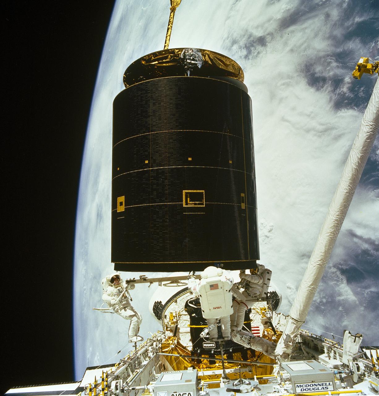
STS-49, the first flight of the Space Shuttle Orbiter Endeavour, lifted off from launch pad 39B on May 7, 1992 at 6:40 pm CDT. The STS-49 mission was the first U.S. orbital flight to feature 4 extravehicular activities (EVAs), and the first flight to involve 3 crew members working simultaneously outside of the spacecraft. The primary objective was the capture and redeployment of the INTELSAT VI (F-3), a communication satellite for the International Telecommunication Satellite organization, which was stranded in an unusable orbit since its launch aboard the Titan rocket in March 1990. The 4.5 ton INTELSAT VI was successfully snared by three astronauts on a third EVA. The three hand-grabbed the errant satellite, pulled it into the cargo bay, and attached a boost-given perigee stage before its release.
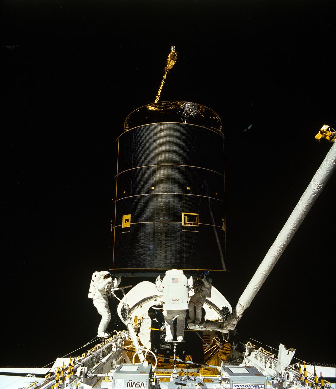
STS-49, the first flight of the Space Shuttle Orbiter Endeavour, lifted off from launch pad 39B on May 7, 1992 at 6:40 pm CDT. The STS-49 mission was the first U.S. orbital flight to feature 4 extravehicular activities (EVAs), and the first flight to involve 3 crew members working simultaneously outside of the spacecraft. The primary objective was the capture and redeployment of the INTELSAT VI (F-3), a communication satellite for the International Telecommunication Satellite organization, which was stranded in an unusable orbit since its launch aboard the Titan rocket in March 1990. The 4.5 ton INTELSAT VI was successfully snared by three astronauts on a third EVA. The three hand-grabbed the errant satellite, pulled it into the cargo bay, and attached a boost-given perigee stage before its release.

Hurricane Daniel intensified between July 18 and July 23rd. NASA new CloudSat satellite was able to capture and confirm this transformation in its side-view images of Hurricane Daniel as seen in this series of images
On Jan. 18, 2011, NASA Terra spacecraft captured this 3-D perspective image of the city of Nova Friburgo, Brazil. A week of torrential rains triggered a series of deadly mudslides and floods. More details about this image at the Photojournal.

NASA Terra spacecraft captured this cloud-free image over the city of Sukkur, Pakistan, on Aug. 18, 2010. Sukkur, located in southeastern Pakistan Sindh Province, is visible as the grey, urbanized area in the lower left center of the image.

NASA Hubble Space Telescope peered deep into Uranus atmosphere to see clear and hazy layers created by a mixture of gases. Using infrared filters, Hubble captured detailed features of three layers of Uranus atmosphere.
The brightest pulsar detected to date is shown in this frame from an animation that flips back and forth between images captured by NASA NuSTAR. A pulsar is a type of neutron star, the leftover core of a star that exploded in a supernova.
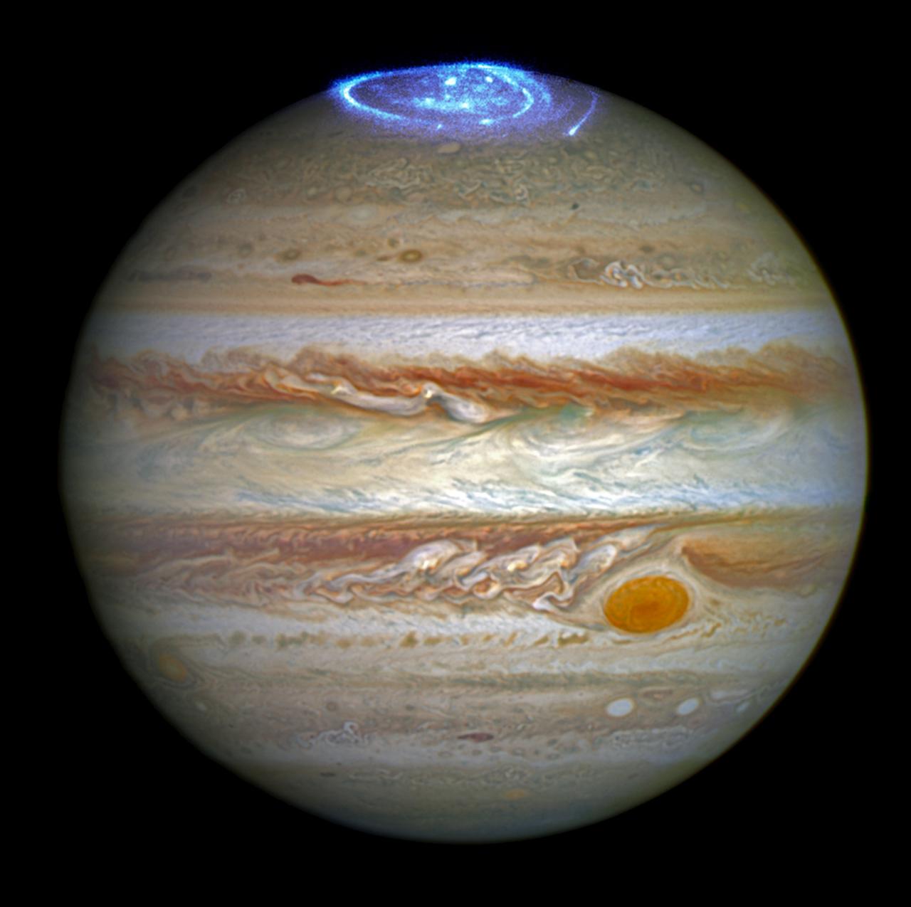
Astronomers are using the NASA/ESA Hubble Space Telescope to study auroras — stunning light shows in a planet’s atmosphere — on the poles of the largest planet in the solar system, Jupiter. This observation program is supported by measurements made by NASA’s Juno spacecraft, currently on its way to Jupiter. Jupiter, the largest planet in the solar system, is best known for its colorful storms, the most famous being the Great Red Spot. Now astronomers have focused on another beautiful feature of the planet, using Hubble's ultraviolet capabilities. The extraordinary vivid glows shown in the new observations are known as auroras. They are created when high-energy particles enter a planet’s atmosphere near its magnetic poles and collide with atoms of gas. As well as producing beautiful images, this program aims to determine how various components of Jupiter’s auroras respond to different conditions in the solar wind, a stream of charged particles ejected from the sun. This observation program is perfectly timed as NASA’s Juno spacecraft is currently in the solar wind near Jupiter and will enter the orbit of the planet in early July 2016. While Hubble is observing and measuring the auroras on Jupiter, Juno is measuring the properties of the solar wind itself; a perfect collaboration between a telescope and a space probe. “These auroras are very dramatic and among the most active I have ever seen”, said Jonathan Nichols from the University of Leicester, U.K., and principal investigator of the study. “It almost seems as if Jupiter is throwing a firework party for the imminent arrival of Juno.” Credits: NASA, ESA, and J. Nichols (University of Leicester)
The JunoCam instrument aboard NASA's Juno spacecraft captured two volcanic plumes rising above the horizon of Jupiter's moon Io on Feb. 3, 2024. Mission scientists think the plumes were emitted either by two vents from one giant volcano, or two volcanoes near each other. The JunoCam instrument imaged the plumes from a distance of about 2,400 miles (3,800 kilometers). Citizen scientist Andrea Luck made this image from raw JunoCam data. https://photojournal.jpl.nasa.gov/catalog/PIA26340
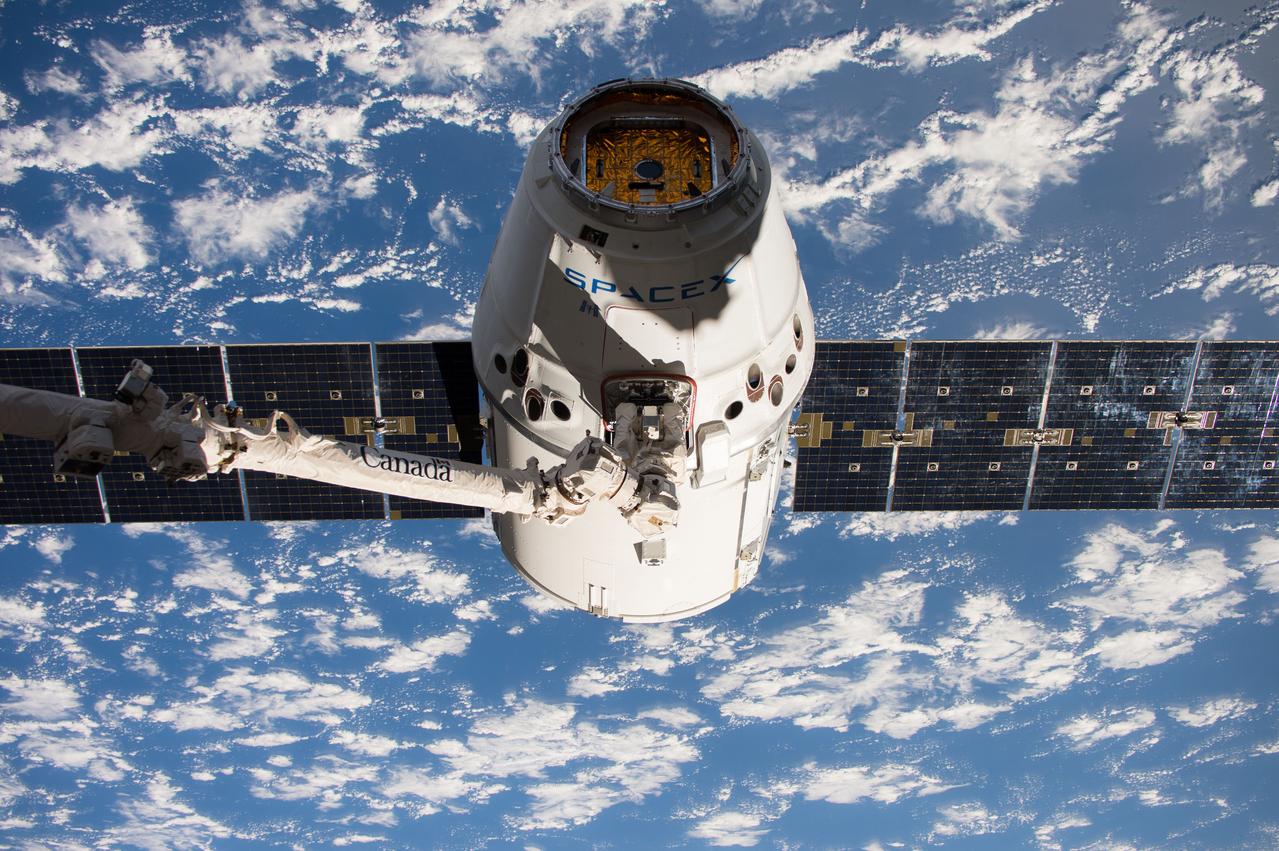
iss052e000436 (June 5, 2017) --- The SpaceX Dragon cargo craft is pictured in the grips of the Canadarm2 robotic arm moments after it was captured early Monday June 5, 2017.

This close-up view of Jupiter captures the turbulent region just west of the Great Red Spot in the South Equatorial Belt, with resolution better than any previous pictures from Earth or other spacecraft. NASA's Juno spacecraft captured this image with its JunoCam citizen science instrument when the spacecraft was a mere 5,400 miles (8,700 kilometers) above Jupiter's cloudtops on Dec. 11, 2016 at 9:14 a.m. PT (12:14 p.m. ET). Citizen scientist Sergey Dushkin produced the sublime color processing and cropped the image to draw viewers' eyes to the dynamic clouds. http://photojournal.jpl.nasa.gov/catalog/PIA21384 . - Enhanced image by Sergey Dushkin based on images provided courtesy of NASA/JPL-Caltech/SwRI/MSSS
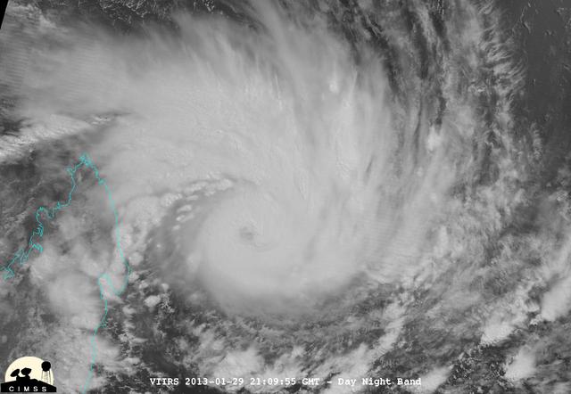
NASA-NOAA's Suomi NPP satellite captured this false-colored night-time image of Cyclone Felleng during the night on Jan. 28, 2013. Felleng is located in the Southern Indian Ocean, and is northwest of Madagascar. The image revealed some pretty cold overshooting tops, topping at ~170K. The image shows some interesting gravity waves propagating out from the storm in both the thermal and visible imagery. For full storm history on NASA's Hurricane Web Page, visit: <a href="http://www.nasa.gov/mission_pages/hurricanes/archives/2013/h2013_Felleng.html" rel="nofollow">www.nasa.gov/mission_pages/hurricanes/archives/2013/h2013...</a> Credit: William Straka, UWM/NASA/NOAA <b><a href="http://www.nasa.gov/audience/formedia/features/MP_Photo_Guidelines.html" rel="nofollow">NASA image use policy.</a></b> <b><a href="http://www.nasa.gov/centers/goddard/home/index.html" rel="nofollow">NASA Goddard Space Flight Center</a></b> enables NASA’s mission through four scientific endeavors: Earth Science, Heliophysics, Solar System Exploration, and Astrophysics. Goddard plays a leading role in NASA’s accomplishments by contributing compelling scientific knowledge to advance the Agency’s mission. <b>Follow us on <a href="http://twitter.com/NASA_GoddardPix" rel="nofollow">Twitter</a></b> <b>Like us on <a href="http://www.facebook.com/pages/Greenbelt-MD/NASA-Goddard/395013845897?ref=tsd" rel="nofollow">Facebook</a></b> <b>Find us on <a href="http://instagram.com/nasagoddard?vm=grid" rel="nofollow">Instagram</a></b>
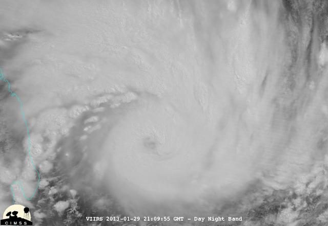
NASA-NOAA's Suomi NPP satellite captured this false-colored night-time image of Cyclone Felleng during the night on Jan. 28, 2013. Felleng is located in the Southern Indian Ocean, and is northwest of Madagascar. The image revealed some pretty cold overshooting tops, topping at ~170K. The image shows some interesting gravity waves propagating out from the storm in both the thermal and visible imagery. For full storm history on NASA's Hurricane Web Page, visit: <a href="http://www.nasa.gov/mission_pages/hurricanes/archives/2013/h2013_Felleng.html" rel="nofollow">www.nasa.gov/mission_pages/hurricanes/archives/2013/h2013...</a> Credit: William Straka, UWM/NASA/NOAA <b><a href="http://www.nasa.gov/audience/formedia/features/MP_Photo_Guidelines.html" rel="nofollow">NASA image use policy.</a></b> <b><a href="http://www.nasa.gov/centers/goddard/home/index.html" rel="nofollow">NASA Goddard Space Flight Center</a></b> enables NASA’s mission through four scientific endeavors: Earth Science, Heliophysics, Solar System Exploration, and Astrophysics. Goddard plays a leading role in NASA’s accomplishments by contributing compelling scientific knowledge to advance the Agency’s mission. <b>Follow us on <a href="http://twitter.com/NASA_GoddardPix" rel="nofollow">Twitter</a></b> <b>Like us on <a href="http://www.facebook.com/pages/Greenbelt-MD/NASA-Goddard/395013845897?ref=tsd" rel="nofollow">Facebook</a></b> <b>Find us on <a href="http://instagram.com/nasagoddard?vm=grid" rel="nofollow">Instagram</a></b>
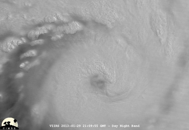
NASA-NOAA's Suomi NPP satellite captured this false-colored night-time image of Cyclone Felleng during the night on Jan. 28, 2013. Felleng is located in the Southern Indian Ocean, and is northwest of Madagascar. The image revealed some pretty cold overshooting tops, topping at ~170K. The image shows some interesting gravity waves propagating out from the storm in both the thermal and visible imagery. For full storm history on NASA's Hurricane Web Page, visit: <a href="http://www.nasa.gov/mission_pages/hurricanes/archives/2013/h2013_Felleng.html" rel="nofollow">www.nasa.gov/mission_pages/hurricanes/archives/2013/h2013...</a> Credit: William Straka, UWM/NASA/NOAA <b><a href="http://www.nasa.gov/audience/formedia/features/MP_Photo_Guidelines.html" rel="nofollow">NASA image use policy.</a></b> <b><a href="http://www.nasa.gov/centers/goddard/home/index.html" rel="nofollow">NASA Goddard Space Flight Center</a></b> enables NASA’s mission through four scientific endeavors: Earth Science, Heliophysics, Solar System Exploration, and Astrophysics. Goddard plays a leading role in NASA’s accomplishments by contributing compelling scientific knowledge to advance the Agency’s mission. <b>Follow us on <a href="http://twitter.com/NASA_GoddardPix" rel="nofollow">Twitter</a></b> <b>Like us on <a href="http://www.facebook.com/pages/Greenbelt-MD/NASA-Goddard/395013845897?ref=tsd" rel="nofollow">Facebook</a></b> <b>Find us on <a href="http://instagram.com/nasagoddard?vm=grid" rel="nofollow">Instagram</a></b>
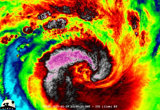
NASA-NOAA's Suomi NPP satellite captured this false-colored night-time image of Cyclone Felleng during the night on Jan. 28, 2013. Felleng is located in the Southern Indian Ocean, and is northwest of Madagascar. The image revealed some pretty cold overshooting tops, topping at ~170K. The image shows some interesting gravity waves propagating out from the storm in both the thermal and visible imagery. For full storm history on NASA's Hurricane Web Page, visit: <a href="http://www.nasa.gov/mission_pages/hurricanes/archives/2013/h2013_Felleng.html" rel="nofollow">www.nasa.gov/mission_pages/hurricanes/archives/2013/h2013...</a> Credit: William Straka, UWM/NASA/NOAA <b><a href="http://www.nasa.gov/audience/formedia/features/MP_Photo_Guidelines.html" rel="nofollow">NASA image use policy.</a></b> <b><a href="http://www.nasa.gov/centers/goddard/home/index.html" rel="nofollow">NASA Goddard Space Flight Center</a></b> enables NASA’s mission through four scientific endeavors: Earth Science, Heliophysics, Solar System Exploration, and Astrophysics. Goddard plays a leading role in NASA’s accomplishments by contributing compelling scientific knowledge to advance the Agency’s mission. <b>Follow us on <a href="http://twitter.com/NASA_GoddardPix" rel="nofollow">Twitter</a></b> <b>Like us on <a href="http://www.facebook.com/pages/Greenbelt-MD/NASA-Goddard/395013845897?ref=tsd" rel="nofollow">Facebook</a></b> <b>Find us on <a href="http://instagram.com/nasagoddard?vm=grid" rel="nofollow">Instagram</a></b>
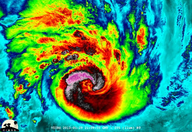
NASA-NOAA's Suomi NPP satellite captured this false-colored night-time image of Cyclone Felleng during the night on Jan. 28, 2013. Felleng is located in the Southern Indian Ocean, and is northwest of Madagascar. The image revealed some pretty cold overshooting tops, topping at ~170K. The image shows some interesting gravity waves propagating out from the storm in both the thermal and visible imagery. For full storm history on NASA's Hurricane Web Page, visit: <a href="http://www.nasa.gov/mission_pages/hurricanes/archives/2013/h2013_Felleng.html" rel="nofollow">www.nasa.gov/mission_pages/hurricanes/archives/2013/h2013...</a> Credit: William Straka, UWM/NASA/NOAA <b><a href="http://www.nasa.gov/audience/formedia/features/MP_Photo_Guidelines.html" rel="nofollow">NASA image use policy.</a></b> <b><a href="http://www.nasa.gov/centers/goddard/home/index.html" rel="nofollow">NASA Goddard Space Flight Center</a></b> enables NASA’s mission through four scientific endeavors: Earth Science, Heliophysics, Solar System Exploration, and Astrophysics. Goddard plays a leading role in NASA’s accomplishments by contributing compelling scientific knowledge to advance the Agency’s mission. <b>Follow us on <a href="http://twitter.com/NASA_GoddardPix" rel="nofollow">Twitter</a></b> <b>Like us on <a href="http://www.facebook.com/pages/Greenbelt-MD/NASA-Goddard/395013845897?ref=tsd" rel="nofollow">Facebook</a></b> <b>Find us on <a href="http://instagram.com/nasagoddard?vm=grid" rel="nofollow">Instagram</a></b>
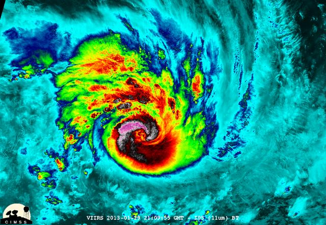
NASA-NOAA's Suomi NPP satellite captured this false-colored night-time image of Cyclone Felleng during the night on Jan. 28, 2013. Felleng is located in the Southern Indian Ocean, and is northwest of Madagascar. The image revealed some pretty cold overshooting tops, topping at ~170K. The image shows some interesting gravity waves propagating out from the storm in both the thermal and visible imagery. For full storm history on NASA's Hurricane Web Page, visit: <a href="http://www.nasa.gov/mission_pages/hurricanes/archives/2013/h2013_Felleng.html" rel="nofollow">www.nasa.gov/mission_pages/hurricanes/archives/2013/h2013...</a> Credit: William Straka, UWM/NASA/NOAA <b><a href="http://www.nasa.gov/audience/formedia/features/MP_Photo_Guidelines.html" rel="nofollow">NASA image use policy.</a></b> <b><a href="http://www.nasa.gov/centers/goddard/home/index.html" rel="nofollow">NASA Goddard Space Flight Center</a></b> enables NASA’s mission through four scientific endeavors: Earth Science, Heliophysics, Solar System Exploration, and Astrophysics. Goddard plays a leading role in NASA’s accomplishments by contributing compelling scientific knowledge to advance the Agency’s mission. <b>Follow us on <a href="http://twitter.com/NASA_GoddardPix" rel="nofollow">Twitter</a></b> <b>Like us on <a href="http://www.facebook.com/pages/Greenbelt-MD/NASA-Goddard/395013845897?ref=tsd" rel="nofollow">Facebook</a></b> <b>Find us on <a href="http://instagram.com/nasagoddard?vm=grid" rel="nofollow">Instagram</a></b>
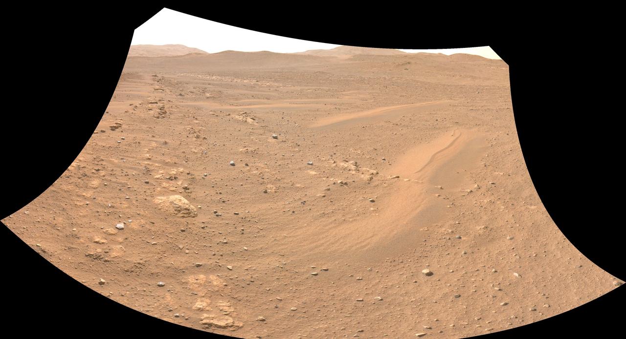
One of the Navcam imagers aboard NASA's Perseverance Mars rover captured the Ingenuity Mars Helicopter on Feb. 26, 2023, the 719th Martian day, or sol, of the mission. The helicopter is visible in the upper left of image. Ingenuity had landed there, at "Airfield Theta," on the previous sol at the conclusion of its 46th flight on Mars. At the time this enhanced image was taken, the helicopter was approximately 490 feet (150 meters) from the rover. Figure A is the same enhanced image annotated to indicate the location of the Mars Helicopter in the distance. A key objective for Perseverance's mission on Mars is astrobiology, including the search for signs of ancient microbial life. The rover will characterize the planet's geology and past climate, pave the way for human exploration of the Red Planet, and be the first mission to collect and cache Martian rock and regolith (broken rock and dust). Subsequent NASA missions, in cooperation with ESA (European Space Agency), would send spacecraft to Mars to collect these sealed samples from the surface and return them to Earth for in-depth analysis. The Mars 2020 Perseverance mission is part of NASA's Moon to Mars exploration approach, which includes Artemis missions to the Moon that will help prepare for human exploration of the Red Planet.NASA's Jet Propulsion Laboratory, which is managed for the agency by Caltech in Pasadena, California, built and manages operations of the Perseverance rover. https://photojournal.jpl.nasa.gov/catalog/PIA25685
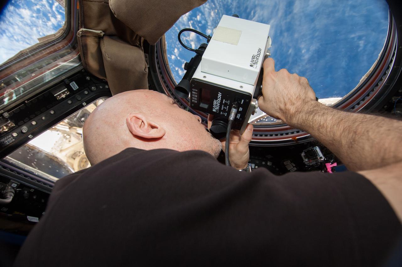
ISS037-E-003918 (29 Sept. 2013) --- At the windows in the International Space Station?s Cupola, European Space Agency astronaut Luca Parmitano, Expedition 37 flight engineer, uses a laser range finder during rendezvous, capture and docking operations with the first Cygnus commercial cargo spacecraft (out of frame) built by Orbital Sciences Corp. The two spacecraft converged at 7:01 a.m. EDT on Sept. 29, 2013.
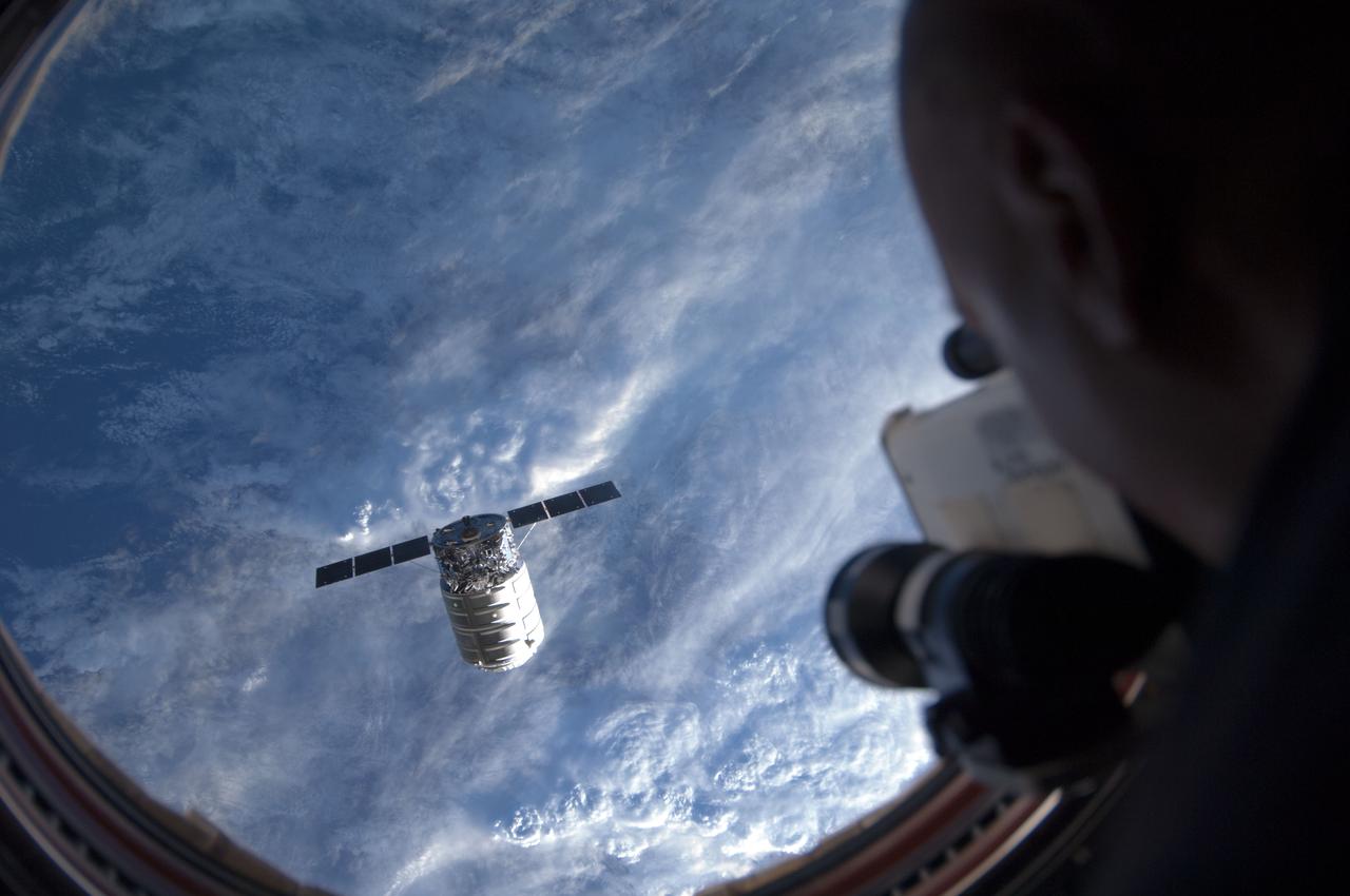
ISS037-E-003937 (29 Sept. 2013) --- At the windows in the International Space Station?s Cupola, European Space Agency astronaut Luca Parmitano, Expedition 37 flight engineer, uses a laser range finder during rendezvous, capture and docking operations with the first Cygnus commercial cargo spacecraft built by Orbital Sciences Corp. The two spacecraft converged at 7:01 a.m. EDT on Sept. 29, 2013.
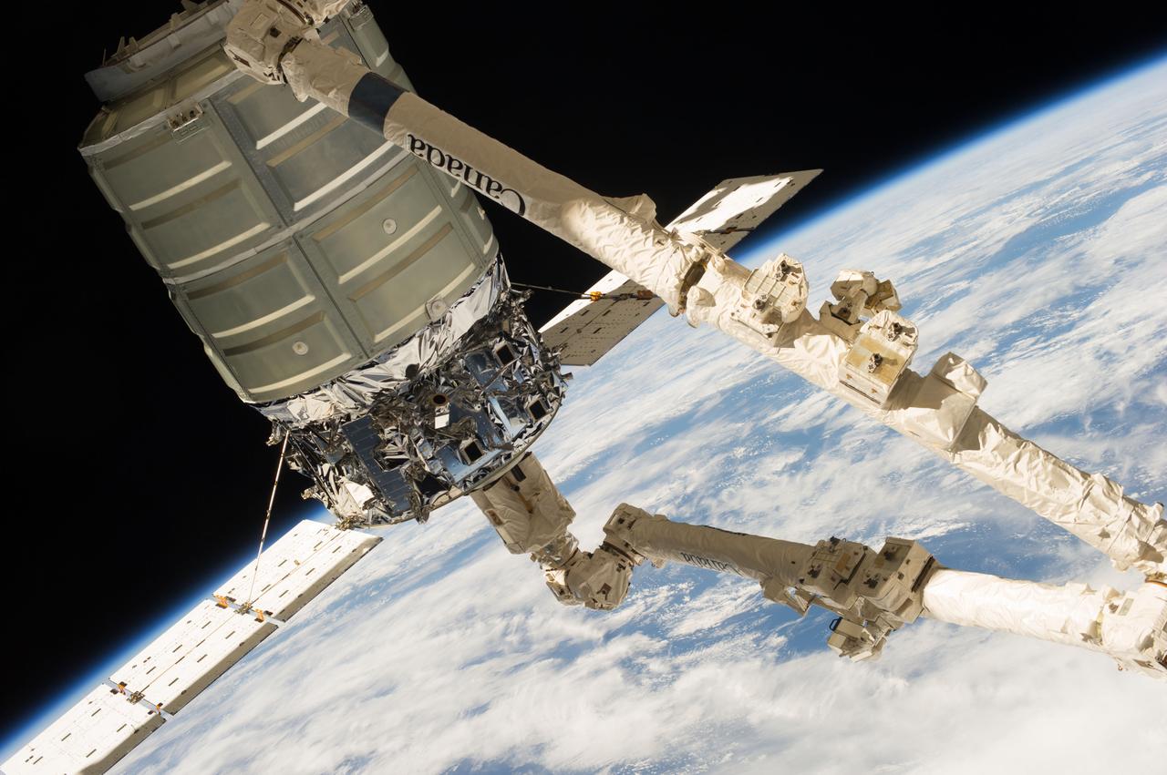
ISS037-E-003897 (29 Sept. 2013) --- The first Cygnus commercial cargo spacecraft built by Orbital Sciences Corp., in the grasp of the Canadarm2, is photographed by an Expedition 37 crew member on the International Space Station during rendezvous, capture and docking operations. The two spacecraft converged at 7:01 a.m. EDT on Sept. 29, 2013. Earth’s horizon and the blackness of space provide the backdrop for the scene.
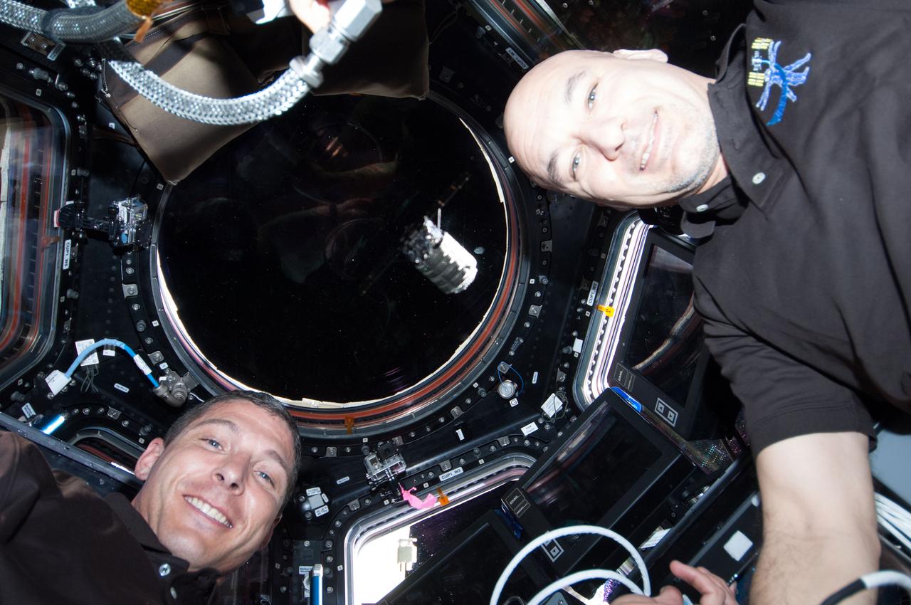
ISS037-E-003935 (29 Sept. 2013) --- NASA astronaut Michael Hopkins (left) and European Space Agency astronaut Luca Parmitano, both Expedition 37 flight engineers, pose for a photo near the windows in the International Space Station?s Cupola during rendezvous, capture and docking operations with the first Cygnus commercial cargo spacecraft (visible at center frame) built by Orbital Sciences Corp. The two spacecraft converged at 7:01 a.m. EDT on Sept. 29, 2013.
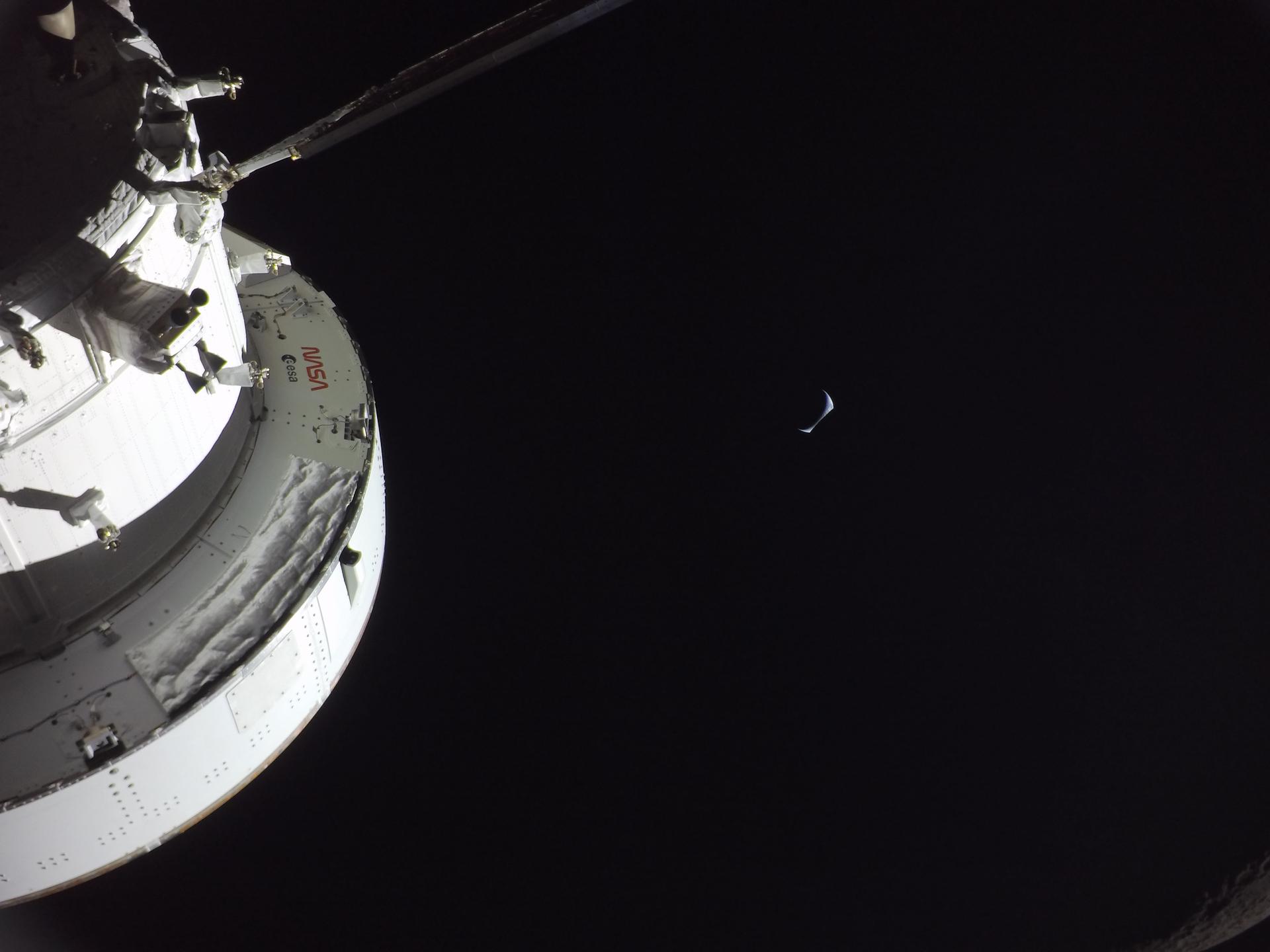
art002e016299 (April 6, 2026) - Earthrise captured from a camera mounted on one of the Orion spacecraft’s solar array wings at 7:22 p.m. ET during the Artemis II crew’s flyby of the Moon’s far side. Earth appears as a delicate sliver - with the portion on the left darkened by shadow and a portion on the right tucking away behind the Moon. A closer look reveals that the Moon occupies the bottom right portion of the photo, identifiable by the edge of it seen in visible light near the bottom corner. Credit: NASA
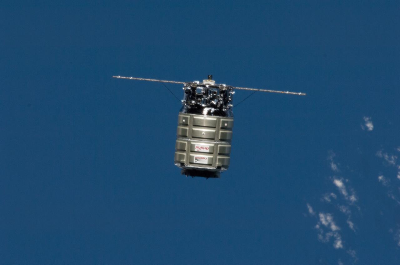
ISS040-E-068069 (16 July 2014) --- The Orbital Sciences’ Cygnus cargo craft is photographed by an Expedition 40 crew member on the International Space Station during rendezvous and capture operations. The two spacecraft converged at 6:36 a.m. (EDT) on July 16, 2014.
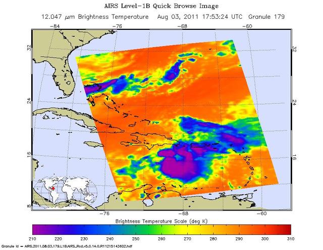
Tropical Storm Emily continues its march toward Hispaniola, which it is expected to reach later on Aug. 3. NASA Aqua spacecraft captured this infrared image 1:53 p.m. EDT on Aug. 3, with the storm located south of Santo Domingo, Dominican Republic.
Orion’s black-and-white optical navigation camera captured this view of the Moon on the fourth day of the Artemis I mission. Orion uses the optical navigation camera to capture imagery of the Earth and the Moon at different phases and distances, providing an enhanced body of data to certify its effectiveness as a method for determining its position in space for future missions under differing lighting conditions.
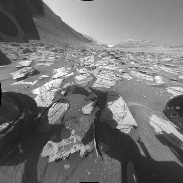
NASA's Curiosity Mars rover recorded two 25-frame videos showing the passage of 12 hours on Nov. 8, 2023, the 4,002nd Martian day, or sol, of the mission. The commands to capture the images that make up these videos were among the last that engineers beamed up to the rover before the start of Mars solar conjunction – a period of several weeks when the Sun is between Earth and Mars. Because the Sun's plasma can interfere with radio communications, NASA's Mars missions stand down from sending commands to their spacecraft during conjunction, bringing the missions to a temporary standstill. (The spacecraft still radio back their health status during this period.) The images were captured with Curiosity's front and rear Hazard-Avoidance Cameras, or Hazcams. Rover drivers use these black-and-white cameras to plan safe drive routes. A long series of images can be put together to create a video so that scientists can look for passing clouds or dust devils, which teach them more about the Martian environment. The perfect time for doing this type of work is when Curiosity is less active for long stretches, as it was during Mars solar conjunction. The lack of robotic arm motion and driving during conjunction allowed the Hazcams to image for 12 hours of a day – from 5:30 a.m. to 5:30 p.m. local Mars time – for the first time. While these Hazcam videos didn't reveal any clouds or dust activity, they did capture the passage of time as the Sun rose and set. The main video shows the front Hazcam's view looking southeast along Gediz Vallis, a valley found on Mount Sharp, the base of which Curiosity has been ascending since 2014. The sky brightens during sunrise in the east (left of image), and the shadow of the rover's stationary 7-foot (2-meter) robotic arm moves across the ground like that of a sundial. The rover's two front wheels are visible on each side of the frame; at upper left is a circular calibration target mounted on the shoulder of the robotic arm. Engineers use the target to test the accuracy of the Alpha Particle X-ray Spectrometer, an instrument that detects chemical elements on the Martian surface. In the middle of the day, the camera's autoexposure algorithm settles on exposure times of around one-third of a second; as evening turns to night, that exposure time grows to more than a minute, causing typical sensor noise known as "hot pixels" that appear as snow across the final image. Video available at https://photojournal.jpl.nasa.gov/catalog/PIA26209
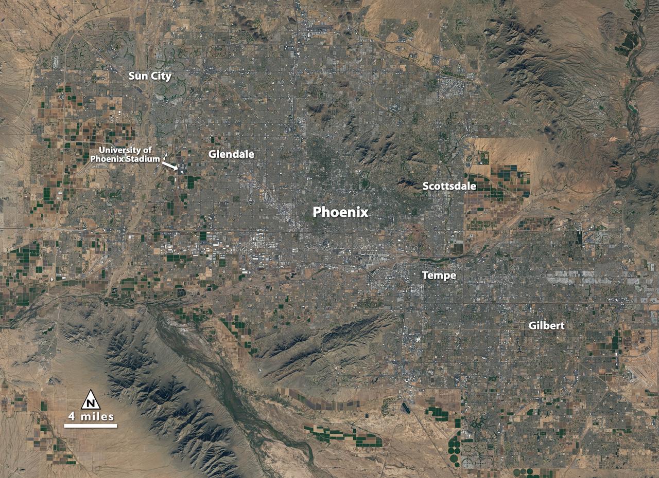
Landsat 7 image of Phoenix, Arizona acquired November 28, 2014. Landsat 7 is a U.S. satellite used to acquire remotely sensed images of the Earth's land surface and surrounding coastal regions. It is maintained by the Landsat 7 Project Science Office at the NASA Goddard Space Flight Center in Greenbelt, MD. Landsat satellites have been acquiring images of the Earth’s land surface since 1972. Currently there are more than 2 million Landsat images in the National Satellite Land Remote Sensing Data Archive. For more information visit: <a href="http://landsat.usgs.gov/" rel="nofollow">landsat.usgs.gov/</a>..To learn more about the Landsat satellite go to:.<a href="http://landsat.gsfc.nasa.gov/" rel="nofollow">landsat.gsfc.nasa.gov/</a> Credit: NASA/GSFC/Landsat 7 <b><a href="http://www.nasa.gov/audience/formedia/features/MP_Photo_Guidelines.html" rel="nofollow">NASA image use policy.</a></b> <b><a href="http://www.nasa.gov/centers/goddard/home/index.html" rel="nofollow">NASA Goddard Space Flight Center</a></b> enables NASA’s mission through four scientific endeavors: Earth Science, Heliophysics, Solar System Exploration, and Astrophysics. Goddard plays a leading role in NASA’s accomplishments by contributing compelling scientific knowledge to advance the Agency’s mission. <b>Follow us on <a href="http://twitter.com/NASAGoddardPix" rel="nofollow">Twitter</a></b> <b>Like us on <a href="http://www.facebook.com/pages/Greenbelt-MD/NASA-Goddard/395013845897?ref=tsd" rel="nofollow">Facebook</a></b> <b>Find us on <a href="http://instagrid.me/nasagoddard/?vm=grid" rel="nofollow">Instagram</a></b>

Landsat 7 image of Boston/Providence area acquired August 25, 2014. Landsat 7 is a U.S. satellite used to acquire remotely sensed images of the Earth's land surface and surrounding coastal regions. It is maintained by the Landsat 7 Project Science Office at the NASA Goddard Space Flight Center in Greenbelt, MD...Landsat satellites have been acquiring images of the Earth’s land surface since 1972. Currently there are more than 2 million Landsat images in the National Satellite Land Remote Sensing Data Archive. For more information visit: <a href="http://landsat.usgs.gov/" rel="nofollow">landsat.usgs.gov/</a>..To learn more about the Landsat satellite go to:.<a href="http://landsat.gsfc.nasa.gov/" rel="nofollow">landsat.gsfc.nasa.gov/</a> Credit: NASA/GSFC/Landsat 7 <b><a href="http://www.nasa.gov/audience/formedia/features/MP_Photo_Guidelines.html" rel="nofollow">NASA image use policy.</a></b> <b><a href="http://www.nasa.gov/centers/goddard/home/index.html" rel="nofollow">NASA Goddard Space Flight Center</a></b> enables NASA’s mission through four scientific endeavors: Earth Science, Heliophysics, Solar System Exploration, and Astrophysics. Goddard plays a leading role in NASA’s accomplishments by contributing compelling scientific knowledge to advance the Agency’s mission. <b>Follow us on <a href="http://twitter.com/NASAGoddardPix" rel="nofollow">Twitter</a></b> <b>Like us on <a href="http://www.facebook.com/pages/Greenbelt-MD/NASA-Goddard/395013845897?ref=tsd" rel="nofollow">Facebook</a></b> <b>Find us on <a href="http://instagrid.me/nasagoddard/?vm=grid" rel="nofollow">Instagram</a></b>
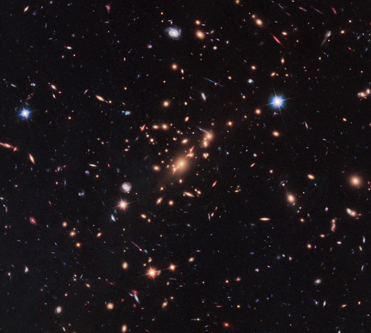
By combining the power of a "natural lens" in space with the capability of NASA's Hubble Space Telescope, astronomers made a surprising discovery—the first example of a compact yet massive, fast-spinning, disk-shaped galaxy that stopped making stars only a few billion years after the big bang. Finding such a galaxy early in the history of the universe challenges the current understanding of how massive galaxies form and evolve, say researchers. Read more: <a href="https://go.nasa.gov/2sWwKkc" rel="nofollow">go.nasa.gov/2sWwKkc</a> caption: Acting as a “natural telescope” in space, the gravity of the extremely massive foreground galaxy cluster MACS J2129-0741 magnifies, brightens, and distorts the far-distant background galaxy MACS2129-1, shown in the top box. The middle box is a blown-up view of the gravitationally lensed galaxy. In the bottom box is a reconstructed image, based on modeling that shows what the galaxy would look like if the galaxy cluster were not present. The galaxy appears red because it is so distant that its light is shifted into the red part of the spectrum. Credits: NASA, ESA, M. Postman (STScI), and the CLASH team <b><a href="http://www.nasa.gov/audience/formedia/features/MP_Photo_Guidelines.html" rel="nofollow">NASA image use policy.</a></b> <b><a href="http://www.nasa.gov/centers/goddard/home/index.html" rel="nofollow">NASA Goddard Space Flight Center</a></b> enables NASA’s mission through four scientific endeavors: Earth Science, Heliophysics, Solar System Exploration, and Astrophysics. Goddard plays a leading role in NASA’s accomplishments by contributing compelling scientific knowledge to advance the Agency’s mission. <b>Follow us on <a href="http://twitter.com/NASAGoddardPix" rel="nofollow">Twitter</a></b> <b>Like us on <a href="http://www.facebook.com/pages/Greenbelt-MD/NASA-Goddard/395013845897?ref=tsd" rel="nofollow">Facebook</a></b> <b>Find us on <a href="http://instagrid.me/nasagoddard/?vm=grid" rel="nofollow">Instagram</a></b>

NASA image acquired: March 29, 2011 The first image acquired by MESSENGER from orbit around Mercury was actually part of an eight-image sequence, for which images were acquired through eight of the WAC’s eleven filters. Here we see a color version of that first imaged terrain; in this view the images obtained through the filters with central wavelengths of 1000 nm, 750 nm, and 430 nm are displayed in red, green, and blue, respectively. One of MESSENGER’s measurement objectives is to create an eight-color global base map at a resolution of 1 km/pixel (0.6 miles/pixel) to help understand the variations of composition across Mercury’s surface. On March 17, 2011 (March 18, 2011, UTC), MESSENGER became the first spacecraft ever to orbit the planet Mercury. The mission is currently in its commissioning phase, during which spacecraft and instrument performance are verified through a series of specially designed checkout activities. In the course of the one-year primary mission, the spacecraft's seven scientific instruments and radio science investigation will unravel the history and evolution of the Solar System's innermost planet. Visit the Why Mercury? section of this website to learn more about the science questions that the MESSENGER mission has set out to answer. Credit: NASA/Johns Hopkins University Applied Physics Laboratory/Carnegie Institution of Washington <b><a href="http://www.nasa.gov/centers/goddard/home/index.html" rel="nofollow">NASA Goddard Space Flight Center</a></b> enables NASA’s mission through four scientific endeavors: Earth Science, Heliophysics, Solar System Exploration, and Astrophysics. Goddard plays a leading role in NASA’s accomplishments by contributing compelling scientific knowledge to advance the Agency’s mission. <b>Follow us on <a href="http://twitter.com/NASA_GoddardPix" rel="nofollow">Twitter</a></b> <b>Join us on <a href="http://www.facebook.com/pages/Greenbelt-MD/NASA-Goddard/395013845897?ref=tsd" rel="nofollow">Facebook</a></b>