
This region of central Asia is situated at the juncture of Mongolia, China and Russia. This image from NASA Terra satellite is MISR Mystery Image Quiz #7.

iss073e0920829 (Oct. 20, 2025) --- This celestial view from a window aboard the SpaceX Dragon crew spacecraft captures the city lights of Central Asia sparkling underneath a bright yellow airglow as an orbital sunrise begins to illuminate Earth's atmosphere underneath a starry night sky. The International Space Station was orbiting 263 miles above Uzbekistan at approximately 4:40 a.m. local time when this long-exposure photograph was taken.
The ASTER instrument onboard NASA Terra spacecraft imaged the Khyber Pass, a mountain pass that links Afghanistan and Pakistan. Throughout its history it has been an important trade route between Central Asia and South Asia.
The 5000 meter 16,000 feet high Tibetan Plateau has been formed by the collision of the Indian subcontinent with central Asia.
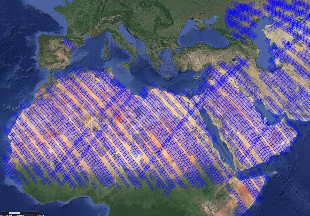
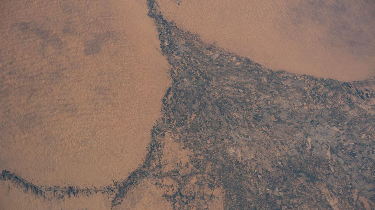
This image shows locations in parts of North Africa, Europe, the Middle East, and Central Asia observed by NASA's Earth Surface Mineral Dust Source Investigation (EMIT). Each blue box is a "scene" the instrument, which is aboard the International Space Station, has captured. The red box indicates where the instrument recently gathered data on three minerals in a location in southwest Libya, in the Sahara Desert. Installed on the space station in July 2022, EMIT orbits Earth about once every 90 minutes to map the world's mineral-dust sources, gathering information about surface composition as the instrument completes about 16 orbits per day. Over the course of its 12-month mission, EMIT will collect measurements of 10 important surface minerals – kaolinite, hematite, goethite, illite, vermiculite, calcite, dolomite, montmorillonite, chlorite, and gypsum – in arid regions between 50-degree south and north latitudes in Africa, Asia, North and South America, and Australia. The data EMIT collects will help scientists better understand the role of airborne dust particles in heating and cooling Earth's atmosphere on global and regional scales. https://photojournal.jpl.nasa.gov/catalog/PIA25429
iss066e089960 (Dec. 11, 2021) --- Kazakhstan's snowy, northeast border with Russia is pictured from the International Space Station as it orbited 266 miles above central Asia.
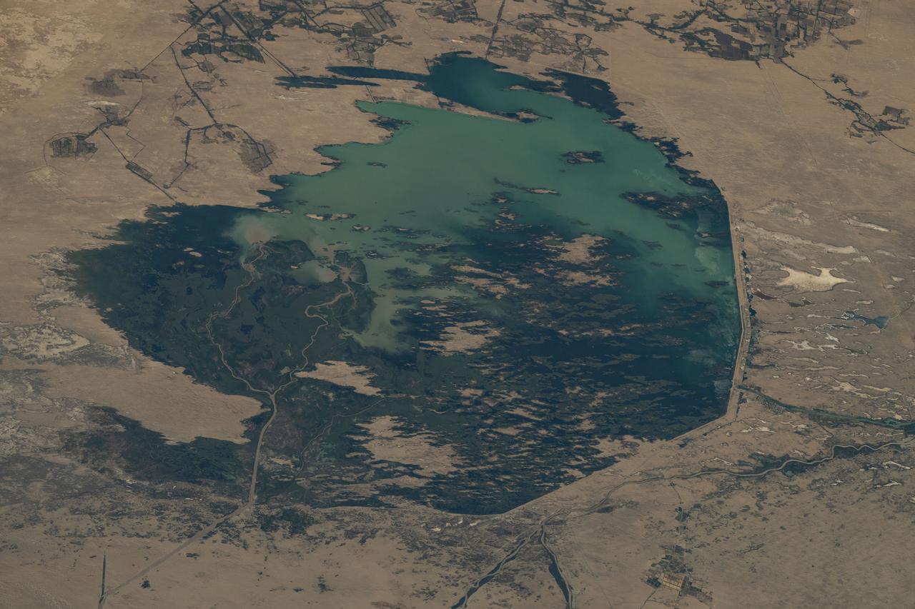
iss072e005520 (Sept. 29, 2024) -- One of the largest lakes in Central Asia, Lake Balkhash, was pictured from the International Space Station as it orbited 260 miles above.
Earth observation taken by an Expedition 36 crew member on board the International Space Station (ISS). Per Twitter message: Tien Shan mountain range, Central Asia.
iss067e302507 (Sept. 1, 2022) --- The Karakum Desert oasis in the Mary region of Turkmenistan is pictured from the International Space Station as it orbited 260 miles above Central Asia.
iss067e212667 (July 31, 2022) --- The Uzbekistan cities of Urgench and Xonqa near the Amu Darya, a major river in Central Asia, are pictured from the International Space Station as it orbited 259 miles above.
iss070e042553 (Dec. 17, 2023) --- The Uly Balkan mountian range in Turkmenistan near the coast of the Caspian Sea is pictured from the International Space Station as it orbited 260 miles above the central Asia nation.
iss070e091704 (Feb. 10, 2024) --- A portion of the Pamir Mountains, a mountain range at the northwest junction of the Himalayas and crossing several Central Asia countries, is pictured from the Interntional Space Station as it orbited 261 miles above Uzbekistan.
iss071e312274 (June 20, 2024) --- The Gökdepe köli fishing pond in the Ahal Region of Turkmenistan is pictured from the International Space Station as it orbited 265 miles above Central Asia.
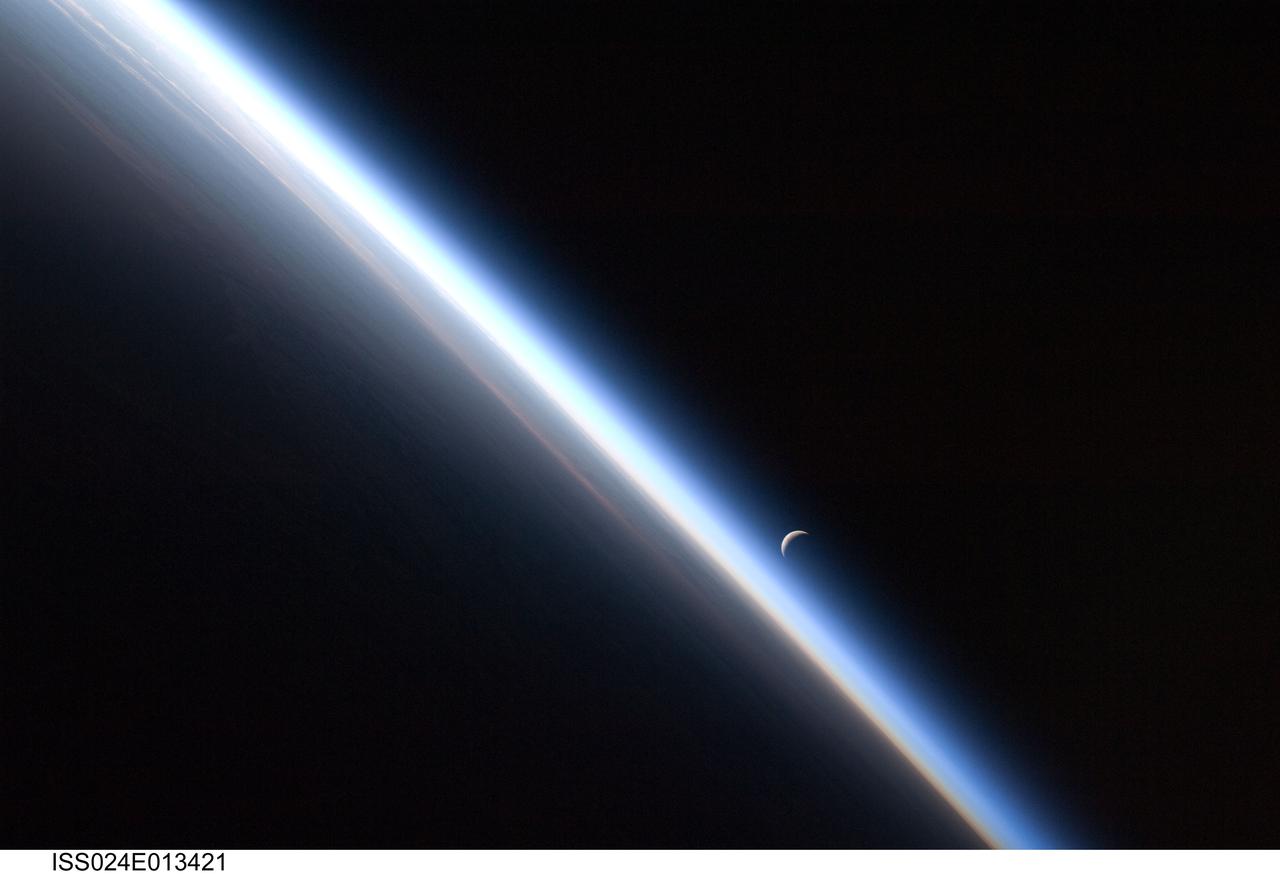
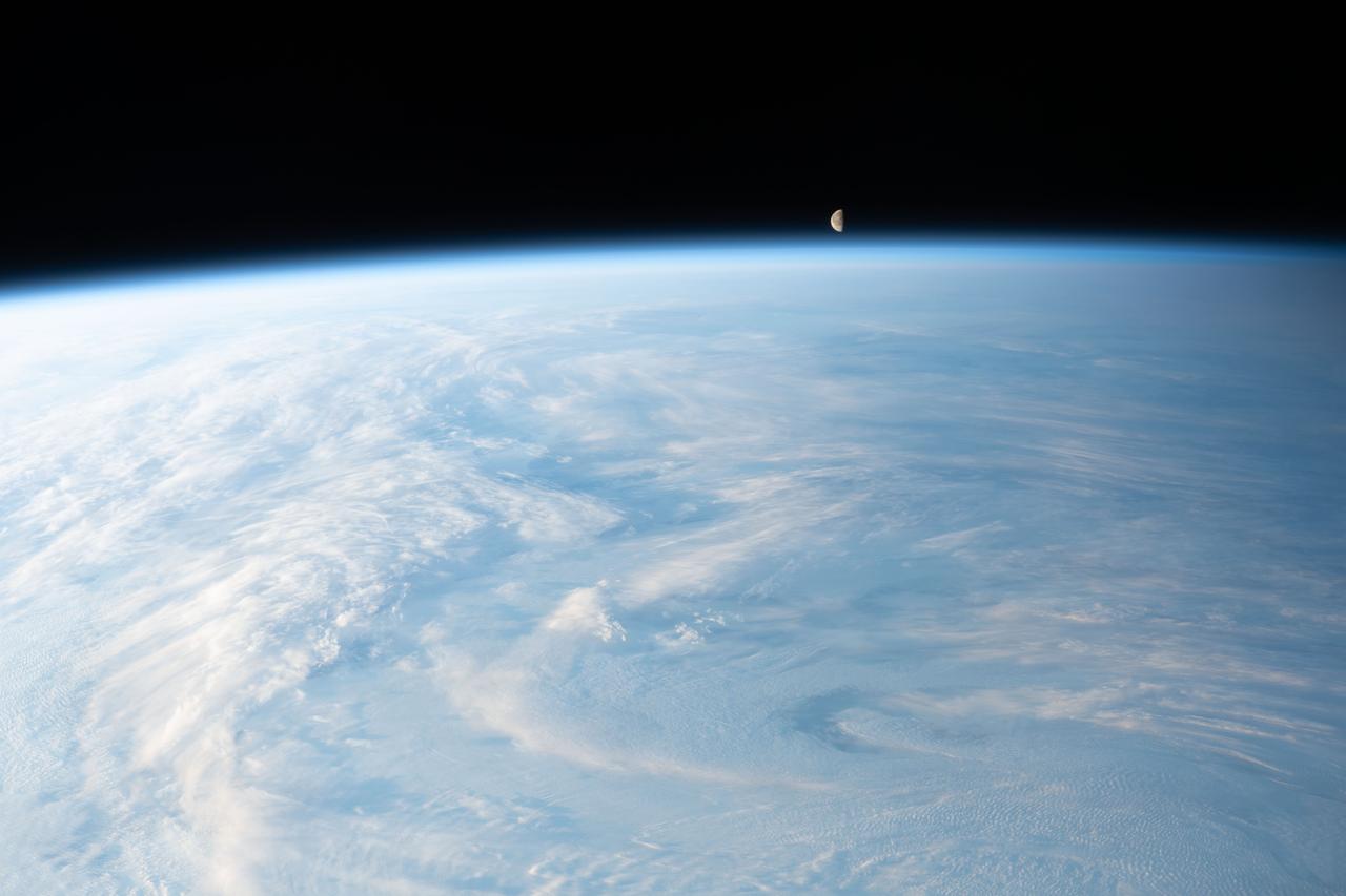
ISS024-E-013421 (4 Sept. 2010) --- A setting last quarter crescent moon and the thin line of Earth’s atmosphere are photographed by an Expedition 24 crew member as the International Space Station passes over central Asia.

iss062e081626 (March 4, 2020) --- The atmospheric glow floats above Earth's moonlit horizon beneath a starry sky as the International Space Station orbited 263 miles above central Asia.
iss070e035253 (Dec. 4, 2023) --- The waning gibbous Moon is pictured just above Earth's horizon in this photograph from the International Space Station as it orbited 262 miles above a cloudy central Asia.
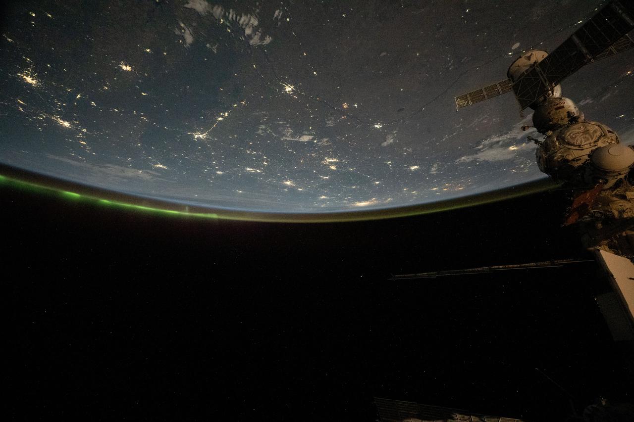
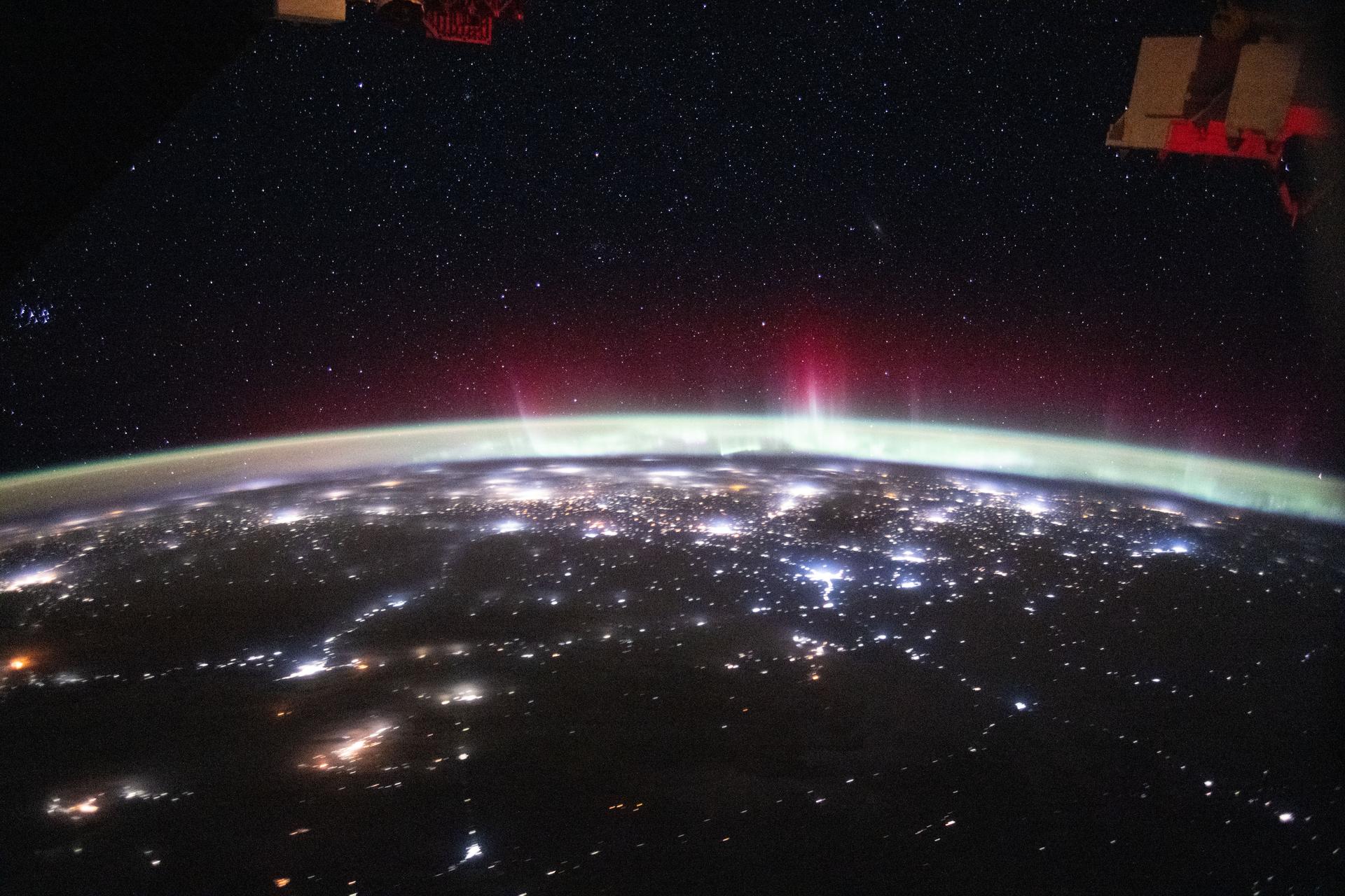
iss071e695419 (Sept. 16, 2024) --- The city lights of central Asia and an aurora crowning Earth's horizon are pictured in this photograph from the International Space Station as it orbited 264 miles above western Kazakhstan.
iss071e092895 (May 20, 2024) --- Mud Volcano in Pakistan's western district of Chagai is pictured from the International Space Station as it orbited 258 miles above central Asia.
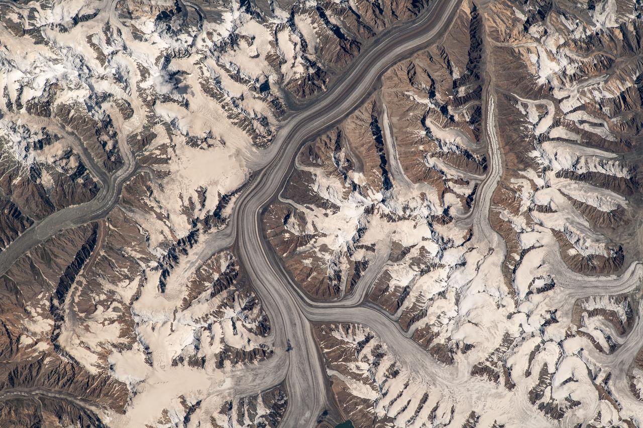
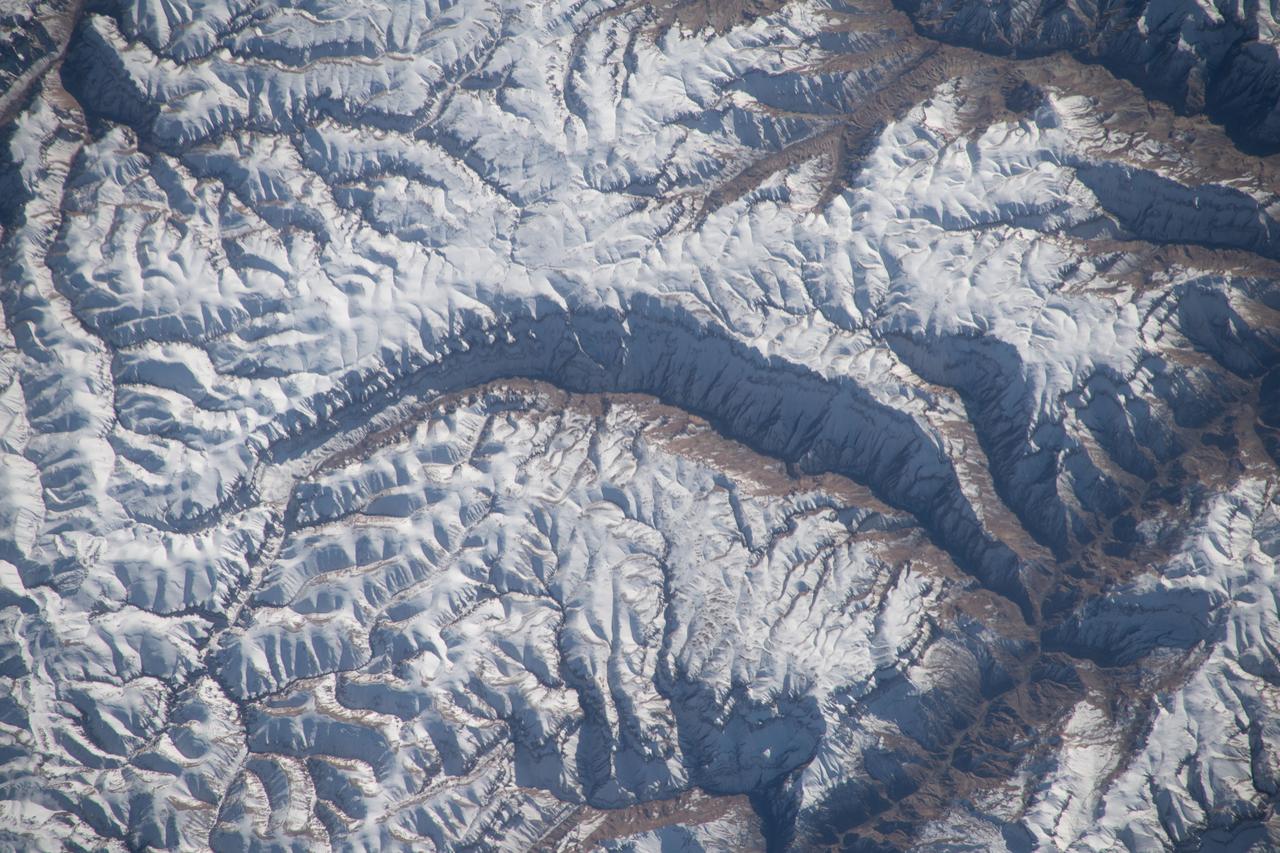
iss069e060329 (Aug. 15, 2023) --- Glaciers in the Pamir mountain range located in The Republic of Tajikistan are pictured from the International Space Station as it orbited 264 miles above Central Asia.
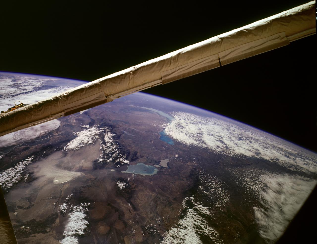
STS085-503-061 (7 - 19 August 1997) --- Lakes Balkhash and Alakol, southern uplands of Kazakhstan, central Asia. The long, 600 kilometers arc of Lake Balkhash occupies the center of this clear west-looking view. The left of the view shows clearly the westernmost Dzungarian Basin in the autonomous region of Xinjiang Uygur (Sinkiang), China. Kazakhstan's capital city Almaty (Alma-Ata) lies out of sight behind the boom. The Dzungarian Gate is the straight, fault-bounded valley cutting through the Dzhungarskiy Alatau Range. The Gate has acted as a major pass for centuries, allowing access between east Asia and central Asia (the valley floor is about 1,500 feet, whereas peaks reach 15,000 feet on the west and about 10,000 feet on the east side) -- it was one of the routes used by the Mongols when they began their invasion of central Asia and Europe in the 13th century. Lake Ebinur is the bright area beneath the dust plume (left center); strong north winds from the steppes of Kazakhstan and Russia are funneled through the Dzungarian Gate where they pick up sediment from dry lakebeds and blow it into China. The Ili River flows westward, parallel to the Dzhungarskiy Alatau Range, through Kapchagay Lake (partially visible beneath boom), then northwest across a large delta plain and into Lake Balkhash.
This spaceborne radar image shows part of the remote central Asian region of Tuva, an autonomous republic of the Russian Federation. Tuva is a mostly mountainous region that lies between western Mongolia and southern Siberia.
iss074e0324639 (Feb. 22, 2026) --- An aurora streams above Earth’s atmospheric glow, blanketing the city lights of Europe and Russia in this photograph taken at approximately 3:30 a.m. local time from the International Space Station as it orbited 263 miles above Central Asia. Credit: NASA/Chris Williams
iss073e0134286 (June 2, 2025) --- The north central Vietnamese coast on the South China Sea, in between the cities of Thanh Hóa on the Nam River (left) and Vinh on the Cá River (right), is pictured from the International Space Station as it orbited 260 miles above Southeast Asia.
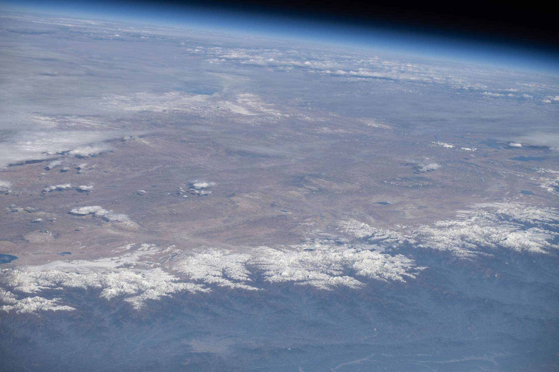
iss074e0316083 (Feb. 18, 2026) --- The far western edge of the Taklamakan Desert—the world’s second-largest shifting sand desert—meets the Pamir Mountains in China, where scorching desert conditions transition to frigid alpine terrain. The International Space Station was orbiting 259 miles above Central Asia when this photograph was taken.
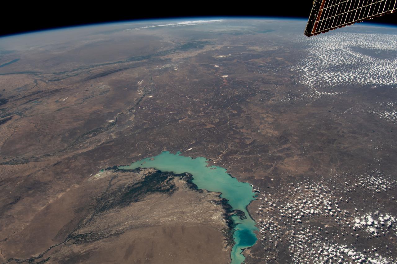
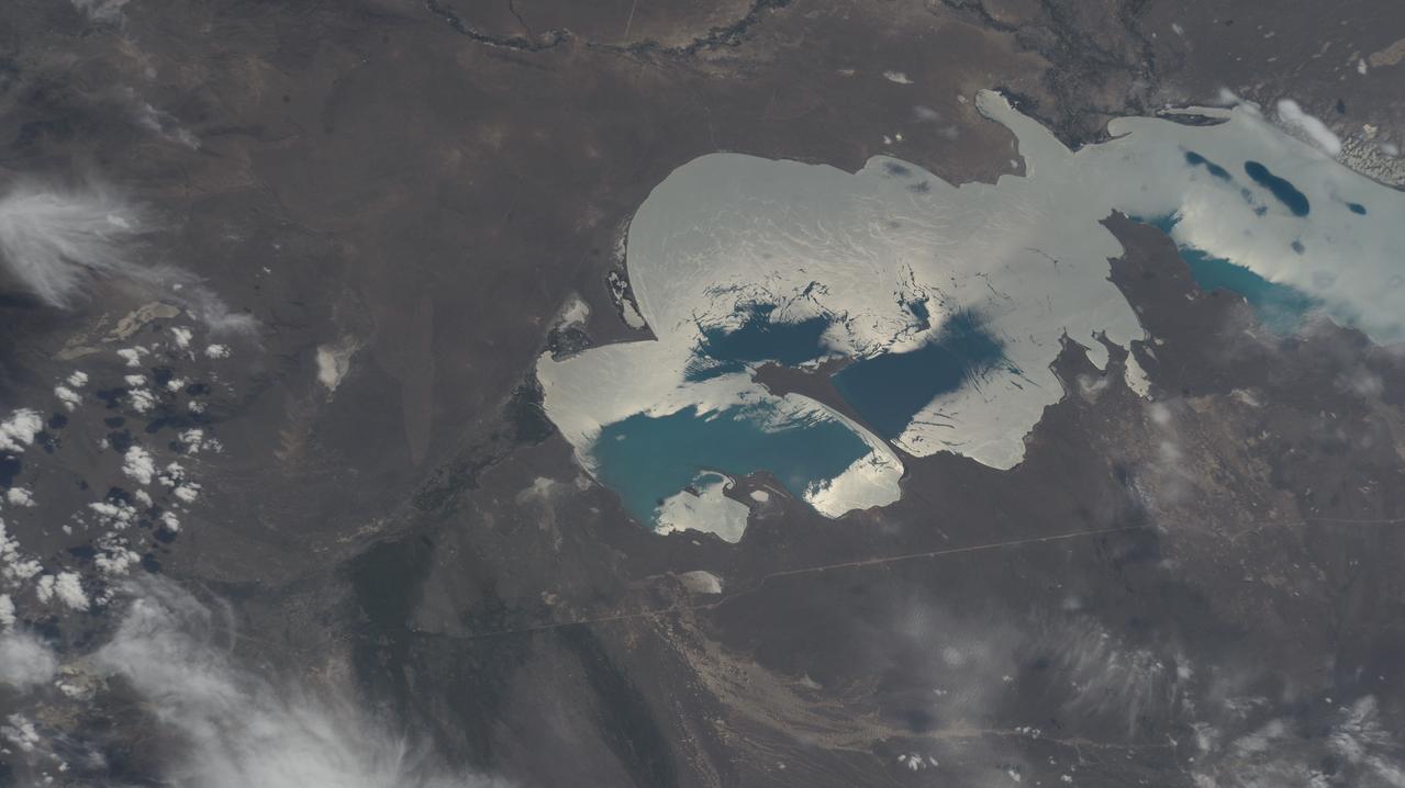
iss069e053802 (August 3, 2023) -- Lake Balkhash, one of the largest in Central Asia, spans roughly 6,500 square miles (17,000 square kilometers) in Kazakhstan. The western part of the lake holds fresh water whereas the eastern side of the basin is salty. The International Space Station soared 261 miles above as this image was taken.
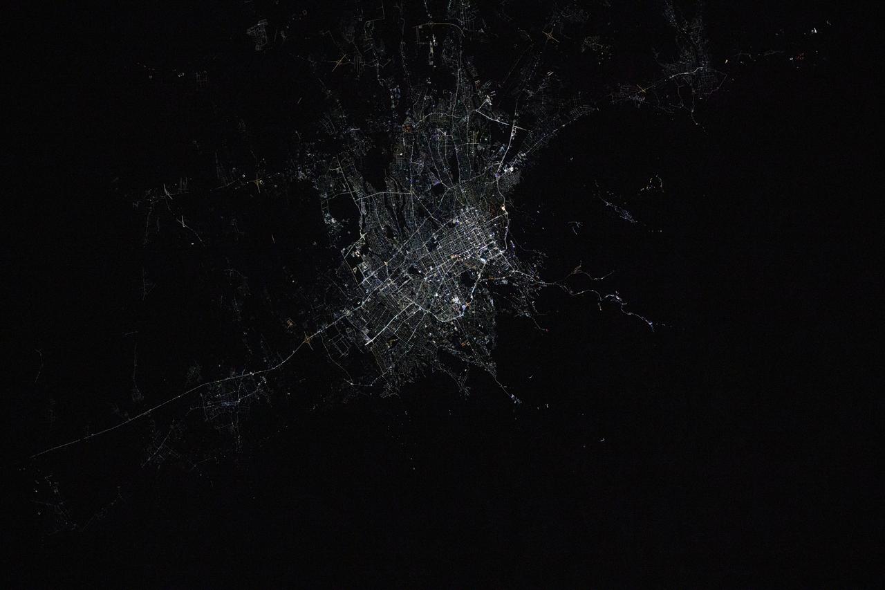
iss072e792891 (March 17, 2025) --- Almaty, Kazakhstan's largest city with a population of about 2.25 million and the second largest city in Central Asia, is pictured at approximately 12:42 a.m. local time from the International Space Station as it orbited 261 miles above.
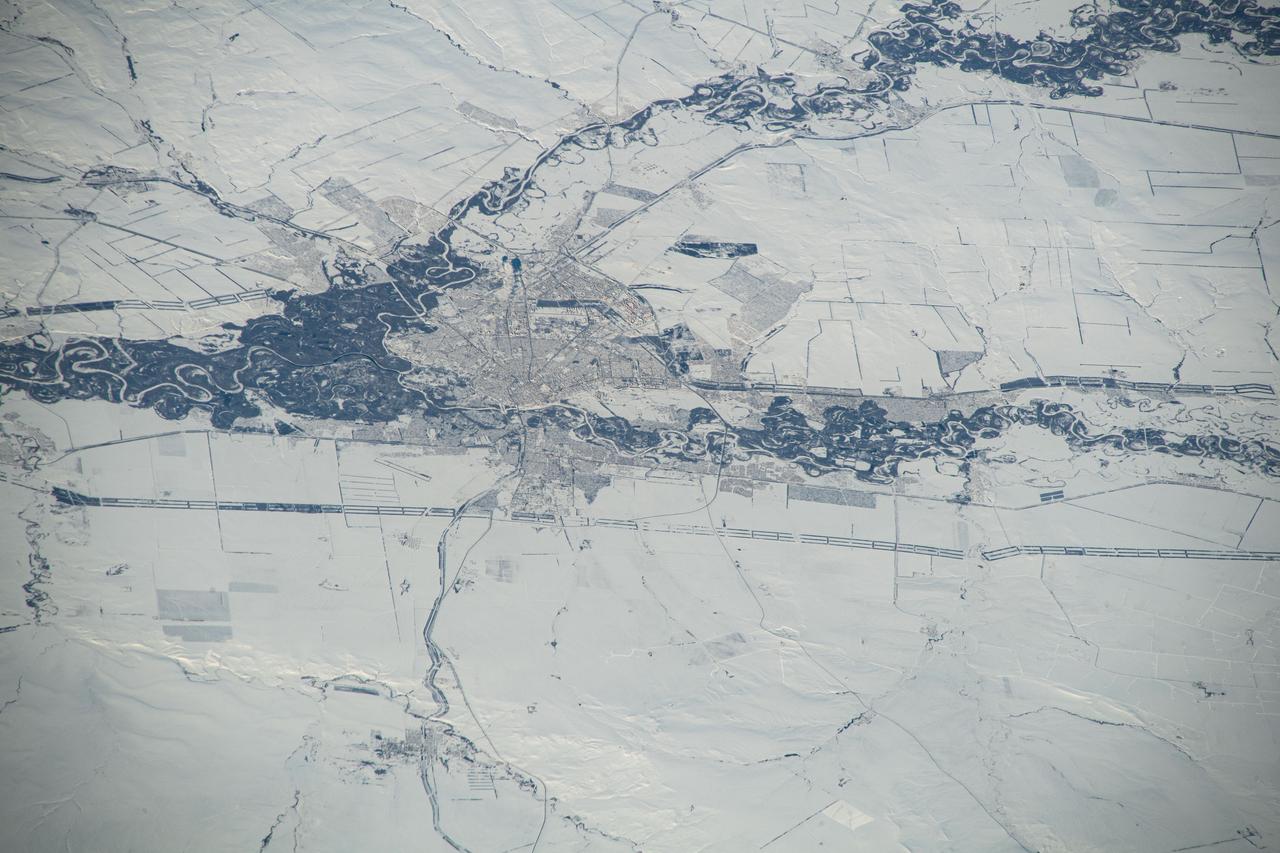
iss070e097619 (Feb. 11, 2024) --- Orenburg, Russia, surrounded by a wintry landscape, the Sakmara and Ural Rivers, and near the border with Kazakhstan, is pictured from the International Station as it orbited 263 miles above the area where Eastern Europe meets central Asia.

ISS017-E-011603 (22 July 2008) --- Layers of Earth's atmosphere, brightly colored as the sun rises over central Asia, and Polar Mesospheric Clouds (also known as noctilucent clouds) are featured in this image photographed by an Expedition 17 crewmember on the International Space Station. The image was acquired in support of International Polar Year research.

iss072e445581 (Dec. 28, 2024) --- The city lights of Tashkent, Uzbekistan's capital and most populous city with a population of about 3.1 million residents, are pictured at approximately 1:36 a.m. local time from the International Space Station as it orbited 259 miles above Central Asia.
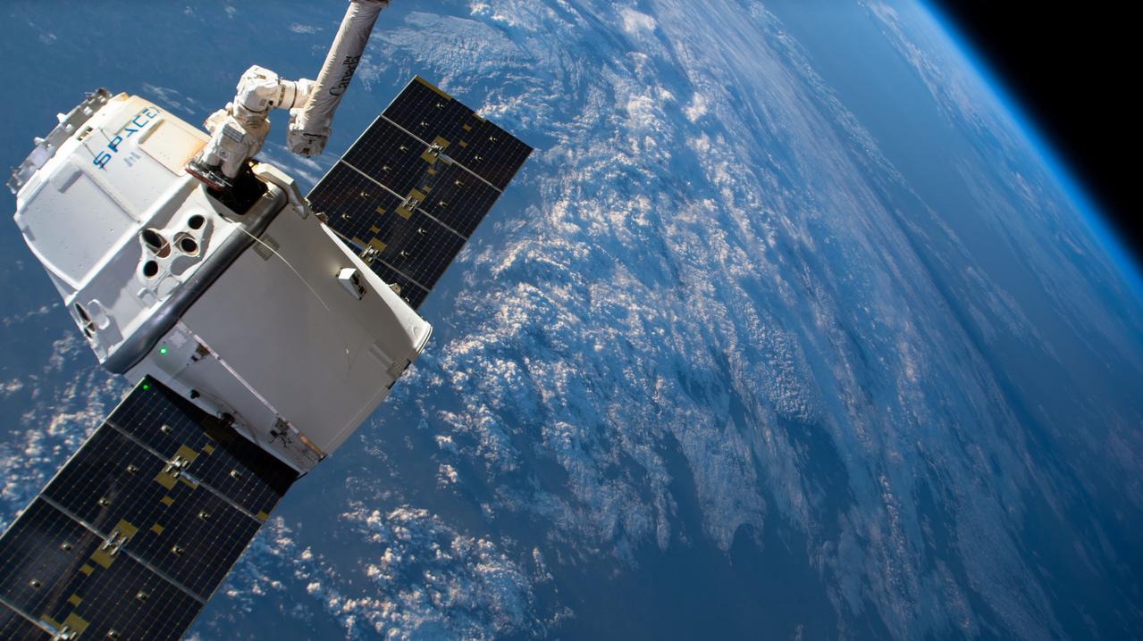
iss059e088875 (June 3, 2019) --- The SpaceX Dragon cargo craft on its 17th contracted mission to resupply mission to the International Space Station is pictured moments before being released from the Canadarm2 robotic arm. The orbiting lab was flying 261 miles above central Asia.
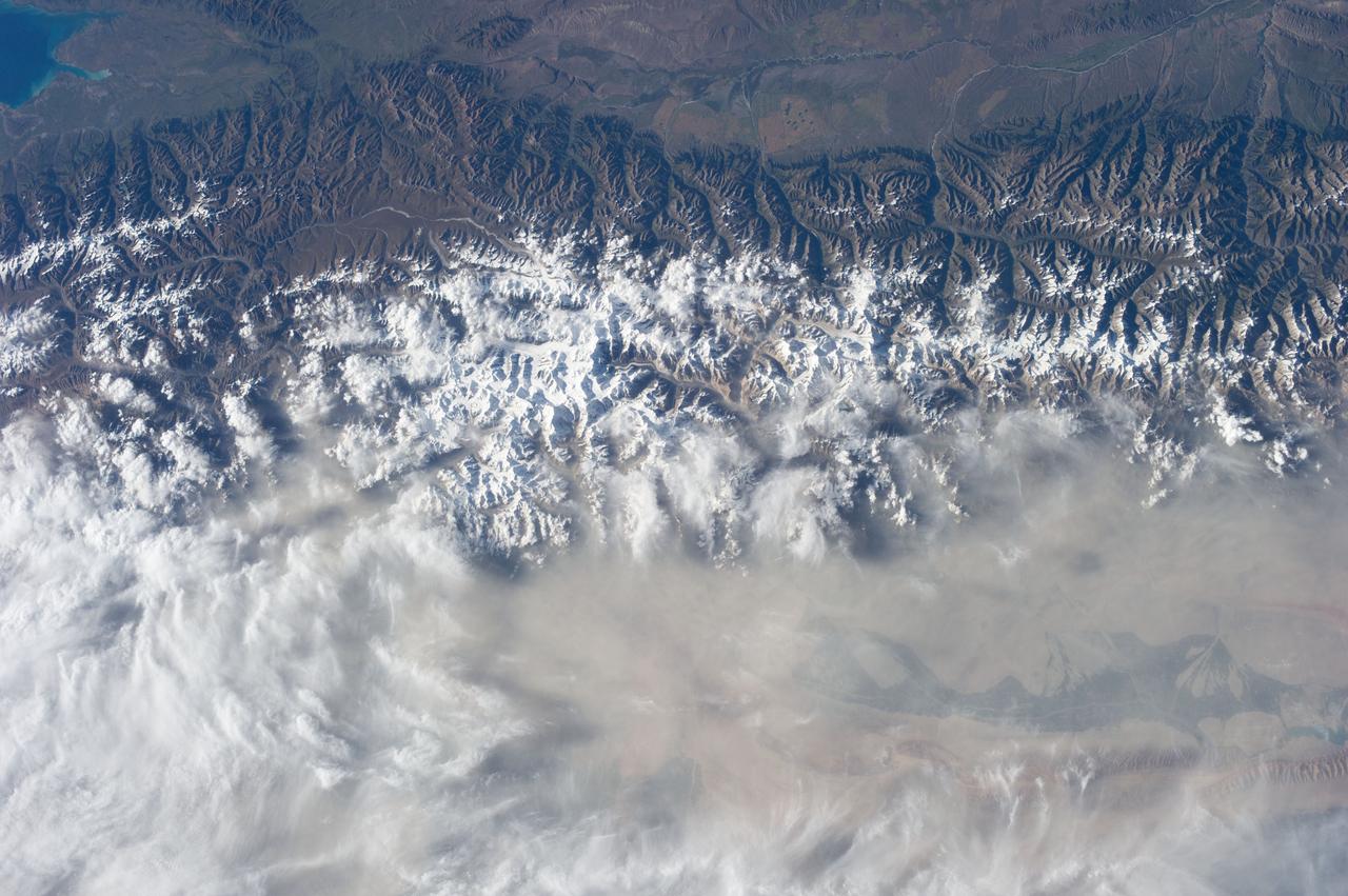
iss074e0002581 (Dec. 14, 2025) --- The International Space Station was orbiting 260 miles above Indravati National Park in central India when this photograph of the Himalayas—more than 700 miles away—was taken, showing the mountain range that separates the Indian subcontinent from Asia.
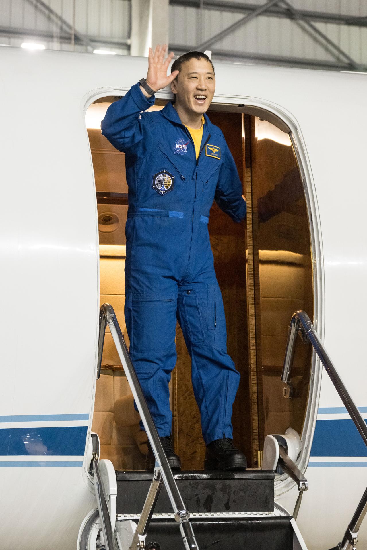
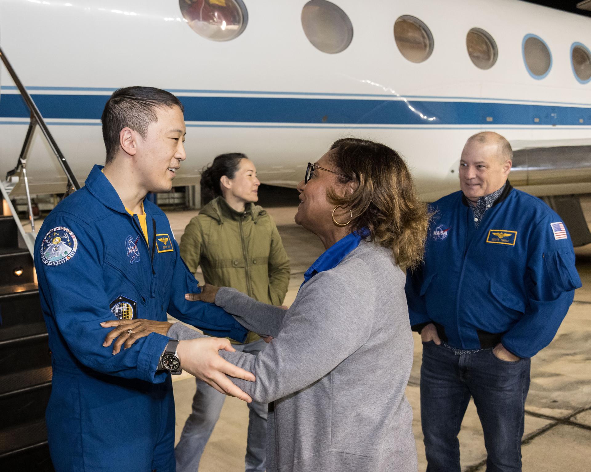
jsc2025e089530 (Dec. 10, 2025) --- NASA astronaut Jonny Kim waves to NASA personnel at Ellington Field after exiting the Gulfstream V aircraft that returned him to Houston, Texas, from Kazakhstan in Central Asia. The day before, Kim had landed in Kazakhstan aboard the Soyuz MS-27 crew spacecraft with Roscosmos cosmonauts Sergey Ryzhikov and Alexey Zubritsky after completing a 245-day research mission aboard the International Space Station. Credit: NASA/Robert Markowitz
The Uvs Nuur Basin in Mongolia and the Russian Federation is the northernmost of the enclosed basins of Central Asia. It takes its name from Uvs Nuur Lake, a large, shallow and very saline lake, very important for migrating birds. Inscribed as a UNESCO World Heritage Site in 2003, the site is made up of twelve protected areas representing major biomes of eastern Eurasia. The steppe ecosystem supports a rich diversity of birds and the desert is home to a number of rare gerbil, jerboas and the marbled polecat. The mountains are an important refuge for the endangered snow leopard, mountain sheep, and the Asiatic ibex. The image covers an area of 46 x 47.8 km, was acquired on September 4, 2001, and is located near 50.3 degrees north latitude, 90.7 degrees east longitude. This image is from NASA Terra satellite. http://photojournal.jpl.nasa.gov/catalog/PIA10613
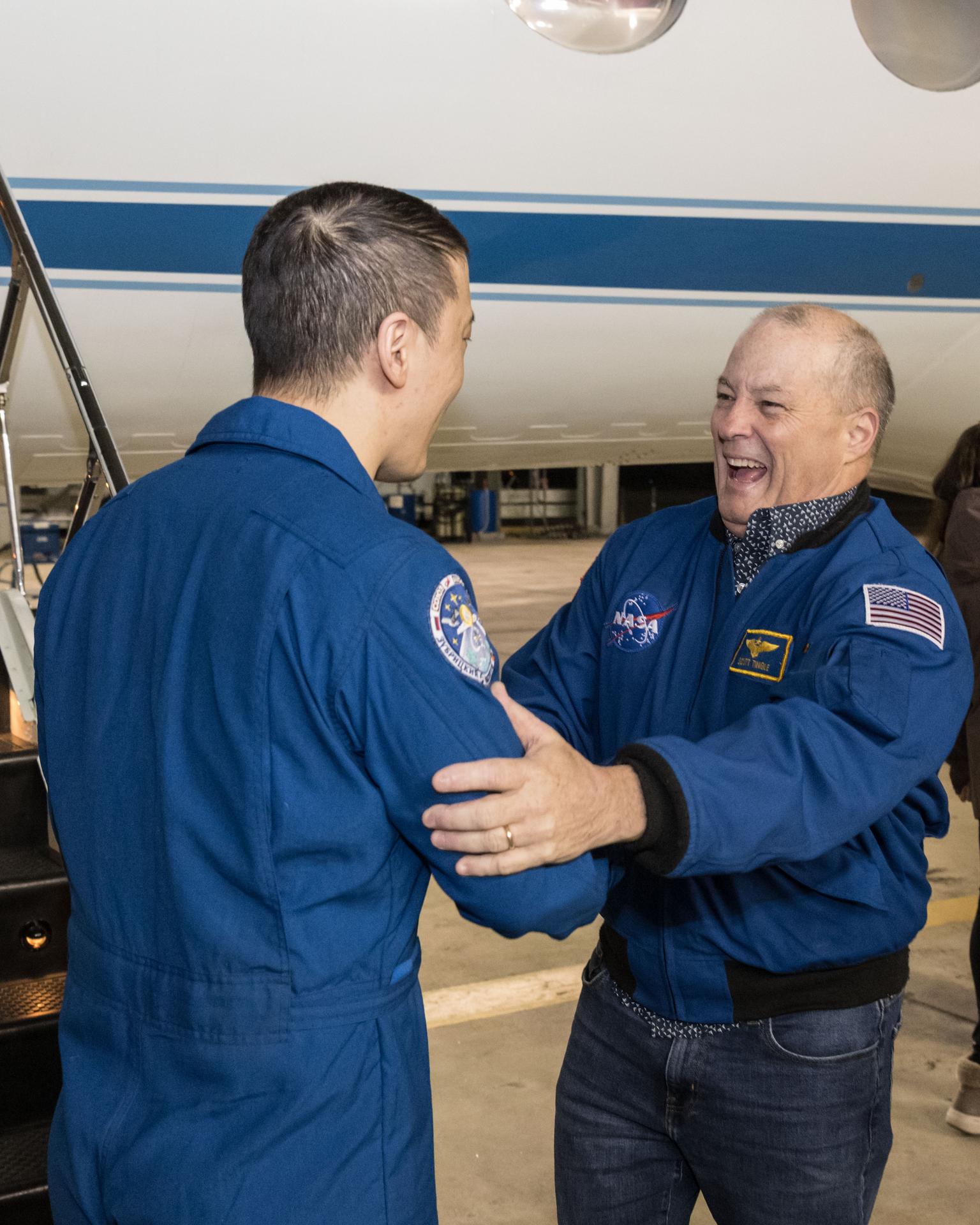
jsc2025e089533 (Dec. 10, 2025) --- NASA astronaut Jonny Kim, greeted by NASA astronaut and Chief of the Astronaut Office Scott Tingle, is pictured at Ellington Field outside the Gulfstream V aircraft that returned him to Houston, Texas, from Kazakhstan in Central Asia. The day before, Kim had landed in Kazakhstan aboard the Soyuz MS-27 crew spacecraft with Roscosmos cosmonauts Sergey Ryzhikov and Alexey Zubritsky after completing a 245-day research mission aboard the International Space Station. In the background (from left), is a NASA employee and NASA astronaut Scott Tingle. Credit: NASA/Robert Markowitz
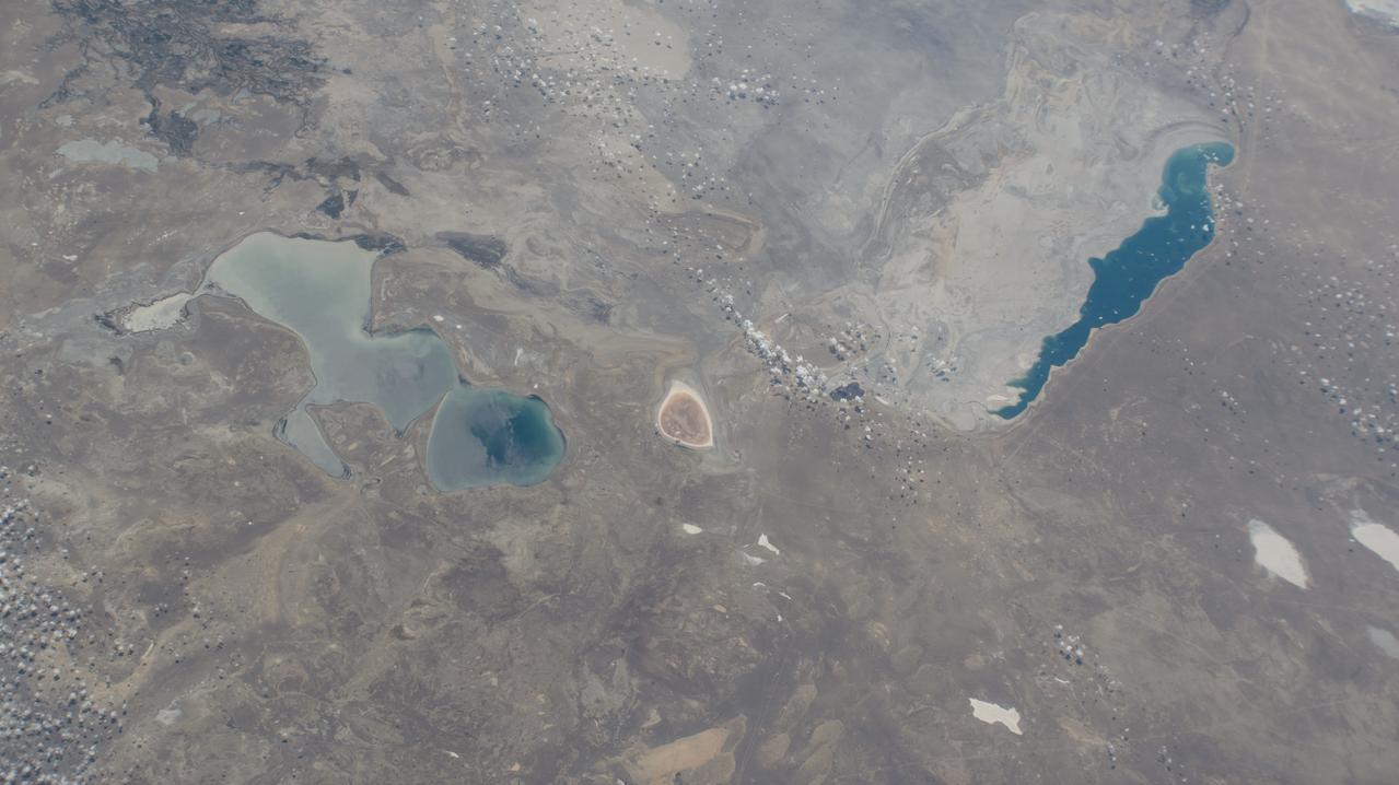
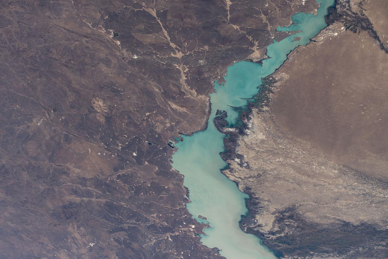
iss071e462182 (Aug. 9, 2024) --- Barsakelmes Nature Reserve in the Aral Sea in Kazakhstan is pictured from the International Space Station as it orbited 263 miles above the Central Asian nation.
iss071e462185 (Aug. 9, 2024) --- Lake Balkhash in Kazakhstan is pictured from the International Space Station as it orbited 262 miles above the Central Asian nation.
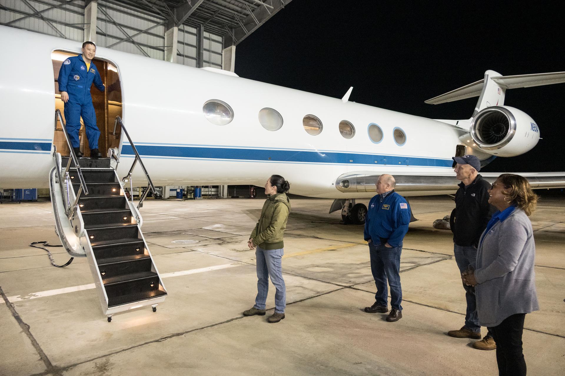
jsc2025e089531 (Dec. 10, 2025) --- NASA astronaut Jonny Kim exits the Gulfstream V aircraft that returned him to Houston, Texas, from Kazakhstan in Central Asia. Waiting to greet Kim are (from left), NASA astronauts Nicole Mann and Scott, Johnson Space Center (JSC) Deputy Director Stephen Koerner, and JSC Director Vanessa Wyche. The day before, Kim had landed in Kazakhstan aboard the Soyuz MS-27 crew spacecraft with Roscosmos cosmonauts Sergey Ryzhikov and Alexey Zubritsky after completing a 245-day research mission aboard the International Space Station. Credit: NASA/Robert Markowitz
jsc2025e089532 (Dec. 10, 2025) --- NASA astronaut Jonny Kim, greeted by Johnson Space Center Director Vanessa Wyche, is pictured at Ellington Field outside the Gulfstream V aircraft that returned him to Houston, Texas, from Kazakhstan in Central Asia. The day before, Kim had landed in Kazakhstan aboard the Soyuz MS-27 crew spacecraft with Roscosmos cosmonauts Sergey Ryzhikov and Alexey Zubritsky after completing a 245-day research mission aboard the International Space Station. In the background (from left), is a NASA employee and NASA astronaut and Chief of the Astronaut Scott Tingle. Credit: NASA/Robert Markowitz
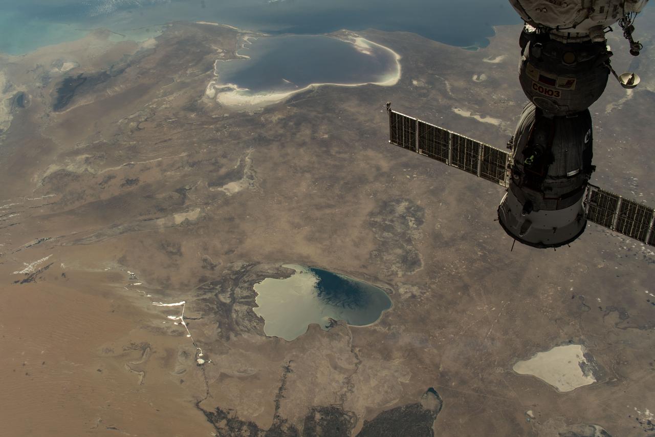
iss073e0424121 (Aug. 7, 2025) --- From top to bottom, the Caspian Sea, the Garabogazköl Basin, and Lake Sarygamysh are pictured from the International Space Station as it orbited 260 miles above Uzbekistan, a hot and dry, landlocked country in Central Asia with a population of about 37.7 million. In the foreground at top right, is the Soyuz MS-27 spacecraft docked to the Prichal module.
iss073e0423962 (Aug. 7, 2025) --- The Zeid Reservoir in Turkmenistan is pictured from the International Space Station as it orbited 260 miles above Central Asia. The reservoir was designed to capture some of the sand and sediment flowing in from the nearby Amu Darya River and the Karakum Canal. This helps keep the water cleaner and protects the canal system from getting clogged.
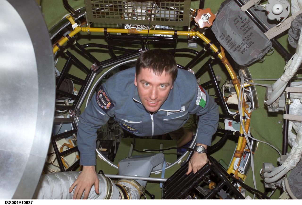
ISS004-E-10637 (27 April 2002) --- Soyuz Taxi Flight Engineer Roberto Vittori of the European Space Agency (ESA) moves through the Zvezda Service Module’s transfer compartment on the International Space Station (ISS). Vittori and his Soyuz Taxi crewmates, Commander Yuri Gidzenko and South African space flight participant Mark Shuttleworth, arrived at the orbital outpost on April 27, 2002 at 2:56 a.m. (CDT) as the two vehicles flew over Central Asia.
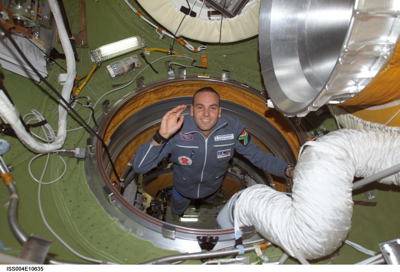
ISS004-E-10635 (27 April 2002) --- South African space flight participant Mark Shuttleworth enters the functional cargo block’s (FGB) pressurized adapter on the International Space Station (ISS). Shuttleworth and his Soyuz Taxi crewmates, Commander Yuri Gidzenko and Flight Engineer Roberto Vittori of the European Space Agency (ESA), arrived at the orbital outpost on April 27, 2002 at 2:56 a.m. (CDT) as the two vehicles flew over Central Asia.
STS059-220-041 (9-20 April 1994) --- View to the south by southwest across the southern Gobi Desert (China) across the Chi-Lien-Shan or Quilienshan or Nanshan (Mountains) in Gansu Province to Lake Quinghai or Ch'ing-Hai (orthography varies with political conditions and scholarship) in Quinghai Province. The lake has a surface elevation of 10,450 feet, partially filling one of the easternmost closed drainage basins of Central Asia. Hasselblad photograph.
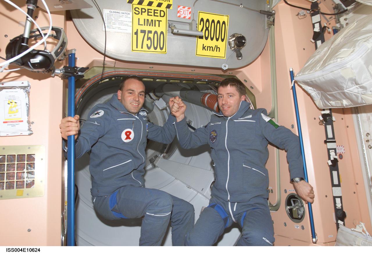
ISS004-E-10624 (27 April 2002) --- Two Soyuz Taxi crewmembers, South African space flight participant Mark Shuttleworth (left) and Flight Engineer Roberto Vittori of the European Space Agency (ESA), are photographed in the Unity node on the International Space Station (ISS). Soyuz Taxi Commander Yuri Gidzenko, representing Rosaviakosmos, is out of frame. The “taxi” crew arrived at the orbital outpost on April 27, 2002 at 2:56 a.m. (CDT) as the two vehicles flew over Central Asia.
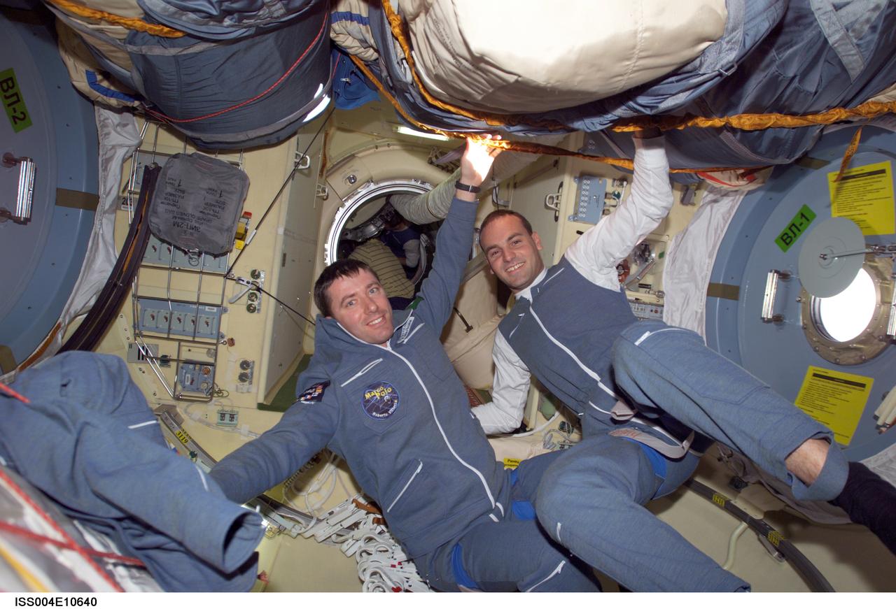
ISS004-E-10640 (27 April 2002) --- Two Soyuz Taxi crewmembers, Flight Engineer Roberto Vittori (left) of the European Space Agency (ESA) and South African space flight participant Mark Shuttleworth, are photographed in the Pirs docking compartment on the International Space Station (ISS). Soyuz Taxi Commander Yuri Gidzenko, representing Rosaviakosmos, is out of frame. The “taxi” crew arrived at the orbital outpost on April 27, 2002 at 2:56 a.m. (CDT) as the two vehicles flew over Central Asia.
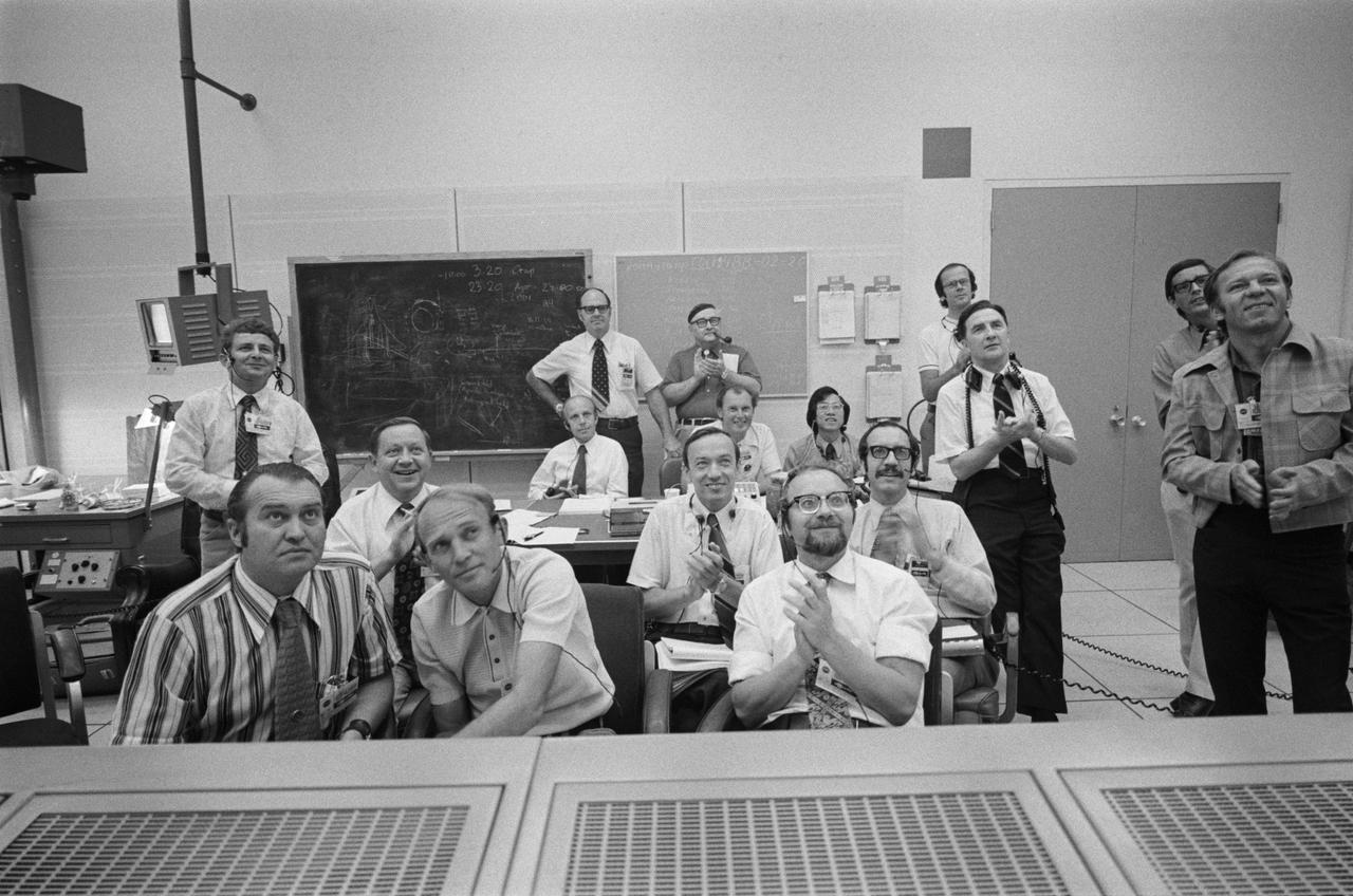
S75-28659 (21 July 1975) --- An overall view of the group of Soviet Union flight controllers who served at the Mission Control Center during the joint U.S.-USSR Apollo-Soyuz Test Project docking mission in Earth orbit. They are applauding the successful touchdown of the Soyuz spacecraft in Central Asia. The television monitor had just shown the land landing of the Soyuz descent vehicle.
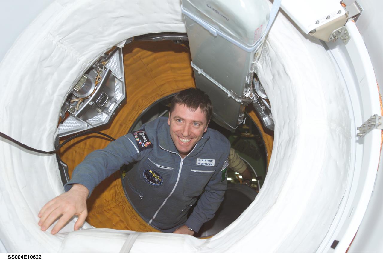
ISS004-E-10622 (27 April 2002) --- Soyuz Taxi Flight Engineer Roberto Vittori of the European Space Agency (ESA) moves through one of the many hatches on the International Space Station (ISS). Vittori and his Soyuz Taxi crewmates, Commander Yuri Gidzenko and South African space flight participant Mark Shuttleworth, arrived at the orbital outpost on April 27, 2002 at 2:56 a.m. (CDT) as the two vehicles flew over Central Asia.
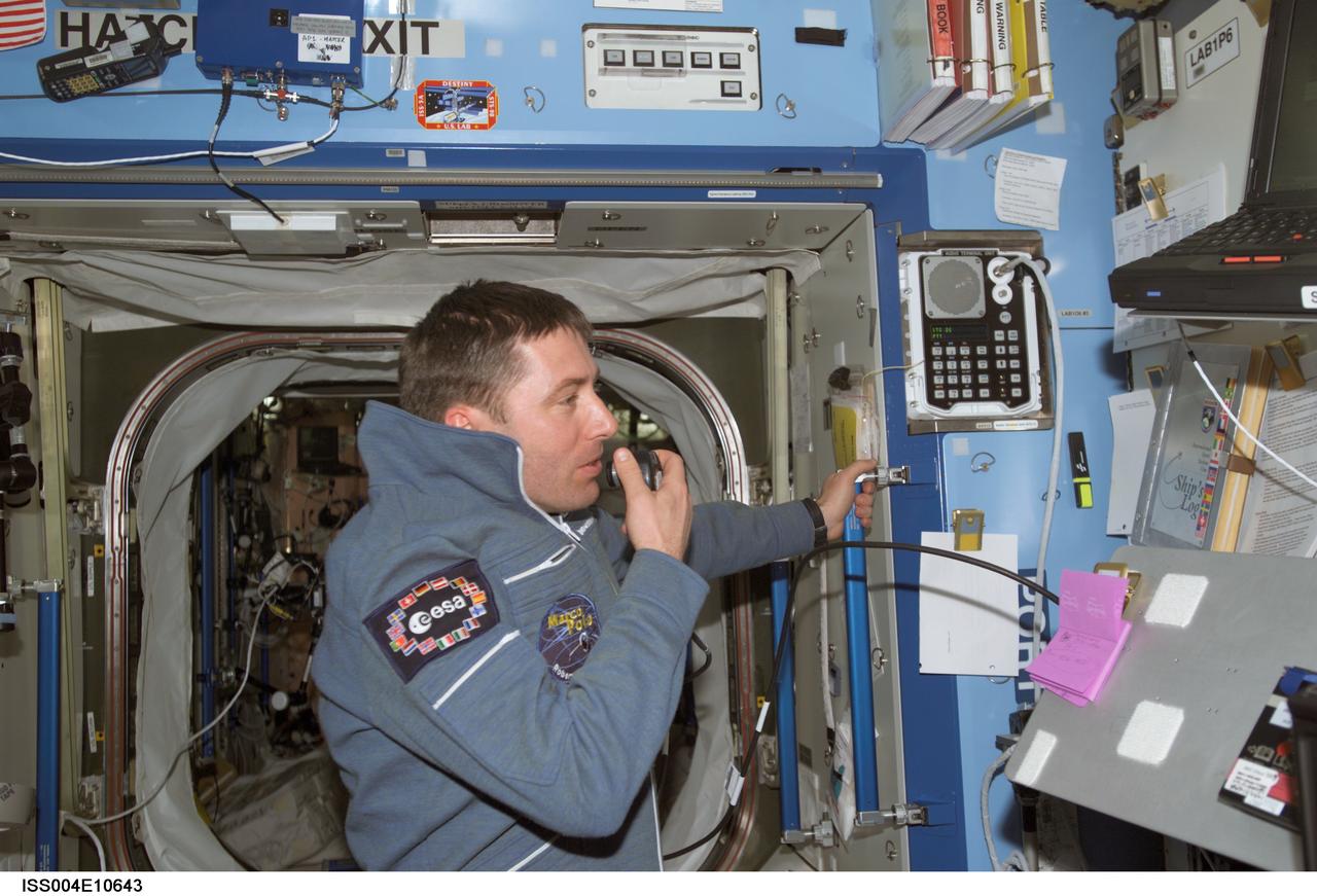
ISS004-E-10643 (27 April 2002) --- Soyuz Taxi Flight Engineer Roberto Vittori of the European Space Agency (ESA) uses a communication system in the Destiny laboratory on the International Space Station (ISS). Vittori and his Soyuz Taxi crewmates, Commander Yuri Gidzenko and South African space flight participant Mark Shuttleworth, arrived at the orbital outpost on April 27, 2002 at 2:56 a.m. (CDT) as the two vehicles flew over Central Asia.
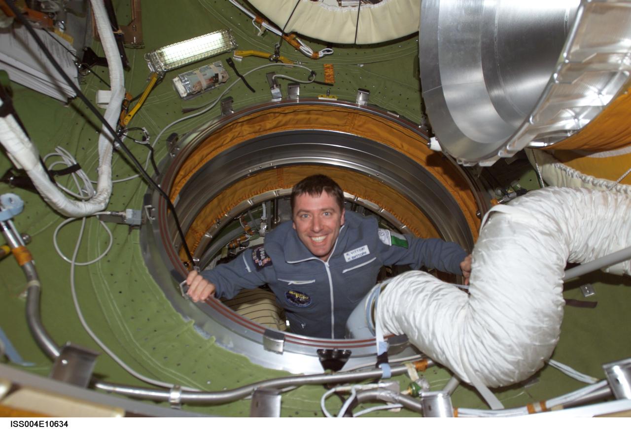
ISS004-E-10634 (27 April 2002) --- Soyuz Taxi Flight Engineer Roberto Vittori of the European Space Agency (ESA) enters the functional cargo block’s (FGB) pressurized adapter on the International Space Station (ISS). Vittori and his Soyuz Taxi crewmates, Commander Yuri Gidzenko and South African space flight participant Mark Shuttleworth, arrived at the orbital outpost on April 27, 2002 at 2:56 a.m. (CDT) as the two vehicles flew over Central Asia.
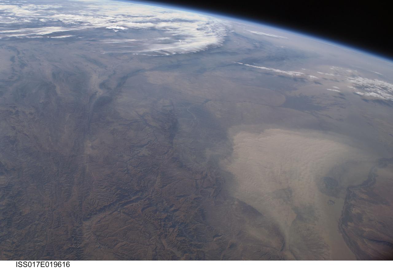
ISS017-E-019616 (16 Oct. 2008) --- A dust storm in Turkmenistan, Central Asia is featured in this image photographed by an Expedition 17 crewmember on the International Space Station. This west-looking view, taken with a short focal length lens from the station, shows a wide swath of central Asia--from Afghanistan, along the length of Turkmenistan to the Caspian Sea. Winds blowing down the largest river valley in the region, the Amudarya, were strong enough to raise a large dust storm. Dust appears as a light brown mass extending into the center of the image from the lower right. Diffuse dust from prior windy weather appears over much of the area making a regional haze that clouds much of the landscape detail. The haze partly obscures the irrigated agriculture in Turkmenistan and entirely obscures the Caspian Sea. Numerous rivers rise in the Hindu Kush mountain complex (lower left). The Band-i Amir River is a major tributary of the main regional river, the Amudarya, which it reaches via a deep canyon. The Amudarya River was the major historical contributor of water to the Aral Sea, but today extensive diversion of river water for agricultural purposes has lead to extensive exposure and desiccation of the sea bed. The exposed sea bed is a major source of saline dusts contaminated with agricultural chemicals that pose a significant environmental hazard to central Asia. To a lesser extent, dusts are also mobilized from sediments along the Amudarya river channel. The Paropamisus Range and the Amudarya (also known as the Oxus River) are mentioned in histories of Alexander the Great's famous military expedition from Greece to India. His horsemen made a fast side excursion from near the Caspian Sea (top right) as far as the Amudarya (lower right).
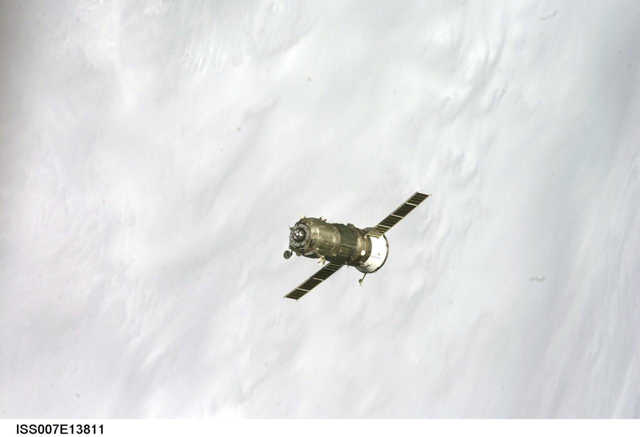
ISS007-E-13811 (30 August 2003) --- Backdropped by a blue and white Earth, an unpiloted Progress supply vehicle approaches the International Space Station (ISS). The Progress 12 resupply craft, which launched from the Baikonur Cosmodrome in Kazakhstan at 8:48 p.m. (CDT) on August 28, 2003, carried nearly three tons of food, fuel, water, supplies and scientific gear for the Expedition 7 crew aboard the Station. The Progress linked up with the Station at 10:40 p.m. (CDT) on August 30, 2003 as the two spacecraft were flying over Central Asia at an altitude of 240 statute miles.
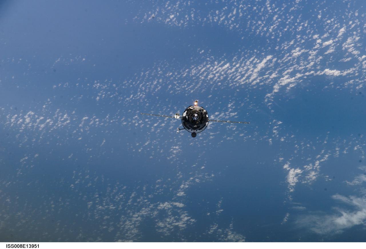
ISS008-E-13951 (31 January 2004) --- Backdropped by a blue and white Earth, an unpiloted Progress supply vehicle approaches the International Space Station (ISS). The Progress 13 resupply craft launched at 5:58 a.m. (CST) on January 29, 2004 from the Baikonur Cosmodrome in Kazakhstan to deliver 2 ½ tons of food, fuel, spare parts and supplies to the Expedition 8 crewmembers onboard the orbital outpost. Progress docked to the aft port of the Zvezda Service Module at 7:13 a.m. (CST) on January 31 as the two craft flew 230 statute miles above Central Asia.
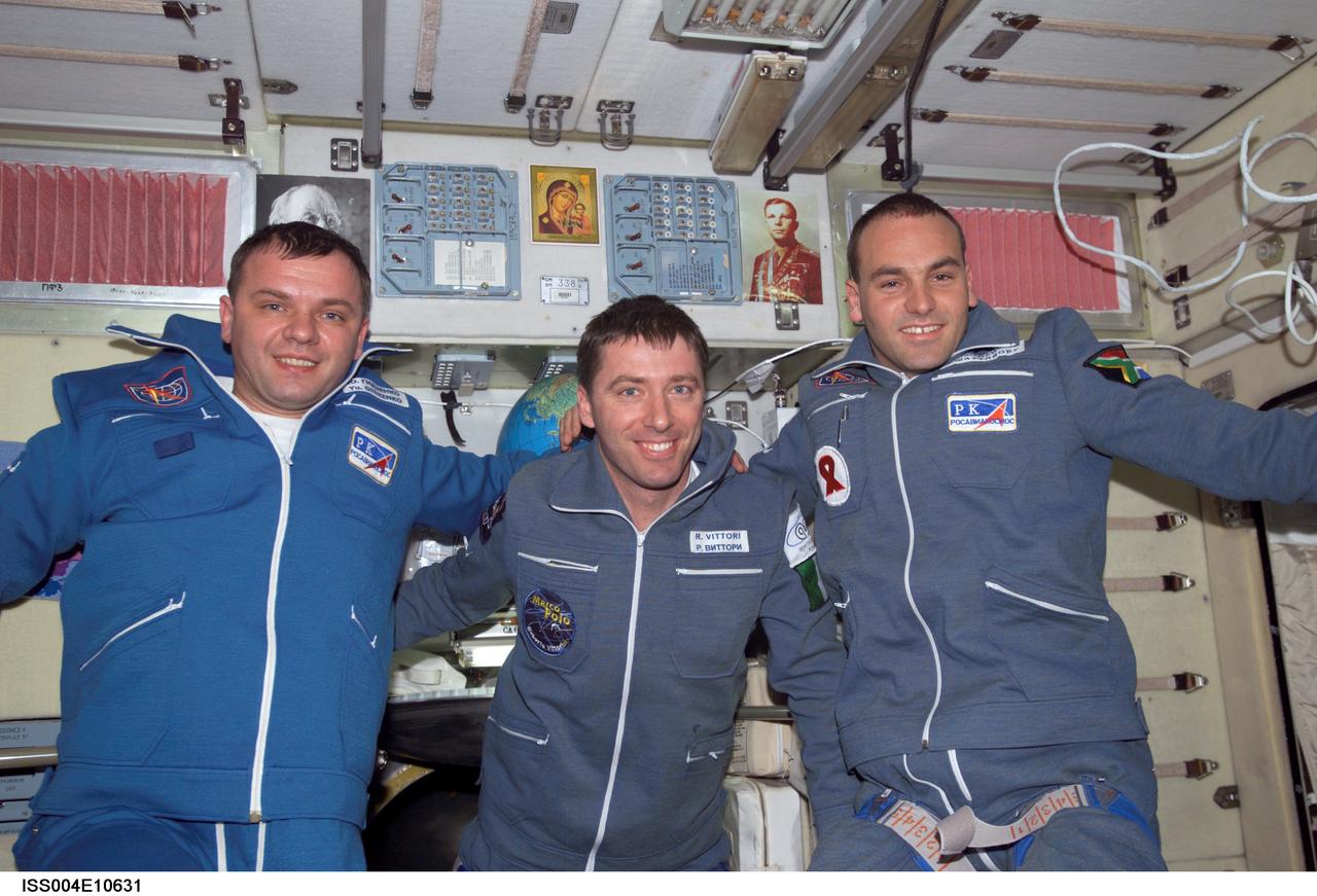
ISS004-E-10631 (27 April 2002) --- The Soyuz Taxi crewmembers pose for a group photo in the Zvezda Service Module on the International Space Station (ISS). From the left are Commander Yuri Gidzenko, who was a member of the first resident crew of the ISS; Flight Engineer Roberto Vittori of the European Space Agency (ESA); and South African space flight participant Mark Shuttleworth. The “taxi” crew arrived at the orbital outpost on April 27, 2002 at 2:56 a.m. (CDT) as the two vehicles flew over Central Asia. Gidzenko represents Rosaviakosmos.

ISS009-E-18364 (14 August 2004) --- Appearing as a silhouette backdropped against airglow of Earth’s horizon, an unpiloted Progress supply vehicle approaches the International Space Station (ISS). The Progress 15 resupply craft launched at 12:03 a.m. (CDT) on August 11, 2004 from the Baikonur Cosmodrome in Kazakhstan to deliver almost three tons of food, fuel, oxygen, water and supplies to the Expedition 9 crewmembers onboard the Station. Progress docked to the aft port of the Zvezda Service Module at 12:01 a.m. (CDT) on August 14 as the two craft flew 225 statute miles over central Asia.
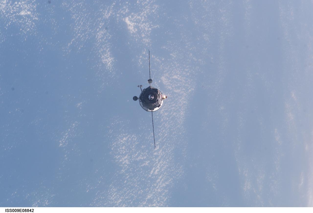
ISS009-E-08842 (27 May 2004) --- Backdropped by a blue and white Earth, an unpiloted Progress supply vehicle approaches the International Space Station (ISS). The Progress 14 resupply craft launched at 7:34 a.m. (CDT) on May 25, 2004 from the Baikonur Cosmodrome in Kazakhstan to deliver 2 ½ tons of food, water, fuel and supplies to the Expedition 9 crewmembers onboard the Station. Progress docked to the aft port of the Zvezda Service Module at 8:55 a.m. (CDT) on May 27 as the two craft flew 230 statute miles above Central Asia.

ISS004-E-10626 (27 April 2002) --- Two Soyuz Taxi crewmembers, South African space flight participant Mark Shuttleworth (left) and Flight Engineer Roberto Vittori of the European Space Agency (ESA), and cosmonaut Yury I. Onufrienko (center), Expedition Four mission commander, are photographed in the Unity node on the International Space Station (ISS). The “taxi” crew arrived at the orbital outpost on April 27, 2002 at 2:56 a.m. (CDT) as the two vehicles flew over Central Asia. Onufrienko represents Rosaviakosmos.
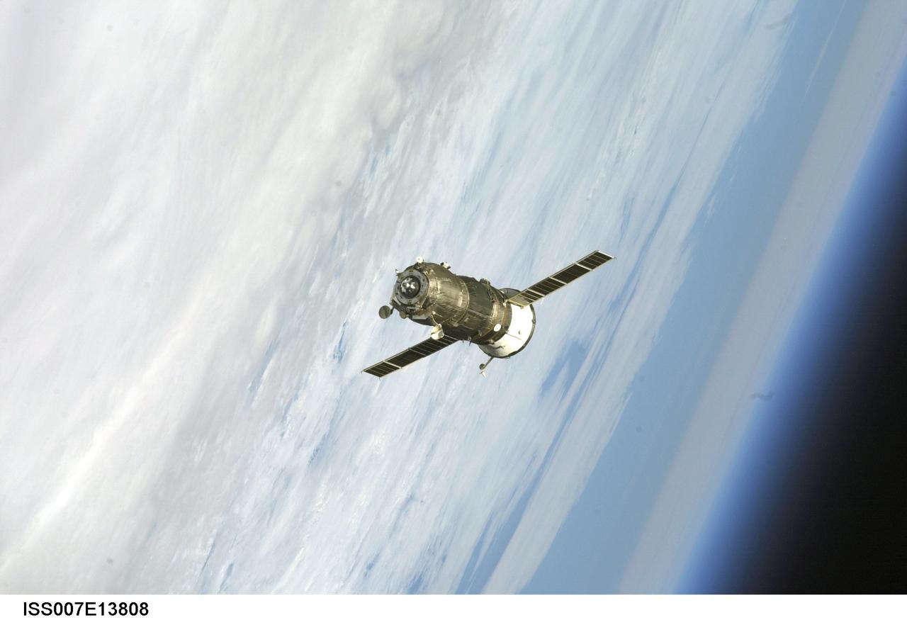
ISS007-E-13808 (30 August 2003) --- Backdropped by Earth’s horizon, an unpiloted Progress supply vehicle approaches the International Space Station (ISS). The Progress 12 resupply craft, which launched from the Baikonur Cosmodrome in Kazakhstan at 8:48 p.m. (CDT) on August 28, 2003, carried nearly three tons of food, fuel, water, supplies and scientific gear for the Expedition 7 crew aboard the Station. The Progress linked up with the Station at 10:40 p.m. (CDT) on August 30, 2003 as the two spacecraft were flying over Central Asia at an altitude of 240 statute miles.
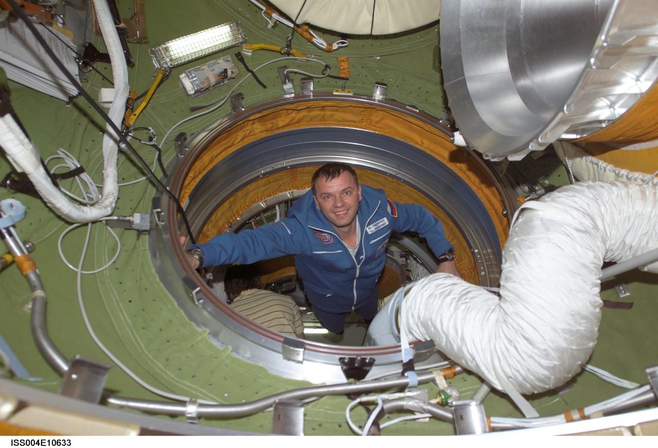
ISS004-E-10633 (27 April 2002) --- Soyuz Taxi Commander Yuri Gidzenko, representing Rosaviakosmos, enters the functional cargo block’s (FGB) pressurized adapter on the International Space Station (ISS). Gidzenko, who is making his third flight into space, is the first former resident of the ISS to return to the complex, having been a member of the Expedition One crew, the first crew to live aboard the station. The “taxi” crew arrived at the orbital outpost on April 27, 2002 at 2:56 a.m. (CDT) as the two vehicles flew over Central Asia.
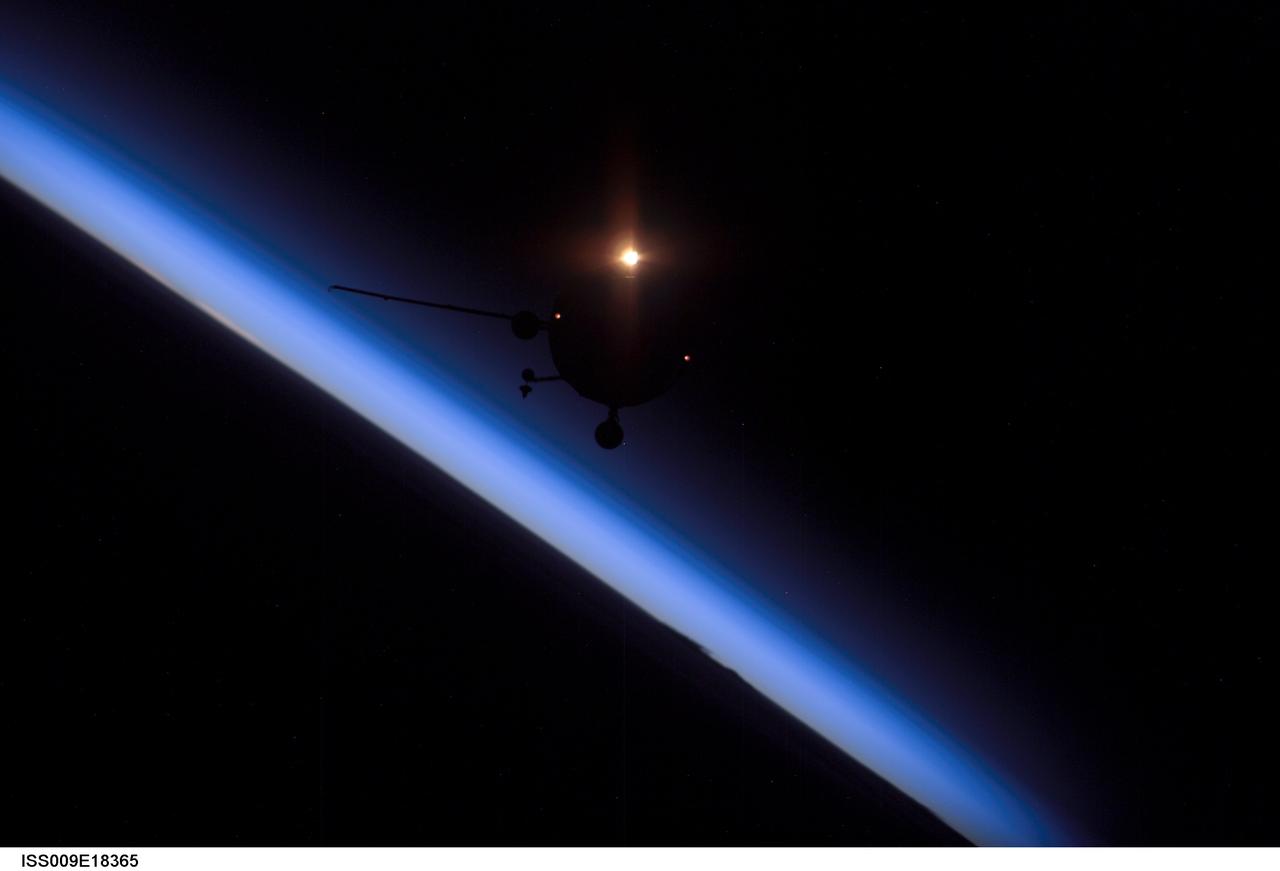
ISS009-E-18365 (14 August 2004) --- Backdropped against the blackness of space and airglow of Earth’s horizon, an unpiloted Progress supply vehicle approaches the International Space Station (ISS). The Progress 15 resupply craft launched at 12:03 a.m. (CDT) on August 11, 2004 from the Baikonur Cosmodrome in Kazakhstan to deliver almost three tons of food, fuel, oxygen, water and supplies to the Expedition 9 crewmembers onboard the Station. Progress docked to the aft port of the Zvezda Service Module at 12:01 a.m. (CDT) on August 14 as the two craft flew 225 statute miles over central Asia.
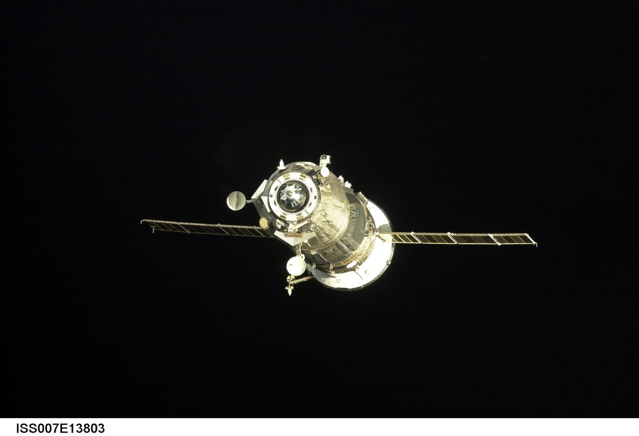
ISS007-E-13803 (30 August 2003) --- Backdropped by the blackness of space, an unpiloted Progress supply vehicle approaches the aft docking port (out of frame) on the Zvezda Service Module on the International Space Station (ISS). The Progress 12 resupply craft, which launched from the Baikonur Cosmodrome in Kazakhstan at 8:48 p.m. (CDT) on August 28, 2003, carried nearly three tons of food, fuel, water, supplies and scientific gear for the Expedition 7 crew aboard the Station. The Progress linked up with the Station at 10:40 p.m. (CDT) on August 30, 2003 as the two spacecraft were flying over Central Asia at an altitude of 240 statute miles.
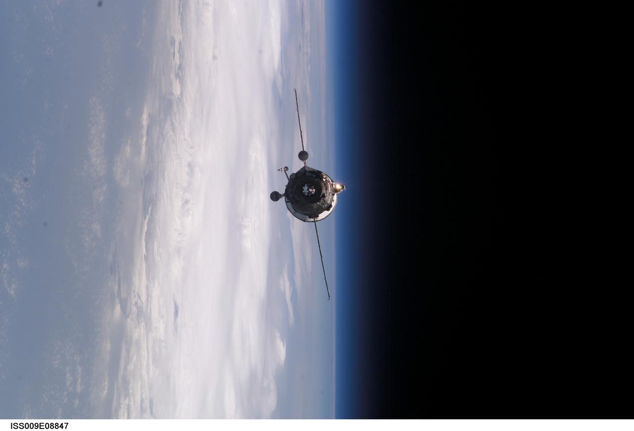
ISS009-E-08847 (27 May 2004) --- Backdropped by the blackness of space and Earth’s horizon, an unpiloted Progress supply vehicle approaches the International Space Station (ISS). The Progress 14 resupply craft launched at 7:34 a.m. (CDT) on May 25, 2004 from the Baikonur Cosmodrome in Kazakhstan to deliver 2 ½ tons of food, water, fuel and supplies to the Expedition 9 crewmembers onboard the Station. Progress docked to the aft port of the Zvezda Service Module at 8:55 a.m. (CDT) on May 27 as the two craft flew 230 statute miles above Central Asia.
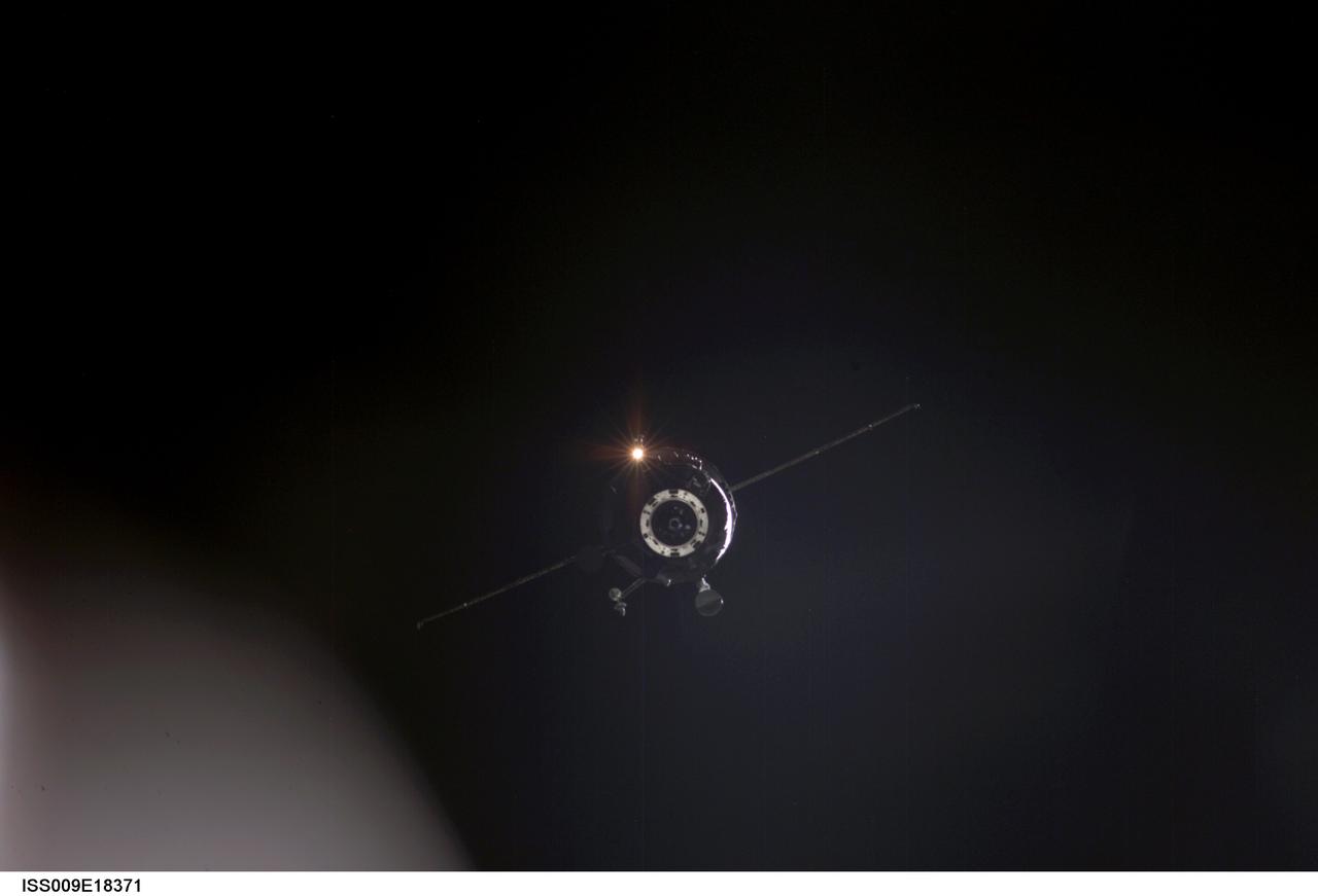
ISS009-E-18371 (14 August 2004) --- Backdropped against the blackness of space, an unpiloted Progress supply vehicle approaches the International Space Station (ISS). The Progress 15 resupply craft launched at 12:03 a.m. (CDT) on August 11, 2004 from the Baikonur Cosmodrome in Kazakhstan to deliver almost three tons of food, fuel, oxygen, water and supplies to the Expedition 9 crewmembers onboard the Station. Progress docked to the aft port of the Zvezda Service Module at 12:01 a.m. (CDT) on August 14 as the two craft flew 225 statute miles over central Asia.
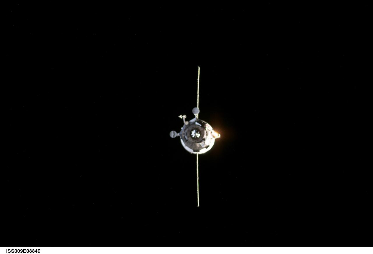
ISS009-E-08849 (27 May 2004) --- Backdropped by the blackness of space, an unpiloted Progress supply vehicle approaches the International Space Station (ISS). The Progress 14 resupply craft launched at 7:34 a.m. (CDT) on May 25, 2004 from the Baikonur Cosmodrome in Kazakhstan to deliver 2 ½ tons of food, water, fuel and supplies to the Expedition 9 crewmembers onboard the Station. Progress docked to the aft port of the Zvezda Service Module at 8:55 a.m. (CDT) on May 27 as the two craft flew 230 statute miles above Central Asia.

ISS007-E-13814 (30 August 2003) --- Backdropped by a blue and white Earth, an unpiloted Progress supply vehicle approaches the International Space Station (ISS). The Progress 12 resupply craft, which launched from the Baikonur Cosmodrome in Kazakhstan at 8:48 p.m. (CDT) on August 28, 2003, carried nearly three tons of food, fuel, water, supplies and scientific gear for the Expedition 7 crew aboard the Station. The Progress linked up with the Station at 10:40 p.m. (CDT) on August 30, 2003 as the two spacecraft were flying over Central Asia at an altitude of 240 statute miles.

ISS007-E-13829 (30 August 2003) --- Backdropped by a blue and white Earth, an unpiloted Progress supply vehicle approaches the International Space Station (ISS). The Progress 12 resupply craft, which launched from the Baikonur Cosmodrome in Kazakhstan at 8:48 p.m. (CDT) on August 28, 2003, carried nearly three tons of food, fuel, water, supplies and scientific gear for the Expedition 7 crew aboard the Station. The Progress linked up with the Station at 10:40 p.m. (CDT) on August 30, 2003 as the two spacecraft were flying over Central Asia at an altitude of 240 statute miles.
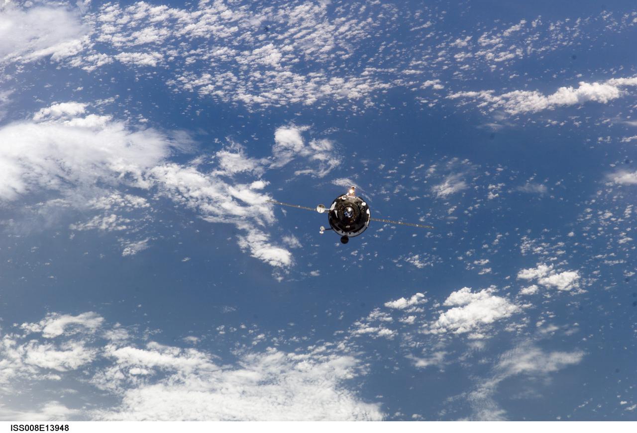
ISS008-E-13948 (31 January 2004) --- Backdropped by a blue and white Earth, an unpiloted Progress supply vehicle approaches the International Space Station (ISS). The Progress 13 resupply craft launched at 5:58 a.m. (CST) on January 29, 2004 from the Baikonur Cosmodrome in Kazakhstan to deliver 2 ½ tons of food, fuel, spare parts and supplies to the Expedition 8 crewmembers onboard the orbital outpost. Progress docked to the aft port of the Zvezda Service Module at 7:13 a.m. (CST) on January 31 as the two craft flew 230 statute miles above Central Asia.
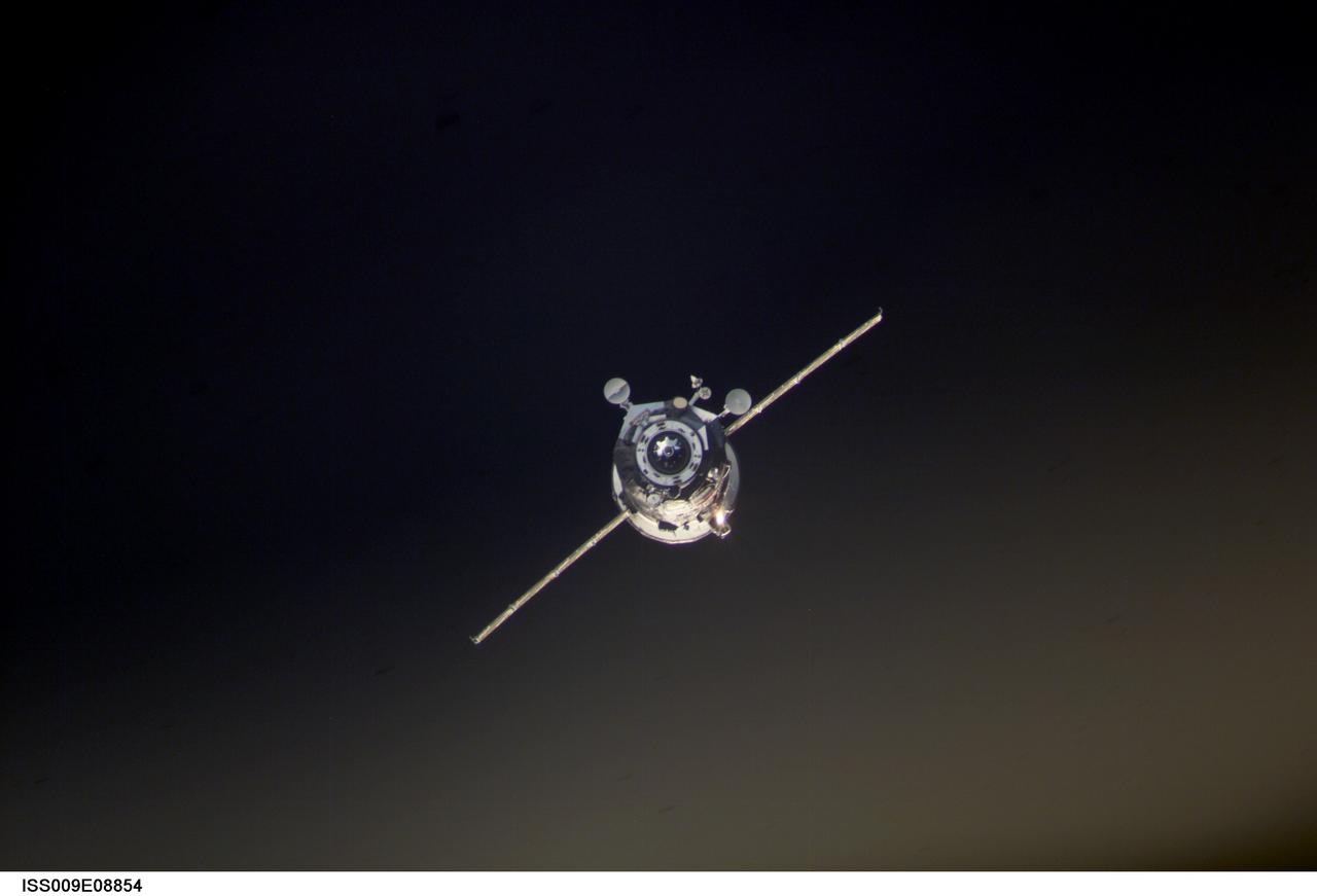
ISS009-E-08854 (27 May 2004) --- Backdropped by the blackness of space, an unpiloted Progress supply vehicle approaches the International Space Station (ISS). The Progress 14 resupply craft launched at 7:34 a.m. (CDT) on May 25, 2004 from the Baikonur Cosmodrome in Kazakhstan to deliver 2 ½ tons of food, water, fuel and supplies to the Expedition 9 crewmembers onboard the Station. Progress docked to the aft port of the Zvezda Service Module at 8:55 a.m. (CDT) on May 27 as the two craft flew 230 statute miles above Central Asia.

ISS004-E-10171 (20 April 2002) --- Astronaut Daniel W. Bursch, Expedition Four flight engineer, wearing a Russian Sokol suit, is seated in the Soyuz 3 spacecraft that is docked to the International Space Station (ISS). The Expedition Four crew undocked the Soyuz 3 capsule from the nadir docking port of the Zarya module of the ISS at 4:16 a.m. (CDT) and flew a short distance down the station for a redocking to the Pirs docking compartment at 4:37 a.m. (CDT) over Central Asia. The move was in preparation for the arrival of the new Soyuz 4 capsule on April 27, 2002, and a three-man “taxi” crew, Commander Yuri Gidzenko, who was a member of the first resident crew of the ISS; Flight Engineer Roberto Vittori of the European Space Agency (ESA); and South African space flight participant Mark Shuttleworth.
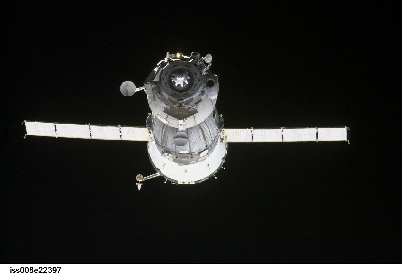
ISS008-E-22397 (21 April 2004) --- Backdropped by the blackness of space, the Soyuz TMA-4 spacecraft approaches the International Space Station (ISS). Onboard the spacecraft are cosmonaut Gennady I. Padalka, Expedition 9 commander representing Russia’s Federal Space Agency; astronaut Edward M. (Mike) Fincke, NASA ISS science officer and flight engineer; and European Space Agency (ESA) astronaut Andre Kuipers of the Netherlands. The Soyuz linked to the nadir docking port of the Zarya Control Module at 12:01 a.m. (CDT) on April 21, 2004 as the two spacecraft flew 230 miles above central Asia. The docking followed Monday’s launch from the Baikonur Cosmodrome in Kazakhstan.
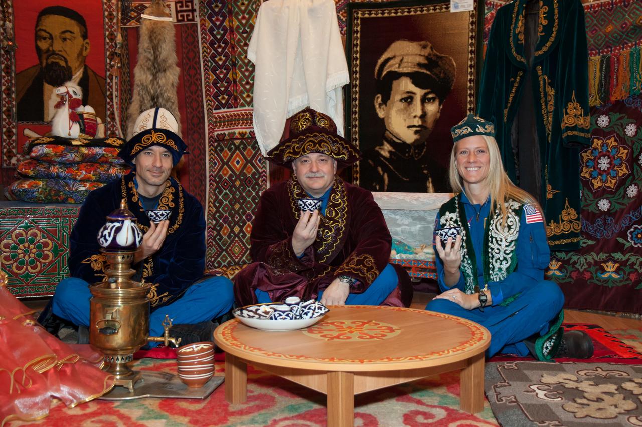
In Baikonur, Kazakhstan, Expedition 34/35 backup crewmembers Luca Parmitano of the European Space Agency (left), Fyodor Yurchikhin (center) and Karen Nyberg of NASA (right) enjoy a meal in a Kazakh yurt Dec. 9, 2012 during a traditional tour of the city. A yurt is a portable, wood-framed dwelling structure that was traditionally used by nomads in the steppes of Central Asia but which is still used for ceremonial celebrations. Prime crewmembers Flight Engineer Tom Marshburn of NASA, Soyuz Commander Roman Romanenko and Flight Engineer Chris Hadfield of the Canadian Space Agency will launch Dec. 19 from the Baikonur Cosmodrome in their Soyuz TMA-07M spacecraft for a five-month mission on the International Space Station. Photo Credit: NASA/Victor Zelentsov
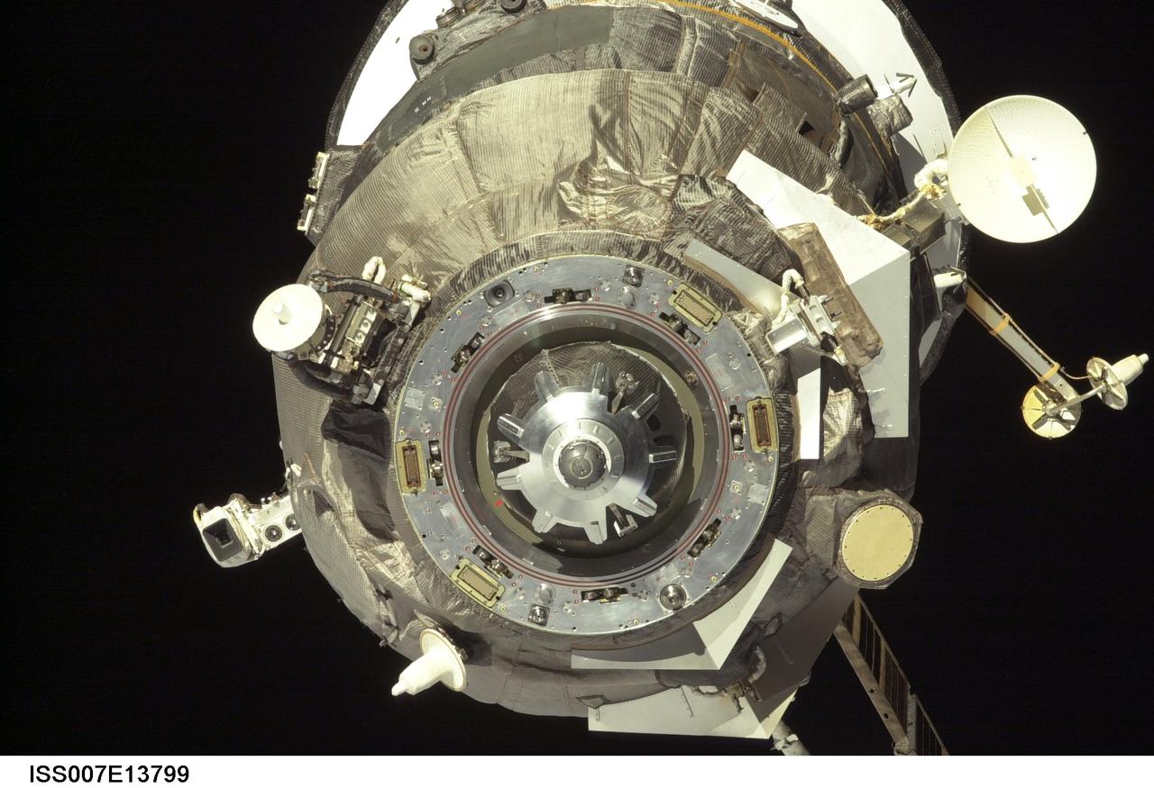
ISS007-E-13799 (30 August 2003) --- This close-up view of an unpiloted Progress supply vehicle was taken by one of the crewmembers onboard the International Space Station (ISS) as it approached the aft docking port (out of frame) on the Zvezda Service Module. The Progress 12 resupply craft, which launched from the Baikonur Cosmodrome in Kazakhstan at 8:48 p.m. (CDT) on August 28, 2003, carried nearly three tons of food, fuel, water, supplies and scientific gear for the Expedition 7 crew aboard the Station. The Progress linked up with the Station at 10:40 p.m. (CDT) on August 30, 2003 as the two spacecraft were flying over Central Asia at an altitude of 240 statute miles.
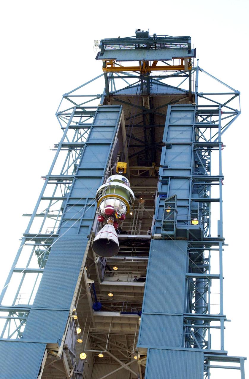
VANDENBERG AFB, CALIF. - The second stage of the Delta II rocket is lifted up the gantry on the launch pad. The Delta II rocket will launch the Aqua-EOS satellite. Aqua is one of a series of spacebased platforms that are central to NASA's Earth Science Enterprise (ESE), a long-term study of the scope, dynamics and implications of global change. The Aqua program is composed of Aqua and other spacecraft (including Terra and Aura) and a data distribution system (ESDIS, and Mission Operations Center Implementation Team). Flying in an orbit that covers the globe every 16 days, Aqua will provide a six-year chronology of the planet and its processes. Comprehensive measurements taken by its onboard instruments will allow multidisciplinary teams of scientists and researchers from North and South America, Asia, Australia and Europe to assess long-term change, identify its human and natural causes and advance the development of models for long-term forecasting. Launch is scheduled for April 26 from Vandenberg
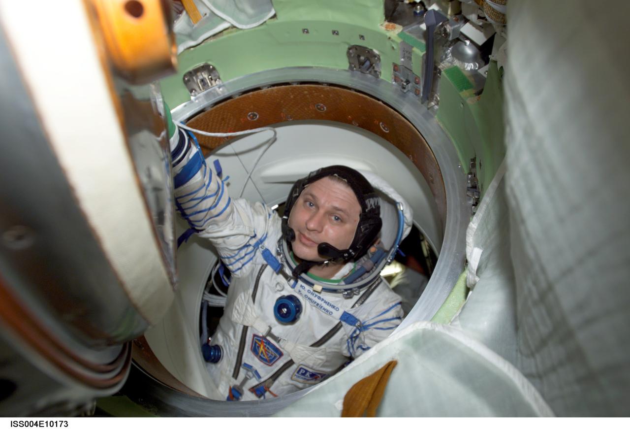
ISS004-E-10173 (20 April 2002) --- Cosmonaut Yury I. Onufrienko, Expedition Four mission commander, wearing a Russian Sokol suit, moves through a hatch in the Soyuz 3 spacecraft that is docked to the International Space Station (ISS). The Expedition Four crew undocked the Soyuz 3 capsule from the nadir docking port of the Zarya module of the ISS at 4:16 a.m. (CDT) and flew a short distance down the station for a redocking to the Pirs docking compartment at 4:37 a.m. (CDT) over Central Asia. The move was in preparation for the arrival of the new Soyuz 4 capsule on April 27, 2002, and a three-man “taxi” crew, Commander Yuri Gidzenko, who was a member of the first resident crew of the ISS; Flight Engineer Roberto Vittori of the European Space Agency (ESA); and South African space flight participant Mark Shuttleworth.

VANDENBERG AFB,CALIF. - On the SLC-2 launch pad, the gantry closes in on the Delta II rocket to enable mating of the second stage. The Delta II will launch the Aqua-EOS satellite. Aqua is one of a series of spacebased platforms that are central to NASA's Earth Science Enterprise (ESE), a long-term study of the scope, dynamics and implications of global change. The Aqua program is composed of Aqua and other spacecraft (including Terra and Aura) and a data distribution system (ESDIS, and Mission Operations Center Implementation Team). Flying in an orbit that covers the globe every 16 days, Aqua will provide a six-year chronology of the planet and its processes. Comprehensive measurements taken by its onboard instruments will allow multidisciplinary teams of scientists and researchers from North and South America, Asia, Australia and Europe to assess long-term change, identify its human and natural causes and advance the development of models for long-term forecasting. Launch is scheduled for April 26 from Vandenberg
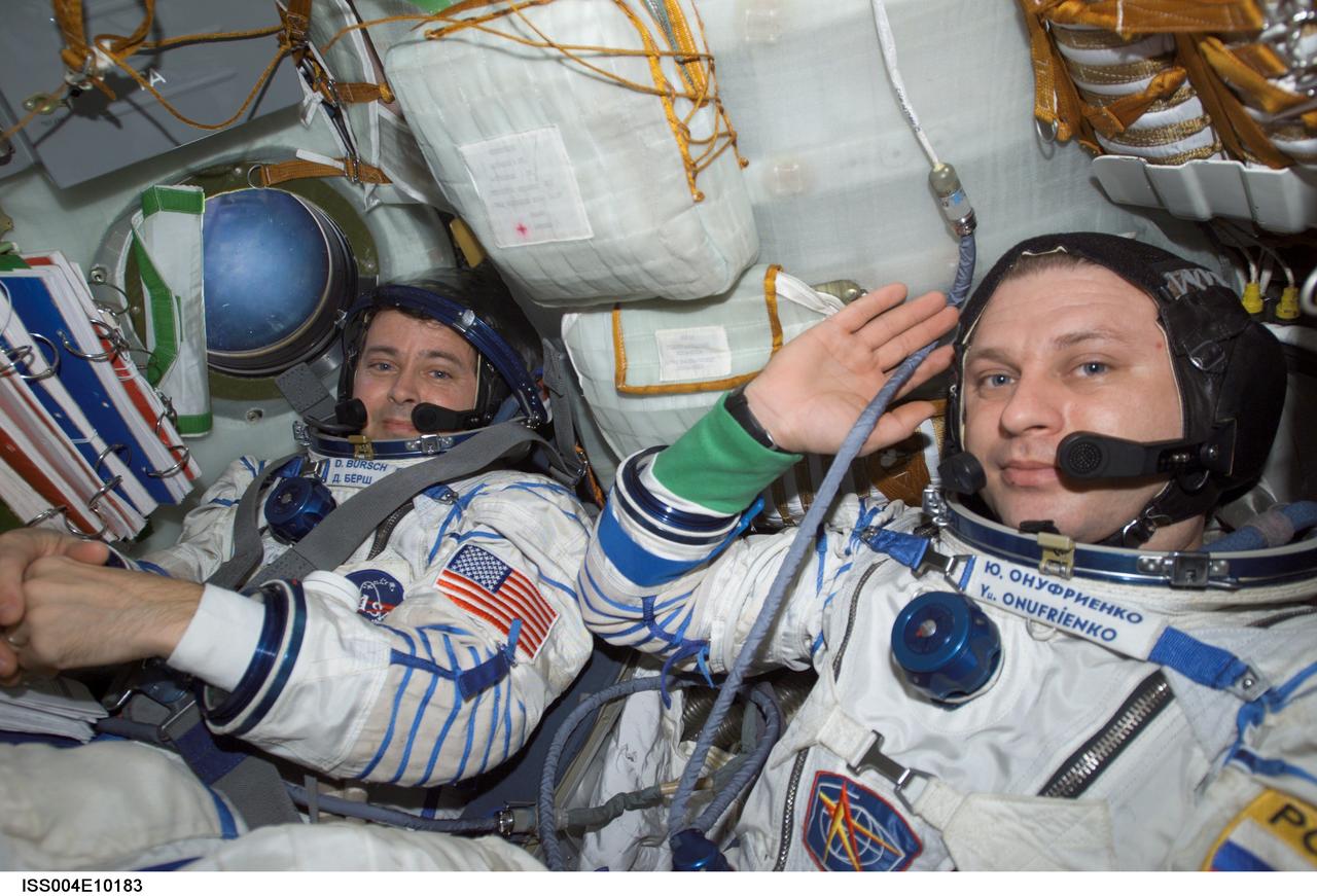
ISS004-E-10183 (20 April 2002) --- Astronaut Daniel W. Bursch (left) and cosmonaut Yury I. Onufrienko, Expedition Four flight engineer and mission commander, respectively, wearing Russian Sokol suits, are seated in the Soyuz 3 spacecraft that is docked to the International Space Station (ISS). The Expedition Four crew undocked the Soyuz 3 capsule from the nadir docking port of the Zarya module of the ISS at 4:16 a.m. (CDT) and flew a short distance down the station for a redocking to the Pirs docking compartment at 4:37 a.m. (CDT) over Central Asia. The move was in preparation for the arrival of the new Soyuz 4 capsule on April 27, 2002, and a three-man “taxi” crew, Commander Yuri Gidzenko, who was a member of the first resident crew of the ISS; Flight Engineer Roberto Vittori of the European Space Agency (ESA); and South African space flight participant Mark Shuttleworth.
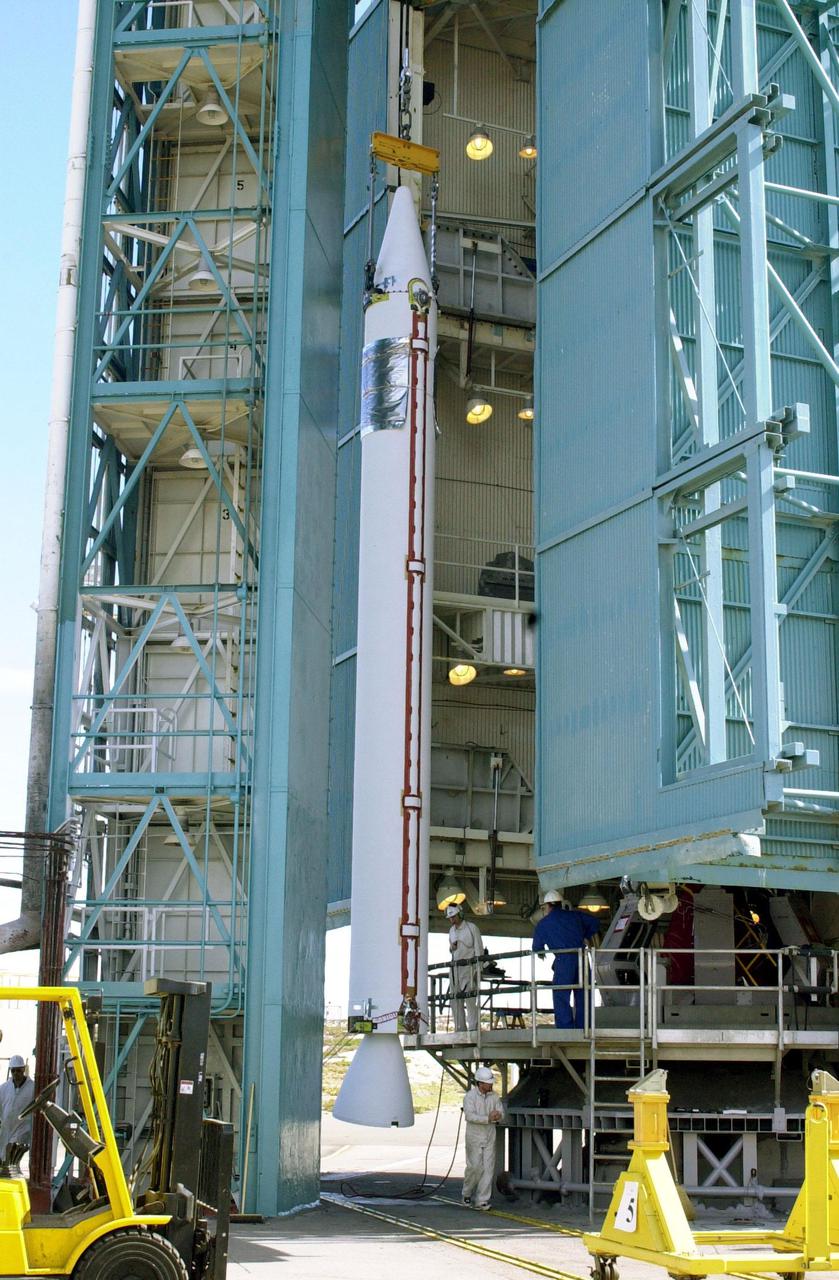
VANDENBERG AFB, CALIF. -- On the launch pad, a solid rocket booster is lifted up the gantry for mating with the Delta II rocket that will launch the Aqua-EOS satellite. Aqua is one of a series of spacebased platforms that are central to NASA's Earth Science Enterprise (ESE), a long-term study of the scope, dynamics and implications of global change. The Aqua program is composed of Aqua and other spacecraft (including Terra and Aura) and a data distribution system (ESDIS, and Mission Operations Center Implementation Team). Flying in an orbit that covers the globe every 16 days, Aqua will provide a six-year chronology of the planet and its processes. Comprehensive measurements taken by its onboard instruments will allow multidisciplinary teams of scientists and researchers from North and South America, Asia, Australia and Europe to assess long-term change, identify its human and natural causes and advance the development of models for long-term forecasting. Launch is scheduled for April 26 from Vandenberg
ISS037-E-000719 (13 Sept. 2013) --- Samarkand, Uzbekistan is featured in this image photographed by one of the Expedition 37 crew members aboard the International Space Station. The historical Silk Road provided trade routes between Asia and Europe as far back as 208 BC according to historical accounts. And, parts of the Silk Road are still used for the transport of goods today. The city of Samarkand is one of the oldest and historically most important cities along the road, occupying a central position between China and the western nationas of Europe, Today, Samarkand is the second largest city in the Republic of Uzbekistan (formed in 1991). The urban area (center) is located within a large oasis situated in the Zerafshan River Valley of southeastern Uzbekistan.
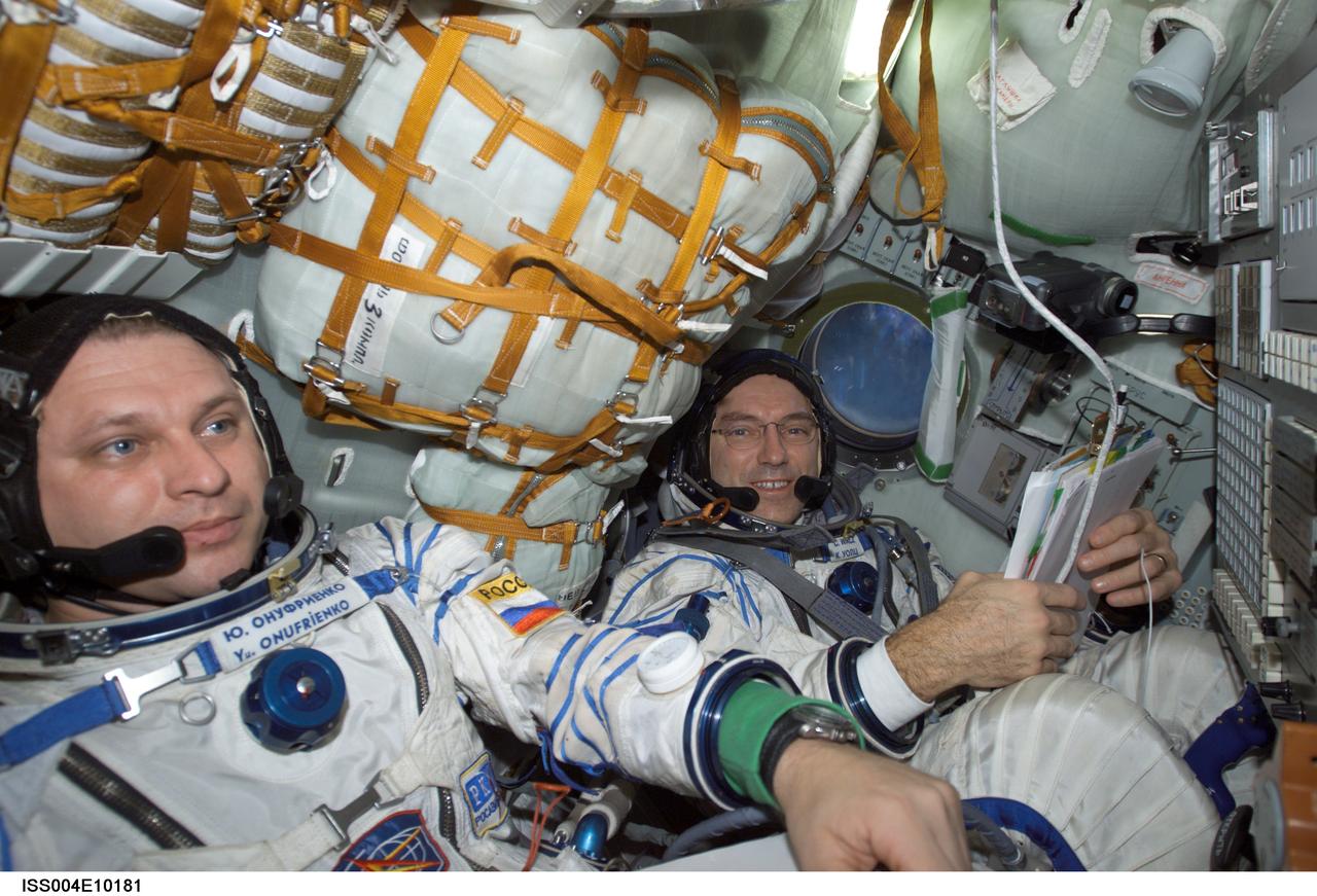
ISS004-E-10181 (20 April 2002) --- Cosmonaut Yury I. Onufrienko (left) and astronaut Carl E. Walz, Expedition Four mission commander and flight engineer, respectively, wearing Russian Sokol suits, are seated in the Soyuz 3 spacecraft that is docked to the International Space Station (ISS). The Expedition Four crew undocked the Soyuz 3 capsule from the nadir docking port of the Zarya module of the ISS at 4:16 a.m. (CDT) and flew a short distance down the station for a redocking to the Pirs docking compartment at 4:37 a.m. (CDT) over Central Asia. The move was in preparation for the arrival of the new Soyuz 4 capsule on April 27, 2002, and a three-man “taxi” crew, Commander Yuri Gidzenko, who was a member of the first resident crew of the ISS; Flight Engineer Roberto Vittori of the European Space Agency (ESA); and South African space flight participant Mark Shuttleworth.
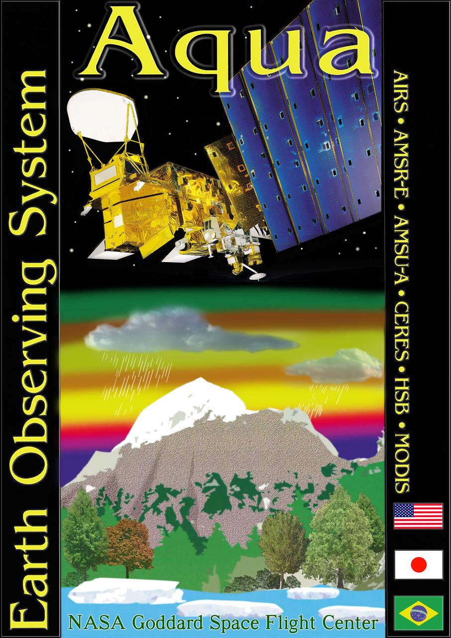
KENNEDY SPACE CENTER, FLA. -- The Aqua-EOS logo. Aqua is one of a series of spacebased platforms that are central to NASA's Earth Science Enterprise (ESE), a long-term study of the scope, dynamics and implications of global change. The Aqua program is composed of Aqua and other spacecraft (including Terra and Aura) and a data distribution system (ESDIS, and Mission Operations Center Implementation Team). Flying in an orbit that covers the globe every 16 days, Aqua will provide a six-year chronology of the planet and its processes. Comprehensive measurements taken by its onboard instruments will allow multidisciplinary teams of scientists and researchers from North and South America, Asia, Australia and Europe to assess long-term change, identify its human and natural causes and advance the development of models for long-term forecasting. Launch is scheduled from Vandenberg Air Force Base, Calif
VANDENBERG AFB, CALIF. -- On the launch pad, an overhead crane lifts a solid rocket booster to vertical for mating with the Delta II rocket that will launch the Aqua-EOS satellite. Aqua is one of a series of spacebased platforms that are central to NASA's Earth Science Enterprise (ESE), a long-term study of the scope, dynamics and implications of global change. The Aqua program is composed of Aqua and other spacecraft (including Terra and Aura) and a data distribution system (ESDIS, and Mission Operations Center Implementation Team). Flying in an orbit that covers the globe every 16 days, Aqua will provide a six-year chronology of the planet and its processes. Comprehensive measurements taken by its onboard instruments will allow multidisciplinary teams of scientists and researchers from North and South America, Asia, Australia and Europe to assess long-term change, identify its human and natural causes and advance the development of models for long-term forecasting. Launch is scheduled for April 26 from Vandenberg
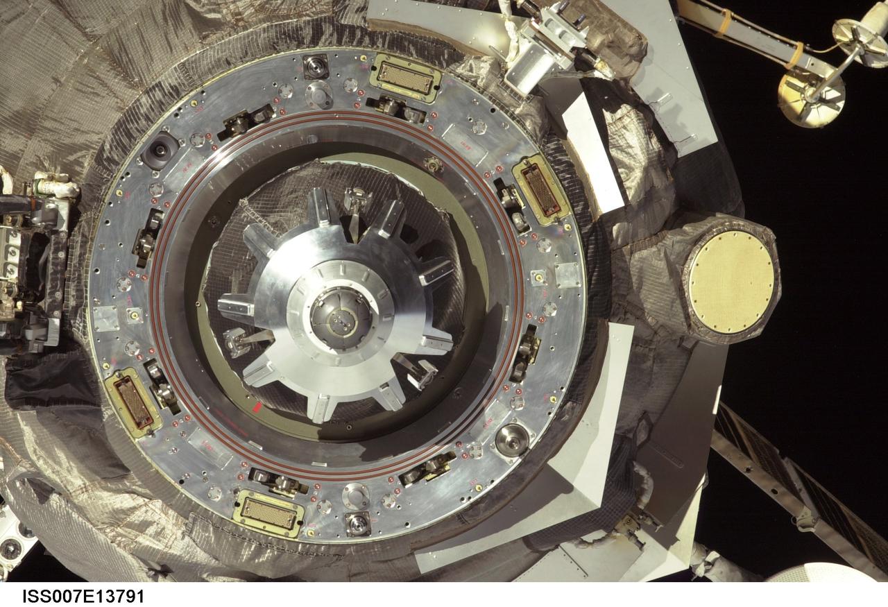
ISS007-E-13791 (30 August 2003) --- This close-up view of an unpiloted Progress supply vehicle was taken by one of the crewmembers onboard the International Space Station (ISS) as it approached the aft docking port (out of frame) on the Zvezda Service Module. The Progress 12 resupply craft, which launched from the Baikonur Cosmodrome in Kazakhstan at 8:48 p.m. (CDT) on August 28, 2003, carried nearly three tons of food, fuel, water, supplies and scientific gear for the Expedition 7 crew aboard the Station. The Progress linked up with the Station at 10:40 p.m. (CDT) on August 30, 2003 as the two spacecraft were flying over Central Asia at an altitude of 240 statute miles.
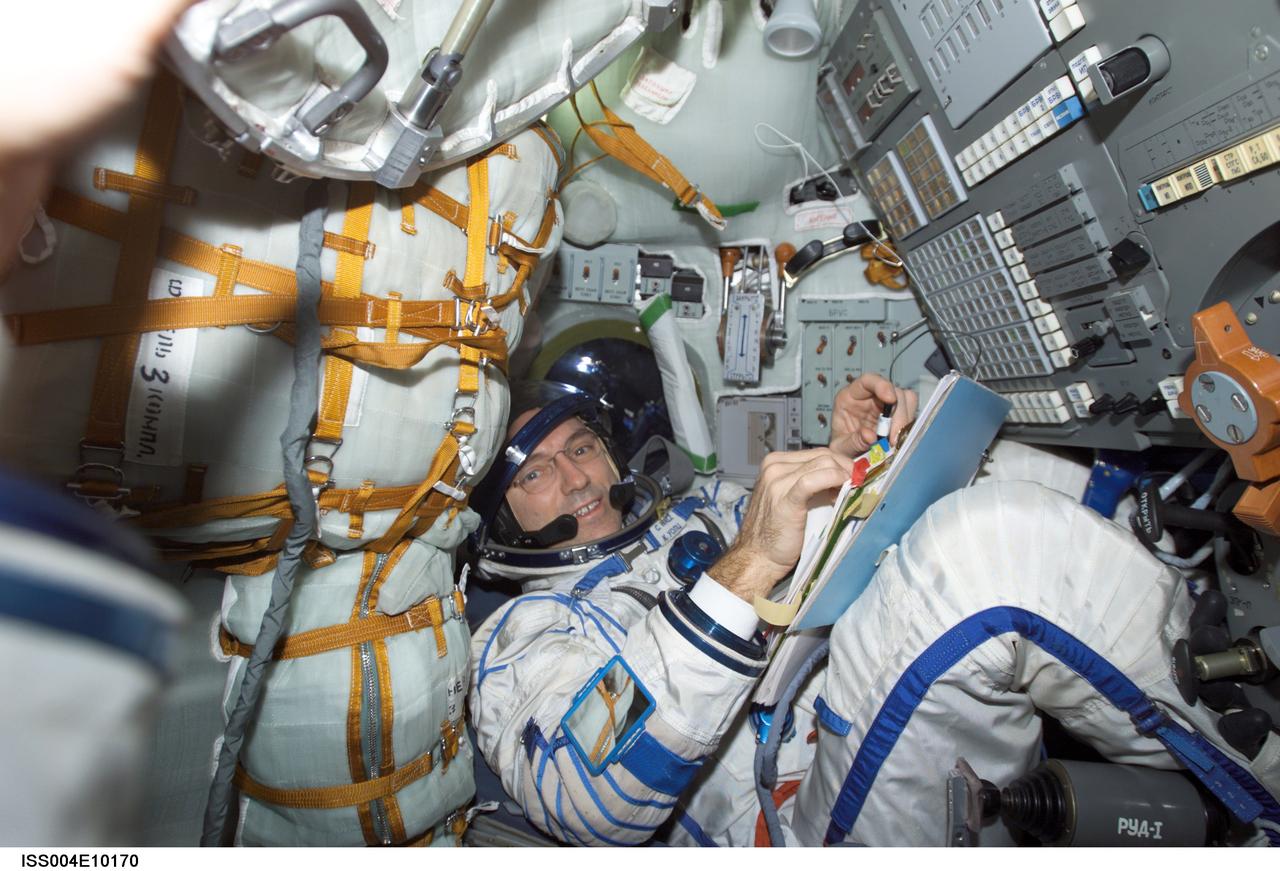
ISS004-E-10170 (20 April 2002) --- Astronaut Carl E. Walz, Expedition Four flight engineer, wearing a Russian Sokol suit, is seated in the Soyuz 3 spacecraft that is docked to the International Space Station (ISS). The Expedition Four crew undocked the Soyuz 3 capsule from the nadir docking port of the Zarya module of the ISS at 4:16 a.m. (CDT) and flew a short distance down the station for a redocking to the Pirs docking compartment at 4:37 a.m. (CDT) over Central Asia. The move was in preparation for the arrival of the new Soyuz 4 capsule on April 27, 2002, and a three-man “taxi” crew, Commander Yuri Gidzenko, who was a member of the first resident crew of the ISS; Flight Engineer Roberto Vittori of the European Space Agency (ESA); and South African space flight participant Mark Shuttleworth.
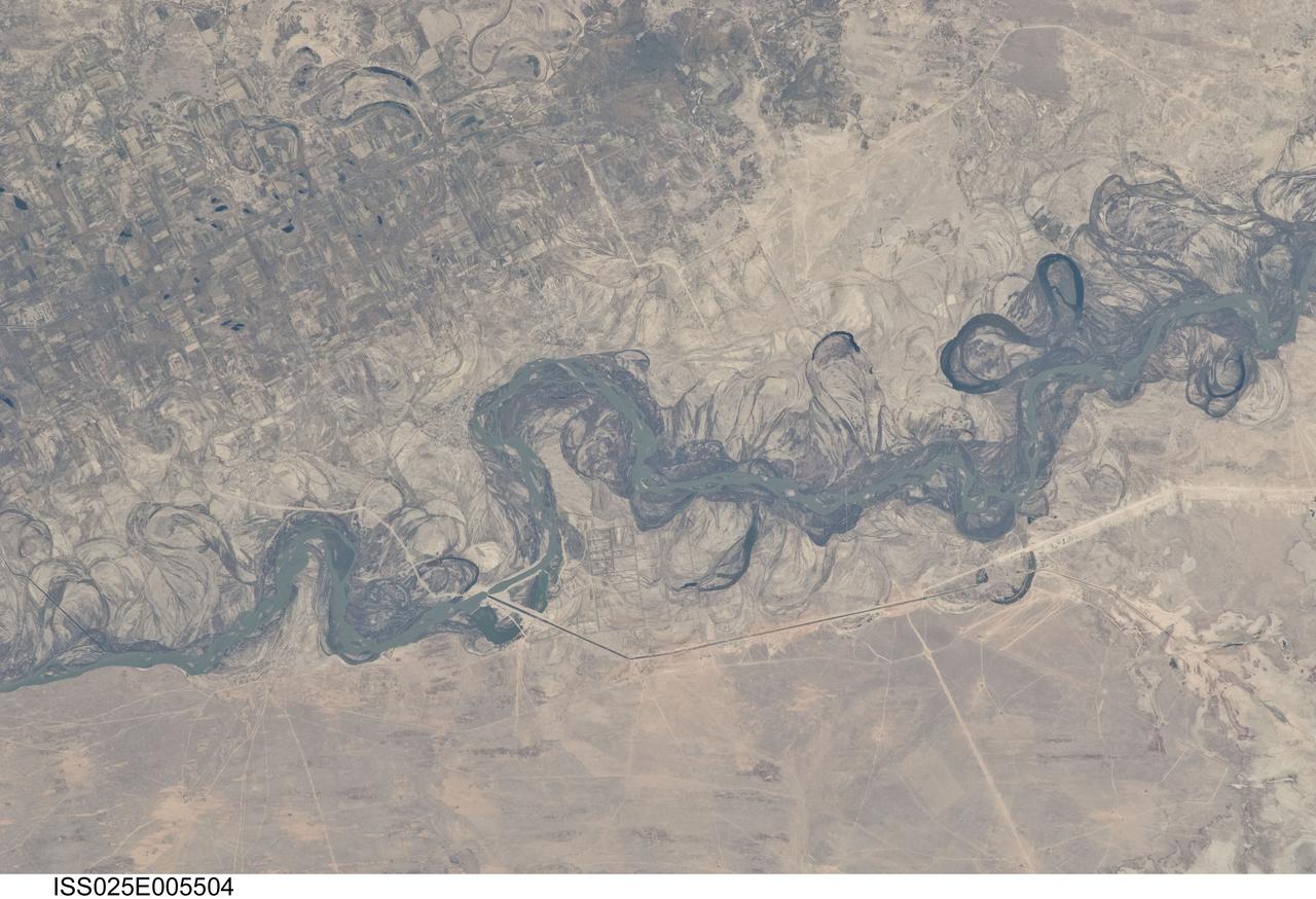
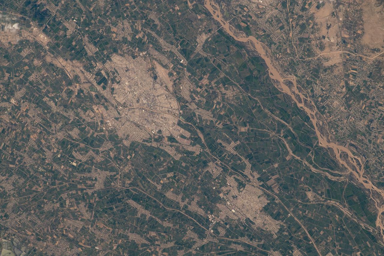
ISS025-E-005504 (30 Sept. 2010) --- Syr Dar’ya River floodplain in Kazakhstan, central Asia is featured in this image photographed by an Expedition 25 crew member on the International Space Station. Central Asia’s most important cotton-growing region is concentrated in the floodplain of the Syr Dar’ya, and is irrigated by water from the river. The floodplain is shown here as a tangle of twisting meanders and loops (center). The darkest areas are brushy vegetation along the present course (filled with blue-green water); wisps of vegetation are also visible along flanking swampy depressions, or sloughs. An older floodplain appears as an area of more diffuse dark vegetation (upper left), where a pattern of relict meander bends is overlain by a rectangular pattern of cotton fields. The straight channel of a new diversion canal—one of sixteen from this point downstream—can be seen along the east bank of the river. The older floodplain area is fed from the Chardara Reservoir immediately upstream (not shown). Half the river flow is controlled from reservoirs, and half from direct water take-off from canals. By contrast with the intensive agricultural use of water shown here, upstream water control in the mountain valleys is oriented more toward power generation. The river flows for a total distance of 2,200 kilometers from the Tien Shan Mountains westward and northwestward to the Aral Sea—the dying waterbody at the low point of the basin far to the northwest. Withdrawals of water from the river for agriculture have continued for many decades. Although the Syr Dar’ya is the second largest river flowing into the sea, its discharge is not very large. As such, it has been easily depleted, with none of its water today reaching the Aral Sea. Control of the river is vested in the Syr Dar’ya Basin Water Organization run by nations with territory in the Syr Dar’ya basin. Some of the organization’s main efforts are accurate gauging of water use along the river course, and repair of canals to reduce widespread water loss by leakage.
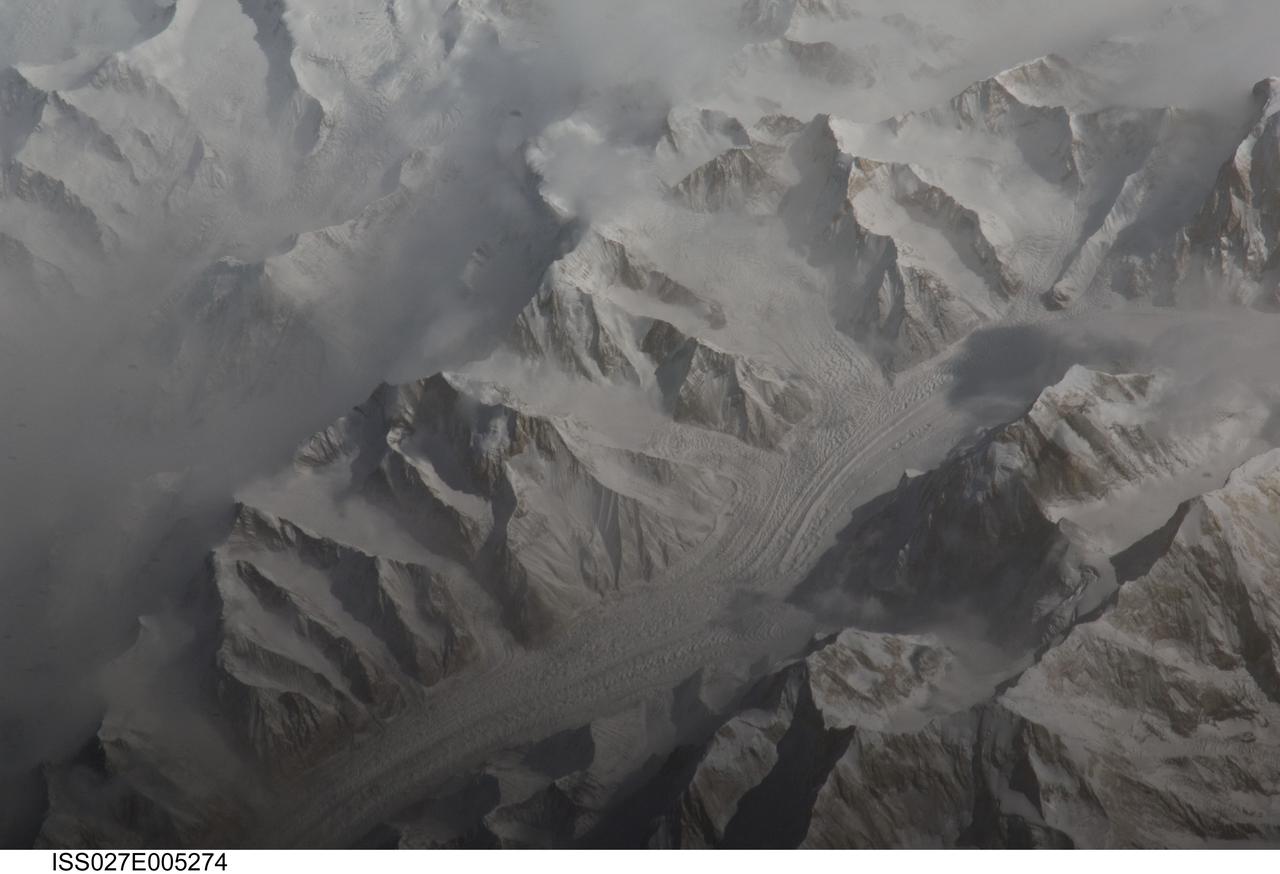
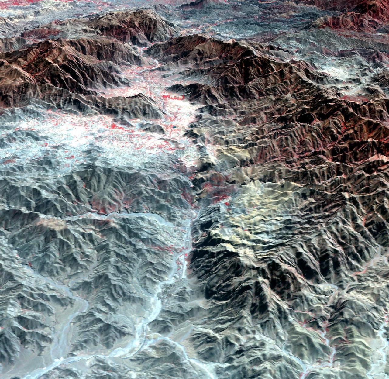
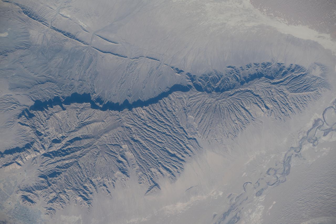
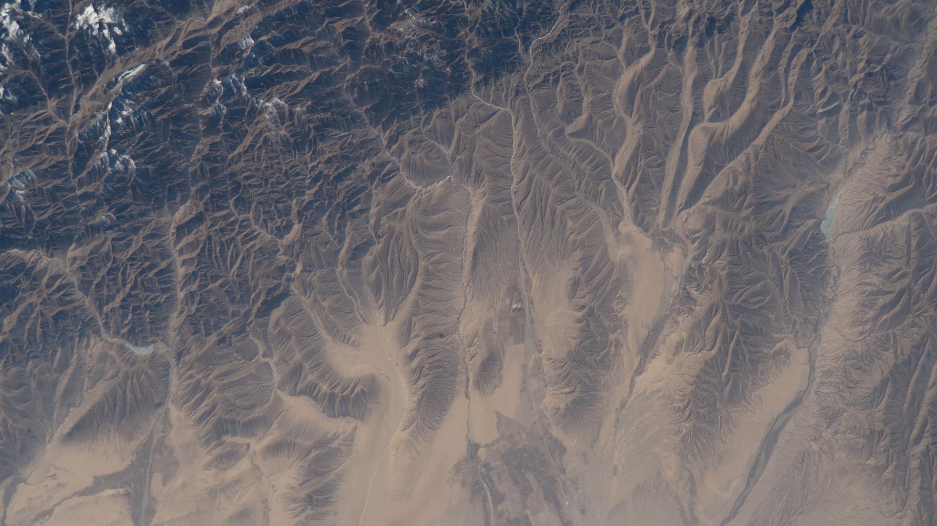
ISS027-E-005274 (16 March 2011) --- Central Tien Shan in the People?s Republic of China is featured in this image photographed by an Expedition 27 crew member on the International Space Station (ISS). The Tien Shan (or ?celestial mountains? in Chinese) is one of the largest continuous mountain ranges in the world, extending approximately 2,500 kilometers roughly east-west across Central Asia. This photograph provides a detailed view of part of the central Tien Shan, located approximately 64 kilometers east of a point where the borders of China, Kyrgyzstan, and Kazakhstan meet. While the image looks like it might have been taken from an airplane, it was taken from the space station at an altitude of 341 kilometers. The distance between the ISS ground track position (approximately 304 kilometers to the southwest) and the imaged area produces an oblique ? looking outwards an angle, rather than straight down ? view that, together with shadowing of valleys, accentuates the mountainous topography. Like the Himalayas to the south, the uplift of the Tien Shan results from the ongoing collision between the Eurasian and Indian continental tectonic plates. The rugged topography of the range is the result of subsequent erosion by water, wind, and in the highest parts of the range, active glaciers. Two types of glaciers are visible in the image; cirque glaciers occupy amphitheater-like depressions on the upper slopes of the mountains, and feed ice downslope to aggregate into large valley glaciers such as the one visible at center. Low clouds obscure an adjacent valley and glaciers to the north (upper left). Two high peaks of the central Tien Shan are identifiable in the image. Xuelian Feng has a high summit of 6,527 meters above sea level. To the east, the aptly-named Peak 6231 has summit of 6,231 meters above sea level.
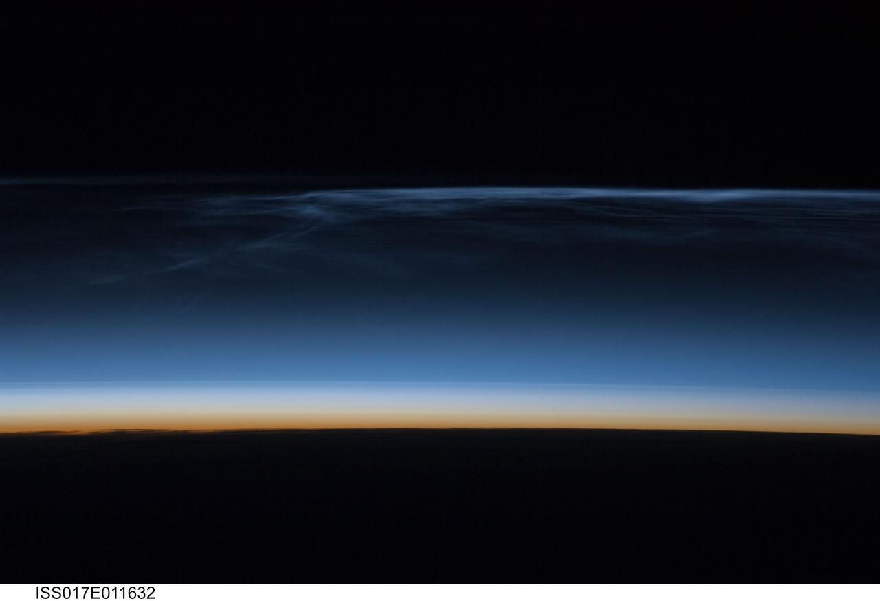
ISS017-E-011632 (22 July 2008) --- Polar Mesospheric Clouds (also known as noctilucent clouds) are transient, upper atmospheric phenomena observed usually in the summer months at high latitudes (greater than 50 degrees) of both the Northern and Southern Hemispheres. They are bright and cloudlike in appearance while in deep twilight. They are illuminated by sunlight when the lower layers of the atmosphere are in the darkness of the Earth's shadow. This image was acquired at an altitude of just over 200 miles in the pre-dawn hours of July 22, 2008 as the International Space Station was passing over western Mongolia in central Asia. The dark horizon of the Earth appears below with some layers of the lower atmosphere already illuminated. The higher, bluish-colored clouds look much like wispy cirrus clouds which can be found in the troposphere as high as 60,000 feet. However noctilucent clouds, as seen here, are observed in the mesosphere at altitudes of 250,000 to 280,000 feet. Astronaut observations of Polar Mesospheric Clouds (PMC) over northern Asia in June and July are not uncommon. The Expedition 17 crew of the International Space Station acquired this image, and more, in support of research for the International Polar Year. Some researchers link increased observations of PMC to changes in global climate; PMC have been the subject of extensive observation and research from space by the Swedish satellite Odin launched in 2001 and more recently by NASA's Aeronomy of Ice in the Mesosphere (AIM) satellite system beginning in 2007.
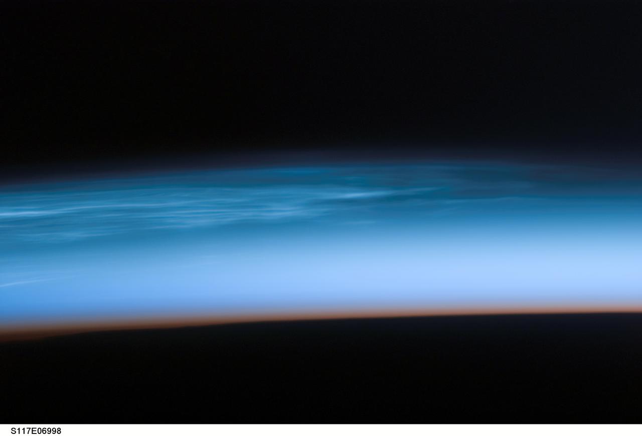
S117-E-06998 (10 June 2007) --- Polar Mesospheric Clouds are featured in this image photographed by a STS-117 crewmember onboard Space Shuttle Atlantis. Sometimes in the summertime in the far northern (or southern) latitudes, high in the Earth's atmosphere at the edge of space, thin silvery clouds form and are observed just after sunset. These high clouds, occurring at altitudes of about 80 kilometers (50 miles), are called Polar Mesospheric Clouds (PMC) or noctilucent clouds, and are the subject of new studies to determine whether their occurrence is related to global climate change. Observations over the past few years suggest that PMC are now observed more frequently and at lower latitudes than historical observations. Several studies related to the International Polar Year (IPY), and the AIM (Aeronomy of Ice in the Mesosphere) spacecraft are underway to collect relevant data on the chemistry and physics of the mesosphere that might explain the occurrence of PMC. Astronauts in orbiting spacecraft frequently observe PMC over Canada, northern Europe and Asia during June, July and August. While PMC also occur over the high latitudes in the southern hemisphere in December, January and February, astronaut observations of southern PMC are less frequent. Earlier in June 2007, the shuttle crew visiting the International Space Station observed spectacular PMC over north-central Asia. This image was taken looking north while the shuttle and station were docking and flying over the border between western China, Mongolia and Kazakhstan. The red-to-dark region at the bottom of the image is the dense part of the Earth's atmosphere. Because this image was taken with a long lens (180mm), the entire profile of the Earth's limb is not captured. To support IPY research over the next 2 years, station crewmembers will be looking for and documenting PMC in both hemispheres.

VANDENBERG AFB, CALIF. - - Inside the gantry on the SLC-2 launch pad, workers check the fitting on the second stage of a Delta II rocket mated with the first stage, below. The Delta II will launch the Aqua-EOS satellite. Aqua is one of a series of spacebased platforms that are central to NASA's Earth Science Enterprise (ESE), a long-term study of the scope, dynamics and implications of global change. The Aqua program is composed of Aqua and other spacecraft (including Terra and Aura) and a data distribution system (ESDIS, and Mission Operations Center Implementation Team). Flying in an orbit that covers the globe every 16 days, Aqua will provide a six-year chronology of the planet and its processes. Comprehensive measurements taken by its onboard instruments will allow multidisciplinary teams of scientists and researchers from North and South America, Asia, Australia and Europe to assess long-term change, identify its human and natural causes and advance the development of models for long-term forecasting. Launch is scheduled for April 26 from Vandenberg
VANDENBERG AFB, CALIF. - Inside the gantry on the SLC-2 launch pad, the second stage of a Delta II rocket is lowered for mating with the first stage, below. The Delta II will launch the Aqua-EOS satellite. Aqua is one of a series of spacebased platforms that are central to NASA's Earth Science Enterprise (ESE), a long-term study of the scope, dynamics and implications of global change. The Aqua program is composed of Aqua and other spacecraft (including Terra and Aura) and a data distribution system (ESDIS, and Mission Operations Center Implementation Team). Flying in an orbit that covers the globe every 16 days, Aqua will provide a six-year chronology of the planet and its processes. Comprehensive measurements taken by its onboard instruments will allow multidisciplinary teams of scientists and researchers from North and South America, Asia, Australia and Europe to assess long-term change, identify its human and natural causes and advance the development of models for long-term forecasting. Launch is scheduled for April 26 from Vandenberg
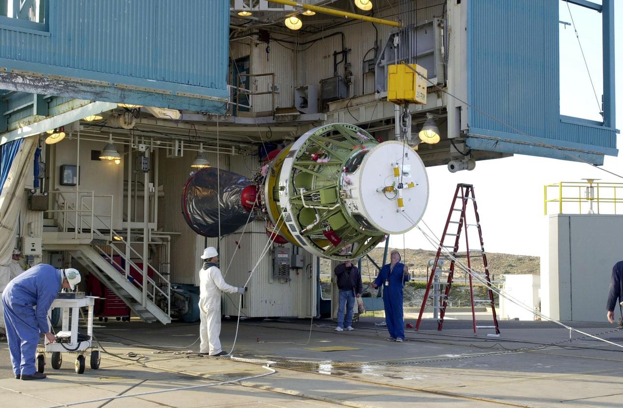
VANDENBERG AFB, CALIF. -- The second stage of the Delta II rocket is ready to be raised to vertical for its lift up the gantry on the launch pad. The Delta II rocket will launch the Aqua-EOS satellite. Aqua is one of a series of spacebased platforms that are central to NASA's Earth Science Enterprise (ESE), a long-term study of the scope, dynamics and implications of global change. The Aqua program is composed of Aqua and other spacecraft (including Terra and Aura) and a data distribution system (ESDIS, and Mission Operations Center Implementation Team). Flying in an orbit that covers the globe every 16 days, Aqua will provide a six-year chronology of the planet and its processes. Comprehensive measurements taken by its onboard instruments will allow multidisciplinary teams of scientists and researchers from North and South America, Asia, Australia and Europe to assess long-term change, identify its human and natural causes and advance the development of models for long-term forecasting. Launch is scheduled for April 26 from Vandenberg
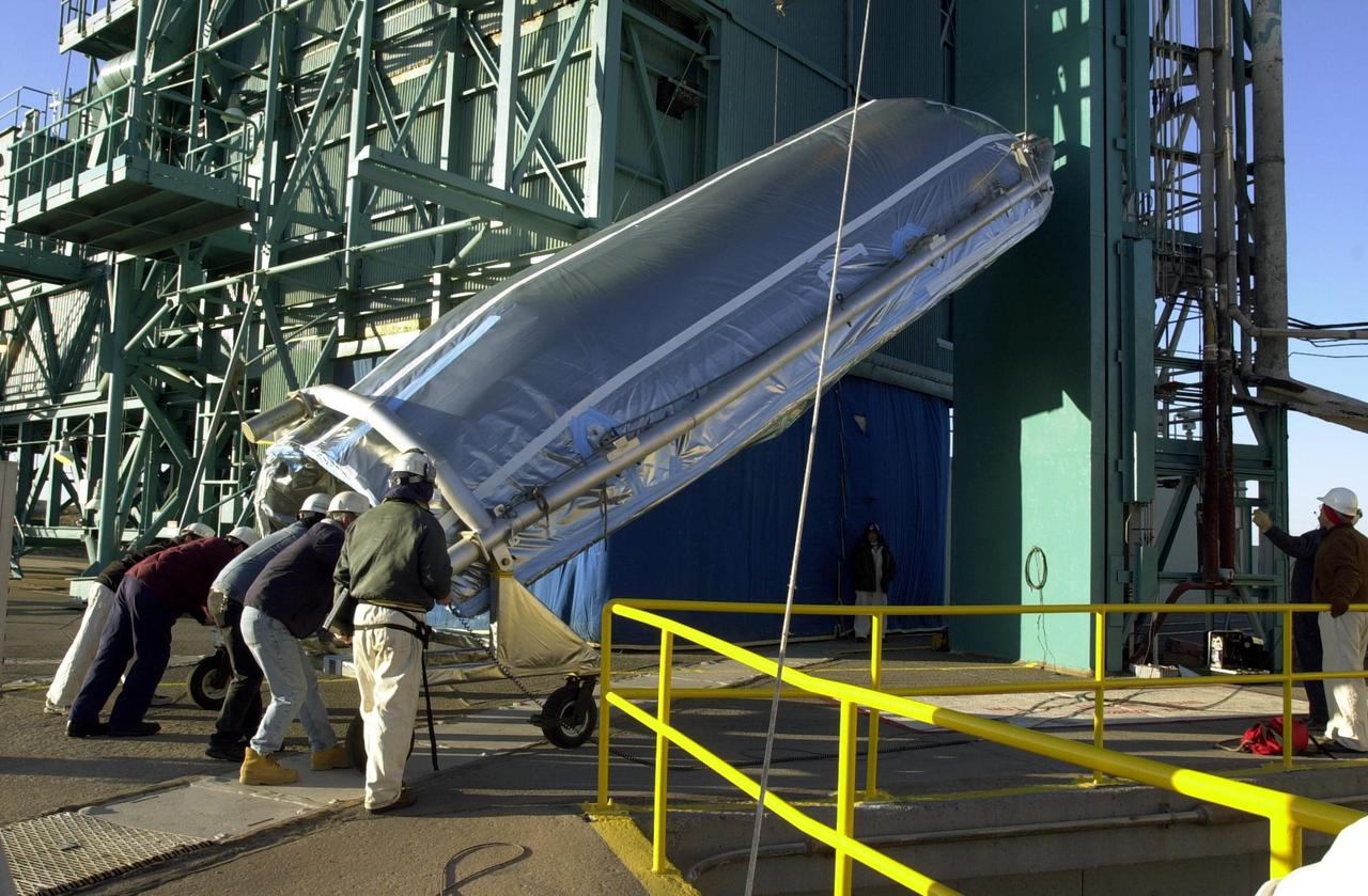
VANDENBERG AFB, CALIF. - On the SLC-2 launch pad, the first half of the Delta II fairing for the Aqua-EOS satellite arrives at the gantry. The Delta II will launch the Aqua-EOS satellite. Aqua is one of a series of spacebased platforms that are central to NASA's Earth Science Enterprise (ESE), a long-term study of the scope, dynamics and implications of global change. The Aqua program is composed of Aqua and other spacecraft (including Terra and Aura) and a data distribution system (ESDIS, and Mission Operations Center Implementation Team). Flying in an orbit that covers the globe every 16 days, Aqua will provide a six-year chronology of the planet and its processes. Comprehensive measurements taken by its onboard instruments will allow multidisciplinary teams of scientists and researchers from North and South America, Asia, Australia and Europe to assess long-term change, identify its human and natural causes and advance the development of models for long-term forecasting. Launch is scheduled for April 26 from Vandenberg
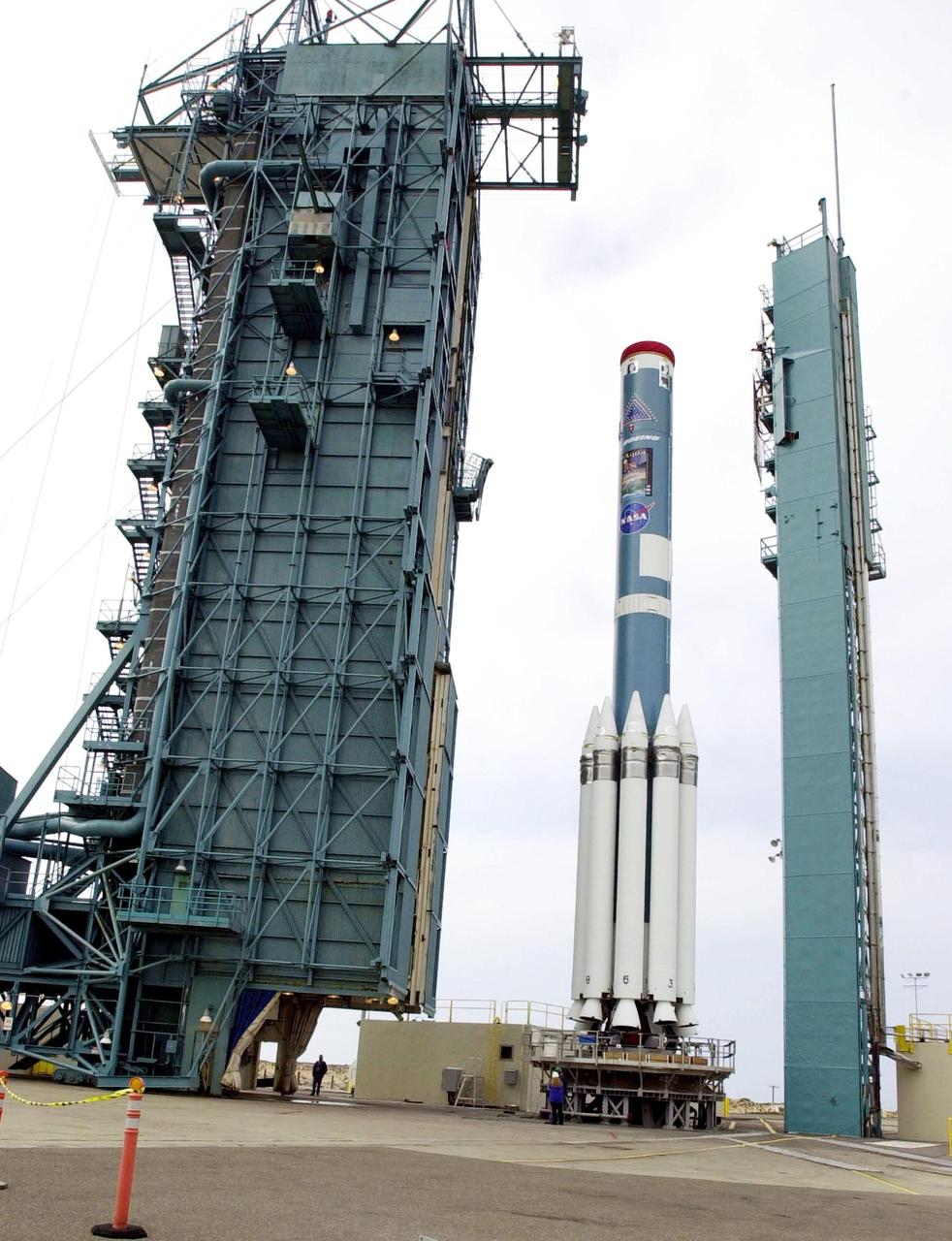
VANDENBERG AFB,CALIF. - The gantry (left) on SLC-2 moves toward the first stage of the Delta II rocket, for mating with the second stage. The Delta II will launch the Aqua-EOS satellite. Aqua is one of a series of spacebased platforms that are central to NASA's Earth Science Enterprise (ESE), a long-term study of the scope, dynamics and implications of global change. The Aqua program is composed of Aqua and other spacecraft (including Terra and Aura) and a data distribution system (ESDIS, and Mission Operations Center Implementation Team). Flying in an orbit that covers the globe every 16 days, Aqua will provide a six-year chronology of the planet and its processes. Comprehensive measurements taken by its onboard instruments will allow multidisciplinary teams of scientists and researchers from North and South America, Asia, Australia and Europe to assess long-term change, identify its human and natural causes and advance the development of models for long-term forecasting. Launch is scheduled for April 26 from Vandenberg
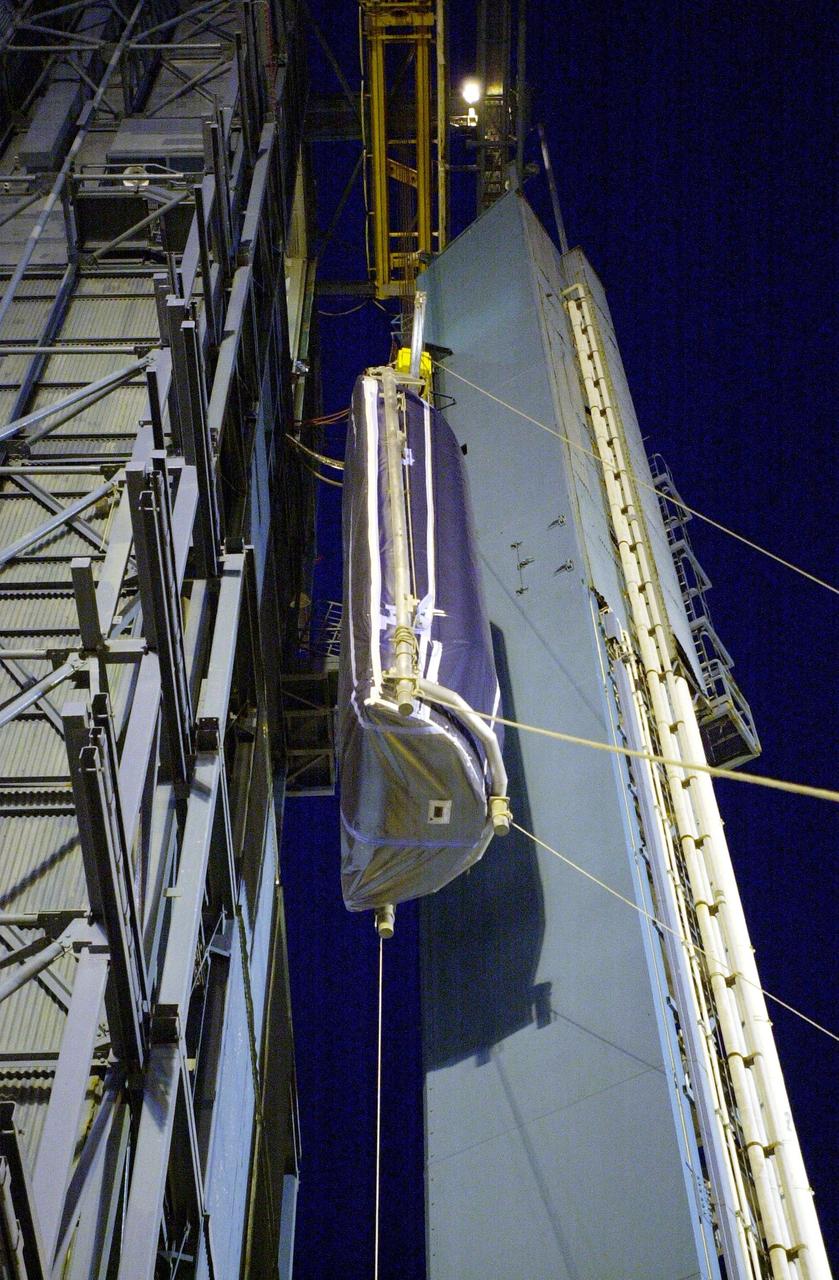
VANDENBERG AFB, CALIF. - On the SLC-2 launch pad, the first half of the Delta II fairing for the Aqua-EOS satellite is lifted up the gantry. The Delta II will launch the Aqua-EOS satellite, one of a series of spacebased platforms that are central to NASA's Earth Science Enterprise (ESE), a long-term study of the scope, dynamics and implications of global change. The Aqua program is composed of Aqua and other spacecraft (including Terra and Aura) and a data distribution system (ESDIS, and Mission Operations Center Implementation Team). Flying in an orbit that covers the globe every 16 days, Aqua will provide a six-year chronology of the planet and its processes. Comprehensive measurements taken by its onboard instruments will allow multidisciplinary teams of scientists and researchers from North and South America, Asia, Australia and Europe to assess long-term change, identify its human and natural causes and advance the development of models for long-term forecasting. Launch is scheduled for April 26 from Vandenberg
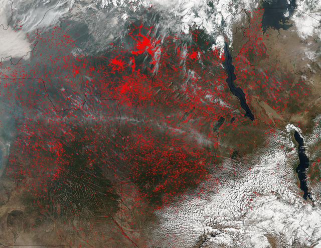
NASA’s Suomi NPP satellite detected thousands of fires burning in central Africa on July 11, 2016. The fires are represented by the multitudes of red dots. Most of the fires burn in grass or cropland. The location, widespread nature, and number of fires suggest that these fires were deliberately set to manage land. Places where traditional plots of open land is not available because the vegetation in the area is dense are the places where "slash and burn" agriculture is practiced most often. These regions include parts of Africa, northern South America, and Southeast Asia, where an abundance of grasslands and rainforests are found. Although most parts of the world outlaw this type of agriculture due to the fact that the smoke from these (or any) fires is a health hazard, the method of agriculture continues because it is the easiest and lowest cost solution to clearing fields for next year's crops. The Suomi NPP satellite is a joint mission between NASA, NOAA and the U.S. Department of Defense. NASA image courtesy Jeff Schmaltz, MODIS Rapid Response Team.
VANDENBERG AFB, CALIF. -- The partially assembled Delta II rocket (right) and the gantry (left) wait for the rocket's second stage to be transported to the launch pad. The Delta II rocket will launch the Aqua-EOS satellite. Aqua is one of a series of spacebased platforms that are central to NASA's Earth Science Enterprise (ESE), a long-term study of the scope, dynamics and implications of global change. The Aqua program is composed of Aqua and other spacecraft (including Terra and Aura) and a data distribution system (ESDIS, and Mission Operations Center Implementation Team). Flying in an orbit that covers the globe every 16 days, Aqua will provide a six-year chronology of the planet and its processes. Comprehensive measurements taken by its onboard instruments will allow multidisciplinary teams of scientists and researchers from North and South America, Asia, Australia and Europe to assess long-term change, identify its human and natural causes and advance the development of models for long-term forecasting. Launch is scheduled for April 26 from Vandenberg
VANDENBERG AFB, CALIF. - Workers on the launch pad ready the second stage of the Delta II rocket for its lift up the gantry on the launch pad. The Delta II rocket will launch the Aqua-EOS satellite. Aqua is one of a series of spacebased platforms that are central to NASA's Earth Science Enterprise (ESE), a long-term study of the scope, dynamics and implications of global change. The Aqua program is composed of Aqua and other spacecraft (including Terra and Aura) and a data distribution system (ESDIS, and Mission Operations Center Implementation Team). Flying in an orbit that covers the globe every 16 days, Aqua will provide a six-year chronology of the planet and its processes. Comprehensive measurements taken by its onboard instruments will allow multidisciplinary teams of scientists and researchers from North and South America, Asia, Australia and Europe to assess long-term change, identify its human and natural causes and advance the development of models for long-term forecasting. Launch is scheduled for April 26 from Vandenberg
ISS013-E-78506 (7 Sept. 2006) --- Sand dunes near Mongolia's Har Lake are featured in this image photographed by an Expedition 13 crewmember on the International Space Station. Har (or Black) Lake is located in the western part of the country within the Valley of Lakes--part of a system of closed basins that stretches across central Asia. According to scientists, these basins are the remnants of larger paleolakes that had begun to shrink in size by approximately five thousand years ago as regional climate became drier. Today, the Valley of Lakes is an important ecological resource for study of steppe grasslands, and as resting points for large numbers of migratory birds. Portions of the basin are designated as national parks or other protected areas, and Har Lake itself is an ecotourism destination (usually by horseback). This oblique view captures the dynamic nature of the landscape of Har Lake. The lake is encircled by sand dune fields which encroach on the lower slopes of the Tobhata Mountains to the west and south. Gaps in the mountains have been exploited by sand dunes moving eastward (indicating westerly winds) -- the most striking example being a series of dunes entering Har Lake along its southwestern shoreline. Here, the dune forms reflect the channeling of winds through the break in the mountain ridgeline, leading to dune crests oriented transverse to northwesterly winds. Another well-developed line of dunes is visible between Har and Baga Lakes. While these dunes appear to cut across a lake surface, the dunes have in fact moved across a narrow stream channel.
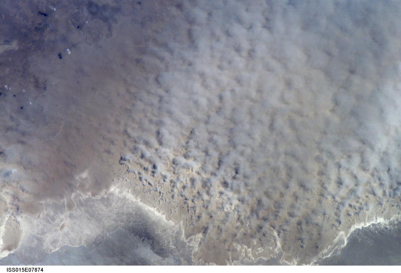
ISS015-E-07874 (12 May 2007) --- A major dust storm (center right) along the east side of the Aral Sea, Kazakhstan, is featured in this image photographed by an Expedition 15 crewmember on the International Space Station while passing over central Asia. The white, irregular lines along the bottom of the image are salt and clay deposits on the present coastline. On the spring day when the ISS crew shot the image, winds were blowing from the west (lower left). The gray, puffy appearance is typical of dust clouds, allowing scientists to distinguish dust from fog and smog. The dust in this image is rising from the sea bed of the Aral Sea, from a point close to the middle of the original Aral Sea of 40--50 years ago, then the fourth largest inland sea on Earth. Heavy extraction of water from the main supply river, the Amu Dary'a, has resulted in rapid shrinking of the sea. According to scientists, dust storms have been occurring in the Aral Sea region for thousands of years, but since the drastic shrinking of the sea over the past half-century an important change in dust composition has occurred. The dust now includes fertilizer and pesticide washed into the Sea from the extensive cotton fields of the Amu Dary'a floodplain. Years of liberal application of agricultural chemicals have resulted in concentration of these pollutants on the sea bed. These are now exposed to the wind and transported hundreds of kilometers in a generally easterly direction. Research suggests that the remobilized chemicals are the cause of high rates of many diseases in the populations along the north, east and southern margins of the Aral Sea. This is one of the unintended consequences of the shrinking of the sea, which has made international news for many years due to the loss of the fishing industry and other significant ecological problems.
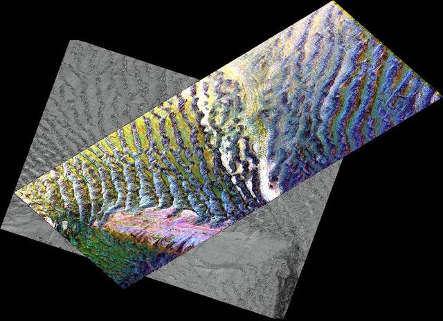
This composite image is of an area thought to contain the ruins of the ancient settlement of Niya. It is located in the southwest corner of the Taklamakan Desert in China Sinjiang Province. This region was part of some of China's earliest dynasties and from the third century BC on was traversed by the famous Silk Road. The Silk Road, passing east-west through this image, was an ancient trade route that led across Central Asia's desert to Persia, Byzantium and Rome. The multi-frequency, multi-polarized radar imagery was acquired on orbit 106 of the space shuttle Endeavour on April 16, 1994 by the Spaceborne Imaging Radar-C/X-band Synthetic Aperture Radar. The image is centered at 37.78 degrees north latitude and 82.41 degrees east longitude. The area shown is approximately 35 kilometers by 83 kilometers (22 miles by 51 miles). The image is a composite of an image from an Earth-orbiting satellite called Systeme Probatoire d'Observation de la Terre (SPOT) and a SIR-C multi-frequency, multi-polarized radar image. The false-color radar image was created by displaying the C-band (horizontally transmitted and received) return in red, the L-band (horizontally transmitted and received) return in green, and the L-band (horizontally transmitted and vertically received) return in blue. The prominent east/west pink formation at the bottom of the image is most likely a ridge of loosely consolidated sedimentary rock. The Niya River -- the black feature in the lower right of the French satellite image -- meanders north-northeast until it clears the sedimentary ridge, at which point it abruptly turns northwest. Sediment and evaporite deposits left by the river over millennia dominate the center and upper right of the radar image (in light pink). High ground, ridges and dunes are seen among the riverbed meanderings as mottled blue. Through image enhancement and analysis, a new feature probably representing a man-made canal has been discovered and mapped. http://photojournal.jpl.nasa.gov/catalog/PIA01726
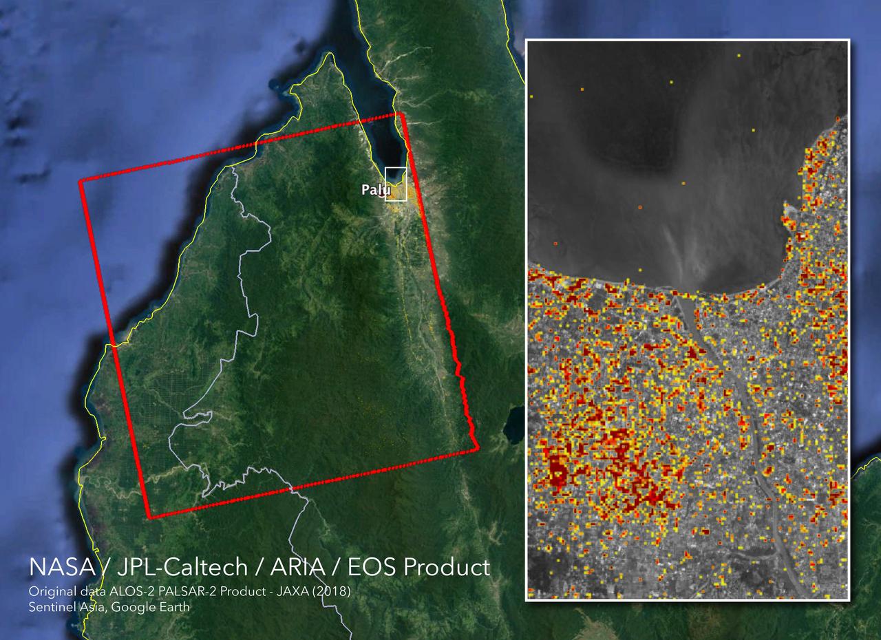
The Advanced Rapid Imaging and Analysis (ARIA) team at NASA's Jet Propulsion Laboratory in Pasadena, California, and Caltech, also in Pasadena, created this Damage Proxy Map (DPM) depicting areas in Central Sulawesi, Indonesia, including the city of Palu, that are likely damaged (shown by red and yellow pixels) as a result of the magnitude 7.5 September 28, 2018 earthquake. The map is derived from synthetic aperture radar (SAR) images from the ALOS-2 satellite, operated by Japan Aerospace Exploration Agency (JAXA). The images were taken before (Aug. 8, 2018) and after (Oct. 3, 2018) the earthquake. The map covers an area of 42 by 44 miles (67 by 70 kilometers), shown by the large red polygon. Each pixel measures about 33 yards (30 meters) across. The color variation from yellow to red indicates increasingly more significant ground surface change. Preliminary validation was done in collaboration with the Earth Observatory of Singapore by comparing with local media information and photos. This damage proxy map should be used as guidance to identify damaged areas, and may be less reliable over vegetated areas. For example, the scattered single colored pixels over vegetated areas may be false positives, and the lack of colored pixels over vegetated areas does not necessarily mean no damage. The DPM was created by the NASA-JPL/Caltech ARIA team, and the ALOS-2 data were provided by JAXA. The Earth Observatory of Singapore coordinated with the Sentinel Asia to timely task the ALOS-2 satellite. The algorithm development was carried out at JPL under a contract with NASA. https://photojournal.jpl.nasa.gov/catalog/PIA22746