This 3-D image, or anaglyph, shows the center of Occator Crater, the brightest area on dwarf planet Ceres, using data from NASA's Dawn mission. The bright central area, including a dome that is 0.25 miles (400 meters) high, is called Cerealia Facula. The secondary, scattered bright areas are called Vinalia Faculae. A 2017 study suggests that the central bright area is significantly younger than Occator Crater. Estimates put Cerealia Facula at 4 million years old, while Occator Crater is approximately 34 million years old. The reflective material that appears so bright in this image is made of carbonate salts, according to Dawn researchers. The Vinalia Faculae seem to be composed of carbonates mixed with dark material. http://photojournal.jpl.nasa.gov/catalog/PIA21398
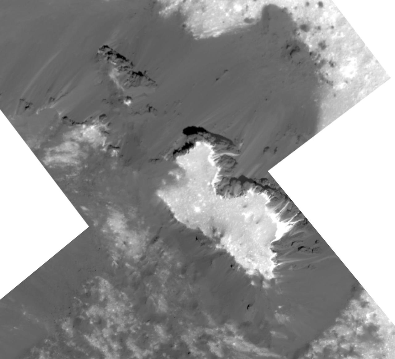
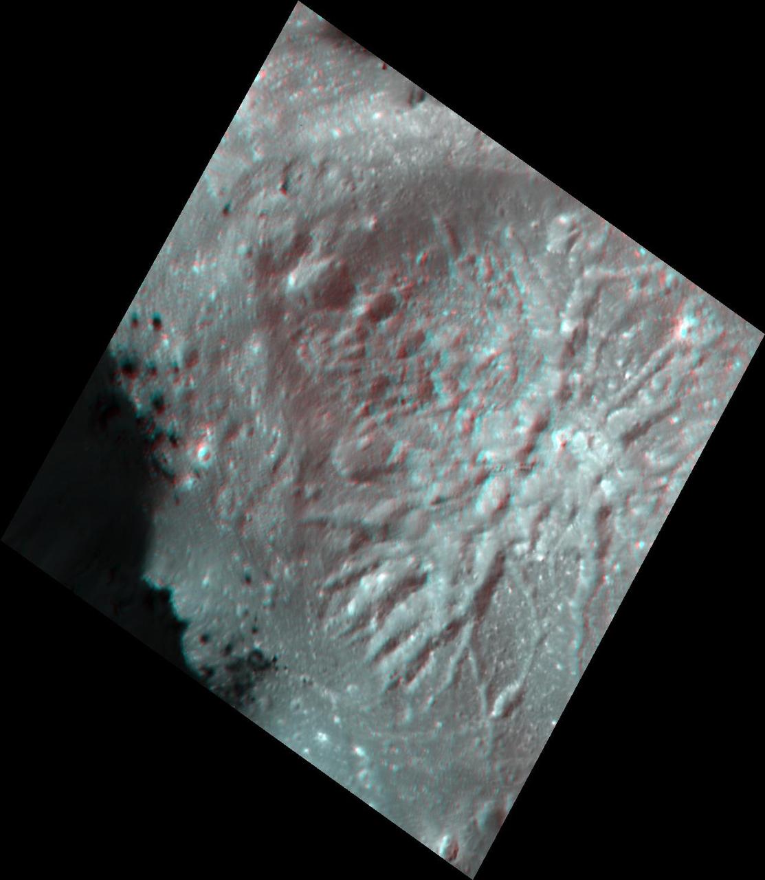
This mosaic of a prominent mound located on the western side of Cerealia Facula was obtained by NASA's Dawn spacecraft on June 22, 2018 from an altitude of about 21 miles (34 kilometers). The geometry of this feature is similar to a mesa or large butte with a flat top. It has been puzzling scientists since its discovery in the early images of the Dawn mission at Ceres. These new images reveal many details. In particular, the relationships between the bright material, mostly composed of sodium carbonate, and the dark background might hold clues about the origin of the facula. This feature is located at about 19.5 degrees north latitude and 239.2 degrees east longitude. https://photojournal.jpl.nasa.gov/catalog/PIA22477
This image was obtained by NASA's Dawn spacecraft on July 5, 2018 from an altitude of about 33 miles (54 kilometers). The center of this picture is located at about 20.3 degrees north latitude and 240.6 degrees east longitude. https://photojournal.jpl.nasa.gov/catalog/PIA22630
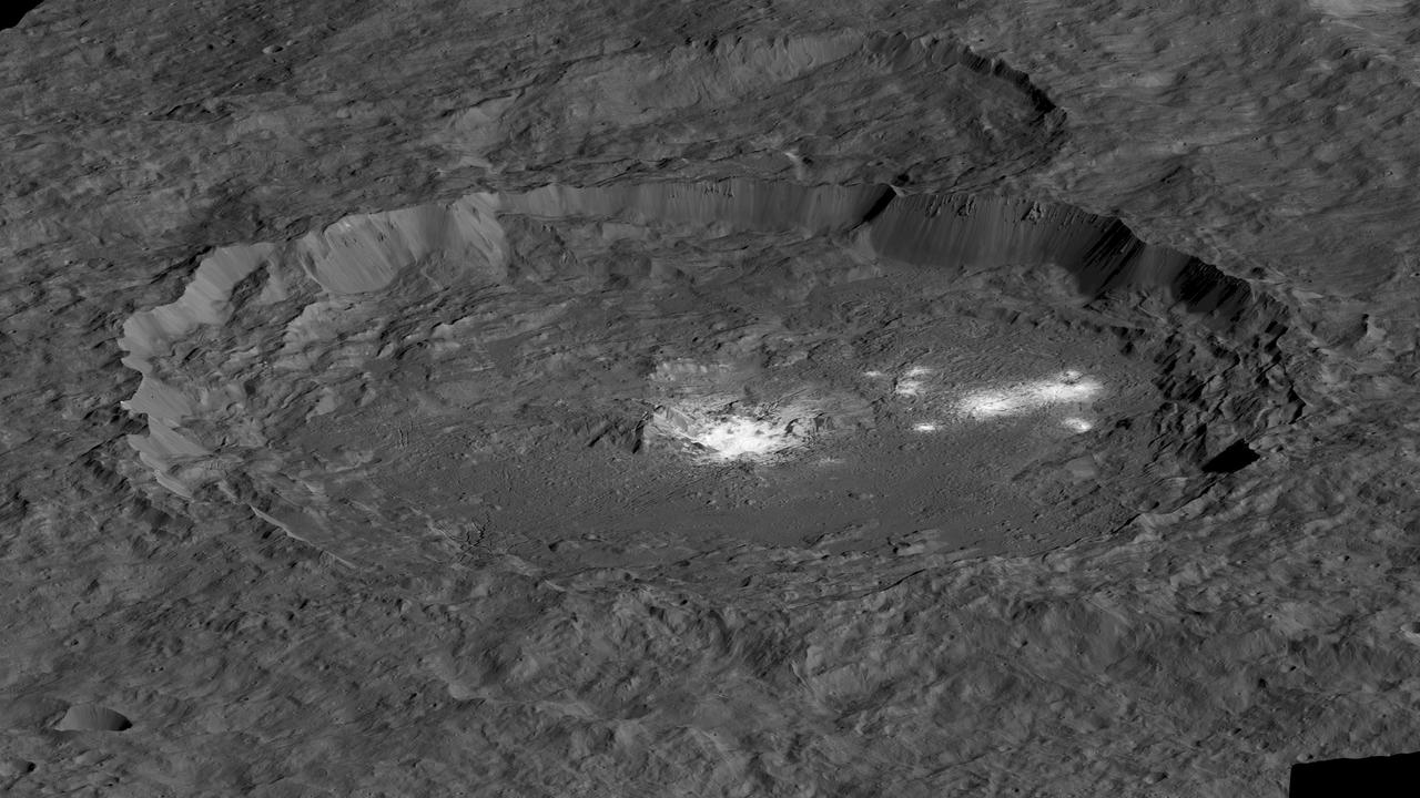
This simulated perspective view shows Occator Crater, measuring 57 miles (92 kilometers) across and 2.5 miles (4 kilometers) deep, which contains the brightest area on Ceres. This region has been the subject of intense interest since Dawn's approach to the dwarf planet in early 2015. This view, which faces north, was made using images from Dawn's low-altitude mapping orbit, 240 miles (385 kilometers) above Ceres. Dawn's close-up view reveals a dome in a smooth-walled pit in the bright center of the crater. Numerous linear features and fractures crisscross the top and flanks of this dome. Prominent fractures also surround the dome and run through smaller, bright regions found within the crater. The central dome area is called Cerealia Facula and the dimmer bright areas are called Vinalia Faculae. https://photojournal.jpl.nasa.gov/catalog/PIA21913
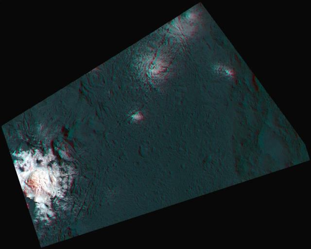
Scientists created this stereo view, called an anaglyph, with two images of the same part of Ceres's surface taken by Dawn on different orbits and from different viewing angles. The images were artificially colored and combined so that when viewed through glasses with a red filter on the left and blue on the right, they provide a 3-D view. The images used for this anaglyph were obtained by NASA's Dawn spacecraft from an altitude of about 21 miles (34 kilometers). The center of this image is located at about 19.6 degrees north latitude and 239.5 degrees east longitude. https://photojournal.jpl.nasa.gov/catalog/PIA22866
This frame from a video shows a flyover of the intriguing crater named Occator on dwarf planet Ceres. Occator is home to Ceres brightest area. Occator is home to Ceres' brightest area. It may have been produced by upwelling of salt-rich liquids after the impact that formed the crater. The animated flyover includes topographic and enhanced-color views of the crater, highlighting the central dome feature. The central area has been named Cerealia Facula. Occator's secondary group of bright spots is called Vinalia Faculae. A video is available at http://photojournal.jpl.nasa.gov/catalog/PIA21080

This photo of Ceres and the bright regions in Occator Crater was one of the last views NASA's Dawn spacecraft transmitted before it depleted its remaining hydrazine and completed its mission. This view, which faces south, was captured on Sept. 1, 2018 at an altitude of 2,340 miles (3,370 kilometers) as the spacecraft was ascending in its elliptical orbit. At its lowest point, the orbit dipped down to only about 22 miles (35 kilometers), which allowed Dawn to acquire very high-resolution images in this final phase of its mission. Some of the close-up images of Occator Crater are shown here. Occator Crater is 57 miles (92 kilometers) across and 2.5 miles (4 kilometers) deep and holds the brightest area on Ceres, Cerealia Facula in its center and Vinalia Faculae in its western side. This region has been the subject of intense interest since Dawn's approach to the dwarf planet in early 2015. https://photojournal.jpl.nasa.gov/catalog/PIA22485
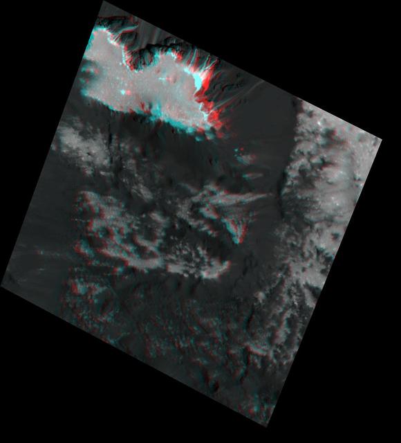
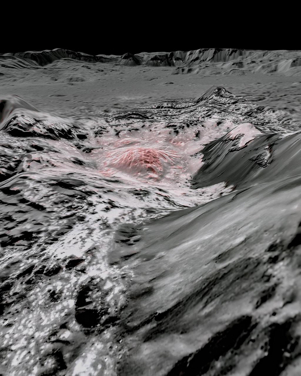
Scientists created this stereo view, called an anaglyph, with two images of the same part of Ceres's surface taken by Dawn on different orbits and from different viewing angles. The images were artificially colored and combined so that when viewed through glasses with a red filter on the left and blue on the right, they provide a 3-D view. The images used in this anaglyph were obtained by NASA's Dawn spacecraft from an altitude of about 21 miles (34 kilometers). This feature is located at about 19.5 degrees north latitude and 239.2 degrees east longitude, in the western part of Cerealia Facula. https://photojournal.jpl.nasa.gov/catalog/PIA22862
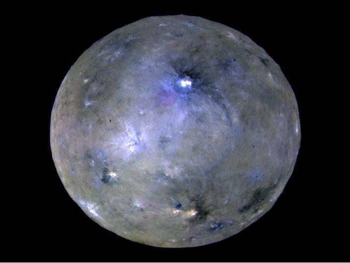
This enhanced color image of Ceres' surface was made from data obtained on April 29, 2017, when NASA's Dawn spacecraft was exactly between the sun and Ceres. Dawn's framing cameras took images of Ceres with a clear filter as well as five different color filters. Images combining these different color filter perspectives reveal fine details of Ceres' surface. For example, they emphasize the distinct compositions and textures of the material ejected from craters. The brightest region on Ceres, called Cerealia Facula, is highlighted in Occator Crater in the center of this image. Vinalia Faculae, the set of secondary bright spots in the same crater, are located to the right of Cerealia Facula. One of the darkest regions on Ceres is next to Occator, and represents ejected material from the impact that formed the crater. The ejected material forms a large arc that extends over several hundred kilometers, below the center of Ceres in this image. That material's distribution is partly determined by Ceres' rotation. Other craters also show a mixture of bright and dark regions. While the bright areas are generally identified as salt-rich material excavated from Ceres' crust, the origin of the dark material remains to be explained. It may have been excavated from a different layer within Ceres' subsurface than the rest of the ejecta blanket. Scientists will continue analyzing the color data to look for clues about the nature of the different materials on Ceres. The blueish color is generally found in association with young craters. Scientists believe the color relates to processes that occur when an impact ejects and redistributes material on the surface. The continuous bombardment of Ceres' surface by micrometeorites alters the texture of the exposed material, leading to its reddening. This image was taken altitude of about 12,000 miles (20,000 kilometers). https://photojournal.jpl.nasa.gov/catalog/PIA21406
NASA's Dawn spacecraft captured pictures in visible and infrared wavelengths, which were combined to create this false-color view of a region in 57-mile-wide (92-kilometer-wide) Occator Crater on the dwarf planet Ceres (in the main asteroid belt between Mars and Jupiter). Here, recently exposed brine, or salty liquids, in the center of the crater were pushed up from a deep reservoir below Ceres' crust. In this view, they appear reddish. In the foreground, is Cerealia Facula ("facula" means bright area), a 9-mile-wide (15-kilometer-wide) region with a composition dominated by salts. The central dome, Cerealia Tholus, is about 1.9 miles (3 kilometers) across at its base and 1,100 feet (340 meters) tall. The dome is inside a central depression about 3,000 feet (900 meters) deep. The area depicted in this scene is about 1.3 miles (2.1 kilometers) wide in the foreground, about 7 miles (11 kilometers) wide across the dome, and 35 miles (56 kilometers) wide in the background, where the crater rim rises against the black sky. The distance from the near point (at the bottom) to the far point (at the top) is about 32 miles (52 kilometers). This mosaic is made from multiple images Dawn captured during its second extended mission in 2018 from an altitude of about 22 miles (35 kilometers). Those were combined with a topographic map based on images obtained during Dawn's prime mission and first extended mission in 2016, from an altitude of about 240 miles (385 kilometers). The resolution varies from about 11 feet (3.5 meters) per pixel in the bright regions to about 115 feet (35 meters) per pixel in the background. The color data that is overlain on the topographic data was obtained during the prime mission in 2015 when the spacecraft was at an altitude of 915 miles (1470 kilometers). It has a resolution of 450 feet (140 meters) per pixel. https://photojournal.jpl.nasa.gov/catalog/PIA24021

This collage shows some of the most interesting geological sites that NASA's Dawn spacecraft has revealed at dwarf planet Ceres. Images were acquired with the spacecraft's framing camera during various phases of the mission: Survey orbit at a distance of about 2,700 miles (4,400 kilometers); high-altitude mapping orbit (HAMO) at a distance of 915 miles (1,470 kilometers) from Ceres; and low-altitude mapping orbit (LAMO) at an altitude of 240 miles (385 kilometers). In the first row, from left to right: Ceres in shown in false color, roughly centered on Occator Crater, home of the brightest area on Ceres. This picture combines color images obtained by Dawn in its survey orbit. Red corresponds to a wavelength range around 980 nanometers (near infrared), green to a wavelength range around 750 nanometers (red, visible light) and blue to a wavelength range of around 430 nanometers (blue, visible light). This picture illustrates the diversity of terrains on Ceres where the bluish material points to recently emplaced material and the brownish background material is associated with older terrains. Juling Crater (12 miles, 20 kilometers in diameter) as seen in LAMO. Central coordinates are 36 degrees south latitude, 168 degrees east longitude. It is named after the Sakai/Orang Asli (Malaysia) spirit of the crops. This crater displays evidence for the presence of ice -- for example, in the form of a large flow feature seen at the top of the image. Oxo Crater (6 miles, 10 kilometers in diameter) as seen in LAMO. Center coordinates are 42 degrees north latitude, 0 degrees east longitude. It is named after the god of agriculture in Afro-Brazilian beliefs of Yoruba derivation. Oxo hosts the first site at which Dawn detected ice on Ceres, exposed by a landslide. Ahuna Mons is not only a volcano, but also the tallest mountain on Ceres. It is about 2.5 miles (4 kilometers) high and 11 miles (17 kilometers) wide. Center coordinates are 10 degrees south latitude, 316 degrees east longitude. This view combines images obtained in LAMO in blue (430 nanometers), green (750 nanometers) and infrared (980 nanometers) color filters. Ahuna is named after the Sumi tribe (Nagaland, northeastern India) traditional post-harvest thanksgiving festival. Second Row Occator Crater (57 miles, 92 kilometers across) is seen in LAMO images. Center coordinates are 20 degrees north latitude, 239 degrees east longitude. Named after the Roman agricultural deity of the harrowing. This image shows a "Type I" flow feature with a thick "toe" typical of rock glaciers and icy landslides on Earth as viewed in LAMO. The flow feature, found in Ghanan Crater (77 degrees north latitude, 31 degrees east longitude), is one of the most voluminous on Ceres. Enhanced color view of Haulani Crater (21 miles, 34 kilometers in diameter) in color observed in HAMO. Central coordinates: 6 degrees north latitude, 11 degrees east longitude. Named after the Hawaiian plant goddess. Kokopelli Crater (21 miles, 34 kilometers in diameter) seen in LAMO. Central coordinates: 18 degrees north latitude, 125 degrees east longitude. Named after the Pueblo (SW USA) fertility deity, who presides over agriculture. This crater displays a nice arrangement of scarps that likely formed when the crater partly collapsed during its formation. Third Row Central region of Occator Crater, called Cerealia Facula, seen in color. The facula -- or "bright spot" -- is about 9 miles (14 kilometers) in diameter. Center coordinates: 20 N, 240 E. Cerealia refers to the major festival in Ancient Rome that celebrates the grain goddess Ceres (8 days in mid- to late April). The view was produced by combining the highest resolution images of Occator obtained in LAMO (at image scales of 35 meters, or 115 feet, per pixel) with color images obtained in HAMO (at image scales of 135 meters, or about 440 feet, per pixel). The three images used to produce the color were taken using filters centered at 430, 750 and 980 nanometers (the last being slightly beyond the range of human vision, in the near-infrared). North part of Nar Sulcus seen in LAMO. The full feature is about 39 miles (63 km) in length and is located around 42 degrees south latitude, 280 degrees east longitude. Nar is a Azerbaijani festival of pomegranate harvest held in October-November in Goychay city, center of pomegranate cultivation in Azerbaijan. A sulcus is a set of parallel furrows or ridges. Ikapati Crater (31 miles, 50 kilometers in diameter) seen in LAMO. Central coordinates: 34 degrees north latitude, 46 degrees east longitude. Ikapati is named after the Philippine goddess of the cultivated lands. The crater has a smooth floor, probably because heat from the impact that formed Ikapati caused ice in the ground to melt, and then refreeze. This view of Ceres, taken in LAMO, shows an area located at approximately 86 degrees south longitude, 177 degrees east longitude. This part of Ceres, near the south pole, has such long shadows because, from the perspective of this location, the sun is near the horizon. At the time this image was taken, the sun was 4 degrees north of the equator. If you were standing this close to Ceres' south pole, the sun would never get high in the sky during the course of a nine-hour Cerean day. https://photojournal.jpl.nasa.gov/catalog/PIA22090