
STS095-E-5229 (4 Nov. 1998)--- STS-95 payload specialist Chiaki Mukai, representing Japan's National Space Development Agency (NASDA), changes out cassette on camera. The scene was recorded with an electronic still camera (ESC) at 03:09:07 GMT, Nov. 4.
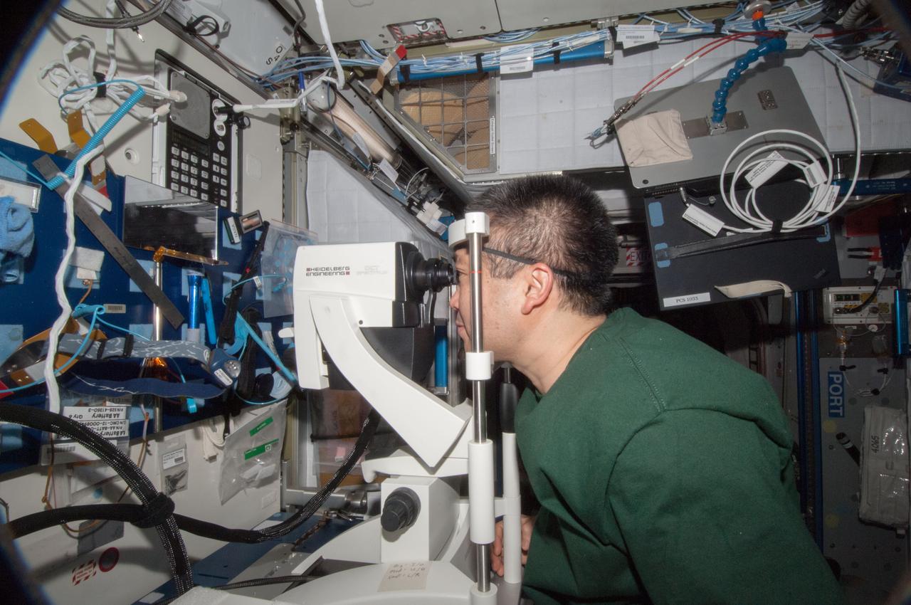
ISS038-E-011806 (4 Dec. 2013) --- In the International Space Station?s Harmony node, Japan Aerospace Exploration Agency astronaut Koichi Wakata, Expedition 38 flight engineer, performs an eye exam for the Ocular Health experiment which observes and seeks to understand vision changes during long-term space missions.

STS095-E-5227 (4 Nov. 1998) --- Astronaut Steven W. Lindsey, STS-95 pilot, has done a 180-degree change of posture from earlier frame as he inputs data on a laptop in Spacehab aboard the Space Shuttle Discovery. The photo was taken with an electronic still camera (ESC) at 03:07:52 GMT, Nov. 4.

S128-E-007282 (4 Sept. 2009) --- Onboard the International Space Station since July, astronaut Tim Kopra is pictured on the orbital outpost a little less than a week before his scheduled return to Earth. Earlier this week, Kopra changed roles from Expedition 20 flight engineer to STS-128 mission specialist. Kopra came up to the station with the STS-127 crew and participated in a spacewalk on July 18. He will return to Earth aboard the Discovery on a scheduled Sept. 10 landing.

Colin Dundas, a research geologist with the U.S. Geological Survey, speaks during a briefing, Thursday, Aug. 4, 2011, at NASA Headquarters in Washington. Observations from NASA's Mars Reconnaissance Orbiter (MRO) have revealed possible flowing water during the warmest months on Mars. Dark, finger-like features appear and extend down some Martian slopes during late spring through summer, fade in winter, and return during the next spring. Repeated observations have tracked the seasonal changes in these recurring features on several steep slopes in the middle latitudes of Mars' southern hemisphere. Photo Credit: (NASA/Paul E. Alers)

Philip Christensen, a geophysicist at Arizona State University, speaks during a briefing, Thursday, Aug. 4, 2011, at NASA Headquarters in Washington. Observations from NASA's Mars Reconnaissance Orbiter (MRO) have revealed possible flowing water during the warmest months on Mars. Dark, finger-like features appear and extend down some Martian slopes during late spring through summer, fade in winter, and return during the next spring. Repeated observations have tracked the seasonal changes in these recurring features on several steep slopes in the middle latitudes of Mars' southern hemisphere. Photo Credit: (NASA/Paul E. Alers)
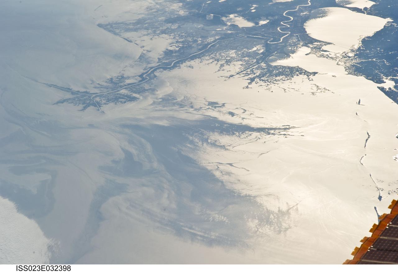
ISS023-E-032398 (4 May 2010) --- Japan Aerospace Exploration Agency (JAXA) astronaut Soichi Noguchi, Expedition 23 flight engineer, photographed the Mississippi Delta showing the oil slick in the Gulf of Mexico on May 4, 2010. Part of the river delta and nearby Louisiana coast appear dark in the sunglint. This phenomenon is caused by sunlight reflecting off the water surface, in a mirror-like manner, directly back towards the astronaut observer onboard the International Space Station (ISS). The sunglint improves the identification of the oil spill which is creating a different water texture (and therefore a contrast) between the smooth and rougher water of the reflective ocean surface. Other features which cause a change in surface roughness that can be seen in sunglint are wind gusts, naturally occurring oils that will be gathered by and take the form of water currents or wave patterns, and less windy areas behind islands.

ISS023-E-032396 (4 May 2010) --- Japan Aerospace Exploration Agency (JAXA) astronaut Soichi Noguchi, Expedition 23 flight engineer, photographed the tail end of the Mississippi Delta showing the oil slick in the Gulf of Mexico on May 4, 2010. Part of the river delta and nearby Louisiana coast appear dark in the sunglint. This phenomenon is caused by sunlight reflecting off the water surface, in a mirror-like manner, directly back towards the astronaut observer onboard the International Space Station (ISS). The sunglint improves the identification of the oil spill which is creating a different water texture (and therefore a contrast) between the smooth and rougher water of the reflective ocean surface. Other features which cause a change in surface roughness that can be seen in sunglint are wind gusts, naturally occurring oils that will be gathered by and take the form of water currents or wave patterns, and less windy areas behind islands.
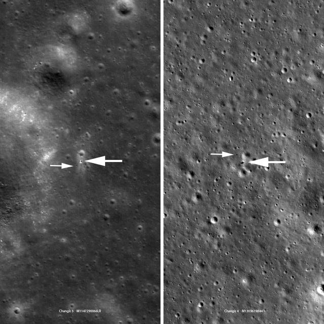
Chang'e 3 (left, M147290066LR) and Chang'e 4 (right, M1303619844LR) are very similar in size and instrumentation. The Chang'e 3 image looks a bit fuzzier because the landing site is at 44° north latitude where the LRO orbit is about twice as far from the Moon relative to the Chang'e 4 site at 45° south latitude (1.6 meter pixels enlarged to 0.85 meter pixels; 5.2 feet vs. 2.8 feet). Each panel is 463 meters (1520 feet) wide, large arrows indicate landers and small arrows indicate rovers. Credits: NASA/Goddard/Arizona State University More info: https://www.nasa.gov/feature/goddard/2019/chang-e-landers-a-closer-look
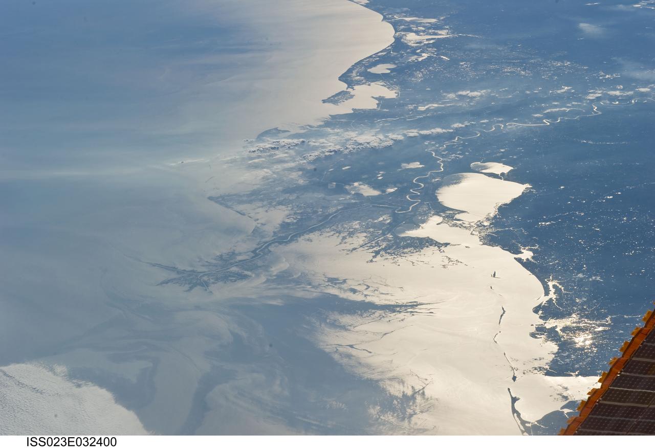
ISS023-E-032400 (4 May 2010) --- Japan Aerospace Exploration Agency (JAXA) astronaut Soichi Noguchi, Expedition 23 flight engineer, photographed the Mississippi Delta showing the oil slick in the Gulf of Mexico on May 4, 2010. Part of the river delta and nearby Louisiana coast appear dark in the sunglint. This phenomenon is caused by sunlight reflecting off the water surface, in a mirror-like manner, directly back towards the astronaut observer onboard the International Space Station (ISS). The sunglint improves the identification of the oil spill which is creating a different water texture (and therefore a contrast) between the smooth and rougher water of the reflective ocean surface. Other features which cause a change in surface roughness that can be seen in sunglint are wind gusts, naturally occurring oils that will be gathered by and take the form of water currents or wave patterns, and less windy areas behind islands.
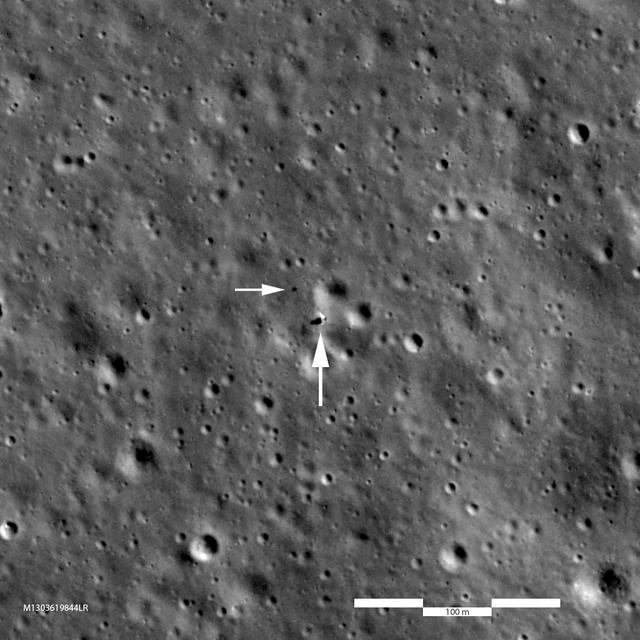
Chang'e 3 (left, M147290066LR) and Chang'e 4 (right, M1303619844LR) are very similar in size and instrumentation. The Chang'e 3 image looks a bit fuzzier because the landing site is at 44° north latitude where the LRO orbit is about twice as far from the Moon relative to the Chang'e 4 site at 45° south latitude (1.6 meter pixels enlarged to 0.85 meter pixels; 5.2 feet vs. 2.8 feet). Each panel is 463 meters (1520 feet) wide, large arrows indicate landers and small arrows indicate rovers. Credits: NASA/Goddard/Arizona State University More info: https://www.nasa.gov/feature/goddard/2019/chang-e-landers-a-closer-look

STS081-S-001 (June 1996) --- The STS-81 crew patch for the fifth Shuttle-Mir docking mission, is shaped to represent the Roman numeral V. The space shuttle Atlantis, OV-104, is launching toward a rendezvous with Russia?s Mir Space Station, silhouetted in the background. Atlantis and the STS-81 crew will spend several days docked to Mir during which time astronaut Jerry M. Linenger (NASA-Mir 4) will replace astronaut John E. Blaha (NASA-Mir 3) as the United States crew member onboard Mir. Scientific experiments and logistics will also be transferred between Atlantis and Mir. The United States and Russian flags are depicted along with the names of the shuttle crew members: Michael A. Baker, commander; Brent W. Jett, pilot; Peter J. K.(Jeff) Wisoff, mission specialist 1; John W. Grunsfeld, mission specialist 2; Marsha S. Ivins, mission specialist 3; Linenger; mission specialist 4; and Blaha, mission specialist 5. The NASA insignia design for space shuttle flights is reserved for use by the astronauts and for other official use as the NASA Administrator may authorize. Public availability has been approved only in the forms of illustrations by the various news media. When and if there is any change in this policy, which is not anticipated, the change will be publicly announced. Photo credit: NASA
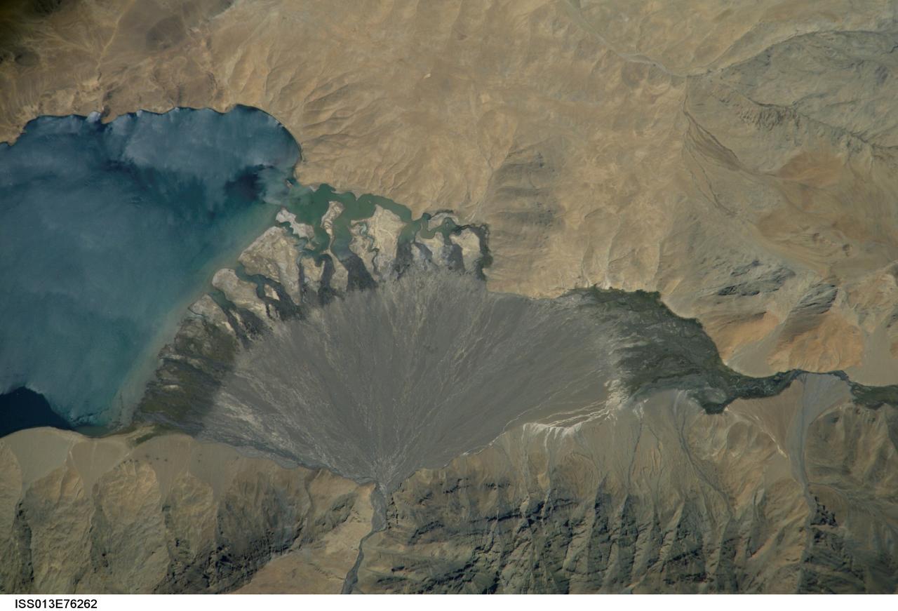
ISS013-E-76262 (4 Sept. 2006) --- Lake Morari, Tibet is featured in this image photographed by an Expedition 13 crewmember onboard the International Space Station. Melt-water from glaciers to the east and west drains into Lake Morari, a large lake on the Tibetan Plateau which lies at an altitude of 4,521 meters (14,830 feet). The main inflow to the lake is via a west-side stream. Mud from this river gives the light blue hues to the lake water. The well-formed alluvial fan (center), built by sediment from the main inflow river, is the reason the lake has formed at this point in the valley. The fan has dammed up the depression now occupied by Lake Morari (approximately 7 kilometers wide in this view) and forms the curved southern shore of the lake. The apex of the fan lies fully 40 meters above the level of the lake. The change of color and texture on the fan seems to result from a new influx of gray sediment on top of an older fan which had several channels cut into it. Interestingly, the alluvial fan also acts as the only outlet of the lake, although no obvious outlet channel can be seen in this detailed view. South of the fan an outlet river appears as a green surface, possibly due to aquatic vegetation or algae. Altitude measurements show that the outlet river lies many meters below the lake surface.

January 25, 2012 <b>*Updated February 2, 2012: According to Flickr, "The western hemisphere Blue Marble 2012 image has rocketed up to over 3.1 million views making it one of the all time most viewed images on the site after only one week."</b> A 'Blue Marble' image of the Earth taken from the VIIRS instrument aboard NASA's most recently launched Earth-observing satellite - Suomi NPP. This composite image uses a number of swaths of the Earth's surface taken on January 4, 2012. The NPP satellite was renamed 'Suomi NPP' on January 24, 2012 to honor the late Verner E. Suomi of the University of Wisconsin. Suomi NPP is NASA's next Earth-observing research satellite. It is the first of a new generation of satellites that will observe many facets of our changing Earth. Suomi NPP is carrying five instruments on board. The biggest and most important instrument is The Visible/Infrared Imager Radiometer Suite or VIIRS. To read more about NASA's Suomi NPP go to: <a href="http://www.nasa.gov/npp" rel="nofollow">www.nasa.gov/npp</a> Credit: NASA/NOAA/GSFC/Suomi NPP/VIIRS/Norman Kuring <b><a href="http://www.nasa.gov/audience/formedia/features/MP_Photo_Guidelines.html" rel="nofollow">NASA image use policy.</a></b> <b><a href="http://www.nasa.gov/centers/goddard/home/index.html" rel="nofollow">NASA Goddard Space Flight Center</a></b> enables NASA’s mission through four scientific endeavors: Earth Science, Heliophysics, Solar System Exploration, and Astrophysics. Goddard plays a leading role in NASA’s accomplishments by contributing compelling scientific knowledge to advance the Agency’s mission. <b>Follow us on <a href="http://twitter.com/NASAGoddardPix" rel="nofollow">Twitter</a></b> <b>Like us on <a href="http://www.facebook.com/pages/Greenbelt-MD/NASA-Goddard/395013845897?ref=tsd" rel="nofollow">Facebook</a></b> <b>Find us on <a href="http://instagrid.me/nasagoddard/?vm=grid" rel="nofollow">Instagram</a></b>
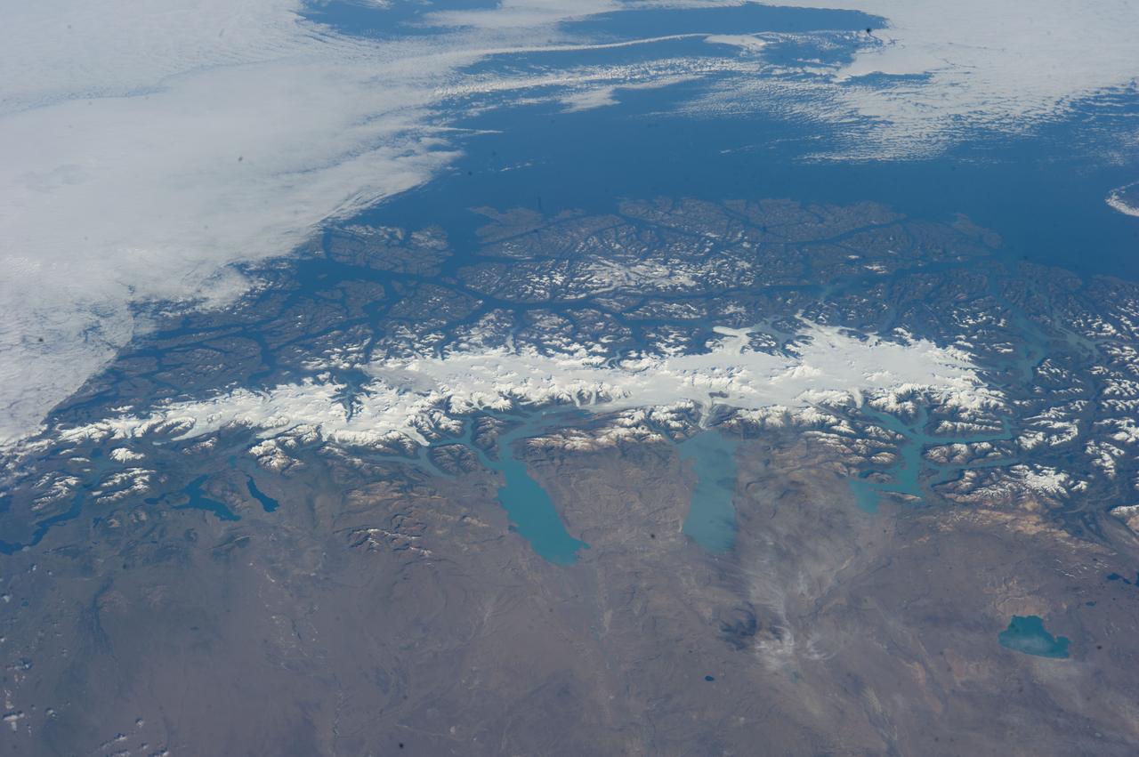
ISS038-E-047324 (13 Feb. 2014) --- This grand panorama of the Southern Patagonia Icefield (center) was imaged by an Expedition 38 crew member on the International Space Station on one of the rare clear days in the southern Andes Mountains. With an area of 13,000 square kilometers, the icefield is the largest temperate ice sheet in the Southern Hemisphere. Storms that swirl into the region from the southern Pacific Ocean (top) bring rain and snow (equivalent to a total of 2-11 meters of rainfall per year) resulting in the buildup of the ice sheet shown here (center). During the ice ages the glaciers were far larger. Geologists now know that ice tongues extended far onto the plains in the foreground, completely filling the great Patagonian lakes on repeated occasions. Similarly, ice tongues extended into the dense network of fjords (arms of the sea) on the Pacific side of the icefield. Ice tongues today appear tiny compared to the view that an "ice age" astronaut would have seen. A study of the surface topography of sixty-three glaciers, based on Shuttle Radar Topography Mission (SRTM) data, compared data from 2000 to data from studies going back about 30 years (1968-1975). Many glacier tongues showed significant annual "retreat" of their ice fronts, a familiar signal of climate change. The study also revealed that the almost invisible loss by glacier thinning is far more significant in explaining ice loss. The researchers concluded that volume loss by frontal collapse is 4-10 times smaller than that caused by thinning. Scaled over the entire icefield, including frontal loss (so-called calving when ice masses collapse into the lakes), it was calculated that 13.5 cubic kilometers of ice was lost each year over the study period. This number becomes more meaningful compared with the rate measured in the last five years of the study (1995-2000), when the rate increased almost threefold, averaging 38.7 cubic kilometers per year. Extrapolating results from the low altitude glacier tongues implies that the high plateau ice on the spine of the Andes is thinning as well. In the decade since this study the often-imaged Upsala Glacier has retreated a further three kilometers, as shown recently in images taken by crew members aboard the space station. Glacier Pio X, named for Pope Pius X, is the only large glacier that is growing in length.