Channel with Island in False Color
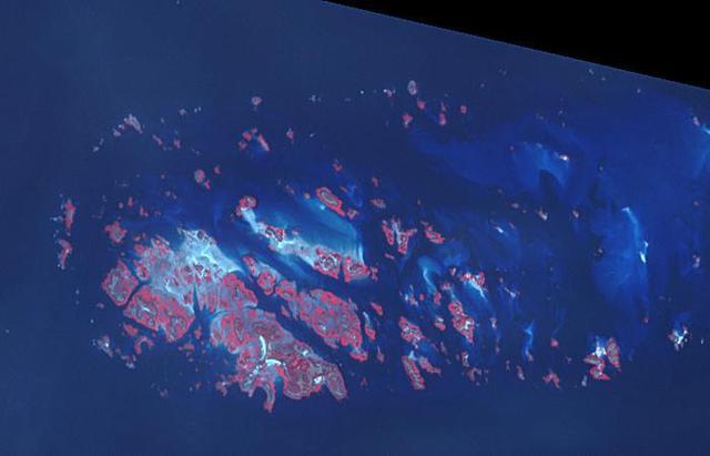
Chausey is a group of small islands and islets off the coast of Normandy and is part of the French Channel Islands. Chausey bounced back and forth between England and France for 800 years before finally officially belonging to France in the 19th century. The archipelago comprises 365 islands at low tide (2019 image), compared to only 52 islands at high tide (2018 image). The images were acquired July 7, 2018 and September 10, 2019, cover an area of 6.7 by 10.5 km, and are located at 48.9 degrees north, 1.8 degrees west. With its 14 spectral bands from the visible to the thermal infrared wavelength region and its high spatial resolution of about 50 to 300 feet (15 to 90 meters), ASTER images Earth to map and monitor the changing surface of our planet. ASTER is one of five Earth-observing instruments launched Dec. 18, 1999, on Terra. The instrument was built by Japan's Ministry of Economy, Trade and Industry. A joint U.S./Japan science team is responsible for validation and calibration of the instrument and data products. The broad spectral coverage and high spectral resolution of ASTER provides scientists in numerous disciplines with critical information for surface mapping and monitoring of dynamic conditions and temporal change. Example applications are monitoring glacial advances and retreats; monitoring potentially active volcanoes; identifying crop stress; determining cloud morphology and physical properties; wetlands evaluation; thermal pollution monitoring; coral reef degradation; surface temperature mapping of soils and geology; and measuring surface heat balance. https://photojournal.jpl.nasa.gov/catalog/PIA25800
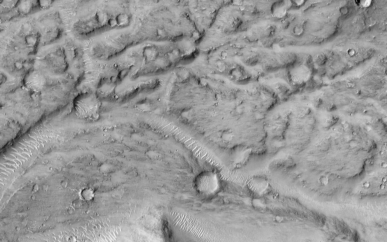
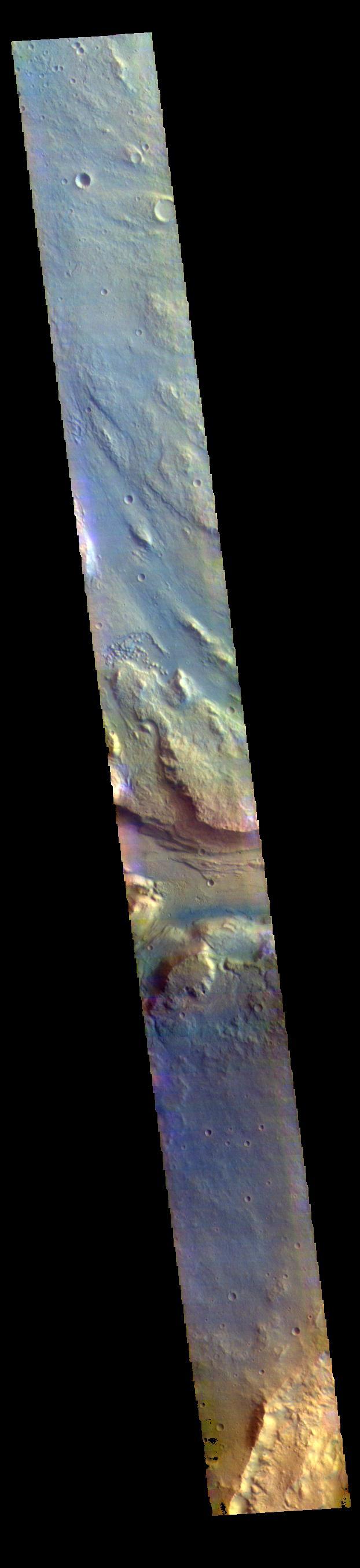
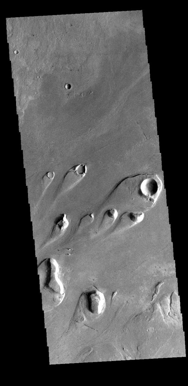
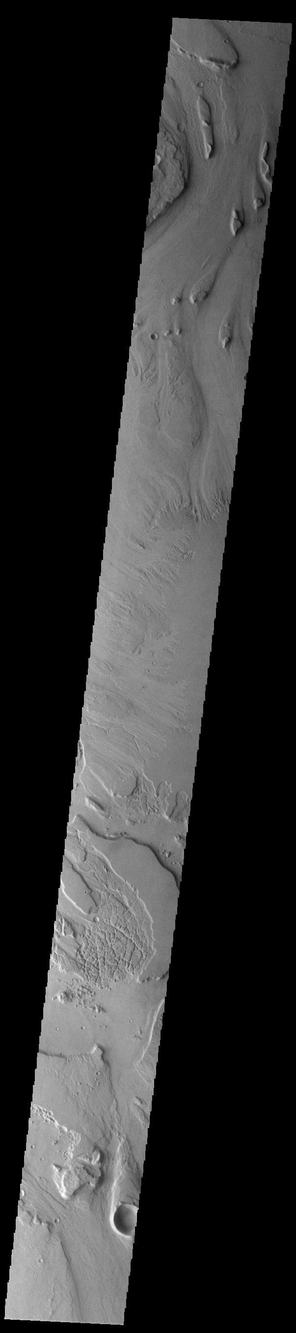
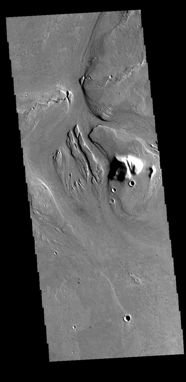
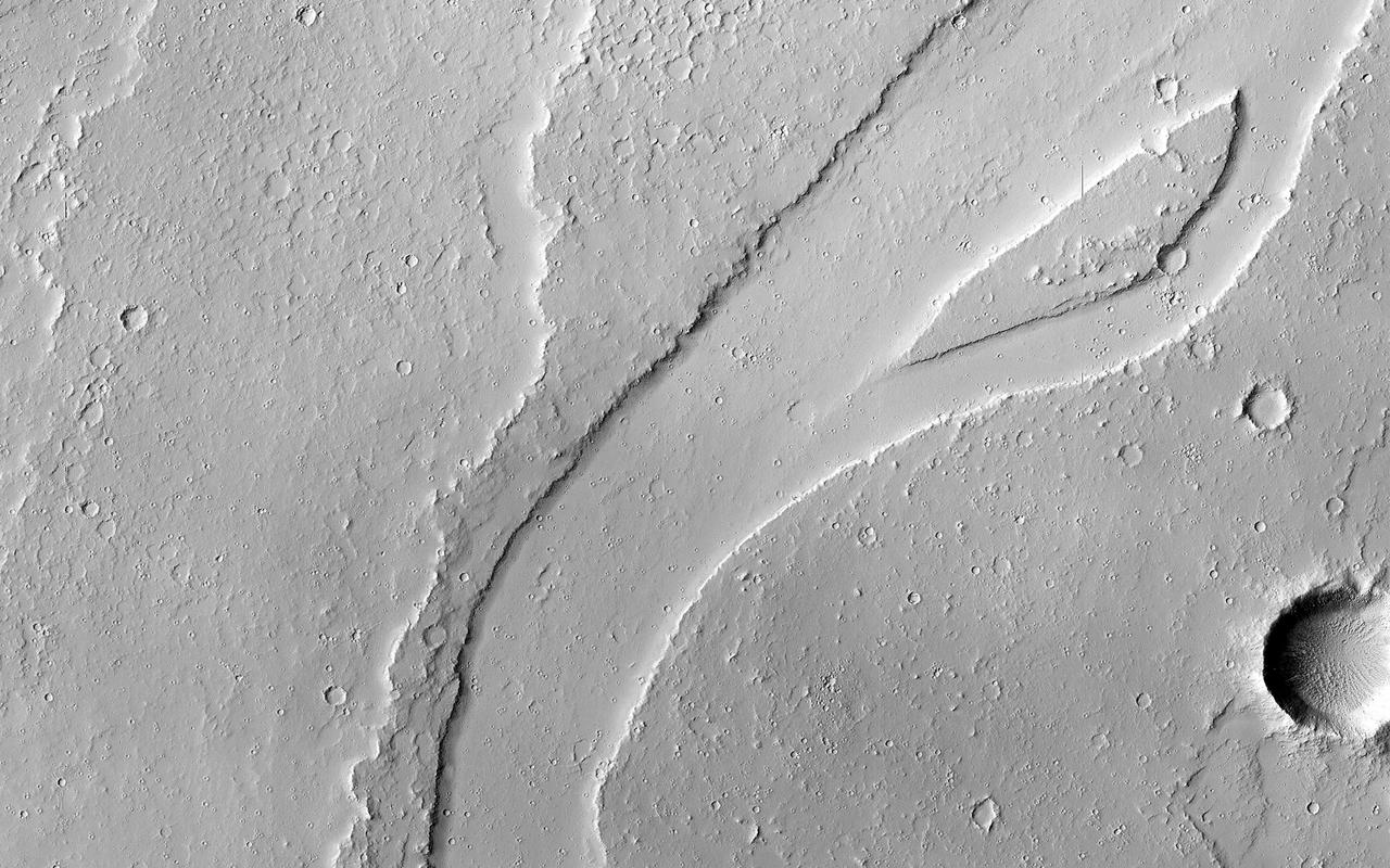
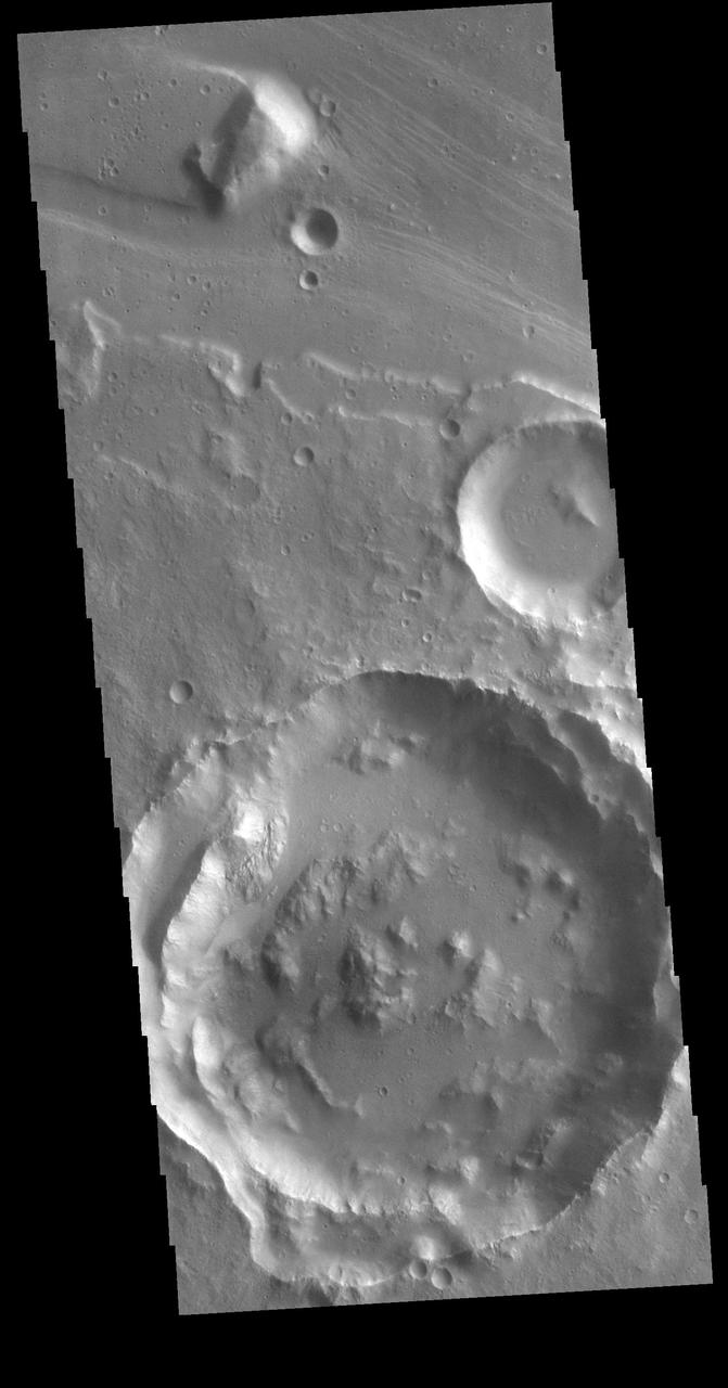
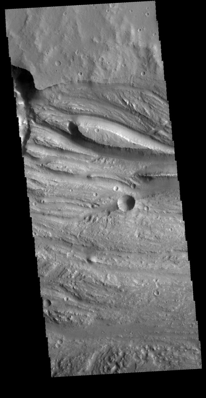
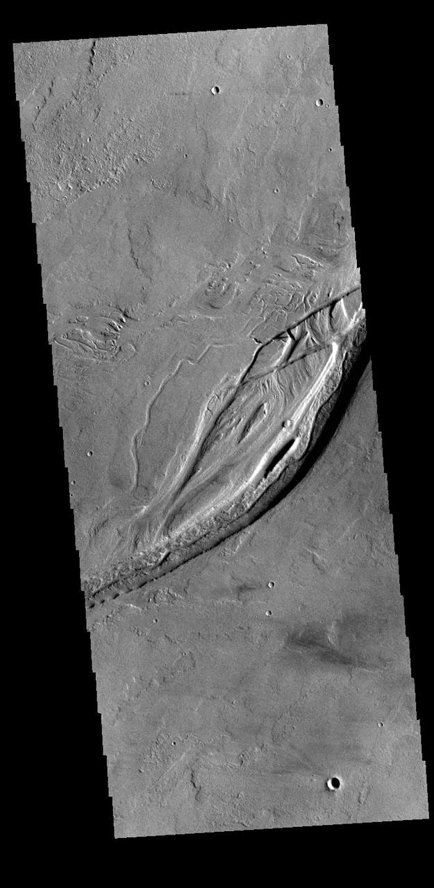
This image focuses on small channels formed on the floor of the much larger Kasei Valles, one of the largest outflow channels on Mars. The enormous floods that formed such channels sometimes flowed around either side of topographic rises forming islands with a streamlined shape. The channels in this image are located on the trailing edge of such a formation (white shaded box). The small channels formed linear coalescing pits, perhaps by ground ice sublimating into the atmosphere leaving the surface material to collapse. Much of the remaining material seems to be made up of easily eroded sediments likely deposited by the floodwaters, which have subsequently formed dunes inside the channels. Kasei extends almost 1600 kilometers (980 miles) across the surface towards the northeast before it empties into Chryse Planitia in the northern lowlands of Mars. https://photojournal.jpl.nasa.gov/catalog/PIA25702
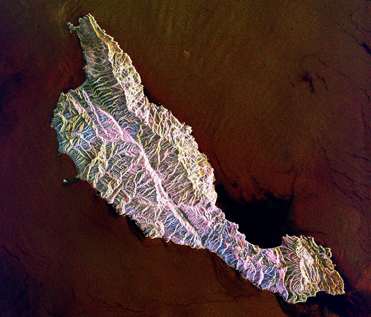
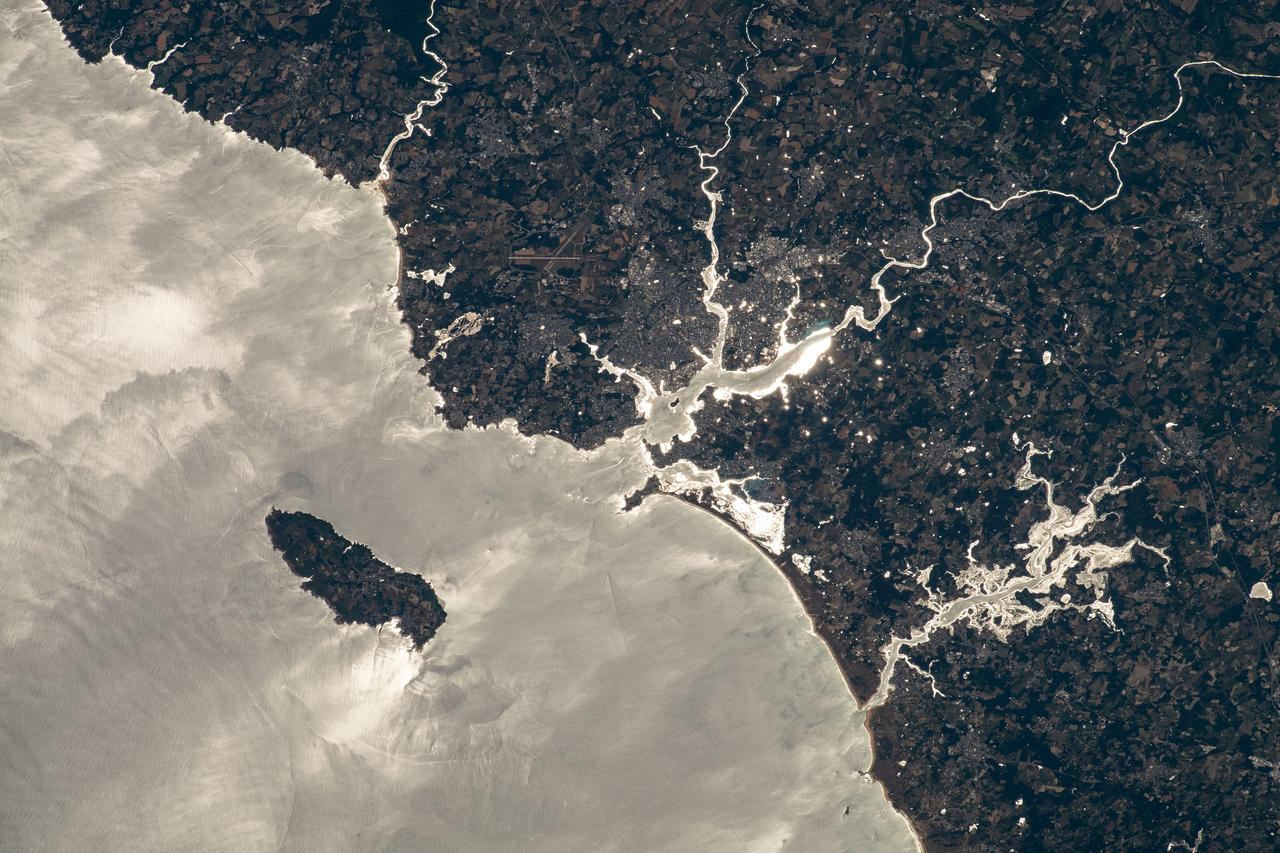
Sark (lower right) is part of the English Channel Islands off the coast of Normandy, France. It is a royal fief, part of the Bailiwick of Guernsey (left side), and has its own set of laws based on Norman law, its own parliament, and exchequer. Until 2008, it was the last feudal state in Europe with hereditary government. Sark is one of the few places in the world where cars are banned. The image was acquired June 16, 2017, covers an area of 14.1 by 25.3 km, and is located at 49.4 degrees north, 2.5 degrees west. With its 14 spectral bands from the visible to the thermal infrared wavelength region and its high spatial resolution of about 50 to 300 feet (15 to 90 meters), ASTER images Earth to map and monitor the changing surface of our planet. ASTER is one of five Earth-observing instruments launched Dec. 18, 1999, on Terra. The instrument was built by Japan's Ministry of Economy, Trade and Industry. A joint U.S./Japan science team is responsible for validation and calibration of the instrument and data products. The broad spectral coverage and high spectral resolution of ASTER provides scientists in numerous disciplines with critical information for surface mapping and monitoring of dynamic conditions and temporal change. Example applications are monitoring glacial advances and retreats; monitoring potentially active volcanoes; identifying crop stress; determining cloud morphology and physical properties; wetlands evaluation; thermal pollution monitoring; coral reef degradation; surface temperature mapping of soils and geology; and measuring surface heat balance. https://photojournal.jpl.nasa.gov/catalog/PIA25859
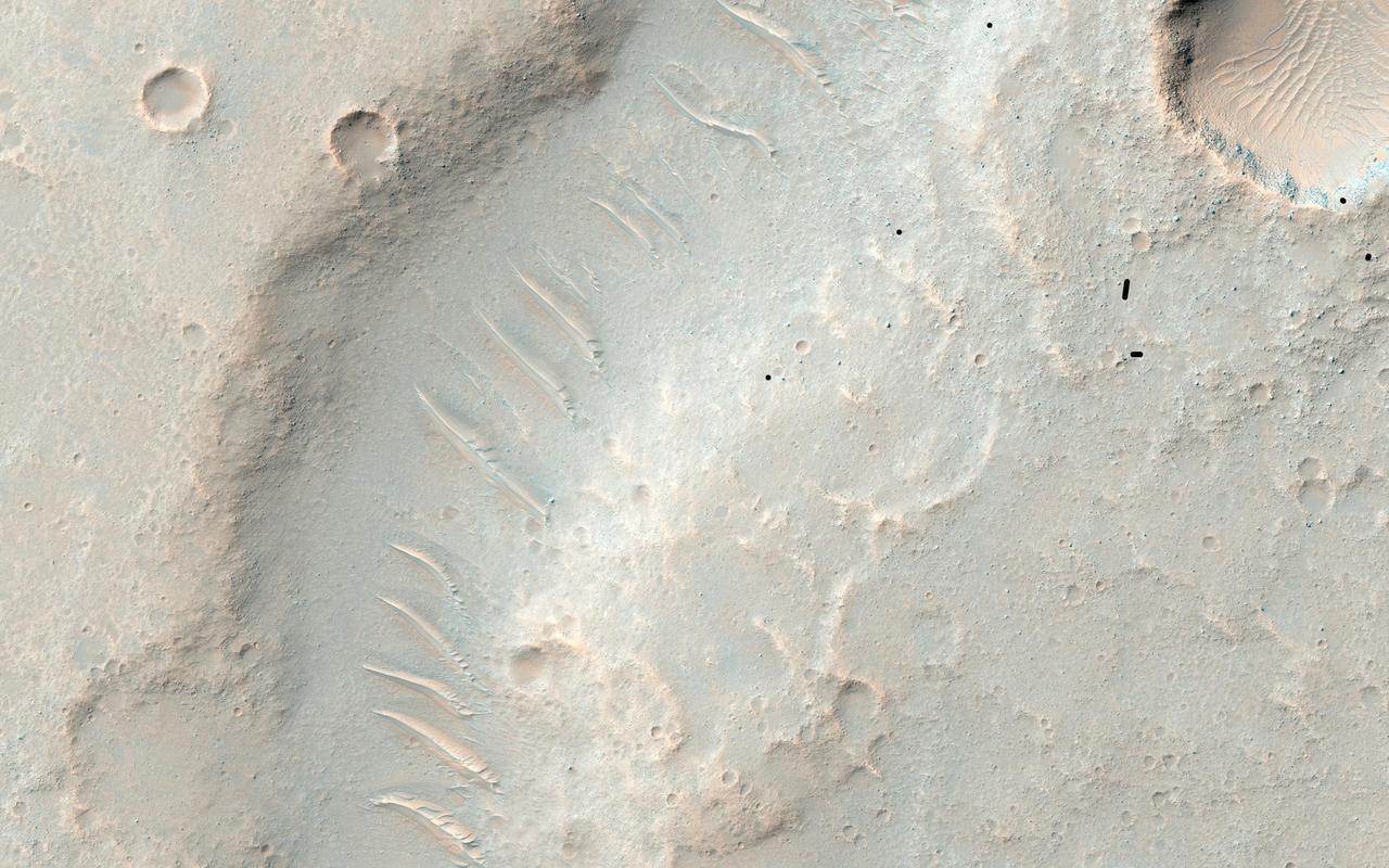
This image shows the northern terminus of an outflow channel located in the volcanic terrains of Amenthes Planum. The channel sources from the Palos impact crater to the south, where water flowed into the crater from Tinto Vallis and eventually formed a paleo lake. As rising lake levels breached through the crater's rim and inundated the plains to the north, the resulting high velocity, large discharge floods plucked out and eroded the volcanic plains scouring out the "Palos Outflow Channel" and the streamlined mesa-islands on its floor. These streamlined forms are the eroded remnants of plains material sculpted by catastrophic floods and are not sediment deposits emplaced by lower magnitude stream flows. Both the fluvial channel floor and the volcanic island surfaces are densely cratered by impacts suggesting that both the surfaces and the flood events are ancient. The morphology (shape) of the channel system and its islands have been preserved through the eons, but water has long been absent from this drainage system. Since then, winds have transported light-toned sediments across this terrain forming extensive dune fields within the channel system, on the floors of impact craters, and in other protected locations in the Palos Outflow Channel region. A closer look shows chevron, or fish-bone shaped, light-toned dunes located near the top of the image where numerous smaller channels have cut through the landscape. These dunes likely started out as Transverse Aeolian Ridges (TAR) that form perpendicular to the prevailing wind direction where the wind-blown sediment supply is scarce. This intriguing morphology likely reflects changes in the prevailing wind environment over time. http://photojournal.jpl.nasa.gov/catalog/PIA21023
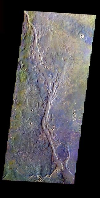
The complex channel and streamlined islands are part of Maja Valles as seen by NASA 2001 Mars Odyssey spacecraft.
The streamlined island in this image captured by NASA 2001 Mars Odyssey spacecraft is located in the channel of Marte Vallis.

This IR image from NASA 2001 Mars Odyssey spacecraft shows streamlined islands in the channel of Mangala Valles.
The streamlined islands in this image from NASA 2001 Mars Odyssey spacecraft are located in the channel of Marte Vallis.
This image from NASA 2001 Mars Odyssey spacecraft shows a streamlined island in a broad channel in Chryse Planitia. The channel is part of the outflow region of Lobo Vallis, a northern branch of Kasei Valles.
This space radar image shows the rugged topography of Santa Cruz Island, part of the Channel Islands National Park in the Pacific Ocean off the coast of Santa Barbara and Ventura, Calif.
This VIS image captured by NASA 2001 Mars Odyssey spacecraft shows streamlined islands are located in the channel of Mangala Valles, a portion of which is shown in the image.
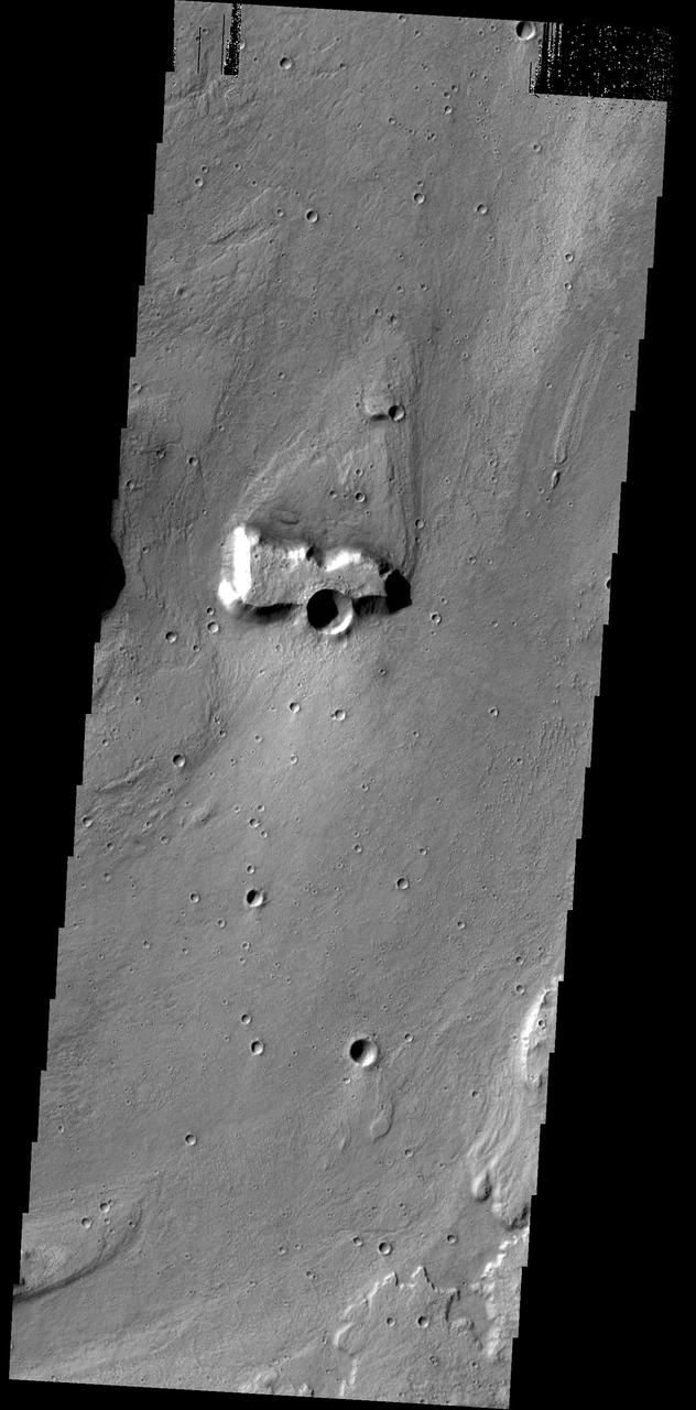
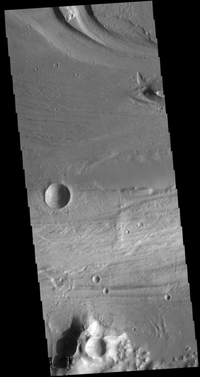
Today's VIS image is located near the beginning of Kasei Valles. At the top of the image is the relative high land of Lunae Planum. The Kasei Valles channel is just below. The bottom part of the image is an eroded surface that forms an island in the channel. The surface of the island has been modified by the flow of water. The linear features forming right angle intersections were caused by tectonic forces in the region. Orbit Number: 72404 Latitude: 18.9511 Longitude: 286.59 Instrument: VIS Captured: 2018-04-10 22:34 https://photojournal.jpl.nasa.gov/catalog/PIA22584
This false color image contains several channel features. Towards the top of the image are several stream-lined islands, created by liquid flow eroding preexisting rock. The islands have a tear-drop shape, with the pointy end down stream from the rounded end. In this case the fluid flowed from the bottom right of the frame towards the upper left. Just below the center of the image is a larger, deeper channel. All these channel features merge into Ares Vallis, a huge outflow channel that empties into Chryse Planitia. The THEMIS VIS camera contains 5 filters. The data from different filters can be combined in multiple ways to create a false color image. These false color images may reveal subtle variations of the surface not easily identified in a single band image. Orbit Number: 61501 Latitude: 4.31188 Longitude: 343.17 Instrument: VIS Captured: 2015-10-25 18:03 https://photojournal.jpl.nasa.gov/catalog/PIA23066
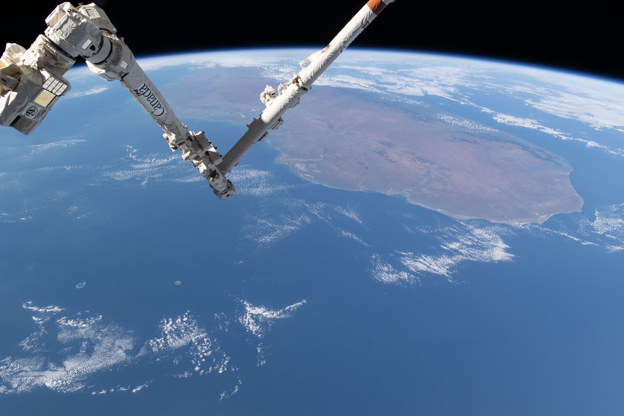
iss071e361950 (July 15, 2024) --- The International Space Station's 57.7-foot-long Canadarm2 robotic arm crosses the foreground as the orbital outpost soared 265 miles above the Mozambique Channel south of the African island nation of Madagascar.
The streamlined island in this image from NASA 2001 Mars Odyssey spacecraft formed within the channel of Maja Valles. The flow of water was deflected by the crater leaving material in the lee of the crater.
The sinuous channels and streamlined islands at the junction of Shalbatana and Simud Vallis, seen in this NASA Mars Odyssey image, present an erosional history of the catastrophic floods that scoured the Martian surface hundreds of millions of years ago.
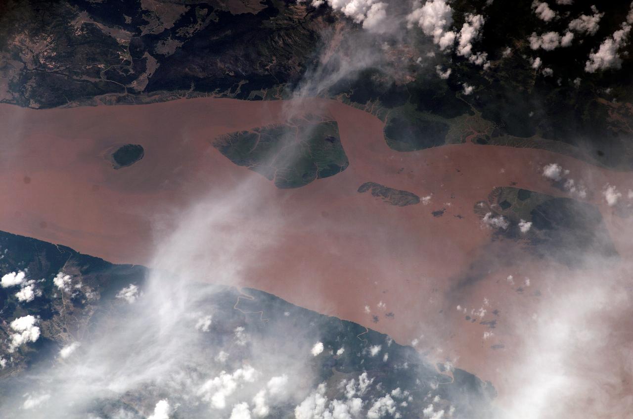
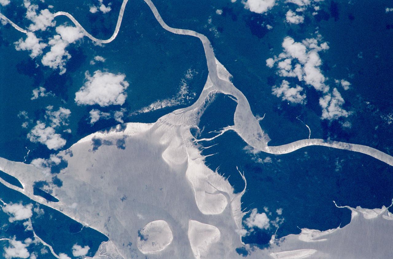
ISS010-E-13029 (13 January 2005) --- The Perigoso Channel and Amazon River mouth are featured in this image photographed by an Expedition 10 crewmember on the International Space Station (ISS). According to NASA scientists studying the Expedition 10 imagery, between 2000 and 2005 the channel on the west side of the island has shifted to the northwest – by eroding ~200 meters of the mainland shoreline and accreting sediment on the west side of the island, broadly maintaining the width of the channel. The North Channel (right) has been significantly widened. This has resulted in the erosional removal of almost 1 kilometer of the north end of the island, as well narrowing of a smaller island downstream (lower right). A more important but subtler visual effect has been the accumulation of sediment on the upstream (left) two-thirds of the island, accompanied by the establishment of permanent vegetation (dark green).
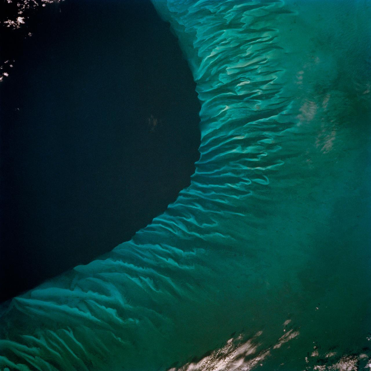
The striking views provided by the Bahama Islands lend insights into the important problems of limestone (CaCO3) production and transport. This photograph includes the southern part of Eleuthera Island in the northern Bahamas. The hook-shaped island encloses a relatively shallow platform (light blue) which is surrounded by deep water (dark blue). The feathery pattern along the western edge of Eleuthera's platform are sand bars and sand channels created by tidal currents sweeping on and off the platform. The channels serve to funnel large amounts of CaCO3 off the platform and into the deeper water.
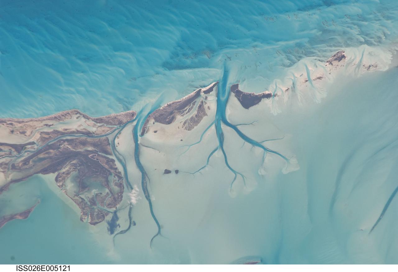
ISS026-E-005121 (27 Nov. 2010) --- Tidal flats and channels on Long Island, Bahamas are featured in this image photographed by an Expedition 26 crew member on the International Space Station. The islands of the Bahamas in the Caribbean Sea are situated on large depositional platforms (the Great and Little Bahama Banks) composed mainly of carbonate sediments ringed by fringing reefs – the islands themselves are only the parts of the platform currently exposed above sea level. The sediments are formed mostly from the skeletal remains of organisms settling to the sea floor; over geologic time, these sediments will consolidate to form carbonate sedimentary rocks such as limestone. This detailed photograph provides a view of tidal flats and tidal channels near Sandy Cay on the western side of Long Island, located along the eastern margin of the Great Bahama Bank. The continually exposed parts of the island have a brown coloration in the image, a result of soil formation and vegetation growth (left). To the north of Sandy Cay an off-white tidal flat composed of carbonate sediments is visible; light blue-green regions indicate shallow water on the tidal flat. Tidal flow of seawater is concentrated through gaps in the anchored land surface, leading to formation of relatively deep tidal channels that cut into the sediments of the tidal flat. The channels, and areas to the south of the island, have a vivid blue coloration that provides a clear indication of deeper water (center).
On July 21, 2007, the world most active volcano, Kilauea on Hawaii Big Island, produced a fissure eruption from the Puu Oo vent, which fed an open lava channel and lava flows toward the east. This image is from NASA Terra satellite.
This VIS image shows a portion of Kasei Valles. Kasei Valles is a large channel system that drained from the Tharsis volcanic highlands to the lower elevation Chryse Plainitia. At the top of the image is a deeper section of the channel with a tear-drop shaped central island. The direction of fluid flow is identified by the shape of the island, with the narrow "tail" on the down hill end. Orbit Number: 64185 Latitude: 26.0042 Longitude: 289.472 Instrument: VIS Captured: 2016-06-02 19:34 http://photojournal.jpl.nasa.gov/catalog/PIA20798
This image from NASA Mars Reconnaissance Orbiter spacecraft shows a channel system flowing to the southwest toward the huge Hellas impact basin. We're not sure if this channel-inside-a-channel was carved by flowing water or lava. Flowing water erodes channels, and flowing lava both erodes and melts surrounding rock to form channels. It's not clear whether a huge surge of water or lava first formed the wide channel and then subsided into a trickle to form this narrow, inner channel, or if a trickle formed the inner channel and a subsequent surge formed the wider one. Detailed analysis of the shape could reveal which scenario is most likely, as well as whether water or lava is responsible. Relevant observations for such a determination would include, for example, the facts that the channels lack levees (ridges along the banks) and that the inner channel diverts around a mound, which at one time was an island. This channel system flowed to the southwest toward the huge Hellas impact basin.
ISS012-E-09567 (28 Nov. 2005) --- Houston Ship Channel, Texas is featured in this image photographed by an Expedition 12 crewmember on the International Space Station. This view depicts the San Jacinto River portion of the Houston Ship Channel, one of the United States' busiest sea ports. The Channel provides a conduit between the continental interior and the Gulf of Mexico for both petrochemical products and Midwestern grain. The original watercourse for the Channel, Buffalo Bayou, has its headwaters 30 miles to the west of the city of Houston and has been used to move goods to the sea since at least 1836. Wakes of ships traveling along the channel are visible to the south of the Goat Islands (bright oblong islands at top center of image). The close proximity to Texas oilfields led to the establishment of numerous petrochemical refineries along the waterway, such as the Exxon Mobil Baytown installation on the eastern bank of the San Jacinto River. While much of the Ship Channel is associated with heavy industry, two icons of Texas history are also located along its length. A close search of the photo's details reveals both the battleship U.S.S. Texas and the neighboring San Jacinto Monument. The Texas saw service during both World Wars, and is the last remaining example of a dreadnought-class battleship in existence. The nearby San Jacinto Monument commemorates the 1836 battle in which Texas won its independence from Mexico. The monument itself is a 570 feet (173 meters) high shaft topped by a 34 feet (10 meters) high star, making it 15 feet (5 meters) higher than the Washington Monument in Washington, D.C. The Houston Ship Channel has been periodically widened and deepened to accommodate ever-larger ships, and is currently 530 feet (161 meters) wide by 45 feet (14 meters) deep by 50 miles (80 kilometers) long. The islands in the ship channel are part of the ongoing channel widening and deepening project--created by dredge spoils, salt marshes and bird islands are part of the Houston Port Authority's beneficial use and environmental mitigation responsibilities.
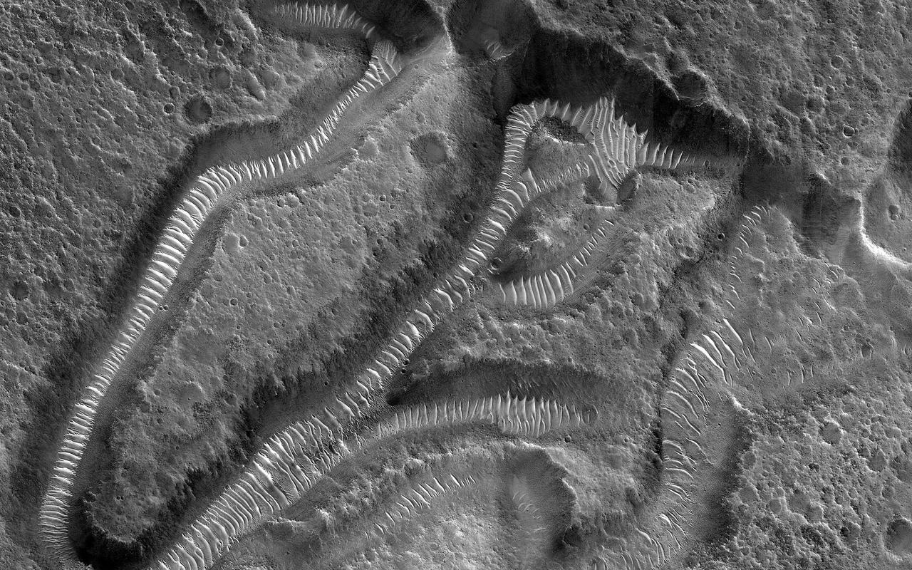
This image shows a portion of Lethe Vallis, an outflow channel that also transported lava. Another investigation of this area (Balme et al., 2011) discovered a repeat pattern of dune-like forms in the channel interpreted as fluvial dunes (or, giant current ripples) which are dunes formed by flowing water. This is one of only a few places on Mars where these pristine-appearing landforms have been identified. The channel formed by catastrophic floods, during which it produced the prominent crater-cored, teardroped-shaped island in the middle. The island has the blunter end pointing upstream and the long tail pointing downstream. Both the island and the fluvial dunes were formed by these extreme floods and their size is an indicator of the enormous discharges required to create them. The margins of the channel also show the terminal front of a pristine lava flow unit that inundated the channel from the south and the dunes show the remnants of another older lava flow. The top of the island displays polygonal patterned ground texture, which is a characteristic of periglacial processes in ice-rich ground. The dark materials from the channel and island walls are probably dark sand being eroded from an underlying horizontal basaltic (lava) layer. The crater at the core of the island has elongated dunes and reticulate dust ridges inside. This single image thus contains features formed by periglacial, volcanic, fluvial, impact, aeolian and mass wasting processes, all in one place. http://photojournal.jpl.nasa.gov/catalog/PIA21039
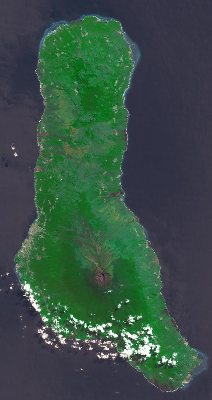
Grande Comore is the largest island of the Union of the Comoros, an island nation located in the Mozambique Channel northwest of Madagascar. The nation was granted independence from France in 1975, and became the Federated Islamic Republic of the Comoro Islands. In 2001, the government reformed as the Union of the Comoros. The three islands making up the country are all of volcanic origin, and Grande Comore is still volcanically active. The image was acquired June 22, 2022, covers an area of 25.7 by 67.4 km, and is located at 11.7 degrees south, 43.3 degrees east. With its 14 spectral bands from the visible to the thermal infrared wavelength region and its high spatial resolution of about 50 to 300 feet (15 to 90 meters), ASTER images Earth to map and monitor the changing surface of our planet. ASTER is one of five Earth-observing instruments launched Dec. 18, 1999, on Terra. The instrument was built by Japan's Ministry of Economy, Trade and Industry. A joint U.S./Japan science team is responsible for validation and calibration of the instrument and data products. The broad spectral coverage and high spectral resolution of ASTER provides scientists in numerous disciplines with critical information for surface mapping and monitoring of dynamic conditions and temporal change. Example applications are monitoring glacial advances and retreats; monitoring potentially active volcanoes; identifying crop stress; determining cloud morphology and physical properties; wetlands evaluation; thermal pollution monitoring; coral reef degradation; surface temperature mapping of soils and geology; and measuring surface heat balance. https://photojournal.jpl.nasa.gov/catalog/PIA25444
Today's VIS image shows part of Athabasca Valles. Multiple streamlined islands are seen in this image. The teardrop shaped features were formed by liquid flow deflected around features such as craters and hills. The 'tail' of the island points downstream. The source of the fluid was likely an outburst of groundwater, perhaps related to the Elysium volcanic complex located to the northwest of this image. Arising from Cerberus Fossae, the formation mode of this channel is still being debated. While the channel features are similar to water flow, other features are similar to lava flows, and yet other features have an appearance of slabs of material that floated on an underlying fluid. It is thought that Athabasca Valles is the youngest outflow channel system on Mars. Athabasca Valles is just one of the complex channel formations in the Elysium Planitia region. Orbit Number: 89977 Latitude: 9.44823 Longitude: 156.138 Instrument: VIS Captured: 2022-03-28 00:21 https://photojournal.jpl.nasa.gov/catalog/PIA25466
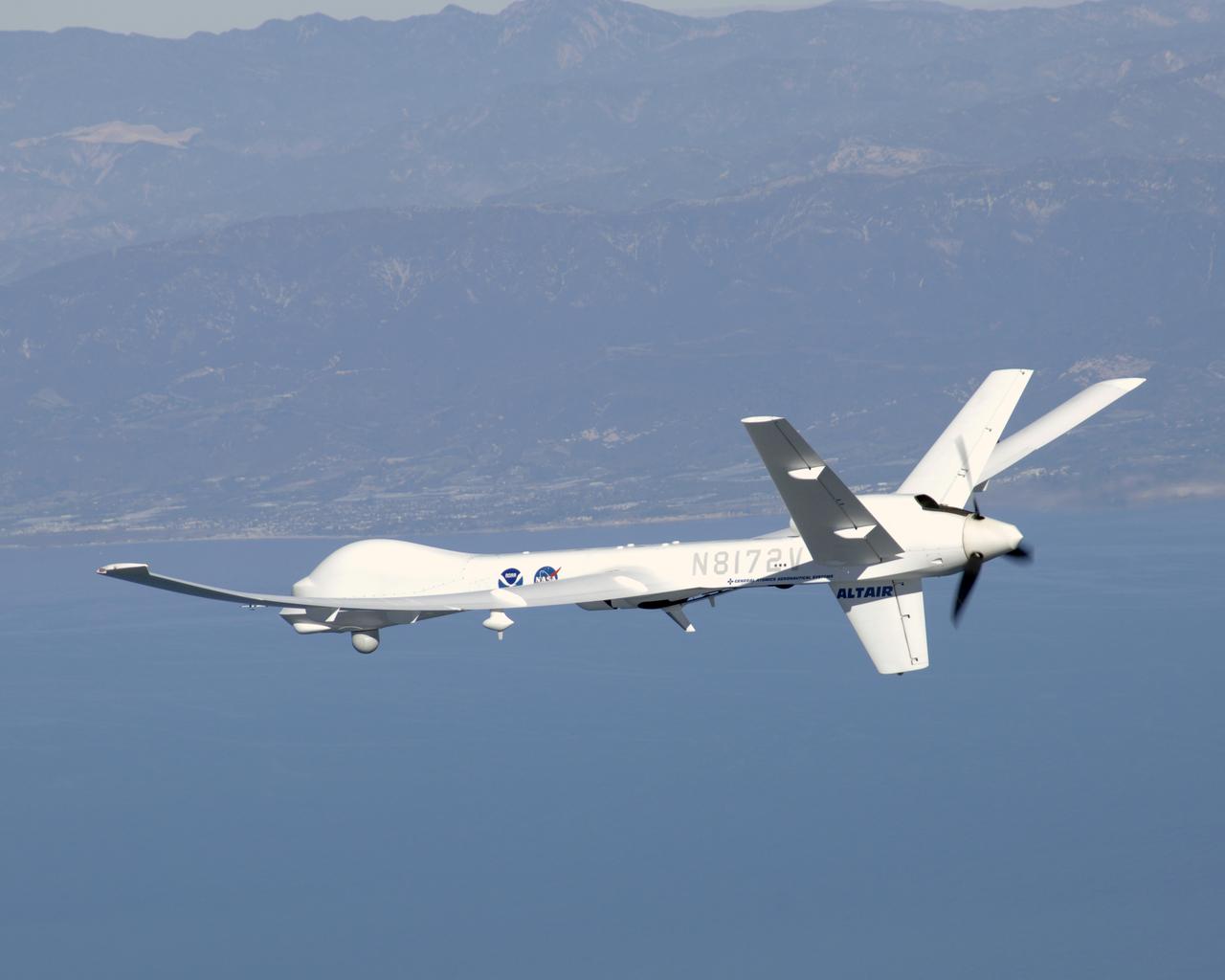
General Atomics' uninhabited Altair flew a NOAA/NASA coastal mapping, mammal observation and marine monitoring mission off the California coast in late 2005.
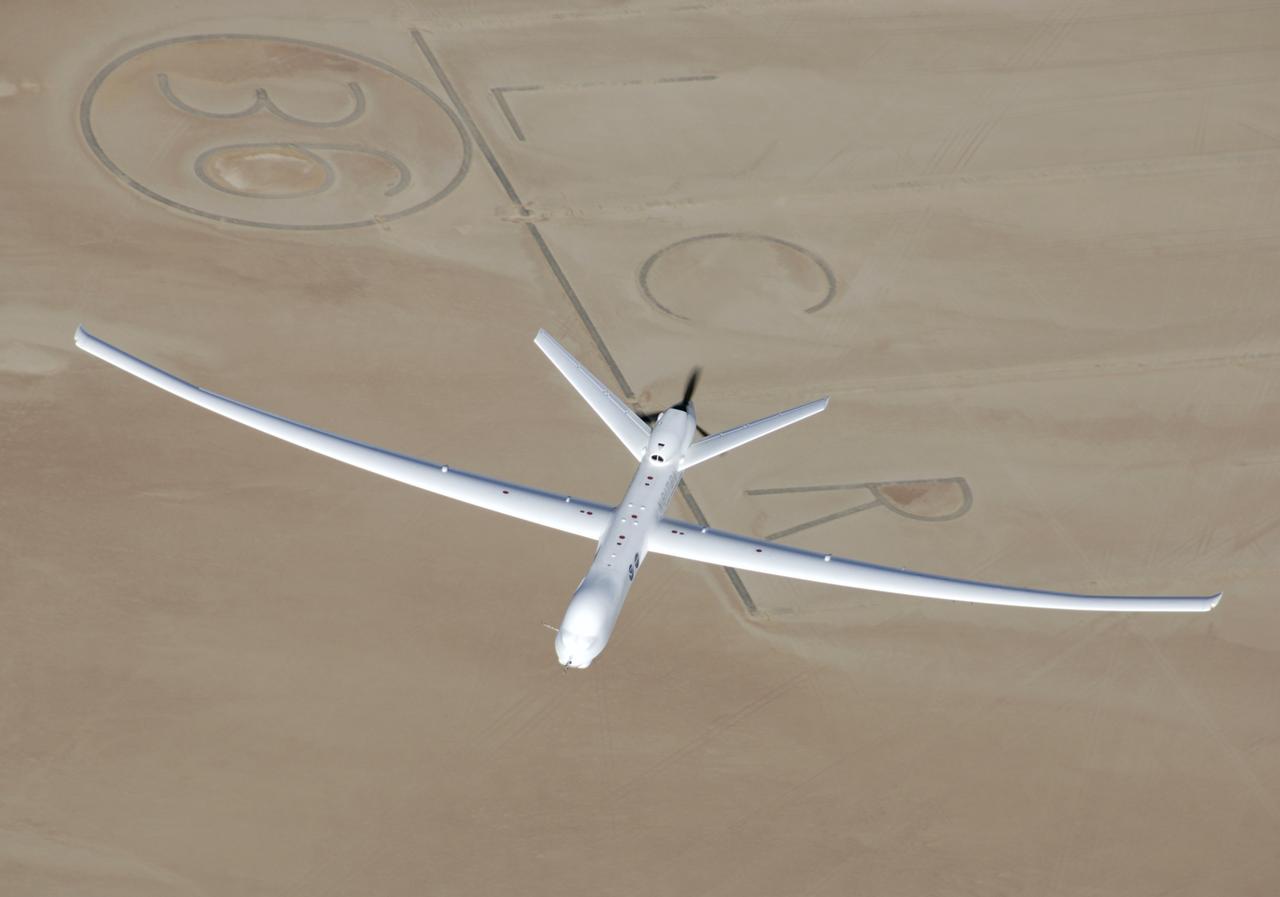
General Atomics' remotely-operated Altair soars over Rogers Dry Lake at Edwards Air Force Base during a NOAA/NASA earth science mission in November 2005.

General Atomics' uninhabited Altair flew a NOAA/NASA coastal mapping, mammal observation and marine monitoring mission off the California coast in late 2005.

General Atomics' uninhabited Altair flew a NOAA/NASA coastal mapping, mammal observation and marine monitoring mission off the California coast in late 2005.
iss070e025919 (Nov. 16, 2023) --- The partly cloudy coast of southwestern Madagascar on the Mozambique Channel is pictured from the International Space Station as it orbited 264 miles above the island nation.
iss069e032071 (July 15, 2023) --- The Bombetoka Bay leads into the Mozambique Channel from the island nation of Madagascar in this photograph from the International Space Station as it orbited 262 miles above.
iss071e218076 (June 26, 2024) --- The northwest coast of Madagascar on the Mozambique Channel is pictured from the International Space Station as it orbited 267 miles above the East African island nation.
This image from NASA Mars Reconnaissance Orbiter shows a lava channel, which lies just to the east of the largest volcano in the solar system: Olympus Mons. The channel appears to be discontinuous, meaning it disappears several times throughout its length, but in fact, it is likely that the channel continues underground as a lava tube. These are relatively common features at terrestrial volcanic centers, such as the Big Island of Hawai'i. The channel appears to have been infilled with dust and sand, so that the entrance to a lava tube cave is no longer visible at this particular location; fortunately this has been observed elsewhere on Mars. http://photojournal.jpl.nasa.gov/catalog/PIA19299
Today's VIS image shows a small section of Mangala Valles. Mangala Valles is a complex channel more than 900km long (560 miles). The channel system starts near Mangala Fossae, a large tectonic feature that intersects the volcanic plains of Daedalia Planum. Like other channels in the region, Mangala Valles flows northward, eventually emptying into southern Amazonis Planitia. Visible at the top of the image are tear-drop shaped hills within the channel. These features are called streamlined islands and the narrow "tail" points down stream. Orbit Number: 84304 Latitude: -16.0319 Longitude: 210.534 Instrument: VIS Captured: 2020-12-15 20:48 https://photojournal.jpl.nasa.gov/catalog/PIA24411
STS062-85-031 (4-18 March 1994) --- The shallow platforms (bright blue) and deep channels (dark blue) of the Bahamas provide a striking visual from space. On a finer scale, delicate patterns are created by the islands, sandbars and tidal channels. This view features a portion of the Tongue of the Ocean, one of the large deep water sounds in the western Bahamas. On the platform along the edge of the Tongue of the Ocean are convoluted sandbars bordering channels which fall into the deeper water. These channels provide an avenue for transport of sediment off the shallow platform (3-10 meters) into the deeper water (1,800 meters).
STS054-152-102 (13-19 Jan. 1993) --- This is a south-looking, wide angle view of the northern Bahamas, featuring the islands (from mid-foreground toward background) of Eleuthera, New Providence, and Andros. The northern shore of Cuba can be seen in the background. The resort city of Nassau occupies much of eastern New Providence. The Bahamas host some very distinctive features -- the deep blue channels and the shallow, light blue platforms, feathery sand bars at the edges of the deep water sounds, and colorful lakes and tidal channels like seen on Andros Island.
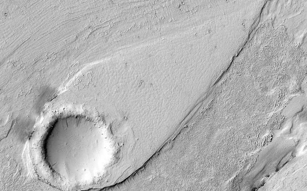
Except for the loss of its ring of ejecta, the crater at the leading edge of this streamlined island in Kasei Vallis, imaged here by NASA Mars Odyssey, shows no hint of the catastrophic floods that passed by it. Kasei Vallis is one of several major outflow channel systems that were active over 3 billion years ago. The intense floods scoured the landscape, eroding craters and producing streamlined islands. But in a close-up view, the evidence for these floods is not apparent. This true of the most similar terrestrial example, the channeled scablands of eastern Washington which also were formed by a catastrophic flood. http://photojournal.jpl.nasa.gov/catalog/PIA04022
The light blue shallow water platforms of the Bahamas, (24.0N, 77.0W) which are separated by very deep dark blue channels make for a striking scene. In the foreground is Andros Island and in the background are the Tongue of the Ocean, the Exuma Islands, Exuma Sound and the Atlantic Ocean. The Bahamas are one of the few regions where calcium carbonate precipitates directly out of the water, as the mineral aragonite, to form the coral reef islands.

ISS047e141619 (06/06/2016) --- This Earth observation image captured by Expedition 47 members aboard the International Space Station is of Juan de Nova Island, also known as Saint-Christophe. The small French tropical island is in the narrowest part of the Mozambique Channel, about one-third of the way between Madagascar and Mozambique. The Island is 3.7 miles long and 1 mile at its widest. It is a nature reserve surrounded by reefs. Forests cover about half the island and sea turtles nest on the beaches. It is largely uninhabited but the French maintain a weather station on the Island.

This VIS image shows part of Athabasca Valles. Several streamlined islands are visible, with 'tails' pointing downstream. Arising from Cerberus Fossae, the formation mode of this channel is still being debated. While the channel features are similar to water flow, other features are similar to lava flows, and yet other features have an appearance of slabs of material that floated on an underlying fluid. This is just one of the complex channel formations in the Elysium Planitia region. Orbit Number: 81766 Latitude: 8.8671 Longitude: 155.76 Instrument: VIS Captured: 2020-05-20 22:21 https://photojournal.jpl.nasa.gov/catalog/PIA24013
This VIS image shows part of Athabasca Valles. Several streamlined islands are visible, with 'tails' pointing downstream. Arising from Cerberus Fossae, the formation mode of this channel is still being debated. While the channel features are similar to water flow, other features are similar to lava flows, and yet other features have an appearance of slabs of material that floated on an underlying fluid. This is just one of the complex channel formations in the Elysium Planitia region. Orbit Number: 86820 Latitude: 7.69451 Longitude: 154.454 Instrument: VIS Captured: 2021-07-11 01:35 https://photojournal.jpl.nasa.gov/catalog/PIA25103
This VIS image shows part of the complex channel called Mengala Valles. The tear-drop shaped regions in the channel are called streamlined islands and the narrow "tail" points down stream. Orbit Number: 60732 Latitude: -5.55105 Longitude: 209.351 Instrument: VIS Captured: 2015-08-23 10:11 http://photojournal.jpl.nasa.gov/catalog/PIA19783
This image captured by NASA 2001 Mars Odyssey spacecraft shows a portion of Hebrus Valles. This channel system was formed by liquid flow of either water or lava, or a combination of both. There is a streamlined island in this image and channels at several different elevations. Orbit Number: 61733 Latitude: 17.9819 Longitude: 127.921 Instrument: VIS Captured: 2015-11-13 20:40 http://photojournal.jpl.nasa.gov/catalog/PIA20234
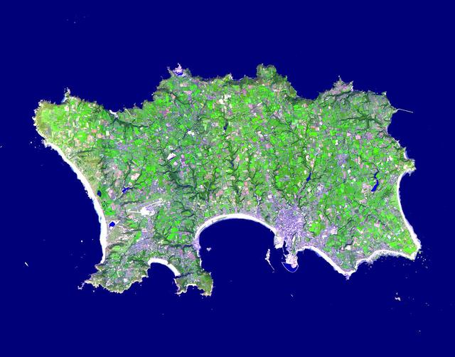
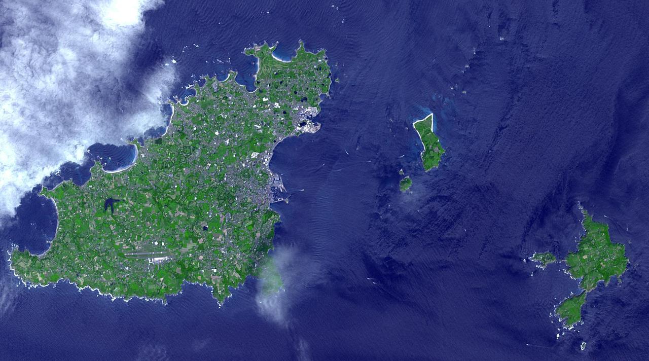
The Isle of Jersey (officially called the Bailiwick of Jersey) is the largest Channel Island, positioned in the Bay of Mont St Michel off the north-west coast of France. The island has a population of about 90,000, and covers about 90 square kilometers. The economy is based largely on international financial services, agriculture, and tourism. Called Caesaria in Roman times, Jersey becaame part of the Duchy of Normandy in 912. When William the Conqueror invaded and took the throne of England in 1066, the fortunes of Jersey then became linked to those in England, although the island manages its internal affairs through its own parliament, the States of Jersey. This image was acquired on September 23, 2000 by the Advanced Spaceborne Thermal Emission and Reflection Radiometer (ASTER) on NASA's Terra satellite. With its 14 spectral bands from the visible to the thermal infrared wavelength region, and its high spatial resolution of 15 to 90 meters (about 50 to 300 feet), ASTER images Earth to map and monitor the changing surface of our planet. http://photojournal.jpl.nasa.gov/catalog/PIA03879
The Tharsis region of Mars is covered in vast lava flows, many with channels. Some channels, however, resemble features that may have been formed by water. In this image, we see a smooth, flat-bottomed channel within the roughly irregular edges of a possible lava flow. This long, winding channel runs for 115 kilometers (70 miles) from its source (shown in ESP_045091_2045), maintaining a nearly consistent width. There is also a streamlined island within the channel, which is 1.25 kilometers (about 3/4 mile) long. One possibility is that a lava flow formed, and later groundwater was released, preferentially flowing through and further eroding the pre-existing lava channel. Or, the original lava flow could have been a very low-viscosity lava. We look at the shape and profile of the channel, and the channel and lava flow edges, to understand the characteristics of the fluids at work. Although there are lava flows and rivers on Earth that we can observe to understand the processes at work, the interplay of the features on Mars may tell a more complicated story. We want to be able to understand the history of volcanic activity in Tharsis, as well as possible interaction with ground water release, to better understand some of the younger landforms on Mars. http://photojournal.jpl.nasa.gov/catalog/PIA21104

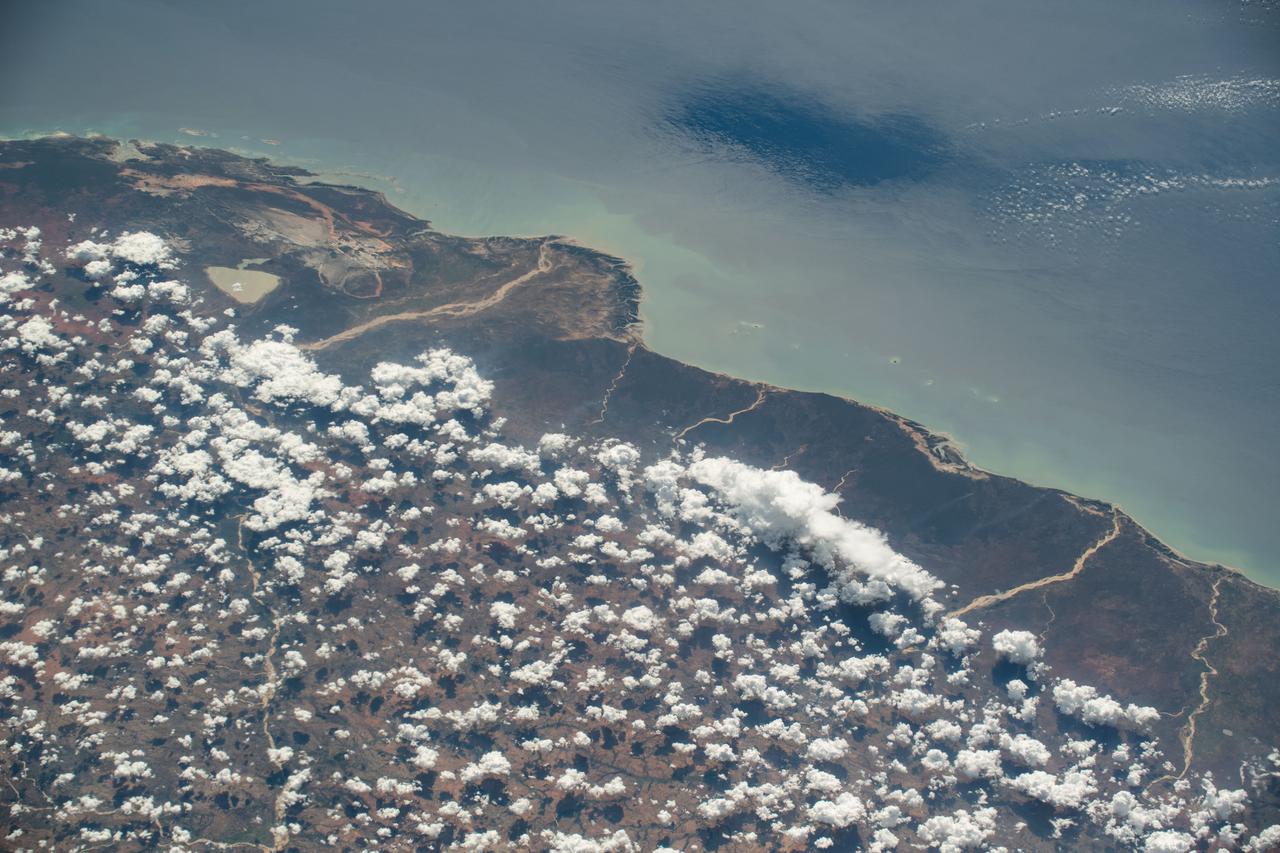
iss056e084625 (July 7, 2018) --- The island nation of Madagascar was photographed by an Expedition 56 crew member as the International Space Station orbited about 255 miles above the Mozambique Channel which separates Madagascar from the African nation of Mozambique.
iss071e111610 (May 23, 2024) -- Nearly halfway between Madagascar and Mozambique lies the Bassas da India atoll in the Mozambique Channel. The uninhabited ring-shaped island spans roughly 330 feet (~100 meters) around a shallow lagoon. The International Space Station was soaring 260 miles above as this photo was taken.
This VIS image shows part of the channel called Athabasca Valles. Several streamlined islands are visible at the top of the image. Orbit Number: 77224 Latitude: 7.56007 Longitude: 154.397 Instrument: VIS Captured: 2019-05-12 22:19 https://photojournal.jpl.nasa.gov/catalog/PIA23322

This image from NASA Terra spacecraft shows Prince Patrick Island, which is located in the Canadian Arctic Archipelago, and is the westernmost Elizabeth Island in the Northwest Territories of Canada. The island is underlain by sedimentary rocks, cut by still-active faults. The streams follow a dendritic drainage system: there are many contributing streams (analogous to the twigs of a tree), which are then joined together into the tributaries of the main river (the branches and the trunk of the tree, respectively). They develop where the river channel follows the slope of the terrain. The image covers an area of 22 by 27 km, was acquired July 2, 2011, and is located at 76.9 degrees north, 118.9 degrees west. http://photojournal.jpl.nasa.gov/catalog/PIA19222
The channel form at the top of this VIS image is part of Tiu Valles. The impact crater has affected the course of the channel, as has the small hill at the top of the image. This type of feature, a hill with a teardrop shaped section, is called a streamline island. The hill interrupts the fluid flow, creating eddies on the downstream side where the flow velocity lessens and it is unable to erode as easily as in the main part of the channel. The teardrop points downstream. Located in Margaritifer Terra, Tiu Valles is part of a large system of channels that arise from Vallis Marineris and flow northward to empty into Chryse Planitia. Orbit Number: 86527 Latitude: 16.6616 Longitude: 325.954 Instrument: VIS Captured: 2021-06-16 22:38 https://photojournal.jpl.nasa.gov/catalog/PIA24998
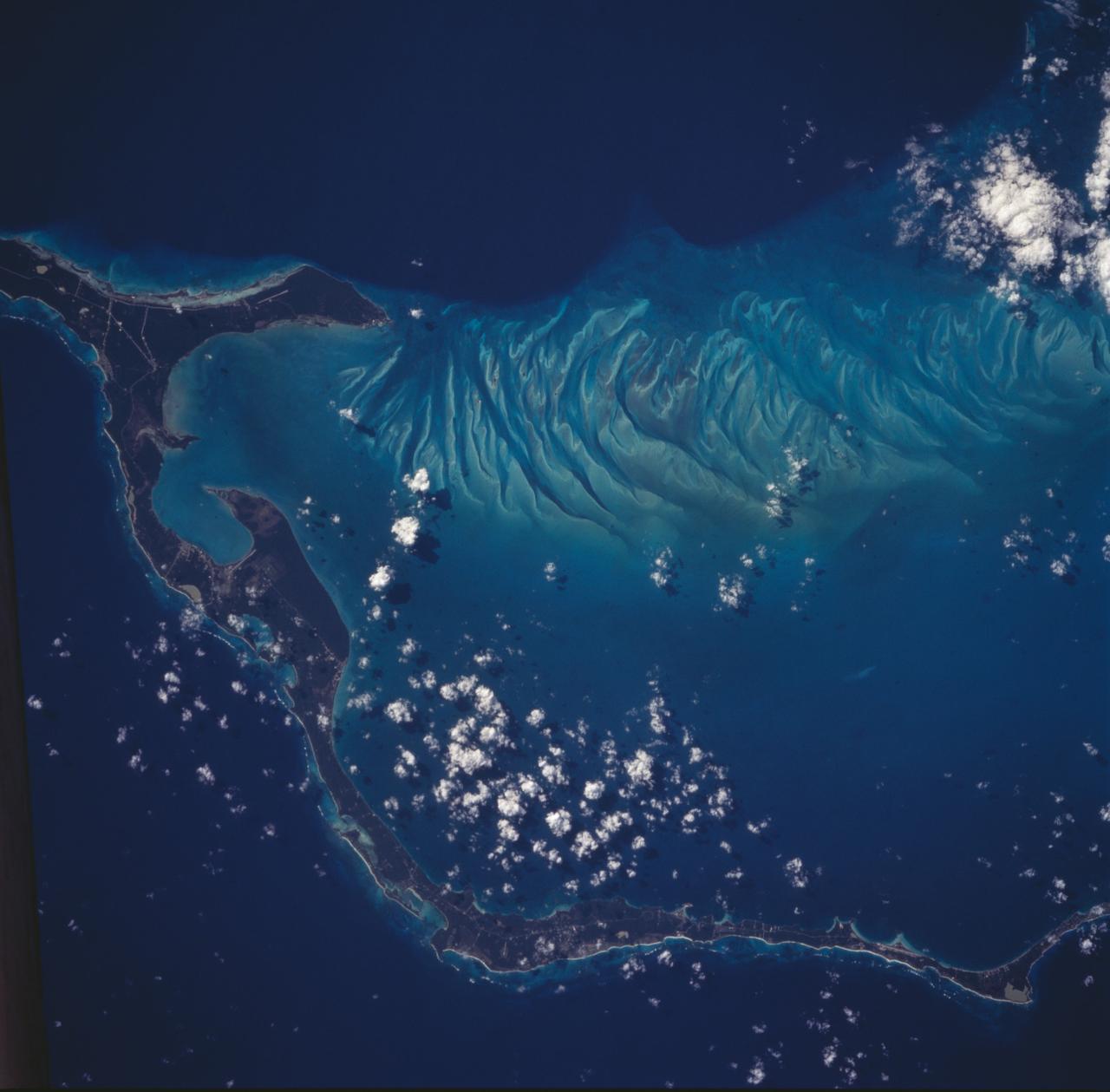
STS100-708-78 (19 April-1 May 2001) --- Southwest of the Bahamas and north of Hispaniola lie the Turks and Caicos Islands, photographed by the astronaut/cosmonaut crew aboard the Earth-orbiting Space Shuttle Endeavour. In this view, the extensive shallow water areas of Caicos Bank (turquoise blue) dominate to the south of the Caicos Islands. Caicos Bank covers an area of 7,680 square kilometers (1.9 million acres). The coral reefs of Caicos are primarily along the north deep water edge of the islands, and in a barrier along the south margin of the bank. The area is known for its marine caves and blowholes. To the east of Caicos Bank, near the tail of the Shuttle, is the island of Grand Turk, part of the much smaller Turks Bank. The channel that runs between the two banks is more than 2,200 meters (1.4 miles) deep.
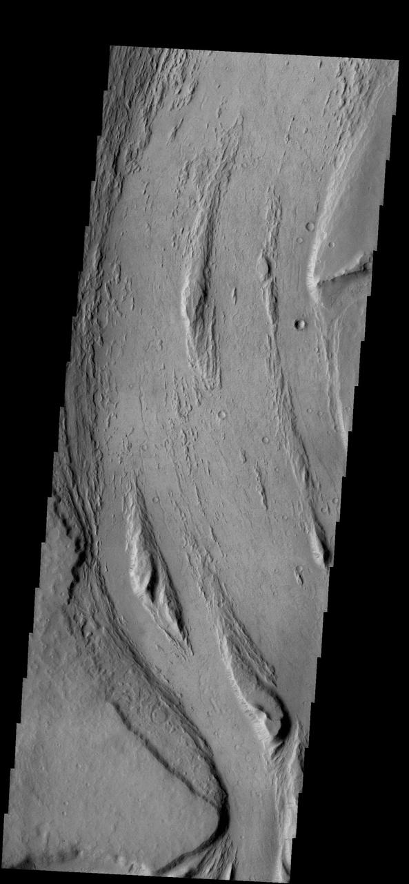
The force of moving water from a flood carved these teardrop-shaped islands within Granicus Valles. The orientation of the islands can be used as an indicator of the direction the water flowed. In this case, the water flowed primarily towards the upper left of the image. The image also contains many narrow sinuous channels. Geologists can determine that the floods occurred before a later tectonic event in the region. This event caused the crust to fracture into numerous blocks and fissures (grabens). Many fissures can be seen cutting across the former flood pathways. http://photojournal.jpl.nasa.gov/catalog/PIA04037
STS006-45-097 (4-9 April 1983) --- This photograph was taken with a handheld 70mm camera aimed through the “ceiling” windows of the Earth-orbiting space shuttle Challenger during its five-day STS-6 mission. A beautiful photo shows the contrast between the islands, clouds, shallow water and deep water. Islands of the Bahamas seen are New Providence (upper left) and Eleuthera (right). Northeast Providence Channel is at the upper edge and Exuma Sound is at the lower left with the open Atlantic along the right edge. The wind, from the south, causes a long cloud to develop downwind from Eleuthera Point. Photo credit: NASA
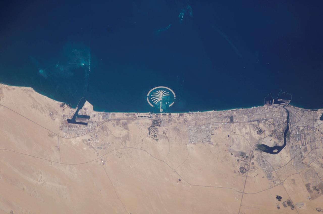
ISS006-E-35516 (5 March 2003) --- This photo of Palm Island Resort was taken by an Expedition 6 crewmember onboard the International Space Station (ISS). This man-made structure in the shape of a palm tree, just 1 mile off the coast from Dubai, United Arab Emirates, is scheduled to be complete by 2006. It will have 17 huge fronds surrounded by a crescent-shaped breakwater. This island is being built from 2.8 billion cubic feet of land dredged from the approach channel to the emirate’s Jebel Ali port, which is being deepened to 17 meters (56 feet). Sediments in the water from dredging activity can be seen near the port.
STS039-71-088 (28 April-6 May 1991) --- A handheld 70mm frame of the southern Persian Gulf area. The island in the middle of the frame is Al Jirab, 30 miles west of Abu Dhabi in the United Arab Emirates. On the mainland beaches opposite the island, a thick and continuous black fringe of oil can be seen as a line. Photo experts studying the STS 39 photography have not yet ascertained the source of the oil. They disclosed that if the oil does in fact stem from damaged Kuwaiti offshore oil fields, the slick has been blown southward at least 460 miles. The city of Tarif is visible in the affected area. Lighter brown slicks can be seen offshore. A causeway joins Al Jirab to the mainland and a dredged ship channel with its associated islands can be seen west of the causeway.
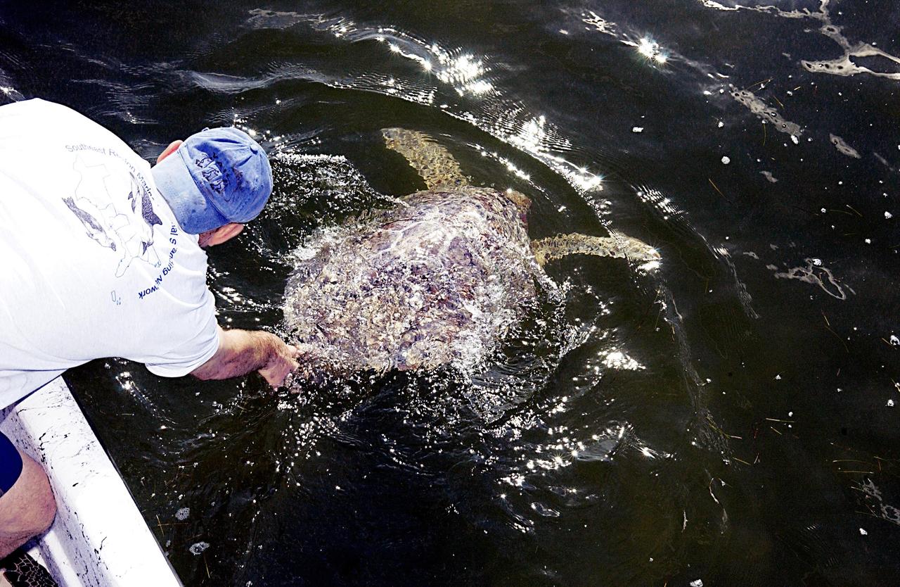
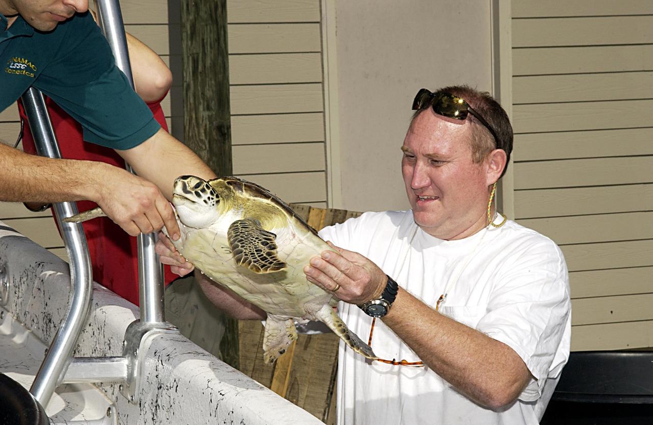
KENNEDY SPACE CENTER, FLA. - A sea turtle is released into the Mosquito Lagoon. It is one of several turtles found stunned, impacted by the unseasonal cold temperatures experienced in Central Florida. The cooperative effort of KSC contractor Dynamac Corporation's Aquatics Program and the Merritt Island National Wildlife Refuge warmed the turtles and evaluated them for release. Most were tagged and the largest one received a transmitter, provided by the University of Central Florida, for satellite tracking. The turtles were then transported through the Haulover Canal to a location away from the main channel for release..
This VIS image is located in Ravi Vallis, a channel running from the highlands of Xanthe Terra to the complex lower elevation Hydraotes Chaos. The tear-drop shaped island near the center of the image indicates fluid flow was from the left to the right side of the image. Orbit Number: 64209 Latitude: 0.0308233 Longitude: 320.437 Instrument: VIS Captured: 2016-06-04 18:52 http://photojournal.jpl.nasa.gov/catalog/PIA20801
iss067e128929 (June 13, 2022) --- The island of Groix is pictured off the northwestern coast of France with the Atlantic Ocean beaming from the sun's glint in this photograph from the International Space Station as it orbited 264 miles above the English Channel. The rivers (from top left to bottom right) La Laïta, Blavet, and Scorf, including the rivière d'Étel, are seen emptying into the Atlantic.
Today's VIS image shows a section of Labou Vallis. Labou Vallis is located south of Eumenides Dorsum and is 258 kilometers (160 miles) long. The 'tail' of the tear-dropped shaped island in the center of the channel points downstream, indicating the liquid flow was towards the top of this image. Orbit Number: 90200 Latitude: -7.83684 Longitude: 204.926 Instrument: VIS Captured: 2022-04-15 08:56 https://photojournal.jpl.nasa.gov/catalog/PIA25473
KENNEDY SPACE CENTER, FLA. - Several sea turtles await their release into the Mosquito Lagoon. They were found stunned, impacted by the unseasonal cold temperatures experienced in Central Florida. The cooperative effort of KSC contractor Dynamac Corporation's Aquatics Program and the Merritt Island National Wildlife Refuge warmed the turtles and evaluated them for release. Most were tagged and the largest one received a transmitter, provided by the University of Central Florida, for satellite tracking. The turtles were then transported through the Haulover Canal to a location away from the main channel for release.
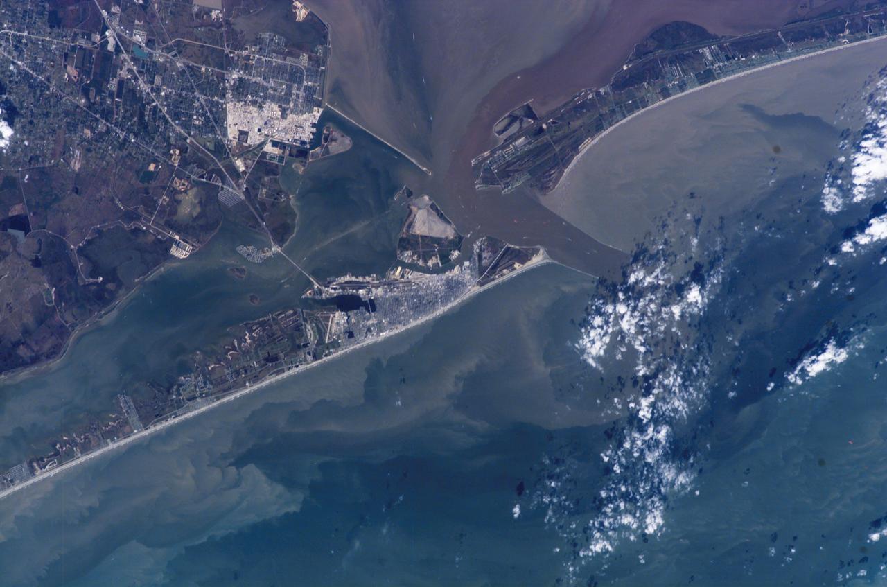
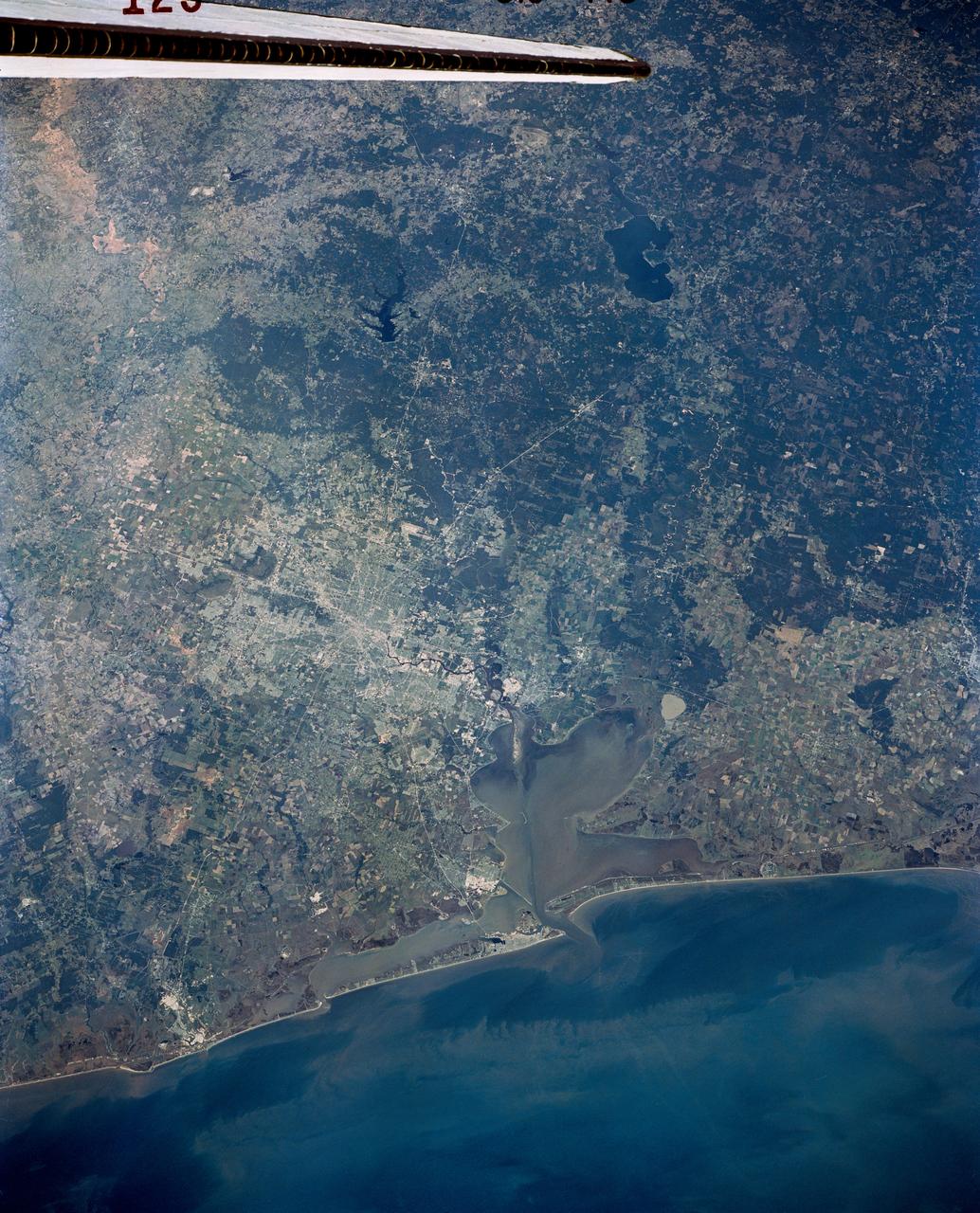
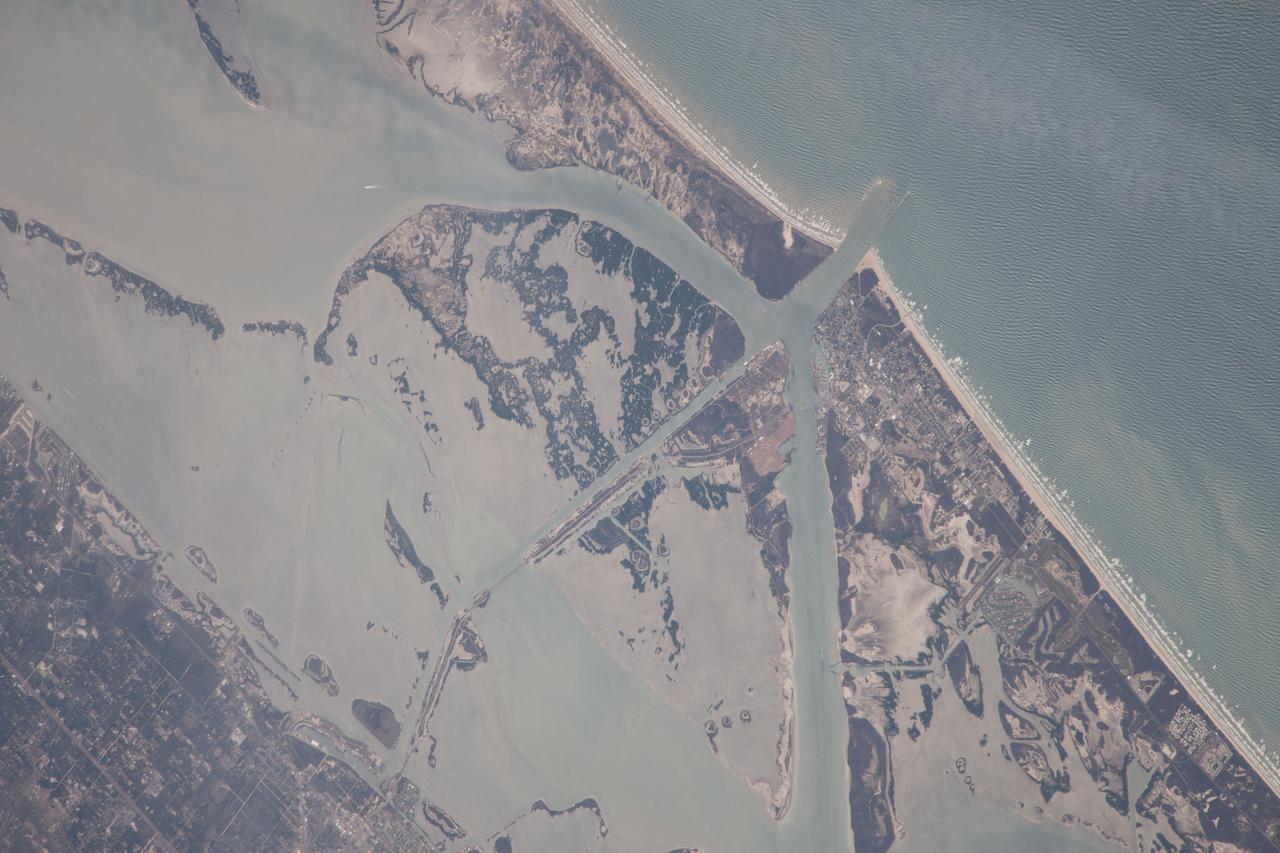
ISS014-E-07258 (4 Nov. 2006) --- Galveston, Texas is featured in this image photographed by an Expedition 14 crewmember on the International Space Station (ISS). Mexico established a port of entry (known as Galveston) in 1825, and following the Texas Revolution it was the capital of the Republic of Texas during 1836. The modern-day city of Galveston was incorporated in 1839, and became the major trading seaport of Texas during the latter half of the 19th century. The city was largely destroyed in early September of 1900 by a powerful hurricane; this, coupled with construction of the Houston Ship Channel and discovery of oil in eastern Texas shifted the center of trade northwest to Houston. Many human footprints are easily observed from the vantage point of low Earth orbit. The eastern half of Galveston Island is dominated by the city of Galveston (gray-white region at center). A large seawall along the Gulf of Mexico (southern coastline of Galveston Island) protects most of the city. To the west of Galveston, coastal wetlands are largely submerged by regional subsidence--a result of ground water withdrawal by the petrochemical industry of Houston and Texas City. The entrance to Galveston Bay and the Houston Ship Channel is located between Galveston Island and the Bolivar Peninsula (upper right). Numerous ship wakes are visible along the Houston Ship Channel. Other visible features of the entrance to Galveston Bay include the five-mile long Texas City Dike, a structure that protects the Texas City channel and includes a fishing pier that extends 600 feet beyond the end of the Dike. Extensive petroleum processing facilities are located to the west of the Dike in Texas City. The Intracoastal Waterway runs through western Galveston Bay; new subdivisions built on dredge spoils are visible along the northern boundary of the Waterway. Geologists studying the ISS collection of down linked still imagery observe that complex estuarine sediment patterns are visible in this image. Dark brown to tan waters adjacent to the Bolivar Peninsula and Texas City Dike reflect increased sediment loads following heavy rains in mid-to-late October, coupled with northerly winds moving Bay water southwards. Turbidity currents to both the northwest and southeast of Galveston Island produce a more chaotic pattern of sediment-laden (light green to tan) and relatively sediment-free (dark green) water leading into the dark green Gulf of Mexico (lower right).
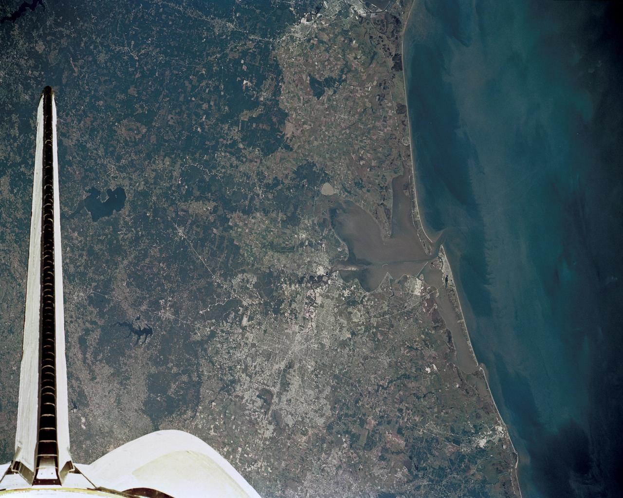
51J-143-126 (5 Oct. 1985) --- The vertical stabilizer of the Earth-orbiting Space Shuttle Atlantis serves to partially frame this scene of Metropolitan Houston. Hold photo with vertical tail at top so that north will be at top. America's fourth largest city, with its radiating highway network, lies at the junction between the East Texas piney woods, containing lakes Conroe and Livingston (near top center and top right, respectively), and the coastal prairie, now largely farmland (left side of frame). The coast stretches from the left at Freeport and the mouth of the Brazos River, past Galveston and Texas City, and the circle of the High Island Salt Dome (clearly seen at lower right near the Bolivar Peninsula), to Port Arthur on the Neches River (far right). Patterns of muddy and clear water are particularly well-displayed in Galveston and Trinity Bays, as well as in the Gulf of Mexico. With a close look, the Harris County Domed Stadium (Astrodome) can be recognized on Houston's south side. The NASA Johnson Space Center (JSC) and the Clear Lake City area are easily delineated some 25 miles southeast of downtown Houston. The scene was recorded on film by one of the STS-51J crewmembers using a handheld Hasselblad camera and 70mm film.
Long regarded as one of the best photo of Houston, Texas (29.5N, 95.0W), this view from space shows the entire greater Houston/Galveston region in remarkable detail and clarity. The dark north/south line in the water between Houston and Galveston is the Houston Ship Channel. NASA's Johnson Space Center and Mission Control is located on the north shore of Clear Lake west of the channel. The extensive road and highway network can be seen in great detail.
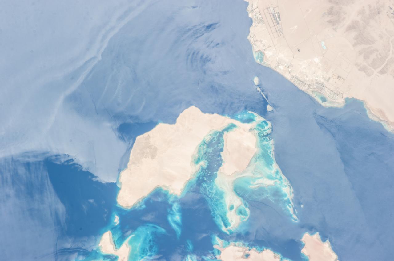
ISS036-E-010628 (24 June 2013) --- Strait of Tiran, Red Sea and Gulf of Aqaba are featured in this image photographed by an Expedition 36 crew member on the International Space Station. The approximately six-kilometer wide Strait of Tiran (also known as the Straits of Tiran) between the Egyptian mainland and Tiran Island separates the Gulf of Aqaba from the Red Sea, and provides two channels (290 meters and 73 meters deep, respectively) navigable by large ships bound for ports in Jordan and Israel. A smaller passage also exists between the east side of Tiran Island and Saudi Arabia, but this a single channel that is 16 meters deep. Due to its strategic position, control of the Strait has been an important factor in historical conflicts of the region, such as the Suez Crisis in 1956 and the Six-Day War in 1967. This photograph illustrates the morphology of the Strait. The relatively clear, deep-water passages of the western Strait of Tiran are visible at right, while the more sinuous shallow-water passage on the Saudi Arabia side can be seen at bottom center. Light blue to turquoise areas around Tiran Island indicate shallow water, while the island itself is arid and largely free of vegetation. Coral reefs are also found in the Straits of Tiran and are a popular diving destination. The silvery sheen on the water surface within the Strait and the south of Tiran Island is sunglint – light reflecting off the water surface back towards the observer on the space station. Disturbance to the water surface, as well as presence of substances such as oils and surfactants, can change the reflective properties of the water surface and highlight both surface waves and subsurface currents. For example, a large wave set is highlighted by sunglint at upper left.
STS102-331-012 (8-21 March 2001) --- The STS-102 crew members used a 35mm camera on the flight deck of the Space Shuttle Discovery to record this image of several meandering distributary channels of the Orinoco River draining northward into the south side of the Gulf of Paria in eastern Venezuela. According to NASA scientists studying the STS-102 collection, these sediment-laden channels carry a tremendous quantity of fluvial material that constantly changes the size and shapes of the shoreline and adjacent islands. An assortment of mud flats and sand bars, seen here as lighter colored features in the water, are affected both by stream flow and tidal forces. The extensive dark landscape identifies the flat, swampy coastal plains of northeast Venezuela that is covered by dense stands of vegetation.
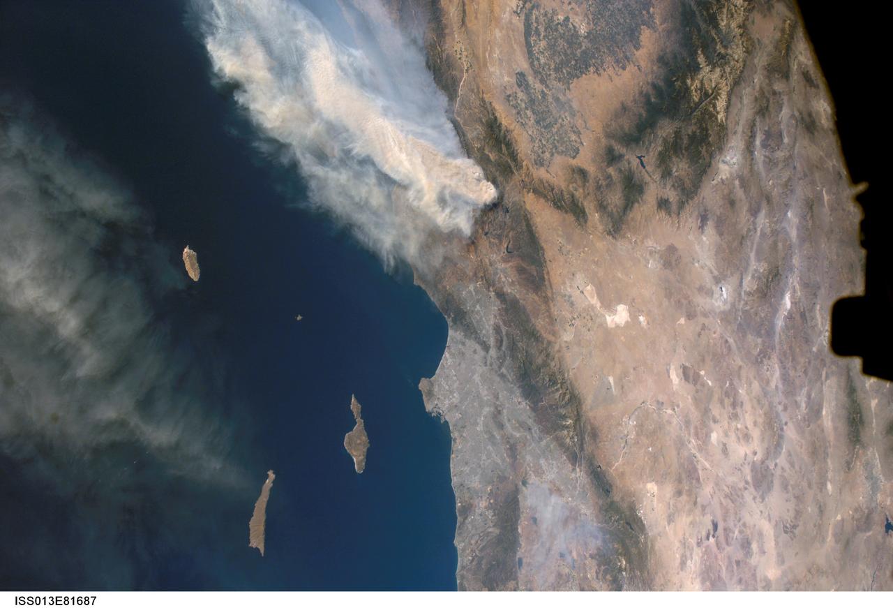
ISS013-E-81687 (17 Sept. 2006) --- A forest fire in southern California is featured in this image photographed by an Expedition 13 crewmember on the International Space Station. The day fire started in Los Padres National Forest north of Los Angeles on Sept. 4, 2006. Easterly winds on Sept. 17 blew the smoke west out to sea, and this wind shift was observed by station crewmembers. The forested mountains north of Los Angeles appear dark green, the smoke a dusky gray. Dense farmland at the south end of California's central valley is framed by the forested Sierra Nevada mountain range. White patches near the center of the view are dry lakes of the Mojave Desert, one of which acts as a landing site for the space shuttle. The dark irregular shape at image right is part of the space station. Death Valley and Las Vegas are visible at image right. The extent of the day fire smoke plume can be gauged from the gray urban region of greater Los Angeles (center) which stretches along 50 miles of coastline. The plume obscures the northern Channel Islands, but the southern Channel Islands are silhouetted against the ocean.
Hawaii's Kilauea volcanic eruption continues after seven weeks of continuous outpouring of lava over the northeastern part of the island. More than 6,100 acres of the Big Island have been covered with new lava, destroying hundreds of homes. At the same time, new land has been created as lava filled Kapoho Bay at the ocean. For some time, the activity has been confined to a leveed channel flow, that starts from the active-most vent, and makes it way 8 miles (13 kilometers) to the ocean. In this image from the Advanced Spaceborne Thermal Emission and Reflection (ASTER) radiometer instrument on NASA's Terra satellite, vegetation is displayed in red, clouds are white and the hot lava flows, detected by ASTER's thermal infrared channels, are overlaid in yellow. The image was acquired June 23, 2018, covers an area of 14.2 by 14.6 miles (23 by 23.3 kilometers), and is located at 19.6 degrees north, 154.9 degrees west. https://photojournal.jpl.nasa.gov/catalog/PIA22553
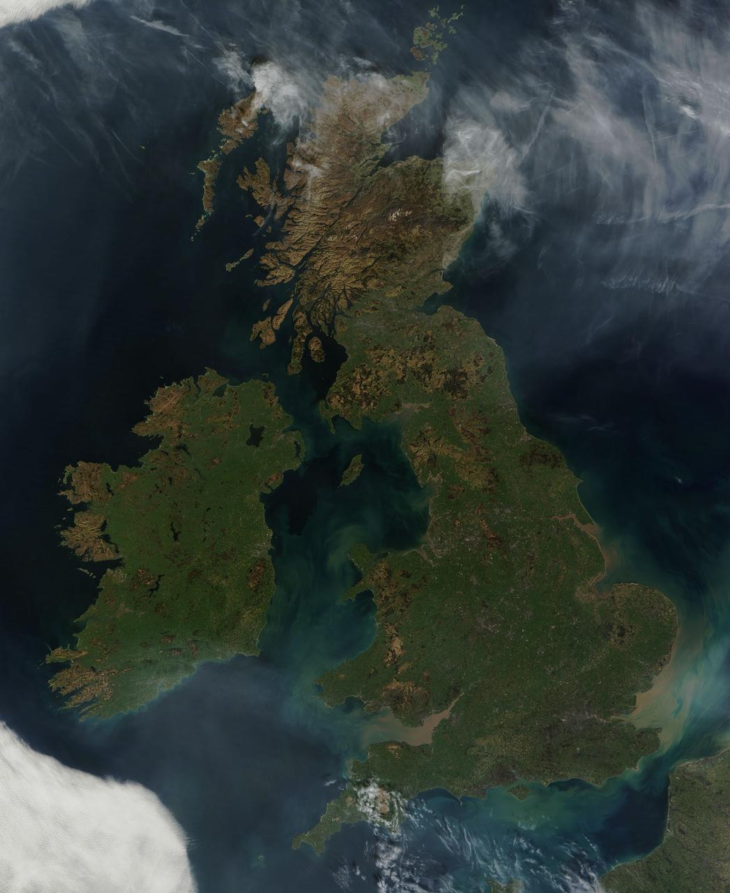
NASA image acquired March 26, 2012 This nearly cloud-free view of Great Britain and Ireland was acquired by the Moderate Resolution Imaging Spectroradiometer (MODIS) aboard NASA’s Terra satellite on March 26, 2012. Just a few days into spring, most of the land appears green, although not quite as brilliant as the summertime hues that give Ireland the nickname “the Emerald Island”. The islands of Ireland (west) and Great Britain (east) are separated by the Irish Sea, which is filled with the turquoise, green and tan swirls typical of sediment, although blooming algae could also contribute some color to the waters. To the southeast, the English Channel separates the island of Great Britain from France (south) and Belgium (north). London can be seen as a gray circle situated inland on the tan-colored River Thames. The sediment from the Thames flows into the English Channel due east of London. The United Kingdom is made up of Wales, Scotland and England, all located primarily on the island of Great Britain, and of Northern Ireland, which comprises the northern section of the island of Ireland. Dublin, in the Republic of Ireland, can be seen as a gray smudge on the eastern coast of the island. Almost due west Galway can be seen as a linear gray streak on the northern coast of Galway Bay, with the blue waters of Loch Corrib to the north. Most of the United Kingdom and Ireland are part of the Celtic broadleaf forest ecoregion, where acid-loving oak and mixed oak forests abound, along with fen and swamp forests and ombrotrophic mires. A portion of the Scottish Highlands, in the north of Great Britain, are covered by the Caledon conifer forest ecoregion. The Caledonia conifers once covered a large area of Scotland, but now only about 1% of the original forest survives, mostly high in the cooler areas of the Highlands. NASA/GSFC/Jeff Schmaltz/MODIS Land Rapid Response Team <b><a href="http://www.nasa.gov/audience/formedia/features/MP_Photo_Guidelines.html" rel="nofollow">NASA image use policy.</a></b> <b><a href="http://www.nasa.gov/centers/goddard/home/index.html" rel="nofollow">NASA Goddard Space Flight Center</a></b> enables NASA’s mission through four scientific endeavors: Earth Science, Heliophysics, Solar System Exploration, and Astrophysics. Goddard plays a leading role in NASA’s accomplishments by contributing compelling scientific knowledge to advance the Agency’s mission. <b>Follow us on <a href="http://twitter.com/NASA_GoddardPix" rel="nofollow">Twitter</a></b> <b>Like us on <a href="http://www.facebook.com/pages/Greenbelt-MD/NASA-Goddard/395013845897?ref=tsd" rel="nofollow">Facebook</a></b> <b>Find us on <a href="http://instagrid.me/nasagoddard/?vm=grid" rel="nofollow">Instagram</a></b>
STS098-713a-019 (16 February 2001) --- The International Space Station is backdropped over clouds, water and land in South America. South central Chile shows up at bottom of the frame. Just below the Destiny laboratory, the Chacao Channel separates the large island of Chiloe from the mainland and connects the Gulf of Coronados on the Pacific side with the Gulf of Ancud southwest of the city of Puerto Montt. The crews of the Space Shuttle Atlantis and the International Space Station parted company at 8:06 a.m. (CST), February 16, as astronaut Mark L. Polansky, pilot, flew the shuttle halfway around the station and its new Destiny laboratory before moving off.
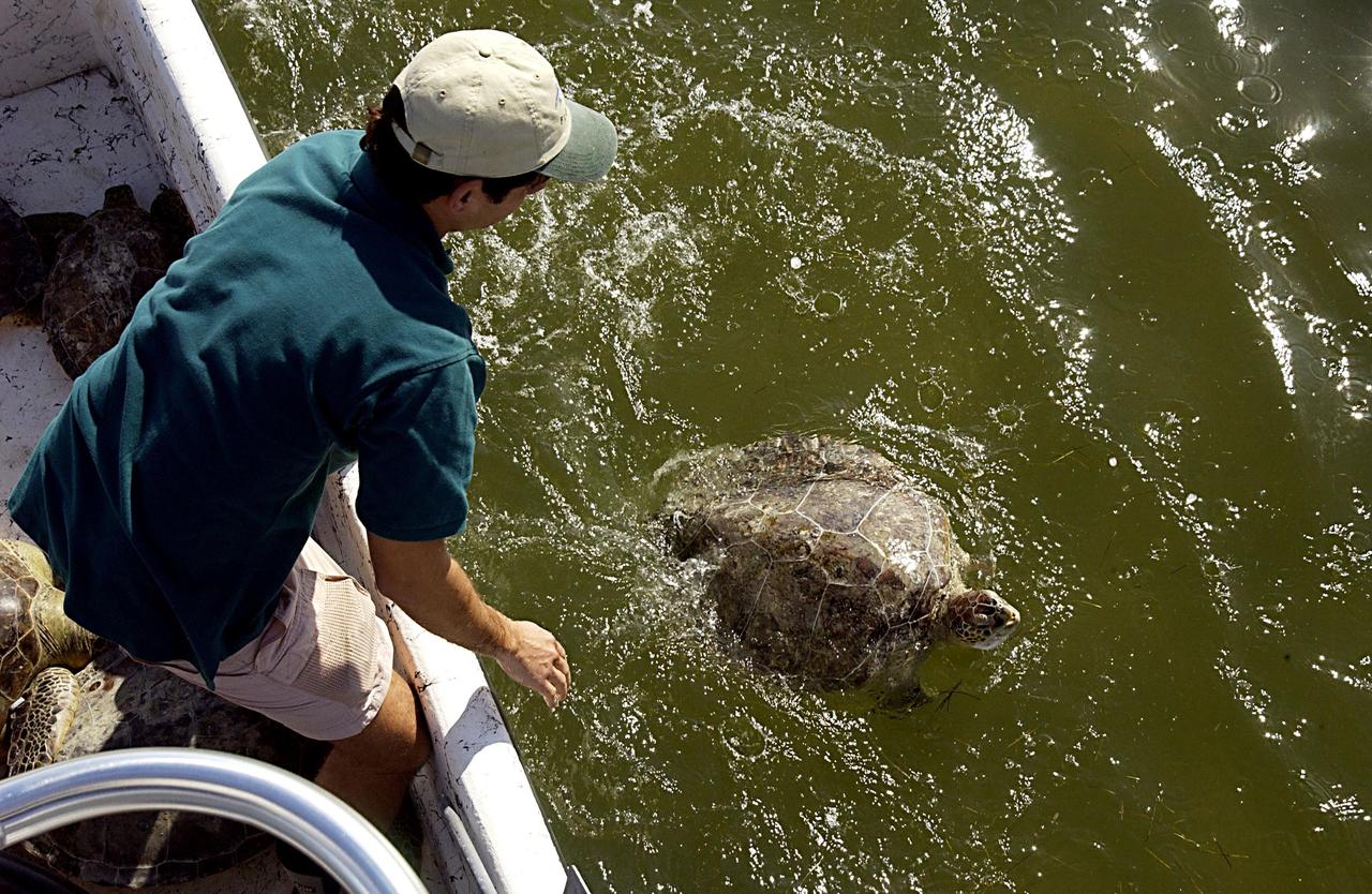
KENNEDY SPACE CENTER, FLA. - A worker watches as one of the rescued sea turtles swims away in Mosquito Lagoon. It is one of several turtles found stunned, impacted by the unseasonal cold temperatures experienced in Central Florida. The cooperative effort of KSC contractor Dynamac Corporation's Aquatics Program and the Merritt Island National Wildlife Refuge warmed the turtles and evaluated them for release. Most were tagged and the largest one received a transmitter, provided by the University of Central Florida, for satellite tracking. The turtles were then transported through the Haulover Canal to a location away from the main channel for release.
41G-120-079 (5-13 Oct 1984) --- This oblique view, photographed from the Space Shuttle Challenger, shows the south tip of the island of Madagascar. Sunglint reflects on the surface of the Mozambique Channel. The crew consisted of astronauts Robert L. Crippen, commander; Jon A. McBride, pilot; mission specialist's Kathryn D. Sullivan, Sally K. Ride, and David D. Leestma; Canadian astronaut Marc Garneau; and Paul D. Scully-Power, payload specialist. EDITOR'S NOTE: The STS-41G mission had the first American female EVA (Sullivan); first seven-person crew; first orbital fuel transfer; and the first Canadian (Garneau).
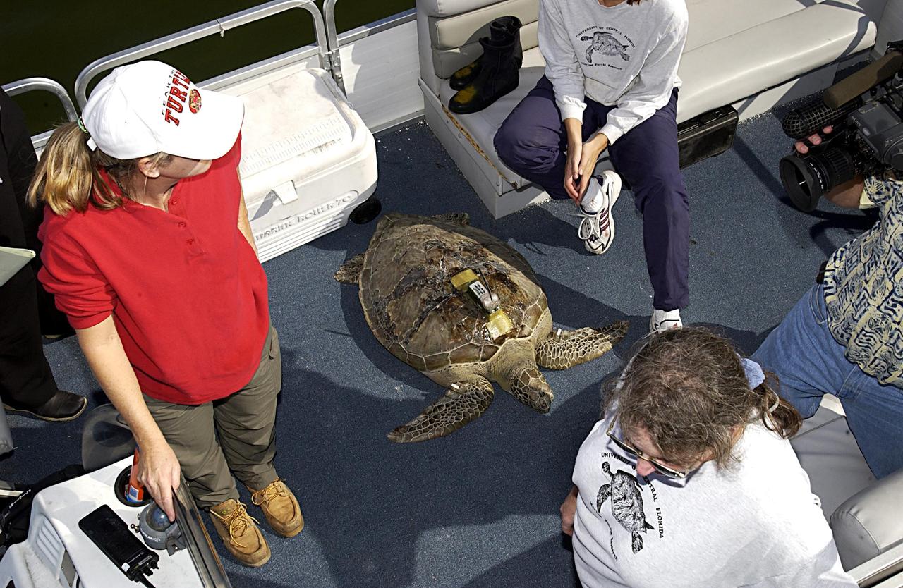
KENNEDY SPACE CENTER, FLA. -- A large sea turtle with a transmitter lies in the skiff that will return it to the Mosquito Lagoon. It is one of several turtles found stunned, impacted by the unseasonal cold temperatures experienced in Central Florida. The cooperative effort of KSC contractor Dynamac Corporation's Aquatics Program and the Merritt Island National Wildlife Refuge warmed the turtles and evaluated them for release. Most were tagged and one received a transmitter, provided by the University of Central Florida, for satellite tracking. The turtles were then transported through the Haulover Canal to a location away from the main channel and released.
STS098-713a-016 (16 February 2001) --- The International Space Station is backdropped over clouds, water and land in South America. South central Chile shows up at bottom of the frame. Just below the Destiny laboratory, the Chacao Channel separates the large island of Chiloe from the mainland and connects the Gulf of Coronados on the Pacific side with the Gulf of Ancud southwest of the city of Puerto Montt. The crews of the Space Shuttle Atlantis and the International Space Station parted company at 8:06 a.m. (CST), February 16, as astronaut Mark L. Polansky, pilot, flew the shuttle halfway around the station and its new Destiny laboratory before moving off.
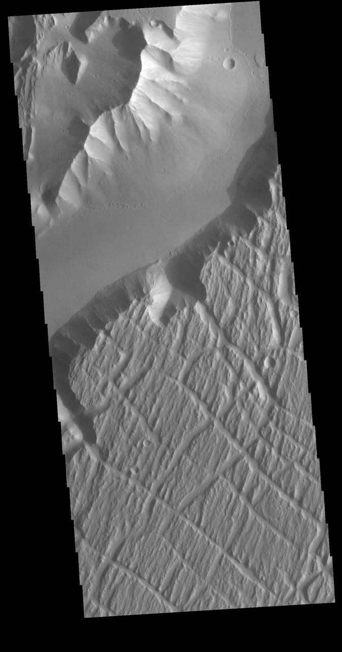
Olympica Fossae is a complex channel located on the volcanic plains between Alba Mons and Olympus Mons. It contains both linear sections that appear to be tectonic in origin and sinuous sections that were more likely created by liquid flow. There are several streamlined islands in this image, indicating a fluvial origin in this section of the fossae. Given the location it appears that lava, rather than water, was the fluid. Olympica Fossae 420km long (261 miles). Orbit Number: 95165 Latitude: 23.3032 Longitude: 243.696 Instrument: VIS Captured: 2023-05-29 04:39 https://photojournal.jpl.nasa.gov/catalog/PIA26264
KENNEDY SPACE CENTER, FLA. -- A sea turtle is carried toward the skiff that will return it to the lagoon. It is one of several turtles found stunned, impacted by the unseasonal cold temperatures experienced in Central Florida. The cooperative effort of KSC contractor Dynamac Corporation's Aquatics Program and the Merritt Island National Wildlife Refuge warmed the turtles and evaluated them for release. Most were tagged and one received a transmitter, provided by the University of Central Florida, for satellite tracking. The turtles were then transported through the Haulover Canal to a location away from the main channel and released.
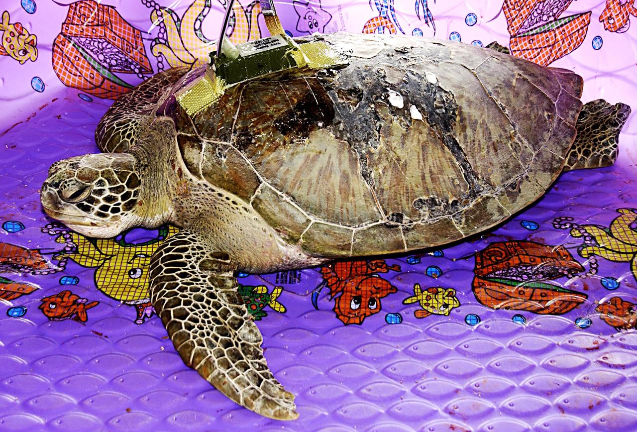
KENNEDY SPACE CENTER, FLA. -- A sea turtle rescued from the Mosquito Lagoon is seen with a transmitter recently attached to its back. Several turtles were found stunned, impacted by the unseasonal cold temperatures experienced in Central Florida. The cooperative effort of KSC contractor Dynamac Corporation's Aquatics Program and the Merritt Island National Wildlife Refuge warmed the turtles and evaluated them for release. Most were tagged and one received the transmitter, provided by the University of Central Florida, for satellite tracking. The turtles were then transported in a skiff through the Haulover Canal to a location away from the main channel and released back into the Mosquito Lagoon.
KENNEDY SPACE CENTER, FLA. -- A sea turtle rescued from the Mosquito Lagoon is prepared to receive a transmitter on its back. Several turtles were found stunned, impacted by the unseasonal cold temperatures experienced in Central Florida. The cooperative effort of KSC contractor Dynamac Corporation's Aquatics Program and the Merritt Island National Wildlife Refuge warmed the turtles and evaluated them for release. Most were tagged and one received the transmitter, provided by the University of Central Florida, for satellite tracking. The turtles were then transported in a skiff through the Haulover Canal to a location away from the main channel and released into the Indian River Lagoon.

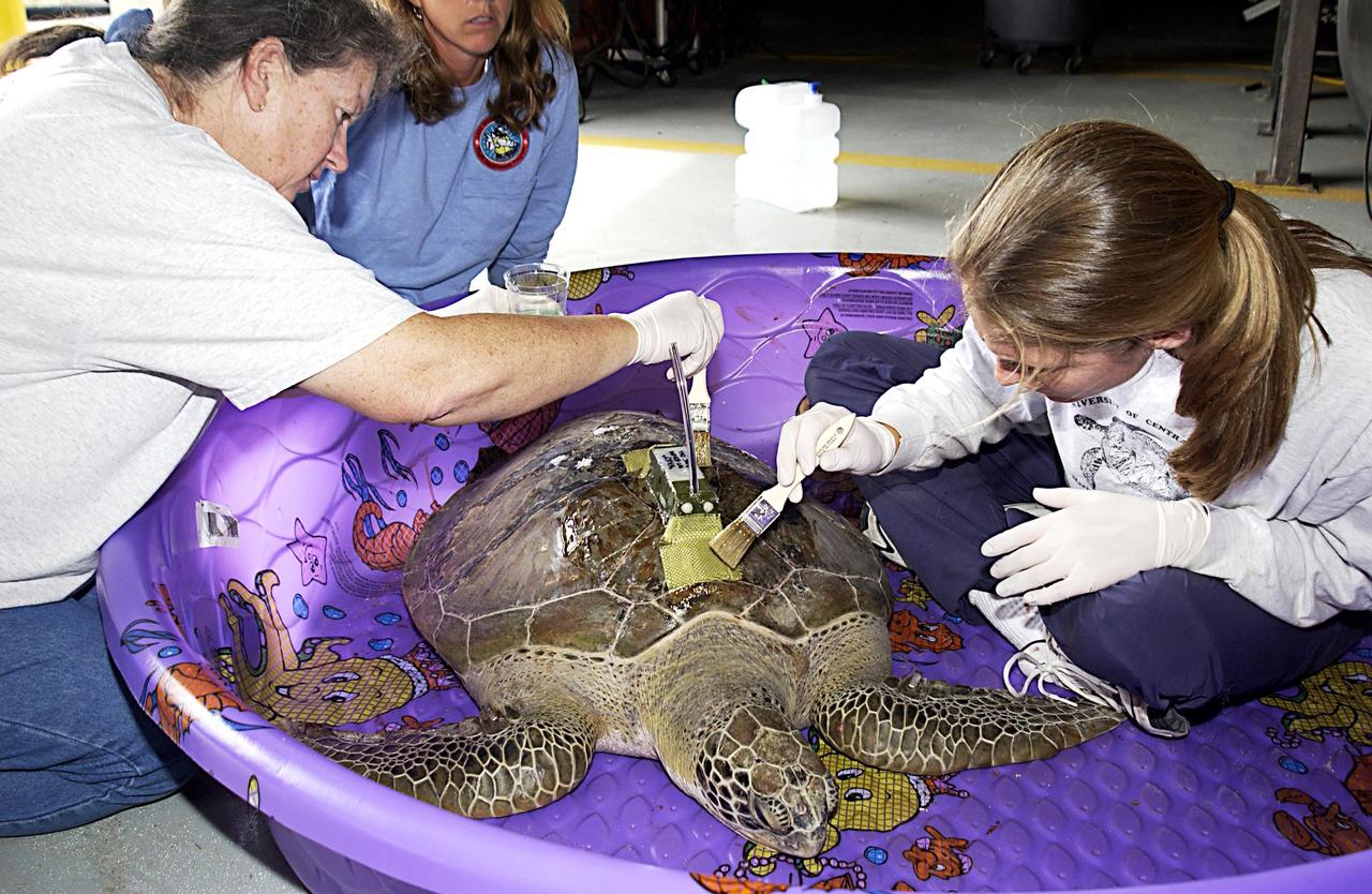
KENNEDY SPACE CENTER, FLA. -- This closeup shows the transmitter being attached to a sea turtle rescued from the Mosquito Lagoon. Several turtles were found stunned, impacted by the unseasonal cold temperatures experienced in Central Florida. The cooperative effort of KSC contractor Dynamac Corporation's Aquatics Program and the Merritt Island National Wildlife Refuge warmed the turtles and evaluated them for release. Most were tagged and one received the transmitter, provided by the University of Central Florida, for satellite tracking. The turtles were then transported in a skiff through the Haulover Canal to a location away from the main channel and released into the Indian River Lagoon.
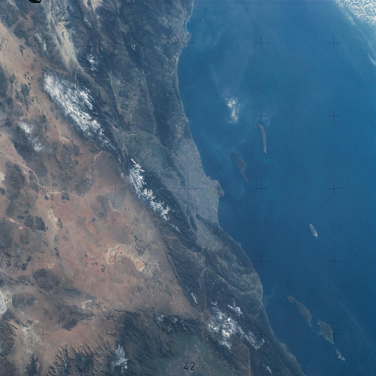
SL4-142-4542 (November 1973-February 1974) --- An oblique view of the Pacific Coast of Southern California, including the Los Angeles and San Diego areas, as seen from the Skylab space station in Earth orbit. This picture was taken by one of the Skylab 4 crewmen using a hand-held 70mm Hasselblad camera with a 100mm lens and SO-368 medium-speed Ektachrome film. The visible coastline extends from San Diego northwesterly to Santa Barbara. The Mojave Desert occupies much of the photograph. This view also includes the Channel Islands off the coast. Note that the higher elevations of the mountains are covered with snow. Photo credit: NASA
Oblique Earth Observation taken by the Apollo 9 crew. View is of California including: Sanata Barbara, Los Angeles, San Diego, Santa Rosa, San Miguel, and Santa Cruz Islands, Santa Barbara Channel, Salton Sea and the Service Module (SM) Lunar Module (LM) adapter (S.L.A.) in the distance. Film magazine was A,film type was SO-368 Ektachrome with 0.460 - 0.710 micrometers film / filter transmittance response and haze filter, 80mm lens. Latitude was 32.55 N by Longitude 119.58 W, Altitude miles were 106 and cloud cover was 25%.
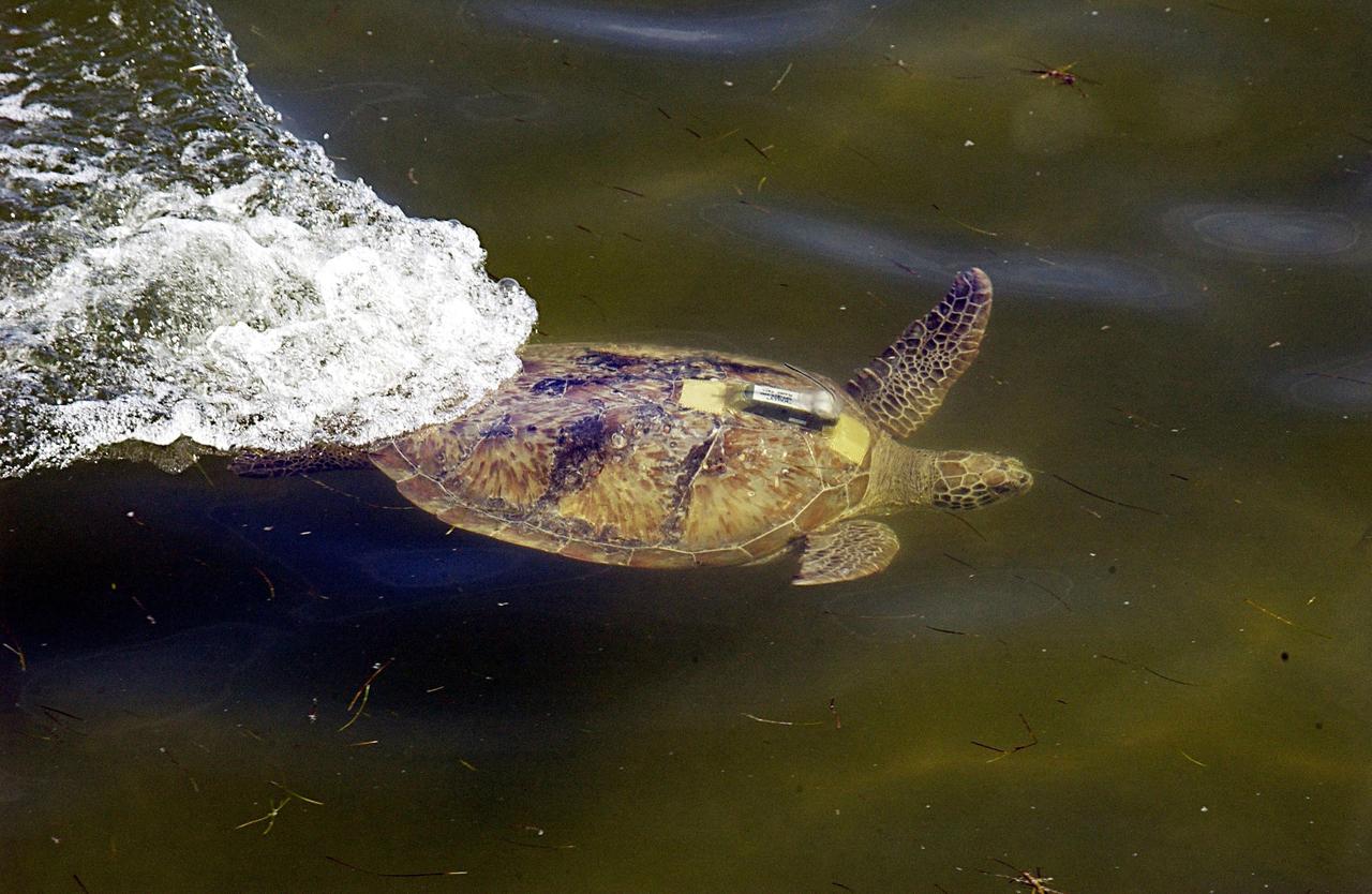
KENNEDY SPACE CENTER, FLA. -- A large sea turtle with a transmitter swims away after release into the Mosquito Lagoon. It is one of several turtles found stunned, impacted by the unseasonal cold temperatures experienced in Central Florida. The cooperative effort of KSC contractor Dynamac Corporation's Aquatics Program and the Merritt Island National Wildlife Refuge warmed the turtles and evaluated them for release. Most were tagged and the largest one received a transmitter, provided by the University of Central Florida, for satellite tracking. The turtles were then transported through the Haulover Canal to a location away from the main channel for release.
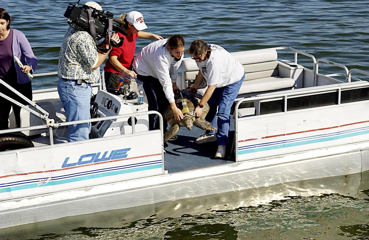
KENNEDY SPACE CENTER, FLA. -- A large sea turtle with a transmitter is ready to be returned to the Mosquito Lagoon. It is one of several turtles found stunned, impacted by the unseasonal cold temperatures experienced in Central Florida. The cooperative effort of KSC contractor Dynamac Corporation's Aquatics Program and the Merritt Island National Wildlife Refuge warmed the turtles and evaluated them for release. Most were tagged and the one received a transmitter, provided by the University of Central Florida, for satellite tracking. The turtles were then transported through the Haulover Canal to a location away from the main channel and released.
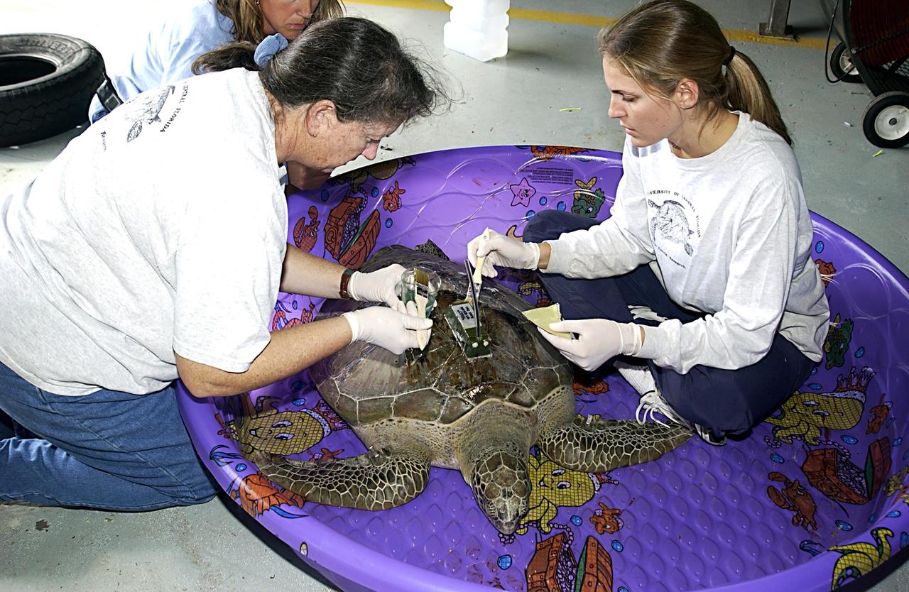
KENNEDY SPACE CENTER, FLA. - A sea turtle rescued from the Mosquito Lagoon is prepared to receive a transmitter on its back. Several turtles were found stunned, impacted by the unseasonal cold temperatures experienced in Central Florida. The cooperative effort of KSC contractor Dynamac Corporation's Aquatics Program and the Merritt Island National Wildlife Refuge warmed the turtles and evaluated them for release. Most were tagged and one received the transmitter, provided by the University of Central Florida, for satellite tracking. The turtles were then transported in a skiff through the Haulover Canal to a location away from the main channel and released into the Indian River Lagoon.
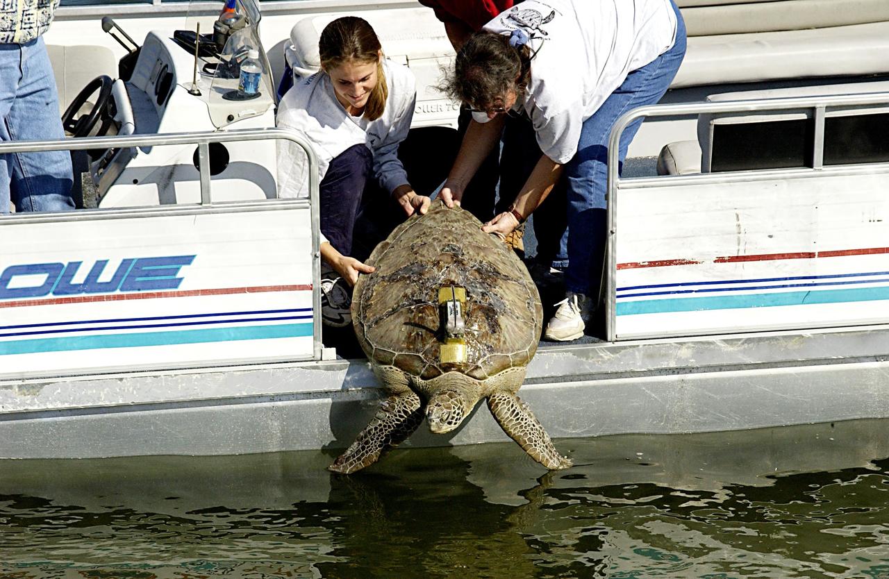
KENNEDY SPACE CENTER, FLA. -- A large sea turtle with a transmitter is released into the Mosquito Lagoon. It is one of several turtles found stunned, impacted by the unseasonal cold temperatures experienced in Central Florida. The cooperative effort of KSC contractor Dynamac Corporation's Aquatics Program and the Merritt Island National Wildlife Refuge warmed the turtles and evaluated them for release. Most were tagged and the largest one received a transmitter, provided by the University of Central Florida, for satellite tracking. The turtles were then transported through the Haulover Canal to a location away from the main channel for release.
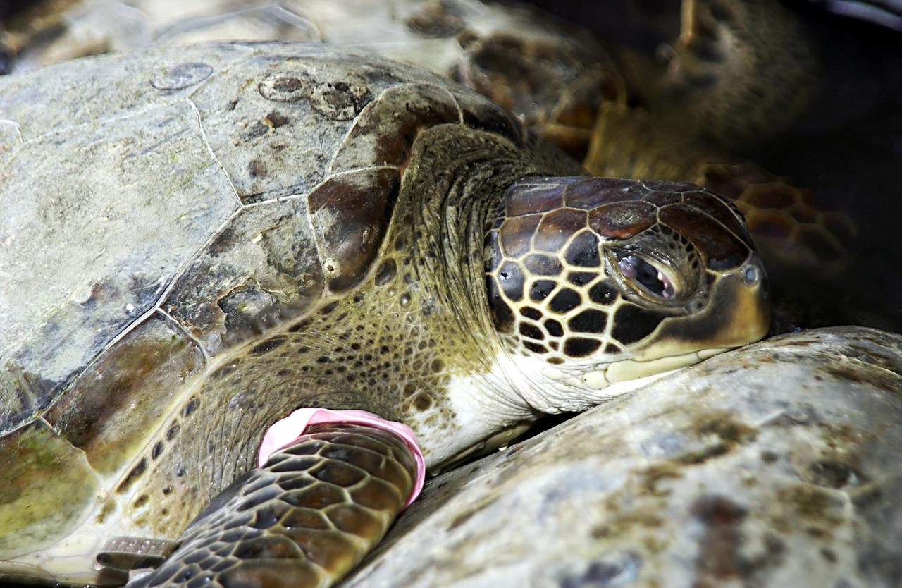
KENNEDY SPACE CENTER, FLA. - One of several sea turtles rescued from the Mosquito Lagoon is ready for release. The turtles were found stunned, impacted by the unseasonal cold temperatures experienced in Central Florida. The cooperative effort of KSC contractor Dynamac Corporation's Aquatics Program and the Merritt Island National Wildlife Refuge warmed the turtles and evaluated them for release. Most were tagged and one received the transmitter, provided by the University of Central Florida, for satellite tracking. The turtles were then transported in a skiff through the Haulover Canal to a location away from the main channel and released back into the Mosquito Lagoon.
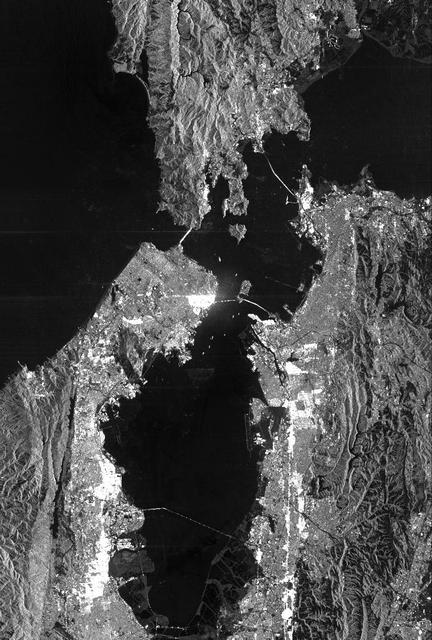
This is a radar image of San Francisco, California, taken on October 3,1994. The image is about 40 kilometers by 55 kilometers (25 miles by 34 miles) with north toward the upper right. Downtown San Francisco is visible in the center of the image with the city of Oakland east (to the right) across San Francisco Bay. Also visible in the image is the Golden Gate Bridge (left center) and the Bay Bridge connecting San Francisco and Oakland. North of the Bay Bridge is Treasure Island. Alcatraz Island appears as a small dot northwest of Treasure Island. This image was acquired by the Spaceborne Imaging Radar-C and X-band Synthetic Aperture Radar (SIR-C/X-SAR) aboard the space shuttle Endeavour on orbit 56. The image is centered at 37 degrees north latitude, 122degrees west longitude. This single-frequency SIR-C image was obtained by the L-band (24 cm) radar channel, horizontally transmitted and received. Portions of the Pacific Ocean visible in this image appear very dark as do other smooth surfaces such as airport runways. Suburban areas, with the low-density housing and tree-lined streets that are typical of San Francisco, appear as lighter gray. Areas with high-rise buildings, such as those seen in the downtown areas, appear in very bright white, showing a higher density of housing and streets which run parallel to the radar flight track. http://photojournal.jpl.nasa.gov/catalog/PIA01751
ISS038-E-57806 (21 Feb. 2014) --- One of the Expedition 38 crew members aboard the International Space Station photographed this image of the Gulf of Mexico's Intracoastal Waterway in southern Texas. Represented in the photo are 18 kilometers (11.2 miles) of the overall 4800 kilometers-long (3000 miles) barge channel that lies on the protected inshore of the coastal islands of the southern and eastern USA, including coastal Texas. The small city of Port Aransas lies on a barrier island fully 18 kilometers (11.2 miles) seaward of the mainland and its sister city, Aransas Pass (lower left). This image shows parts of the waterway that are artificial, as in the straight sector leading into Corpus Christi Bay. Corpus Christi lies outside the lower margin of the image. Other sectors of the waterway are natural bays such as Aransas Bay. Jetties protect the inlet into the Gulf of Mexico (top right). Inlets at many points cut through the barrier islands to give shipping access to the Gulf of Mexico and the Atlantic Ocean.
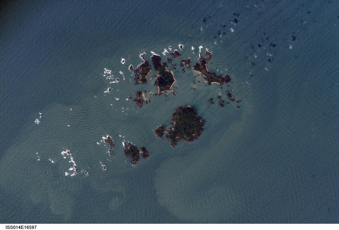
ISS014-E-16597 (10 March 2007) --- Isles of Scilly, United Kingdom is featured in this image photographed by an Expedition 14 crewmember on the International Space Station. The Isles of Scilly, an archipelago of approximately 150 islands, is located some 44 kilometers southwest of the westernmost point of England (Land's End). According to scientists, the islands are an erosional remnant of an ancient granite intrusion, and are notable because they have been inhabited for over 4000 years. Historical and geological evidence cited by NASA scientists on the Isles indicates that many of the islands were larger and/or connected in the recent past--this could be due to local subsidence, rising sea levels, or a combination of both factors. Even today, it is possible to walk between certain islands during low tides. The Isles have been designated a United Kingdom Area of Outstanding Natural Beauty due to their unique landscape, ecology, and historical significance. The potential effect of rising sea level on the Isles is a primary concern for both long-term ecosystem health and human habitability. This image illustrates the geographic configuration of the archipelago, and its effect on ocean wave patterns. Long linear swells oriented northeast-southwest and moving to the southeast (from upper left to lower right) are diffracted (bent) as they approach the coastlines and small shoals of the Isles. The wave diffraction forms complex interacting surface patterns--this is most clearly visible southwest of St. Mary's island (left). The dominant ocean wave pattern resumes to the southeast of St. Mary's, but with an additional northwest-southeast oriented pattern superimposed, possibly due to winds originating in the English channel to the east (not shown). Suspended, tan-colored sediments visible within and around the archipelago are locally derived from continuing wave erosion of the granite forming the islands and remobilization of beach sands. Bright white areas in the photograph are waves breaking on shoals.
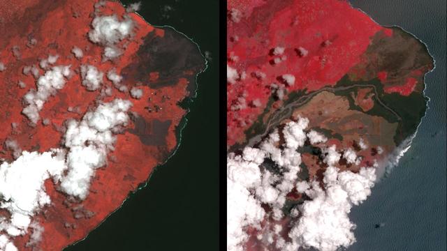
The Advanced Spaceborne Thermal Emission and Reflection (ASTER) instrument onboard NASA's Terra spacecraft obtained near-infrared data of the ongoing Kilauea volcano eruption and its impact on the Leilani Estates area on May 15, 2018 (left) and June 23, 2018 (right). The current eruption began May 3. Red areas are vegetated, while white areas are clouds or volcanic plumes. The new dark areas show where the ground has been covered with lava flows. The lava seen here, flowing a high rate of volume from a vent designated Fissure 8, flowed eastward to the coast. In early June 2018, these rapidly moving flows destroying hundreds of homes in and around the towns of Vacationland and Kapoho, and filled in Kapoho Bay. The flows are now creating a new broad delta, extending the island of Hawaii. A plume has formed where incandescent lava flows into the Pacific. In the ASTER observation obtained on June 23, a well-developed leveed and perched lava channel flowing from left to right is clearly seen. For the month of June, flow activity was mostly confined to Fissure 8 and areas fed by this lava channel. The image was acquired June 23, 2018, covers an area of about 14 by 14 miles (23 by 23 kilometers), and is located at 19.6 degrees north, 154.9 degrees west. https://photojournal.jpl.nasa.gov/catalog/PIA22593
ISS010-E-05070 (25 October 2004) --- Corrientes, Argentina, and the Parana River are featured in this image photographed by an Expedition 10 crewmember on the International Space Station (ISS). Corrientes, Argentina sits on the east bank of the Parana River, South America’s third largest river (after the Negro and Amazon Rivers). From its headwaters in southeastern Brazil, the river flows southwestward around southern Paraguay, and then into Argentina. Corrientes is located just inside Argentina, across the river from the southwestern tip of Paraguay. The bridge over the Parana, built in the 1970s, connects Corrientes to its sister city, Resistencia, (beyond the left edge of image) on the western bank of the river. Sun glint on the river gives it a silvery glow and emphasizes channel islands in the river, side channels, and meander scars on the floodplain opposite the city, and even reveals the pattern of disturbed flow downstream of the bridge pylons. The old part of the city appears as a zone of smaller, more densely clustered city blocks along the river to the north of a major highway, which runs through Corrientes from the General Belgrano Bridge to the northeast (upper right of image). Larger blocks of the younger cityscape, with more green space, surround these core neighborhoods.
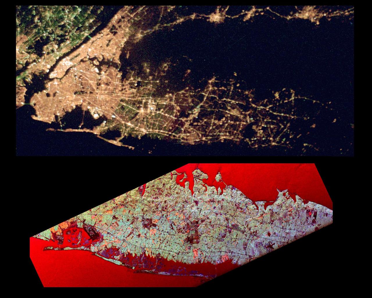
This pair of images of the Long Island, New York region is a comparison of an optical photograph (top) and a radar image (bottom), both taken in darkness in April 1994. The photograph at the top was taken by the Endeavour astronauts at about 3 a.m. Eastern time on April 20, 1994. The image at the bottom was acquired at about the same time four days earlier on April 16,1994 by the Spaceborne Imaging Radar-C/X-Band Synthetic Aperture Radar (SIR-C/X-SAR) system aboard the space shuttle Endeavour. Both images show an area approximately 100 kilometers by 40 kilometers (62 miles by 25 miles) that is centered at 40.7 degrees North latitude and 73.5 degrees West longitude. North is toward the upper right. The optical image is dominated by city lights, which are particularly bright in the densely developed urban areas of New York City located on the left half of the photo. The brightest white zones appear on the island of Manhattan in the left center, and Central Park can be seen as a darker area in the middle of Manhattan. To the northeast (right) of the city, suburban Long Island appears as a less densely illuminated area, with the brightest zones occurring along major transportation and development corridors. Since radar is an active sensing system that provides its own illumination, the radar image shows a great amount of surface detail, despite the night-time acquisition. The colors in the radar image were obtained using the following radar channels: red represents the L-band (horizontally transmitted and received); green represents the L-band (horizontally transmitted and vertically received); blue represents the C-band (horizontally transmitted and vertically received). In this image, the water surface - the Atlantic Ocean along the bottom edge and Long Island Sound shown at the top edge - appears red because small waves at the surface strongly reflect the horizontally transmitted and received L-band radar signal. Networks of highways and railroad lines are clearly visible in the radar image; many of them can also be seen as bright lines i the optical image. The runways of John F. Kennedy International Airport appear as a dark rectangle in Jamaica Bay on the left side of the image. Developed areas appear generally as bright green and orange, while agricultural, protected and undeveloped areas appear darker blue or purple. This contrast can be seen on the barrier islands along the south coast of Long Island, which are heavily developed in the Rockaway and Long Beach areas south and east of Jamaica Bay, but further to the east, the islands are protected and undeveloped. http://photojournal.jpl.nasa.gov/catalog/PIA01785
STS068-232-083 (30 September-11 October 1994) --- This is a view of Mount Pinatubo, Philippine Islands, orient with the coast to the top. View westward across central Luzon and Mount Pinatubo. Manilla Bay is in partial sunglint along the left edge of the frame. The extensive flows of volcanic ash (lahars) extending from the mountain are readily seen despite partial cloud cover. The ash is mobilized with every rain in this typhoon-ridden region, flowing down valleys, filling drainage channels, and covering fields and towns. The STS-68 crew obtained excellent photographs of the region, for comparison to the radar data also obtained on the mission. Photographs in sunglint have proven particularly helpful because they show the exact outlines of surface water, which provides a datum point for the radar returns.
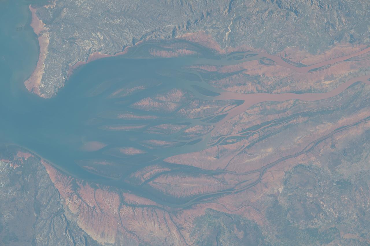
STS093-716-065 (23-27 July 1999) --- The STS-93 astronauts aboard the Space Shuttle Columbia took this picture of a sunrise on the Mozambique Channel along the coast of Madagascar. The nearest point of land is Cape Saint Andre, which forms the northwest corner of the island. Sunglint highlights the land-water boundary along a series of dynamic estuaries. The fifth inlet from the bottom just above the small lake is the Betsiboka Estuary. When the photo was taken, the shuttle was flying over a point located at 18.7 degrees south latitude and 36.1 degrees east longitude. Data back information on the 70mm film listed the time and date as 03:40:43 GMT, July 26, 1999 (orbit 48).
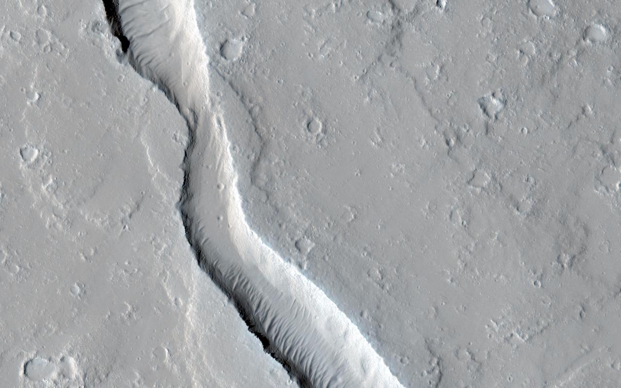
The gullies in this image are within the valley wall of an ancient channel-Nirgal Vallis-a testament to flowing water in Mars' ancient past. However, the formation of gullies are still the subject of much debate with respect to their formation: "wet" vs. "dry" or even "dry" with the aid of some lubricating fluid. Gullies most commonly form in the steep walls of simple craters. Gullies are common even in cold arctic deserts on Earth (e.g., the Haughton impact structure on Devon Island). This suggests that these provocative features can form on a mostly dry Mars that is only sporadically wet. Regardless, these features bear a remarkable resemblance to flowers, including the blossom, petals, stem, and roots. Can you see it too? http://photojournal.jpl.nasa.gov/catalog/PIA19294
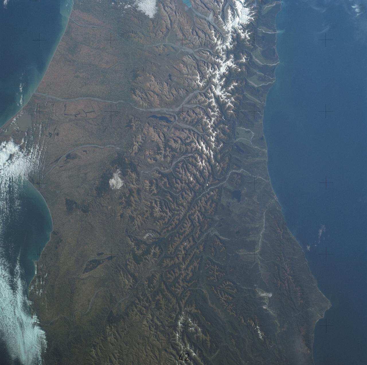
SL4-137-3700 (22 Dec. 1973) --- A near vertical view of a portion of South Island, New Zealand, as see from the Skylab space station in Earth orbit. This picture was taken by one of the Skylab 4 crew members with a handheld 70mm Hasselblad camera using a 100mm lens. The picture should be held with the largest body of water (Tasman Sea) on the left. Cape Foulwind is at the upper left. The City of Christchurch is under clouds at the center right margin. Note the movement of sediment by alongshore currents, especially on the east (right) side of the island. The Alpine Fault, which is part of the circum-Pacific volcanic-tectonic belt, is clearly visible on the left (west) side of the island. The fault line is marked by a scarp, which appears very distinct from orbital altitude. Differences in topography and vegetation on either side of the fault are also sharp. Streams change direction at the fault line, and the change in slope at the fault line is evident in the widening of stream channels. The left side of the fault has moved northeast (upward) relative to the right side; some stream offsets indicate the direction of relative movement, but others are controlled by local topography. The Alpine Fault, which also transects New Zealand's North Island, was photographed and described more than a dozen times by the Skylab 4 crewmen. The circum-Pacific volcanic-tectonic belt is a feature of the Earth's crust which is related to sea floor spreading and continental drift. Though the Alpine Fault is sharply delineated in this photograph, other major crustal features are subtle that their existence was unknown before their observation from orbit. The distance from top to bottom is about 290 kilometers (175 miles). Photo credit: NASA
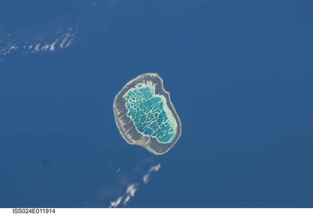
ISS024-E-011914 (13 Aug. 2010) --- Mataiva Atoll, Tuamotu Archipelago in the South Pacific Ocean is featured in this image photographed by an Expedition 24 crew member on the International Space Station. The Tuamotu Archipelago is part of French Polynesia, and forms the largest chain of atolls in the world. This photograph features Mataiva Atoll, the westernmost atoll of the Tuamotu chain. An atoll is a ring-shaped island that encloses a central lagoon. This distinctive morphology is usually associated with oceanic islands formed by volcanoes; coral reefs become established around the partially submerged volcanic cone. Over geologic time the central volcano becomes extinct, followed by erosion and subsidence beneath the sea surface, leaving the coral reefs as a ring around (or cap on) the submerged island remnant. Coral reefs exposed above the sea surface in turn experience erosion, sedimentation and soil formation, leading to the establishment of vegetation and complex ecosystems – including in many cases human habitation. Mataiva Atoll is notable in that its central lagoon includes a network of ridges (white, center) and small basins formed from eroded coral reefs. Mataiva means “nine eyes” in Tuamotuan, an allusion to nine narrow channels on the south-central portion of the island. The atoll is sparsely populated, with only a single village – Pahua – located on either side of the only pass providing constant connection between the shallow (light blue) water of the lagoon and the deeper (dark blue) adjacent Pacific Ocean. Much of the 10 kilometer-long atoll is covered with forest (greenish brown); vanilla and copra (dried coconut) are major exports from the atoll, but tourism is becoming a greater economic factor.

This is an image of Taal volcano, near Manila on the island of Luzon in the Philippines. The black area in the center is Taal Lake, which nearly fills the 30-kilometer-diameter (18-mile) caldera. The caldera rim consists of deeply eroded hills and cliffs. The large island in Taal Lake, which itself contains a crater lake, is known as Volcano Island. The bright yellow patch on the southwest side of the island marks the site of an explosion crater that formed during a deadly eruption of Taal in 1965. The image was acquired by the Spaceborne Imaging Radar-C/X-band Synthetic Aperture Radar (SIR-C/X-SAR) aboard the space shuttle Endeavour on its 78th orbit on October 5, 1994. The image shows an area approximately 56 kilometers by 112 kilometers (34 miles by 68 miles) that is centered at 14.0 degrees north latitude and 121.0 degrees east longitude. North is toward the upper right of the image. The colors in this image were obtained using the following radar channels: red represents the L-band (horizontally transmitted and received); green represents the L-band (horizontally transmitted and vertically received); blue represents the C-band (horizontally transmitted and vertically received). Since 1572, Taal has erupted at least 34 times. Since early 1991, the volcano has been restless, with swarms of earthquakes, new steaming areas, ground fracturing, and increases in water temperature of the lake. Volcanologists and other local authorities are carefully monitoring Taal to understand if the current activity may foretell an eruption. Taal is one of 15 "Decade Volcanoes" that have been identified by the volcanology community as presenting large potential hazards to population centers. The bright area in the upper right of the image is the densely populated city of Manila, only 50 kilometers (30 miles) north of the central crater. http://photojournal.jpl.nasa.gov/catalog/PIA01768
STS060-94-007 (3-11 Feb 1994) --- The Isle of Wight, over 380 square kilometers, is a diamond-shaped island located off the south coast of England. Separated from the mainland by The Solent, a narrow channel of water, the island is a popular resort area due to its scenery and mild climate. Sediment from English Lowland drainage systems, most notably the River Test, is visible entering The Solent and spilling into the English Channel. At the tip of the linear, northwestward inlet is the mouth of the Test and the city of Southampton, discernible as a small patch of lighter gray. Further east is a series of protected bays which are, from west to east: Portsmouth Harbour, Langstone Harbour, and Chichester Harbour. The city of Portsmouth is the location of Great Britain's chief naval station and arsenal. Portsmouth houses numerous ships of past and present glory. Two of the most notable vessels in Portsmouth are the 104-gun Victory, and the remains of the Mary Rose. The renowned HMS Victory, still carried on active duty rolls of the Royal Navy, and the acting Post Ship of the Royal Navy Base Commander, was built in 1765. The HMS Victory was severely damaged and dismasted in battle. A careful inspection of the original film will show the 175-foot long HMS Victory in this frame. According to NASA geologists it is extremely unusual for Portsmouth to be this cloud-free. It has been a site of some interest for many Space Shuttle missions during the past 10 years.