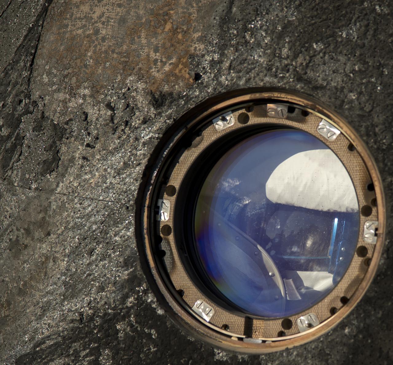
A closely cropped image of the Soyuz capsule shows the charring that took place during reentry of the Soyuz TMA-03M capsule after it landed with Expedition 31 Commander Oleg Kononenko of Russia and Flight Engineers Don Pettit of NASA and Andre Kuipers of the European Space Agency in a remote area near the town of Zhezkazgan, Kazakhstan, on Sunday, July 1, 2012. Pettit, Kononenko and Kuipers returned from more than six months onboard the International Space Station where they served as members of the Expedition 30 and 31 crews. Photo Credit: (NASA/Bill Ingalls)
The Multi-angle Imaging SpectroRadiometer (MISR) instrument on NASA's Terra satellite took this image of the Woolsey Fire in southern California on Nov. 11, 2018. The Woolsey Fire had charred more than 90,000 acres as of Nov. 12, 2018, and was 20-percent contained at that time. https://photojournal.jpl.nasa.gov/catalog/PIA22818

S67-49447 (9 Nov. 1967) --- Close-up view of the charred heat shield of the Apollo Spacecraft 017 Command Module aboard the USS Bennington. The damage was caused by the extreme heat of reentry. The carrier Bennington was the prime recovery ship for the Apollo 4 (Spacecraft 017/Saturn 501) unmanned, Earth-orbital space mission. Splashdown occurred at 3:37 p.m. (EST), Nov. 9, 1967, 934 nautical miles northwest of Honolulu, Hawaii.
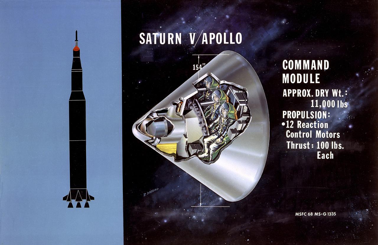
This is a cutaway illustration of the Saturn V command module (CM) configuration. The CM was crammed with some of the most complex equipment ever sent into space at the time. The three astronaut couches were surrounded by instrument panels, navigation gear, radios, life-support systems, and small engines to keep it stable during reentry. The entire cone, 11 feet long and 13 feet in diameter, was protected by a charring heat shield. The 6.5 ton CM was all that was finally left of the 3,000-ton Saturn V vehicle that lifted off on the journey to the Moon.
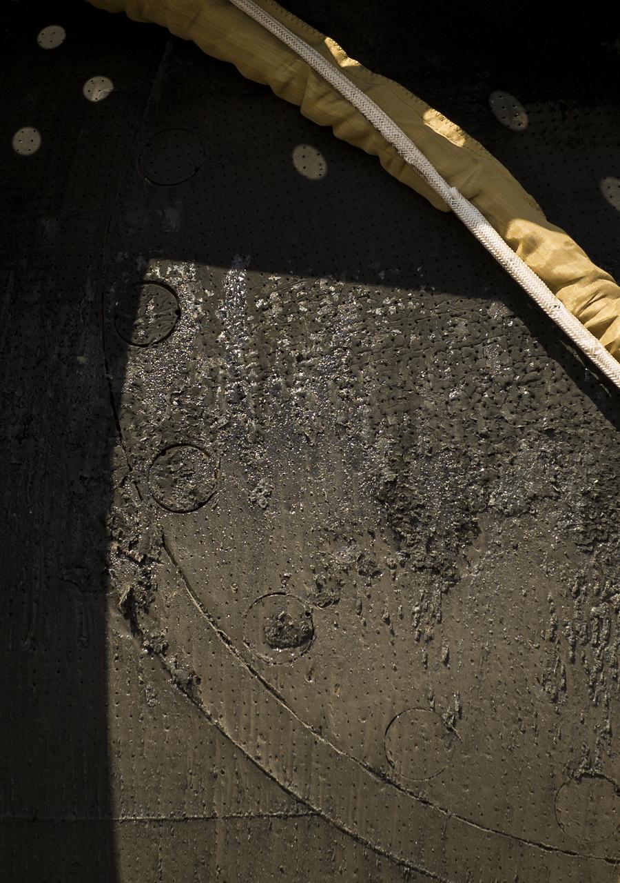
A window of the charred Soyuz MS-07 spacecraft is seen shortly after Expedition 55 crew members Anton Shkaplerov of Roscosmos, Scott Tingle of NASA, and Norishige Kanai of the Japan Aerospace Exploration Agency (JAXA) landed in the capsule near the town of Zhezkazgan, Kazakhstan on Sunday, June 3, 2018. Shkaplerov, Tingle, and Kanai are returning after 168 days in space where they served as members of the Expedition 54 and 55 crews onboard the International Space Station. Photo Credit: (NASA/Bill Ingalls)

S67-49423 (9 Nov. 1967) --- The Apollo Spacecraft 017 Command Module, with flotation collar still attached, is hoisted aboard the USS Bennington, prime recovery ship for the Apollo 4 (Spacecraft 017/Saturn 501) unmanned, Earth-orbital space mission. The Command Module splashed down at 3:37 p.m. (EST), Nov. 9, 1967, 934 nautical miles northwest of Honolulu, Hawaii, in the mid-Pacific Ocean. Note charred heat shield caused by extreme heat of reentry.

A test block of Avcoat undergoes heat pulse testing inside an arc jet test chamber at NASA’s Ames Research Center in California. The test article, configured with both permeable (upper) and non-permeable (lower) Avcoat sections for comparison, helped to confirm understanding of the root cause of the loss of charred Avcoat material that engineers saw on the Orion spacecraft after the Artemis I test flight beyond the Moon.
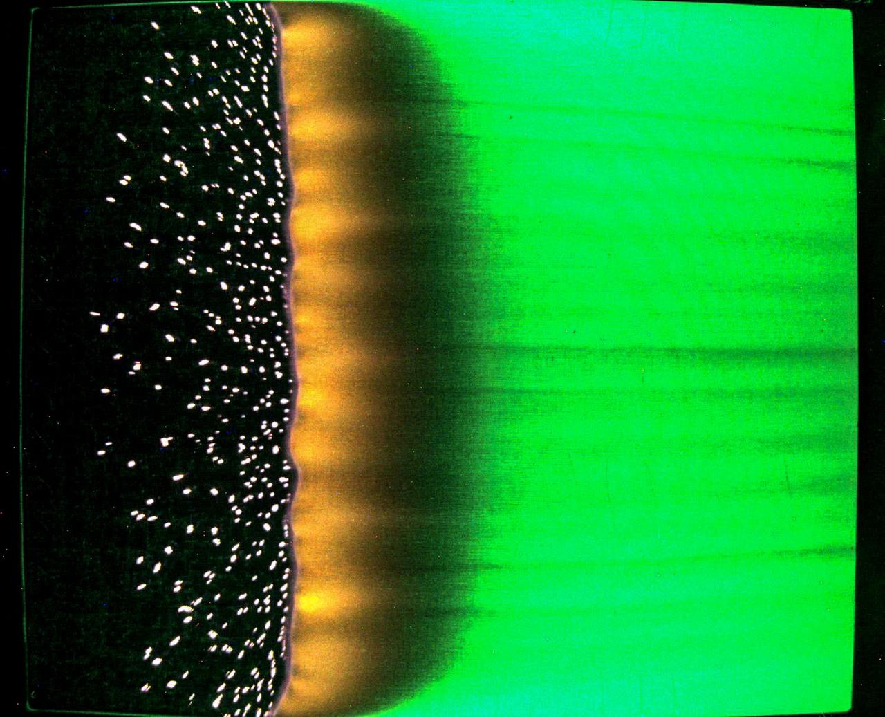
jsc2023e046375 (7/25/2023) --- A sample of fabric burns inside Spacecraft Fire Experiment-IV (Saffire-IV). The sample is a composite fabric made of cotton and fiberglass and is 40 cm wide. The image appears green because green LED lights are used to illuminate the sample during a burn. The flame appears orange in this image and the black region to the right of the flame is the cotton in the sample beginning to heat and char. The bright specks to the left of the flame are smoldering cotton that remains on the fiberglass substrate after the flame passes. In Saffire-VI, this fabric is burned at higher oxygen concentrations. Researchers aim to study realistic flame spread to aid the development of fire safety equipment and strategies for future spacecraft.
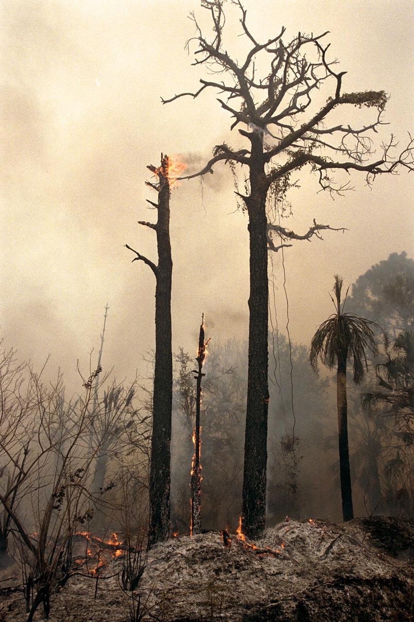
KENNEDY SPACE CENTER, FLA. -- Charred trees and brush in a wooded section of Kennedy Space Center still burn Monday, June 22, after lightning touched off three different fires Sunday evening in and around Kennedy Space Center at Tel IV, Ransom Road and Pine Island Road. This area is part of the Merritt Island National Wildlife Refuge operated by the U.S. Fish and Wildlife Service. The fires were a short distance from operational facilities at the space center and forced the closing of Florida State Route 3. The fires are being contained by firefighters from Kennedy Space Center and the U.S. Fish and Wildlife Service
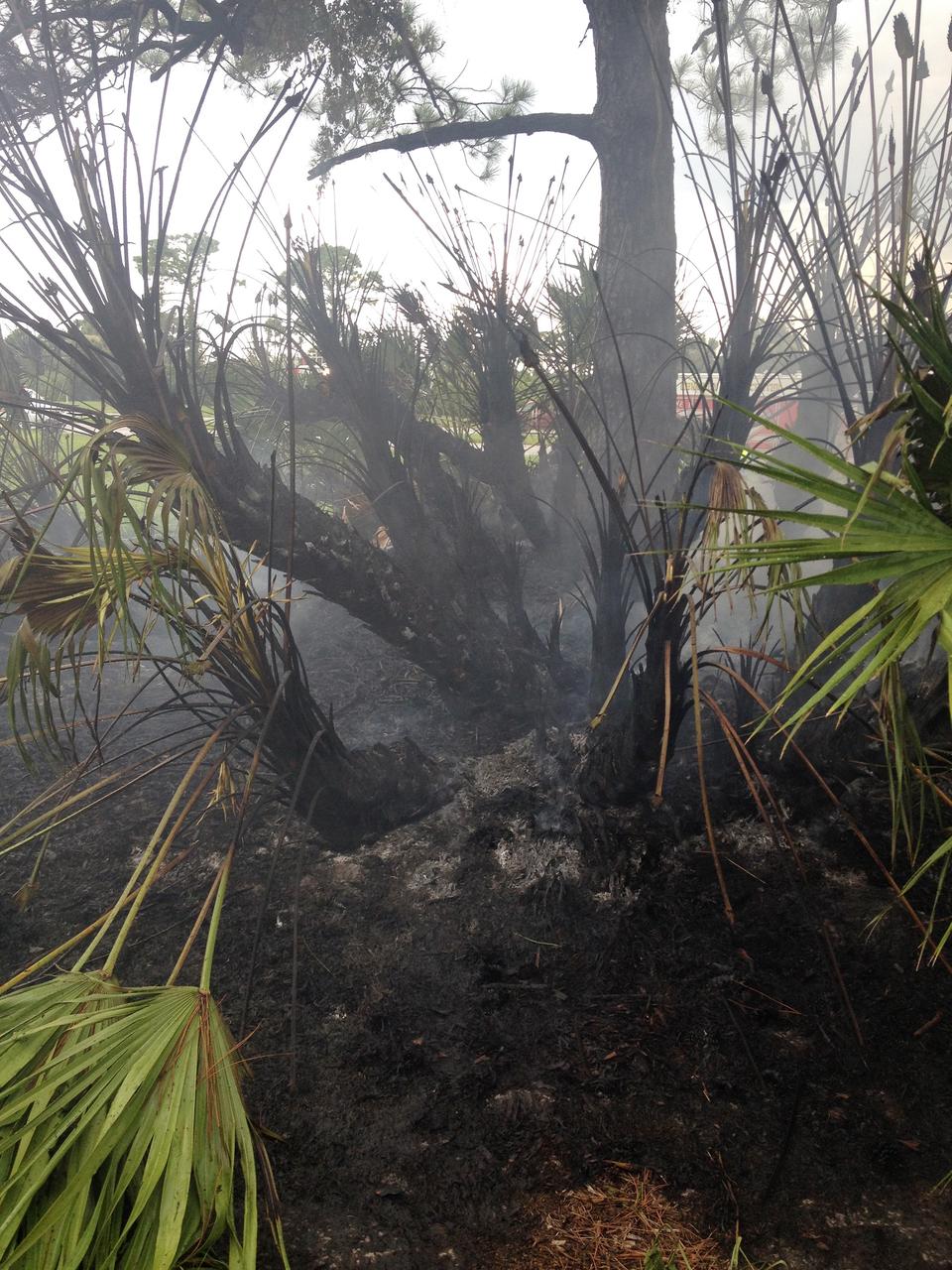
CAPE CANAVERAL, Fla. – A charred palmetto palm remains after a brush fire is extinguished near Headquarters Building in the Industrial Area of NASA’s Kennedy Space Center in Florida. The fire was ignited by a lightning strike. The space center is nestled on the Merritt Island National Wildlife Refuge, which is managed by the U.S. Fish and Wildlife Service. Chenega Security & Support Solutions is responsible for Kennedy's Fire Rescue Department. For information on the refuge, visit http://www.fws.gov/merrittisland/Index.html. For more on Kennedy Space Center, visit http://www.nasa.gov/kennedy. Photo credit: NASA/Ben Smegelsky
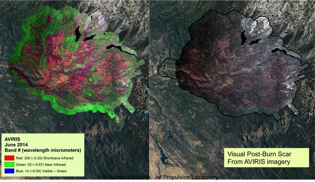
At left, a NASA AVIRIS map shows the spectral signature of the 2013 Rim fire in and near Yosemite National Park, California, the third largest in the state's history, burning more than 250,000 acres. Almost two years later, forest restoration efforts are still ongoing. Charred wood has a strong signal in the wavelengths shown here in red, so areas that are predominantly red in the image were heavily burned. The wavelengths of green, visible light (the color of vegetation) appear on this map as blue. There are no solid blue patches on the map because no large areas of green, living foliage survived the fire. Purple, a mixture of red and blue, indicates an area where charred wood and living plants are mingled. This image provides far more information about the state of the post-fire vegetation than the view on the right, which is what an observer flying overhead would see. AVIRIS is a unique NASA science instrument that measures the complete solar reflected portion of the electromagnetic spectrum with unmatched spectral range, calibration accuracy and signal-to-noise ratio. AVIRIS spectra are measured from 370 to 2,500 nanometers at 9.8-nanometer intervals. Images are acquired with 20-, 6- or 4-meter (66-, 20, or 13-feet) spatial resolution with a 34 degree swath. Up to 100 million spectra are measured in image format on each flight. The spectral image measurements are provided in orthorectified (geometrically corrected) format for direct use by scientists. http://photojournal.jpl.nasa.gov/catalog/PIA19361
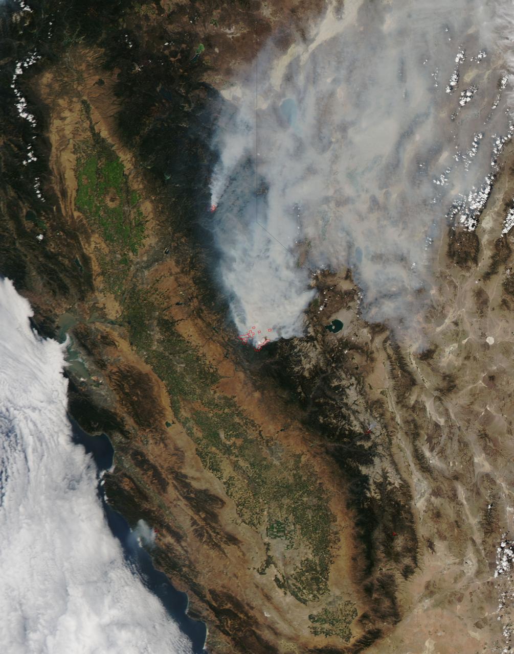
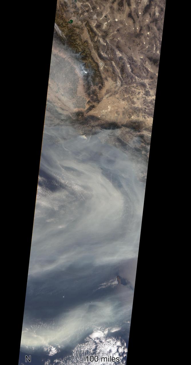
On August 23, 2013, the Moderate Resolution Imaging Spectroradiometer (MODIS) on NASA’s Aqua satellite acquired this image of the drought-fueled Rim fire burning in central California, near Yosemite National Park. Red outlines indicate hot spots where MODIS detected unusually warm surface temperatures associated with fires. Winds blew a thick smoke plume toward the northeast. A smaller fire—American fire—burned to the north. The lower image is a photograph that shows the fire burning at night on August 21. Started on August 17, 2013, the fast-moving fire had already charred more than 100,000 acres (40,000 hectares) by August 23, despite the efforts of more than 2,000 firefighters. Hundreds of people were forced to evacuate their homes, and roads in the area were closed. As of August 23, no structures had been reported destroyed, but the fire threatened the towns of Groveland and Pine Mountain Lake. By late August, wildfires had burned 3.4 million acres in the United States, making 2013 somewhat less active than other recent years. Over the last decade, fires charred 5.7 million acres on average by August 22, according to statistics published the National Interagency Fire Center. NASA image by Jeff Schmaltz, LANCE/EOSDIS Rapid Response. Caption by Adam Voiland. Instrument: Aqua - MODIS Credit: <b><a href="http://www.earthobservatory.nasa.gov/" rel="nofollow"> NASA Earth Observatory</a></b> <b><a href="http://www.nasa.gov/audience/formedia/features/MP_Photo_Guidelines.html" rel="nofollow">NASA image use policy.</a></b> <b><a href="http://www.nasa.gov/centers/goddard/home/index.html" rel="nofollow">NASA Goddard Space Flight Center</a></b> enables NASA’s mission through four scientific endeavors: Earth Science, Heliophysics, Solar System Exploration, and Astrophysics. Goddard plays a leading role in NASA’s accomplishments by contributing compelling scientific knowledge to advance the Agency’s mission. <b>Follow us on <a href="http://twitter.com/NASA_GoddardPix" rel="nofollow">Twitter</a></b> <b>Like us on <a href="http://www.facebook.com/pages/Greenbelt-MD/NASA-Goddard/395013845897?ref=tsd" rel="nofollow">Facebook</a></b> <b>Find us on <a href="http://instagram.com/nasagoddard?vm=grid" rel="nofollow">Instagram</a></b>
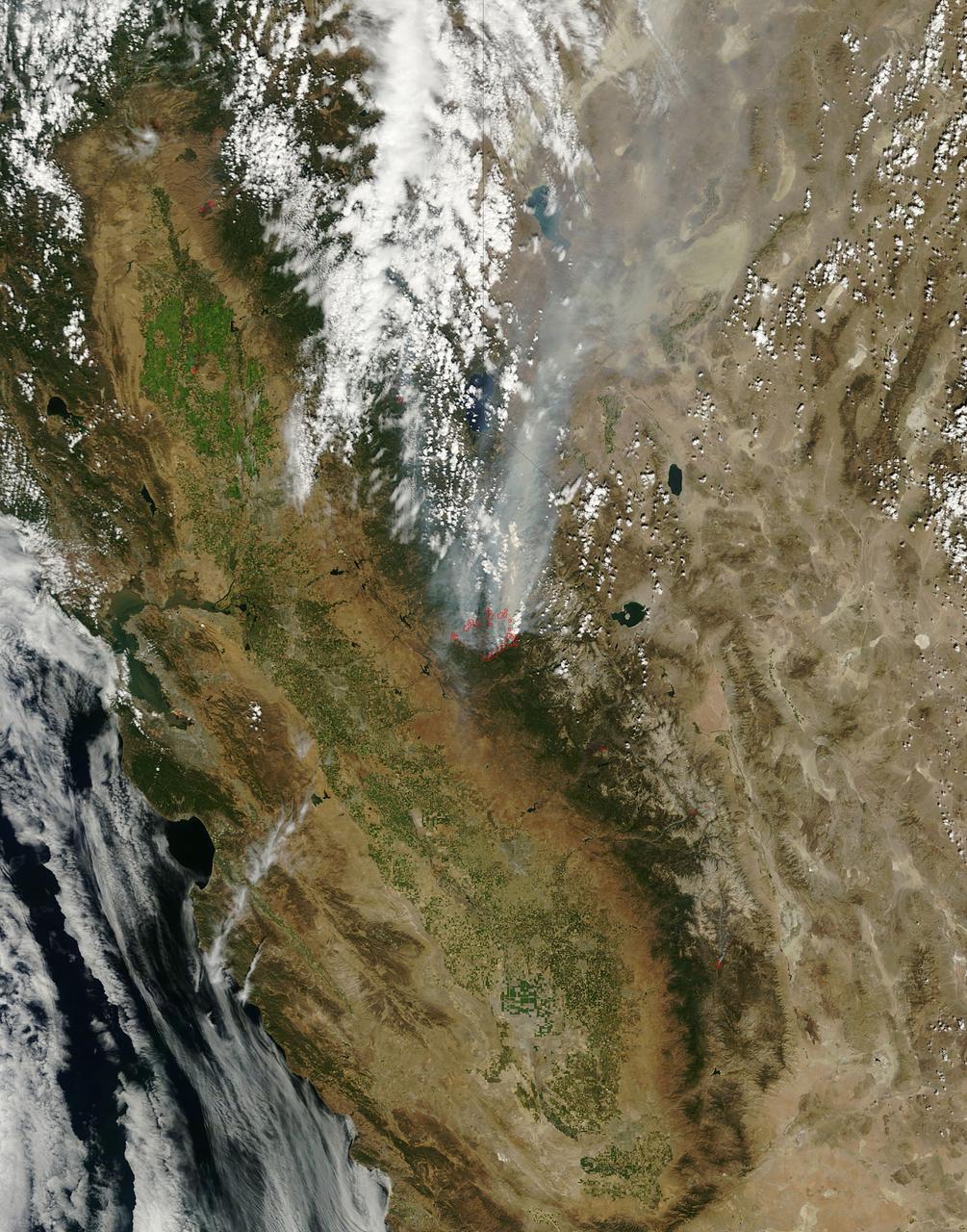
On August 25, 2013, the Moderate Resolution Imaging Spectroradiometer (MODIS) on NASA’s Terra satellite acquired this image of the drought-fueled Rim fire burning in central California, near Yosemite National Park. Red outlines indicate hot spots where MODIS detected unusually warm surface temperatures associated with fires. Winds blew a thick smoke plume toward the northeast. A smaller fire—American fire—burned to the north. Started on August 17, 2013, the fast-moving fire had already charred more than 100,000 acres (40,000 hectares) by August 23, despite the efforts of more than 2,000 firefighters. Hundreds of people were forced to evacuate their homes, and roads in the area were closed. As of August 23, no structures had been reported destroyed, but the fire threatened the towns of Groveland and Pine Mountain Lake. By late August, wildfires had burned 3.4 million acres in the United States, making 2013 somewhat less active than other recent years. Over the last decade, fires charred 5.7 million acres on average by August 22, according to statistics published the National Interagency Fire Center. NASA image by Jeff Schmaltz, LANCE/EOSDIS Rapid Response. Caption by Adam Voiland. Instrument: Terra - MODIS Credit: <b><a href="http://www.earthobservatory.nasa.gov/" rel="nofollow"> NASA Earth Observatory</a></b> <b><a href="http://www.nasa.gov/audience/formedia/features/MP_Photo_Guidelines.html" rel="nofollow">NASA image use policy.</a></b> <b><a href="http://www.nasa.gov/centers/goddard/home/index.html" rel="nofollow">NASA Goddard Space Flight Center</a></b> enables NASA’s mission through four scientific endeavors: Earth Science, Heliophysics, Solar System Exploration, and Astrophysics. Goddard plays a leading role in NASA’s accomplishments by contributing compelling scientific knowledge to advance the Agency’s mission. <b>Follow us on <a href="http://twitter.com/NASA_GoddardPix" rel="nofollow">Twitter</a></b> <b>Like us on <a href="http://www.facebook.com/pages/Greenbelt-MD/NASA-Goddard/395013845897?ref=tsd" rel="nofollow">Facebook</a></b> <b>Find us on <a href="http://instagram.com/nasagoddard?vm=grid" rel="nofollow">Instagram</a></b>
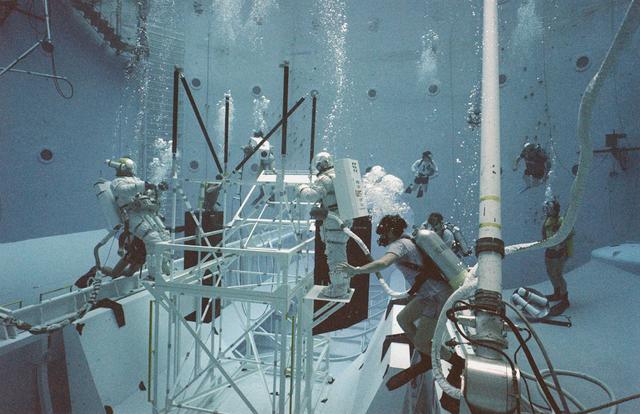
One of the main components of the Hubble Space Telescope (HST) is the Solar Array Drive Electronics (SADE) system. This system interfaces with the Support System Module (SSM) for exchange of operational commands and telemetry data. SADE operates and controls the Solar Array Drive Mechanisms (SADM) for the orientation of the Solar Array Drive (SAD). It also monitors the position of the arrays and the temperature of the SADM. During the first HST servicing mission, the astronauts replaced the SADE component because of some malfunctions. This turned out to be a very challenging extravehicular activity (EVA). Two transistors and two diodes had been thermally stressed with the conformal coating discolored and charred. Soldered cornections became molten and reflowed between the two diodes. The failed transistors gave no indication of defective construction. All repairs were made and the HST was redeposited into orbit. Prior to undertaking this challenging mission, the orbiter's crew trained at Marshall Space Flight Center's (MSFC) Neutral Buoyancy Simulator (NBS) to prepare themselves for working in a low gravity environment. They also practiced replacing HST parts and exercised maneuverability and equipment handling. Pictured are crew members practicing on a space platform.
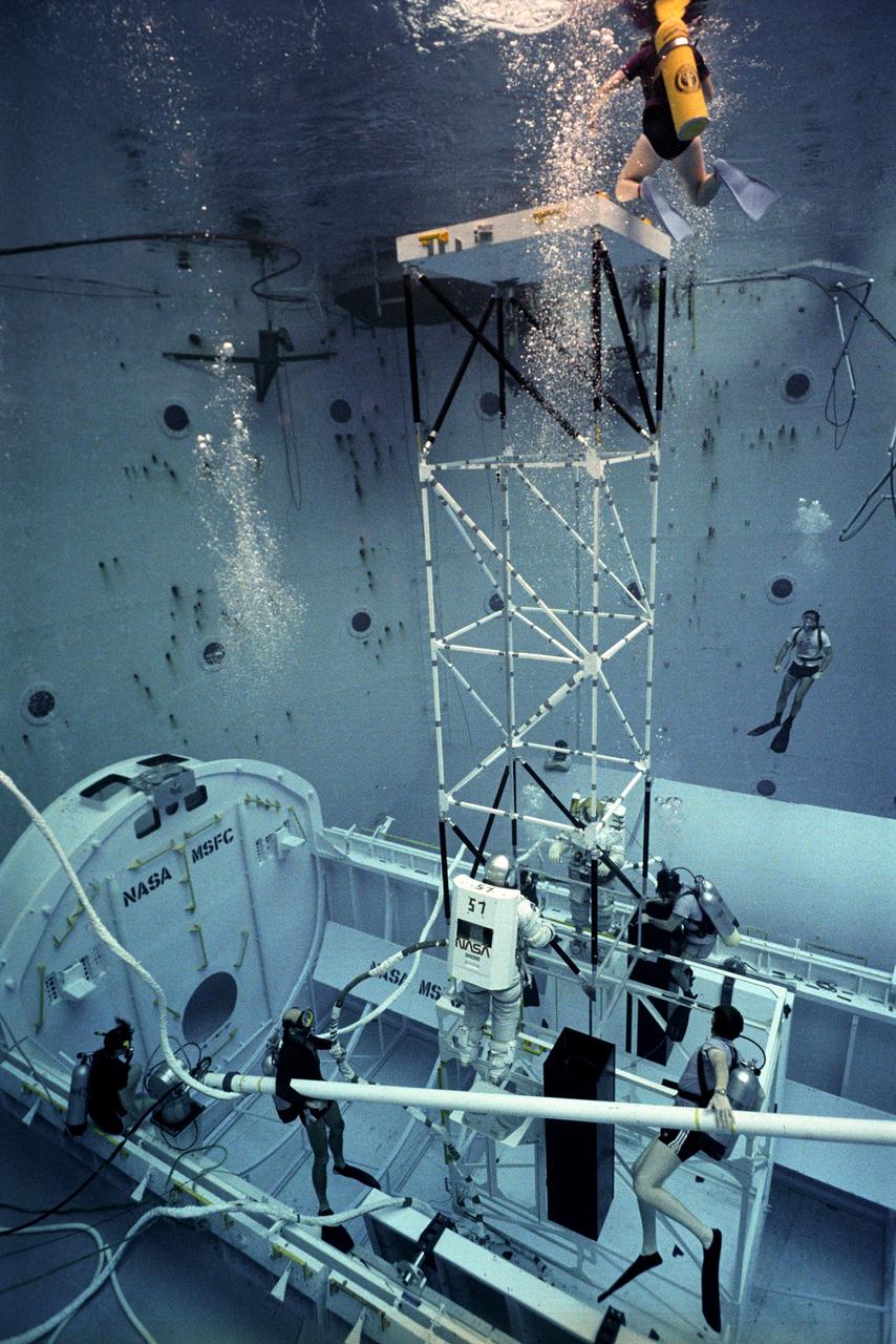
One of the main components of the Hubble Space Telescope (HST) is the Solar Array Drive Electronics (SADE) system. This system interfaces with the Support System Module (SSM) for exchange of operational commands and telemetry data. SADE operates and controls the Solar Array Drive Mechanisms (SADM) for the orientation of the Solar Array Drive (SAD). It also monitors the position of the arrays and the temperature of the SADM. During the first HST servicing mission, the astronauts replaced the SADE component because of some malfunctions. This turned out to be a very challenging extravehicular activity (EVA). Two transistors and two diodes had been thermally stressed with the conformal coating discolored and charred. Soldered cornections became molten and reflowed between the two diodes. The failed transistors gave no indication of defective construction. All repairs were made and the HST was redeposited into orbit. Prior to undertaking this challenging mission, the orbiter's crew trained at Marshall Space Flight Center's (MSFC) Neutral Buoyancy Simulator (NBS) to prepare themselves for working in a low gravity environment. They also practiced replacing HST parts and exercised maneuverability and equipment handling. Pictured is an astronaut practicing climbing a space platform that was necessary in making repairs on the HST.
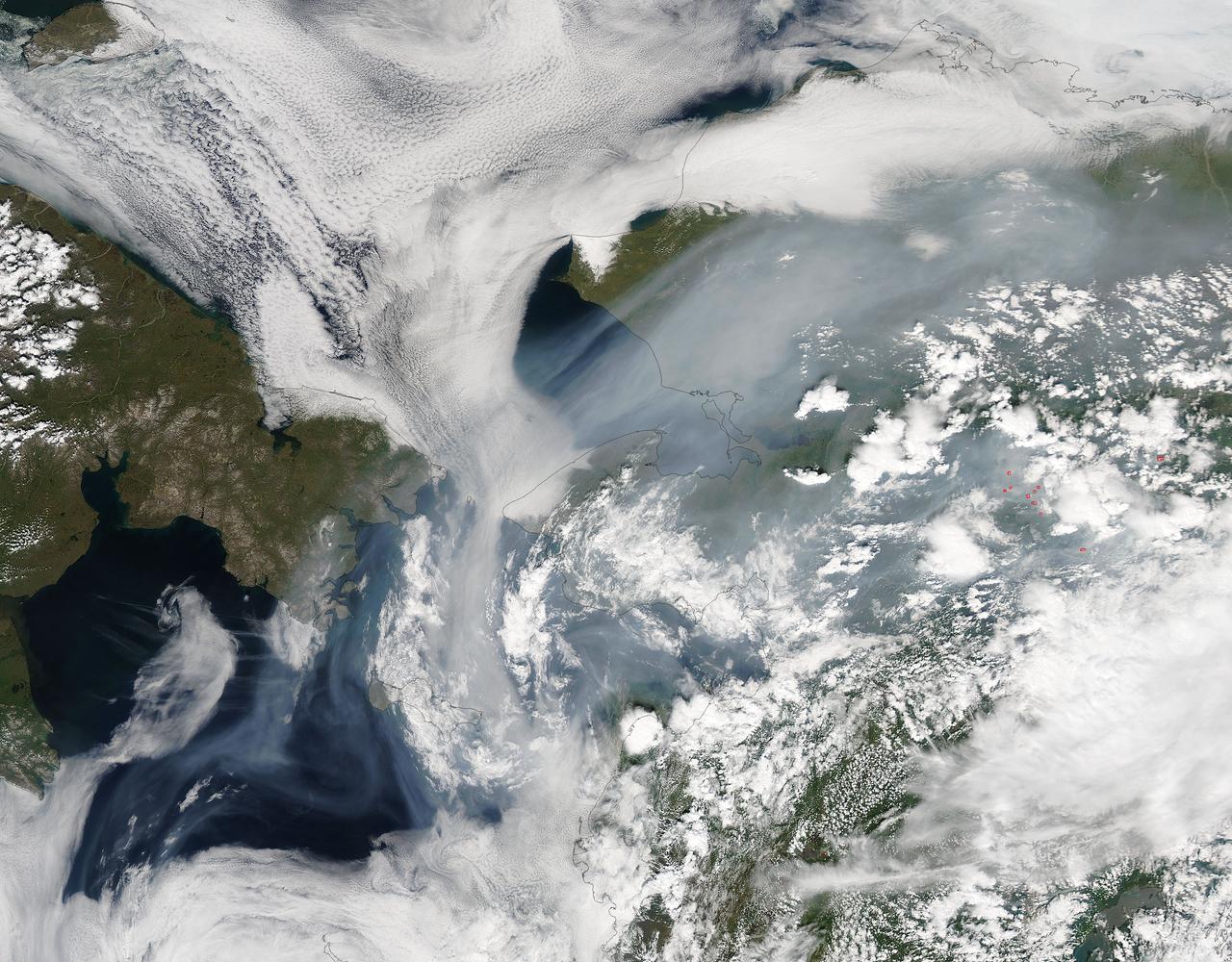
Fires have raged throughout Alaska in 2015. The Moderate Resolution Imaging Spectroradiometer (MODIS) on NASA’s Aqua satellite acquired this image on July 14, 2015. Actively burning areas, detected by the thermal bands on MODIS, are outlined in red. According to the most recent update (July 16, 2015) from the Alaska Interagency Coordination Center, about 304 fires were actively burning when MODIS imaged the area. To date, fires have charred a total of 4,854,924 acres in Alaska. The worst fire season in Alaska's history was in 2004. At this point in time, 2015 is a month ahead of the totals in 2004 putting it on track surpass the fire totals in 2004. The amount of acreage burned in Alaska during June 2015 shattered the previous acreage record set in June 2004 by more than 700,000 acres delivering a sobering piece of news for Alaskan residents. Credit: NASA/GSFC/Jeff Schmaltz/MODIS Land Rapid Response Team <b><a href="http://www.nasa.gov/audience/formedia/features/MP_Photo_Guidelines.html" rel="nofollow">NASA image use policy.</a></b> <b><a href="http://www.nasa.gov/centers/goddard/home/index.html" rel="nofollow">NASA Goddard Space Flight Center</a></b> enables NASA’s mission through four scientific endeavors: Earth Science, Heliophysics, Solar System Exploration, and Astrophysics. Goddard plays a leading role in NASA’s accomplishments by contributing compelling scientific knowledge to advance the Agency’s mission. <b>Follow us on <a href="http://twitter.com/NASAGoddardPix" rel="nofollow">Twitter</a></b> <b>Like us on <a href="http://www.facebook.com/pages/Greenbelt-MD/NASA-Goddard/395013845897?ref=tsd" rel="nofollow">Facebook</a></b> <b>Find us on <a href="http://instagrid.me/nasagoddard/?vm=grid" rel="nofollow">Instagram</a></b>
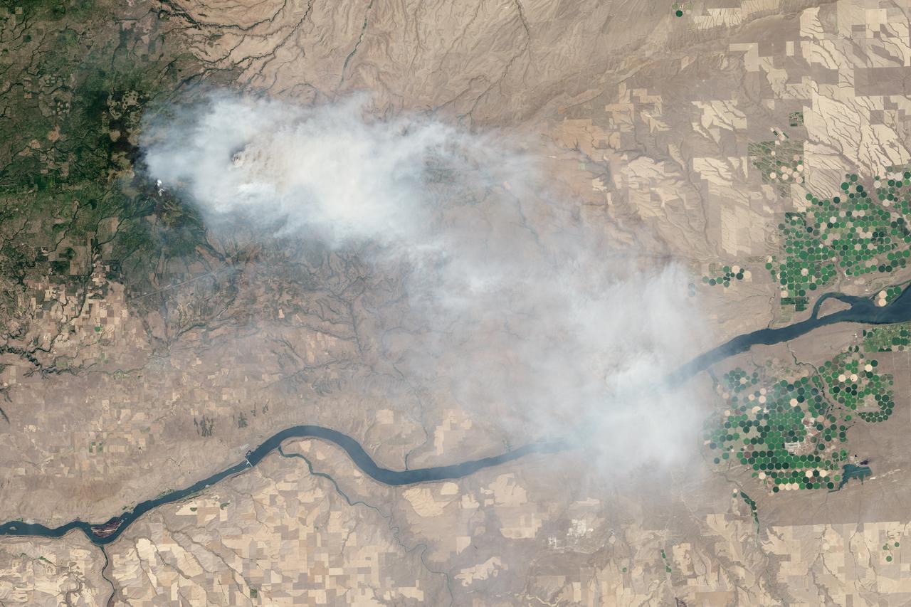
Eight major wildfires burned through forests and grasslands in the Pacific Northwest in late-July 2013, threatening homes and forcing road closings and evacuations. Many parts of Washington and Oregon faced extreme fire threats, as strong thunderstorms lined up to hit parched forests and grasslands with lightning. On July 28, 2013, the Operational Land Imager (OLI) on Landsat 8 captured these images of the Mile Marker 28 fire in the Simcoe Mountains northeast of Goldendale, Washington. Smoke blew east toward Kennewick, Pasco, and Richland. The lower image shows a closer view of smoke billowing up from the most active part of the fire. Ignited on July 24, 2013, the fire charred more than 22,000 acres (8,900 hectares) by July 30, when more than 1,000 firefighters achieved 40 percent containment. The blaze forced the evacuation of dozens of homes and the closure of US Highway 97. Through July 25, 450 wildfires had burned 10,220 acres (4,136 hectares) in Washington, while Oregon saw 603 fires that burned 63,135 acres (25,549 hectares). In all, 2.3 million acres burned across the United States by late-July, below the national average. Over the past ten years, an average of 4.2 million acres had burned in the United States by the end of each July. While coastal and western Washington receive heavy rain throughout the year, the rain shadow caused by the Cascades leaves central Washington quite dry. The mountains force moist air from the Pacific to rise, causing it to cool and condense into rain or snow on the windward side of the Cascades. So little moisture is left by the time air passes over the Cascades, that the area around Mile Marker 28 typically receives just 8 inches (20 centimeters) of precipitation per year. NASA Earth Observatory image by Jesse Allen and Robert Simmon, using Landsat data from the U.S. Geological Survey. Caption by Adam Voiland Instrument: Landsat 8 - OLI More info: <a href="http://earthobservatory.nasa.gov/IOTD/view.php?id=81738" rel="nofollow">earthobservatory.nasa.gov/IOTD/view.php?id=81738</a> Credit: <b><a href="http://www.earthobservatory.nasa.gov/" rel="nofollow"> NASA Earth Observatory</a></b> <b><a href="http://www.nasa.gov/audience/formedia/features/MP_Photo_Guidelines.html" rel="nofollow">NASA image use policy.</a></b> <b><a href="http://www.nasa.gov/centers/goddard/home/index.html" rel="nofollow">NASA Goddard Space Flight Center</a></b> enables NASA’s mission through four scientific endeavors: Earth Science, Heliophysics, Solar System Exploration, and Astrophysics. Goddard plays a leading role in NASA’s accomplishments by contributing compelling scientific knowledge to advance the Agency’s mission. <b>Follow us on <a href="http://twitter.com/NASA_GoddardPix" rel="nofollow">Twitter</a></b> <b>Like us on <a href="http://www.facebook.com/pages/Greenbelt-MD/NASA-Goddard/395013845897?ref=tsd" rel="nofollow">Facebook</a></b> <b>Find us on <a href="http://instagram.com/nasagoddard?vm=grid" rel="nofollow">Instagram</a></b>