
This charged couple device CCD is part of the CheMin instrument on NASA Curiosity rover. When CheMin directs X-rays at a sample of soil, this imager, which is the size of a postage stamp, detects both the position and energy of each X-ray photon.
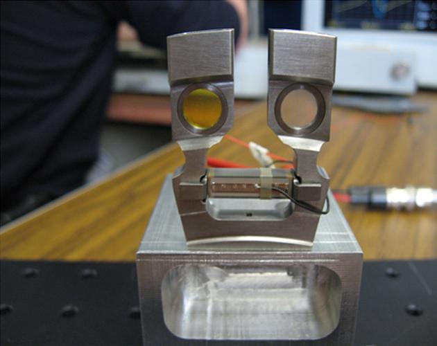
This image shows the cells that hold the soil samples that are vibrated by the Chemistry and Mineralogy CheMin instrument on NASA Curiosity rover.
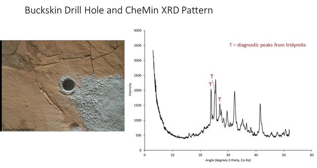
The graph at right presents information from the NASA Curiosity Mars rover's onboard analysis of rock powder drilled from the "Buckskin" target location, shown at left. X-ray diffraction analysis of the Buckskin sample inside the rover's Chemistry and Mineralogy (CheMin) instrument revealed the presence of a silica-containing mineral named tridymite. This is the first detection of tridymite on Mars. Peaks in the X-ray diffraction pattern are from minerals in the sample, and every mineral has a diagnostic set of peaks that allows identification. The image of Buckskin at left was taken by the rover's Mars Hand Lens Imager (MAHLI) camera on July 30, 2015, and is also available at PIA19804. http://photojournal.jpl.nasa.gov/catalog/PIA20271
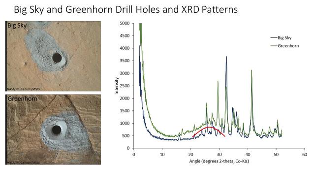
The graph at right presents information from the NASA Curiosity Mars rover's onboard analysis of rock powder drilled from the "Big Sky" and "Greenhorn" target locations, shown at left. X-ray diffraction analysis of the Greenhorn sample inside the rover's Chemistry and Mineralogy (CheMin) instrument revealed an abundance of silica in the form of noncrystalline opal. The broad hump in the background of the X-ray diffraction pattern for Greenhorn, compared to Big Sky, is diagnostic of opal. The image of Big Sky at upper left was taken by the rover's Mars Hand Lens Imager (MAHLI) camera the day the hole was drilled, Sept. 29, 2015, during the mission's 1,119th Martian day, or sol. The Greenhorn hole was drilled, and the MAHLI image at lower left was taken, on Oct. 18, 2015 (Sol 1137). http://photojournal.jpl.nasa.gov/catalog/PIA20272
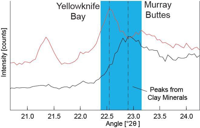
Data graphed here from the Chemistry and Camera (CheMin) instrument on NASA's Mars Curiosity rover show a difference between clay minerals in powder drilled from mudstone outcrops at two locations in Mars' Gale Crater: "Yellowknife Bay" and "Murray Buttes." CheMin's X-ray diffraction analysis reveals information about the crystalline structure of minerals in the rock. The intensity peaks marked with dotted vertical lines in this chart indicate that the crystalline structure of the two sites' clay minerals differs. The difference can be tied to a compositional difference in the clay minerals, as depicted in a diagram at PIA21148. The Yellowknife Bay site is on the floor of Gale Crater. The Murray Buttes site is on lower Mount Sharp, the layered mound in the center of the crater. http://photojournal.jpl.nasa.gov/catalog/PIA21147
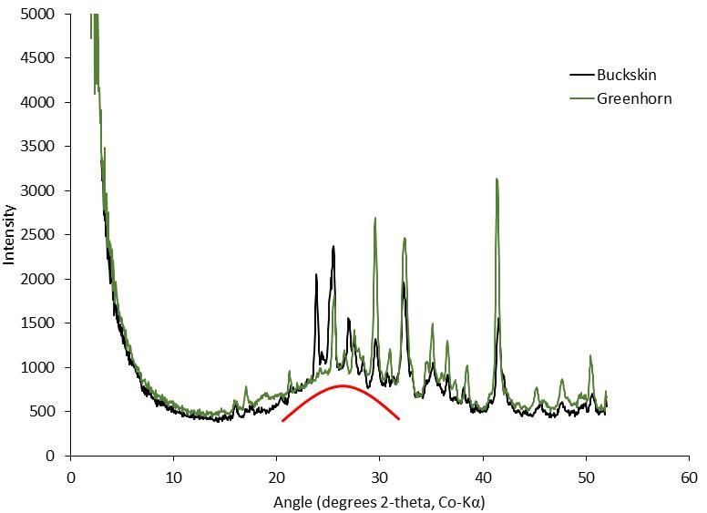
This graph presents information from the NASA Curiosity Mars rover's onboard analysis of rock powder drilled from the "Buckskin" and "Greenhorn" target locations on lower Mount Sharp. Buckskin, in the "Marias Pass" area, and Greenhorn, in the "Bridger Basin" area, both contain high concentrations of silica. X-ray diffraction analysis of powered samples inside Curiosity's Chemistry and Mineralogy (CheMin) instrument revealed that each of them contains silica in the form of noncrystalline opal. The broad hump in the two X-ray diffraction patterns is diagnostic of opaline silica. Some of the silica in Buckskin is in the form of tridymite. http://photojournal.jpl.nasa.gov/catalog/PIA20273
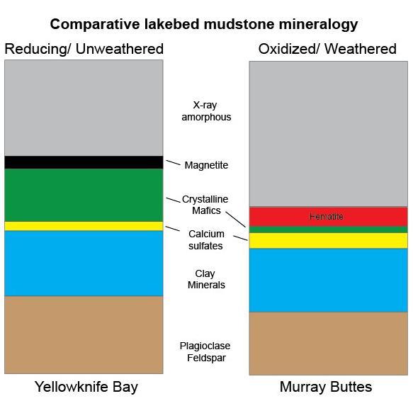
This graphic shows proportions of minerals identified in mudstone exposures at the "Yellowknife Bay" location where NASA's Curiosity Mars rover first analyzed bedrock, in 2013, and at the "Murray Buttes" area investigated in 2016. Minerals were identified by X-ray diffraction analysis of sample powder from the rocks. The samples were acquired by drilling and delivered to the Chemistry and Mineralogy (CheMin) instrument inside the rover. Two key differences in the Murray Buttes mudstone include hematite rather than magnetite, and far less abundance of crystalline mafic minerals, compared to the Yellowknife Bay mudstone composition. Hematite and magnetite are both iron oxide minerals, with hematite as a more oxidized one. That difference could result from the Murray Buttes mudstone layer experiencing more weathering than the Yellowknife Bay mudstone. More weathering could also account for the lower abundance of crystalline mafics, which are volcanic-origin minerals such as pyroxene and olivine. The Yellowknife Bay site is on the floor of Gale Crater. The Murray Buttes site is on lower Mount Sharp, the layered mound in the center of the crater. http://photojournal.jpl.nasa.gov/catalog/PIA21149
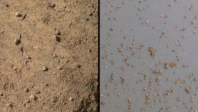
NASA Mars rover Curiosity acquired close-up views of sands in the Rocknest wind drift to document the nature of the material that the rover scooped, sieved and delivered to the CheMin and SAM instruments in October and November 2012.
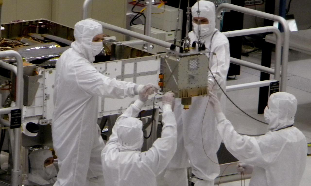
Members of NASA Mars Science Laboratory team carefully steer the hoisted Chemistry and Mineralogy CheMin instrument during its June 15, 2010, installation into the mission Mars rover, Curiosity.
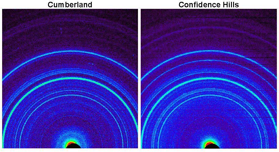
This side-by-side comparison shows the X-ray diffraction patterns of two different samples collected from rocks on Mars by NASA Curiosity rover. The images present data obtained by Curiosity Chemistry and Mineralogy instrument CheMin.
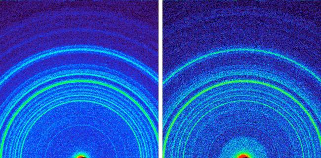
These images, made from data obtained by Curiosity CheMin, show the patterns obtained from a drift of windblown dust and sand called Rocknest and from a powdered rock sample drilled from the John Klein bedrock.
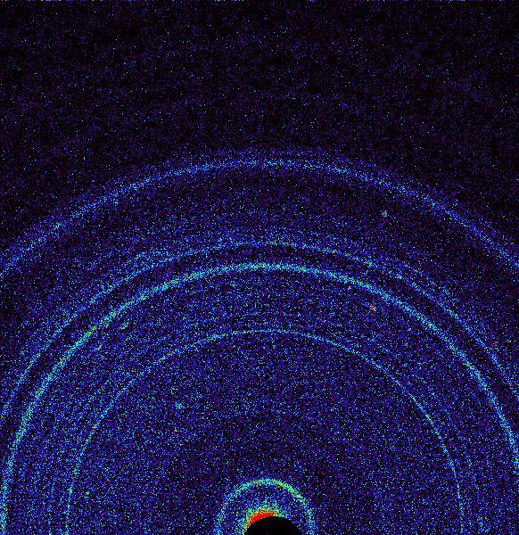
This graphic shows results of the first analysis of Martian soil by the CheMin experiment on NASA Curiosity rover. The image reveals the presence of crystalline feldspar, pyroxenes and olivine mixed with some amorphous non-crystalline material.
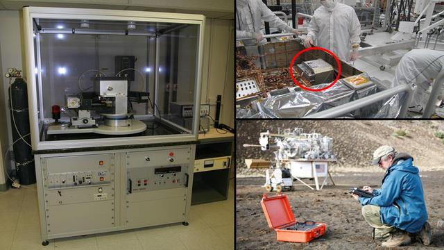
A conventional X-ray diffraction instrument left is the size of a large refrigerator, in contrast to the compact size of the Chemistry and Mineralogy CheMin instrument on NASA Curiosity rover top right.
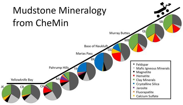
This series of pie charts shows similarities and differences in the mineral compositions of mudstones at 10 sites where NASA's Curiosity Mars rover collected rock-powder samples and analyzed them with the rover's Chemistry and Mineralogy (CheMin) instrument. The charts are arrayed in chronological order, with an indication of relative elevation as the rover first sampled two sites on the floor of Gale Crater in 2013 and later began climbing the crater's central mound, Mount Sharp. The pie chart farthest to the right and uphill shows composition at the "Sebina" target, sampled in October 2016. Five non-mudstone rock targets that the rover drilled and analyzed within this time frame are not included. The mineralogical variations in these mudstones may be due to differences in any or all of these factors: the source materials deposited by water that entered lakes, the processes of sedimentation and rock forming, and how the rocks were later altered. One trend that stands out is that the mineral jarosite -- shown in purple -- was more prominent in the "Pahrump Hills" area of lower Mount Sharp than at sites examined either earlier or later. Jarosite is an indicator of acidic water. Mudstone layers uphill from Pahrump Hills have barely detectable amounts of jarosite, indicating a shift away from acidic conditions in these overlying -- thus younger -- layers. Clay minerals, shown as green, declined in abundance at sites midway through this series, then came back as the rover climbed higher. Each drilled-and-analyzed target is identified with a two-letter abbreviation: JK for "John Klein," CB for "Cumberland." CH for "Confidence Hills," MJ for "Mojave," TP for "Telegraph Peak," BK for "Buckskin," OD for "Oudam," MB for "Marimba," QL for "Quela," and SB for Sebina. http://photojournal.jpl.nasa.gov/catalog/PIA21146

CAPE CANAVERAL, Fla. – David Blake, NASA principal investigator for the Chemistry and Mineralogy (CheMin) investigation by the Curiosity rover, explains the experiment to the media in NASA Kennedy Space Center's Press Site auditorium in Florida during prelaunch activities for the agency’s Mars Science Laboratory (MSL) launch. CheMin is designed to analyze powdered rock and soil samples by identifying and quantifying their mineral content using X-ray diffraction, a first for a mission to Mars. The car-sized Martian rover, Curiosity, has 10 science instruments designed to search for signs of life, including methane, and help determine if the gas is from a biological or geological source. Liftoff of MSL aboard a United Launch Alliance Atlas V rocket from Space Launch Complex-41 on Cape Canaveral Air Force Station is planned during a launch window which extends from 10:02 a.m. to 11:45 a.m. EST on Nov. 26. For more information, visit http://www.nasa.gov/msl. Photo credit: NASA/Kim Shiflett
CAPE CANAVERAL, Fla. – David Blake, NASA principal investigator for the Chemistry and Mineralogy (CheMin) investigation by the Curiosity rover, demonstrates the experiment for the media in NASA Kennedy Space Center's Press Site auditorium in Florida during prelaunch activities for the agency’s Mars Science Laboratory (MSL) launch. CheMin is designed to analyze powdered rock and soil samples by identifying and quantifying their mineral content using X-ray diffraction, a first for a mission to Mars. The car-sized Martian rover, Curiosity, has 10 science instruments designed to search for signs of life, including methane, and help determine if the gas is from a biological or geological source. Liftoff of MSL aboard a United Launch Alliance Atlas V rocket from Space Launch Complex-41 on Cape Canaveral Air Force Station is planned during a launch window which extends from 10:02 a.m. to 11:45 a.m. EST on Nov. 26. For more information, visit http://www.nasa.gov/msl. Photo credit: NASA/Kim Shiflett
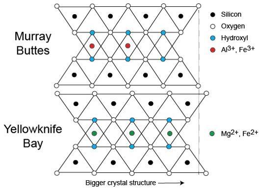
This diagram illustrates how the dimensions of clay minerals' crystal structure are affected by which ions are present in the composition of the mineral. Different clay minerals were identified this way at two sites in Mars' Gale Crater: "Murray Buttes" and "Yellowknife Bay." In otherwise identical clay minerals, a composition that includes aluminum and ferric iron ions (red dots) results in slightly smaller crystalline unit cells than one that instead includes magnesium and ferrous iron ions (green dots). Ferric iron is more highly oxidized than ferrous iron. Crystalline cell units are the basic repeating building blocks that define minerals. X-ray diffraction analysis, a capability of the Chemistry and Mineralogy (CheMin) instrument on NASA's Curiosity Mars rover, identifies minerals from their crystalline structure. http://photojournal.jpl.nasa.gov/catalog/PIA21148
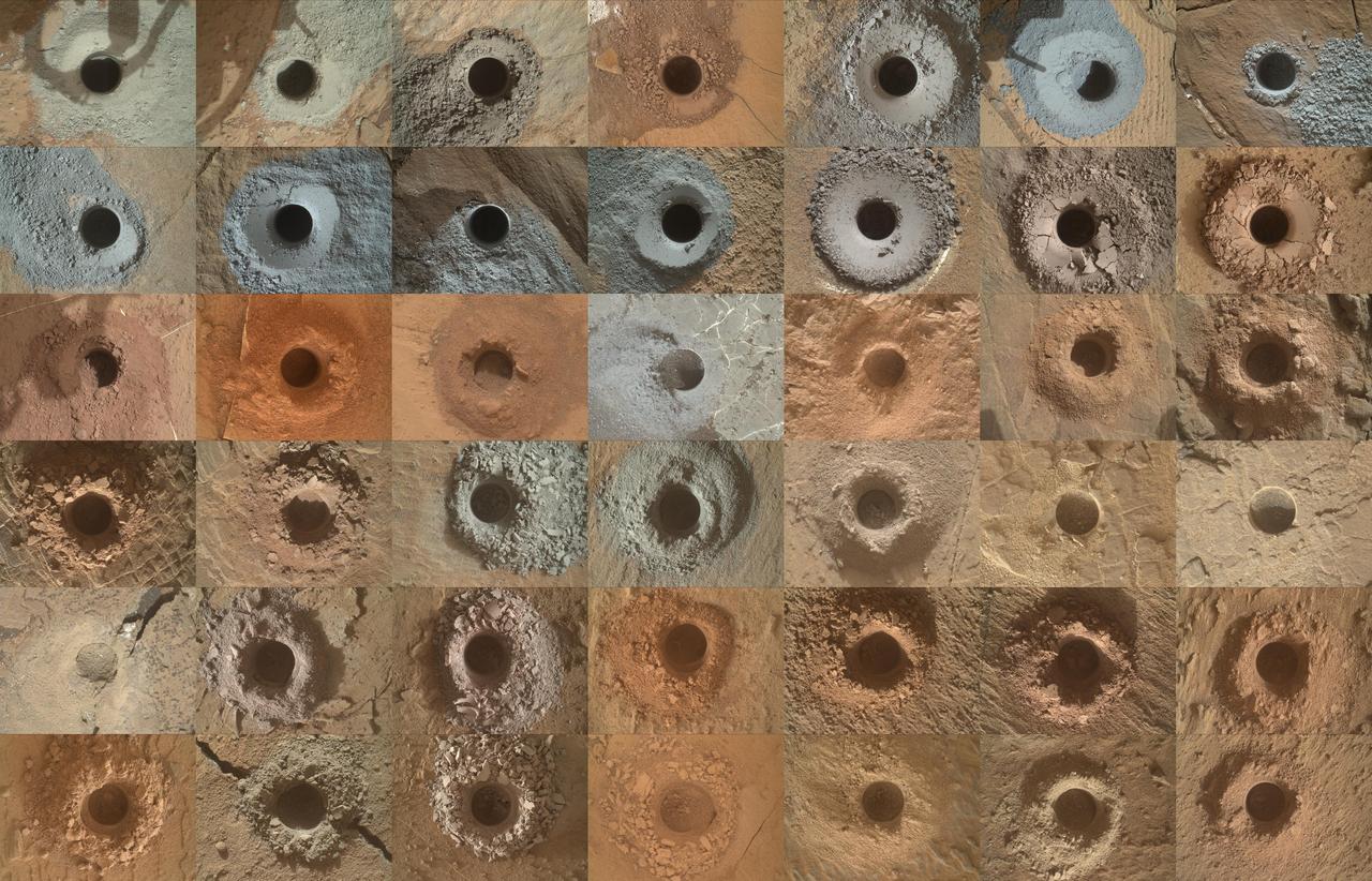
NASA's Curiosity Mars rover has collected 42 powderized rock samples with the drill on the end of its robotic arm. This grid shows all 42 holes made by the drill when collecting the samples, from "John Klein" (drilled on Feb. 9, 2013, the 182nd Martian day, or sol, of the mission) in the upper left, to "Kings Canyon" (drilled on Aug. 3, 2024, the 4,263rd Martian day, or sol, of the mission) in the lower right. Each hole is a little over a half-inch (16 millimeters) wide. The images were captured by the Mars Hand Lens Imager (MAHLI), a camera on the end of the rover's arm. After drilling a sample, the powderized rock is trickled into instruments inside of Curiosity's belly that can analyze the composition of the rocks. Those instruments include Sample Analysis at Mars (SAM) and Chemistry & Mineralogy (CheMin). https://photojournal.jpl.nasa.gov/catalog/PIA26403
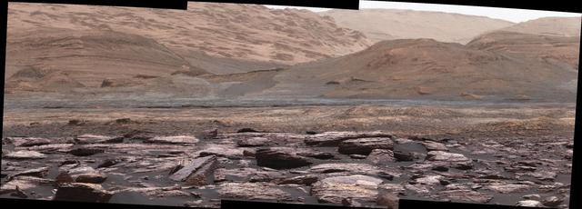
The foreground of this scene from the Mast Camera (Mastcam) on NASA's Curiosity Mars rover shows purple-hued rocks near the rover's late-2016 location on lower Mount Sharp. The scene's middle distance includes higher layers that are future destinations for the mission. Variations in color of the rocks hint at the diversity of their composition on lower Mount Sharp. The purple tone of the foreground rocks has been seen in other rocks where Curiosity's Chemical and Mineralogy (CheMin) instrument has detected hematite. Winds and windblown sand in this part of Curiosity's traverse and in this season tend to keep rocks relatively free of dust, which otherwise can cloak rocks' color. The three frames combined into this mosaic were acquired by the Mastcam's right-eye camera on Nov. 10, 2016, during the 1,516th Martian day, or sol, of Curiosity's work on Mars. The scene is presented with a color adjustment that approximates white balancing, to resemble how the rocks and sand would appear under daytime lighting conditions on Earth. Sunlight on Mars is tinged by the dusty atmosphere and this adjustment helps geologists recognize color patterns they are familiar with on Earth. The view spans about 15 compass degrees, with the left edge toward southeast. The rover's planned direction of travel from its location when this scene was recorded is generally southeastward. The orange-looking rocks just above the purplish foreground ones are in the upper portion of the Murray formation, which is the basal section of Mount Sharp, extending up to a ridge-forming layer called the Hematite Unit. Beyond that is the Clay Unit, which is relatively flat and hard to see from this viewpoint. The next rounded hills are the Sulfate Unit, Curiosity's highest planned destination. The most distant slopes in the scene are higher levels of Mount Sharp, beyond where Curiosity will drive. Figure 1 is a version of the same scene with annotations added as reference points for distance, size and relative elevation. The annotations are triangles with text telling the distance (in kilometers) to the point in the image marked by the triangle, the point's elevation (in meters) relative to the rover's location, and the size (in meters) of an object as big as the triangle at that distance. An annotated figure is available at http://photojournal.jpl.nasa.gov/catalog/PIA21256

This self-portrait of NASA's Curiosity Mars rover shows the vehicle at a drilled sample site called "Okoruso," on the "Naukluft Plateau" of lower Mount Sharp. The scene combines multiple images taken with the rover's Mars Hand Lens Imager (MAHLI) on May 11, 2016, during the 1,338th Martian day, or sol, of the rover's work on Mars. In front of the rover is the hole, surrounded by grayish drill cuttings, created by using Curiosity's drill to collect sample rock powder at Okoruo, plus a patch of powder dumped onto the ground after delivery of a portion to the rover's internal Chemistry and Mineralogy (CheMin) laboratory instrument. The rover team compared the rock powder from drilling at Okoruso to material from the nearby "Lubango" drilling site, which is visible behind the rover, just to the left of the mast. The Lubango site was selected within a pale zone, or "halo," beside a fracture in the area's sandstone bedrock. Okoruso is in less-altered bedrock farther from any fractures. Note that the Okoruso drill cuttings appear darker than the Lubango drill cuttings. The Lubango sample was found to be enriched in silica and sulfates, relative to Okoruso. To the left of the rover, in this scene, several broken rocks reveal grayish interiors. Here, Curiosity was driven over the rocks in a fracture-associated halo, so that freshly exposed surfaces could be examined with MAHLI, Mast Camera (Mastcam) and Chemistry and Camera (ChemCam) instruments. An upper portion of Mount Sharp is prominent on the horizon. http://photojournal.jpl.nasa.gov/catalog/PIA20602
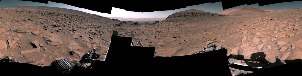
NASA's Curiosity Mars rover captured this 360-degree panorama at a site nicknamed "Ubajara" on April 30, 2023, the 3,815th Martian day, or sol, of the mission. Taken by the rover's Mastcam, this panorama was stitched together from 141 images after they were sent to Earth. Dark rover tracks recede into the distance in the center of the scene. Curiosity used the drill on the end of its robotic arm to take a sample from Ubajara, then dropped the pulverized rock into instruments within the rover's body. One of those instruments, called CheMin (Chemistry & Mineralogy), used X-ray diffraction to discover the presence of an iron carbonate mineral called siderite in samples from this site and two others: one above and one below Ubajara in a region enriched with salty minerals called sulfates. The discovery of siderite may help solve one of Mars' mysteries: There is strong evidence that liquid water coursed over the planet's surface billions of years ago, suggesting Mars had a thick, carbon-rich atmosphere rather than the wispy one it has today (a thicker carbon dioxide atmosphere is required to provide enough pressure and warmth for water to remain liquid on a planet's surface; otherwise, it rapidly vaporizes or freezes – which is the case on Mars today). That carbon dioxide and water should have reacted with Martian rocks to create carbonate minerals. However, when scientists study the planet with satellites that ample carbonate hasn't been apparent – even at Curiosity's site. It's possible that other minerals may be masking carbonate from satellite near-infrared analysis, particularly in sulfate-rich areas. If other such layers across Mars also contain hidden carbonates, the amount of stored carbon dioxide would be part of that needed in the ancient atmosphere to create conditions warm enough to support liquid water. The rest could be hidden in other deposits or have been lost to space over time. https://photojournal.jpl.nasa.gov/catalog/PIA26554