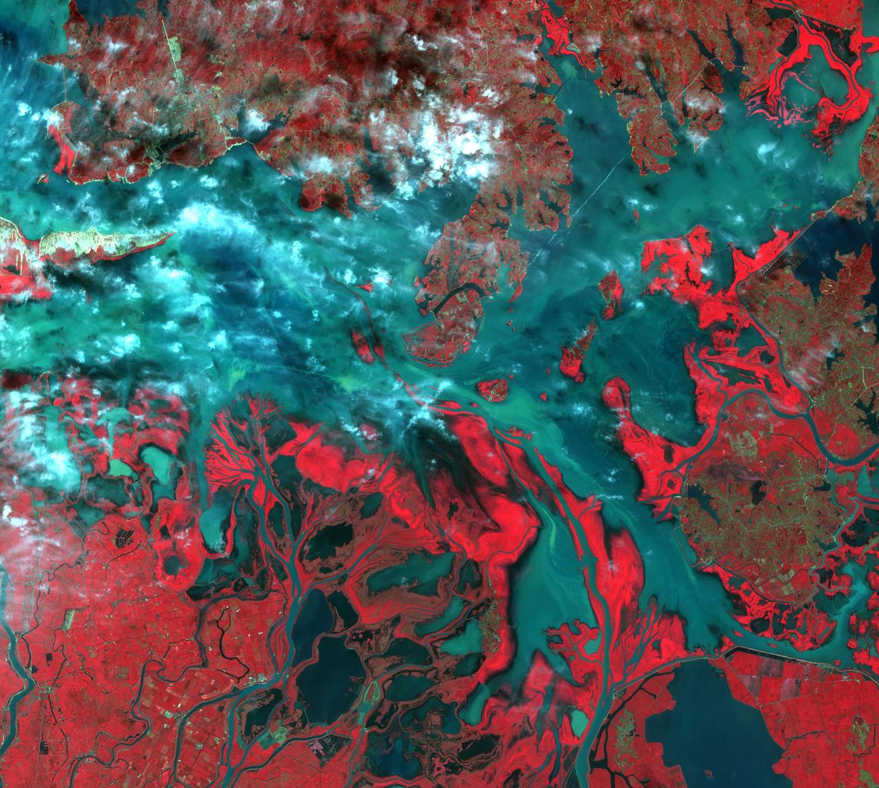
This image from NASA Terra spacecraft shows Poyang Lake, which was once China largest freshwater lake.
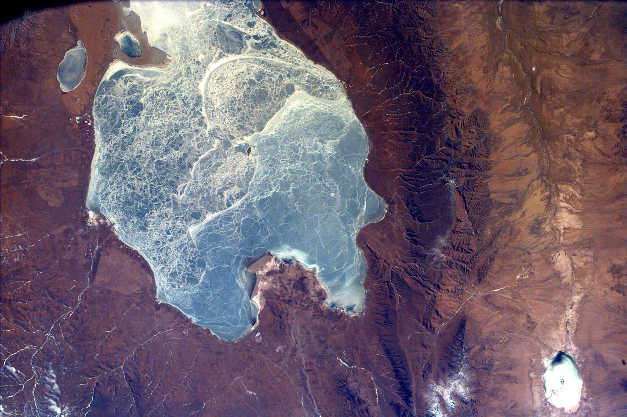
This image from NASA EarthKAM captures almost all of Quinghai, the largest lake in China. It is located in the Quinghai Province on the Quinghai Tibetan Plateau.
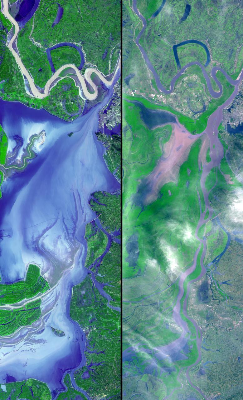
These images show dramatic change in the water at Dongting Lake in Hunan province, China. A flood crest surged down the Yangtze River in late August of this year, but the embankments made by residents there held. The left image was acquired on September 2, 2002 and shows the extent of the lake. The right image was obtained March 19, 2002 before the flooding began. These images were acquired on September 2, 2002 and March 19, 2002 by the Advanced Spaceborne Thermal Emission and Reflection Radiometer (ASTER) on NASA's Terra satellite. With its 14 spectral bands from the visible to the thermal infrared wavelength region, and its high spatial resolution of 15 to 90 meters (about 50 to 300 feet), ASTER will image Earth for the next 6 years to map and monitor the changing surface of our planet. http://photojournal.jpl.nasa.gov/catalog/PIA03858
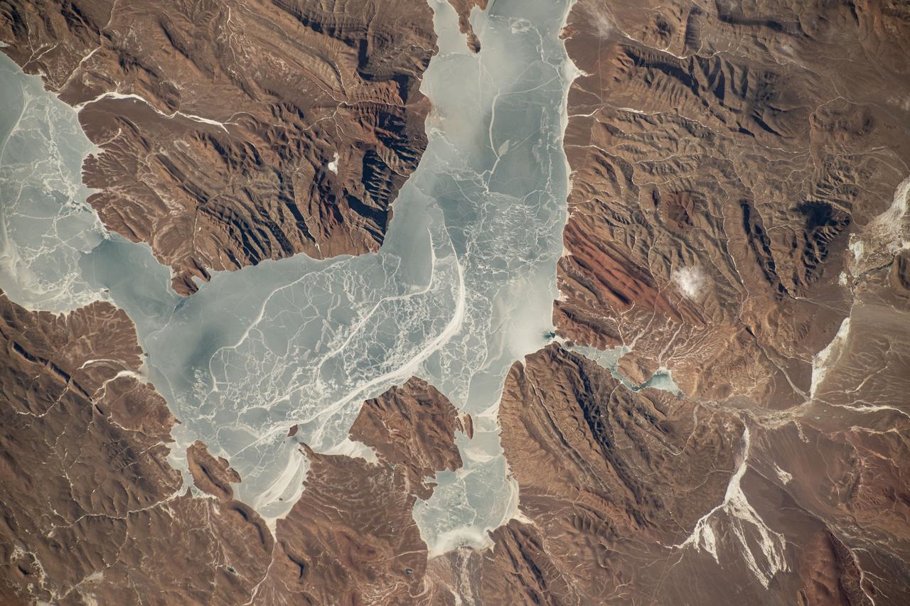
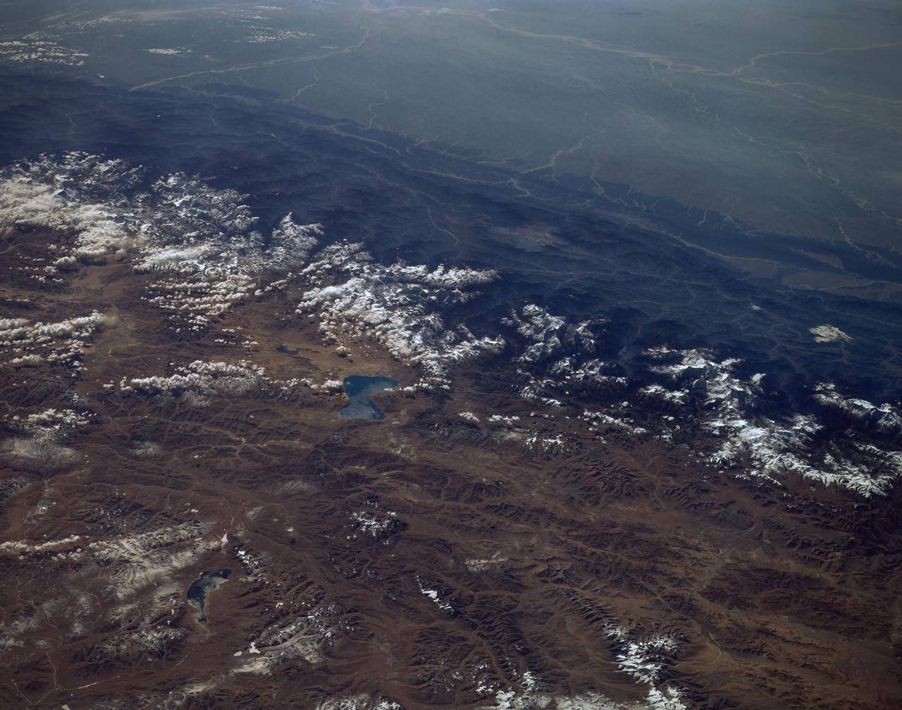
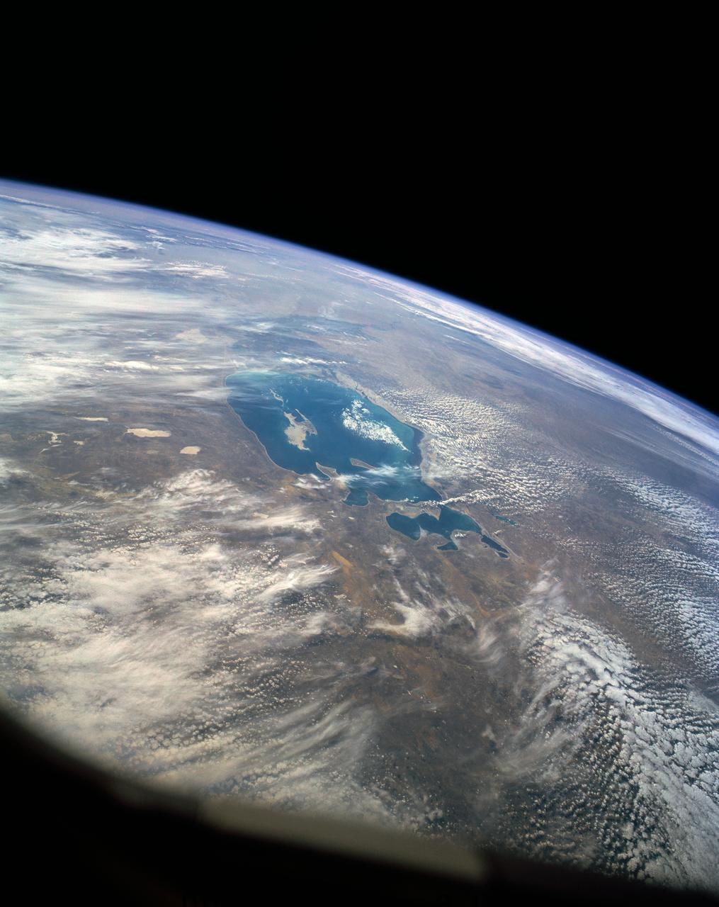
iss072e363454 (Dec. 13, 2024) --- An icy lake in southwestern China's high plateau region north of the Himalayas is pictured from the International Space Station as it orbited 262 miles above the Asian continent.
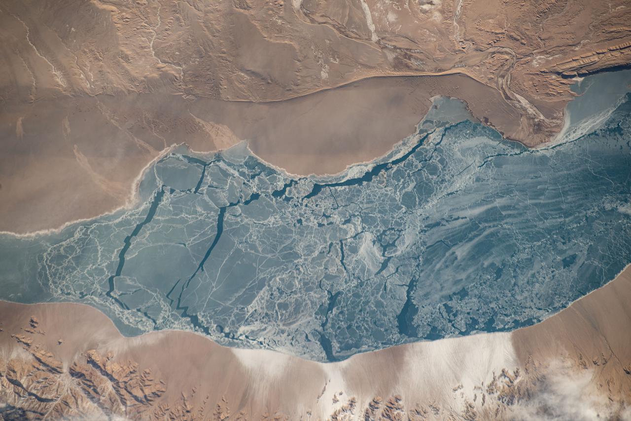
iss072e363445 (Dec. 13, 2024) --- An icy lake in southwestern China's high plateau region north of the Himalayas is pictured from the International Space Station as it orbited 262 miles above the Asian continent.
This image from NASA Terra spacecraft shows Baektu Mountain, an active volcano on the border between North Korea and China. Rising to 2744 m, its summit caldera is filled with a crater lake, Heaven Lake.
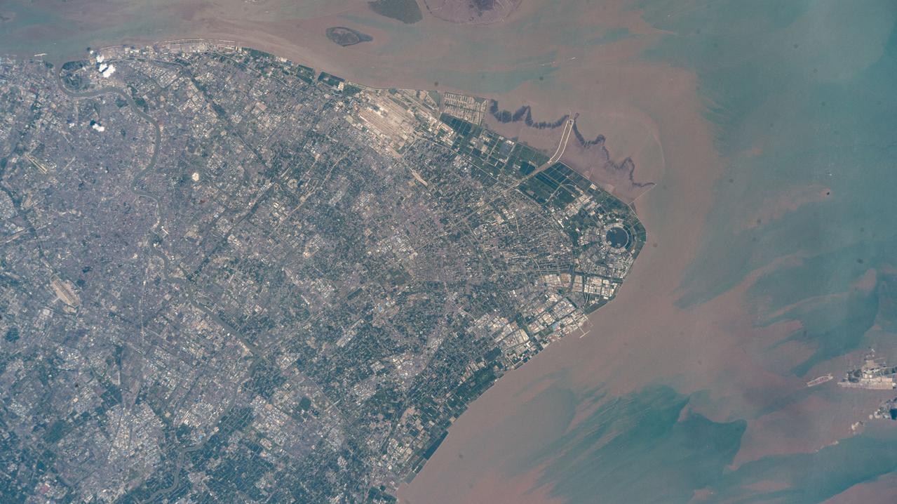
iss073e0513927 (Aug. 22, 2025) --- Shanghai, China's most populous city with over 24 million citizens and sitting on the East China Sea at the mouth of the Yangtze River, is pictured from the International Space Station as it orbited 260 miles above. Highlights include Shanghai Pudong International Airport (at top), the second busiest airport in the world by cargo traffic, and the circular Dishui Lake (center right), the largest artificial freshwater lake in China, hosting business and recreational activities.
ISS047e137096 (06/03/2016) --- This stunning Earth image taken from the International Space Station looks from Northwestern China on the bottom into eastern Kazakhstan. The large lake in Kazakhstan with golden sun glint is named Lake Balkhash. It is one of the largest lakes in Asia and is the 15th largest lake in the world. The lake is fed by 7 rivers.
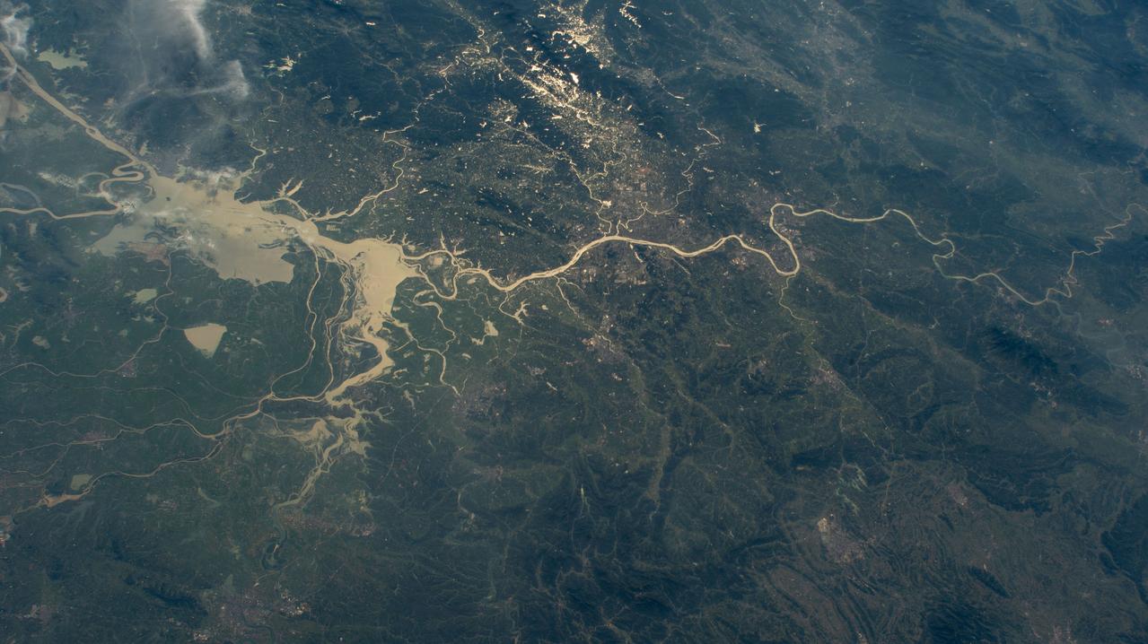
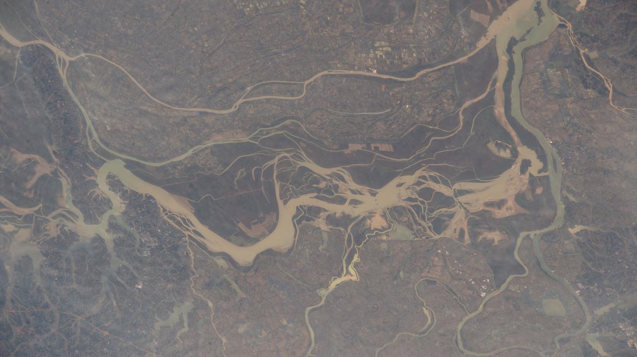
iss071e439833 (Aug. 8, 2024) --- Xiang River runs through the city of Changsha (center) in China's province of Hunan. At far left, the city of Yueyang lies on the bank of Dongdongting Lake in Hunan's humid, subtropical region. The International Space Station was orbiting 262 miles above the Asian nation at the time of this photograph.
iss065e023073 (May 6, 2021) --- A small lake is pictured in Inner Mongolia, China, as the International Space Station orbited 264 miles above.
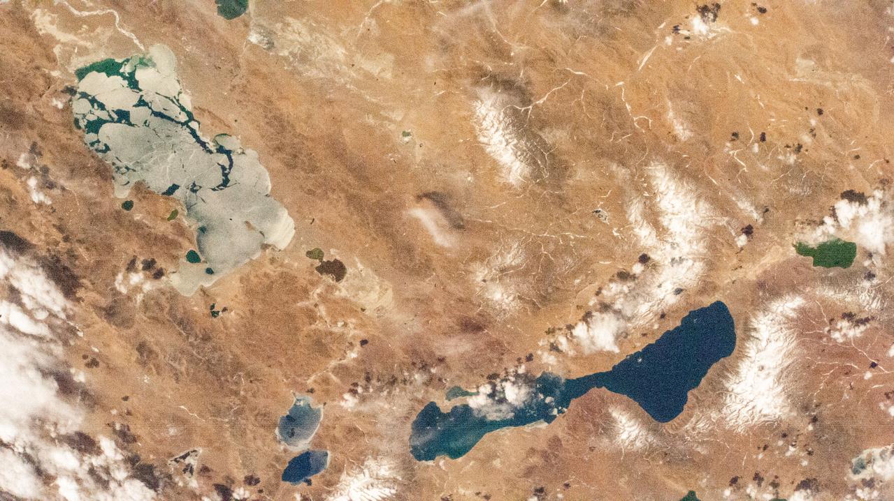
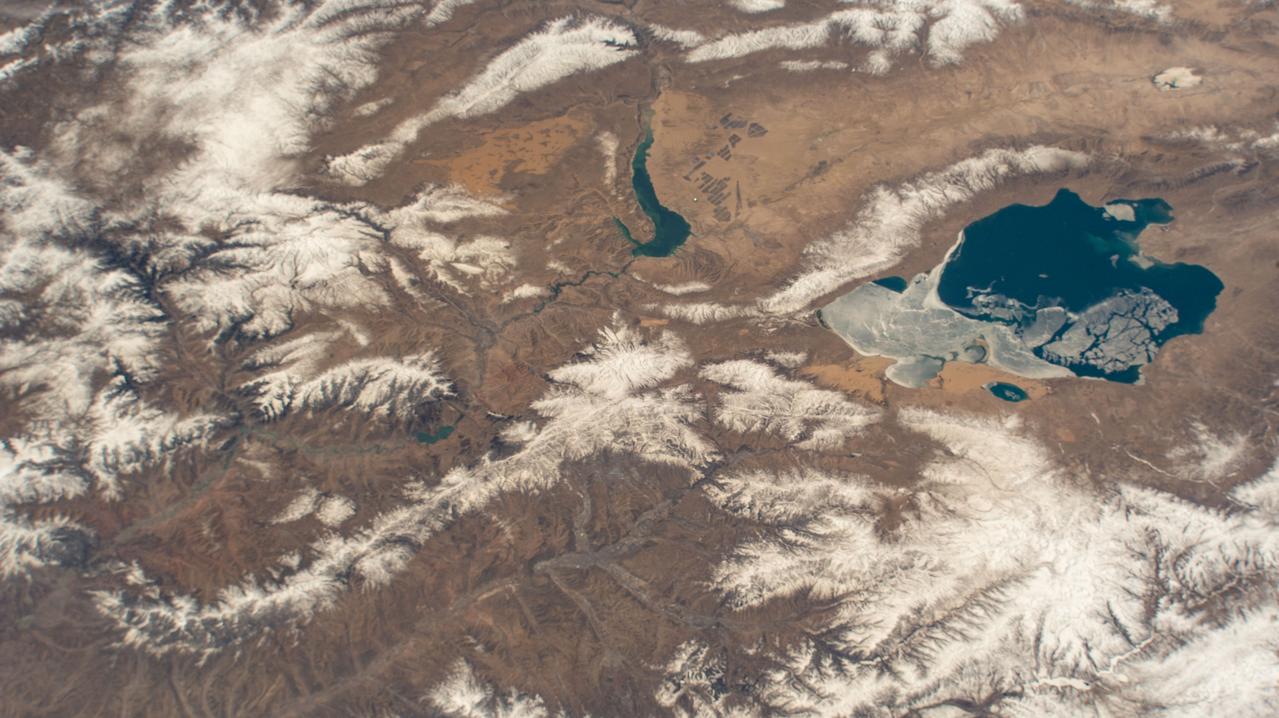
iss071e673954 (Sept. 15, 2024) --- West Taijinar salt lake in China is pictured from the International Space Station as it orbited 260 miles above the Asian nation.
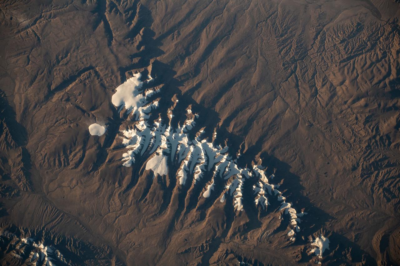
iss069e071176 (Aug. 20, 2023) --- Ka Nasi Lake (lower left) and Ake Kule Lake (upper right), in China's Altai Mountain range near Mongolia's far western border, are pictured in this photograph as the International Space Station orbited 265 miles above.
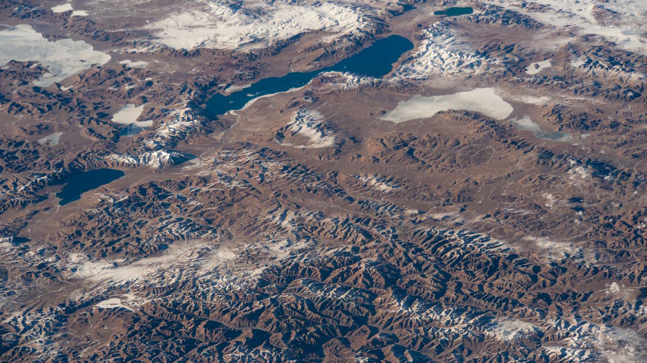
iss067e344813 (Sept. 5, 2022) --- A portion of the Tanggula Mountains near Hala Lake in western China is pictured from the International Space Station as it orbited 260 miles above.
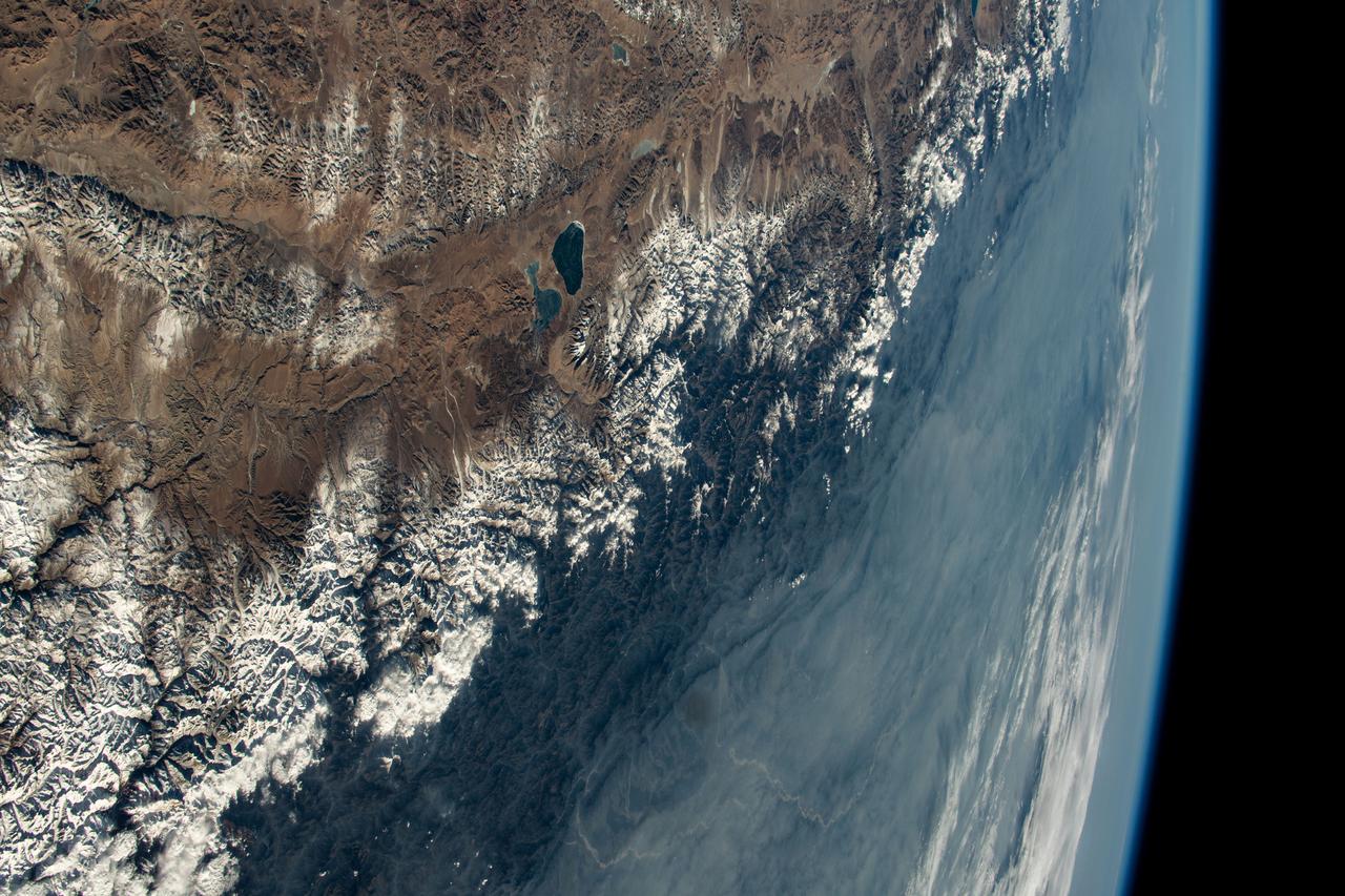
iss066e123378 (Jan. 21, 2022) --- Xuru Co and Deng Reyongcuo, two lakes in southern China just north of the Himalayas, are pictured in this oblique image from the International Space Station as it orbited 257 miles above Bangladesh.
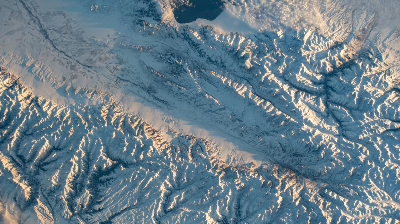
iss064e011823 (Dec. 11, 2020) --- Snow-covered mountains along the Kazakhstan-China border, including Sayram Lake at top, are pictured from the International Space Station as it orbited 263 miles above the Asian nations.
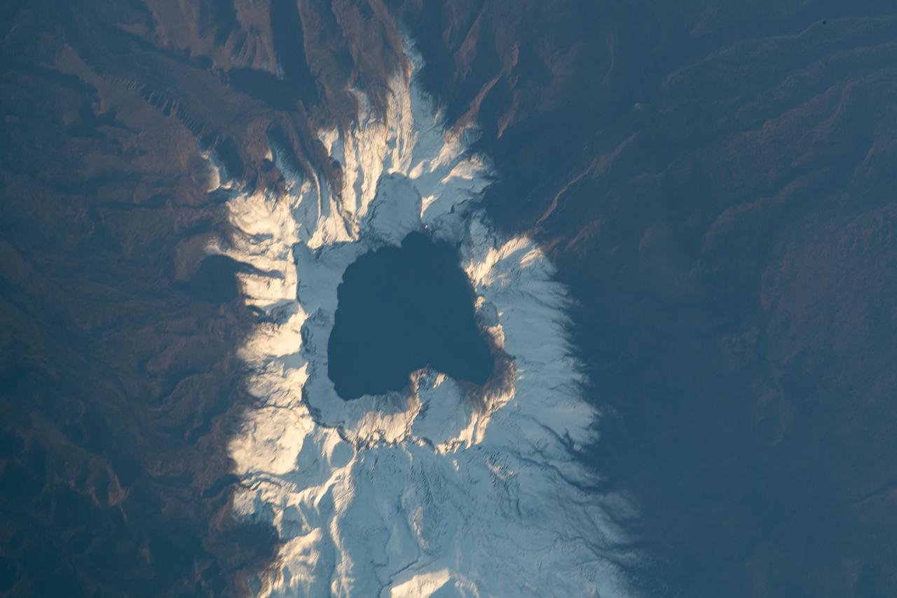
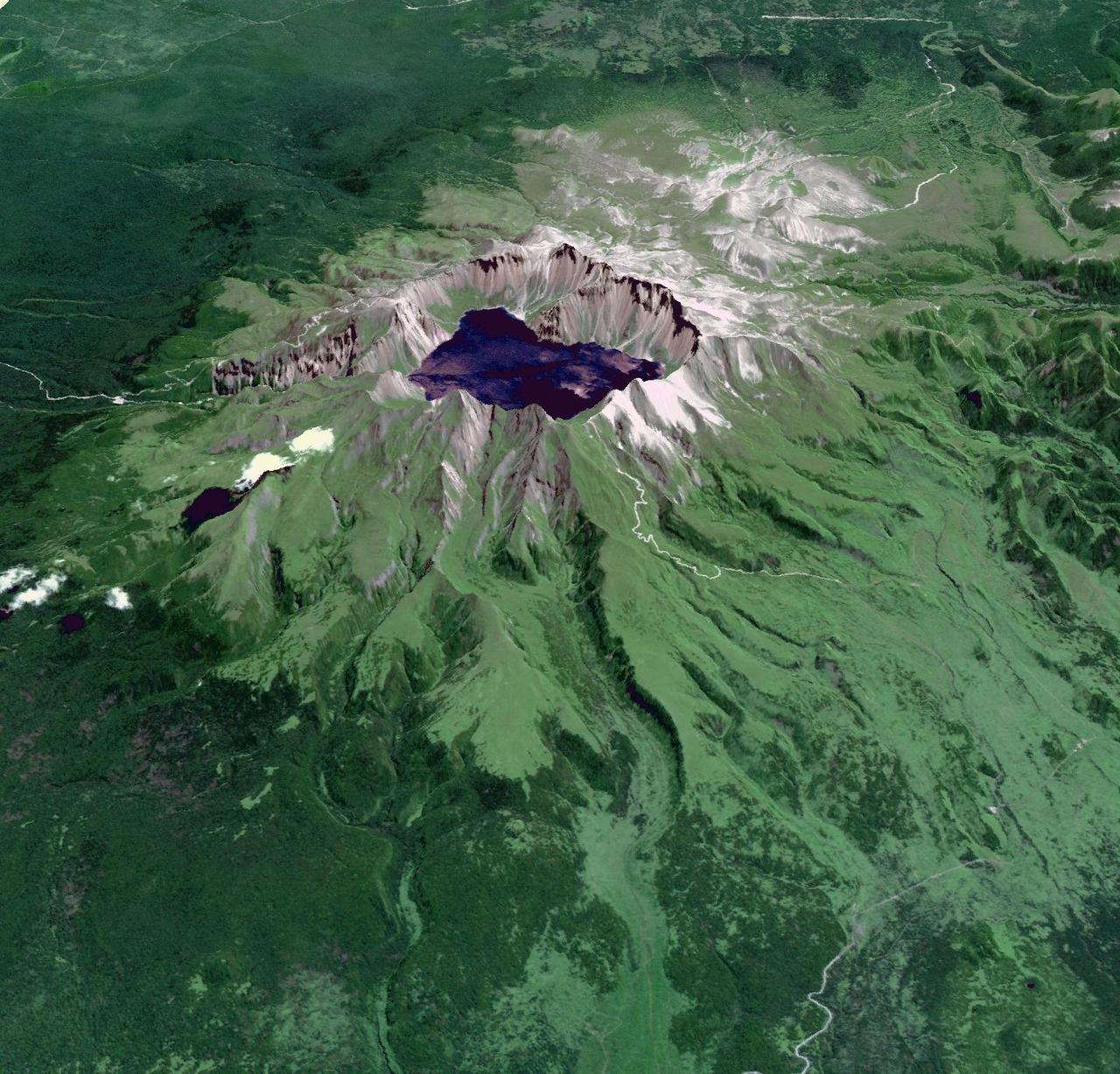
iss065e444007 (Oct. 8, 2021) --- Heaven Lake rests in the crater of the active volcano Paektu Mountain that lies on the China-North Korea border. The International Space Station was orbiting 263 miles above Asia at the time this photograph was taken.
iss069e000174 (March 31, 2023) --- Salt lakes in southern China near the Himalayas are pictured by an external high definition camera on the International Space Station as it orbited 261 miles above.
iss070e031373 (Nov. 28, 2023) --- Rivers and lakes are surrounded by villages in the south-central portion of China in this photograph from the International Space Station as it orbited 260 miles above the Asian nation
STS059-209-081 (9-20 April 1994) --- Lake Balkhash, in eastern Kazakhstan, is some 300 miles long. The lake, frozen in this scene, thawed noticeably during the mission. The shape of the lake is controlled by the delta of the Ili River, which flows from the Tien Shan Mountains in western China across this arid steppe. SRL scientists will use radar data to study the microwave effects of differences in soil moisture, and in freezing or thawing, on the deltaic sediments. Hasselblad camera.
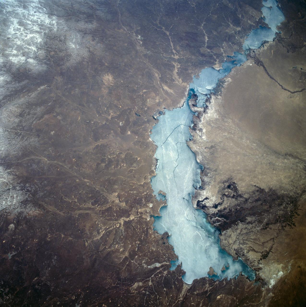
iss069e000989 (April 6, 2023) --- An icy Qinghai Lake (right) and Longyang Gorge Reservoir (top center) in southern China are pictured in this photograph from an external high definition camera on the International Space Station as it orbited 263 miles above.
iss070e097638 (Feb. 11, 2024) --- The Himalayas, separating the Indian subcontinent from China, home to the South Asian nations of Nepal and Bhutan, and with Lakes Mansarovar and Rakshastal on the Chinese side, are pictured from the International Space Station as it orbited 261 miles above.
S63-06438 (15-16 May 1963) --- Changsha area in China, showing Tung Ting lake region, as photographed from the Mercury-Atlas 9 (MA-9) capsule by astronaut L. Gordon Cooper Jr., during his 22-orbit MA-9 spaceflight. Photo credit: NASA
STS085-503-061 (7 - 19 August 1997) --- Lakes Balkhash and Alakol, southern uplands of Kazakhstan, central Asia. The long, 600 kilometers arc of Lake Balkhash occupies the center of this clear west-looking view. The left of the view shows clearly the westernmost Dzungarian Basin in the autonomous region of Xinjiang Uygur (Sinkiang), China. Kazakhstan's capital city Almaty (Alma-Ata) lies out of sight behind the boom. The Dzungarian Gate is the straight, fault-bounded valley cutting through the Dzhungarskiy Alatau Range. The Gate has acted as a major pass for centuries, allowing access between east Asia and central Asia (the valley floor is about 1,500 feet, whereas peaks reach 15,000 feet on the west and about 10,000 feet on the east side) -- it was one of the routes used by the Mongols when they began their invasion of central Asia and Europe in the 13th century. Lake Ebinur is the bright area beneath the dust plume (left center); strong north winds from the steppes of Kazakhstan and Russia are funneled through the Dzungarian Gate where they pick up sediment from dry lakebeds and blow it into China. The Ili River flows westward, parallel to the Dzhungarskiy Alatau Range, through Kapchagay Lake (partially visible beneath boom), then northwest across a large delta plain and into Lake Balkhash.

STS059-220-041 (9-20 April 1994) --- View to the south by southwest across the southern Gobi Desert (China) across the Chi-Lien-Shan or Quilienshan or Nanshan (Mountains) in Gansu Province to Lake Quinghai or Ch'ing-Hai (orthography varies with political conditions and scholarship) in Quinghai Province. The lake has a surface elevation of 10,450 feet, partially filling one of the easternmost closed drainage basins of Central Asia. Hasselblad photograph.
ISS028-E-035137 (30 Aug. 2011) --- Owens Lake in California is featured in this image photographed by an Expedition 28 crew member on the International Space Station. This photograph highlights the mostly dry bed of Owens Lake, located in the Owens River Valley between the Inyo Mountains and the Sierra Nevada. Shallow groundwater, springs, and seeps support minor wetlands and a central brine pool. Two bright red areas along the margins of the brine pool indicate the presence of halophilic, or salt-loving organisms known as Achaeans. Grey and white materials within the lake bed are exposed lakebed sediments and salt crusts. The towns of Olancha and Lone Pine are delineated by the presence of green vegetation indicating a more constant availability of water. According to scientists, the present-day Owens Lake was part of a much larger lake and river system that existed during the Pleistocene Epoch (approximately 3 million to approximately 12,000 years ago) along the current northeastern border of California with Nevada. Meltwater from alpine glaciers in the Sierra Nevada filled the regional valleys of the Basin and Range to form several glacial lakes that were ancestral to the now-dry lakebeds (or playas) of Owens, Searles Lake, and China Lake. While Searles and China Lakes dried out due to regional changes to a hotter and drier climate over thousands of years, Owens Lake became desiccated largely due to the diversion of Owens River water in the early 20th century to serve the needs of the City of Los Angeles, CA located 266 kilometers to the south. Following complete desiccation of the lakebed in 1926, significant amounts of windblown dust were produced ? indeed, the term ?Keeler fog? was coined by residents of the now largely abandoned town on the eastern side of Owens Lake due to the dust. In addition to adverse health effects on local residents, dust from Owens Lake has been linked to visibility reduction in nearby national parks, forests, and wilderness areas. Recently, efforts to control dust evolution from the lakebed have been undertaken by the City of Los Angeles.
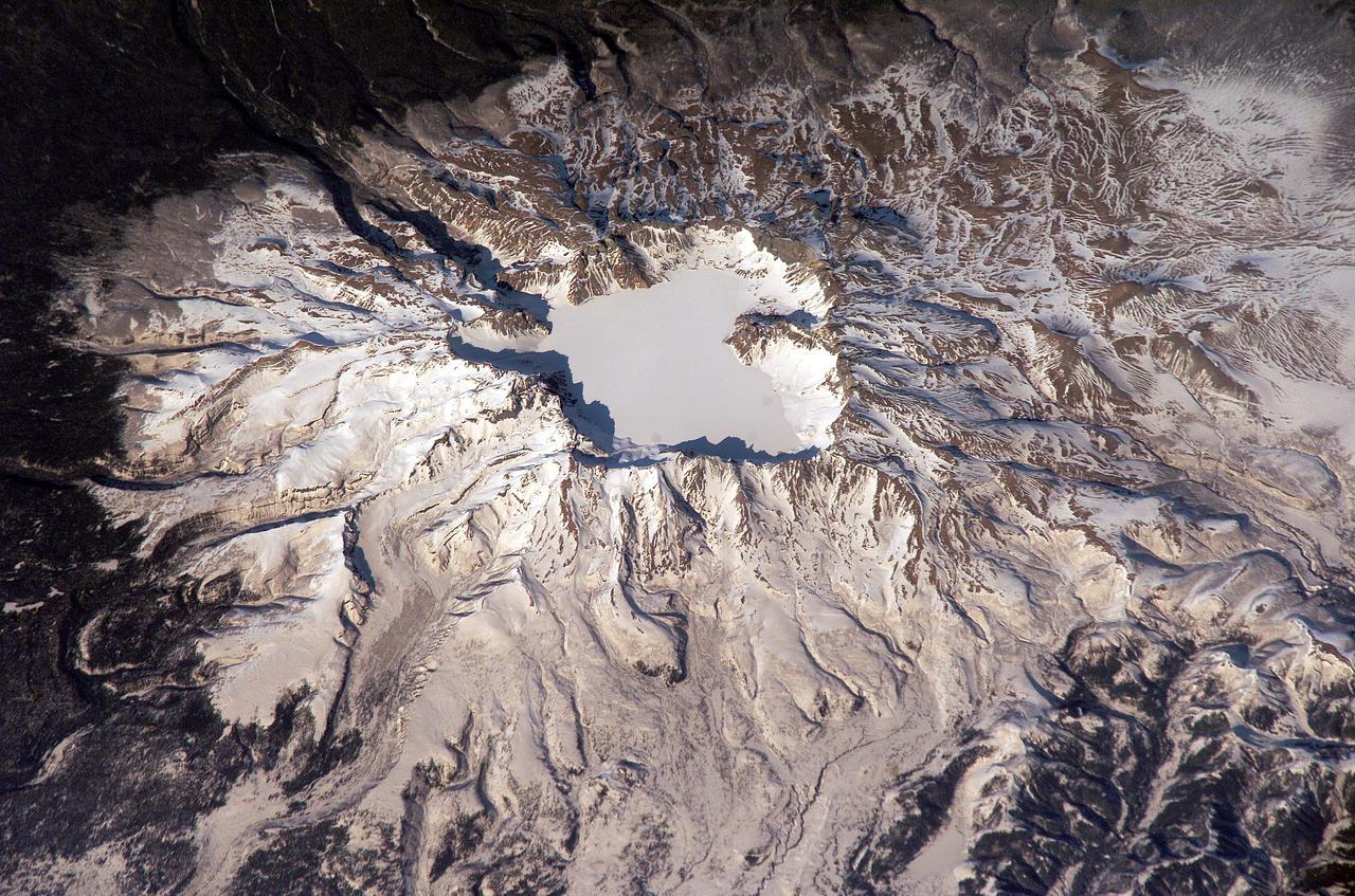
ISS006-E-43366 (4 April 2003) --- This view featuring Baitoushan Volcano, China and North Korea, was photographed by an Expedition 6 crewmember on the International Space Station (ISS). One of the largest known Holocene eruptions occurred at Baitoushan Volcano (also known as Changbaishan in China and P’aektu-san in Korea) about 1000 A.D., with erupted material deposited as far away as northern Japan – a distance of approximately 1200 kilometers. The eruption also created the 4.5 kilometer diameter, 850 meters deep summit caldera of the volcano that is now filled with the waters of Lake Tianchi (or Sky Lake). This oblique photograph was taken during the winter season, and snow highlights frozen Lake Tianchi along with lava flow lobes along the southern face of the volcano. Baitoushan last erupted in 1702 and is considered a dormant volcano. Gas emissions were reported from the summit and nearby hot springs in 1994, but no evidence of renewed activity of the volcano was observed. The Chinese-Korean border runs directly through the center of the summit caldera, and the mountain is considered sacred by the dominantly Korean population living near the volcano. Lake Tianchi is a popular resort destination, both for its natural beauty and alleged sightings of unidentified creatures living in its depths (similar to legendary Loch Ness Monster in Scotland).
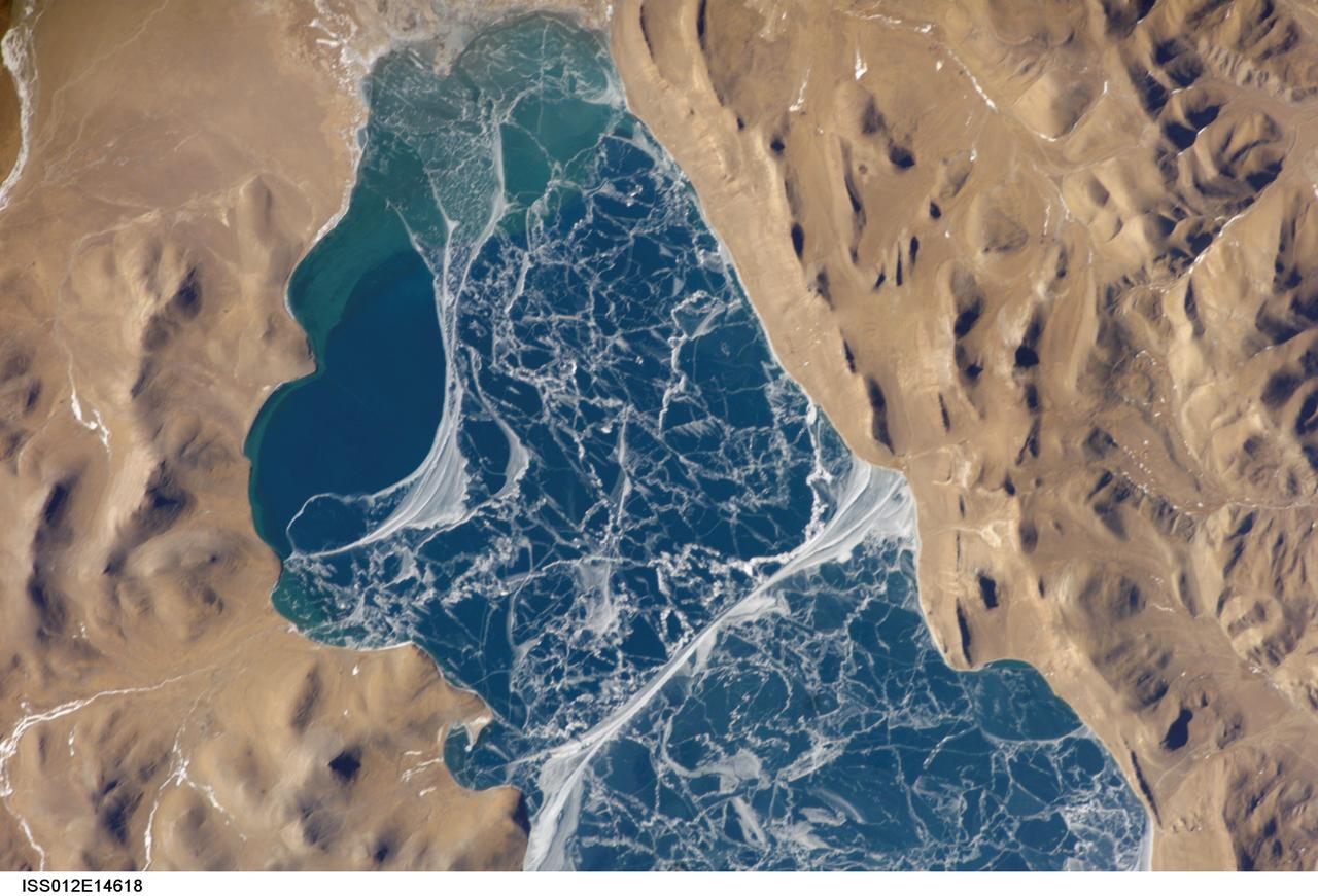
ISS012-E-14618 (6 Jan. 2006) --- A portion of Lake Puma Yumco and parts of Tibet and China are featured in this image photographed by an Expedition 12 crew member on the International Space Station. The alpine lakes of the Tibetan Plateau are some of the most remote in the world. This image depicts Lake Puma Yumco during the winter season. The lake is located at an elevation of 5,030 meters above sea level, and is considered ultraoligotrophic in that nutrient concentrations in both the water column and lake sediments are extremely low. Water in such lakes tends to be blue to blue-green and have high clarity due to the lack of abundant photosynthesizing organisms such as phytoplankton. Water color change in these lakes is usually due to shallowing of the water – blue indicating deeper water - as is visible in the depth transition along the west/southwestern shoreline (left). The maximum dimensions of the lake are 31 kilometers by 14 kilometers, indicating that the ice blocks range from less than ten to hundreds of meters in diameter. According to scientists, the ice pattern is caused by repeated cycles of freezing, fracturing, and refreezing of the ice due to variations in temperature and wind-induced ice motion. A prominent white linear feature extending north-south across the center of the lake (lower center) is suggestive of an ice ridge formed by east-west winds subsequently highlighted by snow.
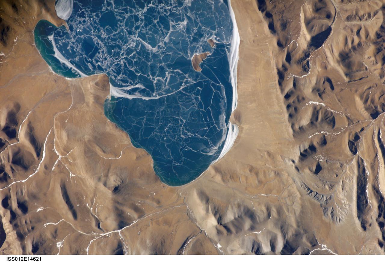
ISS012-E-14621 (6 Jan. 2006) --- A portion of Lake Puma Yumco and parts of Tibet and China are featured in this image photographed by an Expedition 12 crew member on the International Space Station. The alpine lakes of the Tibetan Plateau are some of the most remote in the world. This image depicts Lake Puma Yumco during the winter season. The lake is located at an elevation of 5,030 meters above sea level, and is considered ultraoligotrophic in that nutrient concentrations in both the water column and lake sediments are extremely low. Water in such lakes tends to be blue to blue-green and have high clarity due to the lack of abundant photosynthesizing organisms such as phytoplankton. Water color change in these lakes is usually due to shallowing of the water – blue indicating deeper water. The maximum dimensions of the lake are 31 kilometers by 14 kilometers, indicating that the ice blocks range from less than ten to hundreds of meters in diameter. According to scientists, the ice pattern is caused by repeated cycles of freezing, fracturing, and refreezing of the ice due to variations in temperature and wind-induced ice motion. A prominent white linear feature across the center of the lake (not visible in this image) is suggestive of an ice ridge formed by east-west winds subsequently highlighted by snow.
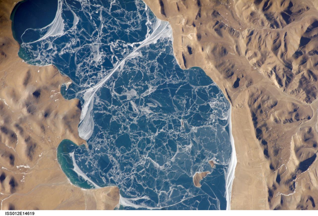
ISS012-E-14619 (6 Jan. 2006) --- A portion of Lake Puma Yumco and parts of Tibet and China are featured in this image photographed by an Expedition 12 crew member on the International Space Station. The alpine lakes of the Tibetan Plateau are some of the most remote in the world. This image depicts Lake Puma Yumco during the winter season. The lake is located at an elevation of 5,030 meters above sea level, and is considered ultraoligotrophic in that nutrient concentrations in both the water column and lake sediments are extremely low. Water in such lakes tends to be blue to blue-green and have high clarity due to the lack of abundant photosynthesizing organisms such as phytoplankton. Water color change in these lakes is usually due to shallowing of the water – blue indicating deeper water - as is visible in the depth transition along the west/southwestern shoreline (upper left). The maximum dimensions of the lake are 31 kilometers by 14 kilometers, indicating that the ice blocks range from less than ten to hundreds of meters in diameter. According to scientists, the ice pattern is caused by repeated cycles of freezing, fracturing, and refreezing of the ice due to variations in temperature and wind-induced ice motion. A prominent white linear feature across the center of the lake is suggestive of an ice ridge formed by east-west winds subsequently highlighted by snow.
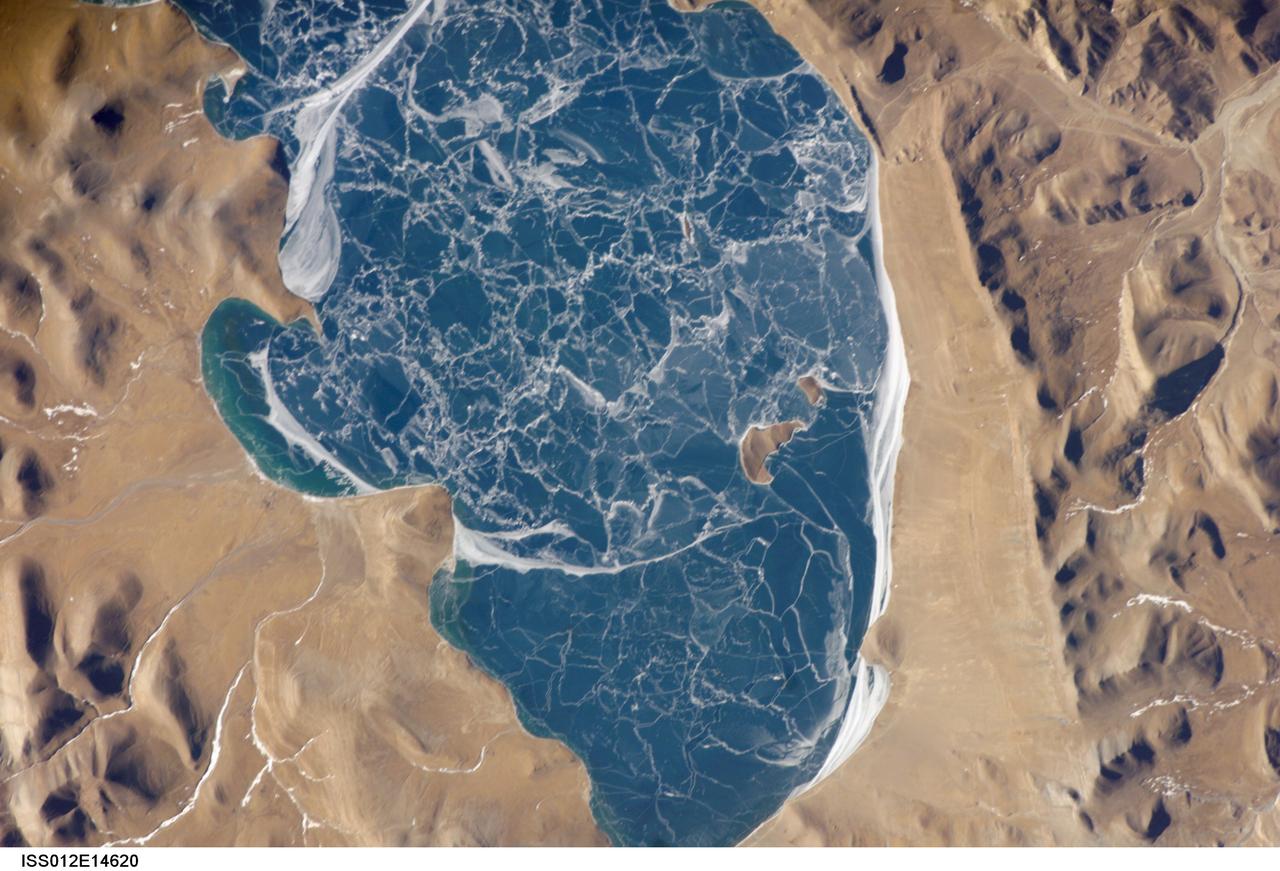
ISS012-E-14620 (6 Jan. 2006) --- A portion of Lake Puma Yumco and parts of Tibet and China are featured in this image photographed by an Expedition 12 crew member on the International Space Station. The alpine lakes of the Tibetan Plateau are some of the most remote in the world. This image depicts Lake Puma Yumco during the winter season. The lake is located at an elevation of 5,030 meters above sea level, and is considered ultraoligotrophic in that nutrient concentrations in both the water column and lake sediments are extremely low. Water in such lakes tends to be blue to blue-green and have high clarity due to the lack of abundant photosynthesizing organisms such as phytoplankton. The maximum dimensions of the lake are 31 kilometers by 14 kilometers, indicating that the ice blocks range from less than ten to hundreds of meters in diameter. According to scientists, the ice pattern is caused by repeated cycles of freezing, fracturing, and refreezing of the ice due to variations in temperature and wind-induced ice motion. A prominent white linear feature across the center of the lake (partially visible in upper left in this image) is suggestive of an ice ridge formed by east-west winds subsequently highlighted by snow.
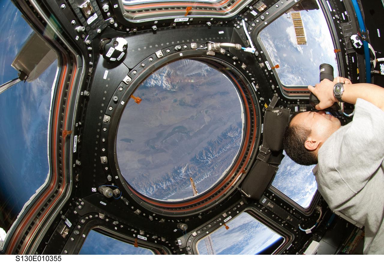
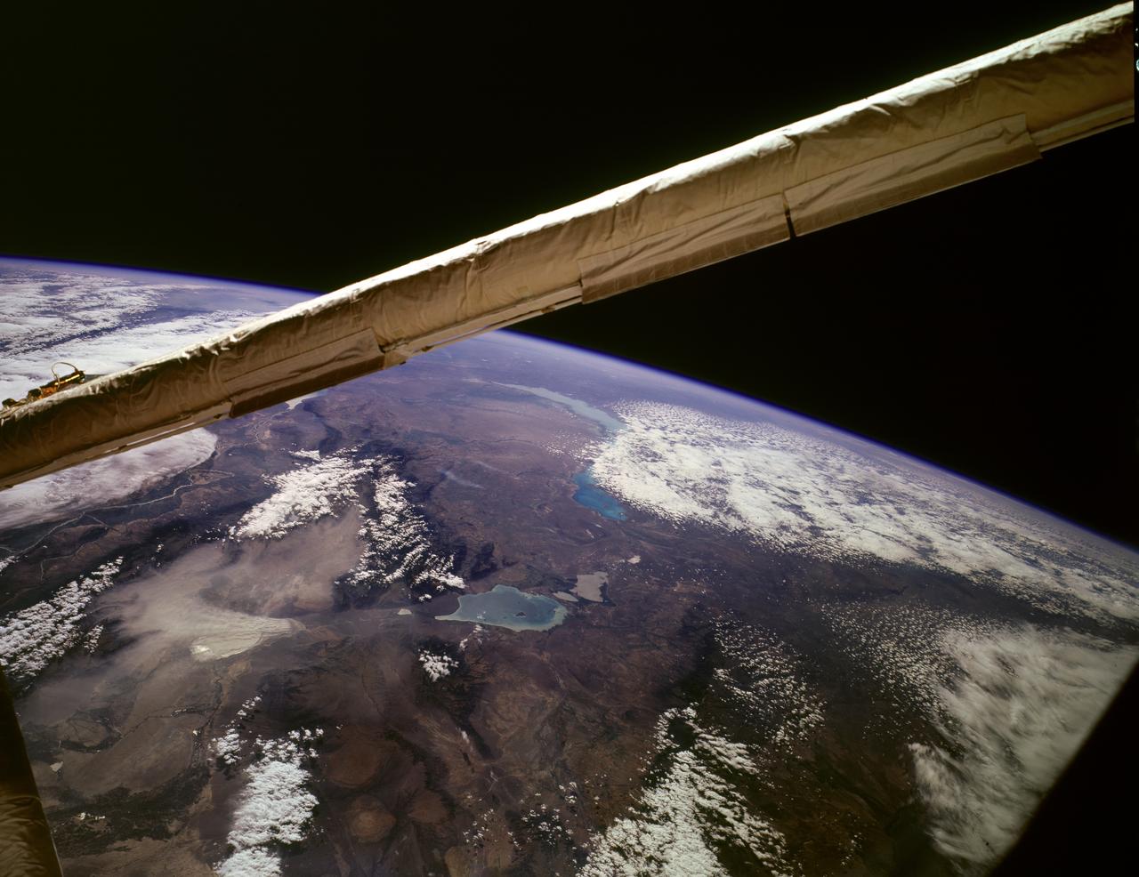
S130-E-010355 (18 Feb. 2010) --- Japan Aerospace Exploration Agency (JAXA) astronaut Soichi Noguchi, Expedition 22 flight engineer, uses a still camera at a window in the Cupola of the International Space Station while space shuttle Endeavour (STS-130) remains docked with the station. The mountains in the center window are the western Burhan Budai Shan (lower right), with Qaidam Basin and lakes, (center), all just north of the city of Golmud, Qinghai Province, China.

S88-25408 (8 Dec 1987) --- James O. Schlosser (left), JSC crew systems branch employee responsible for crew equipment development, gives a briefing on the crew equipment baselined for STs-26 as astronaut James P. Bagian models the new gear. Included in the package are a partial pressure suit, harness, parachute, life raft and survival gear. The deomonstration took place at the Naval Weapons Center in China Lake, CA.
S81E5015 (13 January 1997) --- An Electronic Still Camera (ESC), mounted in the Space Shuttle Atlantis' aft flight deck overhead window, recorded this view of China, featuring two large lakes, Mapam Yumco and Langa Co. Once a year, NASA flies aboard its Shuttle fleet a student project called Kidsat, which enables students on Earth to have hands-on interface with Earth observations from a space perspective.
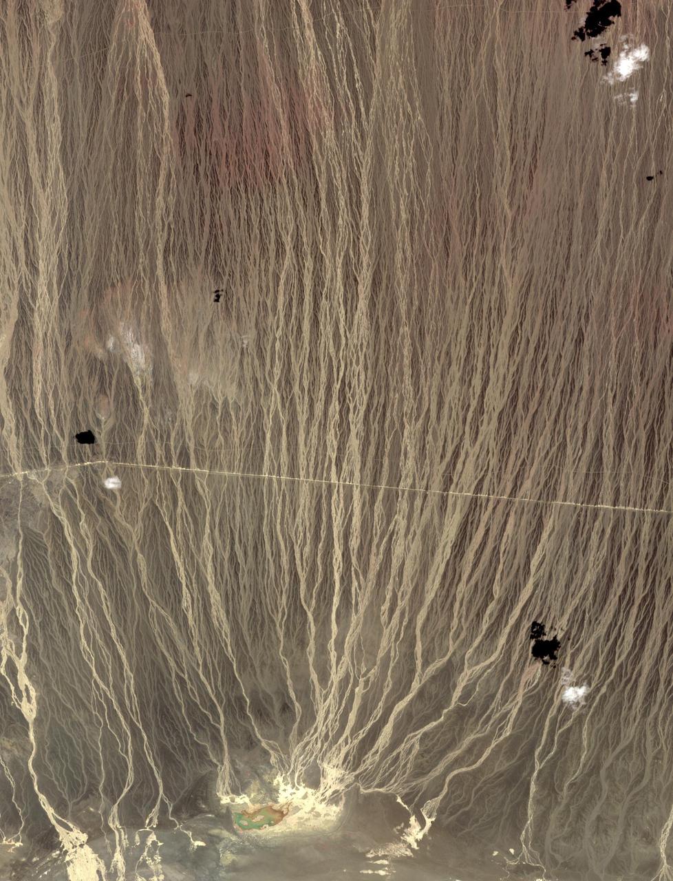
On the border between Mongolia and China, southward draining ephemeral streams have carved a series of parallel channels. Mountains to the north have an elevation of 1800 m; the catchment lake for the streams lies at 500 m elevation. The flat, featureless, homogeneous plain between the source and sink controls the geometry of the drainage pattern. The image was acquired August 17, 2014, covers an area of 17.7 by 36.3 kilometers, and is located at 42.7 degrees north, 100.9 degrees east. https://photojournal.jpl.nasa.gov/catalog/PIA23196
View is southeastward across China (Tibet), half of Nepal and India. The partly frozen lake near the center of the frame is Pei-Ku T'so ("Bos-tie Lake"). The central Himalaya stretches from Mount Everest on the left past Annapurna on the right. Large tributaries converge to form the Ganges River, flowing through the lowland basin south of the Himalaya. This photograph illustrates the rain shadow effect of the Himalaya Chain; wet, warm air from the Indian Ocean is driven against the mountains, lifted, and drained of water that forms ice caps, the abundant rivers, and forests of the foothills. In contrast the high plateau of Tibet is arid, composed largely of topographically-closed basins because stream flow is inadequate to form integrated drainage networks.
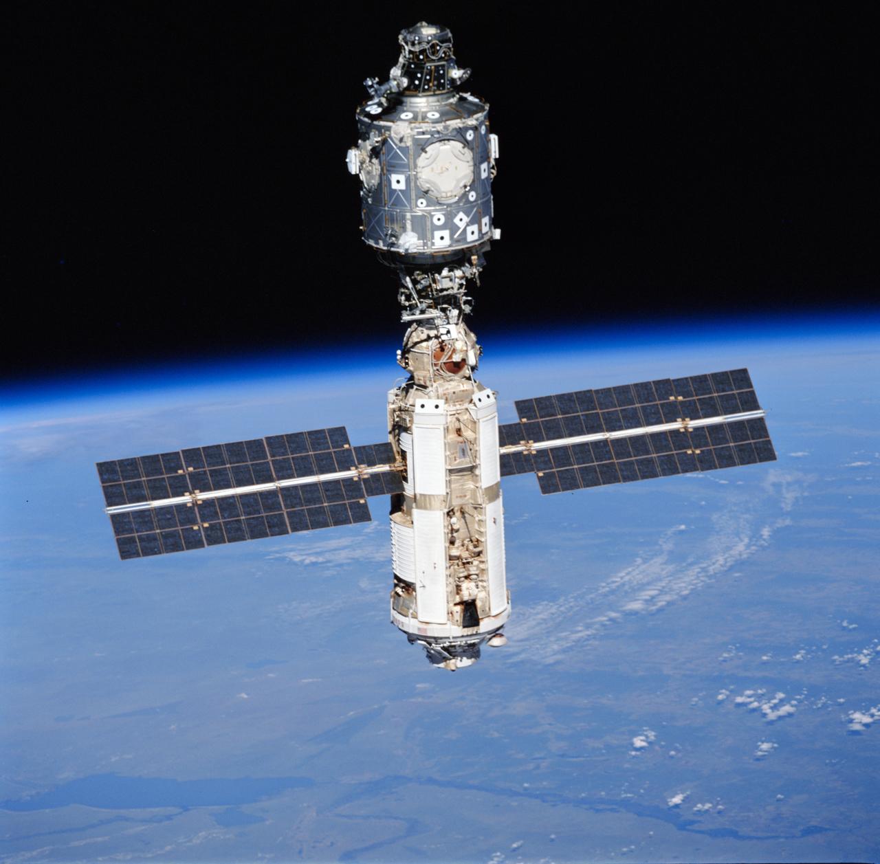
STS096-715-042 (3 June 1999) --- A STS-96 crew member aboard Discovery recorded this image of the International Space Station (ISS) with a 70mm camera during a fly-around following separation of the two spacecraft. Lake Hulun Nur in the People's Republic of China is visible in the lower left portion of the frame. A portion of the work performed on the May 30 space walk by astronauts Tamara E. Jernigan and Daniel T. Barry is evident at various points on the ISS, including the installation of the Russian-built crane (called Strela) and the U.S.-built crane.
41G-120-005 (5-13 Oct 1984) --- The Kyzyl Kum Desert of the Kazakh and Uzbek Soviet Socialist Republics. The Aralskoe More, also known as the Aral Sea, is to the south-southeast. This saltwater lake is fed mainly from waters of the Amu Darya River, mostly with snow melt water from the distant Tyan-Shan Mountains near the Afghanistan and China border. The crew consisted of astronauts Robert L. Crippen, commander; Jon A. McBride, pilot; mission specialist's Kathryn D. Sullivan, Sally K. Ride, and David D. Leestma; Canadian astronaut Marc Garneau; and Paul D. Scully-Power, payload specialist.
Shuttle crew escape systems (CES) tractor rocket tests conducted at Hurricane Mesa, Utah. This preliminary ground test of the tractor rocket will lead up to in-air evaluations. View shows tractor rocket as it is fired from side hatch mockup. The tractor rocket concept is one of two escape methods being studied to provide crew egress capability during Space Shuttle controlled gliding flight. In-air tests of the system, utilizing a Convair-240 aircraft, will begin 11-19-87 at the Naval Weapons Center in China Lake, California.
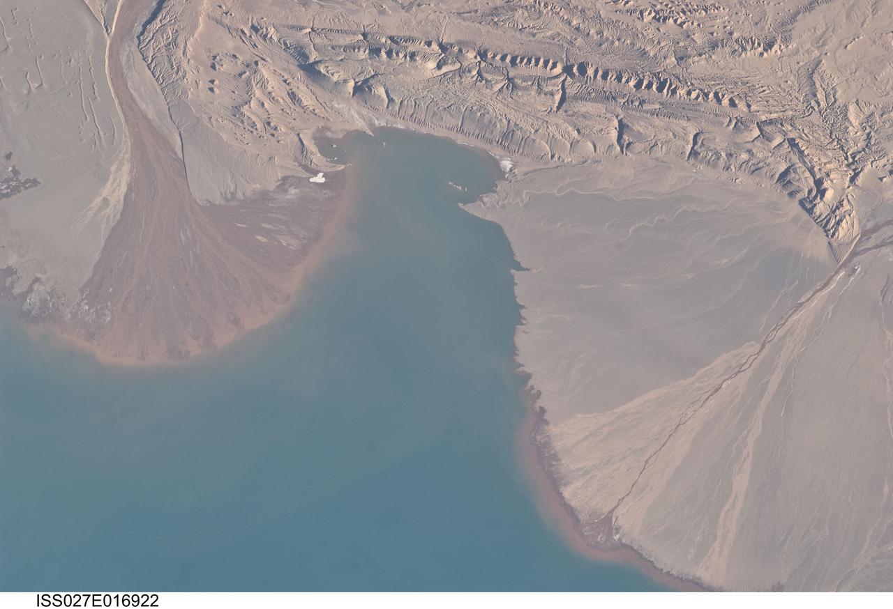
ISS027-E-016922 (25 April 2011) --- River deltas and Lake Ayakum in China (Tibet) are featured in this image photographed by an Expedition 27 crew member on the International Space Station. The Tibetan Plateau contains numerous lakes that dot an otherwise arid landscape. Lake Ayakum is located near the northern boundary of the Plateau to the southeast of the Kunlun Mountains. While many of the small glacier- and snowmelt-fed streams that cross the Tibetan Plateau eventually give rise to major Southeast Asian rivers including the Mekong and Yangtze, some empty into saline lakes such as Lake Ayakum. This detailed photograph highlights two river deltas (upper left and lower right) formed along the southwestern shoreline of the lake. When sediments build up to the point that a river can no longer flow over them, it will jump to a new channel position and begin the process anew. Scientists have noted that, over geologic time, the channels tend to sweep back and forth ? similar to the motion of an automobile windshield wiper ? to form the typical semi-circular or fan shape of the delta. Gray to tan surfaces of both deltas indicate prior positions of their respective river channels; the uniform coloration and smooth texture suggest that they are relatively old and are now inactive. In contrast, the younger and currently active delta surfaces can be recognized by reddish-brown sediment and clearly visible river channels. Lateral channel migration is particularly evident in the approximately eight-kilometer-wide active delta area at upper left. The reddish coloration of the actively depositing sediment may indicate a change from the sources that formed the older parts of the deltas (or indicate weathering and soil formation on the older deposits), or an episodic input of dust or other material to the river catchments.
Suzhou is a major city located in southeastern Jiangsu Province of East China, about 100 km northwest of Shanghai. It is a major economic center and focal point of trade and commerce. The city is situated on the lower reaches of the Yangtze River and the shores of Lake Tai. Founded in 514 BCE, Suzhou has over 2,500 years of history, with an abundant display of relics and sites of historical interest. Since major economic reforms began in 1978, Suzhou has become one of the fastest growing major cities in the world. The population has grown from 0.9 million in 1990, 2.2 million in 2000, 4.1 million in 2010, to 5.3 million in 2017. The Landsat TM image was acquired August 4, 1984, and the Aster image was acquired August 2, 2015. The images cover an area of 48 by 53 km, and are located at 31.2 degrees north, 120.4 degrees east. https://photojournal.jpl.nasa.gov/catalog/PIA22266
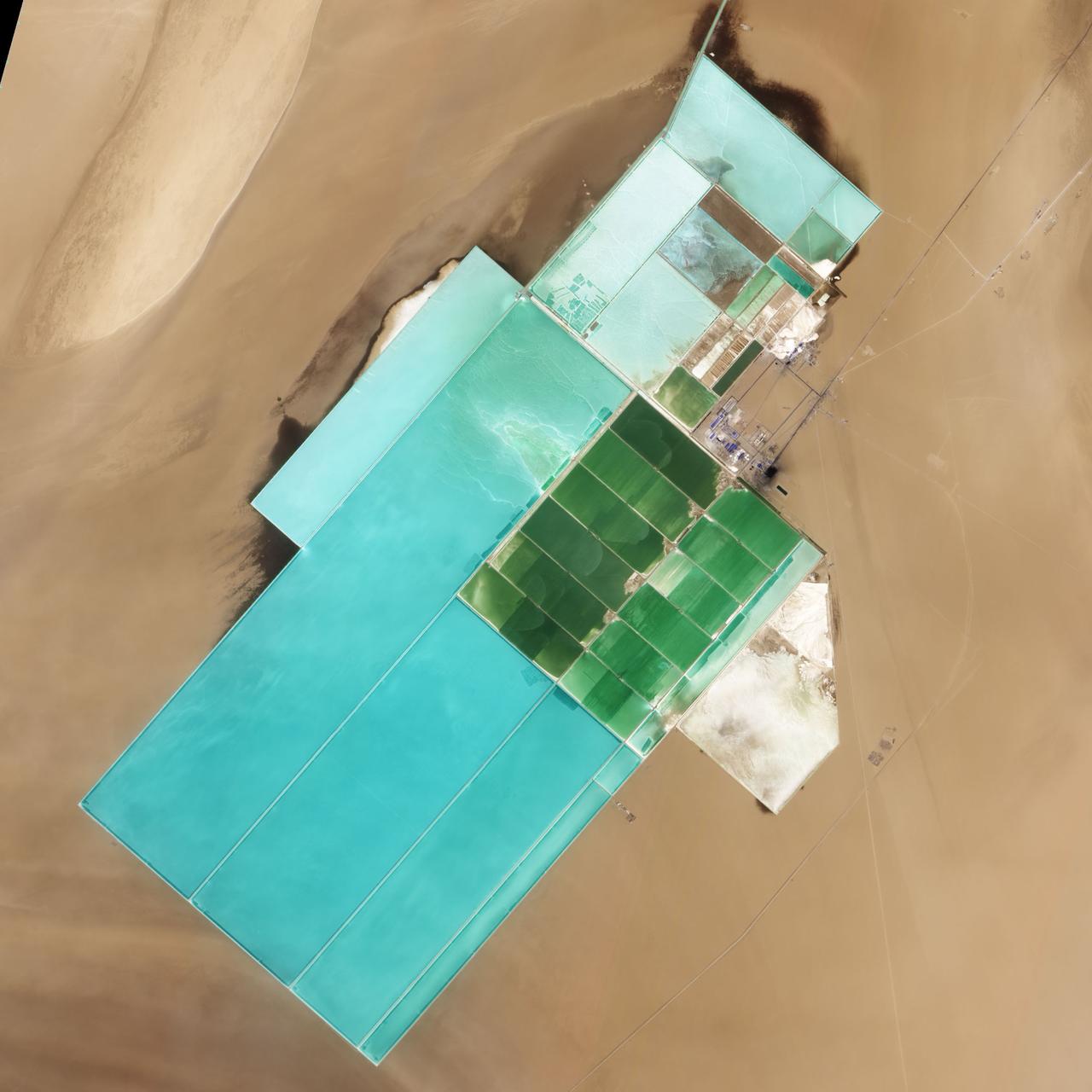
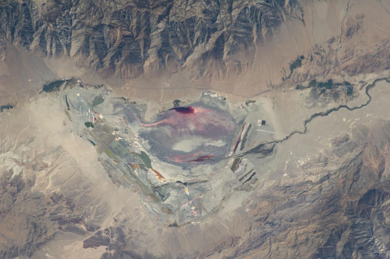
NASA image acquired May 17, 2011 Located in China’s resource-rich but moisture-poor Xinjiang autonomous region, Lop Nur is an uninviting location for any kind of agriculture. It sits at the eastern end of the Taklimakan Desert, where marching sand dunes can reach heights of 200 meters (650 feet), and dust storms rage across the landscape. Yet for all it lacks in agricultural appeal, Lop Nur offers something valuable to farmers the world over: potash. This potassium salt provides a major nutrient required for plant growth, making it a key ingredient in fertilizer. The discovery of potash at Lop Nur in the mid-1990s turned the area into a large-scale mining operation. The Advanced Land Imager (ALI) on NASA’s Earth Observing-1 (EO-1) satellite captured this natural-color image of Lop Nur on May 17, 2011. The rectangular shapes in this image show the bright colors characteristic of solar evaporation ponds. Around the evaporation ponds are the earth tones typical of sandy desert. During the early and middle Pleistocene epoch, this area held a large brackish lake. Uplift of the northern part of the lake in the late Pleistocene created hollows that became receptacles for potash deposition. The main potash deposits found at Lop Nur today are brine potash, and this site is the second-largest source of potash in China. Lop Nur slowly dried up in the Holocene. The area now receives average annual precipitation of just 31.2 millimeters (1.2 inches), and experiences annual evaporation of 2,901 millimeters (114 inches), according to a study published in 2008. The study found, however, that this area has experienced seven major climate changes since the end of the Pleistocene, including climatic conditions far more favorable to farming and settlement than today. Examination of plant and mollusk remains at the lake, as well as studies of sediments, indicate that the Lop Nur region experienced a severe drought about 3,000 years ago, followed by wetter conditions. Between 1,250 and 400 years ago, Lop Nur likely experienced the conditions most favorable to farming and settlement, and red willow trees grew in the area. Pottery dating from the Tang and Song dynasties further testifies to welcoming conditions at the lake centuries ago. Starting around 400 years ago, however, a more arid climate took hold, completely drying out Lop Nur. Today, by providing potash, the desiccated lake still supports agriculture, but it does so for farming efforts further afield. NASA Earth Observatory image created by Jesse Allen and Robert Simmon, using EO-1 ALI data provided courtesy of the NASA EO-1 team. Caption by Michon Scott. Instrument: EO-1 - ALI Credit: <b><a href="http://www.earthobservatory.nasa.gov/" rel="nofollow"> NASA Earth Observatory</a></b> <b><a href="http://www.nasa.gov/centers/goddard/home/index.html" rel="nofollow">NASA Goddard Space Flight Center</a></b> enables NASA’s mission through four scientific endeavors: Earth Science, Heliophysics, Solar System Exploration, and Astrophysics. Goddard plays a leading role in NASA’s accomplishments by contributing compelling scientific knowledge to advance the Agency’s mission. <b>Follow us on <a href="http://twitter.com/NASA_GoddardPix" rel="nofollow">Twitter</a></b> <b>Like us on <a href="http://www.facebook.com/pages/Greenbelt-MD/NASA-Goddard/395013845897?ref=tsd" rel="nofollow">Facebook</a></b> <b>Find us on <a href="http://web.stagram.com/n/nasagoddard/?vm=grid" rel="nofollow">Instagram</a></b>
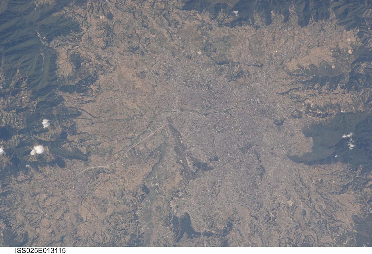
ISS025-E-013115 (9 Nov. 2010) --- Kathmandu, Nepal is featured in this image photographed by an Expedition 25 crew member on the International Space Station. The capital and largest city of Nepal, Kathmandu occupies much of the Kathmandu Valley located near the center of the country. Nepal itself contains much of the Himalaya mountain range between China (Tibet) to the north and India to the south. Geological and fossil evidence indicates that the Kathmandu Valley was filled by a large lake (Paleo-Kathmandu Lake) between approximately 2.8 million and 10,000 years ago, according to scientists. Geologists believe the lake drained in phases over time due both to a drier regional climate, continuing tectonic uplift and faulting in the region, and formation of an integrated valley drainage system as river channels cut through previous natural rock ridge dams. The green vegetated slopes that ring the Kathmandu metro area (light gray, center) include both forest reserves and national parks. The metropolitan area is relatively flat compared to the surrounding high mountains. Tribhuvan International Airport, located near the current eastern margin of the metro area, is the only international airport in Nepal. Archeological evidence suggests that the development of Kathmandu, together with the nearby “sister cities” of Lalitpur and Bhaktapur, began almost 2,000 years ago. Today, Kathmandu and its sister cities form the governmental, cultural, and—as a main access point to the Himalayas for tourism—economic center of the country.
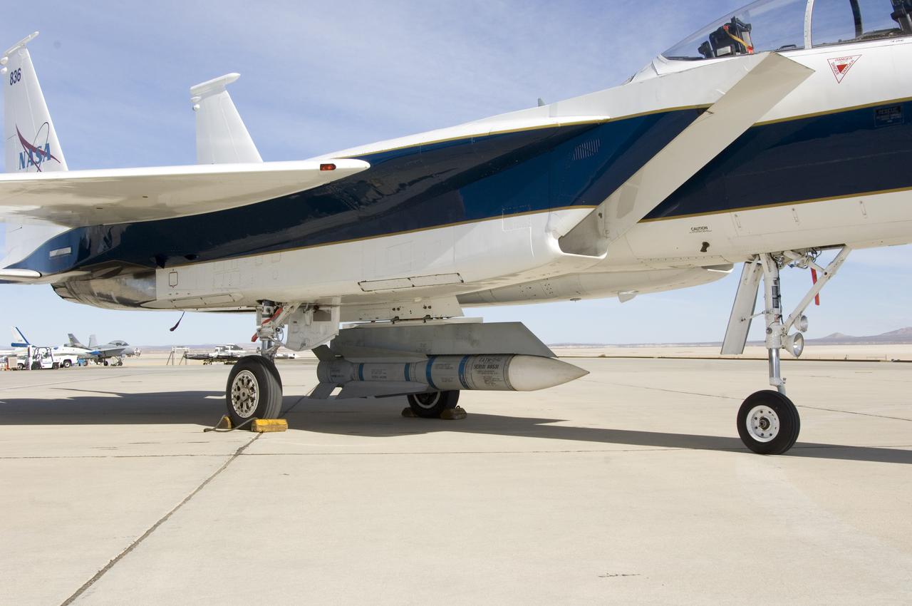
An inert AIM-54 Phoenix missile nestled under the fuselage of NASA Dryden's F-15B aircraft is being studied as a possible test vehicle to obtain hypersonic data.

NASA Dryden aircraft and avionics technicians (from left) Bryan Hookland, Art Cope, Herman Rijfkogel and Jonathan Richards install the nose cone on a Phoenix missile prior to a fit check on the center's F-15B research aircraft.
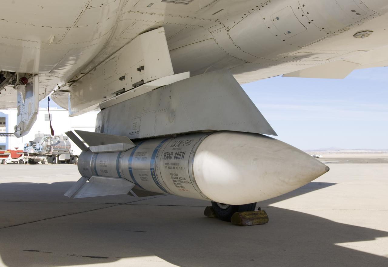
Surplus Navy Phoenix missiles like this one mounted on the centerline pylon of NASA's F-15B research aircraft may be used to acquire hypersonic flight test data.
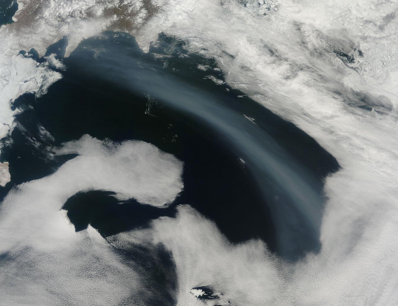
Smoke from Far Eastern Russia’s spring wildfires reached the Bering Sea by May 11, 2012. The Moderate Resolution Imaging Spectroradiometer aboard NASA’s Terra satellite passed over the region at 23:30 UTC on that same day and acquired this true-color image of a broad band of smoke stretching across the blue waters. In this image, the plume of smoke appears light gray while banks of cloud are bright white. Snow covers much of Kamchatka the land mass in the west. Karaginsky Island, just off Kamchatka’s eastern shore, is surrounded by sea ice. Clouds stream off the southwest shores of Beringa and Medny Islands. To the east, Attu Station, Alaska, is surrounded by cloud. In early May, numerous wildfires burned near Lake Baikal, in Siberia. These fires billowed heavy smoke across eastern Mongolia, China and Russia’s Far East. An image of the smoke and fires was captured on May 8 and appeared as the MODIS image of the day on May 11. That image can be viewed here: <a href="http://modis.gsfc.nasa.gov/gallery/individual.php?db_date=2012-05-11" rel="nofollow">modis.gsfc.nasa.gov/gallery/individual.php?db_date=2012-0...</a>. According to a model by the National Oceanic and Atmospheric Administration (NOAA), it is possible that smoke from the Lake Baikal region could take just a few days to reach the Bering Sea. Credit: NASA/GSFC/Jeff Schmaltz/MODIS Land Rapid Response Team <b><a href="http://www.nasa.gov/audience/formedia/features/MP_Photo_Guidelines.html" rel="nofollow">NASA image use policy.</a></b> <b><a href="http://www.nasa.gov/centers/goddard/home/index.html" rel="nofollow">NASA Goddard Space Flight Center</a></b> enables NASA’s mission through four scientific endeavors: Earth Science, Heliophysics, Solar System Exploration, and Astrophysics. Goddard plays a leading role in NASA’s accomplishments by contributing compelling scientific knowledge to advance the Agency’s mission. <b>Follow us on <a href="http://twitter.com/NASA_GoddardPix" rel="nofollow">Twitter</a></b> <b>Like us on <a href="http://www.facebook.com/pages/Greenbelt-MD/NASA-Goddard/395013845897?ref=tsd" rel="nofollow">Facebook</a></b> <b>Find us on <a href="http://instagrid.me/nasagoddard/?vm=grid" rel="nofollow">Instagram</a></b>
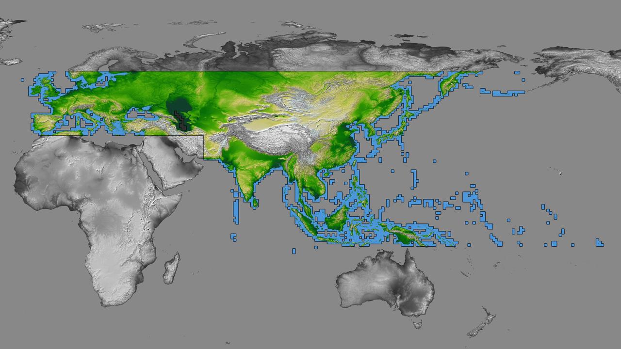
inal Caption Released with Image: The colored regions of this map show the extent of digital elevation data recently released by the Shuttle Radar Topography Mission (SRTM). This release includes data for most of Europe and Asia plus numerous islands in the Indian and Pacific Oceans. SRTM flew on board the Space Shuttle Endeavour in February 2000 and used an interferometric radar system to map the topography of Earth's landmass between latitudes 56 degrees south and 60 degrees north. The data were processed into geographic "tiles," each of which represents one by one degree of latitude and longitude. A degree of latitude measures 111 kilometers (69 miles) north-south, and a degree of longitude measures 111 kilometers or less east-west, decreasing away from the equator. The data are being released to the public on a continent-by-continent basis. This Eurasia segment includes 5,940 tiles, more than a third of the total data set. Previous releases covered North America and South America. Forthcoming releases will include Africa-Arabia and Australia plus an "Islands" release for those islands not included in the continental releases. Together these data releases constitute the world's first high-resolution, near-global elevation model. The resolution of the publicly released data is three arcseconds (1/1,200 of a degree of latitude and longitude), which is about 90 meters (295 feet). European coverage in the current data release stretches eastward from the British Isles and the Iberian Peninsula in the west, across the Alps and Carpathian Mountains, as well as the Northern European Plain, to the Ural and Caucasus Mountains bordering Asia. The Asian coverage includes a great diversity of landforms, including the Tibetan Plateau, Tarin Basin, Mongolian Plateau, and the mountains surrounding Lake Baikal, the world's deepest lake. Mt. Everest in the Himalayas, at 8,848 meters (29,029 feet) is the world's highest mountain. From India's Deccan Plateau, to Southeast Asia, coastal China, and Korea, various landforms place constraints upon land use planning for a great population. Volcanoes in the East Indies, the Philippines, Japan, and the Kamchatka Peninsula form the western part of the "Ring of Fire" around the Pacific Ocean. Many of these regions were previously very poorly mapped due to persistent cloud cover or the inaccessibility of the terrain. Digital elevation data, such as provided by SRTM, are particularly in high demand by scientists studying earthquakes, volcanism, and erosion patterns for use in mapping and modeling hazards to human habitation. But the shape of Earth's surface affects nearly every natural process and human endeavor that occurs there, so elevation data are used in a wide range of applications. In this index map color-coding is directly related to topographic height, with green at the lower elevations, rising through yellow and tan, to white at the highest elevations. The large, very dark green feature in western Asia is the Caspian Sea, which is below sea level. Blue areas on the map represent water within the mapped tiles, each of which includes shorelines or islands. http://photojournal.jpl.nasa.gov/catalog/PIA03398