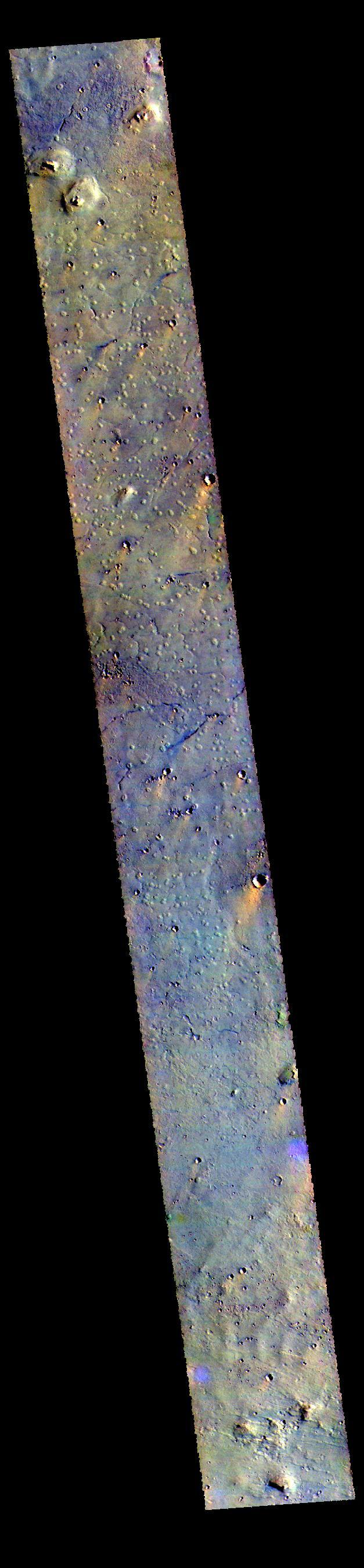
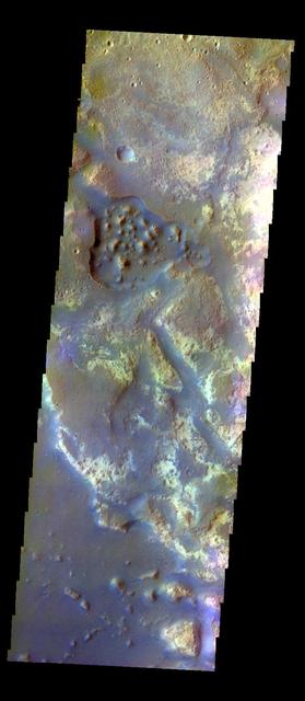
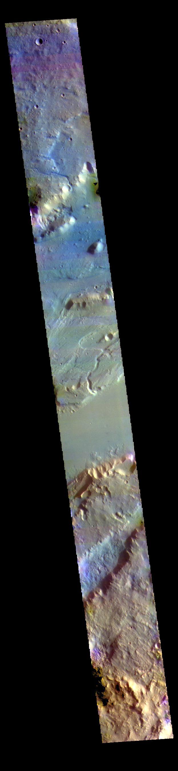
The THEMIS VIS camera contains 5 filters. The data from different filters can be combined in multiple ways to create a false color image. These false color images may reveal subtle variations of the surface not easily identified in a single band image. Today's false color image shows part of the margin of Chryse Planitia. Dark blue in this false color combination is mostly likely basaltic material/dunes. Orbit Number: 44280 Latitude: 33.0423 Longitude: 309.853 Instrument: VIS Captured: 2011-12-08 07:16 http://photojournal.jpl.nasa.gov/catalog/PIA21162
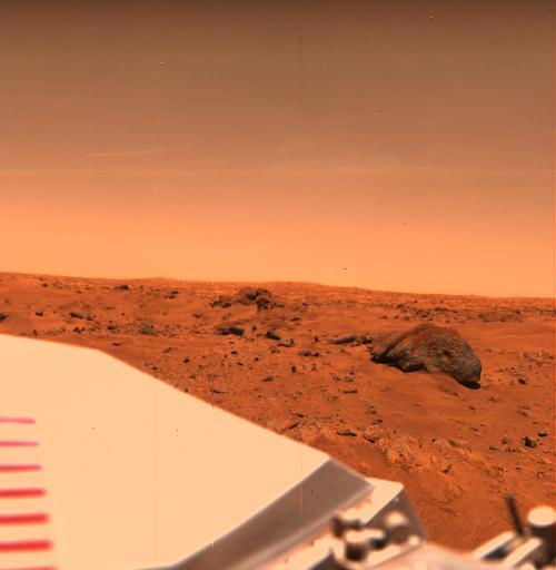
Big Joe in the Chryse Planitia
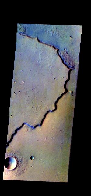
Surface Changes in Chryse Planitia
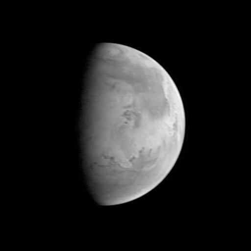
MGS Approach Image - Chryse Planitia
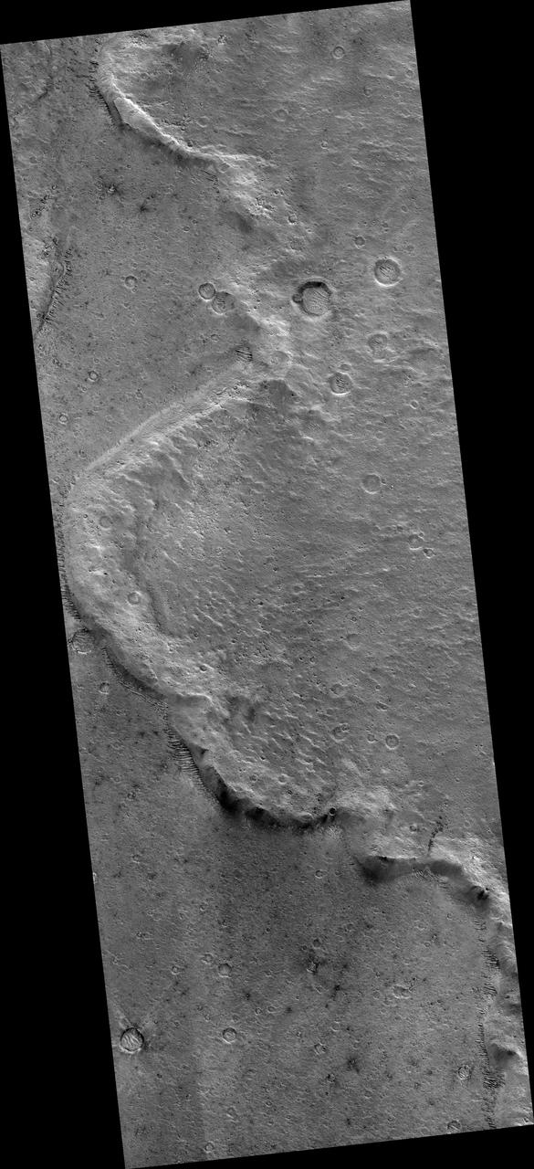
Distal Rampart of Crater in Chryse Planitia
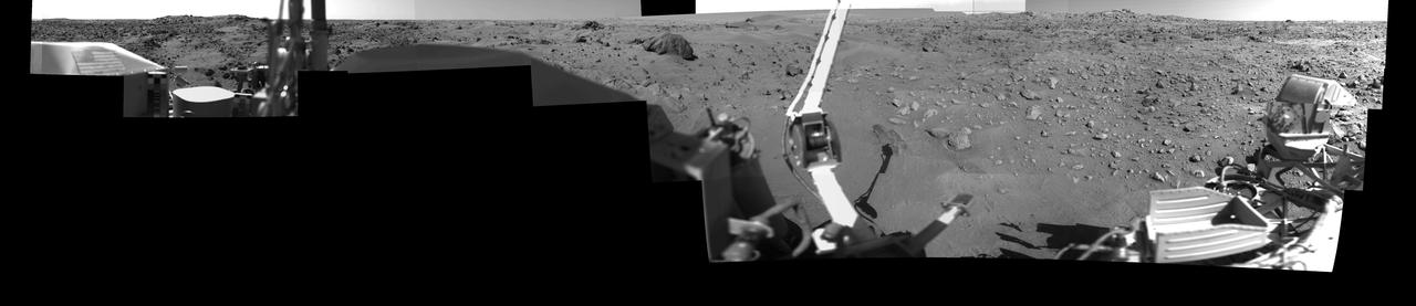
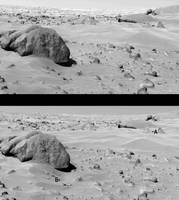
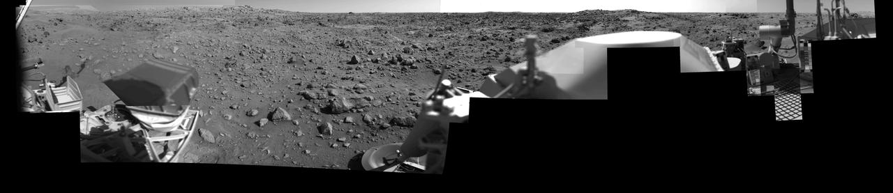
Afternoon on Chryse Planitia - Viking Lander 1 Camera 1 Mosaic
Morning on Chryse Planitia - Viking Lander 1 Camera 1 Mosaic
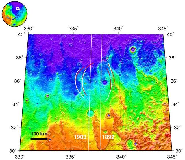
Topographic Map of Chryse Planitia with Location of Possible Buried Basin
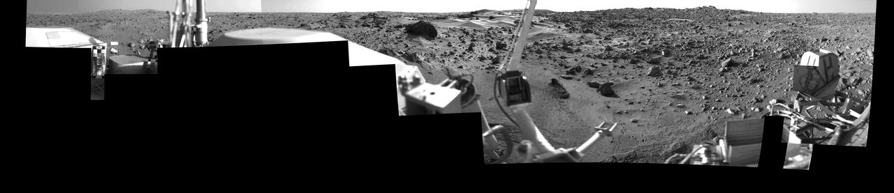
Afternoon on Chryse Planitia - Viking Lander 1 Camera 2 Mosaic
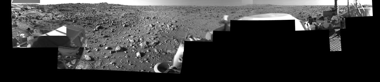
Morning on Chryse Planitia - Viking Lander 1 Camera 2 Mosaic
This VIS image shows some of the plains of Chryse Planitia. The THEMIS VIS camera contains 5 filters. The data from different filters can be combined in multiple ways to create a false color image. These false color images may reveal subtle variations of the surface not easily identified in a single band image. Orbit Number: 61439 Latitude: 35.01 Longitude: 327.345 Instrument: VIS Captured: 2015-10-20 15:41 https://photojournal.jpl.nasa.gov/catalog/PIA22793
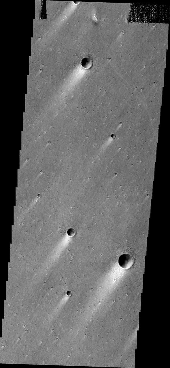
Windstreaks located in Chryse Planitia as seen by NASA 2001 Mars Odyssey spacecraft.

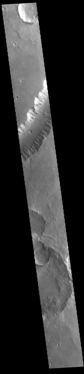
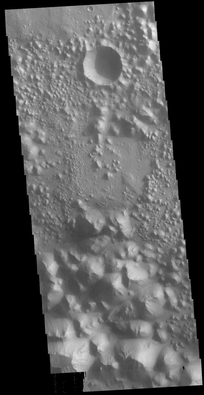
Multiple overlapping lobes of ejecta are visible in this image of an unnamed crater in Chryse Planitia as seen by NASA 2001 Mars Odyssey spacecraft.
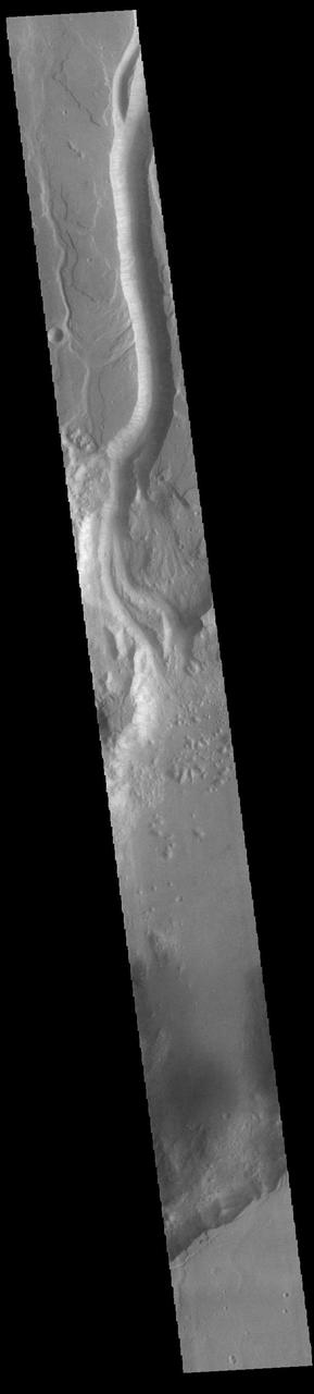
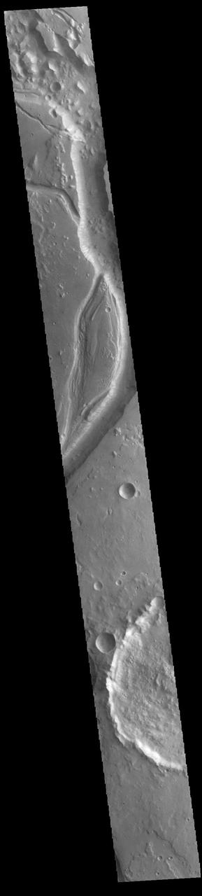
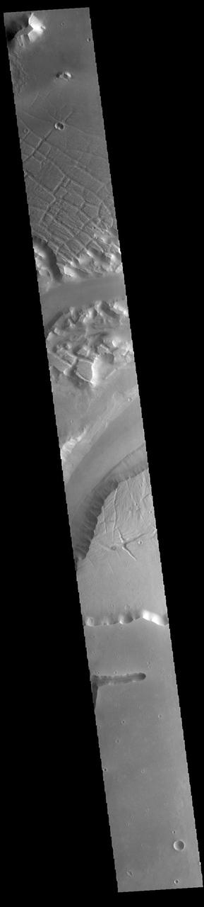
The channels, both large and small, in this image from NASA 2001 Mars Odyssey spacecraft are part of Kasei Valles near its terminus in Chryse Planitia.
This image from NASA 2001 Mars Odyssey spacecraft is located on the margin of Tempe Terra near Chryse Planitia. Several channels are visible as well as tectonic features.
This image captured by NASA 2001 Mars Odyssey spacecraft shows a small portion of Shalbatana Vallis, near the end of the channel where it drains into Chryse Planitia.
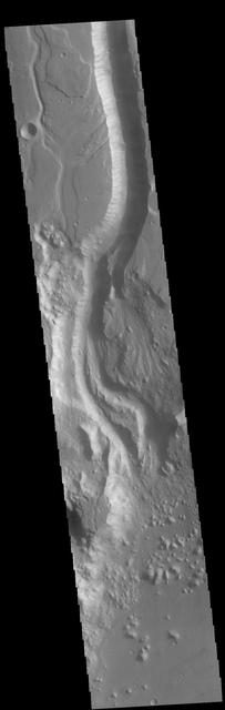
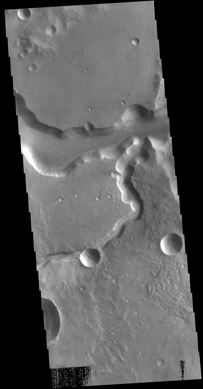
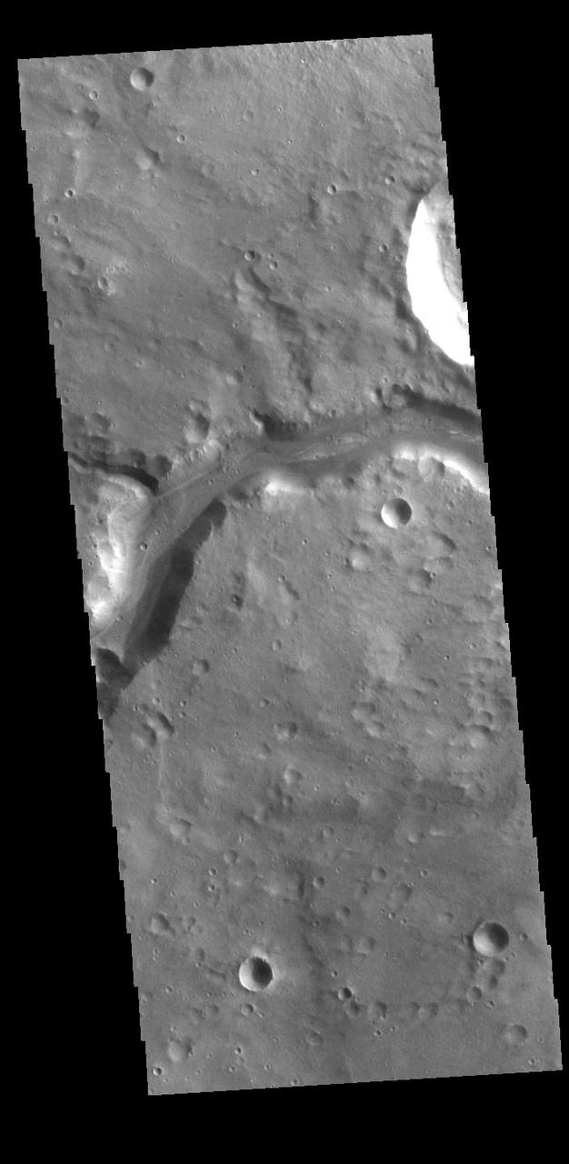
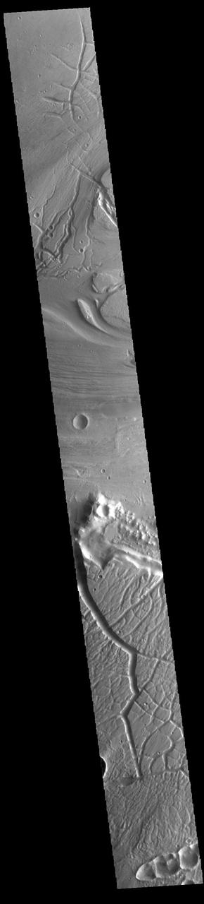
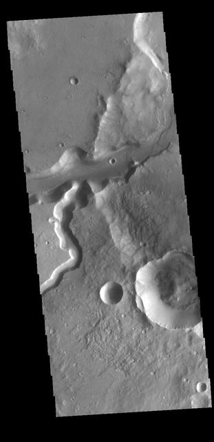
Today's VIS image shows a small portion of Lobo Vallis near where it recombines with Kasei Valles and empties into Chryse Planitia. Kasei Valles is a huge channel system that drained the higher elevations of Tharsis into the low of Chryse Planitia. Orbit Number: 71206 Latitude: 28.9604 Longitude: 303.568 Instrument: VIS Captured: 2018-01-02 06:02 https://photojournal.jpl.nasa.gov/catalog/PIA22374
Today's VIS image shows a section of Kasei Valles. This complex channel arose in the Tharsis voclanic region and flowed eastward into Chryse Planitia. Chryse Planitia is a large circular basin, probably formed by a meteor impact. Orbit Number: 80675 Latitude: 26.039 Longitude: 307.827 Instrument: VIS Captured: 2020-02-21 02:28 https://photojournal.jpl.nasa.gov/catalog/PIA23858
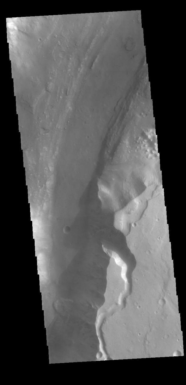
This image from NASA 2001 Mars Odyssey spacecraft shows a streamlined island in a broad channel in Chryse Planitia. The channel is part of the outflow region of Lobo Vallis, a northern branch of Kasei Valles.
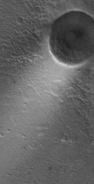
This MOC image shows a wind streak created in the lee -- the downwind side -- of a crater in far eastern Chryse Planitia. The winds responsible for the formation of the streak blew from the upper right northeast to the lower left southwest
This image from NASA 2001 Mars Odyssey spacecraft is of Lismore Crater. This crater, located in Chryse Planitia, is relatively unmodified, meaning it appears very much like it did when it first formed.
Oxia Planum is an ancient Noachian epoch terrain situated to the east of Chryse Planitia at about 18 degrees north. This image from NASA Mars Reconnaissance Orbiteris of a proposed ExoMars Landing Site.
This Mars Global Surveyor MGS Mars Orbiter Camera MOC image shows two impact craters of nearly equal size, plus their associated wind streaks. These occur in far eastern Chryse Planitia
There are several streamlined islands in this image of Kasei Valles. This image captured by NASA 2001 Mars Odyssey spacecraft is located near the region where Kasei Valles empties into Chryse Planitia.
This VIS image shows part of Ares Vallis, one of the large channels in Margaritfer Terra that empty into Chryse Planitia. Orbit Number: 72477 Latitude: 5.49596 Longitude: 341.524 Instrument: VIS Captured: 2018-04-16 22:49 https://photojournal.jpl.nasa.gov/catalog/PIA22610
This VIS image shows a section of Shalbatana Vallis. Shalbatana Vallis is located in Xanthe Terra and is one of many channels that empty into Chryse Planitia. Orbit Number: 79639 Latitude: 8.5729 Longitude: 317.92 Instrument: VIS Captured: 2019-11-27 19:06 https://photojournal.jpl.nasa.gov/catalog/PIA23706

This VIS image shows a section of Shalbatana Vallis. Shalbatana Vallis is one of many channels that empty into Chryse Planitia. Orbit Number: 71904 Latitude: 8.70914 Longitude: 319.411 Instrument: VIS Captured: 2018-02-28 17:58 https://photojournal.jpl.nasa.gov/catalog/PIA22499
Today's VIS image shows a section of Ares Vallis. Ares Vallis is a large channel that arises in Iani Chaos, passes through Margaritifer Terra, and then empties into Chryse Planitia. Orbit Number: 80624 Latitude: 0.445959 Longitude: 342.666 Instrument: VIS Captured: 2020-02-16 21:33 https://photojournal.jpl.nasa.gov/catalog/PIA23843
Today's VIS image shows a section of unnamed channel located at the margin where large northward flowing channels enter Chryse Planitia. Channels such as Tiu, Ares, and Shalbatana Valles arise from the Valles Marineris canyons to empty a thousand miles later into the Chryse basin. Ares Vallis is over 1600km long (1000 miles) and Tiu Vallis is over 1720km long (1069 miles). Orbit Number: 81548 Latitude: 10.9272 Longitude: 324.621 Instrument: VIS Captured: 2020-05-02 23:34 https://photojournal.jpl.nasa.gov/catalog/PIA23995
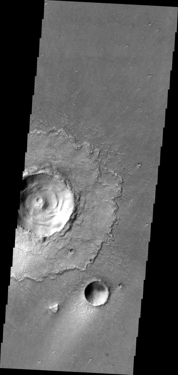
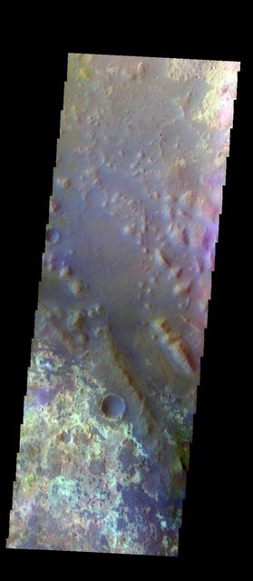
The THEMIS VIS camera contains 5 filters. The data from different filters can be combined in multiple ways to create a false color image. This false color image from NASA 2001 Mars Odyssey spacecraft shows part of Calahorra Crater in Chryse Planitia.
The THEMIS VIS camera contains 5 filters. The data from different filters can be combined in multiple ways to create a false color image. This image from NASA 2001 Mars Odyssey spacecraft shows where Mawrth Vallis empties into Chryse Planitia.
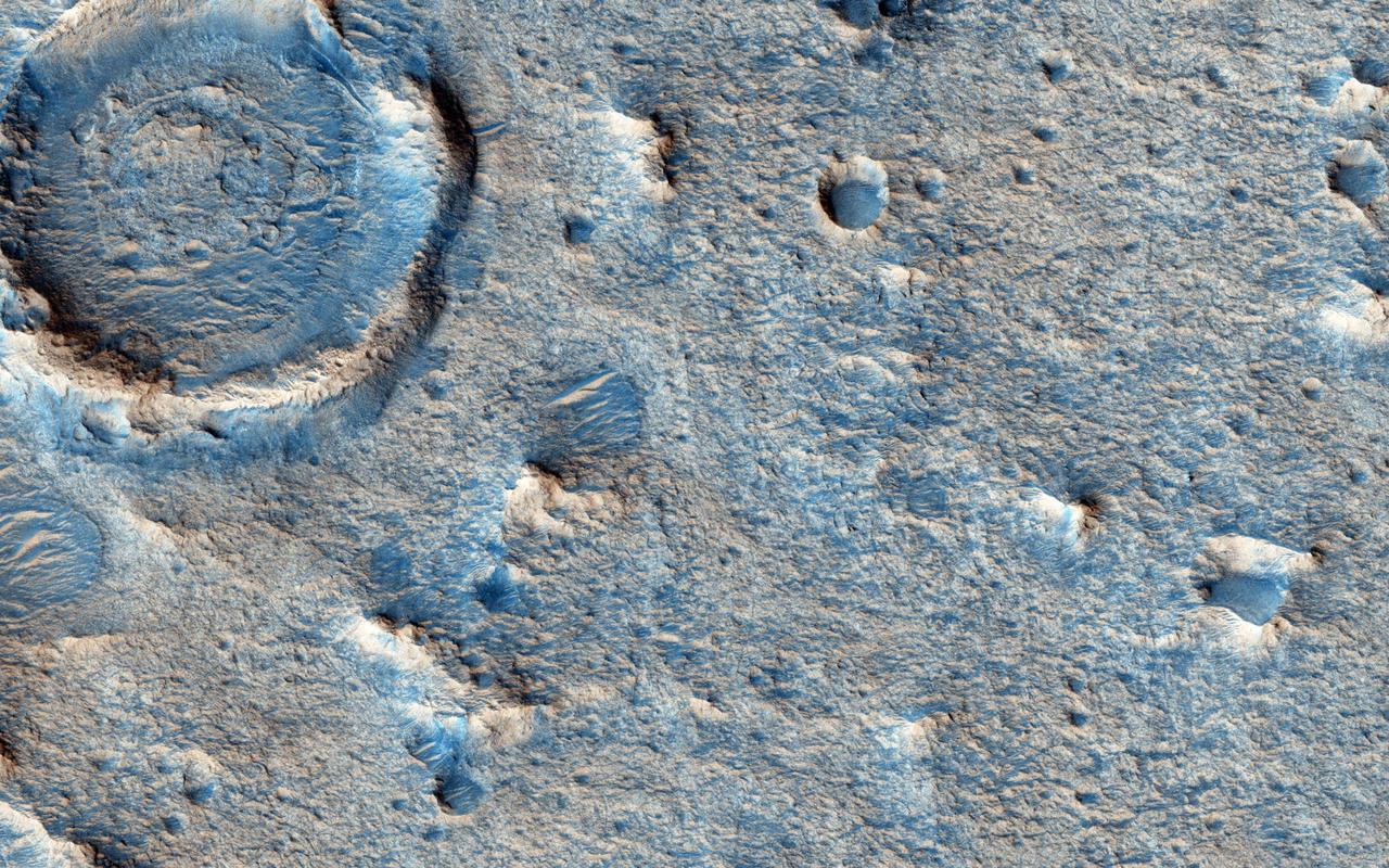
The suggested area in this observation from NASA Mars Reconnaissance Orbiter is characterized by a group of cones, shield-like features, and round mounds. They are a few hundred meters to kilometers in diameter but their heights are unknown.
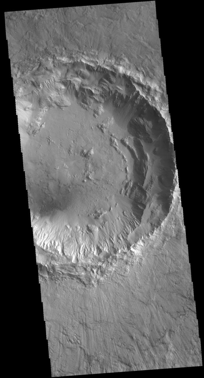
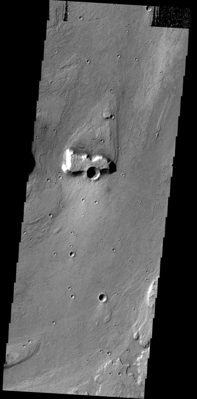
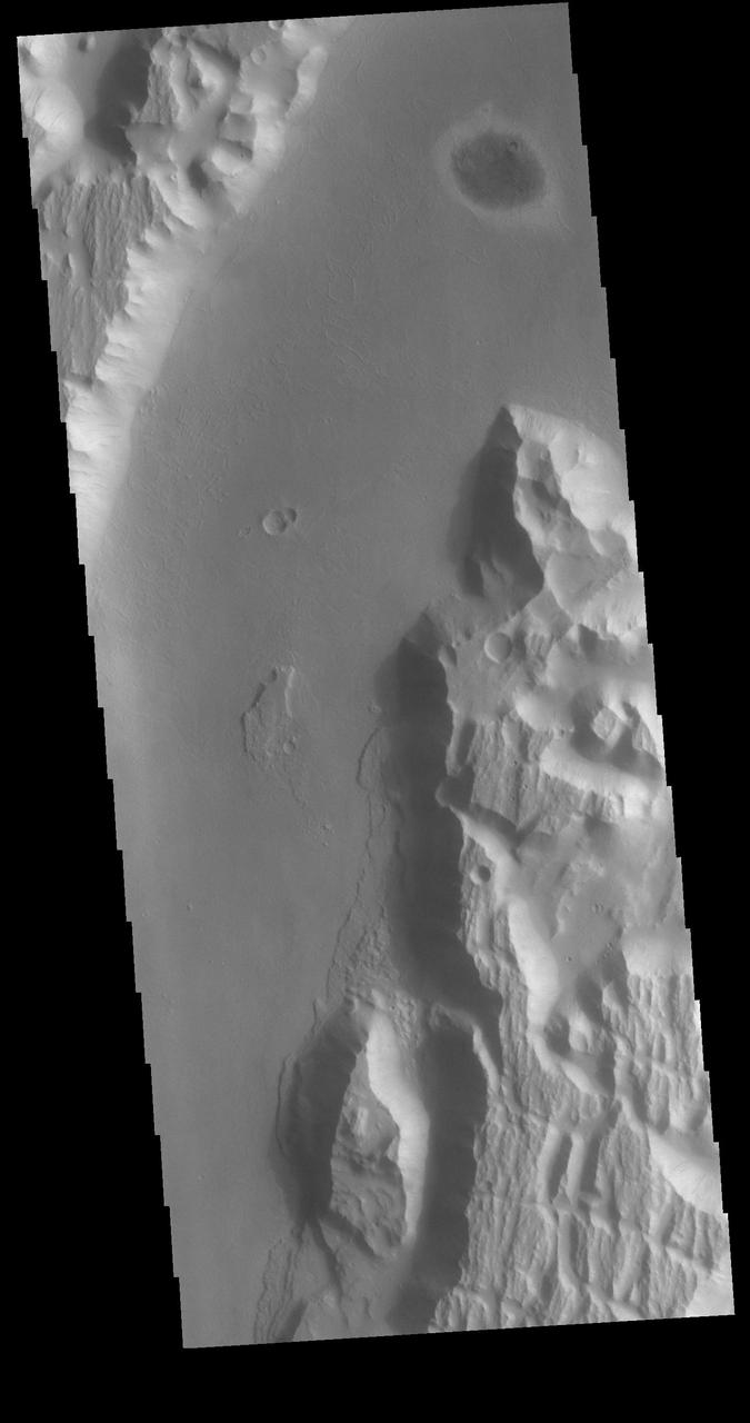
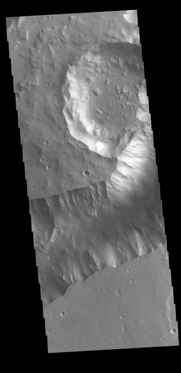
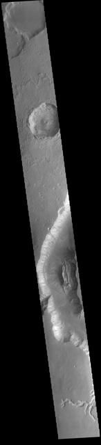
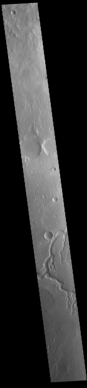
Today's VIS image from NASA's 2001 Mars Odyssey is of an unnamed crater in Chryse Planitia. There are several concentric ridges visible on the right side of this image. These features formed at the time of impact and are part of the rim structure of this crater. Numerous gullies dissect the rim and a small dune field is located on the floor of the crater. Orbit Number: 61676 Latitude: 36.5047 Longitude: 329.655 Instrument: VIS Captured: 2015-11-09 04:07 http://photojournal.jpl.nasa.gov/catalog/PIA20233
This VIS image shows a section of Shalbatana Vallis. Located in Xanthe Terra, Shalbatana Vallis is one of many channels that empty into Chryse Planitia. Shalbatana Vallis is an outflow channel carved by massive floods from escaping groundwater whose source lies far to the south of this image. The vallis is over 1300 km long (807 miles). Orbit Number: 79040 Latitude: 8.51397 Longitude: 319.159 Instrument: VIS Captured: 2019-10-09 11:21 https://photojournal.jpl.nasa.gov/catalog/PIA23561
Bahram Vallis crosses this VIS image. Bharam Vallis drains from the the higher elevations of Lunae Planum into the Chryse Planitia basin. At the base of several of the scalloped channel wall sections deposits of material can be seen. Orbit Number: 77643 Latitude: 20.8706 Longitude: 303.262 Instrument: VIS Captured: 2019-06-16 10:30 https://photojournal.jpl.nasa.gov/catalog/PIA23363
Bahram Vallis crosses this VIS image. Bharam Vallis drains from the higher elevations of Lunae Planum into the Chryse Planitia basin. Bahram Vallis is 270km (167 miles) long, with an almost uniform width along most of the channel. Orbit Number: 86116 Latitude: 20.5906 Longitude: 302.116 Instrument: VIS Captured: 2021-05-14 02:29 https://photojournal.jpl.nasa.gov/catalog/PIA24222
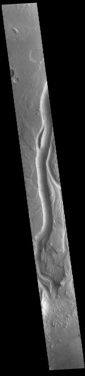
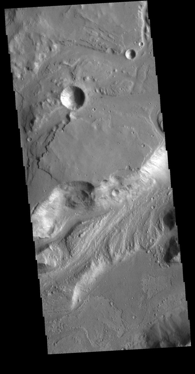
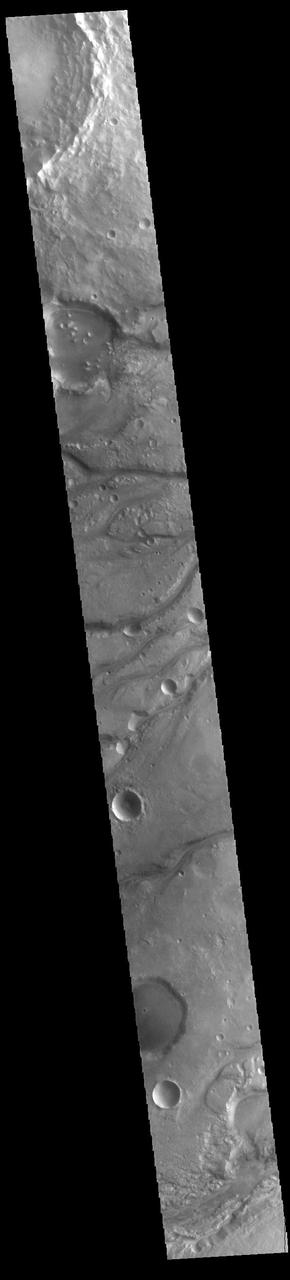
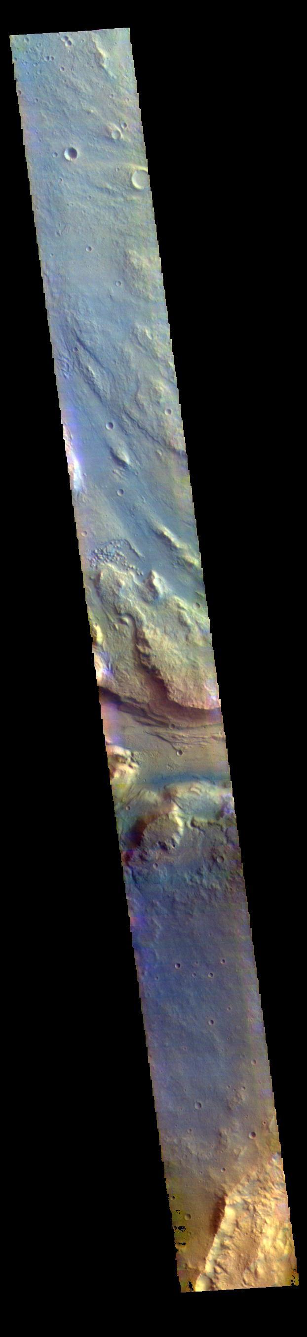
This image captured by NASA 2001 Mars Odyssey spacecraft shows a small portion of Kasei Valles, a large outflow channel system located between the Tharsis volcanic highlands to the west and the lower elevation Chryse Planitia to the east. Orbit Number: 61889 Latitude: 28.226 Longitude: 305.133 Instrument: VIS Captured: 2015-11-26 17:04 http://photojournal.jpl.nasa.gov/catalog/PIA20241
Today's VIS image shows part of Ares Vallis. Located in Margaritifer Terra, Ares Vallis is part of a large system of channels that arise from Vallis Marineris and empty into Chryse Planitia. Orbit Number: 85304 Latitude: 16.5128 Longitude: 327.987 Instrument: VIS Captured: 2021-03-08 05:51 https://photojournal.jpl.nasa.gov/catalog/PIA24775
This VIS image shows a section of Kasei Valles. Kasei Valles is a huge outflow channel that drains from the higher elevations of Tharsis down into the lowlands of Chryse Planitia. The THEMIS VIS camera contains 5 filters. The data from different filters can be combined in multiple ways to create a false color image. These false color images may reveal subtle variations of the surface not easily identified in a single band image. Orbit Number: 61365 Latitude: 26.3054 Longitude: 303.514 Instrument: VIS Captured: 2015-10-14 13:23 https://photojournal.jpl.nasa.gov/catalog/PIA22790
Today's VIS image shows a portion of Kasei Valles, just at the region where the northward flow of the channel turns eastward towards it's eventual end in Chryse Planitia. Kasei Valles is one of the largest outflow channel systems on Mars, in places up to 482 km (300 miles) wide and 1580 km (982 miles) long. For comparison, the Grand Canyon in Arizona is is only 29 km (18 miles) at its widest and only 446 km (277 miles) long. Orbit Number: 79952 Latitude: 20.11 Longitude: 286.449 Instrument: VIS Captured: 2019-12-23 13:42 https://photojournal.jpl.nasa.gov/catalog/PIA23748
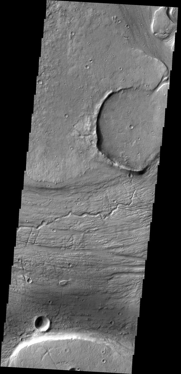
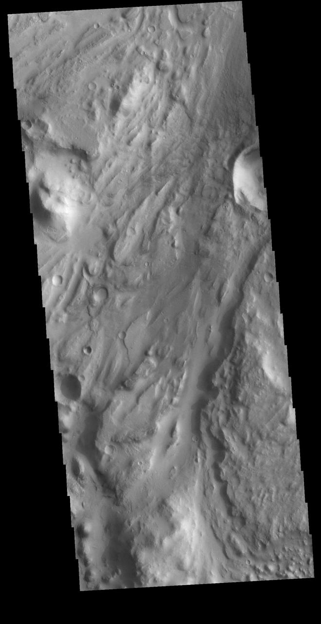
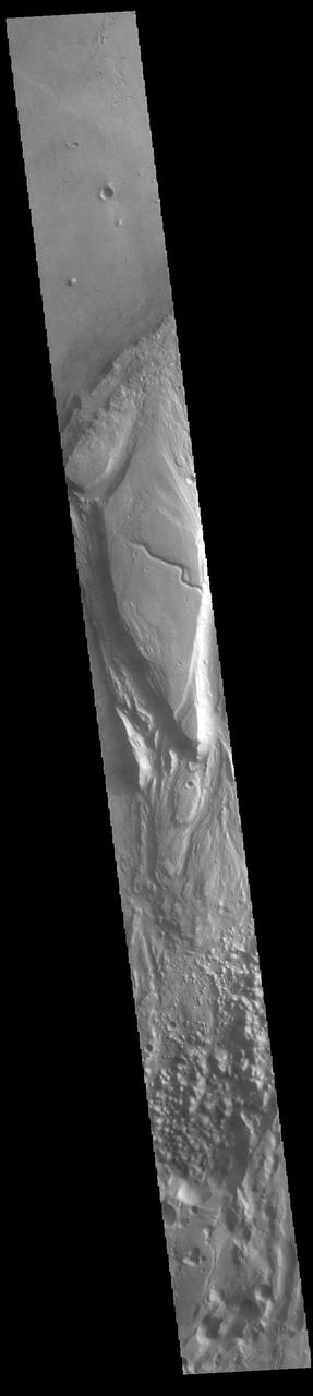
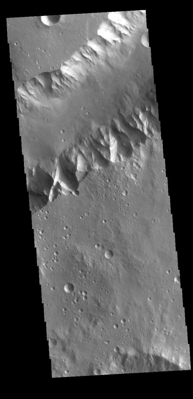
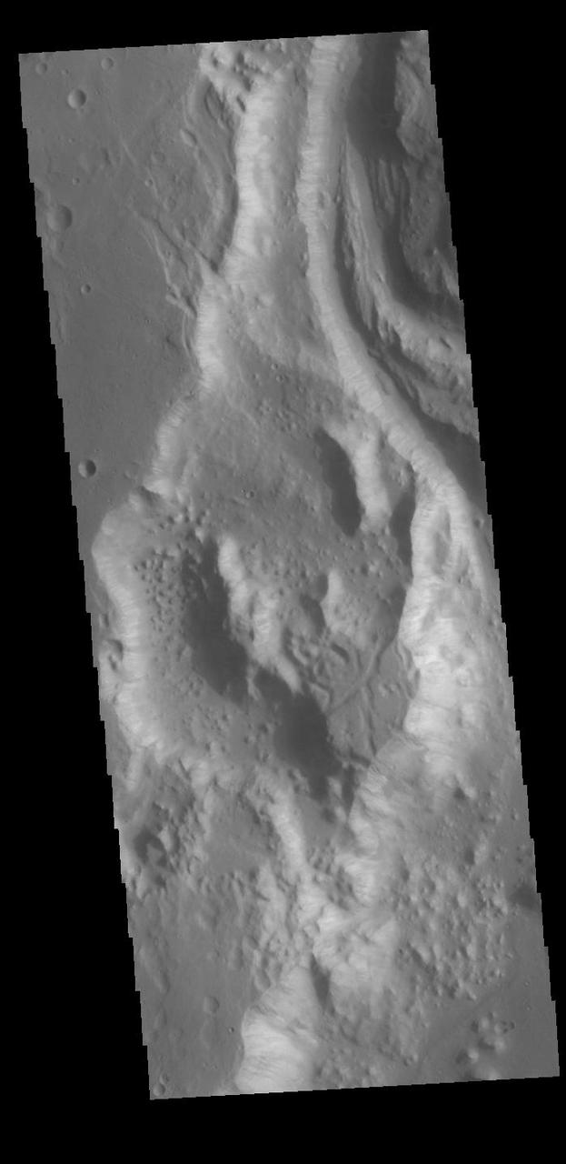
Huge regions of complex valleys and chaos are located in Xanthe and Margaritifer Terras. Rising from Valles Marineris, outflow channels like Ares, Tiu and Shalbantana valles empty into Chryse Planitia. This VIS image shows part of Chryse Chaos, located within Masursky Crater, along the Tiu Valles channel. Chaos forms from erosion of the surface into mesa features. With time the valleys expand creating the jumble of hills seen in the image. Orbit Number: 79152 Latitude: 11.5428 Longitude: 327.544 Instrument: VIS Captured: 2019-10-18 16:42 https://photojournal.jpl.nasa.gov/catalog/PIA23578

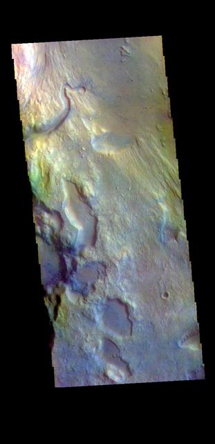
This image was acquired on May 15, 2018 by NASA's Mars Reconnaissance Orbiter. This observation shows relatively bright mounds scattered throughout darker and diverse surfaces in Chryse Planitia. These mounds are hundreds of meters in size. The largest of the mounds shows a central pit, similar to the collapsed craters found at the summit of some volcanoes on Earth. The origins of these pitted mounds or cratered cones are uncertain. They could be the result of the interaction of lava and water, or perhaps formed from the eruption of hot mud originating from beneath the surface. These features are very interesting to scientists who study Mars, especially to those involved in the ExoMars Trace Gas Orbiter mission. If these mounds are indeed mud-related, they may be one of the long sought after sources for transient methane on Mars. More information is available at https://photojournal.jpl.nasa.gov/catalog/PIA22682
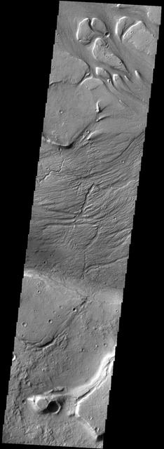
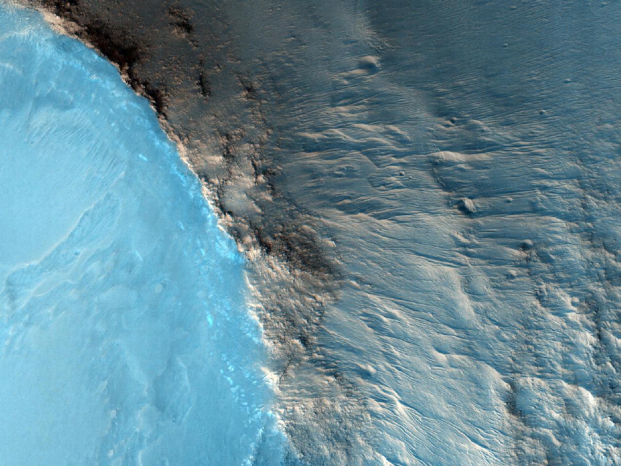
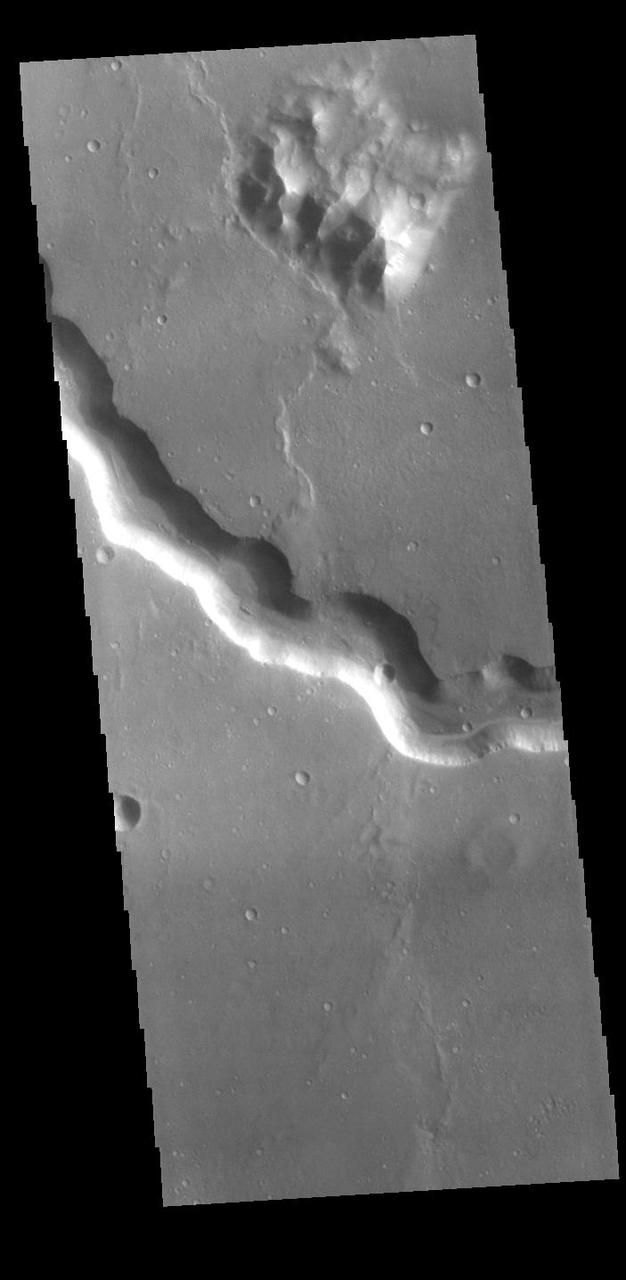
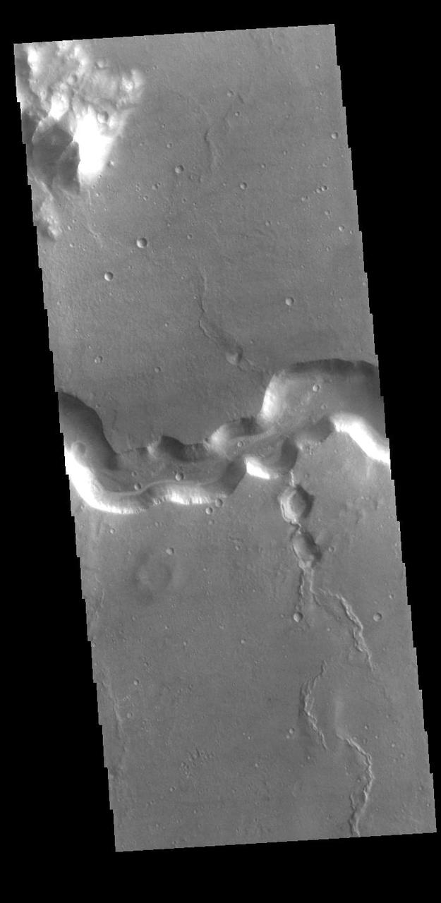
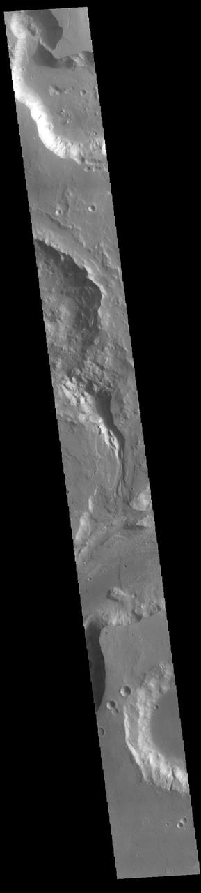
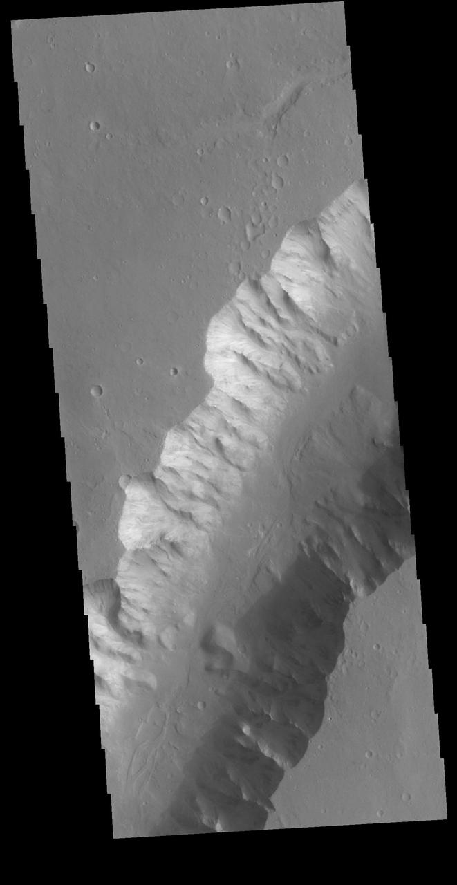
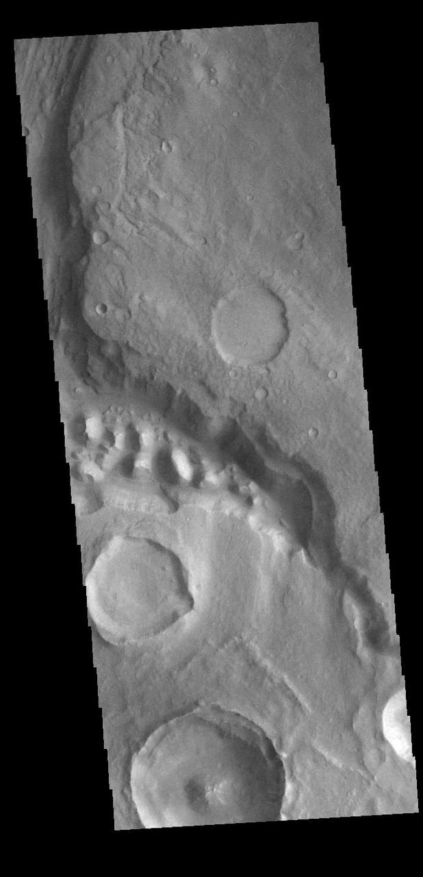
Located in Margaritifer Terra, Morava Valles is one of several channels that empty northward towards Chryse Planitia. Chaos terrain is typified by regions of blocky, often steep sided, mesas interspersed with deep valleys. With time and erosion the valleys widen and the mesas become smaller. It has been proposed that a catastrophic outflow of subsurface water creates the chaos and provides the surface flow creating the channel. Morava Valles arises from a region of chaos. Chaos terrain is also found along the course of the channel and may occur when the channel flow fluid warms the subsurface ice creating additional release points for melted subsurface ice. This VIS image shows a region of chaos near the terminal end of Morava Valles. Orbit Number: 78166 Latitude: -11.1105 Longitude: 337.845 Instrument: VIS Captured: 2019-07-29 11:58 https://photojournal.jpl.nasa.gov/catalog/PIA23418
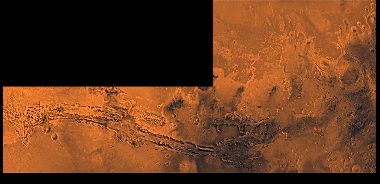
A color image of Valles Marineris, the great canyon and the south Chryse basin-Valles Marineris outflow channels of Mars; north toward top. The scene shows the entire Valles Marineris canyon system, over 3,000 km long and averaging 8 km deep, extending from Noctis Labyrinthus, the arcuate system of graben to the west, to the chaotic terrain to the east and related outflow canyons that drain toward the Chryse basin. Eos and Capri Chasmata (south to north) are two canyons connected to Valles Marineris. Ganges Chasma lies directly north. The chaos in the southeast part of the image gives rise to several outflow channels, Shalbatana, Simud, Tiu, and Ares Valles (left to right), that drained north into the Chryse basin. The mouth of Ares Valles is the site of the Mars Pathfinder lander. This image is a composite of Viking medium-resolution images in black and white and low-resolution images in color; Mercator projection. The image roughly extends from latitude 20 degrees S. to 20 degrees N. and from longitude 15 degrees to 102.5 degrees. The connected chasma or valleys of Valles Marineris may have formed from a combination of erosional collapse and structural activity. Layers of material in the eastern canyons might consist of carbonates deposited in ancient lakes, eolian deposits, or volcanic materials. Huge ancient river channels began from Valles Marineris and from adjacent canyons and ran north. Many of the channels flowed north into Chryse Basin. The south Chryse outflow channels are cut an average of 1 km into the cratered highland terrain. This terrain is about 9 km above datum near Valles Marineris and steadily decreases in elevation to 1 km below datum in the Chryse basin. Shalbatana is relatively narrow (10 km wide) but can reach 3 km in depth. The channel begins at a 2- to 3-km-deep circular depression within a large impact crater, whose floor is partly covered by chaotic material, and ends in Simud Valles. Tiu and Simud Valles consist of a complex of connected channel floors and chaotic terrain and extend as far south as and connect to eastern Valles Marineris. Ares Vallis originates from discontinuous patches of chaotic terrain within large craters. In the Chryse basin the Ares channel forks; one branch continues northwest into central Chryse Planitia and the other extends north into eastern Chryse Planitia. http://photojournal.jpl.nasa.gov/catalog/PIA00426
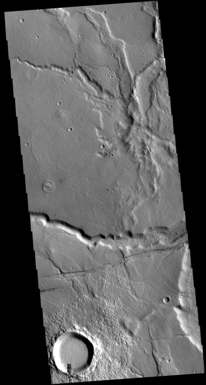
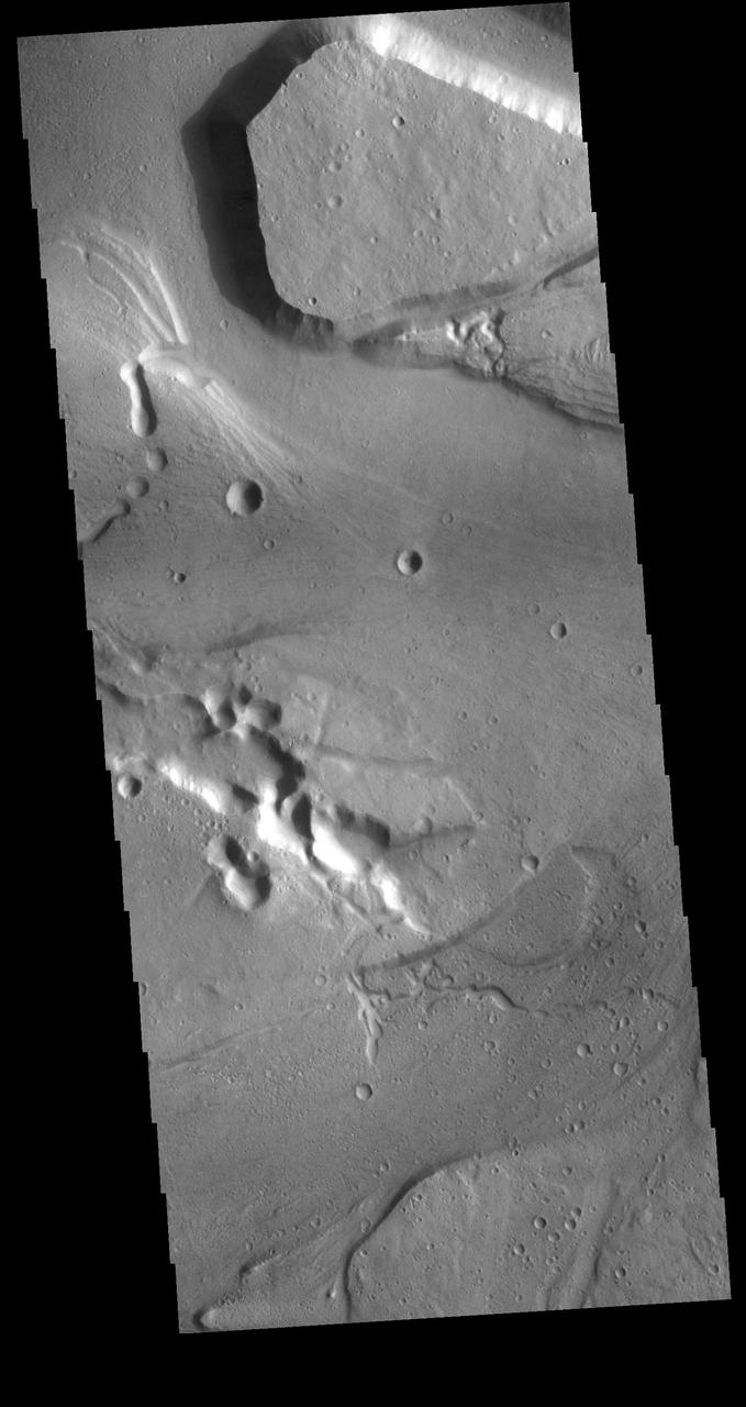
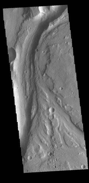
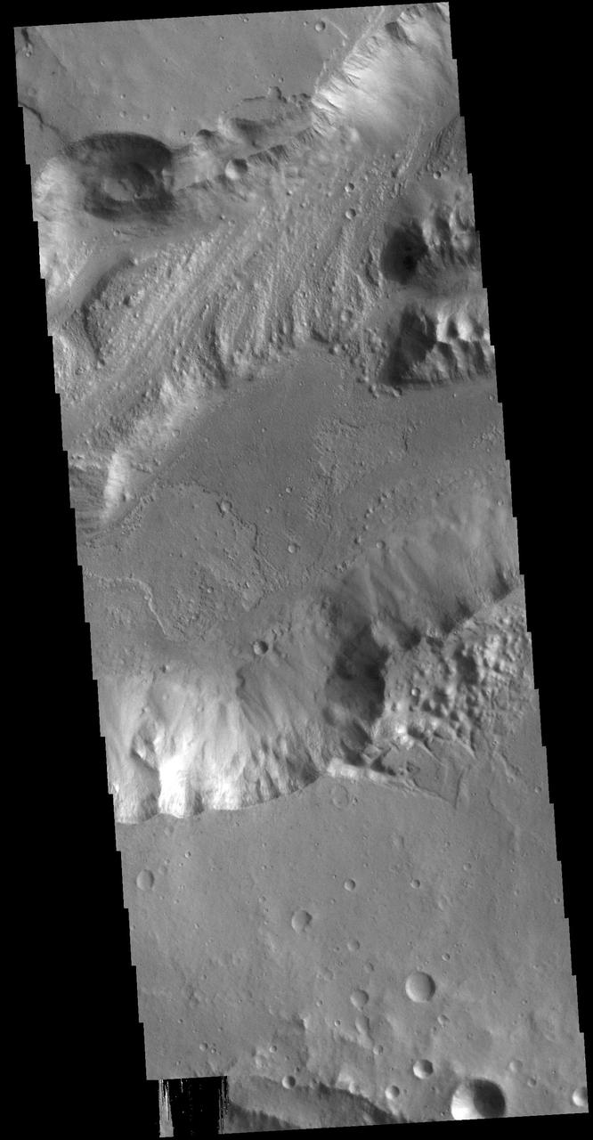
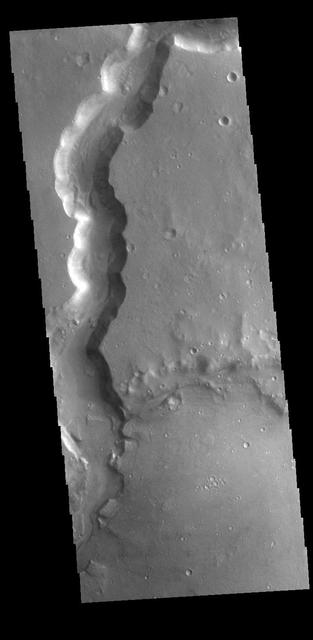
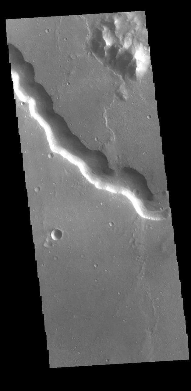
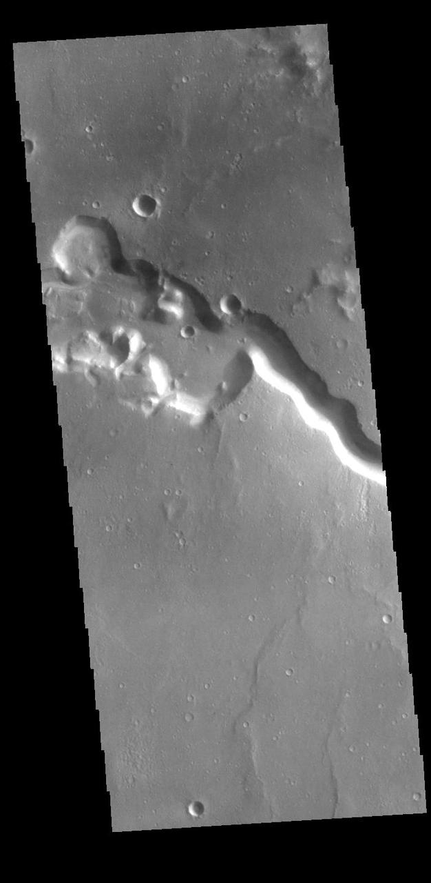
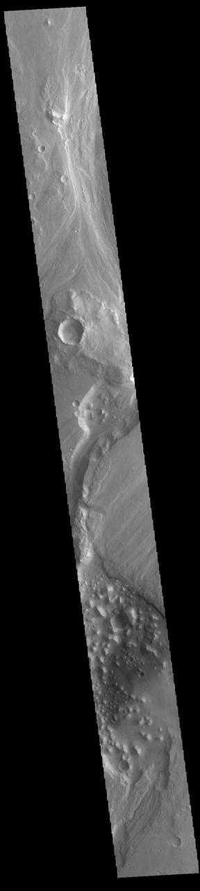
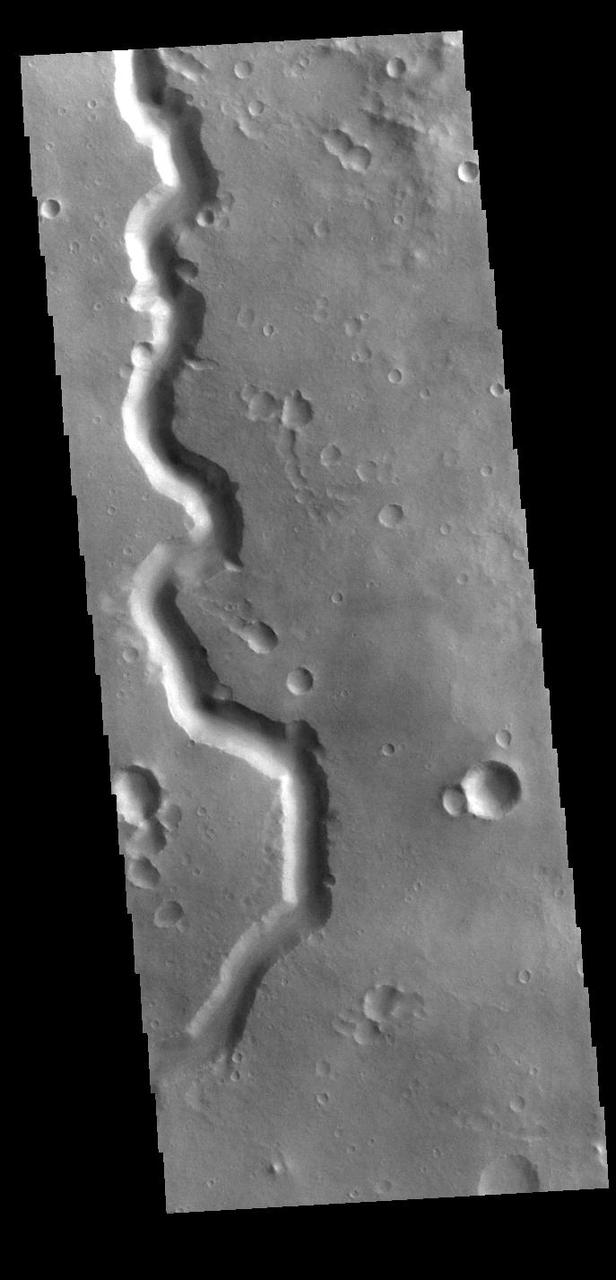
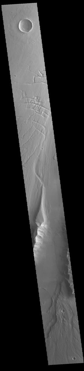
The channel form at the top of this VIS image is part of Tiu Valles. The impact crater has affected the course of the channel, as has the small hill at the top of the image. This type of feature, a hill with a teardrop shaped section, is called a streamline island. The hill interrupts the fluid flow, creating eddies on the downstream side where the flow velocity lessens and it is unable to erode as easily as in the main part of the channel. The teardrop points downstream. Located in Margaritifer Terra, Tiu Valles is part of a large system of channels that arise from Vallis Marineris and flow northward to empty into Chryse Planitia. Orbit Number: 86527 Latitude: 16.6616 Longitude: 325.954 Instrument: VIS Captured: 2021-06-16 22:38 https://photojournal.jpl.nasa.gov/catalog/PIA24998
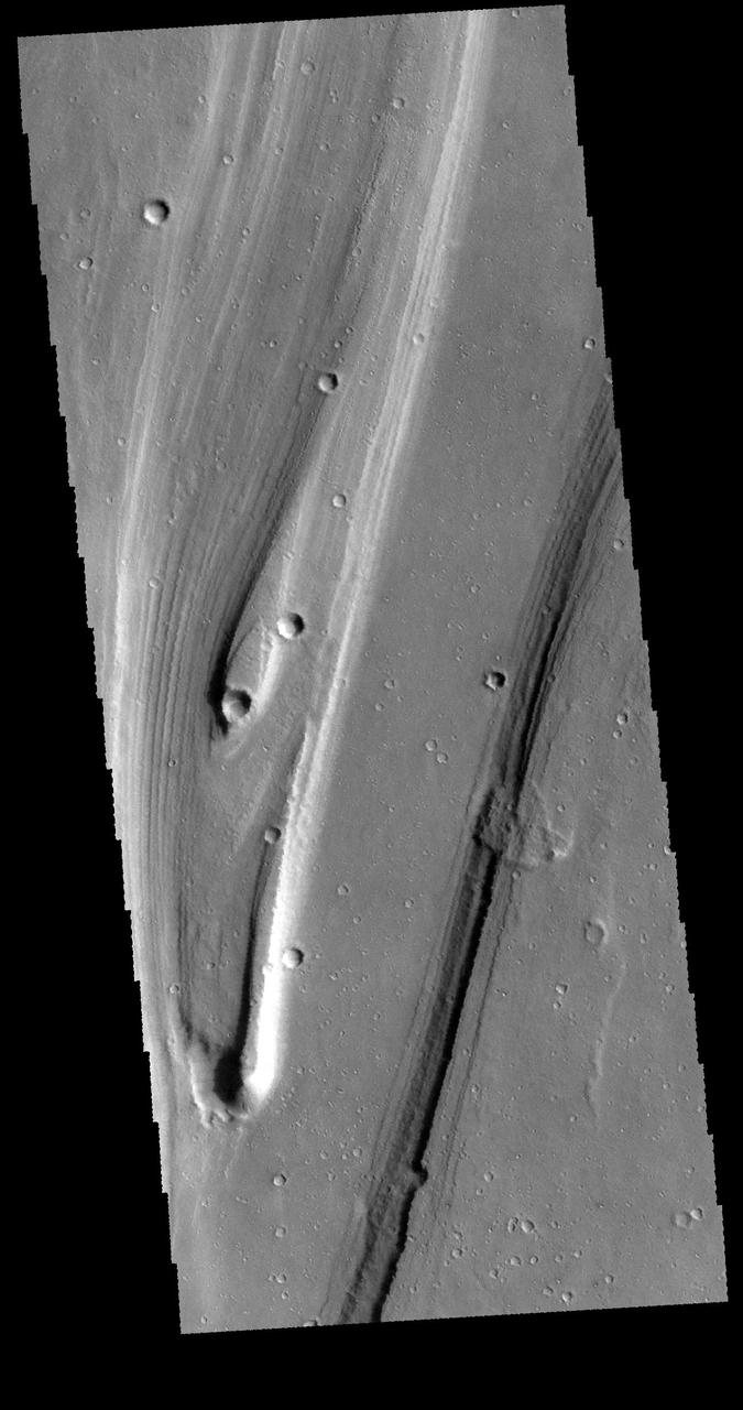
This VIS image shows part of Nanedi Valles. Located In Xanthe Terra, the channel system is 508 km (315 miles) long. Nanedi Valles contains two large channels that join together as the elevation drops near Chryse Planitia. Both sections of channel are visible in this image. Orbit Number: 89747 Latitude: 6.03809 Longitude: 312.054 Instrument: VIS Captured: 2022-03-09 01:48 https://photojournal.jpl.nasa.gov/catalog/PIA25460
This VIS image shows part of Hydraotes Chaos. Hydraotes Chaos measures about 300 kilometers (190 miles) wide by roughly 350 km (220 mi) north-south, and it lies in a valley leading northeast out of Ganges Chasma at the east end of Valles Marineris. Tiu Valles flows northward from Hydraotes Chaos to empty into Chryse Planitia. Orbit Number: 80949 Latitude: 1.53809 Longitude: 326.515 Instrument: VIS Captured: 2020-03-14 15:48 https://photojournal.jpl.nasa.gov/catalog/PIA23906
Today's VIS image shows a portion of Shalbatana Vallis. Located in Xanthe Terra, Shalbatana Vallis is an outflow channel carved by massive floods of escaping groundwater whose source lies far to the south of this image. Shalbatana Vallis is over 1300 km long (808 miles). This channel, and all others in this region, drain into Chryse Planitia. Orbit Number: 85529 Latitude: 9.26895 Longitude: 317.915 Instrument: VIS Captured: 2021-03-26 18:26 https://photojournal.jpl.nasa.gov/catalog/PIA24830
Today's VIS image shows a portion of Ares Vallis. Located in Margaritifer Terra, Ares Vallis is an outflow channel carved by massive floods of escaping groundwater whose source lies far to the south of this image. Ares Vallis is over 1757 km long (1091 miles). This channel, and all others in this region, drain into Chryse Planitia. Orbit Number: 93939 Latitude: 9.783 Longitude: 334.4 Instrument: VIS Captured: 2023-02-17 05:51 https://photojournal.jpl.nasa.gov/catalog/PIA25930
Today's VIS image shows a section of Bahram Vallis. This channel is located in northern Lunae Planum, south of Kasei Valles. Bharam Vallis drains from the higher elevations of Lunae Planum towards the Chryse Planitia basin. This channel is over 300km long (186miles). Orbit Number: 88175 Latitude: 20.6178 Longitude: 302.162 Instrument: VIS Captured: 2021-10-30 15:19 https://photojournal.jpl.nasa.gov/catalog/PIA25156
Today's VIS image shows a section of Bahram Vallis. This channel is located in northern Lunae Planum, south of Kasei Valles. Bharam Vallis drains from the higher elevations of Lunae Planum towards the Chryse Planitia basin. This channel is over 300km (186 miles) long. Orbit Number: 94564 Latitude: 20.5977 Longitude: 302.359 Instrument: VIS Captured: 2023-04-09 17:00 https://photojournal.jpl.nasa.gov/catalog/PIA26036
Today's VIS image shows a portion of Shalbatana Vallis. Located in Xanthe Terra, Shalbatana Vallis is an outflow channel carved by massive floods of escaping groundwater whose source lies far to the south of this image. Shalbatana Vallis is over 1300 km long (808 miles). This channel, and all others in this region, drain into Chryse Planitia. Orbit Number: 95175 Latitude: 6.47506 Longitude: 317.532 Instrument: VIS Captured: 2023-05-30 00:19 https://photojournal.jpl.nasa.gov/catalog/PIA26268
Today's VIS image shows a portion of Shalbatana Vallis. Located in Xanthe Terra, Shalbatana Vallis is an outflow channel carved by massive floods of escaping groundwater whose source lies far to the south of this image. Shalbatana Vallis is over 1300 km long (808 miles). This channel, and all others in this region, drain into Chryse Planitia. Orbit Number: 89622 Latitude: 8.24518 Longitude: 317.972 Instrument: VIS Captured: 2022-02-26 18:47 https://photojournal.jpl.nasa.gov/catalog/PIA25405
Today's VIS image shows a section of Tiu Valles. Located in Margaritifer Terra, Tiu Valles is a complex channel that is part of a large system of outflow channels that arise from Vallis Marineris and flow northward to empty into Chryse Planitia. Tiu Vallis is 1720 km (1069 miles) long. Orbit Number: 87675 Latitude: 4.06653 Longitude: 329.088 Instrument: VIS Captured: 2021-09-19 11:09 https://photojournal.jpl.nasa.gov/catalog/PIA25261

Today's VIS image shows a landslide deposit in Tiu Valles. The impact that created the crater likely caused the landslide, either during the impact event or shortly after. Located in Margaritifer Terra, Tiu Valles is part of a large system of channels that arise from Vallis Marineris and flow northward to empty into Chryse Planitia. Tiu Valles is 1720km long (1069 miles). Orbit Number: 88299 Latitude: 14.6135 Longitude: 325.705 Instrument: VIS Captured: 2021-11-09 20:20 https://photojournal.jpl.nasa.gov/catalog/PIA25197
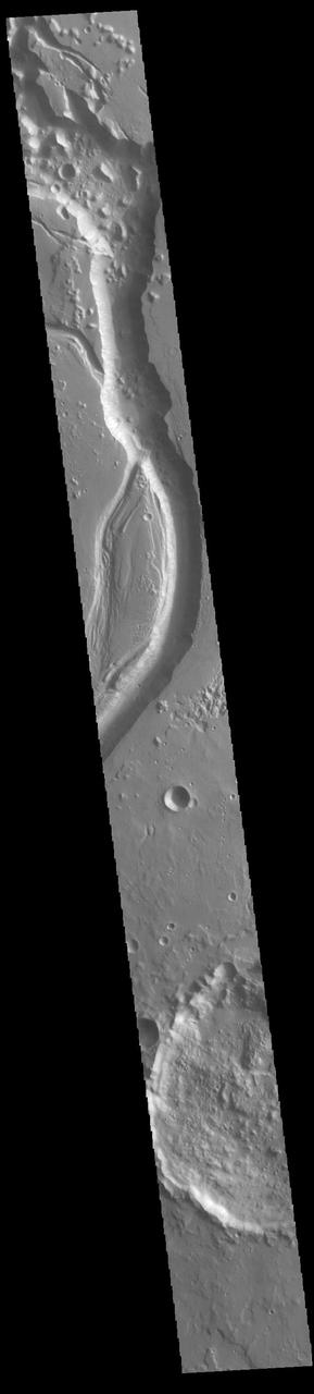
Today's VIS image shows a small section of Shalbatana Vallis. Located in Xanthe Terra, Shalbatana Vallis is an outflow channel carved by massive floods of escaping groundwater whose source lies far to the south of this image. This channel, and all others in this region, drain into Chryse Planitia. Shalbatana Vallis is 1029km long (639 miles). Orbit Number: 95150 Latitude: 10.3961 Longitude: 318.227 Instrument: VIS Captured: 2023-05-27 22:56 https://photojournal.jpl.nasa.gov/catalog/PIA26262
Today's VIS image shows a small section of Shalbatana Vallis. Located in Xanthe Terra, Shalbatana Vallis is an outflow channel carved by massive floods of escaping groundwater whose source lies far to the south of this image. This channel, and all others in this region, drain into Chryse Planitia. Shalbatana Vallis is 1029km long (639 miles). Orbit Number: 82035 Latitude: 4.79125 Longitude: 315.838 Instrument: VIS Captured: 2020-06-12 01:54 https://photojournal.jpl.nasa.gov/catalog/PIA24114
Today's VIS image shows a portion of Shalbatana Vallis. Located in Xanthe Terra, Shalbatana Vallis is an outflow channel carved by massive floods of escaping groundwater whose source lies far to the south of this image. Shalbatana Vallis is over 1300 km long (808 miles). This channel, and all others in this region, drain into Chryse Planitia. Orbit Number: 86752 Latitude: 5.19688 Longitude: 316.501 Instrument: VIS Captured: 2021-07-05 11:12 https://photojournal.jpl.nasa.gov/catalog/PIA24992
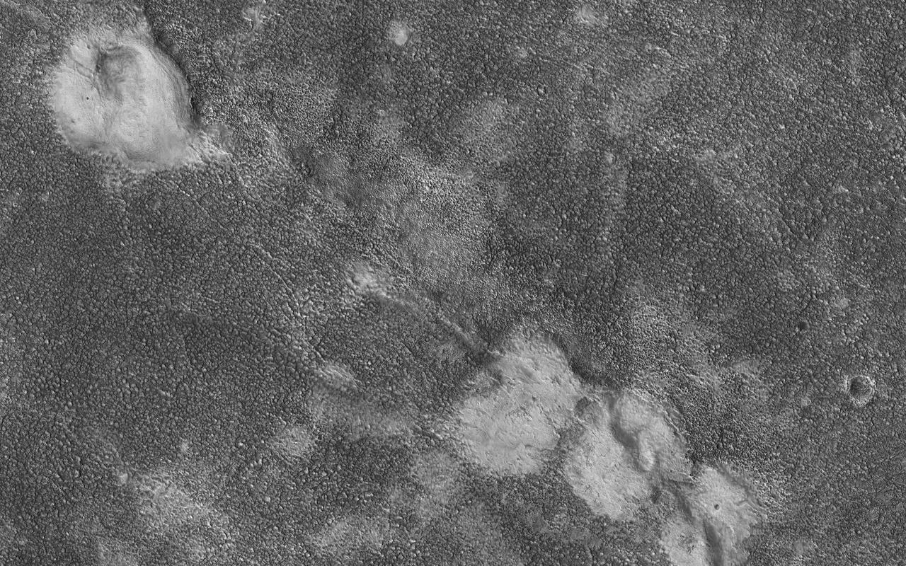
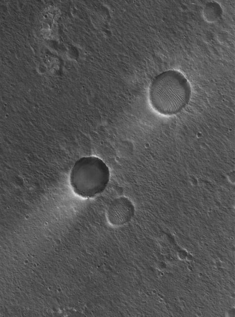
This image shows four relatively bright mounds along a linear, curving feature that appears to be a rift zone, where the shallow surface materials have pulled apart. The mounds also appear to be deformed. A possible geologic interpretation is that as the rift began to open, subsurface material (perhaps mud) erupted to create the mounds, which were then deformed as the rift continued to spread. This region (Chryse Planitia) is a low-elevation basin in which large outflow channels deposited water and sediments billions of years ago. https://photojournal.jpl.nasa.gov/catalog/PIA23672
Today's VIS image shows a portion of Shalbatana Vallis. Located in Xanthe Terra, Shalbatana Vallis is an outflow channel carved by massive floods of escaping groundwater whose source lies far to the south of this image. Shalbatana Vallis is over 1300 km long (808 miles). This channel, and all others in this region, drain into Chryse Planitia. Orbit Number: 88162 Latitude: 8.96896 Longitude: 318.805 Instrument: VIS Captured: 2021-10-29 13:34 https://photojournal.jpl.nasa.gov/catalog/PIA25151
Today's VIS image shows a section of Bahram Vallis. This channel is located in northern Lunae Planum, south of Kasei Valles. Bharam Vallis drains from the higher elevations of Lunae Planum towards the Chryse Planitia basin. This channel is over 300km long (186miles). Orbit Number: 87576 Latitude: 20.3115 Longitude: 302.882 Instrument: VIS Captured: 2021-09-11 07:37 https://photojournal.jpl.nasa.gov/catalog/PIA25224
Today's VIS image shows a portion of Shalbatana Vallis. Located in Xanthe Terra, Shalbatana Vallis is an outflow channel carved by massive floods of escaping groundwater whose source lies far to the south of this image. Shalbatana Vallis is over 1300 km long (808 miles). This channel, and all others in this region, drain into Chryse Planitia. Orbit Number: 80787 Latitude: 8.81946 Longitude: 319.078 Instrument: VIS Captured: 2020-03-01 07:42 https://photojournal.jpl.nasa.gov/catalog/PIA23903
Today's VIS image shows a section of Shalbatana Vallis. Located in Xanthe Terra, Shalbatana Vallis is an outflow channel carved by massive floods of escaping groundwater whose source lies far to the south of this image. This channel, and all others in this region, drain into Chryse Planitia. Shalbatana Vallis is 1029km (639 miles) long. Orbit Number: 85816 Latitude: 10.2994 Longitude: 318.18 Instrument: VIS Captured: 2021-04-19 09:35 https://photojournal.jpl.nasa.gov/catalog/PIA24874

Today's VIS image shows a portion of Shalbatana Vallis. Located in Xanthe Terra, Shalbatana Vallis is an outflow channel carved by massive floods of escaping groundwater whose source lies far to the south of this image. Shalbatana Vallis is over 1300 km long (808 miles). This channel, and all others in this region, drain into Chryse Planitia. Orbit Number: 94913 Latitude: 3.32953 Longitude: 316.445 Instrument: VIS Captured: 2023-05-08 10:33 https://photojournal.jpl.nasa.gov/catalog/PIA26217
Today's VIS image shows a section of Bahram Vallis. This channel is located in northern Lunae Planum, south of Kasei Valles. Bharam Vallis drains from the higher elevations of Lunae Planum towards the Chryse Planitia basin. This channel is over 300km long (186miles). Orbit Number: 94876 Latitude: 21.1353 Longitude: 301.426 Instrument: VIS Captured: 2023-05-05 09:33 https://photojournal.jpl.nasa.gov/catalog/PIA26211
Today's VIS image shows a section of Bahram Vallis. This channel is located in northern Lunae Planum, south of Kasei Valles. Bharam Vallis drains from the higher elevations of Lunae Planum towards the Chryse Planitia basin. This channel is over 300km long (186miles). Orbit Number: 94826 Latitude: 21.4639 Longitude: 303.82 Instrument: VIS Captured: 2023-05-01 06:44 https://photojournal.jpl.nasa.gov/catalog/PIA26179
Today's VIS image shows a portion of Shalbatana Vallis. Located in Xanthe Terra, Shalbatana Vallis is an outflow channel carved by massive floods of escaping groundwater whose source lies far to the south of this image. Shalbatana Vallis is over 1300 km long (808 miles). This channel, and all others in this region, drain into Chryse Planitia. Orbit Number: 88761 Latitude: 8.29946 Longitude: 317.817 Instrument: VIS Captured: 2021-12-17 21:18 https://photojournal.jpl.nasa.gov/catalog/PIA25300
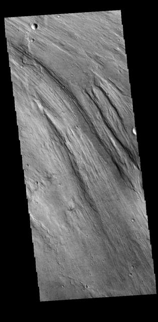
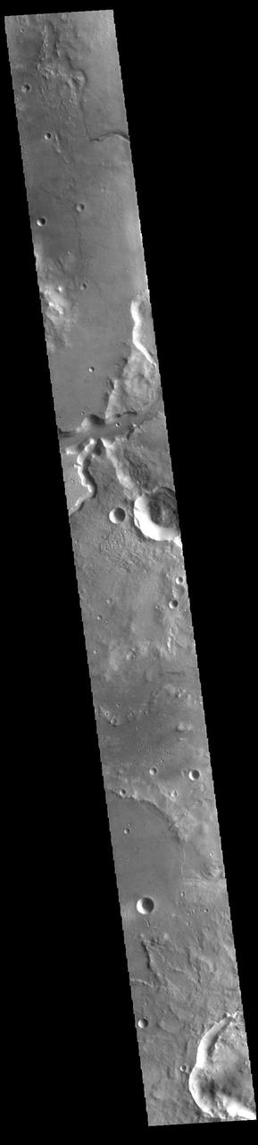
The channels that dissect the center of the VIS image are called Maumee Valles. The much larger Maja Valles is located at the very bottom of the image. The channels in this region are flowing from the highlands of Lunae Planum into the lowlands of Chryse Planitia. Maumee Valles is 390km (242 miles) long. Orbit Number: 94227 Latitude: 18.6849 Longitude: 304.703 Instrument: VIS Captured: 2023-03-12 23:02 https://photojournal.jpl.nasa.gov/catalog/PIA25995
Today's VIS image shows a section of Bahram Vallis. This channel is located in northern Lunae Planum, south of Kasei Valles. Bharam Vallis drains from the higher elevations of Lunae Planum towards the Chryse Planitia basin. This channel is over 300km long (186miles). Orbit Number: 95138 Latitude: 20.0779 Longitude: 303.077 Instrument: VIS Captured: 2023-05-26 23:17 https://photojournal.jpl.nasa.gov/catalog/PIA26260
Today's VIS image shows part of Maja Valles, a large channel system in Lunae Planum. Maja Valles in 1600 km (1000 miles) long. Like most outflow channels in the region, Maja Valles arises from the Valles Marineris region and drains into Chryse Planitia. Maja Valles starts in Juventae Chasma. Orbit Number: 85617 Latitude: 4.08955 Longitude: 299.934 Instrument: VIS Captured: 2021-04-03 00:18 https://photojournal.jpl.nasa.gov/catalog/PIA24857
Today's VIS image shows a small section of Shalbatana Vallis. Located in Xanthe Terra, Shalbatana Vallis is an outflow channel carved by massive floods of escaping groundwater whose source lies far to the south of this image. This channel, and all others in this region, drain into Chryse Planitia. Orbit Number: 80550 Latitude: 5.84335 Longitude: 316.746 Instrument: VIS Captured: 2020-02-10 19:21 https://photojournal.jpl.nasa.gov/catalog/PIA23839
Today's VIS image shows a section of Bahram Vallis. This channel is located in northern Lunae Planum, south of Kasei Valles. Bharam Vallis drains from the higher elevations of Lunae Planum towards the Chryse Planitia basin. This channel is over 300km long (186miles). Orbit Number: 93965 Latitude: 20.1543 Longitude: 302.9 Instrument: VIS Captured: 2023-02-19 09:18 https://photojournal.jpl.nasa.gov/catalog/PIA25936

This VIS image shows the two sections of Nanedi Valles. Located In Xanthe Terra, the channel system is 508 km (315 miles) long. Nanedi Valles contains two large channels that join together as the elevation drops near Chryse Planitia. Orbit Number: 89747 Latitude: 6.03809 Longitude: 312.054 Instrument: VIS Captured: 2022-03-09 01:48 https://photojournal.jpl.nasa.gov/catalog/PIA25393
Today's VIS image shows a portion of Shalbatana Vallis. Located in Xanthe Terra, Shalbatana Vallis is an outflow channel carved by massive floods of escaping groundwater whose source lies far to the south of this image. This channel, and all others in this region, drain into Chryse Planitia. Orbit Number: 79926 Latitude: 9.15283 Longitude: 318.044 Instrument: VIS Captured: 2019-12-21 10:15 https://photojournal.jpl.nasa.gov/catalog/PIA23742
Today's VIS image shows a small section of Shalbatana Vallis. Located in Xanthe Terra, Shalbatana Vallis is an outflow channel carved by massive floods of escaping groundwater whose source lies far to the south of this image. This channel, and all others in this region, drain into Chryse Planitia. Shalbatana Vallis is 1029km long (639 miles). Orbit Number: 94314 Latitude: 5.05202 Longitude: 316.721 Instrument: VIS Captured: 2023-03-20 02:52 https://photojournal.jpl.nasa.gov/catalog/PIA26002
This VIS image shows a section of Nanedi Valles. Located In Xanthe Terra, the channel system is 508 km (315 miles) long. Nanedi Valles contains two large channels that join together as the elevation drops near Chryse Planitia. Orbit Number: 87763 Latitude: 1.08634 Longitude: 310.73 Instrument: VIS Captured: 2021-09-26 17:02 https://photojournal.jpl.nasa.gov/catalog/PIA25268
The THEMIS VIS camera contains 5 filters. The data from different filters can be combined in multiple ways to create a false color image. These false color images may reveal subtle variations of the surface not easily identified in a single band image. Today's false color image shows part of Mawrth Valles, near to the point where it empties into Chryse Planitia. Orbit Number: 11060 Latitude: 25.6292 Longitude: 341.23 Instrument: VIS Captured: 2004-06-12 01:58 http://photojournal.jpl.nasa.gov/catalog/PIA19785
This VIS image shows a section of Nanedi Valles (bottom half of image). Located In Xanthe Terra, the channel system is 508 km (315 miles) long. Nanedi Valles contains two large channels that join together as the elevation drops near Chryse Planitia. Orbit Number: 85392 Latitude: 6.00615 Longitude: 310.665 Instrument: VIS Captured: 2021-03-15 11:42 https://photojournal.jpl.nasa.gov/catalog/PIA24780
Today's VIS image shows a portion of Kasei Valles. Kasei Valles is one of the largest outflow channel systems on Mars, in places up to 482 km (300 miles) wide and 1580 km (982 miles) long. For comparison, the Grand Canyon in Arizona is is only 29 km (18 miles) at its widest and only 446 km (277 miles) long. Kasei Valles flows eastward through Lunae Planum and empties into Chryse Planitia. Orbit Number: 85218 Latitude: 21.7275 Longitude: 288.166 Instrument: VIS Captured: 2021-03-01 03:56 https://photojournal.jpl.nasa.gov/catalog/PIA24821
Today's VIS image shows a portion of Shalbatana Vallis. Located in Xanthe Terra, Shalbatana Vallis is an outflow channel carved by massive floods of escaping groundwater whose source lies far to the south of this image. Shalbatana Vallis is over 1300 km long (808 miles). This channel, and all others in this region, drain into Chryse Planitia. A small landslide deposit is visible at the bottom of the image. Orbit Number: 88187 Latitude: 6.89989 Longitude: 317.849 Instrument: VIS Captured: 2021-10-31 14:58 https://photojournal.jpl.nasa.gov/catalog/PIA25160
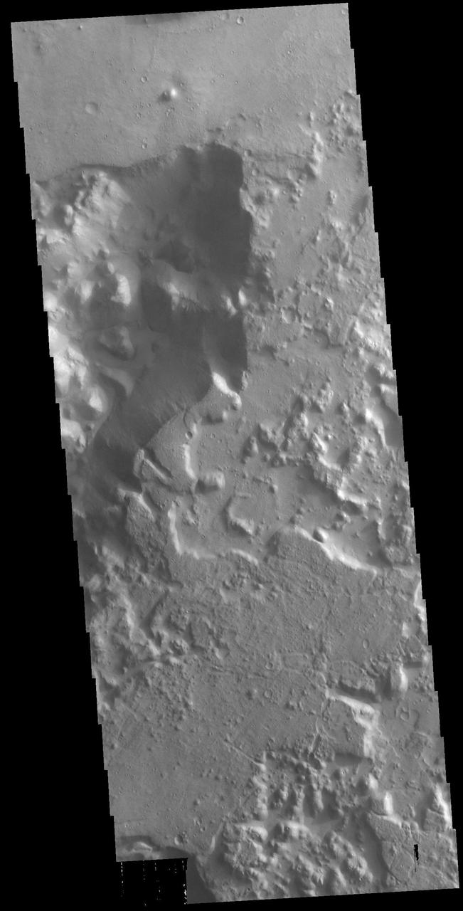
Today's VIS image shows a small section of Hydaspis Chaos, one of many regions of chaos in Margaritifer Terra. The term chaos is applied to regions where the surface is being eroded to form mesas. As the surface processes continue individual mesas become more isolated and take on the appearance of regions of hills. Hydaspis Chaos is is part of the huge outflow system flowing from Valles Marineris to Chryse Planitia. Orbit Number: 79027 Latitude: 2.3043 Longitude: 335.049 Instrument: VIS Captured: 2019-10-08 09:37 https://photojournal.jpl.nasa.gov/catalog/PIA23544
Today's VIS image shows a portion of Kasei Valles. Kasei Valles is one of the largest outflow channel systems on Mars, in places up to 482 km (300 miles) wide and 1580 km (982 miles) long. For comparison, the Grand Canyon in Arizona is is only 29 km (18 miles) at its widest and only 446 km (277 miles) long. Kasei Valles flows eastward through Lunae Planum and empties into Chryse Planitia. Orbit Number: 93978 Latitude: 24.9563 Longitude: 287.171 Instrument: VIS Captured: 2023-02-20 11:01 https://photojournal.jpl.nasa.gov/catalog/PIA25939
Today's VIS image shows a portion of Kasei Valles. Kasei Valles is one of the largest outflow channel systems on Mars, in places up to 482 km (300 miles) wide and 1580 km (982 miles) long. For comparison, the Grand Canyon in Arizona is is only 29 km (18 miles) at its widest and only 446 km (277 miles) long. Kasei Valles flows eastward through Lunae Planum and empties into Chryse Planitia. Orbit Number: 93928 Latitude: 25.9137 Longitude: 289.462 Instrument: VIS Captured: 2023-02-16 08:13 https://photojournal.jpl.nasa.gov/catalog/PIA25927
The THEMIS VIS camera contains 5 filters. The data from different filters can be combined in multiple ways to create a false color image. These false color images may reveal subtle variations of the surface not easily identified in a single band image. Today's false color image shows part of the main channel of Ares Vallis, as well as a small side tributary. Located in Margaritifer Terra, Ares Vallis is part of a large system of channels that arise in Valles Marineris and flow northward into Chryse Planitia. Orbit Number: 79239 Latitude: 7.64196 Longitude: 338.056 Instrument: VIS Captured: 2019-10-25 20:37 https://photojournal.jpl.nasa.gov/catalog/PIA24660
Today's VIS image shows part of Hydaspis Chaos, one of many regions of chaos in Margaritifer Terra. Chaos terrain is typified by mesas and valleys. The initial breakup of the surface can be due to tectonic forces, although on Mars it is thought that the mode of formation involves release of melted subsurface ice. With time and erosion the valleys widen and the mesas grow smaller. Hydaspis Chaos is is part of the huge outflow system flowing from Valles Marineris to Chryse Planitia. The channel in the center of the image becomes part of the larger Tiu Valles channel. Orbit Number: 87600 Latitude: 3.42796 Longitude: 332.822 Instrument: VIS Captured: 2021-09-13 06:56 https://photojournal.jpl.nasa.gov/catalog/PIA25228
Today's VIS image shows a portion of Kasei Valles. Kasei Valles is one of the largest outflow channel systems on Mars, in places up to 482 km (300 miles) wide and 1580 km (982 miles) long. For comparison, the Grand Canyon in Arizona is is only 29 km (18 miles) at its widest and only 446 km (277 miles) long. Kasei Valles flows eastward through Lunae Planum and empties into Chryse Planitia. Orbit Number: 80538 Latitude: 24.6507 Longitude: 300.343 Instrument: VIS Captured: 2020-02-09 19:44 https://photojournal.jpl.nasa.gov/catalog/PIA23845
This false color image shows a tributary channel that empties into the main Ares Vallis channel. This tributary channel is located east of Ares Vallis. Located in Margaritifer Terra, Ares Vallis is part of a large system of channels that arise from Vallis Marineris and empty into Chryse Planitia. The THEMIS VIS camera contains 5 filters. The data from different filters can be combined in multiple ways to create a false color image. These false color images may reveal subtle variations of the surface not easily identified in a single band image. Orbit Number: 63809 Latitude: 4.17241 Longitude: 343.459 Instrument: VIS Captured: 2016-05-02 20:09
Today's VIS image shows a portion of Kasei Valles. Kasei Valles is one of the largest outflow channel systems on Mars, in places up to 482 km (300 miles) wide and 1580 km (982 miles) long. For comparison, the Grand Canyon in Arizona is is only 29 km (18 miles) at its widest and only 446 km (277 miles) long. Kasei Valles flows eastward through Lunae Planum and empties into Chryse Planitia. Orbit Number: 85280 Latitude: 25.2042 Longitude: 299.095 Instrument: VIS Captured: 2021-03-06 06:28 https://photojournal.jpl.nasa.gov/catalog/PIA24822
![Today's VIS image shows the region where the northward flow of Kasei Valles turns to the east having split into two large channels. This image is located in the southern branch of Kasei Valles, called the Kasei Valles Canyon. Arising from Vallis Marineris and ending in Chryse Planitia, the valles is over 1,580 km long (982 miles), making Kasei Valles one of the largest outflow channels on Mars. [The US/Canadian border from eastern Montana to western Idaho is ~ 972 miles in length.] Orbit Number: 79041 Latitude: 21.9093 Longitude: 288.446 Instrument: VIS Captured: 2019-10-09 13:24 https://photojournal.jpl.nasa.gov/catalog/PIA23562](https://images-assets.nasa.gov/image/PIA23562/PIA23562~medium.jpg)
Today's VIS image shows the region where the northward flow of Kasei Valles turns to the east having split into two large channels. This image is located in the southern branch of Kasei Valles, called the Kasei Valles Canyon. Arising from Vallis Marineris and ending in Chryse Planitia, the valles is over 1,580 km long (982 miles), making Kasei Valles one of the largest outflow channels on Mars. [The US/Canadian border from eastern Montana to western Idaho is ~ 972 miles in length.] Orbit Number: 79041 Latitude: 21.9093 Longitude: 288.446 Instrument: VIS Captured: 2019-10-09 13:24 https://photojournal.jpl.nasa.gov/catalog/PIA23562
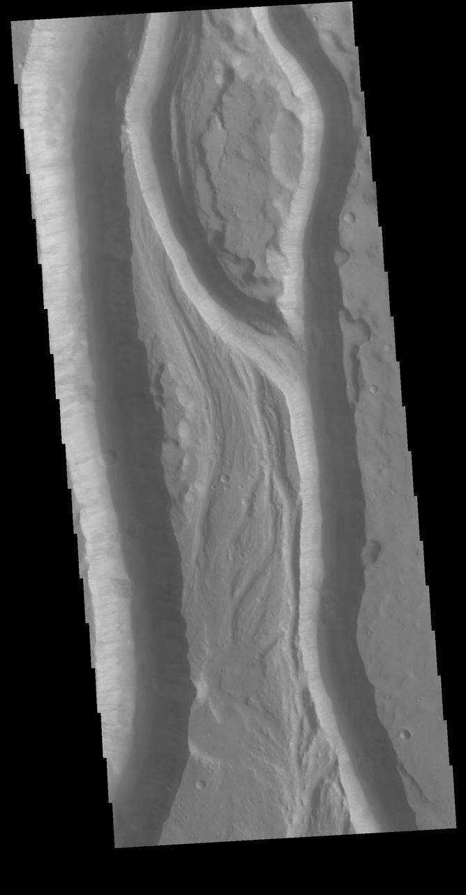
Today's VIS image shows a small section of Shalbatana Vallis. Located in Xanthe Terra, Shalbatana Vallis is an outflow channel carved by massive floods of escaping groundwater whose source lies far to the south of this image. This channel, and all others in this region, drain into Chryse Planitia. Shalbatana Vallis is 1029km long (639 miles). A small tributary channel is located on the right side of the image. The flat lying bench on the side of the main channel may be a delta deposit created by the tributary channel. Orbit Number: 85866 Latitude: 3.02377 Longitude: 316.732 Instrument: VIS Captured: 2021-04-23 12:22 https://photojournal.jpl.nasa.gov/catalog/PIA24880
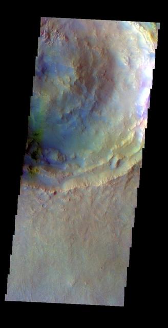
The large crater at the bottom of today's image is called McLaughlin Crater. It is located west of Mawrth Vallis, on the margin between Arabia Terra and Chryse Planitia. The THEMIS VIS camera contains 5 filters. The data from different filters can be combined in multiple ways to create a false color image. These false color images may reveal subtle variations of the surface not easily identified in a single band image. Orbit Number: 62100 Latitude: 22.4939 Longitude: 337.635 Instrument: VIS Captured: 2015-12-14 02:05 https://photojournal.jpl.nasa.gov/catalog/PIA23108
Today's VIS image shows a section of Bahram Vallis. This channel is located in northern Lunae Planum, south of Kasei Valles. Bharam Vallis drains from the higher elevations of Lunae Planum towards the Chryse Planitia basin. This channel is over 300km long (186miles). In this image Bahram Vallis enters Waspam Crater (right side of image) and then exits the crater (top right corner). Orbit Number: 81374 Latitude: 20.3853 Longitude: 303.032 Instrument: VIS Captured: 2020-04-18 15:46 https://photojournal.jpl.nasa.gov/catalog/PIA23956

Today's VIS image shows a portion of Kasei Valles. Kasei Valles is one of the largest outflow channel systems on Mars, in places up to 482 km (300 miles) wide and 1580 km (982 miles) long. For comparison, the Grand Canyon in Arizona is is only 29 km (18 miles) at its widest and only 446 km (277 miles) long. Kasei Valles flows eastward through Lunae Planum and empties into Chryse Planitia. Orbit Number: 88163 Latitude: 22.243 Longitude: 288.106 Instrument: VIS Captured: 2021-10-29 15:37 https://photojournal.jpl.nasa.gov/catalog/PIA25153
Today's VIS image is located in the plains between Chryse and Acidalia Planitias. Dark blue tones in this false color combination are usually created by basaltic sands. There appears to be surface sands in the middle of the image. The "orange" tail behind the crater towards the top of the image is created by wind action. Wind will both erode and deposit fine materials. The wind tail is the downward side of the crater. These features are termed windstreaks, and they help to understand the direction of wind. Both the windstreak and the surface sands indicate a dusty/sandy region confined to the central part of this image. The THEMIS VIS camera contains 5 filters. The data from different filters can be combined in multiple ways to create a false color image. These false color images may reveal subtle variations of the surface not easily identified in a single band image. Orbit Number: 62487 Latitude: 35.5378 Longitude: 328.516 Instrument: VIS Captured: 2016-01-14 23:06 https://photojournal.jpl.nasa.gov/catalog/PIA23111
The THEMIS VIS camera contains 5 filters. The data from different filters can be combined in multiple ways to create a false color image. These false color images may reveal subtle variations of the surface not easily identified in a single band image. Today's false color image shows the channel floor of Mawrth Vallis. Of all the channels carved by flowing water on Mars, one of the more unusual is Mawrth Vallis, whose name comes from the Welsh word for Mars. Mawrth Vallis winds through northwest Arabia Terra for some 640 kilometers (400 miles) before emptying into Acidalia Planitia on the edge of the vast northern lowlands. Unlike many outflow channels that start in regions of chaotic terrain, Mawrth Vallis just appears and then grows deeper as it heads downstream, holding a width of approximately 15 km (9 mi) until it widens near its mouth at Chryse Planitia. Orbit Number: 71080 Latitude: 22.9484 Longitude: 341.466 Instrument: VIS Captured: 2017-12-22 20:52 https://photojournal.jpl.nasa.gov/catalog/PIA24507

Today's image shows the channel floor of Mawrth Vallis. Of all the channels carved by flowing water on Mars, one of the more unusual is Mawrth Vallis, whose name comes from the Welsh word for Mars. Mawrth Vallis winds through northwest Arabia Terra for some 640 kilometers (400 miles) before emptying into Acidalia Planitia on the edge of the vast northern lowlands. Unlike many outflow channels that start in regions of chaotic terrain, Mawrth Vallis just appears and then grows deeper as it heads downstream, holding a width of approximately 15 km (9 mi) until it widens near its mouth at Chryse Planitia. And the floor of the channel is a much more complex surface than most channels, with layers of different materials and a decidedly non-waterworn appearance. Today's image is located within an almost 90 degree bend in the channel. Orbit Number: 87662 Latitude: 22.708 Longitude: 341.608 Instrument: VIS Captured: 2021-09-18 09:34 https://photojournal.jpl.nasa.gov/catalog/PIA25229

The THEMIS VIS camera contains 5 filters. The data from different filters can be combined in multiple ways to create a false color image. These false color images may reveal subtle variations of the surface not easily identified in a single band image. Today's false color image shows a small section of Mawrth Vallis (near the top of the image). Of all the channels carved by flowing water on Mars, one of the more unusual is Mawrth Vallis, whose name comes from the Welsh word for Mars. Mawrth winds through northwest Arabia Terra for some 640 kilometers (400 miles) before emptying into Acidalia Planitia on the edge of the vast northern lowlands. Unlike many outflow channels that start in regions of chaotic terrain, Mawrth Vallis just appears and then grows deeper as it heads downstream, holding a width of approximately 15 km (9 mi) until it widens near its mouth at Chryse Planitia. Orbit Number: 68698 Latitude: 21.9401 Longitude: 342.256 Instrument: VIS Captured: 2017-06-09 14:48 https://photojournal.jpl.nasa.gov/catalog/PIA24079
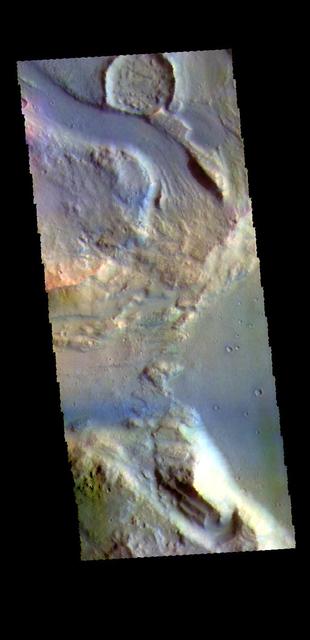
This false color image contains several channel features. Towards the top of the image are several stream-lined islands, created by liquid flow eroding preexisting rock. The islands have a tear-drop shape, with the pointy end down stream from the rounded end. In this case the fluid flowed from the bottom right of the frame towards the upper left. Just below the center of the image is a larger, deeper channel. All these channel features merge into Ares Vallis, a huge outflow channel that empties into Chryse Planitia. The THEMIS VIS camera contains 5 filters. The data from different filters can be combined in multiple ways to create a false color image. These false color images may reveal subtle variations of the surface not easily identified in a single band image. Orbit Number: 61501 Latitude: 4.31188 Longitude: 343.17 Instrument: VIS Captured: 2015-10-25 18:03 https://photojournal.jpl.nasa.gov/catalog/PIA23066
Today's VIS image shows part of Maja Valles, a large channel system in Lunae Planum. The main part of the channel is visible at the upper left in this image. The lower part of the image is located within an old crater called Stege Crater. The channel in the central part of the image is flowing along the inner rim of the crater and into the main Maja Valles channel just off the image to the left. Maja Valles in 1600 km (1000 miles) long. Like most outflow channels in the region, Maja Valles arises from Valles Marineris and drains into Chryse Planitia. Maja Valles starts in Juventae Chasma. Orbit Number: 89111 Latitude: 4.27445 Longitude: 300.886 Instrument: VIS Captured: 2022-01-15 16:56 https://photojournal.jpl.nasa.gov/catalog/PIA25347
This VIS image shows a region of chaos near the terminal end of Morava Valles. Located in Margaritifer Terra, Morava Valles is one of several channels that empty northward towards Chryse Planitia. Morava Valles arises from a region of chaos. Chaos terrain is also found along the course of the channel and may occur where the channel flow fluid warmed the subsurface ice creating additional release points for melted subsurface ice. Chaos terrain is typified by regions of blocky, often steep sided, mesas interspersed with deep valleys. With time and erosion the valleys widen and the mesas become smaller. It has been proposed that a catastrophic outflow of subsurface water creates the chaos and provides the surface flow creating the channel. Orbit Number: 79002 Latitude: -11.1516 Longitude: 338.097 Instrument: VIS Captured: 2019-10-06 08:08 https://photojournal.jpl.nasa.gov/catalog/PIA23541