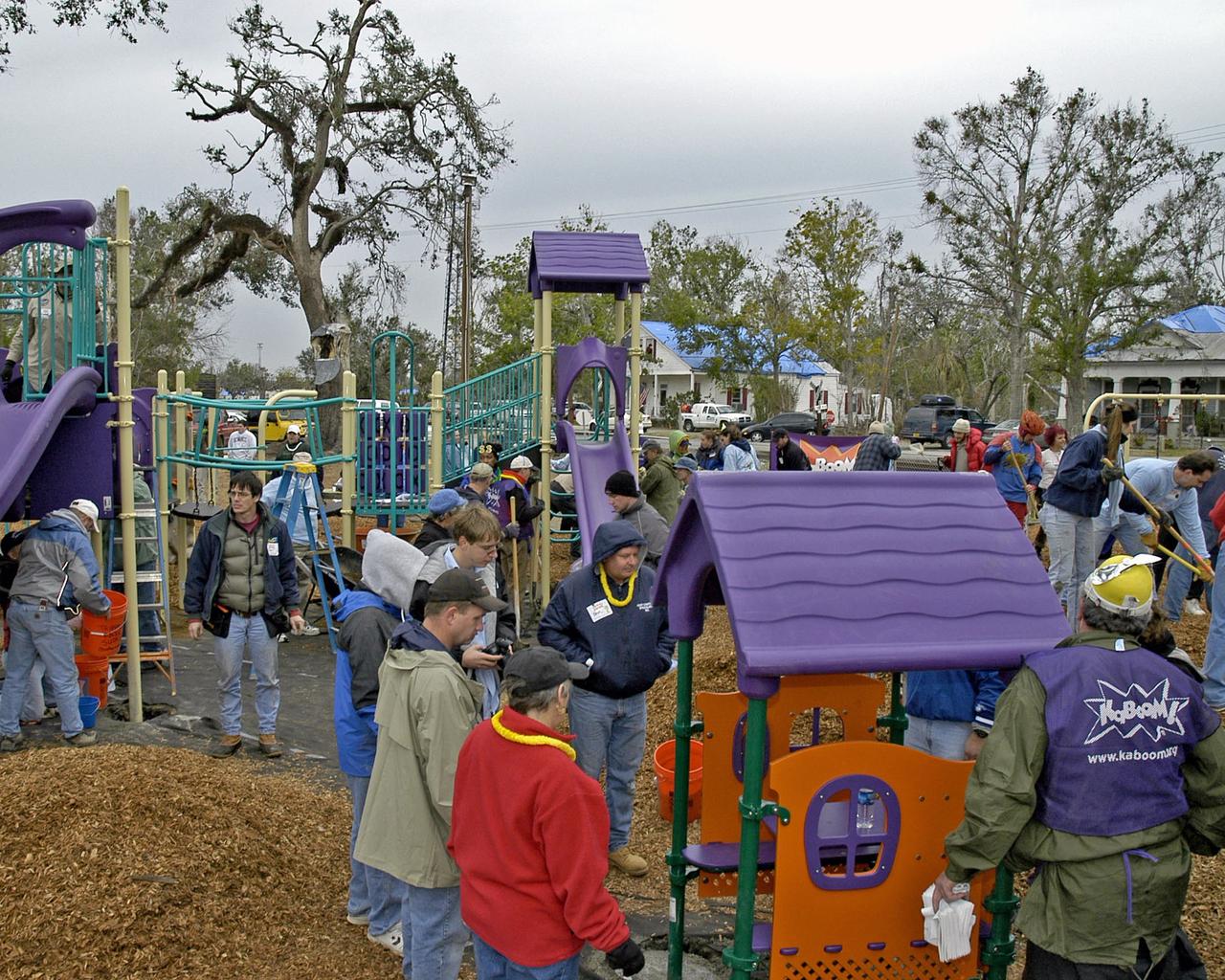
More than 650 volunteers - many of them employees at NASA's Stennis Space Center - weathered rain and cold to transform Bay St. Louis' old City Park into a playground Dec. 17. Volunteers assembled and erected a slide, swing set, jungle gym, sand box and planter benches in an eight-hour time frame. The playground was the first new structure built in the town devastated by Hurricane Katrina and the first on the Gulf Coast after the storm. The project was financed and led by nonprofit organization KaBOOM!, whose vision is to create a great place to play within walking distance of every child in America.
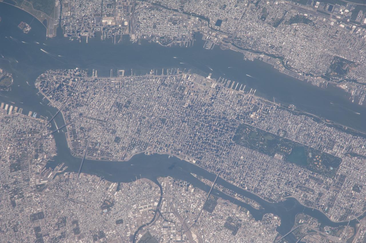
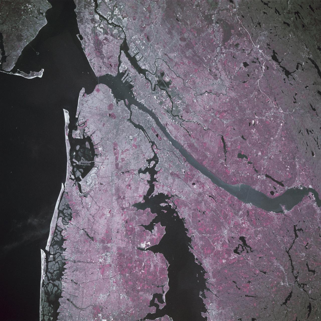
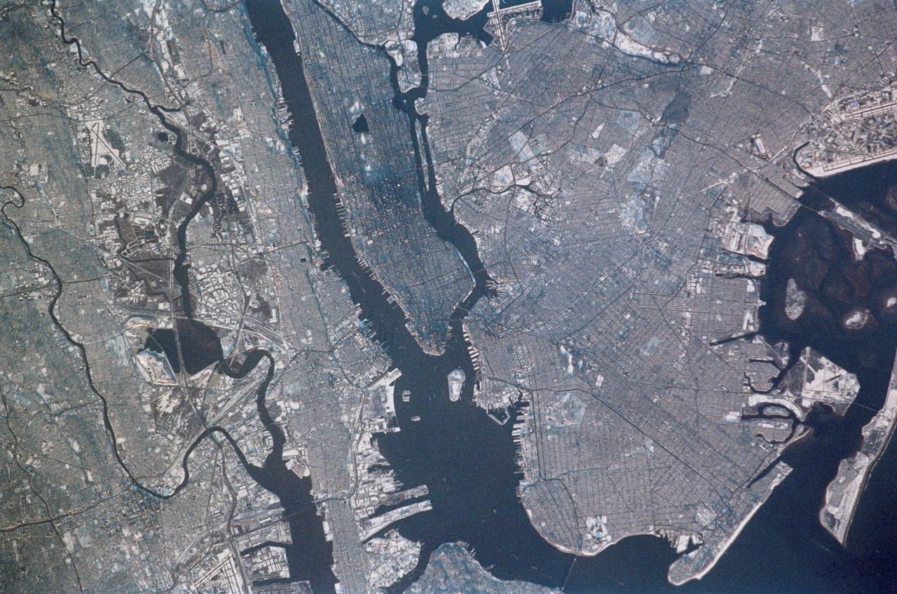
This radar image of the New York city metropolitan area. The island of Manhattan appears in the center of the image. The green-colored rectangle on Manhattan is Central Park.
More than 2 million acres were consumed by hundreds of fires between December 2002 and February 2003 in southeastern Australia national parks, forests, foothills and city suburbs as seen by NASA Terra spacecraft.
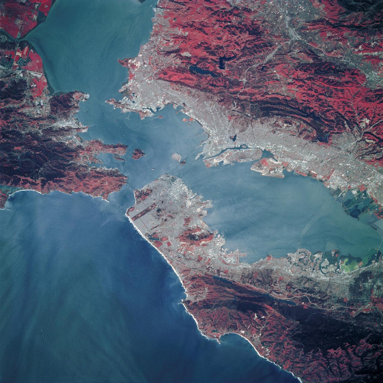
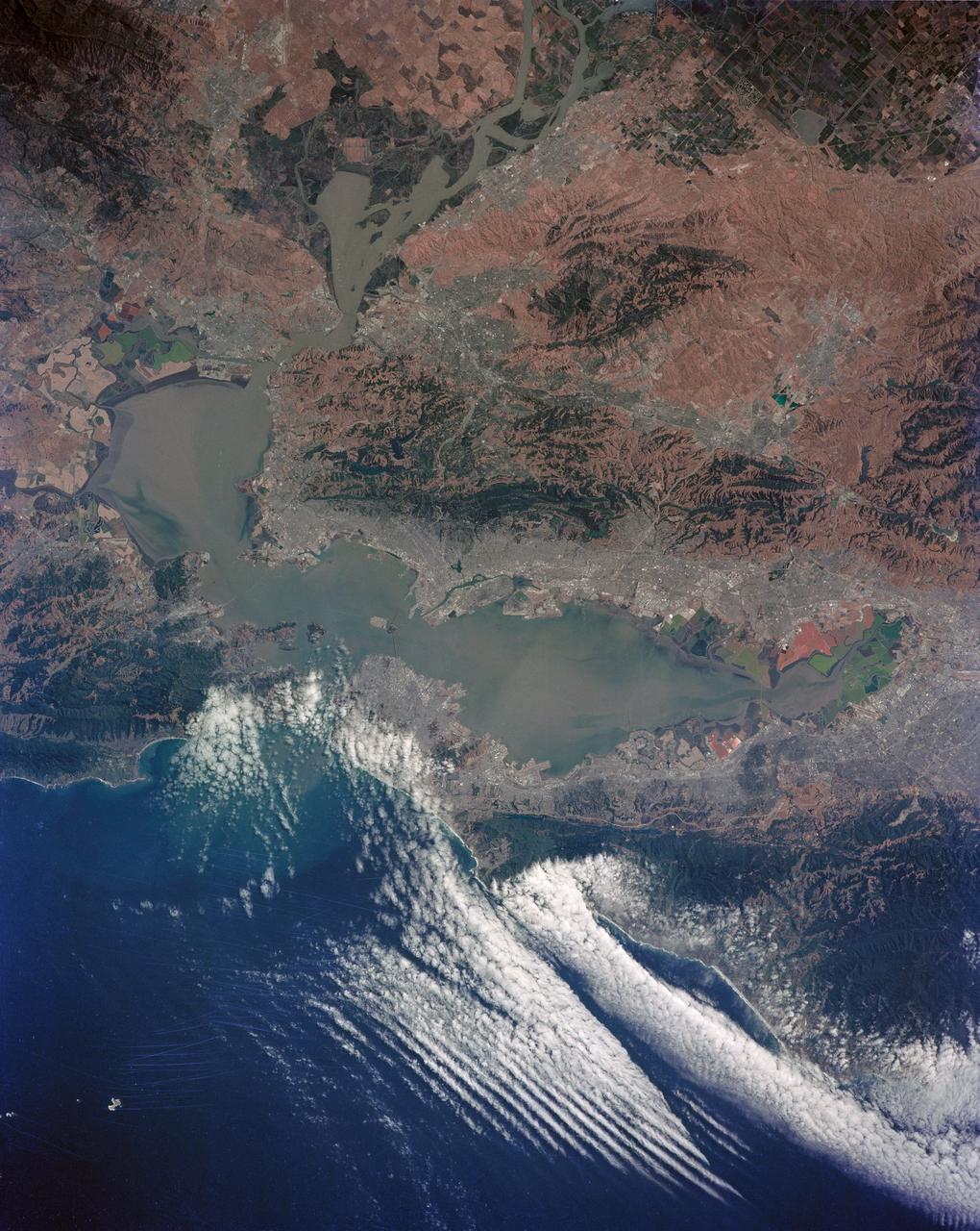
STS039-89-053 (28 April-6 May 1991) --- A 70mm, infrared frame of the city of San Francisco, taken on a clear day. The gray areas represent urban regions, and the red areas are vegetated. Within the city of San Francisco, parks like Golden Gate park and the Presidio at the base of the Golden Gate Bridge easily stand out from the well-developed parts of the city. Major thoroughfares and bridges (Golden Gate and Bay Bridges) are seen as are other landmarks such as Candlestick Park and Alcatraz. The trace of the San Andreas faults show as a straight valley running northerly along the San Francisco peninsula. Good detail is visible in the turbid waters of San Francisco Bay.
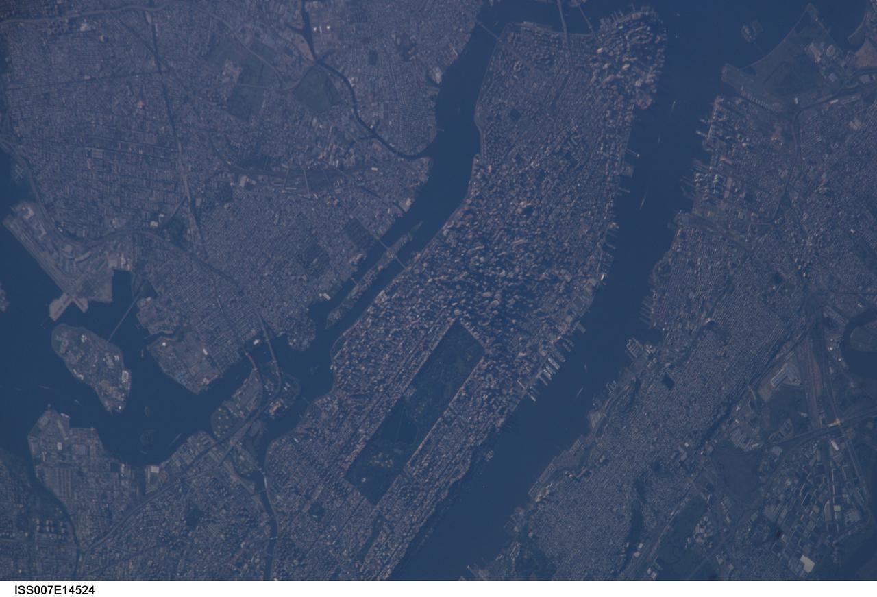
ISS007-E-14524 (7 September 2003) --- This view of New York City at dawn was taken by an Expedition 7 crewmember onboard the International Space Station (ISS). Central Park on Manhattan is just below center frame.
iss055e084525 (May 18, 2018) --- The archaeological and heritage site of N'Dhala Gorge Nature Park, near the city of Alice Springs in the Northern Territory of Australia, is pictured from the International Space Station.
iss056e077377 (June 24, 2018) --- The North Saskatchewan River and the southwestern portion of the Canadian city of Edmonton, Alberta were pictured as the International Space Station orbited about 255 miles above Banff National Park in the Rocky Mountains.
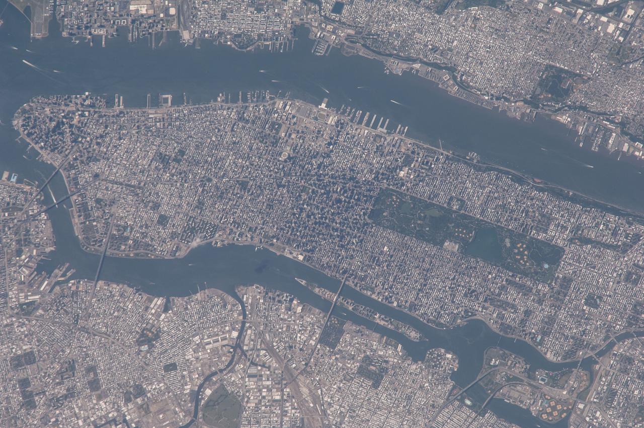
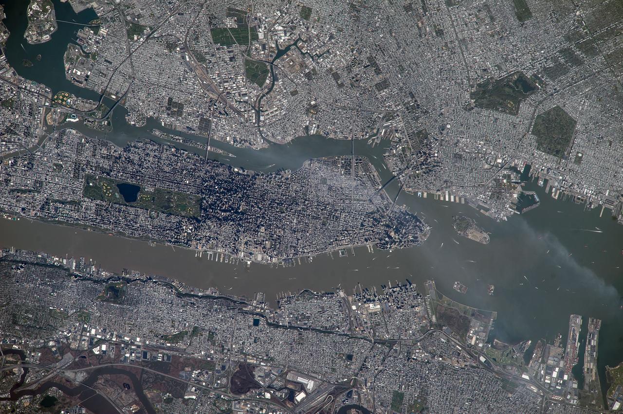
iss065e484582 (Oct. 15. 2021) --- Central Park figures prominently in this photograph of Manhattan Island in New York City as the International Space Station orbited 262 miles above the northeastern United States.
ISS040-E-108383 (25 Aug. 2014) --- One of the Expediton 40 crew members aboard the Earth-orbiting International Space Station photographed this image of a large part of New York City on Aug. 25, 2014. Manhattan Island and its Central Park are tell-tale points for recognition purposes for the six-person crew of the orbital outpost, flying 225 approximately nautical miles above the city.
ISS040-E-108386 (25 Aug. 2014) --- One of the Expedition 40 crew members aboard the Earth-orbiting International Space Station photographed this image of a large part of New York City on Aug. 25, 2014. Manhattan Island and its Central Park are tell-tale points for recognition purposes for the six-person crew of the orbital outpost, flying approximately 225 nautical miles above the city. The 800mm focal length used by the crew member provides great detail in the scene.
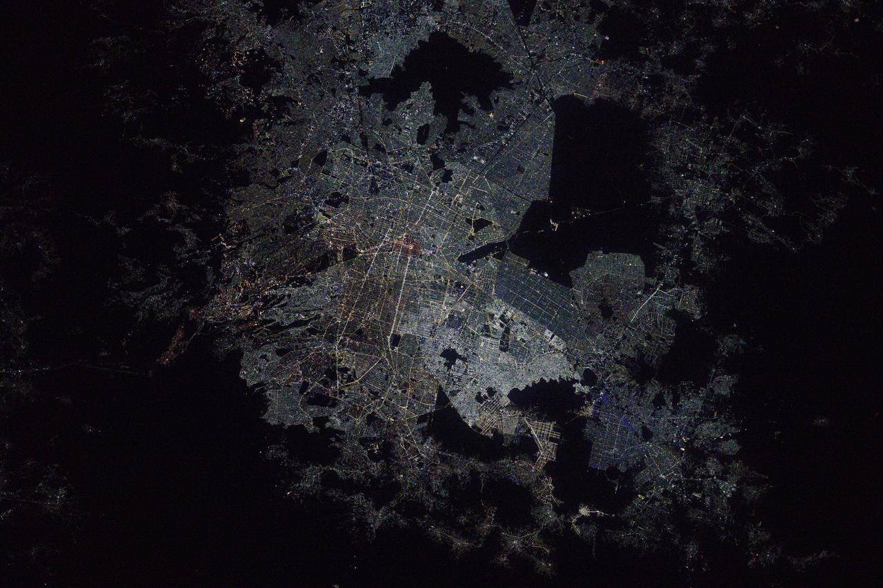
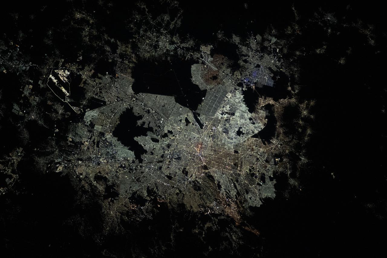
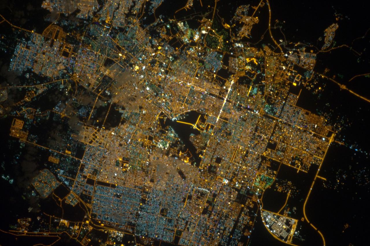
iss073e0075943 (May 16, 2025) --- Mexico City, the capital and most-populous city of the Latin American nation, surrounded by the dark voids of Lago de Texcoco nature preserve, the Lago Tláhuac-Xico nature preserve, and the Cumbres del Ajusco National Park is pictured at approximately 3 a.m. local time from the International Space Station as it orbited 259 miles above.
ISS040-E-108372 (25 Aug. 2014) --- One of the Expedition 40 crew members aboard the Earth-orbiting International Space Station photographed this image of a large part of New York City on Aug. 25, 2014. Manhattan Island and its Central Park are tell-tale points for recognition purposes for the six-person crew of the orbital outpost, flying approximately 225 nautical miles above the city. The 800mm focal length used by the crew member provides great detail in the scene.
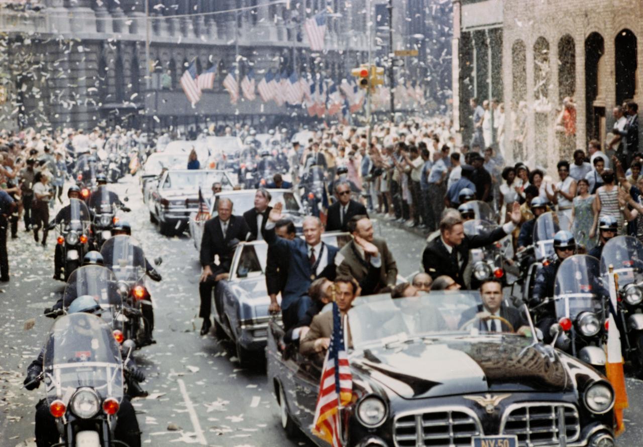
S70-17433 (13 Aug. 1969) --- New York City welcomes Apollo 11 crewmen in a showering of ticker tape down Broadway and Park Avenue in a parade termed as the largest in the city's history. Pictured in the lead car, from the right, are astronauts Neil A. Armstrong, commander; Michael Collins, command module pilot; and Edwin E. Aldrin Jr., lunar module pilot. The three astronauts teamed for the first manned lunar landing, on July 20, 1969.
iss070e027906 (Nov. 19, 2023) --- The night lights of Mexico City, the capital and largest city of Mexico with a population of 9.2 million, are pictured from the International Space Station as it orbited 260 miles above the central American nation. At far left, the well-lit Felipe Ángeles International Airport is easily observable from low-Earth orbit. The large, dark area at center top, is Lake Texcoco Ecological Park. The dark area just below, is the Sierra de Guadalupe mountain range.
ISS040-E-108374 (25 Aug. 2014) --- One of the Expedition 40 crew members aboard the Earth-orbiting International Space Station photographed this image of a large part of New York City on Aug. 25, 2014. Manhattan Island and its Central Park are tell-tale points for recognition purposes for the six-person crew of the orbital outpost, flying approximately 225 nautical miles above the city. The 800mm focal length used by the crew member provides great detail in the scene.

September 11th remembrance ceremony held in front of NASA Research Park Bldg-17 (Lunar Science Institute) hosted by the American Legion, Post 881, Moffett Field. City of Sunnyvale council members - Otto Lee and David Whittum presents Cerificate of Commendation
September 11th remembrance ceremony held in front of NASA Research Park Bldg-17 (Lunar Science Institute) hosted by the American Legion, Post 881, Moffett Field. City of Sunnyvale council members - Otto Lee and David Whittum presents Cerificate of Commendation
iss070e103269 (Feb. 27, 2024) --- The Summits of Monterrey National Park, part of the Sierra Madre Occidental mountain range and in between the cities of Monterrey and Saltillo in Mexico, was pictured by Expedition 70 Flight Engineer Jasmin Moghbeli of NASA as the International Space Station orbited 263 miles above the Latin American nation.
ISS028-E-045535 (9 Sept. 2011) --- The greater New York City metropolitan area can be studied in this photograph taken aboard the International Space Station by one of the Expedition 28 crew members. Central Park on Manhattan can be used as a guide for orientation, just to the right of center in the frame.

September 11th remembrance ceremony held in front of NASA Research Park Bldg-17 (Lunar Science Institute) hosted by the American Legion, Post 881, Moffett Field. City of Sunnyvale council members - Otto Lee and David Whittum presents Cerificate of Commendation
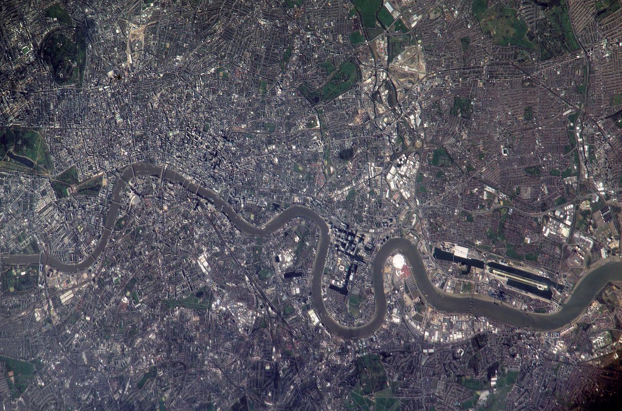
ISS010-E-22495 (2 April 2005) --- Numerous recognizable features appear in this detailed view of London, United Kingdom, photographed by an Expedition 10 crewmember on the International Space Station (ISS). The photographer had to look back along track for the shot, from a position over northern Germany. The most striking visual features are green open spaces such as Regent’s Park, Hyde Park and St. James’s Park east of Buckingham Palace. Many smaller parks indicate why Londoners are proud of being able to walk miles through the city mainly on grass. The River Thames—with its bridges and barges (some of the more than 14,000 craft registered to sail the Thames)—is the axis upon which the city was founded in Roman times. The relatively small area known as the City of London coincides with the ancient walled Roman city of Londinium on the north bank of the river (the line of the wall is marked closely for almost its entire length by modern streets), and includes St. Paul’s Cathedral near where the Roman temple stood. For scale, the river is 265 meters wide near St. Paul’s. The City is the financial center while Westminster is the center of government, including the Houses of Parliament and Downing Street, where the British Prime Minister lives. Several large structures visible in this image are railroad stations; three serving areas north of London (Euston, St. Pancras and King’s Cross), and Waterloo Station serving southern Britain. The London Eye, a famous Ferris wheel 140 meters high, is situated on an oval island in the River Thames, visible just west of Waterloo Station. Many larger buildings can also be identified, partly because they cast shadows—Buckingham Palace, St Paul’s Cathedral, and the Tate Modern art museum (a converted power station, the 99-meter chimney was designed to fall just short of the crest of St Paul’s dome).
STS072-721-010 (11-20 Jan. 1996) --- Astronauts aboard the Space Shuttle Endeavour exposed this frame of Brisbane, the third largest city in Australia, as well as the capital of Queensland. The heart of the city is 12 miles from Moreton bay and is located on the Brisbane River. In the photograph this area is clearly visible due to the "W"-shaped bend in the river. Mount Coot-Na Park is the dark area on the upper edge of the frame. This area provides an overlook for the entire city. Moreton Island is the Exclamation shaped island protecting the harbor. Fraser Island is about 150 miles north of Brisbane. The international airport is directly above the river in this view.
STS040-152-100 (5-14 June 1991) --- Although clouds obscure part of the city of San Francisco and the mouth of San Francisco Bay, development and physiographic features in the immediate vicinity of the bay are well displayed. The photograph clearly shows the eastern part of the city, including the Embarcadero, the Bay Bridge, which was damaged in the 1989 earthquake, and Candlestick Park, San Mateo, and Dumbarton Bridges, cross the southern portion of the bay. Vari-colored salt ponds also rim the southern Bay near Moffett Field. Highway 280 runs along the San Andreas fault south of the city. On the eastern margin of the bay are Berkeley the Sacramento River and the Haywood and Calaveras faults.

Ushuaia is the capital of Tierra Del Fuego, Argentina, and is regarded as the southernmost city in the world. First inhabited more than 10,000 years ago, the city received its first major economic growth when a prison was established in the 1890s. Ushuaia's current population of about 57,000 has developed the city into a tourist hub for those visiting the Tierra del Fuego National Park. The image was acquired March 25, 2018, covers an area of 18.6 by 21.1 kilometers, and is located at 54.8 degrees south, 68.3 degrees west. https://photojournal.jpl.nasa.gov/catalog/PIA22685

ISS014-E-08741 (28 Nov. 2006) --- Mumbai, India is featured in this image photographed by an Expedition 14 crewmember on the International Space Station. This view is one of three (frames 8741, 8742 and 8744) acquired within ten seconds of each other as the station passed over India. Mumbai (formerly known as Bombay) is a so-called mega city, with over 21 million people living in the greater Mumbai metropolitan region. Mega cities like Tokyo, New York, Sao Paulo, and Mumbai are also known as conurbations -- large contiguous areas of urban land cover formed from the growth and merging together of previously separate and distinct urban centers. The Mumbai conurbation includes several municipal entities including Bhiwandi, Kalyan, Thane, and Ulhasnagar. Located along the coast of western India on Salsette Island, Mumbai is generally considered to be the most modern of India's cities and is a major economic, transportation, and cultural center. Almost cloud-free conditions reveal the continuous urban land cover of the mega city extending north to south across Salsette Island -- a distance of nearly 50 kilometers. Sanjay Gandhi National Park, bordered on three sides by the urbanized area, is the largest national park in the world located within city limits. In addition to providing a refuge for native flora and fauna, the park also includes two lakes that form part of the Mumbai drinking water system.
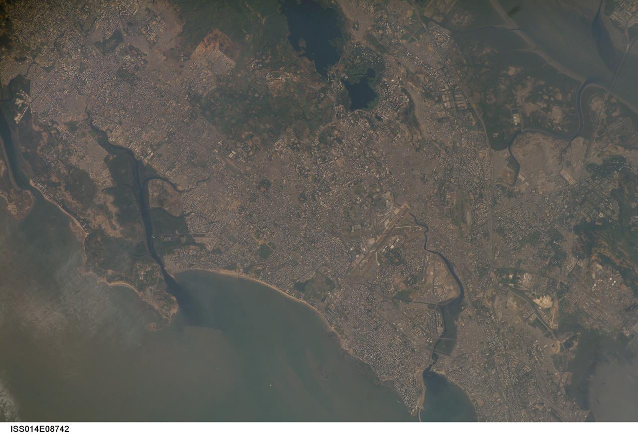
ISS014-E-08742 (28 Nov. 2006) --- Mumbai, India is featured in this image photographed by an Expedition 14 crewmember on the International Space Station. This view is one of three (frames 8741, 8742 and 8744) acquired within ten seconds of each other as the station passed over India. Mumbai (formerly known as Bombay) is a so-called mega city, with over 21 million people living in the greater Mumbai metropolitan region. Mega cities like Tokyo, New York, Sao Paulo, and Mumbai are also known as conurbations -- large contiguous areas of urban land cover formed from the growth and merging together of previously separate and distinct urban centers. The Mumbai conurbation includes several municipal entities including Bhiwandi, Kalyan, Thane, and Ulhasnagar. Located along the coast of western India on Salsette Island, Mumbai is generally considered to be the most modern of India's cities and is a major economic, transportation, and cultural center. Almost cloud-free conditions reveal the continuous urban land cover of the mega city extending north to south across Salsette Island -- a distance of nearly 50 kilometers. Sanjay Gandhi National Park (partially out of frame), bordered on three sides by the urbanized area, is the largest national park in the world located within city limits. In addition to providing a refuge for native flora and fauna, the park also includes two lakes that form part of the Mumbai drinking water system.
STS054-74-049 (13-19 Jan. 1993) --- St. Croix is the largest, and most industrial of the U.S. Virgin Islands. This photograph captures St. Croix's features in great detail. The large industrial complex in the middle of the southern shore is the world's largest petroleum refinery. The main city, Christiansted, can be seen across the island on the north shore. The reefs around the eastern end of St. Croix are preserved as a submarine national park -- Buck Island Reef National Park -- around the small island off the north shore of the eastern end of St. Croix.
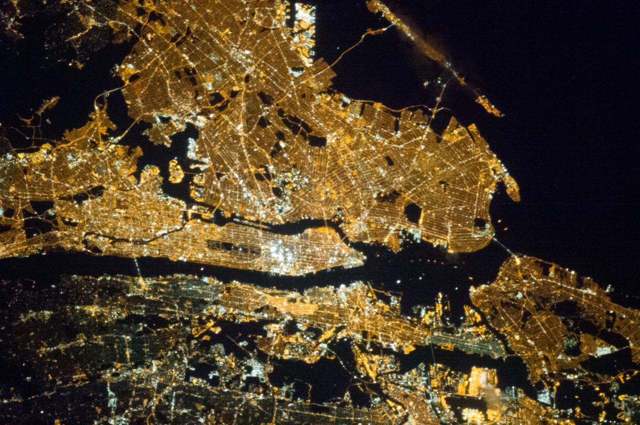
iss073e0982169 (Oct. 25, 2025) --- Long Island, New York—the most populous island in the United States—stretches 118 miles from west to east, extending from Brooklyn to Montauk Point. It lies between Long Island Sound to the north and the New York/New Jersey Bight to the south. Toward the upper left, New York City's island borough of Manhattan is visible, with the Hudson River and East River flowing on either side. The city's bright lights contrast with the elongated, darkened area of Central Park. This image was captured at approximately 2:24 a.m. local time from the International Space Station as it orbited 263 miles above the Empire State.
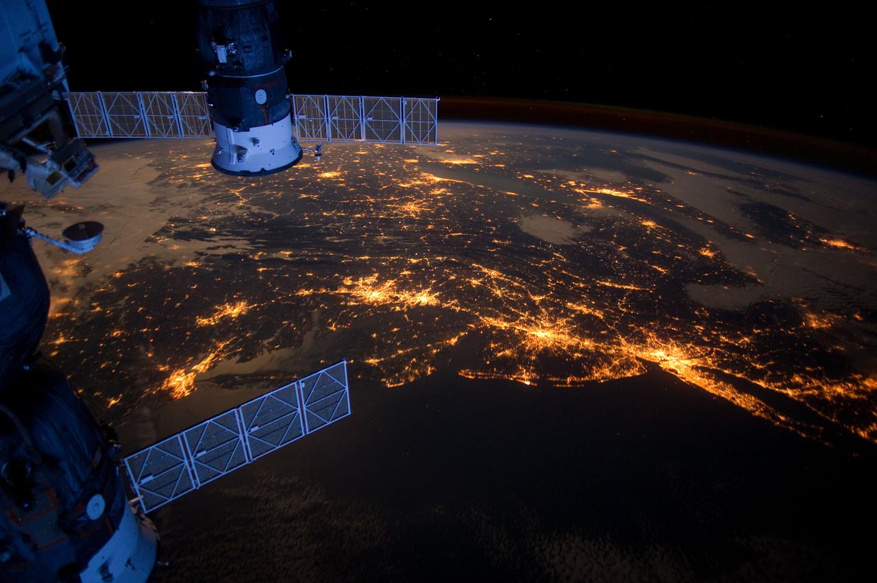
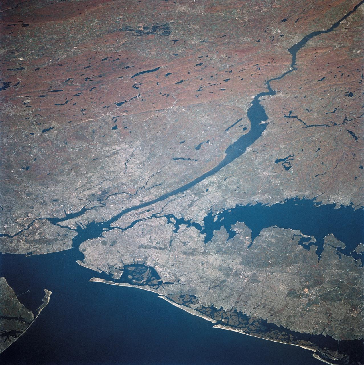
ISS030-E-078095 (6 Feb. 2012) --- One of the Expedition 30 crew members aboard the International Space Station took this nighttime photograph of much of the eastern (Atlantic) coast of the United States. Large metropolitan areas and other easily recognizable sites from the Virginia/Maryland/Washington, D.C. area spanning almost to Rhode Island are visible in the scene. Boston is just out of frame at right. Long Island and the Greater Metropolitan area of New York City are visible in the lower right quadrant. Large cities in Pennsylvania (Philadelphia and Pittsburgh) are near center. Parts of two Russian vehicles parked at the orbital outpost are seen in left foreground.
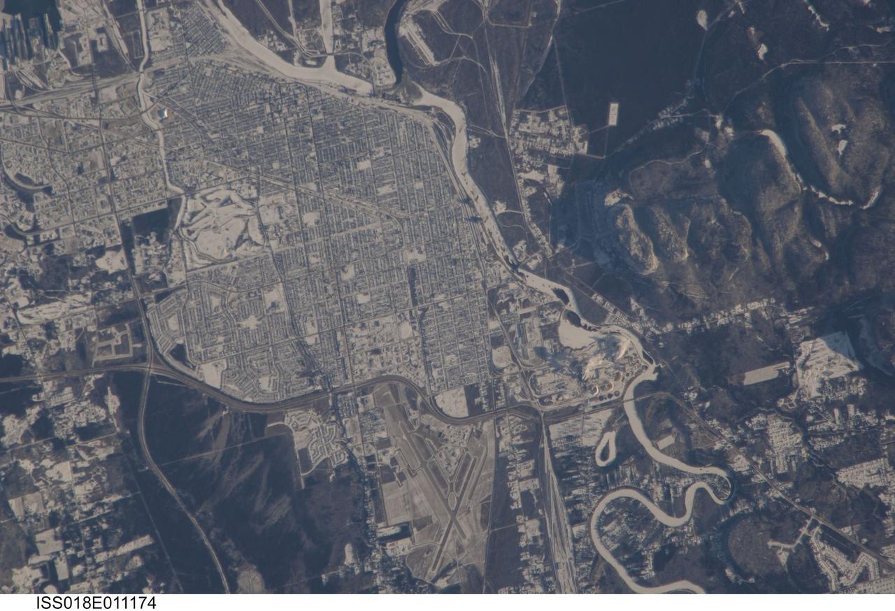
ISS018-E-011174 (6 Dec. 2008) --- The City of Thunder Bay, Ontario, Canada is featured in this image photographed by an Expedition 18 crewmember on the International Space Station. Located on the shores of Lake Superior, the metropolitan area of Thunder Bay is one of the largest in the Province of Ontario. It is also the major port providing access to the Great Lakes for central Canada?s grain products. The City of Thunder Bay is relatively new ? it was incorporated in 1970 by combining the cities of Fort William (depicted in this astronaut photograph) and Port Arthur with the townships of Neebing and McIntyre. While the growth and merging of separate municipalities into a larger contiguous metropolitan area is common (a process called agglomeration by urban geographers), it is less common for distinct cities to also merge into a new political entity. This detailed view is centered on the southern portion of Thunder Bay, comprised of the older city of Fort William. Winter snows outline the street grid of the city, while park areas interspersed throughout the street grid appear as roughly rectangular areas of unbroken white snow. Built materials appear light gray, while vegetated areas and rock outcrop near Mount McKay are dark green to dark gray. The Kam River to the south of Fort William is ice-covered, and has a homogeneous covering of snow that traces the river channel.
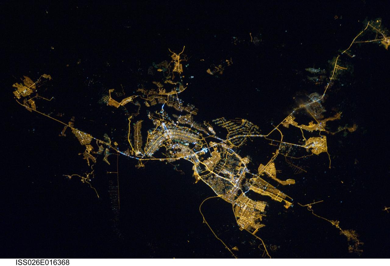
ISS026-E-016368 (8 Jan. 2011) --- Brasilia, Brazil at night time is featured in this image photographed by an Expedition 26 crew member on the International Space Station. Whether seen at night or during the day, the capital city of Brazil is unmistakable from orbit. Brasilia is located on a plateau (the Planalto Central) in the west-central part of the country, and is widely considered to be one of the best examples of 20th century urban planning in the world. One of its most distinctive design features—as seen from above—suggests a bird, butterfly, or airplane traveling along a northwest-southeast direction, and is made dramatically visible by city light patterns (center left, directly to the west of Lake Paranoa). Following the establishment of Brasilia in the early 1960s informal settlements began to form around the original planned city. Ceilandia, located to the west of Brasilia, was one such informal settlement. In 1970 the settlement was formalized by the government and is now a satellite city of Brasilia with its own distinct urban identity. The developed areas of Brasilia and its satellite cities are clearly outlined by street grid and highway light patterns at night in this photograph taken from the space station. The large unlit region to the northwest of the city is the Brasilia National Park (lower left); other dark regions to the south and southwest contain agricultural fields and expanses of Cerrado tropical savanna.
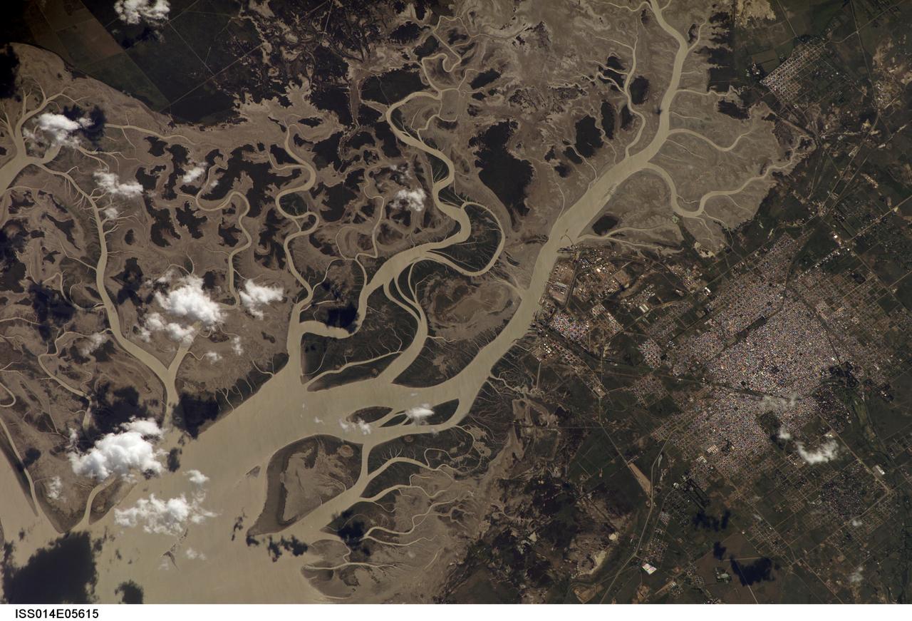
ISS014-E-05615 (14 Oct. 2006) --- Bahia Blanca, Buenos Aires Province, Argentina is featured in this image photographed by an Expedition 14 crewmember on the International Space Station. The port city of Bahia Blanca lies almost 600 kilometers southwest of Buenos Aires on the southern rim of the Argentine economic heartland. This small city of 275,000 people is captured in one frame which shows its position near the mouth of the Arroyo Naposta. The salt flats (gray) and wetlands bordering this estuary, characterized by twisting, light colored tidal channels and dark swamps, lie mainly on the south side of the river. The yellow tinge to the water surfaces arises from the partial sunglint reflection on this particular day. The name Bahia Blanca (White Bay) derives from the white color of the salt and was applied to the major bay--noted by Magellan as he probed the coast of South America for a passage to the Pacific Ocean in 1520--and then to the city at the head of this bay. Highways, airline routes and pipelines from oil and gas fields to the west and south all converge on Bahia Blanca. The city is a major cultural center and historically has acted as a gateway for immigration. Higher ground on the north side of the estuary affords stable ground for the growth of the city and for intensive agriculture, a mainstay of the Argentine economy. The city is set back from the waterfront where an industrial park, a petrochemical center, and dockyards (white ellipse) are located.
ISS033-E-020288 (13 Nov. 2012) --- A nighttime view of Riyadh, Saudi Arabia is featured in this image photographed by an Expedition 33 crew member on the International Space Station. The population of Riyadh, the capital city of Saudi Arabia, has risen dramatically in the last half century, from 150,000 in 1960 to an estimated 5.4 million in 2012. The city appears as a brightly colored patchwork in this nighttime photograph. The brightest lights, apart from those on the old Riyadh Airbase at center (the new international airport is far outside the city and not shown here), follow the commercial districts along King Abdullah Road and King Fahd Branch Road. Many of the darker patches within the built area are city parks. University sectors stand out with different street and light patterns, as seen in the King Saud University campus which houses the Arabic Language Institute, and the Princess Nora Bint Abdul Rahman University which is the largest all-female university in the world. Highways and various ring roads also stand out in night imagery due to bright regular lighting. Lighted developments beyond the ring roads mark the growth of the city. Newer neighborhoods, set further from the city center, are recognizable by blue-gray lightning.
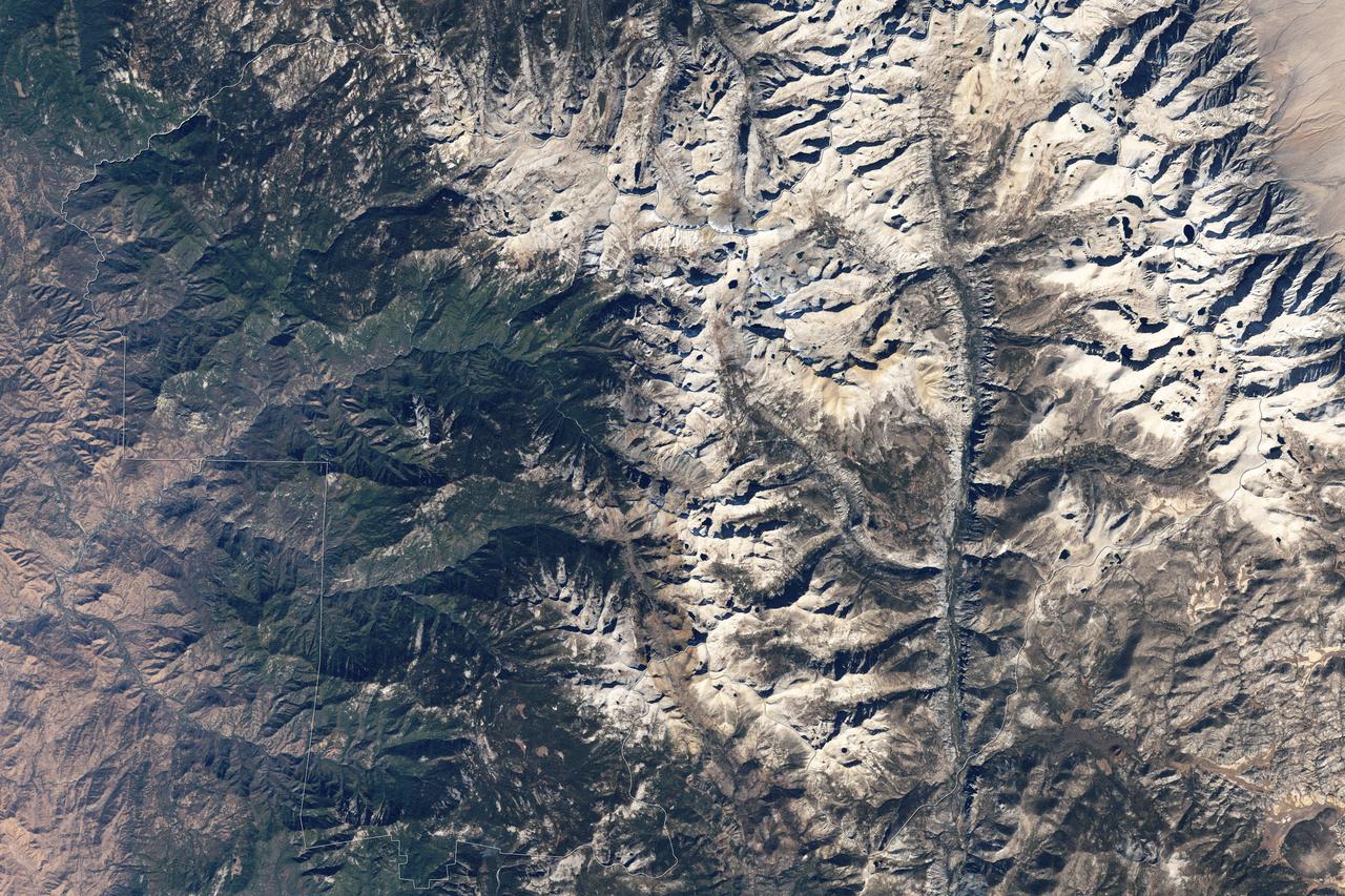
Naked peaks, sheltered valleys, snowfields, towering trees, and alpine meadows make up the varied landscape of Sequoia National Park in California. Established as a National Park by Congress on September 25, 1890, Sequoia National Park is the second-oldest U.S. National Park, after Yellowstone. This national park borders Kings Canyon National Park. The Thematic Mapper sensor on NASA’s Landsat 5 satellite captured this true-color image of Sequoia National Park, outlined in white, on October 22, 2008. Sunlight illuminates southern slopes, leaving northern faces in shadow in this autumn image. In the west, deep green conifers carpet most of the land. These forested mountains are home to the park’s most famous giant sequoia trees. Sequoia National Park sits at the southern end of the Sierra Nevada mountains. Terrain alternates between extremes, from peaks such as Mt. Whitney—the highest peak in the contiguous United States—to deep caverns. The rivers and lakes in this region are part of a watershed valuable not only to the plants and animals of the park, but also to farms and cities in California’s Central Valley. Read more: <a href="http://go.nasa.gov/2bzGOXr" rel="nofollow">go.nasa.gov/2bzGOXr</a> Credit: NASA/Landsat5 <b><a href="http://www.nasa.gov/audience/formedia/features/MP_Photo_Guidelines.html" rel="nofollow">NASA image use policy.</a></b> <b><a href="http://www.nasa.gov/centers/goddard/home/index.html" rel="nofollow">NASA Goddard Space Flight Center</a></b> enables NASA’s mission through four scientific endeavors: Earth Science, Heliophysics, Solar System Exploration, and Astrophysics. Goddard plays a leading role in NASA’s accomplishments by contributing compelling scientific knowledge to advance the Agency’s mission. <b>Follow us on <a href="http://twitter.com/NASAGoddardPix" rel="nofollow">Twitter</a></b> <b>Like us on <a href="http://www.facebook.com/pages/Greenbelt-MD/NASA-Goddard/395013845897?ref=tsd" rel="nofollow">Facebook</a></b> <b>Find us on <a href="http://instagrid.me/nasagoddard/?vm=grid" rel="nofollow">Instagram</a></b>
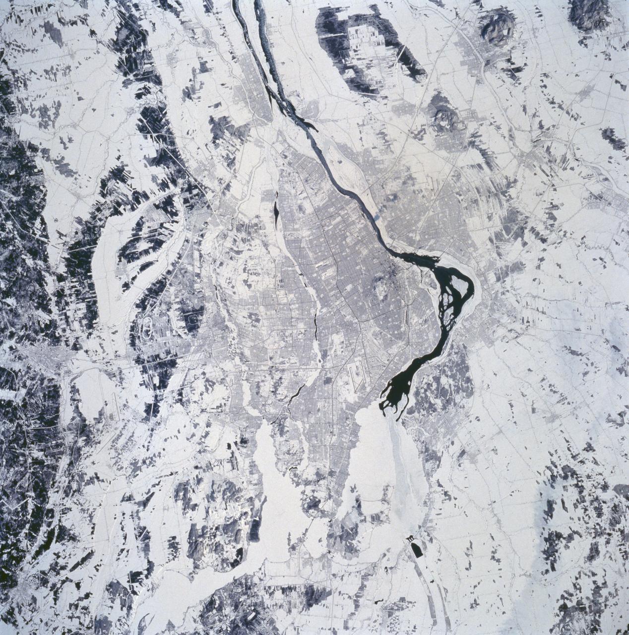
STS060-94-072 (3-11 Feb 1994) --- The city of Montreal is located on the island of Montreal at the confluence of the St. Lawrence and Ottawa Rivers. Despite its distance from the sea (1,000 miles) Montreal is a large inland port. It is also Canada's largest city and the second largest French speaking city in the world. This particular snow covered scene highlights the major highways and street patterns throughout the metropolitan Montreal area. The runways of the two large international airports of Mirabel (located 25 miles northwest of downtown Montreal) and Dorval (located approximately 8 miles west of the downtown area) are clearly visible on this photograph. Even the outline of Mount Royal Park, an imposing hilly feature near the downtown central business district, can be seen. Patches of open, ice-free (very dark areas) are detectable as the St. Lawrence River (Seaway) makes its way along the south and southeastern side of Montreal.
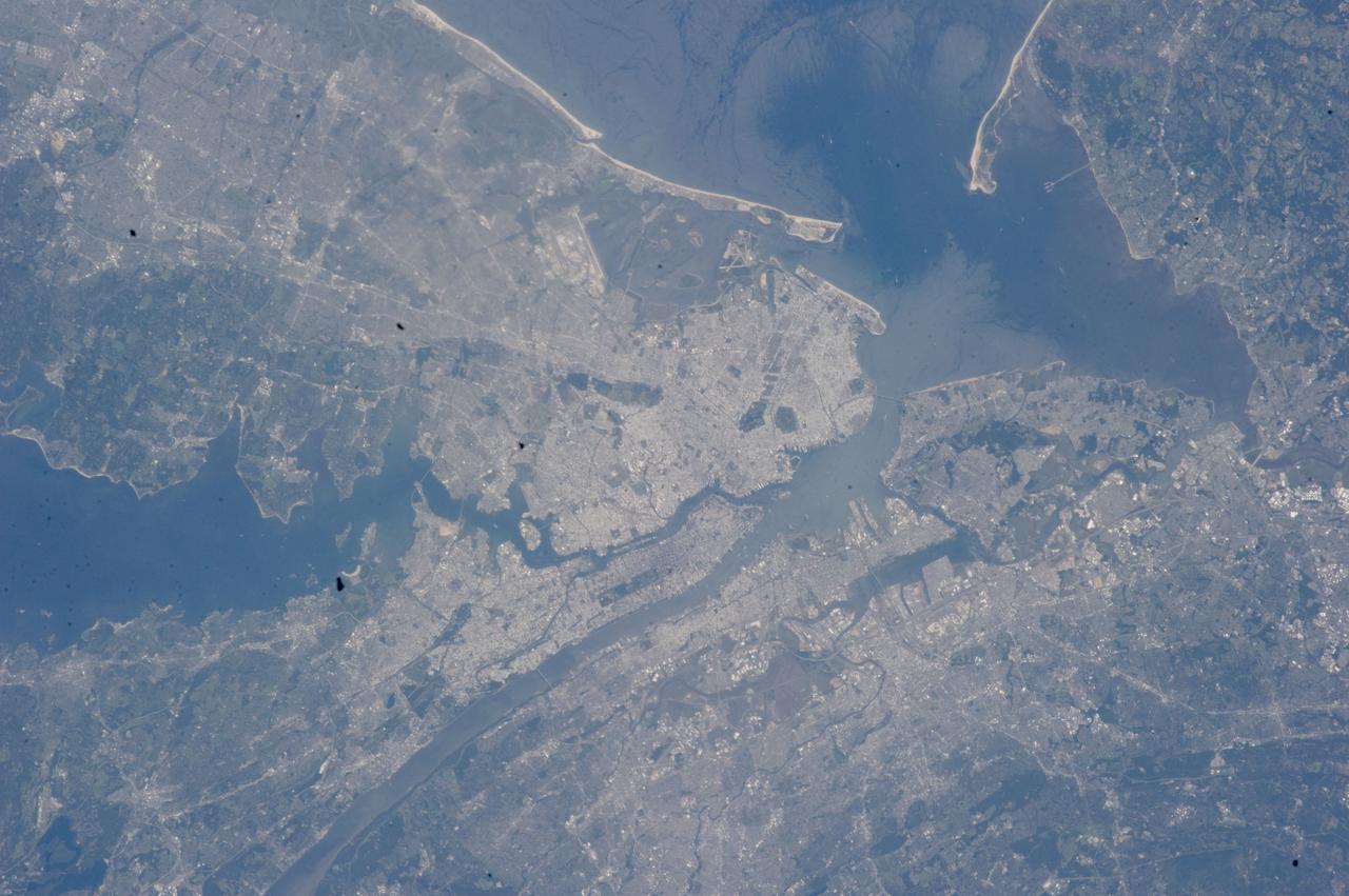
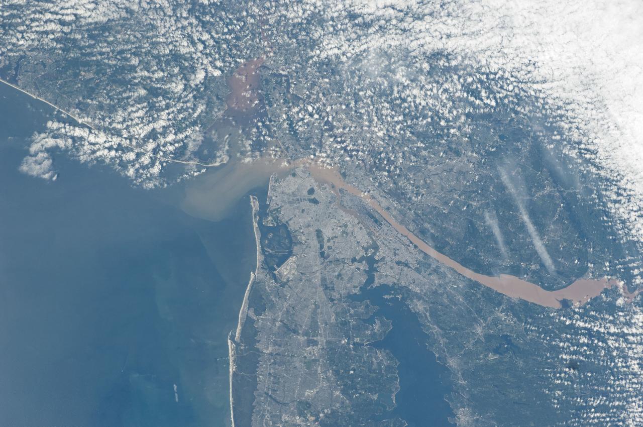
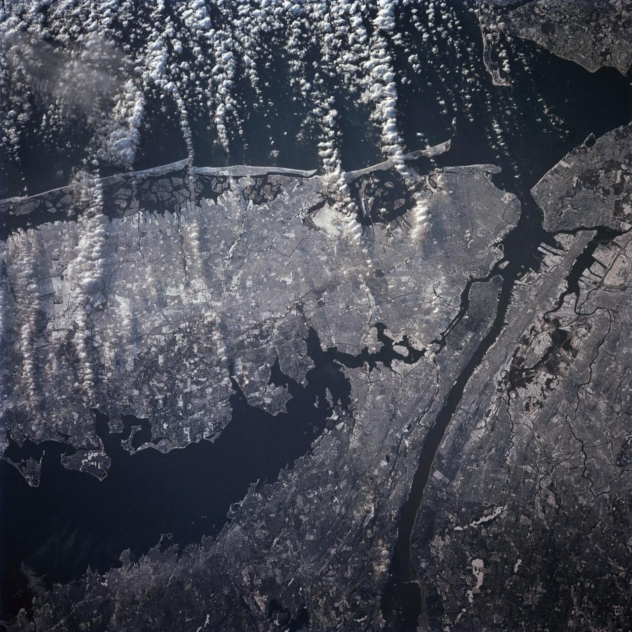
ISS032-E-027898 (12 Sept. 2012) --- This vertical view from the International Space Station features New York City. With a population in the metropolitan New York of 18.9 million (2011 figures from Census Bureau), and in the city of some 8.25 million, the New York City area is one of the leading commercial, financial, cultural, and communication centers in the world. The sediment-laden Hudson River enters the scene near the bottom left (north) of the image and can be seen flowing south emptying into Upper and Lower New York Bays (right of center). Much of Long Island is visible extending to the east at center and upper left of the image. Right (west) of the Hudson River, much of the state of New Jersey and the Newark metropolitan area are visible. Sandy Hook in New Jersey can be seen in the upper right quadrant of the image. Central Park on Manhattan can be seen below and just to the left of center as a dark rectangular patch.
STS-42 Earth observation taken aboard Discovery, Orbiter Vehicle (OV) 103, is of New York City (NYC), New York (41.0N, 74.0W). Snow cover highlights the large areas of development and the many reservoirs in this wintertime scene of the metropolitan NYC area. Features such as Central Park in Manhattan, the George Washington Bridge connecting Manhattan with New Jersey, street patterns in most of the boroughs, La Guardia and JFK airports in Queens, and the extensive harbor system are easily identified.
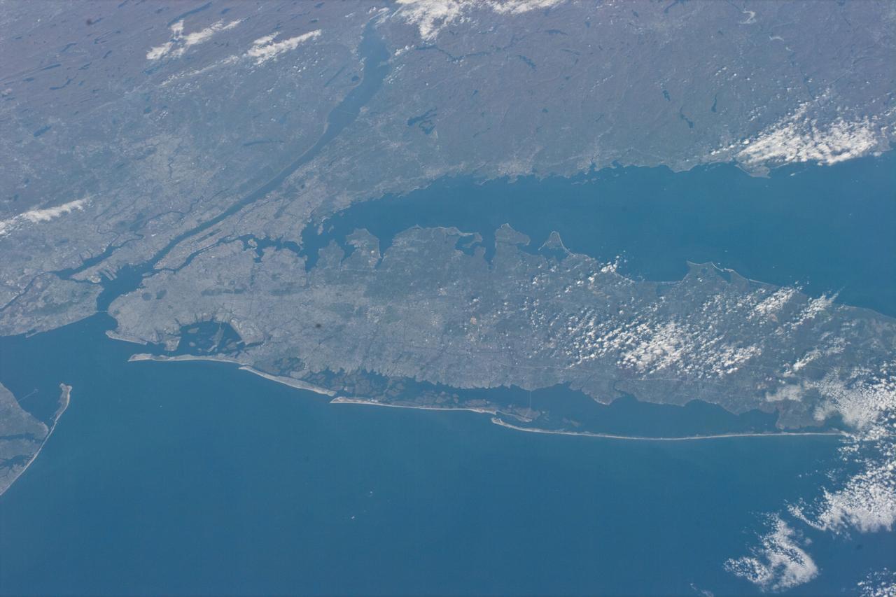
STS073-E-5098 (30 Oct. 1995) --- Long Island, New York stretches across the scene. The New York City metropolitan complex is at the left; Central Park can be seen as a dark rectangle between the Hudson and East Rivers. Sandy beaches of the Long Island barrier islands mark the boundary between Atlantic Ocean and quiet lagoons and marshes. The frame was exposed with the Electronic Still Camera (ESC).
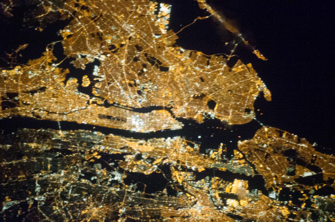
ISS035-E-008051 (23 March 2013) --- One of the Expedition 35 crew members aboard the Earth-orbiting International Space Station exposed this 400 millimeter night image of the greater New York City metropolitan area on March 23. For orientation purposes, note that Manhattan runs horizontal through the frame from left to the midpoint. Central Park is just a little to the left of frame center.
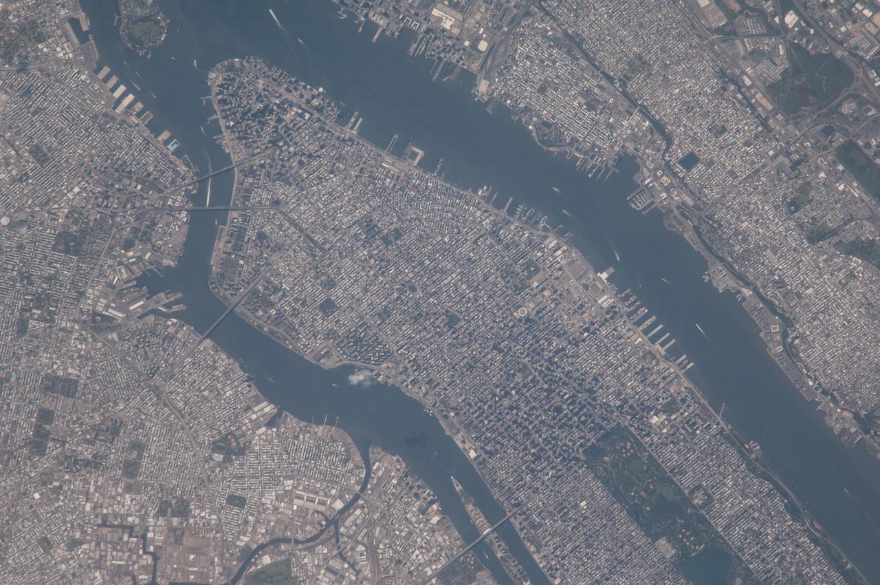
ISS010-E-21487 (26 March 2005) --- Manhattan Island and its easily recognizable Central Park are featured in this image photographed by an Expedition 10 crewmember on the International Space Station. Some of the other New York City boroughs (including parts of Queens and Brooklyn) are also shown, as are two small sections of the New Jersey side of the Hudson River.
ISS035-E-008056 (23 March 2013) --- One of the Expedition 35 crew members aboard the Earth-orbiting International Space Station exposed this 400 millimeter night image of the greater New York City metropolitan area on March 23. For orientation purposes, note that Manhattan runs horizontal through the frame from left to the midpoint. Central Park is just a little to the left of frame center.
ISS041-E-016740 (17 Sept. 2014) --- One of the Expedition 41 crew members aboard the Earth-orbiting International Space Station exposed this Sept. 17 nocturnal scene featuring most of the largest cities on the central eastern seaboard. Even at 221 nautical miles above Earth, the 28mm focal length on the still camera was able to pick up detail in the image, for example, Central Park on Manhattan at right frame. The nation?s capital is very near frame center.
STS062-81-010 (4-18 March 1994) --- The recent heavy snowfalls help to accentuate the major transportation networks, (railroads, highways and airports), throughout the New York City metropolitan area. This particular scene also highlights the land-water boundaries and the lighter open spaces, such as parks, cemeteries and recreational areas. The snows have produced a white blanket effect on these areas. Even some of the snow-covered lakes can be discerned. The boroughs of Staten Island, Brooklyn, Queens, The Bronx and Manhattan are also recognizable on the photograph.
In this late winter scene of Chicago, Illinois, USA (41.5N, 87.0W) the light dusting of snow has actually enhanced the determination of the cities street pattern, parks and other cultural features. Sited at the south end of Lake Michigan, Chicago has long served as an industrial, transportation and communications center for the midwest. The obvious snowline on the ground enables meteorologists to trace the regional groundtracks of winter storms.
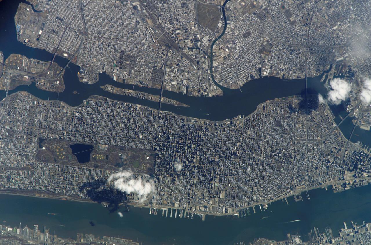
ISS039-E-018541 (5 May 2014) --- New York City is featured in this image photographed by an Expedition 39 crew member on the International Space Station. This detailed image reveals the narrow shape of Manhattan located between the Hudson River and the East River, a feature familiar to crews on the space station. The ragged line of shadow cast by the Palisades cliff crosses the bottom of the image. Wharves jut into the rivers; bridges are visible mainly because of the shadows they cast, and the grid pattern of major roads stands out. On the island of Manhattan itself the main visual features are Central Park (with playing fields as white dots) and two darker zones where the tallest buildings in Midtown East and the Financial District cast strong shadows, even in this early afternoon view. Rivers and parks reduce the effect of the urban heat island – the local zone of higher surface and atmospheric temperatures generated by storage and later release of heat by city materials such as concrete and tarmac. Rivers provide pathways for wind and the cooling effect of parks is detectable by instruments on spacecraft that can measure the temperature of the ground surface. Tall buildings have a more complex effect. Shadowed zones in the "urban canyons" between tall buildings – as shown in this image – receive fewer hours of direct sun per day. But where the sun can reach canyon floors, the sun's energy is reflected back up at the walls of the buildings where it is absorbed and later released as heat. This is especially the case at night when urban canyons retain more heat than those sections of the city with shorter buildings.
STS039-88-054 (28 April-6 May 1991) --- The dense urban development of the New York City metropolitan area in downstate New York, Long Island and New Jersey shows up as gray and white on this color Infrared photograph. The scene was taken on a remarkably clear spring day. Almost all the major man-made structures of the area are obvious, including ship traffic in and out of New York Harbor, the piers, all of the bridges spanning the area rivers and connecting Manhattan Island with New Jersey, the Bronx, Brooklyn and Queens, the three major airports (Newark, La Guardia and JFK), the New York State thruway, as well as Shea Stadium and Yankee Stadium. The reds and pinks are vegetated areas. Central Park clearly shows up on Manhattan, as do the string of parks along the cliffs (formed by the Palisades sill) along the west side of the Hudson north of the George Washington Bridge.
STS058-081-038 (18 Oct-1 Nov 1993) --- Fall colors in the northeast were captured by the STS-58 crew members. Long Island and the lower Hudson River dominate this scene, taken on a clear October day at the peak of the colorful fall foliage season. The maples and oaks of the Hudson Highlands are particularly striking, and contrast with the many lakes and reservoirs north of the city. The New York metropolitan area in New York and New Jersey (including Jersey City and Newark) is easily seen in the foreground. Manhattan Island sits near the middle of the scene, but Central Park foliage is still fairly green. West Point can be seen near the upper right, on the west-pointing bend of the Hudson, and the Catskills are in the far upper left.
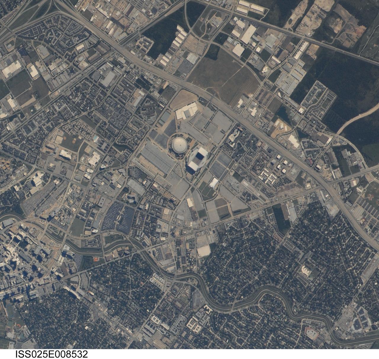
ISS025-E-008532 (5 Oct. 2010) --- Photographed by an Expedition 25 crew member on the International Space Station, this highly detailed photograph highlights the Reliant Park area of the Houston, TX “inner loop”, defined as that part of the metropolitan area located within Interstate Highway 610 that rings the downtown area. Reliant Park includes two large sports complexes visible at center, Reliant Stadium and Reliant Astrodome. Houston is the location of the NASA Johnson Space Center (out of frame) and is notable among major US metropolitan areas for its lack of formal zoning ordinances (other forms of regulation play a similar role here). This leads to highly mixed land use within the urban and suburban areas of the city. The land uses adjacent to Reliant Park include large asphalt parking areas, vacant lots with a mixture of green grass cover and brown exposed topsoil, and both single- and multi-family residential areas. A forested area (dark green, lower left) is located less than two kilometers from the parking lots of Reliant Park. This subset of a handheld digital camera image has a spatial resolution of 2-3 meters per pixel (or picture element), making it one of the highest spatial resolution images yet obtained from the space station. Such high image resolution is made possible by using lens “doublers” to increase the optical magnification of camera lenses. As important is active ISS motion compensation by experienced astronauts during photography. Motion compensation requires the astronaut to pan the camera by hand at just the right rate, keeping the object at the same point in the viewfinder. The technique involves bracing oneself against the space station bulkhead to prevent movement related to weightlessness. Early attempts produce a “smeared” image that looks out of focus. Traditional short lens photography is easier because it does not require motion compensation.
ISS038-E-016506 (12 Dec. 2013) --- A nighttime view of Salt Lake City, Utah is featured in this image photographed by an Expedition 38 crew member on the International Space Station. The Salt Lake City metropolitan area is located along the western front of the Wasatch Range in northern Utah. Viewed at night from the vantage point of the space station, the regular north-south and east-west layout of street grids typical of western U.S. cities is clearly visible. Known as "the crossroads of the West", the headquarters of The Church of Jesus Christ of Latter-day Saints (also known as the LDS Church and informally as the Mormon Church), and the state capital of Utah, Salt Lake City was founded in 1847 by Brigham Young together with other followers of the Mormon faith. The Salt Lake City metropolitan area today is included in the larger urban Wasatch Front region of Utah which includes over two million people (approximately 80 percent of the population of the state). Both the color of the city lights and their density provide clues to the character of the urban fabric -- yellow gold lights generally indicate major roadways such as Interstate Highway 15 that passes through the center of the metropolitan area (center, left to right), while bright white clusters of lights are associated with city centers, commercial, and industrial areas. In contrast, residential and suburban areas are recognizable due to diffuse and relatively dim lighting (center left). The Wasatch Range to the east is largely dark, as are several large urban parks and golf courses located within the illuminated urban areas.
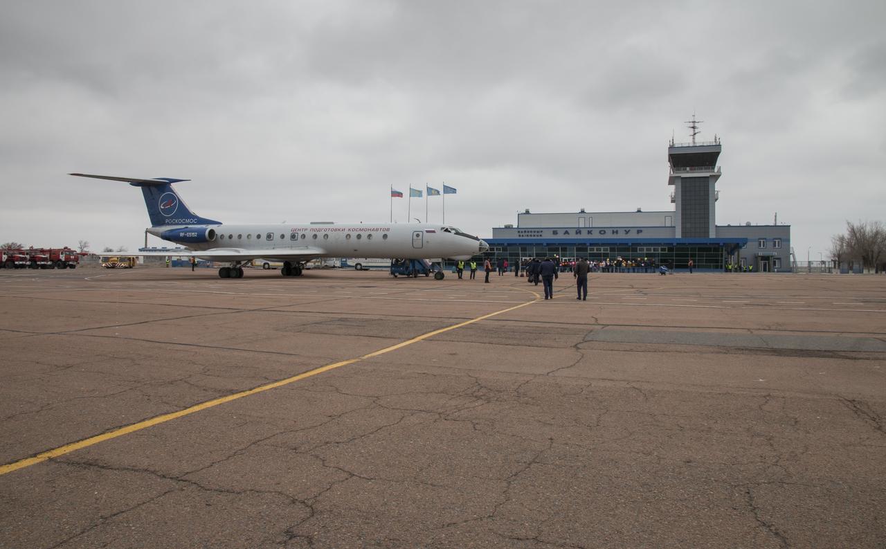
The Gagarin Cosmonaut Training Center (GCTC) aircraft is seen parked at the Kraini Airport after flying Expedition 43 NASA Astronaut Scott Kelly, Russian Cosmonauts Mikhail Kornienko, center, and Gennady Padalka of the Russian Federal Space Agency (Roscosmos) from Star City, Russia, Saturday, March 14, 2015, Baikonur, Kazakhstan. The trio are preparing for launch to the International Space Station in their Soyuz TMA-16M spacecraft from the Baikonur Cosmodrome in Kazakhstan March 28, Kazakh time. As the one-year crew, Kelly and Kornienko will return to Earth on Soyuz TMA-18M in March 2016. Photo Credit: (NASA/Victor Zelentsov)
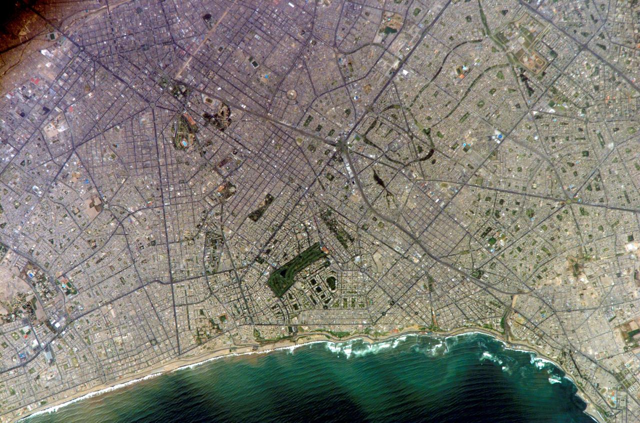
ISS010-E-20111 (15 March 2005) --- Lima, Peru is featured in this image photographed by an Expedition 10 crewmember on the International Space Station (ISS). Located on the broad alluvial fan of the Rimac River, Lima is the capital of Peru and the only mega city (7.7 million inhabitants in 2002) located on the western coastline of South America. The city was established by Francisco Pizarro in 1535 and became an important colonial port linking silver mines of the Altiplano of the high Andes to the east with the burgeoning Spanish empire. During the mid-20th century a significant relocation of people from rural mountain communities into the Lima metropolitan area led to its growth into a mega city. Problems now facing the metropolitan region include development of adequate water resources, control of pollution, and the potential effects of natural hazards such as earthquakes and landslides. This photograph depicts the wealthier San Isidro and Mira Flores quarters of Lima. This part of the metropolitan area is characterized by numerous vegetated parks, golf courses (such as the Lima Golf Course—approximately 1 kilometer long), and greenbelts interspersed with residential and commercial areas. The higher proportion of dark asphalt in the street grid of the residential and commercial areas lends a purple coloration to the left portion of the image (downtown Lima is to the north). Regions with fewer built materials and vegetation are light tan. Wave patterns are visible approaching beaches, popular tourist destinations, in the lower half of the image.
ISS011-E-07471 (28 May 2005) --- Sept-Îles, Gulf of St Lawrence, Quebec, Canada is featured in this image photographed by an Expedition 11 crewmember on the International Space Station (ISS). Seven Island Bay (left side of the image) is one of the largest (8–10 kilometers across) and best protected bays on Quebec’s north shore of the Gulf of St. Lawrence. Because this is both a deep water port and ice-free year round, Sept-Îles is one of Quebec’s busiest ports. Locally produced materials (iron ore, alumina) comprise the bulk of port traffic, but Sept-Îles also acts as a trans-shipment point for goods moving to Europe, the Far East and South America. The small city of Sept-Îles (~30,000 people) appears in the center of the view; Pointe Noir is opposite the city in the lower left corner. The industrial park lies top left and the angled runways of the airport appear east of the city. Five (of the bay’s seven) islands appear at the bottom of the view. Wind and swells produce patterns on the water. Ships can be seen in the bay and a ship wake appears between the two left islands at the bottom of the view.
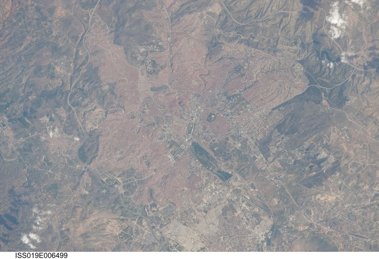
ISS019-E-006499 (11 April 2009) --- Ankara, Turkey is featured in this image photographed by an Expedition 19 crewmember on the International Space Station. The central portion of the capital city of Turkey, Ankara, is featured in this view. Ankara is located in central Turkey ? the climate here is continental and relatively dry, leading to cold winters and hot summers. The region is prone to major earthquakes, as Turkey experiences tectonic forces from both the African plate to the west and the Arabian plate to the east. Despite the earthquake hazard, the city traces its roots back into antiquity, with a Hittite settlement here prior to 1200 BC. A citadel built and occupied in turn by the Galatians, Romans, Byzantines, and Seljuks overlooks the central portion of the city, and today serves as both a historical and recreational site. Perhaps an even more imposing structure - the mausoleum of the founder of the modern-day Republic of Turkey, Mustafa Kemal Ataturk is visible upon an adjacent hill to the southwest. Hillslopes around the city (left and right) are fairly green due to spring seasonal rainfall. One of the most striking aspects of the urban area is the almost uniform use of red brick roofing tiles that contrast with lighter colored road networks ? this is particularly evident in the northern (lower left) and southern (upper right) portions of the city. Numerous park areas are visible as green patches interspersed within the red-tile roofed urban region. A region of cultivated fields in the western portion of the city (center) is a recreational farming area known as the Ataturk Forest Farm and Zoo ? an interesting example of intentional preservation of a former land use within an urban area.
ISS035-E-27265 (23 April 2013) --- This detailed photo, taken by one of the Expedition 35 crew members aboard the Earth-orbiting International Space Station, features the metropolitan areas of San Diego, California, USA; and Tijuana, Baja California, Mexico. Together they form an international conurbation that crosses the USA-Mexico border (white line) at the northern end of the peninsula of Baja California near the city of San Ysidro, CA. Urban and suburban areas appear a light gray, speckled with white rooftops indicating large industrial and commercial buildings and centers. Vegetated areas ? parks, golf courses, and the foothills of nearby mountains ? appear green, in contrast to the tan and dark brown of exposed soils and bedrock in highland areas. The San Diego-Tijuana conurbation also includes the cities of Chula Vista, Carlsbad, San Marcos, National City in the USA; and Tecate, and Rosarito Beach in Mexico. The combined population of the region is approximately 5 million according to 2010 census information from both the USA and Mexico. The city of Coronado, CA, situated on an artificial peninsula across the bay from San Diego, is both a popular beach resort and the location of U.S. Navy air station and training facilities. Point Loma defines the western boundary of San Diego Bay, and is part of the city of San Diego. While the northern half of the Point Loma peninsula hosts various residential communities, the southern half is federal land occupied by US Navy installations, the Fort Rosecrans National Cemetery and the Cabrillo National Monument that marks the landing of the first European on the west coast of the United States.

STS097-303-031 (30 Nov. - 11 Dec. 2000) --- This scene of Melbourne in Australia's state of Victoria was photographed with a 35mm camera by one of the STS-97 astronauts aboard the Space Shuttle Endeavour in December 2000. Downtown Melbourne (population 3.2 million people based on year 2000 estimate), is visible in this very detailed city view. Melbourne is the second largest city in Australia, capital city and major seaport in the state of Victoria. A tremendous amount of the urban infrastructure can be seen, including the central business district, overall gridded street pattern, numerous highways and railroads, airports, and recreational facilities. Slight color differences throughout the image help to identify residential areas of the city from the commercial zones (clusters of more highly reflective surfaces). Downtown Melbourne can be identified by the concentration of tall buildings and the shadows cast by these buildings immediately northeast of the estuary (linear, dark feature). Several rivers and creeks are visible (dark, meandering lines) as they drain through the city and empty into the large estuary that forms the lower reaches of the Yarra River. Port Melbourne is located along the south side of the broad estuary. Several piers extend eastward from the peninsula that separates Hobson Bay (east) from Alton Bay (west) along the northern edge of Port Phillip Bay (the larger body of water). The dark features scattered throughout the urban built-up area are primarily open spaces such as parks and golf courses. The runways of Moorabbin Airport are located near the southeastern edge of the image, while the runways of a smaller airport are also visible northwest of the downtown area.
STS060-83-016 (3-11 Feb 1994) --- White Sands National Monument (Park) is easily recognized in the center of this near-vertical color photograph. White Sands is the world's largest gypsum dune field. It represents an alabaster sea that covers nearly 300 square miles. The National Park Service has the responsibility to preserve this unique feature, allowing the dune world to unfold in its natural environment, but without interference from humans. White Sands lies within a spectacular, oblong geological depression called the Tularosa Basin bounded by the Sacramento Mountains on the east and the San Andres Mountains on the west. Climatically the basin is a true desert, averaging less than 10 inches of rainfall per year. In terms of topographic relief the Sacramento Mountains attain elevations greater than 9,000 feet above sea level, while the San Andres Mountains on the west exceed altitudes of 8,000 feet. At the southwest corner of the White Sands is dry lake, Lucero. This lake is the lowest point in the Tularosa Basin at 3,900 feet. In terms of cultural features the city of Alamogordo (over 20,000 population) and Holloman Air Force Base can be seen with great clarity on this photograph. The area is accessible by highways U.S.70 & 82 from Las Cruces, New Mexico, and U.S.54 from El Paso, Texas.
ISS016-E-022772 (11 Jan. 2008) --- Perth, Australia is featured in this image photographed by an Expedition 16 crewmember on the International Space Station (ISS). Perth is the capital of the state of Western Australia, and the largest city of the southwestern continent of Australia with an estimated population of over 1.5 million (December 2006). The downtown area of Perth and the surrounding suburbs are located on flood plain deposits of the Swan and Canning Rivers that flow through the center of the metropolitan area. Perth enjoys a Mediterranean climate, where the summers are hot and dry and winters are cool and moist. Wildfires can develop during the summer months; several large fires threatened the eastern portion of the metropolitan area in 2005. This view captures variations in urban land cover in the visible wavelengths to which the human eye is sensitive (visible red, green, and blue). The downtown center of Perth at left is characterized by large buildings (such as skyscrapers) with white reflective rooftops. Suburbs to the south (across the Swan River) are characterized by higher density of small buildings with predominantly reddish-purple roofs. Several areas of green vegetation are visible in the image. Parks and golf courses comprised mainly of grass present an even green coloration, while the dense tree canopy of Kings Park appears dark green. Variations in the coloration of the Swan and Canning Rivers is due to sunglint, or light reflected off the water surface back to the observer (in this case, a crewmember onboard the ISS).
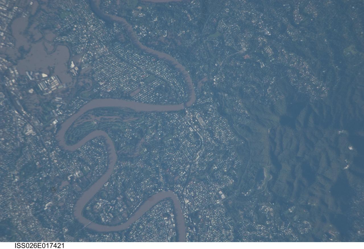
ISS026-E-017421 (13 Jan. 2011) --- Photographed by an Expedition 26 crew member on the International Space Station, this detailed photograph illustrates flooding in suburbs of the Brisbane, Australia metropolitan region. The Brisbane area experienced catastrophic flooding following unusually heavy rainfall on Jan. 10, 2011. With surficial soils already saturated from previous rainfall events, eastward-draining surface flow caused the Brisbane River to flood—inundating an estimated 20,000 homes in suburbs of the capital city of Queensland. Other cities in Queensland have also experienced damaging floods during previous heavy rainfall events this year. The image highlights several suburbs along the Brisbane River in the southern part of the Brisbane metropolitan area. The light-colored rooftops of residences and other structures contrast sharply with green vegetation and brown, sediment laden floodwaters. Most visible low-lying areas are inundated by floodwater, perhaps the most striking being Rocklea at upper left. The suburb of Yeronga (lower left) also has evident regions of flooding, as does a park and golf course located along a bend in the Brisbane River to the south of St. Lucia (center). Flooding becomes less apparent near the higher elevations of Mt. Coot-Tha at right.
S73-35078 (July-Sept. 1973) --- A nearly vertical view of the Phoenix, Arizona metropolitan area is seen in this Skylab 3 (second manning) Earth Resources Experiments Package S190-B (five-inch Earth terrain camera) photograph taken from the Skylab space station in Earth orbit. Also in the picture are Scottsdale, Paradise Valley, Tempe, Mesa, Komatke, Salt River Indian Reservation and part of the Gila River Indian Reservation. Features which can be delineated from the photograph include: cultural patterns defined by commercial, industrial, agricultural and residential areas; transportation networks consisting of major corridors, primary, secondary and feeder streets; major urban developments in the area such as airports, Squaw Peak City Park, Turf Paradise Race Track and the State Fairgrounds. Phoenix is one of the 27 census cities of interest under study by the U.S. Geological Survey and is the center of the Arizona Regional Ecological Test Site. A large number of investigators will be using the Skylab data. This photo will be compared to earlier ones to document changes in the urban area with time. The landscape is well defined in terms of mountains, alluvial fans and river flood plains. Several different types of natural vegetation and irrigated crop lands can be mapped. Geological features are not well displayed but mining activities are readily identified. Photo credit: NASA
While gymnasts leap, cyclists pedal and divers twirl for Olympic gold in Rio de Janeiro, Brazil, several NASA Earth Observing satellites catch glimpses of the city and its surroundings from space. This image shows how Rio Olympic Park appeared to the Operational Land Imager (OLI), a sensor on Landsat 8, last September as the city prepared for the 2016 Summer Olympic Games. Image credit: Landsat 8/NASA Earth Observatory <b><a href="http://www.nasa.gov/audience/formedia/features/MP_Photo_Guidelines.html" rel="nofollow">NASA image use policy.</a></b> <b><a href="http://www.nasa.gov/centers/goddard/home/index.html" rel="nofollow">NASA Goddard Space Flight Center</a></b> enables NASA’s mission through four scientific endeavors: Earth Science, Heliophysics, Solar System Exploration, and Astrophysics. Goddard plays a leading role in NASA’s accomplishments by contributing compelling scientific knowledge to advance the Agency’s mission. <b>Follow us on <a href="http://twitter.com/NASAGoddardPix" rel="nofollow">Twitter</a></b> <b>Like us on <a href="http://www.facebook.com/pages/Greenbelt-MD/NASA-Goddard/395013845897?ref=tsd" rel="nofollow">Facebook</a></b> <b>Find us on <a href="http://instagrid.me/nasagoddard/?vm=grid" rel="nofollow">Instagram</a></b>
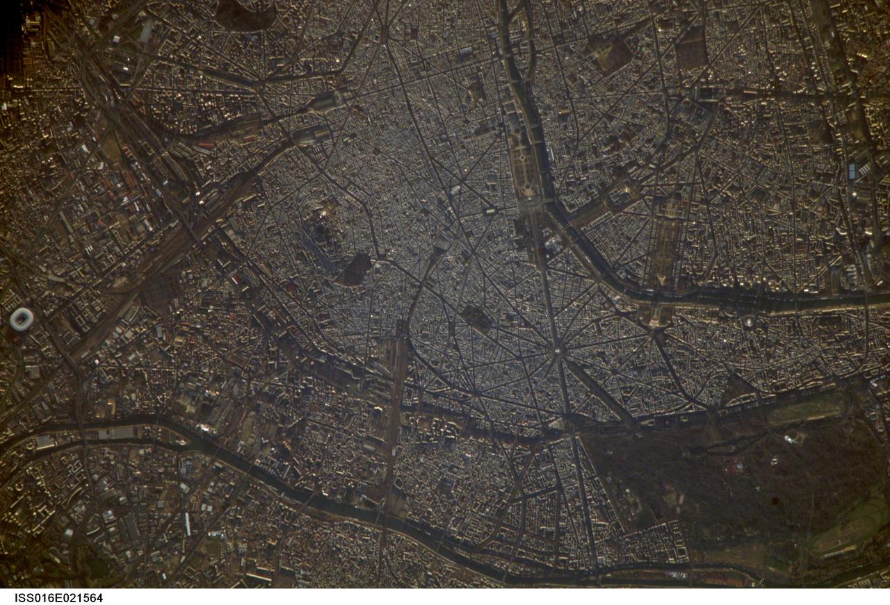
ISS016-E-021564 (7 Jan. 2008) --- Paris, France is featured in this image photographed by an Expedition 16 crewmember on the International Space Station. A crisp, clear winter day over France provided a detailed view of the city of Paris. This image shows the recognizable street pattern of the city - and some of the world's most notable landmarks - along the Seine River. One of the main avenues radiating like spokes from the Arc de Triomphe (lower right) is the Avenue des Champs-Elysees running southeast to the Garden of Tuileries (Jardin des Tuileries). The garden -- recognizable by its light green color relative to the surrounding built materials -- was originally commissioned by Catherine de Medici in 1559, and is now bounded by the Place de la Concorde to the northeast and the Louvre museum along the Seine River at the southeast end. Other, similarly colored parks and greenspaces are visible throughout the image. Farther south on the Seine is the Ile de la Cite, location of the famous Notre Dame cathedral. Perhaps most prominent is the characteristic "A" profile of the Eiffel Tower west of the Jardin des Tuileries, highlighted by morning sunlight.
STS113-347-034 (23 November - 7 December 2002) --- The STS-113 crewmembers used a 35mm still camera to record this image of New York City. Manhattan Island appears just left of center, flanked by the lower Hudson River (left), and the East River (right). The lake in Central Park on Manhattan is particularly clear. The Verrazano Narrows Bridge appears center on the bottom margin of the view, dividing upper New York Bay from Lower New York Bay. Newark Bay is the body of water lower left. Three well known islands appear at the north (top) end of Upper New York Bay, the smallest being Liberty Island (with the Statue of Liberty not visible at this resolution), Ellis Island, the middle-sized island, and Governor's Island, the largest. Queens appears top right, and Brooklyn, lower right, with the Naval Air Station on Jamaica Bay on the right margin.
STS068-237-055 (30 September - 11 October 1994) --- This coastal area, considered home by astronaut Peter J. K. (Jeff) Wisoff, was photographed from the Space Shuttle Endeavour during the Space Radar Laboratory (SRL-2) mission. Wisoff, a native of Norfolk, talked about this area during a post-flight crew awards and presentation event at the Johnson Space Center (JSC). He pointed out that the waterways are heavily used for commercial, recreational and military purposes. Piers near the mouth of the Elizabeth River are associated with the U. S. Naval Base and those down river support the activities of the city of Norfolk. Seashore State Park and the Ft. Story Military Reservation are visible at the mouth of the Chesapeake.
SL4-139-4040 (10 Jan. 1974) --- An oblique view of a portion of the Western United States, as photographed from the Skylab space station in Earth orbit by one of the Skylab 4 crewmen. The camera used was a hand-held 70mm Hasselblad, with SO-368 medium-speed Ektachrome film. This photograph is one of a stereo pair (the other being 4039) taken to support the hydrological studies of the changing snow patterns in several watersheds. Stereo analysis will enable snow to be distinguished from clouds quantitatively. In a qualitative sense, the clouds are the fuzzy white, whereas the snow is distinct white. The area covered is from the Colorado Springs, Colorado area at the south to (and beyond) the Black Hills, South Dakota area. The Black Forest between Colorado Springs and Denver is evident as are the mountains west of these cities. South Park, west of Colorado Springs, and the South Platte River running north and east from Denver are two other conspicuous features. Photo credit: NASA
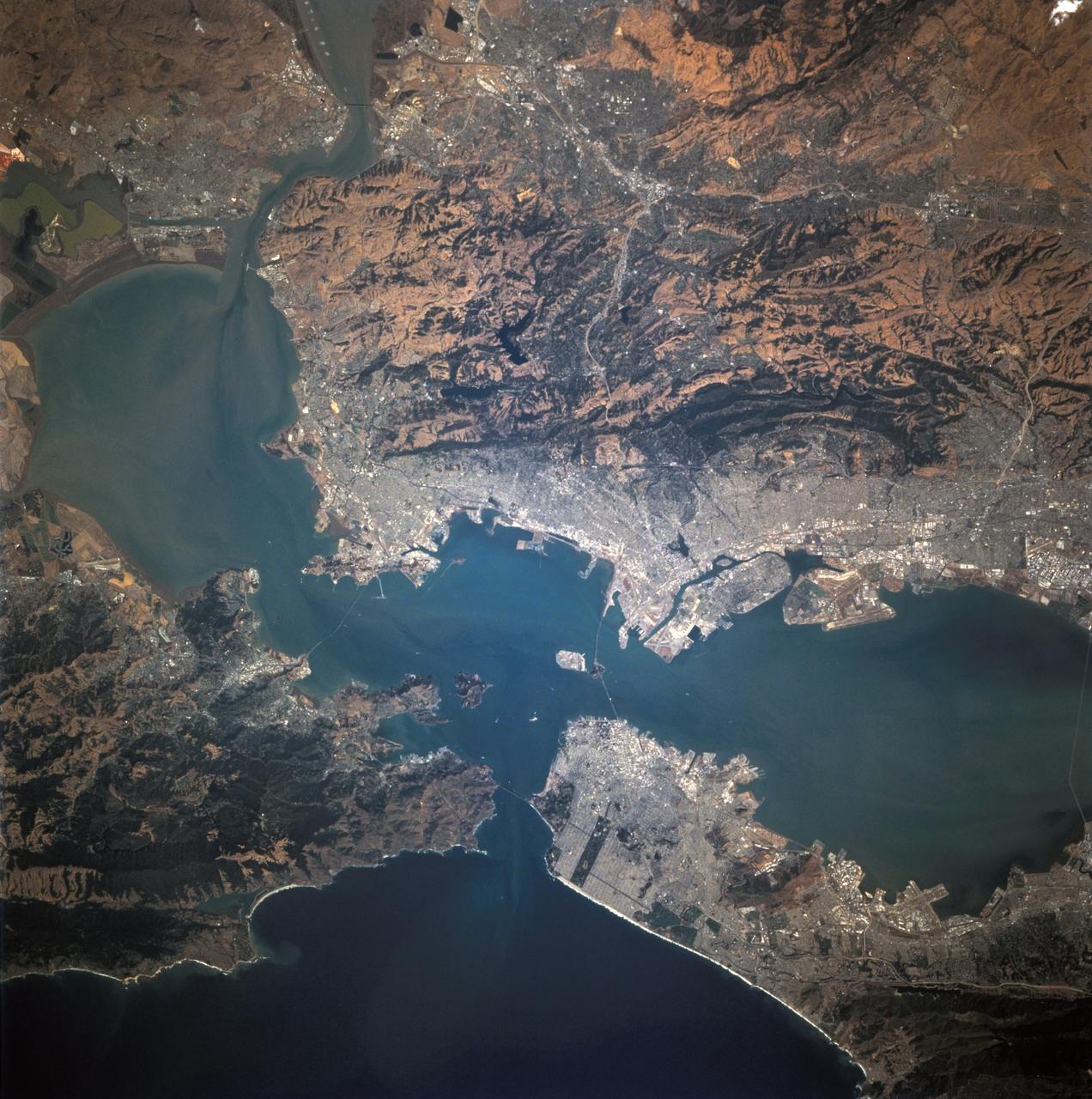
STS068-244-022 (30 September-11 October 1994) --- (San Francisco, San Pablo Bay Area) Photographed through the Space Shuttle Endeavour's flight deck windows, the heavily populated bay area is featured in this 70mm frame. The relatively low altitude of Endeavour's orbit (115 nautical miles) and the use of a 250mm lens on the Hasselblad camera allowed for capturing detail in features such as the Berkeley Marina (frame center). The region's topography is well depicted with the lowland areas heavily populated and the hills much more sparsely covered. The Oakland Hills in the right lower center appear to be re-vegetated after a devastating fire. The Golden Gate Recreation Area in the upper left also shows heavy vegetation. The three bridges across the main part of the bay and their connecting roads are prominent. Cultural features such as Golden Gate Park and the Presidio contrast with the gray of the city.
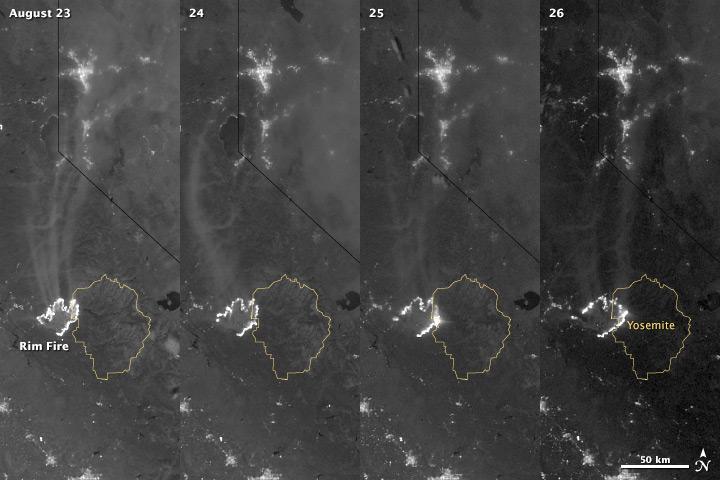
The winter of 2013 was among the driest on record for California, setting the stage for an active fire season. By August 26, the Rim Fire had made its way into the record books. At just 15 percent contained, the fire is now the 13th largest in California since records began in 1932. Apart from being large, the fire is also threatening one of the United States’ greatest natural treasures: Yosemite National Park. The Visible Infrared Imaging Radiometer Suite (VIIRS) on the Suomi NPP satellite tracked the growth of the fire between August 23 and August 26 in this series of nighttime images. The VIIRS day-night band is extremely sensitive to low light, making it possible to see the fire front from space. The brightest, most intense parts of the fire glow white, exceeding the brightness of the lights of Reno, Nevada to the north. Pale gray smoke streams north away from the fire throughout the sequence. The perimeter of the fire grows from day to day along different fronts, depending on winds and fire fighting efforts. On August 24, fire fighters focused their efforts on containing the western edge of the fire to prevent it from burning into Tuolumne City and the populated Highway 108 corridor. They also fought the eastern edge of the fire to protect Yosemite National Park. These efforts are evident in the image: Between August 23 and 24, the eastern edge of the fire held steady, and the western edge receded. The fire grew in the southeast. On the morning of August 25 fire managers reported that the fire was growing in the north and east. In the image, the most intense activity is just inside Yosemite National Park. Fire fighters reported that the Rim Fire continued to be extremely active on its eastern front on the morning of August 26, and this activity is visible in the image. By 8:00 a.m., the fire had burned 149,780 acres. The fire forced firefighters in Yosemite National Park to take measures to protect the Merced and Tuolumne Groves of Giant Sequoias, but the National Park Service reported that the trees were not in imminent danger. While parts of the park are closed, webcams show that most of the park has not been impacted. The Rim Fire started on the afternoon of August 17. It has destroyed 23 structures and threatened 4,500 other buildings. Its cause is under investigation. More details: <a href="http://1.usa.gov/18ilEAA" rel="nofollow">1.usa.gov/18ilEAA</a> NASA Earth Observatory image by Jesse Allen and Robert Simmon, using VIIRS Day Night Band data. Caption by Holli Riebeek. Instrument: Suomi NPP - VIIRS <b><a href="http://www.nasa.gov/audience/formedia/features/MP_Photo_Guidelines.html" rel="nofollow">NASA image use policy.</a></b> <b><a href="http://www.nasa.gov/centers/goddard/home/index.html" rel="nofollow">NASA Goddard Space Flight Center</a></b> enables NASA’s mission through four scientific endeavors: Earth Science, Heliophysics, Solar System Exploration, and Astrophysics. Goddard plays a leading role in NASA’s accomplishments by contributing compelling scientific knowledge to advance the Agency’s mission. <b>Follow us on <a href="http://twitter.com/NASA_GoddardPix" rel="nofollow">Twitter</a></b> <b>Like us on <a href="http://www.facebook.com/pages/Greenbelt-MD/NASA-Goddard/395013845897?ref=tsd" rel="nofollow">Facebook</a></b> <b>Find us on <a href="http://instagram.com/nasagoddard?vm=grid" rel="nofollow">Instagram</a></b>
The winter of 2013 was among the driest on record for California, setting the stage for an active fire season. By August 26, the Rim Fire had made its way into the record books. At just 15 percent contained, the fire is now the 13th largest in California since records began in 1932. Apart from being large, the fire is also threatening one of the United States’ greatest natural treasures: Yosemite National Park. The Visible Infrared Imaging Radiometer Suite (VIIRS) on the Suomi NPP satellite tracked the growth of the fire between August 23 and August 26 in a series of nighttime images. The VIIRS day-night band is extremely sensitive to low light, making it possible to see the fire front from space. The brightest, most intense parts of the fire glow white, exceeding the brightness of the lights of Reno, Nevada to the north. Pale gray smoke streams north away from the fire throughout the sequence. The perimeter of the fire grows from day to day along different fronts, depending on winds and fire fighting efforts. On August 24, fire fighters focused their efforts on containing the western edge of the fire to prevent it from burning into Tuolumne City and the populated Highway 108 corridor. They also fought the eastern edge of the fire to protect Yosemite National Park. These efforts are evident in the image: Between August 23 and 24, the eastern edge of the fire held steady, and the western edge receded. The fire grew in the southeast. On the morning of August 25 fire managers reported that the fire was growing in the north and east. In the image, the most intense activity is just inside Yosemite National Park. Fire fighters reported that the Rim Fire continued to be extremely active on its eastern front on the morning of August 26, and this activity is visible in the image. By 8:00 a.m., the fire had burned 149,780 acres. The fire forced firefighters in Yosemite National Park to take measures to protect the Merced and Tuolumne Groves of Giant Sequoias, but the National Park Service reported that the trees were not in imminent danger. While parts of the park are closed, webcams show that most of the park has not been impacted. The Rim Fire started on the afternoon of August 17. It has destroyed 23 structures and threatened 4,500 other buildings. Its cause is under investigation. More details: <a href="http://1.usa.gov/18ilEAA" rel="nofollow">1.usa.gov/18ilEAA</a> NASA Earth Observatory image by Jesse Allen and Robert Simmon, using VIIRS Day Night Band data. Caption by Holli Riebeek. Instrument: Suomi NPP - VIIRS <b><a href="http://www.nasa.gov/audience/formedia/features/MP_Photo_Guidelines.html" rel="nofollow">NASA image use policy.</a></b> <b><a href="http://www.nasa.gov/centers/goddard/home/index.html" rel="nofollow">NASA Goddard Space Flight Center</a></b> enables NASA’s mission through four scientific endeavors: Earth Science, Heliophysics, Solar System Exploration, and Astrophysics. Goddard plays a leading role in NASA’s accomplishments by contributing compelling scientific knowledge to advance the Agency’s mission. <b>Follow us on <a href="http://twitter.com/NASA_GoddardPix" rel="nofollow">Twitter</a></b> <b>Like us on <a href="http://www.facebook.com/pages/Greenbelt-MD/NASA-Goddard/395013845897?ref=tsd" rel="nofollow">Facebook</a></b> <b>Find us on <a href="http://instagram.com/nasagoddard?vm=grid" rel="nofollow">Instagram</a></b>
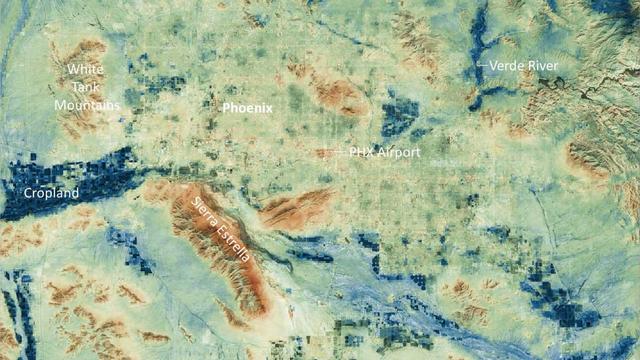
Researchers at NASA's Jet Propulsion Laboratory have created a series of maps showing land-surface temperatures in the Phoenix area in July 2023, when the city experienced a record-breaking run of hot weather. The images reveal the cumulative effect – overnight and across the month – of relentless daytime heating. The data was captured during overnight hours (around 2 a.m.) on several days in July by an instrument called the Visible Infrared Imaging Radiometer Suite (VIIRS) aboard the NOAA-NASA Suomi National Polar-orbiting Partnership (Suomi NPP) satellite managed by the National Oceanic and Atmospheric Administration and NASA. The images show how built surfaces – roads, buildings, airport runways, and the like – retain heat, sometimes hovering around 100 degrees Fahrenheit (38 degrees Celsius) for hours after sunset. From July 1 to July 19, the built surfaces in the maps grew progressively hotter, likely the combined effect of the heat wave intensifying and the cumulative heating of those human-made structures. Due to their high heat capacity, these surfaces didn't fully cool overnight before the onset of the next day's heat. At the center of the images is Phoenix's Sky Harbor International Airport, where VIIRS measured the hottest land-surface temperature within the city. The airport is also where Phoenix takes its official air temperature. By those measurements, the city experienced the hottest month on record in July, including a record 31 consecutive days in which the temperature exceeded 110 degrees Fahrenheit (43.3 degrees Celsius). The previous record was 18 days. Land-surface temperatures in cities are usually warmer than in rural and undeveloped areas because of human activities and the materials used for building. Streets – seen in these maps as a grid pattern – are often the hottest part of the built environment due to dark asphalt paving that absorbs more sunlight than lighter-colored surfaces; asphalt absorbs up to 95% of solar radiation. In the images, the mountains near Phoenix are also notably hot due to their angle to the Sun and greater soil exposure from lack of vegetation. The hot surfaces in and around the city stand in contrast to nearby irrigated surfaces such as agricultural fields, golf courses, and parks, which fell as low as 68 degrees Fahrenheit (18.9 degrees Celsius) during the night. The Verde River and other nearby waterways also were significantly cooler. VIIRS is one of five instruments aboard the NOAA-NASA Suomi NPP satellite. Short for Suomi National Polar-orbiting Partnership, the spacecraft is one of several in the Joint Polar Satellite System. The images were produced from the VNP21IMG Land Surface Temperature product, which is available at NASA's Land, Atmosphere Near-real-time Capability for EOS (LANCE). Animation available at https://photojournal.jpl.nasa.gov/catalog/PIA25868
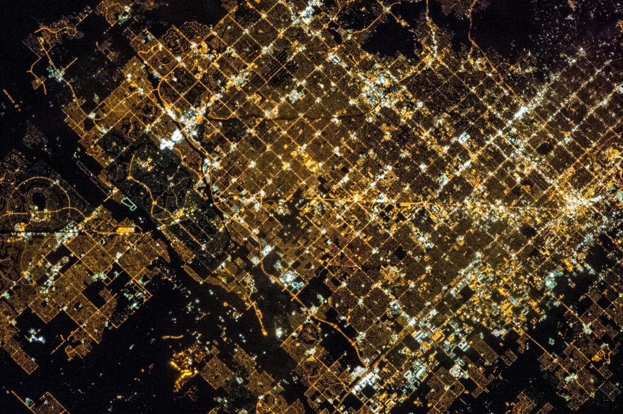
ISS035-E-005438 (16 March 2013) --- One of the Expedition 35 crew members on the International Space Station used a still camera with a 400 millimeter lens to record this nocturnal image of the Phoenix, Arizona area. Like many large urban areas of the central and western United States, the Phoenix metropolitan area is laid out along a regular grid of city blocks and streets. While visible during the day, this grid is most evident at night, when the pattern of street lighting is clearly visible from above – in the case of this photograph, from the low Earth orbit vantage point of the International Space Station. The urban grid form encourages growth of a city outwards along its borders, by providing optimal access to new real estate. Fueled by the adoption of widespread personal automobile use during the 20th century, the Phoenix metropolitan area today includes 25 other municipalities (many of them largely suburban and residential in character) linked by a network of surface streets and freeways. The image area includes parts of several cities in the metropolitan area including Phoenix proper (right), Glendale (center), and Peoria (left). While the major street grid is oriented north-south, the northwest-southeast oriented Grand Avenue cuts across it at image center. Grand Avenue is a major transportation corridor through the western metropolitan area; the lighting patterns of large industrial and commercial properties are visible along its length. Other brightly lit properties include large shopping centers, strip centers, and gas stations which tend to be located at the intersections of north-south and east-west trending streets. While much of the land area highlighted in this image is urbanized, there are several noticeably dark areas. The Phoenix Mountains at upper right are largely public park and recreational land. To the west (image lower left), agricultural fields provide a sharp contrast to the lit streets of neighboring residential developments. The Salt River channel appears as a dark ribbon within the urban grid at lower right.
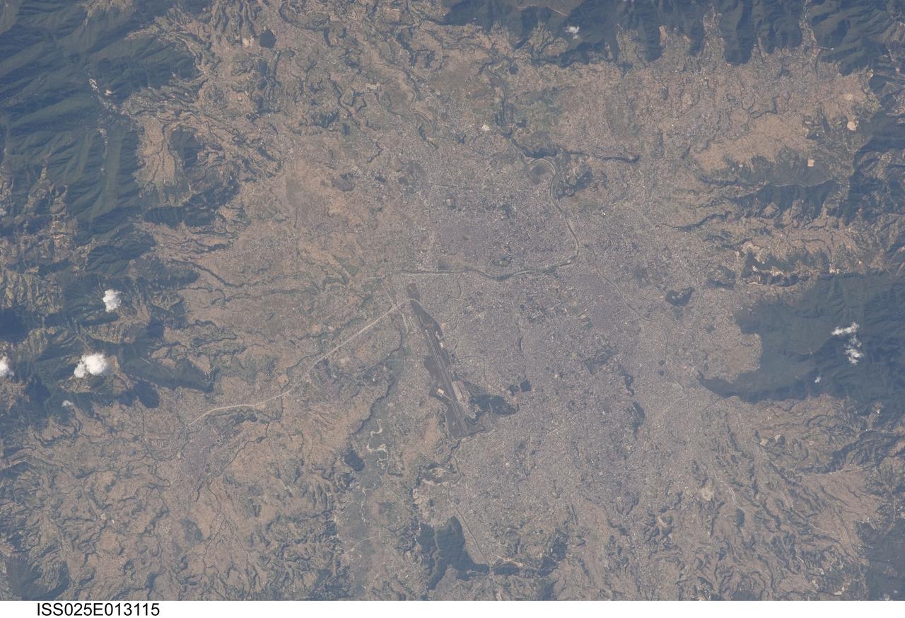
ISS025-E-013115 (9 Nov. 2010) --- Kathmandu, Nepal is featured in this image photographed by an Expedition 25 crew member on the International Space Station. The capital and largest city of Nepal, Kathmandu occupies much of the Kathmandu Valley located near the center of the country. Nepal itself contains much of the Himalaya mountain range between China (Tibet) to the north and India to the south. Geological and fossil evidence indicates that the Kathmandu Valley was filled by a large lake (Paleo-Kathmandu Lake) between approximately 2.8 million and 10,000 years ago, according to scientists. Geologists believe the lake drained in phases over time due both to a drier regional climate, continuing tectonic uplift and faulting in the region, and formation of an integrated valley drainage system as river channels cut through previous natural rock ridge dams. The green vegetated slopes that ring the Kathmandu metro area (light gray, center) include both forest reserves and national parks. The metropolitan area is relatively flat compared to the surrounding high mountains. Tribhuvan International Airport, located near the current eastern margin of the metro area, is the only international airport in Nepal. Archeological evidence suggests that the development of Kathmandu, together with the nearby “sister cities” of Lalitpur and Bhaktapur, began almost 2,000 years ago. Today, Kathmandu and its sister cities form the governmental, cultural, and—as a main access point to the Himalayas for tourism—economic center of the country.
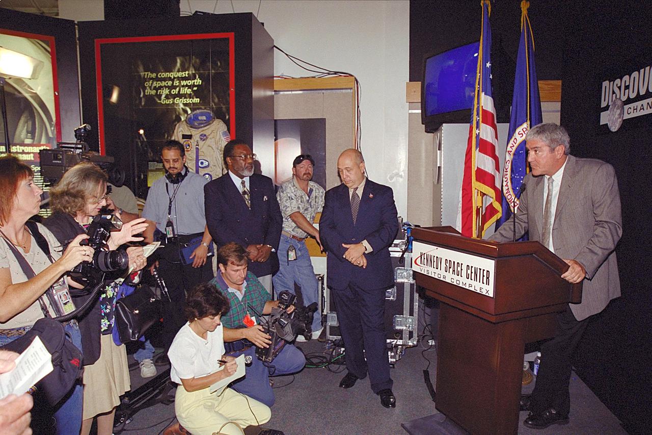
Media gather at the KSC Visitor Complex for the kickoff of the Discovery Channel's Liberty Bell 7 Space Capsule Exhibit, which will open to the public on Saturday, June 17. At the podium is Mike Quattrone, executive vice president and general manager, Discovery Channel.; Standing to the left of the podium is Rick Abramson, president and chief operating officer of Delaware North Parks Services of Spaceport, Inc., and far left, Jim Jennings, deputy director of Kennedy Space Center.; Liberty Bell 7 launched U.S. Air Force Captain Virgil “Gus” Grissom July 21, 1961 on a mission that lasted 15 minutes and 37 seconds before sinking to the floor of the Atlantic Ocean, three miles deep. It lay undetected for nearly four decades before a Discovery Channel expedition located it and recovered it. The space capsule is now restored and preserved, and part of an interactive exhibit touring science centers and museums in 12 cities throughout the United States until 2003. The exhibit includes hands-on elements such as a capsule simulator, a centrifuge, and ROV pilot
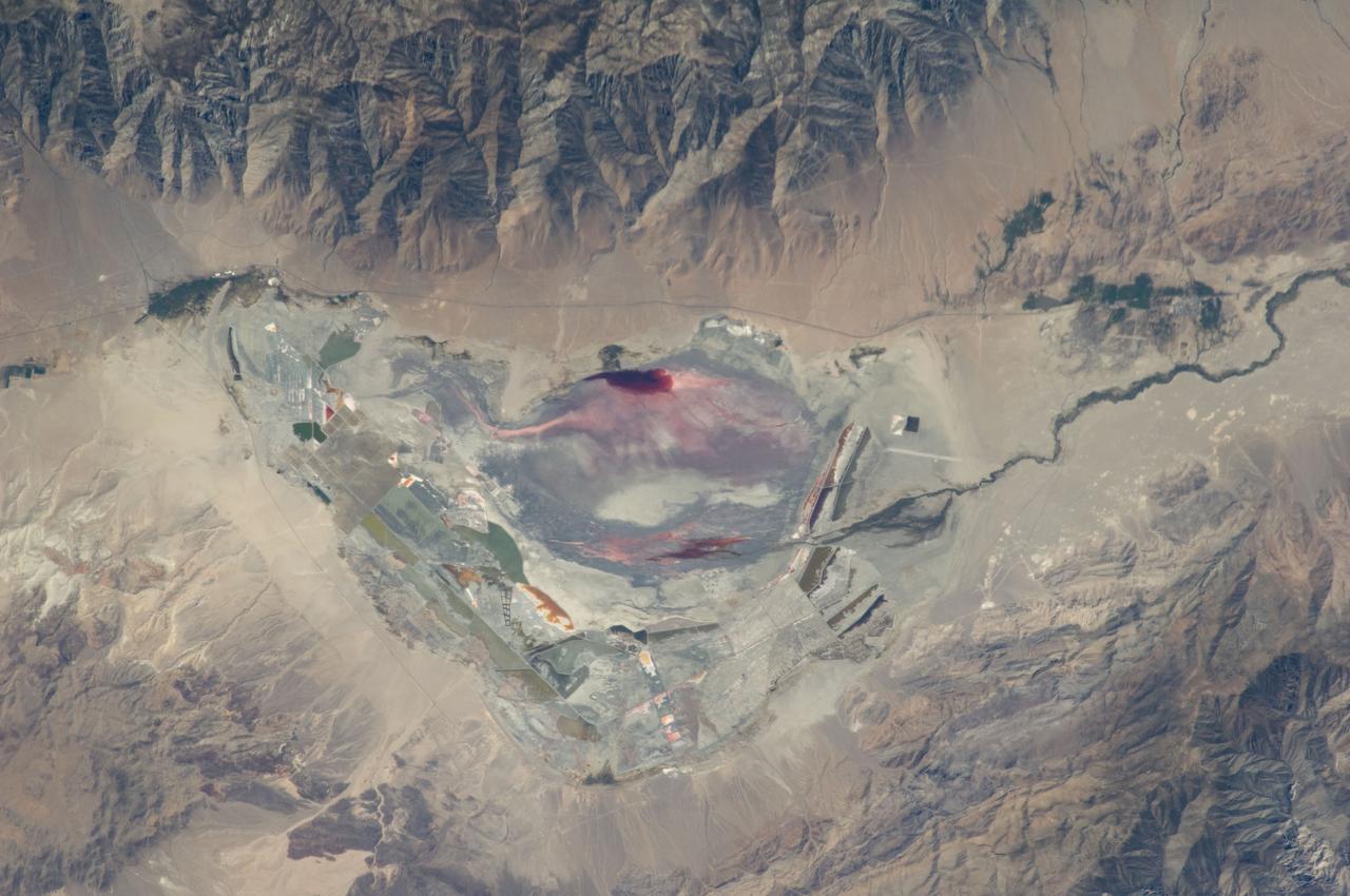
ISS028-E-035137 (30 Aug. 2011) --- Owens Lake in California is featured in this image photographed by an Expedition 28 crew member on the International Space Station. This photograph highlights the mostly dry bed of Owens Lake, located in the Owens River Valley between the Inyo Mountains and the Sierra Nevada. Shallow groundwater, springs, and seeps support minor wetlands and a central brine pool. Two bright red areas along the margins of the brine pool indicate the presence of halophilic, or salt-loving organisms known as Achaeans. Grey and white materials within the lake bed are exposed lakebed sediments and salt crusts. The towns of Olancha and Lone Pine are delineated by the presence of green vegetation indicating a more constant availability of water. According to scientists, the present-day Owens Lake was part of a much larger lake and river system that existed during the Pleistocene Epoch (approximately 3 million to approximately 12,000 years ago) along the current northeastern border of California with Nevada. Meltwater from alpine glaciers in the Sierra Nevada filled the regional valleys of the Basin and Range to form several glacial lakes that were ancestral to the now-dry lakebeds (or playas) of Owens, Searles Lake, and China Lake. While Searles and China Lakes dried out due to regional changes to a hotter and drier climate over thousands of years, Owens Lake became desiccated largely due to the diversion of Owens River water in the early 20th century to serve the needs of the City of Los Angeles, CA located 266 kilometers to the south. Following complete desiccation of the lakebed in 1926, significant amounts of windblown dust were produced ? indeed, the term ?Keeler fog? was coined by residents of the now largely abandoned town on the eastern side of Owens Lake due to the dust. In addition to adverse health effects on local residents, dust from Owens Lake has been linked to visibility reduction in nearby national parks, forests, and wilderness areas. Recently, efforts to control dust evolution from the lakebed have been undertaken by the City of Los Angeles.
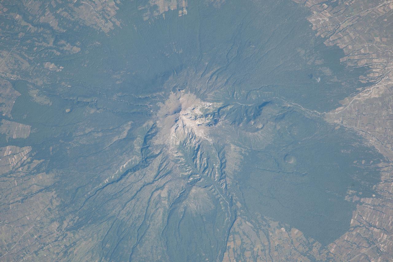
ISS037-E-022473 (29 Oct. 2013) --- La Malinche Volcano, Mexico is featured in this image photo graphed by an Expedition 37 crew member on the International Space Station. Located approximately 30 kilometers to the northeast of the city of Puebla, the summit of Volcan la Malinche rises to an elevation of 4,461 meters above sea level. This detailed photograph highlights the snow-dusted summit, and the deep canyons that cut into the flanks of this eroded stratovolcano. La Malinche has not been historically active, but radiometric dating of volcanic rocks and deposits associated with the structure indicate a most recent eruption near the end of the 12th century. NASA scientists cite evidence that lahars, or mudflows, associated with an eruption about 3,100 years ago, affected Pre-Columbian settlements in the nearby Puebla basin. The volcano is enclosed within La Malinche National Park situated within parts of the states of Puebla and Tlaxcala; extensive green forest cover is visible on the lower flanks of the volcano. Access to the volcano is available through roadways, and it is frequently used as a training peak by climbers prior to attempting higher summits. The rectangular outlines of agricultural fields are visible forming an outer ring around the forested area. While the volcano appears to be quiescent, its relatively recent (in geological terms) eruptive activity, and location within the Trans-Mexican Volcanic Belt– a tectonically active region with several current and historically active volcanoes including Popocatepetl to the west and Pico de Orizaba to the east - suggests that future activity is still possible and could potentially pose a threat to the nearby city of Puebla.
ISS033-E-014186 (16 Oct. 2012) --- A nighttime view of Baltimore, Maryland is featured in this image photographed by an Expedition 33 crew member in the International Space Station. Baltimore is located on the U.S. mid-Atlantic coastline along the terminus of the Patapsco River into Chesapeake Bay, and is the largest seaport along this part of the coast. Like many large U.S. metropolitan areas, the most brightly lit area corresponds to the highest density of buildings and typically indicates the urban core -- in this case, downtown Baltimore at center. Highways and large arterial streets appear as bright yellow-orange lines extending outwards from the downtown area into the surrounding suburban regions (light violet and reddish brown regions of diffuse lighting). Dark areas beyond the suburban zone are rural - or to the southeast, indicate the waters of Chesapeake Bay. Small dark patches within the metropolitan area are open space including parks, cemeteries, and the Baltimore Zoo (top left). Two large, brightly-lit areas along Chesapeake Bay are commercial/industrial regions, and include the major port facilities for Baltimore. The City of Baltimore was incorporated in 1796, after serving as the de facto capital of the nascent United States of America during the Second Continental Congress (from Dec. 20, 1776 to March 4, 1777). Today, the Baltimore metropolitan area (as defined by the Baltimore Metropolitan Council) includes over 2.5 million people and includes six Maryland counties (Anne Arundel, Baltimore, Carroll, Harford, and Howard) in addition to the City of Baltimore. The region is also a focus of urban ecological research through the Baltimore Ecosystem Study.
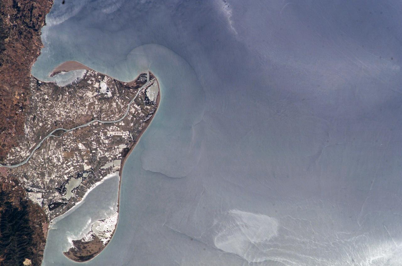
ISS009-E-09985 (3 June 2004) --- The Ebro River Delta, located along the eastern coast of Spain, is featured in this image photographed by an Expedition 9 crewmember on the International Space Station (ISS). Taken in partial sun glint, this view defines the Ebro’s fresh water lens— the water density boundary between the upper layer of fresh water issuing from the Ebro River mouth and the saltier, denser Mediterranean Sea water. According to NASA geologists studying the ISS imagery, diversion and impoundment of the Ebro River upstream has led to a decrease in water and sediment delivery to the delta. This decrease has led to increased erosion in some areas to the northeast of El Fangar Bay and along the southwestern shoreline of the delta. The Ebro River Delta is one of the largest wetland areas in the western Mediterranean region. The Ebro delta has grown rapidly—the historical rate of growth of the delta is demonstrated by the city of Amposta. This city was a seaport in the 4th Century, and is now located well inland from the current Ebro river mouth. The rounded form of the delta attests to the balance between sediment deposition by the Ebro River and removal of this material by wave erosion. The modern delta is in intensive agricultural use for rice, fruit, and vegetables. White polygonal areas to the north and south of the Ebro River are paddy fields. The Ebro delta also hosts numerous beaches, marshes, and saltpans that provide habitat for over 300 species of birds. A large part of the delta was designated as Parc Natural del Delta de l'Ebre (Ebre Delta National Park) in 1983. A network of canals and irrigation ditches constructed by both agricultural and conservation groups are helping to maintain the ecologic and economic resources of the Ebro Delta.
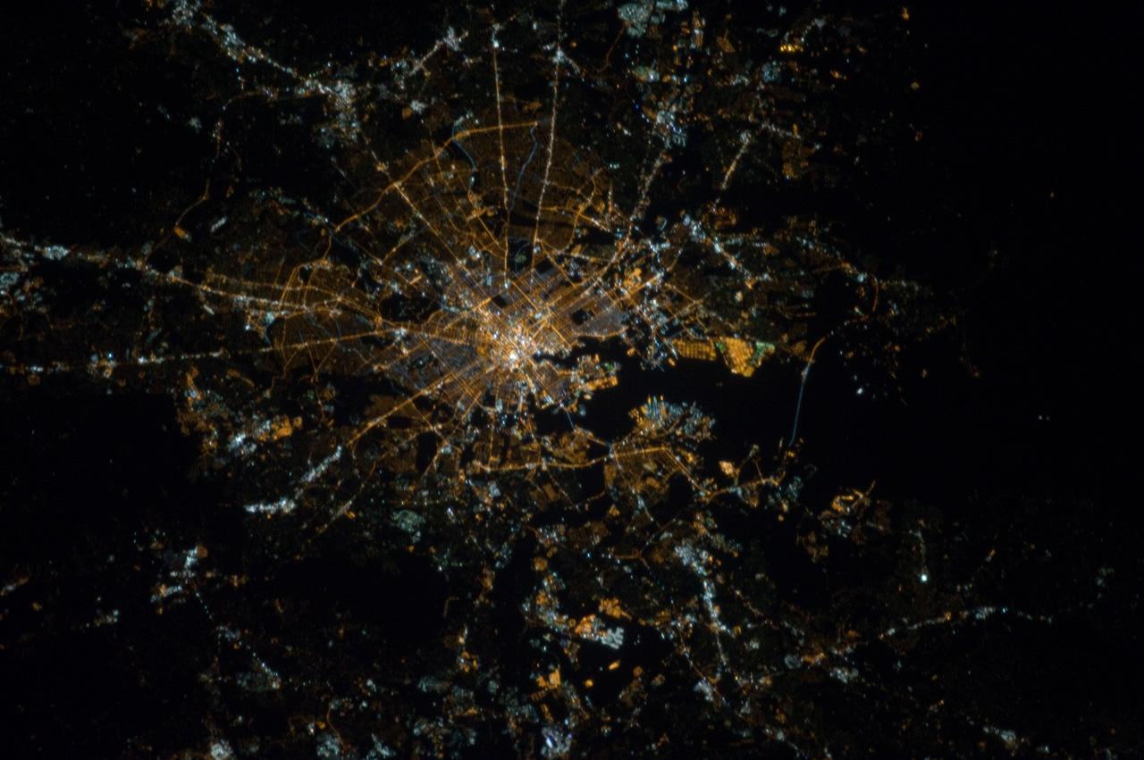
ISS027-E-033889 (16 May 2011) --- Izmir Metropolitan Area, Izmir Province in Turkey is featured in this image photographed by an Expedition 27 crew member on the International Space Station. The metropolis of Izmir is located in the western Anatolia region of Turkey. It is the country’s third largest city in terms of population and the second largest port city (after Istanbul). The Izmir region has included urban areas for almost 3,500 years, and the ancient core of the metropolitan area was originally known as Smyrna. Due to its location on the Gulf of Izmir (lower left) with access to the Aegean Sea, Izmir (or Smyrna) has been an important Mediterranean Sea port for most of its history. This detailed photograph highlights the modern urban landscape of the Izmir metropolitan area. Today, the metropolitan area includes eleven districts, many of which were independent neighborhoods prior to agglomeration into “greater Izmir”. Densely built-up residential and commercial districts, characterized by gray to reddish gray rooftops occupy much of the central part of the image. Larger structures with bright white rooftops are indicative of commercial/industrial areas near the Izmir Port at left. Two large sport complexes, the Ataturk Stadium and Sirinyer Hippodrome (horse racing track) are clearly visible at upper left and right respectively. Numerous vegetated parks (green) are located throughout the area. In addition to being a major trade center, greater Izmir is a hub for regional tourism.
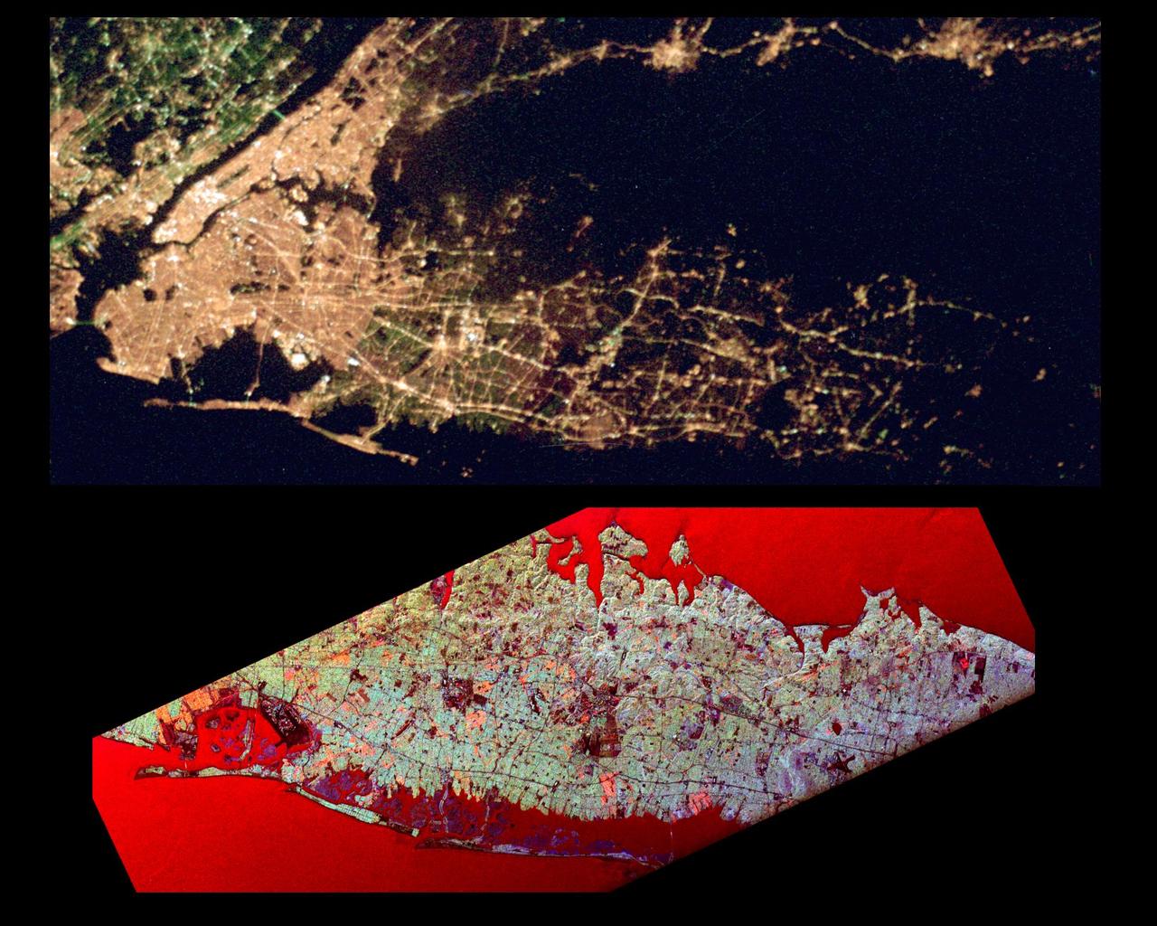
This pair of images of the Long Island, New York region is a comparison of an optical photograph (top) and a radar image (bottom), both taken in darkness in April 1994. The photograph at the top was taken by the Endeavour astronauts at about 3 a.m. Eastern time on April 20, 1994. The image at the bottom was acquired at about the same time four days earlier on April 16,1994 by the Spaceborne Imaging Radar-C/X-Band Synthetic Aperture Radar (SIR-C/X-SAR) system aboard the space shuttle Endeavour. Both images show an area approximately 100 kilometers by 40 kilometers (62 miles by 25 miles) that is centered at 40.7 degrees North latitude and 73.5 degrees West longitude. North is toward the upper right. The optical image is dominated by city lights, which are particularly bright in the densely developed urban areas of New York City located on the left half of the photo. The brightest white zones appear on the island of Manhattan in the left center, and Central Park can be seen as a darker area in the middle of Manhattan. To the northeast (right) of the city, suburban Long Island appears as a less densely illuminated area, with the brightest zones occurring along major transportation and development corridors. Since radar is an active sensing system that provides its own illumination, the radar image shows a great amount of surface detail, despite the night-time acquisition. The colors in the radar image were obtained using the following radar channels: red represents the L-band (horizontally transmitted and received); green represents the L-band (horizontally transmitted and vertically received); blue represents the C-band (horizontally transmitted and vertically received). In this image, the water surface - the Atlantic Ocean along the bottom edge and Long Island Sound shown at the top edge - appears red because small waves at the surface strongly reflect the horizontally transmitted and received L-band radar signal. Networks of highways and railroad lines are clearly visible in the radar image; many of them can also be seen as bright lines i the optical image. The runways of John F. Kennedy International Airport appear as a dark rectangle in Jamaica Bay on the left side of the image. Developed areas appear generally as bright green and orange, while agricultural, protected and undeveloped areas appear darker blue or purple. This contrast can be seen on the barrier islands along the south coast of Long Island, which are heavily developed in the Rockaway and Long Beach areas south and east of Jamaica Bay, but further to the east, the islands are protected and undeveloped. http://photojournal.jpl.nasa.gov/catalog/PIA01785
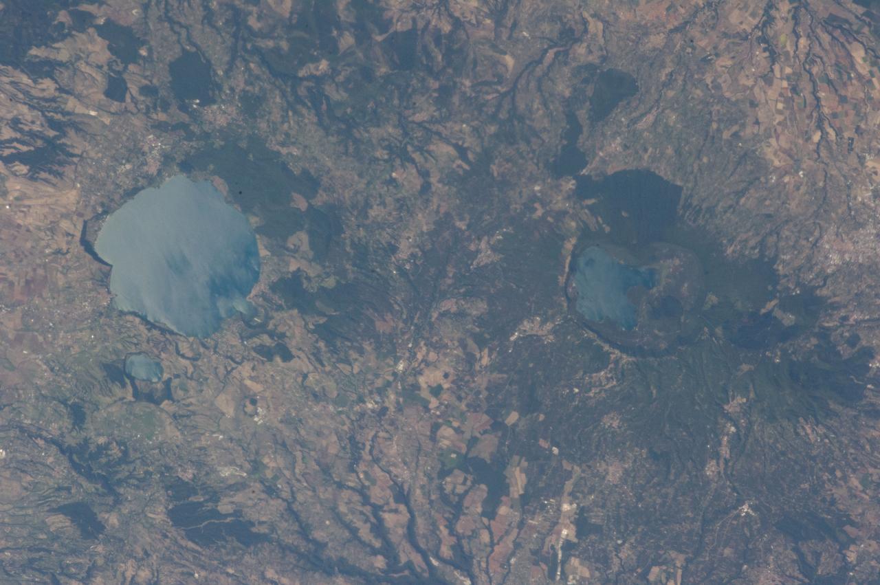
ISS036-E-039778 (3 Sept. 2013) --- Caldera lakes to the northwest of Rome, Italy are featured in this image photographed by an Expedition 36 crew member on the International Space Station. The Lazio region of central Italy has many landforms of volcanic origin, including several large lakes that mark the locations of ancient volcanoes. This photograph highlights two such lakes, Lago di Vico and Lago Bracciano, located to the northwest of the capital city of Rome. Both lakes are located within calderas, large depressions that form after violent explosive eruptions empty a volcano’s underlying magma chamber. Any remnants of the volcanic edifice can then collapse into the newly-formed void space, leading to the creation of large depressions. These depressions can then fill partially or completely with water, forming permanent lakes. Lago Bracciano (left) is the larger of the two lakes highlighted in the image; it is approximately eight kilometers wide at its widest point, and is located 32 kilometers northwest of Rome. According to scientists, the volcanic activity that led to the formation of Lago Bracciano began approximately 600,000 years ago and continued to approximately 40,000 years ago as part of the formation of the Sabatini volcanic complex. While part of the lake formation was due to caldera collapse of part of a large magma chamber, the current depression was also formed by movement along numerous faults in the area – a process known as volcano-tectonic collapse. Located approximately 24 kilometers to the north-northwest of Lago Bracciano, Lago di Vico (right) occupies part of a caldera associated with eruptive activity that began approximately 800,000 years ago and continued until approximately 90,000 years ago. The caldera formed largely by the catastrophic eruption of the ancestral Vico volcano approximately 200,000-150,000 years ago. The final phase of volcanic activity in the caldera led to the formation of a small lava cone in the northeast quadrant known as Mount Venus. The extent of the lakes of Bracciano and Vico are readily apparent in this image due to sunglint – light reflecting back towards the observer from the water surfaces. This reflection gives a mirror-like sheen to the water surfaces in the image. Dark green forested areas associated with parks are visible near both lakes, while light gray to white regions indicate built areas - such as the city of Viterbo at right - and tilled fields (bottom center).
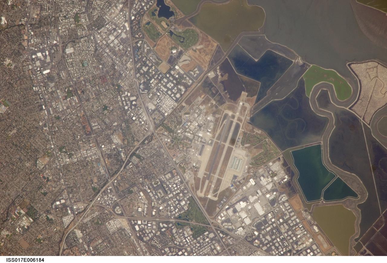
ISS017-E-006184 (3 May 2008) --- NASA Ames Research Center, Moffett Field, CA is featured in this image photographed by an Expedition 17 crewmember on the International Space Station. This view illustrates the diverse built environment surrounding NASA's Ames Research Center, or ARC located at the southernmost end of the San Francisco Bay. Founded in 1939 as an aircraft research laboratory, Ames became a NASA facility in 1958. Its original aircraft research focus was enhanced by the adjacent Moffett Field -- an active Naval Air Station until 1994 and original home of the Navy dirigible U.S.S. Macon. The large hangar for docking the U.S.S. Macon is still present at Moffett Field, and is visible in this image (center). Today, NASA ARC includes the former Naval Air Station, and continues its focus on aeronautics in addition to nanotechnology, information technology, fundamental space biology, biotechnology, thermal protection systems, and human factors research. Land use and land cover in the southern San Francisco Bay area is a diverse mix of industrial, institutional, and residential patterns. Industrial lots -- characterized by lack of green vegetation and large buildings with highly reflective white rooftops -- border NASA ARC to the west, east, and south. The city of Mountain View directly to the south appears as a dense gray-brown network of streets and residential properties with interspersed green parks. The northern boundary of NASA ARC consists of former salt ponds in the process of being returned to tidal wetlands (right). Drainage channels that predate the salt pond levees are visible at right.
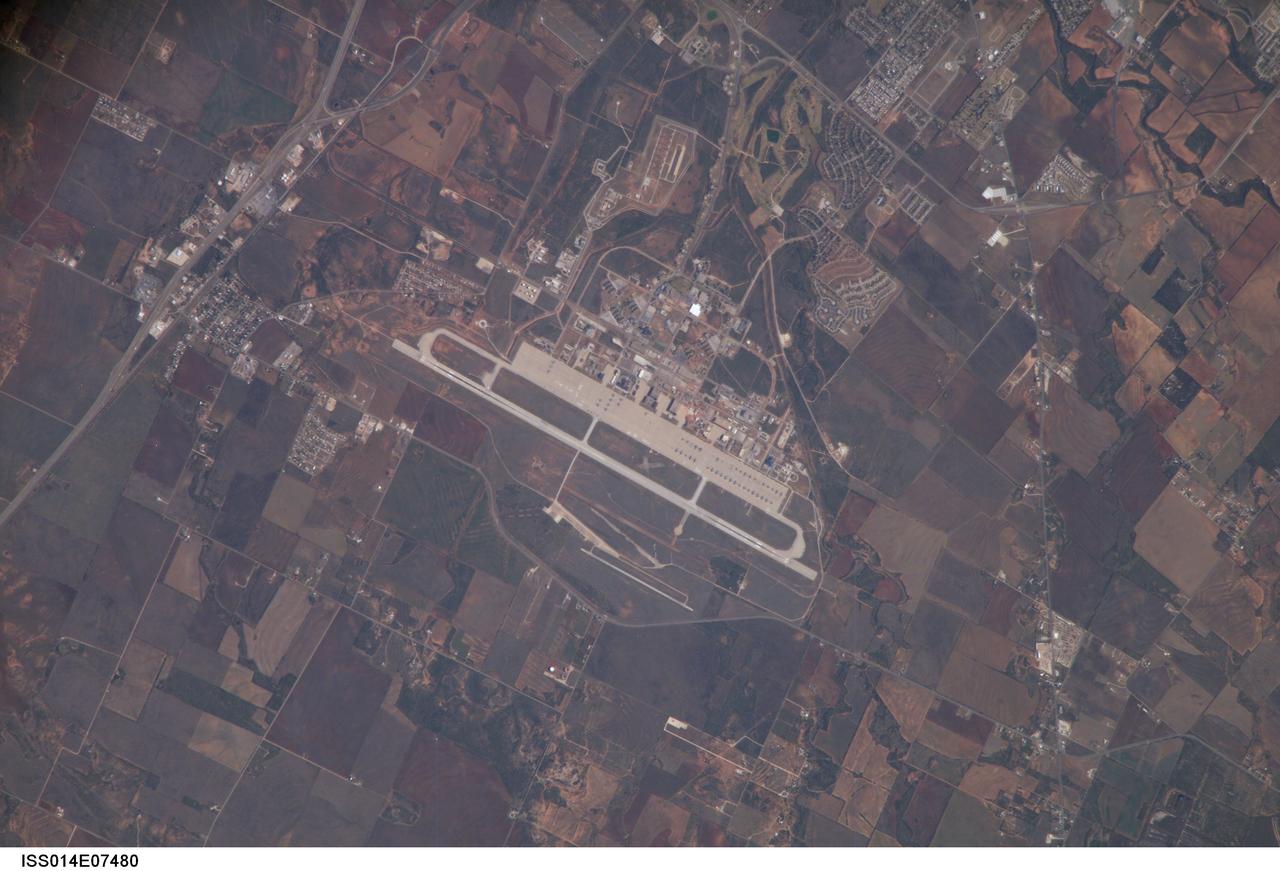
ISS014-E-07480 (11 Nov. 2006) --- Dyess Air Force Base is featured in this image photographed by an Expedition 14 crewmember on the International Space Station. Dyess Air Force Base, located near the central Texas city of Abilene, is the home of the 7th Bomb Wing and 317th Airlift Groups of the United States Air Force. The Base also conducts all initial Air Force combat crew training for the B-1B Lancer aircraft. The main runway is approximately 5 kilometers in length to accommodate the large bombers and cargo aircraft at the base -- many of which are parked in parallel rows on the base tarmac. Lieutenant Colonel William E. Dyess, for whom the base is named, was a highly decorated pilot, squadron commander, and prisoner of war during World War II. The nearby town of Tye, Texas was established by the Texas and Pacific Railway in 1881, and expanded considerably following reactivation of a former air field as Dyess Air Force Base in 1956. Airfields and airports are useful sites for astronauts to hone their long camera lens photographic technique to acquire high resolution images. The sharp contrast between highly reflective linear features, such as runways, with darker agricultural fields and undisturbed land allows fine focusing of the cameras. This on-the-job training is key for obtaining high resolution imagery of Earth, as well as acquiring inspection photographs of space shuttle thermal protection tiles during continuing missions to the International Space Station.
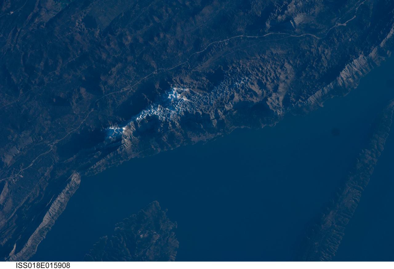
ISS018-E-015908 (29 Dec. 2008) --- The Biokovo Range in Croatia is featured in this image photographed by an Expedition 18 crewmember on the International Space Station. The Biokovo Range in Croatia is part of the Dinaric Alps extending northwest-southeast along the coastline of the Adriatic Sea. The Range itself is the location of a national park; the nearby city of Makarska, located between the mountains and the sea, is a popular tourist destination. The highest peak in the Biokovo Range, Sveti Jure (1762 meters above sea level), is reachable by road or hiking. The Range is comprised mainly of Mesozoic age carbonate rocks ? primarily limestone, a sedimentary rock type rich in calcium carbonate ? deposited in relatively warm, shallow waters. Later tectonic processes uplifted and exposed the carbonate rocks to erosion ? leading to a distinctive geological surface known as karst topography. Karst topography originates due to the chemical erosion of carbonate rocks by acids formed in surface and subsurface water; as the rock is dissolved, underground networks of drainages and caves form. As more underground void space develops through time, the overlaying rock and soil collapses to form a variety of landforms including sinkholes, blind valleys, and towers. In the Biokovo Range, much of the karst surface has a pitted appearance, made easily visible by early morning light in this astronaut photograph. The pitted appearance is produced by numerous circular or semi-circular collapse valleys known locally as vrtace. While this image captures Sveti Jure covered with snow, there are no glaciers or ice fields in the Biokovo Range.
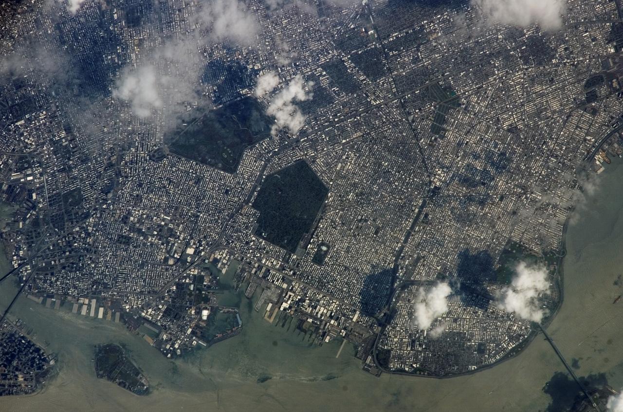
ISS015-E-05483 (28 April 2007) --- Brooklyn, New York waterfront is featured in this image photographed by an Expedition 15 crewmember on the International Space Station. This view illustrates the dense urban fabric of Brooklyn, New York City's largest borough (population of 2.6 million), characterized by the regular pattern of highly reflective building rooftops (white). Two main arteries from Manhattan into Brooklyn, the famous Brooklyn Bridge and neighboring Manhattan Bridge, cross the East River along the left (north) side of the image. The dense built-up fabric contrasts with the East River and Upper New York Bay (bottom center) waterfront areas, recognizable by docks and large industrial loading facilities that extend across the bottom center from left to right. Much of the shipping traffic has moved to the New Jersey side of New York Bay--this has spurred dismantling and redevelopment of the historic dockyards and waterfront warehouses into residential properties. However, efforts to conserve historic buildings are also ongoing. The original name for Brooklyn, Breukelen, means "broken land" in Dutch--perhaps in recognition of the highly mixed deposits (boulders, sand, silt, and clay) left behind by the Wisconsin glacier between 20,000--90,000 years ago, according to scientists. These deposits form much of Long Island, of which Brooklyn occupies the western tip. This image features one of Brooklyn's largest green spaces, the Green-Wood Cemetery. Today, the cemetery functions as both a natural park and a place of internment. The green tree canopy of the Cemetery contrasts sharply with the surrounding urban land cover, is an Audubon Sanctuary, and provides the final resting place for many 19th and 20th century New York celebrities. Also visible in the image is Governor's Island, which served as a strategic military installation for the US Army (1783--1966) and a major US Coast Guard installation (1966--1996). Today the historic fortifications on the island and their surroundings comprise the Governors Island National Monument.

NASA image acquired April 18 - October 23, 2012 This image of North and South America at night is a composite assembled from data acquired by the Suomi NPP satellite in April and October 2012. The new data was mapped over existing Blue Marble imagery of Earth to provide a realistic view of the planet. The nighttime view was made possible by the new satellite’s “day-night band” of the Visible Infrared Imaging Radiometer Suite. VIIRS detects light in a range of wavelengths from green to near-infrared and uses filtering techniques to observe dim signals such as city lights, gas flares, auroras, wildfires, and reflected moonlight. In this case, auroras, fires, and other stray light have been removed to emphasize the city lights. “Artificial lighting is a excellent remote sensing observable and proxy for human activity,” says Chris Elvidge, who leads the Earth Observation Group at NOAA’s National Geophysical Data Center. Social scientists and demographers have used night lights to model the spatial distribution of economic activity, of constructed surfaces, and of populations. Planners and environmental groups have used maps of lights to select sites for astronomical observatories and to monitor human development around parks and wildlife refuges. Electric power companies, emergency managers, and news media turn to night lights to observe blackouts. Named for satellite meteorology pioneer Verner Suomi, NPP flies over any given point on Earth's surface twice each day at roughly 1:30 a.m. and p.m. The polar-orbiting satellite flies 824 kilometers (512 miles) above the surface, sending its data once per orbit to a ground station in Svalbard, Norway, and continuously to local direct broadcast users distributed around the world. The mission is managed by NASA with operational support from NOAA and its Joint Polar Satellite System, which manages the satellite's ground system. NASA Earth Observatory image by Robert Simmon, using Suomi NPP VIIRS data provided courtesy of Chris Elvidge (NOAA National Geophysical Data Center). Suomi NPP is the result of a partnership between NASA, NOAA, and the Department of Defense. Caption by Mike Carlowicz. Instrument: Suomi NPP - VIIRS Credit: <b><a href="http://www.earthobservatory.nasa.gov/" rel="nofollow"> NASA Earth Observatory</a></b> <b>Click here to view all of the <a href="http://earthobservatory.nasa.gov/Features/NightLights/" rel="nofollow"> Earth at Night 2012 images </a></b> <b>Click here to <a href="http://earthobservatory.nasa.gov/NaturalHazards/view.php?id=79787" rel="nofollow"> read more </a> about this image </b> <b><a href="http://www.nasa.gov/audience/formedia/features/MP_Photo_Guidelines.html" rel="nofollow">NASA image use policy.</a></b> <b><a href="http://www.nasa.gov/centers/goddard/home/index.html" rel="nofollow">NASA Goddard Space Flight Center</a></b> enables NASA’s mission through four scientific endeavors: Earth Science, Heliophysics, Solar System Exploration, and Astrophysics. Goddard plays a leading role in NASA’s accomplishments by contributing compelling scientific knowledge to advance the Agency’s mission. <b>Follow us on <a href="http://twitter.com/NASA_GoddardPix" rel="nofollow">Twitter</a></b> <b>Like us on <a href="http://www.facebook.com/pages/Greenbelt-MD/NASA-Goddard/395013845897?ref=tsd" rel="nofollow">Facebook</a></b> <b>Find us on <a href="http://instagram.com/nasagoddard?vm=grid" rel="nofollow">Instagram</a></b>

A major winter storm is poised to wallop the Mid-Atlantic and bring large amounts of snow to cities including Baltimore, Md., Washington, D.C. area on March 2 and 3, according to NOAA's National Weather Service. NOAA's GOES-East satellite captured this image of the clouds associated with the winter storm as it continued moving east toward those cities. On March 2, the National Weather Prediction Center in College Park, Md. noted that there is a slight risk for severe thunderstorms over parts of the western Gulf Coast and the Lower Mississippi Valley as a result of the southern portion of the system. The update at 7 a.m. EST noted that freezing rain/sleet is possible over parts of the lower Mississippi Valley and parts of the central Appalachians, while eastern Texas and the lower Mississippi Valley into the Ohio Valley are expected to experience heavy rain. The NWS Short Range Forecast Discussion stated "A strong storm over the Southern Plains/Lower Mississippi Valley will advance northeastward along a quasi-stationary front to off the Southern Mid-Atlantic Coast by Monday evening. Moisture from the Gulf of Mexico will overrun and pool along the associated front producing an area of snow extending from the Central Plains into the Northeast." The clouds are associated with a cold from that stretches from eastern Maine through Maryland and west into the Tennessee Valley. The low pressure center associated with the front was located over Arkansas. At NASA/NOAA's GOES Project at NASA's Goddard Space Flight Center in Greenbelt, Md. the cloud data from NOAA's GOES-East satellite were overlaid on a true-color image of land and ocean created by data from the Moderate Resolution Imaging Spectroradiometer or MODIS instrument that flies aboard NASA's Aqua and Terra satellites. Together, those data created the entire picture of the position of this major winter storm. GOES satellites provide the kind of continuous monitoring necessary for intensive data analysis. Geostationary describes an orbit in which a satellite is always in the same position with respect to the rotating Earth. This allows GOES to hover continuously over one position on Earth's surface, appearing stationary. As a result, GOES provide a constant vigil for the atmospheric "triggers" for severe weather conditions such as tornadoes, flash floods, hail storms and hurricanes. For updated information about the storm system, visit NOAA's NWS website: <a href="http://www.weather.gov" rel="nofollow">www.weather.gov</a> For more information about GOES satellites, visit: <a href="http://www.goes.noaa.gov/" rel="nofollow">www.goes.noaa.gov/</a> or <a href="http://goes.gsfc.nasa.gov/" rel="nofollow">goes.gsfc.nasa.gov/</a> Rob Gutro NASA Goddard Space Flight Center, Greenbelt, Md. <b><a href="http://www.nasa.gov/audience/formedia/features/MP_Photo_Guidelines.html" rel="nofollow">NASA image use policy.</a></b> <b><a href="http://www.nasa.gov/centers/goddard/home/index.html" rel="nofollow">NASA Goddard Space Flight Center</a></b> enables NASA’s mission through four scientific endeavors: Earth Science, Heliophysics, Solar System Exploration, and Astrophysics. Goddard plays a leading role in NASA’s accomplishments by contributing compelling scientific knowledge to advance the Agency’s mission. <b>Follow us on <a href="http://twitter.com/NASAGoddardPix" rel="nofollow">Twitter</a></b> <b>Like us on <a href="http://www.facebook.com/pages/Greenbelt-MD/NASA-Goddard/395013845897?ref=tsd" rel="nofollow">Facebook</a></b> <b>Find us on <a href="http://instagram.com/nasagoddard?vm=grid" rel="nofollow">Instagram</a></b>
Sochi, Russia Winter Olympic Sites (Coastal Cluster) The Black Sea resort of Sochi, Russia, is the warmest city ever to host the Winter Olympic Games, which open on Feb. 7, 2014, and run through Feb. 23. This north-looking image, acquired on Jan. 4, 2014, by the Advanced Spaceborne Thermal Emission and Reflection Radiometer (ASTER) instrument on NASA's Terra spacecraft, shows the Sochi Olympic Park Coastal Cluster -- the circular area on the shoreline in the bottom center of the image -- which was built for Olympic indoor sports. Even curling has its own arena alongside multiple arenas for hockey and skating. The Olympic alpine events will take place at the Mountain Cluster, located in a snow-capped valley at the top right of the image. Sochi itself, a city of about 400,000, is not visible in the picture. It's farther west (left) along the coast, past the airport at bottom left. In the image, red indicates vegetation, white is snow, buildings are gray and the ocean is dark blue. The area imaged is about 15 miles (24 kilometers) from west to east (left to right) at the coastline and 25 miles (41 kilometers) from front to back. Height is exaggerated 1.5 times. The image was created from the ASTER visible and near-infrared bands, draped over ASTER-derived digital elevation data. With its 14 spectral bands from the visible to the thermal infrared wavelength region and its high spatial resolution of 15 to 90 meters (about 50 to 300 feet), ASTER images Earth to map and monitor the changing surface of our planet. ASTER is one of five Earth-observing instruments launched Dec. 18, 1999, on Terra. The instrument was built by Japan's Ministry of Economy, Trade and Industry. A joint U.S./Japan science team is responsible for validation and calibration of the instrument and data products. The broad spectral coverage and high spectral resolution of ASTER provides scientists in numerous disciplines with critical information for surface mapping and monitoring of dynamic conditions and temporal change. Example applications are: monitoring glacial advances and retreats; monitoring potentially active volcanoes; identifying crop stress; determining cloud morphology and physical properties; wetlands evaluation; thermal pollution monitoring; coral reef degradation; surface temperature mapping of soils and geology; and measuring surface heat balance. The U.S. science team is located at NASA's Jet Propulsion Laboratory, Pasadena, Calif. The Terra mission is part of NASA's Science Mission Directorate, Washington, D.C. More information about ASTER is available at <a href="http://asterweb.jpl.nasa.gov/" rel="nofollow">asterweb.jpl.nasa.gov/</a>. Image credit: NASA/GSFC/METI/ERSDAC/JAROS, and U.S./Japan ASTER Science Team <b><a href="http://www.nasa.gov/audience/formedia/features/MP_Photo_Guidelines.html" rel="nofollow">NASA image use policy.</a></b> <b><a href="http://www.nasa.gov/centers/goddard/home/index.html" rel="nofollow">NASA Goddard Space Flight Center</a></b> enables NASA’s mission through four scientific endeavors: Earth Science, Heliophysics, Solar System Exploration, and Astrophysics. Goddard plays a leading role in NASA’s accomplishments by contributing compelling scientific knowledge to advance the Agency’s mission. <b>Follow us on <a href="http://twitter.com/NASAGoddardPix" rel="nofollow">Twitter</a></b> <b>Like us on <a href="http://www.facebook.com/pages/Greenbelt-MD/NASA-Goddard/395013845897?ref=tsd" rel="nofollow">Facebook</a></b> <b>Find us on <a href="http://instagram.com/nasagoddard?vm=grid" rel="nofollow">Instagram</a></b>
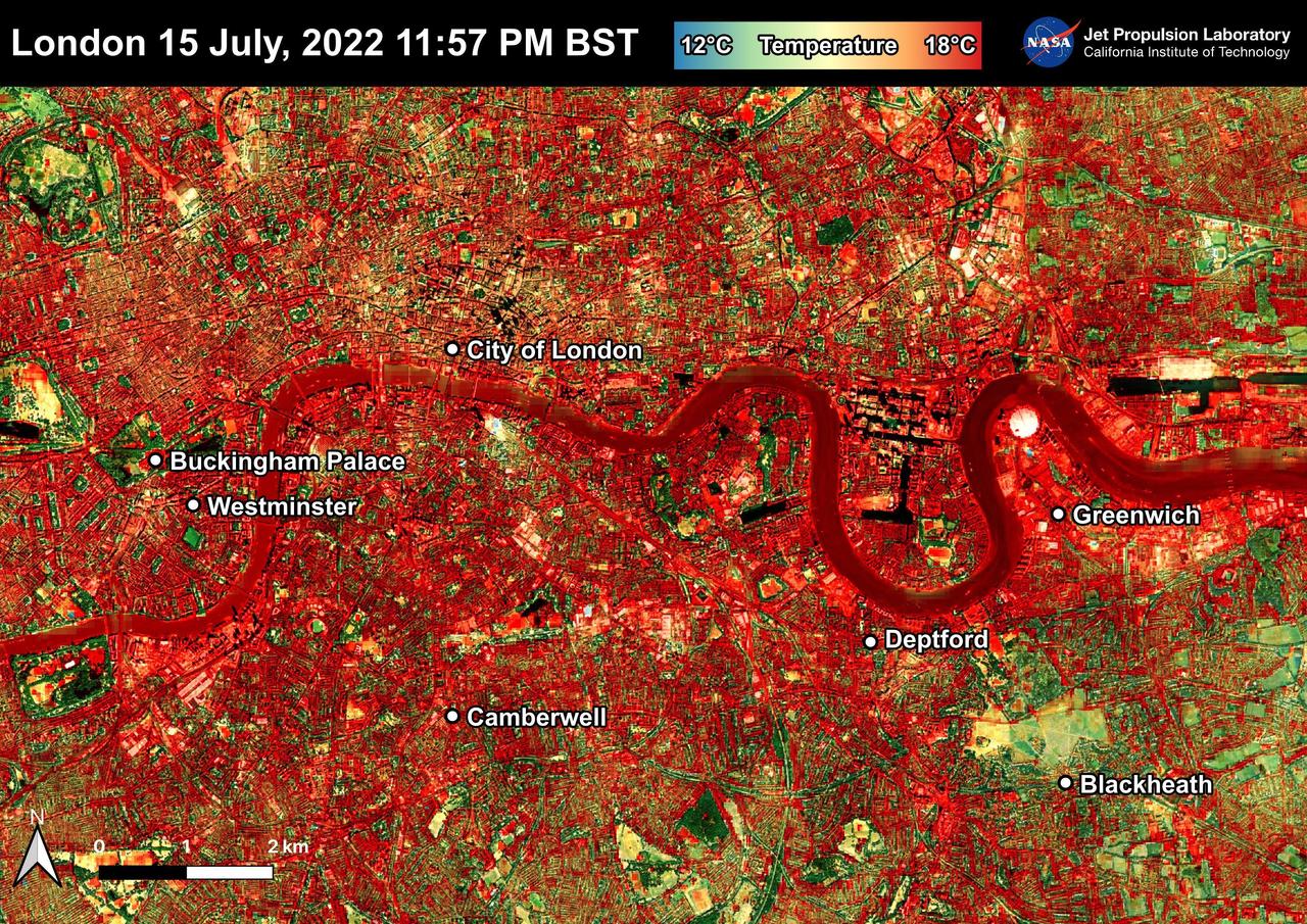
NASA's Ecosystem Spaceborne Thermal Radiometer Experiment on Space Station (ECOSTRESS) instrument recorded this image of ground surface temperatures in London and surrounding areas on July 15, 2022, just before midnight local time. It shows surface temperatures exceeding 68 degrees Fahrenheit (20 degrees Celsius) at 11:57 p.m. British Summer Time. Parts of Europe in mid-July experienced a record-breaking heat wave. The United Kingdom reaching its highest air temperature on record on July 19, 104.5 F (40.3 C) in Coningsby, about 110 miles (177 kilometers) north of London, which itself saw a high of 104.3 F (40.2 C) the same day. That evening, the overnight low was also a record-breaker: 78.4 F (25.8 C) at Kenley Airfield in Greater London. In this image, the red areas indicate hotter temperatures commonly associated with developed areas. These surfaces – roofs, paved streets, and other built structures – remain warm long after the sun sets. Blue and green areas indicate cooler areas commonly associated with parks and other natural land surfaces. Because this image was acquired at night, it shows bodies of water being warmer than the land surface. This is because water tends to change temperature more slowly, so its temperature stays elevated long after land surfaces have cooled down. Cities are usually warmer than open land with natural surfaces because of human activities as well as the materials used in building and construction. Streets are often the hottest part of the built environment due to asphalt paving. Dark-colored surfaces absorb more heat from the Sun than lighter-colored ones; asphalt absorbs up to 95% of solar radiation and retains the heat for hours into nighttime. This image overlays ECOSTRESS surface temperature data on a Google satellite map for context. ECOSTRESS measures the temperature of the ground, which is hotter than the air temperature during the daytime. The instrument launched to the space station in 2018. Its primary mission is to identify plants' thresholds for water use and water stress, giving insight into their ability to adapt to a warming climate. However, ECOSTRESS is also useful for documenting other heat-related phenomena, like patterns of heat absorption and retention. Its high-resolution images, with a pixel size of about 225 feet (70 meters) by 125 feet (38 meters), are a powerful tool for understanding our environment. https://photojournal.jpl.nasa.gov/catalog/PIA25423
In October 1963, the Project Mercury Summary Conference was held in the Houston, TX, Coliseum. This series of 44 photos is documentation of that conference. A view of the Houston, TX, Coliseum, and parking area in front with a Mercury Redstone Rocket setup in the parking lot for display (S63-16451). A view of an Air Force Atlas Rocket, a Mercury Redstone Rocket, and a Mercury Spacecraft on a test booster on display in the front area of the Coliseum (S63-16452). A view an Air Force Atlas Rocket and a Mercury Redstone Rocket set up for display with the Houston City Hall in the background (S63- 16453). This view shows the Atlas Rocket, Mercury Redstone, and Mercury Test Rocket with the Houston, TX, Coliseum in the background (S63- 16454). A balcony view, from the audience right side, of the attendees looking at the stage (S63-16455). A view of the NASA Space Science Demonstration with equipment setup on a table, center stage and Space Science Specialist briefing the group as he pours Liquid Oxygen into a beaker (S63-16456). View of the audience from the balcony on the audience right showing the speakers lecturn on stage to the audience left (S63-16457). A view of attendees in the lobby. Bennet James, MSC Public Affairs Office is seen to the left of center (S63-16458). Another view of the attendees in the lobby (S63- 16459). In this view, Astronaut Neil Armstrong is seen writing as others look on (S63-16460). In this view of the attendees, Astronauts Buzz Aldrin and Walt Cunningham are seen in the center of the shot. The October Calendar of Events is visable in the background (S63-16461). Dr. Charles Berry is seen in this view to the right of center, seated in the audience (S63-16462). View of " Special Registration " and the five ladies working there (S63-16463). A view from behind the special registration table, of the attendees being registered (S63-16464). A view of a conference table with a panel seated. (R-L): Dr. Robert R. Gilruth, Hugh L. Dryden, Walter C. Williams, and an unidentified man (S63- 16465). A closeup of the panel at the table with Dr. Gilruth on the left (S63-16466). About the same shot as number S63-16462, Dr. Berry is seen in this shot as well (S63-16467). In this view the audio setup is seen. In the audience, (L-R): C. C. Kraft, Vernon E. (Buddy) Powell, Public Affairs Office (PAO); and, in the foreground mixing the audio is Art Tantillo; and, at the recorder is Doyle Hodges both of the audio people are contractors that work for PAO at MSC (S63-16468). In this view Maxime Faget is seen speaking at the lecturn (S63-16469). Unidentified person at the lecturn (S63-16470). In this view the motion picture cameras and personel are shown documenting the conference (S63-16471). A motion picture cameraman in the balcony is shown filming the audience during a break (S63- 16472). Family members enjoy an exhibit (S63-16473). A young person gets a boost to look in a Gemini Capsule on display (S63-16474). A young person looks at the Gemini Capsule on display (S63-16475). Dr. Robert R. Gilruth is seen at the conference table (S63-16476). Walt Williams is seen in this view at the conference table (S63-16477). Unidentified man sitting next to Walt Williams (S63-16478). (L-R): Seated at the conference table, Dr. Robert Gilruth, Hugh L. Dryden, and Walt Williams (S63- 16479). Group in lobby faces visable, (L-R): Walt Williams, unidentified person, Dr. Robert Gilruth, Congressman (S63-16480). Man in uniform at the lecturn (S63-16481). Astronaut Leroy Gordon Cooper at the lecturn (S63-16482). Astronaut Cooper at the lecturn with a picture on the screen with the title, " Astronaut Names for Spacecraft " (S63-16483). Dr. Gilruth at the lecturn (S63-16484). Walt Williams at the lecturn (S63-16485). Unidentified man at the lecturn (S63-16486). John H. Boynton addresses the Summary Conference (S63-16487). (L-R): Astronaut Leroy Gordon Cooper, Mrs. Cooper, Senator Cris Cole, and Mrs. Cole (S63- 16488). In this view in the lobby, Senator and Mrs. Cris Cole, with Astronaut Gordon Cooper standing near the heatshield, and Mrs. Cooper; next, on the right is a press photographer (S63-16489). (L-R): Astronaut L. Gordon Cooper and Mrs. Cooper, unidentified man, and Senator Walter Richter (S63-16490). (L-R): Eugene Horton, partially obscured, briefs a group on the Mercury Spacecraft, an unidentified person, Harold Ogden, a female senator, Senator Chris Cole, Mrs. Cole, an unidentified female, Senator Walter Richter, Jim Bower, and an unidentified female (S63-16491). In this view, Mrs. Jim Bates is seen in the center, and Senator Walter Richter to the right (S63- 16492). The next three (3) shots are 4X5 CN (S63-16493 - S63-16495). In this view a NASA Space Science Demonstration is seen (S63-16493). In this view a shot of the conference table is seen, and, (L-R): Dr. Robert R. Gilruth, Hugh L. Dryden, Mr. Walter Williams, and an unidentfied man (S63-16494 - S63-16495). HOUSTON, TX
On Jan. 20 at 2:30 p.m. EST the VIIRS instrument aboard NASA-NOAA's Suomi NPP captured this image of the winter storm moving through the central U.S. Credits: NASA Goddard Rapid Response The low pressure area from the Eastern Pacific Ocean moved into the western U.S. and tracked across the four corners region into Texas where NASA-NOAA's Suomi NPP satellite observed the clouds associated with the storm. The Visible Infrared Imaging Radiometer Suite (VIIRS) instrument aboard Suomi NPP satellite captured the visible image on January 20, 2016 at 19:30 UTC (2:30 p.m. EST) when the storm was over the central U.S. In the image, snow cover is visible in the Rockies and southern Great Lakes states. VIIRS collects visible and infrared imagery and global observations of land, atmosphere, cryosphere and oceans. That low pressure system located over the south central United States on Jan. 21 is expected to track east across the Tennessee Valley and will give way to a deepening coastal low pressure area. The National Weather Service said "This latter feature takes over and becomes a dominant force in setting up heavy snow bands over the Mid-Atlantic and very gusty winds." The storm system is expected to bring an increased risk of severe weather from far southeastern Texas across southern Louisiana/Mississippi, and into the far western Florida Panhandle on Thursday, Jan. 21. That threat for severe weather will move east as the low pressure area continues heading in that direction. The National Weather Service Weather Prediction Center in College Park, Maryland said "A potentially crippling winter storm is anticipated for portions of the mid-Atlantic Friday into early Saturday. Snowfall may approach two feet for some locations, including the Baltimore and Washington, D.C. metro areas. Farther north, there is uncertainty in snowfall for the New York City-to-Boston corridor. Farther south, significant icing is likely for portions of Kentucky and North Carolina." <b><a href="http://www.nasa.gov/audience/formedia/features/MP_Photo_Guidelines.html" rel="nofollow">NASA image use policy.</a></b> <b><a href="http://www.nasa.gov/centers/goddard/home/index.html" rel="nofollow">NASA Goddard Space Flight Center</a></b> enables NASA’s mission through four scientific endeavors: Earth Science, Heliophysics, Solar System Exploration, and Astrophysics. Goddard plays a leading role in NASA’s accomplishments by contributing compelling scientific knowledge to advance the Agency’s mission. <b>Follow us on <a href="http://twitter.com/NASAGoddardPix" rel="nofollow">Twitter</a></b> <b>Like us on <a href="http://www.facebook.com/pages/Greenbelt-MD/NASA-Goddard/395013845897?ref=tsd" rel="nofollow">Facebook</a></b> <b>Find us on <a href="http://instagram.com/nasagoddard?vm=grid" rel="nofollow">Instagram</a></b>