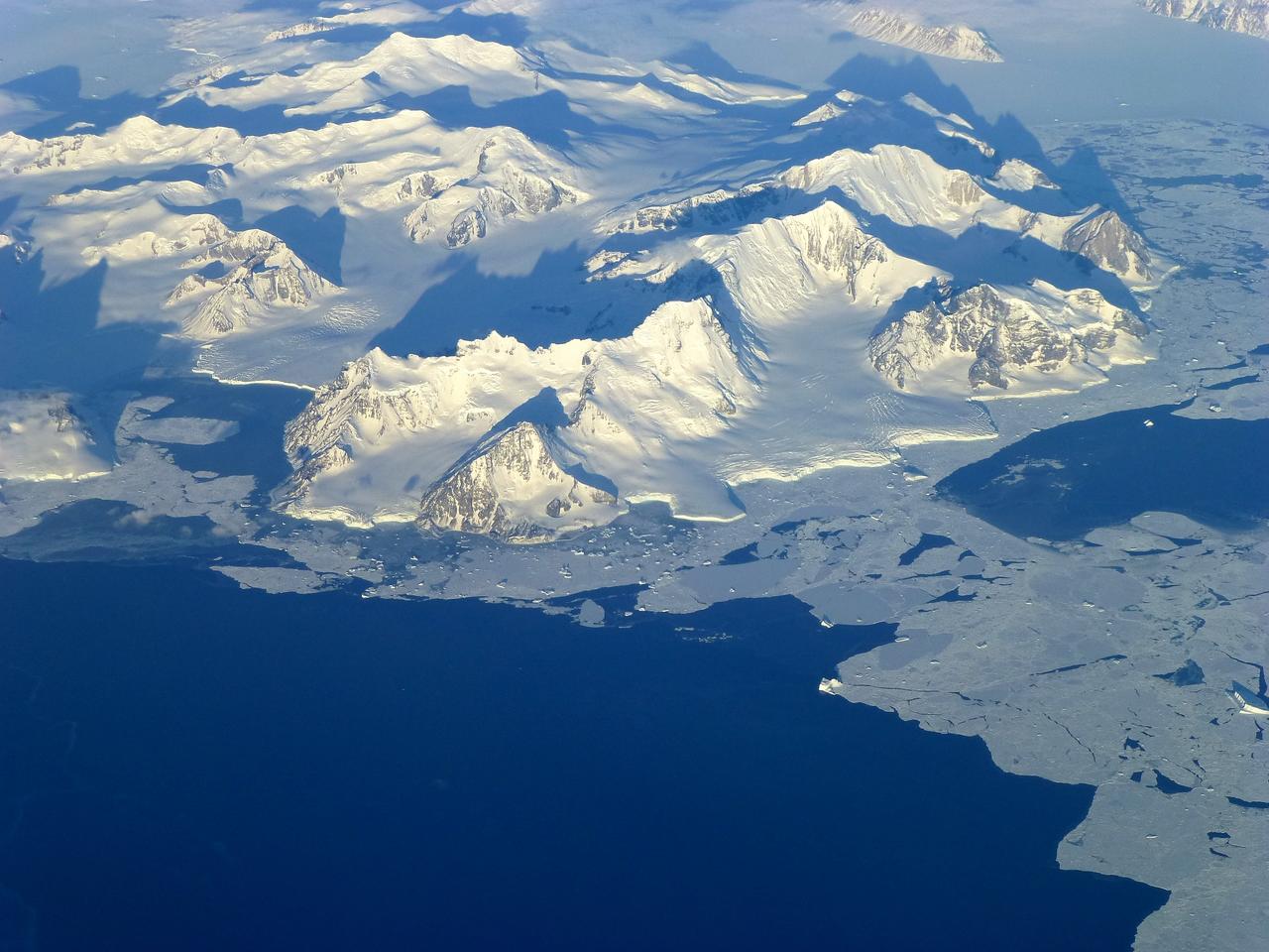
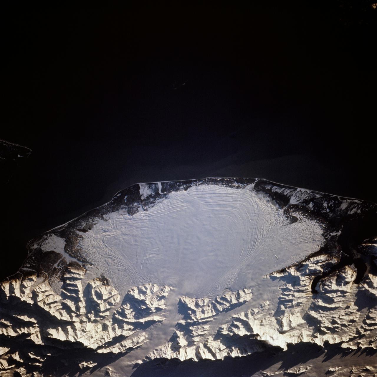
View of the northern Antarctic Peninsula from high altitude during IceBridge's flight back from the Foundation Ice Stream, on Oct. 28. Credit: NASA/Goddard/Maria-Jose Vinas NASA's Operation IceBridge is an airborne science mission to study Earth's polar ice. For more information about IceBridge, visit: <a href="http://www.nasa.gov/icebridge" rel="nofollow">www.nasa.gov/icebridge</a> <b><a href="http://www.nasa.gov/audience/formedia/features/MP_Photo_Guidelines.html" rel="nofollow">NASA image use policy.</a></b> <b><a href="http://www.nasa.gov/centers/goddard/home/index.html" rel="nofollow">NASA Goddard Space Flight Center</a></b> enables NASA’s mission through four scientific endeavors: Earth Science, Heliophysics, Solar System Exploration, and Astrophysics. Goddard plays a leading role in NASA’s accomplishments by contributing compelling scientific knowledge to advance the Agency’s mission. <b>Follow us on <a href="http://twitter.com/NASA_GoddardPix" rel="nofollow">Twitter</a></b> <b>Like us on <a href="http://www.facebook.com/pages/Greenbelt-MD/NASA-Goddard/395013845897?ref=tsd" rel="nofollow">Facebook</a></b> <b>Find us on <a href="http://instagrid.me/nasagoddard/?vm=grid" rel="nofollow">Instagram</a></b>
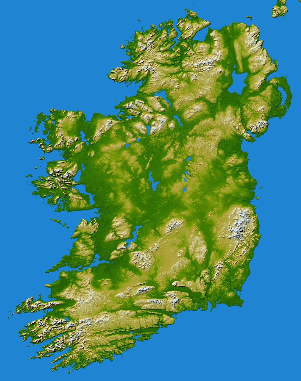
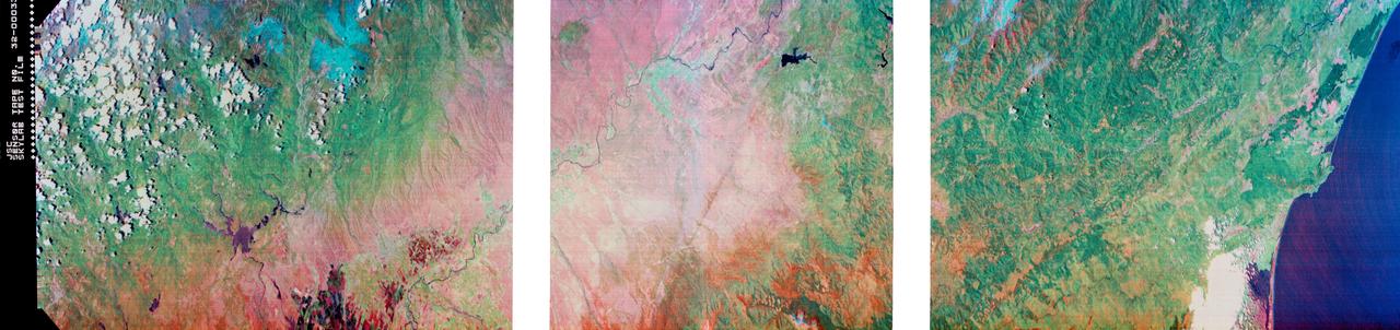
The island of Ireland comprises a large central lowland of limestone with a relief of hills surrounded by a discontinuous border of coastal mountains which vary greatly in geological structure.
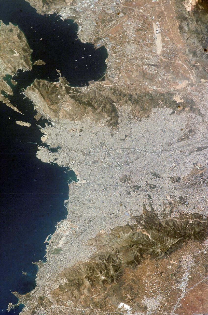
Los Angeles may be the world entertainment capital, but it is a difficult place to locate television and radio antennas. The metropolitan area spreads from the Pacific Ocean to upper and lower deserts, valleys, mountains, canyons and coastal plains.
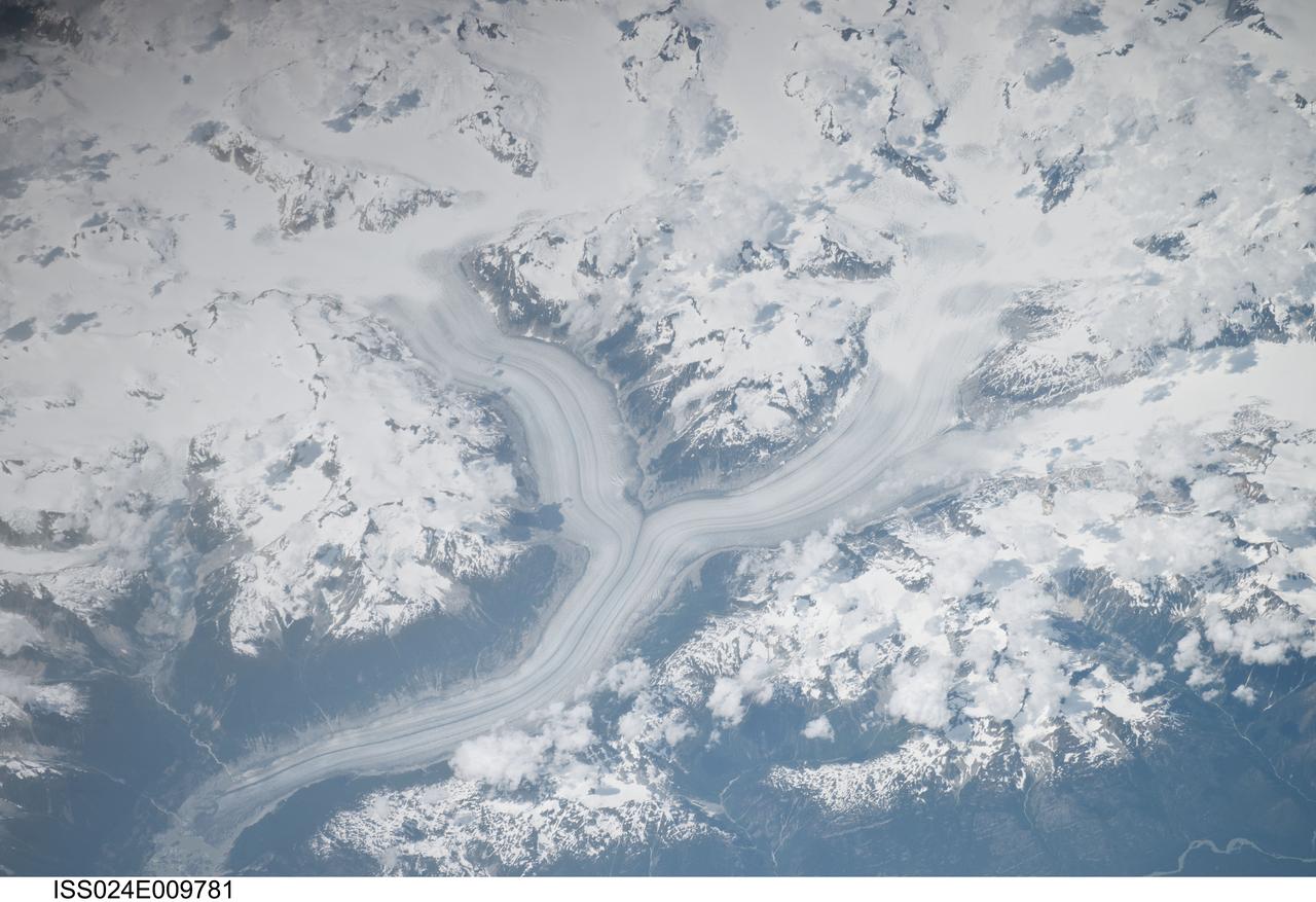
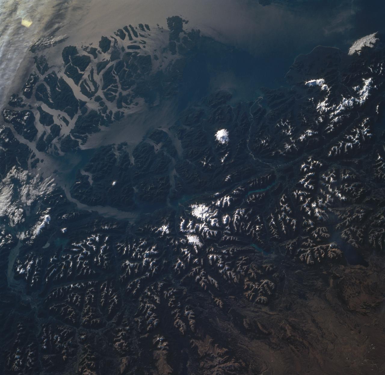
ISS024-E-009781 (28 July 2010) --- The Coastal Mountains in British Columbia, Canada are featured in this image photographed by an Expedition 24 crew member on the International Space Station.
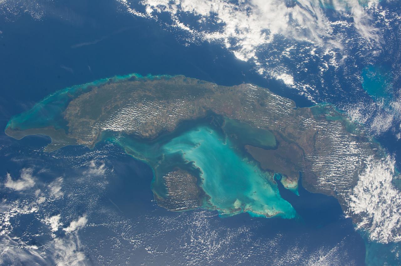
ISS038-E-021397 (24 Dec. 2013) --- The Caribbean country of Cuba is pictured in this nadir image, photographed by one of the Expedition 38 crew members aboard the International Space Station. (Note: North is at the top of the picture.) Cuba is an archipelago of islands in the northern Caribbean Sea at the confluence with the Gulf of Mexico and the Atlantic Ocean. In the southeast, the dark coastal area is home to the Sierra Maestra mountains. It is the highest mountain range on the island, with Pico Turquino reaching nearly 2000 meters. On the central southern coast of the island is the Sierra Del Escambray mountain range, including the 1160 meter-high Pico San Juan, Cuba's second highest peak.
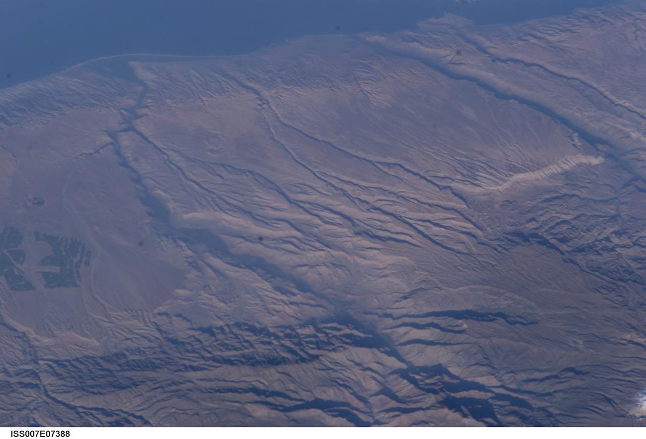
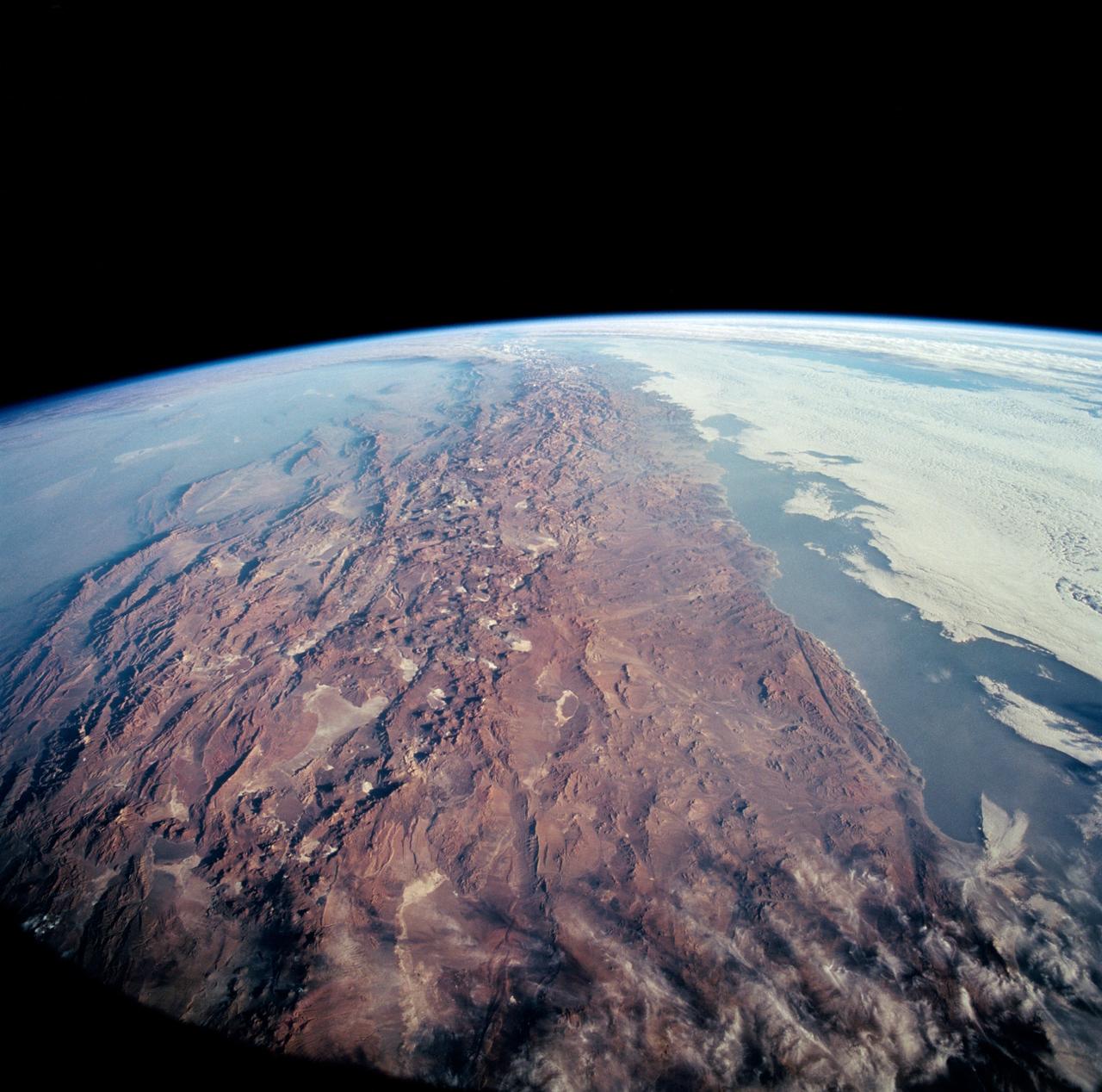
ISS007-E-07388 (14 June 2003) --- Some of the deepest canyons in the world cut west to the Pacific from the high crest of the Andes Mountains in Peru. This view taken by an Expedition 7 crewmember onboard the International Space Station (ISS) provides a birds-eye view down the canyons of the Rio Camana (center left) and the Rio Ocona (upper right). The low early morning sun highlights the extreme topography created by rapidly uplifting mountains and powerful water erosion by water dropping nearly 10,000 feet in this view. At the edge of the image are the snowy flanks of Nevado Coropuna, the highest mountain in the Cordillera Occidental (6613 meters). The coastal city of Camana is visible in the upper left.
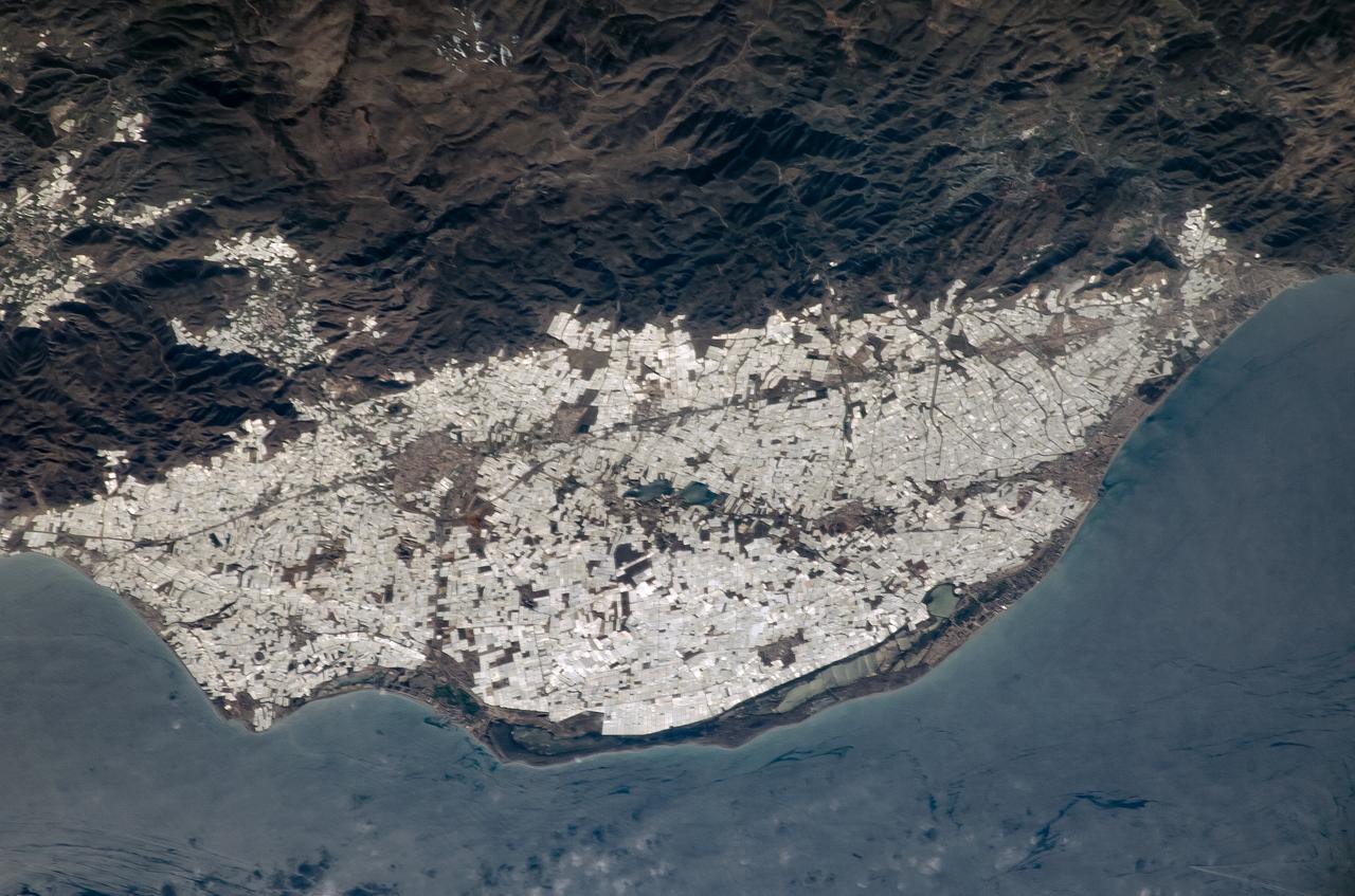
ISS008-E-14686 (7 February 2004) --- This image featuring southern Spain was photographed by an Expedition 8 crewmember on the International Space Station (ISS). Over the past 50 years, the small coastal plain (campo), some 30 kilometers southwest of the city of Almeria, has been intensively developed for agriculture. The area has a dry mild, Mediterranean climate and is further sheltered on the north by the Sierra de Gador. Note the dense, bright pattern of thousands of greenhouses extending from the shoreline right up to the base of the mountains and even into some of the smaller valleys. Saltpan operations can also be seen in the long coastal lagoons.
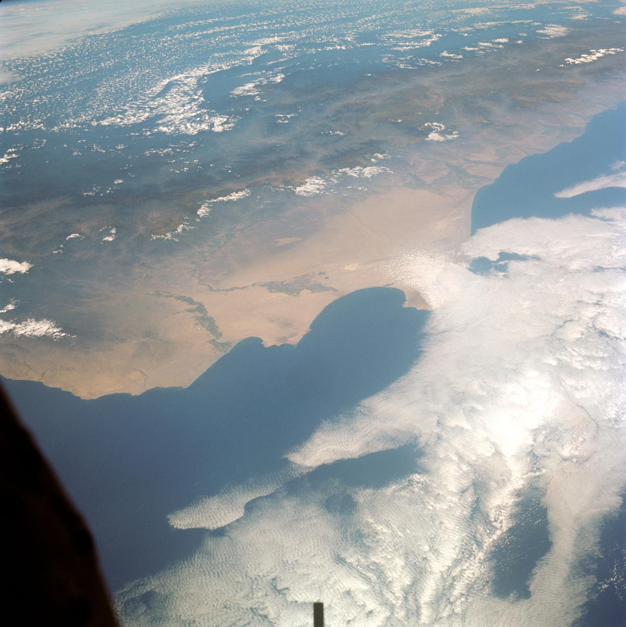
STS085-505-078 (7 - 19 August 1997) --- This large-format photograph, taken from the Earth-orbiting Space Shuttle Discovery with a 250mm lens, shows most of Lebanon, from the Israeli border to just south of Tripoli. The main distinction is that between the forested coastal mountain ranges which receive rainfall regularly off the Mediterranean, and the yellow-brown "rainshadow" deserts inland (east) of the mountains. Damascus, capital of Syria lies just outside the view bottom right. The biblical and classical cities of Acre (bottom), Tyre, Sidon and Beirut (top, on promontory) all lie on the coast. The Bekaa valley and the Litani River lie inland of the Lebanon Mountains east of Beirut. The agricultural area in the south of the photograph is part of Israel and borders the Golan Heights.
STS-65 Earth observation taken aboard Columbia, Orbiter Vehicle (OV) 102, shows Northern Chile and the Andes Mountains. This color photograph is a panoramic (southern view) that features Chile and the Andes Mountains of South America. The Atacama Desert, one of the driest regions on Earth, is clearly visible along the Chilean coast. In the near left foreground is the Salar de Arizaro. Salar Punta Negra in the center foreground appears to be partially filled with water. On the right side of the view, a coastal plateau rises from the Pacific Ocean and meets the Andes Mountains that appear as a backbone running north to south along the border of Chile and Argentina. In the distant left portion of the view can be seen the hazy Chaco Plains and Pampas.
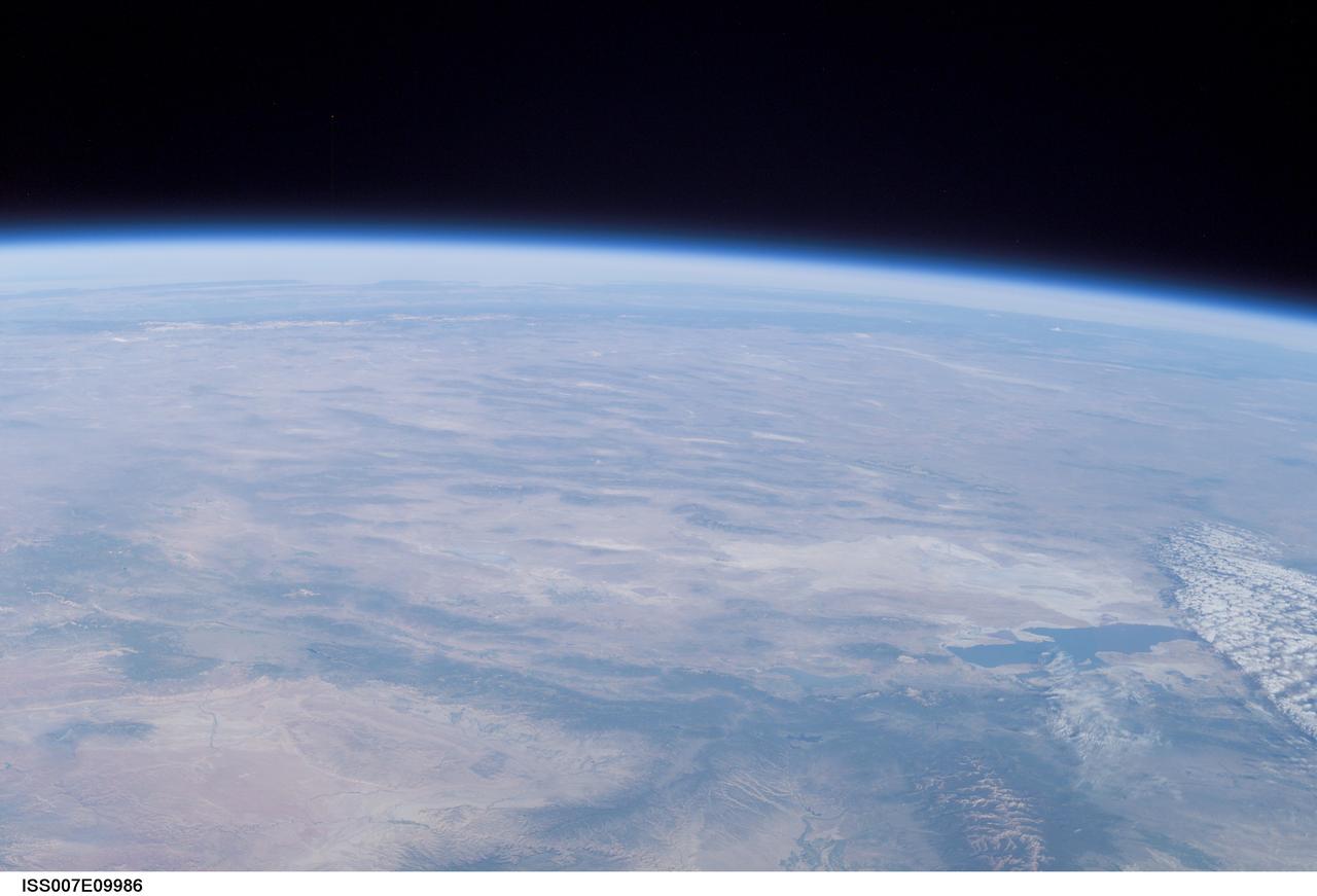
ISS007-E-09986 (11 July 2003) --- This view of Earth’s horizon was taken by an Expedition 7 crewmember onboard the International Space Station (ISS) while the Station was in orbit over Dodge City, Kansas. In the lower right is the Great Salt Lake. At the left side in the distance are the Sierra Nevada Mountains with elevations between 12,000 and 15,000 feet, and coastal California.
iss073e0381336 (July 18, 2025) --- Santiago, Chile, the South American nation's capital and largest city with a metropolitan population of over 6.9 million, is pictured at approximately 4:57 a.m. local time from the International Space Station as it orbited 266 miles above. Santiago rests in the Chilean Central Valley in between the Andes Mountains and the Chilean Coastal Range on the Pacific coast.
STS054-151-009 (13-19 Jan 1993) --- This large format camera's view shows the circular volcanic structure of the Brandberg mountain, which at 2630 meters (8,550 feet) is the highest point in the new nation of Namibia. The Brandberg is a major feature in the very arid Namib Desert on Africa's southwest coast. Coastal fog brings some moisture to the driest parts of the desert.
S66-38290 (5 June 1966) --- The north coastal area of Peru looking southeast across the Andes Mountains as seen from the National Aeronautics and Space Administration's Gemini-9A spacecraft. The body of water is the Pacific Ocean. The image was taken with a modified 70mm Hasselblad camera, using Eastman Kodak, Ektachrome MS (S.O. 217) color film. Photo credit: NASA

STS003-10-606 (30 March 1982) --- The entire state of New Jersey (39.5N, 74.5W) is seen in great detail in this photograph. Philadelphia, PA on the west bank of the Delaware River and Camden, NJ on the east bank of this natural boundary, are easily seen as well as the coastal resort of Atlantic City. Further north, New York City and most of Long Island can be seen in fair detail while further inland, the northern Appalachian Mountains can be seen going diagonal across the scene. Photo credit: NASA
S66-38298 (5 June 1966) --- The central coastal area of Peru as seen from the Gemini-9A spacecraft during its 35th revolution of Earth. The body of water is the Pacific Ocean. The mountains are in the Cordillera Blanca range of the Andes. The 22,205-feet Huascaran is the highest peak in the area. The image was taken with a modified 70mm Hasselblad camera, using Eastman Kodak, Ektachrome MS (S.O. 217) color film Photo credit: NASA
STS060-83-041 (3-11 Feb 1994) --- The large city of Monterrey, in northeastern Mexico, was founded at the edge between the Sierra Madre Oriental and the Rio Grande Embayment portion of the Gulf Coastal Plain. This location is analogous to the Fall Line along the United States eastern seaboard, but instead of lying along a stream at the head of navigation, Monterrey lies at the boundary between a well-watered mountain range and a semi-arid plain where irrigation is often necessary for successful agriculture. The mountains themselves are formed from folded limestone and shale beds; to the south of the city, beds are crumpled into tight folds. Around and north of the city, more open folds gradually give way to nearly flat-lying beds of the coastal plain. Because of the water and other resources such as shale and limestone to quarry and burn for cement, Monterrey early became a thriving industrial center. It is now one of Mexico's largest cities with a population of approximately 5 million. According to NASA geologists, the STS-60 photography of this area is the best that has been acquired during the past 32 years of space photography by the United States. Monterrey remains an area of high interest for future photography in order to assess the impact of urbanization in this area.
STS085-716-081 (7-19 August 1997) --- This photograph provides a southerly view from Vancouver, B. C. in the foreground, to Portland, Oregon near the top. Coastal stratus, a common occurrence, hugs the Pacific coastline and laps into Puget sound. The silty Fraser River cuts through Vancouver and empties into Puget Sound with a large, milky plume of sediment (bottom). Near the top of the image, the Columbia River runs across the Cascades (between Mt. Adams and Mt. Hood) and the Coast Ranges to the Pacific Ocean. Snow caps the highest peaks of the Olympic Mountains (near center), and the Cascade volcanoes of Rainier (closest to Seattle), Adams and Hood (top). The smaller, gray mountain just south (above and right) of Rainier is Mt. St. Helens.
ISS009-E-11537 (12 June 2004) --- Athens, Greece is featured in this image photographed by an Expedition 9 crewmember on the International Space Station (ISS). This photo includes areas of new construction or renovation for the Olympic Games, such as the Faliro Coastal Zone Olympic Complex and Helliniko Olympic Complex. The image also demonstrates the control of bounding mountain ranges (Mts. Aigeleos and Hymettos) on the western and southern expansion of the Athens urban area. Athens is located in the Central Plains region of Attica in eastern Greece. The large basin in which Athens is located was formed by faulting and has accumulated thick deposits of clays and alluvium.

STS100-713-064 (19 April-1 May 2001) --- This southerly-looking view, captured with a 70mm camera onboard the Space Shuttle Endeavour, shows the triangular-shaped island of Sicily. With only very limited coastal plains the island's topography consists of rugged hills and low mountains. Snow-capped Mt. Etna, one of the world's most instrumented volcanoes, is visible near the northeast point of the island. Two other distinctive features in this image are the lighter-colored zone of suspended sediment in the water along the southern coast and, in the distance, the smaller islands of Malta.
STS084-727-053 (15-24 May 1997) --- This view of Lima, Peru is among a very few photographed by astronauts who have orbited Earth since the early 1960's. Francisco Pizarro founded the city of Lima in 1535. Lima is located 13 kilometers (8 miles) inland from the Peruvian coast and is surrounded by coastal desert and the Andes mountains. Suburbs of Lima extend in all directions except to the east, where the Andes prohibits growth. The three rivers, Chillion to the northeast of Lima, the Rimac which runs through the northern part of the city, and the Mala to the southeast, all drain the central Andes. The island off the coast is San Lorenzo.
STS066-117-014 (3-14 Nov. 1994) --- Malaspina Glacier can be seen in this north-northeastern photograph taken in November, 1994. The glacier, located in the south shore of Alaska is a classic example of a piedmont glacier lying along the foot of a mountain range. The principal source of ice for the glacier is provided by the Seward Ice Field to the north (top portion of the view) which flows through three narrow outlets onto the coastal plain. The glacier moves in surges that rush earlier-formed moraines outward into the expanding concentric patterns along the flanks of the ice mass.
STS061-101-023 (8 Dec 1993) --- This color photograph is a spectacular, panoramic (southeastern view) shot that features the northern half of the country of Chile and the Andes Mountains of South America. The Atacama Desert, one of the driest regions on earth, is clearly visible along the northern Chilean coast. This desert extends from roughly Arica in the north to the city of Caldera in the south, a distance of six hundred miles. Some parts of this very arid region go for more than twenty years without measurable precipitation. It is an area of dramatic and abrupt elevation changes. For example, from the waters edge there is an escarpment of the coastal plateau that rises like an unbroken wall two or three thousand feet above the Pacific Ocean. From the coastal plateau, there is an even more dramatic increase in elevation -- from two thousand feet above sea level to an average elevation of thirteen thousand feet above sea level in the Bolivian Altiplano. This elevation change occurs within a one hundred to two hundred mile distance from the Pacific Ocean. The north-south trending spine of the Andes Mountains can be seen on this photograph. Several of the volcanic peaks in this mountain chain exceed 20,000 feet above sea level. Interspersed with these volcanic peaks, numerous dry lake beds (salars) can be seen as highly reflective surfaces. The largest of these salars (Salar de Uyuni) is visible at the edge of the Hubble Space Telescope (HST). Offshore, the cold Peruvian current produces low stratus clouds that can be found along this coastline at certain times of the year. This is the same type of meteorological phenomena that is found along the southern California coast and the Skeleton coast of southwestern Africa.
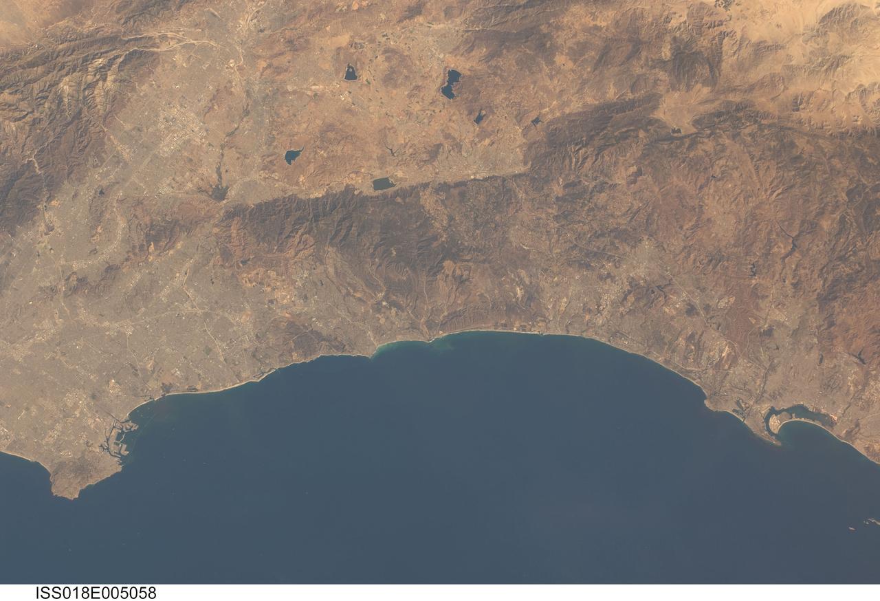
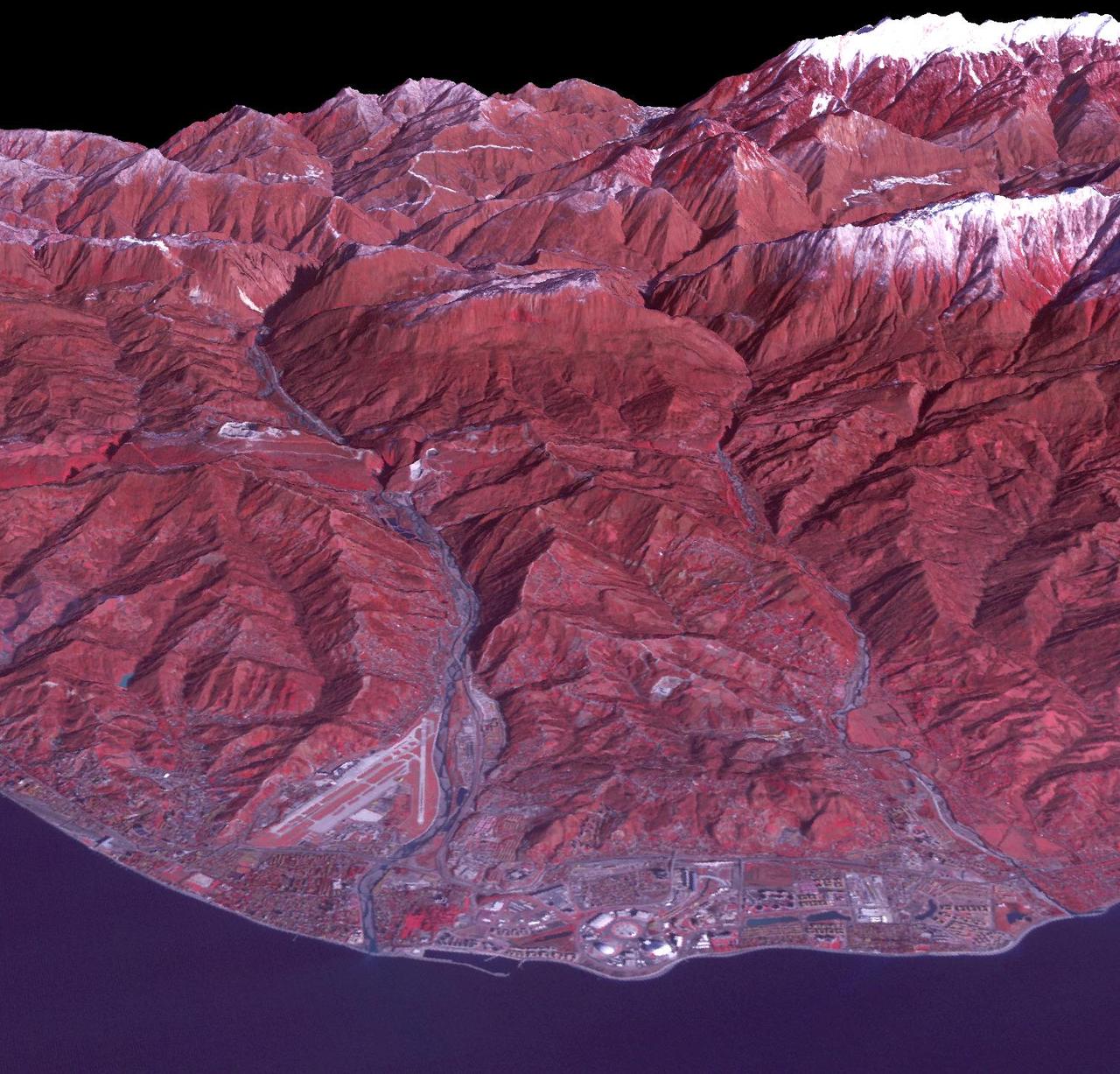
ISS018-E-005058 (24 Oct. 2008) --- Southern California's coastline, from southern Los Angeles to Tijuana in Mexico, a distance of about 225 kilometers, is featured in this image photographed by an Expedition 18 crewmember on the International Space Station. Port facilities of Los Angeles Harbor give much detail to the coastline at the north end and arcuate San Diego Bay is highly recognizable at the south end (right bottom). The image includes much of one of the most densely populated parts of the USA, with approximately 20 million people within the parts of five counties shown here. The dense urban areas appear gray, with the largest conurbation in the north of the view, in the region Long Beach--Los Angeles--San Bernardino. A smaller zone appears around San Diego--Tijuana in the south. Major highways with their associated strip development snake through these dense urban areas. The geography and geomorphology of Southern California is defined by long linear features that are surface traces of large transform faults. These faults, including the Elsinore fault and San Jacinto fault seen here, are generally considered part of the San Andreas system, and make up the broad zone comprising the tectonic plate boundary between North America to the east and the Pacific plate to the west. The Elsinore fault marks the steep eastern scarp of the Santa Ana Mountains, as well as the precipitation boundary between the wetter mountains and the drier deserts to the east. The rainfall difference is reflected in the darker appearance (more vegetation) of the mountains and coastal regions. Inland of the mountains, climates are far drier, and the natural vegetation is scrubby and much less dense which allows brown and yellow soils to show through. However, the entire region is arid; water management is a critical issue for the large urban areas of the state. Several reservoirs that are visible east of the Santa Ana Mountains provide water for both cities and agriculture in southern California.
ISS009-E-18679 (17 August 2004) --- Ural River Delta, Kazakhstan is featured in this image photographed by an Expedition 9 crewmember on the International Space Station (ISS). The Ural River is one of two major rivers (the other river is the Volga) that empty into the northern coast of the Caspian Sea, creating extensive wetlands. This image shows details of the Ural's tree-like (or “digitate”) delta. According to NASA scientists studying the Space Station imagery, this type of delta forms when wave action is low and sediment content in the river is high. New distributary channels form in the delta when the river breaches natural levees formed by sediment deposition. The dark regions running along the coast are the wetlands that support high biodiversity due to the unique environment and relative isolation of the Caspian Sea. The coastal wetlands are especially important to migrating birds as an important stop-over along the Asian flyway. The Ural River's trek to the Caspian is long — roughly 2400 kilometers (1500 miles) from the Ural Mountains in Russia south to empty into the northern Caspian Sea in Kazakhstan. Although the current sea level of the Caspian is more than 26 meters below global mean sea level the water levels have risen roughly 2 meters since 1980. This has lead to flooding of much of the coastal region, including the Ural delta, and endangers these coastal wetland environments. The coastal flooding has also impacted the oil exploration infrastructure bordering the Caspian coastline, scientists report.
2013 image of Adler and the newly created Olympic Coastal Cluster. This false color satellite image reveals a largely agricultural area that was transformed into the Coastal Olympic Cluster with the nearby Olympic Village and Rail Station with transport to the Mountain Cluster. A spanking new breakwater structure was installed to create a harbor for cruise ships. The airport also received an expansion to handle the increased traffic. Caption and image provided by Tim Assal, US Geological Survey – Fort Collins Science Center Credit: NASA/Landsat <b><a href="http://www.nasa.gov/audience/formedia/features/MP_Photo_Guidelines.html" rel="nofollow">NASA image use policy.</a></b> <b><a href="http://www.nasa.gov/centers/goddard/home/index.html" rel="nofollow">NASA Goddard Space Flight Center</a></b> enables NASA’s mission through four scientific endeavors: Earth Science, Heliophysics, Solar System Exploration, and Astrophysics. Goddard plays a leading role in NASA’s accomplishments by contributing compelling scientific knowledge to advance the Agency’s mission. <b>Follow us on <a href="http://twitter.com/NASAGoddardPix" rel="nofollow">Twitter</a></b> <b>Like us on <a href="http://www.facebook.com/pages/Greenbelt-MD/NASA-Goddard/395013845897?ref=tsd" rel="nofollow">Facebook</a></b> <b>Find us on <a href="http://instagram.com/nasagoddard?vm=grid" rel="nofollow">Instagram</a></b>
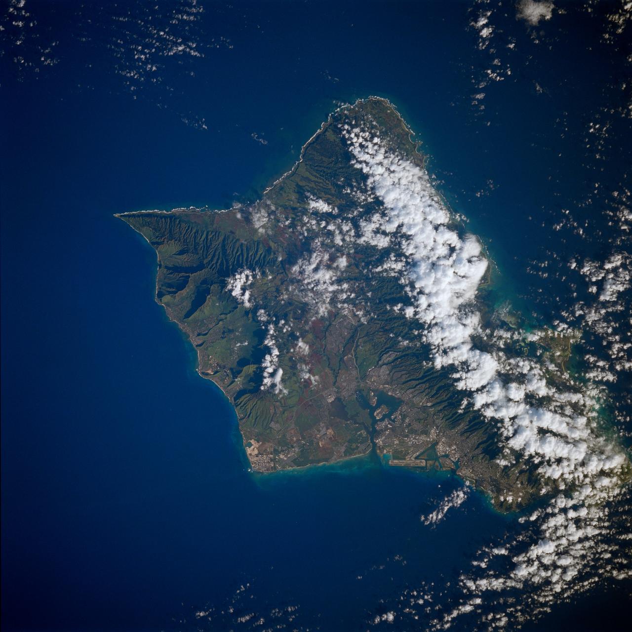
STS080-758-065 (19 Nov.-7 Dec. 1996) --- The island of Oahu, state of Hawaii was photographed by the crew members aboard the Earth-orbiting Space Shuttle Columbia. The western portion (lower part of photograph) of the well eroded extinct volcano is quite clear. The northeastern coastal area and Koolau Range of mountains, which runs the length of the island (30 miles) are cloud covered. This is an unusual case. This is the windward side of the island (great for surfing) and the warm moist Pacific winds sweep up the mountains thus causing the clouds and an unusually high rainfall. The city of Honolulu is along the right side with the Honolulu International Airport clearly seen. Below the airport is the narrow entrance to Pearl Harbor and nearby Hickam Air Force Base. The narrow sand beaches of the Waikiki Beach resort area, just above Diamond Head - on the lower right, appear as narrow white lines along the coast above the airport and port of Honolulu. The sharp point at the lower portion of the photo is Kaena Point. The cliffs there are so steep that there is no developed roadway although a narrow gauge railway was carved into the cliffs and operated the first half of the century.
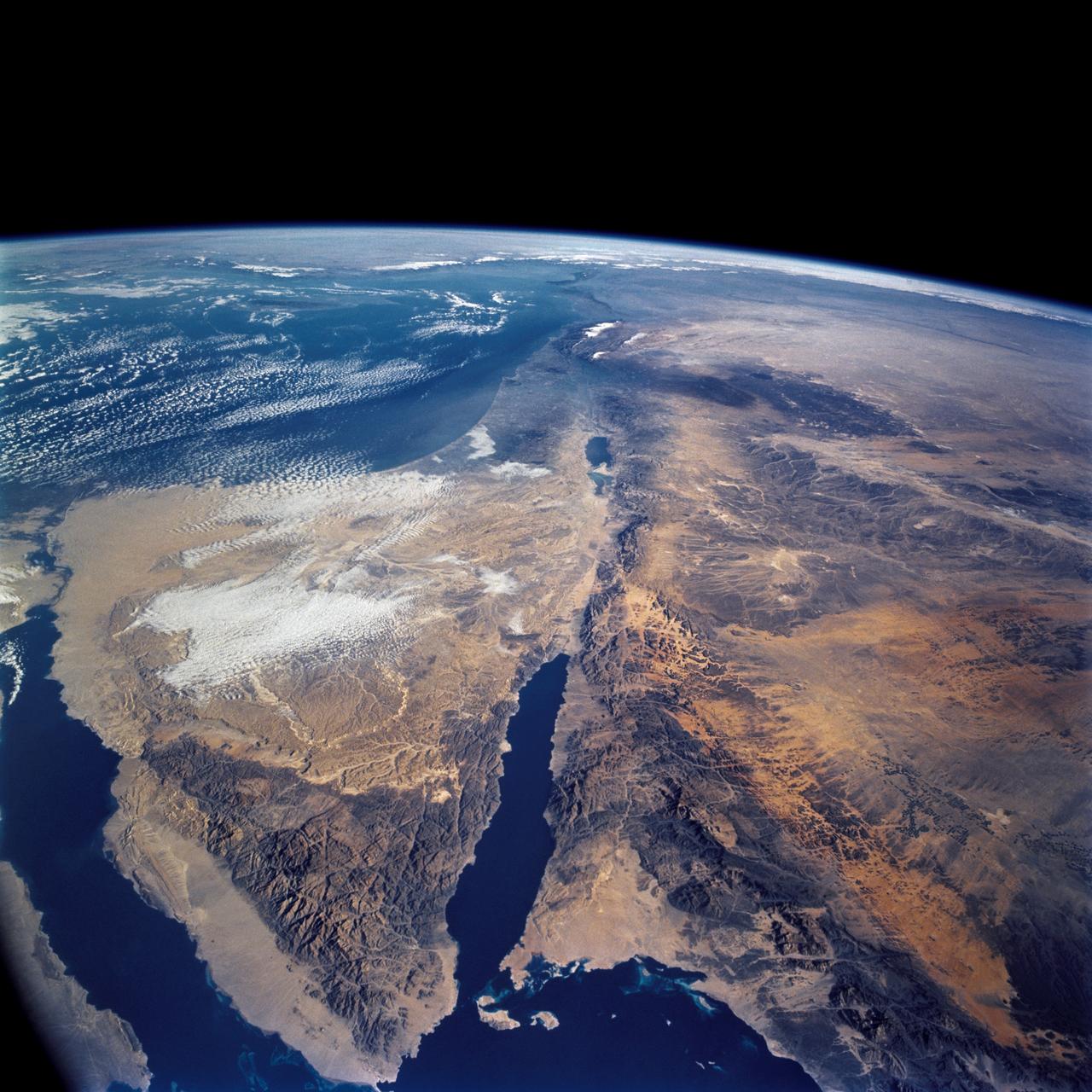
STS109-708-024 (1-12 March 2002) --- The astronauts on board the Space Shuttle Columbia took this 70mm picture featuring the Sinai Peninsula and the Dead Sea Rift. The left side of the view is dominated by the great triangle of the Sinai peninsula, which is partly obscured by an unusual cloud mass on this day. The famous Monastery of St. Catherine lies in the very remote, rugged mountains in the southern third of the peninsula (foreground). The Gulf of Aqaba is a finger of the Red Sea bottom center, pointing north to the Dead Sea, the small body of water near the center of the view. According to NASA scientists studying the STS-109 photo collection, the gulf and the Dead Sea are northerly extensions of the same geological rift that resulted in the opening of the Red Sea . The Gulf of Suez appears in the lower left corner. Northwest Saudi Arabia occupies the lower right side of the view, Jordan and Syria the right and top right, and the Eastern Mediterranean Sea the top left. Thin white lines of cloud have formed along the coastal mountains of southern Turkey and stretch across the top of the view near the Earth's limb.
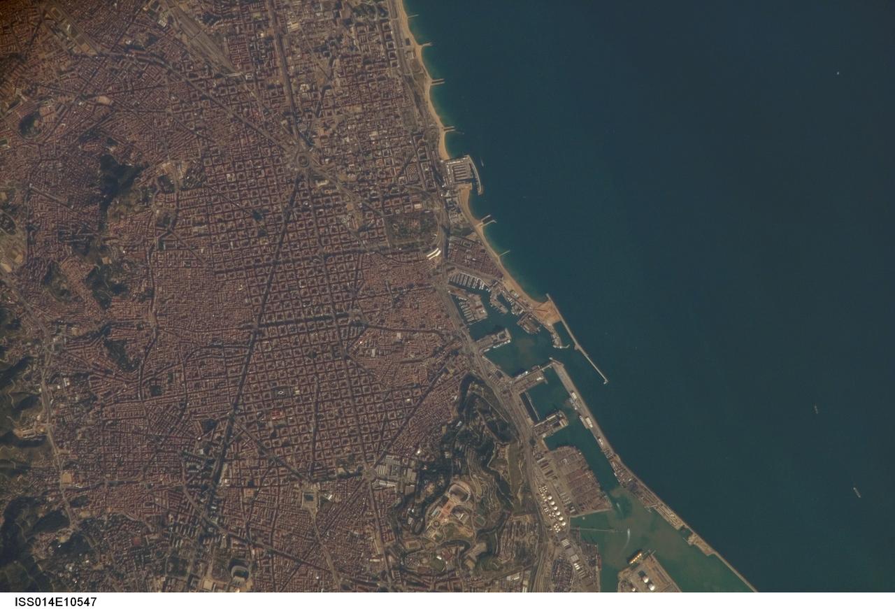
ISS014-E-10547 (30 Dec. 2006) --- Barcelona, Spain is featured in this image photographed by an Expedition 14 crewmember on the International Space Station. Barcelona occupies a low plateau along the Mediterranean coastal plain. The city is the second largest in Spain (after the capital of Madrid), and hosts the country's largest seaport (portions of which are visible at lower right). This detailed view captures several notable features of the Barcelona urban landscape. The architectural design of the Eixample district (center) displays a grid pattern distinctive for Barcelona. Built during the 19th and 20th centuries, the district was built with octagonal city blocks -- originally intended to be open structures of only two or three sides surrounding gardens and open space. While the original street grid pattern remains, today many of the octagonal blocks are completely built up. The adjacent Cuitat Vella, or old city, presents a much denser building pattern which dates from Roman times. Also visible at lower right is the 173-meter high Montjuic Mountain -- historically the location of fortresses due to its strategic position overlooking the city's harbor. Light tan and orange structures visible at the crest of the mountain include the stadium and other buildings used in the 1992 Summer Olympic Games at Barcelona.
ISS036-E-025802 (26 July 2013) --- A nighttime view of southwestern Saudi Arabia is featured in this image photographed by an Expedition 36 crew member on the International Space Station. In addition to city lights, patchy cloud cover partially obscures and blurs city lights, especially in the vicinity of Khamis Mushait and Abha. While much of the country is lightly populated desert ? and relatively dark at night due to lack of city and roadway lights ? the southwestern coastal region has more moderate climate and several large cities. Three brightly lit urban centers are visible at top left; Jeddah, Mecca, and Taif. Jeddah is the gateway city for Islamic pilgrims going to nearby Mecca (a religious journey known as the hajj). Taif to the east is located on the slopes of the Sarawat Mountains, and provides a summer retreat for the Saudi government from the desert heat of the capital city of Riyadh. Bright yellow-orange lighting marks highways that parallel the trend of the Asir Mountains at center, connecting Mecca to the resort cities of Al Bahah and Abha (lower right). Smaller roadways, lit with blue lights, extend to the west to small cities along the Red Sea coastline. The bright yellow-orange glow of the city of Abha is matched by that of the city of Khamis Mushait (or Khamis Mushayt) to the northeast. The brightly lit ribbon of highway continues onward towards other large cities to the south (Jazan, not shown) and southeast (Najran, not shown).

ISS028-E-016225 (12 July 2011) --- Components of the International Space Station, though moving along at 17,500 miles per hour, appear to hover above the Pacific Ocean just off the California coast. Ten cosmonauts and astronauts were working together when this photo was taken -- four of them as STS-135 visitors from the docked space shuttle Atlantis and six as members of the Expedition 28 crew. The Cupola, near center of frame, is attached to Node 3 or Tranquility. A Russian Soyuz and a Russian Progress spacecraft are parked at the station, left side of frame. While much of the coast is obscured by clouds, just inland from left to right, one can see the agriculture of the San Joaquin Valley, the southern Sierra Nevada, the Los Angeles Basin (center), the Mojave Desert, coastal mountains of southern California, the Salton Sea, the Imperial Valley, and the mouth of the Colorado River on the extreme right edge.
STS081-720-081 (12-22 Jan. 1997) --- As seen from Russia's Mir space station while docked to the Space Shuttle Atlantis, this scene provides a panorama of the central Atlantic coast of the United States. The view extends from the Chesapeake Bay at the top of the view to Charleston, South Carolina near the lower right corner. Heavy snow-cover on the Appalachian Mountains (on the left of the photo) contrasts with the darker piedmont. The dark piedmont, in turn, changes sharply in the center of the photo to the gray-colored coastal plain. Cape Hatteras, Cape Lookout and Cape Fear (top to bottom) mark the points along the North Carolina coast. Another boundary can be seen offshore. The clouds and the line of lighter-colored water off Cape Hatteras mark the western edge of the warm Gulf Stream which runs northward along the coast to Cape Hatteras before it shoots eastward across the Atlantic.
S73-34295 (June 1973) --- A vertical view of a portion of northern California reproduced from data taken from the Skylab Multispectral Scanner, experiment S192, in the Skylab space station in Earth orbit. This view is the most westerly one-third of Frame No. 001, Roll No. 518, S192, Skylab 2. Frame No. 001 extends from the Pacific coast at the Eureka area southeasterly 175 nautical miles to the Feather River drainage basin. Included in this view are Eureka, Trinidad, Klamath & Trinity Rivers and the Coastal Range mountains. This non-photographic image is a color composite of channels 2 (visible), 7, and 12 (infrared) from the Earth Resources Experiments Package (EREP) S192 scanner. The scanner techniques assist with spectral signature identification and mapping of ground truth targets in agriculture, forestry, geology, hydrology and oceanography. Photo credit: NASA
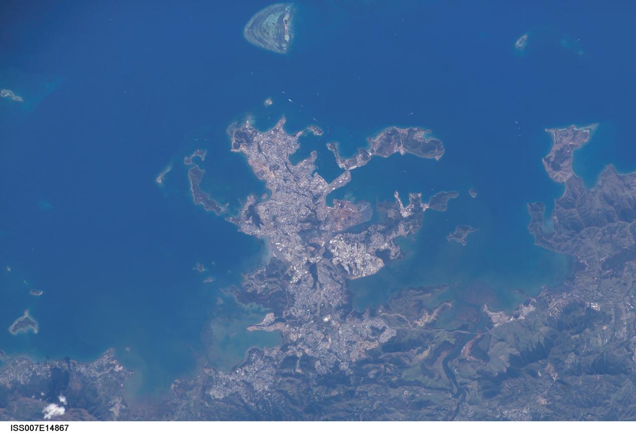
ISS007-E-14867 (13 September 2003) --- This view featuring Noumea, New Caledonia was taken by one of the Expedition 7 crewmembers onboard the International Space Station (ISS). The mountains forming the spine of the island of Grande Terre contain large reserves of nickel and chromium, and New Caledonia mines are one of the world’s greatest producers of nickel. This image shows details of New Caledonia’s main city, Noumea, which is built on a peninsula that juts into the lagoon on the southwest side of the island. The reefs here face localized problems from pollution and overfishing. The tourism industry is very important to the economy of Noumea, with extensive hotel development in the city and along the southeast coast of Grand Terre. The picture shows how urban development extends to the steep slopes of the coastal hills.
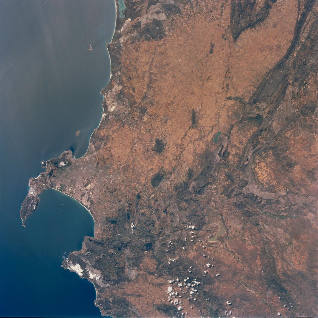
STS097-711-069 (30 Nov. - 11 Dec. 2000) This view featuring Cape Town and the Western Cape Province in the Republic of South Africa was provided by one of the STS-97 astronauts using a 70mm handheld camera aboard the Earth-orbiting Space Shuttle Endeavour. The capital and largest city of Western Cape Province, Cape Town (1995 population in the urban and suburban area shows in excess of 1.9 million), is visible between False Bay (large, U-shaped bay) and a smaller bay along the Atlantic coast of the peninsula. Within the urban built-up area some of the infrastructure of Cape Town, including the city center and the harbor and waterfront facilities, can be identified near the small bay (middle left edge of the image). Table Mountain elevation of 3563 feet (1086 meters above sea level) separates the city center (north of the mountain) from the southern suburbs of Cape Town. The Cape of Good Hope, long famous as the gateway from the Atlantic Ocean to the Indian Ocean, is located at the southern tip of the claw-shaped peninsula. False Bay is a popular recreational region for the local residents of the greater Cape Town region, as well as a tourist attraction for people who live beyond the borders of South Africa. The lighter-colored terrain, mainly north of Cape Town, shows a landscape of large, cultivated field patterns. These coastal plains are separated from the interior by a chain of folded mountain ranges that include the Cedarberg (dark, linear, north/south aligned feature in the upper right corner) and the more complex, folded Herrivierberge Mountains (dark structure, right middle) that are located northeast of Cape Town.
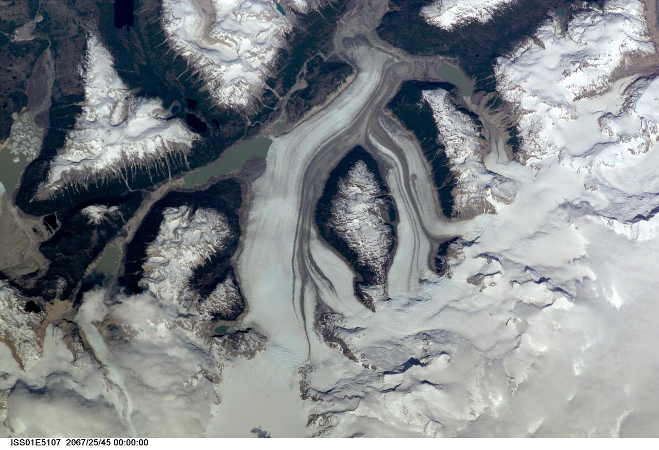
ISS01-E-5107 (December 2000) --- This nadir view of a Chilean glaciated area was provided by one of the early December digital still camera images down linked from the International Space Station (ISS) to ground controllers in Houston. The remote headwaters of the Rio de la Colonia are located on the eastern flank of the Cerro Pared Norte, a high, coastal range of the Andes in southern Chile. This is but a portion of a larger glaciated region of the Chilean coast located at only 47 degrees south latitude. The river actually begins its flow just off the top of this scene at the foot of the two large, converging, valley glaciers near the center. Some of the numerous lakes visible are tinted by the fine glacial sediments suspended in their waters. Note the shards of ice that have calved from the glaciers into the lakes on the left. Also note the shadows of the crest of the over 14,000-foot mountains (lower center). The remote headwaters of the Rio de la Colonia are located on the eastern flank of the Cerro Pared Norte, a high, coastal range of the Andes in southern Chile. This is a but a portion of a larger glaciated region of the Chilean coast located at only 47 degrees south latitude. The river actually begins its flow just off the top of this scene at the foot of the two large, converging, valley glaciers near the center. Some of the numerous lakes visible are tinted by the fine glacial sediments suspended in their waters. Note the shards of ice that have calved from the glaciers into the lakes on the left. Also note the shadows of the crest of the over 14,000-foot mountains (lower center).
STS097-715-061 (10 December 2000) This view over the Central Andes Mountains in Argentina and Chile was taken on December 10, 2000 by one of the astronauts aboard the Earth-orbiting Space Shuttle Endeavour. Extending 5500 miles (8850 kilometers) along the western coast of South America from northern Colombia to Cape Horn in southern Chile, the Andes are the longest mountain range, above sea level, and the second highest range in the world. According to NASA scientists studying the STS-97 photo collection, this immense system came into existence nearly 70 million years ago. With numerous active volcanoes and a slow uplift, the building of the Andes Mountains continues today rising four inches (10 centimeters) per century, the scientists say. In this north-looking view, snow covers the higher peaks of the range, some of which rise to over 20000 feet (6100 meters) above sea level. Along the left or western portion of the view, clouds can be seen along coastal areas of Chile. In the bottom left quadrant of the scene, the blue waters of the Paloma Reservoir, a recreational lake, are visible. The folded Tontal Range (bottom center) and the Valle Fertil Range (upper right quadrant and partially cloud covered) of western Argentina can be seen. The rocks of these ranges, the scientists point out, are ancient compared to the younger volcanic peaks and ranges of the Andes. The city of San Juan, Argentina is visible on the eastern (right) base of the Tontal Range in the lower right quadrant of the view.
STS060-85-000AH (3-11 Feb 1994) --- This view is centered at about 44 degrees south along the Chilean continental margin of South America. The dark-colored coastal region is heavily forested by dense old-growth forests that are now being cut, but east of the mountains in Argentina the dry climate supports very little vegetation. This desert region known as Patagonia appears as light brown colors. The coastline is especially dramatic because it is shaped by the tortuous channels carved by glaciers which have left fjords. These fjords have effectively cut across the continental divide, and are bordered by active volcanoes which reach elevations between 2, 000 - 3,000 meters. The prominent volcanic peak in the center of the frame is Mt. Melimoya. To the north is a long, snow-covered volcanic ridge called Cerro Yantales. Cerro Yantales recently reported greatly increased fumarolic activity, including the emission of yellow gases near the summit. Russian and American scientists will use this photography to look for further evidence of increased activity like snow melt around the peak. Other Russian and American scientists are particularly interested in mapping the summertime snowline and firm (permanent snow field) elevations as early indications of any potential climatic variation in the making.
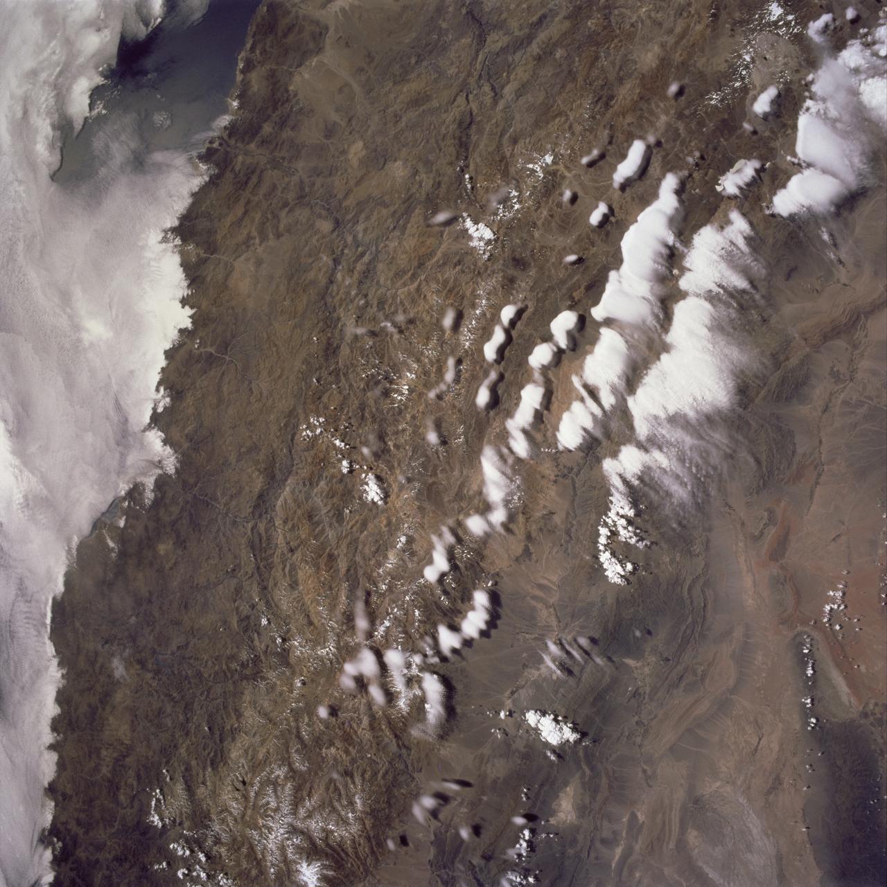
STS062-151-182Z (4-18 March 1994) --- This east-looking view shows most of the east-west extent of the country of Sudan. The foreground shows a vegetation-less and almost uninhabited region of northwest Sudan. The rich earth colors are ancient soils (browner and redder tones), a concentrated mass of what may be volcanic cinder cones (dark brown dots - center) and dune and younger river sediments (yellows). The photo would have been difficult to locate had it not been for two recognizable features in the background: a visually well-known inselberg ("island mountain" -- top center) on a large west-bank tributary of the White Nile; and the confluence of the Blue and White Nile's, with the great cotton developments of the Gezira Scheme between them (top left). The Red Sea coast is almost obscured by a dust cloud but can be discerned running across the top of the picture. The clouds at top may be developing over the coastal ranges of Saudi Arabia beyond the Red Sea.
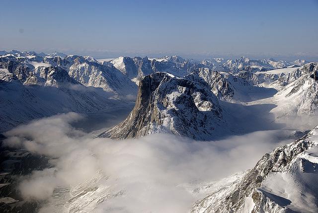
On April 8, 2011, IceBridge flew a mission to coastal areas in southwest Greenland. Mountains and an open-water fjord surround one of the mission's targets, a small ice cap called Sukkertoppen Isflade. Operation IceBridge, now in its third year, makes annual campaigns in the Arctic and Antarctic where science flights monitor glaciers, ice sheets and sea ice. Credit: NASA/GSFC/Michael Studinger To learn more about Ice Bridge go to: <a href="http://www.nasa.gov/mission_pages/icebridge/news/spr11/index.html" rel="nofollow">www.nasa.gov/mission_pages/icebridge/news/spr11/index.html</a> <b><a href="http://www.nasa.gov/centers/goddard/home/index.html" rel="nofollow">NASA Goddard Space Flight Center</a></b> enables NASA’s mission through four scientific endeavors: Earth Science, Heliophysics, Solar System Exploration, and Astrophysics. Goddard plays a leading role in NASA’s accomplishments by contributing compelling scientific knowledge to advance the Agency’s mission. <b>Follow us on <a href="http://twitter.com/NASA_GoddardPix" rel="nofollow">Twitter</a></b> <b>Join us on <a href="http://www.facebook.com/pages/Greenbelt-MD/NASA-Goddard/395013845897?ref=tsd" rel="nofollow">Facebook</a></b>
This is a color composite image of southern Bahia, Brazil, centered at 15.22 degree south latitude and 39.07 degrees west longitude. The image was acquired by the Spaceborne Imaging Radar-C/X-band Synthetic Aperture Radar aboard the space shuttle Endeavour on its 38th orbit of Earth on October 2, 1994. The image covers an area centered over the Una Biological Reserve, one the largest protected areas in northeastern Brazil. The 7,000-hectare reserve is administered by the Brazilian Institute for the Environment and is part of the larger Atlantic coastal forest, a narrow band of rain forest extending along the eastern coast of Brazil. The Atlantic coastal forest of southern Bahia is one of the world's most threatened and diverse ecosystems. Due to widespread settlement, only 2 to 5 percent of the original forest cover remains. Yet the region still contains an astounding variety of plants and animals, including a large number of endemic species. More than half of the region's tree species and 80 percent of its animal species are indigenous and found nowhere else on Earth. The Una Reserve is also the only federally protected habitat for the golden-headed lion tamarin, the yellow-breasted capuchin monkey and many other endangered species. In the past few years, scientists from Brazilian and international conservation organizations have coordinated efforts to study the biological diversity of this region and to develop practical and economically viable options for preserving the remaining primary forests in southern Bahia. The shuttle imaging radar is used in this study to identify various land uses and vegetation types, including remaining patches of primary forest, cabruca forest (cacao planted in the understory of the native forest), secondary forest, pasture and coastal mangrove. Standard remote-sensing technology that relies on light reflected from the forest canopy cannot accurately distinguish between cabruca and undisturbed forest. Optical remote sensing is also limited by the nearly continuous cloud cover in the region and heavy rainfall, which occurs more than 150 days each year. The ability of the shuttle radars to "see" through the forest canopy to the cultivated cacao below -- independent of weather or sunlight conditions --will allow researchers to distinguish forest from cabruca in unprecedented detail. This SIR-C/X-SAR image was produced by assigning red to the L-band, green to the C-band and blue to the X-band. The Una Reserve is located in the middle of the image west of the coastline and slightly northwest of Comandatuba River. The reserve's primary forests are easily detected by the pink areas in the image. The intensity of red in these areas is due to the high density of forest vegetation (biomass) detected by the radar's L-band (horizontally transmitted and vertically received) channel. Secondary forest is visible along the reserve's eastern border. The Serrado Mar mountain range is located in the top left portion of the image. Cabruca forest to the west of Una Reserve has a different texture and a yellow color. The removal of understory in cabruca forest reduces its biomass relative to primary forest, which changes the L-band and C-band penetration depth and returns, and produces a different texture and color in the image. The region along the Atlantic is mainly mangrove swamp, agricultural fields and urban areas. The high intensity of blue in this region is a result of increasing X-band return in areas covered with swamp and low vegetation. The image clearly separates the mangrove region (east of coastal Highway 001, shown in blue) from the taller and dryer forest west of the highway. The high resolution capability of SIR-C/X-SAR imaging and the sensitivity of its frequency and polarization channels to various land covers will be used for monitoring and mapping areas of importance for conservation. http://photojournal.jpl.nasa.gov/catalog/PIA01764
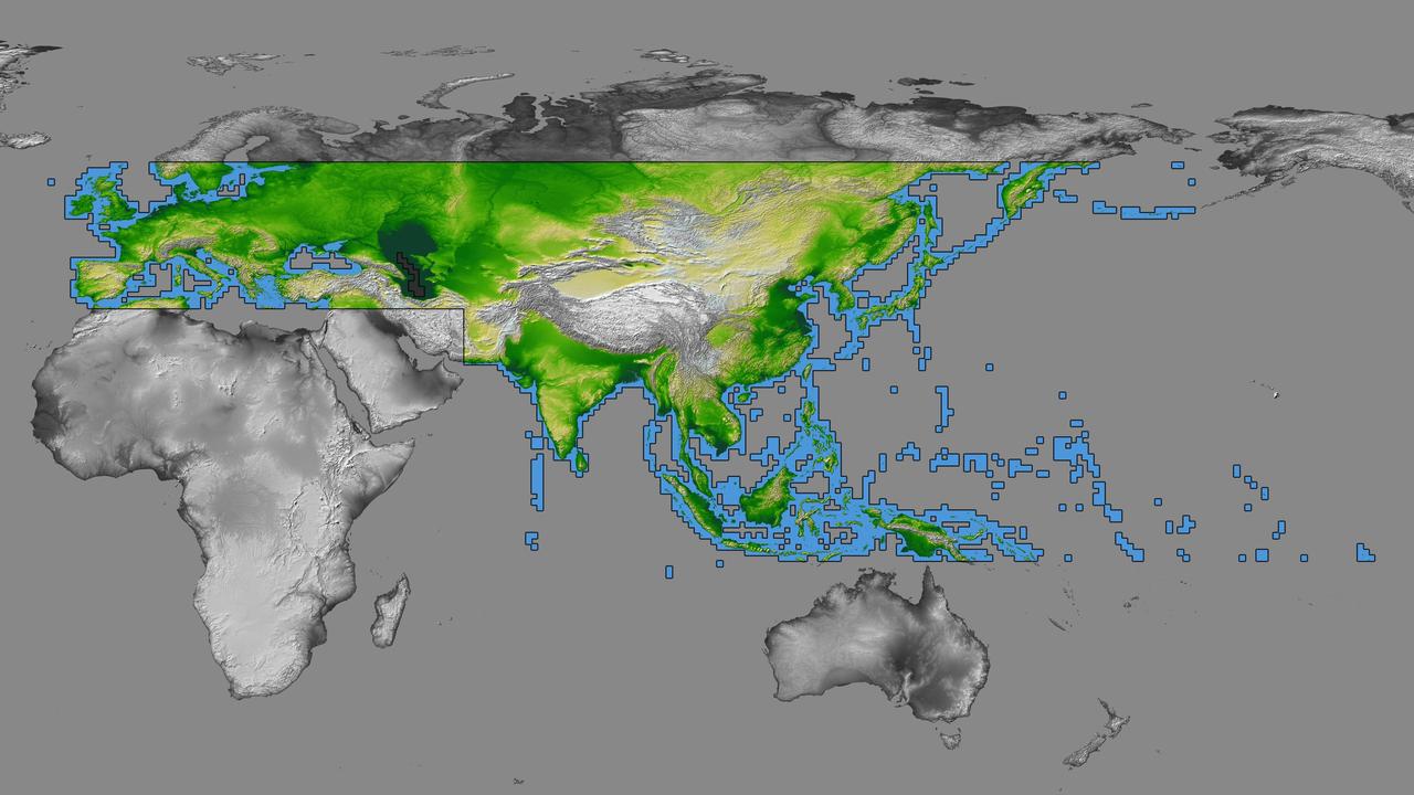
inal Caption Released with Image: The colored regions of this map show the extent of digital elevation data recently released by the Shuttle Radar Topography Mission (SRTM). This release includes data for most of Europe and Asia plus numerous islands in the Indian and Pacific Oceans. SRTM flew on board the Space Shuttle Endeavour in February 2000 and used an interferometric radar system to map the topography of Earth's landmass between latitudes 56 degrees south and 60 degrees north. The data were processed into geographic "tiles," each of which represents one by one degree of latitude and longitude. A degree of latitude measures 111 kilometers (69 miles) north-south, and a degree of longitude measures 111 kilometers or less east-west, decreasing away from the equator. The data are being released to the public on a continent-by-continent basis. This Eurasia segment includes 5,940 tiles, more than a third of the total data set. Previous releases covered North America and South America. Forthcoming releases will include Africa-Arabia and Australia plus an "Islands" release for those islands not included in the continental releases. Together these data releases constitute the world's first high-resolution, near-global elevation model. The resolution of the publicly released data is three arcseconds (1/1,200 of a degree of latitude and longitude), which is about 90 meters (295 feet). European coverage in the current data release stretches eastward from the British Isles and the Iberian Peninsula in the west, across the Alps and Carpathian Mountains, as well as the Northern European Plain, to the Ural and Caucasus Mountains bordering Asia. The Asian coverage includes a great diversity of landforms, including the Tibetan Plateau, Tarin Basin, Mongolian Plateau, and the mountains surrounding Lake Baikal, the world's deepest lake. Mt. Everest in the Himalayas, at 8,848 meters (29,029 feet) is the world's highest mountain. From India's Deccan Plateau, to Southeast Asia, coastal China, and Korea, various landforms place constraints upon land use planning for a great population. Volcanoes in the East Indies, the Philippines, Japan, and the Kamchatka Peninsula form the western part of the "Ring of Fire" around the Pacific Ocean. Many of these regions were previously very poorly mapped due to persistent cloud cover or the inaccessibility of the terrain. Digital elevation data, such as provided by SRTM, are particularly in high demand by scientists studying earthquakes, volcanism, and erosion patterns for use in mapping and modeling hazards to human habitation. But the shape of Earth's surface affects nearly every natural process and human endeavor that occurs there, so elevation data are used in a wide range of applications. In this index map color-coding is directly related to topographic height, with green at the lower elevations, rising through yellow and tan, to white at the highest elevations. The large, very dark green feature in western Asia is the Caspian Sea, which is below sea level. Blue areas on the map represent water within the mapped tiles, each of which includes shorelines or islands. http://photojournal.jpl.nasa.gov/catalog/PIA03398
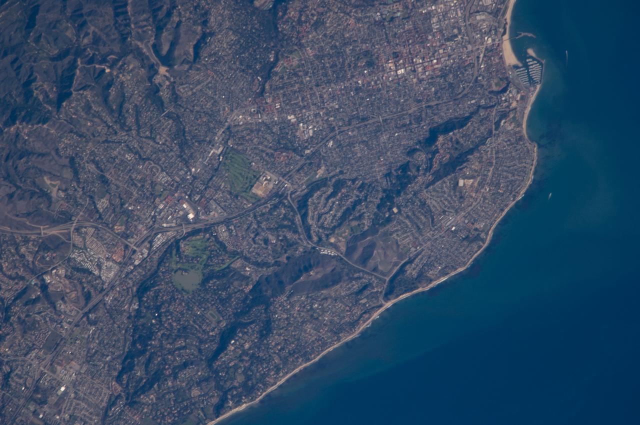
ISS018-E-011096 (6 Dec. 2008) --- Santa Barbara, CA metropolitan area, also known as the ?American Riviera?, is featured in this image photographed by an Expedition 18 crewmember on the International Space Station. The geographic setting of the city - between the Santa Barbara Channel to the south and the steep Santa Ynez Mountains to the north. The city was officially founded as a Spanish mission in 1786, and was incorporated into the United States from Mexico in 1848 following the Mexican-American War. The dramatic landscape of the city is the result of tectonic forces ? the Santa Barbara Channel is part of the boundary between the Pacific oceanic and North American continental crustal plates. Movement along the San Andreas Fault ? the actual zone of contact between the two plates ? over geologic time both raised the Santa Ynez range and lowered the seafloor, forming the deep Santa Barbara Channel. The city has experienced two earthquakes, one in 1812 and another in 1925 that caused significant damage. The urban street grid is defined by white and red rooftops at top center; to the southeast lie beaches and the boat slips of a large marina (top right). Two large golf courses, characterized by expanses of green grass, are visible at center. Low east-west trending hills that parallel the coastline are almost completely covered by residential and commercial development, lending a speckled appearance to the hillsides. Immediately offshore, giant kelp beds are the focus of the Santa Barbara Coastal Long Term Ecological Research site, part of the National Science Foundation?s Long Term Ecological Research Network.
![More than 70% of the world's hazelnuts come from Turkey, and about 60% come from the Eastern Black Sea region on the slopes of the Pontic mountain range, around the ancient coastal city of Giresun. The tradition of hazelnut farming goes back thousands of years. Presently, most of the hazelnut products are processed by women [BBC Travel]. The image was acquired August 15, 2024, covers an area of 35.7 by 36.2 km, and is located at 40.9 degrees north, 38.4 degrees east. With its 14 spectral bands from the visible to the thermal infrared wavelength region and its high spatial resolution of about 50 to 300 feet (15 to 90 meters), ASTER images Earth to map and monitor the changing surface of our planet. ASTER is one of five Earth-observing instruments launched Dec. 18, 1999, on Terra. The instrument was built by Japan's Ministry of Economy, Trade and Industry. A joint U.S./Japan science team is responsible for validation and calibration of the instrument and data products. The broad spectral coverage and high spectral resolution of ASTER provides scientists in numerous disciplines with critical information for surface mapping and monitoring of dynamic conditions and temporal change. Example applications are monitoring glacial advances and retreats; monitoring potentially active volcanoes; identifying crop stress; determining cloud morphology and physical properties; wetlands evaluation; thermal pollution monitoring; coral reef degradation; surface temperature mapping of soils and geology; and measuring surface heat balance. https://photojournal.jpl.nasa.gov/catalog/PIA26450](https://images-assets.nasa.gov/image/PIA26450/PIA26450~medium.jpg)
More than 70% of the world's hazelnuts come from Turkey, and about 60% come from the Eastern Black Sea region on the slopes of the Pontic mountain range, around the ancient coastal city of Giresun. The tradition of hazelnut farming goes back thousands of years. Presently, most of the hazelnut products are processed by women [BBC Travel]. The image was acquired August 15, 2024, covers an area of 35.7 by 36.2 km, and is located at 40.9 degrees north, 38.4 degrees east. With its 14 spectral bands from the visible to the thermal infrared wavelength region and its high spatial resolution of about 50 to 300 feet (15 to 90 meters), ASTER images Earth to map and monitor the changing surface of our planet. ASTER is one of five Earth-observing instruments launched Dec. 18, 1999, on Terra. The instrument was built by Japan's Ministry of Economy, Trade and Industry. A joint U.S./Japan science team is responsible for validation and calibration of the instrument and data products. The broad spectral coverage and high spectral resolution of ASTER provides scientists in numerous disciplines with critical information for surface mapping and monitoring of dynamic conditions and temporal change. Example applications are monitoring glacial advances and retreats; monitoring potentially active volcanoes; identifying crop stress; determining cloud morphology and physical properties; wetlands evaluation; thermal pollution monitoring; coral reef degradation; surface temperature mapping of soils and geology; and measuring surface heat balance. https://photojournal.jpl.nasa.gov/catalog/PIA26450
ISS028-E-018675 (23 July 2011) --- Biomass burning in southern Africa is featured in this image photographed by an Expedition 28 crew member on the International Space Station. A smoke pall of subcontinental proportions dominates this view of tropical southern Africa. In what has been described as the most fire-prone part of the world, numerous fires give rise to regional smoke palls every dry season. Fires are both natural and set by local people to clear woodland for agricultural fields. This recent, oblique, northwest-looking view taken in July 2011 at the end of the dry season shows the extent of the smoke on the African plateau?from central Zimbabwe (lower left) to northern Malawi more than 1,000 kilometers away (top right)?and in the wide coastal plains of the lower Zambezi River valley of Mozambique (lower right). Here smoke can be seen blowing inland (left to right), channeled up the Zambezi River valley and contributing to the pall on the plateau. The light gray smoke plumes contrast with higher altitude, brighter patchy cloud cover at lower right. The smoke palls obscure much surface detail, so that Lake Malawi, one of Africa?s Great Lakes, is barely visible, as is Lake Cahora Bassa, Africa?s fourth largest reservoir, in the Zambezi valley. The sun?s reflection off its surface (sunglint) makes Lake Kariba most prominent in the view at left. Kariba is the world?s largest artificial reservoir by volume, and is 220 kilometers long, giving a sense of the scale of the view. The steep, shadowed, mid-afternoon faces of the Inyanga Mountains on the Mozambique-Zimbabwe border protrude above the smoke layer at lower left. Solar panels extending from Russian spacecraft docked at the International Space Station are visible in the foreground at left.
Sochi, Russia Winter Olympic Sites (Coastal Cluster) The Black Sea resort of Sochi, Russia, is the warmest city ever to host the Winter Olympic Games, which open on Feb. 7, 2014, and run through Feb. 23. This north-looking image, acquired on Jan. 4, 2014, by the Advanced Spaceborne Thermal Emission and Reflection Radiometer (ASTER) instrument on NASA's Terra spacecraft, shows the Sochi Olympic Park Coastal Cluster -- the circular area on the shoreline in the bottom center of the image -- which was built for Olympic indoor sports. Even curling has its own arena alongside multiple arenas for hockey and skating. The Olympic alpine events will take place at the Mountain Cluster, located in a snow-capped valley at the top right of the image. Sochi itself, a city of about 400,000, is not visible in the picture. It's farther west (left) along the coast, past the airport at bottom left. In the image, red indicates vegetation, white is snow, buildings are gray and the ocean is dark blue. The area imaged is about 15 miles (24 kilometers) from west to east (left to right) at the coastline and 25 miles (41 kilometers) from front to back. Height is exaggerated 1.5 times. The image was created from the ASTER visible and near-infrared bands, draped over ASTER-derived digital elevation data. With its 14 spectral bands from the visible to the thermal infrared wavelength region and its high spatial resolution of 15 to 90 meters (about 50 to 300 feet), ASTER images Earth to map and monitor the changing surface of our planet. ASTER is one of five Earth-observing instruments launched Dec. 18, 1999, on Terra. The instrument was built by Japan's Ministry of Economy, Trade and Industry. A joint U.S./Japan science team is responsible for validation and calibration of the instrument and data products. The broad spectral coverage and high spectral resolution of ASTER provides scientists in numerous disciplines with critical information for surface mapping and monitoring of dynamic conditions and temporal change. Example applications are: monitoring glacial advances and retreats; monitoring potentially active volcanoes; identifying crop stress; determining cloud morphology and physical properties; wetlands evaluation; thermal pollution monitoring; coral reef degradation; surface temperature mapping of soils and geology; and measuring surface heat balance. The U.S. science team is located at NASA's Jet Propulsion Laboratory, Pasadena, Calif. The Terra mission is part of NASA's Science Mission Directorate, Washington, D.C. More information about ASTER is available at <a href="http://asterweb.jpl.nasa.gov/" rel="nofollow">asterweb.jpl.nasa.gov/</a>. Image credit: NASA/GSFC/METI/ERSDAC/JAROS, and U.S./Japan ASTER Science Team <b><a href="http://www.nasa.gov/audience/formedia/features/MP_Photo_Guidelines.html" rel="nofollow">NASA image use policy.</a></b> <b><a href="http://www.nasa.gov/centers/goddard/home/index.html" rel="nofollow">NASA Goddard Space Flight Center</a></b> enables NASA’s mission through four scientific endeavors: Earth Science, Heliophysics, Solar System Exploration, and Astrophysics. Goddard plays a leading role in NASA’s accomplishments by contributing compelling scientific knowledge to advance the Agency’s mission. <b>Follow us on <a href="http://twitter.com/NASAGoddardPix" rel="nofollow">Twitter</a></b> <b>Like us on <a href="http://www.facebook.com/pages/Greenbelt-MD/NASA-Goddard/395013845897?ref=tsd" rel="nofollow">Facebook</a></b> <b>Find us on <a href="http://instagram.com/nasagoddard?vm=grid" rel="nofollow">Instagram</a></b>
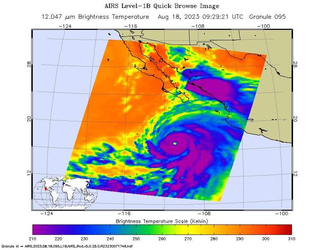
NASA's Atmospheric Infrared Sounder (AIRS) captured Hurricane Hilary on the morning of Aug. 18, 2023, when it was a Category 4 storm roughly 470 miles (760 kilometers) south of Baja California. Hilary could be the first tropical storm to make landfall in California since 1939, according to the National Weather Service. Hilary grew from a tropical storm into a Category 2 hurricane within 24 hours on Aug. 17. Another period of rapid intensification – an increase in maximum sustained wind speed of at least 30 knots (35 mph) within 24 hours – occurred Aug. 17-18. The animation shows some of this rapid growth, with images taken by AIRS Aug. 15-18. This intensification was driven by very warm ocean surface waters and weak wind shear, a term for vertical changes in wind speed. Strong wind shear can keep hurricanes from forming, or can tear them apart. AIRS measures cloud temperatures in infrared wavelengths, which can reveal information about the atmosphere not visible to the human eye. Hilary shows several indicators of a powerful hurricane: a well-defined eye surrounded by a ring of very cold clouds in purple, with warmer outer regions seen in yellows and oranges. Purple and violet areas are colder, between about minus 82 degrees Fahrenheit and minus 46 F (minus 63 degrees Celsius to minus 44 C). Blue and green regions are roughly minus 28 F to 26 F (minus 33 C to minus 3 C). The cooler parts of the clouds are associated with very heavy rainfall. Most hurricanes in the Pacific Ocean off Mexico travel westward, following tropical trade winds. Occasionally, one of these storms will head northward. Hurricane Hilary is being steered by a weak low-pressure system off the coast of California, an area normally dominated by high pressure and an atmospheric circulation pattern that would deflect storms from the region. The current forecast from the National Hurricane Center has Hilary closely following the western coastline of the Baja California peninsula, weakening as it moves north. Rainfall projections for Southern California range from 2 inches (5 centimeters) in coastal areas to 8 or more inches (20 or more centimeters) in local mountains. For comparison, San Diego and Los Angeles receive no rain in August most years, and the wettest parts of the local mountains receive about 1 inch (3 centimeters) of rain over a normal summer. In conjunction with the Advanced Microwave Sounding Unit (AMSU), AIRS senses emitted infrared and microwave radiation from Earth to provide a 3D look at the planet's weather and climate. Working in tandem, the two instruments make simultaneous observations down to Earth's surface. With more than 2,000 channels sensing different regions of the atmosphere, the system creates a global, 3D map of atmospheric temperature and humidity, cloud amounts and heights, greenhouse gas concentrations, and many other atmospheric phenomena. Launched into Earth orbit in 2002 aboard NASA's Aqua spacecraft, the AIRS and AMSU instruments are managed by NASA's Jet Propulsion Laboratory in Southern California, under contract to NASA. JPL is a division of Caltech. Animation available at https://photojournal.jpl.nasa.gov/catalog/PIA25779
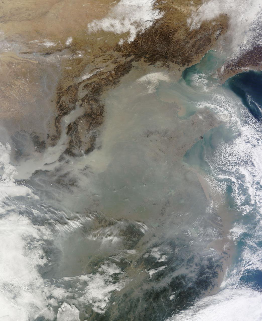
The skies over northern China were shrouded with a thick haze in late December, 2013. The Moderate Resolution Imaging Spectroradiometer (MODIS) aboard the Terra satellite captured this true-color image on December 23. The dense, gray haze obscures almost all the land and much of the coastal waters from view south and east of the Taihang Mountains. Clearer air covers the region north of the mountains, although fingers of haze roll through most river valleys. The cities of Beijing and Hebei, both west of the Bohai Sea are complete enshrouded. By December 24 the smog levels in some area exceeded World Health Organization-recommended levels by 30 times, according to Bloomberg News. The concentration of PM2.5, which are fine air particulates, were reported at 421 micrograms per cubic meter at 2 p.m. near Tiananmen Square in Beijing, while levels were 795 in Xi’an and 740 in Zhengzhou. The World Health Organization (WHO) recommends 24-hour exposure to PM2.5 concentrations no higher than 25 micrograms per cubic meter. While not the sole cause of haze and pollution, the use of coal as a very cheap energy source adds to the problem, particularly north of the Huai River. Prior to 1980, the government policy provided free coal for fuel boilers for all people living north of the Huai River. The widespread use of coal allows people in the north to stay warm in winter, but they have paid a price in air quality. According to Michael Greenstone, a Professor of Environmental Economics at Massachusetts Institute of Technology (MIT), whose research team published a paper on sustained exposure to air pollution on life expectancy in the region, air pollution, as measured by total suspended particulates, was about 55% higher north of the Huai River than south of it, for a difference of around 184 micrograms of particulate matter per cubic meter. The research, published in Proceedings of the National Academy of Sciences in July, 2013, also noted life expectancies were about 5.5 years lower in the north, owing to an increased incidence of cardiorespiratory mortality. Air pollution is an on-going issue for the government of China, and Beijing’s Five-Year Clean Air Action Plan aims to reduce overall particle density by over 25 percent on the PM2.5 scale by 2017, and also takes aim at shutting down all coal-burning plants. Credit: NASA/GSFC/Jeff Schmaltz/MODIS Land Rapid Response Team <b><a href="http://www.nasa.gov/audience/formedia/features/MP_Photo_Guidelines.html" rel="nofollow">NASA image use policy.</a></b> <b><a href="http://www.nasa.gov/centers/goddard/home/index.html" rel="nofollow">NASA Goddard Space Flight Center</a></b> enables NASA’s mission through four scientific endeavors: Earth Science, Heliophysics, Solar System Exploration, and Astrophysics. Goddard plays a leading role in NASA’s accomplishments by contributing compelling scientific knowledge to advance the Agency’s mission. <b>Follow us on <a href="http://twitter.com/NASA_GoddardPix" rel="nofollow">Twitter</a></b> <b>Like us on <a href="http://www.facebook.com/pages/Greenbelt-MD/NASA-Goddard/395013845897?ref=tsd" rel="nofollow">Facebook</a></b> <b>Find us on <a href="http://instagram.com/nasagoddard?vm=grid" rel="nofollow">Instagram</a></b>
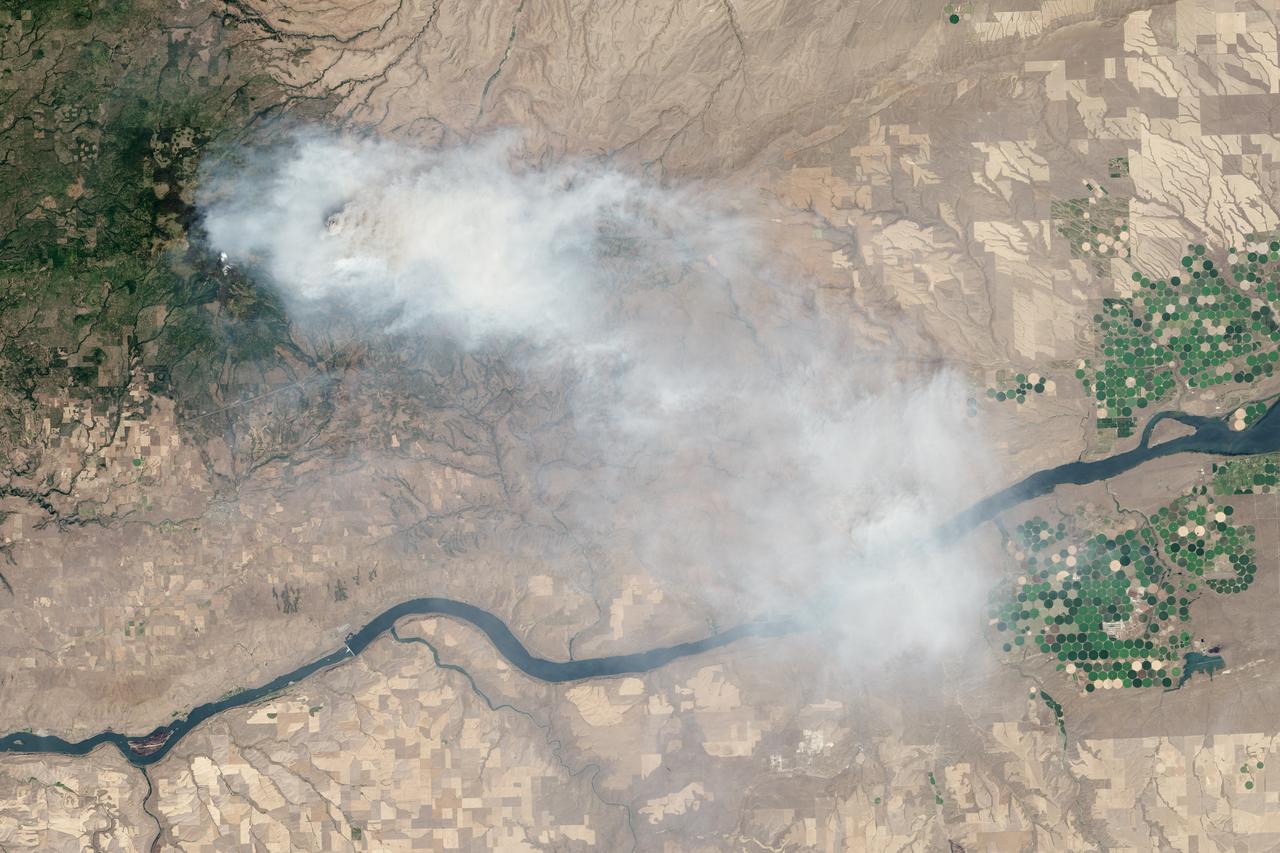
Eight major wildfires burned through forests and grasslands in the Pacific Northwest in late-July 2013, threatening homes and forcing road closings and evacuations. Many parts of Washington and Oregon faced extreme fire threats, as strong thunderstorms lined up to hit parched forests and grasslands with lightning. On July 28, 2013, the Operational Land Imager (OLI) on Landsat 8 captured these images of the Mile Marker 28 fire in the Simcoe Mountains northeast of Goldendale, Washington. Smoke blew east toward Kennewick, Pasco, and Richland. The lower image shows a closer view of smoke billowing up from the most active part of the fire. Ignited on July 24, 2013, the fire charred more than 22,000 acres (8,900 hectares) by July 30, when more than 1,000 firefighters achieved 40 percent containment. The blaze forced the evacuation of dozens of homes and the closure of US Highway 97. Through July 25, 450 wildfires had burned 10,220 acres (4,136 hectares) in Washington, while Oregon saw 603 fires that burned 63,135 acres (25,549 hectares). In all, 2.3 million acres burned across the United States by late-July, below the national average. Over the past ten years, an average of 4.2 million acres had burned in the United States by the end of each July. While coastal and western Washington receive heavy rain throughout the year, the rain shadow caused by the Cascades leaves central Washington quite dry. The mountains force moist air from the Pacific to rise, causing it to cool and condense into rain or snow on the windward side of the Cascades. So little moisture is left by the time air passes over the Cascades, that the area around Mile Marker 28 typically receives just 8 inches (20 centimeters) of precipitation per year. NASA Earth Observatory image by Jesse Allen and Robert Simmon, using Landsat data from the U.S. Geological Survey. Caption by Adam Voiland Instrument: Landsat 8 - OLI More info: <a href="http://earthobservatory.nasa.gov/IOTD/view.php?id=81738" rel="nofollow">earthobservatory.nasa.gov/IOTD/view.php?id=81738</a> Credit: <b><a href="http://www.earthobservatory.nasa.gov/" rel="nofollow"> NASA Earth Observatory</a></b> <b><a href="http://www.nasa.gov/audience/formedia/features/MP_Photo_Guidelines.html" rel="nofollow">NASA image use policy.</a></b> <b><a href="http://www.nasa.gov/centers/goddard/home/index.html" rel="nofollow">NASA Goddard Space Flight Center</a></b> enables NASA’s mission through four scientific endeavors: Earth Science, Heliophysics, Solar System Exploration, and Astrophysics. Goddard plays a leading role in NASA’s accomplishments by contributing compelling scientific knowledge to advance the Agency’s mission. <b>Follow us on <a href="http://twitter.com/NASA_GoddardPix" rel="nofollow">Twitter</a></b> <b>Like us on <a href="http://www.facebook.com/pages/Greenbelt-MD/NASA-Goddard/395013845897?ref=tsd" rel="nofollow">Facebook</a></b> <b>Find us on <a href="http://instagram.com/nasagoddard?vm=grid" rel="nofollow">Instagram</a></b>
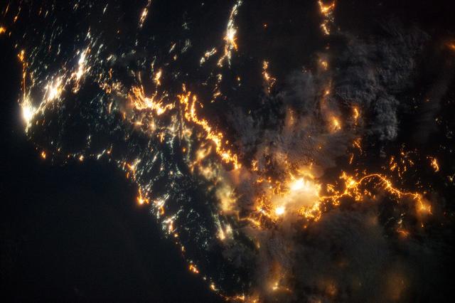
This striking image of the coastline of southwestern Saudi Arabia was taken by astronauts on the International Space Station. Patchy cloud cover partially obscures and blurs the city lights, especially in the vicinity of Khamis Mushait and Abha. While much of the country is lightly populated desert—and relatively dark at night due to lack of city and roadway lights—the southwestern coastal region has a more moderate climate and several large cities. Three brightly lit urban centers are visible at image top left: Jeddah, Mecca, and Taif. Jeddah is the gateway city for Islamic pilgrims going to nearby Mecca, a religious journey known as the Hajj. Taif is located on the slopes of the Sarawat Mountains and provides a summer retreat for the Saudi government from the desert heat of the capital, Riyadh. Bright yellow-orange lighting marks highways that parallel the trend of the Asir Mountains (image center), connecting Mecca to the resort cities of Al Bahah and Abha. Smaller roadways, lit with blue lights, extend to the west to small cities along the Red Sea coastline. The bright yellow-orange glow of the city of Abha is matched by that of Khamis Mushait (or Khamis Mushayt) to the northeast. The brightly lit ribbon of highway continues towards other large cities to the south (Jazan, not shown) and southeast (Najran, not shown). Astronaut photograph ISS036-E-25802 was acquired on July 26, 2013, with a Nikon D3S digital camera using a 50 millimeter lens, and is provided by the ISS Crew Earth Observations experiment and Image Science & Analysis Laboratory, Johnson Space Center. The image was taken by the Expedition 36 crew. It has been cropped and enhanced to improve contrast, and lens artifacts have been removed. The International Space Station Program supports the laboratory as part of the ISS National Lab to help astronauts take pictures of Earth that will be of the greatest value to scientists and the public, and to make those images freely available on the Internet. Additional images taken by astronauts and cosmonauts can be viewed at the NASA/JSC Gateway to Astronaut Photography of Earth. Caption by William L. Stefanov, Jacobs/JETS at NASA-JSC. Instrument: ISS - Digital Camera More info: <a href="http://1.usa.gov/13TqPcr" rel="nofollow">1.usa.gov/13TqPcr</a> Credit: <b><a href="http://www.earthobservatory.nasa.gov/" rel="nofollow"> NASA Earth Observatory</a></b> <b><a href="http://www.nasa.gov/audience/formedia/features/MP_Photo_Guidelines.html" rel="nofollow">NASA image use policy.</a></b> <b><a href="http://www.nasa.gov/centers/goddard/home/index.html" rel="nofollow">NASA Goddard Space Flight Center</a></b> enables NASA’s mission through four scientific endeavors: Earth Science, Heliophysics, Solar System Exploration, and Astrophysics. Goddard plays a leading role in NASA’s accomplishments by contributing compelling scientific knowledge to advance the Agency’s mission. <b>Follow us on <a href="http://twitter.com/NASA_GoddardPix" rel="nofollow">Twitter</a></b> <b>Like us on <a href="http://www.facebook.com/pages/Greenbelt-MD/NASA-Goddard/395013845897?ref=tsd" rel="nofollow">Facebook</a></b> <b>Find us on <a href="http://instagram.com/nasagoddard?vm=grid" rel="nofollow">Instagram</a></b>
In 1968, after state parks had already been established in northern California, the U.S. Congress established Redwood National Park. This new park supplemented protected lands in the region, and in 1994, state and federal authorities agreed to jointly manage the area’s public lands. On February 6, 2003, the Enhanced Thamatic Mapper Plus on NASA’s Landsat 7 satellite captured this true-color image of the southern end of Redwood National Park - a thin coastal corridor connects the northern and southern ends of the park system. Along the coast, sandy beaches appear off-white, and sediments form swirls of pale blue in the darker blue sea. Inland, the park is dominated by green vegetation, with isolated patches of gray-beige rock. This image of the Redwood National Park includes two stands of trees: Lady Bird Johnson Grove and Tall Trees Grove. The first grove was dedicated to the former first lady by President Richard Nixon in August 1969. The second grove became the focus of efforts to protect the surrounding area from logging. Two waterways appear in this image: Redwood Creek and Klamath River. The more conspicuous Klamath River flows through the park system’s midsection (north of the area pictured here). Redwood Creek flows through the southern portion of the park system. Both waterways have carved gorges through the mountainous landscape. Redwood National and State Parks occupy an area considered to be the most seismically active in the United States. The frequent seismic activity has led to shifting waterways, landslides, and rapid erosion along the coastline. Read more: <a href="http://go.nasa.gov/2bRlryv" rel="nofollow">go.nasa.gov/2bRlryv</a> Credit: NASA/Landsat7 <b><a href="http://www.nasa.gov/audience/formedia/features/MP_Photo_Guidelines.html" rel="nofollow">NASA image use policy.</a></b> <b><a href="http://www.nasa.gov/centers/goddard/home/index.html" rel="nofollow">NASA Goddard Space Flight Center</a></b> enables NASA’s mission through four scientific endeavors: Earth Science, Heliophysics, Solar System Exploration, and Astrophysics. Goddard plays a leading role in NASA’s accomplishments by contributing compelling scientific knowledge to advance the Agency’s mission. <b>Follow us on <a href="http://twitter.com/NASAGoddardPix" rel="nofollow">Twitter</a></b> <b>Like us on <a href="http://www.facebook.com/pages/Greenbelt-MD/NASA-Goddard/395013845897?ref=tsd" rel="nofollow">Facebook</a></b> <b>Find us on <a href="http://instagrid.me/nasagoddard/?vm=grid" rel="nofollow">Instagram</a></b>
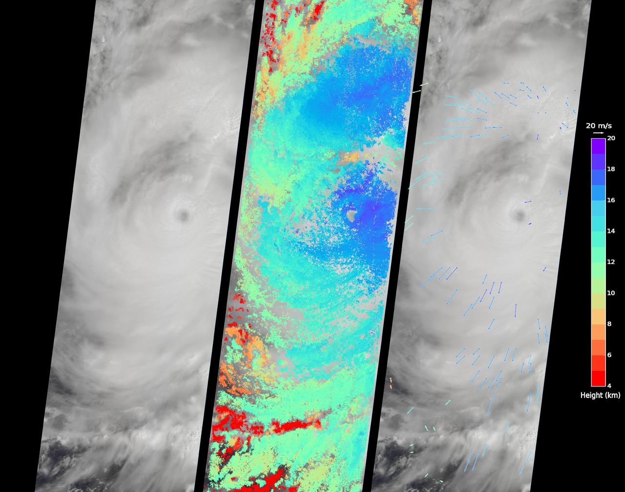
On Sept. 14, 2016, the eye of Super Typhoon Meranti passed just south of Taiwan. The enormous storm, classified as a Category 5 typhoon at the time, still caused much disruption on the island. Nearly 500,000 homes lost power, schools were closed, and most flights were cancelled. Maximum wind speeds were 180 miles per hour (290 kilometers per hour) as the storm passed, and more than 25 inches (64 centimeters) of rain fell on some areas of the country. However, the storm did not pass over Taiwan's mountainous landscape, which would have weakened it. That means it will remain strong as it heads toward mainland China, unlike Super Typhoon Nepartak in July, which weakened from a Category 5 typhoon to a tropical storm after crossing Taiwan. Meranti is currently maintaining Category 4 strength and is expected to make landfall near Shantou, Guangdong province, on Thursday, September 15. The coast of China is more vulnerable to storm surges than Taiwan due to shallower coastal waters and recent rainfall. There is risk of substantial flooding. On Sept. 14, at 10:45 AM local time, the Multi-angle Imaging SpectroRadiometer (MISR) instrument aboard NASA's Terra satellite passed directly over the eye of Meranti. On the left is a natural-color image from MISR's nadir-pointing camera. At this time the eye of Meranti was just off the southern tip of Taiwan, which is invisible under the clouds. The coast of China is barely visible through the clouds in the upper left portion of the image. The small eye and dense high clouds are both markers of the storm's power. MISR's nine cameras, each pointed at a different angle, can be used to determine the heights of clouds based on geometric shifts among the nine images. The middle panel shows these stereo-derived cloud top heights superimposed on the natural color image. The clouds of the central core of Typhoon Meranti have heights ranging between 16 and 20 kilometers (10 and 12.5 miles). It takes about seven minutes for all nine cameras to image the same location on the ground, and wind velocity can be calculated from the motion of the clouds over this seven-minute period. The right panel plots these wind velocities as vectors which indicate both direction and speed. The length of the arrow corresponds to the wind speed, which can be compared to the reference 20 meters per second (45 miles per hour) arrow in the key. Hurricanes and typhoons in the Northern Hemisphere rotate counterclockwise due to the Earth's rotation, but these wind vectors mainly show motion outward from the eye at the storm tops. This is due to the fact that hurricanes draw in moist air at low altitudes, which then flows upwards and outwards around the eye reversing direction. These data were acquired during Terra orbit 88865. http://photojournal.jpl.nasa.gov/catalog/PIA17309
While Sochi is a coastal town on the Black Sea, the skiing events for the XXII Olympic Games are taking place about 40 kilometers (25 miles) inland. The venues are clustered around Krasnaya Polyana, a small town tucked between the Aibiga and Psekhako Ridges in the western Caucasus. This image—acquired by the Advanced Land Imager (ALI) on NASA’s Earth Observing-1 (EO-1) satellite on February 8, 2014—offers a view of the town and the ski facilities. The Rosa Khutor Alpine Center is the home to the downhill, snowboard, and freestyle events. The combined downhill skiing area measures about 20 kilometers (12 miles) in total, with the men’s downhill course stretching 3,500 meters (11,482 feet) and featuring a 1,075-meter (3,526 foot) change in elevation. The highest lift climbs to the summit of Rosa Peak, which rises 2,320 meters (7,612 feet). While not being used for the Olympics, the nearby Black Pyramid mountain has downhill skiing trails as well. The same steep slopes that make Rosa Peak good for skiing also elevate the risk of avalanches. To protect against falling snow, planners installed a series of gas pipes along the top of the ridge. The pipes emit bursts of oxygen and propane that create small, controlled avalanches. Event organizers also installed a series of earthen dams to steer snow away from infrastructure, and they have deployed two backhoes to the top of Aibiga Ridge to knock cornices away before they pose a risk. The Laura Cross-country Ski and Biathalon Center is located to the north on Psekhako Ridge. It includes two stadiums, each with their own start and finish zones, two track systems for skiing and biathlon, as well as shooting areas and warm-up zones. The center is named for the Laura River, a turbulent river that flows nearby. NASA Earth Observatory image by Jesse Allen and Robert Simmon, using EO-1 ALI data provided courtesy of the NASA EO-1 team. Caption by Adam Voiland. Instrument: EO-1 - ALI Read more: <a href="http://earthobservatory.nasa.gov/IOTD/view.php?id=83131&eocn=home&eoci=iotd_grid" rel="nofollow">earthobservatory.nasa.gov/IOTD/view.php?id=83131&eocn...</a> Credit: <b><a href="http://www.earthobservatory.nasa.gov/" rel="nofollow"> NASA Earth Observatory</a></b> <b><a href="http://www.nasa.gov/audience/formedia/features/MP_Photo_Guidelines.html" rel="nofollow">NASA image use policy.</a></b> <b><a href="http://www.nasa.gov/centers/goddard/home/index.html" rel="nofollow">NASA Goddard Space Flight Center</a></b> enables NASA’s mission through four scientific endeavors: Earth Science, Heliophysics, Solar System Exploration, and Astrophysics. Goddard plays a leading role in NASA’s accomplishments by contributing compelling scientific knowledge to advance the Agency’s mission. <b>Follow us on <a href="http://twitter.com/NASAGoddardPix" rel="nofollow">Twitter</a></b> <b>Like us on <a href="http://www.facebook.com/pages/Greenbelt-MD/NASA-Goddard/395013845897?ref=tsd" rel="nofollow">Facebook</a></b> <b>Find us on <a href="http://instagram.com/nasagoddard?vm=grid" rel="nofollow">Instagram</a></b>
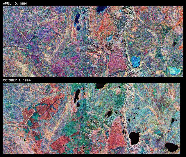
This is a comparison of images over Prince Albert, produced by NASA Spaceborne Imaging Radar-C and X-band Synthetic Aperture Radar aboard the space shuttle Endeavour on its 20th orbit on April 10, 1994. The area is centered at 53.91 degrees north latitude and 104.69 degrees west longitude and is located 40 kilometers (25 miles) north and 30 kilometers (18.5 miles) east of the town of Prince Albert in the Saskatchewan province of Canada. The image covers the area east of Candle Lake, between the gravel highway of 120 and west of highway 106. The area imaged is near the southern limit of the boreal forest. The boreal forest of North America is a continuous vegetation belt at high latitudes stretching across the continent from the Atlantic shoreline of central Labrador and then westward across Canada to the interior mountains and central coastal plains of Alaska. The forest is also part of a larger northern hemisphere circumpolar boreal forest belt. Coniferous trees dominate the entire forest but deciduous trees are also present. During the month of April, the forest experiences seasonal changes from a frozen condition to a thawed condition. The trees are completely frozen over the winter season and the forest floor is covered by snow. As the average temperature rises in the spring, the trees are thawed and the snow melts. This transition has an impact on the rate of moisture evaporation and release of carbon dioxide into the atmosphere. In late September and early October, the boreal forest experiences a relatively different seasonal change. At this time, the leaves on deciduous trees start changing color and dropping off. The soil and trees are quite often moist due to frequent rainfall and cloud cover. The evaporation of moisture and carbon dioxide into the atmosphere also diminishes at this time. SIR-C/X-SAR is sensitive to the moisture of soil and vegetation and can sense this freeze-thaw cycle and the summer-fall seasonal transition over forested areas in particular. Optical sensors, by contrast, are blind to these regions, which are perpetually obscured by thick cloud cover. These changes were detected by comparing the April and October color composite images of L-band data in red, C-band data in green and X-band (vertically received and transmitted) in blue. The changes in intensity of each color over lakes, various forest stands and clear cuts in the two images is striking. Lakes such as Lake Heiberg, Crabtree Lake and Williams Lake, in the right middle part of the image, are frozen in April (appearing in bright blue) and melted (appearing in black) in October. The higher intensity of blue over lakes in April is due to low penetration of the X-band (vertically received and transmitted) and the radar's high sensitivity to surface features. Forest stands also exhibit major changes between the two images. The red areas in the October image are old jack pine canopies that cause higher return at L-band because of their moist condition in late summer compared to their partially frozen condition in April (in purple). Similarly, in the areas near the middle of the image, where black spruce and mixed aspen and jack pine trees dominate, the contrast between blue in October and red and green in April is an indication that the top of the canopy (needles and branches) were frozen in April and moist in October. The changes due to deforestation by logging companies or natural fires can also be detected by comparing the images. For example, the small blue area near the intersection of Harding Road and Highway 120 is the result of logging which occurred after the April data was acquired. The surface area of clear cut is approximately 4 hectares, which is calculated from the high-resolution capability of the radar images and verified by scientists participating in field work during the mission. http://photojournal.jpl.nasa.gov/catalog/PIA01732
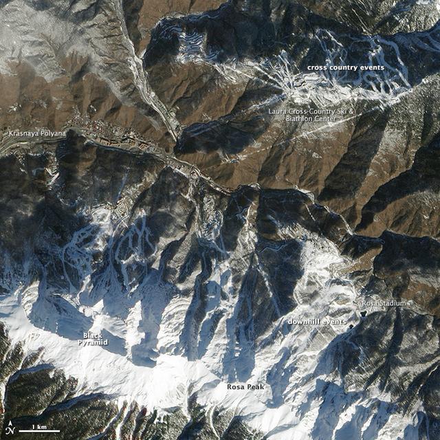
High res here: <a href="http://www.flickr.com/photos/gsfc/12640339235/in/photostream/">www.flickr.com/photos/gsfc/12640339235/in/photostream/</a> While Sochi is a coastal town on the Black Sea, the skiing events for the XXII Olympic Games are taking place about 40 kilometers (25 miles) inland. The venues are clustered around Krasnaya Polyana, a small town tucked between the Aibiga and Psekhako Ridges in the western Caucasus. This image—acquired by the Advanced Land Imager (ALI) on NASA’s Earth Observing-1 (EO-1) satellite on February 8, 2014—offers a view of the town and the ski facilities. The Rosa Khutor Alpine Center is the home to the downhill, snowboard, and freestyle events. The combined downhill skiing area measures about 20 kilometers (12 miles) in total, with the men’s downhill course stretching 3,500 meters (11,482 feet) and featuring a 1,075-meter (3,526 foot) change in elevation. The highest lift climbs to the summit of Rosa Peak, which rises 2,320 meters (7,612 feet). While not being used for the Olympics, the nearby Black Pyramid mountain has downhill skiing trails as well. The same steep slopes that make Rosa Peak good for skiing also elevate the risk of avalanches. To protect against falling snow, planners installed a series of gas pipes along the top of the ridge. The pipes emit bursts of oxygen and propane that create small, controlled avalanches. Event organizers also installed a series of earthen dams to steer snow away from infrastructure, and they have deployed two backhoes to the top of Aibiga Ridge to knock cornices away before they pose a risk. The Laura Cross-country Ski and Biathalon Center is located to the north on Psekhako Ridge. It includes two stadiums, each with their own start and finish zones, two track systems for skiing and biathlon, as well as shooting areas and warm-up zones. The center is named for the Laura River, a turbulent river that flows nearby. NASA Earth Observatory image by Jesse Allen and Robert Simmon, using EO-1 ALI data provided courtesy of the NASA EO-1 team. Caption by Adam Voiland. Instrument: EO-1 - ALI Read more: <a href="http://earthobservatory.nasa.gov/IOTD/view.php?id=83131&eocn=home&eoci=iotd_grid" rel="nofollow">earthobservatory.nasa.gov/IOTD/view.php?id=83131&eocn...</a> Credit: <b><a href="http://www.earthobservatory.nasa.gov/" rel="nofollow"> NASA Earth Observatory</a></b> <b><a href="http://www.nasa.gov/audience/formedia/features/MP_Photo_Guidelines.html" rel="nofollow">NASA image use policy.</a></b> <b><a href="http://www.nasa.gov/centers/goddard/home/index.html" rel="nofollow">NASA Goddard Space Flight Center</a></b> enables NASA’s mission through four scientific endeavors: Earth Science, Heliophysics, Solar System Exploration, and Astrophysics. Goddard plays a leading role in NASA’s accomplishments by contributing compelling scientific knowledge to advance the Agency’s mission. <b>Follow us on <a href="http://twitter.com/NASAGoddardPix" rel="nofollow">Twitter</a></b> <b>Like us on <a href="http://www.facebook.com/pages/Greenbelt-MD/NASA-Goddard/395013845897?ref=tsd" rel="nofollow">Facebook</a></b> <b>Find us on <a href="http://instagram.com/nasagoddard?vm=grid" rel="nofollow">Instagram</a></b>