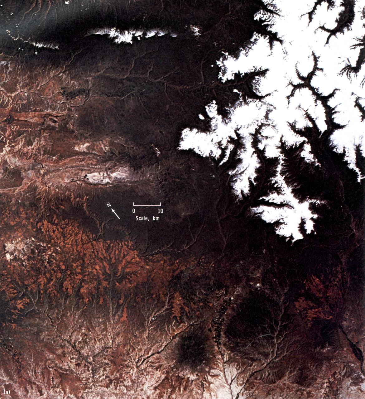
This EREP color photograph of the Uncompahgre Plateau area of Colorado was taken in June of 1973 by the Skylab Multi-spectral Photographic Camera (Skylab EREP Experiment S190A) of the Multi-spectral Photographic Facility during the Skylab-2 Mission.
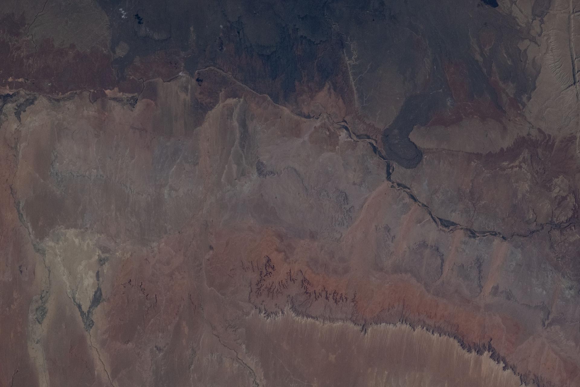
This EREP photograph of the Uncompahgre Plateau area of Colorado illustrates the land use classification using the hierarchical numbering system to depict land forms and vegetative patterns. The numerator is a three-digit number with decimal components identifying the vegetation analog or land use conditions. The denominator uses a three-component decimal system for landscape characterization.
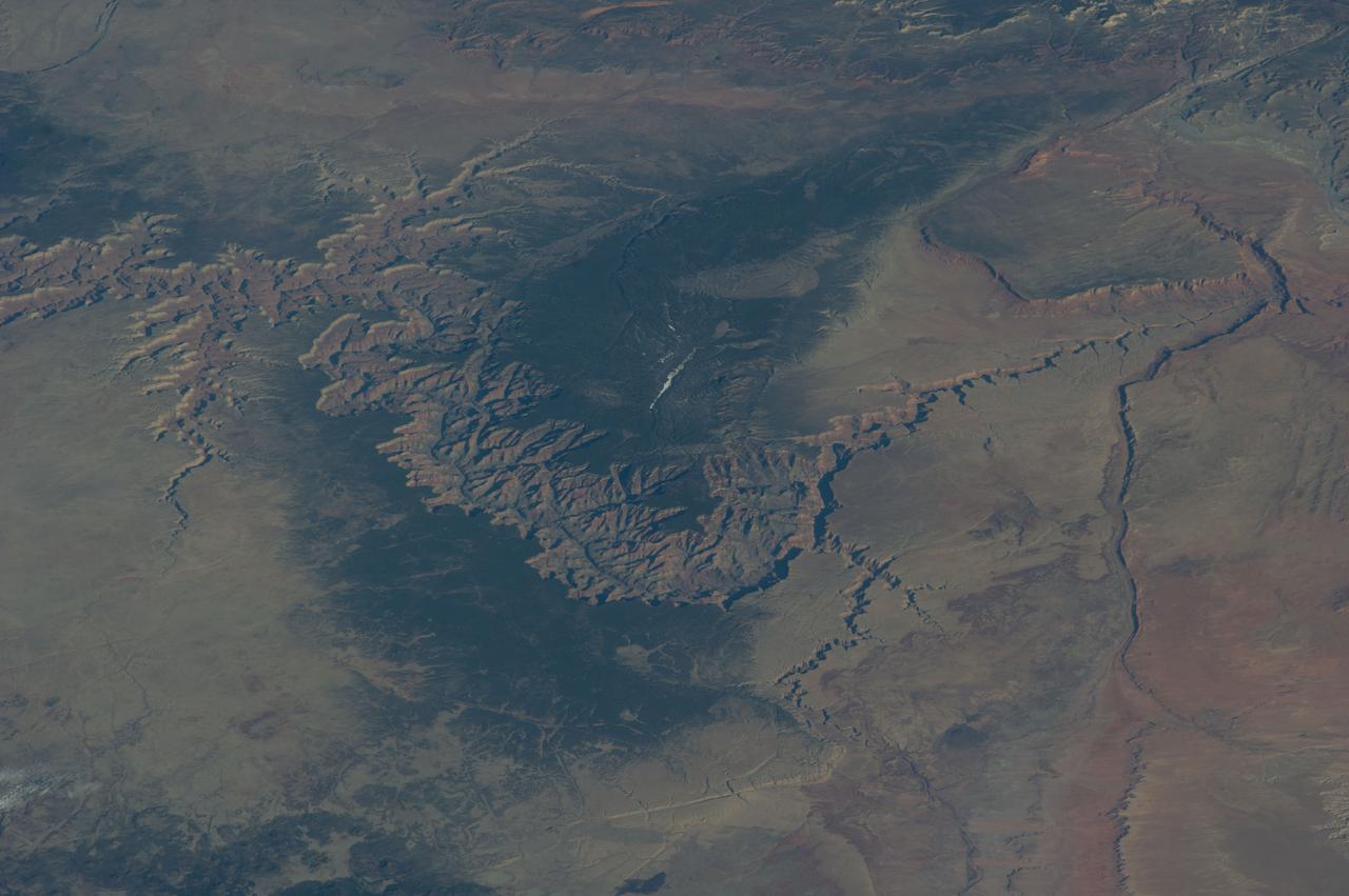
iss074e0301902 (Feb. 3, 2026) --- The Grand Canyon stretches about 277 miles across Arizona in the southwestern corner of the Colorado Plateau. The Colorado River began carving the Grand Canyon—one of the Seven Natural Wonders of the World and a UNESCO World Heritage Site—about 5 to 6 million years ago. The International Space Station was orbiting 259 miles above the United States when this photograph was taken.
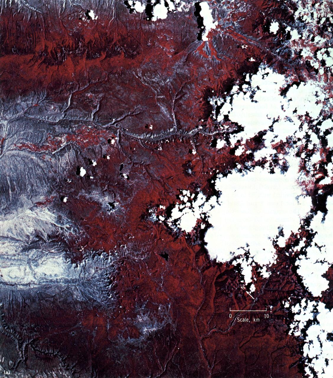
This high-resolution color infrared photograph of the Uncompahgre Plateau area of Colorado was taken by the Multi-spectral Photographic Camera (Skylab EREP Experiment S190A) of the Skylab's Multi-spectral Photographic Facility during the Skylab-3 mission.
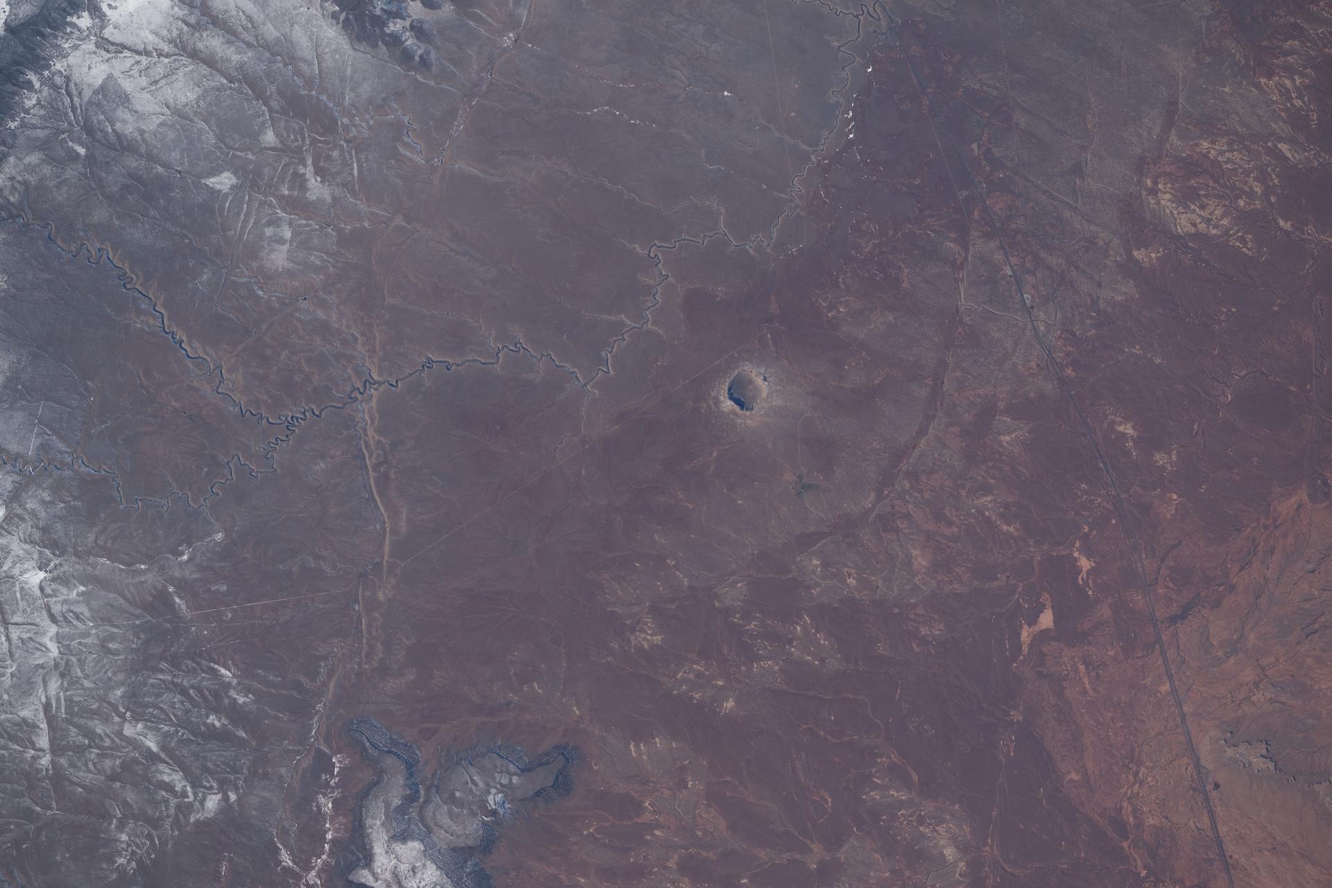
iss074e0208832 (Jan. 26, 2026) --- Meteor Crater in Arizona, a meteorite impact site approximately 4,000 feet in diameter and formed about 50,000 years ago in the high desert of the Colorado Plateau, is pictured from the International Space Station as it orbited 260 miles above the southwestern United States.
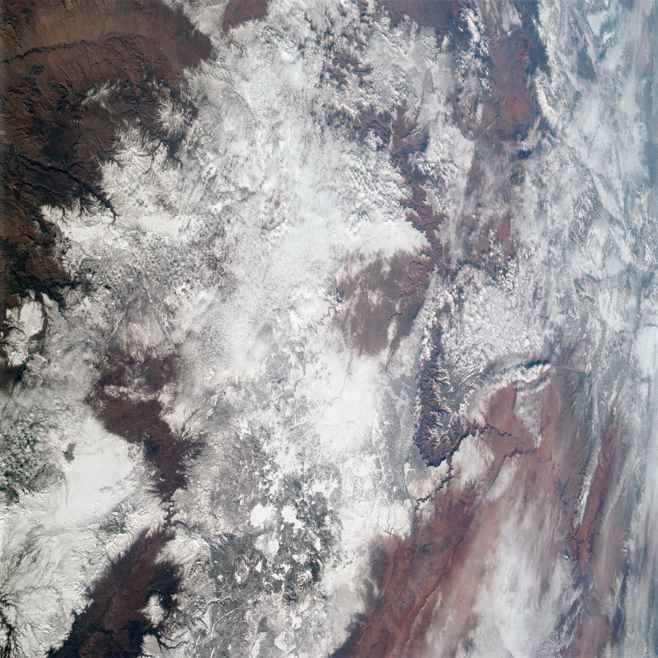
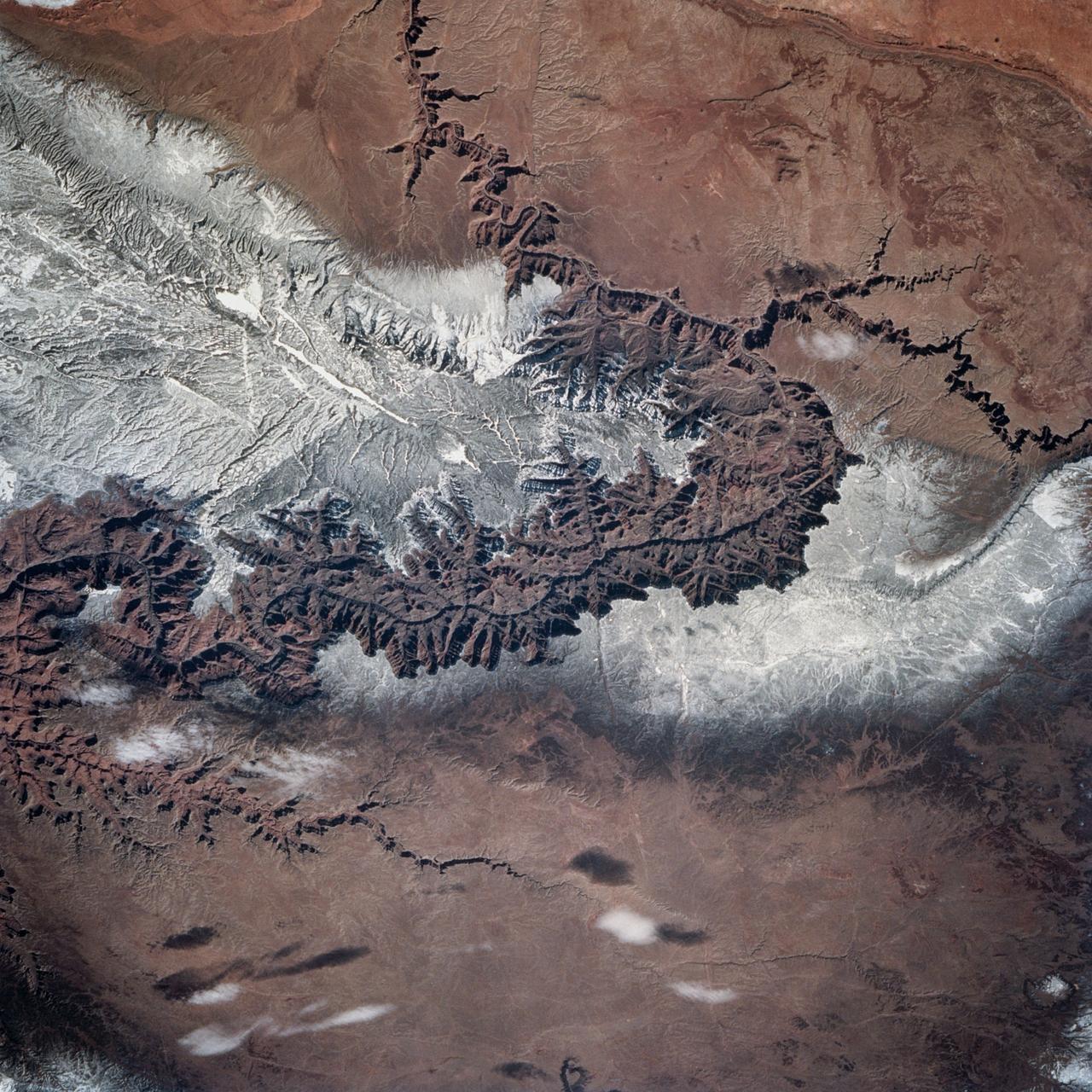
AS09-20-3137 (3-13 March 1969) --- The Grand Canyon is sharply etched on the snow-covered Colorado Plateau in Arizona in this photograph from the Apollo 9 spacecraft during its Earth-orbital mission. Lake Powell behind Glen Canyon Dam is in the upper right corner. Humphreys Peak and the many volcanic craters around the San Francisco Mountains near Flagstaff, Arizona, are right of center. Prescott is under clouds at lower center.
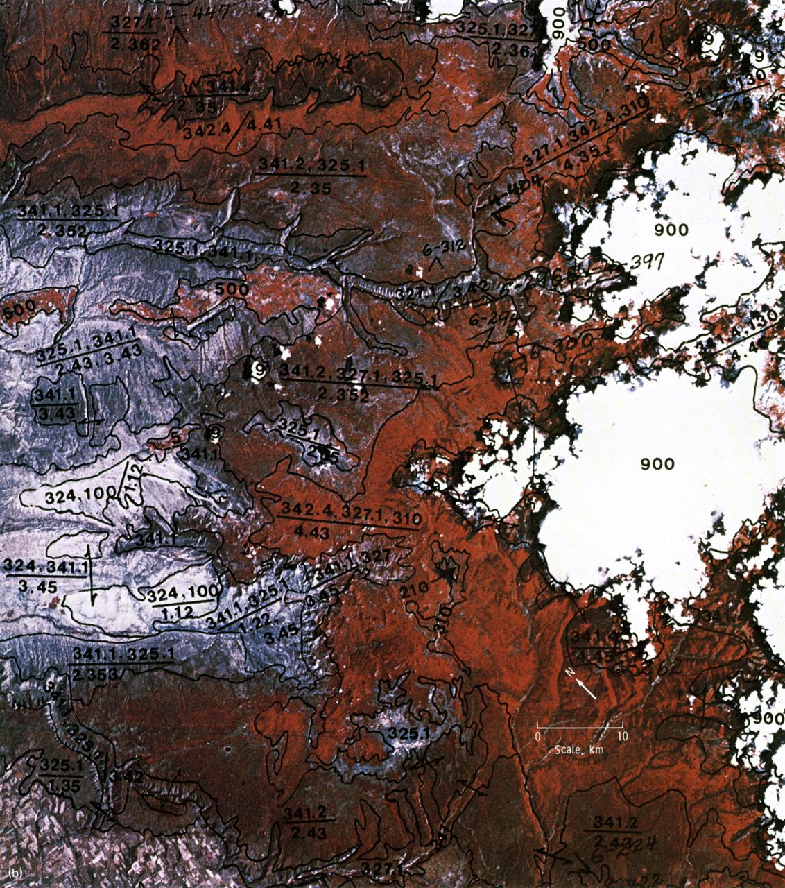
This EREP color infrared photograph of the Uncompahgre Plateau area of Colorado was taken in June of 1973 by the Earth Terrain Camera (Skylab EREP Experiment S190B) of the Skylab's Multi-spectral Photographic Facility during the Skylab-2 mission. Skylab stereoscopic data provided the best identification of vegetation complexes and delineation of vegetation boundaries, particularly in areas where changes in relief were related to changes in vegetation type (a common occurrence in wild-land vegetation communities).
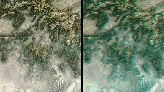
The mountains and desert plateaus of northwest Colorado are shown in this anaglyph from the MISR instrument aboard NASA Terra spacecraft. 3D glasses are necessary to view this image.
Snow covers the Kaibab Plateau on the northern side of the Colorado River in this November, 1994 view of the Grand Canyon. North is to the bottom of this view. The Colorado River has created a canyon which cuts through billions of years of geologic time. The Grand Canyon is 446 kilometers (277 miles) long, averages 16 kilometers (10 miles) wide, and is approximately 1.6 kilometers (1 mile) deep. The Coconino Plateau is located on the upper left side of the view, or to the south of the Colorado River. The direction of the flow of the Colorado River is from the east to the west. Eventually the river turns south and empties into the Gulf of California. The southern portion of Lake Powell in Utah can be seen at the bottom center of the view.
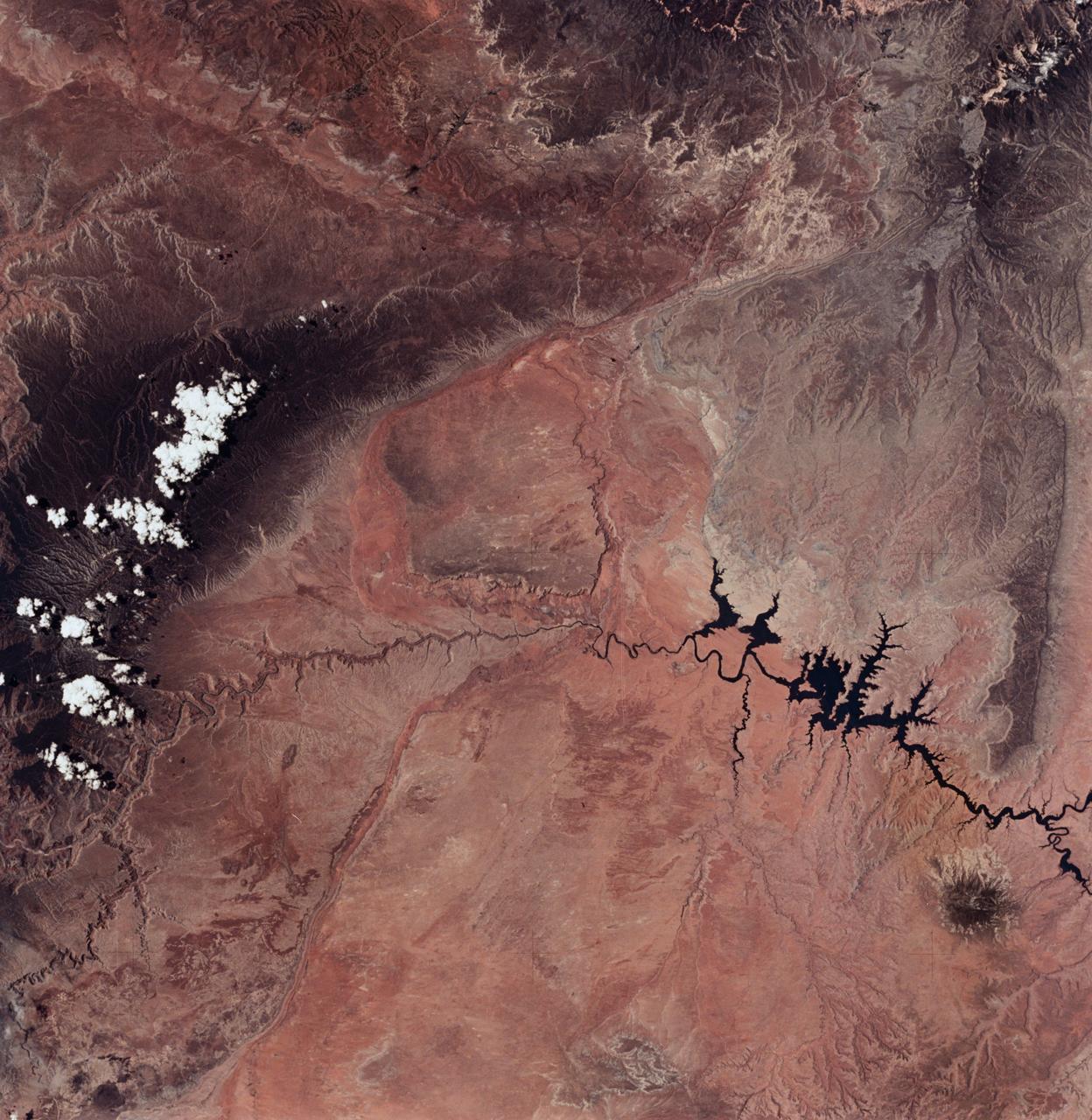
ISS034-E-066804 (12 March 2013) --- One of the Expedition 34 crew members aboard the Earth-orbiting International Space Station on March 12 , 2013 photographed this image of the Colorado Plateau, which spans northern Arizona, southern Utah, northwestern New Mexico and southwestern Colorado. This physiographic province is well known for its striking landscapes and broad vistas—an impression that is enhanced by the view from the orbital perspective of the space station. The image highlights part of the Utah-Arizona border region of the plateau and includes several prominent landforms. The Colorado River, dammed to form Lake Powell in 1963, crosses from east to west, (which is actually left to right in this image because the view looks toward the south, and north appears toward the bottom of the frame). The confluence of the Colorado and San Juan Rivers is also visible in the image. Sunglint, or sunlight reflected off a water surface back toward the observer, provides a silvery. Mirror-like sheen to some areas of the water surfaces. The geologic uplift of the Colorado Plateau led to rapid down cutting of rivers into the flat sedimentary bedrock, leaving spectacular erosional landforms. One such feature – the Rincon ---preserves evidence of a former meander bend of the Colorado River. Photo credit: NASA
iss073e0886969 (Oct. 1, 2025) --- This section of the Navajo Nation in Arizona—part of a territory that also spans New Mexico and Utah—is seen from the International Space Station as it orbited 262 miles above the Colorado Plateau in North America.

STS098-714A-049 (16 February 2001) --- Demonstrating the power of water erosion, this orbital view photographed by the crew of Atlantis during STS-98 on February 16, 2001, as the spacecraft orbited the earth at an altitude of 173 nautical miles (320 kilometers), shows Lake Powell at the headwaters of the Colorado River in southwestern Utah. The river over eons has carved out Arizona's mile deep and 270 mile long Grand Canyon. Prominent in this scene is the Kaibab Plateau at the head of the canyon where the big bend of the Colorado River has eroded the plateau into a peninsula. This plateau, directly across the canyon from the South Rim Visitor's Center, is at the widest part of the canyon, about 12 miles. The Kaibab Indian Reservation and the Kaibab National Forest are visible in the picture.
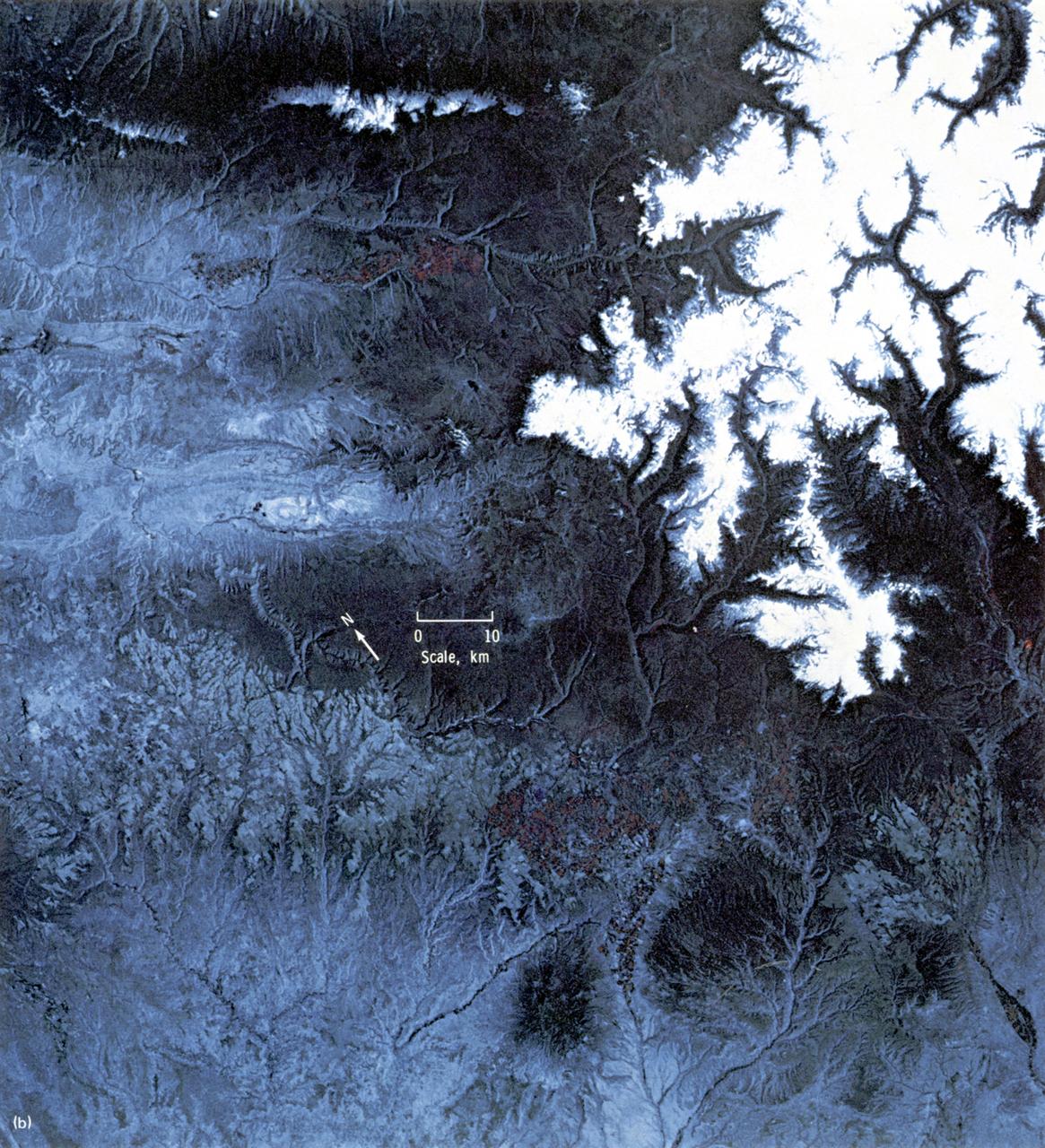
STS060-83-004 (3-11 Feb 1994) --- In this winter scene of the Grand Canyon of Arizona, the canyon is particularly well revealed because snow lies on the rims of the canyon, and exits mid-right; the Little Colorado River enters from the left, joining the Colorado just upstream of its big bend. Visitors to the South Rim can view the canyon in both the east-west and north-south reaches. The South Rim is closer to centers of transportation so that tourists mostly see the canyon from this area, that is from about 7,000 feet. The canyon floor lies at 2,000 feet in this sector. The most heavily snow covered area is the highest, reaching more than 9,000 feet (bottom right). Visitors see this protected area by hiking and mule and helicopter rides. The ecology of this part of the Colorado has been changed since the building of a lake upstream: river water is now derived from snow melt water from the bottom of the lake. This water is much colder than the water which used to flow through the canyon. According to NASA scientists, the view is unusual because the snow also reveals so well the higher country around the canyon, a swath stretching from bottom right to middle left of the view. This higher swath is an arch of uplifted rocks known as the Kaibab Plateau, raised vertically by tectonic forces in the recent geologic past. Despite this up parching, the Colorado River managed to maintain its course to the sea by cutting an ever deeper canyon into the Plateau. The white snow cover hides the fact that the Kaibab Plateau is thickly forested and thus appears dark green in summer, except in areas of clear-cutting. Since the Plateau reaches altitudes of 6 to 9,000 feet, it is both cooler and moister than the surrounding lower desert floor (top and bottom in this view) - where sparse vegetation and rocky country appear as brown colors. The zone of dark color running parallel to the snow line is all that can be seen of the pine forest on the south flanks of the Plateau.
iss073e0886930 (Oct. 1, 2025) --- Arizona's Wupatki National Monument—rich in Native American archaeology, shaped by desert landscapes and ancient volcanic activity—is pictured from the International Space Station as it orbited 262 miles above the southwestern edge of the Colorado Plateau.
iss074e0208848 (Jan. 26, 2026) --- The Colorado River began carving the Grand Canyon—one of the Seven Natural Wonders of the World and a UNESCO World Heritage Site in Arizona—about 5 to 6 million years ago. This photograph was taken from the International Space Station as it orbited 260 miles above the Colorado Plateau in the southwestern United States.
iss074e0208838 (Jan. 26, 2026) --- The Colorado River began carving the Grand Canyon—one of the Seven Natural Wonders of the World and a UNESCO World Heritage Site in Arizona—about 5 to 6 million years ago. This photograph was taken from the International Space Station as it orbited 260 miles above the Colorado Plateau in the southwestern United States.
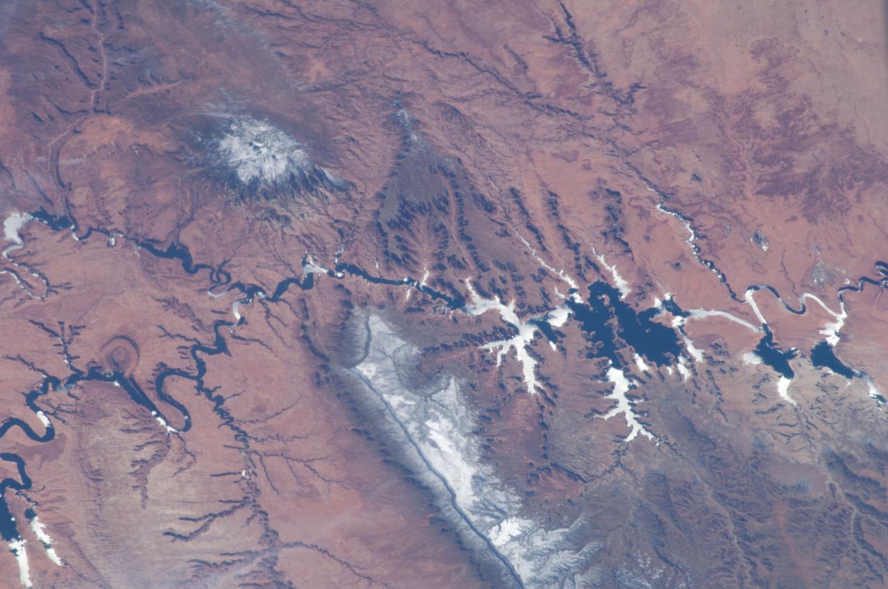
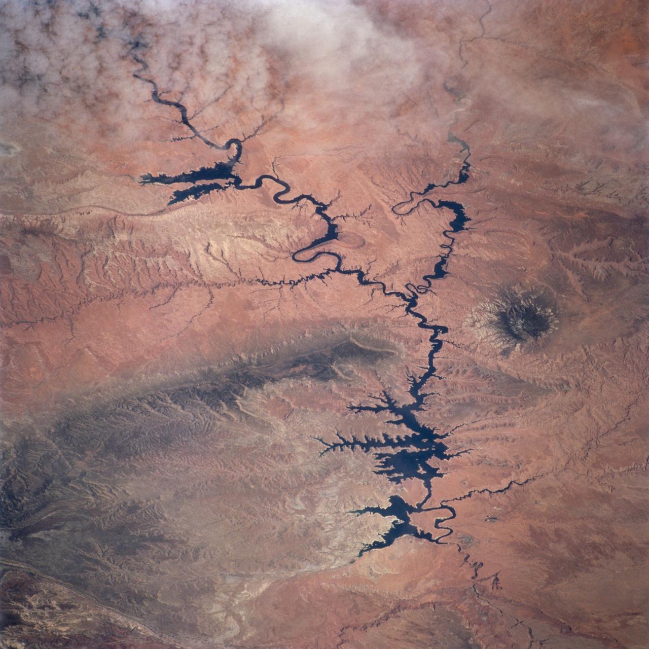
STS112-707-035 (7-18 October 2002) --- The Colorado River snakes across this view, photographed from the Space Shuttle Atlantis, from top left (near the vehicle’s vertical stabilizer), to the lower right, where the Grand Canyon gorge can be detected. The wider blue parts of the Colorado in the center of the view are Lake Powell, an artificial lake more than 120 miles long. The dark green areas are wooded slopes generally above 6000 feet. The Kaibab Plateau (lower left) and the range with Abajo Peak (11,360 feet, Utah-Colorado border region) cross the top of the view. The red areas are lower and semiarid, dominated by desert scrub vegetation.
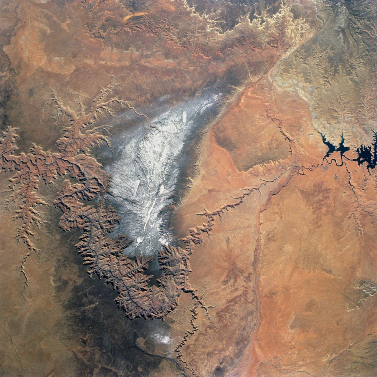
SL2-04-018 (June 1973) --- A vertical view of the Arizona-Utah border area showing the Colorado River and Grand Canyon photographed from the Skylab 1/2 space station in Earth orbit. This picture was taken by one of the six lenses of the Itek-furnished S190-A Multispectral Photographic Facility Experiment in the Multiple Docking Adapter of the space station. Type S0-356 film was used. The row of white clouds extend north-south over the dark colored Kaibab Plateau. The junction of the Colorado and Little Colorado rivers is in the southwest corner of the picture. The body of water is Lake Powell on the Colorado River upstream from the Grand Canyon. The lone peak at the eastern edge of the photograph south of Colorado River is the 10,416-foot Navajo Mountain. The S190-A experiment is part of the Skylab Earth Resources Experiments Package(EREP). Photo credit: NASA
STS073-727-045 (21 October 1995) --- Photographed by the astronauts aboard the Space Shuttle Columbia is this scene over Lake Powell. The lake was formed by the Glen Canyon Dam on the Colorado River. The vertical stabilizer of Columbia points northeastward. Navaho Mountain, northwest of the tail, according to NASA geologists, was formed by an intrusion of molten rock that uplifted older, layered rocks, then cooled, and has been exposed by erosion. The rest of the landscape is dominated by faulted layers of sandstone, shale, and limestone that were formed in shallow seas and great deserts 80 to 250 million years ago. These rocks of the Colorado Plateau were uplifted a few million years ago to be dissected by the meandering Colorado River, San Juan River, and their tributaries.
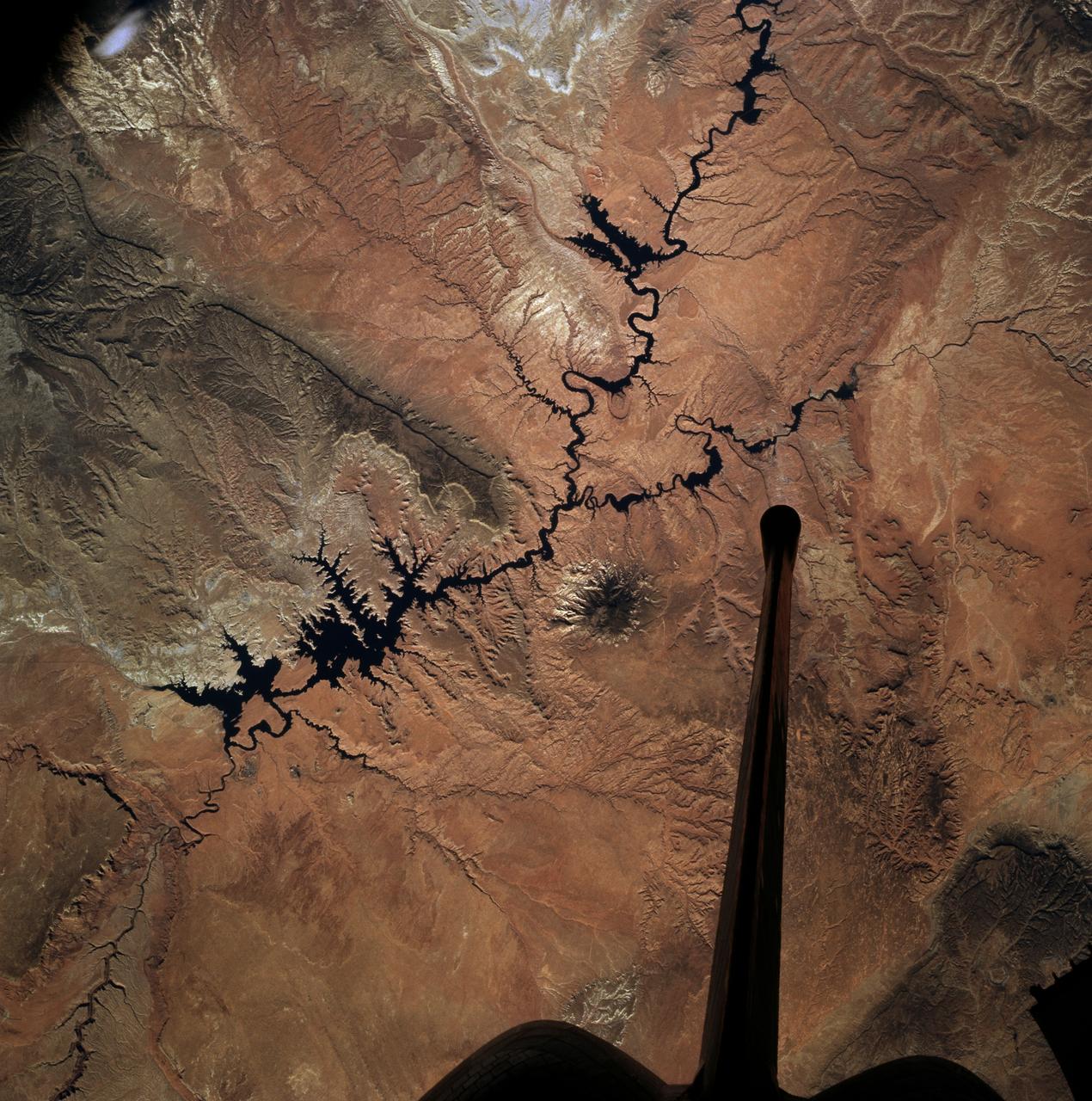
ISS012-E-05172 (14 October 2005) --- Navajo Mountain, Utah is featured in this image photographed by an Expedition 12 crewmember on the international space station. According to scientists, the Colorado Plateau of Arizona, Colorado, New Mexico, and Utah is characterized by mostly flat-lying sedimentary layers that record paleoclimate extremes ranging from oceans to widespread deserts over the last 1.8 billion years. Navajo Mountain is formed by a dome-shaped body of igneous rock (called a laccolith by geologists), one of several in southeast Utah that intrude and uplift the surrounding sedimentary layers of the Plateau. This oblique image highlights Navajo Mountain in the center of the image, surrounded by light red-brown Navajo Sandstone (also visible in canyons at bottom of image). Scientists believe the peak of Navajo Mountain, at approximately 3148 meters (10,388 feet) elevation, is comprised of uplifted Dakota Sandstone deposited during the Cretaceous Period. The establishment of Rainbow Bridge National Monument (1910), and the filling of Glen Canyon by Lake Powell in 1963 (upper right), have facilitated tourism and aesthetic appreciation of this previously remote region. Access to Navajo Mountain is still regulated by the sovereign Navajo Nation, and the process of permitting is required to hike in the region.
The Grand Canyon is one of North America's most spectacular geologic features. Carved primarily by the Colorado River over the past six million years, the canyon sports vertical drops of 5,000 feet and spans a 445-kilometer-long stretch of Arizona desert. The strata along the steep walls of the canyon form a record of geologic time from the Paleozoic Era (250 million years ago) to the Precambrian (1.7 billion years ago). The above view was acquired by the Advanced Spaceborne Thermal Emission and Reflection Radiometer (ASTER) instrument aboard the Terra spacecraft. Visible and near infrared data were combined to form an image that simulates the natural colors of water and vegetation. Rock colors, however, are not accurate. The image data were combined with elevation data to produce this perspective view, with no vertical exaggeration, looking from above the South Rim up Bright Angel Canyon towards the North Rim. The light lines on the plateau at lower right are the roads around the Canyon View Information Plaza. The Bright Angel Trail, which reaches the Colorado in 11.3 kilometers, can be seen dropping into the canyon over Plateau Point at bottom center. The blue and black areas on the North Rim indicate a forest fire that was smoldering as the data were acquired on May 12, 2000. http://photojournal.jpl.nasa.gov/catalog/PIA02668
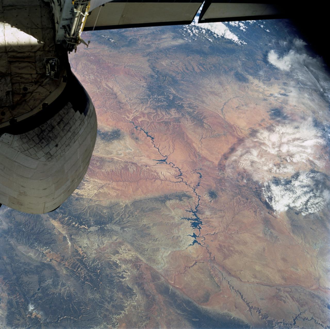
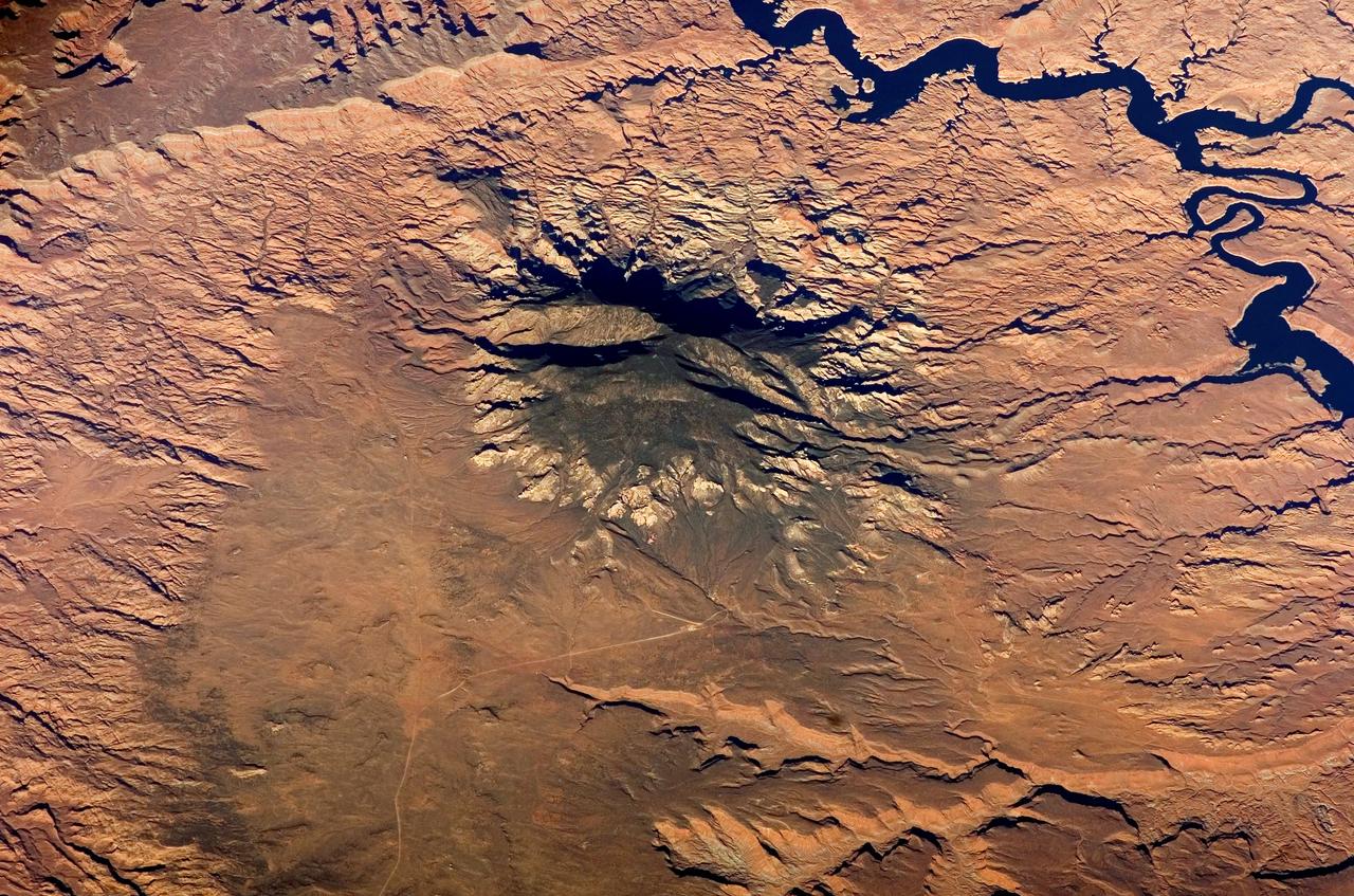
STS100-716-176 (19 April-1 May 2001) --- The deeply entrenched, meandering Colorado River is distinctively dark as the river winds its way across the arid terrain of southeast Utah in this 70mm frame photographed from the Earth-orbiting Space Shuttle Endeavour. While Glen Canyon Dam (bottom of image) is located in northern Arizona, the reservoir of Lake Powell is in Utah. The Escalante and San Juan Rivers, two major tributaries that flow into Lake Powell (from the northwest and east respectively) are also discernable. The darker-looking, elongated and elevated feature north of Lake Powell is the Kaiparowits Plateau. Navajo Mountain is the darker circular feature to the south (to the right) of the lake.
ISS039-E-005258 (25 March 2014) --- Not only do millions of tourists have special attractions to the Grand Canyon, but also through the years astronauts and cosmonauts in space. One of the Expedition 39 crew members aboard the Earth-orbiting International Space Station aimed his camera, equipped with a 180mm lens, at the iconic feature. The steep walls of the Colorado River canyon and its many side canyons make an intricate landscape that contrasts with the dark green, forested plateau to the north and south. The Colorado River has done all the erosional work of carving away cubic kilometers of rock in a geologically short period of time. Visible as a darker line snaking along the bottom of the canyon, the river lies at an altitude of 715 meters (2,345 feet), thousands of meters below the North and South Rims. Temperatures are furnace-like on the river banks in the summer. But Grand Canyon Village, the classic outlook point for visitors, enjoys a milder climate at an altitude of 2,100 meters (6,890 feet). The Grand Canyon has become a geologic icon?a place where, geologists say, one can almost sense the invisible tectonic forces within the Earth. The North and South Rims are part of the Kaibab Plateau, a gentle tectonic swell in the landscape. The uplift of the plateau had two pronounced effects on the landscape that show up in this image. First, in drier parts of the world, forests usually indicate higher places; higher altitudes are cooler and wetter, conditions that allow trees to grow. The other geologic lesson on view is the canyon itself. Geologists now know that a river can cut a canyon only if the Earth surface rises vertically. If such uplift is not rapid, a river can maintain its course by eroding huge quantities of rock and forming a canyon.
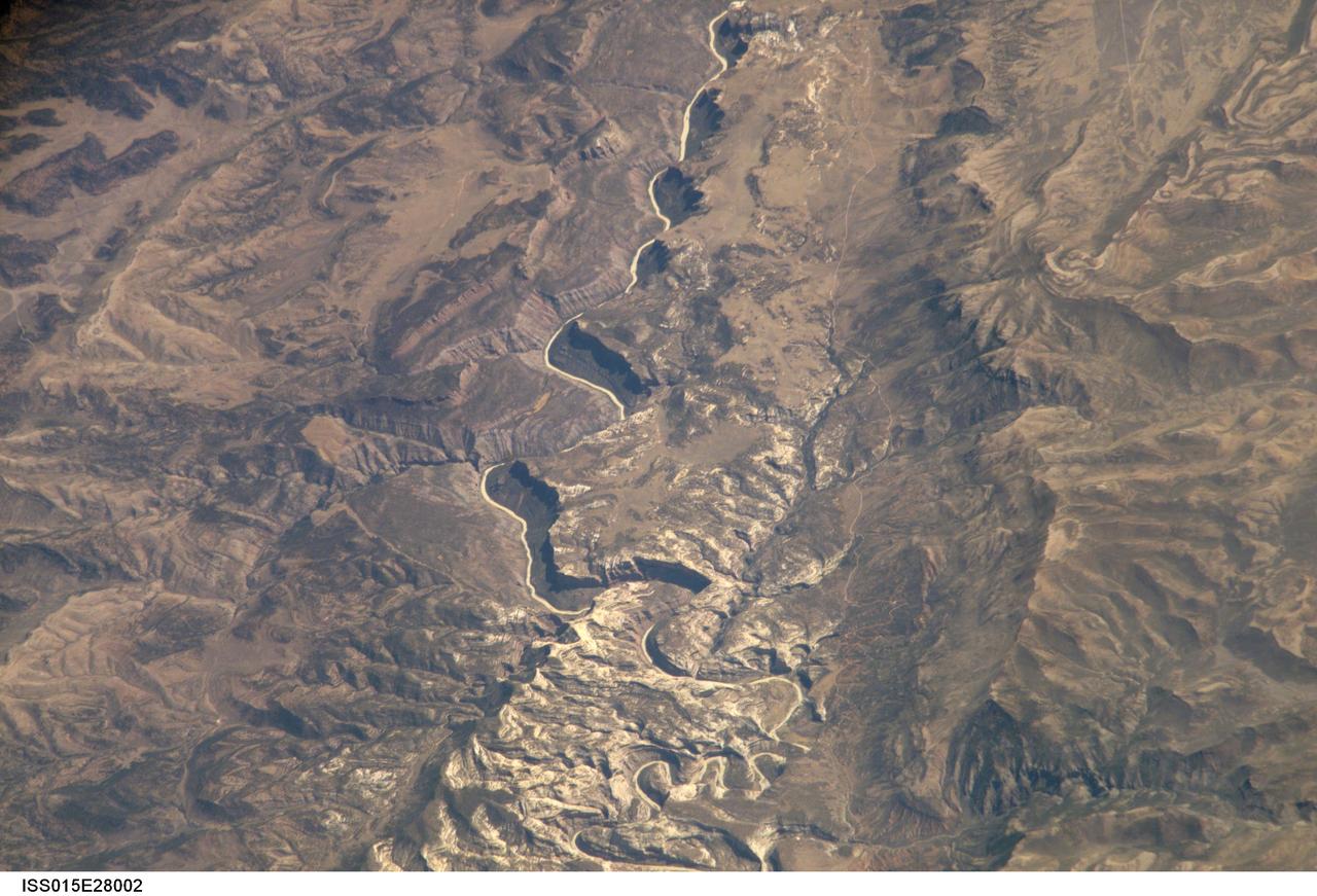
ISS015-E-28002 (12 Sept. 2007) --- A section of Dinosaur National Monument along the Yampa River in Colorado, which straddles the Colorado/Utah border, is featured in this image photographed by an Expedition 15 crewmember on the International Space Station. Dinosaur National Monument is perhaps best known for the abundant fossils found in the approximately 145 Ma (mega-annum, or millions of years old) Morrison Formation exposed in valleys and low ridges, according to scientists. The fossil assemblage is a unique record of terrestrial life of the period (dinosaurs, plants, and other animal species). Remains accumulated in streams and shallow lakes and were swiftly buried (and preserved) by sediments associated with those environments. Scientists believe these sediments in turn were lithified over many millions of years as they were buried under younger deposits -- forming the distinctive stratigraphy of the Monument. The generally flat-laying "layer cake" geology of the region -- similar to the Colorado Plateau to the south - is expressed in the image by parallel beds of tan, reddish-brown, and gray-brown sedimentary rocks cut by the Yampa River at the northern end of the Monument (top). Erosion by the Yampa River exposed the Morrison layer and its trove of fossil material. Together with other fossils found in both older and younger rock layers in the area, the Dinosaur National Monument remains an important scientific resource that continues to provide new insights into the geologic history and paleoecology of the region.
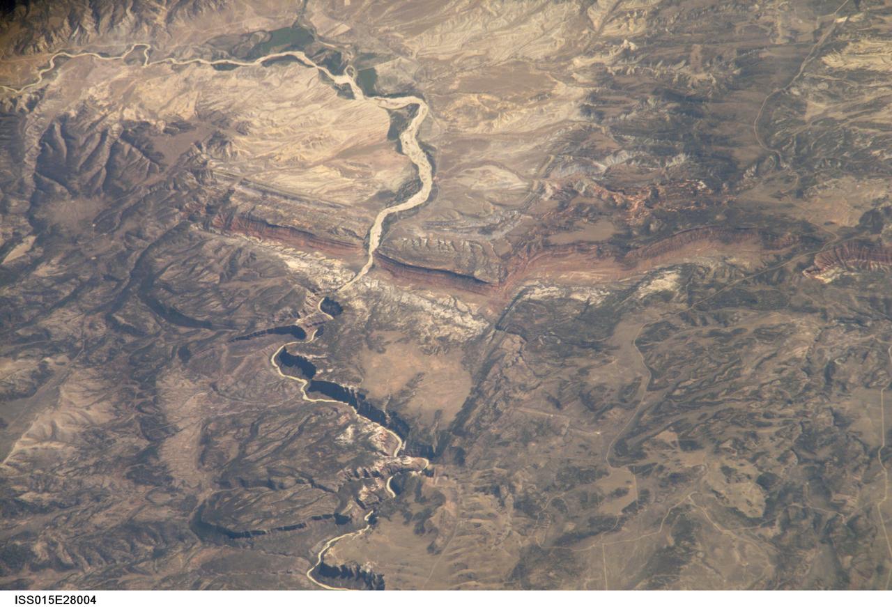
ISS015-E-28004 (12 Sept. 2007) --- A section of Dinosaur National Monument along the Yampa River in Colorado, which straddles the Colorado/Utah border, is featured in this image photographed by an Expedition 15 crewmember on the International Space Station. Dinosaur National Monument is perhaps best known for the abundant fossils found in the approximately 145 Ma (mega-annum, or millions of years old) Morrison Formation exposed in valleys and low ridges, according to scientists. The fossil assemblage is a unique record of terrestrial life of the period (dinosaurs, plants, and other animal species). Remains accumulated in streams and shallow lakes and were swiftly buried (and preserved) by sediments associated with those environments. Scientists believe these sediments in turn were lithified over many millions of years as they were buried under younger deposits -- forming the distinctive stratigraphy of the Monument. The generally flat-laying "layer cake" geology of the region -- similar to the Colorado Plateau to the south - is expressed in the image by parallel beds of tan, reddish-brown, and gray-brown sedimentary rocks cut by the Yampa River at the northern end of the Monument (top). Erosion by the Yampa River exposed the Morrison layer and its trove of fossil material. Together with other fossils found in both older and younger rock layers in the area, the Dinosaur National Monument remains an important scientific resource that continues to provide new insights into the geologic history and paleoecology of the region.
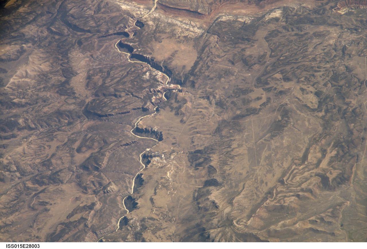
ISS015-E-28003 (12 Sept. 2007) --- A section of Dinosaur National Monument along the Yampa River in Colorado, which straddles the Colorado/Utah border, is featured in this image photographed by an Expedition 15 crewmember on the International Space Station. Dinosaur National Monument is perhaps best known for the abundant fossils found in the approximately 145 Ma (mega-annum, or millions of years old) Morrison Formation exposed in valleys and low ridges, according to scientists. The fossil assemblage is a unique record of terrestrial life of the period (dinosaurs, plants, and other animal species). Remains accumulated in streams and shallow lakes and were swiftly buried (and preserved) by sediments associated with those environments. Scientists believe these sediments in turn were lithified over many millions of years as they were buried under younger deposits -- forming the distinctive stratigraphy of the Monument. The generally flat-laying "layer cake" geology of the region -- similar to the Colorado Plateau to the south - is expressed in the image by parallel beds of tan, reddish-brown, and gray-brown sedimentary rocks cut by the Yampa River at the northern end of the Monument (top). Erosion by the Yampa River exposed the Morrison layer and its trove of fossil material. Together with other fossils found in both older and younger rock layers in the area, the Dinosaur National Monument remains an important scientific resource that continues to provide new insights into the geologic history and paleoecology of the region.
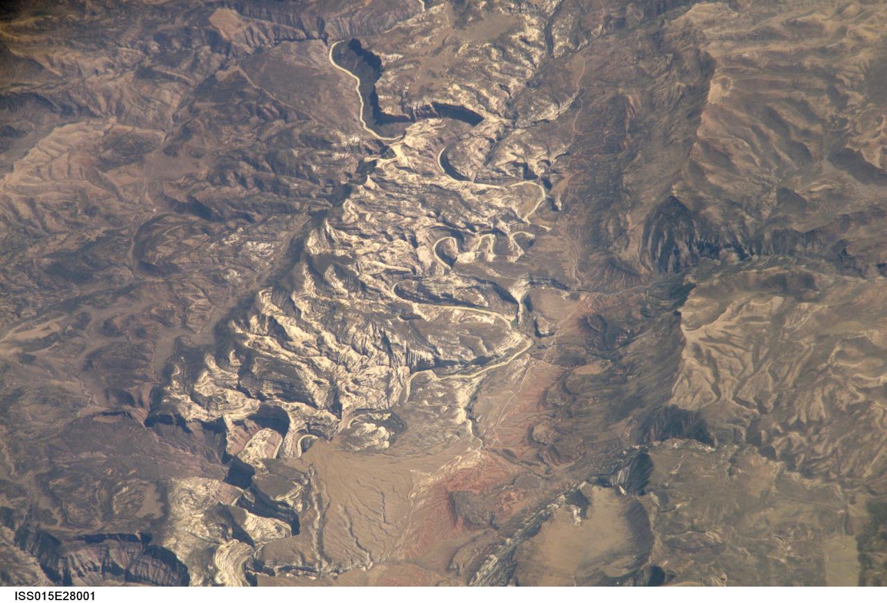
ISS015-E-28001 (12 Sept. 2007) --- A section of Dinosaur National Monument along the Yampa River in Colorado, which straddles the Colorado/Utah border, is featured in this image photographed by an Expedition 15 crewmember on the International Space Station. Dinosaur National Monument is perhaps best known for the abundant fossils found in the approximately 145 Ma (mega-annum, or millions of years old) Morrison Formation exposed in valleys and low ridges, according to scientists. The fossil assemblage is a unique record of terrestrial life of the period (dinosaurs, plants, and other animal species). Remains accumulated in streams and shallow lakes and were swiftly buried (and preserved) by sediments associated with those environments. Scientists believe these sediments in turn were lithified over many millions of years as they were buried under younger deposits -- forming the distinctive stratigraphy of the Monument. The generally flat-laying "layer cake" geology of the region -- similar to the Colorado Plateau to the south - is expressed in the image by parallel beds of tan, reddish-brown, and gray-brown sedimentary rocks cut by the Yampa River at the northern end of the Monument (top). Erosion by the Yampa River exposed the Morrison layer and its trove of fossil material. Together with other fossils found in both older and younger rock layers in the area, the Dinosaur National Monument remains an important scientific resource that continues to provide new insights into the geologic history and paleoecology of the region.
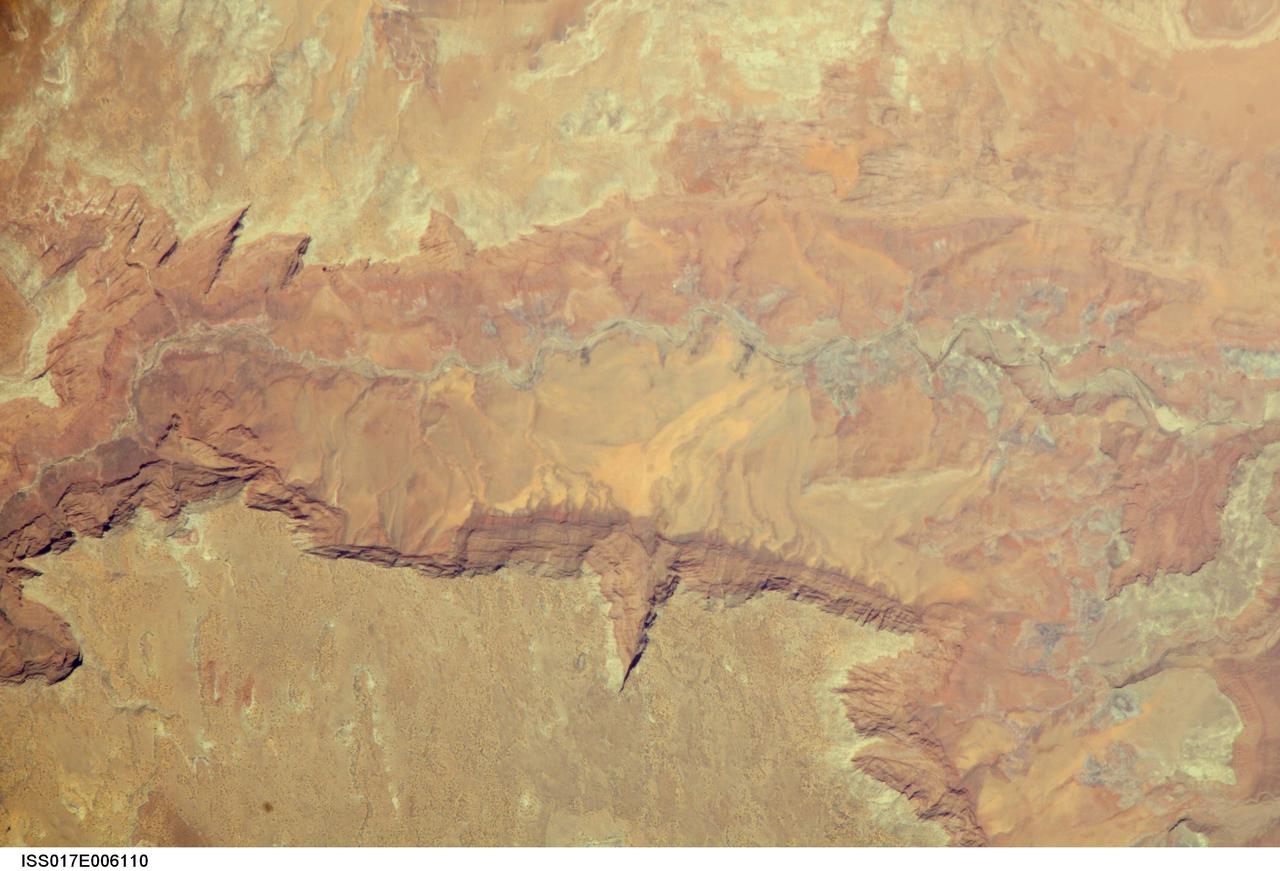
ISS017-E-006110 (2 May 2008) --- Vermilion Cliffs and Paria River, Arizona are featured in this image photographed by an Expedition 17 crewmember on the International Space Station. The largest tributary of the Colorado River between Lake Powell and the Grand Canyon, the Paria River flows southeast from headwaters in southernmost Utah to join the Colorado River between Page, AZ and Marble Canyon. The Paria River provides spectacular scenery, and is known for the very narrow "slot" canyons that it cuts through the layered rocks of the Colorado Plateau. According to scientists, these canyons formed over millions of years by water erosion slicing deep into the rock layers. Exploring the river channel through the slot canyons is a popular activity for hikers and backpackers. Indeed, there is no road access to much of the river channel, and hiking in on foot is the only way to experience the slot canyons. The Paria River also exposes the red and white layers of rocks beneath the Paria Plateau that are known as the Vermilion Cliffs (center). Scientists say that these rocks record the changing environmental conditions of the region during the early Mesozoic Era, ranging from widespread deserts to more water-rich periods when rivers flowed across the landscape. The spectacular scenery of the Vermilion Cliffs and Paria Canyon falls within the Vermilion Cliffs National Monument. This rugged and remote landscape is also home to many species of raptors -- including the California condor -- and other desert fauna such as bighorn sheep.
ISS041-E-067595 (6 Oct. 2014) --- This moonlit panorama was shot recently with a wide-angle lens by an Expedition 41 crew member aboard the International Space Station, as they looked southwest from a point over Nebraska. The wide-angle lens shows a huge swath of country that stretches from Portland, Oregon (right) to Phoenix, Arizona (left). The largest string of lights is the Ogden-Salt Lake City-Provo area (lower center) in Utah. The Los Angeles and San Francisco metropolitan regions, and the cities of the central valley of California (Bakersfield to Redding) stretch across the horizon. The green airglow layer always appears in night images. Moonlight shows the red tinge of the space station?s solar arrays top left. Moonlight emphasizes the broader-scale geological zones. Nevada?s short, dark, parallel mountain ranges of the basin and range geological province (center) contrast with the expanses of flat terrain of the Colorado Plateau (left) in Colorado, Arizona, Utah and New Mexico. The near-full moon even reveals the vast dry lake bed known as the Bonneville Salt Flats. The black line of the Sierra Nevada marks the edge of California?s well-lit central valley (directly below the San Francisco Bay area).
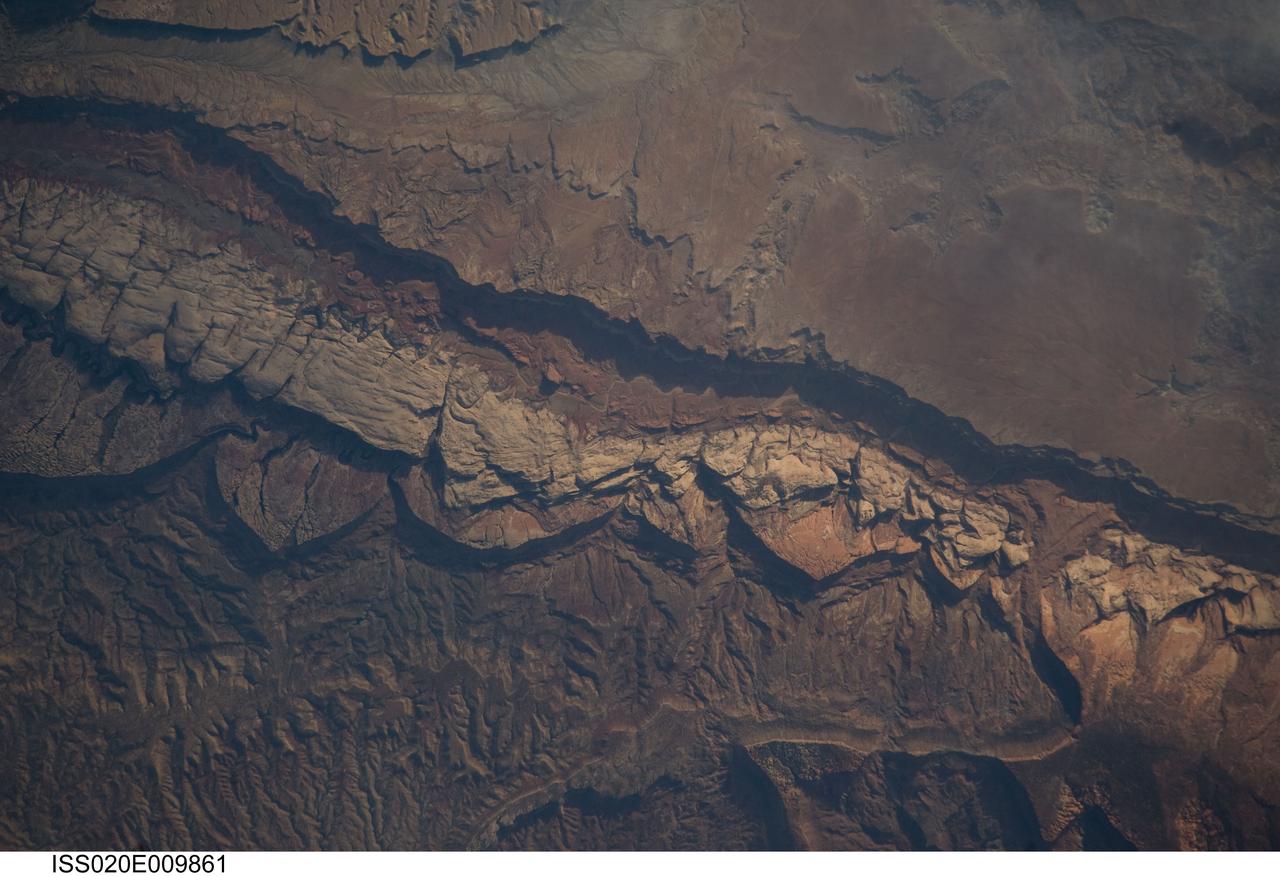
ISS020-E-009861 (14 June 2009) --- Big Thompson Mesa in the Capitol Reef National Park, Utah is featured in this image photographed by an Expedition 20 crew member on the International Space Station. This detailed photograph depicts a portion of Big Thompson Mesa located near the southern end of Capitol Reef National Park. Capitol Reef National Park is located on the Colorado Plateau, a physiographic and geologic province that comprises the adjacent quarters of Arizona, Colorado, New Mexico and Utah. Big Thompson Mesa (upper right) is part of a large feature known as the Waterpocket Fold. The Fold is a geologic structure called a monocline, characterized by generally flat-laying sedimentary rock layers with a steep and highly localized flexure– much like a carpet runner draped over a stair step. Monoclines on the Colorado Plateau are thought to be the result of faulting of stratigraphically lower and more brittle crystalline rocks; while the crystalline rocks were broken into raised or lowered blocks, the overlaying, less brittle sedimentary rocks were flexed without breaking. According to scientists, the portion of the Waterpocket Fold illustrated in this image includes layered rocks formed during the Mesozoic Era (approximately 250 – 65 million years ago) – the oldest layers are at the bottom of the sequence (and also, in this view, the image), with each successive layer younger than the preceding one going upwards in the sequence. Not all of the units present are clearly visible, but some of the major units can be easily distinguished. The bottom half of the image includes the oldest rocks in the view: dark brown and dark green Moenkopi (Trm) and Chinle (Trc) Formations. At center, two strikingly colored units are visible – light red to orange Wingate Sandstone (Jw) and white Navajo Sandstone (Jn). A topographic bench above these units includes reddish brown to brown Carmel Formation (Jc) and Entrada Sandstone (Je). The top of the cliff face above this bench - Big Thompson Mesa - is comprised of brown Dakota Sandstone (Kd). Scientists believe this sequence represents more than 100 million years of deposition. Much younger Quaternary (2.0 million to approximately 10,000 years old) deposits are also present in the view. A regional view of Capitol Reef National Park and the Waterpocket Fold is available here. The area shown in this view is located approximately 65 kilometers to the southeast of Fruita, UT near the southern end of Capitol Reef National Park.
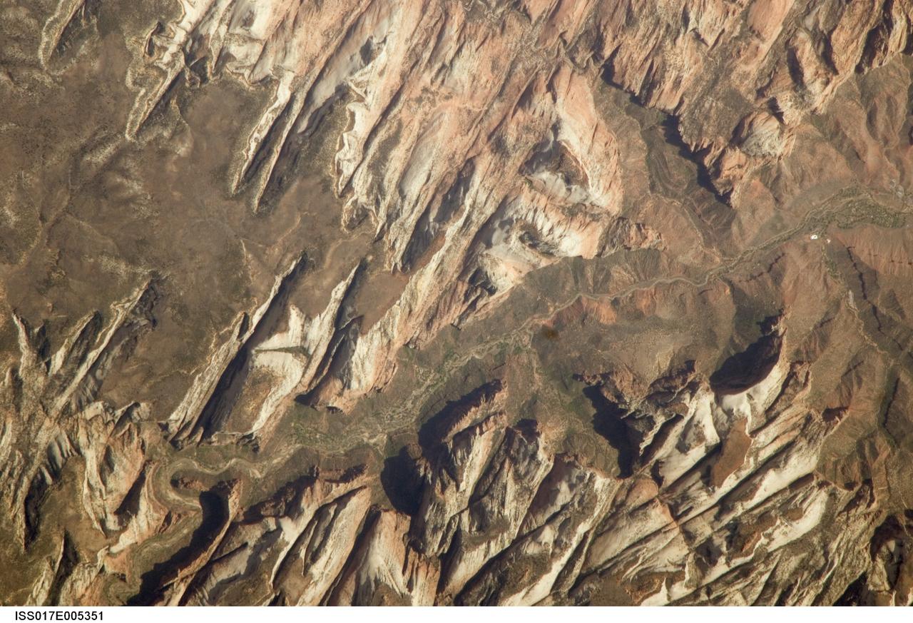
ISS017-E-005351 (26 April 2008) --- Zion National Park, Utah is featured in this image photographed by an Expedition 17 crewmember on the International Space Station. Zion National Park is located in southwestern Utah, along the western margin of the Colorado Plateau. The park was established in 1919, after roadway improvements in southwestern Utah allowed access to the preceding Mukuntuweap National Monument (1909) located in Zion Canyon. The towering cliffs bounding the North Fork of the Virgin River are formed mainly of tan to light pink Navajo Sandstone, the lithified remnants of an extensive sand dune sea that covered the area during the early Mesozoic Era, nearly 200 million years ago, according to scientists. The Zion region would have looked much like the present-day Sahara desert at this time in its geologic history. Brown rock capping the Navajo Sandstone (right) is comprised of younger beds that record changing environmental conditions that fluctuated between shallow seas and deserts. This high resolution image illustrates the incised nature of the bedrock forming the park. The long linear features are joints -- fractures in the rock mass -- formed in response to tectonic stresses that affected the region during its geologic history. The mainly north-northwest trending joints serve to channelize water runoff and are thought to be the main factor that determined the present canyon network. While the park is perhaps best experienced by hiking, backpacking, or biking, Utah State Route 9 provides automobile access up the side of Zion Canyon. The road is visible in this view as a thin brown line climbing the south wall of the canyon (lower left). Access to the rest of the park is provided by a shuttle bus system instituted in 2000 to reduce vehicle noise, improve air quality, and improve wildlife habitat.
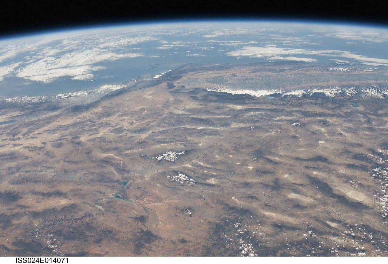
ISS024-E-014071 (9 Sept. 2010) --- This striking panoramic view of the southwestern USA and Pacific Ocean is an oblique image photographed by an Expedition 24 crew member looking outwards at an angle from the International Space Station (ISS). While most unmanned orbital satellites view Earth from a nadir perspective?in other words, collecting data with a ?straight down? viewing geometry?crew members onboard the space station can acquire imagery at a wide range of viewing angles using handheld digital cameras. The ISS nadir point (the point on Earth?s surface directly below the spacecraft) was located in northwestern Arizona, approximately 260 kilometers to the east-southeast, when this image was taken. The image includes parts of the States of Arizona, Nevada, Utah, and California together with a small segment of the Baja California, Mexico coastline at center left. Several landmarks and physiographic features are readily visible. The Las Vegas, NV metropolitan area appears as a gray region adjacent to the Spring Mountains and Sheep Range (both covered by white clouds). The Grand Canyon, located on the Colorado Plateau in Arizona, is visible (lower left) to the east of Las Vegas with the blue waters of Lake Mead in between. The image also includes the Mojave Desert, stretching north from the Salton Sea (left) to the Sierra Nevada mountain range. The Sierra Nevada range is roughly 640 kilometers long (north-south) and forms the boundary between the Central Valley of California and the adjacent Basin and Range. The Basin and Range is so called due to the pattern of long linear valleys separated by parallel linear mountain ranges ? this landscape, formed by extension and thinning of Earth?s crust, is particularly visible at right.