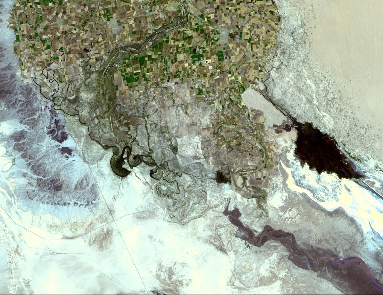
The Colorado River ends its 2330 km journey in the Gulf of Mexico in Baja California. NASA Terra spacecraft acquired this image on May 29, 2006.
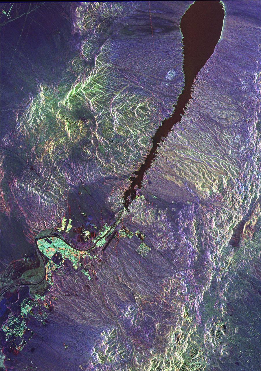
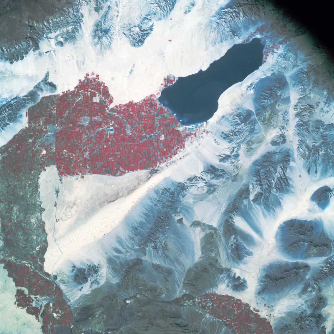
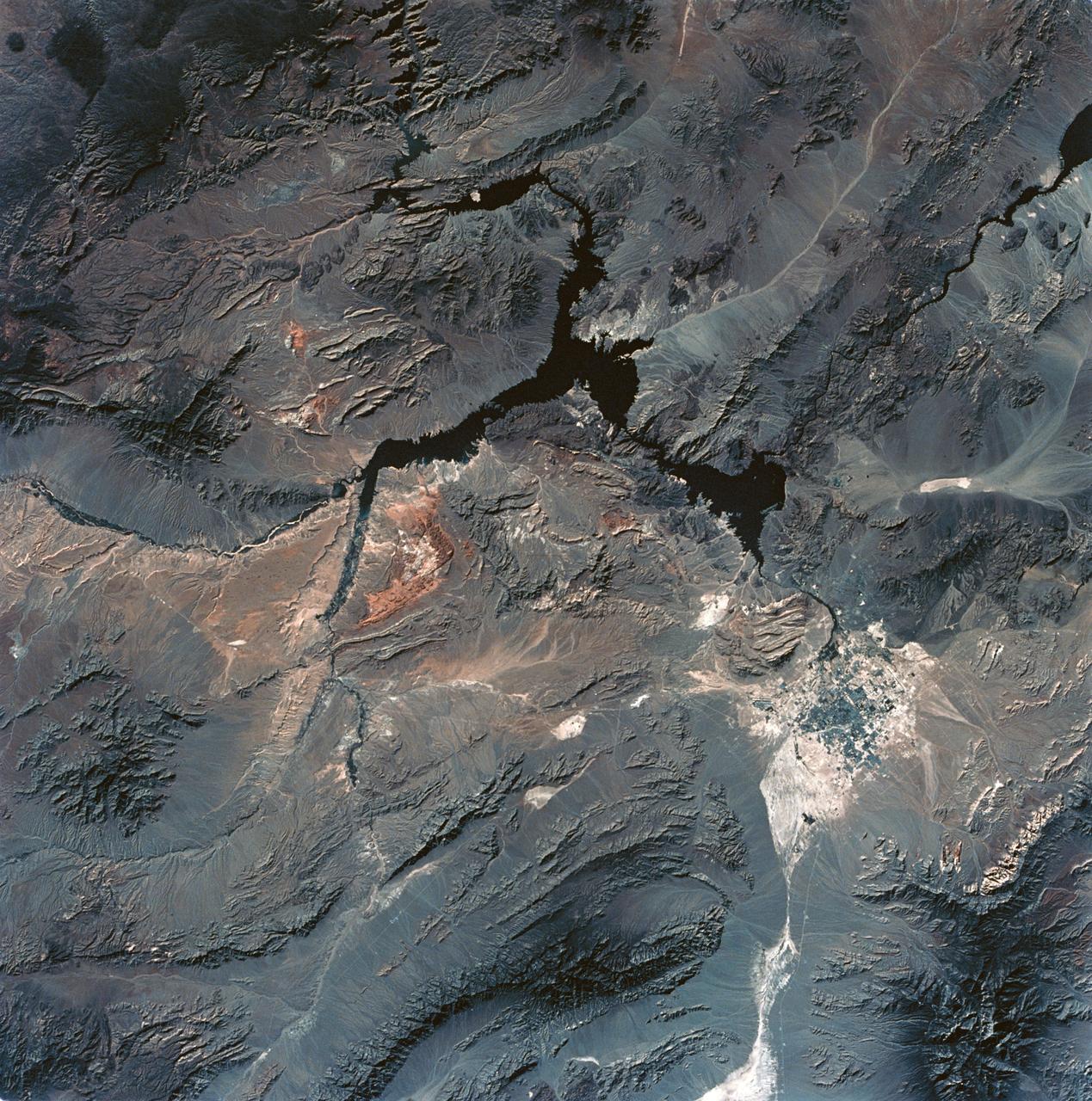
This space radar image illustrates the recent rapid urban development occurring along the lower Colorado River at the Nevada/Arizona state line. Lake Mojave is the dark feature that occupies the river valley in the upper half of the image.
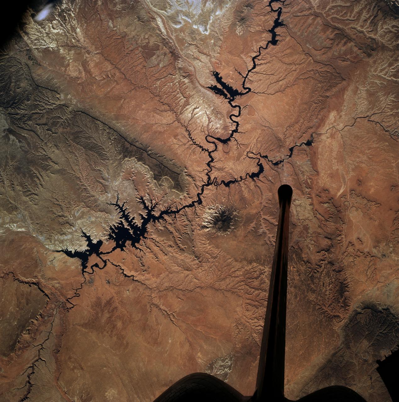
SL2-04-018 (June 1973) --- A vertical view of the Arizona-Utah border area showing the Colorado River and Grand Canyon photographed from the Skylab 1/2 space station in Earth orbit. This picture was taken by one of the six lenses of the Itek-furnished S190-A Multispectral Photographic Facility Experiment in the Multiple Docking Adapter of the space station. Type S0-356 film was used. The row of white clouds extend north-south over the dark colored Kaibab Plateau. The junction of the Colorado and Little Colorado rivers is in the southwest corner of the picture. The body of water is Lake Powell on the Colorado River upstream from the Grand Canyon. The lone peak at the eastern edge of the photograph south of Colorado River is the 10,416-foot Navajo Mountain. The S190-A experiment is part of the Skylab Earth Resources Experiments Package(EREP). Photo credit: NASA
iss072e010488 (Oct. 2, 2024) --- Denver, Colorado, split by the South Platte River, and with Standley Lake at top right, is pictured from the International Space Station as it orbited 258 miles above the Centennial State.
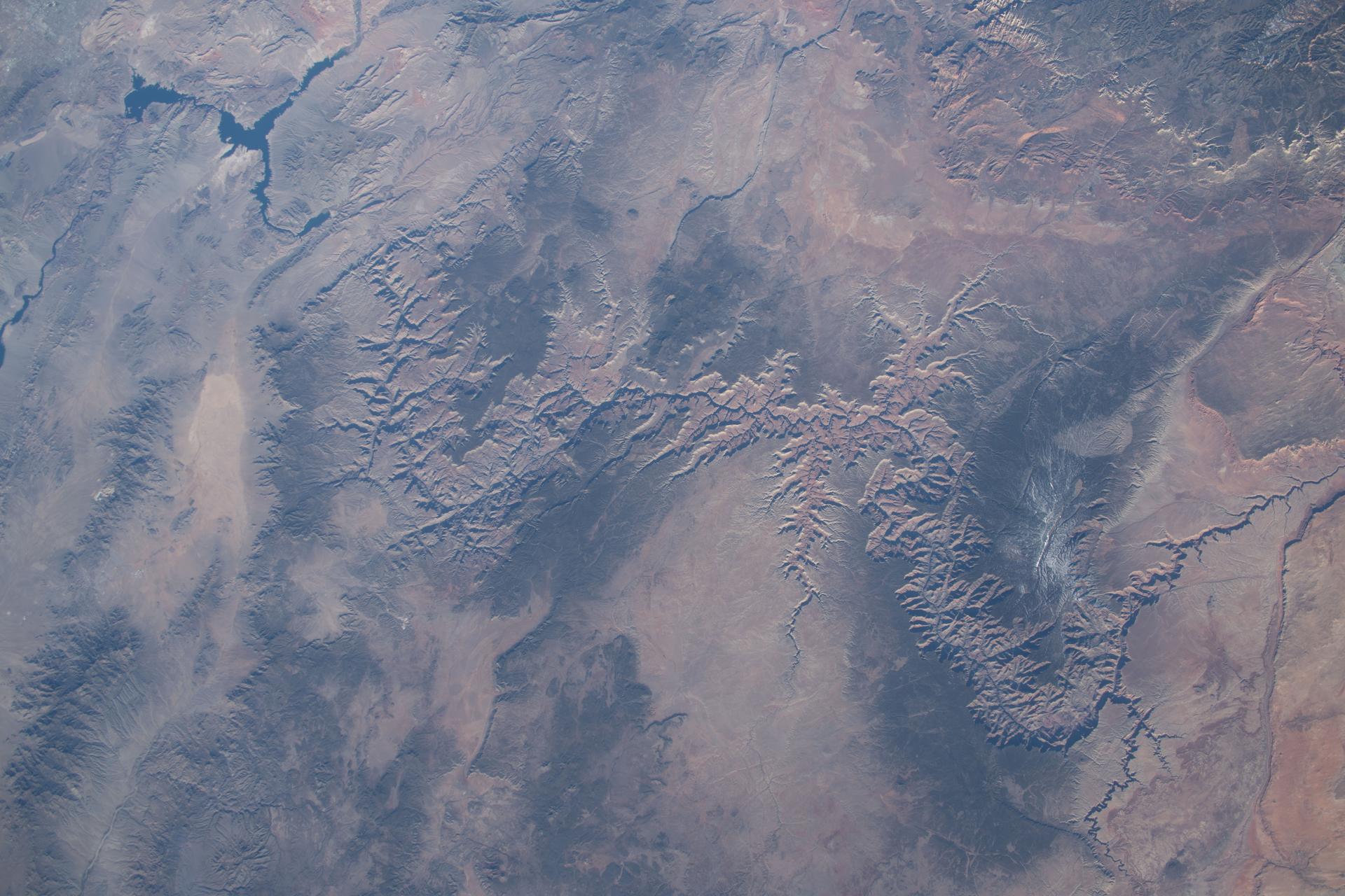
iss074e0301902 (Feb. 3, 2026) --- The Grand Canyon stretches about 277 miles across Arizona in the southwestern corner of the Colorado Plateau. The Colorado River began carving the Grand Canyon—one of the Seven Natural Wonders of the World and a UNESCO World Heritage Site—about 5 to 6 million years ago. The International Space Station was orbiting 259 miles above the United States when this photograph was taken.
STS058-89-013 (18 Oct-1 Nov 1993) --- An oblique westward view, across the wheat fields and cattle pastures, of eastern Colorado to the Front Range of the Rocky Mountains. Denver is bisected at the center of the right edge of the frame. Pikes Peak and Colorado Springs are left of center, and the Arkansas River Valley with Canyon City and the Royal Gorge are along the left edge of the frame. This view shows the startling contrast between the nearly-flat High Plains and the ancient geological uplift of the Rockies.
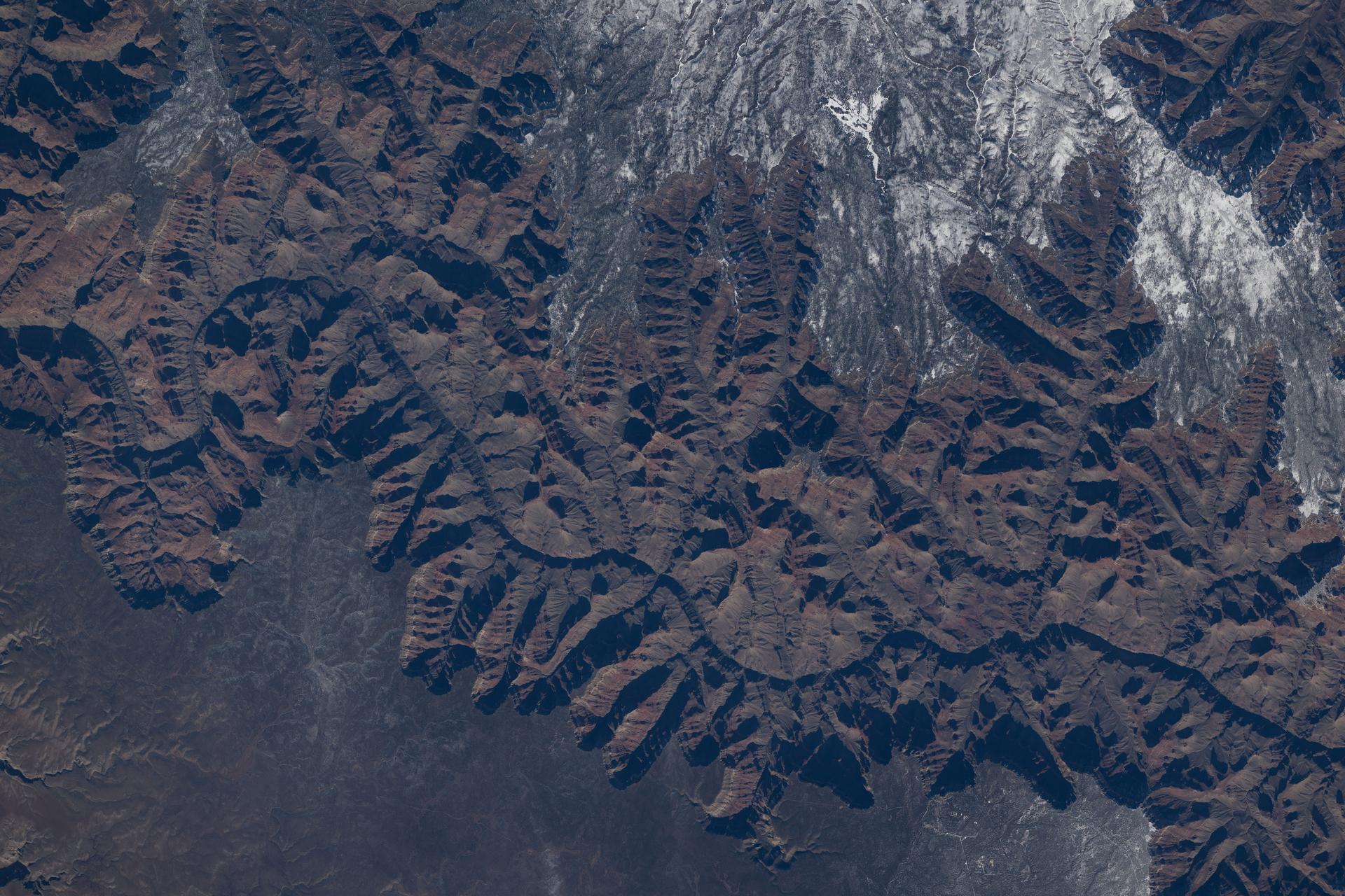
iss074e0208848 (Jan. 26, 2026) --- The Colorado River began carving the Grand Canyon—one of the Seven Natural Wonders of the World and a UNESCO World Heritage Site in Arizona—about 5 to 6 million years ago. This photograph was taken from the International Space Station as it orbited 260 miles above the Colorado Plateau in the southwestern United States.
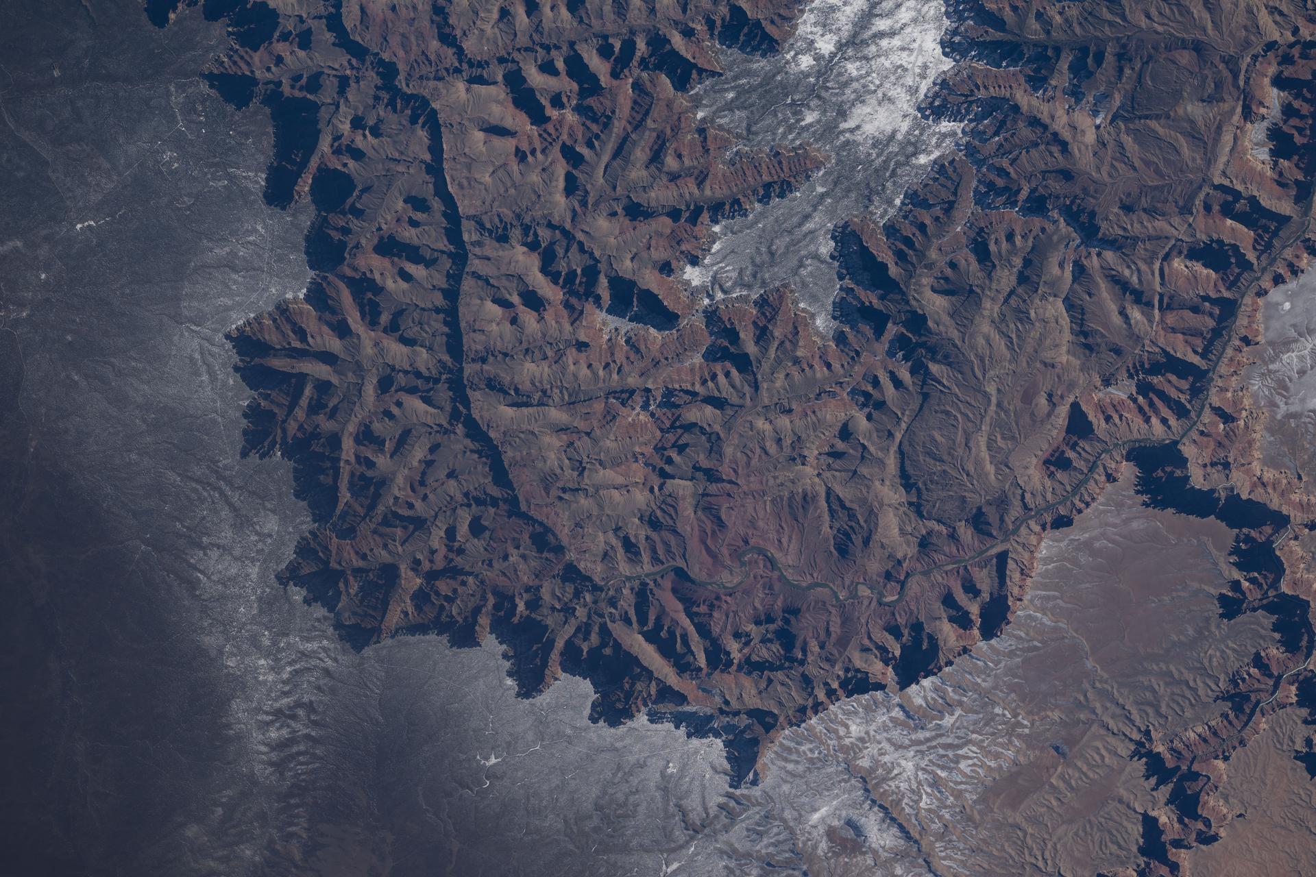
iss074e0208838 (Jan. 26, 2026) --- The Colorado River began carving the Grand Canyon—one of the Seven Natural Wonders of the World and a UNESCO World Heritage Site in Arizona—about 5 to 6 million years ago. This photograph was taken from the International Space Station as it orbited 260 miles above the Colorado Plateau in the southwestern United States.
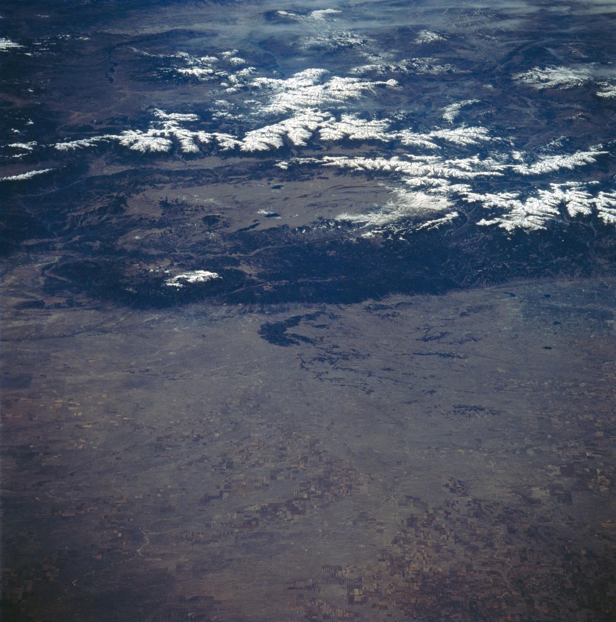
SL4-138-3875 (February 1974) --- A color oblique photograph looking east over the Rocky Mountains and Great Plains. This view covers a portion of the States of Colorado, Wyoming, and Nebraska. A Skylab 4 crewmen took this picture with a hand-held 70mm Hasselblad camera. This entire region, covered with a blanket of snow, depicts much of the structural and topographic features of the Rocky Mountain chain. Man's only apparent change to the snow pattern seen here is the (right center) metropolitan areas of Denver and Colorado Springs, Colorado, which can be observed along the eastern edge of the mountain front. Grand Junction, Colorado on the western slope of the Rocky Mountains is just off the photograph at left center bottom. The major inter-montane valleys of South Park (right center), Middle Park (center), and North Park (left center) are clearly visible and separate the Colorado Rockies Front Range from the high rugged mountains can be discovered such as Pikes Peak near right border (center), Mt. Cunnison region, circular feature accentuated by the Cunnison River (dark) in the right center (bottom) of the photograph. The snow covered peaks of Mts. Harvard, Princeton and Yale form the high region of the Collegiate Range which is the pronounced mountain area in the right center. Snow cover not only enhances mountain features but also the drainage patterns. East of Denver (right corner) the sinuous trace of the South Platte River (center) and its junction with the North Platte River near North Platte, Nebraska. Lake McConaughy in Nebraska is the body of water (black) near the river intersection. The trace of the Republic River in southern Nebraska is visible near the right corner of the photography. Geologic and hydro logic studies using this photograph will be conducted by Dr. Roger Morrison, U.S. Geological Survey. Photo credit: NASA
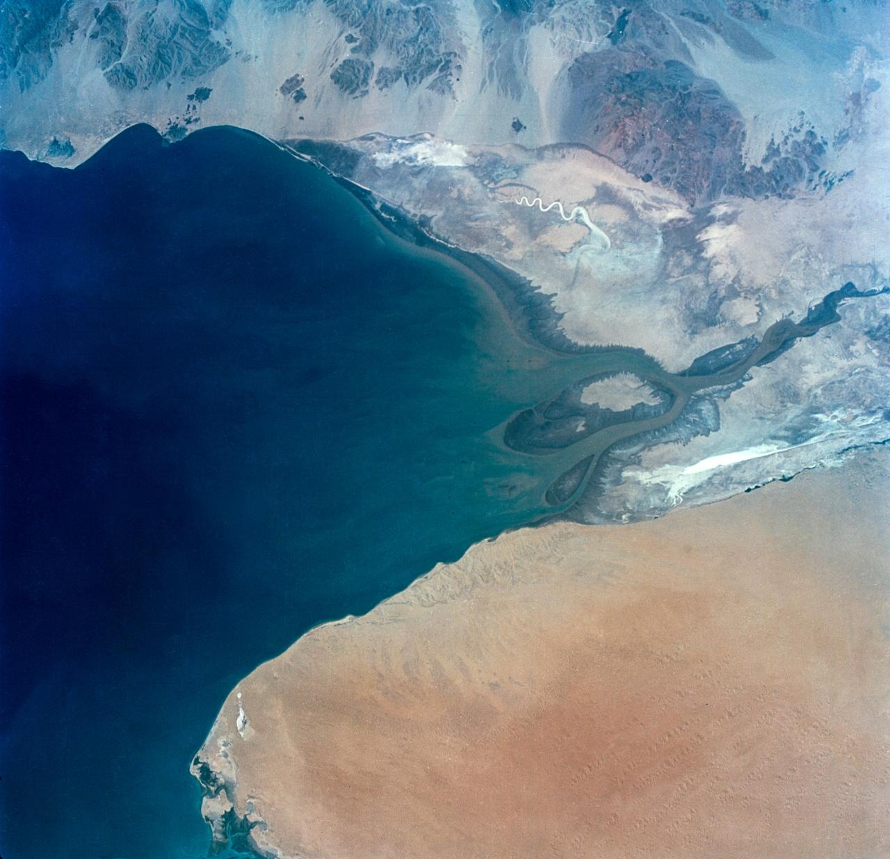
S65-34673 (3-7 June 1965) --- This photograph shows the north end of the Gulf of California at the mouth of the Colorado River as it was seen from the Gemini-4 spacecraft during orbital flight June 3-7, 1965. This picture was part of the Synoptic Terrain Photography experiments conducted during the flight to obtain high quality photographs of large land areas already mapped by aerial photography. In charge of these experiments was Dr. Paul D. Lowman Jr., NASA geologist from Goddard Space Flight Center, Greenbelt, Md. This picture was taken with a modified 70mm Hasselblad camera using Eastman color film, ASA 64 at a lens setting of 250th of a second at f/11.
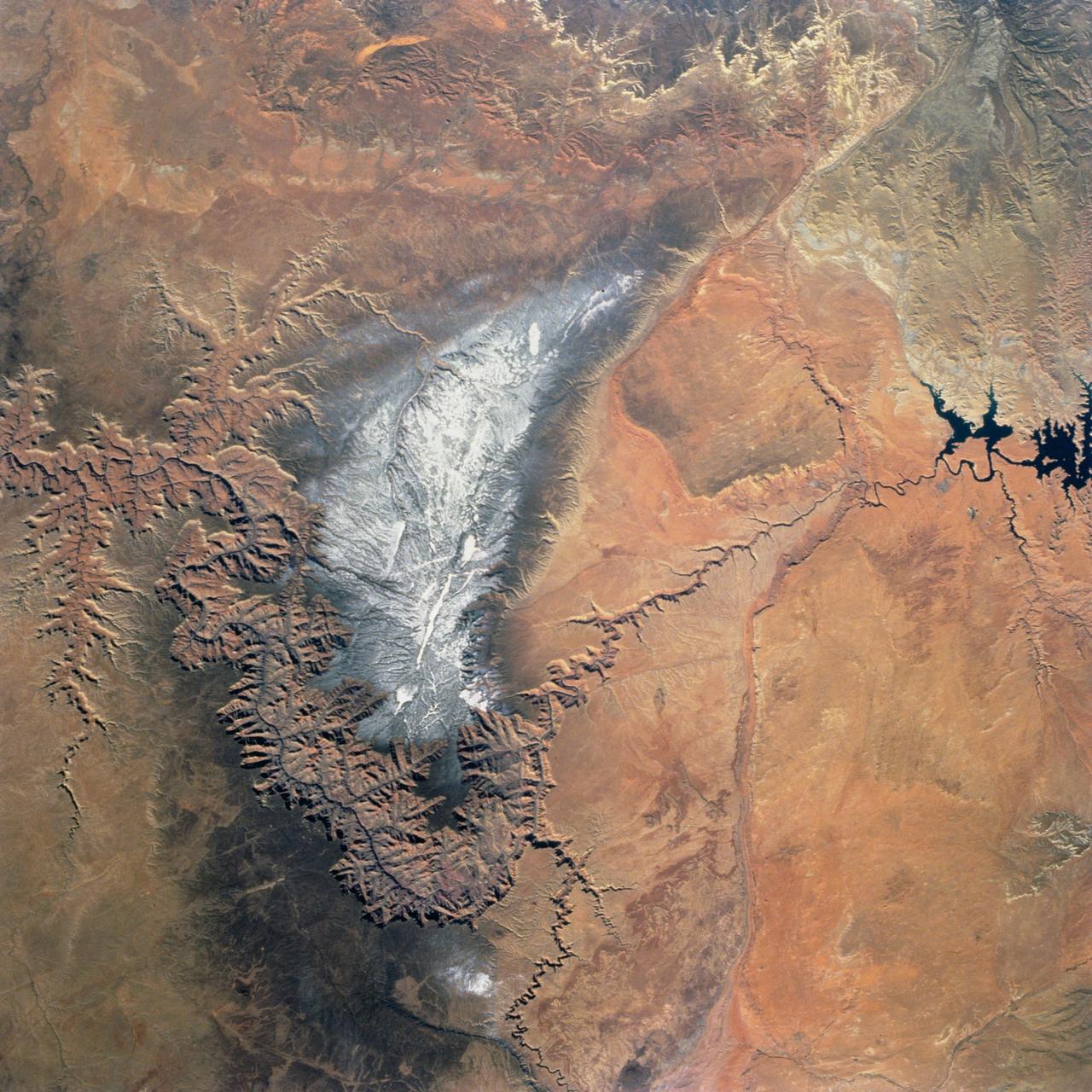
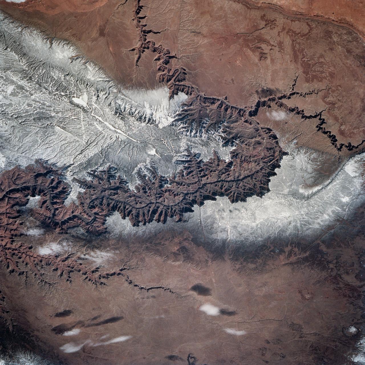
Snow covers the Kaibab Plateau on the northern side of the Colorado River in this November, 1994 view of the Grand Canyon. North is to the bottom of this view. The Colorado River has created a canyon which cuts through billions of years of geologic time. The Grand Canyon is 446 kilometers (277 miles) long, averages 16 kilometers (10 miles) wide, and is approximately 1.6 kilometers (1 mile) deep. The Coconino Plateau is located on the upper left side of the view, or to the south of the Colorado River. The direction of the flow of the Colorado River is from the east to the west. Eventually the river turns south and empties into the Gulf of California. The southern portion of Lake Powell in Utah can be seen at the bottom center of the view.
This dramatic view looks west along the Cucharas River Canyon in Colorado toward the 4,152 meter 13,623 ft high Spanish Peaks, in the foothills of the Sangre De Cristo Mountains.
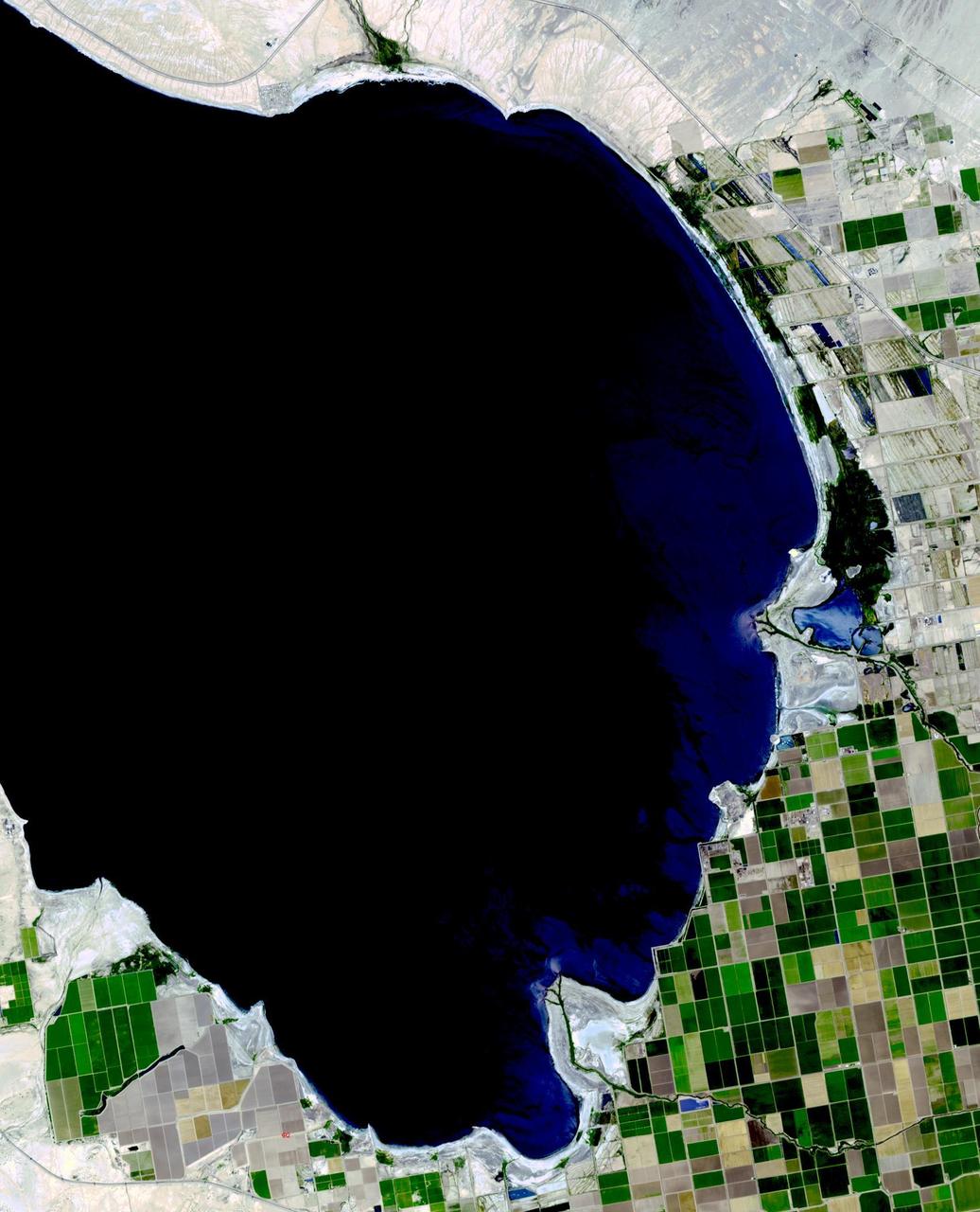
The Salton Sea in south California was created in 1905 when spring flooding on the Colorado River breached a canal. For 18 months the entire volume of the river rushed into the Salton Trough, creating a lake 32 km wide and 72 km long. In the 1950s, resorts sprang up along the shores. However, shrinking of the lake and increased salinity led to the abandonment of the resorts. The two images show the shrinking lake on May 31, 1984 (Landsat) and June 14, 2015 (ASTER). The images cover an area of 37.5 x 27 km, and are located at 33.2 degrees north, 115.7 degrees west. http://photojournal.jpl.nasa.gov/catalog/PIA19786
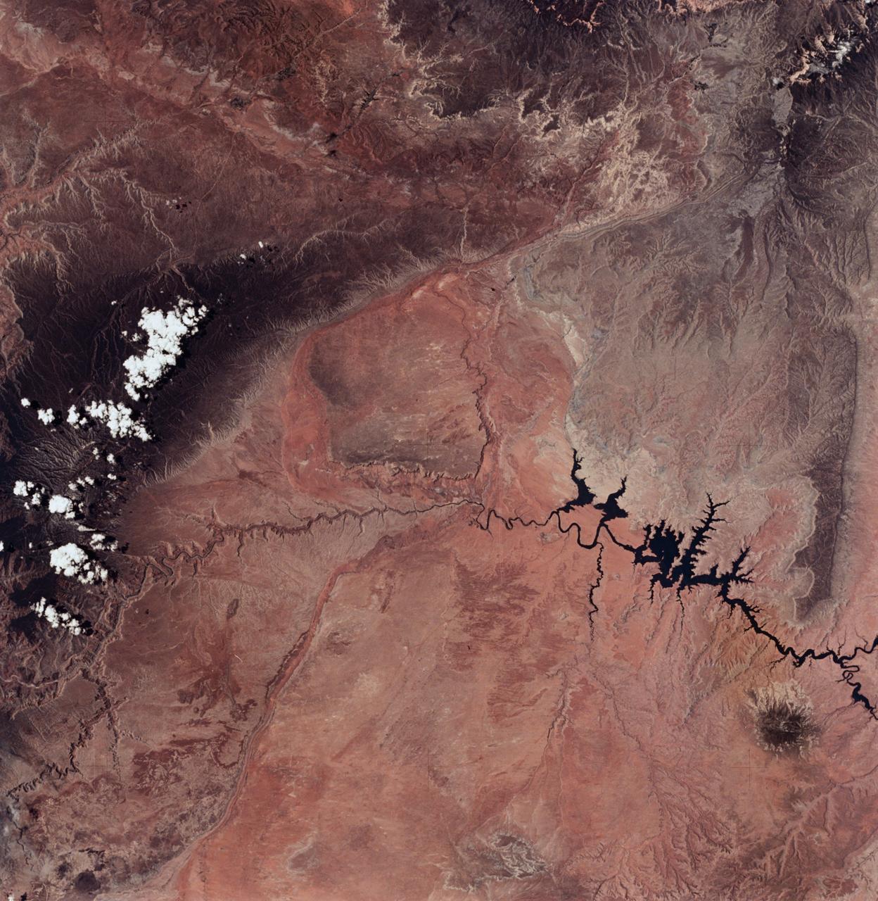
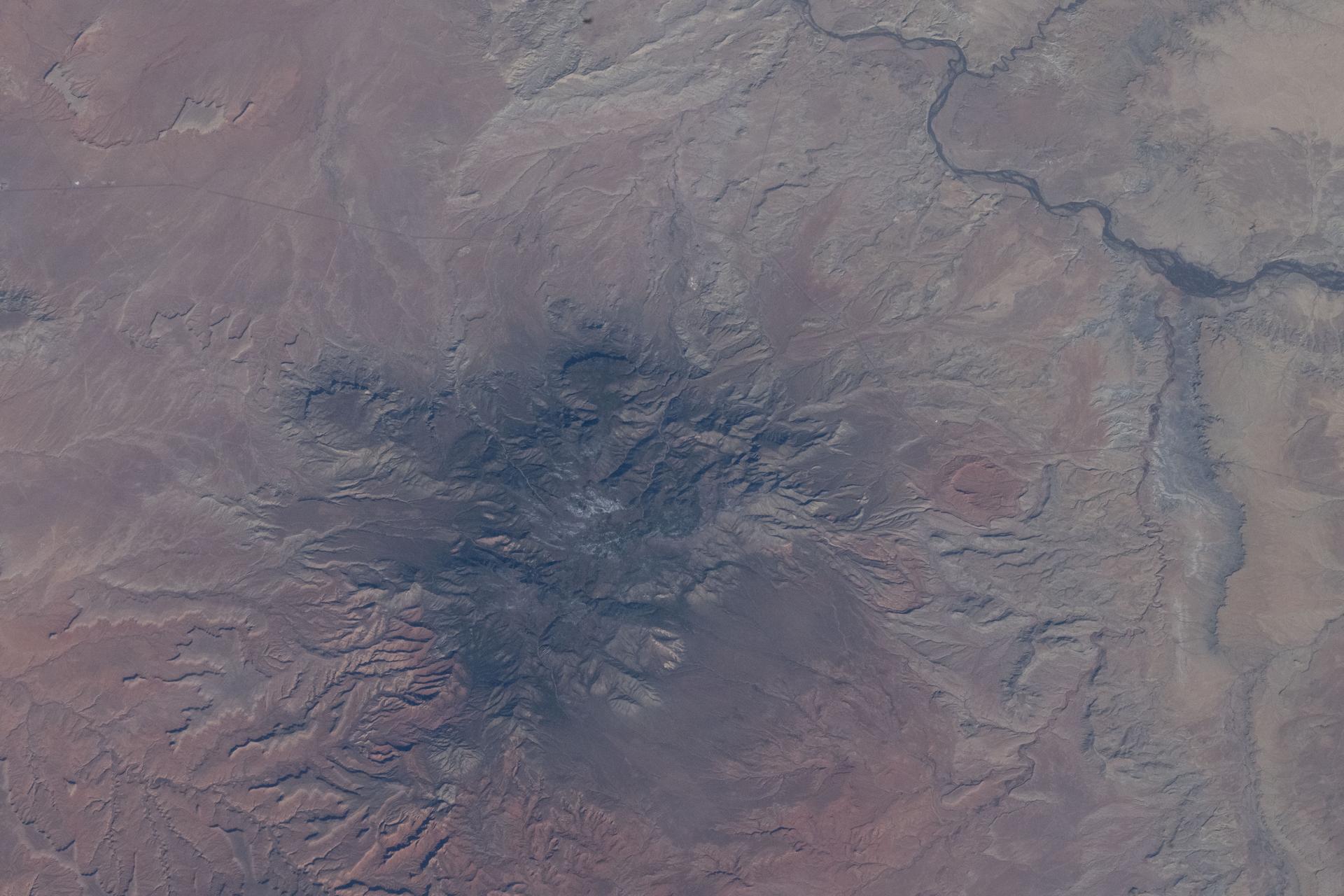
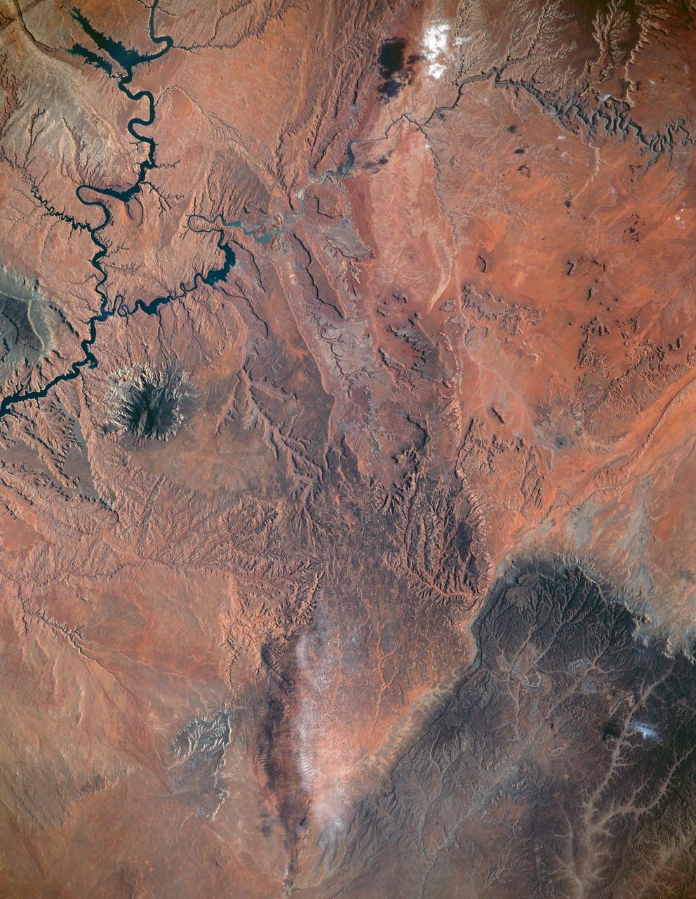
ISS034-E-066804 (12 March 2013) --- One of the Expedition 34 crew members aboard the Earth-orbiting International Space Station on March 12 , 2013 photographed this image of the Colorado Plateau, which spans northern Arizona, southern Utah, northwestern New Mexico and southwestern Colorado. This physiographic province is well known for its striking landscapes and broad vistas—an impression that is enhanced by the view from the orbital perspective of the space station. The image highlights part of the Utah-Arizona border region of the plateau and includes several prominent landforms. The Colorado River, dammed to form Lake Powell in 1963, crosses from east to west, (which is actually left to right in this image because the view looks toward the south, and north appears toward the bottom of the frame). The confluence of the Colorado and San Juan Rivers is also visible in the image. Sunglint, or sunlight reflected off a water surface back toward the observer, provides a silvery. Mirror-like sheen to some areas of the water surfaces. The geologic uplift of the Colorado Plateau led to rapid down cutting of rivers into the flat sedimentary bedrock, leaving spectacular erosional landforms. One such feature – the Rincon ---preserves evidence of a former meander bend of the Colorado River. Photo credit: NASA
iss064e002258 (Oct. 28, 2020) --- The upper Gulf of California and Colorado River Delta Biosphere Reserve in Mexico is pictured from the International Space Station.
SL2-81-014 (22 June 1973) --- Desert and mountain scenery along the Utah/Colorado border are displayed in this scene of the Canyonlands National Park, UT (39.0N, 110.0W). The park occupies the near center of the image, displaying spectacular incised meanders and the bulls-eye structure of Upheaval Dome (a salt dome). The Green River and the Colorado River flow southward to join (off scene) before flowing through the Grand Canyon National Park. Photo credit: NASA
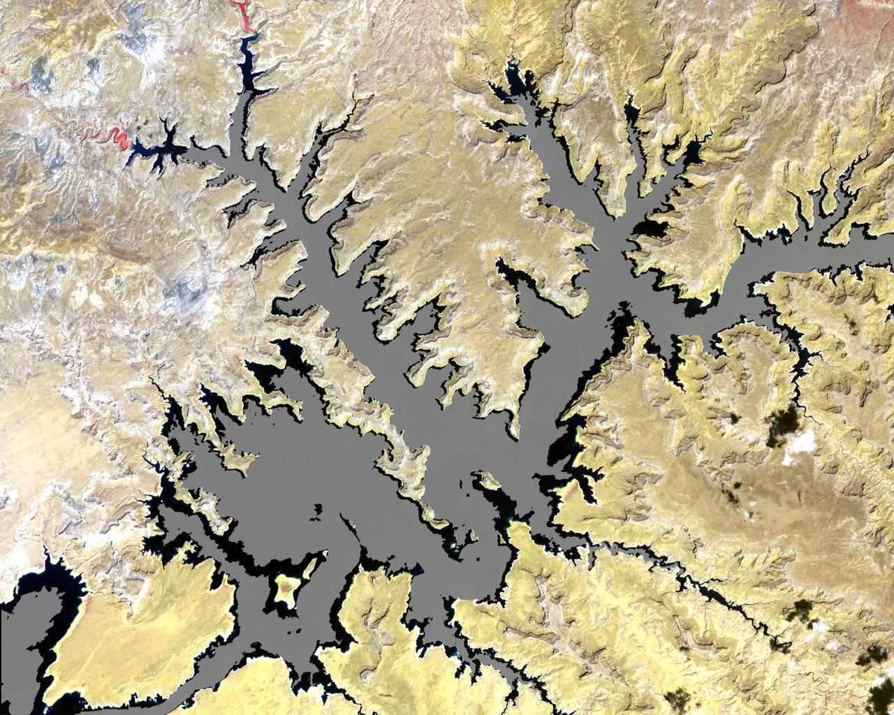
The white ring around Lake Powell tells the story. The surface is down 98 feet. This is critical, because Powell, Lake Mead, and other lakes along the Colorado River provide water for millions of people in five states. We are in the eighth year of a drought on the Colorado River. This year was the driest year ever reported in Southern California, and there is a severe drought in Northern California, down to less than 30-percent of snow pack. This ASTER image of part of Lake Powell was acquired in 2001. The gray area depicts the shrunken, reduced 2007 lake extent compared to the extended, larger black area in 2001. The image covers an area of 24 x 30 km, and is centered near 37.1 degrees north latitude, 111.3 degrees west longitude. This image from NASA Terra satellite. http://photojournal.jpl.nasa.gov/catalog/PIA10614
STS073-727-045 (21 October 1995) --- Photographed by the astronauts aboard the Space Shuttle Columbia is this scene over Lake Powell. The lake was formed by the Glen Canyon Dam on the Colorado River. The vertical stabilizer of Columbia points northeastward. Navaho Mountain, northwest of the tail, according to NASA geologists, was formed by an intrusion of molten rock that uplifted older, layered rocks, then cooled, and has been exposed by erosion. The rest of the landscape is dominated by faulted layers of sandstone, shale, and limestone that were formed in shallow seas and great deserts 80 to 250 million years ago. These rocks of the Colorado Plateau were uplifted a few million years ago to be dissected by the meandering Colorado River, San Juan River, and their tributaries.
ISS015-E-08879 (18 May 2007) --- An evaporation pond near the Colorado River in Utah is featured in this image photographed by an Expedition 15 crewmember on the International Space Station.
iss068e015308 (Oct. 11, 2022) --- Moab, Utah, and the Colorado River are pictured from the International Space Station as it orbited 262 miles above the Beehive State. Credit: NASA/Kjell Lindgren
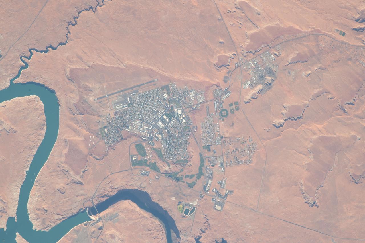
iss056e094592 (July 10, 2018) --- The city of Page, Ariz., the Colorado River and Glen Canyon Dam which forms Lake Powell are pictured as the International Space Station's orbital trek took it over the southwestern United States.
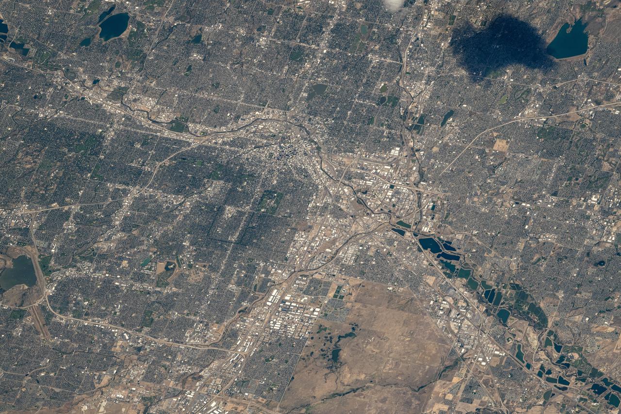
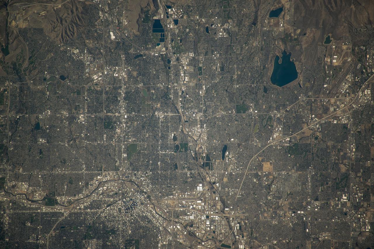
iss071e516877 (Aug. 18, 2024) --- Denver, Colorado, the Centennial State's capital city with a population of over 715,000, and its suburbs along the South Platte River are pictured from the International Space Station as it orbited 260 miles above.
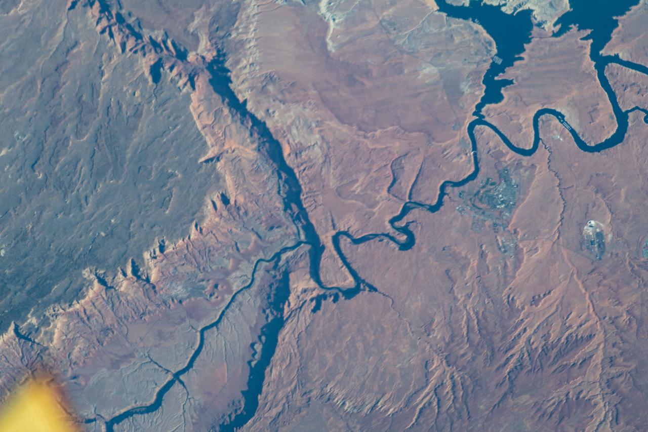
iss063e010159 (May 7, 2020) --- The Colorado River, Horseshoe Bend and a portion of Lake Powell, located in Arizona, is pictured from the International Space Station as it orbited above the southwestern United States.
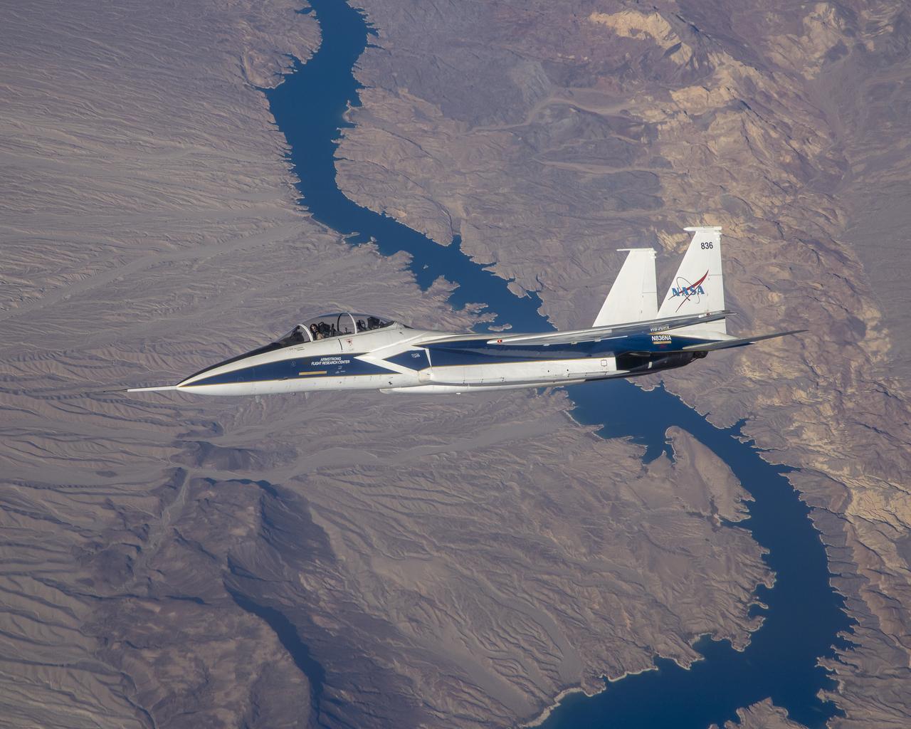
F-15 N836NA with test pilots Nils Larson and Jim Less at the controls flying over the Colorado River during Shock Sensing Probe (SSP) Flight #6.
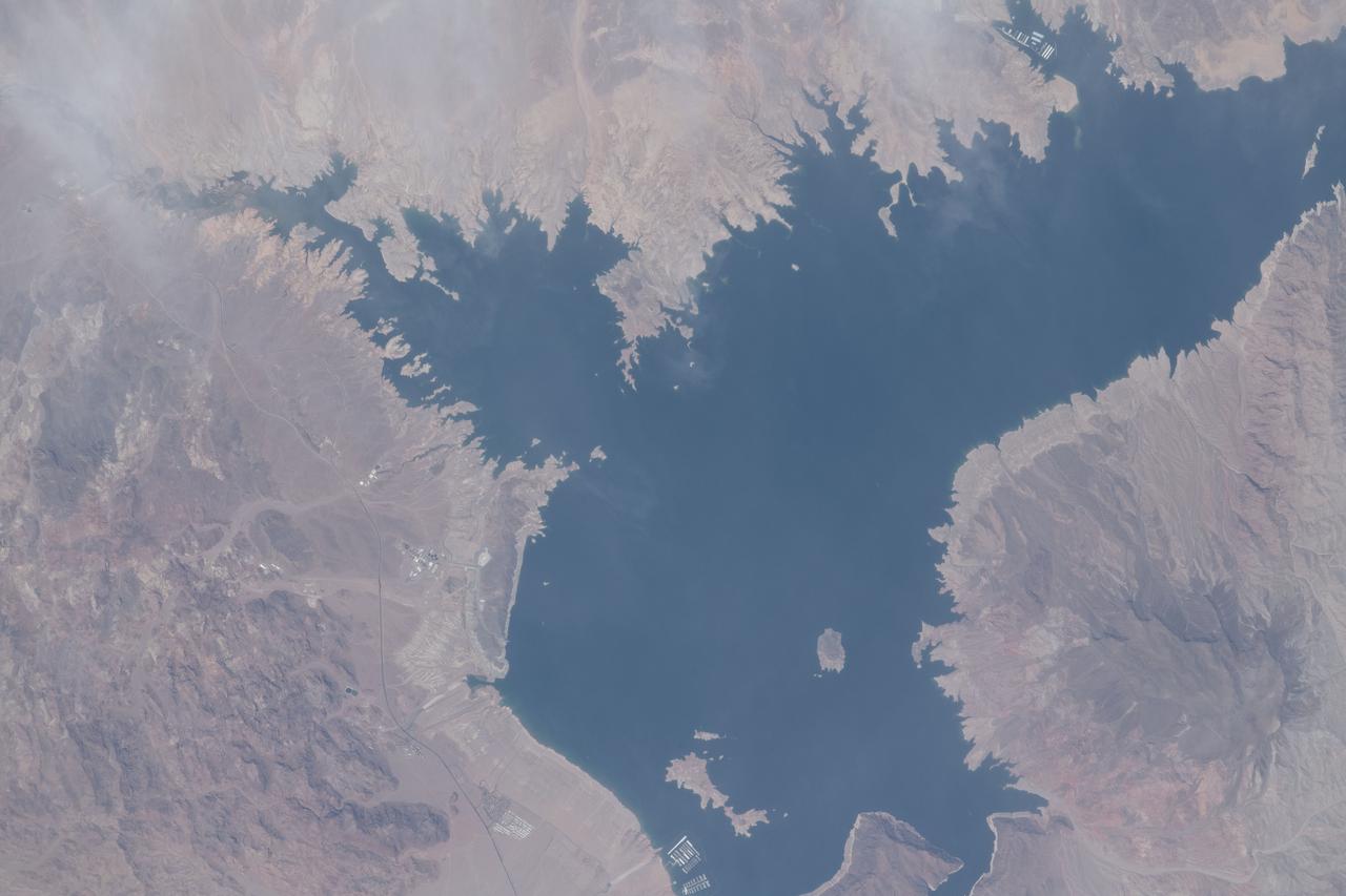
iss065e001327 (April 20, 2021) --- The Colorado River, pictured from the International Space Station at an altitude of 263 miles, separates Arizona from Nevada. The smaller body of water at center left is Las Vegas Bay.
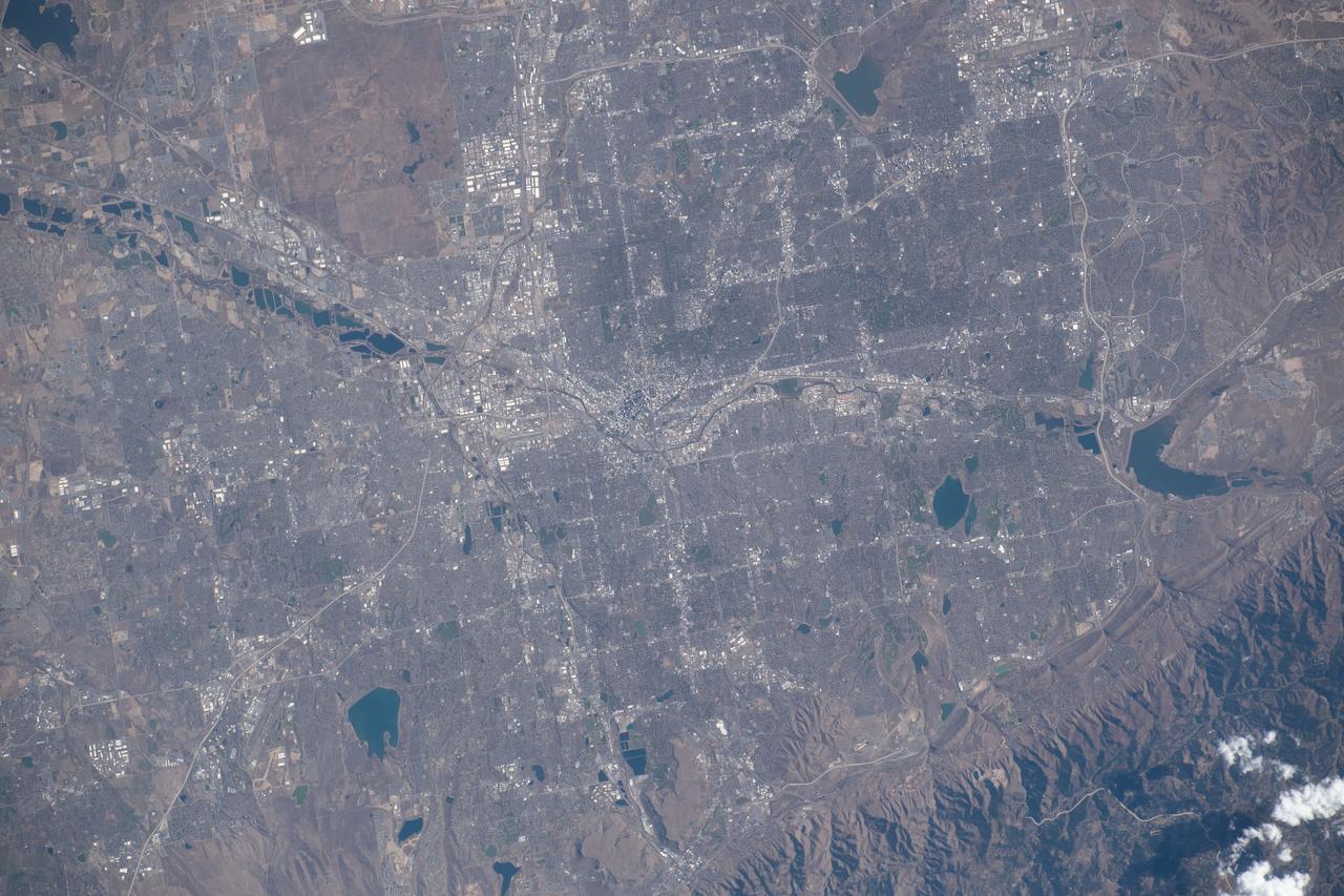
iss070e008429 (Oct. 22, 2023) --- Denver, Colorado, split by the South Platte River and next to the Rocky Mountains, is pictured from the International Space Station as it orbited 262 miles above the Centennial State.

AS09-26A-3781A (11 March 1969) --- Colored infrared photograph of the mouth of the Colorado River in northern Baja California and Sonora, Mexico, as seen from Apollo 9 spacecraft during its 121st revolution of Earth. Photographed from an altitude of 130 nautical miles, at 16:14 GMT, on March 11, 1969. Color infrared film is designed to render healthy green foliage as tones of red, such as the red checker-board patterns in the irrigated farm lands along the Colorado River. Red hues of vegetation can be seen in the valleys and on the slopes of the San Pedro Martia and Juarez Mountains, at left. White ribbon-like salt lakes near the river mouth and the wide expanse of sand dunes in the Great Desert, at right, are evidence of the arid climate. Light colors of silt bands in the waters of the Gulf of California reflect currents and water depths. The town of San Felipe is on the Gulf coast at lower left.

STS098-714A-049 (16 February 2001) --- Demonstrating the power of water erosion, this orbital view photographed by the crew of Atlantis during STS-98 on February 16, 2001, as the spacecraft orbited the earth at an altitude of 173 nautical miles (320 kilometers), shows Lake Powell at the headwaters of the Colorado River in southwestern Utah. The river over eons has carved out Arizona's mile deep and 270 mile long Grand Canyon. Prominent in this scene is the Kaibab Plateau at the head of the canyon where the big bend of the Colorado River has eroded the plateau into a peninsula. This plateau, directly across the canyon from the South Rim Visitor's Center, is at the widest part of the canyon, about 12 miles. The Kaibab Indian Reservation and the Kaibab National Forest are visible in the picture.

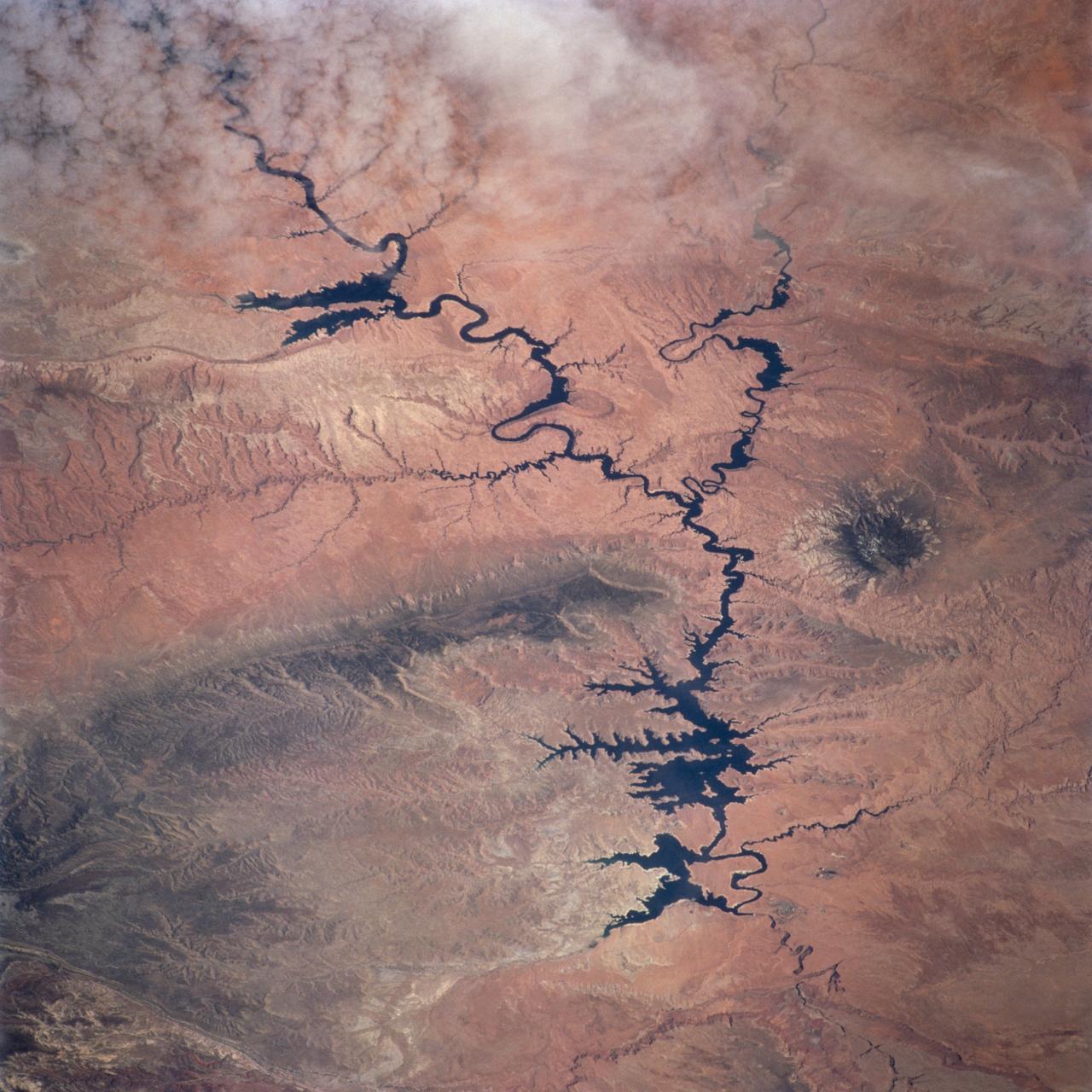
ISS031-E-006398 (30 April 2012) --- Lake Powell and the Rincon in Utah are featured in this image photographed by an Expedition 31 crew member on the International Space Station. This photograph highlights part of Lake Powell; the lake extends across southeastern Utah and northeastern Arizona. Lake Powell started filling in 1963 when the Glen Canyon Dam on the Colorado River in Arizona was completed, and Glen Canyon flooded. The serpentine water surface of the reservoir-highlighted by gray regions of sunglint-follows the incised course of the canyon. Today Lake Powell is part of the Glen Canyon National Recreation Area which extends for more than 186 miles along the shoreline and side canyons. The primary intended use of Lake Powell?s water is support of agricultural production, with a small portion allocated to urban use in Arizona, Nevada, and California. The reservoir did not reach its maximum capacity of 27 million acre-feet until 1980. More recently, extended drought conditions in the southwestern United States over the past decade have resulted in a significant lowering of the Lake water level and emergence of parts of Glen Canyon. Should average precipitation in the Colorado River watershed lessen (as predicted by regional climate change models), that could result in further lowering of the Lake Powell water level and changes to the current water management plans. Fluctuations in water levels and change of river courses are a common occurrence seen in the geologic record of rivers. Looking somewhat like a donut or automobile tire from the vantage point of the space station, the Rincon (center) is an entrenched and abandoned meander, or loop, of the Colorado River, thought to have formed several thousand years ago when the river cut straight across the ends of the loop and shortened its course by six miles. The resulting canyon and 600 ? 750 feet-high central mesa indicate where the river used to flow. The term ?Rincon? also is used by geomorphologists to describe similar ancient river features observed elsewhere. The Goosenecks of the San Juan River are an example of an active entrenched meander.
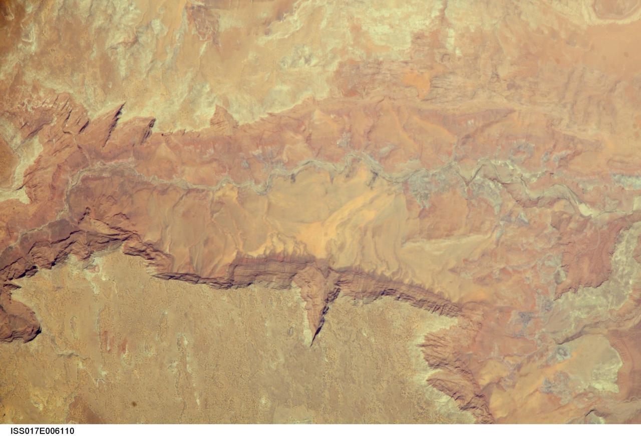
ISS017-E-006110 (2 May 2008) --- Vermilion Cliffs and Paria River, Arizona are featured in this image photographed by an Expedition 17 crewmember on the International Space Station. The largest tributary of the Colorado River between Lake Powell and the Grand Canyon, the Paria River flows southeast from headwaters in southernmost Utah to join the Colorado River between Page, AZ and Marble Canyon. The Paria River provides spectacular scenery, and is known for the very narrow "slot" canyons that it cuts through the layered rocks of the Colorado Plateau. According to scientists, these canyons formed over millions of years by water erosion slicing deep into the rock layers. Exploring the river channel through the slot canyons is a popular activity for hikers and backpackers. Indeed, there is no road access to much of the river channel, and hiking in on foot is the only way to experience the slot canyons. The Paria River also exposes the red and white layers of rocks beneath the Paria Plateau that are known as the Vermilion Cliffs (center). Scientists say that these rocks record the changing environmental conditions of the region during the early Mesozoic Era, ranging from widespread deserts to more water-rich periods when rivers flowed across the landscape. The spectacular scenery of the Vermilion Cliffs and Paria Canyon falls within the Vermilion Cliffs National Monument. This rugged and remote landscape is also home to many species of raptors -- including the California condor -- and other desert fauna such as bighorn sheep.
Lake Mead, America's largest reservoir, on the Colorado River between Nevada and Arizona, has shrunk to historic lows, dropping to about 30% of its capacity. The reservoir provides water to 25 million people in California, Arizona, Nevada, and Mexico. The water level has fallen from 1204 feet in 2000, to an all-time low of 1049" yesterday. The images were acquired May 19, 2000 and May 25 2022, cover an area of 20.5 by 34.9 km, and are located at 36.1 degrees north, 114.6 degrees west. https://photojournal.jpl.nasa.gov/catalog/PIA25279
STS112-707-035 (7-18 October 2002) --- The Colorado River snakes across this view, photographed from the Space Shuttle Atlantis, from top left (near the vehicle’s vertical stabilizer), to the lower right, where the Grand Canyon gorge can be detected. The wider blue parts of the Colorado in the center of the view are Lake Powell, an artificial lake more than 120 miles long. The dark green areas are wooded slopes generally above 6000 feet. The Kaibab Plateau (lower left) and the range with Abajo Peak (11,360 feet, Utah-Colorado border region) cross the top of the view. The red areas are lower and semiarid, dominated by desert scrub vegetation.
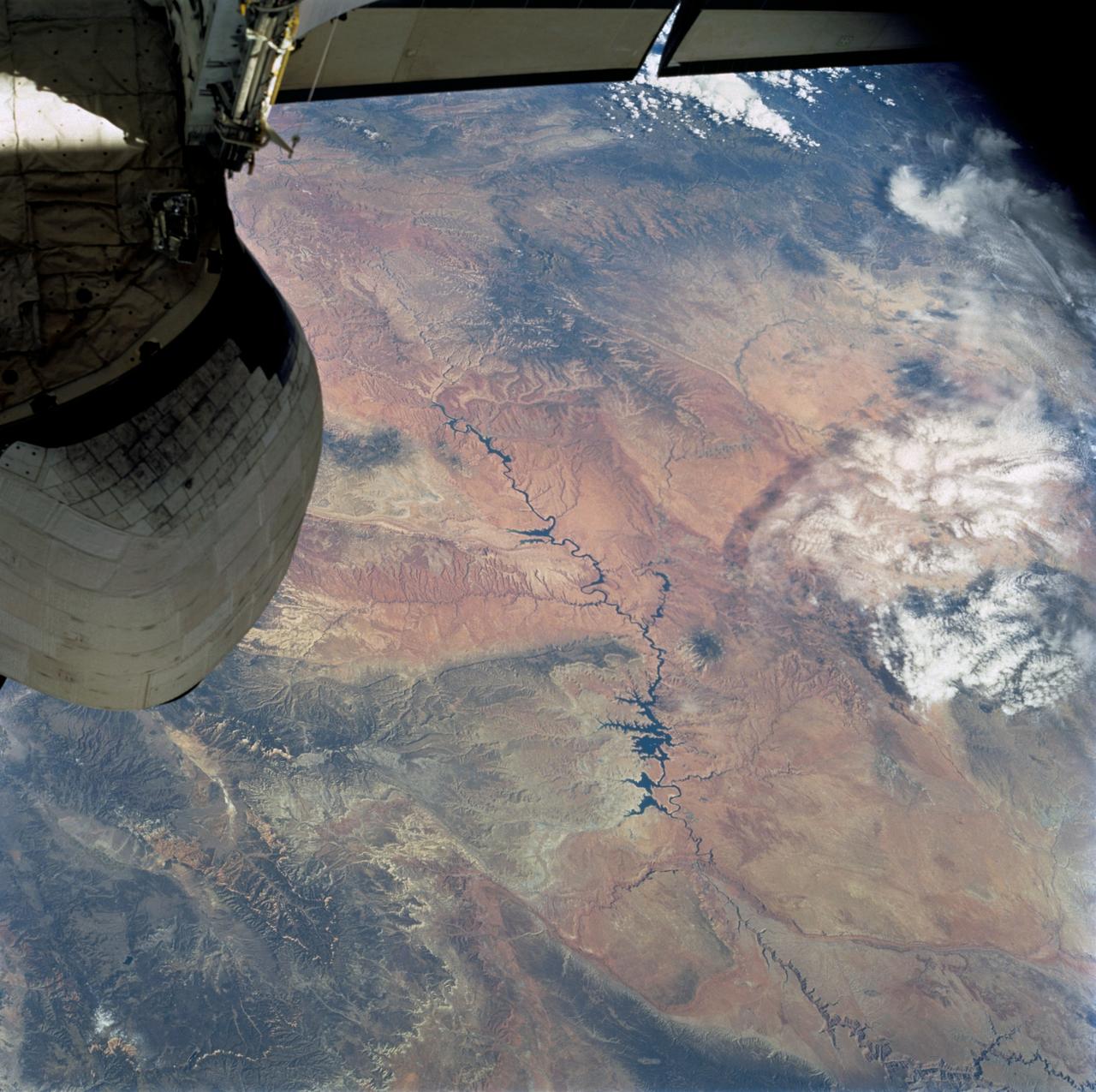
ISS015-E-28002 (12 Sept. 2007) --- A section of Dinosaur National Monument along the Yampa River in Colorado, which straddles the Colorado/Utah border, is featured in this image photographed by an Expedition 15 crewmember on the International Space Station. Dinosaur National Monument is perhaps best known for the abundant fossils found in the approximately 145 Ma (mega-annum, or millions of years old) Morrison Formation exposed in valleys and low ridges, according to scientists. The fossil assemblage is a unique record of terrestrial life of the period (dinosaurs, plants, and other animal species). Remains accumulated in streams and shallow lakes and were swiftly buried (and preserved) by sediments associated with those environments. Scientists believe these sediments in turn were lithified over many millions of years as they were buried under younger deposits -- forming the distinctive stratigraphy of the Monument. The generally flat-laying "layer cake" geology of the region -- similar to the Colorado Plateau to the south - is expressed in the image by parallel beds of tan, reddish-brown, and gray-brown sedimentary rocks cut by the Yampa River at the northern end of the Monument (top). Erosion by the Yampa River exposed the Morrison layer and its trove of fossil material. Together with other fossils found in both older and younger rock layers in the area, the Dinosaur National Monument remains an important scientific resource that continues to provide new insights into the geologic history and paleoecology of the region.
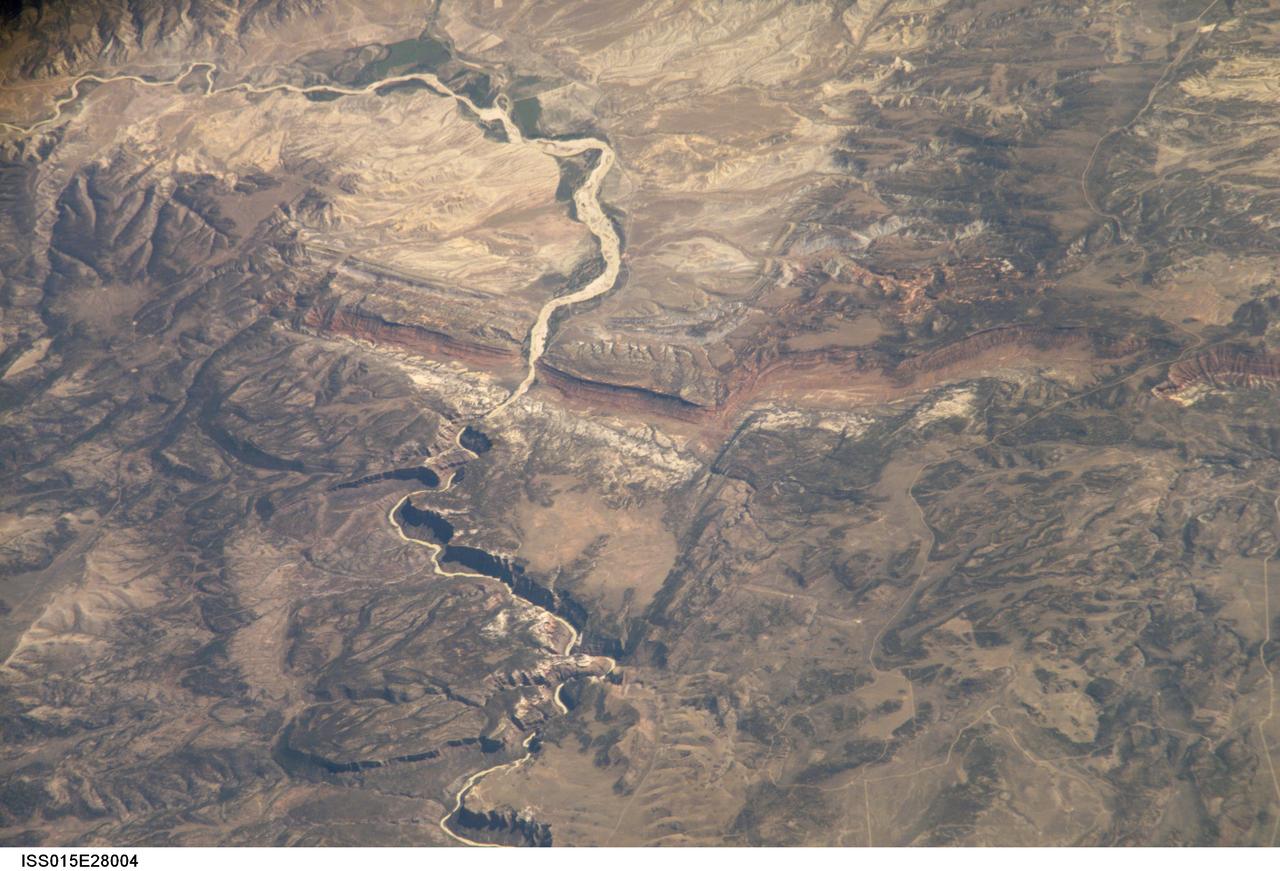
ISS015-E-28004 (12 Sept. 2007) --- A section of Dinosaur National Monument along the Yampa River in Colorado, which straddles the Colorado/Utah border, is featured in this image photographed by an Expedition 15 crewmember on the International Space Station. Dinosaur National Monument is perhaps best known for the abundant fossils found in the approximately 145 Ma (mega-annum, or millions of years old) Morrison Formation exposed in valleys and low ridges, according to scientists. The fossil assemblage is a unique record of terrestrial life of the period (dinosaurs, plants, and other animal species). Remains accumulated in streams and shallow lakes and were swiftly buried (and preserved) by sediments associated with those environments. Scientists believe these sediments in turn were lithified over many millions of years as they were buried under younger deposits -- forming the distinctive stratigraphy of the Monument. The generally flat-laying "layer cake" geology of the region -- similar to the Colorado Plateau to the south - is expressed in the image by parallel beds of tan, reddish-brown, and gray-brown sedimentary rocks cut by the Yampa River at the northern end of the Monument (top). Erosion by the Yampa River exposed the Morrison layer and its trove of fossil material. Together with other fossils found in both older and younger rock layers in the area, the Dinosaur National Monument remains an important scientific resource that continues to provide new insights into the geologic history and paleoecology of the region.
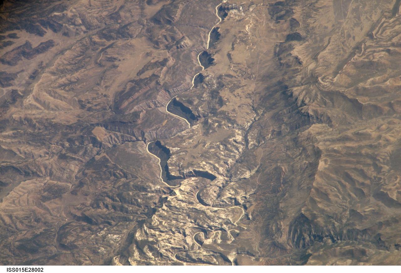
ISS015-E-28003 (12 Sept. 2007) --- A section of Dinosaur National Monument along the Yampa River in Colorado, which straddles the Colorado/Utah border, is featured in this image photographed by an Expedition 15 crewmember on the International Space Station. Dinosaur National Monument is perhaps best known for the abundant fossils found in the approximately 145 Ma (mega-annum, or millions of years old) Morrison Formation exposed in valleys and low ridges, according to scientists. The fossil assemblage is a unique record of terrestrial life of the period (dinosaurs, plants, and other animal species). Remains accumulated in streams and shallow lakes and were swiftly buried (and preserved) by sediments associated with those environments. Scientists believe these sediments in turn were lithified over many millions of years as they were buried under younger deposits -- forming the distinctive stratigraphy of the Monument. The generally flat-laying "layer cake" geology of the region -- similar to the Colorado Plateau to the south - is expressed in the image by parallel beds of tan, reddish-brown, and gray-brown sedimentary rocks cut by the Yampa River at the northern end of the Monument (top). Erosion by the Yampa River exposed the Morrison layer and its trove of fossil material. Together with other fossils found in both older and younger rock layers in the area, the Dinosaur National Monument remains an important scientific resource that continues to provide new insights into the geologic history and paleoecology of the region.
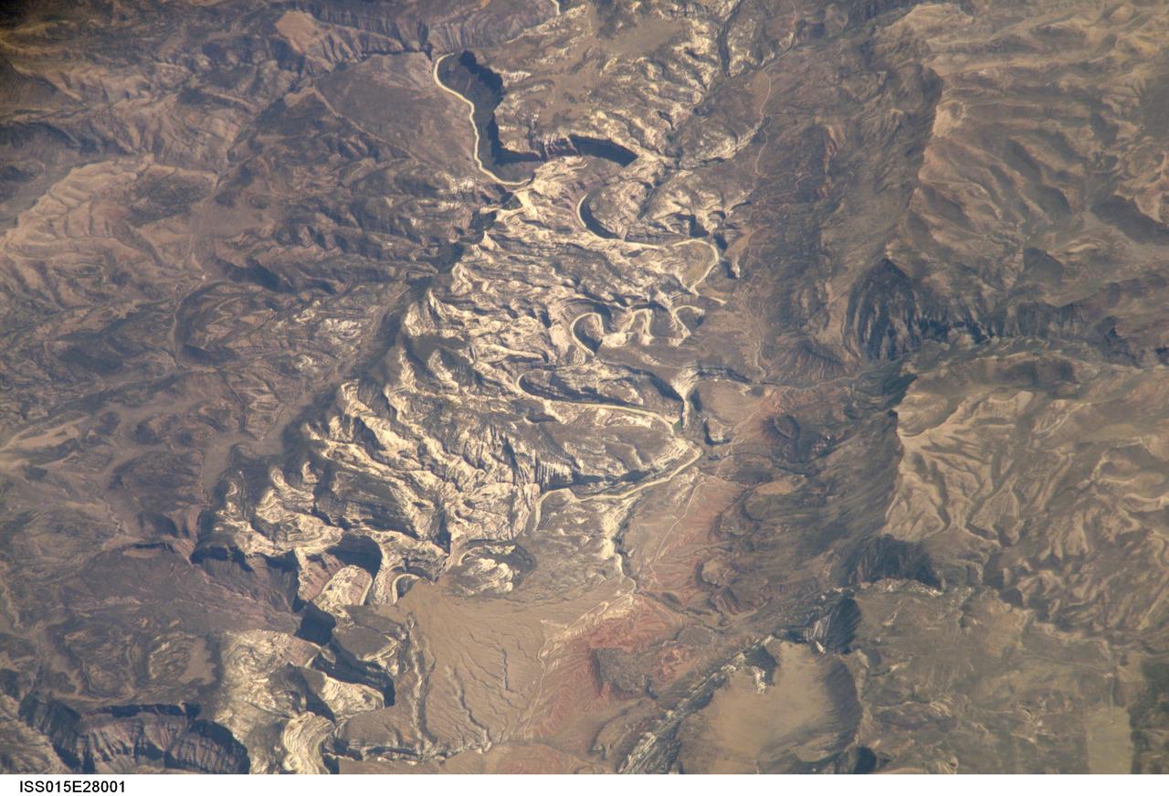
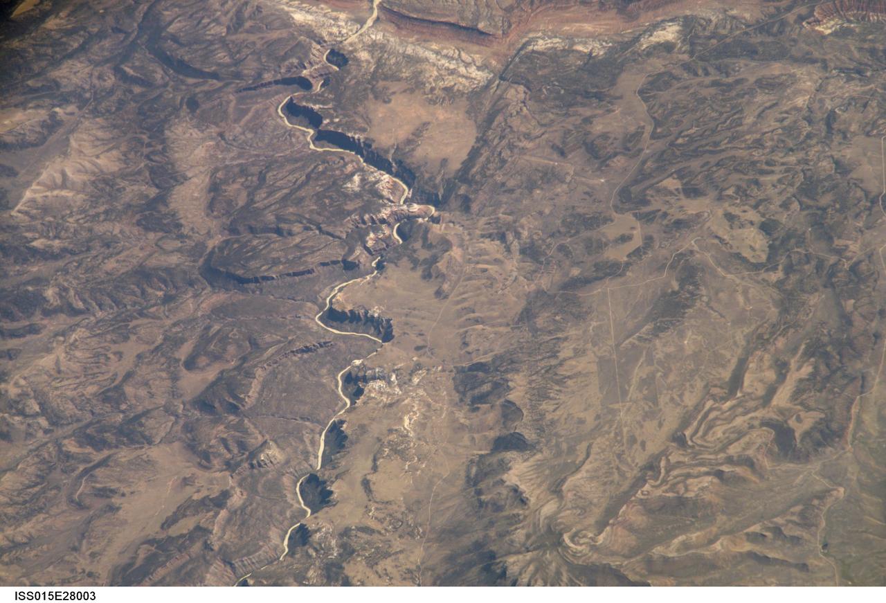
ISS015-E-28001 (12 Sept. 2007) --- A section of Dinosaur National Monument along the Yampa River in Colorado, which straddles the Colorado/Utah border, is featured in this image photographed by an Expedition 15 crewmember on the International Space Station. Dinosaur National Monument is perhaps best known for the abundant fossils found in the approximately 145 Ma (mega-annum, or millions of years old) Morrison Formation exposed in valleys and low ridges, according to scientists. The fossil assemblage is a unique record of terrestrial life of the period (dinosaurs, plants, and other animal species). Remains accumulated in streams and shallow lakes and were swiftly buried (and preserved) by sediments associated with those environments. Scientists believe these sediments in turn were lithified over many millions of years as they were buried under younger deposits -- forming the distinctive stratigraphy of the Monument. The generally flat-laying "layer cake" geology of the region -- similar to the Colorado Plateau to the south - is expressed in the image by parallel beds of tan, reddish-brown, and gray-brown sedimentary rocks cut by the Yampa River at the northern end of the Monument (top). Erosion by the Yampa River exposed the Morrison layer and its trove of fossil material. Together with other fossils found in both older and younger rock layers in the area, the Dinosaur National Monument remains an important scientific resource that continues to provide new insights into the geologic history and paleoecology of the region.
iss073e1199153 (Nov. 29, 2025) --- Pastora Peak, rising to 9,413 feet (2,869 meters) inside Arizona's Navajo Nation near the New Mexico border, is seen from the International Space Station as it orbited 263 miles (423 kilometers) above the Grand Canyon State. At upper right, the San Juan River—a major tributary of the Colorado River—winds through New Mexico.

iss067e170414 (July 1, 2022) --- The Colorado River leads to Lake Buchanan (lower right) formed by the Buchanan Dam that provides water supply and hydroelectric power in Texas. The International Space Station was orbiting 262 miles above the Lone Star state at the time of this photograph.

AS6-02-1455 (4 April 1968) --- Texas is photographed from the Apollo 6 (Spacecraft 020/Saturn 502) unmanned space mission. Seen in this photograph are Midland, Brownfield, Big Spring, J. B. Thomas Lake, headwaters of Colorado and Brazos Rivers, and the west Texas gas and oil fields.
STS100-716-176 (19 April-1 May 2001) --- The deeply entrenched, meandering Colorado River is distinctively dark as the river winds its way across the arid terrain of southeast Utah in this 70mm frame photographed from the Earth-orbiting Space Shuttle Endeavour. While Glen Canyon Dam (bottom of image) is located in northern Arizona, the reservoir of Lake Powell is in Utah. The Escalante and San Juan Rivers, two major tributaries that flow into Lake Powell (from the northwest and east respectively) are also discernable. The darker-looking, elongated and elevated feature north of Lake Powell is the Kaiparowits Plateau. Navajo Mountain is the darker circular feature to the south (to the right) of the lake.
AS09-22-3341 (3-13 March 1969) --- Central Texas area as photographed from the Apollo 9 spacecraft during its Earth-orbital mission. Interstate 35 runs from Austin (right center edge of picture) to Waco (near bottom left corner). Also visible are the cities of Georgetown, Taylor, Temple and Killeen. The Colorado River runs through Austin. The Brazos River flows through Waco. Lake Travis is upstream from Austin. Lake Whitney is at bottom left corner of picture. The Belton Reservoir is near bottom center. The lake formed by the dam on the Lampasas River near Belton is also clearly visible.
STS040-151-123 (5-14 June 1991) --- This large format view shows parts of northern Arizona and southern Utah. San Juan River, Lake Powell and Monument Valley are visible. Water of Lake Powell can be seen filling the valleys of the Colorado and San Juan Rivers at the top of the image. The darker green areas indicate high, forested country of the lone Navajo Mountain (center left) and Black Mesa (bottom right). Strip mines can be seen south of the rim of Black Mesa. Monument Valley lies between the San Juan River and Black Mesa. Shadows thrown by the individual steep-sided hills make them stand out in the scene.
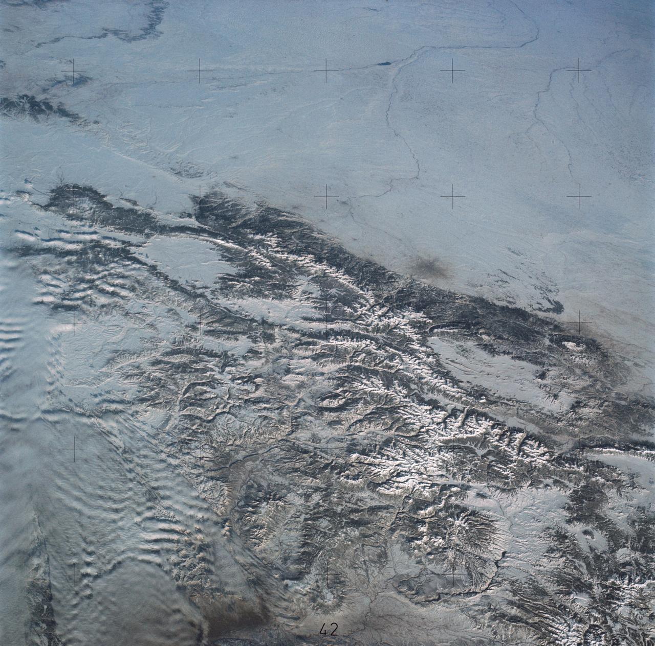
SL4-139-4040 (10 Jan. 1974) --- An oblique view of a portion of the Western United States, as photographed from the Skylab space station in Earth orbit by one of the Skylab 4 crewmen. The camera used was a hand-held 70mm Hasselblad, with SO-368 medium-speed Ektachrome film. This photograph is one of a stereo pair (the other being 4039) taken to support the hydrological studies of the changing snow patterns in several watersheds. Stereo analysis will enable snow to be distinguished from clouds quantitatively. In a qualitative sense, the clouds are the fuzzy white, whereas the snow is distinct white. The area covered is from the Colorado Springs, Colorado area at the south to (and beyond) the Black Hills, South Dakota area. The Black Forest between Colorado Springs and Denver is evident as are the mountains west of these cities. South Park, west of Colorado Springs, and the South Platte River running north and east from Denver are two other conspicuous features. Photo credit: NASA

A paper led by researchers at NASA's Jet Propulsion Laboratory estimates the total volume of water in Earth's rivers – called river storage – on average between 1980 and 2009, and maps out the results for the planet's major hydrological regions. This graphic, adapted from data gathered for the paper, indicates the amount of storage by hydrologic regions that contain one or more river basins, with shades of blue deepening as the amount of storage increases. The paper, published in Nature Geoscience in April 2024, calculated Earth's river storage at about 539 cubic miles (2,246 cubic kilometers), and found that the Amazon River basin, shown in dark blue in South America, was the region with the most storage, with 204 cubic miles (850 cubic kilometers), or about 38% of the global total. The study also estimated the flow of water through more than 3 million segments of river around the world and identified several locations marked by intense human water use, including parts of the Colorado River basin in the United States, portions of the Amazon basin in South America, the Orange River basin in southern Africa, and the Murray-Darling basin in southeastern Australia. https://photojournal.jpl.nasa.gov/catalog/PIA26119
STS060-83-004 (3-11 Feb 1994) --- In this winter scene of the Grand Canyon of Arizona, the canyon is particularly well revealed because snow lies on the rims of the canyon, and exits mid-right; the Little Colorado River enters from the left, joining the Colorado just upstream of its big bend. Visitors to the South Rim can view the canyon in both the east-west and north-south reaches. The South Rim is closer to centers of transportation so that tourists mostly see the canyon from this area, that is from about 7,000 feet. The canyon floor lies at 2,000 feet in this sector. The most heavily snow covered area is the highest, reaching more than 9,000 feet (bottom right). Visitors see this protected area by hiking and mule and helicopter rides. The ecology of this part of the Colorado has been changed since the building of a lake upstream: river water is now derived from snow melt water from the bottom of the lake. This water is much colder than the water which used to flow through the canyon. According to NASA scientists, the view is unusual because the snow also reveals so well the higher country around the canyon, a swath stretching from bottom right to middle left of the view. This higher swath is an arch of uplifted rocks known as the Kaibab Plateau, raised vertically by tectonic forces in the recent geologic past. Despite this up parching, the Colorado River managed to maintain its course to the sea by cutting an ever deeper canyon into the Plateau. The white snow cover hides the fact that the Kaibab Plateau is thickly forested and thus appears dark green in summer, except in areas of clear-cutting. Since the Plateau reaches altitudes of 6 to 9,000 feet, it is both cooler and moister than the surrounding lower desert floor (top and bottom in this view) - where sparse vegetation and rocky country appear as brown colors. The zone of dark color running parallel to the snow line is all that can be seen of the pine forest on the south flanks of the Plateau.
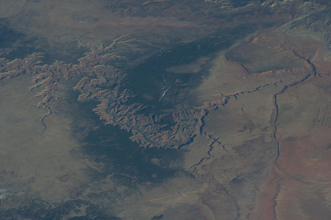
ISS039-E-005258 (25 March 2014) --- Not only do millions of tourists have special attractions to the Grand Canyon, but also through the years astronauts and cosmonauts in space. One of the Expedition 39 crew members aboard the Earth-orbiting International Space Station aimed his camera, equipped with a 180mm lens, at the iconic feature. The steep walls of the Colorado River canyon and its many side canyons make an intricate landscape that contrasts with the dark green, forested plateau to the north and south. The Colorado River has done all the erosional work of carving away cubic kilometers of rock in a geologically short period of time. Visible as a darker line snaking along the bottom of the canyon, the river lies at an altitude of 715 meters (2,345 feet), thousands of meters below the North and South Rims. Temperatures are furnace-like on the river banks in the summer. But Grand Canyon Village, the classic outlook point for visitors, enjoys a milder climate at an altitude of 2,100 meters (6,890 feet). The Grand Canyon has become a geologic icon?a place where, geologists say, one can almost sense the invisible tectonic forces within the Earth. The North and South Rims are part of the Kaibab Plateau, a gentle tectonic swell in the landscape. The uplift of the plateau had two pronounced effects on the landscape that show up in this image. First, in drier parts of the world, forests usually indicate higher places; higher altitudes are cooler and wetter, conditions that allow trees to grow. The other geologic lesson on view is the canyon itself. Geologists now know that a river can cut a canyon only if the Earth surface rises vertically. If such uplift is not rapid, a river can maintain its course by eroding huge quantities of rock and forming a canyon.
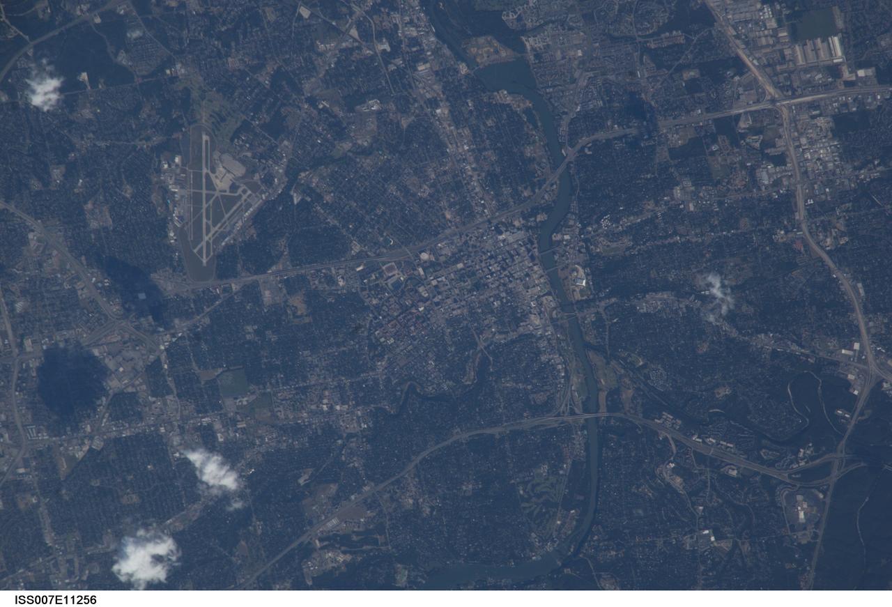
ISS007-E-11256 (29 July 2003) --- This view of the capital city of Austin, Texas was taken by one of the Expedition 7 crewmembers onboard the International Space Station (ISS). Austin is located in the Texas hill country along the banks of the Colorado River (lower left). Onboard are cosmonaut Yuri I. Malenchenko, mission commander, and astronaut Edward T. Lu, NASA ISS science officer and flight engineer.
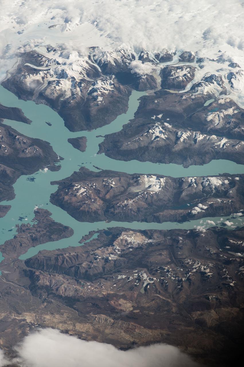
ISS047e014747 (03/22/2016) --- Crewmembers of the International Space Stations Expedition 47 captured this image of southern South America. Patagonia is a sparsely populated region located at the southern end of South America, shared by Argentina and Chile. The region comprises the southern section of the Andes mountains as well as the deserts, steppes and grasslands east of this southern portion of the Andes. The Colorado and Barrancas rivers, which run from the Andes to the Atlantic, are commonly considered the northern limit of Argentine Patagonia
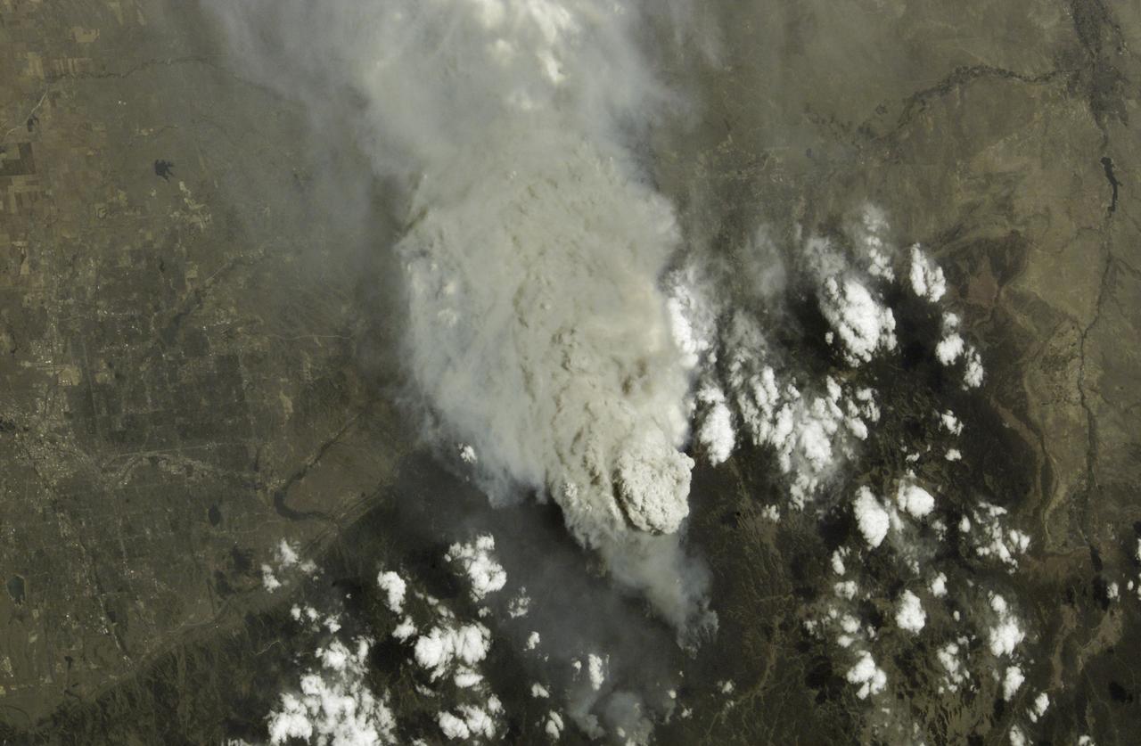
This is a photo of the Hayman Fire burning in the foothills southwest of Denver, Colorado, as viewed by an Expedition Five crewmember aboard the International Space Station (ISS). Astronauts use a variety of lenses and look angles as their orbits pass over the wildfires to document the long-distance movements of smoke from the fires as well as details of the burning areas. In this view, Littleton, Chatfield Lake, and the Arkansas River are all visible.
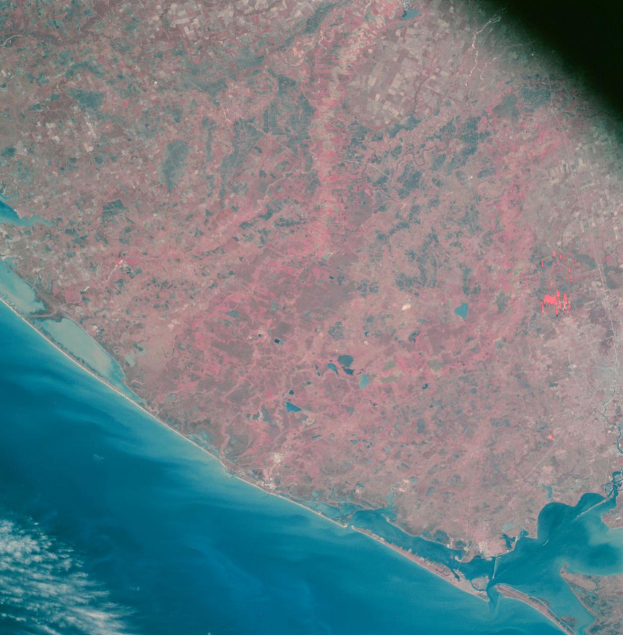
AS09-26A-3727A (8 March 1969) --- Color infrared photograph of the Texas Gulf Coast, Galveston Bay to Matagorda Bay, as seen from the Apollo 9 spacecraft during it 78th revolution of Earth. Houston is located at right center edge of photograph. Also visible are Galveston, Texas City, Manned Spacecraft Center, and Freeport. The mouth of the Colorado River is located near left center edge of picture. This picture was taken as a part of the SO65 Multispectral Terrain Photography Experiment.
AS09-26A-3799A (12 March 1969) --- Color infrared photograph of the Salton Sea and Imperial Valley area of Southern California as seen from the Apollo 9 spacecraft. This picture was taken as a part of the SO-65 Multispectral Terrain Photography Experiment. On the eastern edge of the picture are the Colorado River and a small portion of Arizona. Yuma, Arizona, is at the bottom right corner. The cities of El Centro, California, and Mexicali, Mexico, are at the bottom center.
STS058-74-000R (18 Oct-1 Nov 1993) --- A broad view westward along the Colorado River from just below Glen Canyon Dam (out of picture), through the entire Grand Canyon to Lake Mead and Las Vegas, and westward to include southern Nevada and much of California. The Salton Sea, Los Angeles Basin, and Great Valley rim the Pacific Coast in the distance. Photo credit: NASA
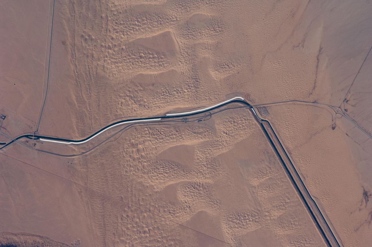
ISS018-E-024949 (31 Jan. 2009) --- The All-American Canal, the largest irrigation canal in the world and a key landmark along the California-Mexico border, is featured in this image photographed by an Expedition 18 crewmember on the International Space Station. This image captures about 15 kilometers of the important infrastructure corridor just west of Yuma, AZ. The prominent dark line crossing the image is the Canal which is crossed, in this view, by Interstate Highway 8. The canal carries 740.6 cubic meters (26,155 cubic feet) of water per second from the Colorado River westward to support the intensive agriculture of California?s Imperial Valley to the northwest, and to nine cities including San Diego, CA. The canal system is the Imperial Valley?s only source of water, and allows irrigation of more than 2,000 square kilometers (500,000 acres) of agricultural fields. The Coachella Canal, one of four main branch canals, leads water north to Imperial Valley. This section of the canal requires constant maintenance. Approximately 68,000 acre-feet of water per year are lost by seepage from the All-American Canal - especially where the canal crosses the great Algodones Dune Field, a portion of which is visible extending from top to bottom in the center of the image. Additionally, dune sand is constantly blown to the southeast, and into the canal. As part of California?s Colorado River Water Use Plan, 37 kilometers (23 miles) of the canal is being lined to prevent water loss by seepage. A recently opened sector parallels the old canal (right) and new lined sectors are under construction (bright lines, center). Engineers have sited new sections of the canal to avoid the worst areas of dune-sand invasion, so that the new configuration will be significantly cheaper to maintain and operate. A new road crosses the dunes and marks the US?Mexico border as part of border fence construction efforts. The margin of the Colorado River floodplain in Mexico is just visible two kilometers south of the border (lower left corner). This floodplain is Mexico?s equivalent of the Imperial Valley in terms of its enormous irrigated agricultural production.
AS09-26A-3800A (12 March 1969) --- Color infrared photograph of southwestern Arizona, Yuma-Gila Desert-Gila River-Colorado River area, taken on March 12, 1969, by one of the four synchronized cameras of the Apollo 9 Earth Resources Survey SO65 Experiment. At 11:28 a.m. (EST) when this picture was made the Apollo 9 spacecraft was at an altitude of 128 nautical miles, and the sun elevation was 30 degrees above the horizon. The location of the point on Earth's surface at which the four-camera combination was aimed 33 degrees 19 minutes north latitude, and 113 degrees 45 minutes west longitude. The other three cameras used: (B) black and white film with a red filter; (C) black and white infrared film; and (D) black and white film with a green filter.

Orbital Sciences Corportation's L1011 prepares to release a Pegasus rocket, January 25, 2003, off the coast of Cape Canaveral, FL, which will deliver the SORCE satellite, Solar Radiation and Climate Experiment, into the low-Earth orbit. The joint project with Orbital, NASA and the University of Colorado satellite is an atmospheric instrument that will measure incoming radiant energy from the sun. Scientists will use this to address long term atmospheric and climate changes. Other uses will be for ozone research and ultraviolet radiation. (Photo by Eric Roback and Rob Rivers, NASA Langley Research Center)
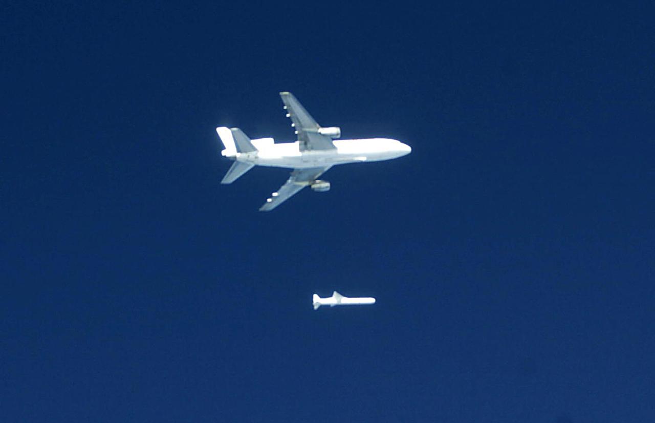
Orbital Sciences Corportation's L1011 releases a Pegasus rocket before ignition, January 25, 2003, off the coast of Cape Canaveral, FL, which will deliver the SORCE satellite, Solar Radiation and Climate Experiment, into the low-Earth orbit. The joint project with Orbital, NASA and the University of Colorado satellite is an atmospheric instrument that will measure incoming radiant energy from the sun. Scientists will use this to address long term atmospheric and climate changes. Other uses will be for ozone research and ultraviolet radiation. (Photo by Eric Roback and Rob Rivers, NASA Langley Research Center)

This simulated true color perspective view over the Grand Canyon was created from Advanced Spaceborne Thermal Emission and Reflection Radiometer (ASTER) data acquired on May 12, 2000. The Grand Canyon Village is in the lower foreground; the Bright Angel Trail crosses the Tonto Platform, before dropping down to the Colorado Village and then to the Phantom Ranch (green area across the river). Bright Angel Canyon and the North Rim dominate the view. At the top center of the image the dark blue area with light blue haze is an active forest fire. http://photojournal.jpl.nasa.gov/catalog/PIA01908
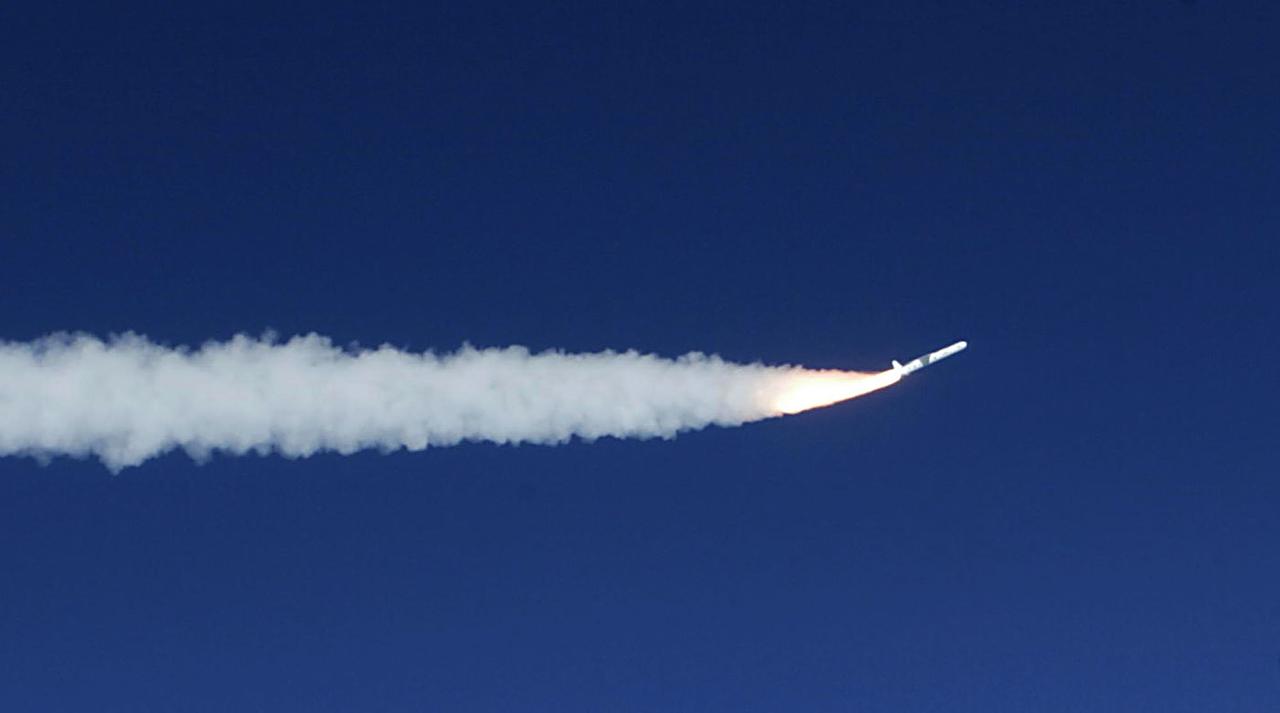
A Pegasus rocket starts it's first stage burn to propel the SORCE Satellite payload into low-Earth orbit, January 25, 2003, off the coast of Cape Canaveral, FL, The SORCE satellite, Solar Radiation and Climate Experiment,is a joint project with Orbital, NASA and the University of Colorado. The satellite is an atmospheric instrument that will measure incoming radiant energy from the sun. Scientists will use this to address long term atmospheric and climate changes. Other uses will be for ozone research and ultraviolet radiation. (Photo by Eric Roback and Rob Rivers, NASA Langley Research Center)
S65-18741 (23 March 1965) --- Astronaut John W. Young took this picture during the Gemini-Titan 3 three-orbit mission as the spacecraft "Molly Brown" passed over Northern Mexico. The large light-brown area is the Sonoran Desert. The Colorado River runs from upper right to lower left. The lower portion of the picture is Mexico, the upper left is California, and the upper right is Arizona. The altitude of the spacecraft was 90 miles. Young used a hand-held modified 70mm Hasselblad camera with color film. The lens setting was 250th of a second at f/11.
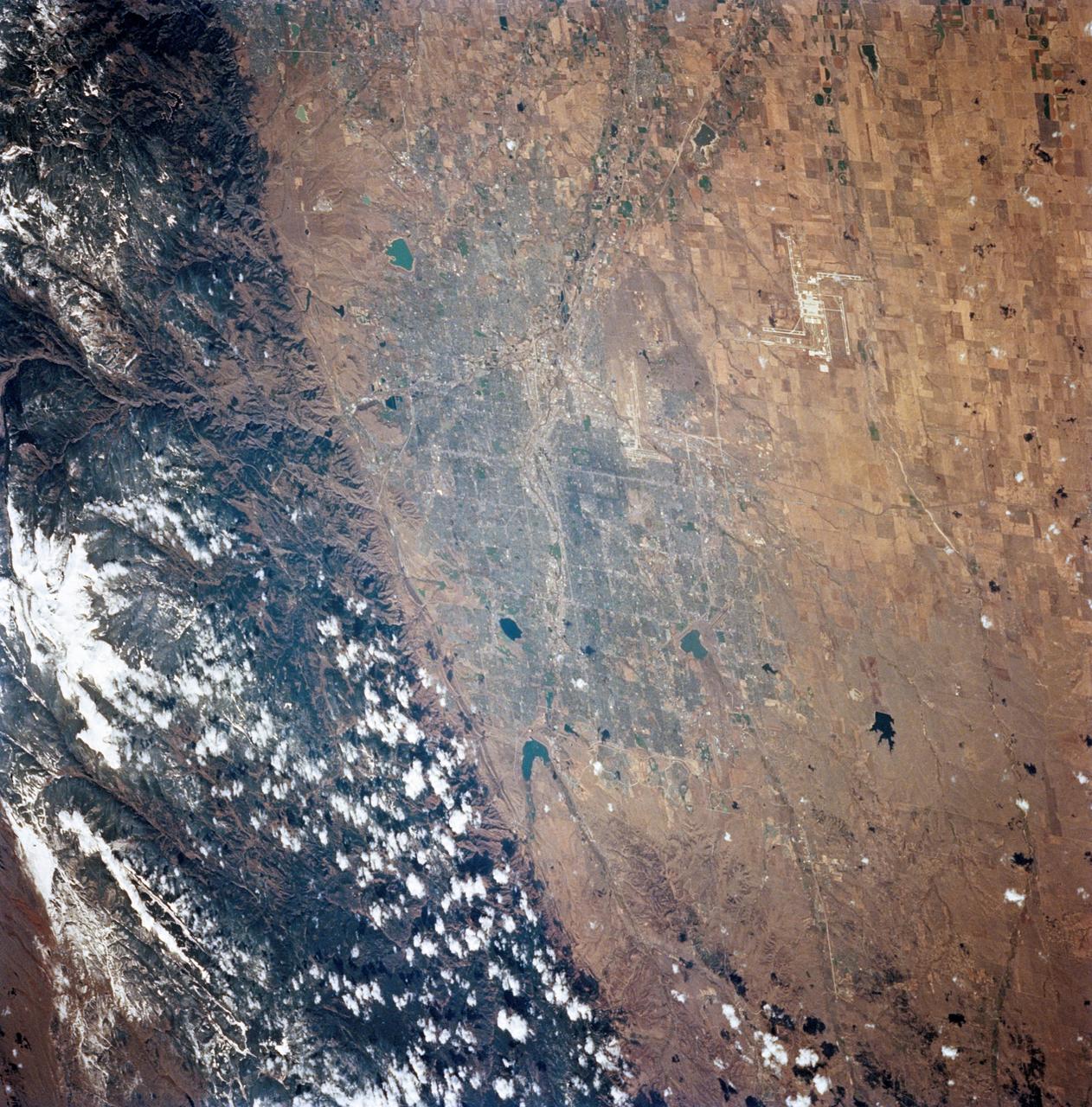
STS068-248-092 (30 September-11 October 1994) --- The location of Denver, Colorado - on the western edge of the High Plains, at the junction of the South Platte River and Clear Creek east of the Rocky Mountains - is graphically displayed. Mount Evans and its surroundings are already covered by snow on October 8, 1994. Clear Creek was one of the first areas in the Rockies where gold was discovered by American prospectors in the 19th century, which led to the settlement of Denver. The growth of 20th century Denver, dominantly to the west and south, is apparent. Stapleton Field, close to downtown Denver, is being replaced by the new regional airport well out on the plains.
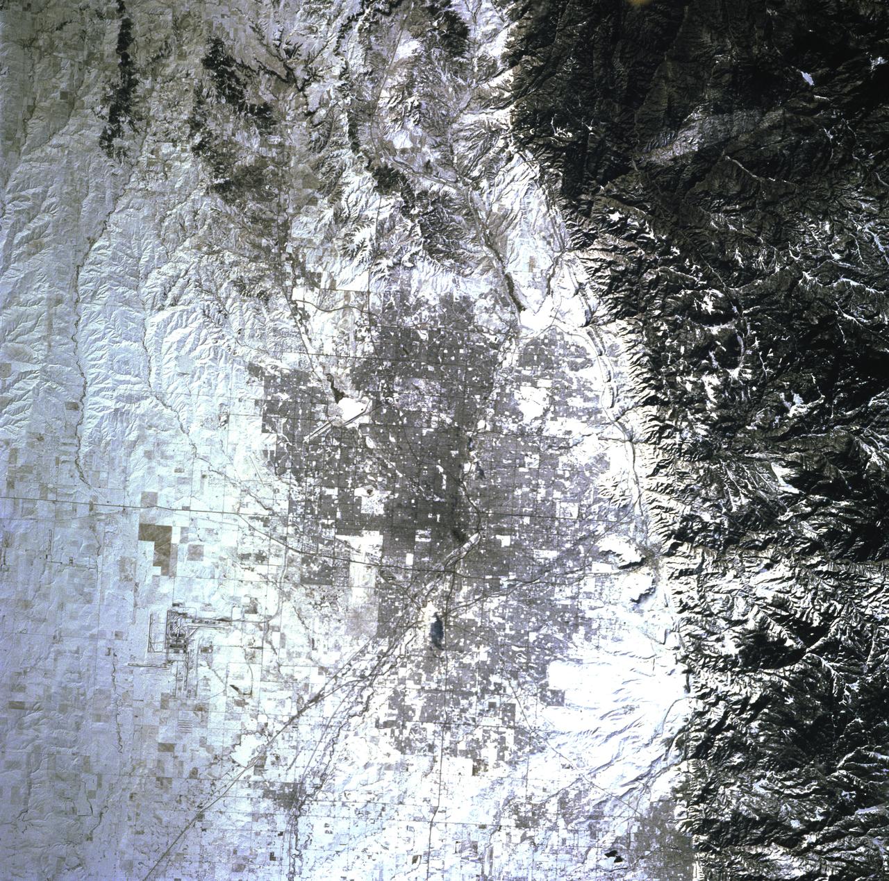
STS081-719-084 (12-22 Jan. 1997) --- The capital of the state of Colorado is featured prominently in this winter scene. Located at the foothills of the Rocky Mountains, Denver's elevation is 5,280 feet and is known as the "Mile High City". The new Denver International Airport (DIA) opened in 1995 and is one of the countries largest airports, can be seen towards the right corner of the photograph. Above and to the right of DIA is the closed Stapleton Airport with its snow covered runways. Other prominent cities featured are Golden, due east of Denver and against the Rockies, and Boulder, to the northeast of the city and also against the Rockies. Brighton is northwest of Denver, near the South Platte River.
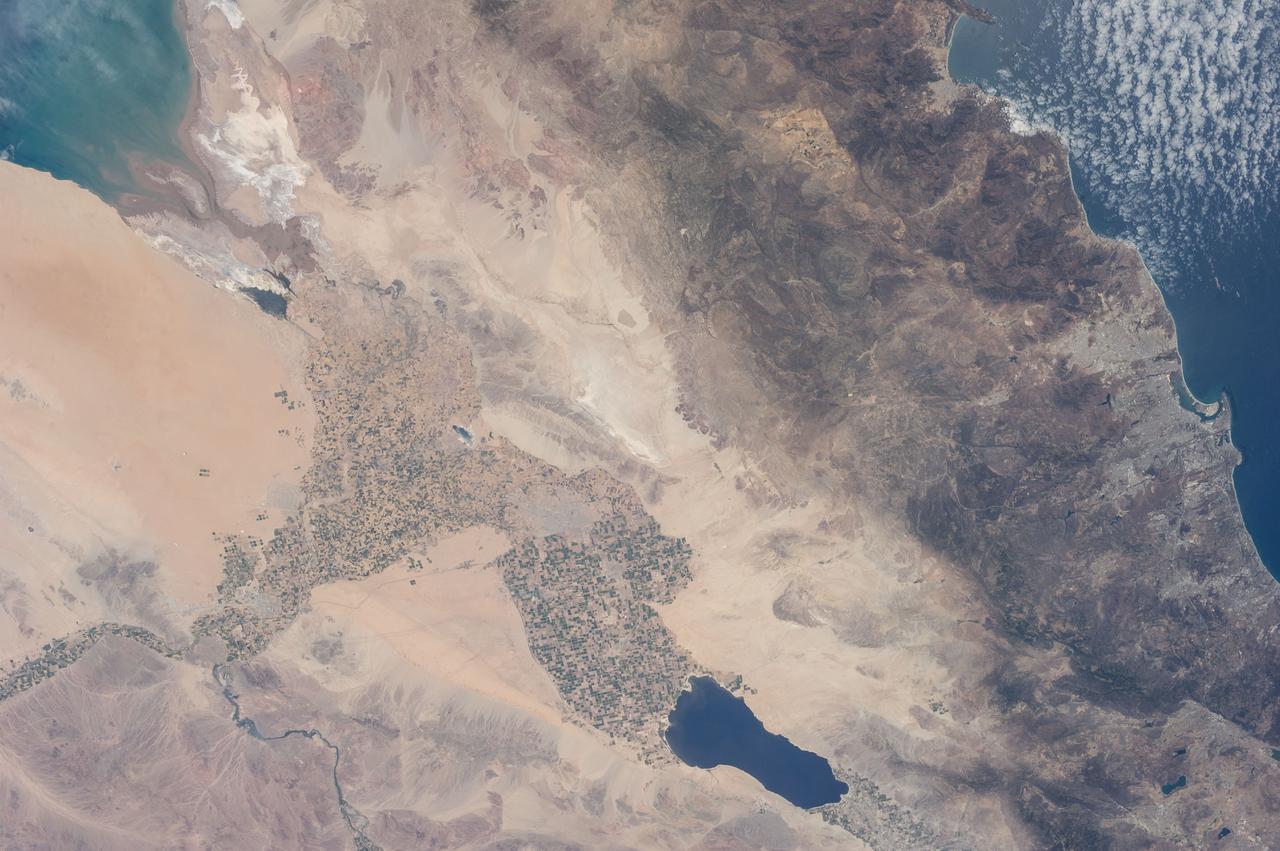
ISS029-E-042846 (16 Nov. 2011) --- Parts of the U.S. and Mexico are seen in this image photographed by one of the Expedition 29 crew members from the International Space Station as it flew above the Pacific Ocean on Nov. 16, 2011. The Salton Sea is in the center of the frame, with the Gulf of Cortez, Mexico's Baja California and the Colorado River in the upper right quadrant. The Los Angeles Basin and Santa Catalina and San Clemente islands are at the bottom center edge of the image. Lake Mead and the Las Vegas area of Nevada even made it into the frame in the upper left quadrant.
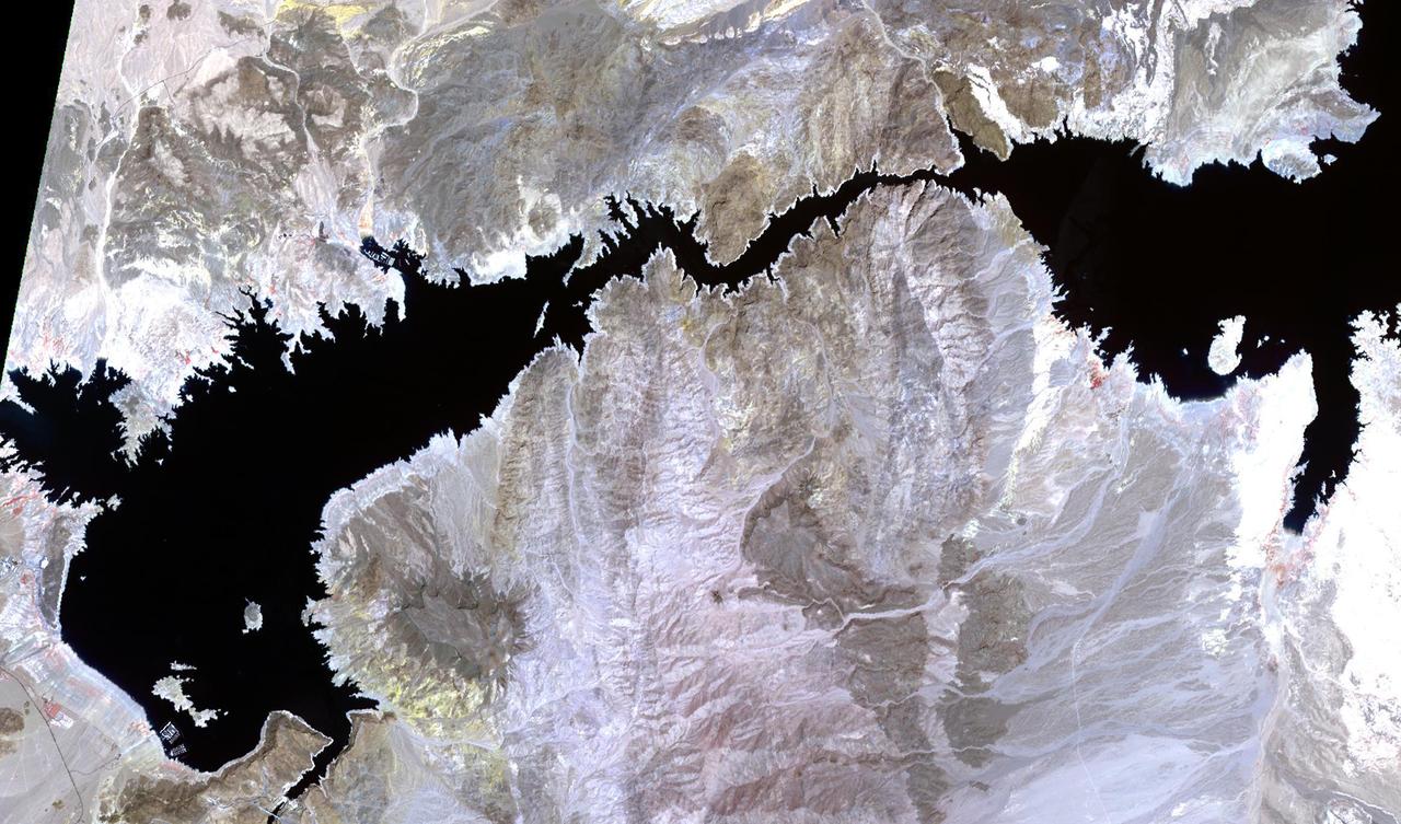
SL2-03-192 (22 June 1973) --- Lake Mead, Nevada, (36.0N, 114.5E) where the water from the Colorado River empties after it's 273 mile journey through the Grand Canyon of Arizona is the subject of this photo. Other features of interest are Hoover Dam on the south shore of Lake Mead where cheap hydroelectric power is secondary to the water resources made available in this northern desert region and the resort city of Las Vegas, just to the west of Lake Mead. In this harsh desert environment, color infrared photography readily penetrates haze, detects and portrays vegetation as shades of red. Photo credit: NASA
ISS018-E-005660 (28 Oct. 2008) --- The Great Divide of the Rocky Mountains in Colorado is featured in this image photographed by an Expedition 18 crewmember on the International Space Station. This view highlights a portion of the Great Divide in the Rocky Mountains approximately 31 kilometers due west of Boulder, Colorado. The Great Divide is one of four continental divides recognized by geographers and hydrologists in North America -- the others being the Northern, Eastern, and Saint Lawrence Seaway Divides -- but it is still generally (and erroneously) known as "the" Continental Divide. The Great Divide is a hydrologic boundary defined by the ultimate destination of precipitation -- rainfall on the western side of the Divide flows to the Pacific Ocean, while rainfall on the eastern side of the Divide flows to the Gulf of Mexico. It is easy to visualize such a boundary traced along the high ridges of the Rocky Mountains, but in regions of less topography more detailed study of the local geomorphology and hydrology are required to map the location of the Divide. This portion of the Rocky Mountains also hosts the Niwot Ridge Long Term Ecological Research (LTER) site. Part of the National Science Foundation LTER program, the Niwot Ridge LTER site studies climate interactions with tundra and alpine ecosystems. Niwot Ridge is visible in this image as a large eastward spur off the central spine of the mountains. The entire Niwot LTER site is located at elevations higher than 3000 m, and includes an active cirque glacier and glacial landforms, tarns (glacial lakes), and permafrost. Lake Granby, located to the west of the Great Divide, is a reservoir on the Colorado River and the second-largest manmade body of water in the state of Colorado. Storage of water began in 1949. Today, the Lake is popular location for fishing, boating and camping.
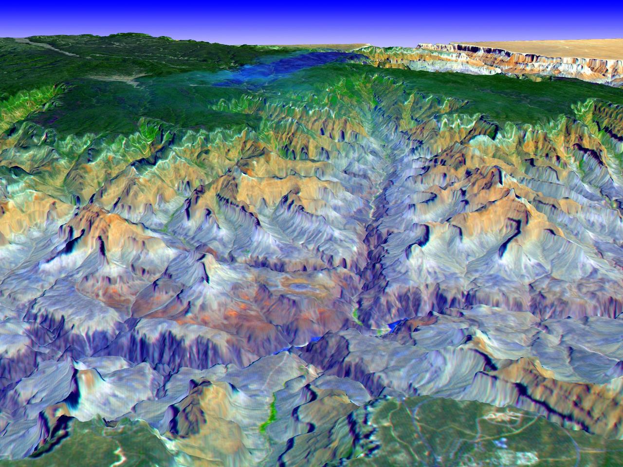
The Grand Canyon is one of North America's most spectacular geologic features. Carved primarily by the Colorado River over the past six million years, the canyon sports vertical drops of 5,000 feet and spans a 445-kilometer-long stretch of Arizona desert. The strata along the steep walls of the canyon form a record of geologic time from the Paleozoic Era (250 million years ago) to the Precambrian (1.7 billion years ago). The above view was acquired by the Advanced Spaceborne Thermal Emission and Reflection Radiometer (ASTER) instrument aboard the Terra spacecraft. Visible and near infrared data were combined to form an image that simulates the natural colors of water and vegetation. Rock colors, however, are not accurate. The image data were combined with elevation data to produce this perspective view, with no vertical exaggeration, looking from above the South Rim up Bright Angel Canyon towards the North Rim. The light lines on the plateau at lower right are the roads around the Canyon View Information Plaza. The Bright Angel Trail, which reaches the Colorado in 11.3 kilometers, can be seen dropping into the canyon over Plateau Point at bottom center. The blue and black areas on the North Rim indicate a forest fire that was smoldering as the data were acquired on May 12, 2000. http://photojournal.jpl.nasa.gov/catalog/PIA02668
Superimposed on an image taken by the HiRISE camera aboard NASA's Mars Reconnaissance Orbiter, this map shows the path taken by the agency's Perseverance Mars rover between Jan. 31, 2024, and June 11, shortly after it arrived at a geologic area of interest the science team calls "Bright Angel." The route where the rover paralleled the Neretva Vallis river channel is depicted in white. The portion of the route where the rover was inside the river channel is depicted in pale blue. The dots along the white line signify locations where the rover stopped after completing a traverse. The University of Arizona, in Tucson, operates HiRISE, which was built by BAE Systems, in Boulder, Colorado. JPL manages the Mars Reconnaissance Orbiter Project for NASA's Science Mission Directorate, Washington. A key objective for Perseverance's mission on Mars is astrobiology, including the search for signs of ancient microbial life. The rover will characterize the planet's geology and past climate, pave the way for human exploration of the Red Planet, and be the first mission to collect and cache Martian rock and regolith (broken rock and dust). Subsequent NASA missions, in cooperation with ESA (European Space Agency), would send spacecraft to Mars to collect these sealed samples from the surface and return them to Earth for in-depth analysis. https://photojournal.jpl.nasa.gov/catalog/PIA26334
ISS028-E-016225 (12 July 2011) --- Components of the International Space Station, though moving along at 17,500 miles per hour, appear to hover above the Pacific Ocean just off the California coast. Ten cosmonauts and astronauts were working together when this photo was taken -- four of them as STS-135 visitors from the docked space shuttle Atlantis and six as members of the Expedition 28 crew. The Cupola, near center of frame, is attached to Node 3 or Tranquility. A Russian Soyuz and a Russian Progress spacecraft are parked at the station, left side of frame. While much of the coast is obscured by clouds, just inland from left to right, one can see the agriculture of the San Joaquin Valley, the southern Sierra Nevada, the Los Angeles Basin (center), the Mojave Desert, coastal mountains of southern California, the Salton Sea, the Imperial Valley, and the mouth of the Colorado River on the extreme right edge.
AS06-02-1436 (4 April 1968) --- View of the mouth of the Colorado River and the Gulf of California in northwestern Mexico as photographed from the unmanned Apollo 6 (Spacecraft 020/Saturn 502) space mission. Altitude of the spacecraft at the time picture was taken was 120 nautical miles. NORTH IS TOWARD LEFT SIDE OF PICTURE. At bottom edge of photograph is Baja California. In the upper left corner is the Mexican state of Sonora showing the Sonoran Desert and the Pinacate Mountains. This photograph was made three hours and seven minutes after liftoff using Eastman Kodak SO-121 high resolution aerial Ektachrome film (exposure setting was f/5.6 at 1/500 second) in a J.A. Maurer model 2200 camera.
SL3-28-059 (July-September 1973) --- A vertical view of the Lake Mead and Las Vegas, Nevada area as photographed from Earth orbit by one of the six lenses of the Itek-furnished S190-A Multispectral Photographic Facility Experiment aboard the Skylab space station. Lake Mead is water of the Colorado River impounded by Hoover Dam. Most of the land in the picture is Nevada. However, a part of the northwest corner of Arizona can be seen. Federal agencies participating with NASA on the EREP project are the Departments of Agriculture, Commerce, Interior, the Environmental Protection Agency and the Corps of Engineers. All EREP photography is available to the public through the Department of Interior?s Earth Resources Observations Systems Data Center, Sioux Falls, South Dakota, 57198. Photo credit: NASA
STS112-708-002 (7-18 October 2002) --- This image, photographed from the Earth-orbiting Space Shuttle Atlantis, covers parts of Utah, Colorado, Wyoming and Idaho. The Front Range of the Rockies is the dark range crossing the bottom of the view, with Denver and neighboring cities (grays) situated in the gentle embayment of the mountains (bottom center of the view). Great Salt Lake in Utah appears as two colors of blue top left, with the snow-covered Uinta Mountains just below, in this northwesterly view. Most of the view encompasses the brown plains of western Wyoming (center) and the cluster of mountains around Yellowstone (top center, top right, with snow). Beyond the brown Snake River Plain, black rocks of the Sawtooth Mountains and neighboring ranges of central Idaho appear top center.
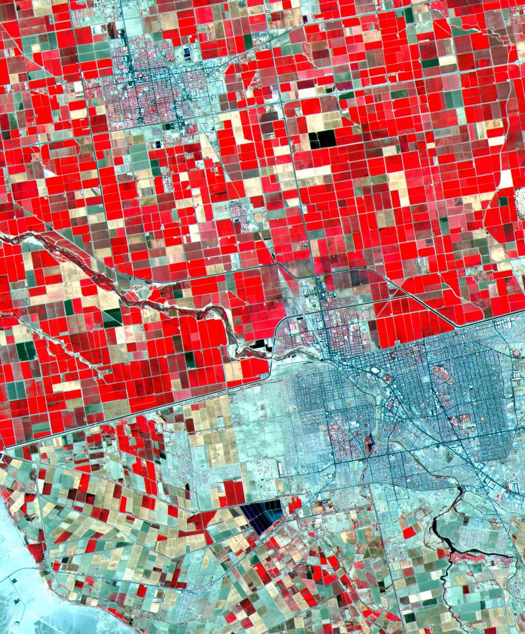
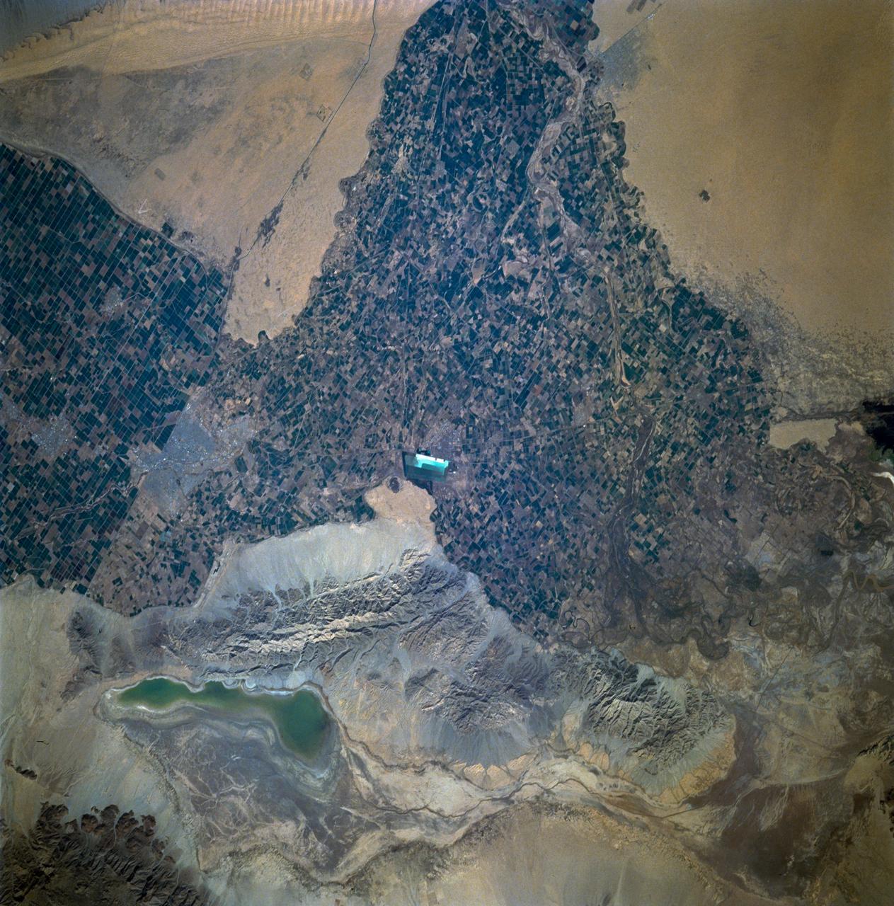
Dramatic differences in land use patterns are highlighted in this image of the U.S.-Mexico border. Lush, regularly gridded agricultural fields on the U.S. side contrast with the more barren fields of Mexico. This June 12, 2000, sub-scene combines visible and near infrared bands, displaying vegetation in red. The town of Mexicali-Calexico spans the border in the middle of the image; El Centro, California, is in the upper left. Watered by canals fed from the Colorado River, California's Imperial Valley is one of the country's major fruit and vegetable producers. This image covers an area 24 kilometers (15 miles) wide and 30 kilometers (19 miles) long in three bands of the reflected visible and infrared wavelength region. http://photojournal.jpl.nasa.gov/catalog/PIA02659
ISS036-E-011034 (21 June 2013) --- The Salton Trough is featured in this image photographed by an Expedition 36 crew member on the International Space Station. The Imperial and Coachella Valleys of southern California – and the corresponding Mexicali Valley and Colorado River Delta in Mexico – are part of the Salton Trough, a large geologic structure known to geologists as a graben or rift valley that extends into the Gulf of California. The trough is a geologically complex zone formed by interaction of the San Andreas transform fault system that is, broadly speaking, moving southern California towards Alaska; and the northward motion of the Gulf of California segment of the East Pacific Rise that continues to widen the Gulf of California by sea-floor spreading. According to scientists, sediments deposited by the Colorado River have been filling the northern rift valley (the Salton Trough) for the past several million years, excluding the waters of the Gulf of California and providing a fertile environment – together with irrigation—for the development of extensive agriculture in the region (visible as green and yellow-brown fields at center). The Salton Sea, a favorite landmark of astronauts in low Earth orbit, was formed by an irrigation canal rupture in 1905, and today is sustained by agricultural runoff water. A wide array of varying landforms and land uses in the Salton Trough are visible from space. In addition to the agricultural fields and Salton Sea, easily visible metropolitan areas include Yuma, AZ (lower left); Mexicali, Baja California, Mexico (center); and the San Diego-Tijuana conurbation on the Pacific Coast (right). The approximately 72-kilometer-long Algodones Dunefield is visible at lower left.
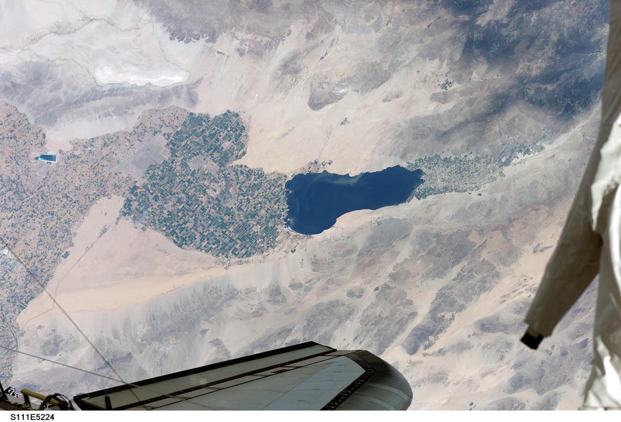
STS111-E-5224 (12 June 2002) --- Southern California’s Salton Sea is routinely a prominent visual for astronauts passing overhead on the shuttle or International Space Station (ISS). This large lake, photographed from the station while docked to the Space Shuttle Endeavour by one of the STS-111 crew members, supports the rich agricultural fields of the Imperial, Coachella and Mexicali Valleys in the California and Mexico desert. According to geologists, the Salton Sea formed by accident in 1905 when an irrigation canal ruptured, allowing the Colorado River to flood the Salton Basin. Today the Sea performs an important function as the sink for agricultural runoff. Water levels are maintained by the runoff from the surrounding agricultural valleys. The Salton Sea salinity is high -- nearly 1/4 saltier than ocean water --but it remains an important stopover point for migratory water birds, including several endangered species. Scientists also noted that the region experiences several environmental problems. The recent increased demands for the limited Colorado River water, the scientists point out, threatens the amount of water allowed to flow into the Salton Sea, and increased salinity with decreased water levels could trigger several regional environmental crises. The agricultural flow into the Sea includes nutrients and agricultural by-products, increasing the productivity and likelihood of algae blooms. This image shows either a bloom, or suspended sediment (usually highly organic) in the water that has been stirred up by winds.

Ground shaking triggered liquefaction in a subsurface layer of water-saturated sand, producing differential lateral and vertical movement in a overlying carapace of unliquified sand and slit, which moved from right to left towards the Pajaro River. This mode of ground failure, termed lateral spreading, is a principal cause of liquefaction-related earthquake damage caused by the Oct. 17, 1989, Loma Prieta earthquake. Sand and soil grains have faces that can cause friction as they roll and slide against each other, or even cause sticking and form small voids between grains. This complex behavior can cause soil to behave like a liquid under certain conditions such as earthquakes or when powders are handled in industrial processes. Mechanics of Granular Materials (MGM) experiments aboard the Space Shuttle use the microgravity of space to simulate this behavior under conditons that carnot be achieved in laboratory tests on Earth. MGM is shedding light on the behavior of fine-grain materials under low effective stresses. Applications include earthquake engineering, granular flow technologies (such as powder feed systems for pharmaceuticals and fertilizers), and terrestrial and planetary geology. Nine MGM specimens have flown on two Space Shuttle flights. Another three are scheduled to fly on STS-107. The principal investigator is Stein Sture of the University of Colorado at Boulder. Credit: S.D. Ellen, U.S. Geological Survey
ISS035-E-027431 (23 April 2013) --- This oblique Expedition 35 image from the International Space Station shows parts of Mexico, California and Nevada. The Los Angeles Basin can be easily delineated at left center. If the nomenclature for the body of water in the upper right quadrant of the image were the subject of a trivia question, the answer might be "all the above," as it is recognized by a number of names. They include the Gulf of California, Sea of Cortez, Sea of Cortes, Vermilion Sea as well as its local designations in the Spanish language as Mar de Cortes or Mar Bermejo or Golfo de California. It serves to separate the Baja California Peninsula from the Mexican mainland. It is bordered by the states of Baja California, Baja California Sur, Sonora, and Sinaloa (some of which are out of the frame) with a coastline of approximately 4,000 kilometers (2,500 miles). Rivers which flow into the Gulf of California include the Colorado, Fuerte, Mayo, Sinaloa, Sonora and the Yaqui. The gulf's surface area is about 160,000 square kilometers (62,000 square miles). A mass of clouds sits just off the Pacific coast of Baja California and southern California.
SL4-142-4548 (27 Jan. 1974) --- An oblique view of northwestern Mexico, as photographed from the Skylab space station in Earth orbit by one of the Skylab 4 crewmen. The camera used was a hand-held 70mm Hasselblad, with SO-368 medium-speed Ektachrome film. This photograph was taken on a sweep down the coast to document the fault patterns of southern California and northwest Mexico. SL4-142-4532 gives an excellent overview of the entire region. The specific reason for this picture was an attempt to see if the Agua Blanca Fault in Baja California extends to the east toward the Gulf of California. Several attempts were made by the Skylab 4 crew to visually detect such an extension, but none was found. The report was that the fault disappeared into an area of sand and heavily eroded material that obscured any feature that might be present deeper. This area of sand and loose material is the light-colored area in the center of Baja at the extreme north part of the photograph. In addition to this geology the Pinacate volcanic field in Sonora, the sand dunes in Sonora, and the sediment flow patterns of the Colorado River entering the Gulf are additional areas of study utilizing this photograph. Photo credit: NASA
STS060-93-081 (3-11 Feb 1994)--- The Imperial Valley was documented using three films - color visible (seen here), the American infrared film (Kodak Aerochrome 2443), and the Russian panchromatic infrared film (SN-10). Results of this test still await detailed science analysis. However it does appear that good data was acquired of the region, and this data will be complemented by photography acquired by the Mir cosmonauts. In this frame, the U.S.-Mexico border goes from the upper left to the middle right. It is discernible as a vegetation line between Calexico, California and Mexicali, Mexico. The darker vegetation north of that line is due to different agricultural practices, heavier uses of fertilizers and pesticides, and lined (tiled) agricultural fields allowing subterraneean runoff of saline irrigation runoff. South of the line, the more polluted water draining out of the U.S. agricultural areas into the Mexican area has resulted in higher soil salinities and a consequent reduction in agricultural productivity. At the center of the frame, a large settling and desalinization plant has been built to attempt to purify, to some degree, the polluted irrigation waters draining south out of California. The All-American Canal, which brings in water from the Colorado River (off the frame, to the right), is located in the middle right hand portion of the frame. To the upper left is the normally dry Laguna Salada.
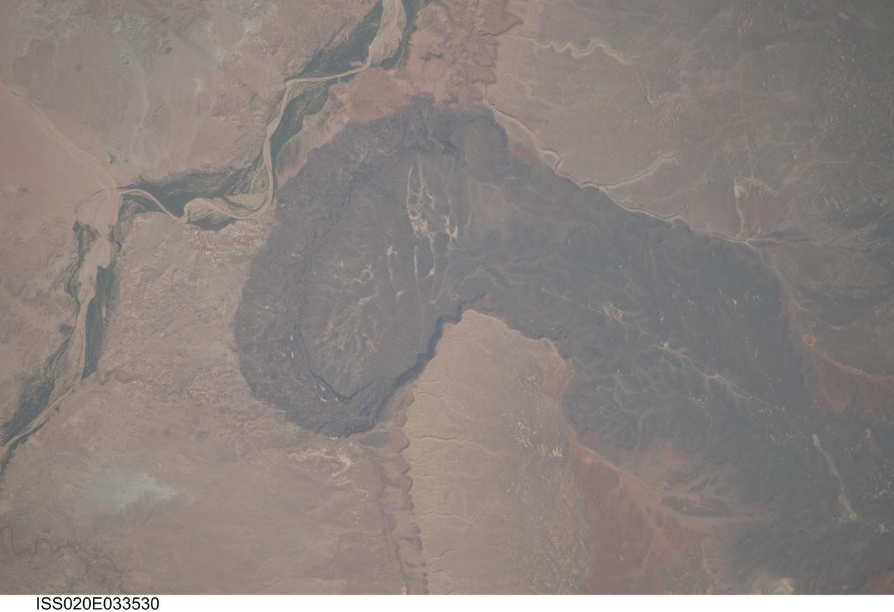
ISS020-E-033530 (21 Aug. 2009) --- Black Point Lava Flow in northern Arizona, seen in this image photographed by an Expedition 20 crew member on the International Space Station, is an excellent setting for training and systems testing for future exploration missions to the moon. Seen from space, the other-worldly footprint of the dark black basaltic lava creates a striking landscape. The flow is part of Arizona?s San Francisco Volcanic Field, a group of geologically young (approximately 6 million to less than one thousand years old, according to scientists) volcanoes, flows and cinder cones located just north of Flagstaff, Arizona. Scientists believe when it erupted onto the surface, the Black Point Lava flowed eastward over the older Permian and Triassic sedimentary rock sequences (spanning the period from roughly 300 to 240 million years ago) that are so well known around the vicinity of the Grand Canyon. The eastern edge of the flow slumps down to the surrounding plain, and ends along the Little Colorado River (upper left). In late August and early September 2009, scientists and engineers from NASA and several universities will travel to the Black Point Lava Flow to conduct tests for NASA?s Lunar Electric Rover (LER). This year, a team of geologists will support the tests, simulating traverses that might occur on the moon.
STS062-85-095 (4-18 March 1994) --- Gatun Lake and the forested Panama Canal Zone can be seen in this north northwest-looking low oblique photograph obtained in March 1994. The shipping chanel of the canal is 82.4 kilometers (51.2 miles) long, though the canal zone is only 65 kilometers (40 miles) long. The width of the canal zones extends generally 8 kilometers (5 miles) on either side of the shipping channel, except near Madden Lake. The canal connects the Atlantic Ocean (coastal city of Colon) with the Pacific Ocean near Panama City in a line that takes a northwest to southeast course because of the configuration of the isthmus. The canal zigzags across the isthmus to take advantage of the geographic features of the area such as the Chagres River. The controlled water supply for the canal is provided by the three artificial lakes: Gatun near the Atlantic terminus, Miraflores near the Pacific terminus and Madden about halfway across the isthmus. Gatun is the largest of the three lakes covering an area of 429 square kilometers (165 square miles). In the midst of this lake is Barro Colorado Island, a world-famous wild game perserve. Madden Lake was built as a large supplemental reservoir to keep water levels up in the canal during the dry season. All three lakes are vital sources of water for maintaining the ship channel over the continental divide (Gaillard Cut) and for regulating the flow of water that enables hugh vessels to be lifted and lowered in massive locks.
ISS017-E-005351 (26 April 2008) --- Zion National Park, Utah is featured in this image photographed by an Expedition 17 crewmember on the International Space Station. Zion National Park is located in southwestern Utah, along the western margin of the Colorado Plateau. The park was established in 1919, after roadway improvements in southwestern Utah allowed access to the preceding Mukuntuweap National Monument (1909) located in Zion Canyon. The towering cliffs bounding the North Fork of the Virgin River are formed mainly of tan to light pink Navajo Sandstone, the lithified remnants of an extensive sand dune sea that covered the area during the early Mesozoic Era, nearly 200 million years ago, according to scientists. The Zion region would have looked much like the present-day Sahara desert at this time in its geologic history. Brown rock capping the Navajo Sandstone (right) is comprised of younger beds that record changing environmental conditions that fluctuated between shallow seas and deserts. This high resolution image illustrates the incised nature of the bedrock forming the park. The long linear features are joints -- fractures in the rock mass -- formed in response to tectonic stresses that affected the region during its geologic history. The mainly north-northwest trending joints serve to channelize water runoff and are thought to be the main factor that determined the present canyon network. While the park is perhaps best experienced by hiking, backpacking, or biking, Utah State Route 9 provides automobile access up the side of Zion Canyon. The road is visible in this view as a thin brown line climbing the south wall of the canyon (lower left). Access to the rest of the park is provided by a shuttle bus system instituted in 2000 to reduce vehicle noise, improve air quality, and improve wildlife habitat.
An autumn storm brought the first snow of the season to the Upper Mississippi River Valley and the Midwestern United States in early November, 2013. The Moderate Resolution Imaging Spectroradiometer (MODIS) aboard NASA’s Terra satellite captured this true color image on November 6 just as the storm was clearing. A long band of snow stretching from Colorado in the southwest to Wisconsin in the northeast marked the path of the blowing storm. According to WeatherBug, up to 10 inches blanketed Gordon, Nebraska and Pipestone, Minnesota. Most snow totals in the Central and Northern Plains and Upper Mississippi Valley ranged from 2-5 inches, while Minneapolis-St. Paul metro area picked up 1-2 inches of new snow from the event. Credit: NASA/GSFC/Jeff Schmaltz/MODIS Land Rapid Response Team <b><a href="http://www.nasa.gov/audience/formedia/features/MP_Photo_Guidelines.html" rel="nofollow">NASA image use policy.</a></b> <b><a href="http://www.nasa.gov/centers/goddard/home/index.html" rel="nofollow">NASA Goddard Space Flight Center</a></b> enables NASA’s mission through four scientific endeavors: Earth Science, Heliophysics, Solar System Exploration, and Astrophysics. Goddard plays a leading role in NASA’s accomplishments by contributing compelling scientific knowledge to advance the Agency’s mission. <b>Follow us on <a href="http://twitter.com/NASA_GoddardPix" rel="nofollow">Twitter</a></b> <b>Like us on <a href="http://www.facebook.com/pages/Greenbelt-MD/NASA-Goddard/395013845897?ref=tsd" rel="nofollow">Facebook</a></b> <b>Find us on <a href="http://instagram.com/nasagoddard?vm=grid" rel="nofollow">Instagram</a></b>
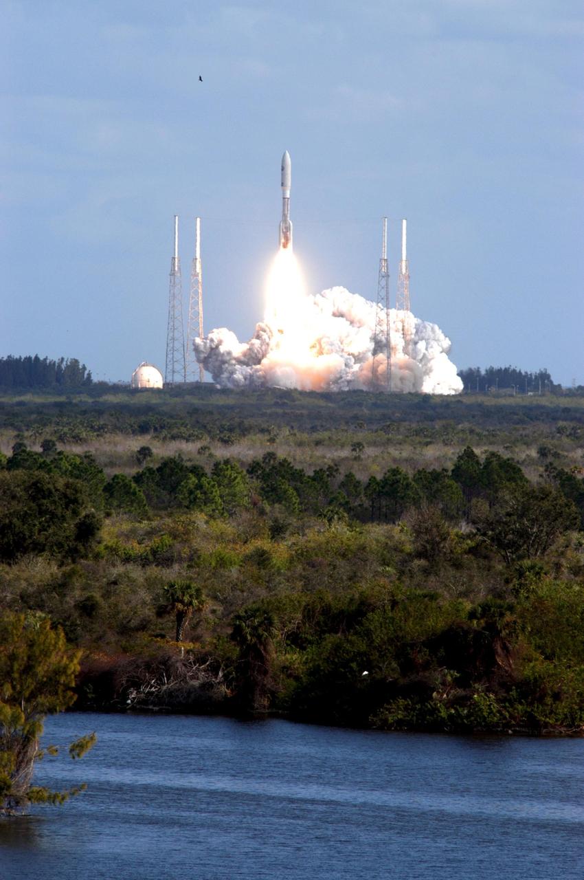
KENNEDY SPACE CENTER, FLA. — Viewed from a vantage point on the nearby river bank, NASA’s New Horizons spacecraft roars into the cloud-scattered sky trailing fire from the Atlas V rocket that propels it. Liftoff was on time at 2 p.m. EST from Complex 41 on Cape Canaveral Air Force Station in Florida. This was the third launch attempt in as many days after scrubs due to weather concerns. The compact, 1,050-pound piano-sized probe will get a boost from a kick-stage solid propellant motor for its journey to Pluto. New Horizons will be the fastest spacecraft ever launched, reaching lunar orbit distance in just nine hours and passing Jupiter 13 months later. The New Horizons science payload, developed under direction of Southwest Research Institute, includes imaging infrared and ultraviolet spectrometers, a multi-color camera, a long-range telescopic camera, two particle spectrometers, a space-dust detector and a radio science experiment. The dust counter was designed and built by students at the University of Colorado, Boulder. The launch at this time allows New Horizons to fly past Jupiter in early 2007 and use the planet’s gravity as a slingshot toward Pluto. The Jupiter flyby trims the trip to Pluto by as many as five years and provides opportunities to test the spacecraft’s instruments and flyby capabilities on the Jupiter system. New Horizons could reach the Pluto system as early as mid-2015, conducting a five-month-long study possible only from the close-up vantage of a spacecraft. Photo credit: NASA/George Shelton
ISS011-E-08410 (9 June 2005) --- Las Cruces, New Mexico is featured in this image photographed by an Expedition 11 crewmember on the International Space Station. The city of Las Cruces is located within the Rio Grande Rift, a large geological feature that extends from Colorado southward into Mexico. According to NASA geologists, rifting usually heralds the breakup of continental landmasses, such as the separation of South America and Africa to form the southern Atlantic Ocean during the Mesozoic Era. The Rift is marked by a series of depressions (known as graben) caused by the subsidence of crustal blocks between parallel faults as the continental crust is pulled apart by tectonic forces. These graben are frequently marked by uplifted rocks along bounding faults — the striking Organ Mountains to the east of Las Cruces are one such uplifted fault block. While separation of the continental crust is no longer occurring, the Rio Grande Rift is still considered active as evidenced by frequent low-intensity earthquakes and hot springs to the north of Las Cruces. The modern city of Las Cruces — the seat of Doña Ana County and home to New Mexico State University — is undergoing rapid urban expansion due to influx of new residents attracted to the climate and landscape. The current urban area (gray to white region at image center) contrasts sharply with agricultural lands (dark green and grey brown) located along the Rio Grande River and the surrounding desert valley floor to the northeast and southwest (brown, blue gray and tan areas).

NOAA's GOES-East satellite provided a look at the frigid eastern two-thirds of the U.S. on Jan. 7, 2015, that shows a blanket of northern snow, lake-effect snow from the Great Lakes and clouds behind the Arctic cold front. A visible picture captured at 1600 UTC (11 a.m. EST) showed the effects of the latest Arctic outbreak. The cold front that brought the Arctic air has moved as far south as Florida, and stretches back over the Gulf of Mexico and just west of Texas today. The image shows clouds behind the frontal boundary stretching from the Carolinas west over the Heartland. Farther north, a wide band of fallen snow covers the ground from New England west to Montana, with rivers appearing like veins. The GOES-East satellite image also shows wind-whipped lake-effect snows off the Great Lakes, blowing to the southeast. Meanwhile, Florida, the nation's warm spot appeared almost cloud-free. To create the image, NASA/NOAA's GOES Project used cloud data from NOAA's GOES-East satellite and overlaid it on a true-color image of land and ocean created by data from the Moderate Resolution Imaging Spectroradiometer, or MODIS, instrument that flies aboard NASA's Aqua and Terra satellites. Together, those data created the entire picture of the Arctic outbreak. The forecast from NOAA's National Weather Service Weather Prediction Center (WPC) calls for more snow along the Appalachian Mountains from Tennessee north to upstate New York. Snow is also expected to fall from New England west to Montana, and in eastern New Mexico and the Colorado Rockies. The WPC summary for Jan. 7 noted: Bitter cold will be felt from the western High Plains to the Mid-Atlantic and Northeast U.S. for the next few days. Widespread subzero overnight lows are forecast for the Dakotas, Upper Midwest, Great Lakes, and interior New England. Wind Chill Advisories and Warnings are in effect for many of these areas. GOES-East provides visible and infrared images over the eastern U.S. and the Atlantic Ocean from its fixed orbit in space. NOAA's GOES satellites provide the kind of continuous monitoring necessary for intensive data analysis. Geostationary describes an orbit in which a satellite is always in the same position with respect to the rotating Earth. This allows GOES to hover continuously over one position on Earth's surface, appearing stationary. As a result, GOES provide a constant vigil for the atmospheric triggers for severe weather conditions such as tornadoes, flash floods, hail storms and hurricanes. For updated information about the storm system, visit NOAA's NWS website: <a href="http://www.weather.gov" rel="nofollow">www.weather.gov</a> For more information about GOES satellites, visit: <a href="http://www.goes.noaa.gov/" rel="nofollow">www.goes.noaa.gov/</a> or goes.gsfc.nasa.gov/ Rob Gutro NASA's Goddard Space Flight Center, Greenbelt, Md. <b><a href="http://www.nasa.gov/audience/formedia/features/MP_Photo_Guidelines.html" rel="nofollow">NASA image use policy.</a></b> <b><a href="http://www.nasa.gov/centers/goddard/home/index.html" rel="nofollow">NASA Goddard Space Flight Center</a></b> enables NASA’s mission through four scientific endeavors: Earth Science, Heliophysics, Solar System Exploration, and Astrophysics. Goddard plays a leading role in NASA’s accomplishments by contributing compelling scientific knowledge to advance the Agency’s mission. <b>Follow us on <a href="http://twitter.com/NASAGoddardPix" rel="nofollow">Twitter</a></b> <b>Like us on <a href="http://www.facebook.com/pages/Greenbelt-MD/NASA-Goddard/395013845897?ref=tsd" rel="nofollow">Facebook</a></b> <b>Find us on <a href="http://instagram.com/nasagoddard?vm=grid" rel="nofollow">Instagram</a></b>