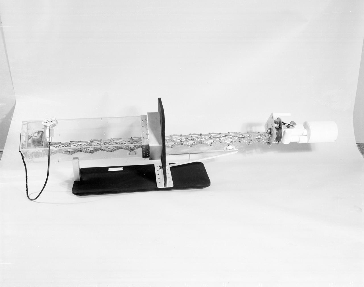
The Apollo Telescope Mount (ATM), designed and developed by the Marshall Space Flight Center, served as the primary scientific instrument unit aboard the Skylab. The ATM contained eight complex astronomical instruments designed to observe the Sun over a wide spectrum from visible light to x-rays. This photo depicts a side view is of a fully extended ATM contamination monitor mockup.
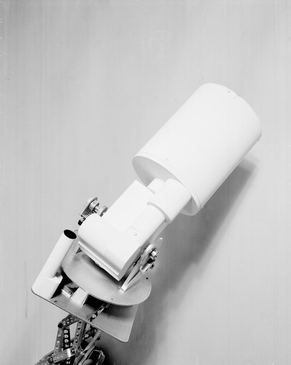
The Apollo Telescope Mount (ATM), designed and developed by the Marshall Space Flight Center, served as the primary scientific instrument unit aboard the Skylab. The ATM contained eight complex astronomical instruments designed to observe the Sun over a wide spectrum from visible light to x-rays. This angle view is of an ATM contamination monitor meter mockup.
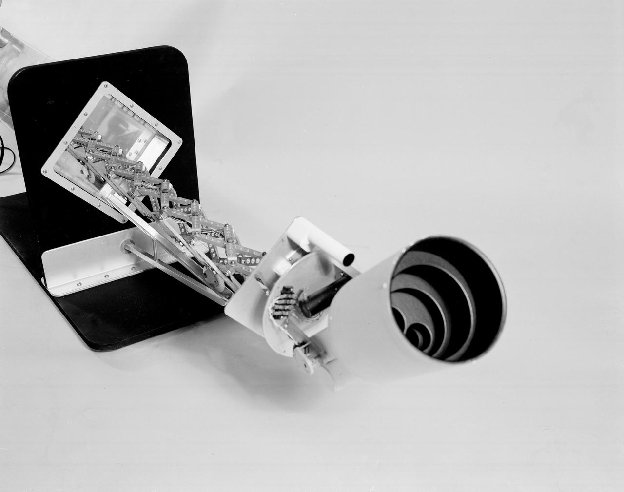
The Apollo Telescope Mount (ATM), designed and developed by the Marshall Space Flight Center, served as the primary scientific instrument unit aboard the Skylab. The ATM contained eight complex astronomical instruments designed to observe the Sun over a wide spectrum from visible light to x-rays. This photo depicts a mockup of the ATM contamination monitor camera and photometer.
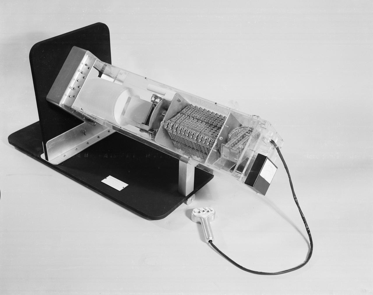
The Apollo Telescope Mount (ATM), designed and developed by the Marshall Space Flight Center, served as the primary scientific instrument unit aboard the Skylab. The ATM contained eight complex astronomical instruments designed to observe the Sun over a wide spectrum from visible light to x-rays. This photo of the ATM contamination monitor mockup offers an extended view of the sunshield interior.

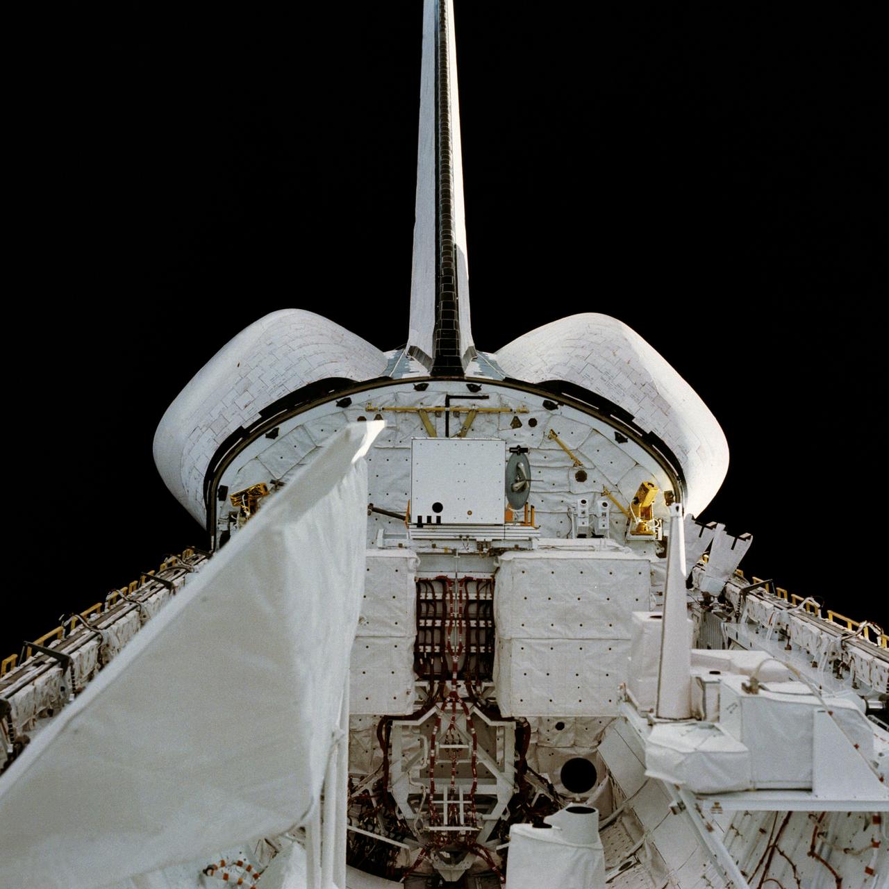
STS004-37-670 (27 June-4 July 1982) --- The North Atlantic Ocean southeast of the Bahamas serves as backdrop for this 70mm scene of the Columbia?s remote manipulator system (RMS) arm and hand-like device (called and end effector) grasping a multi-instrument monitor for detecting contaminants. The experiments is called the induced environment contaminant monitor (IECM). The small box contains 11 instruments for checking the contaminants in and around the orbiter?s cargo bay which might adversely affect delicate experiments carried onboard. Astronauts Thomas K. Mattingly II and Henry W. Hartsfield Jr. manned the Columbia for seven days and one hour. The Columbia?s vertical tail and orbital maneuvering system (OMS) pods are at left foreground. Photo credit: NASA
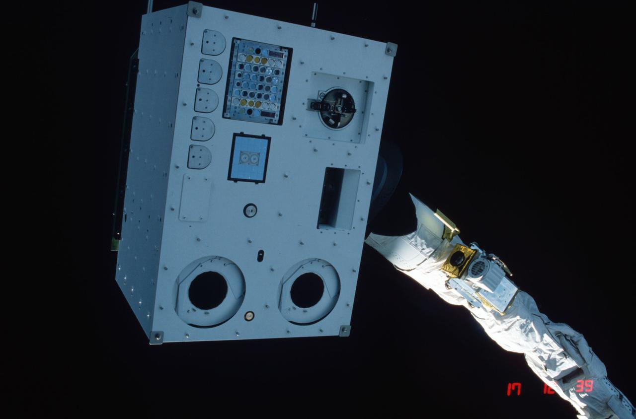
STS004-23-119 (27 June-4 July 1982) --- This is a close-up view of the Marshall Space Flight Center-developed Induced Environment Contamination Monitor (IECM), a multi-instrument box designed to check for contaminants in and around the space shuttle orbiter cargo bay which might adversely affect delicate experiments carried aboard. The astronaut crew of Thomas K. Mattingly II and Henry W. Hartsfield Jr. maneuvered the Canadian-built robot arm (called the remote manipulator system) very near their overhead flight deck windows and captured this scene with a 35mm camera. HOLD PICTURE HORIZONTALLY WITH FRAME NUMBER AT TOP CENTER. Cameras for the 11 instruments are pictured as black circles at the bottom of the frame. The access door to the arm and safe plug is located about halfway up the left edge of the box. A cascade injector device is immediately to the right of the plug. The rectangular opening at right center of the monitor is the optical effects module. Mass spectrometer is at upper left. Air sampler bottles are at upper left. The colorful rectangle near upper left of the monitor is the passive array. Not easily seen, but also a part of the instrument, are the cryogenic quartz crystal micro balance and the temperature controlled quartz micro balance. Photo credit: NASA
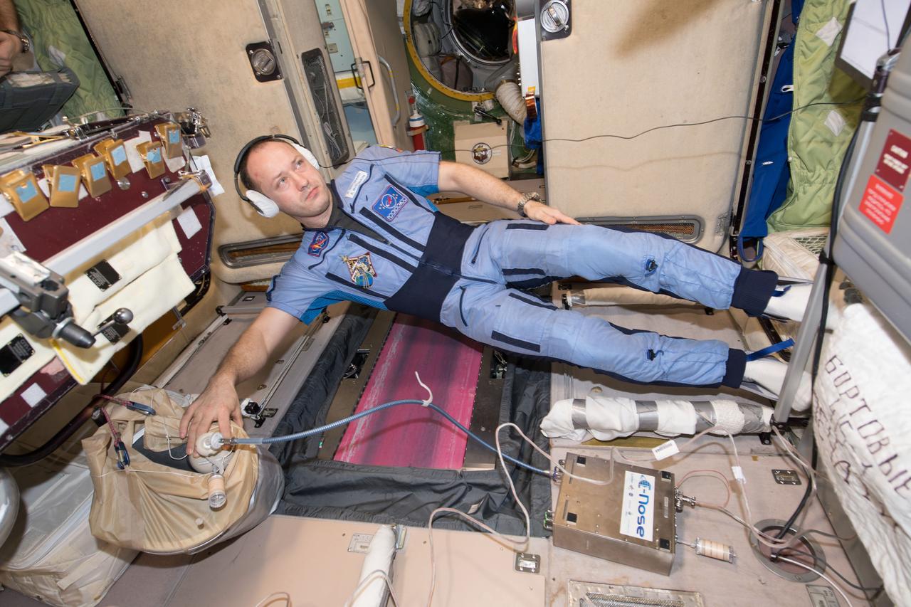
iss053e238931 (Nov. 22, 2017) --- Flight Engineer Alexander Misurkin from Roscosmos works with the JPL Electronic Nose (ENose) experiment in the Zvezda service module. ENose is a full-time, continuously operating event monitor designed to detect air contamination from spills and leaks in the crew habitat of the International Space Station. It fills the long-standing gap between onboard alarms and complex analytical instruments. ENose provides rapid, early identification and quantification of atmospheric changes caused by chemical species to which it has been trained. ENose can also be used to monitor cleanup processes after a leak or a spill.
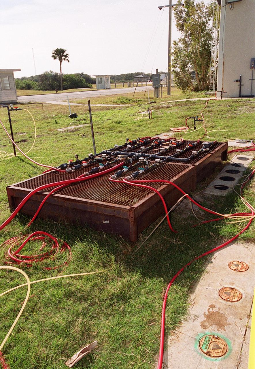
At Launch Complex 34, Cape Canaveral Air Station, several studies are under way for groundwater cleanup of trichloroethylene at the site. Shown here is monitoring equipment for one of the methods, potassium permanganate oxidation. Concentrations of trichloroethylene solvent have been identified in the soil at the complex as a result of cleaning methods for rocket parts during the Apollo Program in the 60s. The environmental research project involves the Department of Defense, Environmental Protection Agency, Department of Energy and NASA, who formed the Interagency NDAPL Consortium (IDC), to study three contamination cleanup technologies: Six Phase Soil Heating, Steam Injection and In Situ Oxidation with Potassium Permanganate. All three methods may offer a way to remove the contaminants in months instead of decades. KSC hosted a two-day conference that presented information and demonstrations of the three technologies for representatives from environmental and federal agencies

At Launch Complex 34, Cape Canaveral Air Station, several studies are under way for groundwater cleanup of trichloroethylene at the site. Shown here is monitoring equipment for one of the methods, potassium permanganate oxidation. Concentrations of trichloroethylene solvent have been identified in the soil at the complex as a result of cleaning methods for rocket parts during the Apollo Program in the 60s. The environmental research project involves the Department of Defense, Environmental Protection Agency, Department of Energy and NASA, who formed the Interagency NDAPL Consortium (IDC), to study three contamination cleanup technologies: Six Phase Soil Heating, Steam Injection and In Situ Oxidation with Potassium Permanganate. All three methods may offer a way to remove the contaminants in months instead of decades. KSC hosted a two-day conference that presented information and demonstrations of the three technologies for representatives from environmental and federal agencies

This 1970 photograph shows Skylab's Multispectral Scanner, one of the major components of an Earth Resources Experiment Package (EREP). It was designed to evaluate the on-orbit use of multispectral scanning of Earth resources. Investigators could evaluate the usefulness of spacecraft multispectral data for crop identification, vegetation mapping, soil moisture measurements, identification of contaminated areas in large bodies of water, and surface temperature mapping. The overall purpose of the EREP was to test the use of sensors that operated in the visible, infrared, and microwave portions of the electromagnetic spectrum to monitor and study Earth resources. The Marshall Space Flight Center had program management responsibility for the development of Skylab hardware and experiments.
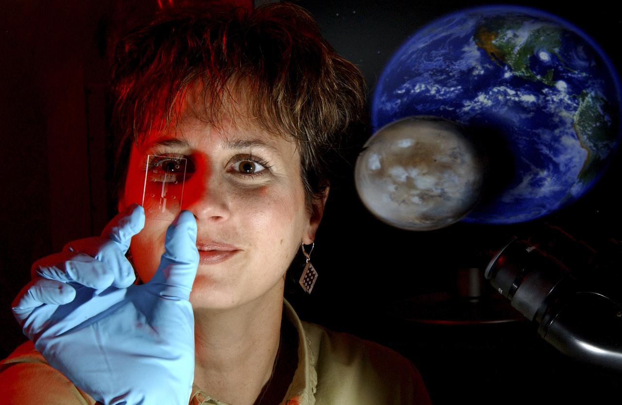
Dr. Lisa Monaco, Marshall Space Flight Center’s (MSFC’s) project scientist for the Lab-on-a-Chip Applications Development (LOCAD) program, examines a lab on a chip. The small dots are actually ports where fluids and chemicals can be mixed or samples can be collected for testing. Tiny channels, only clearly visible under a microscope, form pathways between the ports. Many chemical and biological processes, previously conducted on large pieces of laboratory equipment, can now be performed on these small glass or plastic plates. Monaco and other researchers at MSFC in Huntsville, Alabama, are customizing the chips to be used for many space applications, such as monitoring microbes inside spacecraft and detecting life on other planets. The portable, handheld Lab-on-a Chip Application Development Portable Test System (LOCAD-PTS) made its debut flight aboard Discovery during the STS-116 mission launched December 9, 2006. The system allowed crew members to monitor their environment for problematic contaminants such as yeast, mold, and even E.coli, and salmonella. Once LOCAD-PTS reached the International Space Station (ISS), the Marshall team continued to manage the experiment, monitoring the study from a console in the Payload Operations Center at MSFC. The results of these studies will help NASA researchers refine the technology for future Moon and Mars missions. (NASA/MSFC/D.Stoffer)
STS002-13-208 (12-14 Nov. 1981) --- This clear view of the aft section of the Earth-orbiting space shuttle Columbia's cargo bay and some of its cargo was photographed through the flight deck's aft windows. Visible in the center of the photo are the twin orbital maneuvering system (OMS) pods. The vertical stabilizer or tail splits the top part of the image in half. The Induced Environment Contamination Monitor (IECM) Location experiment is located in the back center of the cargo bay, near the top. There is a grapple fixture attached to the side of the IECM. Various components of the Office of Space Terrestrial Applications (OSTA-1) payload are seen near the aft section of the cargo bay, such as the Feature Identification and Location Experiment (FILE) (the long cone shaped object on the right back), the Shuttle Multispectral Infrared Radiometer (SMIRR) (on pallet base) and the SIR-A recorder in the right foreground. In the left foreground the Shuttle Imaging Radar-A (SIR-A) antenna can be seen. Photo credit: NASA
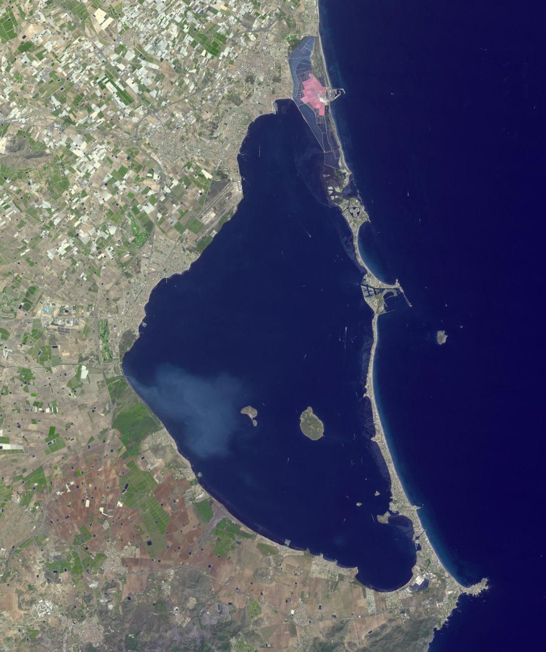
Mar Menor, in southeast Spain, is Europe's largest coastal saltwater lagoon. For the past 40 years, Mar Menor has faced severe contamination from agricultural runoff, leading to large algal blooms, and ecological degradation. Now, major restoration and prevention programs are in place to restore the lagoon, and try to reverse the damage. The image was acquired August 24, 2023, covers an area of 22.6 by 27.4 km, and is located at 37.7 degrees north, 0.8 degrees west. With its 14 spectral bands from the visible to the thermal infrared wavelength region and its high spatial resolution of about 50 to 300 feet (15 to 90 meters), ASTER images Earth to map and monitor the changing surface of our planet. ASTER is one of five Earth-observing instruments launched Dec. 18, 1999, on Terra. The instrument was built by Japan's Ministry of Economy, Trade and Industry. A joint U.S./Japan science team is responsible for validation and calibration of the instrument and data products. The broad spectral coverage and high spectral resolution of ASTER provides scientists in numerous disciplines with critical information for surface mapping and monitoring of dynamic conditions and temporal change. Example applications are monitoring glacial advances and retreats; monitoring potentially active volcanoes; identifying crop stress; determining cloud morphology and physical properties; wetlands evaluation; thermal pollution monitoring; coral reef degradation; surface temperature mapping of soils and geology; and measuring surface heat balance. https://photojournal.jpl.nasa.gov/catalog/PIA26009

When NASA started plarning for manned space travel in 1959, the myriad challenges of sustaining life in space included a seemingly mundane but vitally important problem: How and what do you feed an astronaut? There were two main concerns: preventing food crumbs from contaminating the spacecraft's atmosphere or floating into sensitive instruments, and ensuring complete freedom from potentially catastrophic disease-producing bacteria, viruses, and toxins. To solve these concerns, NASA enlisted the help of the Pillsbury Company. Pillsbury quickly solved the first problem by coating bite-size foods to prevent crumbling. They developed the hazard analysis and critical control point (HACCP) concept to ensure against bacterial contamination. Hazard analysis is a systematic study of product, its ingredients, processing conditions, handling, storage, packing, distribution, and directions for consumer use to identify sensitive areas that might prove hazardous. Hazard analysis provides a basis for blueprinting the Critical Control Points (CCPs) to be monitored. CCPs are points in the chain from raw materials to the finished product where loss of control could result in unacceptable food safety risks. In early 1970, Pillsbury plants were following HACCP in production of food for Earthbound consumers. Pillsbury's subsequent training courses for Food and Drug Administration (FDA) personnel led to the incorporation of HACCP in the FDA's Low Acid Canned Foods Regulations, set down in the mid-1970s to ensure the safety of all canned food products in the U.S.
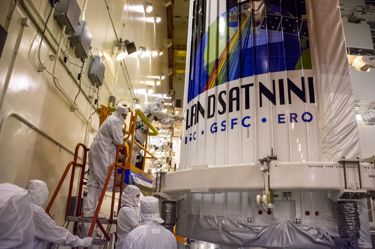
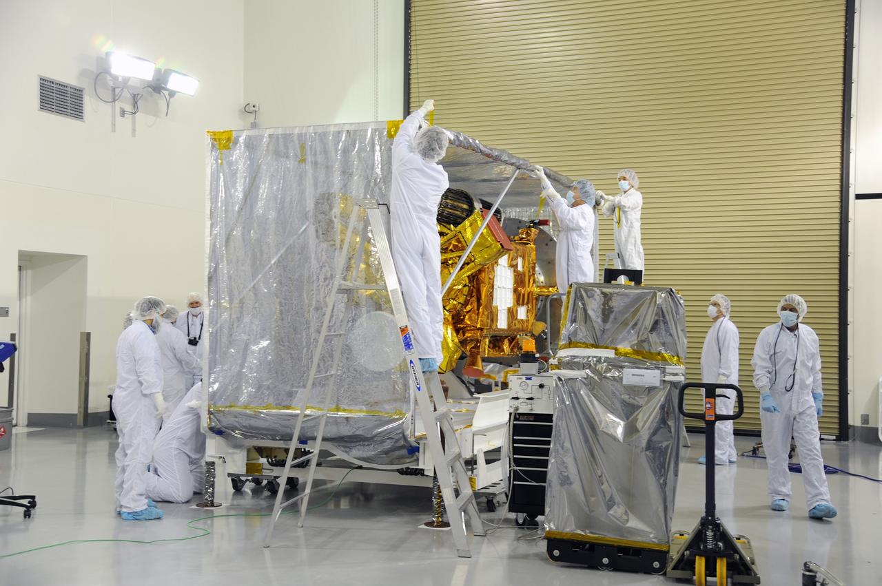
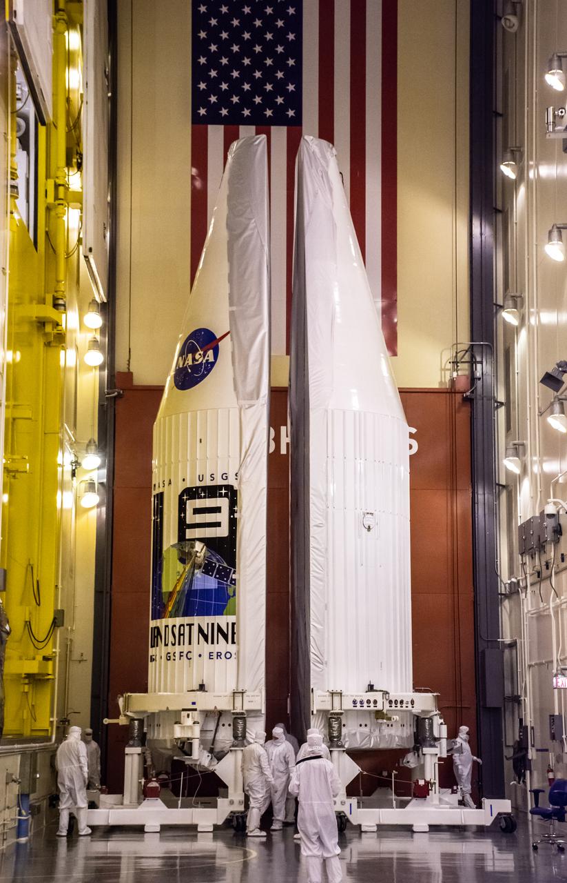
Inside the Integrated Processing Facility at Vandenberg Space Force Base in California, United Launch Alliance (ULA) technicians prepare to remove the contamination barrier and access door from the two ULA Atlas V rocket payload fairings for NASA’s Landsat 9 satellite on June 24, 2021. The fairings will encapsulate the satellite for its launch atop the Atlas V from Vandenberg in September 2021. The launch is being managed by NASA’s Launch Services Program based at Kennedy Space Center in Florida. Landsat 9 will continue the nearly 50-year legacy of previous Landsat missions. It will monitor key natural and economic resources from orbit. Landsat 9 is managed by the agency’s Goddard Space Flight Center in Greenbelt, Maryland. It will carry two instruments: the Operational Land Imager 2, which collects images of Earth’s landscapes in visible, near-infrared and shortwave infrared light, and the Thermal Infrared Sensor 2, which measures the temperature of land surfaces. Like its predecessors, Landsat 9 is a joint mission between NASA and the U.S. Geological Survey.
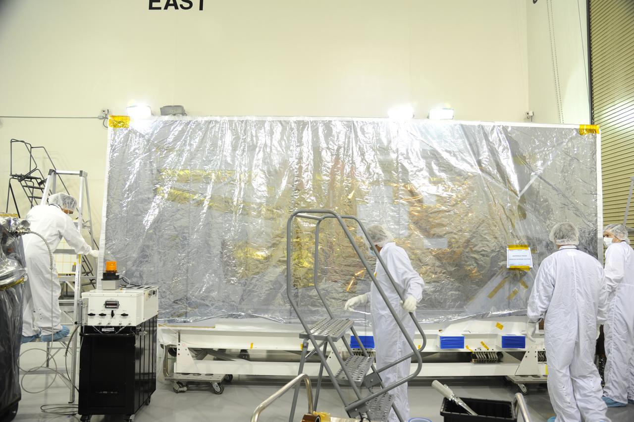
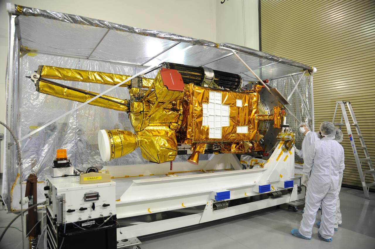
The protective covering has been replaced around NASA's Soil Moisture Active Passive, or SMAP, spacecraft following the spacecraft's post-shipment inspection in the Astrotech payload processing facility on Vandenberg Air Force Base in California. The covering will protect the spacecraft from static-charge buildup and contamination while it awaits further processing. SMAP will launch on a Delta II 7320 configuration vehicle featuring a United Launch Alliance first stage booster powered by an Aerojet Rocketdyne RS-27A main engine and three Alliant Techsystems, or ATK, strap-on solid rocket motors. Once on station in Earth orbit, SMAP will provide global measurements of soil moisture and its freeze/thaw state. These measurements will be used to enhance understanding of processes that link the water, energy and carbon cycles, and to extend the capabilities of weather and climate prediction models. SMAP data also will be used to quantify net carbon flux in boreal landscapes and to develop improved flood prediction and drought monitoring capabilities. Launch from Space Launch Complex 2 is targeted for Jan. 29, 2015.
VANDENBERG AIR FORCE BASE, Calif. – Workers inspect NASA's Soil Moisture Active Passive, or SMAP, spacecraft after its protective covering is removed in the Astrotech payload processing facility on Vandenberg Air Force Base in California during a post-shipment inspection. The covering protected the spacecraft from static-charge buildup and contamination while it was in transit from NASA's Jet Propulsion Laboratory in Pasadena, California. SMAP will launch on a Delta II 7320 configuration vehicle featuring a United Launch Alliance first stage booster powered by an Aerojet Rocketdyne RS-27A main engine and three Alliant Techsystems, or ATK, strap-on solid rocket motors. Once on station in Earth orbit, SMAP will provide global measurements of soil moisture and its freeze/thaw state. These measurements will be used to enhance understanding of processes that link the water, energy and carbon cycles, and to extend the capabilities of weather and climate prediction models. SMAP data also will be used to quantify net carbon flux in boreal landscapes and to develop improved flood prediction and drought monitoring capabilities. Launch from Space Launch Complex 2 is targeted for Jan. 29, 2015. To learn more about SMAP, visit http://smap.jpl.nasa.gov. Photo credit: NASA/Robert Rasmison
VANDENBERG AIR FORCE BASE, Calif. – The protective covering has been replaced around NASA's Soil Moisture Active Passive, or SMAP, spacecraft following the spacecraft's post-shipment inspection in the Astrotech payload processing facility on Vandenberg Air Force Base in California. The covering will protect the spacecraft from static-charge buildup and contamination while it awaits further processing. SMAP will launch on a Delta II 7320 configuration vehicle featuring a United Launch Alliance first stage booster powered by an Aerojet Rocketdyne RS-27A main engine and three Alliant Techsystems, or ATK, strap-on solid rocket motors. Once on station in Earth orbit, SMAP will provide global measurements of soil moisture and its freeze/thaw state. These measurements will be used to enhance understanding of processes that link the water, energy and carbon cycles, and to extend the capabilities of weather and climate prediction models. SMAP data also will be used to quantify net carbon flux in boreal landscapes and to develop improved flood prediction and drought monitoring capabilities. Launch from Space Launch Complex 2 is targeted for Jan. 29, 2015. To learn more about SMAP, visit http://smap.jpl.nasa.gov. Photo credit: NASA/Robert Rasmison
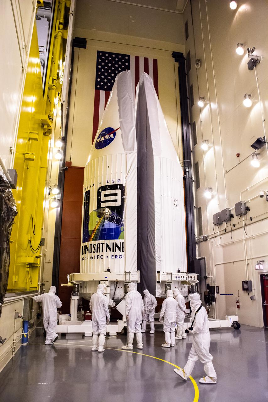
Inside the Integrated Processing Facility at Vandenberg Space Force Base in California, United Launch Alliance (ULA) technicians remove the contamination barrier from the two ULA Atlas V rocket payload fairings for NASA’s Landsat 9 satellite on June 23, 2021. The fairings will encapsulate the satellite for its launch atop the Atlas V from Vandenberg in September 2021. The launch is being managed by NASA’s Launch Services Program based at Kennedy Space Center in Florida. Landsat 9 will continue the nearly 50-year legacy of previous Landsat missions. It will monitor key natural and economic resources from orbit. Landsat 9 is managed by the agency’s Goddard Space Flight Center in Greenbelt, Maryland. It will carry two instruments: the Operational Land Imager 2, which collects images of Earth’s landscapes in visible, near-infrared and shortwave infrared light, and the Thermal Infrared Sensor 2, which measures the temperature of land surfaces. Like its predecessors, Landsat 9 is a joint mission between NASA and the U.S. Geological Survey.
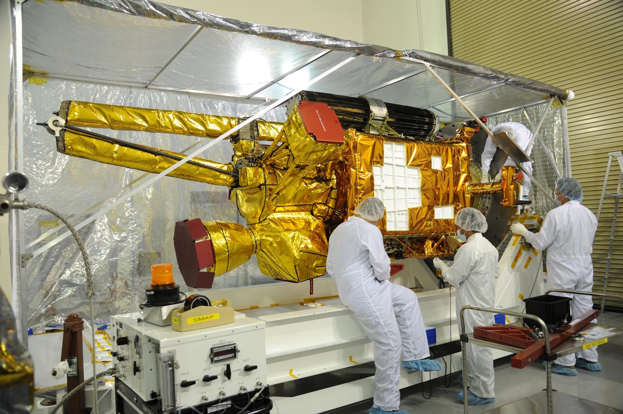
NASA's Soil Moisture Active Passive, or SMAP, spacecraft comes into view as the protective covering is removed in the Astrotech payload processing facility on Vandenberg Air Force Base in California during a post-shipment inspection. The covering protected the spacecraft from static-charge buildup and contamination while it was in transit from NASA's Jet Propulsion Laboratory in Pasadena, California. SMAP will launch on a Delta II 7320 configuration vehicle featuring a United Launch Alliance first stage booster powered by an Aerojet Rocketdyne RS-27A main engine and three Alliant Techsystems, or ATK, strap-on solid rocket motors. Once on station in Earth orbit, SMAP will provide global measurements of soil moisture and its freeze/thaw state. These measurements will be used to enhance understanding of processes that link the water, energy and carbon cycles, and to extend the capabilities of weather and climate prediction models. SMAP data also will be used to quantify net carbon flux in boreal landscapes and to develop improved flood prediction and drought monitoring capabilities. Launch from Space Launch Complex 2 is targeted for Jan. 29, 2015.
VANDENBERG AIR FORCE BASE, Calif. – Workers remove the protective covering from around NASA's Soil Moisture Active Passive, or SMAP, spacecraft in the Astrotech payload processing facility on Vandenberg Air Force Base in California during a post-shipment inspection. The covering protected the spacecraft from static-charge buildup and contamination while it was in transit from NASA's Jet Propulsion Laboratory in Pasadena, California. SMAP will launch on a Delta II 7320 configuration vehicle featuring a United Launch Alliance first stage booster powered by an Aerojet Rocketdyne RS-27A main engine and three Alliant Techsystems, or ATK, strap-on solid rocket motors. Once on station in Earth orbit, SMAP will provide global measurements of soil moisture and its freeze/thaw state. These measurements will be used to enhance understanding of processes that link the water, energy and carbon cycles, and to extend the capabilities of weather and climate prediction models. SMAP data also will be used to quantify net carbon flux in boreal landscapes and to develop improved flood prediction and drought monitoring capabilities. Launch from Space Launch Complex 2 is targeted for Jan. 29, 2015. To learn more about SMAP, visit http://smap.jpl.nasa.gov. Photo credit: NASA/Robert Rasmison
Inside the Integrated Processing Facility at Vandenberg Space Force Base in California, United Launch Alliance (ULA) technicians remove the contamination barrier from the two ULA Atlas V rocket payload fairings for NASA’s Landsat 9 satellite on June 23, 2021. The fairings will encapsulate the satellite for its launch atop the Atlas V from Vandenberg in September 2021. The launch is being managed by NASA’s Launch Services Program based at Kennedy Space Center in Florida. Landsat 9 will continue the nearly 50-year legacy of previous Landsat missions. It will monitor key natural and economic resources from orbit. Landsat 9 is managed by the agency’s Goddard Space Flight Center in Greenbelt, Maryland. It will carry two instruments: the Operational Land Imager 2, which collects images of Earth’s landscapes in visible, near-infrared and shortwave infrared light, and the Thermal Infrared Sensor 2, which measures the temperature of land surfaces. Like its predecessors, Landsat 9 is a joint mission between NASA and the U.S. Geological Survey.
The Marshall Space Flight Center (MSFC) is responsible for designing and building the life support systems that will provide the crew of the International Space Station (ISS) a comfortable environment in which to live and work. Scientists and engineers at the MSFC are working together to provide the ISS with systems that are safe, efficient, and cost-effective. These compact and powerful systems are collectively called the Environmental Control and Life Support Systems, or simply, ECLSS. This photograph shows the fifth generation Urine Processor Development Hardware. The Urine Processor Assembly (UPA) is a part of the Water Recovery System (WRS) on the ISS. It uses a chase change process called vapor compression distillation technology to remove contaminants from urine. The UPA accepts and processes pretreated crewmember urine to allow it to be processed along with other wastewaters in the Water Processor Assembly (WPA). The WPA removes free gas, organic, and nonorganic constituents before the water goes through a series of multifiltration beds for further purification. Product water quality is monitored primarily through conductivity measurements. Unacceptable water is sent back through the WPA for reprocessing. Clean water is sent to a storage tank.

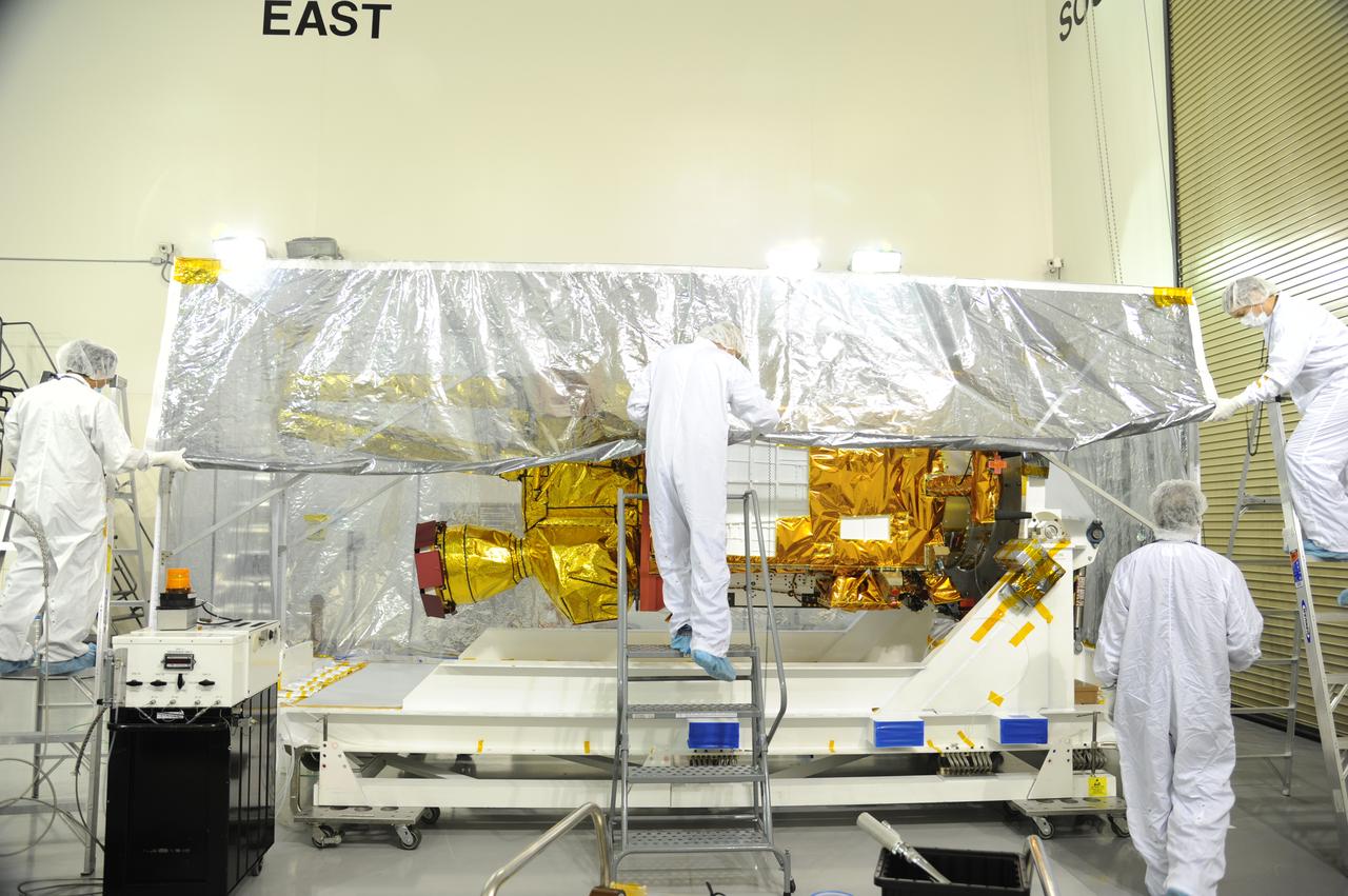
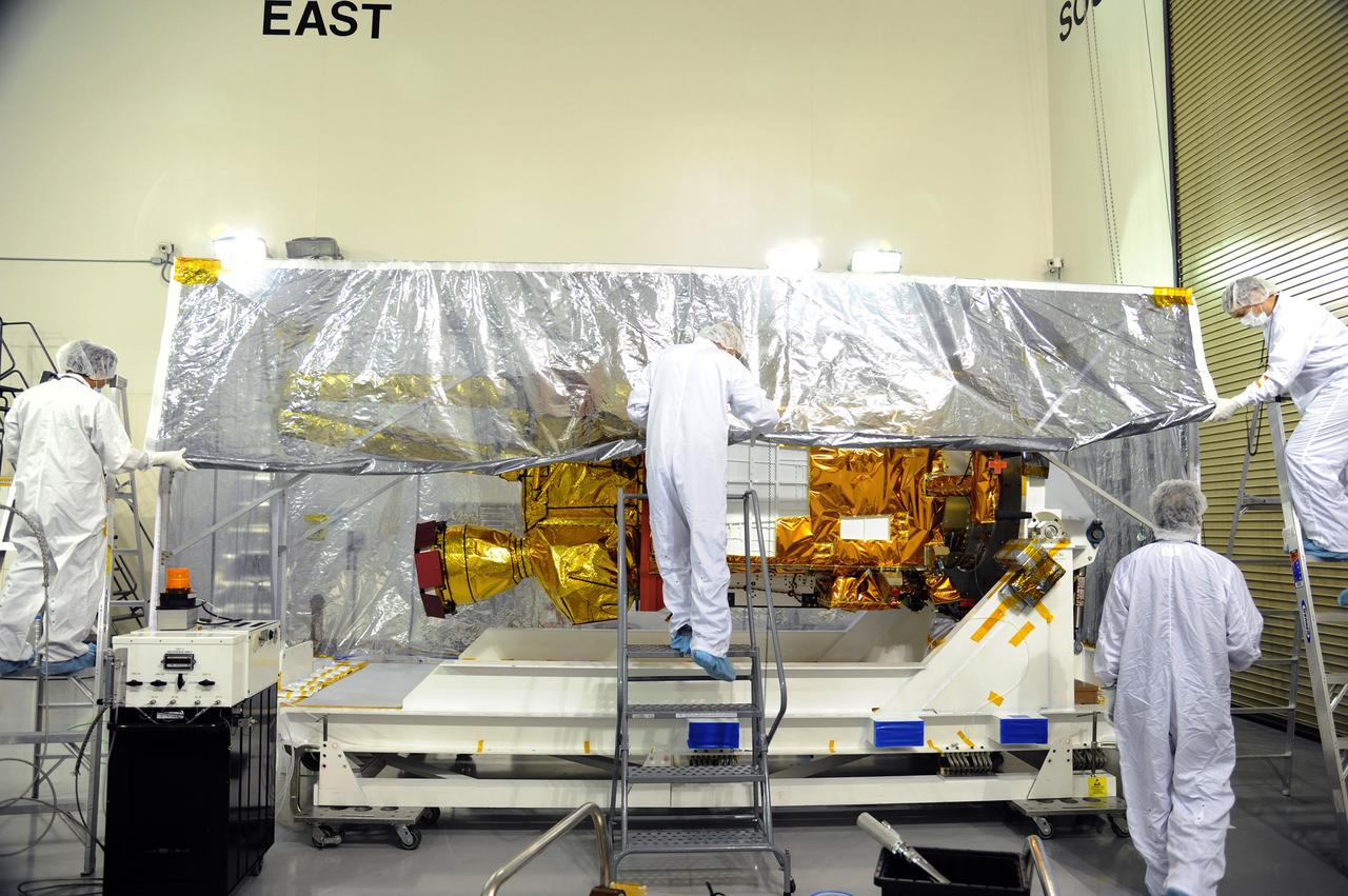
Inside the Integrated Processing Facility at Vandenberg Space Force Base in California, United Launch Alliance (ULA) technicians perform a blacklight test and sampling for contaminants on one of two ULA Atlas V rocket payload fairings for NASA’s Landsat 9 satellite on June 23, 2021. The fairings will encapsulate the satellite for its launch atop the Atlas V from Vandenberg in September 2021. The launch is being managed by NASA’s Launch Services Program based at Kennedy Space Center in Florida. Landsat 9 will continue the nearly 50-year legacy of previous Landsat missions. It will monitor key natural and economic resources from orbit. Landsat 9 is managed by the agency’s Goddard Space Flight Center in Greenbelt, Maryland. It will carry two instruments: the Operational Land Imager 2, which collects images of Earth’s landscapes in visible, near-infrared and shortwave infrared light, and the Thermal Infrared Sensor 2, which measures the temperature of land surfaces. Like its predecessors, Landsat 9 is a joint mission between NASA and the U.S. Geological Survey.

Inside the Integrated Processing Facility at Vandenberg Space Force Base in California, United Launch Alliance (ULA) technicians prepare to perform a blacklight test and sampling for contaminants on the two ULA Atlas V rocket payload fairings for NASA’s Landsat 9 satellite on June 23, 2021. The fairings will encapsulate the satellite for its launch atop the Atlas V from Vandenberg in September 2021. The launch is being managed by NASA’s Launch Services Program based at Kennedy Space Center in Florida. Landsat 9 will continue the nearly 50-year legacy of previous Landsat missions. It will monitor key natural and economic resources from orbit. Landsat 9 is managed by the agency’s Goddard Space Flight Center in Greenbelt, Maryland. It will carry two instruments: the Operational Land Imager 2, which collects images of Earth’s landscapes in visible, near-infrared and shortwave infrared light, and the Thermal Infrared Sensor 2, which measures the temperature of land surfaces. Like its predecessors, Landsat 9 is a joint mission between NASA and the U.S. Geological Survey.
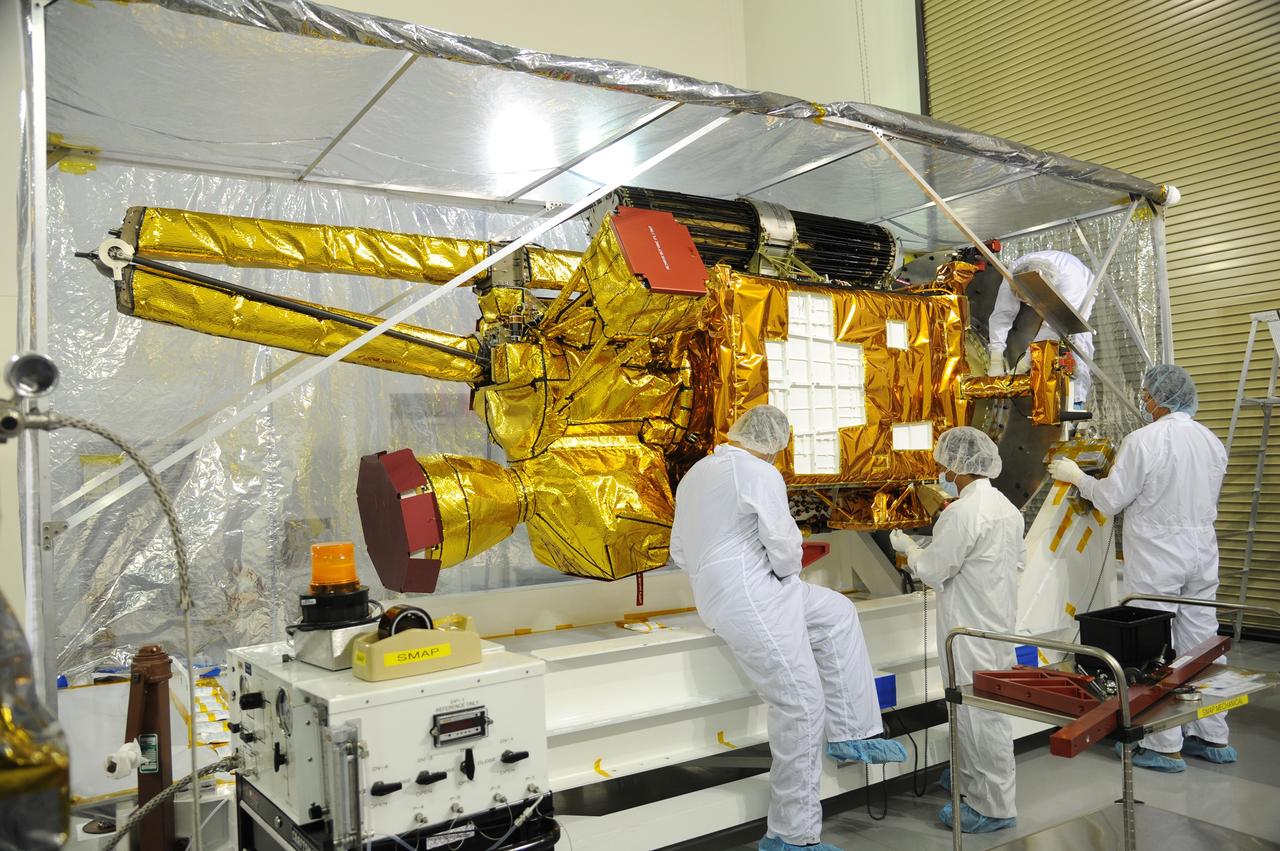
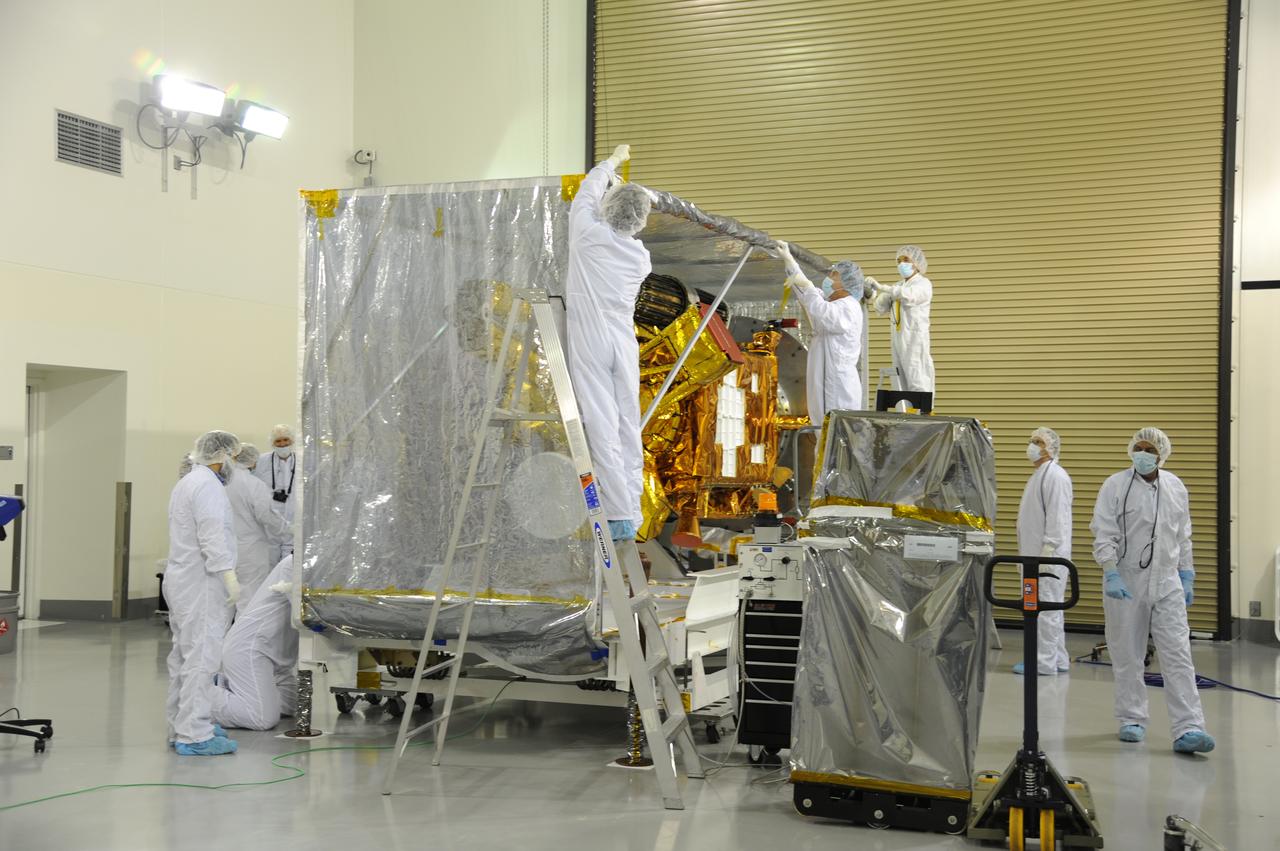
Preparations are underway to remove the protective covering from NASA's Soil Moisture Active Passive, or SMAP, spacecraft in the Astrotech payload processing facility on Vandenberg Air Force Base in California during a post-shipment inspection. The covering protects the spacecraft from static-charge buildup and contamination. SMAP will launch on a Delta II 7320 configuration vehicle featuring a United Launch Alliance first stage booster powered by an Aerojet Rocketdyne RS-27A main engine and three Alliant Techsystems, or ATK, strap-on solid rocket motors. Once on station in Earth orbit, SMAP will provide global measurements of soil moisture and its freeze/thaw state. These measurements will be used to enhance understanding of processes that link the water, energy and carbon cycles, and to extend the capabilities of weather and climate prediction models. SMAP data also will be used to quantify net carbon flux in boreal landscapes and to develop improved flood prediction and drought monitoring capabilities. Launch from Space Launch Complex 2 is targeted for Jan. 29, 2015.
Workers remove the protective covering from around NASA's Soil Moisture Active Passive, or SMAP, spacecraft in the Astrotech payload processing facility on Vandenberg Air Force Base in California during a post-shipment inspection. The covering protected the spacecraft from static-charge buildup and contamination while it was in transit from NASA's Jet Propulsion Laboratory in Pasadena, California. SMAP will launch on a Delta II 7320 configuration vehicle featuring a United Launch Alliance first stage booster powered by an Aerojet Rocketdyne RS-27A main engine and three Alliant Techsystems, or ATK, strap-on solid rocket motors. Once on station in Earth orbit, SMAP will provide global measurements of soil moisture and its freeze/thaw state. These measurements will be used to enhance understanding of processes that link the water, energy and carbon cycles, and to extend the capabilities of weather and climate prediction models. SMAP data also will be used to quantify net carbon flux in boreal landscapes and to develop improved flood prediction and drought monitoring capabilities. Launch from Space Launch Complex 2 is targeted for Jan. 29, 2015.
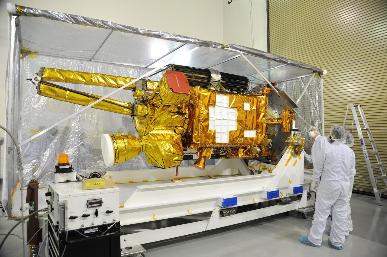
VANDENBERG AIR FORCE BASE, Calif. – NASA's Soil Moisture Active Passive, or SMAP, spacecraft comes into view as the protective covering is removed in the Astrotech payload processing facility on Vandenberg Air Force Base in California during a post-shipment inspection. The covering protected the spacecraft from static-charge buildup and contamination while it was in transit from NASA's Jet Propulsion Laboratory in Pasadena, California. SMAP will launch on a Delta II 7320 configuration vehicle featuring a United Launch Alliance first stage booster powered by an Aerojet Rocketdyne RS-27A main engine and three Alliant Techsystems, or ATK, strap-on solid rocket motors. Once on station in Earth orbit, SMAP will provide global measurements of soil moisture and its freeze/thaw state. These measurements will be used to enhance understanding of processes that link the water, energy and carbon cycles, and to extend the capabilities of weather and climate prediction models. SMAP data also will be used to quantify net carbon flux in boreal landscapes and to develop improved flood prediction and drought monitoring capabilities. Launch from Space Launch Complex 2 is targeted for Jan. 29, 2015. To learn more about SMAP, visit http://smap.jpl.nasa.gov. Photo credit: NASA/Robert Rasmison
Inside the Integrated Processing Facility at Vandenberg Space Force Base in California, United Launch Alliance (ULA) technicians prepare to perform a blacklight test and sampling for contaminants on the two ULA Atlas V rocket payload fairings for NASA’s Landsat 9 satellite on June 23, 2021. The fairings will encapsulate the satellite for its launch atop the Atlas V from Vandenberg in September 2021. The launch is being managed by NASA’s Launch Services Program based at Kennedy Space Center in Florida. Landsat 9 will continue the nearly 50-year legacy of previous Landsat missions. It will monitor key natural and economic resources from orbit. Landsat 9 is managed by the agency’s Goddard Space Flight Center in Greenbelt, Maryland. It will carry two instruments: the Operational Land Imager 2, which collects images of Earth’s landscapes in visible, near-infrared and shortwave infrared light, and the Thermal Infrared Sensor 2, which measures the temperature of land surfaces. Like its predecessors, Landsat 9 is a joint mission between NASA and the U.S. Geological Survey.

VANDENBERG AIR FORCE BASE, Calif. – Preparations are underway to remove the protective covering from NASA's Soil Moisture Active Passive, or SMAP, spacecraft in the Astrotech payload processing facility on Vandenberg Air Force Base in California during a post-shipment inspection. The covering protects the spacecraft from static-charge buildup and contamination. SMAP will launch on a Delta II 7320 configuration vehicle featuring a United Launch Alliance first stage booster powered by an Aerojet Rocketdyne RS-27A main engine and three Alliant Techsystems, or ATK, strap-on solid rocket motors. Once on station in Earth orbit, SMAP will provide global measurements of soil moisture and its freeze/thaw state. These measurements will be used to enhance understanding of processes that link the water, energy and carbon cycles, and to extend the capabilities of weather and climate prediction models. SMAP data also will be used to quantify net carbon flux in boreal landscapes and to develop improved flood prediction and drought monitoring capabilities. Launch from Space Launch Complex 2 is targeted for Jan. 29, 2015. To learn more about SMAP, visit http://smap.jpl.nasa.gov. Photo credit: NASA/Robert Rasmison
Workers inspect NASA's Soil Moisture Active Passive, or SMAP, spacecraft after its protective covering is removed in the Astrotech payload processing facility on Vandenberg Air Force Base in California during a post-shipment inspection. The covering protected the spacecraft from static-charge buildup and contamination while it was in transit from NASA's Jet Propulsion Laboratory in Pasadena, California. SMAP will launch on a Delta II 7320 configuration vehicle featuring a United Launch Alliance first stage booster powered by an Aerojet Rocketdyne RS-27A main engine and three Alliant Techsystems, or ATK, strap-on solid rocket motors. Once on station in Earth orbit, SMAP will provide global measurements of soil moisture and its freeze/thaw state. These measurements will be used to enhance understanding of processes that link the water, energy and carbon cycles, and to extend the capabilities of weather and climate prediction models. SMAP data also will be used to quantify net carbon flux in boreal landscapes and to develop improved flood prediction and drought monitoring capabilities. Launch from Space Launch Complex 2 is targeted for Jan. 29, 2015.
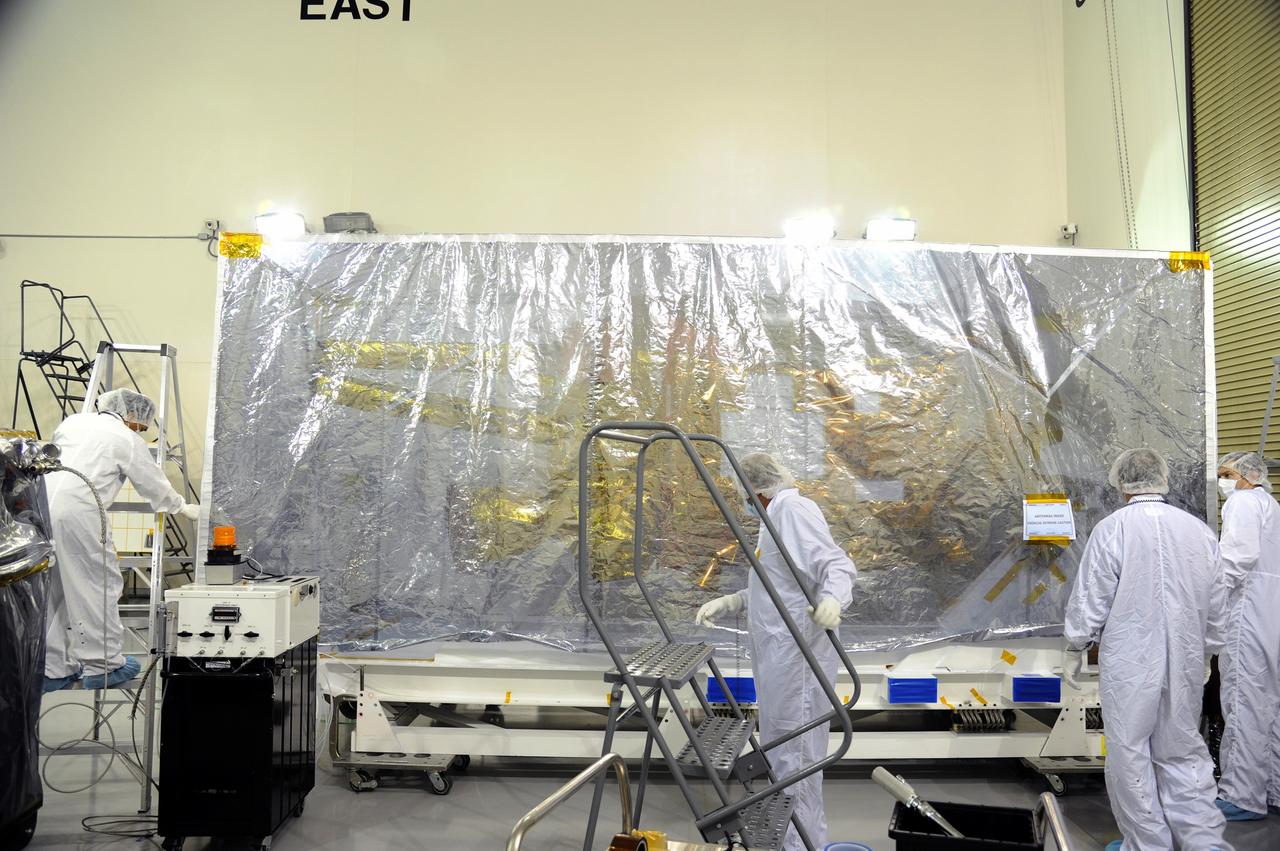
Workers replace the protective covering around NASA's Soil Moisture Active Passive, or SMAP, spacecraft following the spacecraft's post-shipment inspection in the Astrotech payload processing facility on Vandenberg Air Force Base in California. The covering protected the spacecraft from static-charge buildup and contamination while it was in transit from NASA's Jet Propulsion Laboratory in Pasadena, California. SMAP will launch on a Delta II 7320 configuration vehicle featuring a United Launch Alliance first stage booster powered by an Aerojet Rocketdyne RS-27A main engine and three Alliant Techsystems, or ATK, strap-on solid rocket motors. Once on station in Earth orbit, SMAP will provide global measurements of soil moisture and its freeze/thaw state. These measurements will be used to enhance understanding of processes that link the water, energy and carbon cycles, and to extend the capabilities of weather and climate prediction models. SMAP data also will be used to quantify net carbon flux in boreal landscapes and to develop improved flood prediction and drought monitoring capabilities. Launch from Space Launch Complex 2 is targeted for Jan. 29, 2015.
VANDENBERG AIR FORCE BASE, Calif. – Workers replace the protective covering around NASA's Soil Moisture Active Passive, or SMAP, spacecraft following the spacecraft's post-shipment inspection in the Astrotech payload processing facility on Vandenberg Air Force Base in California. The covering protected the spacecraft from static-charge buildup and contamination while it was in transit from NASA's Jet Propulsion Laboratory in Pasadena, California. SMAP will launch on a Delta II 7320 configuration vehicle featuring a United Launch Alliance first stage booster powered by an Aerojet Rocketdyne RS-27A main engine and three Alliant Techsystems, or ATK, strap-on solid rocket motors. Once on station in Earth orbit, SMAP will provide global measurements of soil moisture and its freeze/thaw state. These measurements will be used to enhance understanding of processes that link the water, energy and carbon cycles, and to extend the capabilities of weather and climate prediction models. SMAP data also will be used to quantify net carbon flux in boreal landscapes and to develop improved flood prediction and drought monitoring capabilities. Launch from Space Launch Complex 2 is targeted for Jan. 29, 2015. To learn more about SMAP, visit http://smap.jpl.nasa.gov. Photo credit: NASA/Robert Rasmison
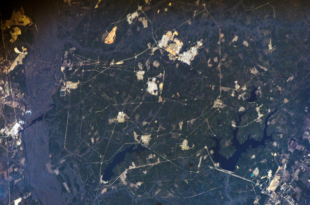
ISS012-E-16633 (28 Jan. 2006) --- Savannah River Site, South Carolina is featured in this image photographed by an Expedition 12 crew member on the International Space Station. Situated between the South Carolina piedmont and the Atlantic Ocean, the Savannah River Site is an important part of the US Department of Energy’s nuclear program. Construction of the site – originally called the Savannah River Plant – began in 1951 for the purpose of generating radioactive materials, primarily the hydrogen isotope tritium and plutonium-239, necessary for nuclear weapons production during the Cold War. A total of five nuclear reactors occupy the central portion of the site and operated throughout 1953-1992. Following the end of the Cold War in 1991 activities at the Savannah River Site are now focused on disposal of nuclear wastes, environmental cleanup of the site itself, and development of advanced remediation technologies. The Savannah River Site is located in the Sand Hills region of South Carolina and includes an area of 800 square kilometers (300 square miles). The southern half of the Site (building clusters with reflective white rooftops) is shown. The nearby Savannah River and its tributary creeks provided a ready source of water for the nuclear reactors; to this end, two artificial lakes (“L” Lake and Par Pond) were constructed. The meandering channel of the River and its floodplain, characterized by grey-brown sediments, extends from northwest to southeast across the left portion of the image. The proximity of the River, and the permeable nature of the geological materials under laying the site (sand, clay, gravel, and carbonate rocks), necessitate extensive and ongoing environmental monitoring and cleanup efforts to reduce potential contamination of local water sources. According to NASA scientists, final remediation of wastes posing threats to surface and groundwater is scheduled to occur by 2025.