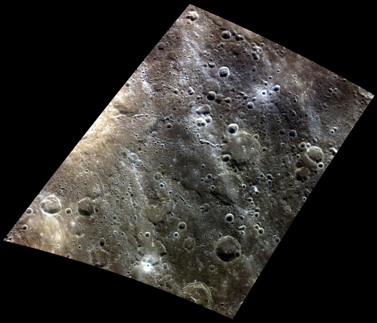
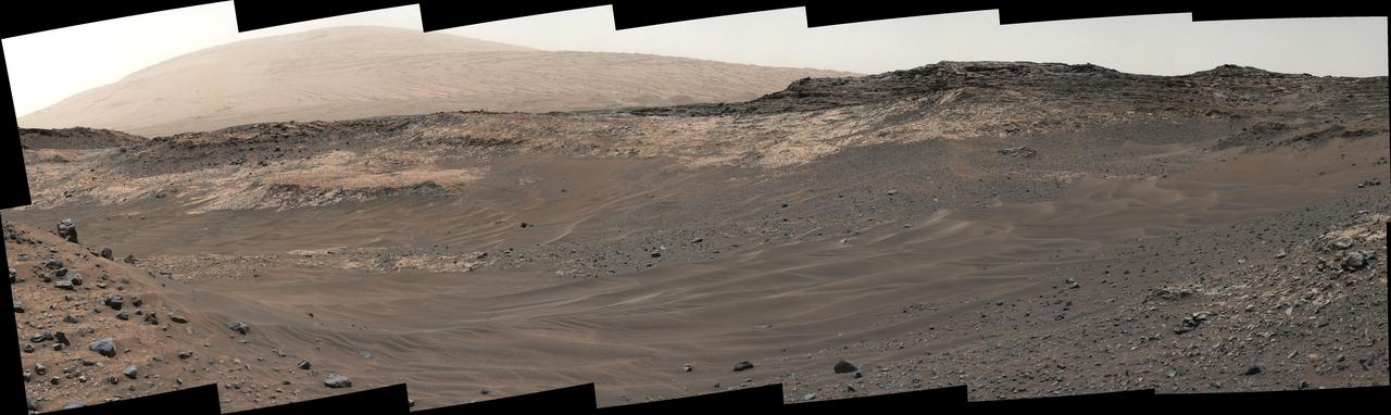
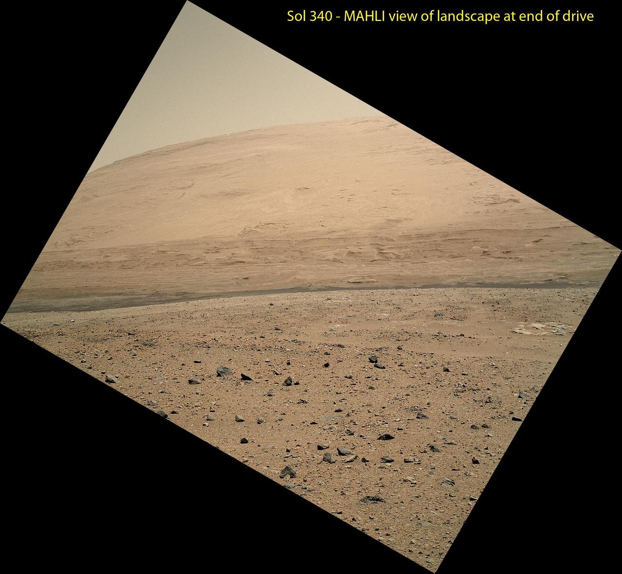
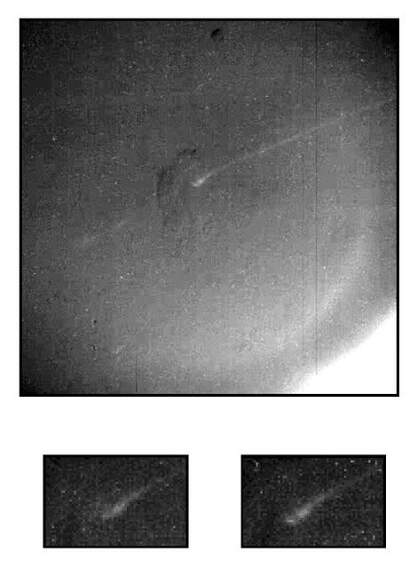
The Crossing of Endeavour
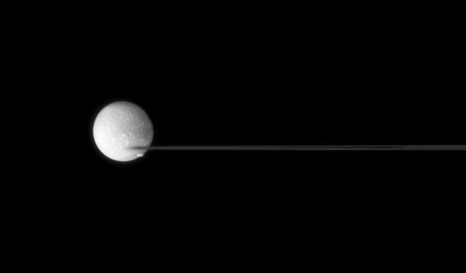
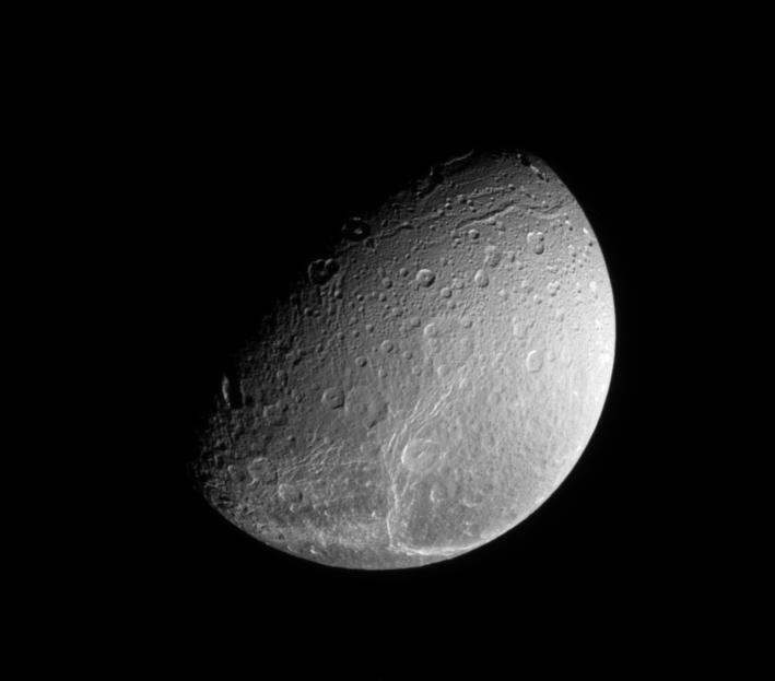
Crossing Dione
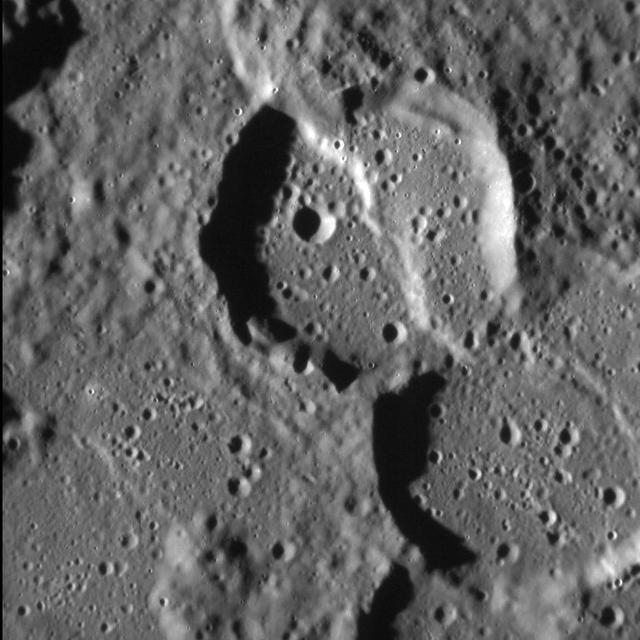
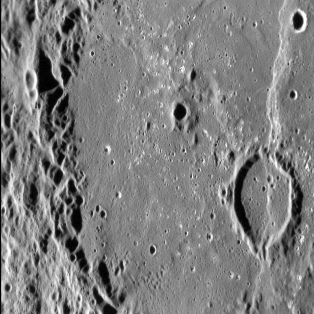
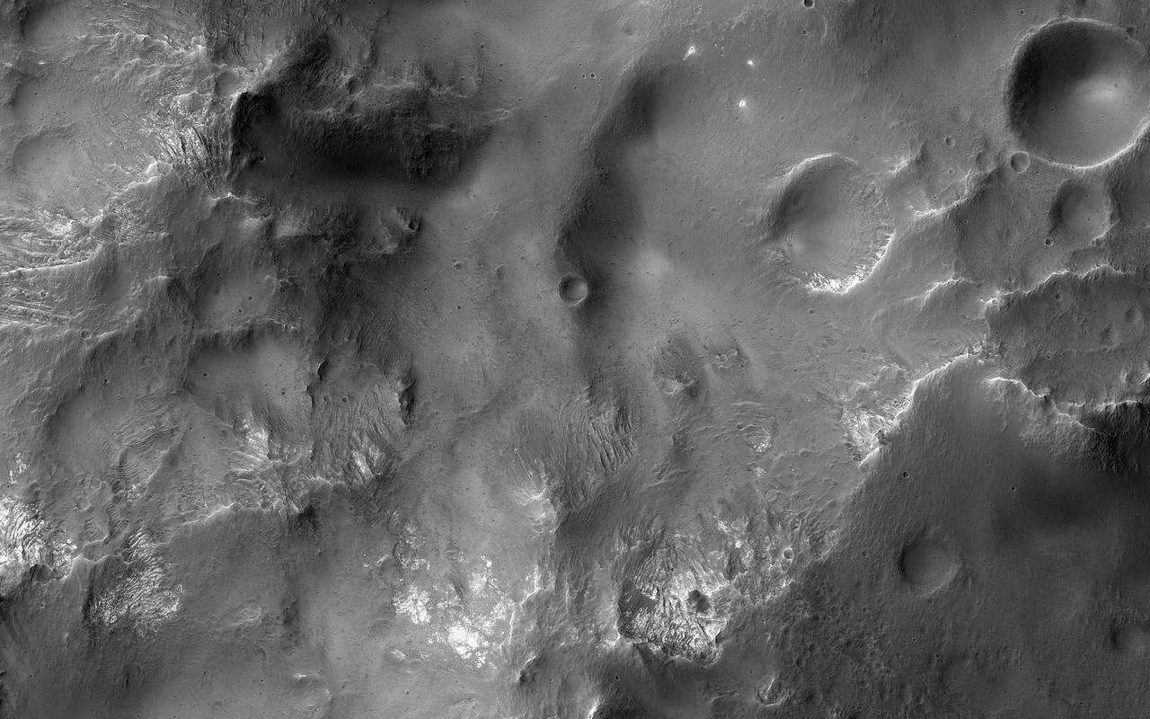
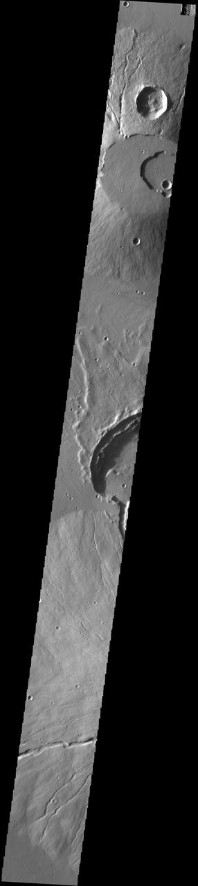
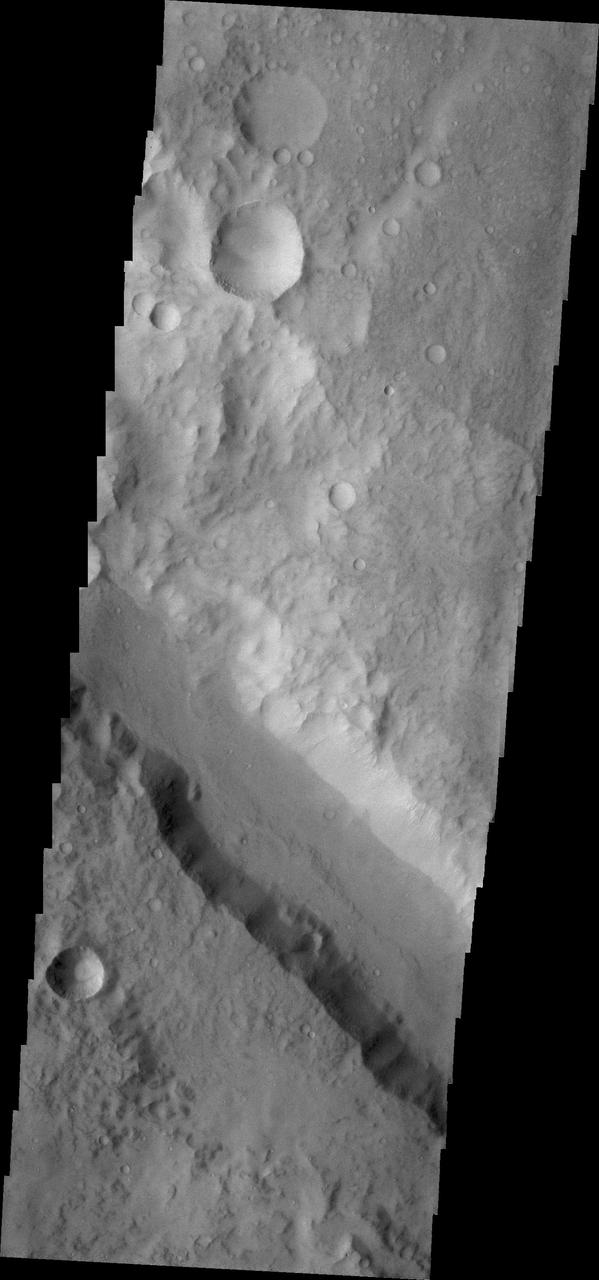
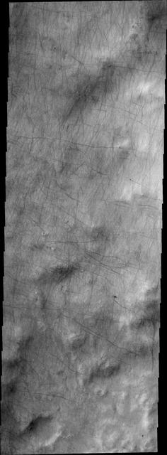
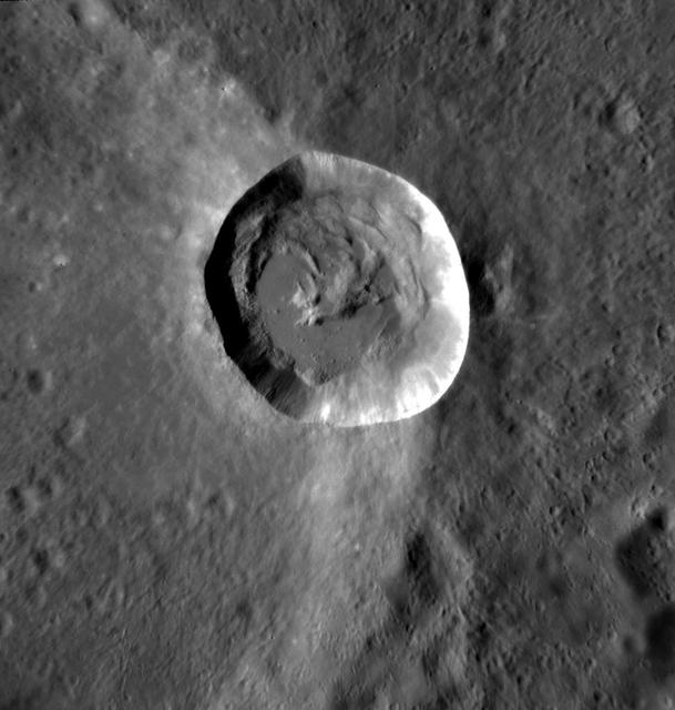
Crossed Craters
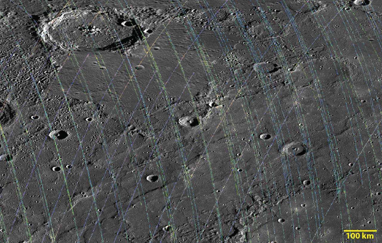
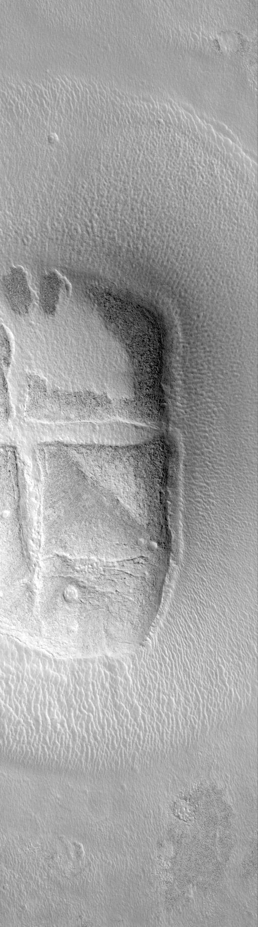
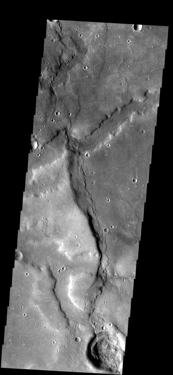
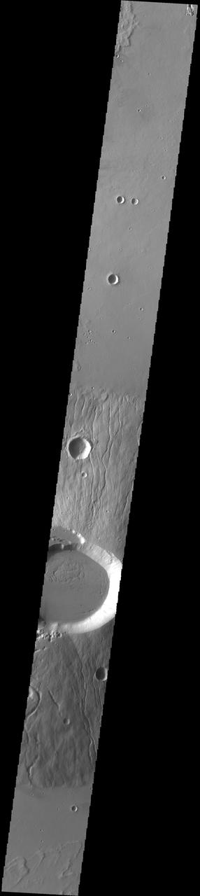
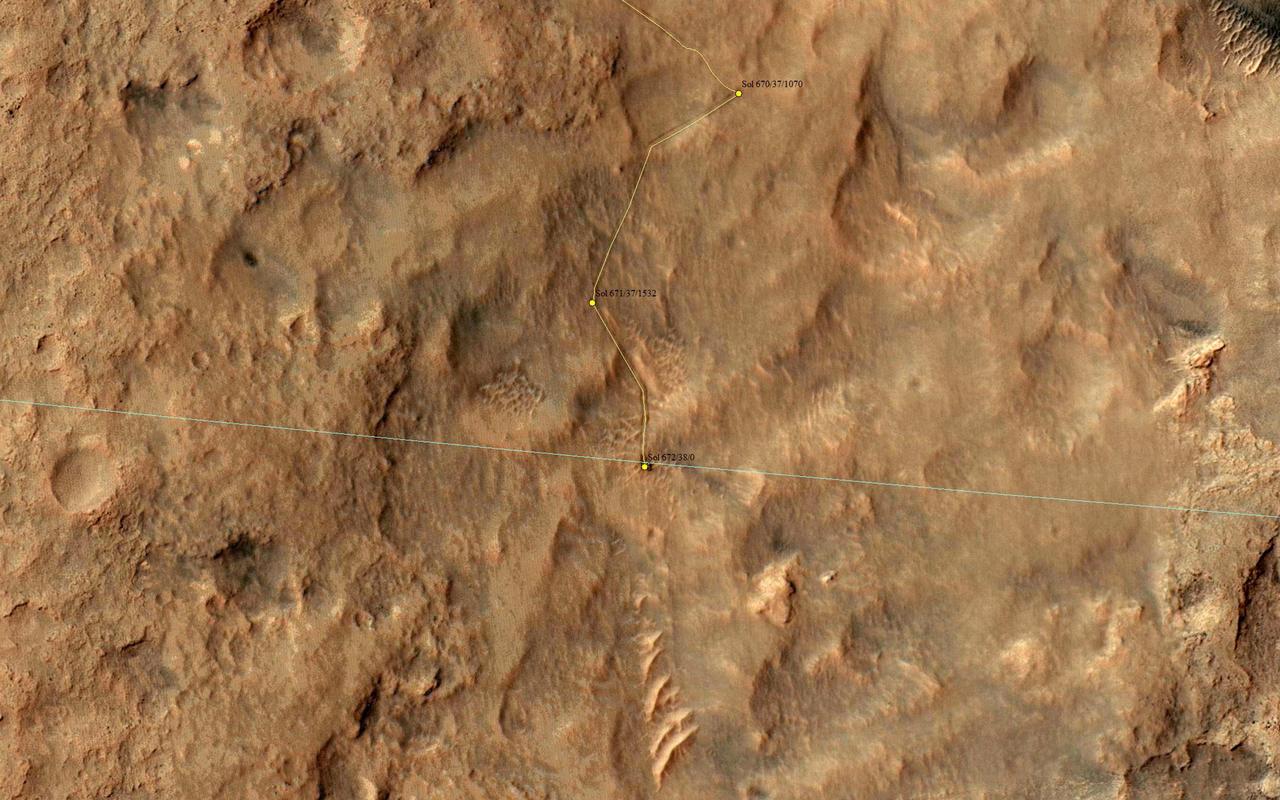
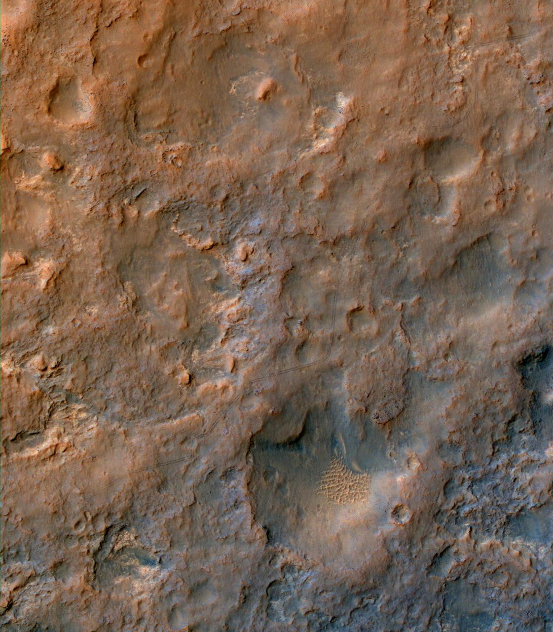
Crossing Paths
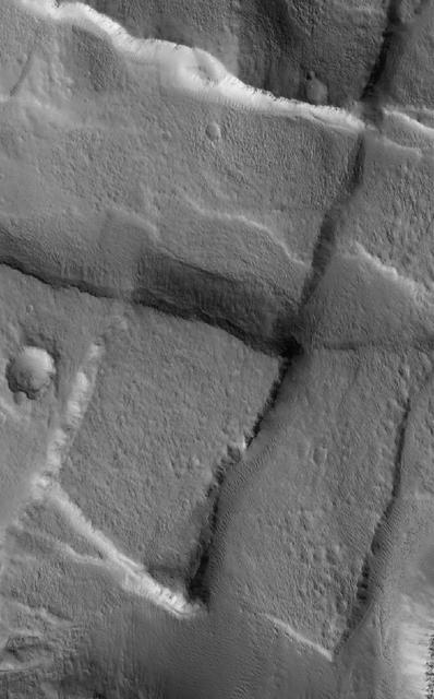
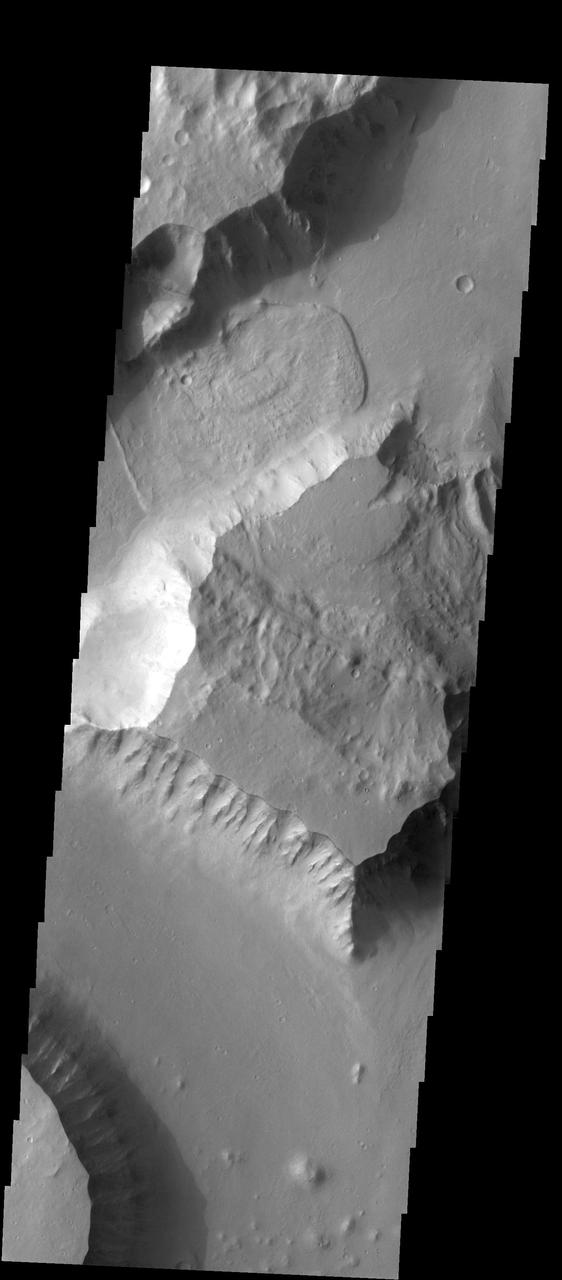
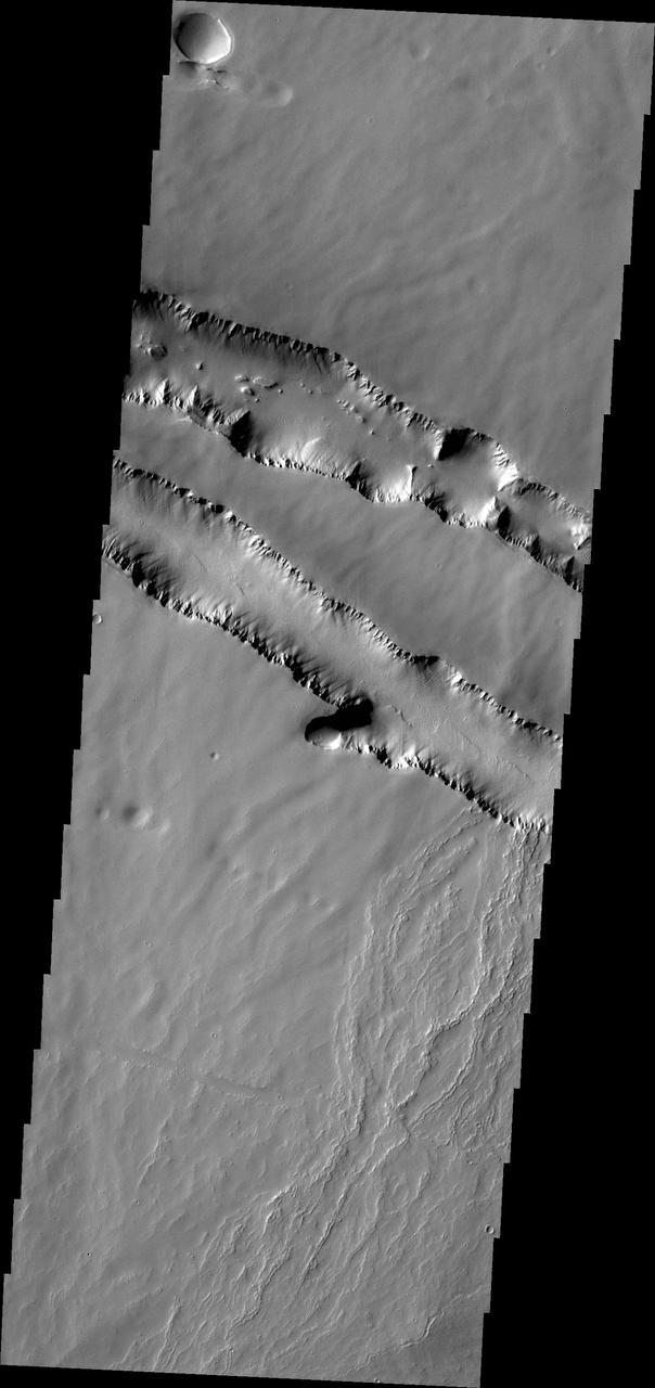
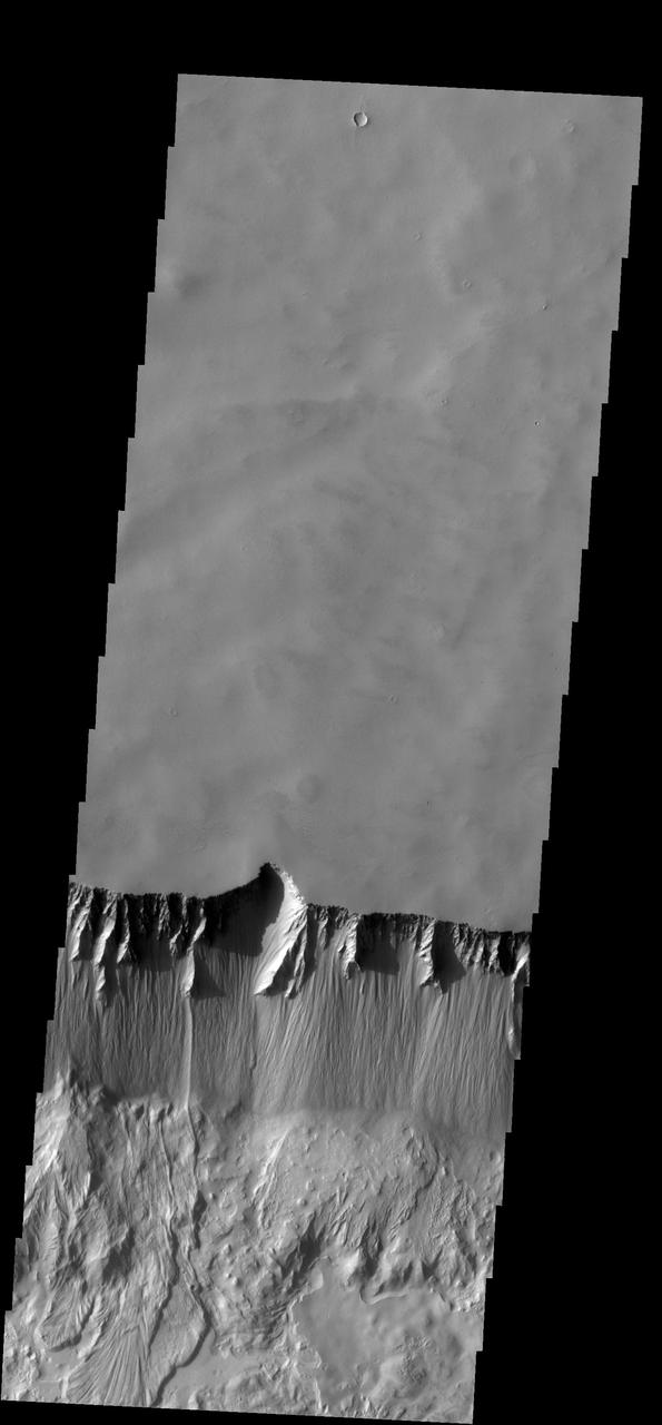
Crossing Cliffs
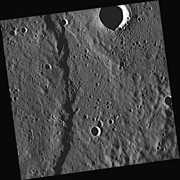
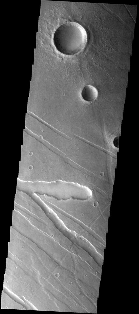
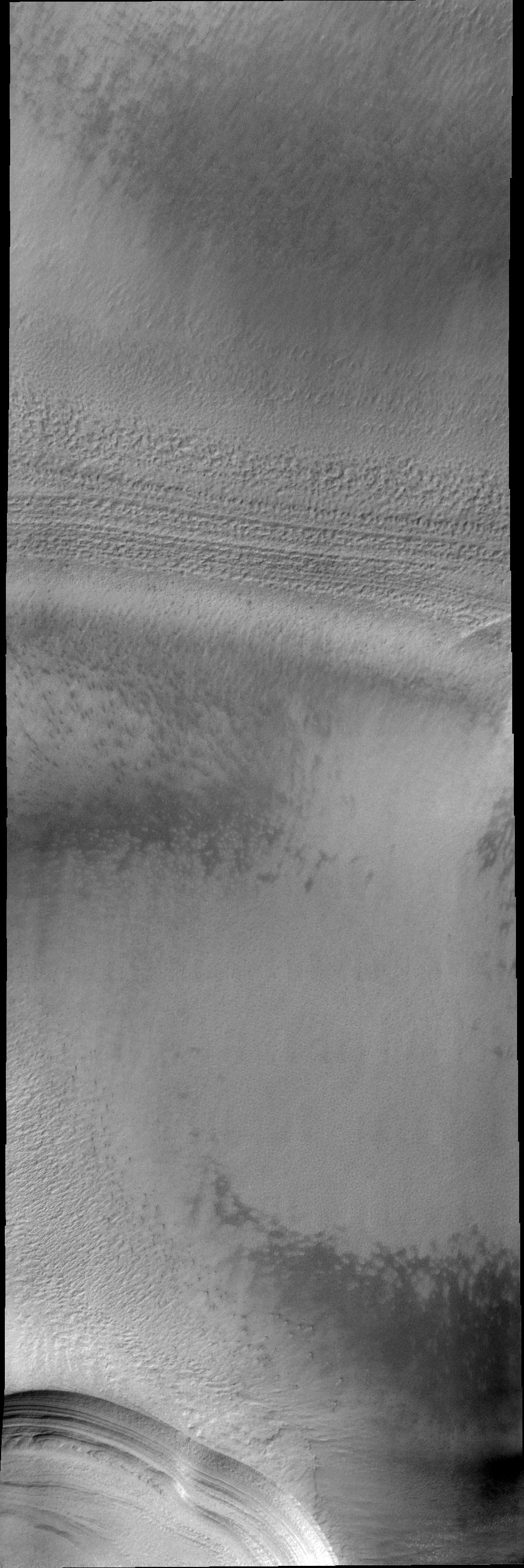
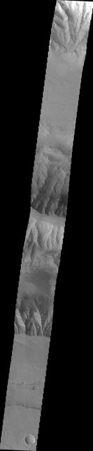
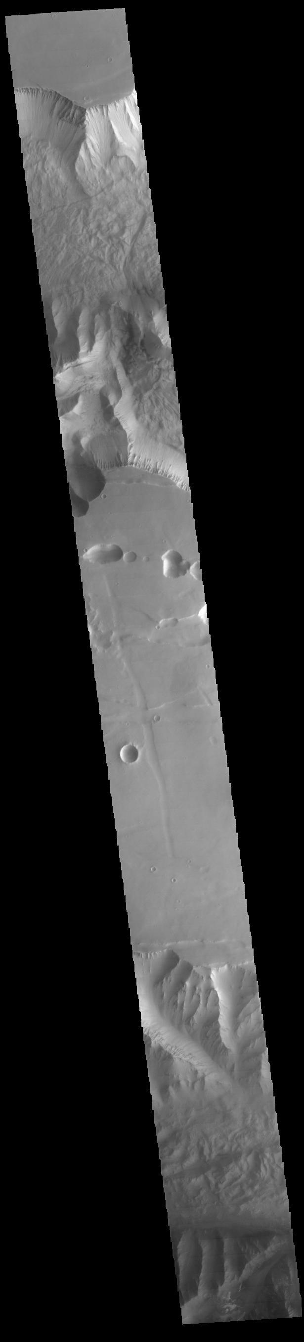
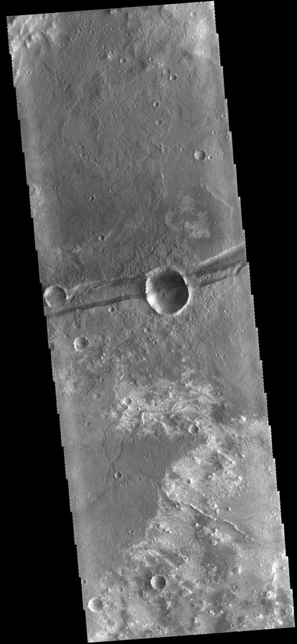
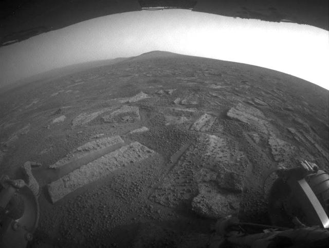
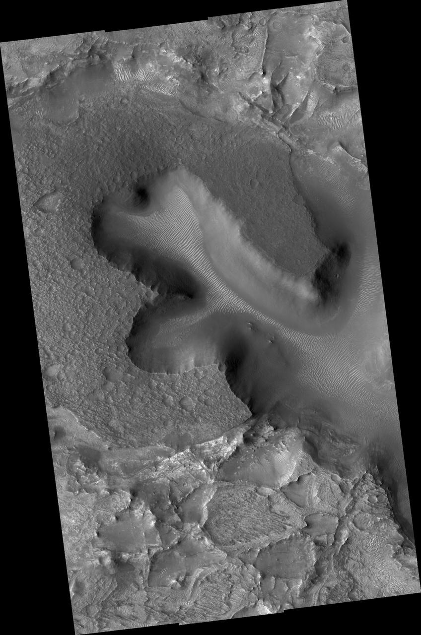
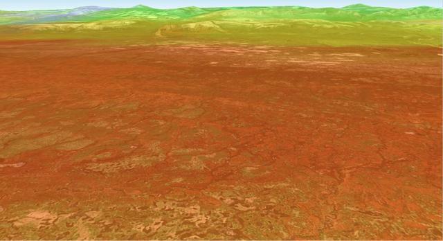
Valley Crossing

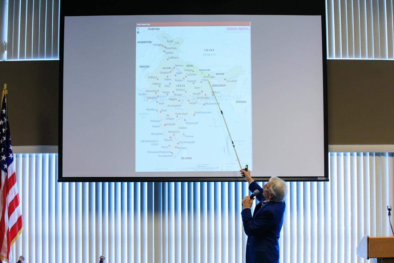
Arthur Muir, a retired Chicago attorney and America’s oldest Mt. Everest summiteer, addresses the audience during the inaugural Cross-Program Connection event at NASA Kennedy Space Center’s Space Station Processing Facility on March 8, 2023. Muir, 75, was the speaker at the Florida spaceport function titled “Explorers Doing the Impossible.” He toured Kennedy before sharing his experiences in overcoming incredible challenges during his journey to the top of Earth’s highest mountain.

Arthur Muir, a retired Chicago attorney and America’s oldest Mt. Everest summiteer, addresses the audience during the inaugural Cross-Program Connection event at NASA Kennedy Space Center’s Space Station Processing Facility on March 8, 2023. Muir, 75, was the speaker at the Florida spaceport function titled “Explorers Doing the Impossible.” He toured Kennedy before sharing his experiences in overcoming incredible challenges during his journey to the top of Earth’s highest mountain.
Arthur Muir, a retired Chicago attorney and America’s oldest Mt. Everest summiteer, delivers his presentation during the inaugural Cross-Program Connection event at NASA Kennedy Space Center’s Space Station Processing Facility on March 8, 2023. Muir, 75, was the speaker at the Florida spaceport function titled “Explorers Doing the Impossible.” He toured Kennedy before sharing his experiences in overcoming incredible challenges during his journey to the top of Earth’s highest mountain.

An audience member asks a question during the inaugural Cross-Program Connection event at NASA Kennedy Space Center’s Space Station Processing Facility on March 8, 2023. Arthur Muir, a retired Chicago attorney and America’s oldest Mt. Everest summiteer, was the speaker at the Florida spaceport function titled “Explorers Doing the Impossible.” He toured Kennedy before sharing his experiences in overcoming incredible challenges during his journey to the top of Earth’s highest mountain.

Arthur Muir, a retired Chicago attorney and America’s oldest Mt. Everest summiteer, attends the inaugural Cross-Program Connection event at NASA Kennedy Space Center’s Space Station Processing Facility on March 8, 2023. Muir, 75, was the speaker at the Florida spaceport function titled “Explorers Doing the Impossible.” He toured Kennedy before sharing his experiences in overcoming incredible challenges during his journey to the top of Earth’s highest mountain.

NASA’s Exploration Ground Systems Manager Shawn Quinn, right, moderates the inaugural Cross-Program Connection event at NASA Kennedy Space Center’s Space Station Processing Facility in Florida on March 8, 2023. Other participants, from left, are: Stacie Turner, Kennedy’s Deep Space Logistics; Dana Hutcherson, NASA’s Commercial Crew Program deputy program manager; and Arthur Muir, a retired Chicago attorney and America’s oldest Mt. Everest summiteer. Muir, 75, was the speaker at the event titled “Explorers Doing the Impossible.” He toured Kennedy before sharing his experiences in overcoming incredible challenges during his journey to the top of Earth’s highest mountain.
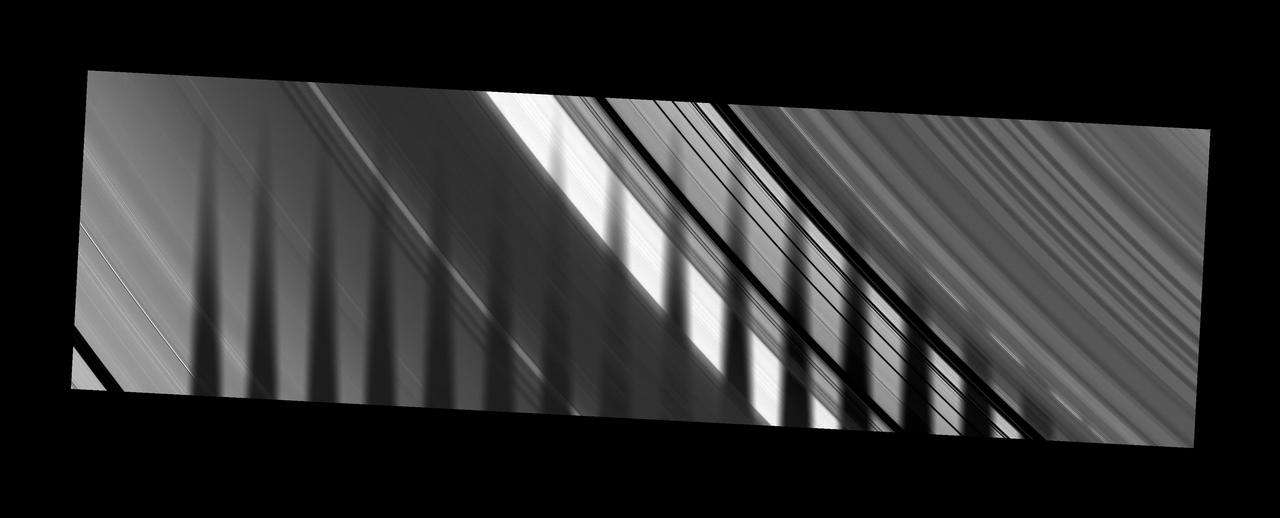
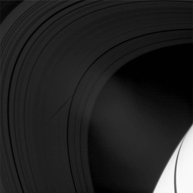
Star-Crossed Rings
Cross-Cutting Faults
Cross-Cutting Relationships
Dario Basin: Complex Cross-cuts
Hot-Cross-Bun on the Northern Plains
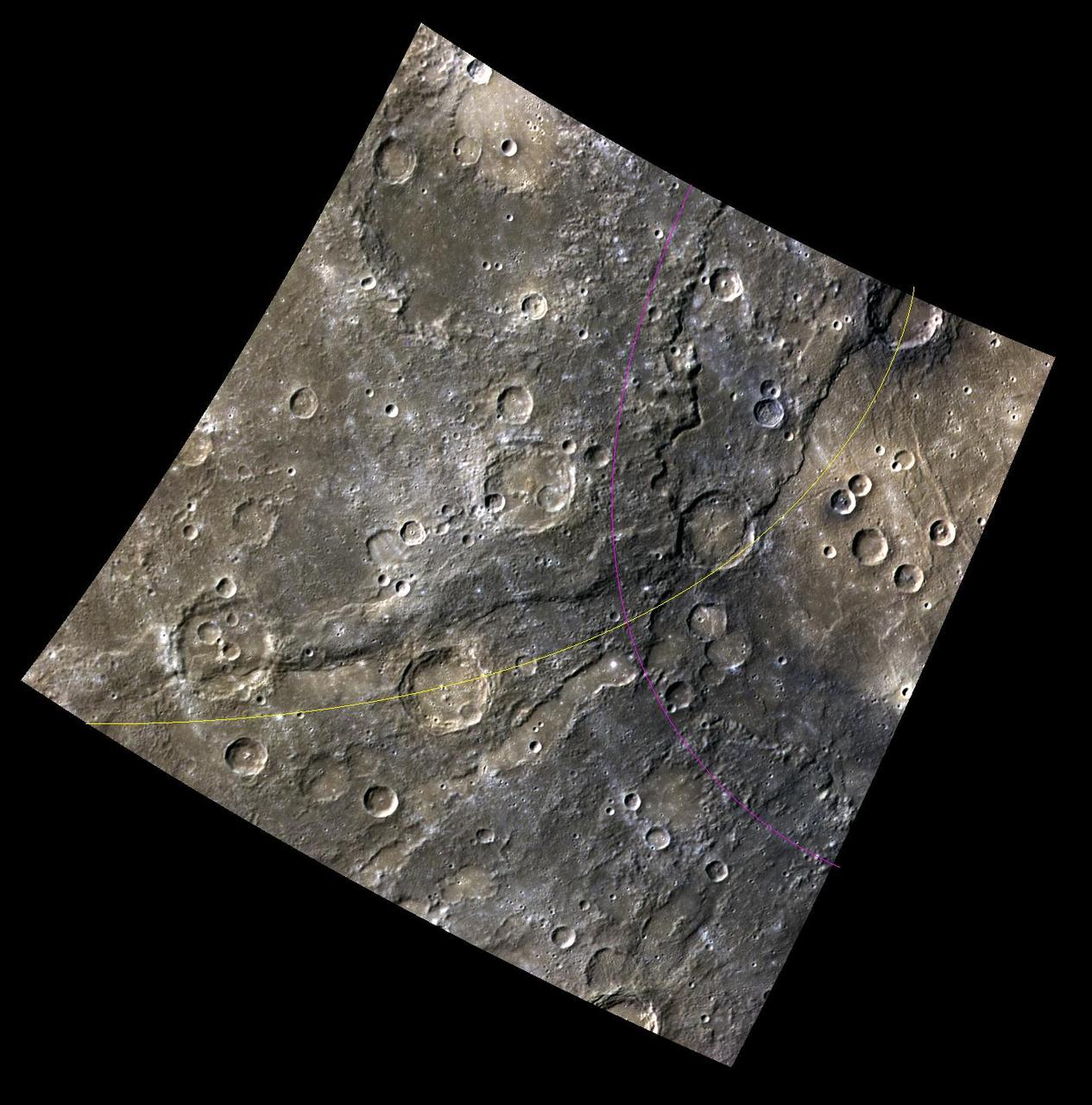
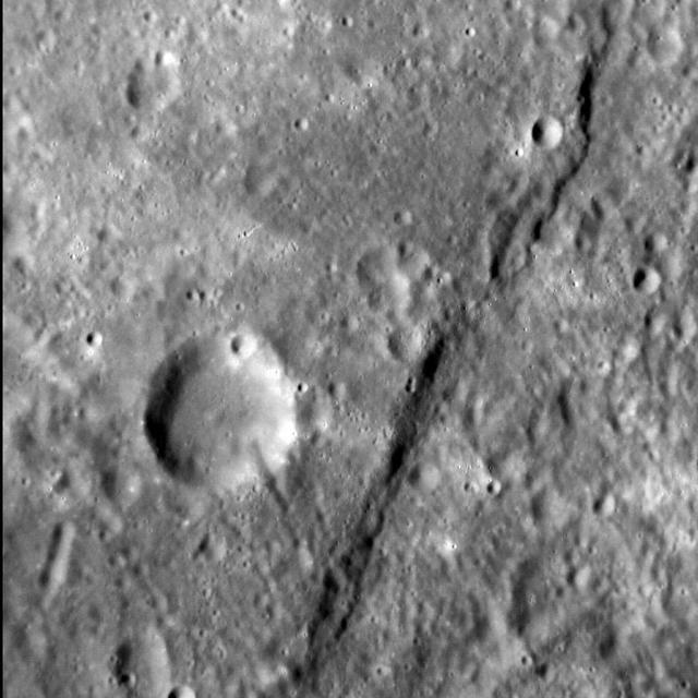
Crossing Paths. At the left edge of this color view is a relatively fresh crater as seen by NASA MESSENGER spacecraft.

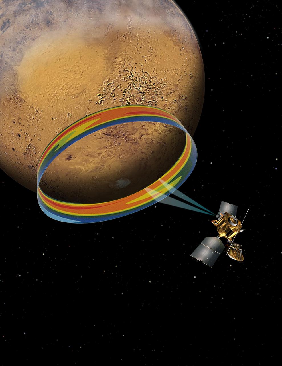
Hubble Views Saturn Ring-Plane Crossing

Ice Layer Cross-Section In False Color
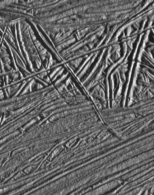
Cross-cutting Relationships of Surface Features on Europa

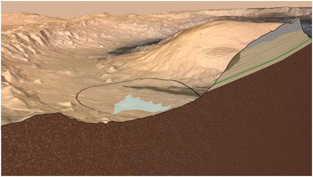
This cross-section graphic provides an interpretation of the geologic relationship between the Murray Formation, the crater floor sediments, and the hematite ridge.

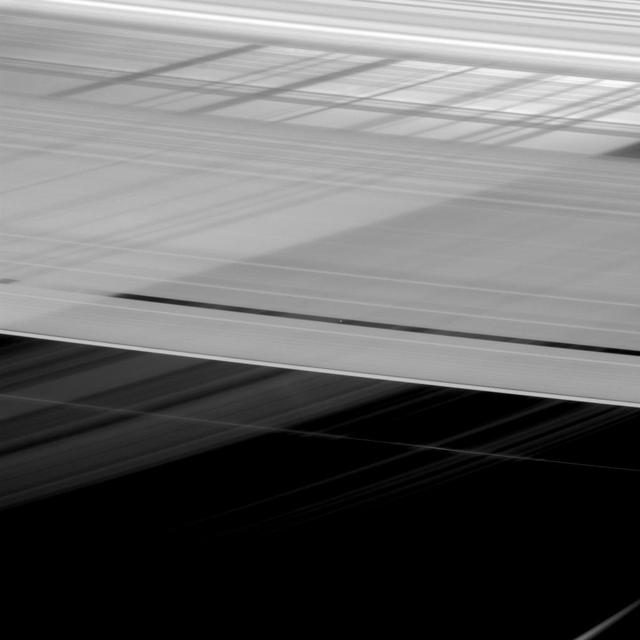
The shadow of the moon Janus crosses the Encke Gap as it strikes the plane of Saturn rings in this image taken as the planet approached its August 2009 equinox.

Hubble Views Saturn Ring-Plane Crossing Satellites Labeled
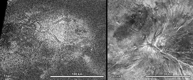
NASA Cassini spacecraft obtained this image of a feature shaped like a hot cross bun in the northern region of Titan left that bears a striking resemblance to a similar feature on Venus right.
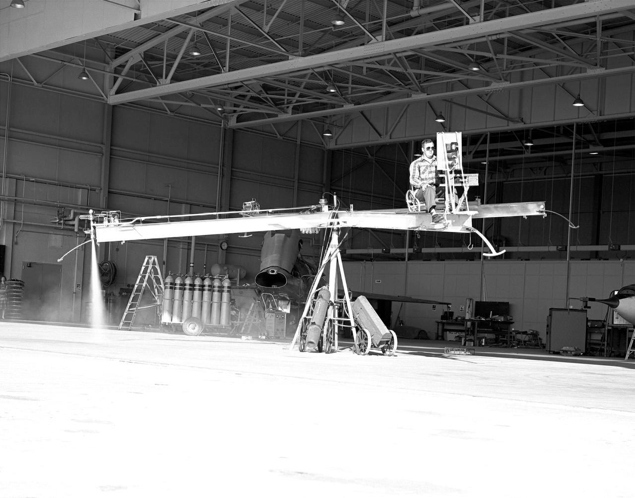
NACA High-Speed Flight Station test pilot Stan Butchart flying the Iron Cross, the mechanical reaction control simulator. High-pressure nitrogen gas expanded selectively, by the pilot, through the small reaction control thrusters maneuvered the Iron Cross through the three axes. The exhaust plume can be seen from the aft thruster. The tanks containing the gas can be seen on the cart at the base of the pivot point of the Iron Cross. NACA technicians built the iron-frame simulator, which matched the inertia ratios of the Bell X-1B airplane, installing six jet nozzles to control the movement about the three axes of pitch, roll, and yaw.
![This new Hubble image showcases a remarkable variety of objects at different distances from us, extending back over halfway to the edge of the observable Universe. The galaxies in this image mostly lie about five billion light-years from Earth but the field also contains other objects, both significantly closer and far more distant. Studies of this region of the sky have shown that many of the objects that appear to lie close together may actually be billions of light-years apart. This is because several groups of galaxies lie along our line of sight, creating something of an optical illusion. Hubble’s cross-section of the Universe is completed by distorted images of galaxies in the very distant background. These objects are sometimes distorted due to a process called gravitational lensing, an extremely valuable technique in astronomy for studying very distant objects [1]. This lensing is caused by the bending of the space-time continuum by massive galaxies lying close to our line of sight to distant objects. One of the lens systems visible here is called CLASS B1608+656, which appears as a small loop in the centre of the image. It features two foreground galaxies distorting and amplifying the light of a distant quasar the known as QSO-160913+653228. The light from this bright disc of matter, which is currently falling into a black hole, has taken nine billion years to reach us — two thirds of the age of the Universe. As well as CLASS B1608+656, astronomers have identified two other gravitational lenses within this image. Two galaxies, dubbed Fred and Ginger by the researchers who studied them, contain enough mass to visibly distort the light from objects behind them. Fred, also known more prosaically as [FMK2006] ACS J160919+6532, lies near the lens galaxies in CLASS B1608+656, while Ginger ([FMK2006] ACS J160910+6532) is markedly closer to us. Despite their different distances from us, both can be seen near to CLASS B1608+656 in the central region of this Hubble image. To capture distant and dim objects like these, Hubble required a long exposure. The image is made up of visible and infrared observations with a total exposure time of 14 hours. More info: <a href="http://www.spacetelescope.org/news/heic1408/" rel="nofollow">www.spacetelescope.org/news/heic1408/</a> Credit: NASA/ESA/Hubble <b><a href="http://www.nasa.gov/audience/formedia/features/MP_Photo_Guidelines.html" rel="nofollow">NASA image use policy.</a></b> <b><a href="http://www.nasa.gov/centers/goddard/home/index.html" rel="nofollow">NASA Goddard Space Flight Center</a></b> enables NASA’s mission through four scientific endeavors: Earth Science, Heliophysics, Solar System Exploration, and Astrophysics. Goddard plays a leading role in NASA’s accomplishments by contributing compelling scientific knowledge to advance the Agency’s mission. <b>Follow us on <a href="http://twitter.com/NASAGoddardPix" rel="nofollow">Twitter</a></b> <b>Like us on <a href="http://www.facebook.com/pages/Greenbelt-MD/NASA-Goddard/395013845897?ref=tsd" rel="nofollow">Facebook</a></b> <b>Find us on <a href="http://instagram.com/nasagoddard?vm=grid" rel="nofollow">Instagram</a></b>](https://images-assets.nasa.gov/image/GSFC_20171208_Archive_e001152/GSFC_20171208_Archive_e001152~medium.jpg)
This new Hubble image showcases a remarkable variety of objects at different distances from us, extending back over halfway to the edge of the observable Universe. The galaxies in this image mostly lie about five billion light-years from Earth but the field also contains other objects, both significantly closer and far more distant. Studies of this region of the sky have shown that many of the objects that appear to lie close together may actually be billions of light-years apart. This is because several groups of galaxies lie along our line of sight, creating something of an optical illusion. Hubble’s cross-section of the Universe is completed by distorted images of galaxies in the very distant background. These objects are sometimes distorted due to a process called gravitational lensing, an extremely valuable technique in astronomy for studying very distant objects [1]. This lensing is caused by the bending of the space-time continuum by massive galaxies lying close to our line of sight to distant objects. One of the lens systems visible here is called CLASS B1608+656, which appears as a small loop in the centre of the image. It features two foreground galaxies distorting and amplifying the light of a distant quasar the known as QSO-160913+653228. The light from this bright disc of matter, which is currently falling into a black hole, has taken nine billion years to reach us — two thirds of the age of the Universe. As well as CLASS B1608+656, astronomers have identified two other gravitational lenses within this image. Two galaxies, dubbed Fred and Ginger by the researchers who studied them, contain enough mass to visibly distort the light from objects behind them. Fred, also known more prosaically as [FMK2006] ACS J160919+6532, lies near the lens galaxies in CLASS B1608+656, while Ginger ([FMK2006] ACS J160910+6532) is markedly closer to us. Despite their different distances from us, both can be seen near to CLASS B1608+656 in the central region of this Hubble image. To capture distant and dim objects like these, Hubble required a long exposure. The image is made up of visible and infrared observations with a total exposure time of 14 hours. More info: <a href="http://www.spacetelescope.org/news/heic1408/" rel="nofollow">www.spacetelescope.org/news/heic1408/</a> Credit: NASA/ESA/Hubble <b><a href="http://www.nasa.gov/audience/formedia/features/MP_Photo_Guidelines.html" rel="nofollow">NASA image use policy.</a></b> <b><a href="http://www.nasa.gov/centers/goddard/home/index.html" rel="nofollow">NASA Goddard Space Flight Center</a></b> enables NASA’s mission through four scientific endeavors: Earth Science, Heliophysics, Solar System Exploration, and Astrophysics. Goddard plays a leading role in NASA’s accomplishments by contributing compelling scientific knowledge to advance the Agency’s mission. <b>Follow us on <a href="http://twitter.com/NASAGoddardPix" rel="nofollow">Twitter</a></b> <b>Like us on <a href="http://www.facebook.com/pages/Greenbelt-MD/NASA-Goddard/395013845897?ref=tsd" rel="nofollow">Facebook</a></b> <b>Find us on <a href="http://instagram.com/nasagoddard?vm=grid" rel="nofollow">Instagram</a></b>
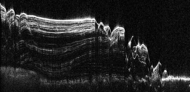
This image shows a cross-section of a portion of the north polar ice cap of Mars, derived from data acquired from NASA Mars Reconnaissance Orbiter Shallow Radar instrument. The data depict the region internal ice structure.
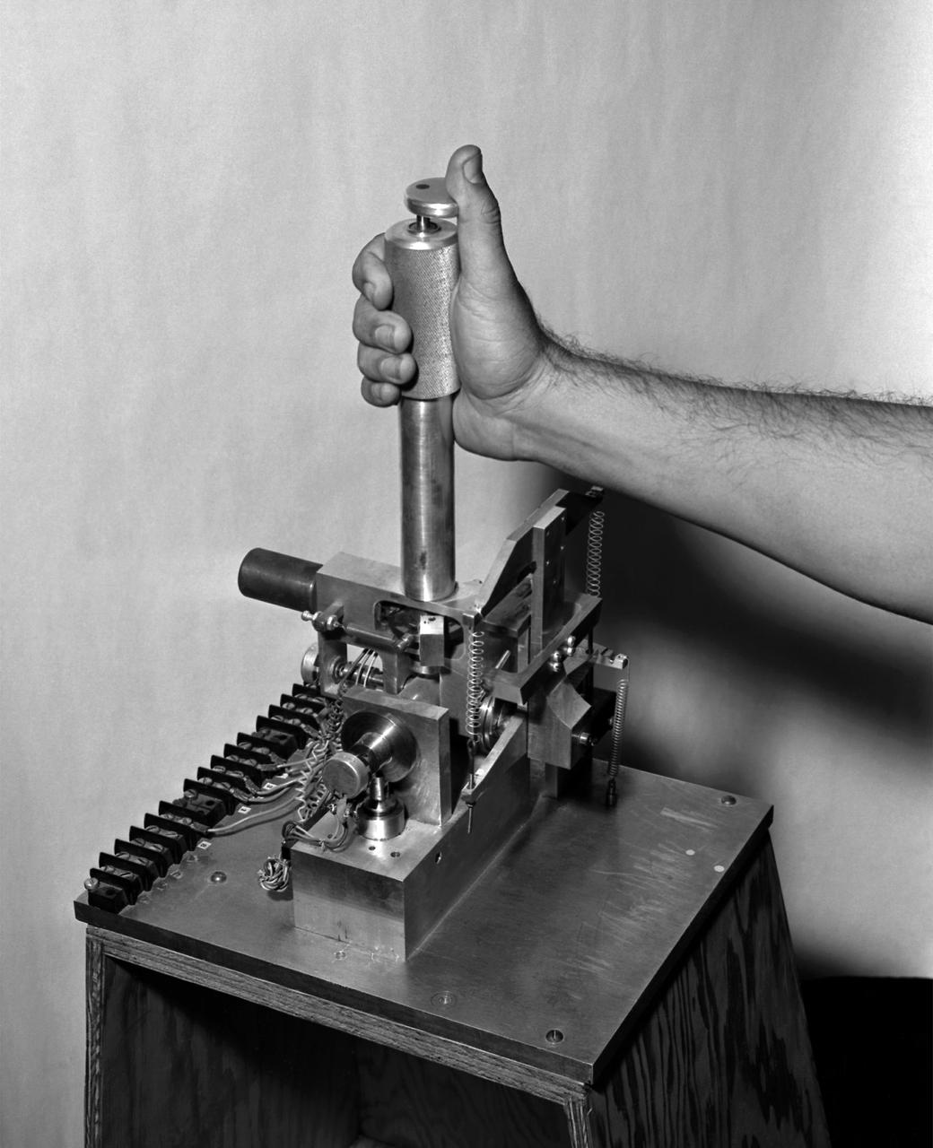
A photo of the control stick used on the Iron Cross Attitude Simulator. Although it resembled today's desktop computer flight sticks, its operation was different. As with a standard control stick, moving it back and forth raised and lowered the nose resulting in changes in pitch. Moving the stick to the right or left raised or lowered the wing, resulted in changes in roll. This control stick had a third axis, not found in standard control sticks. Twisting the stick to the right or left caused the airplane's nose to move horizontally in the same direction, resulting in changes in yaw.

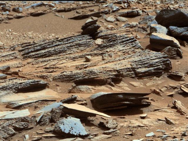
This view from the NASA Curiosity Mars rover shows an example of cross-bedding that results from water passing over a loose bed of sediment. It was taken at a target called Whale Rock within the Pahrump Hills outcrop at the base of Mount Sharp.
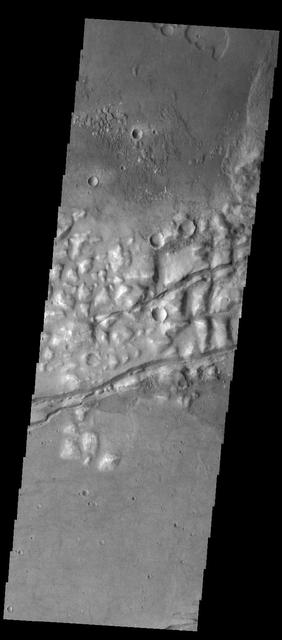
This image shows a cross-section of a complex crater in Terra Cimmeria. Starting in the center, we see a series of peaks with exposed bedrock. These peaks formed during the impact event when material that was originally several kilometers below the surface was uplifted and exposed. The impact also melted the rocks. This eventually cooled, forming the pitted materials that coat the crater floor around the uplift. The rim of the crater was unstable, and collapsed inwards to form terraces, and we see additional pitted materials between the terraces and the rim. Just outside the crater we can see dark-toned material that was excavated and thrown out after the impact. https://photojournal.jpl.nasa.gov/catalog/PIA23022
This artist impression Mars Gale Crater depicts a cross section through the mountain in the middle of the crater, from a viewpoint looking toward the southeast. NASA rover Curiosity will land in Gale Crater in August 2012.
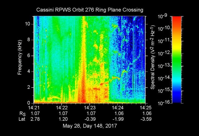
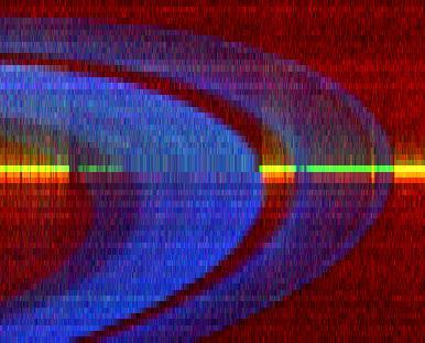
The sounds and colorful spectrogram in this still image and video represent data collected by the Radio and Plasma Wave Science, or RPWS, instrument on NASA's Cassini spacecraft, as it crossed through Saturn's D ring on May 28, 2017. This was the first of four passes through the inner edge of the D ring during the 22 orbits of Cassini's final mission phase, called the Grand Finale. During this ring plane crossing, the spacecraft was oriented so that its large high-gain antenna was used as a shield to protect more sensitive components from possible ring-particle impacts. The three 33-foot-long (10-meter-long) RPWS antennas were exposed to the particle environment during the pass. As tiny, dust-sized particles strike Cassini and the RPWS antennas, the particles are vaporized into tiny clouds of plasma, or electrically excited gas. These tiny explosions make a small electrical signal (a voltage impulse) that RPWS can detect. Researchers on the RPWS team convert the data into visible and audio formats, some like those seen here, for analysis. Ring particle hits sound like pops and cracks in the audio. Particle impacts are seen to increase in frequency in the spectrogram and in the audible pops around the time of ring crossing as indicated by the red/orange spike just before 14:23 on the x-axis. Labels on the x-axis indicate time (top line), distance from the planet's center in Saturn radii, or Rs (middle), and latitude on Saturn beneath the spacecraft (bottom). These data can be compared to those recorded during Cassini's first dive through the gap between Saturn and the D ring, on April 26. While it appeared from those earlier data that there were essentially no particles in the gap, scientists later determined the particles there are merely too small to create a voltage detectable by RPWS, but could be detected using Cassini's dust analyzer instrument. After ring plane crossing (about 14:23 onward) a series of high pitched whistles are heard. The RPWS instrument detects such tones during each of the Grand Finale orbits and the team is working to understand their source. The D ring proved to contain larger ring particles, as expected and recorded here, although the environment was determined to be relatively benign -- with less dust than other faint Saturnian rings Cassini has flown through. https://photojournal.jpl.nasa.gov/catalog/PIA21620
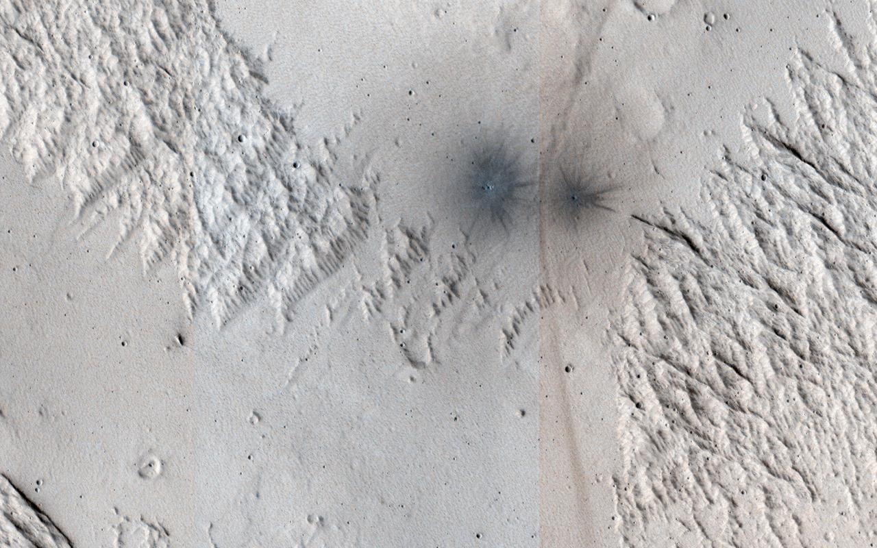
This image shows terrain near Mangala Valles. At the bottom of the image are two black spots that are recent impact craters. The black spots form because the craters exposed cleaner materials in the subsurface beneath the bright, dusty surface. Our image is also interesting because the surface has a criss-cross pattern formed by wind activity. Bright ripples that are oriented from the upper right to the lower left are perpendicular to the wind flow. In contrast, outcrops that have been eroded by the wind are oriented perpendicular to the ripples to produce the criss-cross pattern we now observe. https://photojournal.jpl.nasa.gov/catalog/PIA24146
This animation shows images of the far side of the moon, illuminated by the sun, as it crosses between the DISCOVR spacecraft's Earth Polychromatic Imaging Camera (EPIC) camera and telescope, and the Earth - one million miles away. Credits: NASA/NOAA A NASA camera aboard the Deep Space Climate Observatory (DSCOVR) satellite captured a unique view of the moon as it moved in front of the sunlit side of Earth last month. The series of test images shows the fully illuminated “dark side” of the moon that is never visible from Earth. The images were captured by NASA’s Earth Polychromatic Imaging Camera (EPIC), a four megapixel CCD camera and telescope on the DSCOVR satellite orbiting 1 million miles from Earth. From its position between the sun and Earth, DSCOVR conducts its primary mission of real-time solar wind monitoring for the National Oceanic and Atmospheric Administration (NOAA). Read more: <a href="http://www.nasa.gov/feature/goddard/from-a-million-miles-away-nasa-camera-shows-moon-crossing-face-of-earth" rel="nofollow">www.nasa.gov/feature/goddard/from-a-million-miles-away-na...</a> <b><a href="http://www.nasa.gov/audience/formedia/features/MP_Photo_Guidelines.html" rel="nofollow">NASA image use policy.</a></b> <b><a href="http://www.nasa.gov/centers/goddard/home/index.html" rel="nofollow">NASA Goddard Space Flight Center</a></b> enables NASA’s mission through four scientific endeavors: Earth Science, Heliophysics, Solar System Exploration, and Astrophysics. Goddard plays a leading role in NASA’s accomplishments by contributing compelling scientific knowledge to advance the Agency’s mission. <b>Follow us on <a href="http://twitter.com/NASAGoddardPix" rel="nofollow">Twitter</a></b> <b>Like us on <a href="http://www.facebook.com/pages/Greenbelt-MD/NASA-Goddard/395013845897?ref=tsd" rel="nofollow">Facebook</a></b> <b>Find us on <a href="http://instagrid.me/nasagoddard/?vm=grid" rel="nofollow">Instagram</a></b>

This animation still image shows the far side of the moon, illuminated by the sun, as it crosses between the DISCOVR spacecraft's Earth Polychromatic Imaging Camera (EPIC) camera and telescope, and the Earth - one million miles away. Credits: NASA/NOAA A NASA camera aboard the Deep Space Climate Observatory (DSCOVR) satellite captured a unique view of the moon as it moved in front of the sunlit side of Earth last month. The series of test images shows the fully illuminated “dark side” of the moon that is never visible from Earth. The images were captured by NASA’s Earth Polychromatic Imaging Camera (EPIC), a four megapixel CCD camera and telescope on the DSCOVR satellite orbiting 1 million miles from Earth. From its position between the sun and Earth, DSCOVR conducts its primary mission of real-time solar wind monitoring for the National Oceanic and Atmospheric Administration (NOAA). Read more: <a href="http://www.nasa.gov/feature/goddard/from-a-million-miles-away-nasa-camera-shows-moon-crossing-face-of-earth" rel="nofollow">www.nasa.gov/feature/goddard/from-a-million-miles-away-na...</a> <b><a href="http://www.nasa.gov/audience/formedia/features/MP_Photo_Guidelines.html" rel="nofollow">NASA image use policy.</a></b> <b><a href="http://www.nasa.gov/centers/goddard/home/index.html" rel="nofollow">NASA Goddard Space Flight Center</a></b> enables NASA’s mission through four scientific endeavors: Earth Science, Heliophysics, Solar System Exploration, and Astrophysics. Goddard plays a leading role in NASA’s accomplishments by contributing compelling scientific knowledge to advance the Agency’s mission. <b>Follow us on <a href="http://twitter.com/NASAGoddardPix" rel="nofollow">Twitter</a></b> <b>Like us on <a href="http://www.facebook.com/pages/Greenbelt-MD/NASA-Goddard/395013845897?ref=tsd" rel="nofollow">Facebook</a></b> <b>Find us on <a href="http://instagrid.me/nasagoddard/?vm=grid" rel="nofollow">Instagram</a></b>
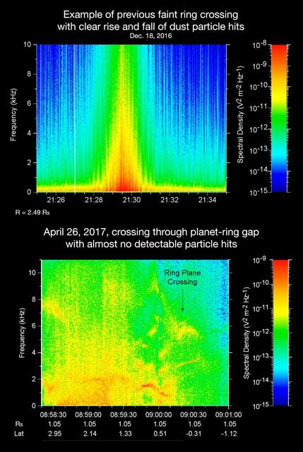
The sounds and spectrograms in these two videos represent data collected by the Radio and Plasma Wave Science, or RPWS, instrument on NASA's Cassini spacecraft, as it crossed the plane of Saturn's rings on two separate orbits. As tiny, dust-sized particles strike Cassini and the three 33-foot-long (10-meter-long), RPWS antennas, the particles are vaporized into tiny clouds of plasma, or electrically excited gas. These tiny explosions make a small electrical signal (a voltage impulse) that RPWS can detect. Researchers on the RPWS team convert the data into visible and audio formats, like those seen here, for analysis. Ring particle hits sound like pops and cracks in the audio. The first video (top image in the montage) was made using RPWS data from a ring plane crossing on Dec. 18, 2016, when the spacecraft passed through the faint, dusty Janus-Epimetheus ring (see PIA08328 for an image that features this ring). This was during Cassini's 253rd orbit of Saturn, known as Rev 253. As is typical for this sort of ring crossing, the number of audible pops and cracks rises to a maximum around the time of a ring crossing and trails off afterward. The peak of the ring density is obvious in the colored display at the red spike. The second video (bottom image in the montage) was made using data RPWS collected as Cassini made the first dive through the gap between Saturn and its rings as part of the mission's Grand Finale, on April 26, 2017. Very few pops and cracks are audible in this data at all. In comparing the two data sets, it is apparent that while Cassini detected many ring-particles striking Cassini when passing through the Janus-Epimetheus ring, the first Grand Finale crossing -- in stark contrast -- was nearly particle free. The unexpected finding that the gap is so empty is a new mystery that scientists are eager to understand. On April 26, 2017, Cassini dove through the previously unexplored ring-planet gap at speeds approaching 75,000 mph (121,000 kph), using its large, dish-shaped high-gain antenna (or HGA) as a shield to protect the rest of the spacecraft and its instruments from potential impacts by small, icy ring particles. Two of Cassini's instruments, the magnetometer and RPWS, extend beyond the protective antenna dish, and were exposed to the particle environment during the dive. The Cassini team used this data from RPWS, along with inputs from other components on the spacecraft, to make the decision of whether the HGA would be needed as a shield on most future Grand Finale dives through the planet-ring gap. Based on these inputs the team determined this protective measure would not be needed, allowing the team's preferred mode of science operations to proceed, with Cassini able to point its science instruments in any direction necessary to obtain scientists' desired observations. (Four of the 21 remaining dives pass through the inner D ring. The mission had already planned to use the HGA as a shield for those passes.) The colors on the spectrogram indicate the emitted power of the radio waves, with red as the most powerful. Time is on the x-axis, and frequency of the radio waves is on the y-axis. The audible whistle in the April 26 data, just before ring plane crossing, is due to a type of plasma wave that will be the subject of further study. In addition, there is an abrupt change beginning at the 09:00:00 mark on the spectrogram that represents a change in the RPWS antenna's operational configuration (from monopole mode to dipole mode). The videos can be viewed at https://photojournal.jpl.nasa.gov/catalog/PIA21446
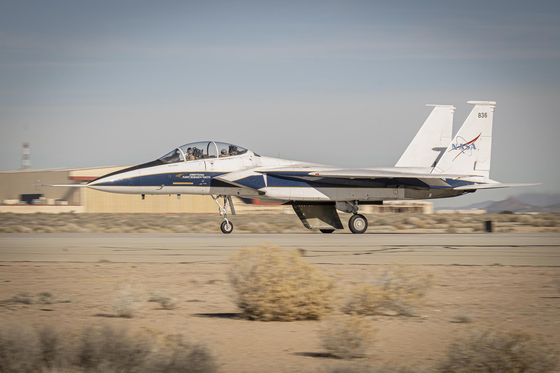
NASA’s Cross Flow Attenuated Natural Laminar Flow (CATNLF) scale model completes its first major milestone – high-speed taxi test – Tuesday, Jan. 12, 2026, at Edwards Air Force Base in California. NASA’s F-15 research aircraft, with the 3-foot-tall test article mounted on its underside, reached speeds of approximately 144 mph during testing. If successful, the technology could be applied to future commercial aircraft to improve efficiency and potentially reduce fuel consumption.
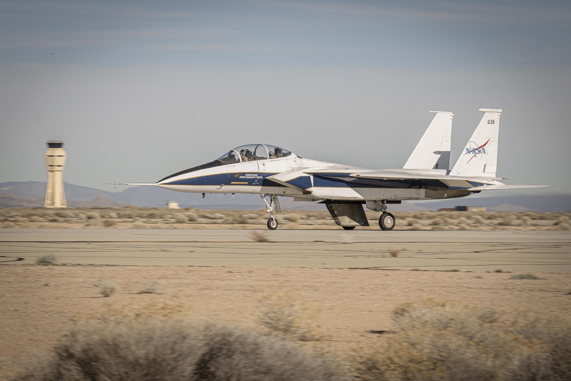
NASA’s Cross Flow Attenuated Natural Laminar Flow (CATNLF) scale model completes its first major milestone – high-speed taxi test – Tuesday, Jan. 12, 2026, at Edwards Air Force Base in California. NASA’s F-15 research aircraft, with the 3-foot-tall test article mounted on its underside, reached speeds of approximately 144 mph during testing. If successful, the technology could be applied to future commercial aircraft to improve efficiency and potentially reduce fuel consumption.
This image of Tiu Vallis shows a landslide that crossed the entire width of the channel
These streamers of clouds cross over a small crater without deflection

STS075-351-022 (22 Feb.- 9 March 1996) --- The space shuttle Columbia's vertical stabilizer appears to point to the four stars of the Southern Cross. The scene was captured with a 35mm camera just prior to a sunrise. The seven member crew was launched aboard the space shuttle Columbia on Feb. 22, 1996, and landed on March 9, 1996. Crew members were Andrew M. Allen, mission commander; Scott J. Horowitz, pilot; Franklin R. Chang-Diaz, payload commander; and Maurizio Cheli, European Space Agency (ESA); Jeffrey A. Hoffman and Claude Nicollier, ESA, all mission specialists; along with payload specialist Umberto Guidoni of the Italian Space Agency (ASI).

A Neptune-size planet with a clear atmosphere is shown crossing in front of its star in this artist depiction. Such crossings, or transits, are observed by telescopes like NASA Hubble and Spitzer to glean information about planets atmospheres.
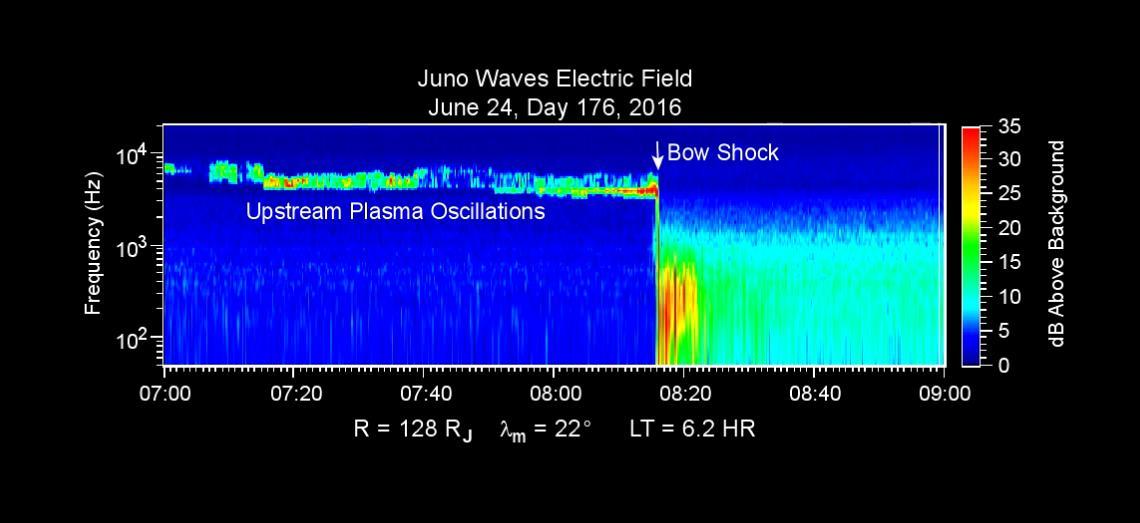
This chart presents data that the Waves investigation on NASA's Juno spacecraft recorded as the spacecraft crossed the bow shock just outside of Jupiter's magnetosphere on June 24, 2016, while approaching Jupiter. Audio accompanies the animation, with volume and pitch correlated to the amplitude and frequency of the recorded waves. The graph is a frequency-time spectrogram with color coding to indicate wave amplitudes as a function of wave frequency (vertical axis, in hertz) and time (horizontal axis, with a total elapsed time of two hours). During the hour before Juno reached the bow shock, the Waves instrument was detecting mainly plasma oscillations just below 10,000 hertz (10 kilohertz). The frequency of these oscillations is related to the local density of electrons; the data yield an estimate of approximately one electron per cubic centimeter (about 16 per cubic inch) in this region just outside Jupiter's bow shock. The broadband burst of noise marked "Bow Shock" is the region of turbulence where the supersonic solar wind is heated and slowed by encountering the Jovian magnetosphere. The shock is analogous to a sonic boom generated in Earth's atmosphere by a supersonic aircraft. The region after the shock is called the magnetosheath. The vertical bar to the right of the chart indicates the color coding of wave amplitude, in decibels (dB) above the background level detected by the Waves instrument. Each step of 10 decibels marks a tenfold increase in wave power. When Juno collected these data, the distance from the spacecraft to Jupiter was about 5.56 million miles (8.95 million kilometers), indicated on the chart as 128 times the radius of Jupiter. Jupiter's magnetic field is tilted about 10 degrees from the planet's axis of rotation. The note of 22 degrees on the chart indicates that at the time these data were recorded, the spacecraft was 22 degrees north of the magnetic-field equator. The "LT" notation is local time on Jupiter at the longitude of the planet directly below the spacecraft, with a value of 6.2 indicating approximately dawn. http://photojournal.jpl.nasa.gov/catalog/PIA20753
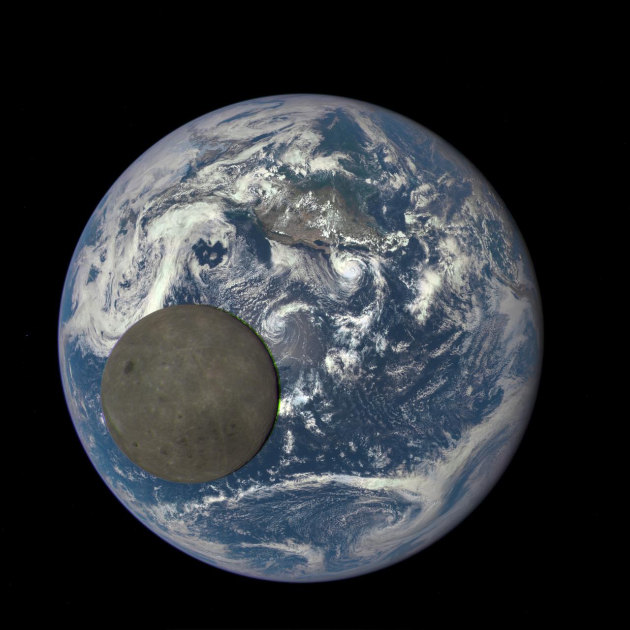
This animation still image shows the far side of the moon, illuminated by the sun, as it crosses between the DISCOVR spacecraft's Earth Polychromatic Imaging Camera (EPIC) camera and telescope, and the Earth - one million miles away. Credits: NASA/NOAA A NASA camera aboard the Deep Space Climate Observatory (DSCOVR) satellite captured a unique view of the moon as it moved in front of the sunlit side of Earth last month. The series of test images shows the fully illuminated “dark side” of the moon that is never visible from Earth. The images were captured by NASA’s Earth Polychromatic Imaging Camera (EPIC), a four megapixel CCD camera and telescope on the DSCOVR satellite orbiting 1 million miles from Earth. From its position between the sun and Earth, DSCOVR conducts its primary mission of real-time solar wind monitoring for the National Oceanic and Atmospheric Administration (NOAA).
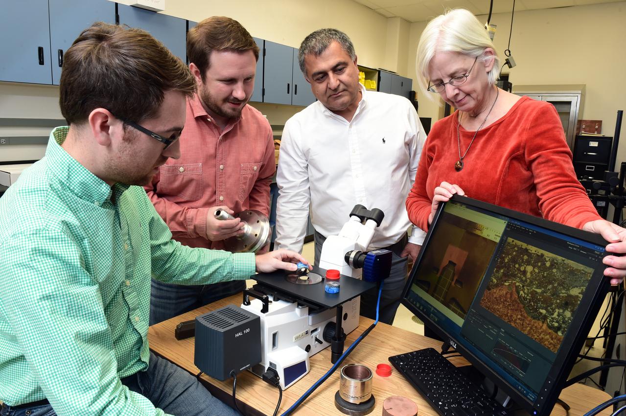
Majid Babai along with Dr. Judy Schneider, and graduate students Chris Hill and Ryan Anderson examine a cross section of the prototype rocket engine igniter created by an innovative bi-metallic 3-D printing advanced manufacturing process under a microscope.
This movie begins with a view of the sunlit side of the rings. As the spacecraft speeds from south to north, the rings appear to tilt downward and collapse to a thin plane
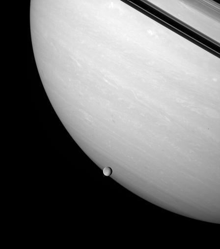
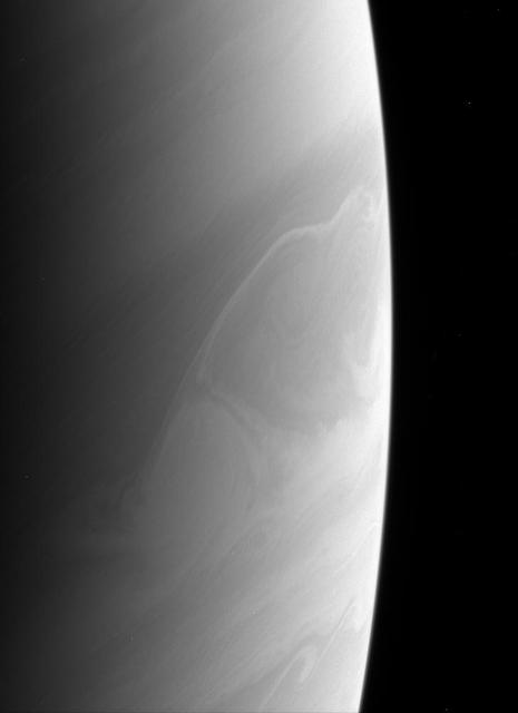
Rhea brushes the stormy face of Saturn, an airless ice orb against the feathery bands of a gas giant
Several fractures cross through Gorgonum Chaos in this image captured by NASA 2001 Mars Odyssey spacecraft.
NASA Cassini spacecraft captures the shadow of Saturn moon Tethys as it seems to disappear as it crosses the planet rings.
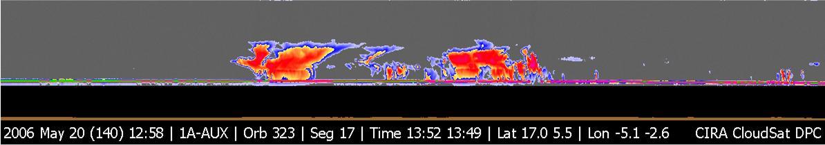
NASA CloudSat image of a horizontal cross-section of tropical clouds and thunderstorms over east Africa.
Broad channels appear to cross a substantial wrinkle ridge in the image of part of Noachis Terra
The numerous layers of the south polar cap are shown in cross-section in this 2001 Mars Odyssey THEMIS VIS image.
This image captured by NASA 2001 Mars Odyssey spacecraft crosses the summit of Uranius Tholus, as well as the western flank of Ceraunius Tholus.
The shadow of the moon Epimetheus crosses Saturn rings in this image taken as the planet approached its August 2009 equinox.
This 2001 Mars Odyssey THEMIS VIS image crosses Coprates Chasma, showing both floor and wall features of the canyon.
The channel crossing this image from NASA 2001 Mars Odyssey spacecraft is called Maadim Valles.
This image captured by NASA 2001 Mars Odyssey spacecraft crosses the summit of Ceraunius Tholus.
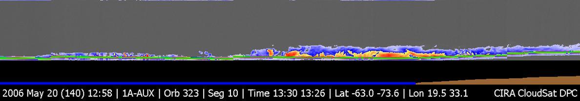
NASA CloudSat image of a horizontal cross-section of a polar night storm near Antarctica.
Dust devil tracks criss-cross the surface in this image captured by NASA 2001 Mars Odyssey spacecraft.
The Cassini spacecraft looks down on the north pole of Dione and the fine fractures that cross its trailing hemisphere.
This image captured by NASA 2001 Mars Odyssey spacecraft crosses both Tithonium and Ius Chasma.
This view southeastward from Curiosity's Mast Camera (Mastcam) shows terrain judged difficult for traversing between the rover and an outcrop in the middle distance where a pale rock unit meets a darker rock unit above it. The Mastcam's left-eye camera captured the component images on May 10, 2015, during the 981st Martian day, or sol, of Curiosity's work on Mars. This observation helped the rover team evaluate routes for driving to that geological contact area where the two rock units meet. The outcrop exposing the contact is in the eastern portion of the "Logan Pass" area. The windblown ripples and the steep ground where ripples are lacking are both poor terrain for the rover to cross. The team subsequently chose to approach a different site where the pale and darker rock units are in contact with each other. That alternative site is in the northern portion of the Logan Pass area, outside of this scene. This panorama spans from east, at left, to south-southwest. The color has been approximately white-balanced to resemble how the scene would appear under daytime lighting conditions on Earth. http://photojournal.jpl.nasa.gov/catalog/PIA19662
The two depression crossing this image are called Pavonis Fossae and are located just north of the volcano in this image captured by NASA 2001 Mars Odyssey spacecraft.
This 2001 Mars Odyssey image shows a region of Aonia Terra criss-crossed with a multitude of dust devil tracks. The tracks show up well on the dusty plains.
This image from NASA 2001 Mars Odyssey crosses Green Crater.The small dark dunes are located on the floor of Green Crater near a younger impact.
The linear depression in the center of this image captured by NASA Mars Odyssey spacecraft is a graben - a fault bounded block of material. The graben crosses the crater and ejecta in the middle of the image.
NASA Mars Reconnaissance Orbiter captured this image on 27 June 2014, when Curiosity had just crossed the edge of the 3-sigma landing.
Thin lineaments cross back and forth, intersecting craters on the surface of Saturn moon Rhea in this equatorial view captured by NASA Cassini spacecraft.
This image from the Mast Camera Mastcam on NASA Mars rover Curiosity shows inclined layering known as cross-bedding in an outcrop called Shaler.

CAMPAIGN COMMITTEE: Frank V. Moore (seated center) has been named Director of the Center' s annual Combined Federal Campaign. Members of his campaign staff are (seated) Ernestine Martin, Mary Jackson, Gwendolyn Leach, Janet McKenzie. Standing are (from left) Willis C. Cross, James Ojiba.

The shadow of the moon Tethys cuts across the C ring in this image taken as Saturn approaches its August 2009 equinox.

On Mar. 6, 2019, SDO observed a long lunar transit - with a twist. The shadow of the Moon in SDO's images first touched the limb of the Sun at 2200 UTC (5pm EST) on Mar. 6, making its way across and finally left the solar disk at 0209 UTC on Mar. 7 (9:09 pm EST, Mar. 6). The moon's apparent reversal is caused by SDO first overtaking the moon in its orbit, then the moon catching up as SDO swings around Earth's dusk side. During the transit the Sun moves in the frame as the telescopes cool and flex in the lunar shadow. Note that the edge of the Moon is very sharp because it has no atmosphere. Movies available at https://photojournal.jpl.nasa.gov/catalog/PIA21905

NASA Wide-field Infrared Survey Explorer captured this colorful image of the reflection nebula IRAS 12116-6001. This cloud of interstellar dust cannot be seen directly in visible light, but WISE detectors observed the nebula at infrared wavelengths.

million kilometers). The satellite's shadow can be seen falling on the face of Jupiter at left. Io is traveling from left to right in its one-and-three-quarter-day orbit around Jupiter. Even from this great distance the image of Io shows dark poles and a bright equatorial region. Voyager will make its closest approach to Jupiter -- 174,000 miles (280,000 kilometer) -- on March 5. It will then continue to Saturn in November 1980, Meanwhile Voyager 2, a sister spacecraft, will fly past Jupiter July 9, 1979, and reach Saturn in August 1981. This color image was taken through orange, green and blue filters. http://photojournal.jpl.nasa.gov/catalog/PIA00455
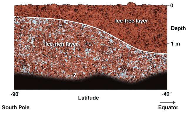
This diagram shows a possible configuration of ice-rich and dry soil in the upper meter 3 feet of Mars. The ice-rich soil was detected by the gamma ray spectrometer suite of instruments aboard NASA Mars Odyssey spacecraft.
At first glance, Saturn rings appear to be intersecting themselves in an impossible way. In actuality, this view from NASA Cassini spacecraft shows the rings in front of the planet, upon which the shadow of the rings is cast.
Saturn atmosphere produces beautiful and sometimes perplexing features. Is the bright feature below center a rare crossing of a feature from a zone to a belt, or is it an illusion created by different cloud layers at different levels?

NASA Mars Odyssey captured this image of Ulysses Fossae, located in the Tharsis Volcanic region. Cross cutting tectonic fractures indicate that this region underwent stresses in multiple directions.
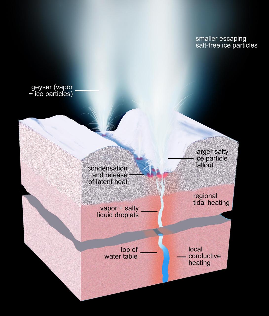
This artist rendering shows a cross-section of the ice shell immediately beneath one of Enceladus geyser-active fractures, illustrating the physical and thermal structure and the processes ongoing below and at the surface.
Do you see what I see in this image from NASA Mars Odyssey spacecraft? The multiple craters that cross the center of this image resemble a baby bug following the larger mama bug.
The MAHLI camera on NASA Curiosity rover is carried at an angle when the rover arm is stowed for driving. Still, the camera is able to record views of the terrain Curiosity is crossing in Gale Crater.

Cross-bedding seen in the layers of this Martian rock is evidence of movement of water recorded by the waves or ripples of loose sediment the water passed over, such as a current in a lake. This image is from NASA Curiosity Mars rover.
The steep northern wall of Tithonium Chasma crosses this image from NASA 2001 Mars Odyssey spacecraft. Landslide deposits from slope failure can be seen at the lower left corner of the image.
Two parallel tracks left by the wheels of NASA Curiosity Mars rover cross rugged ground in this portion of an observation by the HiRISE camera on NASA Mars Reconnaissance Orbiter on Dec. 11, 2013. The rover itself does not appear in this image.
This view shows the terrain that NASA Mars Exploration Rover Opportunity is crossing in a flat area called Botany Bay on the way toward Solander Point, which is visible on the horizon.

This artist concept depicts a comet-like tail of a possible disintegrating super Mercury-size planet candidate as it transits, or crosses, its parent star, named KIC 12557548. The results are based on data from NASA Kepler mission.
This image, taken by NASA Galileo spacecraft, shows the darkside of Jupiter, the part not illuminated by sunlight. The curved line crossing from the lower left to the upper right is the auroral arc on the horizon.
The steep northern wall of Tithonium Chasma crosses this image from NASA 2001 Mars Odyssey spacecraft. Landslide deposits from slope failure can be seen at the lower left corner of the image.
This image from the panoramic camera on NASA Mars Exploration Rover Opportunity shows the best examples yet seen in Meridiani Planum outcrop rocks of well-preserved, fine-scale layering and what geologists call cross-lamination.

This image from NASA European Jason-2 satellite shows Kelvin waves of high sea level red/yellow crossing the Pacific Ocean at the equator. The waves can be related to El Niño events.
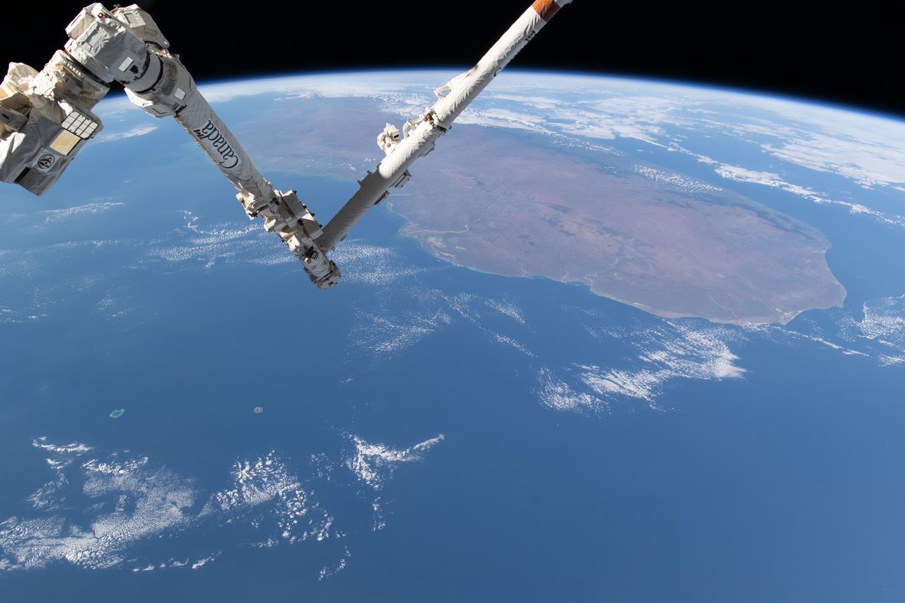
iss071e361950 (July 15, 2024) --- The International Space Station's 57.7-foot-long Canadarm2 robotic arm crosses the foreground as the orbital outpost soared 265 miles above the Mozambique Channel south of the African island nation of Madagascar.
NASA Mars Reconnaissance Orbiter shows densely fractured light-toned rock in the vicinity of the Nili Fossae. The light-toned material is finely layered; these layers can be seen in cross-section along a scarp face at the bottom of the image.
This graphic depicts the Mars Climate Sounder instrument on NASA Mars Reconnaissance Orbiter measuring the temperature of a cross section of the Martian atmosphere as the orbiter passes above the south polar region.
The cliff-like feature crossing this image from NASA MESSENGER spacecraft from top to bottom is one of Mercury famed lobate scarps, and is called Pourquoi-Pas Rupes.
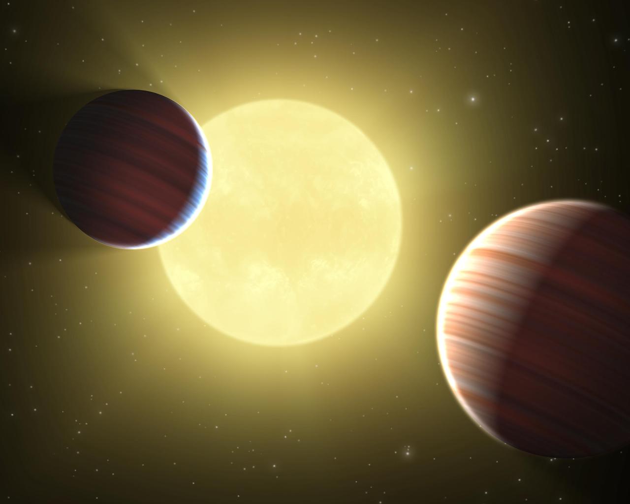
This artist concept illustrates the two Saturn-sized planets discovered by NASA Kepler mission. The star system is oriented edge-on, as seen by Kepler, such that both planets cross in front, or transit, their star, named Kepler-9.
JPL-led study shows bromine explosion on March 13, 2008 across the western Northwest Territories in Canada looking toward the Mackenzie Mountains at the horizon, which prevented the bromine from crossing over into Alaska.

CAMPAIGN COMMITTEE: Frank V. Moore (seated) has been named Director of the Center' s annual Combined Federal Campaign. Members of his campaign staff are (seated) Mary A. Jackson (left) and Gwendolyn Leach. Standing are (from left) Willis C. Cross, Ernestine Martin, Janet McKenzie, and James Ojiba. Photo published in Langley Researcher August 31, 1973 Volume 12, Number 18 page 1.
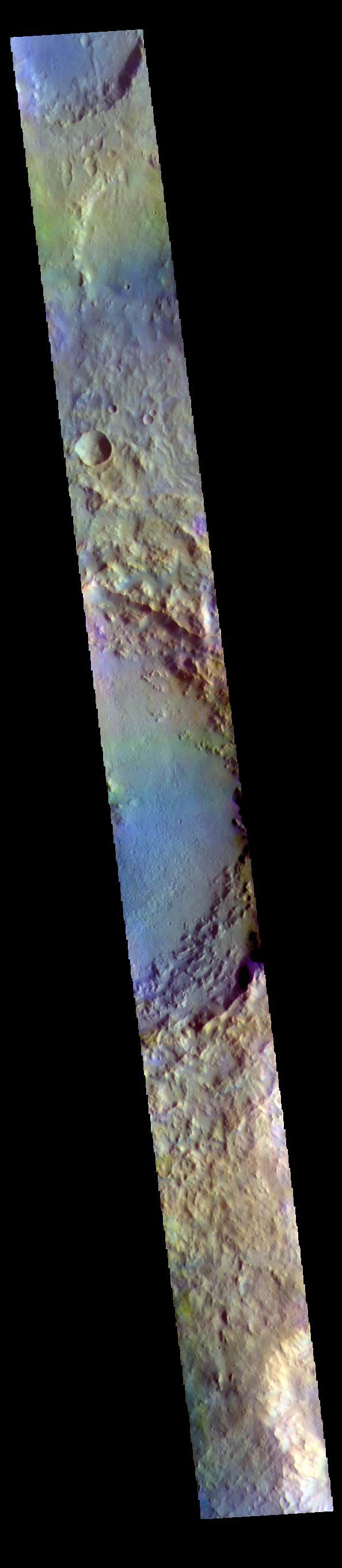
The THEMIS VIS camera contains 5 filters. The data from different filters can be combined in multiple ways to create a false color image. These false color images may reveal subtle variations of the surface not easily identified in a single band image. Today's false color image shows a cross section of Soffen Crater. Located in Terra Cimmeria, Soffen Crater is 58km (36 miles) in diameter. Orbit Number: 81567 Latitude: -23.633 Longitude: 141.085 Instrument: VIS Captured: 2020-05-04 12:55 https://photojournal.jpl.nasa.gov/catalog/PIA24705
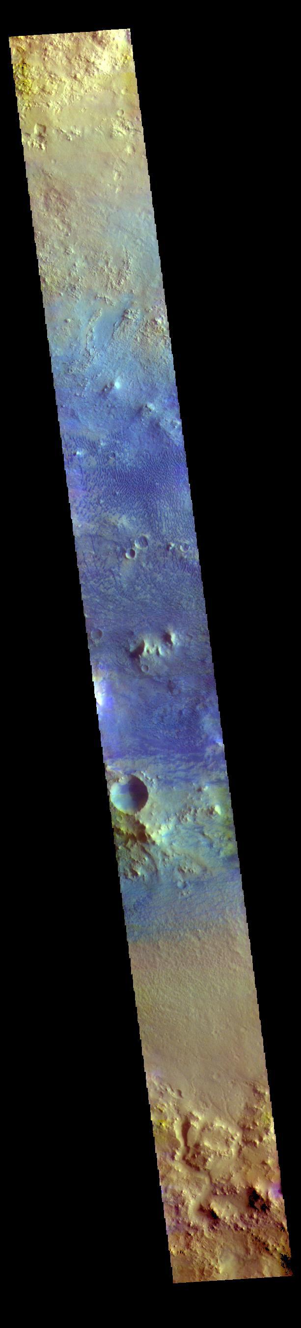
The THEMIS VIS camera contains 5 filters. The data from different filters can be combined in multiple ways to create a false color image. These false color images may reveal subtle variations of the surface not easily identified in a single band image. Today's false color image shows a cross section of Baldet Crater. Dark blue tones in this filter combination indicate basaltic sands. A large field of dunes is visible on the floor of the crater. Baldet Crater is located in Terra Sabaea and is 181km (112 miles) in diameter. Orbit Number: 77776 Latitude: 22.6741 Longitude: 65.6646 Instrument: VIS Captured: 2019-06-27 09:22 https://photojournal.jpl.nasa.gov/catalog/PIA24635