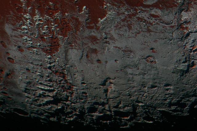
This area is south of Pluto's dark equatorial band informally named Cthulhu Regio, and southwest of the vast nitrogen ice plains informally named Sputnik Planitia. North is at the top; in the western portion of the image, a chain of bright mountains extends north into Cthulhu Regio. New Horizons compositional data indicate the bright snowcap material covering these mountains isn't water, but atmospheric methane that has condensed as frost onto these surfaces at high elevation. Between some mountains are sharply cut valleysindicated by the white arrows. These valleys are each a few miles across and tens of miles long. A similar valley system in the expansive plains to the east (blue arrows) appears to be branched, with smaller valleys leading into it. New Horizons scientists think flowing nitrogen ice that once covered this area -- perhaps when the ice in Sputnik was at a higher elevation -- may have formed these valleys. The area is also marked by irregularly shaped, flat-floored depressions (green arrows) that can reach more than 50 miles (80 kilometers) across and almost 2 miles (3 kilometers) deep. The great widths and depths of these depressions suggest that they may have formed when the surface collapsed, rather than through the sublimation of ice into the atmosphere. This enhanced color image was obtained by New Horizons' Multispectral Visible Imaging Camera (MVIC). The image resolution is approximately 2,230 feet (680 meters) per pixel. It was obtained at a range of approximately 21,100 miles (33,900 kilometers) from Pluto, about 45 minutes before New Horizons' closest approach to Pluto on July 14, 2015. http://photojournal.jpl.nasa.gov/catalog/PIA21026
NASA New Horizons spacecraft captured this image of a chain of snow-capped mountains stretching across the dark expanse on Pluto informally named Cthulhu Regio.

This high-resolution swat of Pluto sweeps over the cratered plains at the west of the New Horizons' encounter hemisphere and across numerous prominent faults, skimming the eastern margin of the dark, forbidding region informally known as Cthulhu Regio, and finally passing over the mysterious, possibly cryovolcanic edifice Wright Mons, before reaching the terminator or day-night line. Among the many notable details shown are the overlapping and infilling relationships between units of the relatively smooth, bright volatile ices from Sputnik Planum (at the edge of the mosaic) and the dark edge or "shore" of Cthulhu. The pictures in this mosaic were taken by the Long Range Reconnaissance Imager (LORRI) in "ride-along" mode with the LEISA spectrometer, which accounts for the 'zigzag' or step pattern. Taken shortly before New Horizons' July 14 closest approach to Pluto, details as small as 500 yards (500 meters) can be seen. http://photojournal.jpl.nasa.gov/catalog/PIA20286

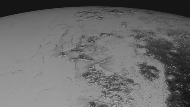
This synthetic perspective view of Pluto, based on the latest high-resolution images to be downlinked from NASA's New Horizons spacecraft, shows what you would see if you were approximately 1,100 miles (1,800 kilometers) above Pluto's equatorial area, looking northeast over the dark, cratered, informally named Cthulhu Regio toward the bright, smooth, expanse of icy plains informally called Sputnik Planum. The entire expanse of terrain seen in this image is 1,100 miles (1,800 kilometers) across. The images were taken as New Horizons flew past Pluto on July 14, 2015, from a distance of 50,000 miles (80,000 kilometers). http://photojournal.jpl.nasa.gov/catalog/PIA19937
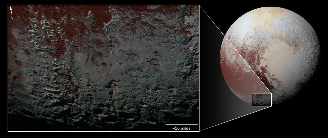
This area is south of Pluto's dark equatorial band informally named Cthulhu Regio, and southwest of the vast nitrogen ice plains informally named Sputnik Planitia. North is at the top; in the western portion of the image, a chain of bright mountains extends north into Cthulhu Regio. New Horizons compositional data indicate the bright snowcap material covering these mountains isn't water, but atmospheric methane that has condensed as frost onto these surfaces at high elevation. Between some mountains are sharply cut valleys -- indicated by the white arrows. These valleys are each a few miles across and tens of miles long. A similar valley system in the expansive plains to the east (blue arrows) appears to be branched, with smaller valleys leading into it. New Horizons scientists think flowing nitrogen ice that once covered this area -- perhaps when the ice in Sputnik was at a higher elevation -- may have formed these valleys. The area is also marked by irregularly shaped, flat-floored depressions (green arrows) that can reach more than 50 miles (80 kilometers) across and almost 2 miles (3 kilometers) deep. The great widths and depths of these depressions suggest that they may have formed when the surface collapsed, rather than through the sublimation of ice into the atmosphere. This enhanced color image was obtained by New Horizons' Multispectral Visible Imaging Camera (MVIC). The image resolution is approximately 2,230 feet (680 meters) per pixel. It was obtained at a range of approximately 21,100 miles (33,900 kilometers) from Pluto, about 45 minutes before New Horizons' closest approach to Pluto on July 14, 2015. http://photojournal.jpl.nasa.gov/catalog/PIA21025
Images downloaded from NASA's New Horizons spacecraft (through Sept. 11, 2015) were stitched together and rendered on a sphere to make a flyover "movie." The animation, made with images from New Horizons' Long Range Reconnaissance Imager (LORRI), begins with a low-altitude look at the informally named Norgay Montes, flies northward over the boundary between informally named Sputnik Planum and Cthulhu Regio, turns, and drifts slowly east. During the animation, the altitude of the observer rises until it is about 10 times higher to show about 80% of the hemisphere New Horizons flew closest to on July 14, 2015. http://photojournal.jpl.nasa.gov/catalog/PIA19951
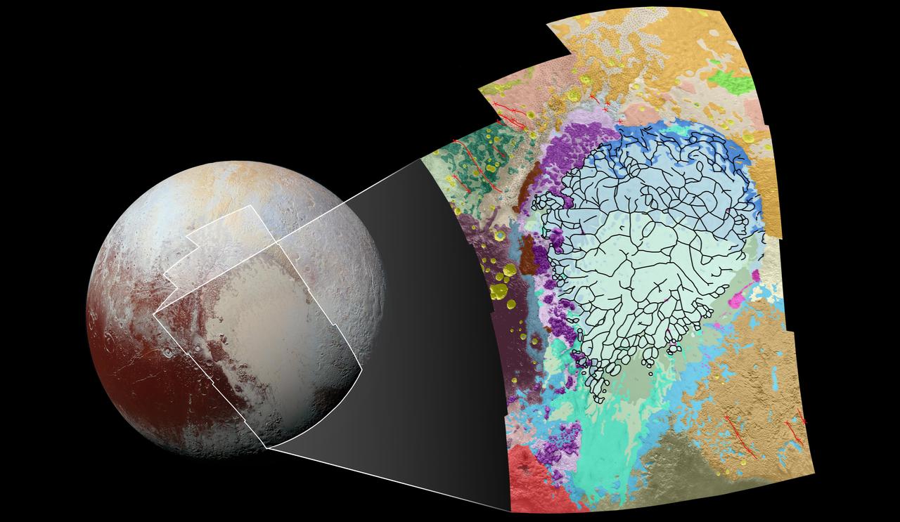
This geological map covers a portion of Pluto's surface that measures 1,290 miles (2,070 kilometers) from top to bottom, and includes the vast nitrogen-ice plain informally named Sputnik Planum and surrounding terrain. The map is overlain with colors that represent different geological terrains. Each terrain, or unit, is defined by its texture and morphology -- smooth, pitted, craggy, hummocky or ridged, for example. How well a unit can be defined depends on the resolution of the images that cover it. All of the terrain in this map has been imaged at a resolution of approximately 1,050 feet (320 meters) per pixel or better, meaning scientists can map units with relative confidence. The various blue and greenish units that fill the center of the map represent different textures seen across Sputnik Planum, from the cellular terrain in the center and north, to the smooth and pitted plains in the south. The black lines represent the troughs that mark the boundaries of cellular regions in the nitrogen ice. The purple unit represents the chaotic, blocky mountain ranges that line Sputnik's western border, and the pink unit represents the scattered, floating hills at its eastern edge. The possible cryovolcanic feature informally named Wright Mons is mapped in red in the southern corner of the map. The rugged highlands of the informally named Cthulhu Regio is mapped in dark brown along the western edge, and is pockmarked by many large impact craters, mapped in yellow. The base map for this geologic map is a mosaic of 12 images obtained by the Long Range Reconnaissance Imager (LORRI) at a resolution of 1,280 feet (about 390 meters) per pixel. The mosaic was obtained at a range of approximately 48,000 miles (77,300 kilometers) from Pluto, about an hour and 40 minutes before New Horizons' closest approach on July 14, 2015. http://photojournal.jpl.nasa.gov/catalog/PIA20465

This synthetic perspective view of Pluto, based on the latest high-resolution images to be downlinked from NASA’s New Horizons spacecraft, shows what you would see if you were approximately 1,100 miles (1,800 kilometers) above Pluto’s equatorial area, looking northeast over the dark, cratered, informally named Cthulhu Regio toward the bright, smooth, expanse of icy plains informally called Sputnik Planum. The entire expanse of terrain seen in this image is 1,100 miles (1,800 kilometers) across. The images were taken as New Horizons flew past Pluto on July 14, 2015, from a distance of 50,000 miles (80,000 kilometers). Read more: <a href="http://1.usa.gov/1MgG7io" rel="nofollow">1.usa.gov/1MgG7io</a> Credit: NASA/Johns Hopkins University Applied Physics Laboratory/Southwest Research Institute <b><a href="http://www.nasa.gov/audience/formedia/features/MP_Photo_Guidelines.html" rel="nofollow">NASA image use policy.</a></b> <b><a href="http://www.nasa.gov/centers/goddard/home/index.html" rel="nofollow">NASA Goddard Space Flight Center</a></b> enables NASA’s mission through four scientific endeavors: Earth Science, Heliophysics, Solar System Exploration, and Astrophysics. Goddard plays a leading role in NASA’s accomplishments by contributing compelling scientific knowledge to advance the Agency’s mission. <b>Follow us on <a href="http://twitter.com/NASAGoddardPix" rel="nofollow">Twitter</a></b> <b>Like us on <a href="http://www.facebook.com/pages/Greenbelt-MD/NASA-Goddard/395013845897?ref=tsd" rel="nofollow">Facebook</a></b> <b>Find us on <a href="http://instagrid.me/nasagoddard/?vm=grid" rel="nofollow">Instagram</a></b>