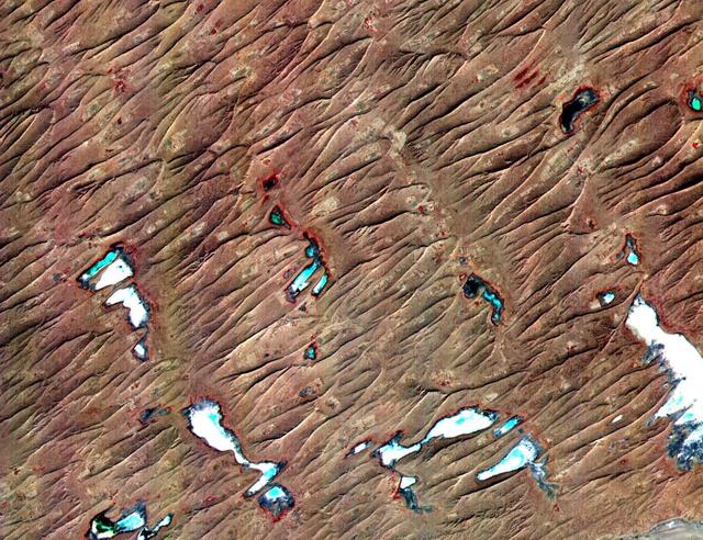
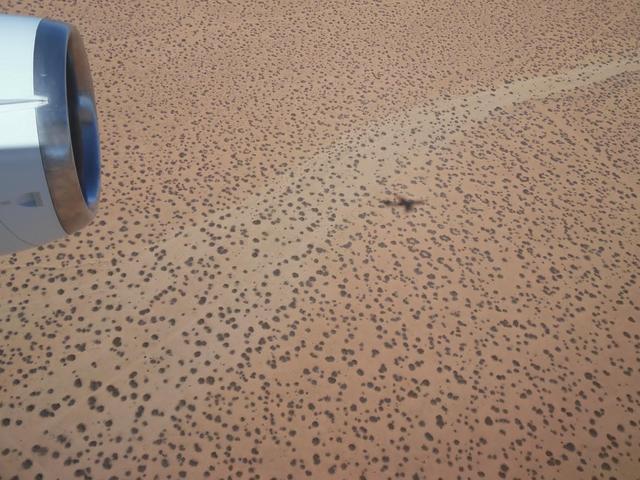
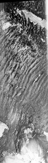
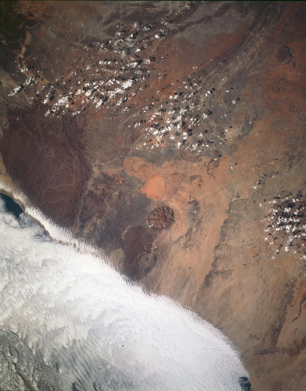
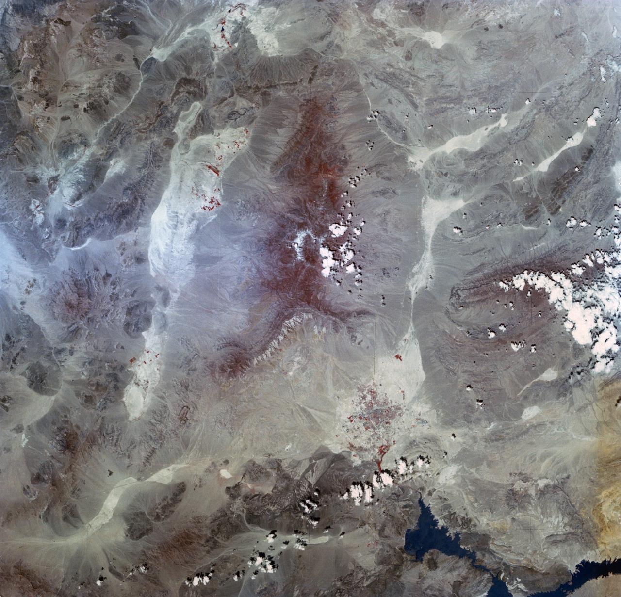
This ASTER sub-scene covers an area of 12 x 15 km in NW India in the Thar Desert. The sand dunes of the Thar Desert constantly shift and take on new shapes. Located in northwestern India and eastern Pakistan, the desert is bounded on the south by a salt marsh known as the Rann of Kutch, and on the west by the Indus River plain. About 800 kilometers long and about 490 kilometers wide, the desert's terrain is mainly rolling sandhills with scattered growths of shrub and rock outcroppings. Only about 12 to 25 centimeters of rain fall on the desert each year, and temperatures rise as high as 52 degrees Celsius. Much of the population is pastoral, raising sheep for their wool. The image is located at 24.4 degrees north latitude and 69.3 degrees east longitude. http://photojournal.jpl.nasa.gov/catalog/PIA11094
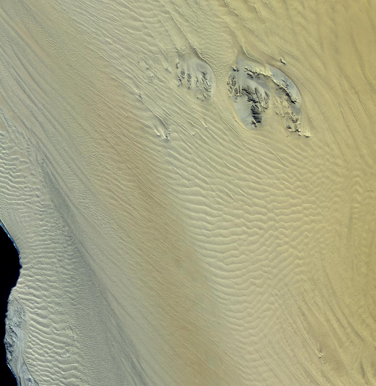
This image, acquired by NASA Terra spacecraft, shows the Namib Desert, a coastal desert in southern Africa. This portion in central Namibia consists entirely of linear and longitudinal sand dunes.
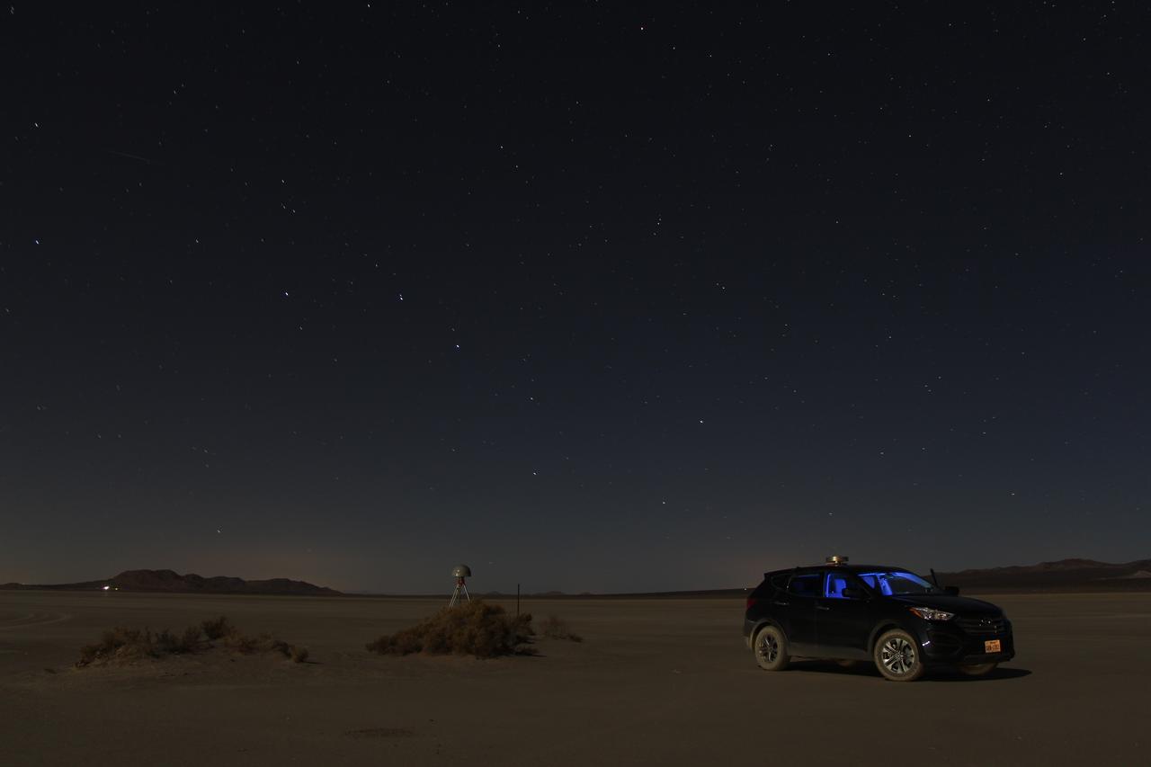
At first glance a dry lake bed in the southern California desert seems like the last place to prepare to study ice. But on Oct. 2, 2014, NASA’s Operation IceBridge carried out a ground-based GPS survey of the El Mirage lake bed in California’s Mojave Desert. Members of the IceBridge team are currently at NASA’s Armstrong Flight Research Center, preparing instruments aboard the DC-8 research aircraft for flights over Antarctica. Part of this preparation involves test flights over the desert, where researchers verify their instruments are working properly. El Mirage serves as a prime location for testing the mission’s laser altimeter, the Airborne Topographic Mapper, because the lake bed has a flat surface and reflects light similarly to snow and ice. This photo, taken shortly after the survey, shows the GPS-equipped survey vehicle and a stationary GPS station (left of the vehicle) on the lake bed with the constellation Ursa Major in the background. By driving the vehicle in parallel back and forth lines over a predefined area and comparing those GPS elevation readings with measurements from the stationary GPS, researchers are able to build an elevation map that will be used to precisely calibrate the laser altimeter for ice measurements. Credit: NASA/John Sonntag Operation IceBridge is scheduled to begin research flights over Antarctica on Oct. 15, 2014. The mission will be based out of Punta Arenas, Chile, until Nov. 23. For more information about IceBridge, visit: <a href="http://www.nasa.gov/icebridge" rel="nofollow">www.nasa.gov/icebridge</a> <b><a href="http://www.nasa.gov/audience/formedia/features/MP_Photo_Guidelines.html" rel="nofollow">NASA image use policy.</a></b> <b><a href="http://www.nasa.gov/centers/goddard/home/index.html" rel="nofollow">NASA Goddard Space Flight Center</a></b> enables NASA’s mission through four scientific endeavors: Earth Science, Heliophysics, Solar System Exploration, and Astrophysics. Goddard plays a leading role in NASA’s accomplishments by contributing compelling scientific knowledge to advance the Agency’s mission. <b>Follow us on <a href="http://twitter.com/NASAGoddardPix" rel="nofollow">Twitter</a></b> <b>Like us on <a href="http://www.facebook.com/pages/Greenbelt-MD/NASA-Goddard/395013845897?ref=tsd" rel="nofollow">Facebook</a></b> <b>Find us on <a href="http://instagram.com/nasagoddard?vm=grid" rel="nofollow">Instagram</a></b>
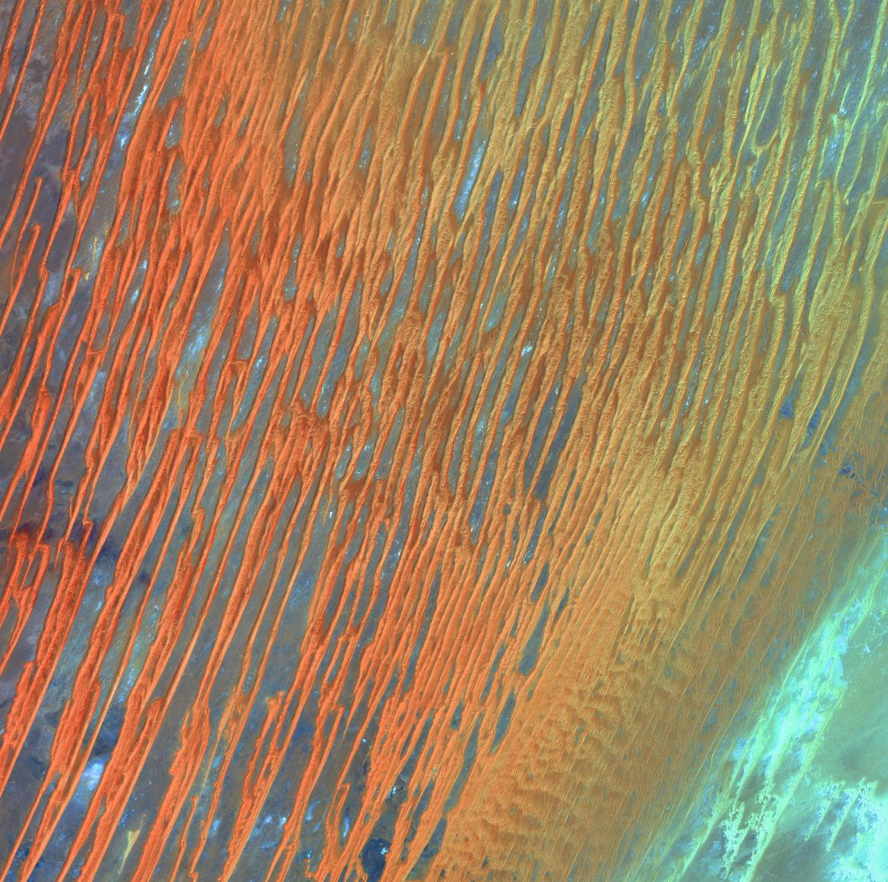
Desert Patterns - April 13th, 2003 Description: Seen through the "eyes" of a satellite sensor, ribbons of Saharan sand dunes seem to glow in sunset colors. These patterned stripes are part of Erg Chech, a desolate sand sea in southwestern Algeria, Africa, where the prevailing winds create an endlessly shifting collage of large, linear sand dunes. The term "erg" is derived from an Arabic word for a field of sand dunes. Credit: USGS/NASA/Landsat 7 To learn more about the Landsat satellite go to: <a href="http://landsat.gsfc.nasa.gov/" rel="nofollow">landsat.gsfc.nasa.gov/</a> <b><a href="http://www.nasa.gov/centers/goddard/home/index.html" rel="nofollow">NASA Goddard Space Flight Center</a></b> enables NASA’s mission through four scientific endeavors: Earth Science, Heliophysics, Solar System Exploration, and Astrophysics. Goddard plays a leading role in NASA’s accomplishments by contributing compelling scientific knowledge to advance the Agency’s mission. <b>Follow us on <a href="http://twitter.com/NASA_GoddardPix" rel="nofollow">Twitter</a></b> <b>Join us on <a href="http://www.facebook.com/pages/Greenbelt-MD/NASA-Goddard/395013845897?ref=tsd" rel="nofollow">Facebook</a></b>
The DC-8 research aircraft casting its shadow on the ground in California's Mojave Desert during an IceBridge instrument check flight. Prior to field campaigns, IceBridge instrument and aircraft teams run the aircraft through a series of tests to ensure that everything is operating at peak condition. Credit: NASA / Jim Yungel NASA's Operation IceBridge is an airborne science mission to study Earth's polar ice. For more information about IceBridge, visit: <a href="http://www.nasa.gov/icebridge" rel="nofollow">www.nasa.gov/icebridge</a> <b><a href="http://www.nasa.gov/audience/formedia/features/MP_Photo_Guidelines.html" rel="nofollow">NASA image use policy.</a></b> <b><a href="http://www.nasa.gov/centers/goddard/home/index.html" rel="nofollow">NASA Goddard Space Flight Center</a></b> enables NASA’s mission through four scientific endeavors: Earth Science, Heliophysics, Solar System Exploration, and Astrophysics. Goddard plays a leading role in NASA’s accomplishments by contributing compelling scientific knowledge to advance the Agency’s mission. <b>Follow us on <a href="http://twitter.com/NASAGoddardPix" rel="nofollow">Twitter</a></b> <b>Like us on <a href="http://www.facebook.com/pages/Greenbelt-MD/NASA-Goddard/395013845897?ref=tsd" rel="nofollow">Facebook</a></b> <b>Find us on <a href="http://instagram.com/nasagoddard?vm=grid" rel="nofollow">Instagram</a></b>
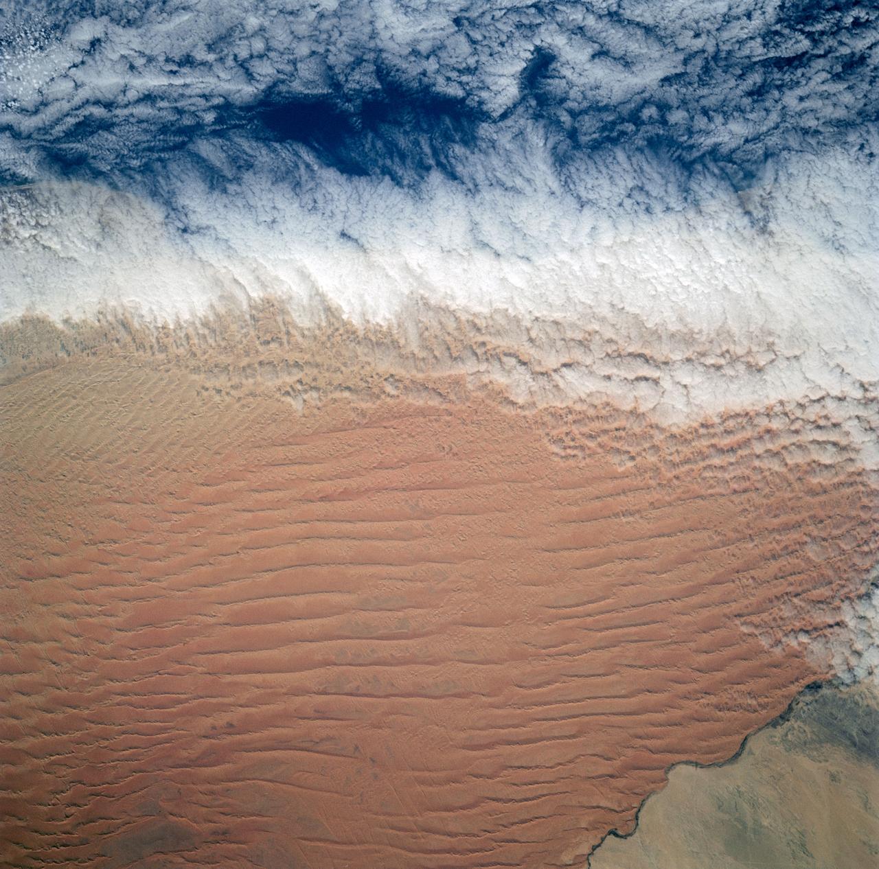
Fog is the only source of moisture for desert dwelling animals and plants living in the Namib Desert sand dune field, Namibia (23.5N, 15.0E). Coastal stratus clouds provide most of the life supporting moisture as fog droplets in this arid land where the usual annual rainfall is less than a quarter of an inch for decades at a time. In this view, the stratus clouds over the coast conform to the dune pattern proving that the fog is in ground contact.
One of the driest regions on Earth, the Namib Desert, Namibia, Africa (23.0N, 15.0E) lies adjacent to the Atlantic coast but the upwelling oceanic water causes a very stable rainless atmosphere. The few local inland rivers do not reach the sea but instead, appear as long indentations where they penetrate the dune fields and end as small dry lakes. The vast dune fields are the result of sands deposited over millions of years by the stream flow.
SL2-03-126 (June 1973) --- A color infrared photograph of the Los Angeles County and Kern County area, taken from the Skylab space station in Earth orbit during its first manned Skylab mission. The Mojave Desert occupies the northeast one-fourth of the photograph. Lake Isabella in the Sierra Nevada Mountains is the v-shaped body of water. The San Gabriel Mountains extend across the southern part of the picture. At lower center is the intersection of the San Andreas and Garlock faults. The San Joaquin Valley is in the center at the left edge. (The picture should be held with the heavy cloud cover at lower right corner so that north will be at top.) This picture was exposed by one of the six lenses of the Itek-furnished S190-A Multispectral Photographic Facility experiment in the Multiple Docking Adapter of the Skylab space station. Type 2443 film was used. Photo credit: NASA
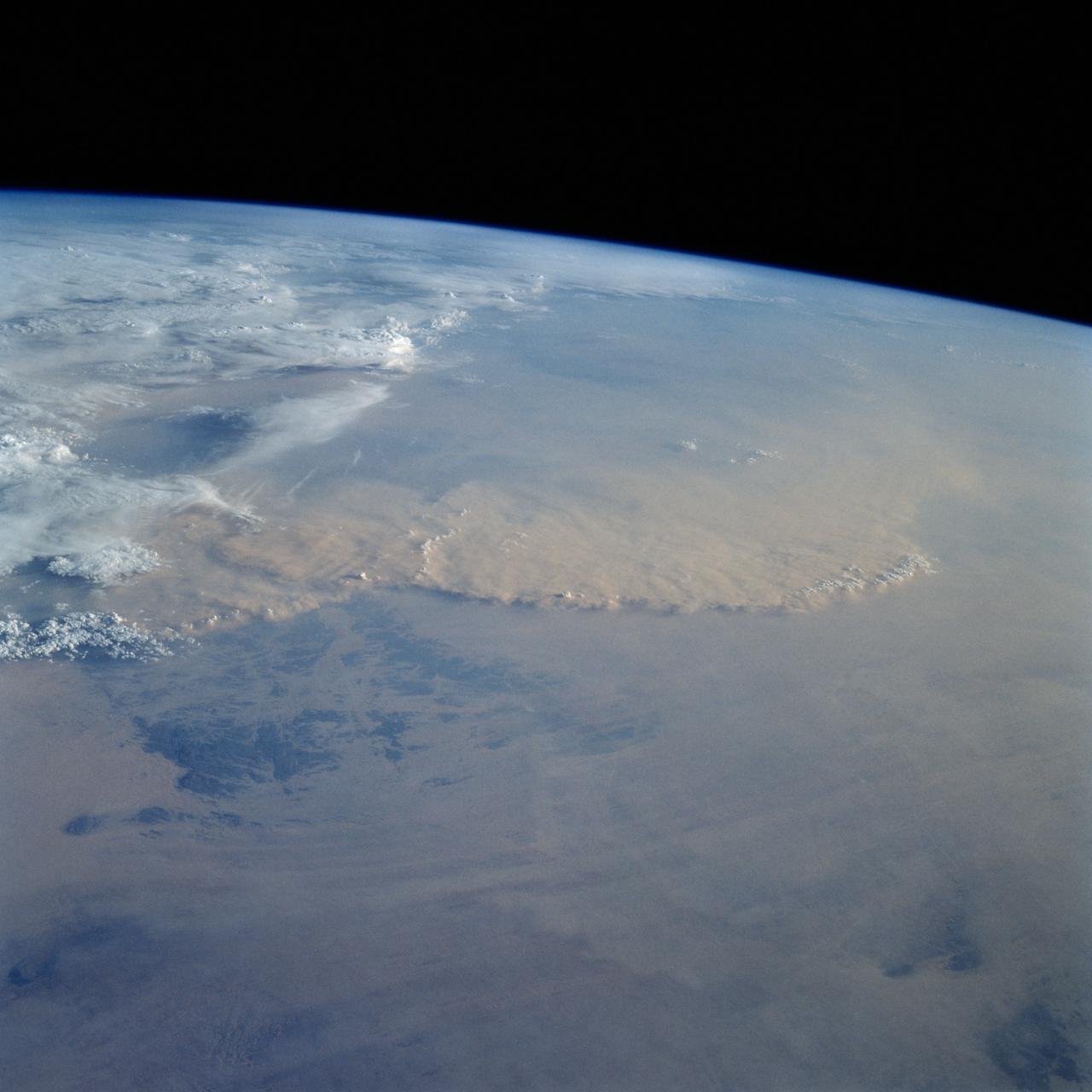
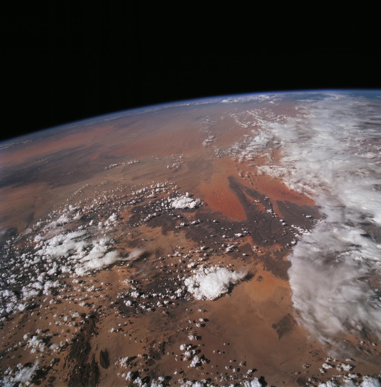
STS049-92-071 (13 May 1992) --- The STS-49 crew aboard the Earth-orbiting Space Shuttle Endeavour captured this Saharan dust storm on the Algeria-Niger border. The south-looking, late-afternoon view shows one of the best examples in the Shuttle photo data base of a dust storm. A series of gust fronts, caused by dissipating thunderstorms have picked up dust along the outflow boundaries. Small cumulus clouds have formed over the most vigorously ascending parts of the dust front, enhancing the visual effect of the front. The storm is moving roughly north-northwest, at right angles to the most typical path for dust storms in this part of the Sahara (shown by lines of sand on the desert surface in the foreground). Storms such as this can move out into the Atlantic, bringing dust even as far as the Americas on some occasions. A crewmember used a 70mm handheld Hasselblad camera with a 100mm lens to record the frame.

STS059-220-041 (9-20 April 1994) --- View to the south by southwest across the southern Gobi Desert (China) across the Chi-Lien-Shan or Quilienshan or Nanshan (Mountains) in Gansu Province to Lake Quinghai or Ch'ing-Hai (orthography varies with political conditions and scholarship) in Quinghai Province. The lake has a surface elevation of 10,450 feet, partially filling one of the easternmost closed drainage basins of Central Asia. Hasselblad photograph.
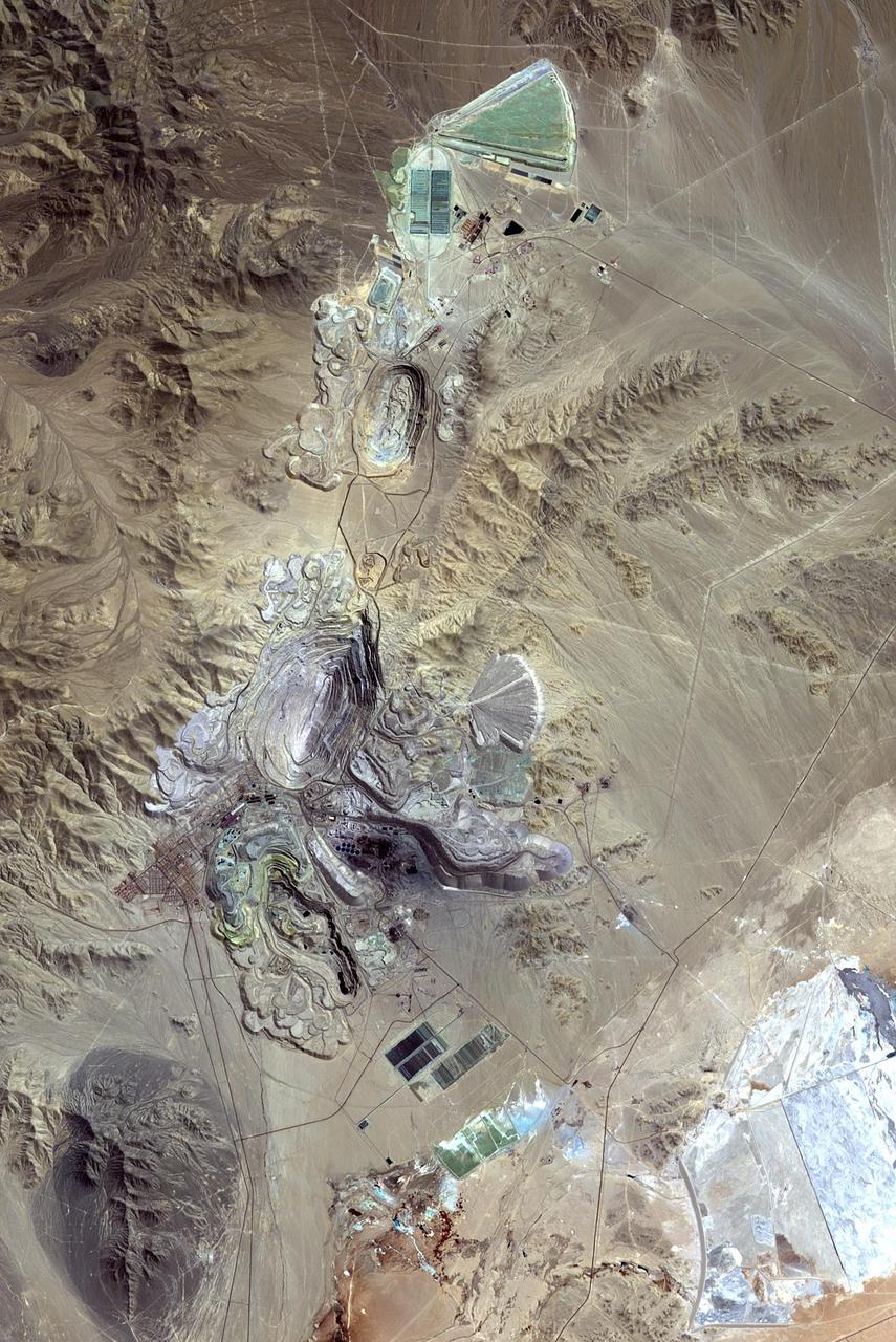
Chuquicamata, in Chile's Atacama Desert, is the largest open pit copper mine in the world, by excavated volume. The copper deposits were first exploited in pre-Hispanic times. Open pit mining began in the early 20th century when a method was developed to work low grade oxidized copper ores. The image was acquired September 2, 2007, covers an area of 19.5 by 29.3 km, and is located at 22.1 degrees south, 68.9 degrees west. http://photojournal.jpl.nasa.gov/catalog/PIA20973
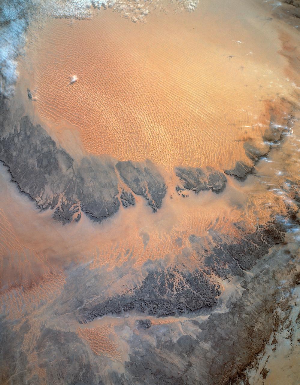
STS054-152-189 (13-19 Jan. 1993) --- This near-vertical color photograph shows the very diverse landscape that is part of the great Sahara Desert of north Africa. Specifically, the vast expanse of sand dunes, located in the extreme southwestern corner of Libya, is known as the Murzuk Sand Sea. Close inspection of this photograph shows the agricultural village of Murzuk as evidenced by the numerous center pivot irrigation patterns at the edge of the Murzuk Sand Sea. The very rugged, dissected terrain to the west of this sand sea is the eastern tip of the Tassili N'ajjer Mountains and the Tadrart Plateau that are in neighboring Algeria. Several smaller areas of sand dunes are interspersed between the major areas of rock outcrops. The photograph was taken with a Linhof camera.
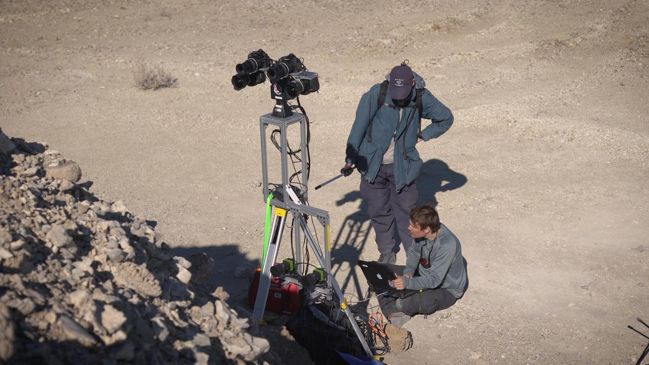
Two members of a field team set up cameras in the Nevada desert in February 2020, as part of a simulated rover operation designed to train scientists who will work with NASA's Perseverance rover after it lands on Mars in February 2021. https://photojournal.jpl.nasa.gov/catalog/PIA23777
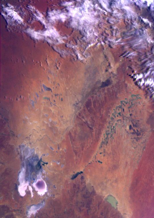
This color image of the Simpson Desert in Australia was obtained by NASA’s Galileo spacecraft at about 2:30 p.m. PST, Dec. 8, 1990, at a range of more than 35,000 miles. http://photojournal.jpl.nasa.gov/catalog/PIA00115
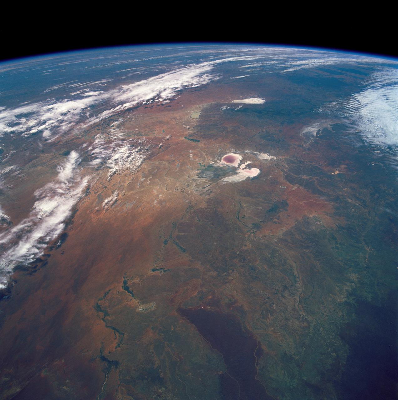
STS035-501-007 (2-10 Dec. 1990) --- The STS-35 crewmembers aboard the Earth-orbiting Space Shuttle Columbia photographed this view of the Arid Simpson Desert of Australia with a handheld Rolleiflex camera. Lake Eyre is normally dry; however, the STS-35 crew was able to recognize water in the lowest parts of the lake (dark pink area) and possibly in Lake Blanche east of Lake Eyre. Lake Frome lies in the distance separated from Lake Torrens (top right) by dark hills of Flinders Range. The Finke River (bottom left to middle) flows into the Eyre basin from the northwest. Although it is the largest river entering the basin, Finke's floods seldom reach Lake Eyre. The dark brown patch in the foreground is an area of ancient, brown lateritic soils partly covered by dunes.
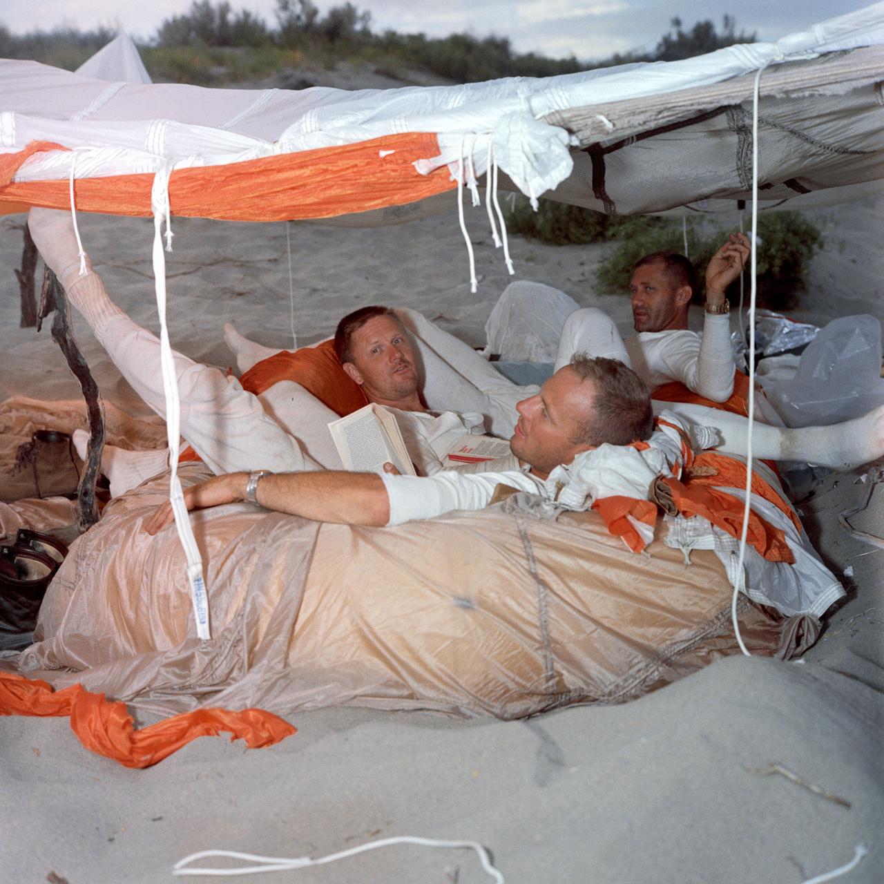
Desert Survival Training with Astronauts Lousma, Ling, and Pogue. PASCO, WA
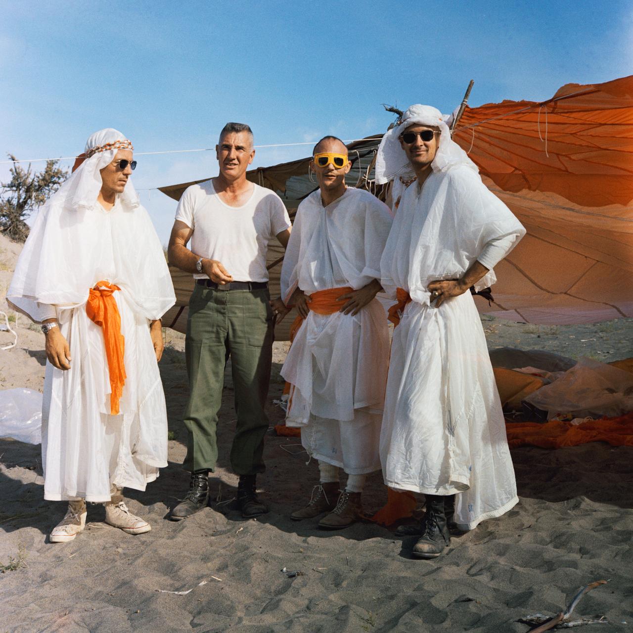
Desert Survival Training Pasco, Washington - Duke, Mattingly, Col. Bohart, Swigert
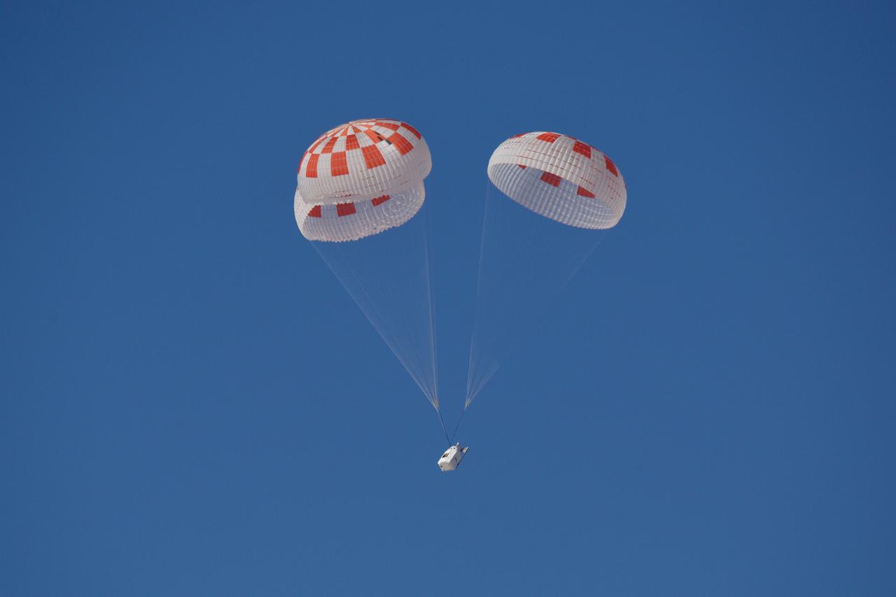
SpaceX performed its fourteenth overall parachute test supporting Crew Dragon development. This most recent exercise was the first of several planned parachute system qualification tests ahead of the spacecraft’s first crewed flight and resulted in the successful touchdown of Crew Dragon’s parachute system. During this test, a C-130 aircraft transported the parachute test vehicle, designed to achieve the maximum speeds that Crew Dragon could experience on re-entry, over the Mojave Desert in Southern California and dropped the vehicle from an altitude of 25,000 feet. The test demonstrated an off-nominal situation, deploying only one of the two drogue chutes and intentionally skipping a reefing stage on one of the four main parachutes, proving a safe landing in such a contingency scenario.
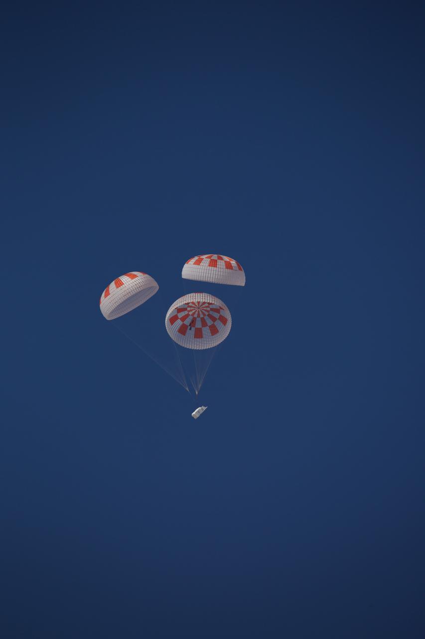
SpaceX performed its fourteenth overall parachute test supporting Crew Dragon development. This most recent exercise was the first of several planned parachute system qualification tests ahead of the spacecraft’s first crewed flight and resulted in the successful touchdown of Crew Dragon’s parachute system. During this test, a C-130 aircraft transported the parachute test vehicle, designed to achieve the maximum speeds that Crew Dragon could experience on re-entry, over the Mojave Desert in Southern California and dropped the vehicle from an altitude of 25,000 feet. The test demonstrated an off-nominal situation, deploying only one of the two drogue chutes and intentionally skipping a reefing stage on one of the four main parachutes, proving a safe landing in such a contingency scenario.
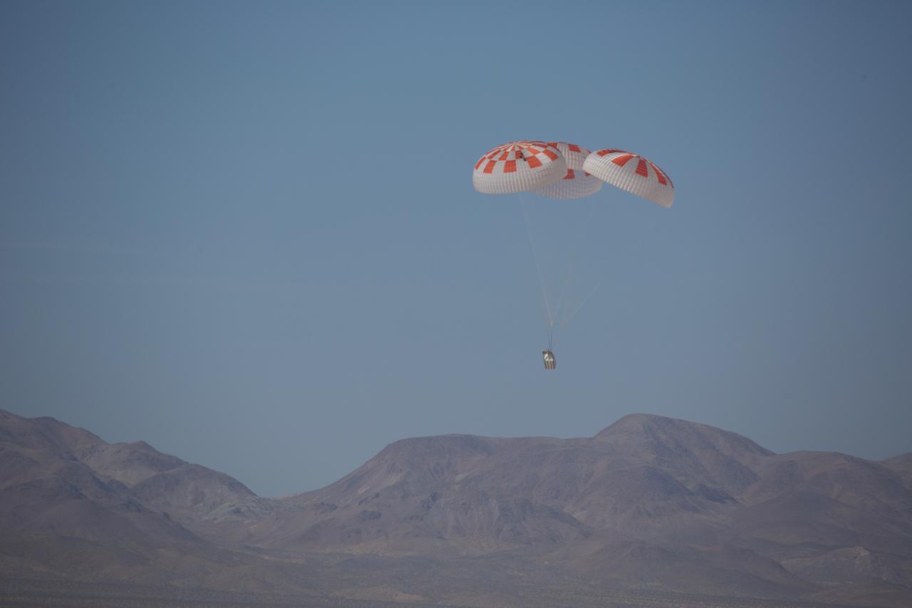
SpaceX performed its fourteenth overall parachute test supporting Crew Dragon development. This most recent exercise was the first of several planned parachute system qualification tests ahead of the spacecraft’s first crewed flight and resulted in the successful touchdown of Crew Dragon’s parachute system. During this test, a C-130 aircraft transported the parachute test vehicle, designed to achieve the maximum speeds that Crew Dragon could experience on re-entry, over the Mojave Desert in Southern California and dropped the vehicle from an altitude of 25,000 feet. The test demonstrated an off-nominal situation, deploying only one of the two drogue chutes and intentionally skipping a reefing stage on one of the four main parachutes, proving a safe landing in such a contingency scenario.
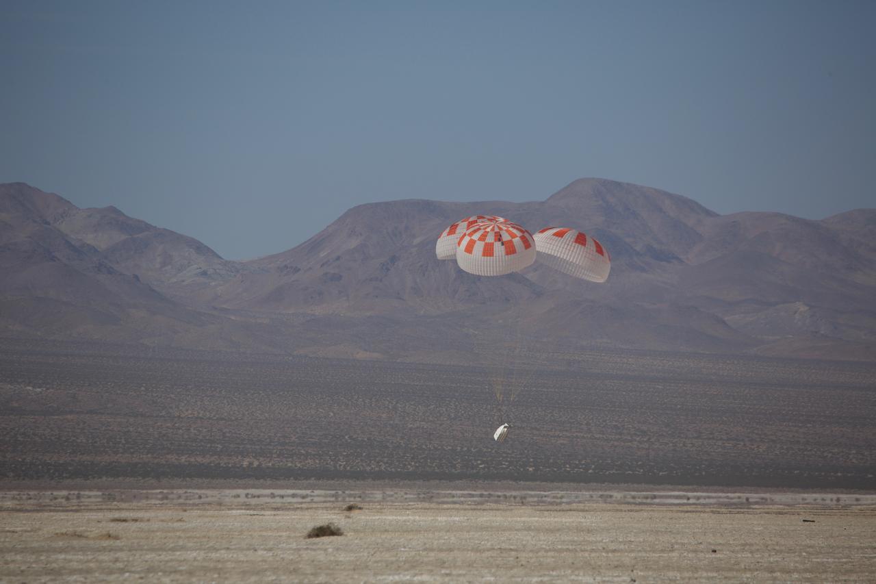
SpaceX performed its fourteenth overall parachute test supporting Crew Dragon development. This most recent exercise was the first of several planned parachute system qualification tests ahead of the spacecraft’s first crewed flight and resulted in the successful touchdown of Crew Dragon’s parachute system. During this test, a C-130 aircraft transported the parachute test vehicle, designed to achieve the maximum speeds that Crew Dragon could experience on re-entry, over the Mojave Desert in Southern California and dropped the vehicle from an altitude of 25,000 feet. The test demonstrated an off-nominal situation, deploying only one of the two drogue chutes and intentionally skipping a reefing stage on one of the four main parachutes, proving a safe landing in such a contingency scenario.
This is a C-band, VV polarization radar image of the Namib desert in southern Namibia, near the coast of South West Africa. The image is centered at about 25 degrees South latitude, 15.5 degrees East longitude. This image was one of the first acquired by the Spaceborne Imaging Radar-C/X-Band Synthetic Aperture Radar (SIR-C/X-SAR) when it was taken on orbit 4 from the shuttle Endeavour on April 9, 1994. The area shown is approximately 78 kilometers by 20 kilometers. The dominant features in the image are complex sand dune patterns formed by the prevailing winds in this part of the Namib desert. The Namib desert is an extremely dry area formed largely because of the influence of the cold Benguela ocean current that flows northward along the coast of Namibia. The bright areas at the bottom of the image are exposed outcrops of Precambrian rocks. This extremely barren area is a region rich in diamonds that through the centuries have washed down from the mountains. The town of Luderitz is located just to the south of the area shown. http://photojournal.jpl.nasa.gov/catalog/PIA01720
iss072e068304 (Oct. 13, 2024) --- The town and commune of In Ghar, with a population of over 11,000 in Algeria's portion of the Sahara Desert, is pictured from the International Space Station as it orbited 259 miles above the African nation.
iss072e474251 (Jan. 14, 2025) --- A portion of the Libyan Desert near the Northern Sudan city of Al Dabbah, on the bank of Nile River, is pictured from the International Space Station as it orbited 259 miles above the African nation.
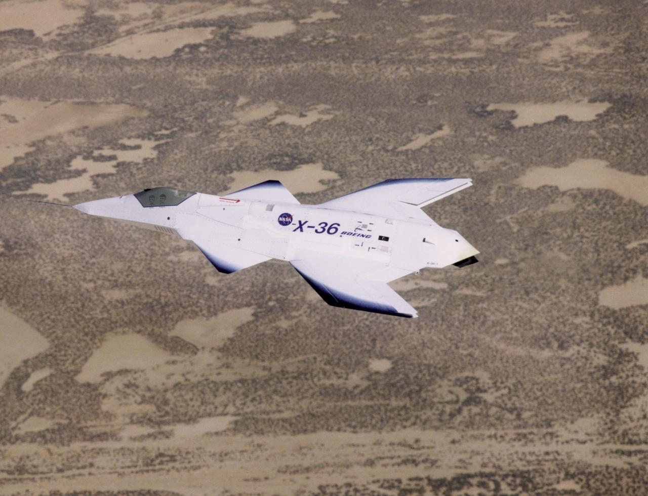
The unusual lines of the X-36 technology demonstrator contrast sharply with the desert floor as the remotely piloted aircraft scoots across the California desert at low altitude during a research flight on October 30, 1997.
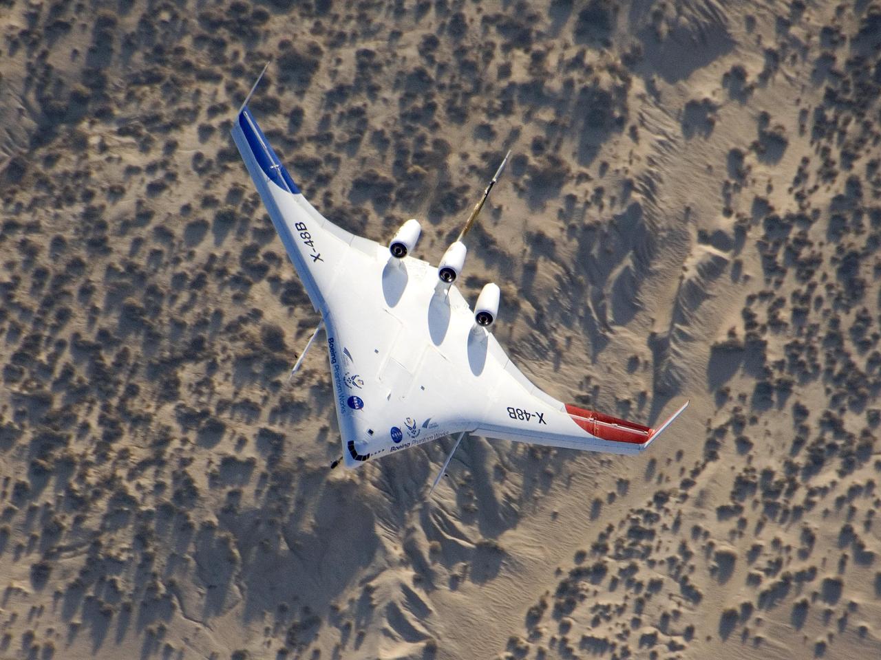
The unique X-48B Blended Wing Body subscale demonstrator banked over desert scrub at Edwards AFB during the aircraft's fifth test flight Aug. 14, 2007.
iss069e004762 (April 20, 2023) --- Wadis, the Arabic term for drainage courses that contain water only when intermittent, heavy rain occurs, in the hot desert climate of Yemen were pictured by NASA astronaut and Expedition 69 Flight Engineer Woody Hoburg as the International Space Station orbited 258 miles above.
iss073e0886770 (Oct. 1, 2025) --- Laguna Salada is a dry lakebed in the Baja California portion of the Sonoran Desert, located near the geologically active San Andreas Fault system. The International Space Station was orbiting 261 miles above Earth when this image was taken.
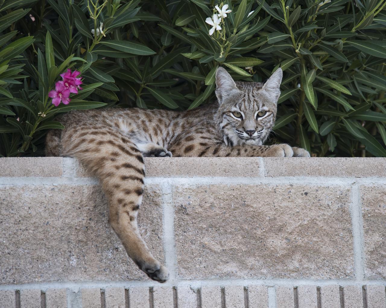
A bobcat resting leisurely on a retaining wall among the flowering bushes at Armstrong Flight Research Center in Edwards, California. The facility is home to a number of wild animals including the bobcats which are free to roam the more than 300,000 acres of Mojave Desert.
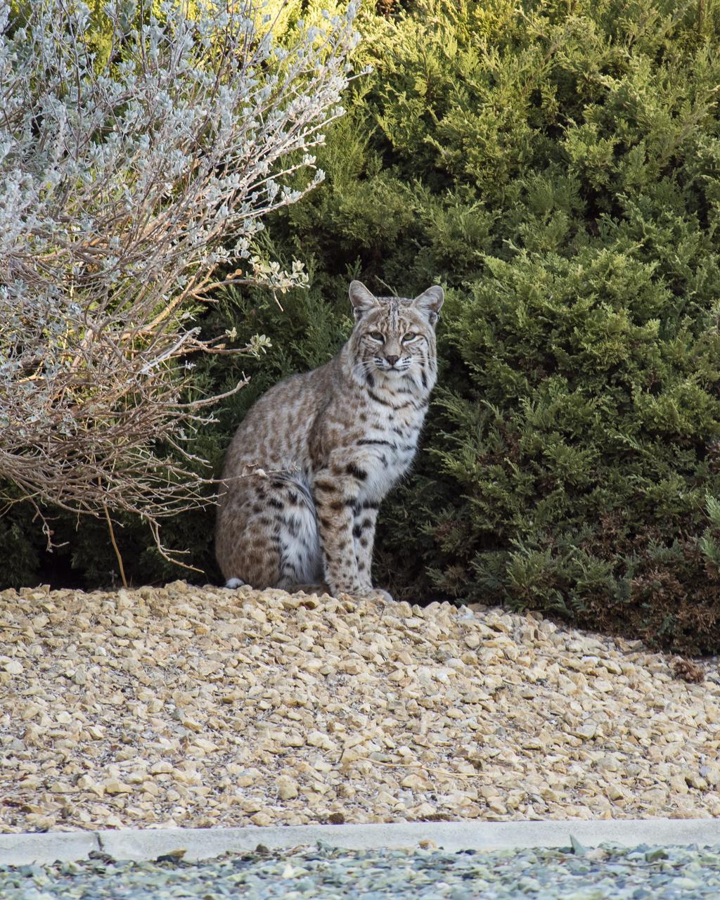
A bobcat surveying the landscape in between bushes at Armstrong Flight Research Center in Edwards, California. The spotted feline makes its home on the more than 300,000 acres of Mojave Desert surrounding the NASA facility housed at Edwards Air Force Base.
iss072e007016 (Oct. 1, 2024) --- The cold desert climate region of Kazakhstan on the coast of the Caspian Sea coast is pictured from the International Space Station as it orbited 259 miles above.
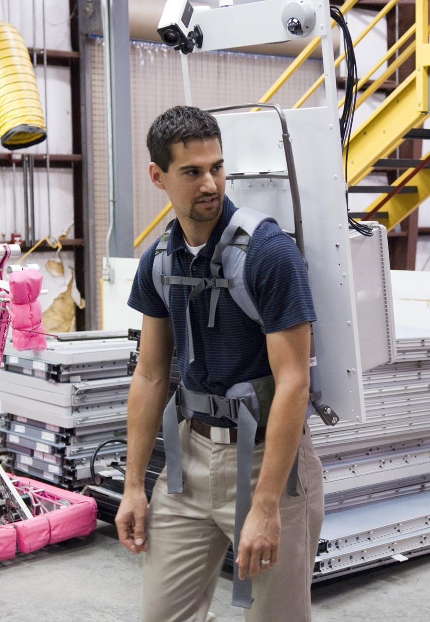
Mike Miller demonstrates one of the backpacks his team designed and built for the Desert Research and Technology Studies project's upcoming field test in Arizona. Miller led the team that developed the backpacks. The backpacks are equipped with GPS antennas, communications components and cameras. They are meant to show researchers what an astronaut might need to explore an alien world and give designers a look at the hardships the equipment could encounter. Photo credit: NASA/Frank Michaux
iss074e0316083 (Feb. 18, 2026) --- The far western edge of the Taklamakan Desert—the world’s second-largest shifting sand desert—meets the Pamir Mountains in China, where scorching desert conditions transition to frigid alpine terrain. The International Space Station was orbiting 259 miles above Central Asia when this photograph was taken.
STS068-228-081 (30 September-11 October 1994) --- This northwest-looking view shows central Algeria with an unusual amount of cloud cover, responsible for one of the infrequent bouts of rain in the Sahara Desert. The lope-shaped, red sand dunes mass in the center of the view is one of the most prominent features in the Sahara as seen from the Space Shuttle Endeavour. It is known as the Tifernine Dunes. The Atlas Mountains (top) are only apparent in this view because of the clouds, which cap their summits.

STS052-152-047 (22 Oct- 1 Nov 1992) --- The Kalahari Desert had not seen any significant rainfall for months before the launch of STS-52. Here, Shuttle astronauts have captured the onset of the (Southern Hemisphere) summer monsoon over the Kalahari Desert, as illustrated by the large thunderstorm towers poking up through the sun's terminator. The summer monsoon, with its associated thunderstorms, generally lasts from November through March. Scientist observers of this area report that the summer monsoon contributes most of the annual rainfall to this environmentally sensitive area. Shuttle nadir position: 28.0 degrees south, 25.1 degrees east. The center of the scene is 22.0 degrees south, 25.0 degrees east, 16:20:04 GMT.
STS058-92-064 (18 Oct-1 Nov 1993) --- This oblique view, looking northeast from central Egypt, shows great expanses of the sand covered and rocky Western Desert in the foreground (bottom). The dark patches bottom right are the Dakhla Oases on the south side of an escarpment. For centuries camel trains have moved from here to the Nile Valley, seen here as a broad green line winding through the desert. The northern half of Egypt's Nile appears here, from about the latitude of Luxor to the delta. Green colors indicate the small area of crops which feed Egypt's population of 55 million. The Nile Delta is partly obscured by a band of clouds, but can be discerned at the coast as a flattened triangle of green. The smaller triangle close by is the Faiyum Basin, a depression irrigated by water from the Nile. The coast of the Mediterranean Sea appears left.

STS001-12-308 (12-14 April 1981) --- Space shuttle Columbia approached Edwards Air Force Base from the left to land at the dry lake at the center. The view is to the southwest. The edge of the light "vee" is the intersection of the San Andres and Garlock Faults at Fort Tejon. Los Angeles is at upper right. Owens Lake is at the lower center. Photo credit: NASA
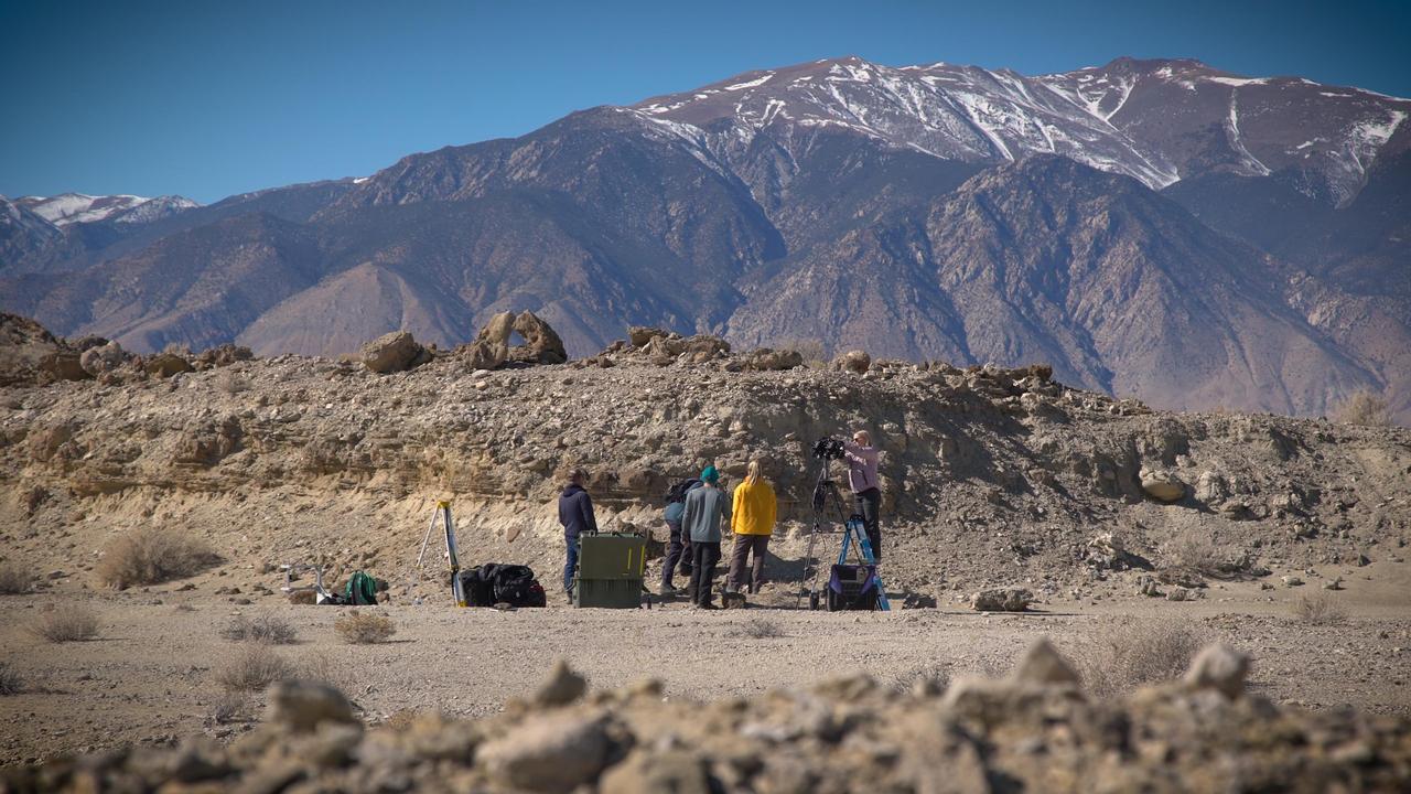
A field team sets up equipment in the Nevada desert in February 2020 as part of a training session for scientists who will work with NASA's Perseverance Mars rover after it lands. Cameras and instruments carried by the field team stood in for an actual rover; the scientists, based in offices around the world, sent commands for images and data, as they will with Perseverance. https://photojournal.jpl.nasa.gov/catalog/PIA23776
iss072e007019 (Oct. 1, 2024) --- The hot desert coast of Western Australia's sparsely-populated Pilbara region on the Indian Ocean is pictured from the International Space Station as it orbited 262 miles above.
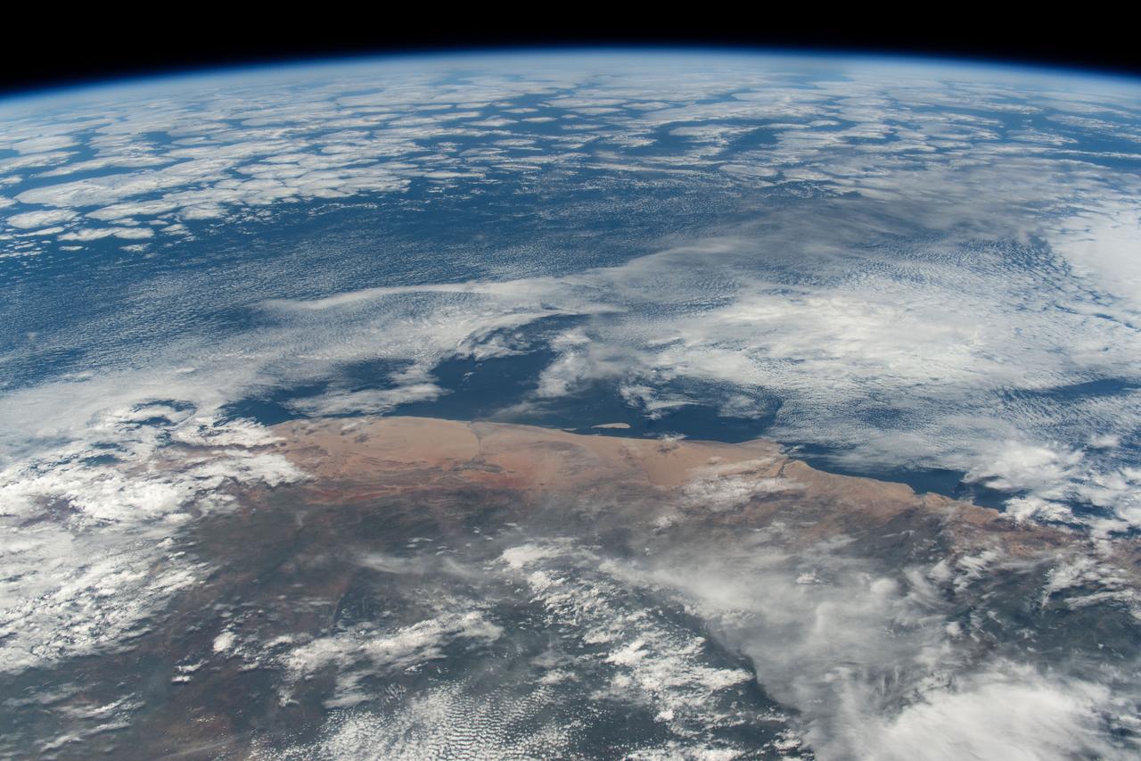
iss072e862085 (March 26, 2025) --- The hot and arid desert coast of Angola on the Atlantic Ocean is pictured from the International Space Station as it orbited 261 miles above the Central African nation.
iss073e0078403 (May 23, 2025) --- The sparsely populated, hot desert region of Western Australia near Neale Junction Nature Reserve is pictured from the International Space Station as it orbited 265 miles above the continental nation.
A front view of the Lunar Electric Rover (LER) during the Desert Research and Technology Studies (RATS) remote field test at Black Point Lava Flow, Arizona in 2008.

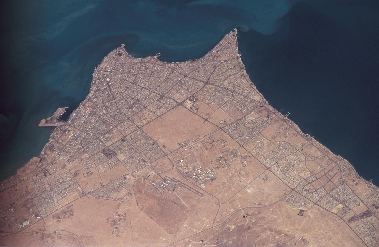
iss072e519565 (Jan. 22, 2025) --- Riyadh, Saudi Arabia, the desert nation's capital and largest city with a population af about 7 million, are pictured at aproximately 10:38 p.m. local time from the International Space Station as it orbited 258 miles above.
STS072-709-063 (11-20 Jan. 1996) --- The astronauts aboard the Space Shuttle Endeavour exposed this 70mm frame of the Air Mountains, located in the country of Niger. These Sahara Desert structures are granitic intrusions. They are resistant to erosion and are very prominent in the lighter colored sands of the area. According to NASA geologists studying the photo collection, the ring-like structure on the lower left-hand edge of the photograph is probably a Quaternary volcanic feature. The highest peaks in the range approach 1,800 meters (6,000 feet). Deep valleys in the range are used by the Tuaregs for pasturage. Uranium and other minerals are being mined in the massif.
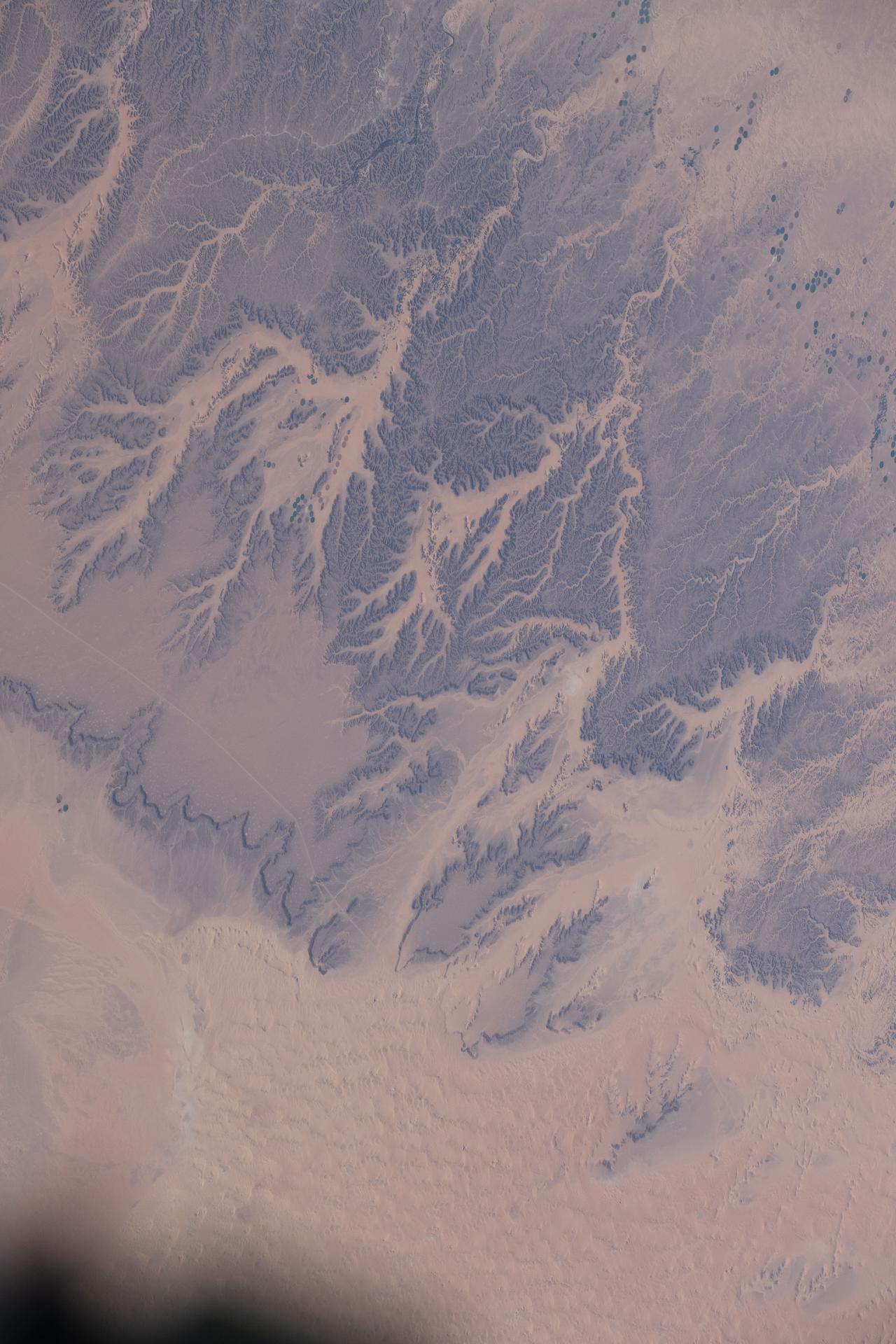
iss074e0320309 (Feb. 21, 2026) --- Wadis, dry riverbeds or channels that carry water only during the rainy season, are pictured in the northern Sahara Desert region of Algeria. The International Space Station was orbiting 260 miles above the North African nation when this photograph was taken. Credit: NASA/Jessica Meir
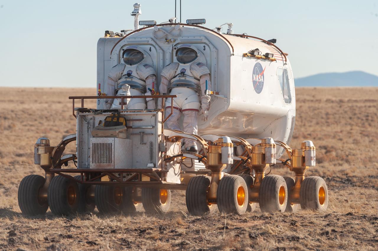
A back view of the Lunar Electric Rover (LER) during the Desert Research and Technology Studies (RATS) remote field test at Black Point Lava Flow, Arizona in 2008. Two Mark III spacesuits are visibly mounted on the LER suit port.
This spaceborne radar image shows part of the Mojave Desert in the vicinity of Barstow, California and reveals evidence of human activities in the arid environment of the southern California deserts.
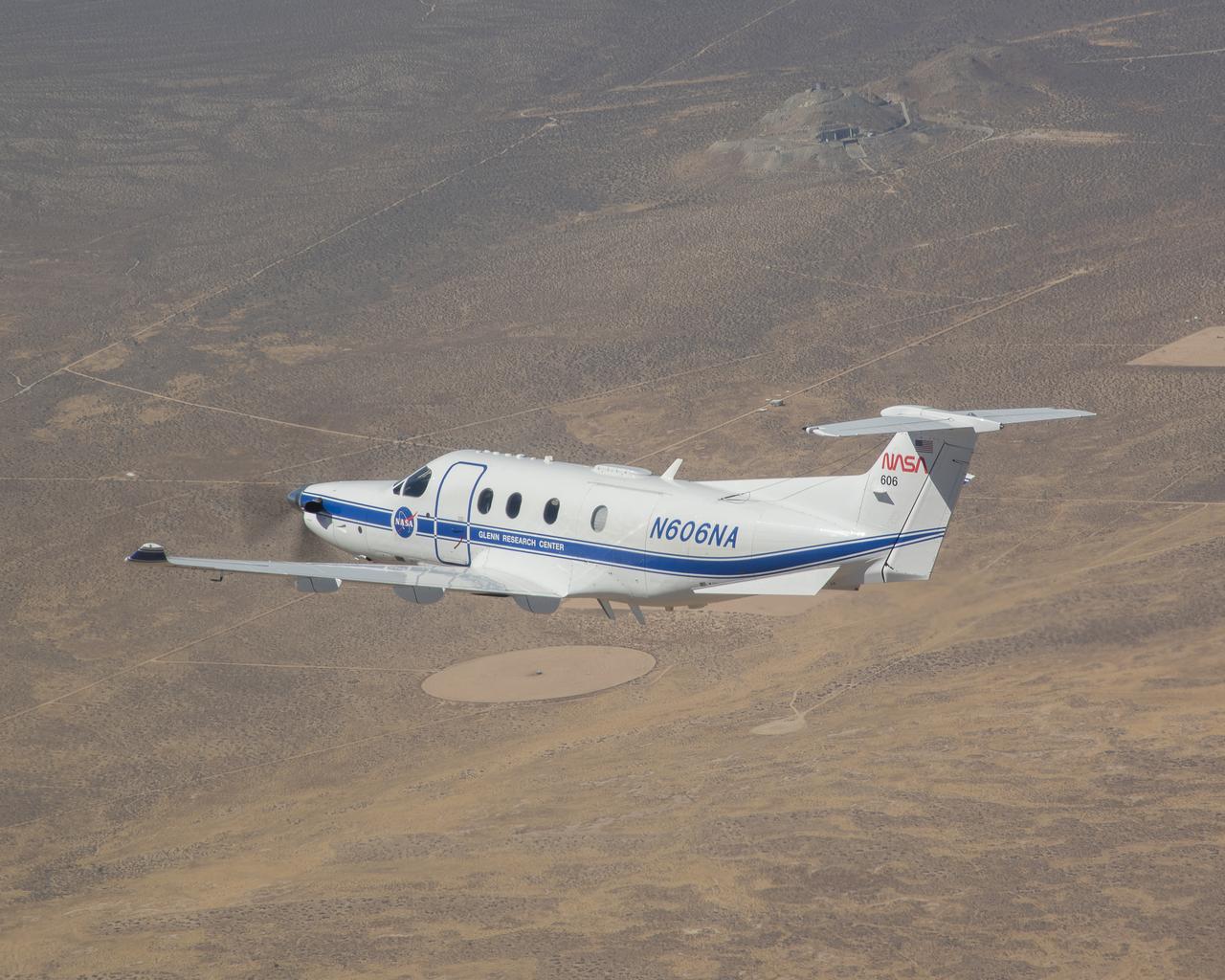
Equipped with state-of-the-art technology to test and evaluate communication, navigation, and surveillance systems, NASA’s Pilatus PC-12 flies over the Mojave Desert near Armstrong Flight Research Center in Edwards, California. Based at Glenn Research Center in Cleveland, the Pilatus PC-12 runs a series of familiarization flights for NASA Armstrong pilots before a test series evaluating ADS-B or Automatic Dependent Surveillance Broadcast systems for advanced air mobility applications in the desert flight test range on Sept. 18, 2024. Airborne work during familiarization flights includes several approach and landings, with an emphasis on avionics, then medium altitude air-work with steep turns, slow flight, and stall demonstrations to qualitatively understand the handling characteristics of the aircraft. The flights lasted about 60 to 90 minutes on average.
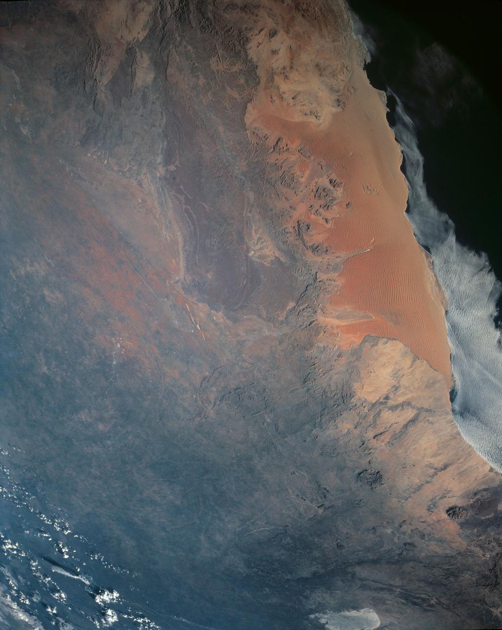
STS054-151-009 (13-19 Jan 1993) --- This large format camera's view shows the circular volcanic structure of the Brandberg mountain, which at 2630 meters (8,550 feet) is the highest point in the new nation of Namibia. The Brandberg is a major feature in the very arid Namib Desert on Africa's southwest coast. Coastal fog brings some moisture to the driest parts of the desert.
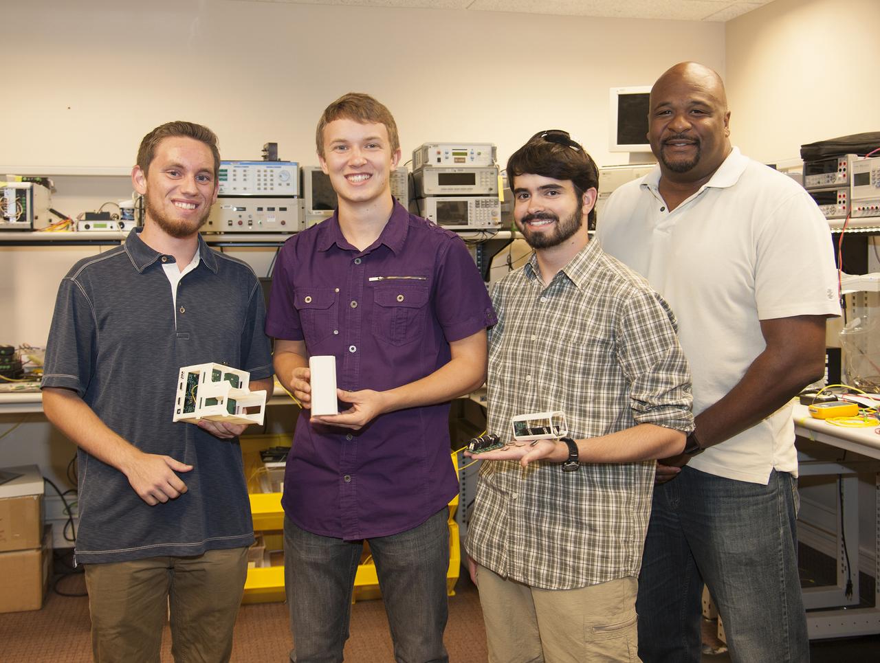
From left, former Desert Christian students Logan Francisco, Kyler Stephens and Jonathan Lokos and NASA Armstrong mentor Allen Parker show the elements of the experiment launched into space on Dec. 3.
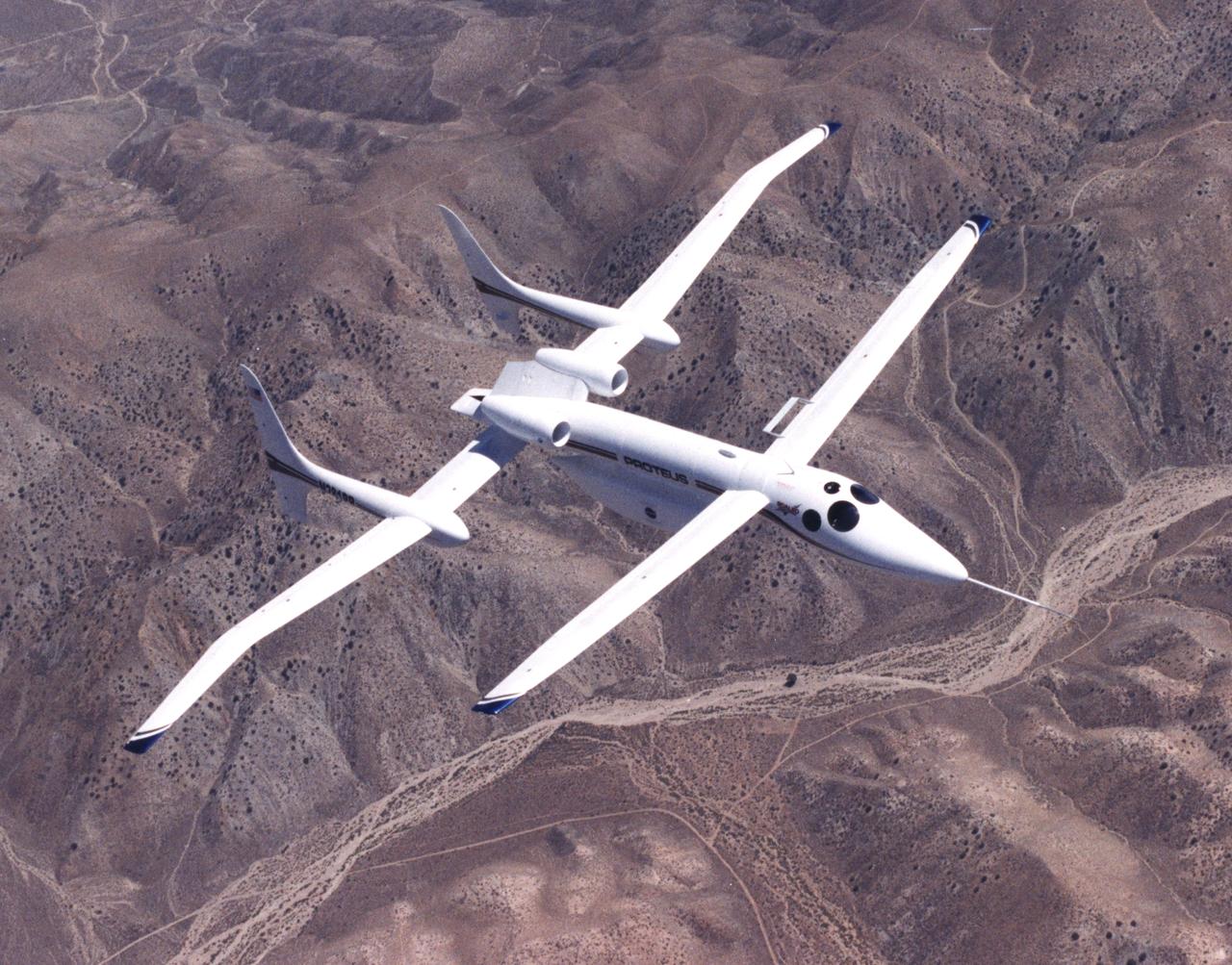
The unusual design of the Proteus high-altitude aircraft, incorporating a gull-wing shape for its main wing and a long, slender forward canard, is clearly visible in this view of the aircraft in flight over the Mojave Desert in California.
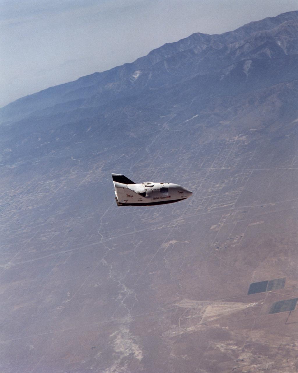
NASA's X-38 glided high over California desert test ranges as it descended from 37,500 feet to land on Rogers Dry Lake for the seventh free flight of the program July 10, 2001.
![This radar image is of an area thought to contain the ruins of the ancient settlement of Niya. It is located in the southwestern corner of the Taklamakan Desert in China Sinjiang Province. This oasis was part of the famous Silk Road, an ancient trade route from one of China's earliest capitols, Xian, to the West. The image shows a white linear feature trending diagonally from the upper left to the lower right. Scientists believe this newly [sic] discovered feature is a man-made canal which presumably diverted river waters toward the settlement of Niya for irrigation purposes. The image was acquired by the Spaceborne Imaging Radar-C and X-band Synthetic Aperture Radar (SIR-C/X-SAR) aboard the space shuttle Endeavour on its 106th orbit on April 16, 1994, and is centered at 37.78 degrees north latitude and 82.41 degrees east longitude. The false-color radar image was created by displaying the C-band (horizontally transmitted and received) return in red, the L-band (horizontally transmitted and received) return in green, and the L-band (horizontally transmitted and vertically received) return in blue. Areas in mottled white and purple are low-lying floodplains of the Niya River. Dark green and black areas between river courses are higher ridges or dunes confining the water flow. http://photojournal.jpl.nasa.gov/catalog/PIA01725](https://images-assets.nasa.gov/image/PIA01725/PIA01725~thumb.jpg)
This radar image is of an area thought to contain the ruins of the ancient settlement of Niya. It is located in the southwestern corner of the Taklamakan Desert in China Sinjiang Province. This oasis was part of the famous Silk Road, an ancient trade route from one of China's earliest capitols, Xian, to the West. The image shows a white linear feature trending diagonally from the upper left to the lower right. Scientists believe this newly [sic] discovered feature is a man-made canal which presumably diverted river waters toward the settlement of Niya for irrigation purposes. The image was acquired by the Spaceborne Imaging Radar-C and X-band Synthetic Aperture Radar (SIR-C/X-SAR) aboard the space shuttle Endeavour on its 106th orbit on April 16, 1994, and is centered at 37.78 degrees north latitude and 82.41 degrees east longitude. The false-color radar image was created by displaying the C-band (horizontally transmitted and received) return in red, the L-band (horizontally transmitted and received) return in green, and the L-band (horizontally transmitted and vertically received) return in blue. Areas in mottled white and purple are low-lying floodplains of the Niya River. Dark green and black areas between river courses are higher ridges or dunes confining the water flow. http://photojournal.jpl.nasa.gov/catalog/PIA01725
SL2-03-192 (22 June 1973) --- Lake Mead, Nevada, (36.0N, 114.5E) where the water from the Colorado River empties after it's 273 mile journey through the Grand Canyon of Arizona is the subject of this photo. Other features of interest are Hoover Dam on the south shore of Lake Mead where cheap hydroelectric power is secondary to the water resources made available in this northern desert region and the resort city of Las Vegas, just to the west of Lake Mead. In this harsh desert environment, color infrared photography readily penetrates haze, detects and portrays vegetation as shades of red. Photo credit: NASA
A launch abort engine built by Aerojet Rocketdyne is hot-fired during tests in the Mojave Desert in California. The engine produces up to 40,000 pounds of thrust and burns hypergolic propellants. The engines have been designed and built for use on Boeing’s CST-100 Starliner spacecraft in sets of four. In an emergency at the pad or during ascent, the engines would ignite to push the Starliner and its crew out of danger.
A launch abort engine built by Aerojet Rocketdyne is hot-fired during tests in the Mojave Desert in California. The engine produces up to 40,000 pounds of thrust and burns hypergolic propellants. The engines have been designed and built for use on Boeing’s CST-100 Starliner spacecraft in sets of four. In an emergency at the pad or during ascent, the engines would ignite to push the Starliner and its crew out of danger.
STS032-85-029 (12 Jan. 1990) --- (ORIENT PHOTO WITH COLUMBIA'S CARGO BAY IN LOWER CENTER). This 70mm frame was taken during a battery of documentary photographs of the recently-recaptured Long Duration Exposure Facility (LEDF). The Atlantic Coast of Namibia serves as a backdrop for the colorful scene. After five-and-one half years orbiting Earth, LDEF was retrieved by STS-32 crewmembers and brought back home at the end of the eleven-day mission for scientific observation. The bus-sized spacecraft was held in the grasp of Columbia's remote manipulator system (RMS) end effector during the survey.
S63-06447 (15-16 May 1963) --- The Great Indian Desert, located west of New Delhi, India, as photographed from the Mercury-Atlas 9 (MA-9) capsule by astronaut L. Gordon Cooper Jr., during his 22-orbit MA-9 spaceflight. Photo credit: NASA
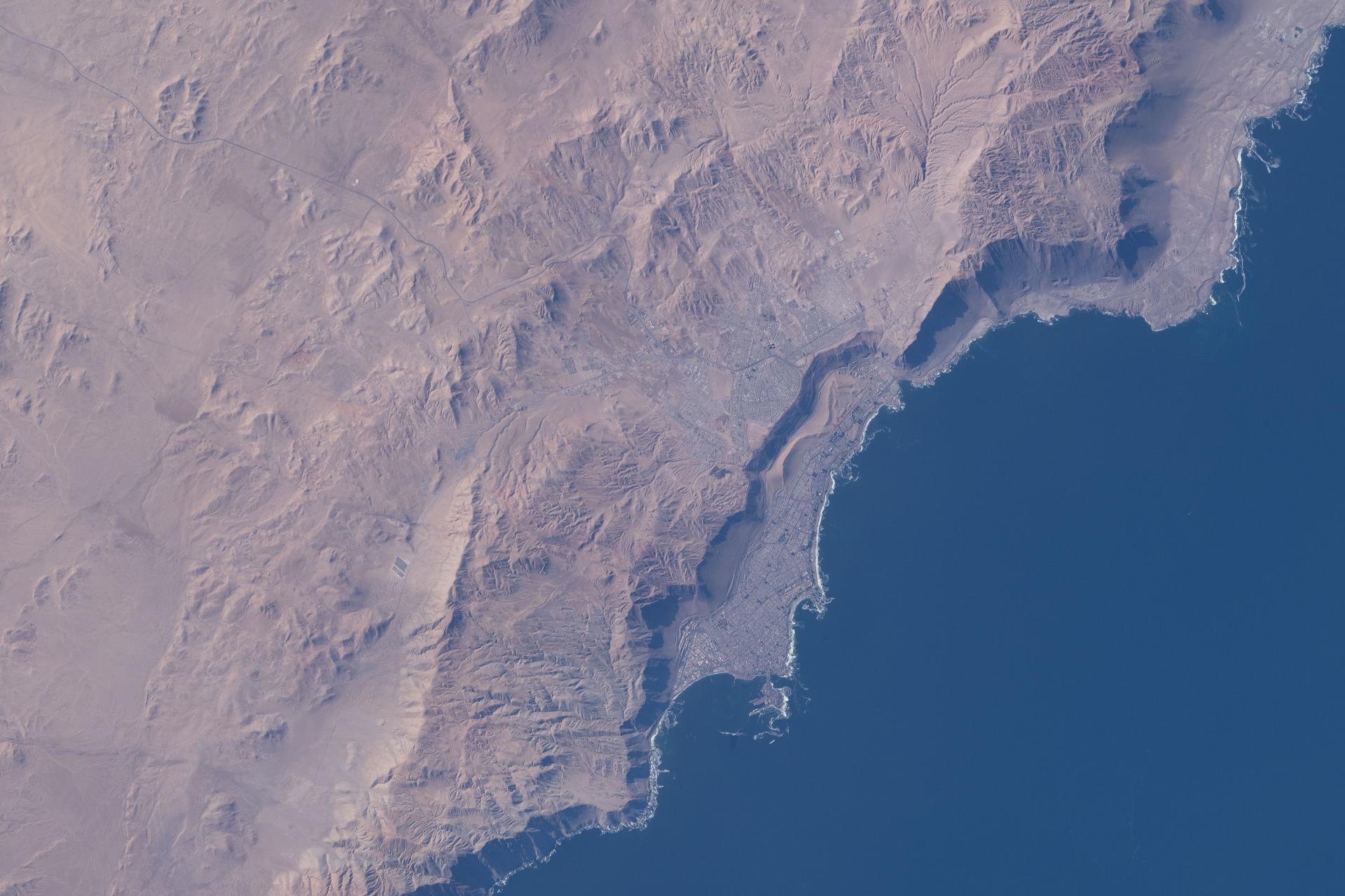
iss074e0362030 (March 5, 2026) --- Iquique, Chile, with a population of over 230,000, lies at the base of a steep coastal slope just west of the Atacama Desert—one of the world’s driest regions—on the South American nation’s Pacific coast. The International Space Station was orbiting 264 miles above at the time of this photograph. Credit: NASA/Jessica Meir
iss073e0511487 (Aug. 20, 2025) --- A portion of the hot, arid Namib Desert near the Atlantic coast, with its sand dunes created by strong onshore winds close to the NamibRand Nature Reserve, is pictured from the International Space Station as it orbited 262 miles above Namibia.
iss074e0315662 (Feb. 13, 2026) --- A portion of the Atacama Desert along Peru’s southern Pacific coast, featuring barren plains, rocky cliffs, vast sand dunes, and fertile river valleys, is pictured from the International Space Station as it orbited 265 miles above the South American nation. Credit: NASA/Chris Williams
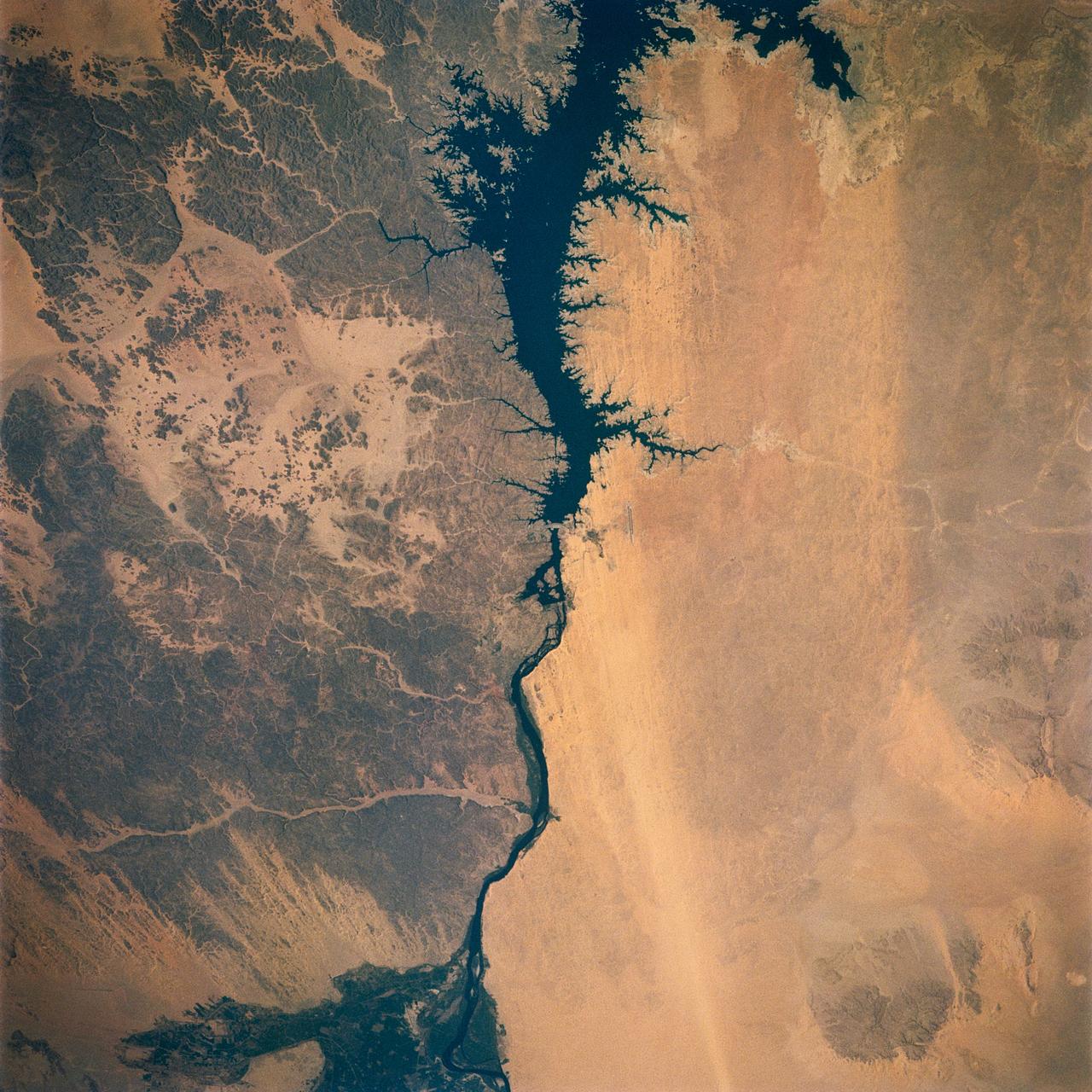
Egypt's High Aswan Dam on the Nile River at the first cataracts, Nile River, (24.0N, 33.0E) was completed in 1971 to provide cheap hydroelectric power and to regulate the historically uneven flow of the Nile River. The contrast between the largely base rock desert east of the Nile versus the sand covered desert west of the river and the ancient irrigated floodplain downstream from the damsite is clearly shown.
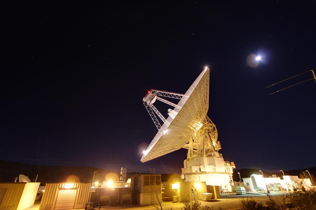
Late night in the desert: Goldstone 230-foot 70-meter antenna tracks spacecraft day and night. This photograph was taken on Jan. 11, 2012. The Goldstone Deep Space Communications Complex is located in the Mojave Desert in California, USA.
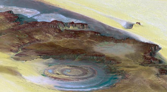
This prominent circular feature, known as the Richat Structure, in the Sahara desert of Mauritania is often noted by astronauts because it forms a conspicuous bull-eye on the otherwise rather featureless expanse of the desert.
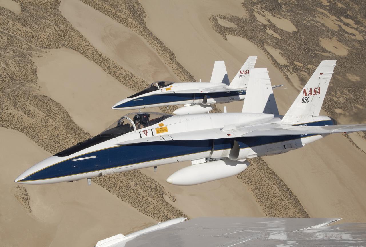
Two NASA Dryden F/A-18s flown by research pilots Frank Batteas and Nils Larson were captured by photographer Lori Losey from a third F/A-18 flown by Dick Ewers as they flew in tight formation over the desert at Edwards Air Force Base.
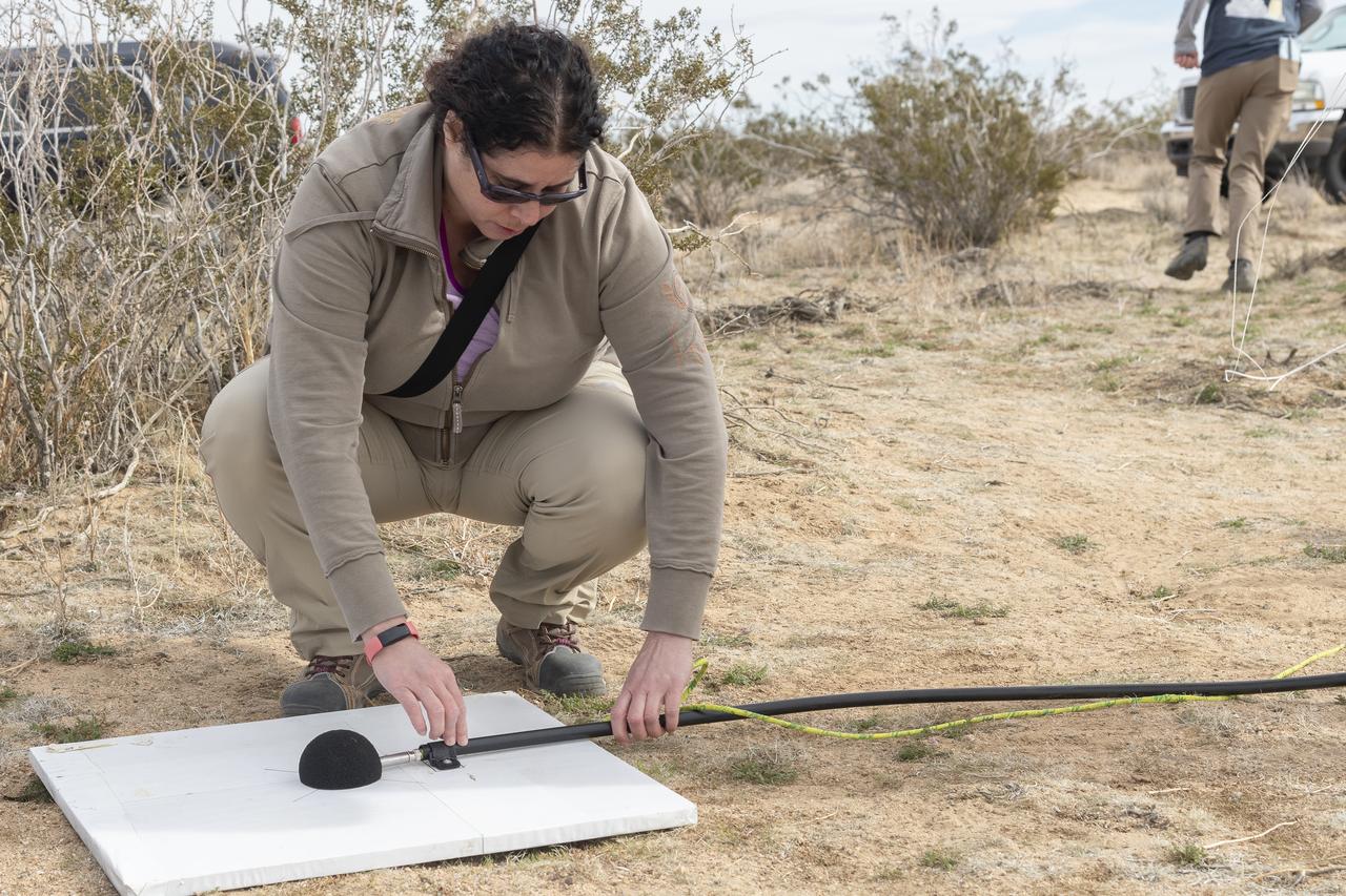
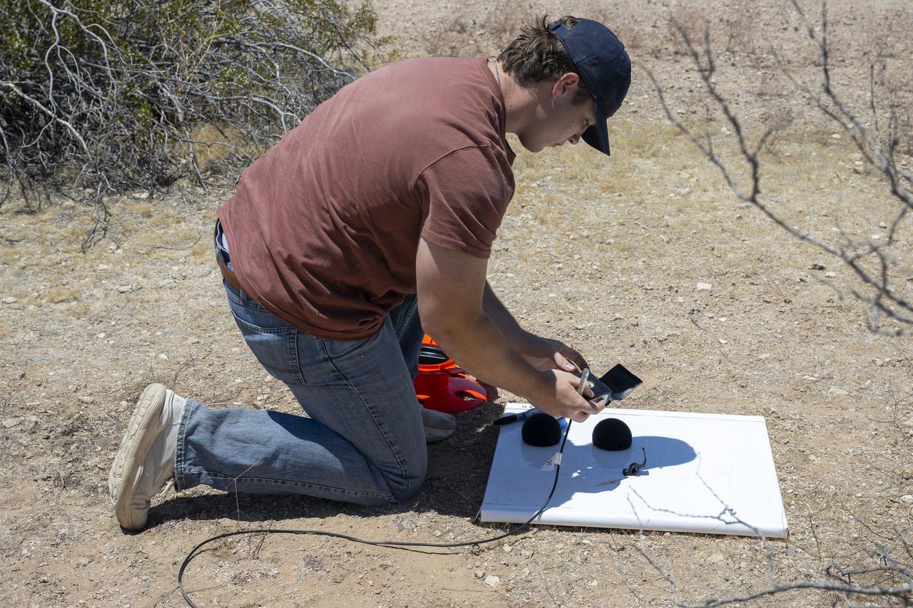
Dr. Alexandra Loubeau, one of the technical co-leads for sonic boom community testing for the Quesst mission, sets out a microphone in the California desert. . The Quesst mission recently completed testing of operations and equipment to be used in recording the sonic thumps of the X-59. The testing was the third phase of Carpet Determination in Entirety Measurements flights, called CarpetDIEM for short. An F-15 and an F-18 from NASA’s Armstrong Flight Research Center created sonic booms, both loud and soft, to verify the operations of ground recording systems spread out across 30 miles of open desert.
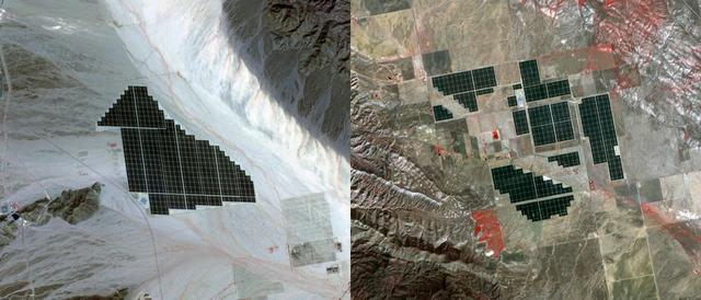
On February 15, 2015 the Desert Sunlight solar project in California’s Mojave Desert became operational. This image from NASA Terra spacecraft shows the 550-megawatt plant generates enough electricity to power 160,000 average homes. Covering an area of 16 km2, the 8.8 million cadmium telluride photovoltaic modules take advantage of the more than 300 days of sunshine. Desert Sunlight joins the similar-sized Topaz Solar Farm in San Luis Obispo County, CA, that became operational in June, 2014. The Desert Sunlight image (left) was acquired March 12, 2015 and is located at 33.8 degrees north, 115.4 degrees west; the Topaz image (right) was acquired September 11, 2014 and is located at 35.4 degrees north, 120.1 degrees west. Each image covers an area of 10.5 x 12 km. http://photojournal.jpl.nasa.gov/catalog/PIA19268
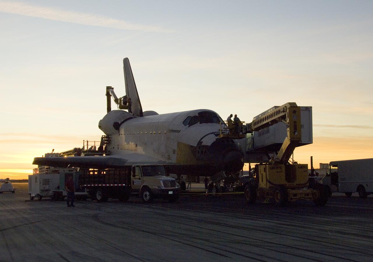
As the sun sets over the high desert, NASA technicians on mobile high-lifts prepare the shuttle Endeavour for towing off the Edwards Air Force Base runway.
STS062-151-182Z (4-18 March 1994) --- This east-looking view shows most of the east-west extent of the country of Sudan. The foreground shows a vegetation-less and almost uninhabited region of northwest Sudan. The rich earth colors are ancient soils (browner and redder tones), a concentrated mass of what may be volcanic cinder cones (dark brown dots - center) and dune and younger river sediments (yellows). The photo would have been difficult to locate had it not been for two recognizable features in the background: a visually well-known inselberg ("island mountain" -- top center) on a large west-bank tributary of the White Nile; and the confluence of the Blue and White Nile's, with the great cotton developments of the Gezira Scheme between them (top left). The Red Sea coast is almost obscured by a dust cloud but can be discerned running across the top of the picture. The clouds at top may be developing over the coastal ranges of Saudi Arabia beyond the Red Sea.

This image of abstract shapes is comprised numerous subparallel, very long, orange colored linear dunes and patchy grey dry lakes (playas). The dunes are aligned north to south in the great central basin of Astralia (27.0S, 138.0E). The regularity of the dunes is created by the winds blowing from the south. As the dunes advance, jaged edges on the south side of each dry lake are formed while the north side is eroded smooth by the wind and water.
STS059-306-034 (9-20 April 1994) --- The radiating transportation pattern of this 20th-Century urban plan is nicely displayed in this high-resolution photograph. Light-toned spots in the desert mark oil well sites; along the south edge of the scene, some dark residue remains from the fires set during the recent Gulf War. Blown sand has nearly hidden the soot and thick oil that were deposited on the surface. Nikon photograph, 300mm lens.
SL2-03-200 (22 June 1973) --- The city of Phoenix, AZ (33.5N, 112.0W) can be seen in good detail in this color infrared scene. Situated among truck crop agriculture fields, the color infrared photo depicts the vegetated fields as shades of red making the agriculture stand out in this desert environment. To the east, Lake Theodore Roosevelt and dam can be easily seen. Photo credit: NASA
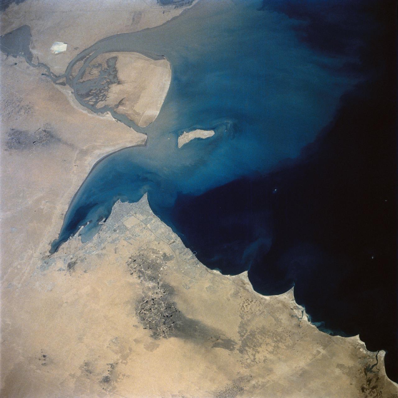
This view of the northern Persian Gulf shows Kuwait City and the Tigris and Euphrates River Deltas (29.5N, 48.5E). The oil laden sands and oil lakes of the Kuwait Oil Fields to the north and south of the city are clearly visible as dark patches surrounded by oil free desert sands. Comparison with earlier photos indicate that the oil laden sands are slowly being covered with clean sand carried by strong NW winds called Shmals.
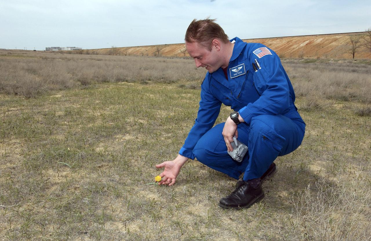
Flight Engineer and NASA Science Officer Mike Fincke looks at a desert tulip just outside the gates to the Soyuz launch pad, Wednesday, April 14, 2004 in Baikonur, Kazakhstan. Photo Credit: (NASA/Bill Ingalls)
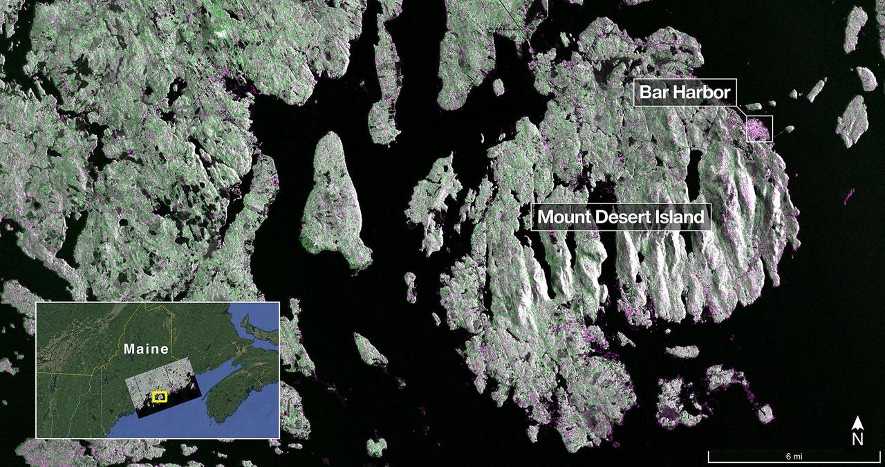
The NISAR (NASA-ISRO Synthetic Aperture Radar) Earth-observing radar satellite's L-band synthetic aperture radar (SAR) system captured this image of Mount Desert Island off the Maine coast on Aug. 21, 2025. Dark areas represent water, green areas are forest, and magenta areas are hard or regular surfaces, such as bare ground or buildings. The bright magenta area on the island's northeast end is the town of Bar Harbor. The satellite is a joint effort between NASA and the Indian Space Research Organisation (ISRO) and is the first satellite to combine L-band and S-band radar systems. The L-band system uses a 10-inch (25-centimeter) wavelength that enables its signal to penetrate forest canopies and measure soil moisture as well as motion of ice surfaces and land down to fractions of an inch – a key measurement in understanding how the land surface moves before, during, and after earthquakes, volcanic eruptions, and landslides. The S-band radar, provided by ISRO's Space Applications Centre, uses a 4-inch (10-centimeter) microwave signal that's more sensitive to small vegetation, which makes it effective at monitoring certain types of agriculture and grassland ecosystems. Data used to create the image was collected during NISAR's commissioning phase, when the spacecraft's systems and instruments are powered on and tested. The NISAR mission will begin science operations in November, roughly 90 days after its July 30, 2025, launch from Satish Dhawan Space Centre on India's southeastern coast. Observations from NISAR will benefit humanity by helping researchers around the world better understand changes in our planet's surface, including its ice sheets, glaciers, and sea ice. It also will capture changes in forest and wetland ecosystems and track movement and deformation of our planet's crust by phenomena such as earthquakes, landslides, and volcanic activity. The global and rapid coverage from NISAR will provide unprecedented support for disaster response, producing data to assist in mitigating and assessing damage, with observations before and after catastrophic events available in short time frames. https://photojournal.jpl.nasa.gov/catalog/PIA26616
Aerospace engineer Larry Cliatt, Quesst Phase 2 Sub-Project Manager abd technical lead for the acoustic validation phase of the Quesst mission, sets up a ground recording system in the California desert. The Quesst mission recently completed testing of operations and equipment to be used in recording the sonic thumps of the X-59. The testing was the third phase of Carpet Determination in Entirety Measurements flights, called CarpetDIEM for short. An F-15 and an F-18 from NASA’s Armstrong Flight Research Center created sonic booms, both loud and soft, to verify the operations of ground recording systems spread out across 30 miles of open desert.
Aerospace engineer Larry Cliatt, Quesst Phase 2 Sub-Project Manager and technical lead for the acoustic validation phase of the Quesst mission, sets up a ground recording system in the California desert. The Quesst mission recently completed testing of operations and equipment to be used in recording the sonic thumps of the X-59. The testing was the third phase of Carpet Determination in Entirety Measurements flights, called CarpetDIEM for short. An F-15 and an F-18 from NASA’s Armstrong Flight Research Center created sonic booms, both loud and soft, to verify the operations of ground recording systems spread out across 30 miles of open desert.
A NASA intern sets up ground recording system (GRS) units in California’s Mojave Desert during a Phase 2 rehearsal of the agency’s Quesst mission. The GRS units were placed across miles of desert terrain to capture the acoustic signature of supersonic aircraft during rehearsal flights and in preparation for the start of the actual tests.
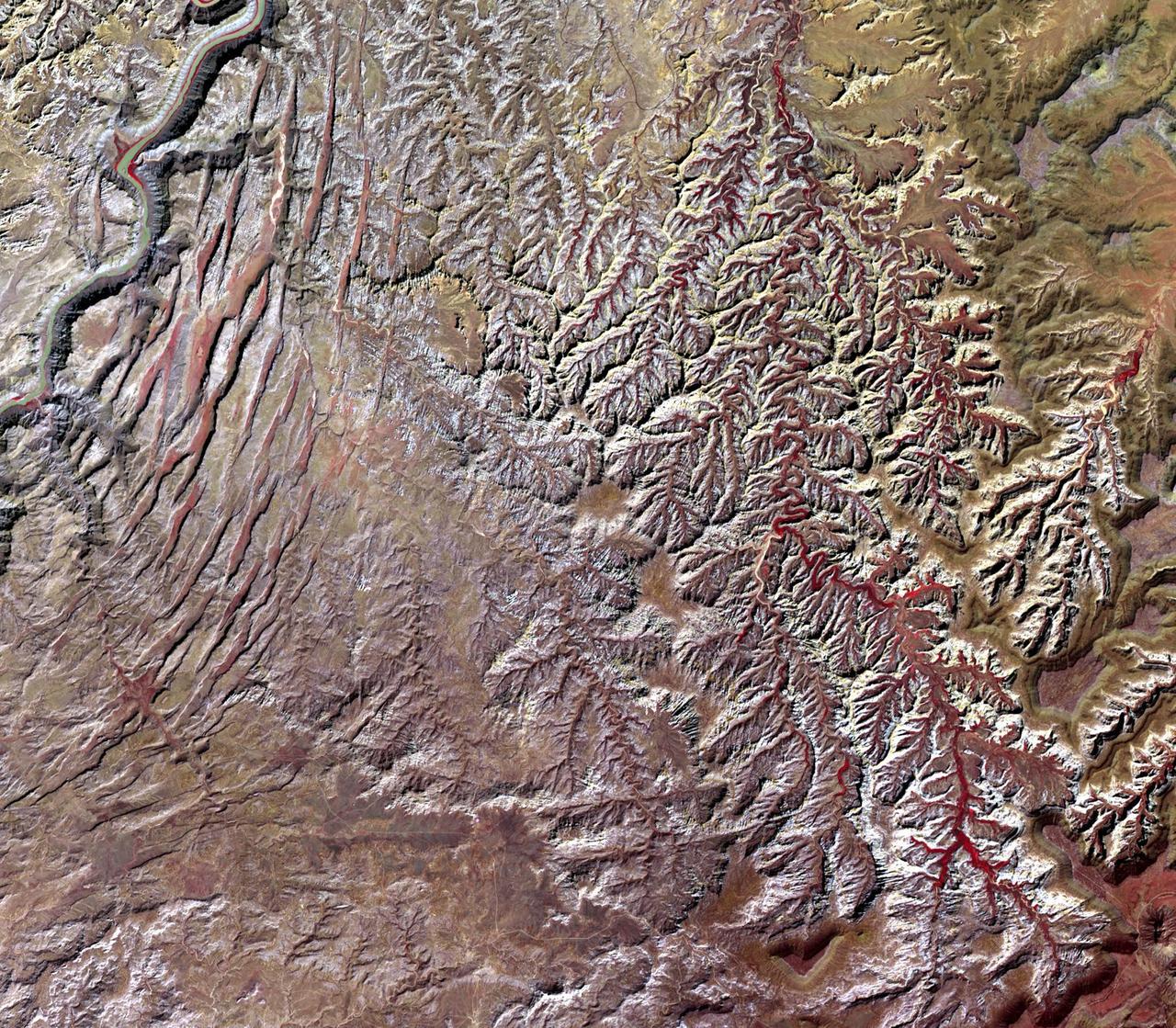
This image, acquired by NASA Terra spacecraft, is of Canyonlands National Park, Utah, a showcase of geology in the southwest desert of the United States.
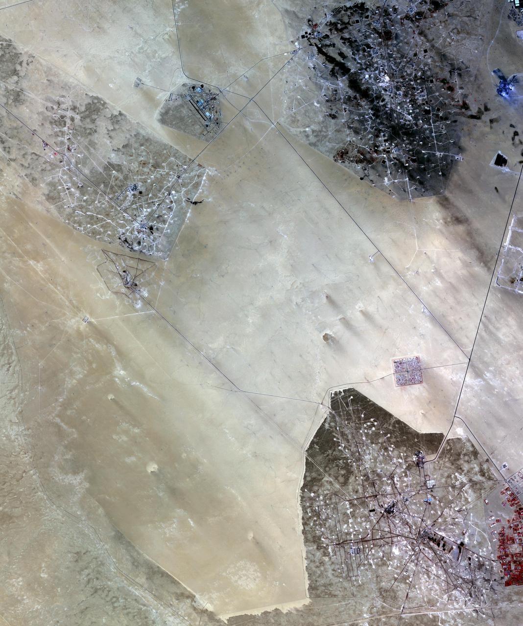
In the desert of southern Kuwait, three oil fields spread out across the empty landscape as seen by NASA Terra spacecraft.
These are the components of the Desert Christian experiment launched to space Dec. 3 that could one day lead to fast-charging batteries.
Oregon Air National Guard and NASA flight crew look out across the desert while awaiting the arrival of the NASA’s newest F-15 aircraft from the Oregon Air National Guard’s 173rd Fighter Wing to NASA’s Armstrong Flight Research Center in Edwards, California, on Monday, Dec. 22, 2025.
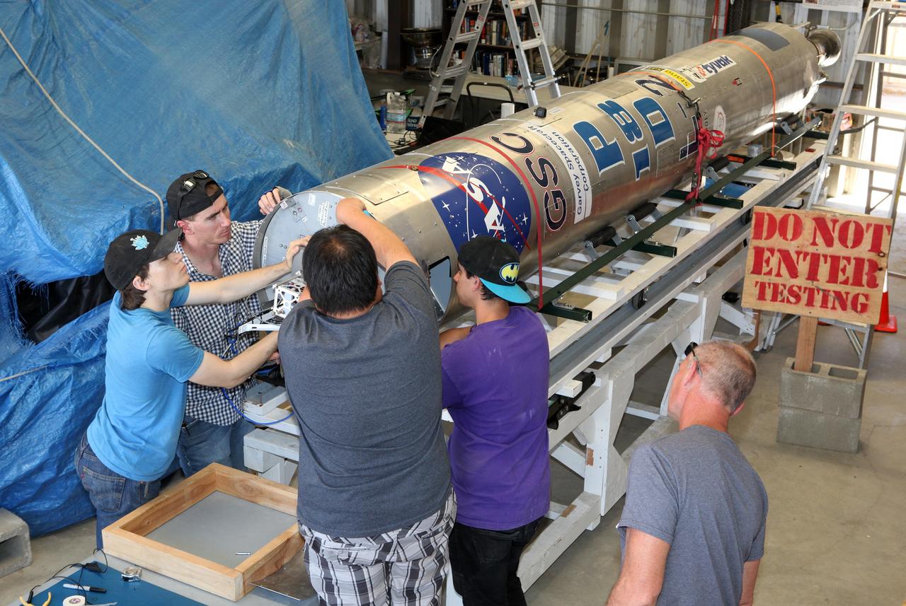
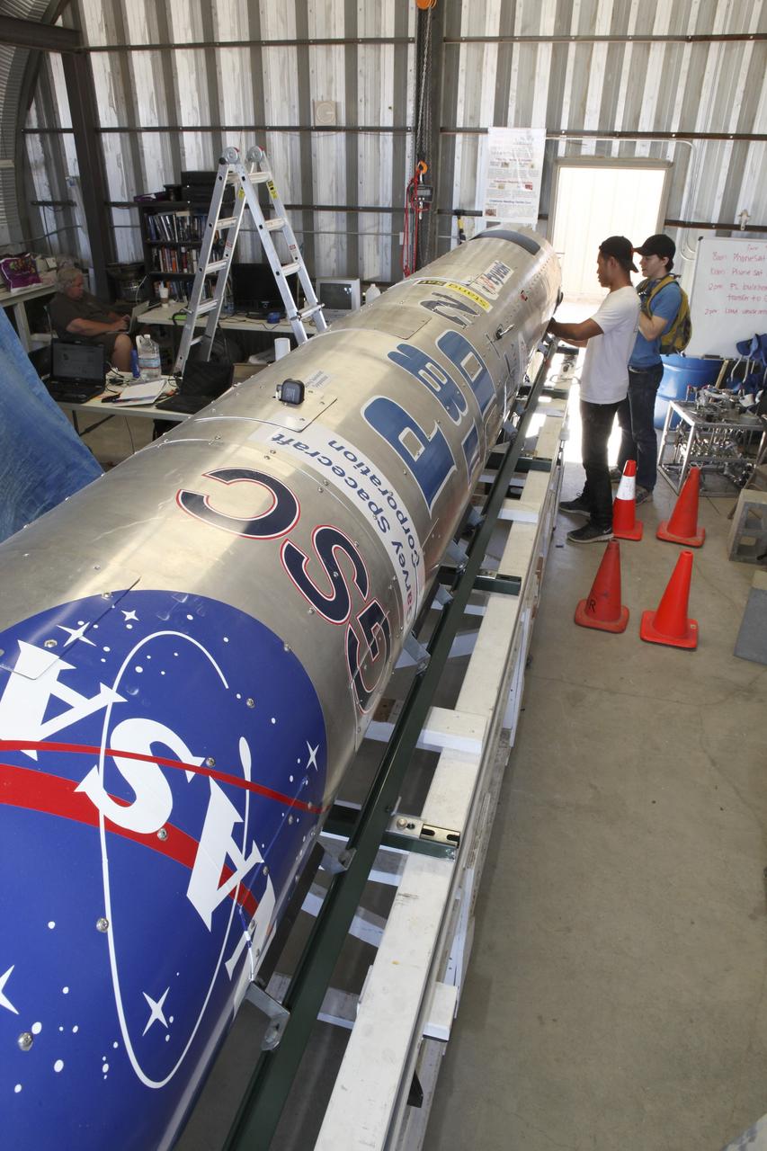
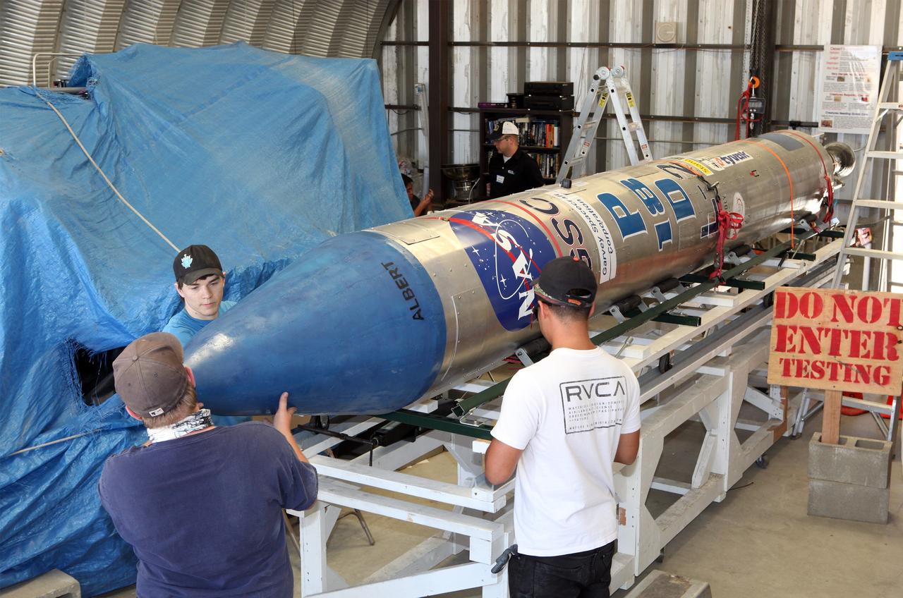
MOJAVE DESERT, Calif. – In the Mojave Desert in California, students and engineers checkout the Garvey Spacecraft Corporation's Prospector P-18D rocket. The rocket is scheduled for launch June 15 with the RUBICS-1 payload on a high-altitude, suborbital flight. The rocket will carry four satellites made from four-inch cube sections. Collectively known as CubeSats, the satellites will record shock, vibrations and heat inside the rocket. They will not be released during the test flight, but the results will be used to prove or strengthen their designs before they are carried into orbit in 2014 on a much larger rocket. A new, lightweight carrier is also being tested for use on future missions to deploy the small spacecraft. The flight also is being watched closely as a model for trying out new or off-the-shelf technologies quickly before putting them in the pipeline for use on NASA's largest launchers. Built by several different organizations, including a university, a NASA field center and a high school, the spacecraft are four-inch cubes designed to fly on their own eventually, but will remain firmly attached to the rocket during the upcoming mission. For more information, visit http://www.nasa.gov/mission_pages/smallsats/elana/cubesatlaunchpreview.html Photo credit: NASA/Dimitri Gerondidakis
MOJAVE DESERT, Calif. – In the Mojave Desert in California, the Garvey Spacecraft Corporation's Prospector P-18D rocket is lifted into position for its scheduled launch on June 15 with the RUBICS-1 payload on a high-altitude, suborbital flight. The rocket will carry four satellites made from four-inch cube sections. Collectively known as CubeSats, the satellites will record shock, vibrations and heat inside the rocket. They will not be released during the test flight, but the results will be used to prove or strengthen their designs before they are carried into orbit in 2014 on a much larger rocket. A new, lightweight carrier is also being tested for use on future missions to deploy the small spacecraft. The flight also is being watched closely as a model for trying out new or off-the-shelf technologies quickly before putting them in the pipeline for use on NASA's largest launchers. Built by several different organizations, including a university, a NASA field center and a high school, the spacecraft are four-inch cubes designed to fly on their own eventually, but will remain firmly attached to the rocket during the upcoming mission. For more information, visit http://www.nasa.gov/mission_pages/smallsats/elana/cubesatlaunchpreview.html Photo credit: NASA/Dimitri Gerondidakis
MOJAVE DESERT, Calif. – In the Mojave Desert in California, final checkouts are completed on the Garvey Spacecraft Corporation's Prospector P-18D rocket positioned for launch with the RUBICS-1 payload on a high-altitude, suborbital flight. The rocket will carry four satellites made from four-inch cube sections. The rocket reached a peak altitude of about 9,000 feet, however the parachute deployed prematurely and the vehicle continued on its trajectory, coasting and tumbling to a hard landing on its side. In spite of the rough ride, all four CubeSats were recovered. PhoneSat and RUBICS received data in flight, but sustained structural damage. CP-9 and StangSat fared better, and their teams are working to recover as much information as possible. Collectively known as CubeSats, the satellites were designed to record shock, vibrations and heat inside the rocket. The results will be used to prove or strengthen their designs before they are carried into orbit in 2014 on a much larger rocket. Built by several different organizations, including a university, a NASA field center and a high school, the spacecraft are four-inch cubes designed to fly on their own eventually, but will remain firmly attached to the rocket during the upcoming mission. For more information, visit http://www.nasa.gov/mission_pages/smallsats/elana/cubesatlaunchpreview.html Photo credit: NASA/Dimitri Gerondidakis
MOJAVE DESERT, Calif. – In the Mojave Desert in California, a student checks out the Garvey Spacecraft Corporation's Prospector P-18D rocket scheduled for launch June 15 with the RUBICS-1 payload on a high-altitude, suborbital flight. The rocket will carry four satellites made from four-inch cube section. Collectively known as CubeSats, the satellites will record shock, vibrations and heat inside the rocket. They will not be released during the test flight, but the results will be used to prove or strengthen their designs before they are carried into orbit in 2014 on a much larger rocket. A new, lightweight carrier is also being tested for use on future missions to deploy the small spacecraft. The flight also is being watched closely as a model for trying out new or off-the-shelf technologies quickly before putting them in the pipeline for use on NASA's largest launchers. Built by several different organizations, including a university, a NASA field center and a high school, the spacecraft are four-inch cubes designed to fly on their own eventually, but will remain firmly attached to the rocket during the upcoming mission. For more information, visit http://www.nasa.gov/mission_pages/smallsats/elana/cubesatlaunchpreview.html Photo credit: NASA/Dimitri Gerondidakis
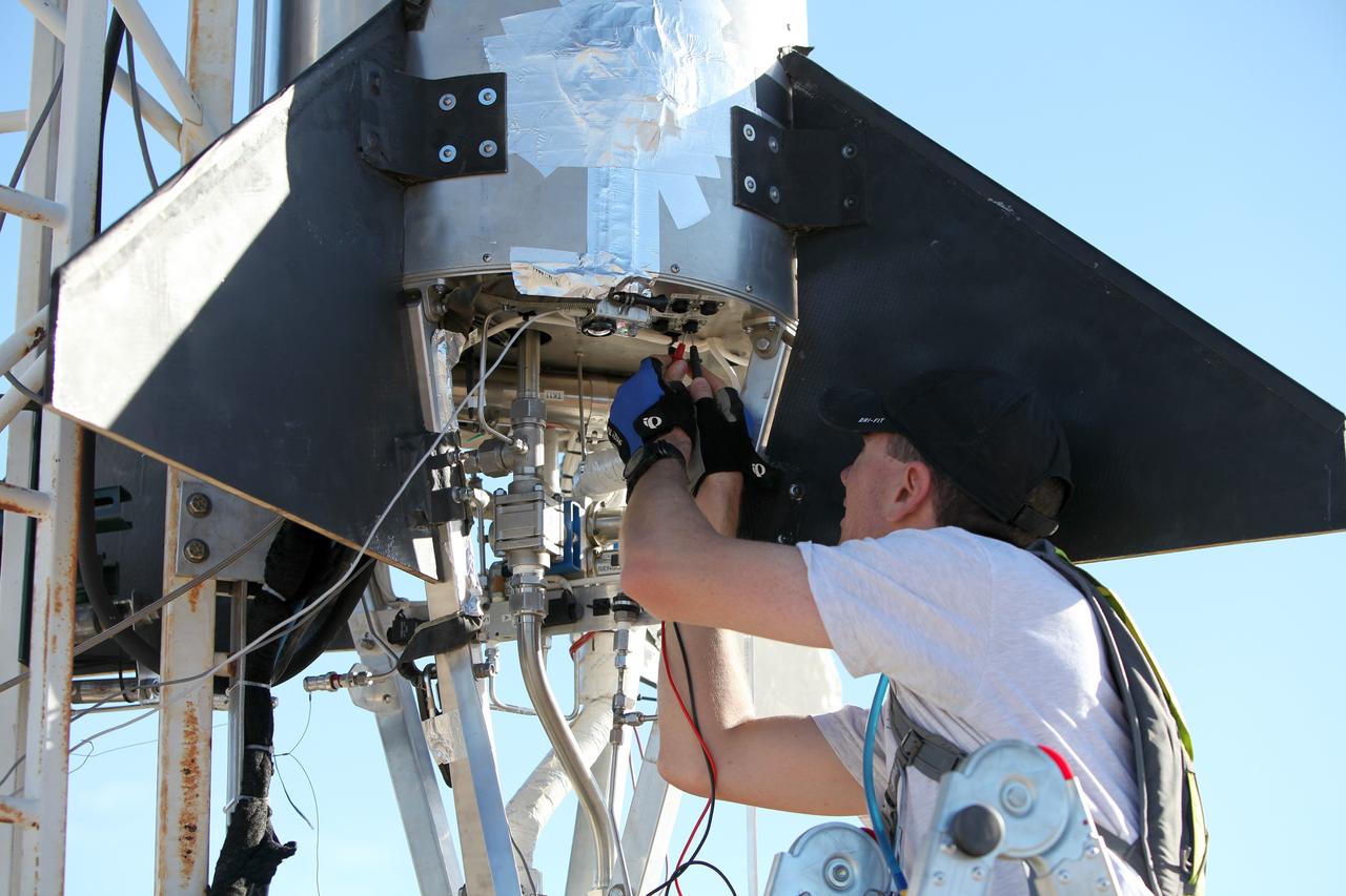
MOJAVE DESERT, Calif. – In the Mojave Desert in California, Kevin Baxter, a range representative of the Friends of Amateur Rocketry launch site, ensures all is ready for launch of the Garvey Spacecraft Corporation's Prospector P-18D rocket with the RUBICS-1 payload on a high-altitude, suborbital flight. The rocket will carry four satellites made from four-inch cube sections. The rocket reached a peak altitude of about 9,000 feet, however the parachute deployed prematurely and the vehicle continued on its trajectory, coasting and tumbling to a hard landing on its side. In spite of the rough ride, all four CubeSats were recovered. PhoneSat and RUBICS received data in flight, but sustained structural damage. CP-9 and StangSat fared better, and their teams are working to recover as much information as possible. Collectively known as CubeSats, the satellites were designed to record shock, vibrations and heat inside the rocket. The results will be used to prove or strengthen their designs before they are carried into orbit in 2014 on a much larger rocket. Built by several different organizations, including a university, a NASA field center and a high school, the spacecraft are four-inch cubes designed to fly on their own eventually, but will remain firmly attached to the rocket during the upcoming mission. For more information, visit http://www.nasa.gov/mission_pages/smallsats/elana/cubesatlaunchpreview.html Photo credit: NASA/Dimitri Gerondidakis
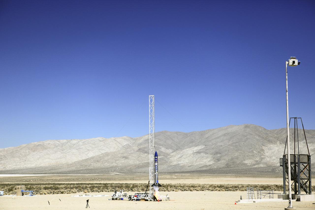
MOJAVE DESERT, Calif. – In the Mojave Desert in California, the Garvey Spacecraft Corporation's Prospector P-18D rocket lifts off at 10:52 a.m. PDT carrying the RUBICS-1 payload on a high-altitude, suborbital flight. The rocket carried four satellites made from four-inch cube sections. The rocket reached a peak altitude of about 9,000 feet, however the parachute deployed prematurely and the vehicle continued on its trajectory, coasting and tumbling to a hard landing on its side. In spite of the rough ride, all four CubeSats were recovered. PhoneSat and RUBICS received data in flight, but sustained structural damage. CP-9 and StangSat fared better, and their teams are working to recover as much information as possible. Collectively known as CubeSats, the satellites were designed to record shock, vibrations and heat inside the rocket. The results will be used to prove or strengthen their designs before they are carried into orbit in 2014 on a much larger rocket. Built by several different organizations, including a university, a NASA field center and a high school, the spacecraft are four-inch cubes designed to fly on their own eventually, but will remain firmly attached to the rocket during the upcoming mission. For more information, visit http://www.nasa.gov/mission_pages/smallsats/elana/cubesatlaunchpreview.html Photo credit: NASA/Dimitri Gerondidakis
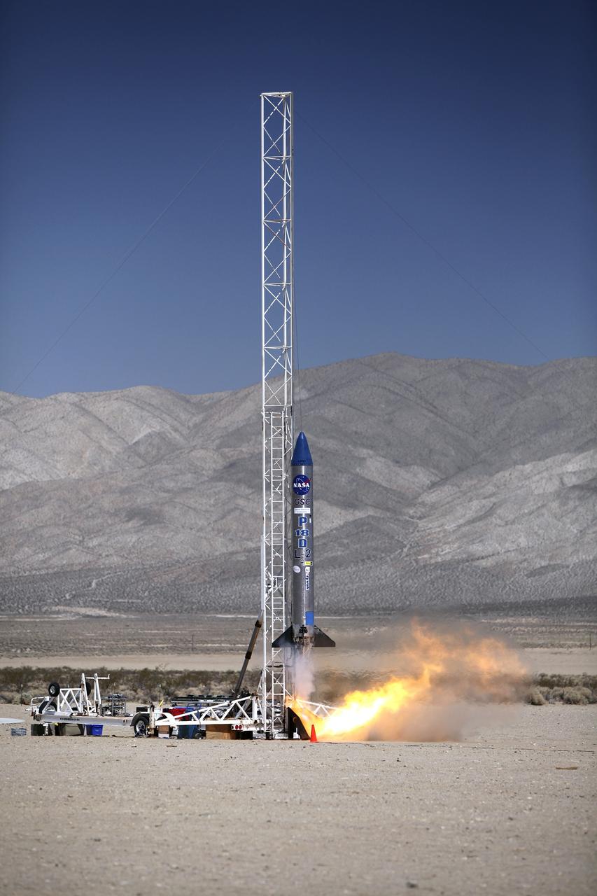
MOJAVE DESERT, Calif. – In the Mojave Desert in California, the Garvey Spacecraft Corporation's Prospector P-18D rocket lifts off at 10:52 a.m. PDT carrying the RUBICS-1 payload on a high-altitude, suborbital flight. The rocket carried four satellites made from four-inch cube sections. The rocket reached a peak altitude of about 9,000 feet, however the parachute deployed prematurely and the vehicle continued on its trajectory, coasting and tumbling to a hard landing on its side. In spite of the rough ride, all four CubeSats were recovered. PhoneSat and RUBICS received data in flight, but sustained structural damage. CP-9 and StangSat fared better, and their teams are working to recover as much information as possible. Collectively known as CubeSats, the satellites were designed to record shock, vibrations and heat inside the rocket. The results will be used to prove or strengthen their designs before they are carried into orbit in 2014 on a much larger rocket. Built by several different organizations, including a university, a NASA field center and a high school, the spacecraft are four-inch cubes designed to fly on their own eventually, but will remain firmly attached to the rocket during the upcoming mission. For more information, visit http://www.nasa.gov/mission_pages/smallsats/elana/cubesatlaunchpreview.html Photo credit: NASA/Dimitri Gerondidakis
MOJAVE DESERT, Calif. – In the Mojave Desert in California, students and engineers pack the parachute in the Garvey Spacecraft Corporation's Prospector P-18D rocket. The work is in preparation for the June 15 launch of a on a high-altitude, suborbital flight. The rocket will carry four satellites made from four-inch cube section. Collectively known as CubeSats, the satellites will record shock, vibrations and heat inside the rocket. They will not be released during the test flight, but the results will be used to prove or strengthen their designs before they are carried into orbit in 2014 on a much larger rocket. A new, lightweight carrier is also being tested for use on future missions to deploy the small spacecraft. The flight also is being watched closely as a model for trying out new or off-the-shelf technologies quickly before putting them in the pipeline for use on NASA's largest launchers. Built by several different organizations, including a university, a NASA field center and a high school, the spacecraft are four-inch cubes designed to fly on their own eventually, but will remain firmly attached to the rocket during the upcoming mission. For more information, visit http://www.nasa.gov/mission_pages/smallsats/elana/cubesatlaunchpreview.html Photo credit: NASA/Dimitri Gerondidakis
MOJAVE DESERT, Calif. – In the Mojave Desert in California, students install the nose cone on the Garvey Spacecraft Corporation's Prospector P-18D rocket. The work is in preparation for the June 15 launch on a high-altitude, suborbital flight. The rocket will carry four satellites made from four-inch cube sections. Collectively known as CubeSats, the satellites will record shock, vibrations and heat inside the rocket. They will not be released during the test flight, but the results will be used to prove or strengthen their designs before they are carried into orbit in 2014 on a much larger rocket. A new, lightweight carrier is also being tested for use on future missions to deploy the small spacecraft. The flight also is being watched closely as a model for trying out new or off-the-shelf technologies quickly before putting them in the pipeline for use on NASA's largest launchers. Built by several different organizations, including a university, a NASA field center and a high school, the spacecraft are four-inch cubes designed to fly on their own eventually, but will remain firmly attached to the rocket during the upcoming mission. For more information, visit http://www.nasa.gov/mission_pages/smallsats/elana/cubesatlaunchpreview.html Photo credit: NASA/Dimitri Gerondidakis
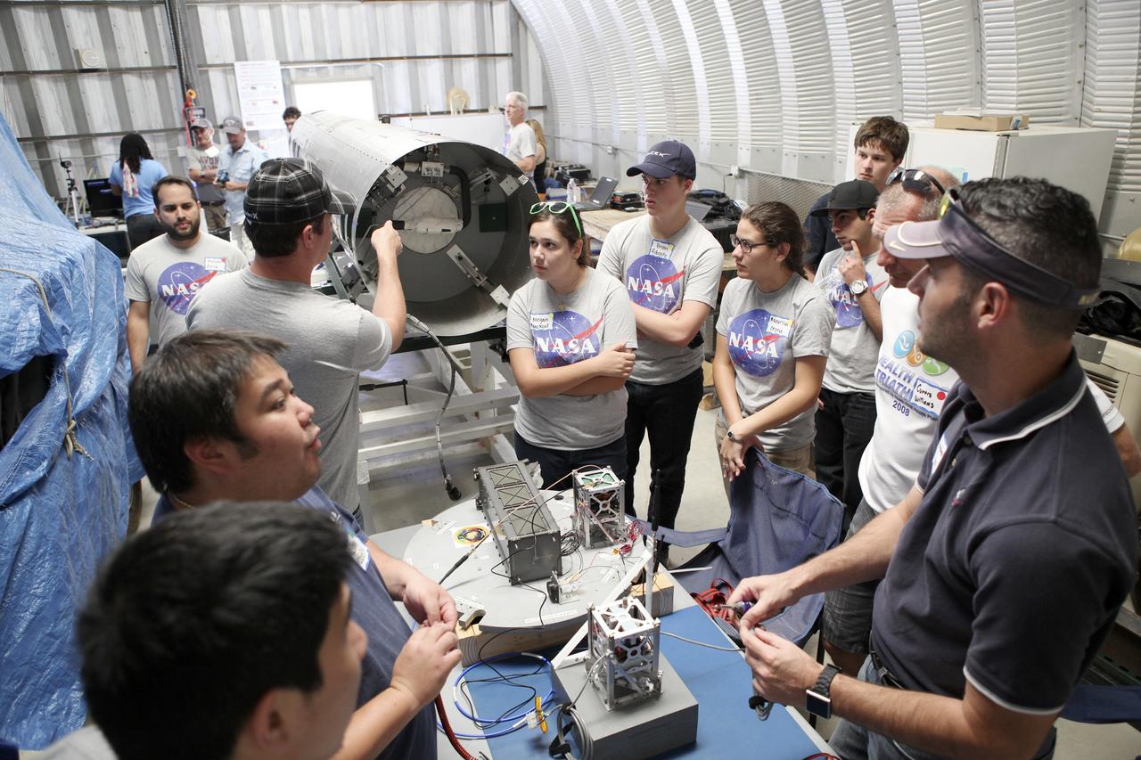
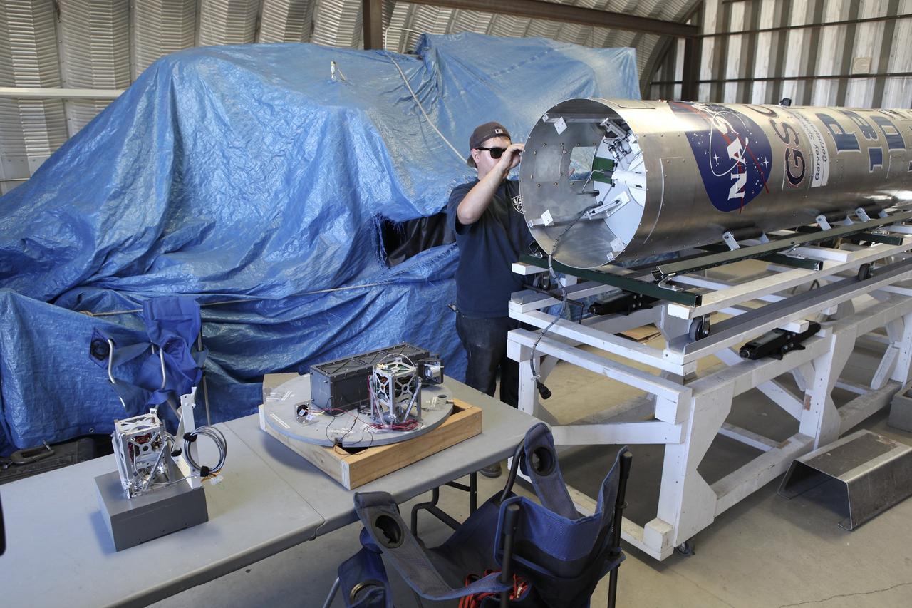
MOJAVE DESERT, Calif. – In the Mojave Desert in California, students and engineers checkout the RUBICS-1 payload into the body of the Garvey Spacecraft Corporation's Prospector P-18D rocket for launch June 15 on a high-altitude, suborbital flight. The flight will carry four satellites made from four-inch cube section. Collectively known as CubeSats, the satellites will record shock, vibrations and heat inside the rocket. They will not be released during the test flight, but the results will be used to prove or strengthen their designs before they are carried into orbit in 2014 on a much larger rocket. A new, lightweight carrier is also being tested for use on future missions to deploy the small spacecraft. The flight also is being watched closely as a model for trying out new or off-the-shelf technologies quickly before putting them in the pipeline for use on NASA's largest launchers. Built by several different organizations, including a university, a NASA field center and a high school, the spacecraft are four-inch cubes designed to fly on their own eventually, but will remain firmly attached to the rocket during the upcoming mission. For more information, visit http://www.nasa.gov/mission_pages/smallsats/elana/cubesatlaunchpreview.html Photo credit: NASA/Dimitri Gerondidakis
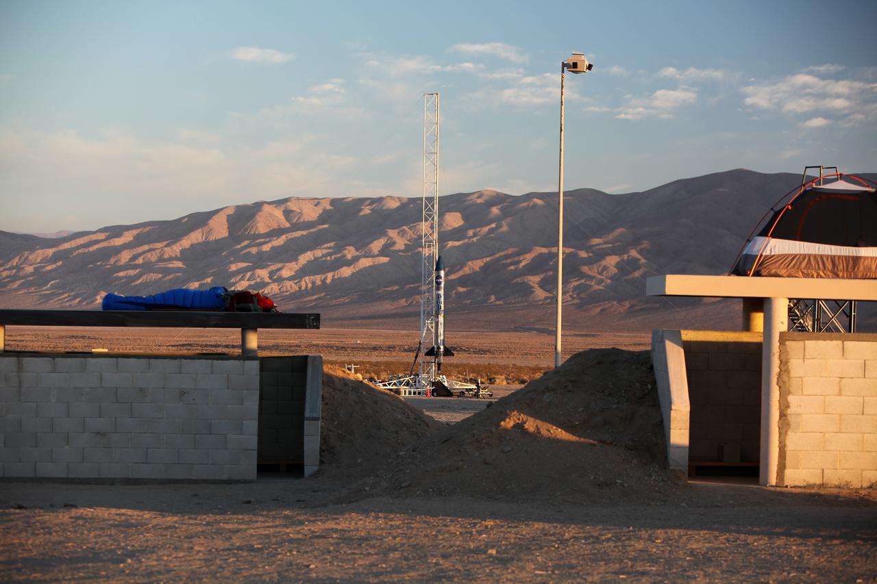
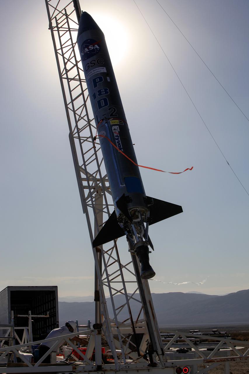
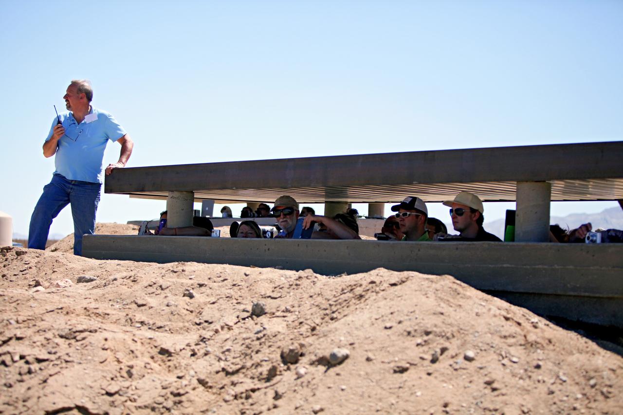
MOJAVE DESERT, Calif. – Viewed from a nearby bunker in the Mojave Desert in California, the Garvey Spacecraft Corporation's Prospector P-18D rocket is positioned for launch with the RUBICS-1 payload on a high-altitude, suborbital flight. The rocket will carry four satellites made from four-inch cube sections. Collectively known as CubeSats, the satellites will record shock, vibrations and heat inside the rocket. They will not be released during the test flight, but the results will be used to prove or strengthen their designs before they are carried into orbit in 2014 on a much larger rocket. A new, lightweight carrier is also being tested for use on future missions to deploy the small spacecraft. The flight also is being watched closely as a model for trying out new or off-the-shelf technologies quickly before putting them in the pipeline for use on NASA's largest launchers. Built by several different organizations, including a university, a NASA field center and a high school, the spacecraft are four-inch cubes designed to fly on their own eventually, but will remain firmly attached to the rocket during the upcoming mission. For more information, visit http://www.nasa.gov/mission_pages/smallsats/elana/cubesatlaunchpreview.html Photo credit: NASA/Dimitri Gerondidakis
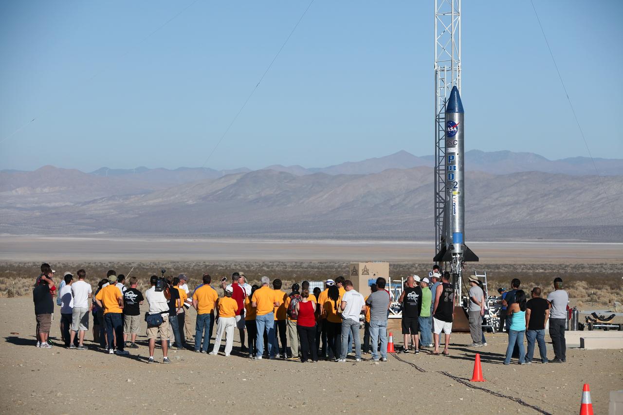
MOJAVE DESERT, Calif. – In the Mojave Desert in California, students and engineers participate in a pre-launch briefing before the lift off of the Garvey Spacecraft Corporation's Prospector P-18D rocket. The rocket is scheduled to launch the RUBICS-1 payload on a high-altitude, suborbital flight. The rocket will carry four satellites made from four-inch cube sections. The rocket reached a peak altitude of about 9,000 feet, however the parachute deployed prematurely and the vehicle continued on its trajectory, coasting and tumbling to a hard landing on its side. In spite of the rough ride, all four CubeSats were recovered. PhoneSat and RUBICS received data in flight, but sustained structural damage. CP-9 and StangSat fared better, and their teams are working to recover as much information as possible. Collectively known as CubeSats, the satellites were designed to record shock, vibrations and heat inside the rocket. The results will be used to prove or strengthen their designs before they are carried into orbit in 2014 on a much larger rocket. Built by several different organizations, including a university, a NASA field center and a high school, the spacecraft are four-inch cubes designed to fly on their own eventually, but will remain firmly attached to the rocket during the upcoming mission. For more information, visit http://www.nasa.gov/mission_pages/smallsats/elana/cubesatlaunchpreview.html Photo credit: NASA/Dimitri Gerondidakis
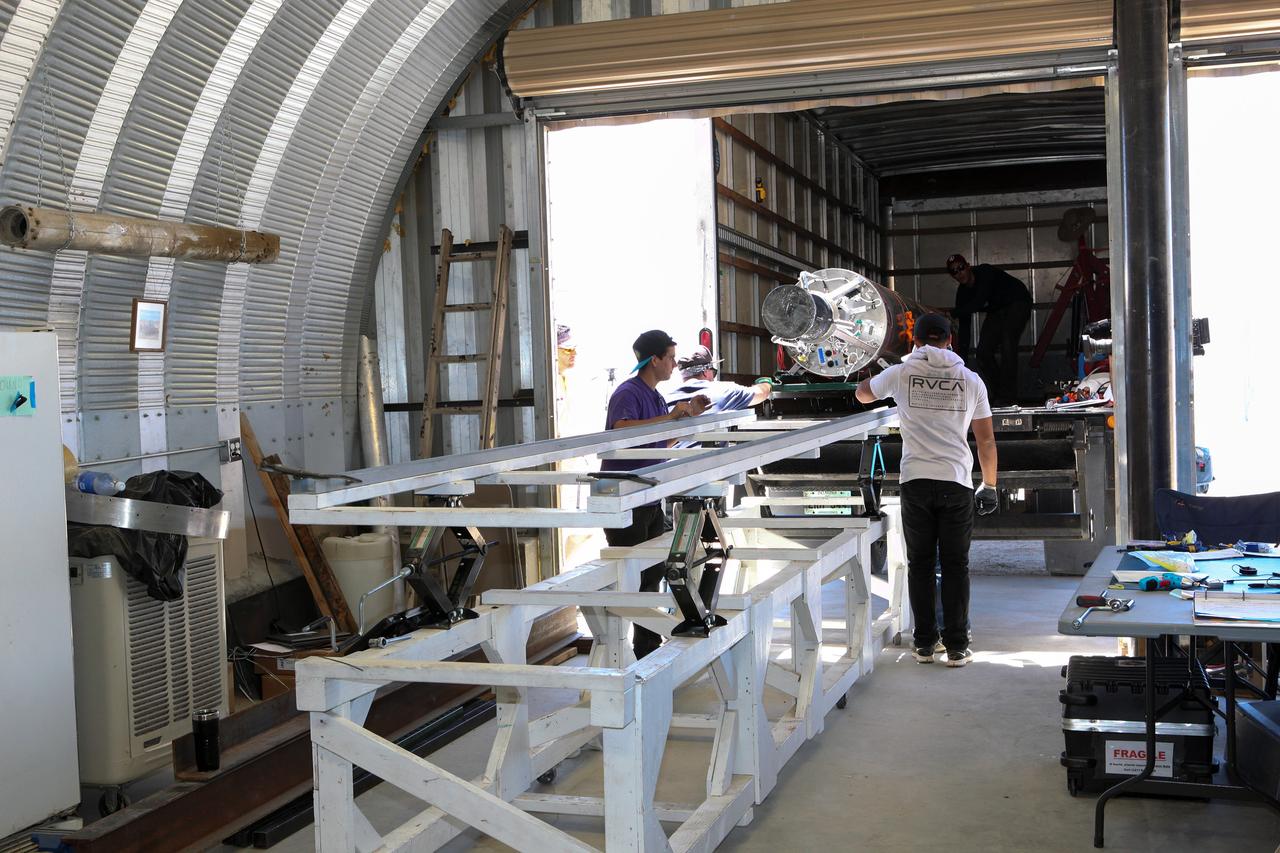
MOJAVE DESERT, Calif. – In the Mojave Desert in California, students and engineers load the Garvey Spacecraft Corporation's Prospector P-18D rocket onto a truck for transportation to the launch site. The rocket is scheduled for launch June 15 with the RUBICS-1 payload on a high-altitude, suborbital flight. The rocket will carry four satellites made from four-inch cube sections. Collectively known as CubeSats, the satellites will record shock, vibrations and heat inside the rocket. They will not be released during the test flight, but the results will be used to prove or strengthen their designs before they are carried into orbit in 2014 on a much larger rocket. A new, lightweight carrier is also being tested for use on future missions to deploy the small spacecraft. The flight also is being watched closely as a model for trying out new or off-the-shelf technologies quickly before putting them in the pipeline for use on NASA's largest launchers. Built by several different organizations, including a university, a NASA field center and a high school, the spacecraft are four-inch cubes designed to fly on their own eventually, but will remain firmly attached to the rocket during the upcoming mission. For more information, visit http://www.nasa.gov/mission_pages/smallsats/elana/cubesatlaunchpreview.html Photo credit: NASA/Dimitri Gerondidakis
MOJAVE DESERT, Calif. – As the sun rises in the Mojave Desert in California, the Garvey Spacecraft Corporation's Prospector P-18D rocket is positioned for launch with the RUBICS-1 payload on a high-altitude, suborbital flight. The rocket will carry four satellites made from four-inch cube sections. Collectively known as CubeSats, the satellites will record shock, vibrations and heat inside the rocket. They will not be released during the test flight, but the results will be used to prove or strengthen their designs before they are carried into orbit in 2014 on a much larger rocket. A new, lightweight carrier is also being tested for use on future missions to deploy the small spacecraft. The flight also is being watched closely as a model for trying out new or off-the-shelf technologies quickly before putting them in the pipeline for use on NASA's largest launchers. Built by several different organizations, including a university, a NASA field center and a high school, the spacecraft are four-inch cubes designed to fly on their own eventually, but will remain firmly attached to the rocket during the upcoming mission. For more information, visit http://www.nasa.gov/mission_pages/smallsats/elana/cubesatlaunchpreview.html Photo credit: NASA/Dimitri Gerondidakis
MOJAVE DESERT, Calif. – In the Mojave Desert in California, students install the nose cone on the Garvey Spacecraft Corporation's Prospector P-18D rocket. The work is in preparation for the June 15 launch on a high-altitude, suborbital flight. The rocket will carry four satellites made from four-inch cube sections. Collectively known as CubeSats, the satellites will record shock, vibrations and heat inside the rocket. They will not be released during the test flight, but the results will be used to prove or strengthen their designs before they are carried into orbit in 2014 on a much larger rocket. A new, lightweight carrier is also being tested for use on future missions to deploy the small spacecraft. The flight also is being watched closely as a model for trying out new or off-the-shelf technologies quickly before putting them in the pipeline for use on NASA's largest launchers. Built by several different organizations, including a university, a NASA field center and a high school, the spacecraft are four-inch cubes designed to fly on their own eventually, but will remain firmly attached to the rocket during the upcoming mission. For more information, visit http://www.nasa.gov/mission_pages/smallsats/elana/cubesatlaunchpreview.html Photo credit: NASA/Dimitri Gerondidakis
MOJAVE DESERT, Calif. – In the Mojave Desert in California, students and engineers pack the parachute in the Garvey Spacecraft Corporation's Prospector P-18D rocket. The work is in preparation for the June 15 launch of a on a high-altitude, suborbital flight. The rocket will carry four satellites made from four-inch cube section. Collectively known as CubeSats, the satellites will record shock, vibrations and heat inside the rocket. They will not be released during the test flight, but the results will be used to prove or strengthen their designs before they are carried into orbit in 2014 on a much larger rocket. A new, lightweight carrier is also being tested for use on future missions to deploy the small spacecraft. The flight also is being watched closely as a model for trying out new or off-the-shelf technologies quickly before putting them in the pipeline for use on NASA's largest launchers. Built by several different organizations, including a university, a NASA field center and a high school, the spacecraft are four-inch cubes designed to fly on their own eventually, but will remain firmly attached to the rocket during the upcoming mission. For more information, visit http://www.nasa.gov/mission_pages/smallsats/elana/cubesatlaunchpreview.html Photo credit: NASA/Dimitri Gerondidakis
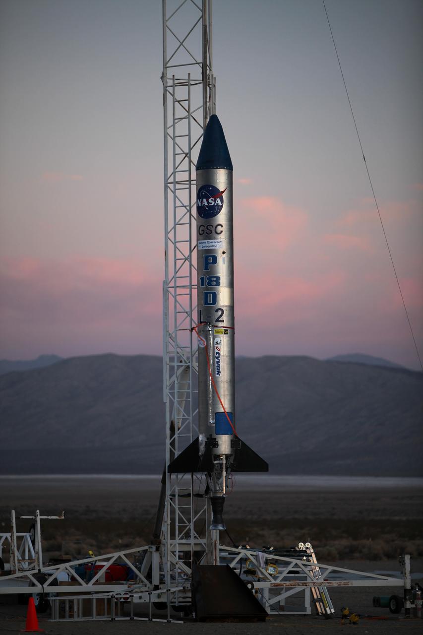
MOJAVE DESERT, Calif. – As the sun rises in the Mojave Desert in California, the Garvey Spacecraft Corporation's Prospector P-18D rocket is positioned for launch with the RUBICS-1 payload on a high-altitude, suborbital flight. The rocket will carry four satellites made from four-inch cube sections. Collectively known as CubeSats, the satellites will record shock, vibrations and heat inside the rocket. They will not be released during the test flight, but the results will be used to prove or strengthen their designs before they are carried into orbit in 2014 on a much larger rocket. A new, lightweight carrier is also being tested for use on future missions to deploy the small spacecraft. The flight also is being watched closely as a model for trying out new or off-the-shelf technologies quickly before putting them in the pipeline for use on NASA's largest launchers. Built by several different organizations, including a university, a NASA field center and a high school, the spacecraft are four-inch cubes designed to fly on their own eventually, but will remain firmly attached to the rocket during the upcoming mission. For more information, visit http://www.nasa.gov/mission_pages/smallsats/elana/cubesatlaunchpreview.html Photo credit: NASA/Dimitri Gerondidakis
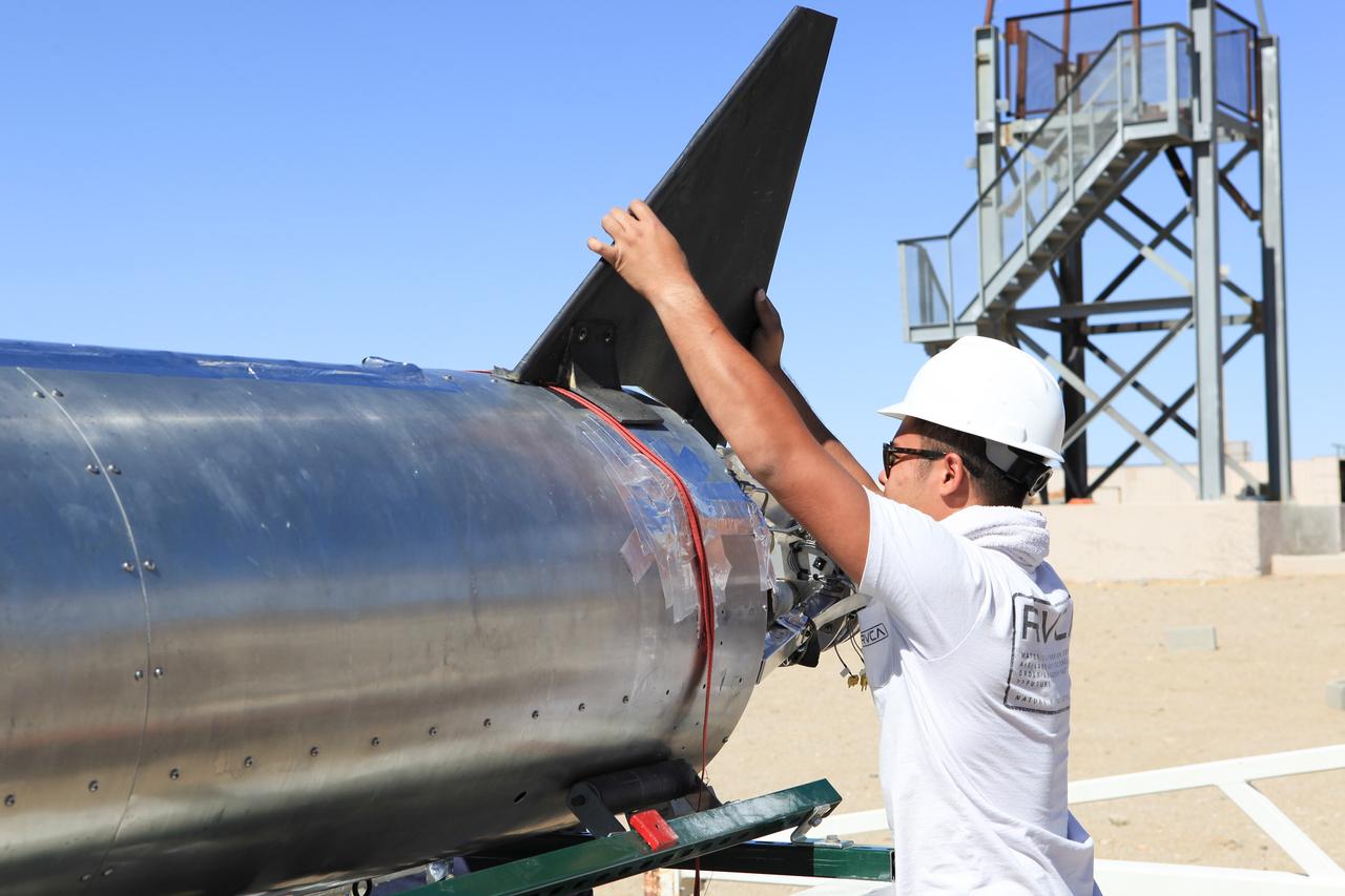
MOJAVE DESERT, Calif. – In the Mojave Desert in California, a student attaches a tail fin to the Garvey Spacecraft Corporation's Prospector P-18D rocket at the Friends of Amateur Rocketry launch site. The rocket is scheduled for flight June 15 with the RUBICS-1 payload on a high-altitude, suborbital flight. The rocket will carry four satellites made from four-inch cube sections. Collectively known as CubeSats, the satellites will record shock, vibrations and heat inside the rocket. They will not be released during the test flight, but the results will be used to prove or strengthen their designs before they are carried into orbit in 2014 on a much larger rocket. A new, lightweight carrier is also being tested for use on future missions to deploy the small spacecraft. The flight also is being watched closely as a model for trying out new or off-the-shelf technologies quickly before putting them in the pipeline for use on NASA's largest launchers. Built by several different organizations, including a university, a NASA field center and a high school, the spacecraft are four-inch cubes designed to fly on their own eventually, but will remain firmly attached to the rocket during the upcoming mission. For more information, visit http://www.nasa.gov/mission_pages/smallsats/elana/cubesatlaunchpreview.html Photo credit: NASA/Dimitri Gerondidakis