
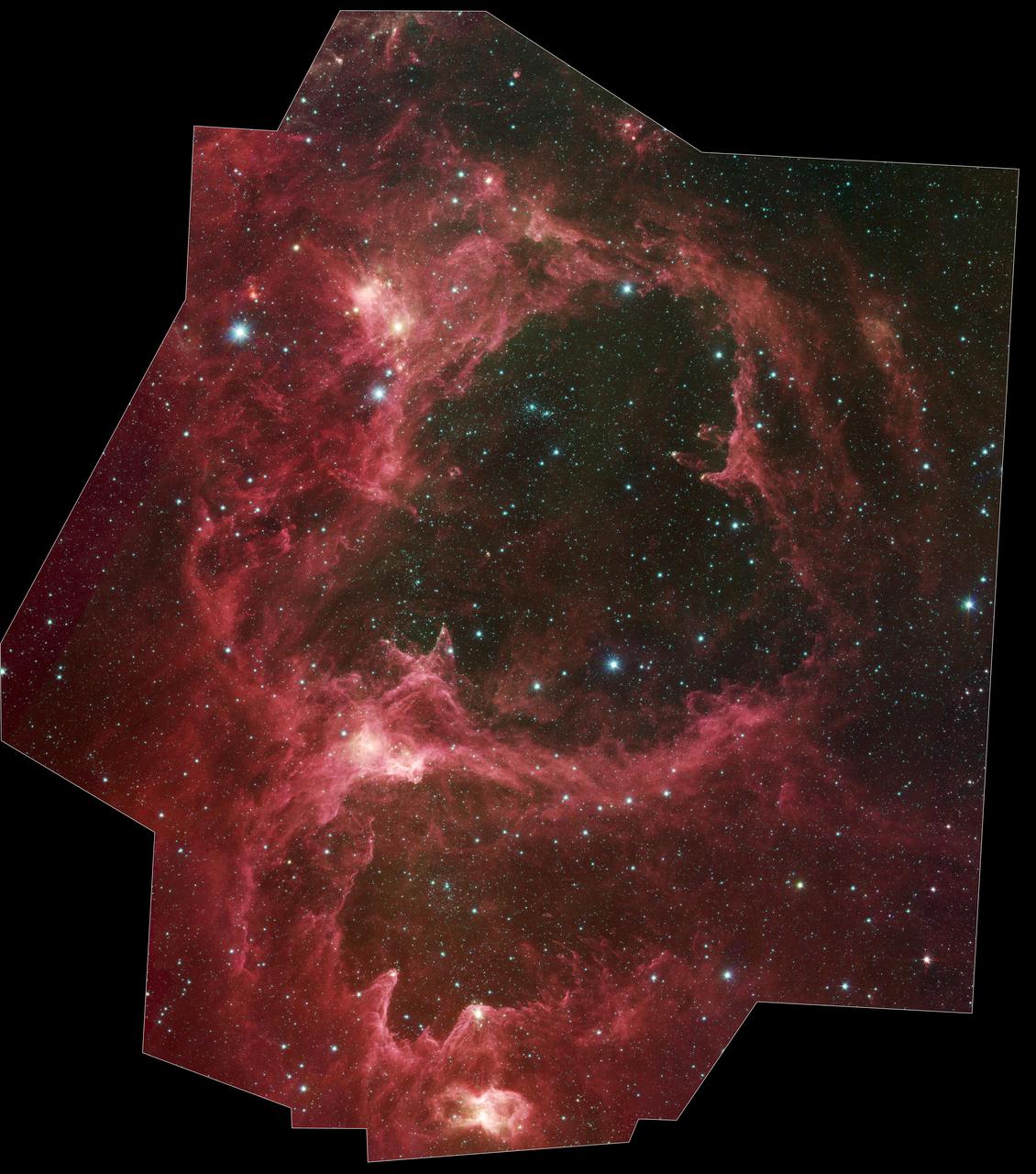
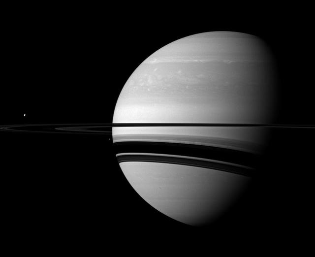
In this rare image taken on 19 July, the wide-angle camera on the international Cassini spacecraft has captured Saturn’s rings and our planet Earth and Moon in the same frame. The dark side of Saturn, its bright limb, the main rings, the F ring, and the G and E rings are clearly seen; the limb of Saturn and the F ring are overexposed. The ‘breaks’ in the brightness of Saturn’s limb are due to the shadows of the rings on the globe of Saturn, preventing sunlight from shining through the atmosphere in those regions. The E and G rings have been brightened for better visibility. Earth, 1.44 billion km away in this image, appears as a blue dot at centre right; the Moon can be seen as a fainter protrusion off its right side. The other bright dots nearby are stars. <b><a href="http://www.nasa.gov/audience/formedia/features/MP_Photo_Guidelines.html" rel="nofollow">NASA image use policy.</a></b> <b><a href="http://www.nasa.gov/centers/goddard/home/index.html" rel="nofollow">NASA Goddard Space Flight Center</a></b> enables NASA’s mission through four scientific endeavors: Earth Science, Heliophysics, Solar System Exploration, and Astrophysics. Goddard plays a leading role in NASA’s accomplishments by contributing compelling scientific knowledge to advance the Agency’s mission. <b>Follow us on <a href="http://twitter.com/NASAGoddardPix" rel="nofollow">Twitter</a></b> <b>Like us on <a href="http://www.facebook.com/pages/Greenbelt-MD/NASA-Goddard/395013845897?ref=tsd" rel="nofollow">Facebook</a></b> <b>Find us on <a href="http://instagrid.me/nasagoddard/?vm=grid" rel="nofollow">Instagram</a></b>

This narrow-angle color image of the Earth, dubbed Pale Blue Dot, is a part of the first ever 'portrait' of the solar system taken by NASA’s Voyager 1. The spacecraft acquired a total of 60 frames for a mosaic of the solar system from a distance of more than 4 billion miles from Earth and about 32 degrees above the ecliptic. From Voyager's great distance Earth is a mere point of light, less than the size of a picture element even in the narrow-angle camera. Earth was a crescent only 0.12 pixel in size. Coincidentally, Earth lies right in the center of one of the scattered light rays resulting from taking the image so close to the sun. This blown-up image of the Earth was taken through three color filters -- violet, blue and green -- and recombined to produce the color image. The background features in the image are artifacts resulting from the magnification. http://photojournal.jpl.nasa.gov/catalog/PIA00452
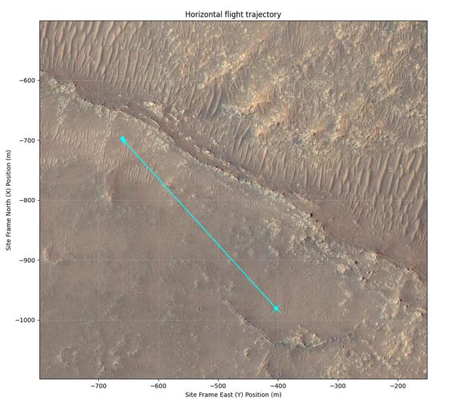
Connecting the Dots: Lander, Heat Shield, Parachute
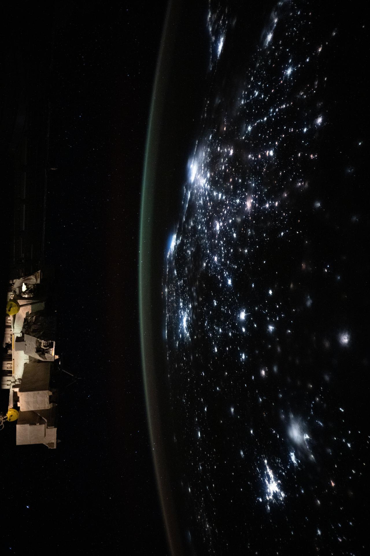
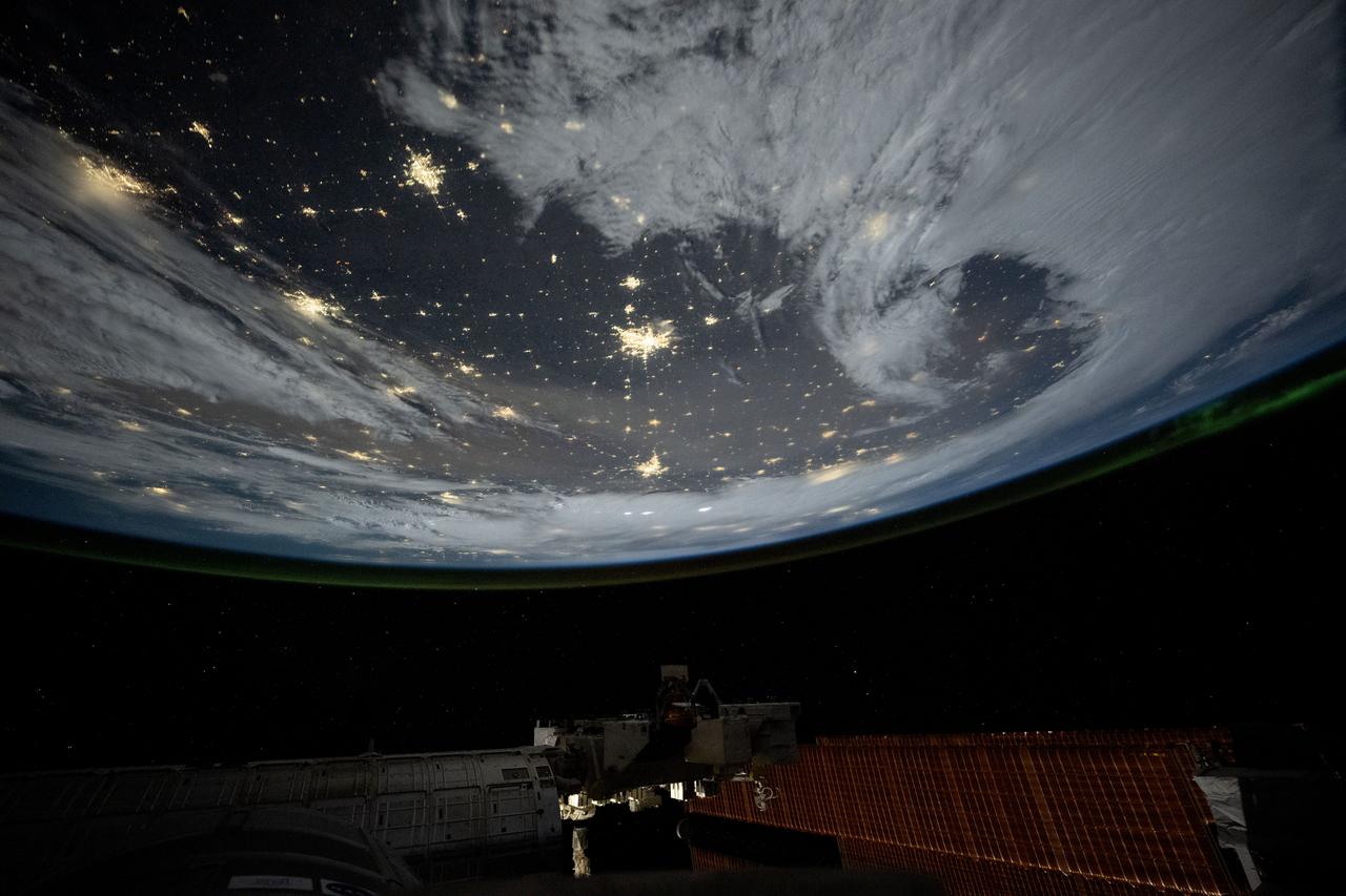
iss072e695073 (March 2, 2025) --- City lights dot the Asian continent with an atmospheric glow blanketing Earth's horizon underneath a starry sky in this long-duration photograph from the International Space Station as it orbited 265 miles above.
Seen by NASA Cassini spacecraft within the vast expanse of Saturn rings, Prometheus appears as little more than a dot. But that little moon still manages to shape the F ring, confining it to its narrow domain. Prometheus (53 miles, or 86 kilometers across) and its fellow moon Pandora (50 miles, or 81 kilometers across) orbit beside the F ring and keep the ring from spreading outward through a process dubbed "shepherding." This view looks toward the unilluminated side of the rings from about 45 degrees below the ringplane. The image was taken in green light with the Cassini spacecraft wide-angle camera on March 8, 2014. The view was obtained at a distance of approximately 533,000 miles (858,000 kilometers) from Prometheus and at a Sun-Prometheus-spacecraft, or phase, angle of 90 degrees. Image scale is 32 miles (51 kilometers) per pixel. http://photojournal.jpl.nasa.gov/catalog/PIA18272
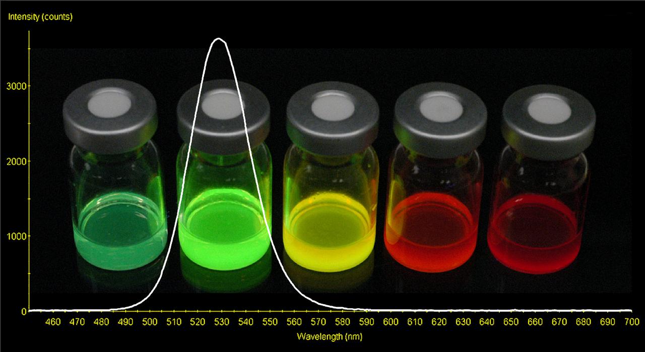
Cadmium selenium Quantum Dots (QDs) are metal nanoparticles that fluoresce in a variety of colors determined by their size. QDs are solid state structures made of semiconductors or metals that confine a countable, small number of electrons into a small space. The confinement of electrons is achieved by the placement of some insulating material(s) around a central, well conducted region. Coupling QDs with antibodies can be used to make spectrally multiplexed immunoassays that test for a number of microbial contaminants using a single test.

Secretary Elaine L. Chao, of the U.S. Department of Transportation (DOT), visits NASA’s Kennedy Space Center in Florida on April 24, 2019. She spoke to Kennedy’s leadership in the Operations and Support Building II and discussed the DOT’s role in enabling commercial space.

Secretary Elaine L. Chao, of the U.S. Department of Transportation (DOT), visits NASA’s Kennedy Space Center in Florida on April 24, 2019. She spoke to Kennedy’s leadership in the Operations and Support Building II and discussed the DOT’s role in enabling commercial space.

Secretary Elaine L. Chao, of the U.S. Department of Transportation (DOT), visits NASA’s Kennedy Space Center in Florida on April 24, 2019. She spoke to Kennedy’s leadership in the Operations and Support Building II and discussed the DOT’s role in enabling commercial space.
iss073e0855854 (Sept. 21, 2025) --- City lights dot the Brazilian landscape and trace a path to Rio de Janeiro and São Paulo (center) on the Atlantic coast in this photograph taken at approximately 2:17 a.m. local from the International Stace Station as it orbited 263 miles above.

For the 30th anniversary of one of the most iconic images taken by NASA's Voyager mission, a new version of the image known as "the Pale Blue Dot." Planet Earth is visible as a bright speck within the sunbeam just right of center and appears softly blue, as in the original version published in 1990 (see PIA00452). This updated version uses modern image-processing software and techniques to revisit the well-known Voyager view while attempting to respect the original data and intent of those who planned the images. In 1990, the Voyager project planned to shut off the Voyager 1 spacecraft's imaging cameras to conserve power and because the probe, along with its sibling Voyager 2, would not fly close enough to any other objects to take pictures. Before the shutdown, the mission commanded the probe to take a series of 60 images designed to produce what they termed the "Family Portrait of the Solar System." Executed on Valentine's Day 1990, this sequence returned images for making color views of six of the solar system's planets and also imaged the Sun in monochrome. The popular name of this view is traced to the title of the 1994 book by Voyager imaging scientist Carl Sagan, who originated the idea of using Voyager's cameras to image the distant Earth and played a critical role in enabling the family portrait images to be taken. The image of Earth was originally published by NASA in 1990. It is republished here to commemorate the 30th anniversary of the Family Portrait of the Solar System (see PIA00451) and the Pale Blue Dot image in particular. The planet occupies less than a single pixel in the image and thus is not fully resolved. (The actual width of the planet on the sky was less than one pixel in Voyager's camera.) By contrast, Jupiter and Saturn were large enough to fill a full pixel in their family portrait images. The direction of the Sun is toward the bottom of the view (where the image is brightest). Rays of sunlight scattered within the camera optics stretch across the scene. One of those light rays happens to have intersected dramatically with Earth. From Voyager 1's vantage point — a distance of approximately 3.8 billion miles (6 billion kilometers) — Earth was separated from the Sun by only a few degrees. The close proximity of the inner planets to the Sun was a key factor preventing these images from being taken earlier in the mission, as our star was still close and bright enough to damage the cameras with its blinding glare. The view is a color composite created by combining images taken using green, blue and violet spectral filters by the Voyager 1 Narrow-Angle Camera. They were taken at 4:48 GMT on Feb. 14, 1990, just 34 minutes before Voyager 1 powered off its cameras forever. Like the original version, this is technically a "false-color" view, as the color-filter images used were mapped to red, green and blue, respectively. The brightness of each color channel was balanced relative to the others, which is likely why the scene appears brighter but less grainy than the original. In addition, the color was balanced so that the main sunbeam (which overlays Earth) appears white, like the white light of the Sun. At its original resolution, the newly processed color image is 666 by 659 pixels in size; this is Figure A. The main image is an enlarged version. The image was processed by JPL engineer and image processing enthusiast Kevin M. Gill with input from two of the image's original planners, Candy Hansen and William Kosmann. https://photojournal.jpl.nasa.gov/catalog/PIA23645
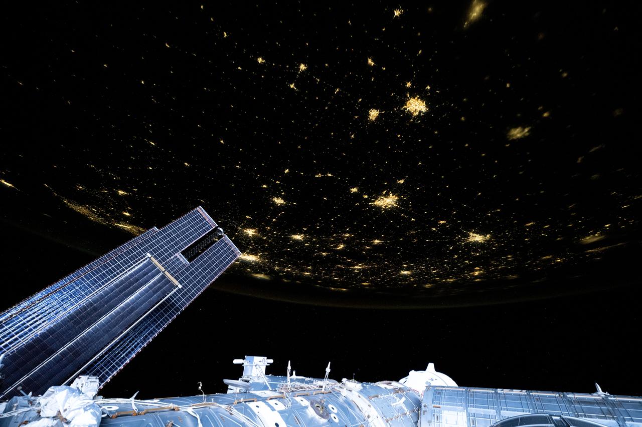
iss073e0148982 (May 21, 2025) --- City lights dot the U.S. landscape looking southeast from 261 miles above Omaha, Nebraska, toward the southern Atlantic coast of the United States in this photograph taken at approximately 11:56 p.m. local time from the International Space Station. Pictured in the foreground, is a set of the orbital outpost's main solar arrays (lower left) and a partially obscured SpaceX Dragon crew spacecraft (lower center) docked to the Harmony module's forward port.

iss073e0149171 (May 21, 2025) --- City lights dot the southern United States' landscape from Louisiana (upper left), to Florida (lower center), to South Carolina (right), in this photograph from the International Space Station as it orbited 260 miles above Georgia at approximately 12:59 a.m. local time.
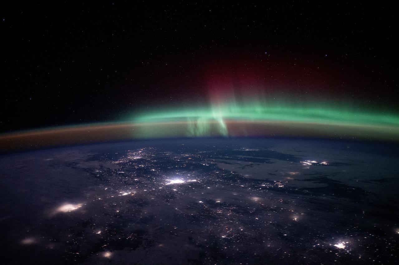
iss072e725406 (March 5, 2025) --- City lights dot the Canadian landscape underneath an atmospheric glow and an aurora borealis in this photograph taken from the International Space Station 262 miles above North America at approximately 12:15 a.m. local time.
iss073e0088323 (May 16, 2025) --- City lights dot the Pacific Northwest region of North America at approximately 2:50 a.m. local time in this photograph from the International Space Station as it orbited 261 miles above the Pacific Ocean. In the lower right foreground, is a set of the orbital outpost's main solar arrays.
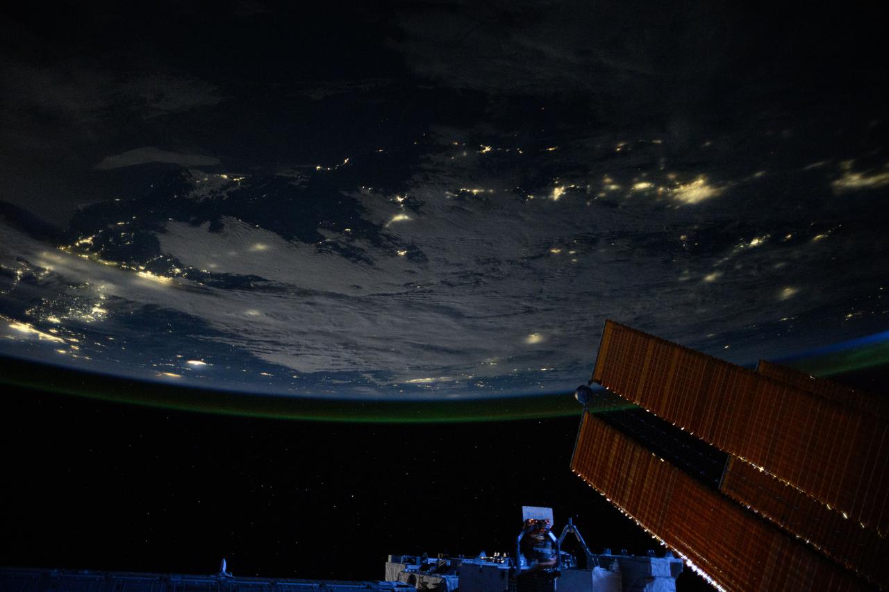
iss072e842757 (March 15, 2025) --- City lights dot the cloudy, midwestern landscape of the United States with a wispy aurora above Earth's horizon in this photograph from the International Space Station as it orbited 261 miles above the Sunflower State of Kansas. In the bottom foreground, is the Kibo laboratory module's Exposed Facility, an external research platform, and the orbital outpost's main solar arrays.
iss072e843309 (March 15, 2025) --- City lights dot the northeastern landscape of China with a wispy aurora above Earth's horizon in this photograph from the International Space Station as it orbited 262 miles above Asia. In the bottom foreground, is the Kibo laboratory module's Exposed Facility, an external research platform, and the orbital outpost's main solar arrays.
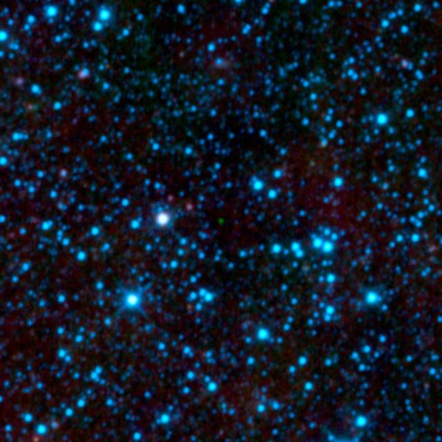
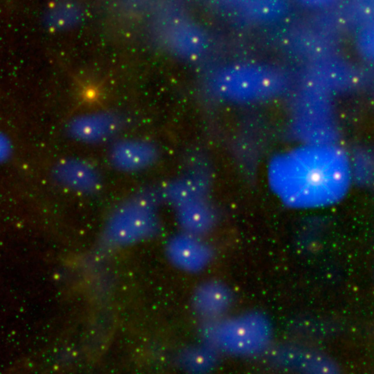
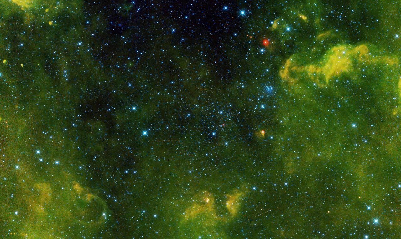
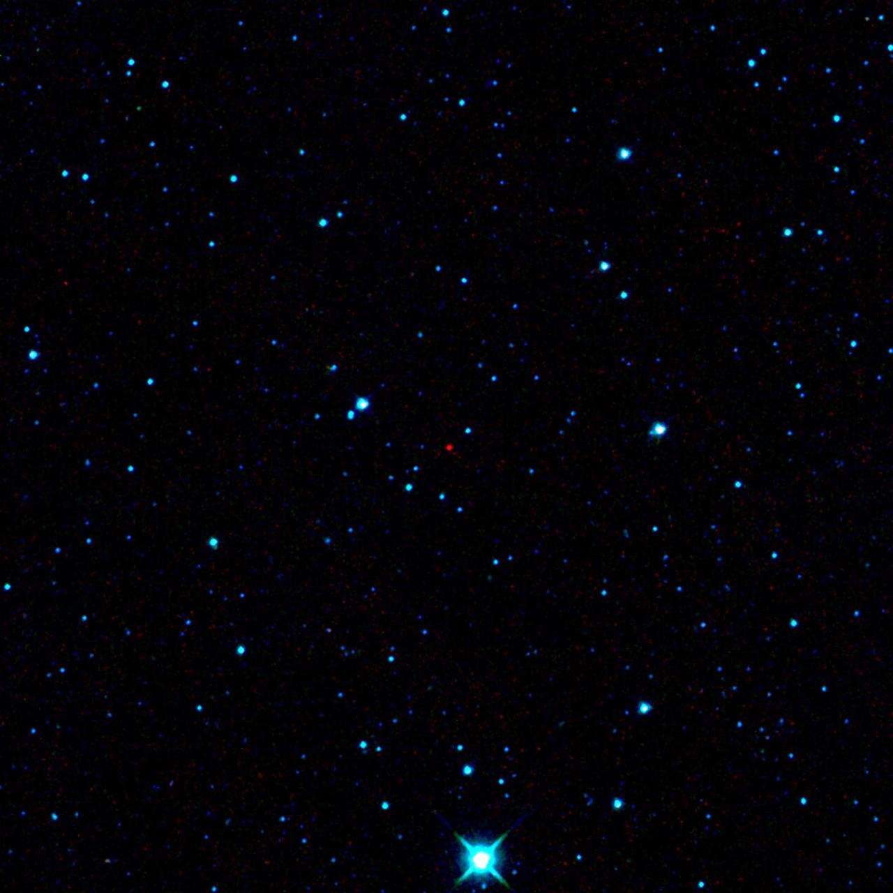
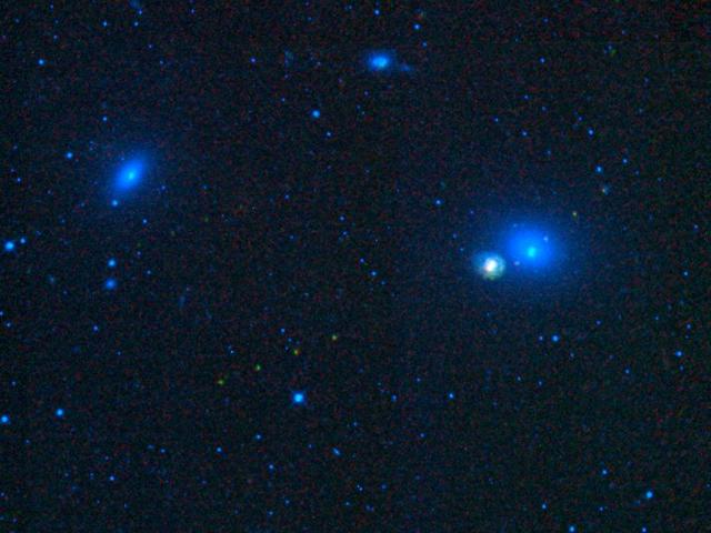
NASA Wide-field Infrared Survey Explorer has uncovered the coldest brown dwarf known so far green dot in very center of this infrared image. WISE 1828+2650 is located in the constellation Lyra. The blue dots are a mix of stars and galaxies.
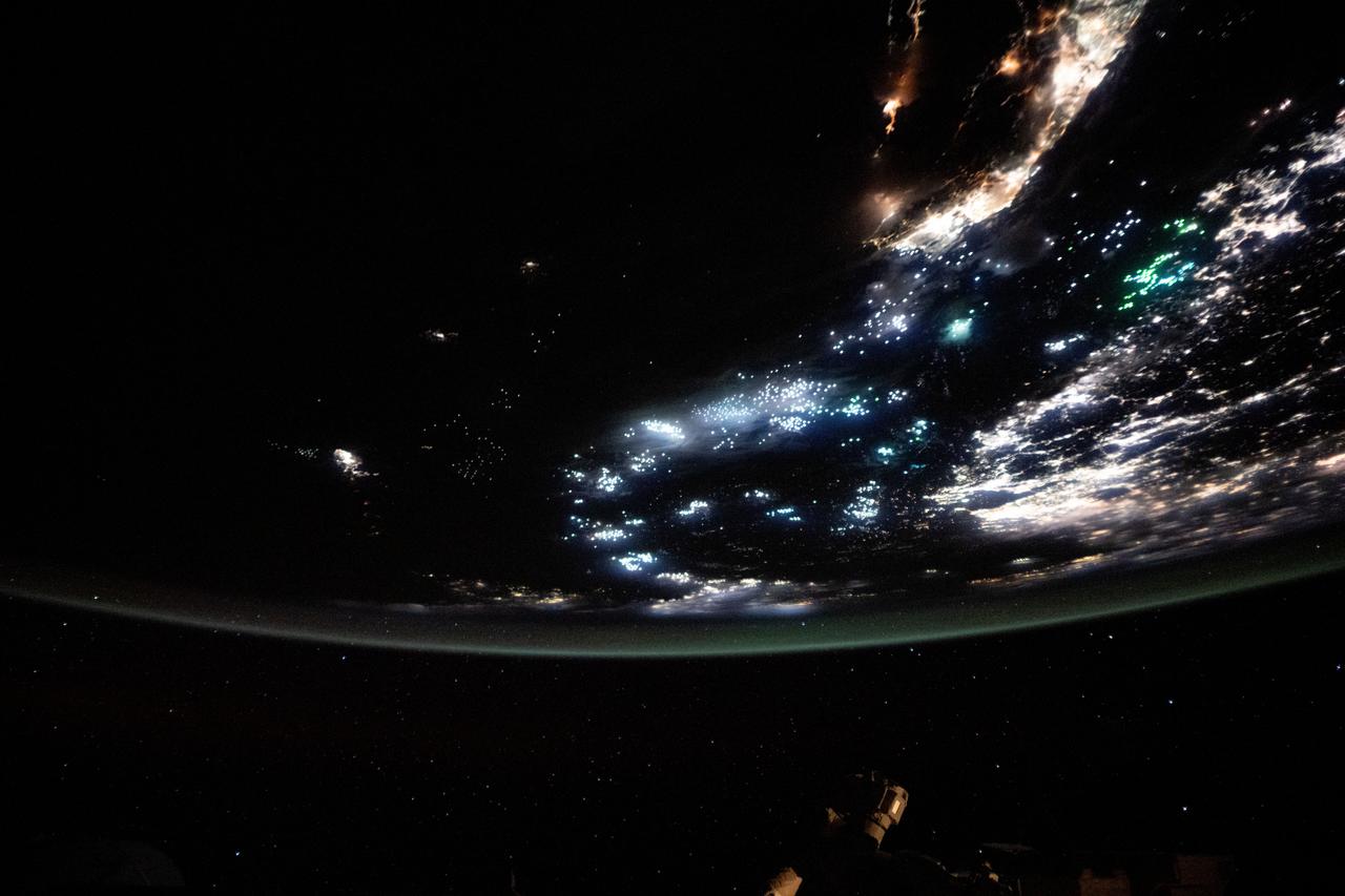
iss073e0688699 (Aug. 26, 2025) --- The blue-green lights of fishing boats, designed to lure squid, sardines, or mackerel, dot the East China Sea and the Taiwan Strait contrasting with the coastal city lights of Taiwan and China. The International Space Station was orbiting 259 miles above the South China Sea just south of Taiwan at approximately 11:53 p.m. local time when this photograph was taken.

iss074e0043921 (Jan. 3, 2026) --- The amber high-pressure sodium lights of Van, Türkiye (center), along with its suburbs and villages, dot the southeast coast of Lake Van in the nation’s Eastern Anatolia Region. The International Space Station was orbiting 262 miles above Earth at approximately 10:12 p.m. local time when this photograph was taken. Credit: JAXA/Kimiya Yui
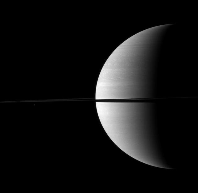
NASA Cassini Orbiter caught the shadow of the moon Prometheus as a small dark dot on Saturn just below the narrow shadow cast by the rings in the center of this image.
Nearly invisible upon first glance, Saturn moon Enceladus is a small bright dot beyond the planet rings in this image taken by NASA Cassini spacecraft.
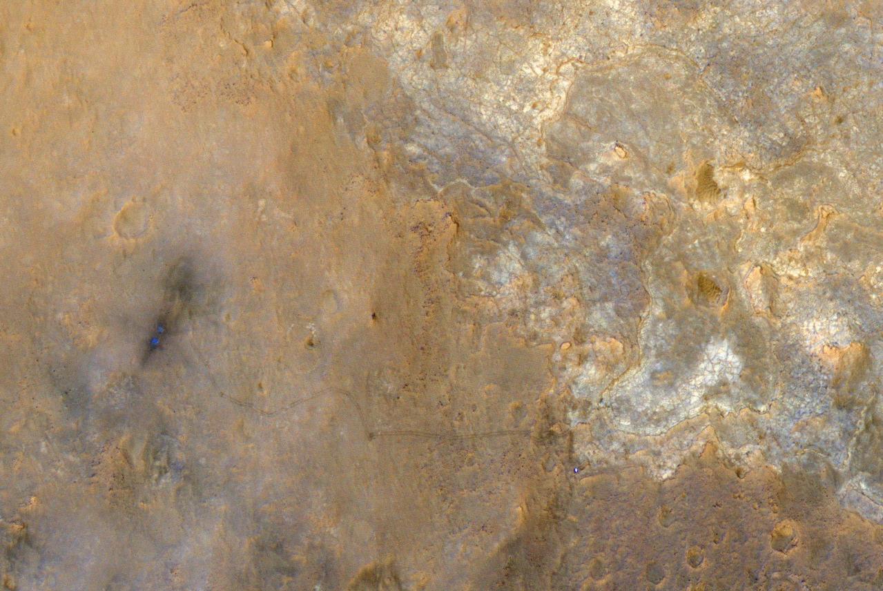
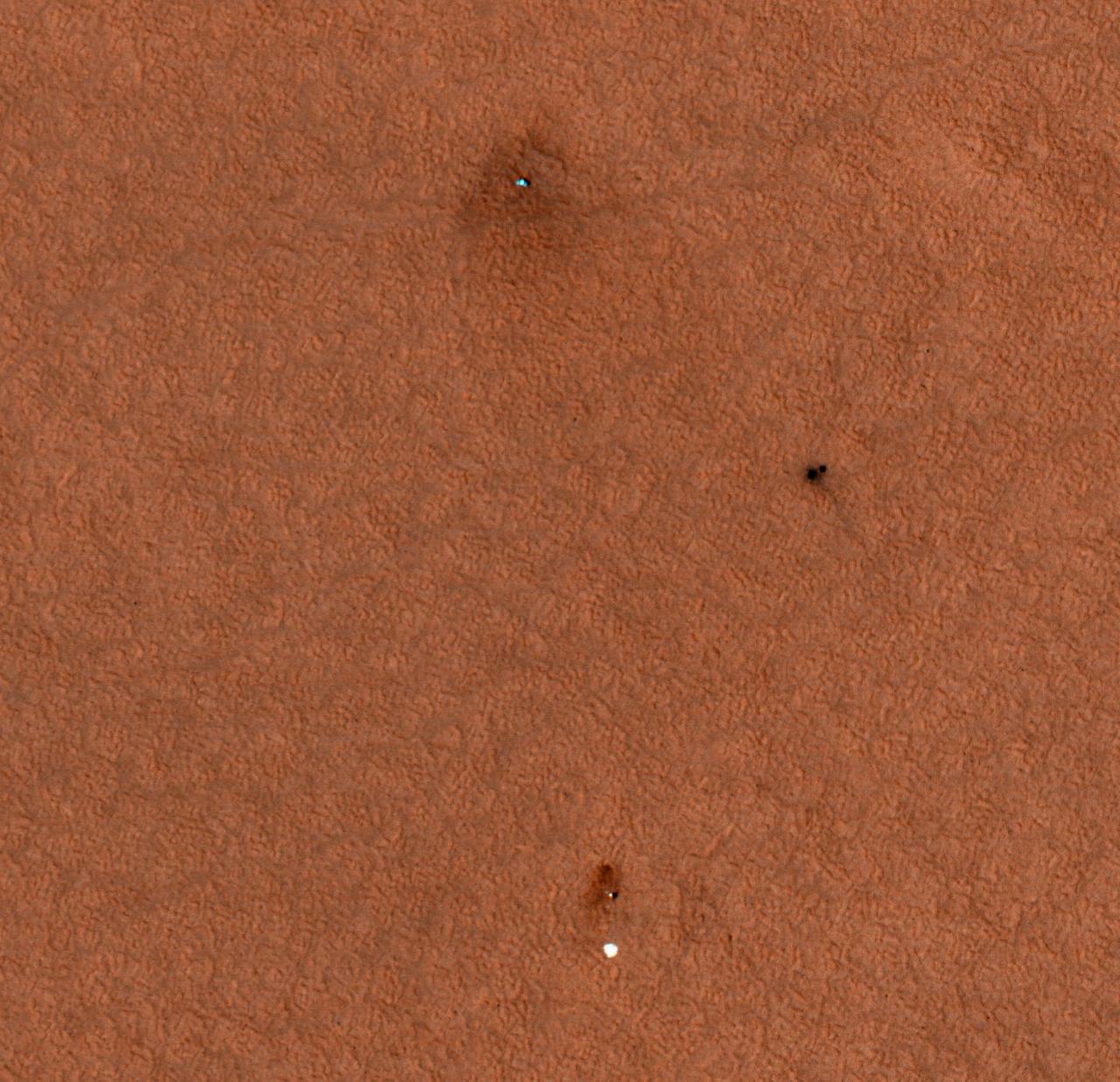
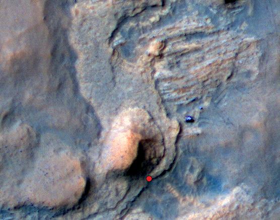
NASA rover Curiosity appears as a bluish dot near the lower right corner of this enhanced-color view from the HiRISE camera on NASA Mars Reconnaissance Orbiter.
It a dust bunny of cosmic proportions. Astronomers used images from NASA WISE to locate an aging star shedding loads of dust orange dot at upper left.
The Cassini spacecraft looks across Saturn cloud-dotted north and shadowed pole, and out across the lanes of ice that compose its rings
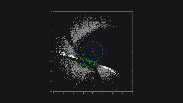
The six red dots in this composite picture indicate the location of the first new near-Earth asteroid, called 2013 YP139, as seen by NASA NEOWISE.

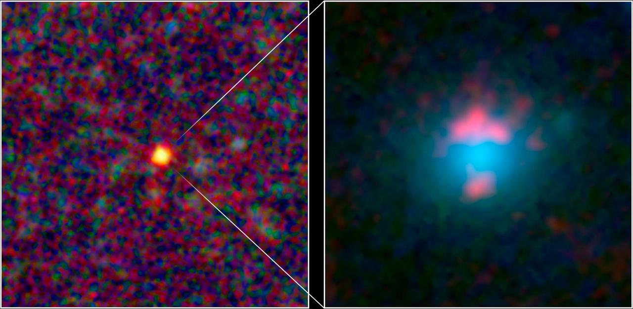
This artist conception illustrates one of the most primitive supermassive black holes known central black dot at the core of a young, star-rich galaxy.
NASA Deep Impact Tempel 1 Mission Update. Images of impact taken with the medium resolution imager. The blue dotted line is the position of the spectrometer slit.
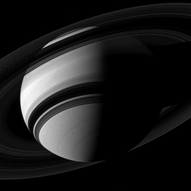
The rings split the planet in two in this NASA Cassini spacecraft view of a crescent Saturn. Saturn moon Tethys is the small dot on the left of the image, below the rings.
The six red dots in this composite picture indicate the location of the first new near-Earth asteroid, called 2013 YP139, as seen by NASA NEOWISE.
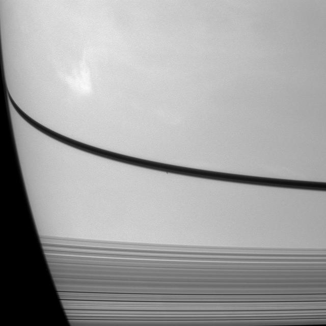
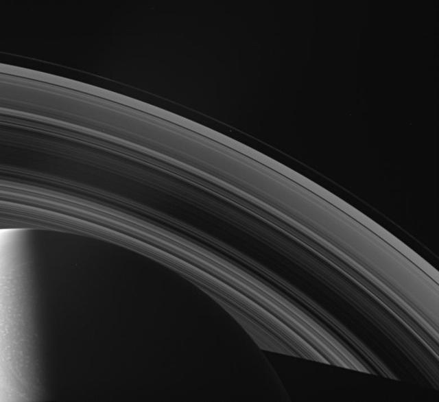
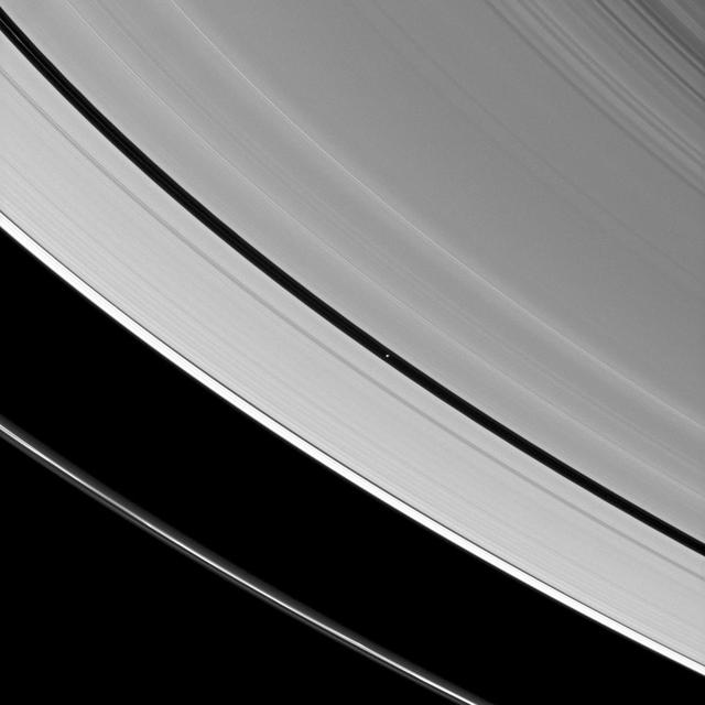
As if trying to get our attention, Mimas is positioned against the shadow of Saturn's rings, bright on dark. As we near summer in Saturn's northern hemisphere, the rings cast ever larger shadows on the planet. With a reflectivity of about 96 percent, Mimas (246 miles, or 396 kilometers across) appears bright against the less-reflective Saturn. This view looks toward the sunlit side of the rings from about 10 degrees above the ringplane. The image was taken with the Cassini spacecraft wide-angle camera on July 13, 2014 using a spectral filter which preferentially admits wavelengths of near-infrared light centered at 752 nanometers. The view was acquired at a distance of approximately 1.1 million miles (1.8 million kilometers) from Saturn and approximately 1 million miles (1.6 million kilometers) from Mimas. Image scale is 67 miles (108 kilometers) per pixel at Saturn and 60 miles (97 kilometers) per pixel at Mimas. http://photojournal.jpl.nasa.gov/catalog/PIA18282
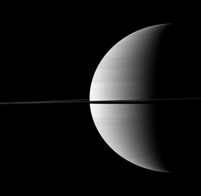
Enceladus (visible in the lower-left corner of the image) is but a speck before enormous Saturn, but even a small moon can generate big waves of excitement throughout the scientific community. Enceladus, only 313 miles (504 kilometers) across, spurts vapor jets from its south pole. The presence of these jets from Enceladus has been the subject of intense study since they were discovered by Cassini. Their presence may point to a sub-surface water reservoir. This view looks toward the unilluminated side of the rings from about 2 degrees below the ringplane. The image was taken with the Cassini spacecraft wide-angle camera on Oct. 20, 2014 using a spectral filter which preferentially admits wavelengths of near-infrared light centered at 752 nanometers. The view was obtained at a distance of approximately 589,000 miles (948,000 kilometers) from Saturn and at a Sun-Saturn-spacecraft, or phase, angle of 26 degrees. Image scale is 35 miles (57 kilometers) per pixel. http://photojournal.jpl.nasa.gov/catalog/PIA18296
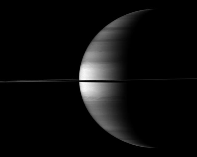
NASA Voyager 2 took this true color photograph of Saturn on July 21, 1981. The moons Rhea and Dione appear as blue dots to the south and southeast of Saturn, respectively.
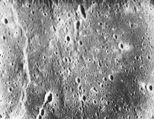
This picture, taken only minutes after NASA Mariner 10 made its closest approach to Mercury, is one of the highest resolution pictures obtained. Abundant craters in various stages of degradation dot the surface.
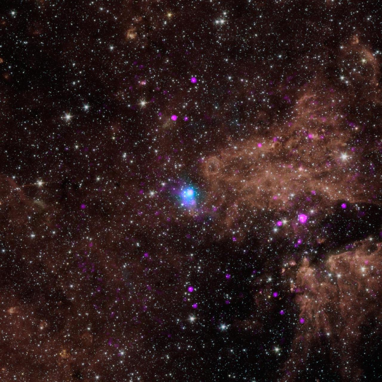
The blue dot in this image marks the spot of an energetic pulsar -- the magnetic, spinning core of star that blew up in a supernova explosion. NASA NuSTAR discovered the pulsar by identifying its telltale pulse.
Generations of stars can be seen in this new infrared portrait from NASA Spitzer Space Telescope. In this wispy star-forming region, called W5, the oldest stars can be seen as blue dots in the centers of the two hollow cavities.

A range of supermassive black holes lights up this new image from NASA NuSTAR. All of the dots are active black holes tucked inside the hearts of galaxies, with colors representing different energies of X-ray light.
Janus is spotted over Saturn north pole in this image while Mimas shadow glides across Saturn in this image from NASA Cassini spacecraft. Janus is the faint dot that appears just above Saturn north pole.
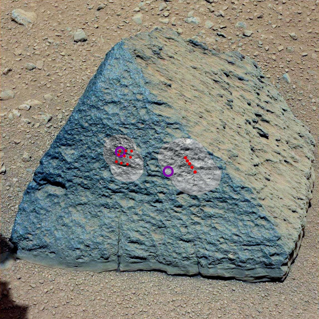
This image shows where NASA Curiosity rover aimed two different instruments to study a rock known as Jake Matijevic. The red dots are where ChemCam zapped the rock with its laser.
This image from NASA Spitzer Space Telescope using infrared light shows what astronomers think is one of the coldest brown dwarfs discovered so far red dot in middle of frame.

This image from the Herschel Observatory, a European Space Agency mission, reveals some of the coldest and darkest material in our galaxy. The yellow filaments show the coldest dust dotted with the youngest embryonic stars.
Saturn moon Epimetheus casts a shadow across colorful rings in this image taken by NASA Cassini spacecraft before the planet August 2009 equinox. Epimetheus is visible as a small dot at the center of the bottom of the image.
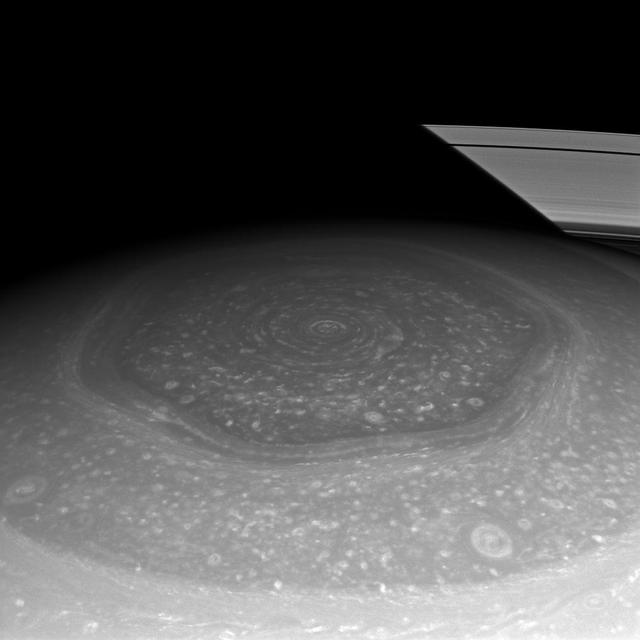
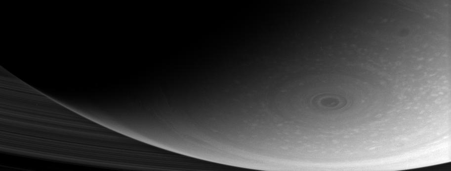
Saturn north polar hexagon basks in the Sun light now that spring has come to the northern hemisphere. Many smaller storms dot the north polar region and Saturn signature rings put in an appearance in the background.
This frame from a movie shows the progression of NASA NEOWISE survey in the mission first year following its restart in December 2013. Each dot represents an asteroid or comet that the mission observed.
The immense size of Saturn is emphasized in this portrait by NASA Cassini spacecraft that features the moon Mimas shown in front of the planet. Mimas appears as only a small dot above the rings near the center of the image.
Infant stars are glowing gloriously in this image of the Serpens star-forming region, captured by NASA Spitzer Space Telescope. The reddish-pink dots are baby stars deeply embedded in the cosmic cloud of gas and dust that collapsed to create it.
The red dot at the center of this image is the first near-Earth asteroid discovered by NASA Wide-Field Infrared Survey Explorer, or WISE -- an all-sky mapping infrared mission designed to see all sorts of cosmic objects.
Generations of stars can be seen in this new infrared portrait from NASA Spitzer Space Telescope. In this wispy star-forming region, called W5, the oldest stars can be seen as blue dots in the centers of the two hollow cavities.
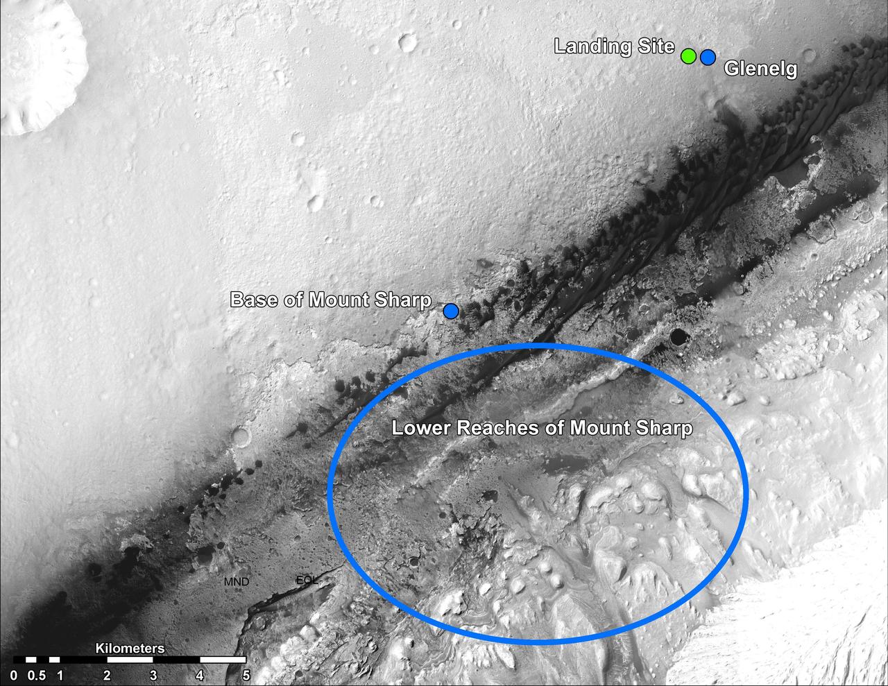
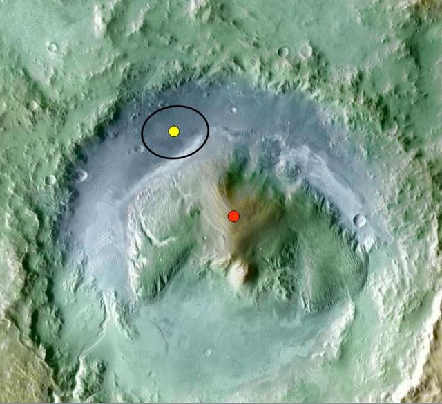
This image shows the landing site of NASA Curiosity rover and destinations scientists want to investigate. Curiosity landed inside Gale Crater on Mars on Aug. 5 PDT Aug. 6 EDT at the green dot, within the Yellowknife quadrangle.
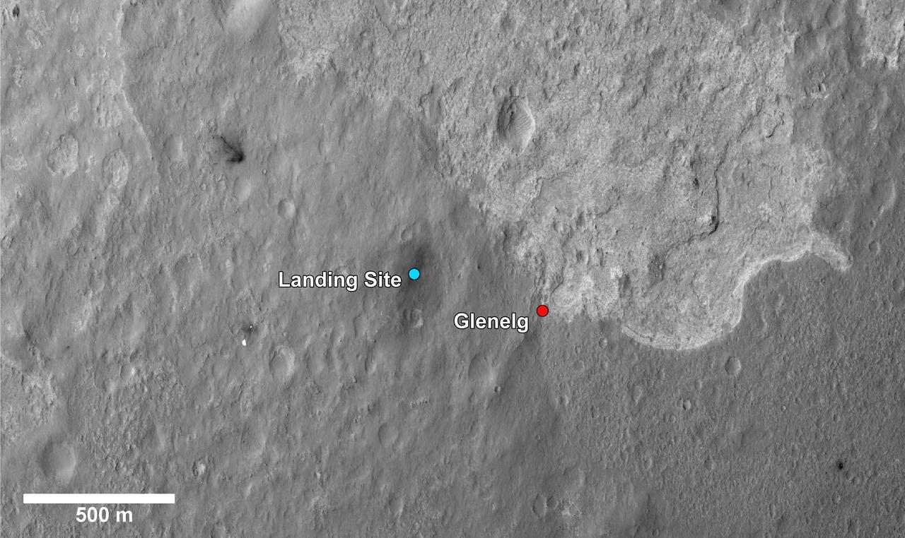
This image shows a closer view of the landing site of NASA Curiosity rover and a destination nearby known as Glenelg. Curiosity landed inside Gale Crater on Mars on Aug. 5 PDT Aug. 6 EDT at the blue dot.
The highly reflective moon Enceladus appears as a bright dot beyond a crescent Saturn in this image from NASA Cassini spacecraft. Enceladus is visible above the ringplane to the left of the center of the image.
This dramatic close-up of Saturn south pole shows the hurricane-like vortex that resides there. The entire polar region is dotted with bright clouds, including one that appears to be inside the central ring of the polar storm
When boulders roll down a dusty Martian slope, they can leave long, dotted tracks behind on the slope surface as seen in this observation from NASA Mars Reconnaissance Orbiter.
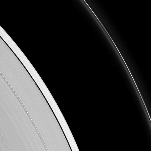
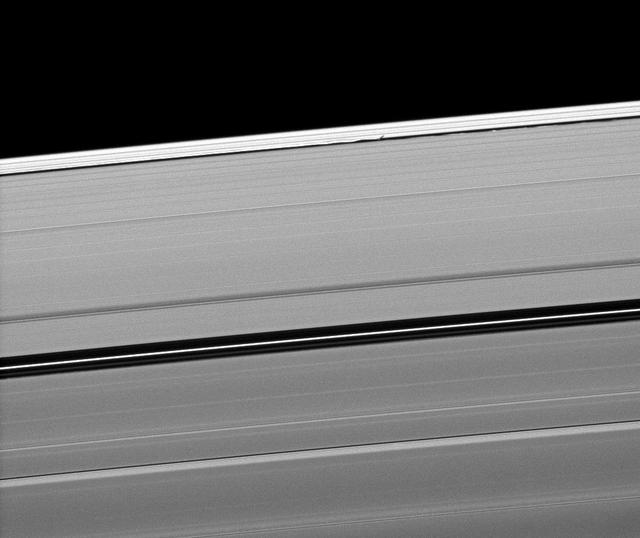
Epimetheus is a lonely dot beyond Saturn rings. The little moon appears at lower left, outside the narrow F ring. Several very faint spokes lurk in the B ring, at right
Color coding in this image of Gale Crater on Mars represents differences in elevation. The vertical difference from a low point inside the landing ellipse for NASA Mars Science Laboratory yellow dot to a high point on the mountain inside the crater.
A pair of Saturn many moons joins the planet in this scene captured by NASA Cassini spacecraft. Tethys appears as a small white dot above the rings on the far left, Enceladus appears as a smaller bright speck beside the planet.
This image composite shows a warped and magnified view of a galaxy discovered by the Herschel Space Observatory, one of five such galaxies uncovered by the infrared telescope. The galaxy, referred to as SDP 81 is the yellow dot in the left image.
In this Mars Reconnaissance Orbiter view of the Curiosity rover mission waypoint called the Kimberley, the red dot indicates the location of a sandstone target, Windjana, selected for close-up inspection.
NASA Spitzer Space Telescope contributed to the infrared component of the observations of a surprisingly large collections of galaxies red dots in center. Shorter-wavelength infrared and visible data are provided by Japan Subaru telescope.
Tiny Daphnis appears as a bright dot in the Keeler Gap next to shadows cast by the moon and the edge waves it has created in the A ring in this image taken by NASA Cassini spacecraft before Saturn August 2009 equinox.
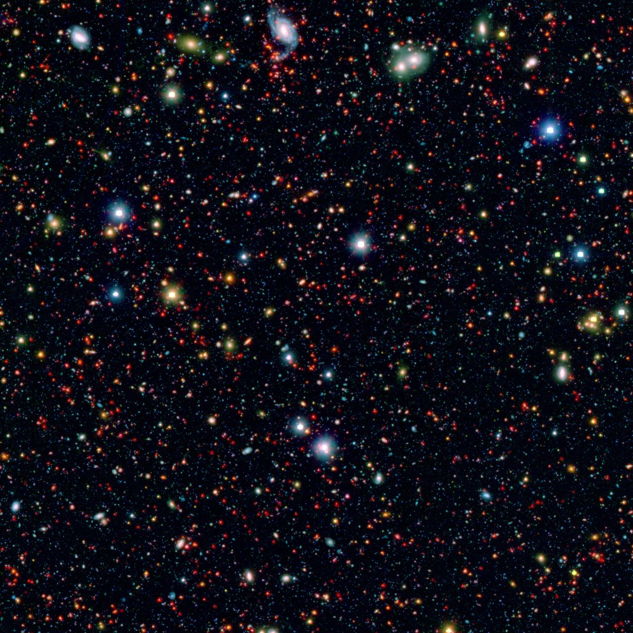
Millions of galaxies populate the patch of sky known as the COSMOS field, short for Cosmic Evolution Survey, a portion of which is shown here. Even the smallest dots in this image are galaxies, some up to 12 billion light-years away.
This NASA Mars Odyssey image shows a location near the highland-lowland boundary scarp in a region called Nepenthes Mensae with relatively smooth plains dotted with some craters and stepped mesas and knobs.
Saturn tiny moon Pan orbits in the middle of the Encke Gap of the planet A ring in this image from the Cassini spacecraft. Pan is visible as a bright dot in the gap near the center of this view.

Engineer Chris Chatellier stands next to a target board with 1,600 dots. The board was one of several used on July 23, 2019, in the Spacecraft Assembly Facility's High Bay 1 at NASA's Jet Propulsion Laboratory in Pasadena, California, to calibrate the forward-facing cameras on the Mars 2020 rover. https://photojournal.jpl.nasa.gov/catalog/PIA23313
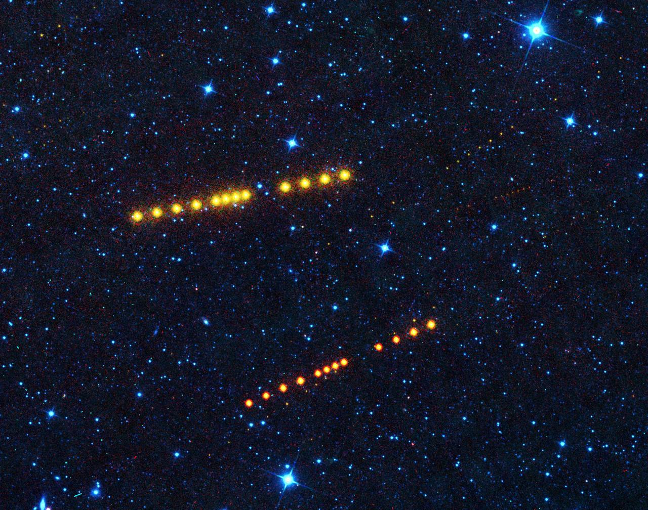
Those aren't Klingon vessels. Appearing as strings of orange dots, the brightest sets of dots belong to asteroids Klotho and Lina. Both orbit out in the main asteroid belt between Mars and Jupiter, while smaller, more distant asteroids can also be seen passing through the image. https://photojournal.jpl.nasa.gov/catalog/PIA23589

This map shows the route driven by NASA's Curiosity Mars rover (blue line) and locations where the rover's Chemistry and Camera (ChemCam) instrument detected the element boron (dots, colored by abundance of boron according to the key at right). The main map shows the traverse from landing day (Sol 0) in August 2012 to the rover's location in September 2016, with boron detections through September 2015. The inset at upper left shows a magnified version of the most recent portion of that traverse, with boron detections during that portion. Overlapping dots represent cases when boron was detected in multiple ChemCam observation points in the same target and non-overlapping dots represent cases where two different targets in the same location have boron. Most of the mission's detections of boron have been made in the most recent seven months (about 200 sols) of the rover's uphill traverse. The base image for the map is from the High Resolution Imaging Science Experiment (HiRISE) camera on NASA's Mars Reconnaissance Orbiter. North is up. The scale bar at lower right represents one kilometer (0.62 mile). http://photojournal.jpl.nasa.gov/catalog/PIA21150

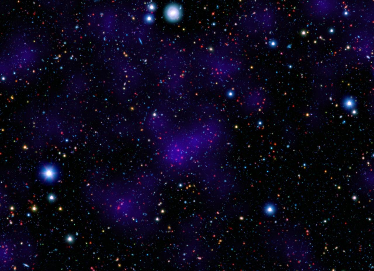
The blue dots in this field of galaxies, known as the COSMOS field, show galaxies that contain supermassive black holes emitting high-energy X-rays. The black holes were detected by NASA's Nuclear Spectroscopic Array, or NuSTAR, which spotted 32 such black holes in this field and has observed hundreds across the whole sky so far. The other colored dots are galaxies that host black holes emitting lower-energy X-rays, and were spotted by NASA's Chandra X-ray Observatory. Chandra data show X-rays with energies between 0.5 to 7 kiloelectron volts, while NuSTAR data show X-rays between 8 to 24 kiloelectron volts. http://photojournal.jpl.nasa.gov/catalog/PIA20865

These dark dunes are influenced by local topography. The shape and orientation of dunes can usually tell us about wind direction, but in this image, the dune-forms are very complex, so it's difficult to know the wind direction. However, a circular depression (probably an old and infilled impact crater) has limited the amount of sand available for dune formation and influenced local winds. As a result, the dunes here form distinct dots and dashes. The "dashes" are linear dunes formed by bi-directional winds, which are not traveling parallel to the dune. Instead, the combined effect of winds from two directions at right angles to the dunes, funnels material into a linear shape. The smaller "dots" (called "barchanoid dunes") occur where there is some interruption to the process forming those linear dunes. This process is not well understood at present and is one motivation for HiRISE to image this area. http://photojournal.jpl.nasa.gov/catalog/PIA20735
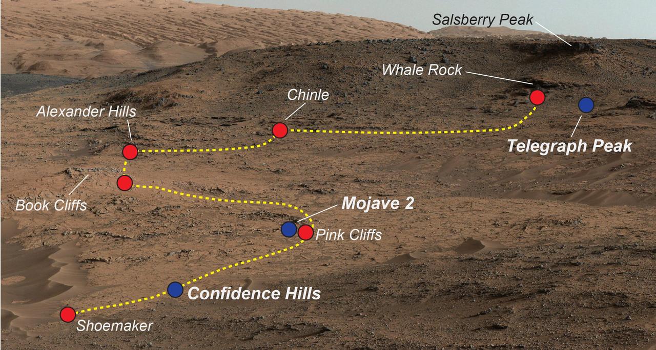
NASA's Curiosity Mars rover examined a mudstone outcrop area called "Pahrump Hills" on lower Mount Sharp, in 2014 and 2015. This view shows locations of some targets the rover studied there. The blue dots indicate where drilled samples of powdered rock were collected for analysis. The rover drilled a sample of rock powder at "Confidence Hills" in September 2014 and analyzed it with internal laboratory instruments. Then the mission conducted a walkabout survey up the slope, along the route indicated in yellow, stopping for close inspection at the red-dot locations. Observations from the walkabout were used to choose where to take additional drilled samples for analysis during a second pass up the slope. The "Mojave 2" sample was collected in January 2015 and the "Telegraph Peak" one in February 2015. This view of the outcrop and other portions of Mount Sharp beyond is a mosaic of images taken by the rover's Mast Camera (Mastcam) in September 2014. https://photojournal.jpl.nasa.gov/catalog/PIA21709

The Swept Wing Laminar Flow test article, integrated to the underside of a NASA F-15, will examine the effectiveness of different configurations of small dots, called distributed roughness elements, to extend smooth, laminar airflow over a wing’s depth, reducing friction drag.
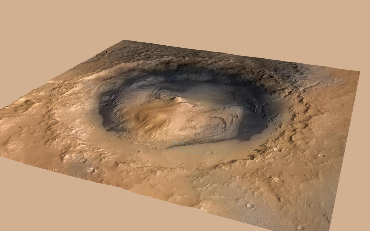
NASA Curiosity rover landed in the Martian crater known as Gale Crater, which is approximately the size of Connecticut and Rhode Island combined. A green dot shows where the rover landed, well within its targeted landing ellipse, outlined in blue.
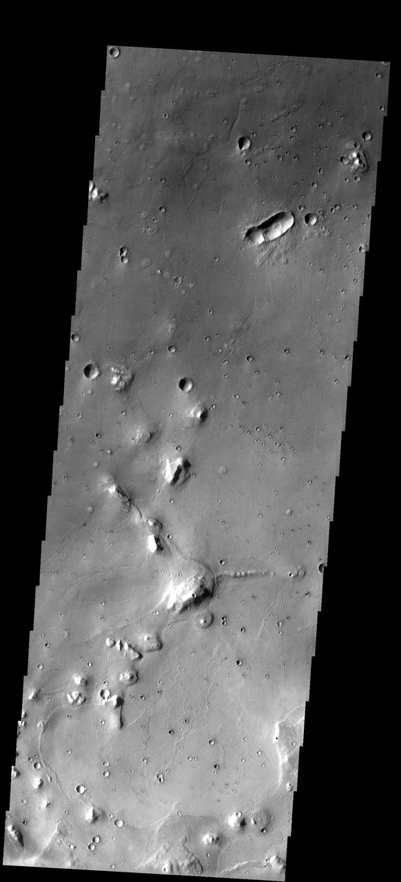
In this image from NASA Mars Odyssey, eroded mesas and secondary craters dot the landscape in an area of Cydonia Mensae. The single oval-shaped crater displays a butterfly ejecta pattern, indicating that the crater formed from a low-angle impact.
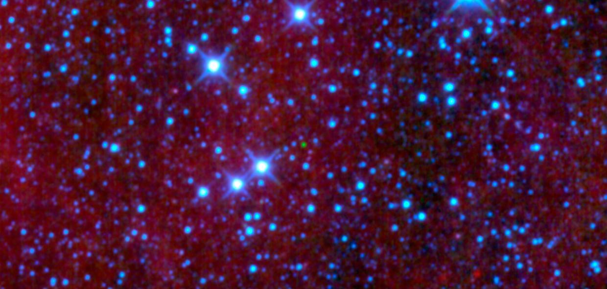
This image from NASA Wide-field Infrared Survey Explorer, shows four galaxies in the Virgo cluster: Messier 59, Messier 60, NGC 4647, and NGC 4638. It also shows the tracks of three asteroids, which appear in this image as trails of green dots.
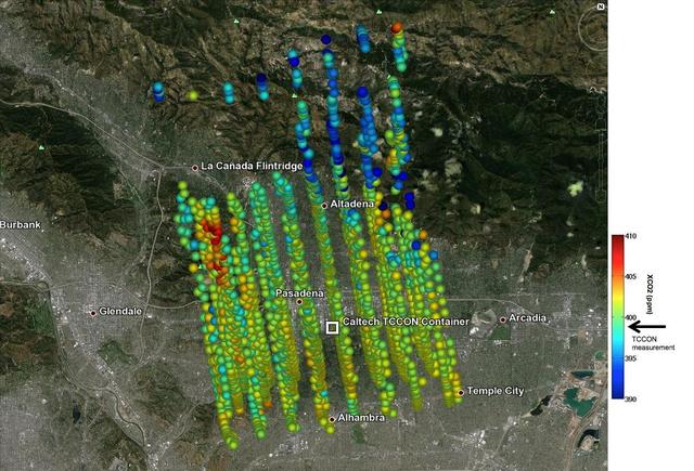
This image shows NASA OCO-2 measurements of carbon dioxide levels over Pasadena and the northern Los Angeles basin on Sept. 5, 2014. Each colored dot represents a single measurement of the greenhouse gas made during an overflight of the area.

The collection of red dots seen here show one of several very distant galaxy clusters discovered by combining ground-based optical data from the NOAO Kitt Peak National Observatory with infrared data from NASA Spitzer Space Telescope.
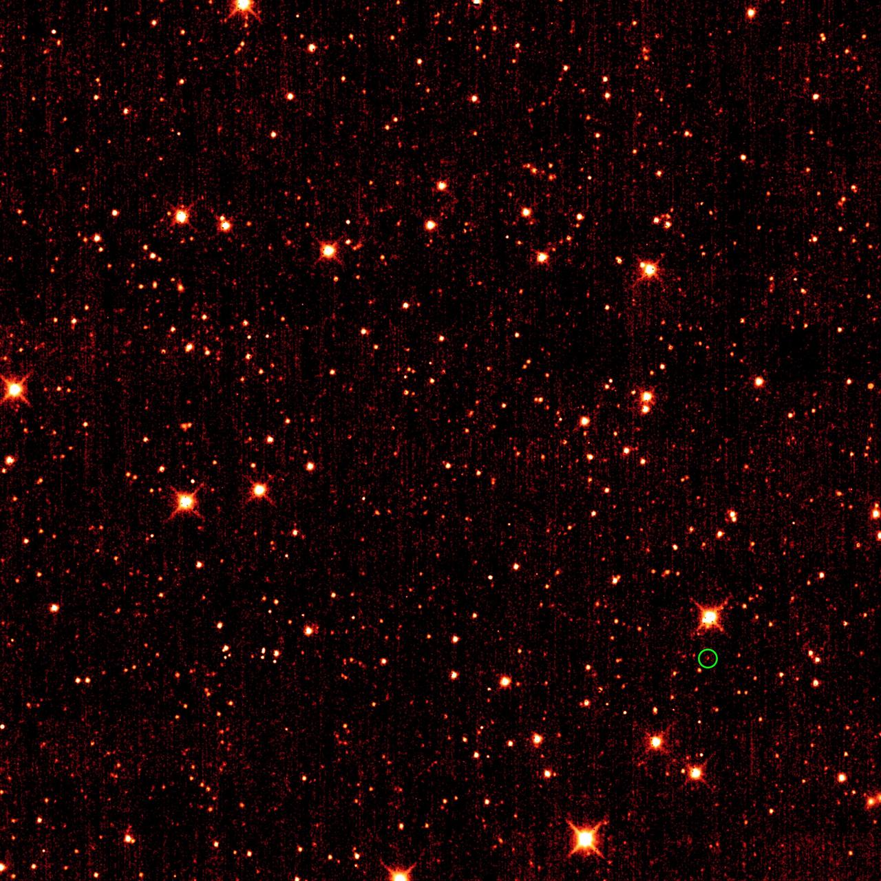
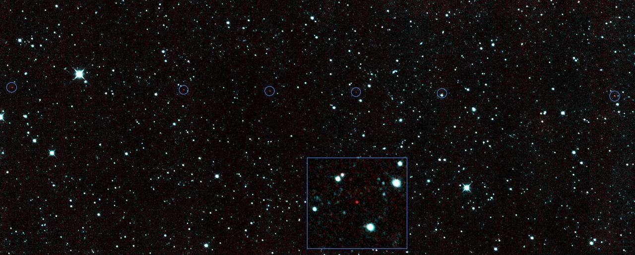
Asteroid 2010 TK7, the first known Earth Trojan asteroid, is circled in green, in this single frame taken by NASA Wide-field Infrared Survey Explorer. The majority of the other dots are stars or galaxies far beyond our solar system.
The green dot in the middle of this image might look like an emerald amidst glittering diamonds, but is a dim star belonging to a class called brown dwarfs; it is the first ultra-cool brown dwarf discovered by NASA Wide-field Infrared Survey Explorer.
Saturn moon Daphnis casts a short shadow on the A ring in this image taken by NASA Cassini spacecraftabout six months after the planet August 2009 equinox. Daphnis appears as a tiny bright dot in the Keeler Gap of the A ring near the center top.

NASA Cassini spacecraft looks past Saturn main rings to spy the tiny moon Atlas, which orbits between the main rings and the thin F ring. The main rings are closer to the spacecraft than Atlas is, and the moon appears as only a small, white dot.
While studying Saturn atmosphere, NASA Cassini spacecraft happens to catch a view of two small, icy satellites. Mimas drifts past on the far right of the image. Janus appears as a black dot just below the rings near the center of the image.
A small galaxy, called Sextans A, is shown here in a multi-wavelength mosaic captured by the ESA Herschel mission. In this image, the purple shows gas; blue shows young stars and the orange and yellow dots are newly formed stars heating up dust.
Cratered terrain in the northern hemisphere of Ceres is seen in this image from NASA's Dawn spacecraft. The scene is dotted with small impacts among larger, more ancient craters. The view is centered at approximately 28 degrees north latitude, 37 degrees east longitude. Dawn took this image on April 18, 2016, from its low-altitude mapping orbit, at a distance of about 240 miles (385 kilometers) above the surface. The image resolution is 120 feet (35 meters) per pixel. http://photojournal.jpl.nasa.gov/catalog/PIA20821
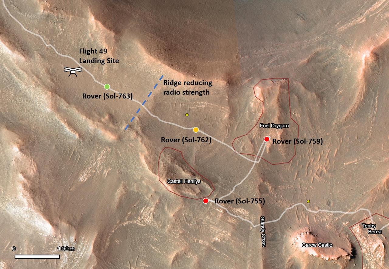
This map shows the locations of NASA's Perseverance Mars rover and its Ingenuity Mars Helicopter in the sols (Martian days) leading up to the helicopter's 50th flight. The helicopter icon can be seen in the upper left. The rover is shown with a red dot in places where communications with the helicopter were impossible. The rover is shown with a yellow dot at its location when the Flight 50 prep sequence was transferred from rover to helicopter. The rover is shown with a green dot at its nearest point to the helicopter before Flight 50 was executed. Ingenuity's 49th flight occurred on April 2, 2023, the 752nd Martian day, or sol, of the rover's mission. The 50th flight occurred April 13, 2023, the 763rd Martian sol of the mission. https://photojournal.jpl.nasa.gov/catalog/PIA25961
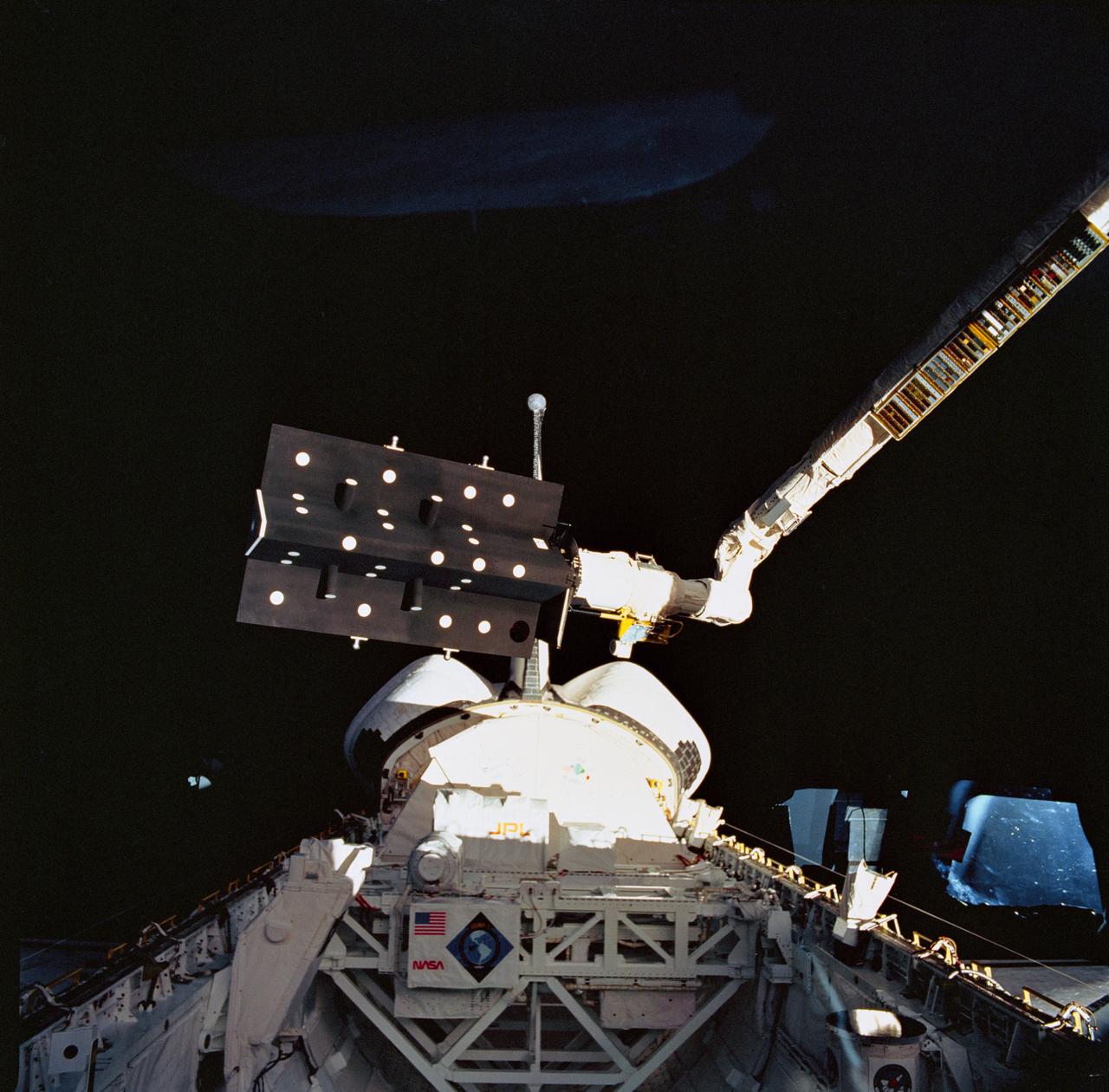
STS052-71-057 (22 Oct-1 Nov 1992) --- This 70mm frame, photographed with a handheld Hasselblad camera aimed through Columbia's aft flight deck windows, captures the operation of the Space Vision System (SVS) experiment above the cargo bay. Target dots have been placed on the Canadian Target Assembly (CTA), a small satellite, in the grasp of the Canadian-built remote manipulator system (RMS) arm. SVS utilized a Shuttle TV camera to monitor the dots strategically arranged on the satellite, to be tracked. As the satellite moved via the arm, the SVS computer measured the changing position of the dots and provided real-time television display of the location and orientation of the CTA. This type of displayed information is expected to help an operator guide the RMS or the Mobile Servicing System (MSS) of the future when berthing or deploying satellites. Also visible in the frame is the U.S. Microgravity Payload (USMP-01).
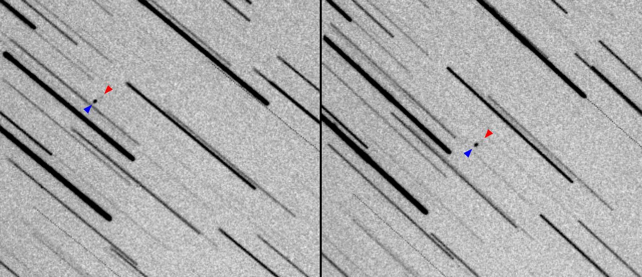
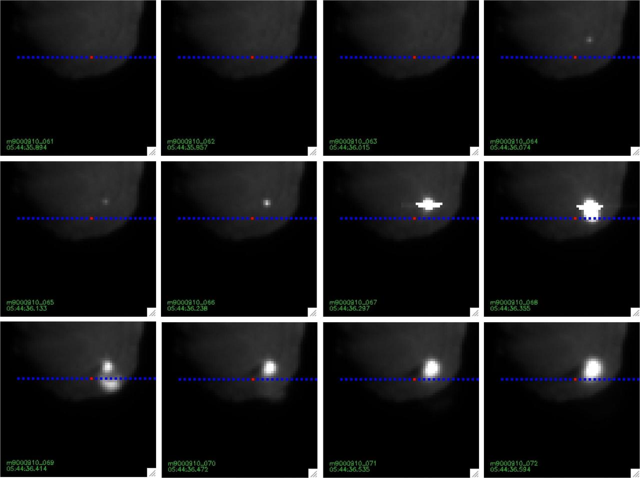
These images show two observations of NASA's Lunar Flashlight and the private ispace HAKUTO-R Mission 1 as the two spacecraft, seen as a pair of dots, journey to the Moon. In Figure A, the images have been joined sequentially to create an animated GIF. The larger HAKUTO-R lunar lander appears as a large black dot, whereas the smaller Lunar Flashlight, which is about the size of a briefcase, appears as a fuzzy grouping of gray pixels. Stars appear as long trails. Both missions launched on Dec. 11, 2022, aboard a SpaceX Falcon 9 rocket, with Lunar Flashlight and HAKUTO-R spacecraft subsequently deploying from it. Astronomer Vishnu Reddy and graduate student Adam Battle, both from University of Arizona's Lunar and Planetary Laboratory and Space4 Center, used a remote 0.5-meter (1.6-foot) telescope in Australia to track the small spacecraft. They used data from the Horizons System at NASA's Jet Propulsion Laboratory in Southern California to find their position in the sky. These images were acquired about 39 hours after launch, when the two spacecraft were 145,000 miles (235,000 kilometers) from Earth. Black and white in the images have been inverted so that the brighter the object, the darker it is. To detect the faint reflected light from both spacecraft, they stacked 80 images, each from a 10-second exposure (for a total exposure time of 800 seconds), based on the rate of motion and direction of the spacecraft. This method resulted in stars appearing as long trails and the two spacecraft appearing as dots. Lunar Flashlight is a small satellite mission planning to use lasers to seek out surface water ice inside permanently shadowed craters at the Moon's South Pole. The small satellite is expected to reach its science orbit around the Moon in April 2023. Movie available at https://photojournal.jpl.nasa.gov/catalog/PIA25257
iss071e695407 (Sept. 16, 2024) --- The city lights of Moscow, Russia, dotted by its surrounding suburbs, are pictured from the International Space Station as it orbited 264 miles above just west of the Volga River.

iss072e143370 (Nov. 1, 2024) --- Earth's dim atmopsheric glow blankets the Gulf of Thailand dotted with the lights of fishing boats in this orbital nighttime photograph from the International Space Station as it soared 259 miles above.

jsc2025e000004 (2024) --- View of ESA astronaut Alexander Gerst activating the Electromagnetic Levitator (EML), a microgravity furnace for metals, inside Europe's Columbus module of the International Space Station during his 2014 Blue Dot mission.
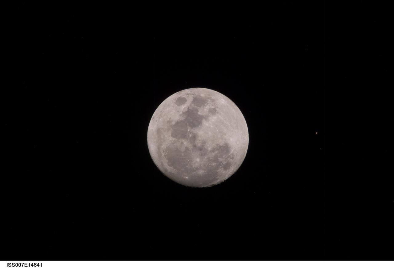
ISS007-E-14641 (9 September 2003) --- This view of a full Moon was photographed by one of the Expedition 7 crewmembers aboard the International Space Station (ISS). The view also includes Mars, which appears as a small dot.
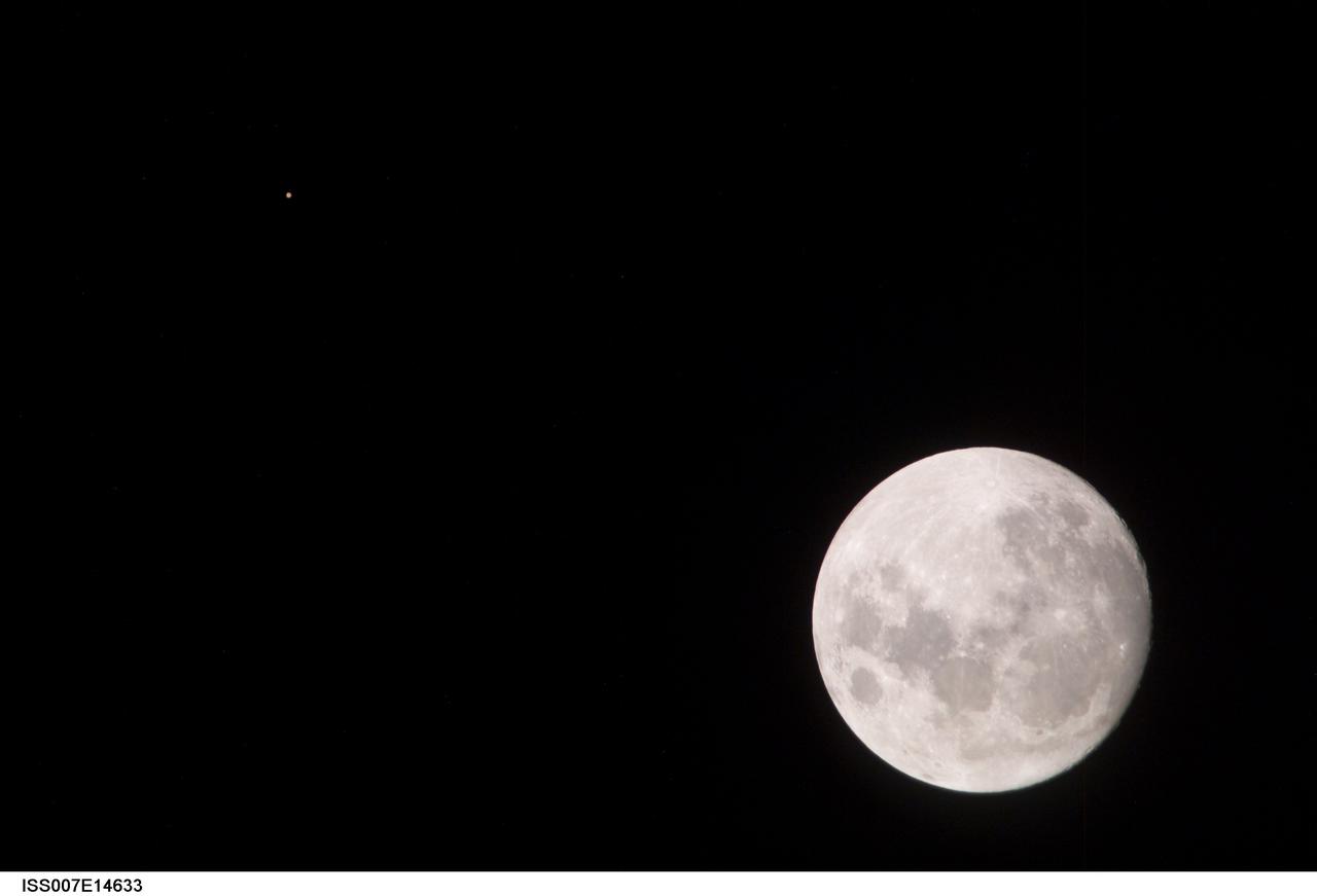
ISS007-E-14633 (9 September 2003) --- This view of a full Moon was photographed by one of the Expedition 7 crewmembers aboard the International Space Station (ISS). The view also includes Mars, which appears as a small dot.

iss041e107733 (11/4/2014) --- ESA astronaut Alexander Gerst activates the Electromagnetic Levitator (EML), a microgravity furnace for metals, inside Europe's Columbus module of the International Space Station during his 2014 Blue Dot mission.
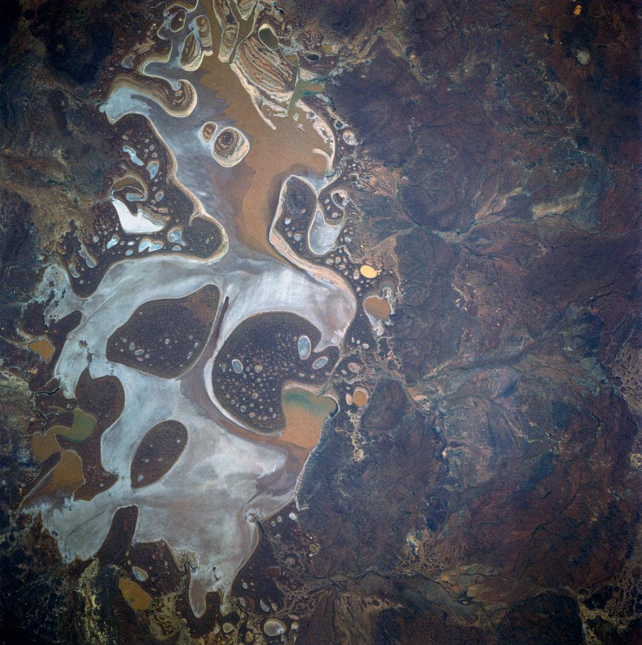
41D-42-045 (30 Aug-5 Sept 1984) --- Lake Carnegie in western Australia, 600 miles northeast of Perth. This is an island basin dotted with numerous salt lakes, ponds, flats, benches, and dunes.

iss065e112847 (June 15, 2021) --- The SpaceX Crew Dragon Endeavour is pictured docked to the Harmony module's forward-facing international docking adapter. The tiny dot just below Endeavour is the Moon in its waxing crescent phase.
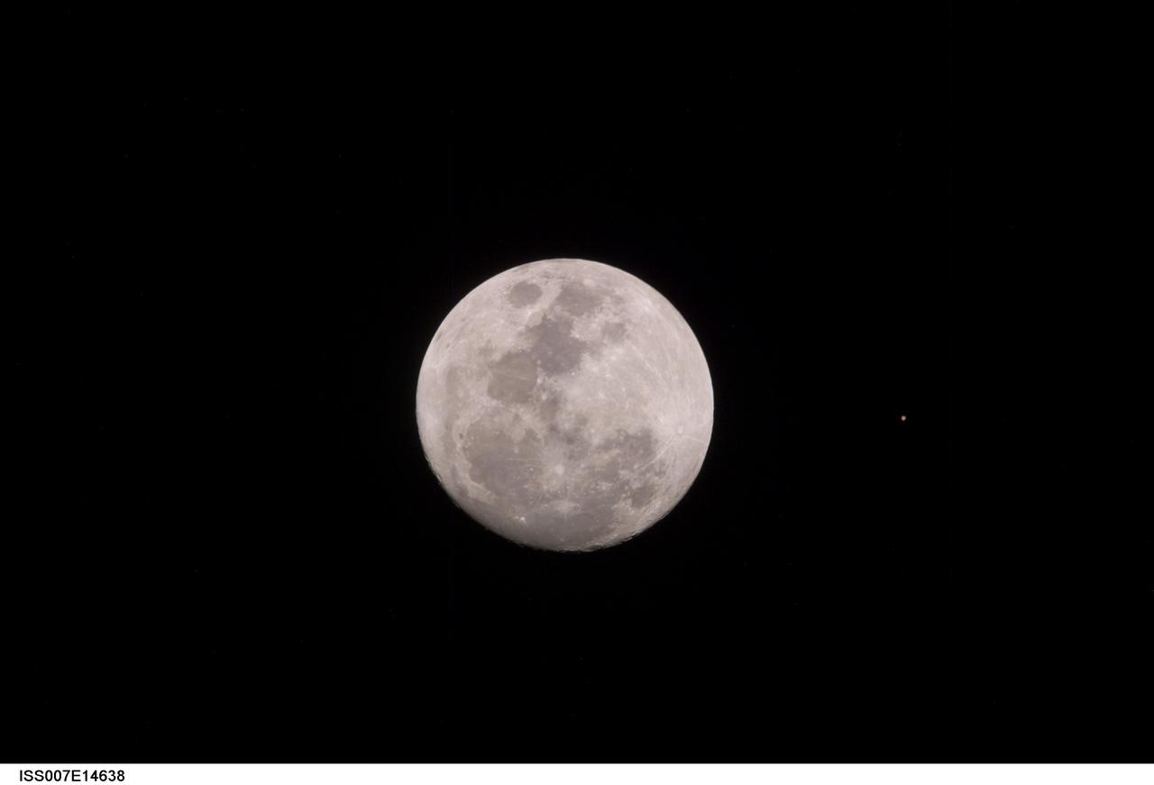
ISS007-E-14638 (9 September 2003) --- This view of a full Moon was photographed by one of the Expedition 7 crewmembers aboard the International Space Station (ISS). The view also includes Mars, which appears as a small dot.
This annotated image of Mars' Jezero Crater depicts the ground track and waypoints of the Ingenuity Mars Helicopter's planned 11th flight, scheduled to take place no earlier than Aug. 4, 2021. It was generated using terrain imaged by the HiRISE camera aboard NASA's Mars Reconnaissance Orbiter. The goal of Flight 11 is to move Ingenuity to a new location where it can support the Perseverance rover by obtaining imagery of geologic features in the "South Seítah" area. This graphic indicates the helicopter's location at takeoff with a pale blue dot on the lower right; upper-left dots indicate its new landing site. https://photojournal.jpl.nasa.gov/catalog/PIA24690
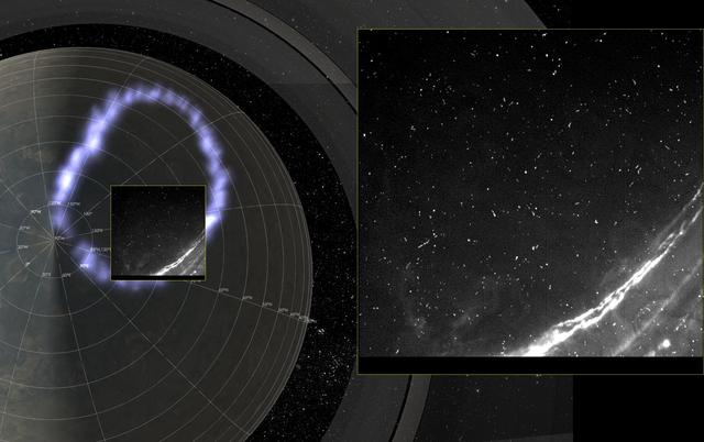
Juno's Radiation Monitoring Investigation used the Stellar Reference Unit (SRU) star camera to collect this high-resolution image Jupiter's northern auroral oval on May 24, 2018 (Perijove 13). Also present in the image are several small bright dots and streaks -- signatures of high energy relativistic electrons from polar beams that are penetrating the camera. The large bright dot in the lower right corner of the image is a flash of Jupiter's lightning. Juno was less than 37,000 miles (60,000 km) from the cloud tops when this SRU image was collected -- the closest view of Jupiter's aurora with a visible light imager. https://photojournal.jpl.nasa.gov/catalog/PIA22968

Over the past 30 years, global average sea level has risen a total of 3.6 inches (9.1 centimeters), as indicated in this graphic, which is based on sea level measurements (in blue) from five successive satellites starting with the U.S.-French TOPEX/Poseidon mission in 1993. The solid red line shows the trajectory of sea level rise from 1993 to 2022, while the dotted red line shows the increase sea level into the future. Researchers can take the solid red line and calculate the rate of sea level rise, which was 0.08 inches (0.20 centimeters) per year in 1993 and doubled to 0.17 inches (0.44 centimeters) per year by 2022. The dotted red line shows that by 2040, sea levels may rise by an additional 3.66 inches (9.3 cm) above 2022 levels. The trajectory shown in the solid and dotted red line is based on work by the NASA Sea Level Change Team and the Ocean Surface Topography Science Team. https://photojournal.jpl.nasa.gov/catalog/PIA25775
STS068-155-011 (30 September-11 October 1994) --- (Okanagan Lake, British Columbia) View southward down the lake; Vernon is in the foreground, Kelowna just before the bend in the lake, and Penticton at the far end of the lake. Green crops are still vigorous despite the season (early October); clear-cuts dot the forested hillsides.

iss067e176807 (July 4, 2022) --- Rio De Janiero, Brazil's second-most populous city, is pictured during an orbital night pass from the International Space Station as it orbited 261 miles above. Boat lights can be seen dotted along the Guanabara Bay.
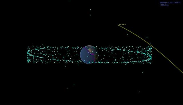
This animation shows the distance between the Apophis asteroid and Earth at the time of the asteroid's closest approach. The blue dots are the many man-made satellites that orbit our planet, and the pink represents the International Space Station. Movie available at https://photojournal.jpl.nasa.gov/catalog/PIA23195